
Council Minutes - Section B: Reports (1-7) - 28 August 2012
Contents | Previous Page: Section A - Procedural Matters | Next Page: Section B – Reports 8-14
Contents | Previous Page: Section A - Procedural Matters | Next Page: Section B – Reports 8-14
Reports 1-7, tabled at the Ordinary Meeting of Council on Tuesday 26 August 2012 held at City Hall, Little Malop Street in Geelong.
Drysdale Urban Design Framework Adoption and Authorisation to Prepare and Exhibit an Amendment
C246 – Consideration and Exhibition of Lara West Growth Area Rezoning and Precinct Structure Plan
Councillor Community Grants Program 2011/2012 – Summary of Allocations 1 April to 30 June 2012
Portfolio: |
Planning - Cr Macdonald |
Source: |
Economic Development Planning & Tourism |
General Manager: |
Peter Bettess |
Index Reference: |
Drysdale Urban Design Framework |
The Drysdale-Clifton Springs Structure Plan identified the need to improve the functionality and layout of the Drysdale Town Centre given the town is expected to grow by approximately 13,913 people over the next 20 to 30 years. The Structure Plan recommended that Council prepare an Urban Design Framework (UDF) for the town centre
A two day Enquiry by Design (EbD) workshop was held in December 2011. The City of Greater Geelong invited a diverse range of stakeholders from across State Government, key agencies and the Drysdale community to attend. The ideas and concepts captured during the workshop have been incorporated into the development of an UDF for the Drysdale Town Centre.
The UDF seeks to provide guidance on future growth and development, built form, streetscapes, traffic and pedestrian movements, car parking and land use. The UDF will provide a vision for how the town might develop, provide flexible design principles and recommend improvements to existing infrastructure and functionality of the town. The UDF will also assist in the assessment of future development proposals.
The UDF was placed on informal exhibition for a 6 week period from 4 June until 13 July 2012. Letters were sent to all attendees of the EbD workshop, owners and occupiers of land within the study area and the properties directly abutting the study area. Two community information sessions were held with approximately 30-40 people attending each session. A total of 24 submissions were received.
The key concerns raised within the submission were the timing for the development of the Drysdale Bypass, high traffic volumes along High Street, removal of pedestrian lights in High Street, removal of the Murradoc Road round-about and replacement with traffic lights, increase in traffic generated by the closure of the Corio tip, pedestrian and bicycle movements, concern over redevelopment of the senior citizens building and the consultation process was not long enough.
The submissions have been considered and the necessary changes have been made to the UDF. To give statutory effect to the UDF, Council must adopt it and proceed to introduce it into the Greater Geelong Planning Scheme.
Cr Macdonald moved, Cr Granger seconded -
That Council:
adopt the Drysdale Urban Design Framework (UDF);
request authorisation from the Minister for Planning to prepare an amendment to the Greater Geelong Planning Scheme;
resolve, subject to the grant of authorisation, to exhibit an amendment to introduce the recommendation of the UDF into the Planning Scheme.
Carried.
The current Drysdale-Clifton Springs Structure Plan was adopted by Council in September 2010. The Structure Plan identified the need to improve the functionality and layout of the Drysdale Town Centre given the town is expected to grow by approximately 13,913 people over the next 20 to 30 years. The Structure Plan recommended that Council prepare an Urban Design Framework for the town centre.
The City of Greater Geelong engaged Beveridge Williams, Design Urban, TTM Consulting, and Urbacity (the consultant team) to conduct an Enquiry by Design process for the Drysdale Town Centre. This two day workshop was held in December 2011. The City of Greater Geelong invited a diverse range of stakeholders from across State Government, key agencies and the Drysdale community to attend. The ideas and concepts captured during the workshop were recorded and a report prepared. The report used both written and visual elements to portray the ideas and concepts and over arching principles.
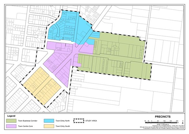
The UDF seeks to further expand on the ideas and concepts developed during the EbD process to develop an overall concept for the town centre. The UDF divides the town into 4 precincts, Town Entry South, Town Centre Core, Town Entry North and Business Corridor. It also investigates the possible development of 7 key sites. The opportunities and constraints for each of the 4 precincts and key development sites were looked at based on the information gathered during the EbD process and from Council Departments and external stakeholders. This information was then used to further develop design concepts for each of the precincts and key sites. See Appendix 1-1 for a map showing the study area and precinct boundaries.
For each of the 4 precincts the UDF seeks to provide guidance on future growth and development, built form, streetscapes, traffic and pedestrian movements, car parking and land use. The UDF will provide a vision for how the town might develop, provide flexible design principles and recommend improvements to existing infrastructure and functionality of the town.
The UDF will also assist in the assessment of future development proposals. Each of the key sites have also been looked at to determine how they could be best developed taking into consideration location, traffic and parking matters, connections with adjoining land uses, building height/built form and pedestrian movements. The UDF also recommends Design and Development Overlay controls to be developed for inclusion into the Greater Geelong Planning Scheme to help guide development into the future.
The UDF also makes a number of changes to improve the long term growth and development of the town centre. The recommended changes include:
Extension of the Business 1 Zoned land long Murradoc Road to allow for specialty retail, a new supermarket and better integration between the existing Aldi Supermarket and the town centre.
Extension of the Business 4 Zone up to the Drysdale Bypass to expand the Drysdale business precinct.
The retention of the Drysdale Bowling Club in its current location. It is recommended that a supermarket be constructed in Murradoc Road instead of the bowling club site as it would create a consolidated car parking area with Aldi, improve linkages to the town centre by encouraging the development of adjacent speciality shops and the creation of new road connections linking central walk to Murradoc Road.
The removal of the round-about and replacement with traffic lights at the High Street and Murradoc Road intersection to facilitate improved vehicle and pedestrian movements.
The development of foot and bicycle paths consistent with Council’s existing strategies.
The development of a streetscape master plan for Murradoc Road to incorporate street tree planting, road widening and a centre median strip.
The UDF was placed on informal exhibition for a 6 week period from the 4 June until 13 July 2012. Letters were sent to all attendees of the EbD workshop, owners and occupiers of land within the study area and the properties directly abutting the study area. Two community information sessions were held with approximately 30-40 people attending each session. A total of 24 submissions were received.
The issues raised during the information sessions and through submissions relate to the timing for the development of the Drysdale Bypass, high traffic volumes along High Street, removal of pedestrian lights in High Street, removal of the Murradoc Road round-about and replacement with traffic lights, increase in traffic generated by the closure of the Corio tip, pedestrian and bicycle movements, concern over redevelopment of the senior citizens building and the consultation process was not long enough.
A response to the submissions is found at Appendix 1-2. The key issues raised within the submissions are responded to below with all submissions documented within the Appendix to this report.
Drysdale Bypass
Officer comment
The Drysdale bypass is located to the east of the township linking Andersons Road with Portarlington Road, by passing the town centre. The bypass is located within a Public Acquisition Overlay. VicRoads have advised that approximately 50% of the land within the Public Acquisition Overlay has been acquired and the road is estimated to cost $80 million. Traffic counts collected by Council in May 2011 show that High Street carries approximately 16,332 vehicles per day. The timing for the delivery of the bypass road has not been determined however VicRoads have advised that they have recently re-commenced analysis and planning for the Drysdale bypass but it is likely the road will not be constructed for at least 10-15 years.
The bypass road was considered by the community to be the main factor in improving traffic movement, safety and amenity throughout the town particularly given the recent increase in truck movements to and from the Drysdale tip. Submissions suggested that new development within Drysdale should not occur until the bypass is constructed so that the traffic and amenity situation along High Street does not get any worse. Drysdale-Clifton Springs has a significant amount of planned residential growth and to limit the development of additional retailing and business uses within the town centre until the bypass is constructed has the potential to significantly impact on the quality and number of services the township may need to support a growing population. The UDF recognises the importance of constructing the Drysdale bypass and its potential to remove a significant amount of traffic from the town centre particularly during the peak holiday periods. The plan relies on the bypass being constructed to help deliver several key concepts including the widening of Murradoc Road and new traffic measures along High Street. The UDF acknowledges that the construction of the bypass will ultimately be delivered by VicRoads and the State Government and is subject to funding commitments. However, VicRoads have advised they will engage with Council in the upcoming planning and analysis phase they are currently undertaking providing Council with an opportunity to encourage VicRoads to look at the timing for the development of the bypass.
Changes to pedestrian traffic lights and the Murradoc Road round-about
Officer comment
The existing pedestrian lights located within High Street and the Murradoc Road round-about were considered by the community to slow the flow of traffic down and cause gridlock during peak traffic times. Investigations during the EbD workshop indicated that a round-about is not the most efficient way to move traffic during peak times because they allow for a constant flow of traffic without creating the necessary breaks to allow vehicles from side streets to access the main flow of traffic. Traffic lights were considered to be the most appropriate way to provide the necessary breaks in traffic flows to keep traffic moving.
Traffic lights would also improve the walkability of the town centre by creating addition safe places to cross High Street. The location of the traffic lights would also improve pedestrian safety between the east and west sides of the town centre improving connections between the existing services and the Aldi Supermarket.
Council and VicRoads would need to work together to improve the traffic flows through the town as part of the overall planning for the development of the bypass. However it is recommended that the round-about be replaced with traffic lights regardless of the timing for the construction of the Drysdale Bypass to improve pedestrian movement throughout the town. Funding for the construction of traffic lights is currently not available but should be looked as part of an overall concept for developing the town square and Murradoc Road.
VicRoads have advised that the replacement of the pedestrian lights in High Street with flashing lights would impact on traffic flows and could actually further slow traffic down. It is a combination of the round-about and the pedestrian lights that create the current slowing of traffic along High Street. The UDF does not advocate the replacement of these pedestrian lights and again this matter would be further investigated as an overall concept for the bypass and Murradoc Road was developed.
Bicycle and Pedestrian Movement
Officer comment
The community raised concerns that the UDF did not adequately address this issue. The UDF identifies the locations within the study area where there are gaps in footpath construction. The plan advocates for footpaths to be constructed in these locations. It is anticipated that where new development occurs adjacent to sites without footpaths, that the developer would construct the footpath. In locations where it is unlikely that a site would be redeveloped Council has a number of strategies, including special rates and charges schemes that could be utilised to construct the footpaths as the need arises.
Council has developed the City of Greater Geelong Cycle Strategy. This document was developed to provide Council with guidance on expanding Geelong’s on and off road cycle network, improving bicycle facilities, enhancing cyclist education and delivering promotions that encourage people to cycle as a means of transport, recreation and sport. The document details improvements to the bicycle network in and around Drysdale. The study area is in part affected by the recommendations of this strategy and it is recommended that they be incorporated into the UDF.
Redevelopment of the Senior Citizens Building
Officer comment
In 2008 Council investigated the possible redevelopment of the Drysdale Senior Citizens Building which is located adjacent to the town square. At that time it was proposed to develop a multi purpose building which could include a new Library, customer service centre and meeting space/function rooms. Since this time Council has upgraded the existing library and customer service centre located in Hancock Street which has taken pressure off the need to up grade these services. The site may still be re-developed as a multi purpose building in the future, but the design and timing of the redevelopment would be subject to a further community consultation process which is not part of the development of the UDF.
The future implementation of the UDF is not expected to result in any adverse environmental impacts. The UDF supports the development of water sensitive urban design treatments to improve the quality of stormwater runoff being generated from new development particularly the industrial precinct along Murradoc Road. This should help to improve the water quality at Lake Lorne.
The eventual implementation of the UDF is likely to require Council funding contributions for several projects identified within the UDF including streetscape works, the re-development of the town square and public buildings. The UDF projects will need to be fully costed and may result in future budget bids to Council and to external funding agencies. There are also several aspects to the plan that could be delivered through developer contributions.
After its subsequent adoption by Council, the policies and outcomes of the UDF will need to be incorporated into the Greater Geelong Planning Scheme. A Planning Scheme Amendment will be prepared to revise Clause 21.14 – The Bellarine Peninsula of the Municipal Strategic Statement to reflect the outcomes of the UDF. A minor review of the wording of the existing Drysdale Commercial Heritage Area Policy will also occur to ensure a cohesive link between the UDF and the heritage controls. Two Design and Development Overlay Controls will be introduced over the town centre and industrial precinct. There may also be developer requests to rezone land along Murradoc Road in accordance with the recommendations of the UDF.
No Council officers have any direct or indirect interest, in accordance with Section 80(C) of the Local Government Act to which this UDF relates.
There are no notable risks in adopting the Drysdale Urban Design Framework
The UDF includes proposals that will deliver significant long term social benefits to Drysdale community. These include increased retail choice and offer through expansion of the shopping centre and industrial precincts and providing improved streetscapes, traffic and pedestrian access throughout the town centre. The UDF will create a new civic precinct including a town square so that it becomes a focus for social interaction within the town.
The draft Drysdale UDF was made available for public comment for a six week period from 1 June until 13 July 2012. The UDF documents were available at the Drysdale Customer Service Centre and on the City’s web site. Two community information sessions were held on the 18 and 23 June 2012. Approximately 30-40 people attended each session. Letters were also sent to affected properties, EbD attendees and surrounding property owners. Notice of the amendment will be given in accordance with the requirements of the Planning and Environment Act 1987.
Cr Richards declared an Indirect Interest by Close Association in Agenda Item 2, Planning Permit Application 528/2005/C, 1-9 Bacchus Marsh Road, 8 Cox Road and 41 Georgia Grove, Corio in that the Council officer, who has a close working association through G21 Environment Pillar with Cr Richards, is an objector/interested party and left the meeting room at 7.37pm.
Portfolio: |
Planning - Cr Macdonald |
Source: |
Statutory Planning – City Development |
General Manager: |
Peter Bettess |
Index Reference: |
528/2005/C |
The application relates to the Medical Centre at the intersection of Bacchus Marsh Road, the Princess Highway and Cox Road in Corio and also has a frontage to Georgia Grove. The site has an overall area of 4672 square metres and proposes to occupy four parcels of land which includes 1-7 Bacchus Marsh Road, 9 Bacchus Marsh Road, 8 Cox Road & 41 Georgia Grove, Corio.
The proposal involves the following elements:
including 41 Georgia Grove & 8 Cox Road into the planning permit address
including the term “boundary realignment” in the planning permit preamble
amending condition 7 to increase the number of practitioners from 15 to 16
including the Corangamite CMA’s conditions onto the permit
extending the existing medical centre to the north over existing car parking spaces
constructing additional parking spaces at the rear of 41 Georgia Grove to account for lost car spaces.
The subject site is situated in the Residential 1 Zone and is subject to the Special Building Overlay.
The application was advertised by way of letters to surrounding land owners as well as objectors to the original permit and past amendments. Signs were also placed on the Cox Road and Bacchus Marsh Road frontages for the statutory 14 day period.
As a result of public notification six (6) objections were received which related to the continual expansion of the medical centre, a commercial use in a residential context, overdevelopment of the site(s), inappropriate built form, amenity impacts, the loss of affordable housing, the lack of need for the expansion and increased flooding issues.
The Council in deciding permit number 280/ 2007 resolved that “Council will not grant any further planning permits which allow the expansion of the medical centre beyond its current boundaries until a Development Plan Overlay is applied to the land.”
Having assessed the proposed amendment against all relevant planning policies and provisions and having taken into consideration the issues raised by objectors it is considered that on balance the proposal is an appropriate outcome for the site and surrounding community.
Based on this it is recommended that the application be supported and that a Notice of Decision to Issue a Planning Permit be issued.
Cr Macdonald moved, Cr Fisher seconded -
That the:
Responsible Authority having considered all matters which the Planning and Environment Act, 1987, requires it to consider, decides to issue a Notice of Decision to Grant a Planning Permit for the Extension to an Existing Medical Centre to include additional Consultation Rooms and an Ancillary Pharmacy, Conversion of the Existing Dwellings at 6 Cox Road into a Medical Centre, the Integration of 43 Georgia Grove within the Medical Complex and Boundary Realignment and a Partial Reduction in the Car Parking Requirements at 1-9 Bacchus Marsh Road, 8 Cox Road & 41 Georgia Grove, Corio in accordance with the plans submitted with the application and subject to the conditions detailed in Appendix 2-2.
Council prepares a planning scheme amendment to apply a Development Plan Overlay to the land.
Carried.
The Site & Locality
The subject site is located at the intersection of Bacchus Marsh Road, the Princess Highway and Cox Road in Corio and also has a frontage to Georgia Grove. The site has an overall area of 4672 square metres and proposes to occupy four parcels of land which includes 1-7 Bacchus Marsh Road, 9 Bacchus Marsh Road, 8 Cox Road and 41 Georgia Grove, Corio.
The land parcel known as 1-7 Bacchus Marsh Road currently contains a medical centre with ancillary pharmacy along with another two single storey buildings which are used as a Path Care premises and also for Melbourne Pathology and a Hearing Clinic.
Current access to the medical centre is via a service road adjacent to Bacchus Marsh Road. The two parcels of land at 43 Georgia Grove and 6 Cox Road are currently occupied by dwellings each with a driveway.
The site is located within an established residential area. The surrounding area consists of single storey dwellings with large open space areas and garaging at the side or rear of houses. To the south of the site on the opposite side of Cox Road is land owned by the City of Greater Geelong and includes a gymnasium, water park and other public facilities. A large public car park is also located on this site.
Site History
It is noted that the original permit PP 528/2005 has been amended on two occasions previous to this.
Furthermore, it is noted that a separate permit was issued for the property at 9 Bacchus Marsh Road, Corio for an additional medical centre (diabetes clinic).
As part of the resolution at the Council Meeting to support the application there was a “Part B” to the resolution which stated that “Council will not grant any further planning permits which allow the expansion of the medical centre beyond its current boundaries until a Development Plan Overlay is applied to the land.”
Furthermore, that application was subsequently appealed to VCAT by an objector and was ultimately approved. In the order handed down by VCAT, Member Fong stated “As far as the Tribunal is concerned, it can only deal with the matter at hand: the merits of the use of no. 9 Bacchus Marsh Road as a medical diabetic clinic. It is not in a position to say whether the clinic will expand. No doubt, there are advantages if there is a long term or medium term plan prepared for the clinic. However, it is not available, and it does not mean that assessment of applications has to cease. Instead, the permit applicant has to put a case each time when further changes or expansion are contemplated by further permit applications, and nearby residents have to deal with it each time. There is inherent uncertainty for all parties.”
The Council must consider each application on its merits notwithstanding the resolution handed down at the Council meeting in relation to PP 280/2007.
Proposal
The proposal involves:
Including 41 Georgia Grove & 8 Cox Road in the planning permit address.
Including boundary realignment in the planning permit preamble.
Amending condition 7 to increase the number of practitioners from 15 to 16.
Extending the existing medical centre to the north over existing car parking spaces.
Constructing additional parking spaces at rear of 41 Georgia Grove to account for lost car spaces.
Public Notification
The application is not exempt from the notice requirements of Section 52(1)(a), (b) and (d), the decision requirements of Section 64(1), (2) and (3) and the review rights of Section 82(1) of the Act and pursuant to Section 52 of the Planning and Environment Act 1987 the following forms of advertising were undertaken:
55 notices were sent to owners and occupiers of adjoining land (includes opposite)
One (1) A3 sign was placed on the land.
As a result of public notification six objections were received. A large number of issues were raised by objectors and due to this large number and a number of similar or the same issues being raised by other objectors the key issues are summarised and responded to in Appendix 2-5.
Assessment
Residential 1 Zone
The use of the land as a medical centre has already been approved and has been established for some time now. The use is now being expanded to include an additional consulting room which also coincides with the request for an additional practitioner. In addition to this, the proposed extension to the medical centre is aimed at improving facilities for staff including, among other things, new training rooms.
These training rooms will, at times, be utilized by students who are completing job placement for their university courses. The students will initially assess a client before the employed practitioner assesses the client, thereby not bringing additional cliental to the clinic. The inclusion of this educational component in to the medical centre function is considered to be both ancillary and acceptable.
The proposed boundary realignment with 41 Georgia Grove is considered to be in accordance with the zone as it still allows for the retention of an existing dwelling fronting Georgia Grove. The residential lot will now be 505 square metres and will still allow for ample open space area to the rear of the dwelling. The existing garage associated with the dwelling on 41 Georgia Grove will need to be demolished as it will traverse the new property boundary however there is considered to be adequate area on the to-be-created 505 square metre allotment for it to be replaced.
Special Building Overlay
The proposal is considered to comply with the purpose and decision guidelines of the Special Building Overlay and the state and local planning policy relating to flooding. The Special Building Overlay was sought to be applied to the land as a result of an extensive flood study of areas of the municipality by the engineering department of council and seeks to address a variety of flooding issues. This area is subject to existing drainage issues and overland flows and the CCMA has assessed these flows and determined an appropriate floor height for the proposed building extension to ensure they will not be affected during a storm event.
State & Local Policy
The proposed amendment is considered to comply with the relevant state and local planning policy listed earlier in this report. The proposed extension maintains a similar building appearance although in this instance it does introduce a double storey built form. Given the size of the subject site and the expansive intersection that surrounds it the built form of the building is considered to fit the scale of the site and surrounding area although the surrounding area is predominantly single storey in scale.
Furthermore, the medical centre is considered to provide an important role in terms of health services in the northern area of the municipality which is considered to current have a short-fall in terms of these facilities. The premises and the proposed extension are subject to federal funding which further identifies the significance of the premises in terms of servicing the surrounding community’s health needs. The facility is highly accessible to public and private transport and adequate car parking facilities have been provided for staff and visitors.
In response to the policy of Clause 22.01 the following responses are provided to each section of policy:
Preferred Location
The use is located so as to benefit and be convenient to local residents and has access to a Road Zone.
Residential properties are not isolated as a result of the use.
The use is located on a site that due to existing conditions has a low standard of residential amenity due to its proximity to key roads which carry large amounts of traffic.
The medical centre is already established but it is noted that it is not located within a business zone as the only practical business zone where it could locate is the Corio Shopping Centre and there is inadequate supply of floor area to locate there. It is noted that the site is located adjoining a Road Zone.
Amenity
The amenity of surrounding residential properties has remained in tact during the recent years of operation of the medical centre and this is not expected to change as the only increase is as a result of an additional practitioner. Additional car parking spaces are to be provided for the practitioner therefore parking impact is negligible.
Design and Siting
The design of the proposed addition is considered to have regard for the existing neighbourhood character. While the surrounding area is predominantly single storey scale, due to the size of the subject site and the expansive intersection that surrounds it the built form of the building is considered to fit the scale of the site. Although double storey in scale it is still considered to reflect a residential scale and appearance, as double storey is not uncommon in a residential area and the use of residential style roof forms and materials.
Landscaping
Existing landscaping will not be impacted upon as a result of the proposed amendment.
Carparking & Traffic
An adequate area is set aside for on site car parking with at least 75 car parking spaces provided across the entire site.
Due to car parking generally being located at the rear it does not dominate the streetscape.
Residential amenity will not be impacted by significant changes in traffic conditions and significant increases in on street parking demand due to the increase in only 1 practitioner and the provision of adequate on-site parking.
Conclusion
Based on the above assessment it is concluded that on balance the proposed amendment is generally compliant with the Planning Scheme and is therefore recommended for support.
Legislative Issues
The Planning and Environment Act 1987 and the Greater Geelong Planning Scheme are the relevant documents under which Council must consider this application.
It is considered that there will be no environmental implications for Council in the granting of this permit
It is considered that there will be no financial implications for Council in the granting of the permit.
The proposal has been assessed against the provisions of the Greater Geelong Planning Scheme as detailed in Appendix 2-3.
There are no Officer conflicts of Interest with this application
It is considered that there will be no risk to Council in the granting of this permit.
It is considered that there will be no social implications for Council in the granting of this permit.
The application was referred to various internal departments of Council for comment
The summary of the referral responses is provided in Appendix 2-4).
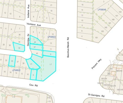
Indicates Objectors
(note - two objectors reside outside locality map)
1-9 BACCHUS MARSH ROAD, 8 COX ROAD AND 41 GEORGIA GROVE, CORIO
Before the use and development starts, amended plan(s) to the satisfaction of the Responsible Authority must be submitted to and approved by the Responsible Authority. When approved, the plan(s) will be endorsed and will then form part of the permit. The plan(s) must be drawn to scale with dimensions and two copies must be provided. The plans must show the following:
A full set of floor plans drawn to scale for each building.
Car parking spaces to have minimum dimensions of 2.6 metre wide by 4.9 metre long.
Elevation drawings to show the deletion of the external double doors fronting Cox Road and the signage associated with the pharmacy.
Elevation drawings which show the finished floor level of all new buildings to be in accordance with condition 15 of this permit.
The location of appropriate signage adjacent to the staff parking areas to ensure that these areas are used for staff parking only.
Elevation plans showing the dimension, wording and colouring of all signage associated with the staff parking areas in accordance with condition 1e above.
The location of signage adjacent to the vehicle entry point on Cox Road to ensure that vehicles can only enter the site at that point.
The site plan amended to show the changes to the vehicle access point on Cox Road in accordance with Conditions 11 and 12 of this permit.
The wing wall to be constructed of a solid material.
The location of a designated bicycle parking rack which must provide for a minimum of six (6) spaces.
The use and development as shown on the endorsed plan(s) must not be altered without the written consent of the Responsible Authority.
A Plan of Consolidation incorporating the titles of 1-7 Bacchus Marsh Road and 8 Cox Road, Corio must be submitted to Council within three (3) months of the date of this permit. Prior to the occupation of the buildings, the consolidation plan shall be lodged with the Land Titles Office for processing and must not be withdrawn. Evidence of lodgement of the plan at the Land Titles Office must be submitted to Council.
If the Plan of Consolidation is not lodged as specified above, this permit shall be null and void. The Responsible Authority may extend the periods referred to if a request is made in writing before the permit expires or within three months afterwards.
Before the development starts, a landscape plan to the satisfaction of the Responsible Authority must be submitted to and approved by the Responsible Authority. This plan must be prepared by a qualified Landscape Architect who is a member of the Australian Institute of Landscape Architects, or a person with a suitable background in horticultural science or an allied field to the satisfaction of the Responsible Authority. When approved, the plan will be endorsed and will then form part of the permit. The plan must be drawn to scale with dimensions and three copies must be provided. The plan must show:
Buildings and trees (including botanical names) on neighbouring properties within three metres of the boundary
Details of surface finishes of pathways and driveways
A planting schedule of all proposed trees, shrubs and ground covers, including botanical names, common names, pot sizes, sizes at maturity, and quantities of each plant.
Landscaping and planting within all open areas of the site
Prior to the occupation of the buildings all landscaping works as shown on the endorsed plan(s) must be completed to the satisfaction of the Responsible Authority and then maintained to the satisfaction of the Responsible Authority.
Unless with the prior written consent of the Responsible Authority, the Medical Centre permitted by this permit must operate only between the following times:
Monday to Friday between 8.00am and 9.00pm
Saturday and Sunday between 9.00am and 6.00pm
The use of the Medical Centre outside these hours must be restricted to emergency cases only.
At no time may more than 16 practitioners operate or conduct consultations in the premises at any one time to the satisfaction of the Responsible Authority.
The entry and exit door located on the western elevation of the pharmacy must only be accessible to the public during the times when the medical centre is open.
Medical waste must be stored and disposed of in accordance with the requirements of the Environment Protection Authority to the satisfaction of the Responsible Authority.
The amenity of the area must not be detrimentally affected by the use or development through the:
Transport of materials, goods or commodities to or from the land.
Appearance of any building, works or materials.
Emission of noise, artificial light, vibration, smell, fumes, smoke, vapour, steam, soot, ash, dust, waste water, waste products, grit or oil.
The site including all buildings, works and landscaping shall be maintained in a neat, tidy and safe condition in accordance with the endorsed plan.
To the satisfaction of the Responsible Authority.
The southern proposed vehicular crossover to the Medical Centre from the arterial road (Cox Road), presently the crossover to 6 Cox Road, shall be constructed/ and be signed to advise patrons of the entry only vehicle movement hereby permitted. The works shall be at full cost to the developer.
The vehicular crossover and entrance referred to in condition 11 above shall be constructed/upgraded to the satisfaction of VicRoads and the Responsible Authority and shall incorporate the following:
The crossover and driveway shall be at least 3 metres wide.
The crossover shall be regraded to provide a smooth transition from the arterial road into the subject land.
The ‘no standing’ sign on the nature strip at the front of 8 Cox Road shall be relocated westwards to the common boundary between 8 and 10 Cox Road.
A left slip lane commencing at the relocated ‘no standing’ sign and extending to the entrance shall be line marked together with a painted chevron to the east of the entrance to indicate the termination of the left slip lane, generally in accordance with the attached diagram in appendix A.
Before the use starts areas set aside for parked vehicles and access lanes as shown on the endorsed plans must be:
Constructed to the satisfaction of the Responsible Authority.
Properly formed to such levels that they can be used in accordance with the plan(s).
Surfaced with an all-weather seal coat to the satisfaction of the Responsible Authority.
Drained and maintained to the satisfaction of the Responsible Authority.
Line-marked to indicate each car space and all access lanes to the satisfaction of the Responsible Authority.
The site shall be drained to the satisfaction of the Responsible Authority and no storm water, sullage, sewerage or polluted drainage shall drain or discharge from the land to adjoining properties.
Deleted.
Deleted.
All stormwater runoff shall be collected on site and discharged to the satisfaction of the Responsible Authority. The Legal Point of Discharge for this development shall be to the kerb and channel in Cox Road to the satisfaction of the Responsible Authority.
All internal property drainage must be designed and constructed to satisfy AS/NZS 3500 to the satisfaction of the Responsible Authority.
The developer shall immediately rectify, at no cost to the Relevant Authority, any damage caused to the Responsible Authorities drainage infrastructure due to the development to the satisfaction of the Responsible Authority.
Prior to the development commencing, the developer must submit a Drainage Design Plan to the Responsible Authority for approval. An approved Civil Consulting Engineer must prepare the plan, and when approved it shall form part of this permit. The plan must include detailed hydrological and hydraulic analysis, pit and pipes sizes, finished surface and existing surface levels, creation of appropriate easements and connection details to the existing council drainage network.
All construction works associated with this development shall be undertaken in accordance with the approved drainage plans to the satisfaction of the Responsible Authority.
All outdoor lighting must be designed, baffled and located to the satisfaction of the Responsible Authority to prevent any adverse effect on adjoining land or road reserve.
The loading and unloading of goods from vehicles must only be carried out on the land to the satisfaction of the Responsible Authority.
The external fabric including the roofing of the new building shall be in muted tonings or of a non-reflective material so as to blend with the environment and preserve the aesthetic amenity of the area to the satisfaction of the Responsible Authority.
The finished floor level of the extension to the existing medical centre be placed a minimum of 300mm above the applicable floor level. This is referred to as the Nominal Flood Protection Level (NFPL) and is 10.33m AHD (e.g. 10.03m AHD + 0.3m = 10.33m AHD). This minimum floor level is also in accordance with the Building Regulations 802 (7) (b).
The proposed car park on 8 Cox Road must remain at the existing ground level.
This permit will expire if one of the following circumstances applies:
The development and use are not started within two years of the date of this permit.
The development is not completed within two years of the date of commencement.
The Responsible Authority may extend the periods referred to if a request is made in writing before the permit expires or within three months afterwards.
The proposed use is defined as a ‘Medical Centre’ and is nested under the Office Group.
Zone
Clause 32.01 – Residential 1 Zone
The purpose of Clause 32.01 of the Residential 1 Zone is to:
implement the State Planning Policy Framework and the Local Planning Policy Framework, including the Municipal Strategic Statement and local planning policies.
provide for residential development at a range of densities with a variety of dwellings to meet the housing needs of all households.
encourage residential development that respects the neighbourhood character.
in appropriate locations, to allow educational, recreational, religious, community and a limited range of other non-residential uses to serve local community needs.
Overlay
The purpose of Clause 43.02 of the Design & Development Overlay is to:
implement the State Planning Policy Framework and the Local Planning Policy Framework, including the Municipal Strategic Statement and local planning policies.
identify areas which are affected by specific requirements relating to the design and built form of new development.
The purpose of Schedule 14 of this overlay is to:
ensure that new dwellings and extensions to existing dwellings are compatible with the existing scale and character of adjoining dwellings and of the area.
ensure that the height and visual bulk of dwellings are acceptable in the neighbourhood setting.
The purpose of Clause 44.05 of the Special Building Overlay is to:
implement the State Planning Policy Framework and the Local Planning Policy Framework, including the Municipal Strategic Statement and local planning policies.
identify land in urban areas liable to inundation by overland flows from the urban drainage system as determined by, or in consultation with, the floodplain management authority.
ensure that development maintains the free passage and temporary storage of floodwaters, minimises flood damage, is compatible with the flood hazard and local drainage conditions and will not cause any significant rise in flood level or flow velocity.
protect water quality in accordance with the provisions of relevant State Environment Protection Policies, particularly in accordance with Clauses 33 and 35 of the State Environment Protection Policy (Waters of Victoria).
Permit Trigger
Pursuant to Clause 32.01-2 of the Residential 1 Zone a permit is required to subdivide land.
Pursuant to Clause 44.05-1 of the Special Building Overlay a permit is required to construct a building or to construct or carry out works.
Pursuant to Clause 44.05-2 of the Special Building Overlay a permit is required to subdivide land.
Pursuant to Clause 43.02-3 of the Design & Development Overlay a permit is required to subdivide land.
Restrictive Covenant
The site is affected by registered restrictive covenant 2250424. The covenant prevents the removal of soil, clay, stone, gravel or sand from the site except for the laying of foundations for any building. The proposed amendment would not result in the breach of any registered restrictive covenant.
Cultural Heritage Management Plan (CHMP)
The Aboriginal Heritage Regulations 2007 specify the circumstances in which a Cultural Heritage Management Plan is required for an activity or class of activity.
Areas of cultural heritage sensitivity are defined within Part 2 - Division 3 of the Aboriginal Heritage Regulations 2007. Part 2 - Division 3 does not identify the site as within an area of cultural heritage sensitivity.
In accordance with the above assessment, a Cultural Heritage Management Plan is not required.
Coastal Hazard Vulnerability Assessment
The subject site is not located with 1km of the coast line and has a contour level of 9-10 metres AHD as per Council's Eview mapping system; therefore a CHVA is not required.
Officer Direct or Indirect Interest
No Council officers have any direct or indirect interest in the matter to which this report relates, in accordance with Section 80 (C) of the Local Government Act.
Car Parking
Currently there appears to be 57 car parking spaces on the site known as 1-7 Bacchus Marsh Road and a further 10 spaces on the site known as 9 Bacchus Marsh Road to service the existing facilities.
The current car parking rate for a medical centre is 5 to the first person providing health services plus 3 to every other person providing health services.
Seven (7) of the existing spaces are to be lost due to the proposed extension to the medical centre however an additional 15 spaces are to be constructed at the rear of 8 Cox Road and 41 & 43 Georgia Grove.
This provides a surplus of 8 car parking spaces which exceeds the requirement for an additional three (3) spaces per every other person providing health services above the first person providing health services.
It is noted that the original application and subsequent amendments were assessed against the previous car parking rate of 5 spaces per practitioner.
Bicycle Spaces
Currently no bicycle parking spaces are provided on site.
Subject to Clause 52.34 the rate for bicycle parking for employees is 1 space per 8 practitioners therefore triggering a requirement of 2 spaces for the allowed 16 practitioners.
Subject to Clause 52.34 the rate for bicycle parking for visitors is 1 space per 4 practitioners therefore triggering a requirement of 4 spaces for the allowed 16 practitioners.
In total six (6) bicycle spaces are required for the site and this will be required via an amended plans condition.
State Planning Policy Framework
Clause 13.02-1 - Floodplain Management
The objective of Clause 13.02-1 of the State Planning Policy Framework is to assist the protection of:
Life, property and community infrastructure from flood hazard.
The natural flood carrying capacity of rivers, streams and floodways.
The flood storage function of floodplains and waterways.
Floodplain areas of environmental significance or of importance to river health.
Strategies
Identify land affected by flooding, including floodway areas, as verified by the relevant floodplain management authority, in planning scheme maps. Land affected by flooding is land inundate by the 1 in 100 year flood event or as determined by the floodplain management authority.
Avoid intensifying the impacts of flooding through inappropriately located uses and developments.
Locate emergency and community facilities (including hospitals, ambulance stations, police stations, fire stations, residential aged care facilities, communication facilities, transport facilities, community shelters and schools) outside the 1 in 100 year floodplain and, where possible, at levels above the height of the probable maximum flood.
Locate developments and uses which involve the storage or disposal of environmentally hazardous industrial and agricultural chemicals or wastes and other dangerous goods (including intensive animal industries and sewage treatment plants) must not be located on floodplains unless site design and management is such that potential contact between such substances and floodwaters is prevented, without affecting the flood carrying and flood storage functions of the floodplain.
Clause 15.01- 1 Urban Design
The objective of Clause 15.01-1 of the State Planning Policy Framework is to create urban environments that are safe, functional and provide good quality environments with a sense of place and cultural identity.
Strategies
Promote good urban design to make the environment more liveable and attractive.
Ensure new development or redevelopment contributes to community and cultural life by improving safety, diversity and choice, the quality of living and working environments, accessibility and inclusiveness and environmental sustainability.
Require development to respond to its context in terms of urban character, cultural heritage, natural features, surrounding landscape and climate.
Require development to include a site analysis and descriptive statement explaining how the proposed development responds to the site and its context.
Ensure sensitive landscape areas such as the bays and coastlines are protected and that new development does not detract from their natural quality.
Ensure transport corridors integrate land use planning, urban design and transport planning and are developed and managed with particular attention to urban design aspects.
Encourage retention of existing vegetation or revegetation as part of subdivision and development proposals.
Clause 17.01-1 – Business
The objective of Clause 17.01-1 of the State Planning Policy Framework is to encourage development which meets the communities’ needs for retail, entertainment, office and other commercial services and provides net community benefit in relation to accessibility, efficient infrastructure use and the aggregation and sustainability of commercial facilities.
Strategies
Locate commercial facilities in existing or planned activity centres.
Provide new convenience shopping facilities to provide for the needs of the local population in new residential areas and within, or immediately adjacent to, existing commercial centres.
Provide outlets of trade-related goods or services directly serving or ancillary to industry and which have adequate on-site car parking.
Locate cinema based entertainment facilities within or on the periphery of existing or planned activity centres. Such facilities should not require a permit for use within activity centres and are not encouraged on freestanding sites.
A five year time limit for commencement should be attached to the planning approval for all shopping centres or expansions of over 1,000 square metres in floor space.
Clause 19.02-1 - Health Facilities
The objective of Clause 19.02-1 of the State Planning Policy Framework is to assist the integration of health facilities with local and regional communities.
Strategies
Facilitate the location of health-related facilities (including acute health, aged care, disability services and community care facilities) with consideration given to demographic trends, the existing and future demand requirements and the integration of services into communities.
Plan public and private developments together, where possible, including some degree of flexibility in use.
Locate hospitals and other large health service facilities in areas highly accessible to public and private transport.
Adequate car parking facilities should be provided for staff and visitors.
Local Planning Policy Framework
Municipal Strategic Statement
Clause 21.06-4 - Neighbourhood Character
The objective of Clause 21.06-4 of the Municipal Strategic Statement is to:
manage the impact of urban change on existing neighbourhoods.
ensure that new development responds to the existing neighbourhood character.
protect areas with a significant garden character.
Strategies
Ensure that development is responsive to the established character of the area.
Support medium density housing in the Residential 3 Zone in accordance with the schedule to the zone.
Acknowledge that neighbourhood character in the Increased Housing Diversity Areas and in Residential 2 Zones will adapt and evolve over time, particularly within and on the edges of activity centres, where land use and development will intensify.
Allow for appropriate transition between residential zones.
Ensure that development on the edges of Residential 1 and Residential 2 Zones is responsive to and respectful of the neighbourhood character in any adjoining Residential 3 Zone.
Support the redevelopment of dwellings owned by the Office of Housing, as part of urban renewal initiatives.
Retain existing vegetation wherever possible, particularly vegetation that contributes to the municipality’s tree canopy.
Avoid gated communities.
Maintain the character of the Rural Living and Low Density Residential Zoned areas.
Clause 21.05-7 - Flooding
The objective of Clause 21.05-7 of the Municipal Strategic Statement is to:
protect floodplains.
minimise the potential for damage and risks to public safety and property from flooding.
Strategies
Ensure that land use and development is compatible with flood prone land.
Discourage land use and development in floodplains where flood function may be impaired.
Recognise flood hazards associated with waterways and ensure the free passage of water whilst protecting development from flooding impacts.
Local Planning Policies
Clause 22.01 - Discretionary Uses in Residential Areas
The objective of Clause 22.01 of the Local Planning Policy Framework is to:
provide for non-residential and service uses which are compatible with the residential character, scale and amenity of neighbourhoods.
provide for non-residential uses which serve the needs of the local community.
encourage the re-use of purpose built non-residential buildings for a mix of appropriate local convenience/service and commercial uses.
ensure that car parking can be appropriately accommodated on site and that on street parking is relied upon only where it can be demonstrated that it will not be to the detriment of surrounding residential uses.
ensure that traffic generated by the use can be accommodated within the surrounding street network.
discourage new non-residential uses in residential zones that could reasonably be located in a nearby business zone.
avoid the concentration of non-residential uses where it would create a de-facto commercial area, isolate residential properties or contribute to unplanned expansion of business zones into surrounding residential land.
Engineering
The current design looks suitable for the development and does not vary from the original a great deal. The original conditions still apply, but detailed design drawings of the variation to the car park and drainage need to be submitted for approval. Traffic should comment on the numbers of car parking if considered to be adequate.
Traffic
The plans show provision of 15 new car parking spaces and removal of seven existing car parking spaces. This is a net gain of eight (8) car spaces.
It is not clear how many additional medical practitioners will be at the site. The plans show provision for four new consulting rooms, which could be construed as four additional practitioners.
At the new planning scheme rate of five (5) car spaces for the first practitioner, and three (3) car spaces for each additional practitioner, it is recommended that a parking demand of three car spaces per practitioner be applied due to existing practitioners at the site.
Four additional practitioners equates to a parking demand of 12 car spaces, leaving a parking shortfall of four car spaces.
A parking waiver of four car spaces is considered acceptable in that it should be demonstrated that all four consulting rooms will not be occupied by a practitioner at the one time, and that the existing car park is not at 100% capacity at all times.
A slight increase in traffic generation is expected as a result of the expansion of the medical centre, which will easily be absorbed into the local road network.
Response
The increase in practitioners is only 1 and this is controlled by a condition of the permit which is being amended to increase from 15 to 16.
It is noted that the plans suggest additional consulting rooms however the applicant has only sought an increase in 1 practitioner.
Subject to the car parking rates this only requires an additional 3 spaces not an additional 12 and the car parking requirements have therefore been met.
External Referrals
Corangamite CMA
The Corangamite CMA did not object to the application based on two (2) conditions which have been included on the planning permit.
Objection
The continual expansion of a medical centre which constitutes a commercial use is inappropriate in a residential context and is an overdevelopment.
Comment
While it is acknowledged that the medical centre has been incrementally expanding for the last couple of years through the purchase of adjoining properties this current amendment is considered to be formalising existing conditions more so than a genuine or meaningful expansion.
The dwelling at 8 Cox Road is being incorporated into the premises formally by this amendment but according to the applicant has been utilized for archival storage for some time now. The site at 41 Georgia Grove was purchased by the medical centre owner recently and while the medical centre is partially expanding on to this property it is still retaining the existing residence and ensuring no vehicle connection to the medical centre from Georgia Grove.
Although the site is situated within a residential zoning it is acceptable to have selected commercial uses within a residential context. The land use has previously been considered appropriate for the context due to the site’s location on three (3) key arterial roads. The consideration for commercial uses within a residential context is generally based around amenity impacts and it is considered that the proposed amendment can be accommodated without any further increase in amenity impacts.
Objection
The built form of the proposed extension to the medical centre is inappropriate in terms of its height and is inappropriate in a residential context.
Comment
It is considered that the proposed extension maintains a similar building appearance to the surrounding residential context although in this instance it does introduce a double storey built form.
The double storey form is contained to the front of the site, removed in its location from nearby residential dwellings. Although a predominantly single storey scale area, double storey development is considered to be appropriate in the Residential 1 Zone.
Given the size of the subject site and the expansive intersection that surrounds it the built form of the building is considered to fit the scale of the site and surrounding area although the surrounding area is predominantly single storey in scale.
Objection
Amenity impacts as a result of increase in traffic and parking demand, the possible access to the medical centre from Georgia Grove, increase in security issues, overlooking from the proposed double storey addition, noise, lighting and hours of operation.
Comment
The potential increase in traffic and parking and associated noise as a result of the proposed amendments is considered to be negligible. With an increase in only one practitioner it is considered reasonable that this will only attract and additional 2-3 clients at any one time with the surrounding street network and car parking provided on site considered to be capable of absorbing this increase. As set out above, Council’s traffic engineer has not raised any concern with this issue.
The noise created by the additional vehicles to the site is also considered to be negligible. There are no proposed changes to the hours of operation therefore impacts from noise will not be increased. Any additional lighting for the extended car park will need to be designed and baffled to ensure no impact to adjoining properties subject to an existing condition of the permit.
Access to the site from Georgia Grove at this point in time is not proposed with the existing dwelling at 41 Georgia Grove being retained for residential purposes. It is considered that any proposal to provide access to the medical centre from Georgia Grove would be difficult to justify considering the adequate and appropriate supply of access from Cox Road and Bacchus Marsh Road, both of which are arterial roads capable of handling large volumes of traffic.
The double storey extension to the medical centre is located a substantial distance from any residential property and will not provide any opportunities for overlooking within the standard 9 metre viewing distance used in ResCode. Therefore any overlooking associated with the development is considered reasonable.
It is noted that the issue of amenity relating to commercial uses in residential areas is dealt with by Clause 22.01 of the Greater Geelong Planning Scheme. A response to the policy located at Clause 22.01 is contained later in this report, however suffice to say that the proposal is considered to comply with the policy.
Objection
The continual expansion of the Medical Centre is resulting in the loss of affordable housing.
Comment
While it could be argued that the continual expansion of the Medical Centre could result in the loss of affordable housing that is not considered to be the case with this amendment.
The dwelling at 8 Cox Road is being incorporated into the premises formally by this amendment but according to the applicant has been utilized for archival storage for some time now while 41 Georgia Grove is still retaining the existing residence.
Notwithstanding this it is important to keep in mind that any potential further expansion of the medical centre on to any adjoining residential lots would need to balance a number of competing planning policies to determine if the loss of what could be affordable housing is appropriate in the context of what is being proposed.
Objection
The need for a particular land use is not a basis for making a planning decision. There is no economic need for the further expansion of the medical centre.
Comment
The issue of the need for a particular land use is considered to be a basis for making a planning decision. In De Nova v Manningham [2008] VCAT 1815 (3 September 2008) it states that “an absence of community need for a facility is not normally a reason for refusing a proposal, but where there is a community need, that can be a consideration weighing in its favour”.
While it could be argued that there is no economic need for the proposed expansion of the medical centre it is considered that there will be a community net benefit as a result of the proposal. This medical centre plays a critical role in providing health services to the surrounding region. Although there are some small scale medical centres in the surrounding neighbourhoods, this premises is considered to provide a wider range of services to the community which are otherwise lacking. The medical centre also has federal government funding for the proposed extension which is considered to indicate the site’s significance in providing health services to the surrounding region.
Objection
The site has exacerbated flooding issues within the area due to the expansive hard surfaced area and the sought increase will further impact surrounding properties.
Comment
The application for the proposed extension of the existing building and car park area was referred to both Council’s engineering department and the Corangamite Catchment Management Authority for comment on flooding and drainage issues.
Detailed engineering plans are required to be submitted to Council’s engineering department prior to the commencement of the development which will need to demonstrate how the development will cater for any additional stormwater as a result of the increase in hard surface area.
The Corangamite Catchment Management Authority have also reviewed the proposal in relation to the Special Building Overlay that affects the site and surrounding area and the potential impacts. The Corangamite Catchment Management Authority did not object to the application based on two (2) conditions which have been included on the planning permit.
Objection
The display of the pharmacy signage is inappropriate in terms of its residential context and contravenes a previous planning permit.
Comment
The display of the pharmacy signage is unrelated to the amendment proposed. The pharmacy signage received approval through PP 1291/2008. Any concerns relating to the legality or otherwise of the relevant signage should be taken up with Council’s enforcement department outside of this planning process.
Objection
The continual expansion of the Medical Centre is resulting in surrounding land owners being hassled to sell their properties.
Comment
This is not a planning matter.
Cr Richards re-entered the meeting room at 7:45pm.
Portfolio: |
Planning – Cr Macdonald |
Source: |
Economic Development, Planning and Tourism – Strategic Implementation |
General Manager: |
Peter Bettess |
Index Reference: |
Project: Amendment C246 |
This report seeks Council approval for the preparation and public exhibition of a Planning Scheme Amendment (C246) to facilitate the development of land for residential and other urban uses to the west of the exiting Lara Township.
The Amendment application was made by SMEC Urban Pty Ltd on behalf of Lara Lakes Project Management Pty Ltd.
The Amendment proposes to rezone the land to the Urban Growth Zone, accompanied by a Precinct Structure Plan, Native Vegetation Precinct Plan and Development Contributions Plan.
The land affected is bounded by Bacchus Marsh Road, Patullos Road, Windemere Road and O’Hallorans Road, Lara. The total area of the site is 390 hectares and comprises multiple lots developed with dwellings in the Rural Living Zone and Farming Zone, as well as some larger farming properties.
At full development Lara West will provide for approximately 4,000 residential lots, retail activity centres, schools, community facilities, parks and sporting grounds. Development is likely to be spread over the next 1-3 decades.
The application is supported by a town planning submission and technical reports addressing transport, stormwater drainage, service infrastructure, community infrastructure, retail economics, and flora and fauna. A draft Native Vegetation Precinct Plan has also been prepared.
The Development Contributions Plan to be placed on exhibition will be prepared by consultants engaged directly by Council, consistent with the process adopted for the Armstrong Creek Growth Area.
It is considered the proposal is supported by the State and Local Planning Policy Framework, including Clause 21.13 Lara, of the Greater Geelong Planning Scheme.
Overall, it is considered that the proposal has sufficient merit to warrant the preparation of an Amendment and public exhibition, subject to authorisation from the Minister for Planning.
Cr Macdonald moved, Cr Granger seconded -
That Council:
Resolves to support the preparation and exhibition of Amendment C246 to the Greater Geelong Planning Scheme for land bounded by Bacchus Marsh Road, Patullos Road, O’Hallorans Road and Windermere Road, Lara, to:
Rezone the land from the Farming Zone and the Rural Living Zone to the Urban Growth Zone (UGZ);
Apply a new schedule to Clause 37.07 (Urban Growth Zone);
Amend Clause 21.13 Lara to update the implementation section relating to the ‘future residential’ area;
Delete the Land Subject to Inundation Overlay that applies to part of the land;
Incorporate the Lara West Precinct Structure Plan, June 2012, to the schedule to Clause 81.01;
Incorporate the Lara West Native Vegetation Precinct Plan, June 2012, to the schedule to Clause 52.16;
Incorporate the Lara West Native Vegetation Precinct Plan, June 2012, to the schedule to Clause 81.01;
Apply a new schedule to Clause 45.06 (Development Contributions Plan Overlay); and
Incorporate the Lara West Development Contributions Plan to the schedule to Clause 81.01.
Request the Minister for Planning to authorise the preparation and exhibition of Amendment C246 to the Greater Geelong Planning Scheme.
* Cr S Kontelj entered the meeting room at 7:49pm.
Carried.
This Planning Scheme Amendment application is the result of extensive pre-application planning between the proponent’s consultants, Council officers and staff from State Government Departments and Agencies. Preliminary planning for the Lara West Growth Area was noted at the 14 February 2012 Council Meeting.
The Lara Structure Plan April 2011 states that the land bounded by Patullos, Bacchus Marsh, Windermere and O’Hallorans Road (the ‘land’) provides the best un-fragmented opportunity for Lara’s future growth. Lara has long been identified in the Municipal Strategic Statement of the Greater Geelong Planning Scheme (GGPS) as a designated greenfield residential growth node.
The Lara Structure Plan Map is shown at Appendix 3-1.
The land area of 390 hectares is mostly used for rural pursuits, with rural residential size lots in the West Gateway subdivision and fronting onto the eastern end of Patullos Road. Many of these smaller lots are between 1.5 and 2 hectares and developed with houses. A landowner information session about the proposed Growth Area was held on 15 February 2012 in Lara.
A current zoning map showing the location of the Lara West Growth Area is at Appendix 3-2 and an aerial map is at Appendix 3-3.
Key landowners in the Growth Area formed Lara Lakes Pty Ltd who engaged Lara Lakes Project Management (LLPM) to achieve a rezoning of the land to enable its development for residential purposes. LLPM have engaged ABC Project Management as project manager and SMEC Urban Pty Ltd as the planning consultant.
On 22 June 2012 SMEC Urban lodged Amendment C246 to the Greater Geelong Planning Scheme seeking a rezoning of the land to the Urban Growth Zone (see Appendix 3-4), accompanied by a Precinct Structure Plan, Native Vegetation Precinct Plan and information necessary for Council to prepare a Development Contributions Plan.
The Geelong region is growing. According to the draft G21 Regional Growth Plan there will be more people living, working and visiting the region over the next 40 years. The population of the Geelong municipality is anticipated to increase from 222,000 in 2011 to 304,000 in 2031.
Lara is well-placed to accommodate some of this growth. Together with Armstrong Creek to the south of urban Geelong and parts of the Bellarine, the township of Lara is designated for greenfield urban growth in the Greater Geelong Planning Scheme. It is strategically located between Geelong and Melbourne with excellent road, rail, seaport and airport links. It is close to significant employment precincts and offers affordable housing, particularly when compared to metropolitan Melbourne.
Lara is an important growth area in the context of the Geelong market as it represents the only formally identified location for future growth north of Geelong’s Central Activities District.
This does not mean that the population of Lara should increase at the expense of the township’s existing ‘rural character’. Growth should also be complimented by improved provision of community services, such as schools, medical facilities and grocery shopping outlets. The Lara Town Centre project will deliver much needed retail capacity for local residents.
The rural setting of the township is important to many of its residents. The Lara Structure Plan identifies areas within the settlement boundary for conventional and low density residential living. There will also be further concentration of housing in existing areas over time. It is critical however that Lara continues to provide a sufficient supply of affordable residential land. The proposed Growth Area provides for the best un-fragmented opportunity that can be brought to market in the short-term.
The Lara West Growth Area will be a fully planned community designed to accommodate approximately 11,000 people. These new residents will be supported by a range of services including retail and employment precincts, schools, Council community centres, sporting facilities, parklands and walking trails and essential infrastructure.
The following section discusses the components of the Amendment application.
Land Supply Assessment
The Growth Area is identified as ‘Future residential’ in the Lara Structure Plan. Clause 21.13 of the Planning Scheme further defines this direction by saying:
Support the rezoning of ‘future residential’ areas when a review of lot supply indicates rezoning is necessary to continue to achieve at least 15 years lot supply taking into consideration any infill opportunities that will not be realised in the short term.
It is understandable that some Growth Area landowners and Lara residents in general are surprised at the timing of this Amendment application. The Panel Hearing which considered submissions to the Lara Structure Plan included extensive discussion on lot supply and timing of development. The Panel’s clear preference, as a priority, was to focus development within the consolidated area of Lara leaving greenfield sites to a later date.
This finding is supported and the Amendment application includes a comprehensive land supply and demand assessment. The assessment includes recent State Government “Victoria in Future” population projections, growth rates, dwelling demand and short-term (5-10 years) identified infill supply likely to be developed.
Key conclusions are:
Approximately 2 years has now lapsed since the supply calculations on which the Lara Structure Plan was based were calculated. During that time building approvals in Lara have surged, reflecting the high level of take-up at the Grand Lakes estate.
An adjustment of supply to take into account only those sites regarded as likely to be developed in the short term indicates there is an estimated 7.4 years and no more than 12.2 years supply of land at Lara.
Given there is likely to be a further period of 2-3 years before additional supply can be brought to market (assuming a rezoning process commences in the near future), the supply situation at Lara can be said to be approaching a severely constrained situation.
Role of the Precinct Structure Plan
The proposed Urban Growth Zone acts like a holding zone and it is the Precinct Structure Plan (PSP) that provides the planning mechanism to enable development. It is a long-term strategic plan and provides landowners, developers and investors with certainty regarding the nature of future development within the PSP area.
The PSP provides the basis for planning controls that apply in the Schedule to the Urban Growth Zone. The draft PSP implementation plan (referred to as the Future Urban Structure Plan) is shown at Appendix 3-5. This plan is informed by a number of technical reports and the culmination of extensive preliminary planning.
Service Infrastructure
Constraints mapping shows the land is burdened by a major gas transmission pipeline, a 220 kw overhead transmission line, the Melbourne–Geelong water infrastructure pipeline and areas subject to flooding. These constraints have had a substantial influence on the layout of the Growth Area.
Input from Service Authorities and Council’s Infrastructure Management Unit have assisted in the preparation of an Infrastructure Services Report and Surface Water Management Strategy. The Surface Water Strategy means properties subject to the Land Subject to Inundation Overlay can be deleted (see Appendix 3-6).
Settlement and Housing
Given the size of the Growth Area, development is likely to occur over a few decades. It is the expectation of Council and Barwon Water that development will be staged in a general east to west direction.
The PSP includes a land budget which shows the total area of the Growth Area to be 389.43 hectares, of which 76 per cent is available for development. The area is anticipated to accommodate between 3,500 and 4,000 residential lots. At an average of 15 dwellings per net developable hectare and 2.9 persons per household, the precinct will house in the order of 10,150 to 11,600 people assuming one household per lot.
The Lara West PSP encourages a variety of lot sizes, density and housing types to be developed to cater for different levels of affordability and lifestyle choices. The variety of housing choice will allow for the creation of a community that attracts a more diverse mix of people. Higher density housing will be concentrated around retail, community and park infrastructure.
It is worth noting that land to the east of O’Hallorans Road, zoned Rural Living Zone, is designated for conventional residential development. Referred to as “Manzeene Avenue/Kees Road” in the Lara Structure Plan, the site is expected to yield 500-550 lots. The planning for Lara West has factored in the additional demand on infrastructure and services these residents will create.
Transport and Movement
The application is supported by a transport assessment by O’Brien Traffic which forms the basis for the road hierarchy, public transport network and walking trails in the PSP. A key feature of the plan will be a central east-west landscaped street that connects schools, activity centres and sporting grounds, serviced by a bus route and bicycle lanes.
Key findings of the transport assessment include:
At completion Lara West would result in traffic generation of approximately 28,000 trips per day to and from the external road network.
Bacchus Marsh Road to the south of Patullos Road will carry up to 9,800 additional vehicles per day and Patullos Road to the east of O’Hallorans Road will also carry up to 9,800 additional vehicles per day.
The intersections of Patullos Road and O’Hallorans Road and Elcho Road and Patullos Road have been designed to be controlled by roundabouts to cater for the turning traffic as well as the through traffic.
The internal road network is designed so that 95 percent of dwellings would be located within 400 metres of a bus stop.
12 metre service road reserves would be provided to Bacchus Marsh Road and Windemere Road.
Community Facilities and Open Space
Lara West will be provided with a range of community facilities to meet the needs of its residents. The location of facilities shall be designed in line with predicted direction of development, and seek to provide community hubs that have safe and convenient access to public transport and walking and cycle paths. Existing drainage and electricity easement constraints of the land also create an opportunity to develop an open space network linked to activity centres.
The PSP makes provision for 2 primary schools (1 state 1 private), a Y10-12 campus of Lara Secondary College, 2 multipurpose community centres, local parks and a District Open Space inclusive of sporting ovals, pavilion, indoor stadium and playground.
Flora and Fauna
As part of the constraints mapping Brett Lane & Associates were engaged to undertake a flora and fauna assessment of the land. The assessment formed the basis of the Native Vegetation Precinct Plan (NVPP) which is proposed to be incorporated into the GGPS.
The NVPP identifies native vegetation to be protected, which have been included as habitat conservation areas in the PSP. Vegetation proposed to be removed must comply with Victoria’s Native Vegetation Framework and gain approval from the Department of Sustainability and Environment. The NVPP does not apply to land in the Growth Area not owned by the developers due to access difficulties. These rural living lots will be subject to separate planning permit requirements.
The PSP includes natural systems and biodiversity planning and design guidelines. Areas of open space including the drainage network will promote extensive revegetation with indigenous plant species and the establishment of suitable habitat for local fauna species.
Activity Centres and Employment
Lara West is planned to contain a Neighbourhood Activity Centre (NAC) and a Local Activity Centre – both on the main east-west connector street, co-located with schools and community facilities and serviced by a bus route. The local centre makes provision for 500 square metres of retail floor space and would be developed early in conjunction with housing, spreading west from O’Hallorans Road.
The proposed NAC is considered to be a sufficient distance from the Lara Town Centre to not directly compete within the same core catchment area. It is important that the town centre maintains its role as the focus for retail and community services in Lara. The NAC would be anchored by a supermarket and supported by specialty shops, medical services and offices. The Essential Economics activity centre assessment expects a supermarket to be supportable in around 2020.
There is also provision for a 3.5 hectare employment precinct on the corner of Bacchus Marsh Road and Patullos Road to take advantage of exposure to passing traffic. This precinct is expected to include a mix of office, showroom, light industrial and service industries.
Development Contributions
A Development Contributions Plan (DCP) is being prepared for Council by consultants Urban Enterprise. The DCP will be placed on exhibition with the Amendment and will be given effect through a DCP Overlay.
DCP projects will include:
Community Facilities
East Multipurpose Community Centre - 2 room preschool, 2 M&CH rooms, 2 general consulting rooms, Meeting room, 2 general activity rooms, child care centre
West Multipurpose Community Centre - 2 room preschool, 2 general consulting rooms, 1 general activity room, Youth resource centre, Civic /cultural venue, child care centre
Library (in Lara township)
Recreation Facilities
2 sports ovals
4 tennis courts
Central pavilion serving playing fields and tennis courts
Passive area in district open space
District playground
3 court stadium
Road intersections and road works
Windermere Road, intersection with O'Halloran & Kees Roads
O'Hallorans Road, intersection with Patullos & Elcho Roads
Bacchus Marsh Road, intersection with main East West road
Bacchus Marsh Road, intersection with Patullos Road
Bacchus Marsh Road, intersection with Windermere Road
Patullos Road East, including bike path
Intersection Traffic Lights
Cost estimates for the above infrastructure items have been provided by the proponents. The initial estimates have been reviewed by Council officers and the proponent has been requested to undertake further detailed work on the infrastructure costs and specifications. Final costs and contribution rates will be calculated after this further work is completed.
Other infrastructure such as local parks, open space improvements, local roads, service roads and drainage will be provided directly be the developers via the normal planning permit process.
Planning is to consider the State Planning Policy Framework, the PSP Guidelines prepared by the Growth Areas Authority and the City of Greater Geelong Sustainable Communities Infrastructure Development Guidelines October 2010.
Any new urban development of this size will increase energy use and greenhouse emissions. Emissions will be minimised by creating communities that contain services within walkable distances to encourage forms of movement other than the car. The Growth Area will also be large enough to support bus routes that link to the Lara Train Station, Lara Town Centre and the Geelong CBD.
The area can efficiently connect to gas and electricity infrastructure immediately to the east. Smarter home designs, as advocated by the City’s Future Proofing Geelong Program, is a significant way for developers and home owners to reduce energy use.
Barwon Water has indicated a preference for growth to occur in a structured, staged way, remaining closely aligned with trunk infrastructure. The Authority states that Class A recycled water will not be considered for the development at this stage and encourages the implementation of stormwater harvesting schemes for public open space.
The flora and fauna assessment concludes that cropping, ploughing and grazing have significantly modified or removed remnant grassland communities through much of the study area. A Native Vegetation Precinct Plan forms part of the Amendment documents and includes identified conservation areas. Extensive revegetation will occur in areas of public open space, particularly along and in water ways, in conjunction with the surface water management strategy.
Planning for the Lara West Growth Area will require Council resources. The main financial implications ultimately will relate to the provision of services and infrastructure for a new community.
As detailed above, a Development Contributions Plan Overlay (DCPO) forms part of the Amendment. The purpose of the DCPO is to levy developer contributions for the provision of works, services and facilities before development can commence.
Clause 11.02 ‘Urban Growth’ of the State Planning Policy Framework requires planning authorities to ensure that sufficient land is available to meet forecast demand.
The Lara West Growth Area is identified as “Future residential” in the Lara Structure Plan and Clause 21.13 of the Greater Geelong Planning Scheme. Clause 21.13 supports the rezoning when a review of lot supply indicates rezoning is necessary to continue to achieve at least 15 years lot supply taking into consideration any infill opportunities that will not be realised in the short term.
The Amendment submission includes an assessment of land supply in Lara by Spade Consultants Pty Ltd. The assessment finds that there is between 7 and 12 years supply of land. The assessment is considered accurate and provides sufficient strategic merit to advance the rezoning at this time.
Lara West is also identified in the draft G21 Regional Growth Plan for planned urban growth.
No Council Officers have any direct or indirect interest, in accordance with section 80(c) of the <em>Local Government Act</em>, to which this report relates.
There are not expected to be any notable risks associated with implementing the recommendation contained in this report.
Councils are required to ensure a sufficient supply of land is available in designated growth areas for residential, commercial and other community uses, including affordable housing close to jobs, transport and services.
On 5 December 2011 Council officers wrote to all directly affected landowners and occupiers informing them of the preliminary planning for the Lara West Growth Area. This was followed by a joint Council and proponent consultation meeting held on 15 February 2012, to which all owners/occupiers were invited.
Notification of this Council Report has been given to directly affected landowners and adjacent landowners to the Growth Area.
Formal public exhibition of Planning Scheme Amendment C246 will occur following this resolution, subject to authorisation from the Minister for Planning.
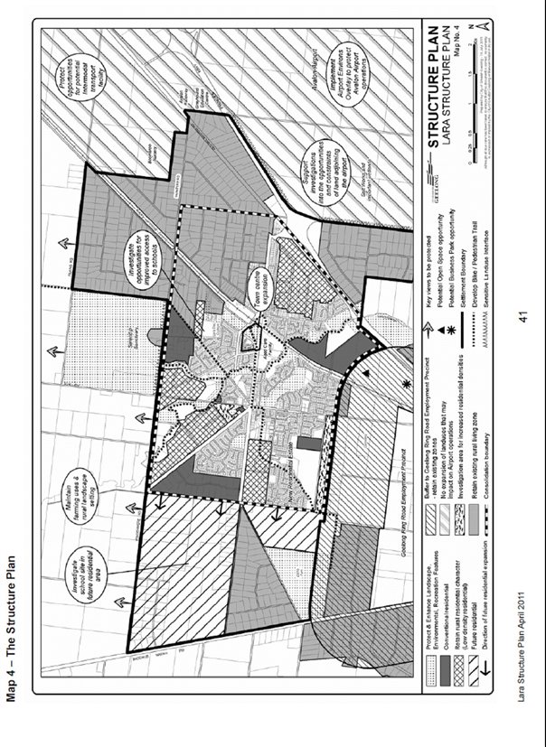
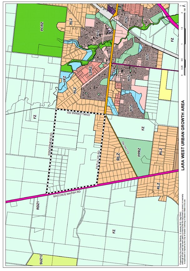
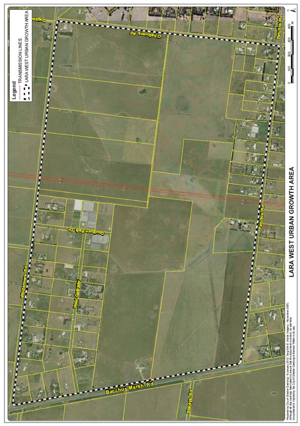
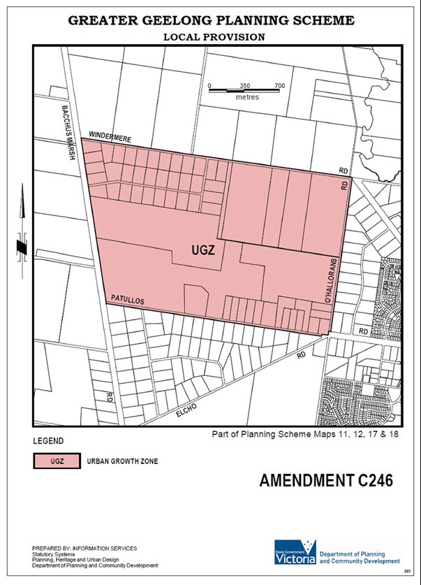
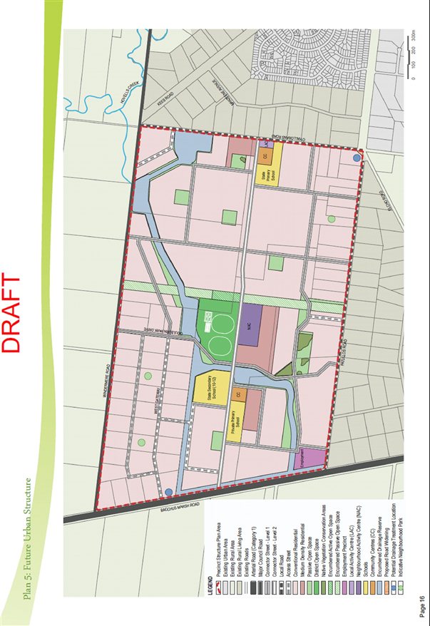
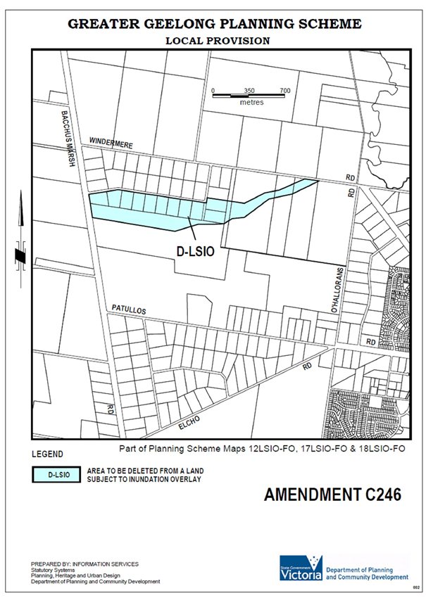
Portfolio: |
Planning - Cr Macdonald |
Source: |
Economic Development, Planning and Tourism - Planning Strategy |
General Manager: |
Peter Bettess |
Index Reference: |
Avalon Airport |
Avalon Airports Australia Pty Ltd released for consultation the “Draft Avalon Airport Land Use Plan” and the “Draft Avalon Airport Master Plan”. The preparation of these plans is a requirement under the lease agreement between the Linfox Group and the Commonwealth Government. As a key stakeholder the City of Greater Geelong is invited to comment on the Draft Land Use Plan and the Draft Master Plan.
The Draft Master Plan sets out a “broad framework for the development of the airport over the next 20 years” whilst noting that the ability of the airport to achieve its vision and the timing of future developments will be influenced by external factors.
Four key tenets for the future development of the airport are defined; passenger operations; technical aviation operations; freight; and retail and commercial developments.
The Draft Master Plan and Draft Land Use Plan are welcomed as a significant step towards providing clear direction for major growth and investment at the airport.
The City of Greater Geelong has fully supported the future development of Avalon Airport as it provides significant employment for the local community and has the potential to play an even greater role in the future by being an international gateway and attracting new business investment to the Geelong region. Diversification of land use at Avalon is warranted to ensure Avalon maximises its potential as a key aviation hub.
The extent and location of retail development at the airport proposed by the Land Use Plan is of concern. Significant retail development along the Princes Highway is contrary to Council’s adopted retail hierarchy, could undermine existing and planned retail expansion at Lara restricted retail expansion in North Geelong, and could ultimately have an adverse impact on existing commercial retail precinct across broader Geelong. Council also sought independent advice on the appropriate extent of retailing at Avalon, a limit of 10,000 square metres was recommended.
The Land Use Plan outlines the desire of the airport operator to assume the role of responsible authority for issuing planning permits on the airport site. This would remove Council’s decision making role and its ability to influence the future development of the airport land.
It is recommended that Council make a submission to the Draft Avalon Airport Land Use Plan and the Draft Avalon Airport Master Plan. This can be achieved by authorising the Mayor to write to Avalon Airports Australia to reiterate Council’s continued support for the future development of Avalon Airport but requesting changes to the Land Use Plan to limit the location and the amount of retailing on the airport site and to retain Council’s role as responsible authority for the airport site.
Cr Granger moved, Cr Macdonald seconded -
That Council authorise the Mayor to make a submission in support of the Draft Avalon Airport Land Use Plan and the Draft Avalon Airport Master Plan. The submission should request modification of the Plans:
to limit the location and the amount of retailing in the Princes Precinct to the area south of the Princes Freeway and north of the multi fuel pipeline which traverses the site being no more than 22 hectares in area
to limit the type of retailing allowable in the Princes Precinct to restricted retail (“big box”) type uses which will not compete with Central Geelong
and to recognise Councils continuing role as the responsible authority.
Carried.
Avalon Airport comprises 1753 hectares of land located south of the Princes Highway between Lara and Little River. The airport was previously used for defence purposes and is leased from the Commonwealth Government by Avalon Airports Australia Pty Ltd (AAA) which is owned by the Linfox Airports Group.
As shown on Attachment 4-1 the airport features one sealed north south runway with a parallel unsealed north south runway which is used by light aircraft for the biennial air show.
Jetstar commenced operations at Avalon in 2004 and Tiger Airways was based there briefly in 2010/11. Qantas heavy engineering maintenance is also based at Avalon. The airport is a significant local employer with approximately 1000 people working at Avalon.
The airport has significant scope for expansion in the future given the availability of land, lack of curfew, significant buffers from sensitive land uses, excellent access to the road network and the planned future rail connection. The Draft Avalon Airport Land Use Plan and the Draft Avalon Airport Master Plan were prepared to articulate the airport operator’s vision on how the airport should develop in the future. The Draft Land Use Plan and the Draft Master Plan are based on a twenty year time horizon from 2012-2032.
Future uses envisaged in the plans are numerous and varied including hotels, warehousing, light manufacturing, office development, retailing, corporate jet accommodation, aviation education and freight and logistics. Continued use of the airport for aircraft maintenance is also planned.
The Draft Master Plan and the Draft Land Use Plan identify precincts within the airport and articulate the vision for the future development of each. The Map at Appendix 4-1 illustrates the location of the eight precincts identified in the Draft Master Plan. Notably the Draft Land Use Plan identifies seven precincts, but the intent is consistent. A brief description of the existing use and proposed future use of each of the eight precincts is provided below.
Princes Precinct
This precinct is 200 hectares in area and abuts the Prince Highway. It is currently farmland and is the location of the existing sky sign. Recognising its exposure to passing traffic, it is intended to develop this area with retail and commercial facilities. Retail developments are required to be oriented to the Highway and provide sufficient car parking.
The car parking requirement, the requirement for development to maximise exposure to the Highway and the precinct’s isolation from the airport terminal would indicate that this is intended to be a standalone retail development which is not associated with the airport.
Retail uses including shop, restricted retail, service station and supermarkets are intended to be allowed in this precinct without a permit, and without a cap on floor space.
Terminals Precinct
This precinct is between 340-350 hectares in area, it contains the existing terminal building, passenger and rental car parking, access roads and waste water treatment facilities. Proposed future development of this precinct includes the proposed rail link and station, additional car parking and terminal facilities for both passengers and freight including freight warehousing. Retail uses including shop, restricted retail, service station and supermarkets are allowed in this precinct without a permit, and without a cap on floor space.
Beach Precinct
This precinct is 350 hectares in area. It is currently developed with hangars, refuelling facilities, taxiways, the air traffic control tower and other ancillary airport uses. Future uses planned for the precinct include warehousing and light industry related activities that benefit from close proximity to the airport and terminal. Additional freight or passenger terminal facilities would also be located in this precinct.
Retail uses including shop, restricted retail, service station and supermarkets are allowed in this precinct without a permit, and without a cap on floor space.
Terminals/Beach Precinct
This precinct is 250 hectares in area. The Draft Master Plan defines this precinct individually on the map as shown in Appendix 4-1; however the Draft Land Use Plan defines it as a combination of the two precincts discussed above. The existing and proposed land uses are discussed in the two precincts above. A significant portion of this land is allocated to Air Show during the biannual Air Show.
Green Precinct
This precinct is 445 hectares in area and is viewed as a long term development prospect. It is largely undeveloped featuring tree plantations and drainage facilities and is used during the air show. Future development for this precinct is not detailed and is likely to be constrained by the environmental values of the precinct.
Runway Precinct
This precinct is 180 hectares in area; it contains the existing runway and taxiways. Access is restricted at this location and to ensure safe aviation operations no development other than navigational aids is permitted.
Dandos Precinct
This precinct is 245 hectares in area and is currently used for farming. It is considered a longer term development area potentially to accommodate a motor sport facility. Group accommodation and a residential hotel are the notable uses allowed in this precinct without a permit.
Avalon East Precinct
This precinct is 235 hectares in area; it is undeveloped and is used as farmland and for activities associated with the air show. This precinct is the location of the proposed north south general aviation runway and may also be developed with additional hangars with the Master Plan identifying the potential for a future parallel north south run way for jet aircraft in the long term. It is identified that this would require acquisition of land to the south.
General aviation users were encouraged by the State Government to relocate to Avalon following the closure of the Geelong Airport in the Armstrong Creek Urban Growth Area, on the proviso that this did not compromise Avalon’s commercial operations.
A review of the Draft Land Use Plan and the Draft Master Plan has identified two significant points on concern for Council. The scale and location of retail and the removal of planning powers for the airport from the Council to the airport operator.
Retailing
As noted above the future development of Avalon will be reliant upon a degree of diversification, but it is crucial that future development be integrated with the use of the land as an airport. Stand alone retailing as envisaged in the Princes Precinct is not supported as it has the potential to have significant impacts on existing retailing given the significance of these issues it was considered appropriate to get independent expert advice in order to ensure Council was fully informed in responding to the Master Plan.
Council commissioned a “Review of Retail and Commercial Components of the Draft Avalon Airport Masterplan” when the first draft of the Master Plan was released in 2010 to obtain independent advice about the potential implications of the retail components of the Master Plan. The Review noted that the retail development envisaged in the Princes Precinct would generate net disbenefits for the region as residents would have to travel further to access retail goods. The Review noted that the proposal was “highly speculative” as retail operators may prefer to invest elsewhere in the Geelong region which there are sites available which have existing and proposed population catchments, as at Waurn Ponds or Armstrong Creek for example.
The Review concluded that “the proposed retail activity in the Princes Precinct is not likely to be serving the needs of airport passengers and visitors but will be mainly aimed at the needs of regional residents, principally residents of Greater Geelong. Because of this, retail development at Avalon may have an adverse impact on retail and activity centre development elsewhere in Greater Geelong.”
A maximum retail floor space of 10,000 square metres integrated into an overall commercial/business precinct within the airport was recommended in the Review. This information was relayed to AAA but has not been reflected in the latest draft. The recommendation in the Review remains relevant given that population growth in this area is already being met with additional new retailing planned for Lara and North Geelong. Currently the floor space limit for retailing at Avalon is 3000 square metres.
Wyndham Council officers have agreed to work with Council and support City of Greater Geelong’s position in the report.
Responsible Authority
The Land Use Plan indicates the desire of the airport operator (AAA) to assume the role of responsible authority for issuing planning permits on the airport site. This would remove Council’s decision making role and remove its ability to influence the future development of the airport land.
The Draft Land Use Plan indicates that there would be no avenue of appeal against decisions, affecting the ability to appeal to VCAT, no public authority involved in land use decisions and in relation to the giving of notice of applications the seeking of “informal comment” would be at the discretion of the airport operator. This contrasts to the existing planning controls whereby Council may give notice of an application if it believes that the grant of a permit would result in adverse amenity impacts. Similarly the right to lodge an appeal with VCAT is also currently provided.
It is considered that that a significant review of the planning controls relating to Avalon Airport is appropriate to minimising the necessity for planning permits and expedite development approvals. This will enhance Avalon Airport in respect to investment attraction generally and demonstrate the status of Avalon Airport as a key regional economic driver. The City of Greater Geelong has previously committed to delivering a planning regime of this nature. It is however considered that the complete removal of any public process associated with the planning and approval of development may not serve the communities long term interests.
In conclusion it is accepted that significant further diversity in land use should be supported and encouraged at Avalon to maximise its future development potential and ultimately achieve international airport status. However future development should be generally linked to the overall use of the site as an airport and ensure the curfew free operation of the airport. Council will continue to work with and promote Avalon as one of the absolute key assets in the region and ensure future decision making supports its continued development for the benefit of the region.
The lodgement of a submission on the Draft Land Use Plan and the Draft Master Plan will not have any adverse environmental impacts. Future development proposals which may result following completion of the plans will require examination of environmental impacts in greater detail. AAA is required to develop an Environment Management Strategy for the approval of the Commonwealth Government.
The lodgement of a submission on the Draft Land Use Plan and the Draft Master Plan will not result in a financial impost on Council.
The lodgement of a submission has no statutory implications for Council. The submission is consistent with Councils adopted polices which seek to protect and promote the retail hierarchy identified at Clause 21.07-8 of the Greater Geelong Planning Scheme.
No Council officer involved in the drafting of this report has any direct or indirect interest, in accordance with Section 80(c) of the Local Government Act in the land to which this report relates.
There are no risks associated with lodging submission to the Draft Avalon Airport Land Use Plan and the Draft Avalon Airport Master Plan.
Relevant social considerations in the submission to the Draft Avalon Airport Land Use Plan and the Draft Avalon Airport Master Plan include the need to provide services such as retailing in close proximity to where people live and work.
The response from Council to Avalon will be made public, and a detailed release in relation to Council’s position will be made available to the press.
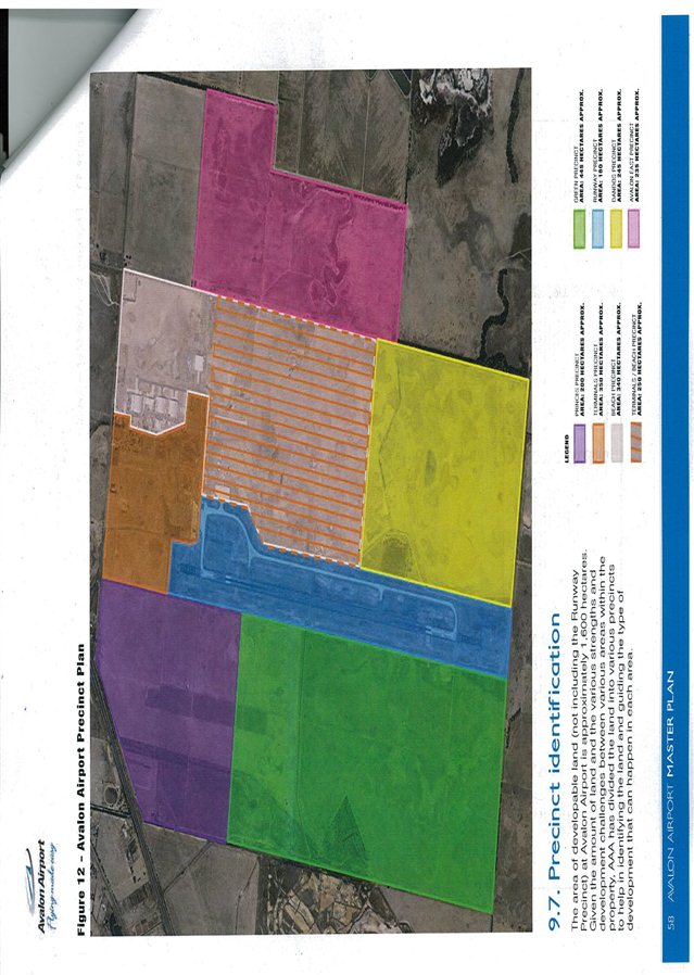
Portfolio: |
Major Projects – Cr S Kontelj |
Source: |
Projects, Recreation & Central Geelong |
General Manager: |
Dean Frost |
Index Reference: |
Project: Yarra Street Pier Reconstruction / Cruise Ship Destination / Communications |
The reconstruction of Yarra Street Pier has been a long term funding priority project for Council. In partnership with Regional Development Victoria, Tourism Victoria and Geelong Otway Tourism, the City of Greater Geelong commissioned a business case for the reconstruction of Yarra Street Pier. The anticipated cost of the proposed development is $33m. Council has committed $5m to build a new pier, along with the Royal Geelong Yacht Club who has pledged $2.5m. It is proposed to approach other levels of Government for the remaining funds.
Benefits of a reconstructed Yarra Street Pier could be to:
Present Geelong as a desirable destination for cruise ship operators (up to 25 ships per annum);
Accommodate naval ships (up to 4 per year);
Improve infrastructure and provide capacity to enable the expansion of events such as the Festival of Sails;
Attract additional day/weekend recreational boat visits to Geelong;
Provide a safe harbour in Corio Bay;
Improve community connections with the bay via fishing and promenading.
The Yarra Street Pier reconstruction (Geelong: Cruise Ship Destination) project is now at a critical stage and is being promoted as Council’s current (‘shovel ready’) funding priority.
It is proposed to establish a Project Governance Structure (refer Appendix 1) to drive the interest in the project with the objective to secure funding from other levels of Government.
This report requests that Council endorses the Terms of Reference (refer Appendix 2) for the Yarra Street Pier Reconstruction Steering Committee and the associated Governance Structure for the Committees therein.
The Mayor vacated the Chair at 8:10pm
Cr Granged assumed the Chair at 8:10pm
Cr S Kontelj moved, Cr Harwood seconded -
That Council endorses the Proposed Yarra Street Pier Reconstruction Steering Committee Project Governance Structure (Appendix 5-1), and adopts the Terms of Reference for the Project Steering Group (Appendix 5-2) to advance the Yarra Street Pier Reconstruction project.
The Mayor re-entered the meeting room at 8:16pm
Carried.
The reconstruction of Yarra Street Pier has been a long term funding priority project for Council. A business case completed recently has estimated the cost of the project to be $33 million. Council has committed $5m to build a new pier, along with the Royal Geelong Yacht Club who has pledged $2.5m.
Council secured funding from Tourism Victoria, Regional Development Victoria and Geelong Otway Tourism to match Council’s funds to commission a business case for the reconstruction of Yarra Street Pier. The business case focused on the development of a bespoke pier able to cater for cruise ships, naval vessels and the major events elements, as well as the opportunities for recreation. Geelong-based GHD was appointed to undertake and complete the business case work.
The business case highlighted that a reconstructed Yarra Street Pier would have the benefits of:
Greater economic returns for both the Geelong region ($41m) and the State ($52.4m);
Approximately 403 FTE new jobs over the first ten years of operation, together with 234 during construction;
Diversifying the waterfront experience leading to increased activity in Central Geelong;
Increasing maritime uses of Corio bay by creating a safe harbour to benefit all users (such as recreational boating);
Securing for the Geelong region a segment of the cruise ship market with up to 4 cruise ship visits per season from 2015, growing to 22 in 2025;
Improved liveability and profile for Geelong as a Waterfront city;
Regular port for visiting naval vessels with up to 4 visits per year;
Improve profile of Port Philip Bay as a marine destination, thereby increasing regional exposure;
Attract significant major events and build on Geelong’s growing reputation as a host city for events, as a direct result of the new pier infrastructure and;
Expand the Festival of Sails event (worth an additional $1.2m spend) and attract1-2 additional yachting regattas per year.
To continue the momentum with this project, it is proposed to establish a project Governance Structure that included input from key regional agencies.
Appendix 5-1 describes the proposed structure that has Council responsible for the project.
It is proposed a Steering Committee be established involving relevant portfolio councillors and key council staff, to oversee and drive project. The primary focus of the group will to be secure the funding required to facilitate the construction of the project.
It is also proposed to establish a Project Reference Group chaired by the Mayor. On the advice of the Steering Committee invitations to participate on this group will be issued to key stakeholder/lobby groups. This will include G21 Regional Alliance, Chamber of Commerce, Committee for Geelong, Geelong Otway Tourism.
The key tasks for the project in the immediate future are to consider work required over the next 12 – 18 months and securing a commitment to invest from State and/or Federal Government.
There are no environmental issues associated with the establishment of this Governance structure.
The capital required for a project of this scale and nature would require State / Federal government funding support of $25.5m. Council has committed $5m and the Royal Geelong Yacht Club has committed $2.5m.
Terms of Reference for the Steering Committee established the Committee as an advisory committee. No powers are delegated and any actions or expenditure which may be necessary can be administered by the Chief Executive Officer under delegation issued by Council.
There are no conflicts of interest by council officers in the preparation of this report.
There are no known risks in the establishment of the governance for this project.
There are no known risks in the establishment of the governance for this project.
Communication with respect to the committees will be under the auspice of the City of Greater Geelong.
Portfolio: |
Community Development – Cr Fisher |
Source: |
Community Services / Health & Local Laws |
General Manager: |
Jenny McMahon |
Index Reference: |
Subject: Animal Management 2012 |
The purpose of this report is to brief Councillors on the actions undertaken in delivering the Domestic Animal Management (DAM) Plan 2008 – 2012.
Council has a legal obligation under the Domestic Animals Act (1994) to produce a DAM Plan. The purpose of the Act is to promote animal welfare, responsible pet ownership and to protect the community and environment.
A range of actions focusing on compliance, policy, education, promotion and marketing, were implemented. (See Appendix 6-1).
Due to the nature and complexity of some actions and because of several unplanned activities such as the introduction of new restricted breed legislation and microchipping requirements for pets being advertised for sale, three matters remain outstanding. It is intended to bring these forward to the new Domestic Animal Management Plan for 2013 – 2017. These outstanding actions relate to the mandatory desexing of cats, the establishment of pet parks and pet selection programs.
With the Domestic Animal Management Plan 2008 in its final year, the Health and Local Laws department has commenced seeking feedback to assist with the development of a new DAM Plan for 2013 – 2017.
Cr Fisher moved, Cr Granger seconded -
That Council note the 2011-2012 Domestic Animal Management Plan Annual Report (Appendix 6-1).
The Mayor assumed the Chair at 8:17pm
Carried.
The plan was adopted by Council in June 2008, after extensive community consultation.
The plan identified three strategic objectives:
Responsible Pet Ownership
Dogs in Public Places, and
Leadership
The principles underpinning the actions were:
The belief that pets contribute to quality of life
A requirement to balance the needs of those who own and those who do not own pets
To value responsible pet ownership
Proactive animal management and education
Ensuring the environment is protected from the negative impacts of dogs and cats
To work in partnership with community, stakeholders and special interest groups
Council to play a leadership role in animal management.
The DAM Plan was adopted by Council in June 2008 after considerable consultation with community, stakeholders, and interested groups. The implementation of policy development, adherence to compliance issues, free education seminars, and communication and marketing campaigns were the main methods for addressing the actions identified under the key objectives.
The three year plan was extended in 2011 for a further twelve months. All but three of the initiatives were addressed. Three actions will continue in 2013. These are:
The introduction of compulsory desexing for all pets
Research partnership to establish pet activity areas
Develop and make available information on pet selection
The outcomes achieved during the life of the plan are contained in the Domestic Animal Management Plan Annual Report for the Department of Primary Industries (See Appendix 6-1).
In summary, approximately 85% of actions listed in the DAM Plan 2008 – 2012 were completed. A review of these outcomes is detailed in Appendix 6-1.
Geelong is a community with the largest dog and cat population of any Victorian municipality, with 35,783 registered dogs and 10,912 registered cats. The DAM Plan was developed to meet its obligations under the Domestic Animals Act, using a mix of education and regulatory approaches, leadership and guidance in facilitating responsible pet ownership, and dogs in public places.
Responsible Pet Ownership
Responsible Pet Ownership challenges included the compulsory introduction of microchipping of all new cat and dog registrations. A number of microchipping and registration ‘road-shows’ were conducted and were well received by the community. These Roadshows have been an excellent way of educating pet owners on the benefits of microchipping and their legal obligations under the Act.
Guest speakers in animal behaviour, dog training, and pet selection were also creditable drawcards for a series of education workshops and seminars.
Dog Control Orders
Council adopted and implemented a range of dog control orders throughout the municipality including coastal and open space areas, public places, and areas under the control of other agencies. These dog controls provided residents with the information they need as to where and when they can walk their dog/s on and off lead and other considerations to protect the community and the environment.
During the term of this Plan, Council has entered into service agreements to conduct dog patrols with the Corangamite Catchment Management Authority and the Barwon Coast Committee of Management.
The development of “Walk Time”, a pocket-sized brochure containing a map of on and off leash zones, together with the provision of signage has been successful in increasing the awareness of the community as to where and when pet owners can walk their dog on and off leash. An ongoing challenge exists for Council to ensure compliance with the minority of pet owners who choose to ignore dog orders in place.
Animal Patrols
With a total land area of 1,250 square kilometres, 349 reserves and parks, 1,300 kilometres of footpaths and shared use paths, over 115 kilometres of creeks and trails, and a vast coast line from Avalon Beach in the north east, along the Bellarine Peninsula coastline to Breamlea in the south (approximately 100 km), the task of conducting regular animal patrols that meet community expectations remains a major challenge for Council’s Animal Management team comprising of seven officers.
To improve service delivery to the community, these Animal Management Officers have each been allocated defined geographic areas in which they are responsible to:
Undertake patrols along pathways, tracks and trails (on foot and cycle)
Issue infringements for non-compliant matters
Provide education to pet owners
Improve case management of animal amenity complaints
Investigate dog attacks and dog rush incidents
A dedicated Animal Collections Officer is responsible for the day to day collection of stray dogs and cats across the municipality.
Dog Waste
It is believed that a minority of dog owners continue to disregard the regulations in relation to ‘picking up their dogs waste’ regardless of the number of litter and special dog waste bins that have been installed within the community. Often people walk past these bins failing to collect a disposal bag to collect the waste.
It is difficult for officers to issue infringements for people not ‘picking up their dogs waste’ as the dog owner denies their dog is responsible. However, under the Local Law, Animal Officers are able to issue an infringement if dog owners are not carrying a device or bag for the purpose of removing waste from the road or council land.
Restricted Breed
In 2011, following the death of a young child, State Legislation was introduced in relation to the declaration of restricted breed dogs – (American Pit Bull Terrier). This involved the cancellation of a previous amnesty in relation to the registration of Restricted Breed Dogs, the introduction of the new restricted breed assessment standard and the establishment of a ‘hot line’ for community feedback. This process impacted on staff resources by taking them away from their core duties. Numerous calls and suspected sightings of American Pit Bull Terrier type dogs were investigated and processed by council officers.
The ongoing impact will be the need to conduct approximately 1,400 assessments of suspected restricted breed dogs (American Pit Bull Terrier type dogs) for 2012/2013.
Cat Population
During the past four years many cats/kittens were at risk of being euthanised due to the high number of impounds and low rate of rehoming such animals. Of the 3227 impounded cats for 2011, only 205 cats were claimed by their owner, 616 were rehoused with 2,406 euthanased (75%) – many of the euthanased cats were kittens. It is estimated that up to 50% of cats present in the city may be unregistered.
The above mentioned cat euthanasia rates compare unfavourably to the dog euthanasia rates of 32% (2011figures). It is encouraging that less cats have been impounded in 2011 and as a consequence there has been a 20% reduction in the numbers of cats that have been euthanased.
Many responsible pet owners support the notion of desexing their pets, particularly with respect to cats. However, the cost of doing so may be a prohibitive factor in making it a low priority for pet owners.
Cats have the propensity to breed rapidly. Evidence indicates a female cat and her mate (who are not desexed) and their offspring can produce two litters each per year, with approximately three kittens per litter surviving. Based on this data, over a four year period, as many as 2,107 cats can be produced.
It is envisaged that this issue will be carried forward to the next DAM Plan process with an aim to reduce this trend by exploring options for desexing programs in partnership with external agencies.
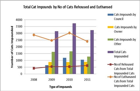
DAM Plan in 2012/2013
Key challenges that have been identified for the next DAM Plan include:
The rise in the number of dogs at large and repeat offenders
The increase in the number of dog attacks and menacing dogs
The increase in barking dog complaints causing distress for the complainant and the owner
The number of nuisance cats
The number of euthanised cats and kittens due to non-desexing and/or non-confinement to property
Pet owners not registering their dogs or cats in accordance with the Domestic Animals Act – (1994), prevents the ability to return animals to their owners and places occupancy pressure on the Pound
Dog control orders are not being observed by some dog owners, in some locations
Dog owners not picking up their dogs’ waste or alternatively discarding used litter bags on tracks/paths
The inappropriate selection of pets, and the unsuitability of a pet to a person and/or property
The introduction of restricted breed legislation in 2011 will see the need to schedule 1,400 restricted breed audits (Pit Bull type dogs) for 2012/2013.
The number of unregistered dog and cat breeders causing an over population. This scenario can impact on impound and euthanasia rates and often discarded/rejected animals
Dogs causing a nuisance and not being effectively controlled in off lead areas.
Council continues to work actively with the Pound provider and animal shelters to rehome suitable dogs and cats. These pets have been vaccinated, wormed, desexed and temperament tested, prior to being rehomed.
Pet numbers are expected to increase along with the City’s increasing population. The trend of living in new communities with smaller residential allotments is likely to escalate the number of dog and cat problems/nuisances in the future if owners do not practice responsible pet selection and pet ownership principles.
It is recognised that dogs need opportunities to exercise outside their home environment. To encourage harmony and coexistence with other public space users, Council has adopted a range of on-leash and off-leash areas for dogs (and their owners) in public places.
Pet owners need to become more responsible, picking up their dogs’ waste, which can cause disease, pollution and damages our waterways. Ample dog litter bins have been provided and in some cases dog poo bags have also been provided in popular dog walking areas.
While there is a cat curfew in place, some cat owners continue to allow their cats to roam free between sunset and sunrise. Cats that roam at night often destroy wildlife, defecate in people’s gardens and create a nuisance to the neighbourhood.
Ongoing education, officer patrols and compliance are the key to reducing these impacts on the environment.
In November 2005 a number of amendments were introduced to the Domestic Animals Act 1994 whereby all Councils in the State were required to prepare a Domestic Animal Management Plan, including a process for evaluating and measuring its progress.
The attached DAM Plan Annual Report outlining the actions achieved during the past 12 months is required to be submitted to the Department of Primary Industries each year.
Council is required to develop a new Domestic Animal Management Plan every four years and presently the Health and Local Laws department has commenced that process through seeking stakeholder feedback.
There is no direct or indirect material interest applicable by Council Officers in the formation of this report.
The Domestic Animal Management Plan aims to provide responsive animal management services to the community, limiting the risk associated with nuisance dog incidents such as menacing and rushing dogs, dog attacks, and dogs at large. The plan has focussed on education and compliance to address these issues. As the population within the City continues to grow so is the likelihood of an increase in incidents which is evident by the graph below.
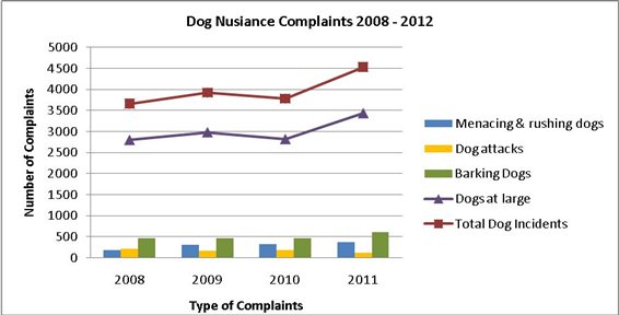
|
Key trends: |
(1) |
The direct relationship between dogs at large and dog incidents |
|
|
(2) |
The gradual increase in barking dog complaints |
2011 statistics indicate a slight reduction in dog attacks which was encouraging. However, 2012 statistics (up to the end of July) indicate that there have been 109 dog attacks for this period.
The emphasis on incident prevention will be paramount in the development of the next DAM Plan.
The objectives of the DAM Plan recognise a community that values responsible pet ownership and high standards of animal welfare.
The actions undertaken in the 2008-2012 DAM Plan strive to promote safe and co-operative behaviour by pet owners and providing a municipality that is pet friendly. Council recognises that not everyone feels comfortable around dogs and some environments are sensitive to their use. A shared pathways charter was introduced as a means of creating and maintaining a healthy and respectful relationship among all pathway users on the tracks and trails of the municipality.
The actions under the DAM Plan are well communicated to the residents of the City. Methodologies used include print media, radio, internet, social media, and workshops/forums. Microchipping and Registration Roadshows have proved invaluable for communicating one-on-one with pet owners. A number of these roadshows have been held at dog clubs creating a greater rapport with club members and animal officers.
Portfolio: |
Democracy & Governance, Communications, Sport & Recreation - Cr Mitchell |
Source: |
Community Services |
General Manager: |
Jenny McMahon |
Index Reference: |
Subject: Councillor Community Grants Program 2011/12 |
The Councillor Community Grants Program has an annual budget allocation of $240,000. This amount is divided into the 12 council wards which equates to an annual allocation of $20,000 per Ward that is available to expend on groups that apply and are eligible under this grant program.
As part of the accountability framework for managing the Councillor Community Grants Program, details of successful applications and allocations are reported to Council.
This report provides a statement of allocations under the program during the period of 1 April to 30 June 2012. (see Appendix 7-1)
The total amount funded under this program for period 1 April to 30 June 2012 was $59,310 allocated to 36 community organisations.
The total amount funded for the 2011/12 financial year was $240,000 allocated amongst 144 community organisations.
Cr Fisher moved, Cr Farrell seconded -
That Council:
note the statement of allocations granted to community groups and organisations for the period 1 April to 30 June 2012.
commends and congratulates the community groups and organisations who have received funding under the Councillor Community Grants Program for their efforts and contribution to the Geelong community.
Cr Granger left the meeting room at 8:24pm
Cr E Kontelj left the meeting room at 8:26pm
Cr Granger re-entered the meeting room at 8:26pm
Cr E Kontelj re-entered the meeting room at 8:27pm
Carried.
The Councillor Community Grants Program is for not-for-profit community groups and organisations who can apply for funds to support either ward based or municipal wide activities or events that will benefit the Geelong community. In order to receive funds, applicants must comply with the established guidelines which govern the grant program.
As part of the ongoing accountability process, a report on the groups that have received funds is presented to Council on a quarterly basis
The total amount funded under this program for the period 1 April to 30 June 2012 was $59,310 allocated to 36 community organisations. This brings the total amount funded for the period 1 July 2011 to 30 June 2012 to $240,000 allocated amongst 144 community organisations.
The allocation of grants assists with meeting the objectives of Council by providing an opportunity to enhance the well-being of the community by building social capital and enabling community engagement through the provision of funds to assist with local activities.
Appendix 7-1 provides a list of groups, the title of the activities funded and the amounts that were allocated during this period, as well as a summary of balances.
Some of the projects supported via this grant program include a variety of environmental activities.
Development of the GEEYOUNG Project was carried out utilising funds in the 2011/12 Budget. Any financial implications of the report for Council will be considered as part of future budget processes.
The provision of grants to the community supports local, community organisations and endorses the aims of City Plan and the G21 Regional Plan.
This report is presented in accordance with the City of Greater Geelong Grants and Donations Policy.
The provision of grants is carried out in accordance with the Local Government Act
The Councillor Community Grants Program has provision in the assessment process to record any conflict of interest relating to each grant application that is assessed.
The Councillor Community Grants Program is governed in accordance with Council’s monitoring, reporting and accountability framework.
Successful applicants are provided with an evaluation form for their completion and return to Council as a record of the outcome of the grant funding they received. Annual audits are also conducted on a sample group of grant recipients.
The provision of the Councillor Community Grants Program provides an opportunity to support and strengthen communities to provide a broad range of activities for the benefit of the Geelong community.
The provision of the Councillor Community Grants provides an opportunity to support and strengthen communities to provide a broad range of activities for the benefit of the Geelong community.
Councillor Community Grants Program 2011/12 Appendix 7-1
List of Allocations – 1 April to 30 June 2012
|
Ward |
Councillor |
Organisation |
Project |
Amount Approved |
Breakdown and Totals Where the Applicant was awarded funds for their project from multiple Ward allocations |
|
Austin |
Mitchell |
BATForce |
A Place for Young People |
$ 2,400.00 |
|
|
Austin |
Mitchell |
Geelong Food Relief Centre |
Upgrade to Power Phasing |
$ 100.00 |
Austin $100, Corio $50, Windermere $500 - TOTAL ALLOCATION $650.00 |
|
Austin |
Mitchell |
Geelong Technical Education Centre |
Breamlea Project Flim Night |
$ 200.00 |
Austin $200, Buckley $1,750.00, Cheetham $600, Corio $200, Cowie $50, Deakin $100, Kardinia $100 - TOTAL ALLOCATION $3,000.00 |
|
Austin |
Mitchell |
St Albans Football & Netball Club - Senior Section |
Senior Football Jumpers & netball uniforms |
$ 4,000.00 |
|
|
Austin |
Mitchell |
The Compassionate Friends Victoria Inc |
Establishment of TCF's Grief Centre Library |
$ 150.00 |
Austin $150, Deakin $50, Kardinia $300, Windermere $100 - TOTAL ALLOCATION $600.00 |
|
Austin |
Mitchell |
Thomson Football & Netball Club - Senior Sections |
Senior Football Jumpers & Netball Uniforms |
$ 4,000.00 |
|
|
Austin |
Mitchell |
Vietnam Veterans Assoc of Aust - Geelong & District Sub-branch |
National Congress - Bus Transport for Delegates |
$ 900.00 |
|
|
Austin |
Mitchell |
Wathaurong Aboriginal Co-operative |
Community Health Day |
$ 250.00 |
Austin $250, Corio $50, Deakin $50, Kardinia $50, Windermere $50 - TOTAL ALLOCATION $450.00 |
|
Austin Total |
|
|
|
$ 12,000.00 |
|
|
Beangala |
Farrell |
Ocean Grove Community Garden Auspiced by Ocean Grove Neighbourhood Centre |
Ocean Grove Community Garden |
$ 2,000.00 |
|
|
Beangala |
Farrell |
Ocean Grove Collendina Cobras Junior Football Club |
Football Jumpers |
$ 2,000.00 |
|
|
Beangala |
Farrell |
Ocean Grove Senior Citizens |
Update existing score boards |
$ 890.00 |
|
|
Beangala |
Farrell |
Ocean Grove Toy Library Inc |
Storage and play items |
$ 1,000.00 |
|
|
Beangala |
Farrell |
Springdale Neighbourhood Centre |
iPads Project |
$ 3,015.00 |
Beangala $3015, Coryule $985 - TOTAL ALLOCATION $4,000.00 |
|
Beangala Total |
|
|
|
$ 8,905.00 |
|
|
Brownbill |
Abley |
AUCA Association Union of Cultures Australia Auspiced by Congolese Association Inc |
Life in Australia Film Project |
$ 100.00 |
Brownbill $100, Buckley $100, Coryule $130, Windermere $100 - TOTAL ALLOCATION $430.00 |
|
Brownbill |
Abley |
Blokes Day Out Launch Committee Auspiced by Barwon Health |
Blokes Day Out |
$ 200.00 |
Brownbill $200, Corio $200, Deakin $200, Windermere $125 - TOTAL ALLOCATION $725.00 |
|
Brownbill |
Abley |
Geelong West Neighbourhood House Inc |
Workshops |
$ 1,405.00 |
|
|
Brownbill Total |
|
|
|
$ 1,705.00 |
|
|
Buckley |
Richards |
AUCA Association Union of Cultures Australia Auspiced by Congolese Association Inc |
Life in Australia Project |
$ 100.00 |
Brownbill $100, Buckley $100, Coryule $130, Windermere $100 - TOTAL ALLOCATION $430.00 |
|
Buckley |
Richards |
Barwon Grove Girl Guides Auspiced by Girl Guides Victoria |
Purchase of Trailer |
$ 3,250.00 |
|
|
Buckley |
Richards |
Barwon Heads Senior Citizens Centre |
Purchase of Quilting Machine |
$ 1,570.00 |
|
|
Buckley |
Richards |
Friends of the Bluff |
Barwon Heads Community Show Bags |
$ 2,000.00 |
|
|
Buckley |
Richards |
Geelong Lutheran College |
Purchase of Marquees |
$ 2,940.00 |
|
|
Buckley |
Richards |
Geelong Technical Education Centre |
Breamlea Project Flim Night |
$ 1,750.00 |
Austin $200, Buckley $1,750.00, Cheetham $600, Corio $200, Cowie $50, Deakin $100, Kardinia $100 - TOTAL ALLOCATION $3,000.00 |
|
Buckley |
Richards |
Grovedale Primary School |
Vegetable Garden & Chicken Coop area |
$ 3,000.00 |
|
|
Buckley |
Richards |
Rice Village |
Quality of Life Project |
$ 1,540.00 |
|
|
Buckley Total |
|
|
|
$ 16,150.00 |
|
|
Cheetham |
Macdonald |
Geelong Technical Education Centre |
Breamlea Project Flim Night |
$ 600.00 |
Austin $200, Buckley $1,750.00, Cheetham $600, Corio $200, Cowie $50, Deakin $100, Kardinia $100 - TOTAL ALLOCATION $3,000.00 |
|
Cheetham Total |
|
|
|
$ 600.00 |
|
|
Corio |
Fisher |
Blokes Day Out Launch Committee |
Barwon Health |
$ 200.00 |
Brownbill $200, Corio $200, Deakin $200, Windermere $125 - TOTAL ALLOCATION $725.00 |
|
Corio |
Fisher |
Geelong Food Relief Centre |
Upgrade to Power Phasing |
$ 50.00 |
Austin $100, Corio $50, Windermere $500 - TOTAL ALLOCATION $650.00 |
|
Corio |
Fisher |
Geelong Technical Education Centre |
Breamlea Project Flim Night |
$ 200.00 |
Austin $200, Buckley $1,750.00, Cheetham $600, Corio $200, Cowie $50, Deakin $100, Kardinia $100 - TOTAL ALLOCATION $3,000.00 |
|
Corio |
Fisher |
St Thomas Aquinas Norlane & St Francis Xavier |
Learning Better together Planning Day |
$ 200.00 |
|
|
Corio |
Fisher |
Wathaurong Aboriginal Co-operative |
Community Health Day |
$ 50.00 |
Austin $250, Corio $50, Deakin $50, Kardinia $50, Windermere $50 - TOTAL ALLOCATION $450.00 |
|
Corio Total |
|
|
|
$ 700.00 |
|
|
Coryule |
Doull |
AUCA Association Union of Cultures Australia Auspiced by Congolese Association Inc |
Life in Australia Project |
$ 130.00 |
Brownbill $100, Buckley $100, Coryule $130, Windermere $100 - TOTAL ALLOCATION $430.00 |
|
Coryule |
Doull |
Batman Park Carpet Bowls Club Auspiced by Indented Head Community Association Inc |
Replacement of Carpet for Indoor Bowls |
$ 1,565.00 |
|
|
Coryule |
Doull |
Indented Head Community Association Inc |
Purchase of new printer |
$ 500.00 |
|
|
Coryule |
Doull |
Springdale Neighbourhood Centre |
iPads Project |
$ 985.00 |
Beangala $3015, Coryule $985 - TOTAL ALLOCATION $4,000.00 |
|
Coryule |
Doull |
St Leonards Tennis Group |
Replace net posts and net winders |
$ 1,000.00 |
|
|
Coryule Total |
|
|
|
$ 4,180.00 |
|
|
Cowie |
Kontelj (E) |
Geelong Technical Education Centre |
Breamlea Project Flim Night |
$ 50.00 |
Austin $200, Buckley $1,750.00, Cheetham $600, Corio $200, Cowie $50, Deakin $100, Kardinia $100 - TOTAL ALLOCATION $3,000.00 |
|
Cowie Total |
|
|
|
$ 50.00 |
|
|
Deakin |
Nelson |
Bellaire Primary School |
Reggio Emilia Inspired Prep Program |
$ 1,900.00 |
|
|
Deakin |
Nelson |
Blokes Day Out Launch Committee Auspiced by Barwon Health |
Blokes Day Out |
$ 200.00 |
Brownbill $200, Corio $200, Deakin $200, Windermere $125 - TOTAL ALLOCATION $725.00 |
|
Deakin |
Nelson |
Geelong Technical Education Centre |
Breamlea Project Flim Night |
$ 100.00 |
Austin $200, Buckley $1,750.00, Cheetham $600, Corio $200, Cowie $50, Deakin $100, Kardinia $100 - TOTAL ALLOCATION $3,000.00 |
|
Deakin |
Nelson |
The Compassionate Friends Victoria Inc |
Establishment of TCF's Grief Centre Library |
$ 50.00 |
Austin $150, Deakin $50, Kardinia $300, Windermere $100 - TOTAL ALLOCATION $600.00 |
|
Deakin |
Nelson |
Wathaurong Aboriginal Co-operative |
Community Health Day |
$ 50.00 |
Austin $250, Corio $50, Deakin $50, Kardinia $50, Windermere $50 - TOTAL ALLOCATION $450.00 |
|
Deakin Total |
|
|
|
$ 2,300.00 |
|
|
Kardinia |
Harwood |
Geelong Technical Education Centre |
Breamlea Project Flim Night |
$ 100.00 |
Austin $200, Buckley $1,750.00, Cheetham $600, Corio $200, Cowie $50, Deakin $100, Kardinia $100 - TOTAL ALLOCATION $3,000.00 |
|
Kardinia |
Harwood |
Oberon South Primary School |
School Improvements |
$ 3,000.00 |
|
|
Kardinia |
Harwood |
Rotaract Club of Belmont |
Drama Camp |
$ 1,650.00 |
|
|
Kardinia |
Harwood |
The Compassionate Friends Victoria Inc |
Establishment of TCF's Grief Centre Library |
$ 300.00 |
Austin $150, Deakin $50, Kardinia $300, Windermere $100 - TOTAL ALLOCATION $600.00 |
|
Kardinia |
Harwood |
Wathaurong Aboriginal Co-operative |
Community Health Day |
$ 50.00 |
Austin $250, Corio $50, Deakin $50, Kardinia $50, Windermere $50 - TOTAL ALLOCATION $450.00 |
|
Kardinia Total |
|
|
|
$ 5,100.00 |
|
|
Kildare |
Kontelj (S) |
Fight Cancer Foundation |
Purchase of Equipment |
$ 500.00 |
|
|
Kildare |
Kontelj (S) |
Dragons Abreast Geelong Inc |
Purchase of Equipment |
$ 1,000.00 |
|
|
Kildare |
Kontelj (S) |
Fyans Park Primary School |
iLearn with iPads |
$ 1,000.00 |
|
|
Kildare |
Kontelj (S) |
Geelong Cement Bowls Club |
Painting Club House Project |
$ 1,000.00 |
|
|
Kildare |
Kontelj (S) |
Islamic Society of Geelong |
Upgrade of Windows & Doors |
$ 1,110.00 |
|
|
Kildare |
Kontelj (S) |
Newtown Pipe Band |
Purchase of New Chanters |
$ 1,000.00 |
|
|
Kildare |
Kontelj (S) |
St John's Lutheran School |
Mothers Day Fete |
$ 1,000.00 |
|
|
Kildare Total |
|
|
|
$ 6,610.00 |
|
|
Windermere |
Granger |
AUCA Association Union of Cultures Australia Auspiced by Congolese Association Inc |
Life in Australia Project |
$ 100.00 |
Brownbill $100, Buckley $100, Coryule $130, Windermere $100 - TOTAL ALLOCATION $430.00 |
|
Windermere |
Granger |
Blokes Day Out Launch Committee Auspiced by Barwon Health |
Blokes Day Out |
$ 125.00 |
Brownbill $200, Corio $200, Deakin $200, Windermere $125 - TOTAL ALLOCATION $725.00 |
|
Windermere |
Granger |
Geelong Food Relief Centre |
Upgrade to Power Phasing |
$ 500.00 |
Austin $100, Corio $50, Windermere $500 - TOTAL ALLOCATION $650.00 |
|
Windermere |
Granger |
St Thomas Aquinas Norlane & St Francis Xavier |
Learning Better together Planning Day |
$ 135.00 |
|
|
Windermere |
Granger |
The Compassionate Friends Victoria Inc |
Establishment of TCF's Grief Centre Library |
$ 100.00 |
Austin $150, Deakin $50, Kardinia $300, Windermere $100 - TOTAL ALLOCATION $600.00 |
|
Windermere |
Granger |
Wathaurong Aboriginal Co-operative |
Community Health Day |
$ 50.00 |
Austin $250, Corio $50, Deakin $50, Kardinia $50, Windermere $50 - TOTAL ALLOCATION $450.00 |
|
Windermere Total |
|
|
|
$ 1,010.00 |
|
|
Grand Total |
|
|
|
$ 59,310.00 |
|
SUMMARY OF TOTALS OF QUARTERLY WARD ALLOCATIONS FOR 2011/2012 FINANCIAL YEAR AS AT 30 JUNE 2012
|
||||||
|
Ward Name |
Ward Councillor |
Total Allocated 1/07/11 – 30/09/11
|
Total Allocated 1/10/11 – 31/12/11 |
Total Allocated 1/1/12 – 31/03/12
|
Total Allocated 1/4/12 - 30/6/12 |
Total Allocated 1/7/11- 30/6/12 |
|
Austin |
Cr John Mitchell |
$3,250 |
$2,500 |
$2,250 |
$12,000 |
$20,000 |
|
Beangala |
Cr Jan Farrell |
$5,050 |
$2,045 |
$4,000 |
$8,905 |
$20,000 |
|
Brownbill |
Cr Barbara Abley |
$8,090 |
$6,750 |
$3,455 |
$1,705 |
$20,000 |
|
Buckley |
Cr Andy Richards |
$1,250 |
$400 |
$2,200 |
$16,150 |
$20,000 |
|
Cheetham |
Cr Rod Macdonald |
$12,030 |
$4,300 |
$3,070 |
$600 |
$20,000 |
|
Corio |
Cr Kylie Fisher |
$7,000 |
$9,800 |
$2,500 |
$700 |
$20,000 |
|
Coryule |
Cr John Doull |
$5,840 |
$6,970 |
$3,010 |
$4,180 |
$20,000 |
|
Cowie |
Cr Eddy Kontelj |
$9,400 |
$5,050 |
$5,500 |
$50 |
$20,000 |
|
Deakin |
Cr Ron Nelson |
$5,000 |
$4,300 |
$8,400 |
$2,300 |
$20,000 |
|
Kardinia |
Cr Bruce Harwood |
$5,650 |
$3,550 |
$5,700 |
$5,100 |
$20,000 |
|
Kildare |
Cr Dr Srechko Kontelj |
$2,900 |
$4,740 |
$5,750 |
$6,610 |
$20,000 |
|
Windermere |
Cr Cameron Granger |
$11,400 |
$6,490 |
$1,100 |
$1,010 |
$20,000 |
| Total | $76,860 |
$56,895 |
$46,935 |
$59,310 |
$240,000 |
|
Contents | Previous Page: Section A - Procedural Matters | Next Page: Section B – Reports 8-14
