
Council Minutes - Section B: Reports (1-8) - 29 January 2013
Contents | Previous Page: Section A - Procedural Matters | Next Page: Section B - Reports - 9-16 - 29 January 2013
Contents | Previous Page: Section A - Procedural Matters | Next Page: Section B - Reports - 9-16 - 29 January 2013
Reports 1-8, tabled at the Ordinary Meeting of Council on Tuesday 29 January 2013 held at City Hall, Little Malop Street in Geelong.
Portfolio: |
Planning – Cr Macdonald |
Source: |
Economic Development, Planning & Tourism - Strategic Implementation |
General Manager: |
Peter Bettess |
Index Reference: |
Subject: Council Reports 2013 |
Amendment C254 is a Council-initiated amendment to give effect to the Leopold Structure Plan and Urban Design Framework (UDF), adopted by Council on 27 September 2011.
Amendment C254 includes an updated planning policy for Leopold and makes a number of minor zone and overlay changes.
The exhibited Structure Plan and UDF give strong preference for expansion of the Activity Centre along Melaluka Road with Clifton Avenue being the limit to any westerly expansion along the Bellarine Highway. The Structure Plan maintains the northern settlement boundary at Portarlington Road while allowing some expansion to the south east up to Mollers Lane.
Public Exhibition of Amendment C254 commenced on 3 February 2012 until 12 March 2012.
Council received 269 submissions, which mainly focussed on two key issues – expansion of the Activity Centre and development north of Portarlington Road.
Council resolved on 24 July 2012 to refer the submissions to an Independent Planning Panel appointed by the Minister for Planning.
A Panel Hearing was held on 3, 4, 5 and 9 October 2012. Council officers provided a detailed presentation to the Panel. Nine submitters made presentations to the Panel. The two landowners of the future shopping centre expansion area - Lascorp Development Group (Australia) Pty and the Perez family - both instructed planning barristers to present their case and had a number of expert witnesses.
The Independent Panel has recommended that the Amendment be adopted generally as exhibited, with some modifications.
One of the key issues heard at the Panel hearing related to the direction of expansion of the existing shopping centre to a sub regional level (up to 35,000 square metres of floor space) and whether it should extend along the Bellarine Hwy west of Clifton Ave. This was the case put forward by the Lascorp lawyers and Masters Home Improvement Stores who wish to build a store at this location.
The Panel has supported Council's preferred option (UDF Concept 1) that the settlement boundary not extend beyond Clifton Avenue. In the view of the Panel there is no basis for extending the activity centre west of Clifton Avenue.
In the view of the Panel there is also no basis for extending the settlement boundary north over Portarlington Road towards Port Phillip Bay. This does not preclude the Council investigating access to Port Phillip Bay.
It is recommended that the amendment be adopted as described in this report.
Cr Macdonald moved, Cr Fisher seconded -
That Council:
re-adopt the Leopold Structure Plan 2011 (Amended 2013) with changes to the Structure Plan map as shown in Appendix 1-4 and other subsequent minor changes.
adopt Amendment C254 in the form as outlined in Appendix 1-5 of this report;
submit the adopted amendment with the prescribed information to the Minister for Planning requesting approval.
requests that the project brief for investigating access to Port Phillip Bay includes the investigation of land uses (other than urban development) in this area, north of the Portarlington Highway .
requests that an investigation be undertaken into the potential uses of the land to the north of the Leopold Shopping Centre and bounded by Clifton Avenue, Melaluka Road and the Portarlington Highway.
Cr Farrell moved, Cr Richards seconded -
That Council:
re-adopt the Leopold Structure Plan 2011 (Amended 2013) with changes to the Structure Plan map as shown in Appendix 1-4 and other subsequent minor changes.
adopt Amendment C254 in the form as outlined in Appendix 1-5 of this report;
submit the adopted amendment with the prescribed information to the Minister for Planning requesting approval.
requests that the project brief for investigating access to Port Phillip Bay includes the investigation of land uses (other than urban development) in this area, north of the Portarlington Highway be at the cost of the landowner.
requests that an investigation be undertaken into the potential uses of the land to the north of the Leopold Shopping Centre and bounded by Clifton Avenue, Melaluka Road and the Portarlington Highway.
Following debate Cr Farrell withdrew her amendment.
The motion was then put and carried.
Amendment C254 is necessary to give effect to the adopted Leopold Structure Plan and Urban Design Framework (UDF). Both the Structure Plan and UDF were adopted by Council on 27 September 2011 after an "informal” process of community consultation.
As exhibited, the amendment proposes to:
Update the Municipal Strategic Statement to:
Amend Clause 21.04 Municipal Framework Plan to recognise Leopold as a Sub Regional Centre.
Amend Clause 21.07-8 City of Geelong Retail Activity Centre Hierarchy to recognise Leopold as a Sub Regional Centre, and not a ‘Potential Sub Regional Centre’.
Amend Clause 21.14 Bellarine Peninsula to reflect the recommendations of the Leopold Structure Plan and Urban Design Framework.
Amend the Planning Scheme zoning and overlay maps and associated schedules to:
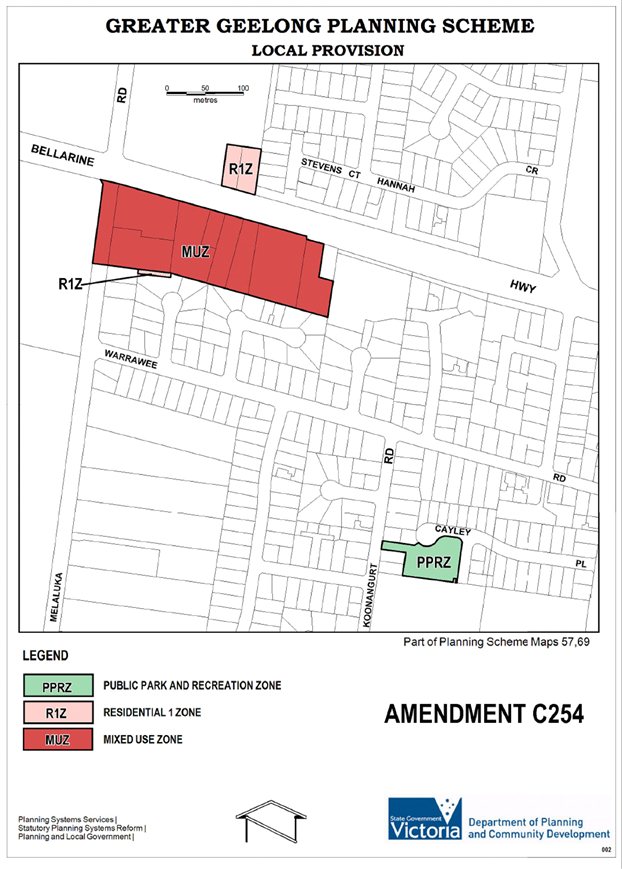
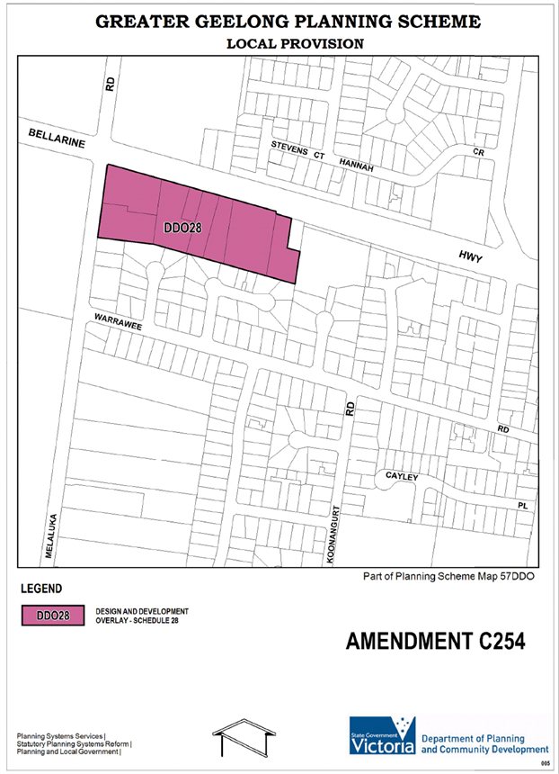
Rezone 143-145 Melaluka Road and 670-678, 672-678, 680-682, 684, 686, 688, 690-694 and 696 Bellarine Highway from a Low Density Residential Zone to a Mixed Use Zone, and introduce a Design and Development Overlay Schedule 29 to the properties.
Rezone a small parcel of land (3.2m2) known as TP861841 at 9 Elaine Place, Leopold, from a Low Density Residential Zone to a Residential 1 Zone.
Rezone 681 and 683 Bellarine Highway from the Low Density Residential Zone to a Residential 1 Zone.
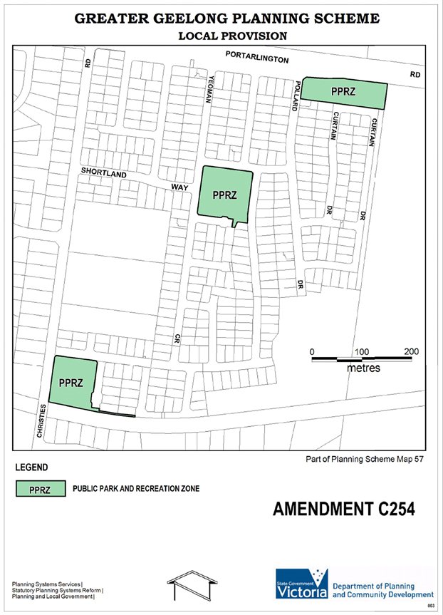
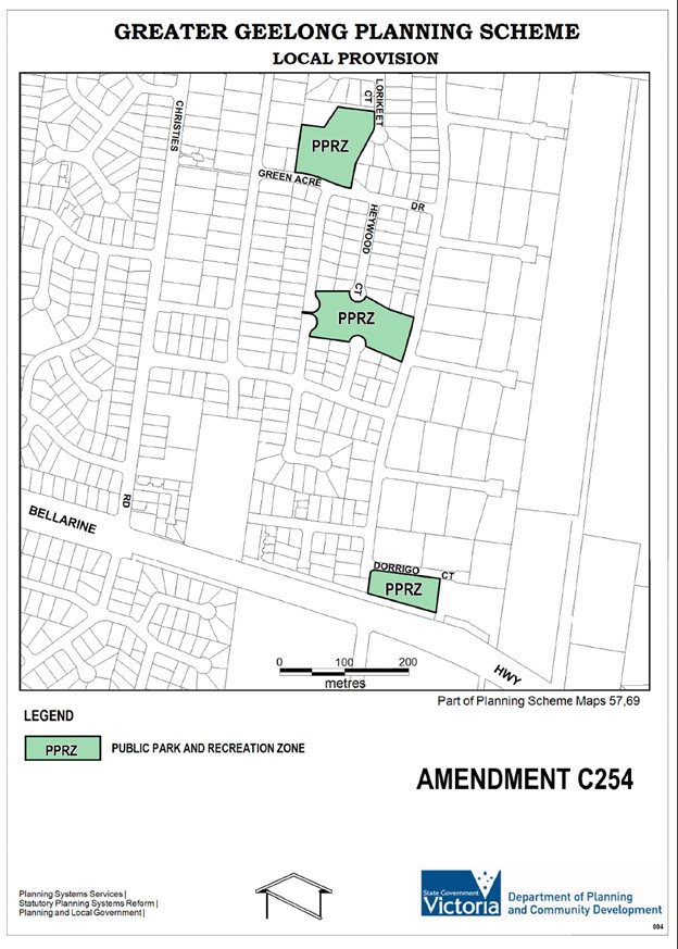
Rezone the following Council owned parks from the Residential 1 Zone to a Public Park and Recreation Zone, and delete Design and Development Overlay – Schedule 14 (DDO14):
33-41 Yeoman Crescent
16-24 Green Acre Drive
16 Heywood Court
116 – 122 Christies Road1-3 Cayley Place
1-5 & 2-6 Grassland Grove
71-73 & 75-77 Melaluka Road
1-3 Pollard Drive
14 Dorrigo Court
Update the Incorporated Document ‘Increased Housing Diversity Areas’ (Clause 81.01) to include a 400m walkable catchment around the Ash Road and Dorothy Street Local Neighbourhood Centres and 800m walkable catchment for the Leopold Sub Regional Retail Activity Centre.
A copy of the Leopold Structure Plan map exhibited with C254 is attached at Appendix 1-1. A copy of the Urban Design Framework Concept 1, the preferred concept previously endorsed by Council, is in Appendix 1-2.
The amendment was exhibited for a period of one month between 3 February 2012 and 12 March 2012.
A total of 269 submissions were received. The submissions were predominantly “pro- forma” submissions on two key issues – expansion of the Activity Centre and development north of Portarlington Road. The breakdown of submissions is:
134 “Pro forma 1” submissions objecting to expansion of the Activity Centre north along Melaluka Road.
78 “Pro forma 2” submissions providing support for a private landowner proposal to develop land north of Portarlington Road.
57 individually written submissions from local residents, landowners, developers and service authorities.
Key issues raised include the future development direction of the sub-regional activity centre, access to Port Philip Bay, development of land north of Portarlington Road for leisure and tourism uses, inclusion of sites within the settlement boundary as suitable for residential development, and the urban consolidation opportunities of existing residential areas.
As a consequence of the formal exhibition period, Council officers recommended a number of changes to the exhibited amendment. These recommendations were put to the Council on 24 July 2012 as part of the report to consider submissions to the amendment. The Panel has considered these changes as part of Council’s ultimate submission to the amendment.
A two person Panel consisting of Chair, John Keaney, and Panel Member, Catherine Hunichen, conducted a directions hearing on 29 August 2012 and a public hearing of the submissions on 3, 4, 5 and 9 October 2012.
The Directions Hearing was held at Council Chambers. The Panel hearing was held at the City of Greater Geelong Council’s Brougham Street offices on 3, 4, 5 October and the final day was held in the offices of Planning Panels Victoria, Melbourne.
Council officers provided a detailed presentation to the Panel. Nine submitters made verbal presentations to the Panel. Key submitters such as Lascorp Development Group (Australia) Pty Ltd and E, P and M Perez both instructed planning barristers who presented a number of expert witnesses to strengthen their case. Other submitters either represented themselves or were represented by planning consultants and solicitors.
A list of submitters taken from the Panel Report is included as Appendix 1-3 to this report.
The Panel report for Council’s consideration was received on 21 November 2012, a full copy of which is available on Council’s website. The Panel report was released to Councillors on 27 November 2012 and released to the general public on 7 December 2012.
The Panel has assessed the Amendment both in relation to general and specific issues. However, the Panel’s report is explicit in stating the limits of its task. Panel report advises that the issue of the specific development of any land is ‘not’ before the Panel. The panel considers that Amendment C254 is a ‘building block’ type amendment which established the strategic foundation and which enables any landowner (or the Council) to then implement that strategic vision with a detailed plan. The Panel further advise that it must therefore limit its enquiry to determining if there is a strategic basis to justify the direction for the future development of Leopold as outlined, and as proposed to be implemented in Amendment C254.
The Panel has recommended that Amendment C254 be adopted, as exhibited, subject to the following modifications:
The UDF Concept 1 be included as the future direction for the growth of the Leopold sub regional activity centre.
The land north of the Activity Centre be included in the next review and investigated for its potential for community facilities for Leopold.
The UDF Concept 1 be included as the future direction for the growth of the Leopold sub regional activity centre.
The LSP not identify any development north of Portarlington Road.
The northern portion of 92 – 110 Mollers Lane be included in the settlement boundary of the Leopold Structure Plan 2011.
The land at 21 – 39 Mollers Land and 31 – 39 Fines Lane not be include within the settlement boundary.
The land at 21 – 39 Mollers Land and 31 - 39 Fines Lane and land at 1 – 19 Mollers Lane, 908 – 960 Portarlington Road and 891 – 899 Bellarine Highway be reviewed during the next 5 year review of the Structure Plan as areas with potential to accommodate the further expansion of Leopold.
The Table to Clause 21.07‐8, the City of Greater Geelong Retail Activity Centre Hierarchy, be amended to remove Leopold from the section ‘Proposed Sub Regional Centre’.
The LSP and UDF be included as Reference Documents in the scheme.
Schedule 30 to the Design and Development Overlay be modified in accordance with Appendix D and be re‐numbered.
The Low Density Residential Zone land be identified on the Leopold Structure Plan 2011 as land suitable for ‘urban consolidation’ subject to further investigation.
Investigations into access to Port Phillip Bay be included as ‘Further Strategic Work’ in the MSS at Clause 21.14”.
Having considered the Panel Report, Council officers recommend that Amendment C254 to the Greater Geelong Planning Scheme is adopted with changes as described in this report.
The Panel’s recommendations are consistent with the intent of Council’s exhibited amendment and are generally supported. The following is a summary of the Panel’s comments and recommendations on key issues together with related officer comments and recommendations.
The Panel investigated whether the various levels of state, regional and local policy support the changes envisaged by the Leopold Structure Plan 2011 (LSP) and the Leopold Urban Design Framework 2011 (UDF).
The Panel believes that “the LSP adequately addresses all of the opportunities and constraints affecting the town and takes account of the range of environmental limitations. The LSP has also benefited from extensive community consultation and input.”
The Panel makes a number of comments in support of the work done by Council and has only two criticisms of the strategic work.
“…the Panel is not convinced that having two growth options for the activity centre in the UDF has assisted the process. The two concepts have tended to blur the discussion and focus submissions on layout and detail whereas the LSP was more correctly based on establishing the need for an expanded centre and then providing sufficient land for that to be achieved.
The second concern is that the LSP is a bit ‘off centre’ regardless of whether the activity centre extends beyond Clifton Avenue. The extension of the town boundary to at least Clifton Avenue brings into consideration all of the land to the north for community type uses”.
The Panel makes some strong statements about land north of the Activity Centre (i.e. between Melaluka Rd and Clifton Ave), including the following:
“The most apparent shortcoming in the LSP concerns the land to the north of the nominated activity centre. While the Panel thinks it is logical to entrench and ‘grow’ the activity centre into a sub-regional centre, it thinks that the LSP has underestimated the obvious potential of the land north of the centre extending as far as Portarlington Road. If the town is to have its ‘heart’ on Melaluka and be flanked by recreation, community and commercial facilities, then the Panel agrees with Mr McNamara, Mr Ganly and Mr Barnes that it is something of a missed opportunity not to have identified the land north of the Perez land for either community, educational or higher density residential use. This would ‘round out’ the western side of Leopold and would provide a multi layered focus to the town.
The Panel urges Council to revisit the land north of the centre in the next review of the LSP.”
Panel Recommendation:
That the land north of the Activity Centre be included in the next review and investigated for its potential for community facilities for Leopold.
Officer comment:
Council officers support investigation of the land north of the activity centre i.e. land bounded by Melaluka Road, Portarlington Road, Clifton Avenue and the Activity Centre.
Any review of this area would need to include a comprehensive analysis of constraints and opportunities. This area is known to have serious drainage and stormwater management issues which may constrain its development potential. On the other hand, it is logical to consider medium to high density housing close to the activity centre to increase the population living within walking distance.
The key two issues for resolution by the Panel were: has sufficient land been set aside for an expanded activity centre, and should the activity centre extend west of Clifton Avenue?
Much of the Panel hearing, and most of the submissions to the amendment, were concerned with this issue. In simple terms, the competing issues arising from submissions are about whether the primary direction of expansion should be north along Melaluka Road (UDF Concept 1 and Council and Perez preferred option) or west along the Bellarine Highway (UDF Concept 2 and Lascorp preferred option).
The two options are summarised by the Panel:
“The ‘Concept 1’ option extends the activity centre in a northerly (and westerly) direction to consume all of the existing ‘Lascorp’ land up to Clifton Avenue and to consume all of the Perez land to the north. This is Council’s ‘preferred’ option and it anticipates that a significant amount of retail, bulky goods and employment floorspace will eventually be developed in this consolidated area bounded by Bellarine Highway, Melaluka Road and Clifton Avenue.
The ‘Concept 2’ option is to extend the centre west over Clifton Avenue. Lascorp made it very clear to the Panel that it wishes to pursue a major retail extension to the existing centre (more or less consistent with its Amendment C277 request) and to develop a stand-alone bulky goods outlet on its land west of Clifton Avenue. It has secured a heads of agreement with the ‘Masters’ chain of stores to develop this land. Lascorp submitted that this site was the only option for the location of a Masters store. In the event that this option was not supported, it was its submission that Masters would not develop anywhere in the centre which would be to the loss of both Leopold and the Bellarine Peninsula.”
The Panel comments on the proposals include:
“…More than anything else, the Panel thinks that Melaluka Road holds the key to the future of the centre and is the ‘glue’ that will bind old and new Leopold around a central and communal focus to provide it with the ‘heart’ that it has so long lacked. In the Panel’s view, extending the centre to the west over Clifton Avenue will dilute the prospects of that happening.
In the view of the Panel, extending the centre beyond Clifton Avenue will inevitably shift the ‘activity’ in the centre. Like it or not, it will split the activity centre and will make Clifton Avenue and not Melaluka Road the ‘heart’ of Leopold simply because of the ‘drawing’ power of the businesses in a new east/west centre fronting the highway and dissected by Clifton Avenue. In the view of the Panel, that is not what is contemplated by the LSP and it would be a poor planning outcome for Leopold.
The Panel therefore supports the restrictions on development to the east side of Clifton Avenue and it is satisfied that there is sufficient land to accommodate the floor space requirements for all suggested uses (including a large format hardware store) to land on the east side of Clifton Avenue. The Panel therefore agrees with Council that the extension of the activity centre does not need to go beyond Clifton Avenue as there is sufficient space east of Clifton Avenue to accommodate the growth of the centre.
The remaining issue for the Panel to determine is whether a westerly extension over Clifton Avenue confounds or is supported by the long held planning policy of a non urban break between Leopold and Moolap. The Panel will now address that issue.”
Panel Recommendation
The UDF Concept 1 be included as the future direction for the growth of the Leopold sub-regional activity centre.
Officer comment
The Panel support for Council’s preferred option (Concept 1) is welcomed. Council officers also endorse the Panel comments about Melaluka Road being the key to the future of the centre and providing a “heart” for Leopold.
Council officers are currently assessing detailed plans submitted by Lascorp as part of a combined rezoning (C277) and planning permit (944/2012) application for the sub regional activity centre. The plans will need to be cognisant of future development on the Perez land to the north. Officers are keen that the plans give Leopold a local “heart” or town centre focussed on Melaluka Road with the bigger sub regional components and large carparks being focussed toward the west.
Council submitted that the overall purpose of the ‘non-urban break’ between Geelong and Leopold had been enshrined in various state, regional and local planning schemes for many years dating back to the 1970’s and applied consistently ever since.
The Panel notes the “strong planning policy basis in the Greater Geelong Planning Scheme for ‘contained’ townships. While this is a policy that applies across the municipality, it is particularly strong on the Bellarine Peninsula where the emphasis is on keeping the individual identity of towns and in keeping them separate. A ‘containment’ philosophy is consistent with State policy and is endorsed by the G21 regional emphasis on ‘settlement breaks’.”
The Panel therefore accepts that a non-urban break between Moolap and Leopold has been a longstanding policy at all levels, notwithstanding that there is no explicit reference anywhere to Clifton Avenue being the boundary of that break.
The Panel strongly supports the principle of the non-urban break between Leopold and Moolap. It therefore does not support a westerly expansion of the centre over Clifton Avenue.”
Panel Recommendation
There was no formal recommendation on this issue but the Panel has endorsed protection of the non-urban break in its comments.
Officer comment
The Panel comments are noted.
The Panel concluded that it supports:
“Council’s long standing policy on the delineation of settlement boundaries and agrees there is clear State Government policy re-enforcing this position. Portarlington Road forms a very distinctive boundary to the north of Leopold and should be supported.
The Panel also finds that at the present time there is sufficient land within the township to develop facilities and residential housing to meet the needs of Leopold into the future. The 5 yearly programme of Structure Plan review provides a timely review mechanism of the growth, infrastructure, community, housing, retail, open space and employment needs of the township.
The Panel does not think that Council’s approach to the land north of Portarlington Road has been to sterilise the land. It is evident from permits issued over recent times that this is anything but a ‘no go’ area. It is a farming precinct within which Council is prepared to contemplate a variety of non urban uses. Houses are not one of them. In relation to the specific request to permit the extension of the existing caravan park, the Panel sees this issue as one that could be dealt with outside the Structure Planning process. This is not a matter for this Panel to resolve.
The Panel therefore does not support any development north of Portarlington Road. The Panel does not support any notation on the plan identifying that the land be the subject of further investigation as it sees no merit in developing this area for urban or tourist related purposes.”
Panel Recommendation
The LSP not identify any development north of Portarlington Road.
Officer comment
The Panel’s recommendation is fully supported.
The principles and directions contained within the Leopold Structure Plan relating to development north of Portarlington Rd will remain as per the adopted plan of September 2011 and as exhibited as part of Amendment C254.
Future proposals for use and development of land within this area can be controlled by the statutory planning process.
The Panel concluded that it supports:
“… a minor addition to the boundary of the LSP to the south east of the town in accordance with Council’s recommendations. The Panel does not support any notations on the plan identifying that any further land to the east be included.”
Panel Recommendations:
The northern portion of 92 – 110 Mollers Lane be included in the settlement boundary of the Leopold Structure Plan 2011.
The land at 31 - 39 Fines Lane not be included within the settlement boundary.
The land at 21 – 39 Mollers Lane not be included within the settlement boundary.
The land at 21-39 Mollers Lane and 31-39 Fines Lane and land at 1-19 Mollers Lane, 908-960 Portarlington Road and 891-899 Bellarine Highway during the next 5 year review of the Structure Plan as areas with potential to accommodate the further expansion of Leopold.
Officer comment
The Panel’s support for the inclusion of the northern portion of land at 92-110 Mollers Lane within the settlement boundary is acknowledged. The northern portion of the site will be included within the long term growth area boundary (see red hatching on plan in Appendix 1-4) and will be required to integrate with the wider area identified for conventional residential development to the north and west- known as the ‘Ash Road Area’.
Prior to the development of the site, further strategic work will be required to ensure issues in relation to drainage and landscape character are appropriately addressed. The Structure Plan will be amended to reflect the addition of this area of land and associated development requirements that would be necessary to include within the outline development plan overlay and/or development plan overlay.
The Panel’s recommendations in relation to land at 31-39 Fines Lane and 21-39 Mollers Lane are acknowledged. The eastern boundary of the Low Density Residential Zone at Birchbank Estate and the western boundary of Mollers Lane are considered to represent a logical and robust settlement boundary for the term of this Structure Plan. The inclusion of either parcels of land within the settlement boundary is not warranted.
The Panel’s recommendation in relation to these two properties and properties at 1-19 Mollers Lane, 908-960 Portarlington Road and 891-899 Bellarine Highway being suitable for further investigation for inclusion within the settlement boundary is acknowledged. The most appropriate time for this to be undertaken is during the next Structure Plan review. Upon the commencement of the next Structure Plan review, an assessment of the adequacy of the residential lot supply will be undertaken to determined the requirement for additional land.
The Panel report includes discussion on implementation of the Structure Plan and UDF. In particular it comments on the proposed zoning and overlays, the Structure Plan map and whether the Structure Plan and UDF should be reference documents in the planning scheme.
The Panel states “… it has a number of concerns with the detail of the exhibited Design and Development Overlay Schedule and these were raised at the Directions Hearing. Specifically, the Panel expressed concern about a ‘development’ control (the DDO) containing extensive ‘use’ provisions. The Panel has removed any reference to ‘use’ in its preferred DDO schedule………..
The DDO Schedule and accompanying planning scheme map should also be correctly numbered, with the next available number in the planning scheme.
It also follows from the above discussion that the Panel recommends that the LSP and UDF be included as Reference Documents in the scheme.”
Panel Recommendations:
The Table to Clause 21.07-8, the City of Greater Geelong Retail Activity Centre Hierarchy, be amended to remove Leopold from the section ‘Proposed Sub Regional Centre’.
The LSP attached at Appendix E [of the Panel Report] be adopted.
The LSP and UDF be included as Reference Documents in the scheme.
The Schedule to the Design and Development Overlay be modified in accordance with Appendix D [of the Panel Report] and be re-numbered.
Officer comment
The Table to Clause 21.07-8 has been amended to show Leopold as a Sub Regional Centre (rather than a Proposed Sub Regional Centre).
The Leopold Structure Plan map changes recommended by the Panel (see Appendix 1-4) have been accepted and included in map in Clause 21.14 which will form part of the planning scheme (see Appendix 1-5).
Officers agree that the Structure Plan and UDF should remain as reference documents. The UDF will remain unchanged and minor changes will be made to the Structure Plan including the new map as recommended by the Panel.
Officers agree with the Panel’s changes to the Design and Development Overlay 28 and these are included in the version recommended for adoption (see Appendix 1-5).
The Panel concluded that:
Port Philip Bay Access
“… while the submissions relating to gaining access to Port Philip Bay have merit, no changes are required to the Structure Plan to facilitate further investigation as it is already adequately dealt with on the Plan.”
Urban Consolidation Opportunities
“While the Panel supports the submissions, it believes that to isolate and rezone the two low density residential sites at this time would be premature as these sites and those adjoining them will require careful planning to ensure the integration of any new subdivision into the surrounding conventional subdivision layout. Infrastructure and servicing issues must also be satisfactorily addressed.
The Panel therefore endorses the approach outlined by the Council, which suggests that the area be identified for ‘further investigation’. With the agreement of the majority of land owners, such an investigation may produce an ODP addressing these and other needs. Any ODP should consider the impact of development on adjoining landowners to ensure these impacts are minimised. Following this process, Council can then determine if a staged process of rezoning and development should occur.”
Panel Recommendation
Investigations into access to Port Phillip Bay be included as ‘Further Strategic Work’ in the MSS at Clause 21.14.
The Low Density Residential Zone land be identified on the Leopold Structure Plan 2011 as land suitable for ‘urban consolidation’ subject to further investigation.
Officer comment
Port Philip Bay Access
The Panel’s recommendation in relation to investigations into access to Port Philip Bay to be included as ‘Further Strategic Work’ in the MSS at Clause 21.14 is supported.
Council officers will report to Council on a project brief for investigating access to Port Phillip Bay in accordance with the Council resolution on 24 July 2012.
Clause 21.14 of the Planning Scheme will be amended accordingly to reflect this Structure Plan Direction.
Urban Consolidation Opportunities
The Panel’s endorsement of the Council’s approach to the further investigation of the low density residential zone at Melaluka Road south is acknowledged.
The requirement for a collective landowner approach to undertake investigations to demonstrate the viability of this area as suitable for rezoning to Residential 1 zone is logical and necessary. This Structure Plan Direction is key to unlocking the potential for rezoning of the land.
The development of the Structure Plan has regard to environmental issues and constraints.
The Structure Plan identifies a settlement boundary which will see population increases accommodated within the existing urban area, reducing urban sprawl and protecting the surrounding coastal and wetland and rural environments.
The Structure Plan has a number of recommendations relating to the environment. Broader sustainability outcomes have been considered for new urban areas (such as waste water reuse, WSUD principles, energy conservation, improving walking/bicycle opportunities to reduce vehicle reliance and directions relating to native vegetation protection/re-vegetation.
The Council is responsible for the costs associated with the planning scheme amendment process including advertising, printing and Panel hearing, and approval of the amendment by the Minister for Planning.
The Structure Plan is consistent with all relevant State and Council planning policies which have been described and discussed in detail in the Structure Plan.
In accordance with Section 80 © of the Local Government Act, Peter Bettess, General Manager, Economic Development, Planning and Tourism declares an indirect financial interest in that he owns Woolworths and Wesfarmers shares.
The development of the Structure Plan involved input from key agencies and groups and review of relevant legislation to ensure appropriate management of constraints and risks.
The development of the Structure Plan had due regard to social and community issues with contributions from Council’s social and recreation planners and from a range of other agencies.
The Structure Plan included input from community service providers and groups and examined directions and recommendations of the Bellarine Peninsula Strategic Plan. The Plan makes recommendations around walkability/accessibility, recreation needs; future social and community facilities and services and affordable housing.
The Structure Plan was informed by a number of reports which were subject to public consultation. The informal consultation of the draft Structure Plan and formal exhibition of Amendment C254 have provided an opportunity for internal and external stakeholders/departments and the community to have input and feedback.
Submitters were notified of the Panel Hearing dates and afforded an opportunity to be heard by Planning Panels Victoria.
Submitters were sent a letter providing a copy of the Panel’s conclusions and recommendations for amendment C254. Submitters will be notified of the final outcome of the amendment which will be decided by the Minister for Planning once Council has resolved to submit the amendment to the Minister for approval.
(Council/Panel Preferred Concept)
No. |
Submitter |
Company / Organisation |
|
1. |
Kim |
Abbott |
|
2. |
Hans |
Alberese |
|
3. |
Andrea |
Alexander |
|
4. |
Jake |
Alford |
|
5. |
Lachy |
Alford |
|
6. |
Lindsay |
Alford |
|
7. |
Eliza |
Alsop |
|
8. |
Kaitlyn |
Amer |
|
9. |
Louise |
Anderson |
|
10. |
|
|
Architects Fulton & Salomon |
11. |
Chris |
Aston |
|
12. |
Jessica |
Aston |
|
13. |
Glennys |
Barnett |
|
14. |
Julie |
Barry |
|
15. |
|
|
Barwon Water |
16. |
Daryl |
Baum |
|
17. |
Ian |
Baxter |
|
18. |
Gary |
Benson |
|
19. |
Terry |
Benson |
|
20. |
Kathryn |
Beveridge |
|
21. |
Robert |
Beveridge |
|
22. |
Ryan |
Binder |
|
23. |
Doug |
Blackwell |
|
24. |
Joseph |
Blahovec |
|
25. |
Sascha |
Blazer |
|
26. |
Shane |
Borczuch |
|
27. |
Allan |
Boyd |
|
28. |
Matt |
Breckov |
|
29. |
Colin |
Brooker |
|
30. |
T |
Brooks |
|
31. |
Peter |
Brown |
|
32. |
R |
Burnie |
|
33. |
Chad |
Butterworth |
|
34. |
Corey |
Byars |
|
35. |
Bree |
Cail |
|
36. |
Sam |
Calder |
|
37. |
Gary |
Callan |
|
38. |
Gary |
Callan |
|
39. |
John |
Cammarotto |
|
40. |
Chris |
Campbell |
|
41. |
Glen |
Campbell |
|
42. |
Jade |
Campbell |
|
43. |
|
|
Cardno |
44. |
|
|
Corangamite Catchment Management Authority |
45. |
|
|
CFA |
46. |
Wayne |
Clay |
|
47. |
A |
Clifton |
|
48. |
Louis |
Clifton |
|
49. |
Mikaela |
Clifton |
|
50. |
Paddy |
Clifton |
|
51. |
Rob |
Clifton |
|
52. |
Kerry |
Coghlan |
|
53. |
Trent |
Coghlan |
|
54. |
Ian |
Cole |
|
55. |
Sandi |
Collier |
|
56. |
Alan |
Collins |
|
57. |
Lisa |
Collins |
|
58. |
Lisa |
Collins |
|
59. |
|
BLANK |
|
60. |
Mary |
Core |
|
61. |
Adam |
Couchman |
|
62. |
Lyn |
Cramer |
|
63. |
|
|
CPG for Paul Masek |
64. |
Brett |
Cunningham |
|
65. |
Simon |
D’Antino |
|
66. |
Eden |
Darragh |
|
67. |
Michael |
Davies |
|
68. |
Heather |
deBakker |
|
69. |
Shane |
Devlin |
|
70. |
Chris |
Dimitrovski |
|
71. |
J F & SI |
Donovan |
|
72. |
David |
Dowd |
|
73. |
Anthony |
Dowie |
|
74. |
Graham |
Drayton |
|
75. |
Robin |
Drayton |
|
76. |
Barbara |
Drummond |
|
77. |
S |
Durbridge |
|
78. |
Greg |
Dye |
|
79. |
Mark |
Dye |
|
80. |
James |
Eastwood |
|
81. |
Paul |
Edwards |
|
82. |
Libby |
Elliott |
|
83. |
Michelle |
Engel |
|
84. |
|
|
ERM for Lascorp |
85. |
Chloe |
Fagan |
|
86. |
Simone |
Fagan |
|
87. |
|
|
Fagg Bros Pty Ltd |
88. |
Guy |
Fantini |
|
89. |
Marianne |
Finn |
|
90. |
H |
Flood |
|
91. |
C |
Ford |
|
92. |
David |
Ford |
|
93. |
Ray |
Freer |
|
94. |
Kristy |
Fromholtz |
|
95. |
Dean |
Gall |
|
96. |
Charles |
Gatt |
|
97. |
Keith |
Gordon |
|
98. |
Eliza |
Gravatt |
|
99. |
Judi |
Gravatt |
|
100. |
Natalie |
Gray |
|
101. |
Pam |
Hammond |
|
102. |
Richard |
Hammond |
|
103. |
Ebony |
Hansen |
|
104. |
Heather |
Harbison |
|
105. |
Damien |
Hardie |
|
106. |
Jane |
Hardman |
|
107. |
Greg |
Hardy |
|
108. |
Kirsty |
Harper |
|
109. |
Dianne |
Harry |
|
110. |
Dean |
Harty |
|
111. |
Alfred |
Hawkins |
|
112. |
Louvain |
Hawkins |
|
113. |
Paul & Paula |
Hayes |
|
114. |
Kirsty |
Heazlewood |
|
115. |
Brenda |
Helwig |
|
116. |
Angela |
Hennessy |
|
117. |
Chris |
Hennessy |
|
118. |
Shane |
Hennessy |
|
119. |
Ian |
Hitchcock |
|
120. |
Wendy |
Hitchcock |
|
121. |
Anne-Maree |
Hoare |
|
122. |
Holly |
Hood |
|
123. |
C |
Horne |
|
124. |
R L & E M |
Hotchin |
|
125. |
Nick |
Hughes |
|
126. |
Paul |
Hulett |
|
127. |
Mark |
Humpage |
|
128. |
Lauren |
Humphris |
|
129. |
Marcus |
Illingworth |
|
130. |
Alan |
Ireland |
|
131. |
Bill |
Iro |
|
132. |
Kenneth |
Ivory |
|
133. |
B |
Jafari |
|
134. |
Chris |
James |
|
135. |
Harry |
James |
|
136. |
Meredith |
James |
|
137. |
Nick |
James |
|
138. |
Max |
Jardine |
|
139. |
Sarah |
Jeffreys |
|
140. |
Steve |
Jeffreys |
|
141. |
Sharelle |
Jenkin |
|
142. |
Shane |
Jones |
|
143. |
Gail |
Joordans |
|
144. |
Paul |
Kelly |
|
145. |
Taya |
Kemp |
|
146. |
C |
Kerr-Nelson |
|
147. |
Rod |
Kiddle |
|
148. |
Anthony |
Kilfoyle |
|
149. |
Rachel |
King |
|
150. |
Annette |
Kontogeorgis |
|
151. |
David |
Kos |
|
152. |
Michael |
Lane |
|
153. |
Brian & Lynette |
Latter |
|
154. |
Michael |
Law |
|
155. |
Stacey |
Learmonth |
|
156. |
Allan |
Lehman |
|
157. |
|
|
Leopold & District Community Assoc |
158. |
Mandy |
Leworthy |
|
159. |
Danielle |
Loader |
|
160. |
Anita |
Long |
|
161. |
Kaiden |
Long |
|
162. |
Jess |
Lothian |
|
163. |
M |
Maroulis |
|
164. |
Peter |
Marshall |
|
165. |
Thomas |
Marshall |
|
166. |
Bob |
Mathieson |
|
167. |
Jocelyn |
Matthews |
|
168. |
Gillian |
McCallum |
|
169. |
Shon |
McClintock |
|
170. |
Tammy |
McDonald |
|
171. |
Jara |
McElhinney |
|
172. |
Karen |
McFarlane |
|
173. |
Andrew |
McKie |
|
174. |
David |
McKie |
|
175. |
Mandy |
McKie |
|
176. |
Kyra |
McKinnis |
|
177. |
Joanne |
McKnight |
|
178. |
Murray |
McLaren |
|
179. |
Robert |
McLaren |
|
180. |
Scott |
McLaren |
|
181. |
Emily |
McMahon |
|
182. |
Rod |
Merrett |
|
183. |
Hesham |
Metwally |
|
184. |
Paul |
Mitchell |
|
185. |
Dennis |
More |
|
186. |
Rod |
Mulgrew |
|
187. |
Luke |
Murray |
|
188. |
Rachel |
Murray |
|
189. |
Peter |
Nowell |
|
190. |
Sibena |
O’Halloran |
|
191. |
Kaye |
Oldham |
|
192. |
Xeni |
Pages |
|
193. |
Greg |
Parker-Hill |
|
194. |
Kylie |
Parsons |
|
195. |
Deb |
Paver |
|
196. |
Allanah |
Penny |
|
197. |
A |
Perez |
|
198. |
Elizabeth |
Perez |
|
199. |
Margarita |
Perez |
|
200. |
Aaron |
Perus |
|
201. |
Dianne |
Perus |
|
202. |
Magenta |
Perus |
|
203. |
Judy |
Phillips |
|
204. |
|
Poligot |
|
205. |
Paul |
Read |
|
206. |
Paul |
Reynolds |
|
207. |
E |
Ricci |
|
208. |
Jake |
Robert |
|
209. |
Emma |
Rodda |
|
210. |
Rob |
Roiter |
|
211. |
Matt |
Russell |
|
212. |
Susan |
Ryan |
|
213. |
B |
Sampson |
|
214. |
J |
Sampson |
|
215. |
L |
Sampson |
|
216. |
Rebecca |
Sanderson |
|
217. |
Dean |
Sayers |
|
218. |
Tim |
Secombe |
|
219. |
Wendy |
Shaw |
|
220. |
John-Luke |
Shelley |
|
221. |
Myra |
Sheppard |
|
222. |
Anna |
Simonsen |
|
223. |
Matt |
Sinkinson |
|
224. |
Andrew |
Sloan |
|
225. |
James |
Smith |
|
226. |
Jessica |
Smith |
|
227. |
S |
Smith |
|
228. |
Brianna |
Spalding |
|
229. |
Felicity & Brad |
Stapleton |
|
230. |
Karen |
Starr |
|
231. |
David |
Stephen |
|
232. |
Simon |
Stephenson |
|
233. |
Anthony |
Storvik |
|
234. |
Tenille |
Storvik |
|
235. |
Marcus |
Stow |
|
236. |
James |
Styles |
|
237. |
Stan |
Sutas |
|
238. |
Sharon |
Taylor |
|
239. |
Jai |
Thompson |
|
240. |
Kirsty |
Timms |
|
241. |
Mel |
Tomlins |
|
242. |
Jesusa |
Torre |
|
243. |
Andrew |
Tozer |
|
244. |
Kahtaya |
Turnbull |
|
245. |
Leanne |
Turnbull |
|
246. |
D |
Turner |
|
247. |
G |
Turner |
|
248. |
Ian |
Turner |
|
249. |
Sara & Paul |
Turner |
|
250. |
Trevor |
Van Arend |
|
251. |
Tim |
Varcoe |
|
252. |
|
|
VicRoads |
253. |
Ron |
Wagener |
|
254. |
Devinia |
Wainwright |
|
255. |
Nicole |
Walker |
|
256. |
Maureen |
Walsh |
|
257. |
Sylvia |
Walsh |
|
258. |
Trevor & Kay |
Walsh |
|
259. |
Steve |
Walton |
|
260. |
Annette |
Watkins |
|
261. |
Brian |
White |
|
262. |
Adrian |
Wiese |
|
263. |
|
Williams |
|
264. |
Randy |
Williams |
|
265. |
John |
Wilson |
|
266. |
Daniel |
Wray |
|
267. |
Kelly |
Wurfel |
|
268. |
Ernest |
Harriss |
|
269. |
|
|
Woolworths Ltd |
Planning and Environment Act 1987
GREATER GEELONG PLANNING SCHEME
AMENDMENT C254
INSTRUCTION SHEET
The planning authority for this amendment is Greater Geelong City Council.
The Greater Geelong Planning Scheme is amended as follows:
Planning Scheme Maps
The Planning Scheme Maps are amended by a total of 5 attached maps.
Zoning Maps
Planning Scheme Map Nos 57 and 69 are amended in the manner shown on the attached maps marked Greater Geelong Planning Scheme, Amendment C254.
Overlay Maps
Planning Scheme Map No.57DDO is amended in the manner shown on the attached maps marked Greater Geelong Planning Scheme, Amendment C254.
Planning Scheme Ordinance
The Planning Scheme Ordinance is amended as follows:
In Local Planning Policy Framework – replace Clause 21.04 with a new Clause 21.04 in the form of the attached document. The changes are as follows:
Municipal Framework Plan has been amended.
In Local Planning Policy Framework – replace Clause 21.07 with a new Clause 21.07 in the form of the attached document. The changes are as follows:
Subclause 21.07 – 8 has been amended.
In Local Planning Policy Framework – replace Clause 21.14 with a new Clause 21.14 in the form of the attached document. The changes are as follows:
Subclauses 21.14 – 2 and 21.14-3 have been amended.
In Overlays – following Clause 43.02 insert a new Schedule 28 in the form of the attached document.
In Incorporated Documents – Clause 81.01, replace the schedule with a new schedule in the form of the attached document.
End of document
21.07 Economic development and employment
21.07-1 Key issues and influences
24/02/2011
C177
Economic Role and Function
14/10/2010
C168
Geelong is the largest regional city in Victoria and the primary service and employment hub for the G21 Geelong Region Alliance.
The City’s infrastructure base includes Avalon Airport, the Geelong Port and major road and rail connections to Metropolitan Melbourne and Victoria’s western regions.
The provision of high quality living, working and recreational environments is critical to attracting and retaining highly skilled people and the businesses in which they work.
Industry
There is a need to provide support for ongoing employment and economic development in the Geelong region.
There is a need to provide a diverse range of appropriately located, well serviced industrial land which meets the needs of a range of industry types and minimises land use conflicts.
Traditional manufacturing industries will continue to be key economic and employment drivers in the municipality, however at the same time the City’s economy will need to focus on emerging industry sectors that underpin economic development, prosperity and employment growth in the new economy.
The changing nature of industrial development means that most industrial development now requires high amenity land that offers a high quality environment for workers and visitors.
There is a need to support industry through the maintenance and improvement of infrastructure including the road, rail, Avalon Airport, deep water port and associated facilities.
The extractive industry operations in the municipality make a vital contribution to the building and construction industries and are of major economic importance to the Geelong region.
Retail
The City of Greater Geelong Retail Activity Centre Hierarchy has been established to articulate the role and function fulfilled by centres of different sizes.
The retail hierarchy supports the primacy of Central Geelong as the focus of retail activity in the region.
There is a need to ensure a mix of commercial uses in activity centres.
The retail hierarchy will be enhanced through high quality urban design and improved pedestrian and public transport accessibility.
There is increasing development pressure for sites located away from activity centres, particularly for bulky goods and other large format retail development types that seek large sites with the capacity for significant car parking.
Greater Geelong exhibits a number of factors that contribute to an increased vulnerability to problem gambling which requires sensitive consideration of their location.
Rural
Agricultural production is modest, but locally important and economically significant for landowners.
There is potential for growth in agricultural production, particularly aquaculture.
Farming activity and the rural landscape are very significant elements to the identity, image and liveability of the City of Greater Geelong.
Farming and rural landscapes form non urban breaks and are a critical element to the settlement strategy, tourism function and lifestyle of the region.
Farming and agriculture are important and valued activities in the northern area of the municipality, particularly in the Anakie area.
Rural land in a number of urban fringe areas accommodates a range of uses and developments which require buffers from residential areas.
The City’s rural areas contain important environmental assets.
Tourism
Tourism is a key part of the economy of the Geelong region. The region includes major tourism destinations such as the Bellarine Peninsula and the coast.
Tourism activities in rural and coastal areas must be carefully managed so as not to compromise the natural environment and/or agricultural activities.
21.07-2 Industry
03/06/2010
C207
Objectives
To provide an adequate supply of appropriately located industrial land that meets the needs of different industries.
To direct different types of industrial development to appropriate locations.
To facilitate well designed and serviced industrial development that provides a high level of amenity for workers and visitors.
To minimise land use conflicts.
Strategies
Focus new industrial development around major transport routes and infrastructure assets.
Protect existing and designated future industrial areas from encroachment by incompatible land uses.
Pupport the development of a technology/business park in the South Western Armstrong Creek Employment Area.
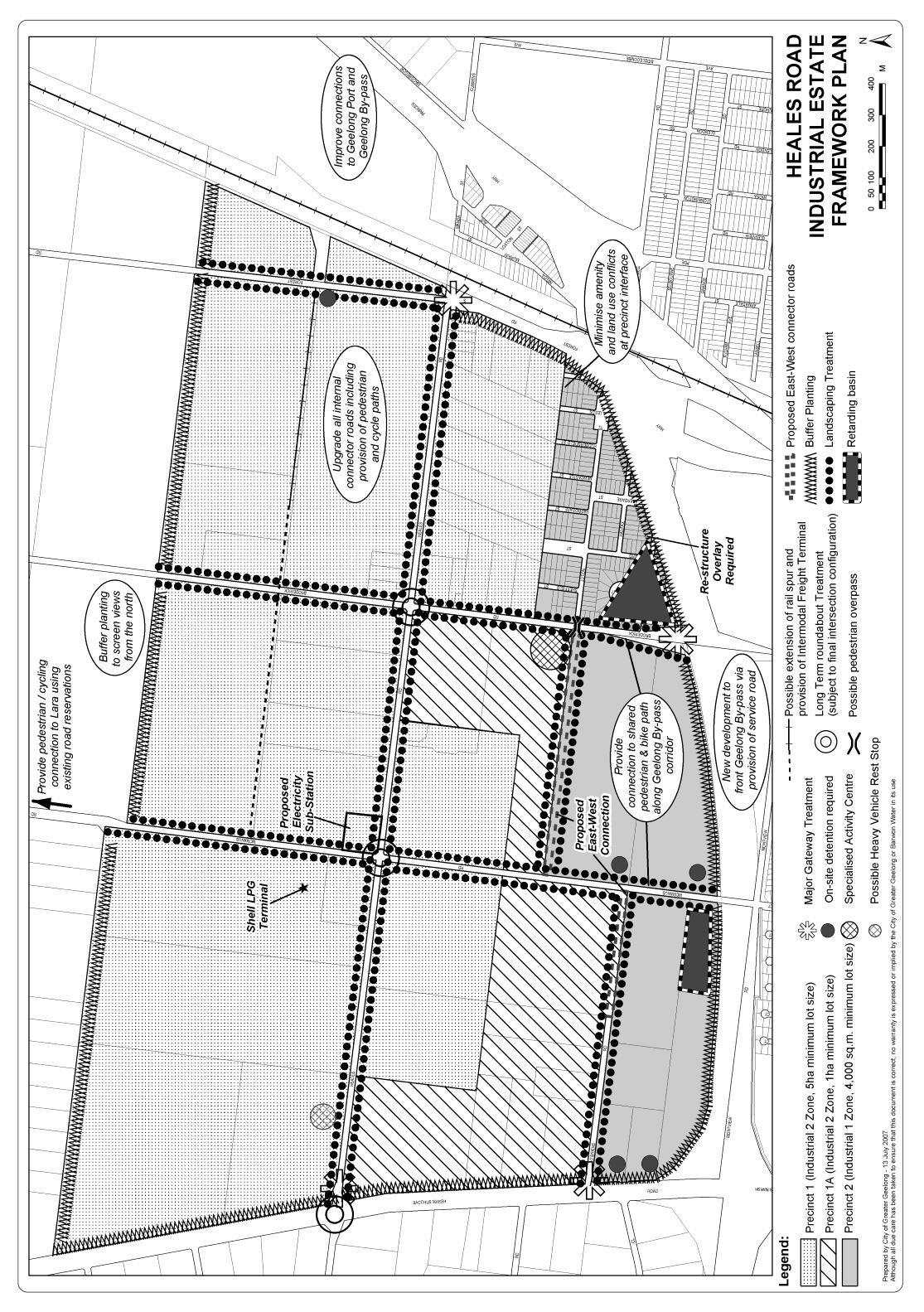
Encourage regional and national scale industrial businesses to locate in the southern part of the Heales Road Industrial Estate, and in appropriate locations in the future South Western Armstrong Creek Employment Area.
Direct industries which require substantial buffer zones from sensitive land uses to the core of the Industrial 2 Zone in the Heales Road Industrial Estate.
Ensure all industrial development incorporates best practice water sensitive urban design and waste management practices.
Ensure all industrial development is appropriately serviced by road, drainage, water, sewerage and telecommunications infrastructure.
Ensure all industrial development provides high quality urban design and landscaping.
Ensure new development in the Heales Road Industrial Estate is configured to minimise the individual and societal risk levels attached to the Shell LPG Storage Facility.
Protect identified stone resources for future extraction and potential extraction industry operations from the encroachment of incompatible land uses.
Direct materials recycling industries to locations that minimise land use conflicts and impacts on the amenity of surrounding areas.
Support the establishment of infrastructure that reduces costs for business and industry.
Support an integrated Geelong Transport Strategy, ensuring that industrial areas are well connected to each other and the rail/freeway network.
Provide sufficient industrial land to meet a range of industrial needs in Geelong, including small to medium sized industry.
Develop the North East Industrial Precinct as a vibrant, new generation, master planned industry and business park that will attract a wide range of users and respond to the changing needs of industry sectors over time, as a key business address in the region and Victoria.
To facilitate the development of vibrant and viable retail activity centres in accordance with the Geelong Retail Activity Centre Hierarchy included at Clause 21.07-8.
To ensure all major retail developments, and out of centre developments, provide a clear net community benefit.
To avoid the risk of exacerbating problem gambling.
Strategies
14/10/2010
C168
Ensure that new retail development is directed to activity centres and is consistent with the role and function described in the Retail Activity Centre Hierarchy included at Clause 21.07-8.
Ensure Central Geelong remains the primary retail activity centre in the G21 Region and the focus of retail activity in the G21 region.
Direct restricted retail (bulky goods) use and development to Central Geelong, the nominated homemaker precinct at Waurn Ponds, the Corio homemaker precinct subject to appropriate re-zoning and other homemaker precincts and activity centres as detailed in Clause 21.07-8.
Discourage restricted retail (bulky goods) development in industrial areas.
Encourage a mix of retail, office, cafes, entertainment, housing, education and community facilities to locate within activity centres.
Support accommodation uses above ground level floor space in activity centres subject to appropriate provision of parking and access requirements.
Require that applications for new centres establish the retail need for such use and development and demonstrate that there are no adverse impacts on the operation of the retail activity centres hierarchy.
Direct the location of gaming machines to venues that makes gaming accessible but not convenient as detailed in Clause 22.57.
21.07-4 Economic growth sectors
28/01/2010
C129 (Part 1)
Objective
To facilitate development in the City’s strategic economic growth sectors.
Strategies
Support industry development in the following strategic growth sectors:
Knowledge, Innovation and Research.
Advanced Manufacturing.
Health.
Tourism.
Small, Micro and Home Based Business.
Food and Horticulture.
Support the development of the Geelong Technology Precinct located at the Deakin University Waurn Ponds campus, particularly biotechnology industry.
Support the development of seafood and aquaculture industries in appropriate locations, particularly in North Geelong, Portarlington and Avalon.
Support the development of health and medical industries, particularly in the Medical Health Cluster in central Geelong (as identified on the Central Geelong Structure Plan Map at Clause 21.09), and around the Deakin University campus at Waurn Ponds.
Support the development of food, horticulture and viticulture industries in appropriate locations, particularly on the Bellarine Peninsula.
Support the development of aerospace industries within the confines of the Avalon Airport site.
21.07-5 Rural Areas
28/01/2010
C129 (Part 1)
Objectives
To support the use of the northern, western and southern rural areas for productive agriculture.
To ensure that rural areas provide an attractive setting through the preservation of a farmed rural landscape.
To protect and enhance the Bellarine Peninsula as a productive rural area with highly significant landscapes based on farming and environmental features.
Strategies
Maintain rural land in large and productive parcels, in accordance with the schedules to the farming zones.
Minimise non farming land uses in rural areas.
Ensure that any non farming land uses will not compromise farming activity in the area.
Ensure development in rural areas respects the farmed landscape character, particularly significant landscapes identified through the Coastal Spaces Landscape Assessment Study.
Ensure that new dwellings do not compromise the productive potential of land and are associated with the productive agricultural use of the land.
Encourage agricultural development with export potential and specifically encourage aquaculture and horticulture activities in the rural areas around Avalon Airport.
21.07-6 Tourism in rural areas
Objectives
To support tourism development in rural areas that respects the open farmed landscape of the area, and contributes to the economy.
Strategies
Within the Bellarine Peninsula rural areas, support appropriately scaled, high quality, landscape responsive tourism uses that are subservient and complimentary to their rural landscape and environmental setting and are associated with agricultural activity on the land.
In all other rural areas support tourism uses and developments in the Farming Zone that are associated with agricultural activity on the land.
Support a limited number of larger scale rural based tourism development within rural areas that require rezoning.
Direct major accommodation facilities to urban areas.
21.07-7 Implementation
24/02/2011
C177
These strategies will be implemented by:
Using policy and the exercise of discretion
Where appropriate, referring applications for the development of land in the Heales Road Industrial Estate to Worksafe.
Using the Discretionary Uses in Residential Areas Policy at Clause 22.01.
Using the Sexually Explicit Adult Entertainment Venues, Adult Sex Bookshops and Adult Cinemas Policy at Clause 22.02.
Using the Assessment Criteria for Retail Planning Applications Policy at Clause 22.03.
Using the Agriculture, Rural Dwellings and Subdivision Policy at Clause 22.05.
Using the Tourism Development in Rural Areas Policy at Clause 22.06.
Using the Racing Dog Keeping and Training Policy at Clause 22.07.
Using the Materials Recycling Policy at Clause 22.08.
Using the Gaming Policy at Clause 22.57.
Applying zones and overlays
Applying the Rural Activity Zone to major tourism proposals in accordance with Clause 22.06 – Tourism Development in Rural Areas.
Applying Schedule 1 to the Urban Growth Zone to the Armstrong Creek North East Industrial Precinct area in accordance with the North East Industrial Precinct, Precinct Structure Plan, May 2010.
Applying Schedule 1 to the Development Contributions Plan Overlay to the Armstrong Creek North East Industrial Precinct area in accordance with the North East Industrial Precinct, Precinct Structure Plan, May 2010.
Further work
Support the development of a masterplan for the Avalon Airport site.
As a priority, commence an investigation into the future residential and industrial land use needs for Geelong, as a basis for future growth area planning that would include:
assessment of the environmental, resource, landscape, development pattern, access, servicing, land use, economic and social constraints and opportunities associated with possible growth areas around Geelong,
identification of a preferred growth area or areas, and
preparation of detailed growth area plans.
References
Heales Road Industrial Estate Framework Plan, MacroPlan Australia and the City of Greater Geelong, 2007.
Armstrong Creek Urban Growth Plan, City of Greater Geelong, 2006.
City of Greater Geelong Retail Strategy, Essential Economics and Hansen Partnership, 2006.
City of Greater Geelong Economic Development Strategy, City of Greater Geelong, 2005.
Geelong Seafood Industry Strategy, City of Greater Geelong, 2003 .
City of Greater Geelong Rural Land Use Strategy, City of Greater Geelong, 2007.
Coastal Spaces Landscape Assessment Study, Department of Sustainability and Environment, 2006.
North East Industrial Precinct, Precinct Structure Plan, May 2010.
North East Industrial Precinct, Development Contributions Plan, May 2010
Greater Geelong Gaming Policy Framework, City of Greater Geelong, 2007.
21.07-8 City of Greater Geelong Retail Activity Centre Hierarchy
--/--/----
C254
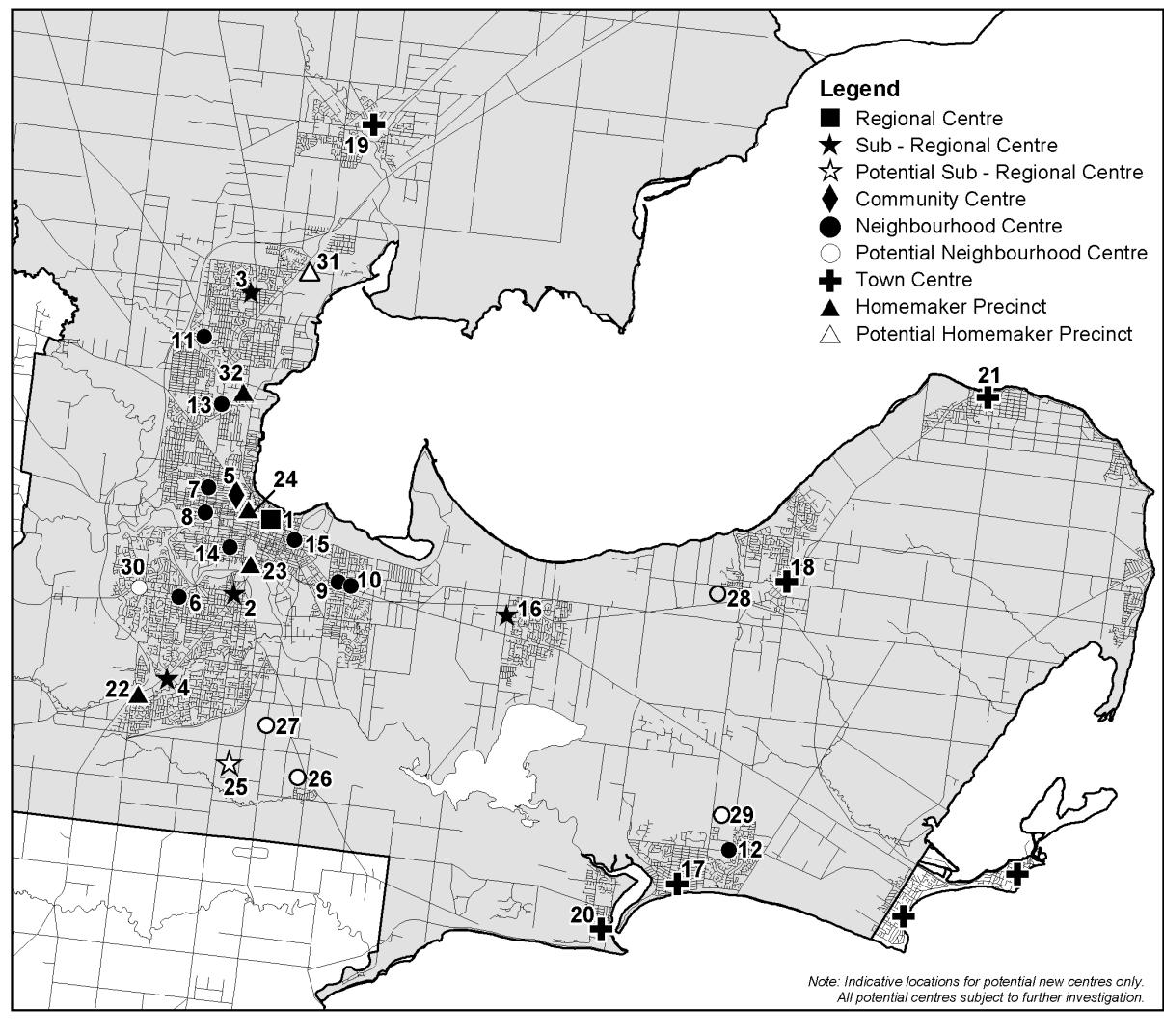
| CITY OF GREATER GEELONG RETAIL ACTIVITY CENTRE HIERARCHY | ||
LEVEL IN HIERARCHY |
IDENTIFIED CENTRES |
INDICATIVE FLOORSPACE AND EXAMPLE KEY TENANTS |
Regional Centre |
Central Geelong (1) |
More than 100,000 sqm Department store, discount store(s), mini major(s), supermarkets(s) and extensive range of specialties |
Sub-regional Centres |
Belmont (2), Corio Village (3), Waurn Ponds (4) Leopold (16) |
15,000 sqm to 35,000 sqm Discount department store(s), mini major(s) supermarket(s) and specialties |
Community Centre |
Pakington Street (Geelong West) (5) |
10,000 sqm to 25,000sqm Supermarket(s), mini major(s) and specialties |
Neighbourhood Centres |
Highton (6), Shannon Avenue (Geelong West) (7), Shannon Avenue (Newtown) (8), Bellarine Village (9), Newcomb Central (10), Bell Post (11), Ocean Grove marketplace (12), Separation Street (13), Pakington Street (Newtown) (14), Geelong East (15) |
2,500 sqm to 25,000 sqm Supermarket (small or full line), primarily convenience oriented specialties |
| Town Centres |
Ocean Grove (Town Centre) (17), Drysdale (18), Lara (19), Barwon Heads (20), Portarlington (21) |
1,500 sqm to 15,000 sqm Supermarket, mini major(s), specialties |
Homemaker Precincts |
Waurn Ponds (22), Moorabool/Fyans (23), Geelong West (24), North Geelong (32) |
5,000 sqm to 50,000 sqm Large restricted retail type tenants |
Potential Subregional Centres |
Armstrong Creek (25) |
|
Potential Neighbourhood Centres |
Armstrong Creek East (26), Armstrong Creek Horseshoe Bend Rd (27), Jetty Road Growth Area (28), Ocean Grove north east growth corridor (29), Wandana Heights (30) |
|
Potential Homemaker Precincts |
Corio (31) |
|
21.07-9 Heales Road Industrial Estate Framework Plan map
28/01/2010
C129(Part1)
21.14 The Bellarine Peninsula
29/11/2012 C273
21.14-1 Key issues and Influences
28/01/2010
C129(Part 1)
The Bellarine Peninsula comprises a series of contained townships separated by rural and coastal areas.
The rural and coastal areas on the Bellarine Peninsula form an important non-urban break between settlements. They are highly valued for their scenic attributes, tourism function, environmental function and lifestyle appeal.
The Bellarine Peninsula is one of the fastest growing areas in the City of Greater Geelong. Population growth on the Bellarine Peninsula is being driven by the attractiveness of the peninsula as a relaxed lifestyle destination within close proximity to urban Geelong.
Appropriately managing urban growth on the Bellarine Peninsula will be critical to retaining the peninsula’s identity and attributes.
--/--/2013
C254
21.14-2 Objectives
To protect and enhance the rural and coastal environment on the Bellarine Peninsula and maintain non-urban breaks between settlements.
To facilitate the development of Ocean Grove, Drysdale/Clifton Springs and Leopold as hubs of development and service provision on the Bellarine Peninsula. In all other townships on the Bellarine Peninsula provide retail, commercial and community uses and facilities that serve the daily needs of the community and encourage street based activity.
To provide for sustainable industrial, commercial, retail, agricultural and tourism development in designated locations, to service the wider Bellarine community.
To preserve the individual character, identity and role of each Bellarine township.
Strategies
Ensure that development responds to the identity and character of the individual township in which it is located.
Protect rural and coastal environments from inappropriate urban encroachment.
Ensure land use and development proceeds generally in accordance with the relevant Structure Plan maps included in this Clause.
Ensure that development outside of settlement boundaries (as shown in the Structure Plan maps included in this clause) does not compromise the rural, environmental and landscape values of the non-urban breaks or longer term growth opportunities.
Direct the bulk of residential growth and retail development to Ocean Grove, Drysdale/Clifton Springs and Leopold consistent with the relevant Structure Plan maps included in this clause.
Direct bulky goods retailing and industrial development to existing and future areas as identified in Structure Plan maps included in this clause.
St Leonards:
Support a mix of retail, commercial, community and entertainment uses within the town centre.
Encourage development which respects the coastal landscape setting of St Leonards by:
Providing reasonable sharing of views of the coast and foreshore.
Promoting contemporary design that reflects the existing scale, setbacks, spacing, forms and materials of the buildings in the locality.
Ensuring that development allows for the protection of significant vegetation and/or planting around buildings and has minimal impact on roadside vegetation.
Support the development of an appropriately located community centre.
Support the on-going management, enhancement and sensitive development of the foreshore, Salt Lagoon Wildlife Reserve and Edwards Point State Faunal Reserve.
Protect the scenic qualities of Murradoc Hill and Swan Bay.
Support the development of a focal building, comprising retail and tourist related activities, at the south west corner of Murradoc and Bluff Roads.
Integrate the town centre and pier-foreshore area.
Portarlington:
Support a mix of retail, commercial, community and entertainment uses within the town centre.
Encourage development which respects the coastal landscape setting of Portarlington by:
Providing reasonable sharing of views of the coast and foreshore.
Promoting contemporary design that reflects the existing scale, setbacks, spacing, forms and materials of the buildings in the locality.
Ensuring that development allows for the protection of significant vegetation and/or planting around buildings and has minimal impact on roadside vegetation.
Support the establishment of a Community Centre in Portarlington within an existing public building.
Support the provision of a new fire station at Portarlington.
Support the integration of the Portarlington town centre and pier-foreshore area.
Support the development of a focal building at 22-34 Newcombe Street, Portarlington, to contain retail uses, tourist accommodation and tourism related activities.
Support development in the Portarlington town centre incorporating accommodation uses above ground level retail floor space, where such development meets all parking and access requirements.
Indented Head:
Encourage development which respects the coastal landscape setting of Indented Head, by:
Providing reasonable sharing of views of the coast and foreshore.
Promoting contemporary design that reflects the existing scale, setbacks, spacing, forms and materials of the buildings in the locality.
Ensuring that development allows for the protection of significant vegetation and/or planting around buildings and has minimal impact on roadside vegetation.
Support the on-going management, enhancement and sensitive development of the foreshore, Point Richards Flora and Fauna Reserve and Salt Lagoon Wildlife Reserve.
Support expansion of the existing retail premises on The Esplanade, Indented Head.
Ocean Grove:
Encourage development which respects the coastal landscape setting of Ocean Grove, by:
Providing reasonable sharing of views of the coast and foreshore
Promoting contemporary design that reflects the existing scale, setbacks, spacing, forms and materials of the buildings in the locality.
Direct new greenfield residential development to the designated growth area in the north-east of the township, as shown on the Structure Plan map.
Encourage a range of accommodation and housing options, including aged care within and adjacent to the town centre and other existing and proposed activity centres.
Ensure development avoids impacts on environmental assets including the Coast, Buckley Park Foreshore Reserve, Goandra Estate, Ocean Grove Nature Reserve, Barwon River/Lake Conneware and the Lake Victoria Wetlands.
Ensure the town centre remains the primary retail centre for Ocean Grove by providing for a range of retail, business and accommodation uses.
Support expansion of the town centre, particularly in a northerly direction up to the Avenue.
Support development of a new Neighbourhood Activity Centre on Grubb Road, to service the future population of the north-east growth area.
Support the continued development of industrial, restricted retail and associated businesses on Grubb Road, and support the expansion of this type of development to the east and north, as shown on the Structure Plan map.
Where appropriate, ensure new developments assist in the establishment of a safe bicycle-pedestrian path network around the town connecting the foreshore, river, nature reserve, Grubb, Banks and Bonnyvale Roads as shown on the Structure Plan map.
Where appropriate, ensure new development contributes to the improvement of open spaces, key pedestrian links and roads as identified on the Structure Plan map.
Provide for a range of appropriately scaled and located tourism accommodation and activities.
Encourage a range of appropriately scaled tourism related activities on the rural periphery of the town which are complementary to the environmental and rural setting.
Support the duplication of Grubb Road in a manner which preserves significant roadside vegetation, provides an attractive town entry, safe crossing points, pedestrian/cycle paths and undergrounding of powerlines.
Leopold:
Support Leopold as a Sub Regional Retail Activity Centre for the Bellarine Peninsula, whilst providing local community, recreational and employment facilities to Leopold’s residents.
Ensure the retention of Leopold as an urban island - supporting urban growth contained to the settlement boundary and preserving the surrounding rural hinterland.
Support the development of the Ash Road Growth Area and other areas identified for residential development on the Structure Plan map.
Support increased housing densities around the Sub Regional Retail Activity Centre and neighbourhood shopping strips at Ash Road and Dorothy Street.
Encourage the northerly expansion of the Sub Regional Retail Activity Centre, ensuring any development integrates with the existing centre and surrounding community facilities, and enhances its appearance and functionality.
Support the local convenience role of the Ash Road and Dorothy Street neighbourhood shopping centres, whilst restricting any future expansion of these centres.
Support the development of Council’s Kensington Road Community Hub to provide a wide range of community, health, education and civic services/facilities.
Encourage the creation of an additional local mixed use centre on the south east corner of Bellarine Highway and Melaluka Road. Any redevelopment of this site could accommodate restaurants, convenience shops, offices and residential development.
Provide public open space within existing and proposed residential areas to cater for the passive and active recreation needs of the community.
Provide an improved transport network which includes better traffic movements, pedestrian and cyclist linkages and public transport options.
Ensure environmentally sensitive areas including Lake Connewarre and Reedy Lake are protected from localised development pressure.
Investigate opportunities for public access to Port Phillip Bay.
Barwon Heads:
Maintain a compact urban form and avoid outward sprawl.
Protect the unique character of Barwon Heads as a coastal village located within a sensitive environment and significant landscape setting.
Ensure the Hitchcock Avenue shopping centre remains the focus of retail activity in Barwon Heads.
Restrict new commercial development to the existing business and mixed use zones in Hitchcock Avenue between Bridge Road and Ozone Road and the south side of Bridge Road.
Ensure new housing development complements the character of Barwon Heads and provides for a variety of housing sizes and types.
Support the continued development of 13th Beach Resort as a tourist destination.
Continue upgrading the Barwon Heads Village Park and foreshore reserves in accordance with established master plans.
Support development of appropriate tourist accommodation around the Barwon Heads town centre.
Drysdale/Clifton Springs:
Contain urban development within the defined settlement boundary on the Structure Plan map.
Support the development of the Jetty Road Urban Growth Area and other areas identified for residential development on the Structure Plan map.
Ensure new development incorporates sustainability principles including environmentally sustainable design, energy efficiency, connectivity and water sensitive urban design.
Reinforce the Drysdale town centre as the primary retail centre including the development of an additional supermarket.
Confine future development of a service business or industrial nature in the identified precinct along Murradoc Road.
Locate and integrate future education, community and recreation facilities to enhance their accessibility and to maximise joint use wherever possible.
Develop the Council owned Palmerston Street site and the Drysdale Regional Community and Cultural Hub for community and recreation purposes.
Ensure any development of short term tourist accommodation at the Curlewis Golf Course is located at the eastern end of the course in close proximity to the Jetty Road Urban Growth Area, functions as a minor component to the primary role of the site as a golf course and maintains the rural landscape character of the site.
Provide additional bicycle and pedestrian opportunities throughout the townships including new footpaths and bicycle lanes.
Point Lonsdale
Support low scaled and designed tourism opportunities on designated land identified on the Point Lonsdale Structure Plan map at Clause 21.14-12.
Ensure new development strengthens the township’s coastal village character and landscape setting by requiring a high standard of architectural and urban design response including;
Low scale forms
Articulation (materials, openings or features such as decks, balconies, wide eaves or canopies).
Contemporary design quality.
Use of materials such as timber, corrugated iron, weatherboard or light coloured render.
Limiting site coverage and provide front and side setbacks that reflect existing neighbourhood patterns and provide opportunities for maintenance and planting of native coastal and indigenous vegetation.
Ensure that new urban development street works and road designs contribute to the implementation of the identified primary and secondary pedestrian/cycle routes and are designed to complement the informal coastal streetscape character.
--/--/2013
C254
21.14-3 Implementation
These strategies will be implemented by:
Using policy and the exercise of discretion
Ensure development respects the natural coastal landscape as described in the Coastal Spaces Landscape Assessment Study and, where relevant, assess applications against schedules 10, 11, 12 13 and 14 to the Significant Landscape Overlay.
Ocean Grove
Support buildings of up to three storeys within the town centre which utilise contemporary building forms and materials, articulation and setback of upper levels so as to complement the coastal setting, and which provide sufficient car parking.
Support higher density development including tourist accommodation of up to three storeys along The Terrace between Hodgson and Eggleston Streets which utilise contemporary building forms and materials, articulation and setback of upper levels to retain a coastal town character and provide for the reasonable sharing of coastal views.
Support further development of existing caravan parks and accommodation uses in residential areas, particularly those close to the beach and river, to provide a broader range of accommodation type and mix.
Applying Zones and overlays
Ocean Grove
Apply the Residential 1 Zone to growth areas identified in the Ocean Grove Structure Plan 2007 as appropriate.
Apply the Development Plan Overlay to those parts of the north-east growth corridor that are rezoned for urban development.
Apply the Development Contributions Plan Overlay to north-east residential corridor.
Apply the Industrial 3 Zone to any expansion of the Grubb Industrial Estate.
Apply the Development Plan Overlay to any expansion of the industrial–restricted retail precinct on Grubb Road.
Apply the Business 1 Zone over land bounded by The Avenue, The Parade, Presidents Avenue and Hodgson Street.
Apply the Mixed Use Zone over the former CFA depot (south-east corner The Avenue and Hodgson Street) and land to the immediate south.
Leopold
Apply the Residential 1 Zone and the Development Plan Overlay to land designated for future residential growth shown on the Leopold Structure Plan map included in this clause.
Apply a combination of business zones, a Design and Development Overlay and a Development Plan Overlay to facilitate the expansion of the Leopold Sub Regional Retail Activity Centre.
Drysdale
Apply the Residential 1 Zone with a Development Plan Overlay (DPO) based on the principles identified in the Structure Plan to Princess Street, Central Road and Oakden Road.
Support the application of the Residential 1 zone to identified residential infill areas to a Residential Zone with appropriate DPO and Developer Contribution Plan (DCP) controls.
Support a joint rezoning and development application at the Curlewis Golf Club to facilitate short term tourist accommodation.
Point Lonsdale
Apply the Residential 1 Zone with a Development Plan Overlay to the portion of the Lonsdale Golf Course shown for residential growth on the Point Lonsdale Structure Plan map at Clause 21.14-12 subject to an amendment and EES process.
Apply appropriate design and environmental overlays to areas of consistent urban and landscape character.
Rezone the Business 4 Zone land on the corner of Fellows Road and Bellarine Highway to facilitate tourism development.
Further work
Review township structure plans as scheduled (in structure plans) to meet emerging needs of communities.
Review the planning framework for land identified in the Coastal Spaces Landscape Assessment Study as regionally significant in the south west of the Bellarine Peninsula to ensure the protection of landscape values is adequately addressed.
Point Lonsdale
Work with the Borough of Queenscliffe to address climate change issues in Point Lonsdale and implement any relevant outcomes.
Prepare detailed streetscape design plans for designated primary and secondary routes as identified in the Point Lonsdale Structure Plan.
Investigate opportunities to establish a railway station-transport interchange precinct to link with the Queenscliff tourist railway service.
Portarlington
Prepare an Urban Design Framework for the Portarlington Town Centre.
Support Parks Victoria Safe Harbour Project, including ensuring appropriate integration with the adjacent foreshore reserve and Town Centre.
Ocean Grove
Prepare a Development Contributions Plan for the Ocean Grove Township, including the northern urban growth area.
Review the application of Significant Landscape Overlay 7.
Prepare an Urban Design Framework and Parking Precinct Plan for the Ocean Grove Town Centre.
Prepare Streetscape Plans for The Parade – Orton Street, Shell and Grubb Roads, Tuckfield Street, The Terrace, the Hodgson – The Parade Town centre entry and key streets between the beach and Town Centre.
Leopold
Implement the Leopold Activity Centre Urban Design Framework, 2011.
Implement the Memorial Park Masterplan, 2011.
Support the implementation of the Kensington Road Community Hub Concept Design, 2008.
Undertake further assessment of sites nominated as “Urban Consolidation” in the plan attached to this Schedule.
Undertake a Flood Study to introduce controls over areas identified appropriate for Floodway Overlay (FO) or Land Subject to Inundation Overlay (LSIO).
Barwon Heads
Undertake a Landscape Assessment Study for the Ewing Blyth/Golf Links/Bridge Road and the Warrenbeen Court residential areas with the intention to apply an overlay to protect the existing character and vegetation.
Undertake a detailed study of Murtnaghurt Lagoon to establish whether the boundaries of the existing Environment Significant Overlay require review.
Implement the findings of the Barwon Heads Parking & Traffic Study.
Consider the impacts of climate change on the future development of Barwon Heads in accordance with the Climate Change Adaptation Strategy to be developed by Council during 2010-2011.
Drysdale/Clifton Springs
Investigate the relocation of the bowling club and the Council depot site on Collins Street to support a combined rezoning and planning permit application on the Drysdale Bowling Club site to facilitate the development of a supermarket.
Develop and implement an Urban Design Framework for the Drysdale town centre, including the Business 4 zoned land along Murradoc Road.
Prepare a Master Plan for the development of a community hub on the Council owned land at Palmerston Street site in the town centre.
Prepare a Master Plan for the development of the Drysdale Regional Community and Cultural Hub.
References
Bellarine Peninsula Strategic Plan, City of Greater Geelong, 2006.
Ocean Grove Structure Plan, Hansen Partnership and the City of Greater Geelong, 2007.
Portarlington Structure Plan, City of Greater Geelong, 2007.
Indented Head Structure Plan, City of Greater Geelong, 2007.
St Leonards Structure Plan, City of Greater Geelong, 2006.
Leopold Structure Plan, City of Greater Geelong, 2011 (amended January 2013).
Leopold Urban Design Framework, City of Greater Geelong, 2011.
Barwon Heads Structure Plan, City of Greater Geelong, 2010.
Drysdale Clifton Springs Structure Plan, City of Greater Geelong, 2010.
Jetty Road Urban Growth Plan 2007.
City of Greater Geelong Municipal Reference Document, Coastal Spaces Landscape Assessment Study (Planisphere, 2006).
Point Lonsdale Structure Plan, Planisphere, April 2009 (amended November 2011).
21.14-4 St Leonards Structure Plan map
28/01/2010
C129(Part 1)
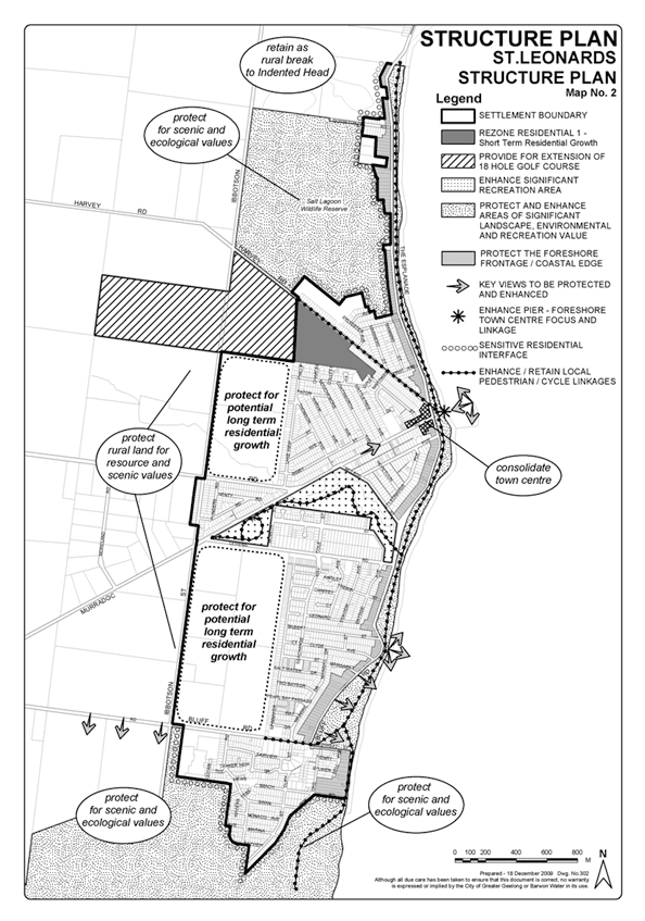
21.14-5 Portarlington Structure Plan map
29/11/2012
C273
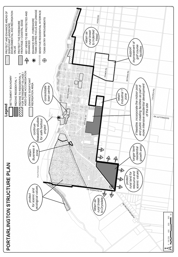
21.14-6 Indented Head Structure Plan map
28/01/2010
C129(Part 1)
21.14-7 Ocean Grove Structure Plan map
28/01/2010
C129(Part 1)
26/08/2010
C159
21.14-8 Leopold Structure Plan map
--/--/2013
C254
21.14-9 Barwon Heads Structure Plan map
21.14-10 Drysdale Clifton Springs Structure Plan map
06/01/2011
C194)
21.14-11 Jetty Road Urban Growth Plan map
28/01/2010
C129(Part 1)
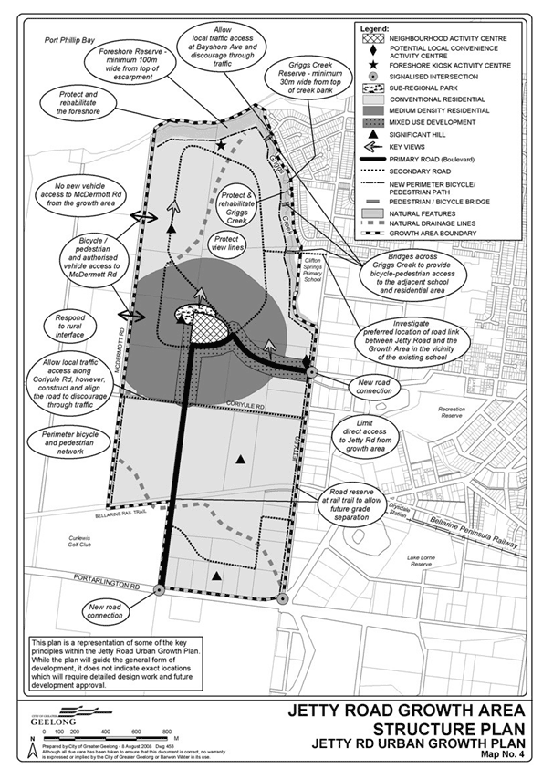
21.14-12 Point Lonsdale Structure Plan map
26/07/2012
C165
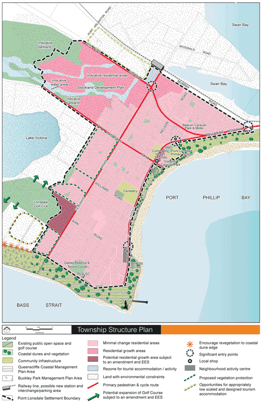
Cr Fagg (Mayor) declared an Indirect Interest by Close Association in Agenda Item 2 – Rippleside – Planning Permit 647/2004/A – Extension of Time, in that he is an adjoining landowner and remained out of the meeting room.
Cr S Kontelj declared an Indirect Interest by Close Association in Agenda Item 2 - Rippleside – Planning Permit 647/2004/A – Extension of Time, in that his sister has an interest in a property in Balmoral Crescent and left the meeting room prior to discussion of the item at 9:25pm.
Portfolio: |
Planning – Cr Macdonald |
Source: |
City Development - Statutory Planning |
General Manager: |
Peter Bettess |
Index Reference: |
P647/2004/A |
Planning Permit 647/2004 was issued by the Victorian Civil and Administrative Tribunal (VCAT) on 28 February 2005. This permit has been extended twice and is still valid. The development must now commence by 28 February 2013 and be completed within six years of the date of commencement.
The permit allows the redevelopment of the site with a convenience shop, restricted recreation facility, marina and 178 dwellings.
An application to amend the planning permit was made to VCAT in April 2012. In summary, the amendment sought to subdivide the land into a number of ‘super lots’ which could then be further subdivided through the operation of the permit. At the Council meeting of 10 July 2012, the Responsible Authority resolved to oppose the amendment.
The amendment application went before VCAT for three days beginning 23 July 2012. VCAT is yet to make a decision as to whether to allow the amendment.
On 10 December 2012, an application was made by Samantha Ramsay on behalf of the owner, Trendcorp Pty Ltd, to extend the date by which the planning permit must be commenced. A new commencement date of 28 February 2014 has been requested.
The site is zoned Comprehensive Development Zone– Schedule 2 (CDZ2) and is subject to an Environmental Audit Overlay (EAO). The CDZ2 includes a sunset clause. The CDZ2 will lapse if the development of the site has not commenced in accordance with any permit issued for such development by 30 January 2013.
The purpose of this report is to form Council’s position on whether to support the extension of time request.
Cr Heagney moved, Cr Richards seconded -
That the Responsible Authority decides to refuse the extension of time sought for Planning Permit 674/2004/A on 10 December 2012, except where VCAT decides to support the application to amend the planning permit that was heard by VCAT in July 2012 but for which a decision is yet to be made.
Carried.
The site and surrounding area
The Rippleside Shipyard site occupies a 2.8 hectare parcel of reclaimed land that extends out from the escarpment or cliff below Balmoral Crescent. It is located between the beaches of St Helen’s Park to the north and Rippleside Park to the south. Access to the site is provided via Liverpool Street.
The site is currently developed with a number of industrial buildings and sealed areas, with a jetty located to the east of the site extending over the water. An escarpment is located to the west of the site, apart from the escarpment the site falls towards the bay, with a fall of around 3.5 metres from west to east.
A number of large dwellings have been developed along the cliff top in Balmoral Crescent and these dwellings are designed to capture the views available of the coast and the ocean.
A Locality Map is provided at Appendix 2-1.
History of the site
In the 1990’s the Port of Geelong determined that the shipyard, other than as a berth for its tug boats, was surplus to its needs and sold the site to the permit applicant. The permit applicant has also obtained a lease over the Crown land of the seabed under the jetty. The resultant site also includes the foreshore area in front of the site.
Following gazettal of Amendment R245, the land, other than the jetty, was rezoned to Comprehensive Development Zone– Schedule 2 (CDZ2) and an Environmental Audit Overlay was applied to the land. The Comprehensive Development Zone was put into place to ensure the integrated redevelopment of the site which is sympathetic to the surrounding residential and recreational environment.
The CDZ2 includes a sunset clause. It will lapse if the development of the site has not commenced in accordance with any permit issued for such development by 30 January 2013. The sunset clause has been extended twice, the last of which was in January 2011 through Amendment C237.
Planning permit application 647/2004 which sought the redevelopment of the site was lodged with Council in May 2004. A total of 100 objections were lodged in relation to the development, along with 65 submissions in support of the proposal. Council failed to make a decision on the application within the time prescribed by the Planning and Environment Act 1987, and an application was made to VCAT. Ultimately, VCAT supported the application which allowed for the redevelopment of the site with a convenience shop, restricted recreation facility, marina and more than 98 dwellings (178 dwellings).
The Planning Permit has been extended on two previous occasions - in February 2008 and November 2011. By letter dated 20 July 2011, Council officers advised the owner in relation to the 2011 extension that the request was supported and that, “Council considers that you will therefore have had adequate time to arrange finance and complete construction within that timeframe, noting that the original planning permit was issued in 2005.” The development must now commence by 28 February 2013 and must now be completed within six years of the date of commencement.
An application to amend the planning permit was made to VCAT in April 2012. In summary, the amendment sought to subdivide the land into a number of ‘super lots’ which could then be further subdivided through the operation of the permit. At the Council meeting of 10 July 2012, Council resolved to oppose the amendment.
The amendment application went before VCAT for three days beginning 23 July 2012. VCAT is yet to make a decision as to whether to allow the amendment.
On 10 December 2012, a third request was made to extend the ‘life’ of the planning permit. A new commencement date of 28 February 2014 has been requested.
Discussion
The extension of time application includes the following reason for requesting the extension:
“Permit 647/2004/A was issued by VCAT and Trendcorp Pty Ltd has applied to VCAT under the major cases list for an amendment to the existing permit to allow for subdivision of the building footprint area into superlots and eventually individual lots. The matter was heard by VCAT on the 23-25 July 2012. A decision was due to be provided by VCAT within 4 weeks of the hearing which would be late August.
“Given that a decision hasn’t yet been made and that the expiry date is rapidly approaching, we respectfully request an extension of 12 months from the current date to allow for the VCAT decision and conditions precedent to be satisfied prior to the expiry. This would make the expiry date 28 February 2014.”
The accepted ‘tests’ for extension of time requests are set out in Kantor vs. Murrindindi Shire Council (18 AATR 285). They are:
Whether there has been a change in planning policy
Whether the landowner is seeking to “warehouse” the permit
Intervening circumstances as bearing upon grant or refusal
The total elapse of time
Whether the time limit originally imposed was adequate
The economic burden imposed on the landowner by the permit
The probability of a permit issuing should a fresh application be made.
Whether there has been a change in planning policy
The planning controls have not significantly altered since the permit issued in 2005. However, the site specific zoning that applies to the land (CDZ2) is due to lapse where the development is not commenced by 30 January 2013.
By letter dated 2 January 2011 in relation to Amendment C237 (that extended the sunset clause in 2011), the Minister for Planning wrote:
”I note the site was rezoned to the Comprehensive Development Zone in 2001 and that this is the second time the date for the lapsing of the schedule has been extended. I am advised that the sunset clause included in Schedule 2 to the Zone was originally specified to try and avoid undue delays in the development of the site. I appreciate that large developments often have considerable lead times. However, I am concerned that extension of such a sunset clause and the related planning controls may also extend the uncertainty about the future of the Rippleside Quay site for the local community. Consequently I have advised the proponent that any further extension of these controls should be considered through the normal exhibited planning scheme amendment process.”
While development of the land could be commenced after 30 January 2013 where a valid permit allowed such development, it is considered that extending the life of the planning permit much more than 12 months beyond the sunset date is at odds with the intent of the CDZ2.
Whether the landowner is seeking to “warehouse” the permit
The owner has sought a significant amendment to the planning permit. Council did not support the amendment and VCAT are yet to decide upon it. The amendment was lodged a considerable time after the planning permit was granted. The owner has been attempting to sell the approved dwellings from a sales office on the land. These factors may suggest that the development is not commercially viable and is unlikely to be acted upon.
Officers consider that the landowner is seeking to ‘warehouse’ the permit that is the subject of Planning Permit 647/2004/A.
Intervening circumstances as bearing upon grant or refusal of an extension
The approaching sunset date in the CDZ2 and the outstanding VCAT decision are considered relevant intervening circumstances.
As discussed, the approaching sunset date is considered to give weight to not extending the permit. Part of the permit holder’s justification for the recent amendment application is understood to be that the approved development has failed to attract sufficient interest to make that development commercially viable.
It is not known whether VCAT will allow the amendment sought to the planning permit, or by what conditions it might be subject to. It may eventuate that an amended permit issues but it has already expired or insufficient time is provided to act upon it.
It is considered reasonable that if VCAT were of a mind to allow an amendment to the permit, the proponent should be afforded the opportunity to act upon it.
The total elapse of time
The permit was first issued in February 2005. Amendments to the plans were approved in October 2007. Two extensions of time have been granted and the development must now commence by 28 February 2013.
Whether the time limit imposed was adequate
The time limit was adequate.
The economic burden imposed by the permit
The economic burden imposed by the permit would be significant (but the time provided to act upon the permit has been significant).
The probability of a permit issuing should a fresh application be made
The probability of a permit issuing is considered low in circumstances that the site specific zoning would lapse on 30 January 2013. Typically, a low probability gives weight to a conclusion that an extension should not be supported.
Conclusion
On balance, it is recommended that an extension of time should be supported only to the extent that it might allow the development that is currently being considered by VCAT.
There are no known environmental implications for Council.
There are no known financial implications for Council.
There are no known policy/legal/statutory implications for Council.
No Council officers involved in this report and request have any direct or indirect interest in the matter to which this report relates, in accordance with Section 80 (C) of the Local Government Act.
There are no known financial risks for Council.
The site has been vacant for a considerable period which has added to uncertainty for nearby residents. A waterside pedestrian link is included in the development proposal which is at risk if the development does not proceed.
Extension of time requests do not typically include third party notice.
Appendix 2-1
Locality Map
Cr Fagg (Mayor) and Cr S Kontelj re-entered the meeting room at 9:30pm.
Cr Fagg (Mayor) resumed the Chair at 9:30pm.
Portfolio: |
Enterprise Geelong – Cr Harwood Knowledge Economy – Cr Macdonald Community Development – Cr Fisher |
Source: |
Economic Development, Planning & Tourism |
General Manager: |
Peter Bettess |
Index Reference: |
Skilling the Bay |
The State Minister for Higher Educations and Skills announced in April 2011 a for a project referred to as Skilling the Bay, $500,000 was allocated to training retrenched workers from Ford, with $1.3 million allocated to the Gordon, to support the Gordon and Deakin University to build the regions skill base, and support businesses to fast track new technologies.
The project has been managed to date by an operational steering committee, chaired by the Gordon CEO, and officer representatives from Deakin University, the State Government and the City of Greater Geelong.
The project has been scoped to include:
Initial research (labour market profile)
Future Industry demonstration projects
Specific sector (HACC) work force development activity
Development of a future jobs vision and implementation of this vision via training and development initiatives
The Gordon, as the lead agency has sought the assistance of Council in the implementation of the Future Industry demonstration projects, and HACC workforce development project.
It is recommended that Council actively support the roll out of the Skilling the Bay project generally, and specifically assist In the implementation of Future Industry demonstration initiative, and the HACC work force development program.
Cr Harwood moved, Cr Macdonald seconded -
That Council resolves to:
endorse the directions of the Skilling the Bay project and actively support the implementation program ongoing.
formally accept the invitation to act as administrator for the future industry project.
actively participate in the Home and Community Care Workforce Development Project.
Carried.
Minister Peter Hall, the Minister for Higher Education and Skills in the State Government, announced in April 2011 the Skilling the Bay Project. The fund was in response to job losses at Ford and other economic challenges across Geelong. $500,000 of the fund was committed to government-sponsored training places for Ford retrenched workers. With $1.3 million committed to assist the Gordon and Deakin University to build the region skill base and support businesses to fast track new technologies and practices.
The two complementary objectives of Skilling the Bay project are:
to develop a long-term jobs vision for Geelong and Workforce Development Action Plan to achieve it; and
to support the growth of existing and emerging industries through targeted demonstration projects
The project is effectively being delivered in three phases:
Detailed labour market profile identifying industries which are challenged or in transition, and also the identification of emerging sectors/opportunities and skills required to achieve success in these emerging fields.
$500,000 committed to a Skilling the Bay demonstration project which aims to trigger growth in an industry for the future, and Home/Community Care (HACC) workforce development project which is specifically targeted at addressing the unmet current and future workforce demands in the HACC sector by providing retraining and transitioning opportunities for retrenched and displaced workers.
The third key element of the project is to develop a Geelong jobs vision and workforce development action plan via a jobs summit, which would benefit from the Geelong Labour market profile being completed, and demonstration projects having commenced. It is considered that at that point in the project an informed position could be taken by key stakeholders as to the key directions to steer Geelong into a positive training and employment future.
Beyond these steps and an implementation program has been developed to follow the jobs summit and will be rolled out from 2014. A copy of the draft delivery plan for the prospect is attached for information.
The project has been managed to date via an operational steering committee of the CEO of the Gordon, an officer representing the City of Greater Geelong, a Deakin University representative and officers of the State Higher Educations and Skills Group.
The steering committee has endorsed the above-mentioned approach and the Gordon as the lead agency has requested the Councils assistance to administer the grant process associated with the Geelong Future Industry Project. The $500,000 committed to this project obviously will be provided via the funding allocated to the Gordon. The Council’s role will be to administer an Expressions Of Interest process to attract key parties which meet the objectives and eligibility criteria, and administer the distribution of grant monies subject to meeting milestones. The Gordon has requested the Councils support and physical assistance in relation to this aspect of the project given the councils established grant management systems and skills in this area across economic development
Further the Gordon as lead of the project has requested the Council engage, through the Aged and Disability Services Business Unit, in the Home and Community Care (HACC) Workforce Development Project given Council is one of the major employers of HACC personnel across the region. The partnering in the delivery of this project is considered appropriate to ensure the delivery of an appropriate outcome (refer
It is recommended that Council endorse the directions of the Skilling the Bay project, offer its support in relation to the promotion of the program, and accept the invitation to assist the project in managing the grant process for the Geelong Future Industry Project and to participate in the Home and Community Care Workforce Development Project.
There are no environmental implications in relation to the report or recommendations.
The grant funding for the future industry project will be provided via the Gordon as part of the state grant monies, and the administration of the fund can be managed within existing budgets of the Planning Strategy and Economic Development Business Unit.
There are no statutory limitations in relation to the recommendations of this report.
It is further considered that the recommendations to actively participate and support the Skilling the Bay project fit comfortably with the directions of the existing Economic Development Strategy of Council.
No council officer involved in the development of this report have a direct or indirect interest in the issue in accordance with section 80 (C) of the Local Government Act to which the report relates.
In relation to the specific exposure of Council in relation to administering the grant funding under the future industry project, each grant applicant will be subject to an individual risk assessment to ensure Council is not exposed in this regard, and similarly in relation to any participation in the HACC Workforce Development Plan, this will be subject to a detailed risk analysis when the project is formalised.
With the significant economic pressure on a range of industry sectors across Geelong it is of paramount importance that Council work collaboratively with partners in delivering direction for future industry and job growth. The recommendations of this report in supporting and participating in the Skilling the Bay project are considered to be appropriate actions in addressing these matters.
As detailed in the report proper there will be a need for active communication and support from the Council in progressing the Skilling the Bay project. A Communication Strategy will be developed by the partners and, with Mayoral representation where appropriate in the Skilling the Bay project and will be part of the ongoing work in delivering the project.
Portfolio: |
Community Safety – Cr Farrell |
Source: |
Community Services / Community Development |
General Manager: |
Jenny McMahon |
Index Reference: |
Subject: Community Services / Gambling |
Council has received an application from Waurn Ponds Management Pty Ltd (in accordance with the Gaming Regulation Act 2003) to increase the number of Electronic Gaming Machines (EGMs) at the Waurn Ponds Hotel, Princess Highway, Waurn Ponds from 56 to 70.
In recent years, Council has received two applications relating to the Waurn Ponds Hotel: 2009 – the transfer of 21 EGMs from the Norlane Hotel to the Waurn Ponds Hotel (for a total of 56 EGMs); 2011 – an application for 14 EGMs (for a total of 70 EGMs).
These applications were not opposed as they resulted in an improvement in the distribution of EGMs within the municipality and improved distribution between areas of high and low SEIFA index. (Norlane is identified as an area of significant disadvantage as opposed to Waurn Ponds which is identified as an area of relative advantage in which EGMs might be reasonably relocated.)
The latter application was approved by the Victorian Commission for Gaming and Liquor Regulation (VCGLR) on the condition that stages 2 and 3 of the proposed redevelopment of the Waurn Ponds Hotel were completed by a specified date (16 August 2013). The hotel owners have been unable to meet this timeline and have requested an extension. Council has been informed by the VCGLR that due to the specified date passing, the original 2011 EGM application approval will lapse and a new application is required. The current application is a re-submission of this previously approved application.
The Waurn Ponds Hotel is located in an area which can accommodate additional machines in accordance with Council’s Strategic Gaming Policy and fits the criteria of a destination gaming venue (which also accords with Council’s Gaming Policy as included in the Planning scheme). Refer Table 1, Attachment 4-1.
In order to allow time for Council to consider this report and make a determination on the matter, Council has notified the VCGLR that it intends to make a submission on the application. However, given that the application is consistent with Council’s Strategic Gaming Policy, and Council did not oppose the previous application, it is recommended that Council now write to the VCGLR stating that it will not be making a submission.
Cr Farrell moved, Cr Heagney seconded -
That Council:
not make a submission on the application by Waurn Ponds Management to the Victorian Commission for Gambling and Liquor Regulation (VCGLR) to increase the number of electronic gaming machines from 56 EGMs to 70 EGMs at the Waurn Ponds Hotel.
writes to the VCGLR confirming this decision.
Carried.
Council adopted a Strategic Gaming Policy on 27 June 2006. This policy was developed in order to guide Council in its consideration of applications for EGMs in the City of Greater Geelong.
In order to guide this process, the municipality was divided into a number of areas which, depending on the local EGM density and Social-Economic Indexes for Areas (SEIFA 2001), were given a rating score. These ratings were in turn colour coded to guide decision-making on each application. The coding ranks areas from red – relatively disadvantaged, through pink, yellow, green and blue – relatively the most advantaged. The purpose of this coding is to indicate where EGMs should be relocated ‘from’, ie areas at the disadvantaged end of the spectrum, and where they should be relocated ‘to’ at the advantaged end. These rating scores have since been amended with the 2006 Census data (2011 data is not yet available at the neighbourhood level). The amended SEIFA scores for the 10 Gaming areas within the City of Greater Geelong / Borough of Queenscliffe are represented in Table 1, Attachment 4-1.
The areas of most disadvantaged are represented by the lowest average SEIFA score. Map 1, Attachment 4-1 shows the 10 areas, colour-coded to reflect the 2006 SEIFA average score. Disadvantaged areas are shaded red whereas advantaged areas are represented in green. Taking into account updated SEIFA data, Waurn Ponds is identified as an area of relative advantage and an area in which EGMs might be reasonably relocated.
In 2010 the Victorian State Government conducted an auction of all available electronic gaming machine licences. This resulted in a proposed shift of machines within the municipality (see Attachment 4-2). Where venues won bids for more machines than they were licensed for, they were/are required to make an application to the Victorian Commission for Gambling and Liquor Regulation to increase the number of machines.
In recent years, Council has received two applications relating to the Waurn Ponds Hotel: 2009 – the transfer of 21 EGMs from the Norlane Hotel to the Waurn Ponds Hotel (for a total of 56 EGMs); 2011 – an application for 14 EGMs (for a total of 70 EGMs). These applications were not opposed as they resulted in an improvement in the distribution of EGMs within the municipality and improved distribution between areas of high and low SEIFA index. (Note: Norlane is identified as an area of significant disadvantage as opposed to Waurn Ponds which is identified as an area of relative advantage in which EGMs might be reasonably relocated.)
The latter application was approved by the VCGLR on the condition that the proposed stages 2 and 3 of the redevelopment were completed within a specified date (16 August 2013). Due to finance difficulties, the hotel owners have requested the VCGLR for an extension. Council did not object to the extension of time, but has been informed by the VCGLR that due to the specified date passing, the original approval will lapse. Therefore a new application is required.
VCGLR regulations required Council to respond by 18 January as to whether it will make a submission in relation to the Waurn Ponds Hotel application. In order to allow time for Council to consider this report and make a determination on the matter, the VCGLR has been notified that Council intends to make a submission. However, given that the application is consistent with Council’s Strategic Gaming Policy it is recommended that Council now write to the VCGLR stating that it will not be making a submission.
Not applicable.
There are no financial implications.
Council will not be preparing a social and economic impact assessment of the proposal, nor obtaining legal representation.
This application is consistent with the Victorian Government’s regional cap on EGMs within regional cap area 8, comprised of City of Greater Geelong and Borough of Queenscliffe.
This application is consistent with the Council’s Strategic Gaming Policy as adopted on 27 June 2006 and the revised map and data information pertaining to the policy.
No Council officer has direct or indirect interest in this report.
Not applicable
This application is consistent with Council’s Strategic Gaming Policy.
The effects of this application will result in a more balanced distribution of EGMs between the southern and northern regions of the municipality.
This application will add 14 EGMs to the Waurn Ponds area, which will result in residents and others having greater access to EGMs in this gaming venue.
Communication of this report is the responsibility of Council’s Community Development Department.
Table 1: Ten gaming areas within City of Greater Geelong as identified by average of SEIFA score 2006
| Area |
2006 Average SEIFA Score |
2006 Colour SEIFA Average Score |
2001 Colour |
Locations include |
AREA 1 |
957.8728571 |
Yellow |
Yellow |
Lara, Balliang, Anakie, Little River |
AREA 2 |
825.4963043 |
Red |
Red |
Corio, Norlane, North Shore, Lovely Banks |
AREA 3 |
917.3785714 |
Yellow |
Pink |
Bell Park, Bell Post Hill, Hamlyn Heights, North Geelong, Rippleside, Batesford |
AREA 4 |
999.888254 |
Green |
Green |
Manifold Heights, Herne Hill, Geelong West, East Geelong, Fyansford, Newtown, Geelong, South Geelong, Thomson, Inner Highton |
AREA 5 |
1000.515556 |
Green |
Yellow |
Highton, Wandana Heights, Belmont, Grovedale, Marshall, Mount Duneed, Waurn Ponds |
AREA 6 |
928.4545455 |
Yellow |
Pink |
Breakwater, Newcomb, Whittington, St Albans Park, Moolap, Leopold |
AREA 7 |
949.8495238 |
Yellow |
Yellow |
Drysdale, Curlewis, Clifton Springs, Wallington, Marcus Hill |
AREA 8 |
933.5111111 |
Yellow |
Pink |
Portarlington, St Leonards, Indented Head |
AREA 9 |
1053.910833 |
Blue |
Blue |
Queenscliff, Point Lonsdale |
AREA 10 |
1040.60875 |
Blue |
Green |
Barwon Heads, Ocean Grove, Connewarre and Breamlea |
Municipal Wide |
958.1729121 |
|
|
|
Map 1: Colour coded gaming areas within City of Greater Geelong
Key
Red – areas relatively most disadvantaged |
|
|
|
|
|
|
|
Blue – areas relatively most advantaged |
Venue/Licence Holder |
Pre-Auction Situation |
Auction Results |
Australian Croatian National Hall Assn |
30 |
30 |
Bairnsdale RSL Sub Branch |
0 |
10 |
Barwon Heads Hotel |
29 |
29 |
Bell Park Sports & Recreation Club |
28 |
28 |
Clifton Springs Golf Club |
40 |
40 |
Gateway Hotel |
60 |
50 |
Geelong Combined Leagues Club |
105 |
105 |
Geelong Football Club |
100 |
100 |
Geelong RSL |
42 |
42 |
Great Western Hotel |
36 |
36 |
Grovedale Hotel |
80 |
80 |
Jokers on Ryrie |
47 |
47 |
Lara Hotel |
20 |
40 |
Lara Sporting Club |
50 |
50 |
Leopold Sportsman’s Club |
35 |
35 |
Lord of The Isles |
60 |
60 |
Norlane Hotel |
105 |
84 |
Ocean Grove Bowling Club |
60 |
60 |
Peninsula Hotel |
55 |
55 |
Pheonix Hotel |
28 |
28 |
Polish Community Assn White Eagle House |
35 |
35 |
Portarlington Golf Club |
55 |
55 |
Pt Cook Investments |
0 |
40 |
Shell Club |
100 |
70 |
Sphinx Hotel |
63 |
57 |
St George Workers Club |
35 |
35 |
Waurn Ponds Hotel |
35 |
70 |
Total |
1333 |
1371 |
Portfolio: |
Community Safety – Cr Farrell |
Source: |
Community Services / Community Development |
General Manager: |
Jenny McMahon |
Index Reference: |
Subject: Community Services / Gambling |
Council has received an application from Dun-ra Investments Pty Ltd (in accordance with the Gaming Regulation Act 2003) to increase the number of electronic gaming machines (EGMs) by four at the Sphinx Entertainment Centre, Thompson Rd, Geelong North.
The Sphinx Entertainment Centre currently has 57 electronic gaming machines as a result of the state-wide auction of EGM entitlements which came into effect on 16 August 2012. It is however, licensed to hold 63 EGMs.
Dun-ra Investments Pty Ltd purchased 10 extra entitlements from Bairnsdale RSL as part of the statewide EGM market transfer process. As this purchase has taken the Sphinx Entertainment Centre over its licensed limit by four, Dun-ra had to apply to the Victorian Commission for Gambling and Liquor Regulation (VCGLR) for an increase. As part of the application process, the company had to submit a Social and Economic Impact Assessment (SEIA) of the proposal. Their SEIA concluded that there will not be a net detriment to the community.
Council’s Strategic Gaming Policy states that there should not be an increase in gaming machines in the area occupied by the Sphinx Hotel. At its meeting held 11 December 2012, Council resolved to carry out its own SEIA and if this determined that there was a net detriment, then Council would consider opposing the application.
The SEIA commissioned by Council identifies some positives and negatives arising from the application. It also raises concerns regarding the social and economic profile of the catchment area and its capacity to absorb gambling losses. However, the overall result of the SEIA is that there will be a net detriment to the community.
As part of the social and economic impact assessment of the proposal, Council commissioned a survey of the local community. The results of the survey demonstrate that 59% of respondents are against the installation of the additional EGMs. However, in terms of the total development (including the EGMs), 47% of the population sample are in favour of the development, 40% are against and a further 11% are undecided.
Solicitors acting on behalf of Council have commenced discussions with representatives of Dun-ra Investments Pty Ltd regarding the concerns raised in Council’s SEIA. Legal representatives for Dun-ra Investments have clarified that the community contribution will amount to $7,500 (half of which will be paid to gambling support service providers), the construction of a frosted glass partition separating the gaming room from the bistro, and will provide a commitment that the development works be completed by 30 June 2016.
Council’s Strategic Gaming Policy and the results of the Social and Economic Impact Assessment suggest that the application should be opposed. However, the outcome of negotiations to date with the applicant, would suggest that any net detriment resulting from the additional machines will be minimised through these amended conditions.
In order to meet the tight VCGLR time-lines, the General Manager Community Services has submitted Council’s SEIA to the VCGLR, indicating that a Council decision on the application will be made on the 29 January 2013. The VCGLR will be notified of Council’s decision on Wednesday 30 January.
Cr Farrell moved, Cr S Kontelj seconded -
That Council:
Notifies the Victorian Commission for Gambling and Liquor Regulation (VCGLR) that Council does not oppose the application by Dun-ra Investments Pty Ltd to increase the number of electronic gaming machines at the Sphinx Entertainment Centre on the condition that:
community contribution will amount to $7,500 (half of which will be paid to gambling support service providers);
the construction of a frosted glass partition separating the gaming room from the bistro, and
provide a commitment that the development works be completed by 30 June 2016.
Notes the submission of Council’s Social and Economic Impact Assessment (SEIA) to the VCGLR (sent by the due date 22 January 2013), regarding the application by Dun-ra Investments Pty Ltd to increase the number of electronic gaming machines at the Sphinx Entertainment Centre.
Carried.
Council has received an application from Dun-ra Investments Pty Ltd (in accordance with the Gaming Regulation Act 2003) to increase the number (four) of electronic gaming machines (EGMs) at the Sphinx Entertainment Centre, Thompson Rd Geelong North.
The Sphinx Entertainment Centre is located in an area in which Council’s Strategic Gaming Policy prohibits an increase in electronic gaming machines. The Sphinx currently has 57 electronic gaming machines as a result of the state-wide auction of EGM entitlements which came into effect on 16 August 2012. It is however, licensed to hold 63 EGMs.
Dun-ra Investments Pty Ltd has since purchased 10 extra EGM entitlements from Bairnsdale RSL as part of the statewide EGM market transfer process. As this purchase had taken the Sphinx Entertainment Centre over its licensed limit by four, it was required to apply to apply to the Victorian Commission for Gambling and Liquor Regulation for an increase in machine numbers.
The number of EGMs within the State Gaming Region Eight including Greater Geelong and Borough of Queenscliffe is capped at 1,421 EGMs within 27 specified venues. Of these, 25 venues and 1,371 EGMs are located in Greater Geelong.
In order to manage applications for EGMs in the City of Greater Geelong, Council adopted a Strategic Gaming Policy on 27 June 2006. A key principle of the policy is to ensure that ‘the impact of gaming should not be unevenly distributed on particular communities/populations…’.
In Council’s Strategic Gaming Policy, areas in the municipality are organised into 10 gaming areas, each with a five kilometre radius, or catchment based on geographical concentrations of gaming activity (see Attachment 5-1, Table 1). Gaming Areas are ranked by their relative advantage and disadvantage, based on average SEIFA scores (Social and Economic Indices for Areas of Advantage and Disadvantage) for all census collector districts (areas identified in the relevant Commonwealth Census of Population and Housing, that include approximately 100 households).
Gaming Areas are ranked from red (the relatively most disadvantaged), though the colour spectrum to pink, yellow, green and to blue (the relatively most advantaged), (refer Attachment 5-1, Page 2). The purpose of the colour is to indicate where electronic gaming machines (EGMs) should be relocated ‘from’ as a priority (areas at the most disadvantaged end of the colour spectrum), and where they should be relocated ‘to’ (areas at the most advantaged end of the colour spectrum).
Council’s Strategic Gaming Policy states that there should not be an increase in gaming machines in the area occupied by the Sphinx Hotel. At its meeting held 11 December 2012, Council resolved that:
Council informs the Victorian Commission for Gambling and Liquor Regulation (VCGLR) by 31 December 2012, of its intention to make a submission on the proposal by Dun-ra Investments Pty Ltd to increase the number of electronic gaming machines at the Sphinx entertainment Centre, 2 Thompson Road, Geelong North.
Council undertakes a Social and Economic Assessment (SEIA) on the proposal.
If the Social and Economic Impact Assessment demonstrates a net detriment to the local community, Council will consider opposing the application at the VCGLR hearing.
Dun-ra Investments Pty Ltd has applied to the Victorian Commission for Gambling and Liquor Regulation (VCGLR) to amend their existing gaming venue operator’s license. The company is seeking a license to operate 67 machines at the venue. The proposal would increase the license limit for the number of machines at the venue by four.
The Capire Consulting Group was commissioned to undertake an independent assessment of the impact that the Dun-ra application would have on the local community. A copy of the Executive Summary of the SEIA is contained in the Attachment 5-2.
Council’s SEIA identifies some positive benefits and some negative. The primary social benefit that can be attributed to the proposal is the expected increase in financial contributions the venue’s owner would make to community groups and charities. The applicant did not make clear the level of community contribution that it will be making. This is a matter under discussion with the applicant.
The negative impacts of the proposal relate to the risk of increasing problem gambling in the local community resulting from increased machine numbers. The venue’s catchment is characterised by a level of disadvantage that is significantly higher than average levels in the City of Greater Geelong and Victoria. There are also a high proportion of low-income households in the local community surrounding the venue.
Although the application represents a modest increase in the number of machines at the venue, there is evidence to suggest that increasing the number of machines in a gaming venue will stimulate the persistence and speed of a gambler’s betting behaviour. In the context of a community that is characterised by disadvantage, low-income households and problem gambling vulnerability, this presents a concern for Council.
Dun-ra Investments Pty Ltd is intending to redevelop motel facilities at the Entertainment Centre. It is unclear whether the redevelopment is contingent on the application going ahead as there are conflicting statements contained within the submission by the applicant. The Capire report was written on the assumption that the redevelopment is not contingent upon additional gaming machines being approved. Consequently, redevelopment of the motel facilities is not considered as a social or economic benefit associated with the application. The report also raised concerns regarding the ‘strong interface’ between parts of the bistro and the gaming room (thereby an increased potential for problem gambling).
As part of the social and economic impact assessment of the proposal, a survey of the local community was conducted. The results of the survey resulted in 59% of respondents being against the installation of further EGMs. However, it also showed that 47% of the population sample were in favour of the development as a whole, with 40% being against and a further 11% being undecided. This would suggest that while a majority within the community are against an increase in the number of EGMs, this would be tolerated if they were seen as integral to the overall development of the venue.
Solicitors acting on behalf of Council have commenced discussions with representatives of Dun-ra Investments Pty Ltd regarding concerns raised in the SEIA. This has resulted in Dun-ra Investments being prepared to negotiate an additional community contribution of $7,500 (half of which will be paid to gambling support service providers), the construction of a frosted glass partition separating the gaming room from the bistro, and a sunset clause at which time the licence will lapse if the development is not substantially completed.
Council’s Strategic Gaming Policy and the results of the Social and Economic Impact Assessment suggest that the application should be opposed. However, the outcome of negotiations to date with the applicant, would suggest that any net detriment resulting from the additional machines will be minimised through these amended conditions. It is therefore recommended that, if these amended conditions are confirmed by the applicant, then the proposal should not be opposed.
Not applicable.
Council’s expenditure to date on the preparation of the social and economic impact of the application, including the community survey is approximately $40,000.
Should Council oppose the application, additional legal fees relating to representation at the VCGLR hearing will apply.
This application is consistent with the Victorian Government Cap on EGMs and venues for the Geelong/Queenscliffe region.
This application is not consistent with the Council’s Strategic Gaming Policy as adopted on 27 June 2006 and the revised map and data information pertaining to the policy.
In order to meet the tight VCGLR time-lines, the General Manager Community Services has written to the VCGLR notifying it that Council will be making a submission regarding the application by the Dun-ra Investments Pty Ltd. In addition, Council has submitted an SEIA to the VCGLR by the due date 22 January 2013.
No Council officer has direct or indirect interest in this report.
Not applicable.
This application is not consistent with Council’s Strategic Gaming Policy and Council’s SEIA has found that the proposal will result in a net detriment for the community.
While Council and the community continues to have concern in regard to problem gambling, Council is required to review each application in line with the Policy and make a recommendation in light of the application. Council continues to be involved actively at a state and local level in advocating for a range of initiatives to address problem gambling and ensure the wellbeing of the community.
Communication of this report is the responsibility of Council’s Community Development Department.
Attachment 5-1
Page 1
Table 1: Ten gaming areas within City of Greater Geelong/Borough of Queenscliffe, as identified by average of SEIFA score 2006
Area |
2006 Average SEIFA Score |
2006 Colour SEIFA Average Score |
2001 Colour |
Locations include |
AREA 1 |
957.8728571 |
Yellow |
Yellow |
Lara, Balliang , Anakie, Little River |
AREA 2 |
825.4963043 |
Red |
Red |
Corio, Norlane, North Shore, Lovely Banks |
AREA 3 |
917.3785714 |
Yellow |
Pink |
Bell Park, Bell Post Hill, Hamlyn Heights, North Geelong, Rippleside, Batesford |
AREA 4 |
999.888254 |
Green |
Green |
Manifold Heights, Herne Hill, Geelong West, East Geelong, Fyansford, Newtown, Geelong, South Geelong, Thomson, Inner Highton |
AREA 5 |
1000.515556 |
Green |
Yellow |
Highton, Wandana Heights, Belmont, Grovedale, Marshall, Mount Duneed, Waurn Ponds |
AREA 6 |
928.4545455 |
Yellow |
Pink |
Breakwater, Newcomb, Whittington, St Albans Park, Moolap, Leopold |
AREA 7 |
949.8495238 |
Yellow |
Yellow |
Drysdale, Curlewis, Clifton Springs, Wallington, Marcus Hill |
AREA 8 |
933.5111111 |
Yellow |
Pink |
Portarlington, St Leonards, Indented Head |
AREA 9 |
1053.910833 |
Blue |
Blue |
Queenscliff, Point Lonsdale |
AREA 10 |
1040.60875 |
Blue |
Green |
Barwon Heads, Ocean Grove, Connewarre and Breamlea |
Municipal Wide |
958.1729121 |
|
|
|
This table shows that while there has been an improvement in the average SEIFA score for Area 3 (in which the Sphinx is located), it continues to be an area of concern and one in which Council policy does not support an increase in the number of EGMs.
Colour coded gaming areas within City of Greater Geelong/Borough of Queenscliffe
Key
Red – areas relatively most disadvantaged |
|
|
|
|
|
|
|
Blue – areas relatively most advantaged |
Executive Summary – Sphinx Entertainment Centre Social and Economic Impact Assessment (SEIA)
Dun-ra Investments Pty Ltd has applied to the Victorian Commission for Gambling and Liquor Regulation to amend their existing gaming venue operator’s license. The company is seeking a license to operate 67 machines at the venue. The proposal would increase the number of machines licensed at the venue by four.
City of Greater Geelong commissioned Capire Consulting Group to undertake an independent assessment of the impact that this proposal would have on the local community. The results of this assessment are detailed within this report.
Dun-ra Investments Pty Ltd is intending to redevelop motel facilities at the Entertainment Centre. This impact assessment has proceeded on the assumption that the redevelopment is not contingent upon additional gaming machines being approved. This assumption is based on statements that have been submitted by Dun- Ra Investments. Consequently, redevelopment of the motel facilities is not considered as a social or economic benefit associated with the application.
In considering both the negative and positive impacts of this proposal the assessment concludes that the proposal would have a negative impact on the local community.
A positive social benefit that can be attributed to the proposal is the expected increase in financial contributions that the venue’s owner would make to community groups and charities. However, the venue owner has not provided any specific commitment regarding increased community funding should the application be approved. In the absence of this information, Capire estimates that the funding increase is likely to be small.
The negative impacts of the proposal relate to the risk that the proposal increases problem gambling in the local community. The venue’s catchment is characterised by a level of disadvantage that is significantly higher than average levels in the City of Greater Geelong and Victoria. There are also a high proportion of low-income households in the local community surrounding the venue.
Although the application represents a modest increase in number of machines at the venue, there is evidence to suggest that increasing the number of machines in a gaming venue will stimulate the persistence and speed of a gambler’s betting behaviour. In the context of a community that is characterised by disadvantage, low income households and problem gambling vulnerability, this is concerning.
The negative impact associated with an increased risk of problem gambling is considered to outweigh positive impacts stemming from the new community funding.
If it is established that the redevelopment of the motel is contingent upon the approval of the additional gaming machines, then additional social and economic benefits can be associated with the application. Specifically, increasing the quantity and variety of accommodation at the venue would have a positive impact on the broader tourism industry in the City of Greater Geelong. Employment associated with the construction and operation of additional motel facilities would also be considered as a social and economic benefit.
At the time of preparing this assessment, City of Greater Geelong is discussing the scale and nature of community funding with Dun-ra Investments. As further information becomes available, the social impacts associated with the proposed increase in community funding will need to be reassessed.
Portfolio: |
Sport & Recreation - Cr Irvine |
Source: |
Projects, Recreation & Central Geelong |
General Manager: |
Dean Frost |
Index Reference: |
Subject: Sport, Leisure & Recreation / Planning & Strategy / Regional Soccer Strategy |
The G21 Regional Football (Soccer) Strategy is a collaborative planning project between City of Greater Geelong (CoGG), Surfcoast Shire, Colac Otway Shire, Golden Plain Shire, Sport and Recreation Victoria and Football Federation Victoria.
The strategy focuses on five key areas for improvement which include -
Alignment of football planning;
Participation pathways;
Facility management;
Club management and support and
Resourcing and partnering.
The strategy recommends a standard of facility provision equating to Football Federation Victoria (C Class) for all new or redeveloped facilities across the Geelong region.
The strategy also identifies the need for a range of sports development opportunities including the employment of a regional administrator.
Cr Irvine moved, Cr Richards seconded -
That Council:
note the G21 Regional Football (Soccer) Strategy report with the following amendment:
1.1 remove action GG1 as it relates to the Connewarre Reserve.
release the G21 Regional Football (Soccer) Strategy document in line with G21 partner Councils.
Cr Farrell left the meeting room at 10:15pm.
Cr Farrell re-entered the meeting room at 10:18pm
Carried.
Australian Rules Football, cricket, tennis and netball have traditionally been the focus of sport and recreation provision in regional and rural Australia. It has become evident that the world game is now making its claim for resources as participation in soccer trends upwards.
Anecdotally, most Local Government authorities can confidently declare that soccer has grown and continues to grow in popularity. The game has enormous appeal as:
it is played across the globe;
it appeals to boys and girls, men and women; and
as a non-contact sport parents perceive that it is a safe game for children to play.
This popularity has led to significant participation growth in soccer over the last decade. During discussions at regional forums soccer was identified as a sport of mutual concern in terms of infrastructure provision (both current and future). Similarly there were shared concerns across the region regarding the growth of soccer from a sports development perspective.
Four Local Government Authorities (LGAs) decided to collaboratively investigate soccer infrastructure and sports development needs from a local and regional perspective. Together the LGAs identified the need to develop clear strategies to assist in assessing current and future provision from a local viewpoint with a regional outlook.
The strategy at its inception involved discussions with Sport and Recreation Victoria, Colac Otway Shire, Golden Plains Shire, Surf Coast Shire, City of Greater Geelong, Leisure Networks, Football Federation of Victoria and the Geelong Regional Football Association. The City of Greater Geelong (CoGG) auspiced the strategy.
The G21 Regional Football (Soccer) Strategy has been prepared following a review of current soccer provision across the G21 Region.
The project aim is,
“To develop a strategic approach to the future provision of football (soccer) in the G21 Region, including regional and local needs for football (soccer) development, governance and facilities.”
Addressing issues and challenges facing Football (Soccer) using a regional approach provides many benefits to project partners and to the sport. It recognises that sporting competitions are not played within a single municipality and that the suite of facilities and service are required within the region to support the sports growth and development.
This regional approach allows Local, State and Federal Governments to target resources in a planned and coordinated way and to integrate future projects and funding opportunities towards achieving wider success and impact. It also assists in the avoidance of facility duplication and it strengthens the ability of partners to provide a diverse range of facilities and services that are accessible to a greater number of participants.
The strategy identified a range of opportunities in its creation and has accordingly developed a set of recommendations in line with these to promote and grow soccer in the region. Each municipality has a set of recommendations specific to its geography. Key recommendations are grouped under the following sub headings
Alignment of football planning,
Participation pathways,
Facility management,
Club management and support,
Resourcing and partnering.
It is anticipated that the strategy implementation will be a shared responsibility between the project partners with the responsibilities of each being noted in the report.
The G21 Regional Football (Soccer) Strategy will have no adverse effects on the Environment. The recommendations contained in the report where appropriate will be subject to an environmental impact study.
G21 Regional Football (Soccer) Strategy has a range of financial implications for the Council, however, the vast majority of these works are underpinned by existing planning. These plans include but are not limited to –
Hume Reserve Master Plan;
Lara Outdoor Recreation Facilities Study;
Drysdale / Clifton Springs Sports Precinct Masterplan;
Stead Park Masterplan;
Myers Reserve Landscape Plan;
St Leonards Reserve Masterplan;
Ocean Grove Sporting Infrastructure Plan;
Eastern Park and Geelong Botanic Gardens Strategic Plan;
Grovedale / Waurn Ponds Leisure Needs Study; and the
Barwon Heads Village Park Management Plan (2002) .
The items contained within the G21 Regional Football (Soccer) Strategy as with the aforementioned plans will be considered annually by council as part of its budget process.
G21 Regional Football (Soccer) Strategy has no legal or statutory implications. The strategy does recommend a standard of soccer facility provision (C Class).
No Council officers involved in the preparation of this report have direct or indirect interest in matters for consideration.
No significant risks have been identified that relate to this report.
Sport and Recreation and in particular organised sport and recreation such as soccer contributes significantly to social capital and is a key contributor to community strength.
The strategies and recommendations contained within the G21 Football (Soccer) Strategy with build social capital via creating and supporting a strong and resilient soccer community.
The G21 Regional Football (Soccer) Strategy has been prepared following a review of Local, State Government and sport specific literature, analysis of demographic, participation and trend data and a detailed consultation process involving:
Master Class
Numerous project and steering group meetings
Opportunities survey
Individual Council meetings and discussions
Two Football (Soccer) club forums1
Football (Soccer) club surveys
Football (Soccer) stakeholder interviews
Presentation and workshop of the key issues with Local Council, SRV and FFV representatives2,
Analysis of workshop discussions.
The Master Class, with expert input from Nigel Hargreaves and key stakeholders from the sport, Council’s and community recreation providers in the region allowed for stakeholders to gain a broader perspective of issues impacting their areas of responsibility.
The draft G21 Regional Football (Soccer) Strategy was placed on public exhibition with the following feedback received:
22 responses
18 responses from the City of Greater Geelong region, 3 Golden Plains Shire and one response did not being geographically aligned.
Issues raised in the submissions included:
Funding support for private football clubs (unique to CoGG);
Location of the regional football centre;
G21 branding of the document;
Encouragement of synthetic pitches;
Advocacy for female friendly change room facilities;
Player Registration statistics.
As a consequence of the submissions the following changes were made:
G21 branding has been changed throughout the report.
An updated FFV player statistics table was added.
All other comments have been duly noted, but no amendments to the strategy have been made. The issue of the City of Greater Geelong’s financial support for clubs operating on privately owned land was not addressed within the study as it is a specific policy issue for CoGG and beyond the scope of this regional plan.
Portfolio: |
Planning – Cr Macdonald |
Source: |
Economic Development, Planning & Tourism – Strategic Implementation |
General Manager: |
Peter Bettess |
Index Reference: |
Subject: Council Reports 2013 Application: C243 – Reports Council & Other |
Amendment C243 is a Council initiated amendment to:
incorporate a Native Vegetation Precinct Plan (NVPP) into the planning scheme and,
amend the extent of the application of Schedule 4 to the Environment Significance Overlay (ESO4) in a manner consistent with the NVPP.
Exhibition of the Amendment resulted in the receipt of total of 15 submissions. The submissions consisted of 9 submissions from landowners within the New Corio Estate (NCE) objecting to the amendment, 1 submission on behalf of a landowner within the Geelong Ring Road Employment Precinct (GREP) supporting the amendment and seeking the deletion of the ESO4 from additional land beyond the investigation area on which the NVPP is based and 5 submissions from public authorities which do not object to the Amendment.
Council resolved at its meeting of 12 April 2012 to refer the Amendment and submissions to an Independent Planning Panel appointed by the Minister for Planning.
A Directions Hearing was held in Geelong on 18 June 2012.
The Panel Hearing was held in Geelong on 16 July 2012.
The Independent Panel has recommended that the Amendment be adopted generally as exhibited, with minor modifications.
It is recommended that the Amendment be adopted as described in this report.
Cr Macdonald moved, Cr Richards seconded -
That Council:
Adopt Amendment C243 in the form as outlined in Appendix 7-1 (A) – (E) to this report, consistent with the changes recommended by the Planning Panel;
Adopt the Geelong Ring Road Native Vegetation Precinct Plan in the form contained at Appendix 7-2 (A) to this report, subject to incorporation of Appendix 7-2 (B) Ecological Values within the New Corio Estate, consistent with the recommendation of the Planning Panel; and
Submit the adopted Amendment together with the prescribed information to the Minister for Planning requesting approval.
Carried.
Amendment 243 applies to undeveloped industrial land in Lara, within the GREP, affected by Schedule 4 to the Environment Significance Overlay (ESO4) and an old inappropriate subdivision in the Farming Zone (FZ) in Corio, the New Corio Estate (NCE).
The proposed changes will ensure that the extent of the application of the ESO4 within the study area more accurately reflects the presence or absence of significant native vegetation. Areas that have been identified as having significant ecological value within the current extent of the ESO4 will be retained.
In the NCE, which is currently not affected by any overlays, it is proposed to introduce the ESO4. The native vegetation identified within the NCE is of high conservation significance and the application of the overlay to this area will ensure its ecological value is protected indefinitely.
In the GREP it is proposed to remove the ESO4 from all affected land except for one site on the west side of McManus Road.
The Amendment and Native Vegetation Precinct Plan were exhibited from 28 July 2011 to 29 August 2011. Notice of the Amendment and NVPP were given to owners and occupiers of affected land and to relevant authorities and Ministers in accordance with the requirements of the Planning and Environment Act 1987.
Fifteen (15) submissions were received in response. Nine (9) were objecting submissions from landowners within the New Corio Estate (NCE) objecting to the amendment, 1 submission on behalf of a landowner within the Geelong Ring Road Employment Precinct (GREP) supporting the amendment and seeking the deletion of the ESO4 from additional land beyond the investigation area and 5 submissions from public authorities which do not object to the Amendment.
Council considered the submissions at its meeting of 12 April 2012 and resolved to refer Amendment C243, together with all submissions received, to an Independent Planning Panel.
A two person Panel, consisting of Chair, Alison Glynn, and Member Rod Gowans, conducted a directions hearing on 18 June, 2012 and a public hearing of the submissions on 29 August, 2012. Both hearings were held at Geelong City Hall. The Panel also undertook unaccompanied site inspections on 18 June and 16 July.
Council officers provided a submission to the Panel in the role of Planning Authority. A separate submission was made by Mr Greg Tobin, Solicitor of Harwood Andrews Lawyers, on behalf of Council as proponent of the Amendment. Mr Tobin called Mr Mark Stockdale, Ecologist of Ecology and Heritage Partners, as a witness.
Two of the objecting submittors made verbal submissions to the Panel. Mr Chris Marshall, Town Planner of TGM Group, appeared on behalf of another objecting submittor.
The Panel report for Council’s consideration was received on 6 August 2012, a full copy of which is available on the City website.
The Panel has assessed the NVPP and the Amendment together with the points of submission put to it during the Hearing and as contained in the submissions.
A list of submittors is included as Appendix 7-4 to this report.
Panel Conclusions and Recommendations
The Panel has recommended that the Amendment and NVPP be supported subject to changes, for the reasons set out in its report.
Panel recommendation:
For the reasons outlined in this report, the Panel recommends that should be adopted subject to the following recommendations:
Remove land at 580 Princes Highway, Corio from the amendment.
Incorporate a clearer, more appropriately scaled plan (or plans) into the NVPP that identifies the area of significant vegetation and property boundaries in both the GREP and NCE areas.
Response to Panel Recommendations
Having considered the Panel Report Council Officers recommend adoption of Amendment C243 to the Greater Geelong Planning Scheme with the inclusion of the changes recommended by the Panel, for the reasons set out in this report:
The Panel’s recommendations in relation to the Amendment are consistent with the intent of Council’s exhibited Amendment and are supported by Council Officers. The following excerpts from the Planning Panel Report, together with related Officer comments, provide direction for Council on the Panel Recommendations.
Key Issues:
The Panel Report states that:
“The submissions to the amendment and the evidence presented raised a number of issues for resolution. The Panel has summarised these as follows:
Does the vegetation on the NEC and GREP land warrant protection under the planning scheme?
Are the mechanisms proposed by Council to protect the vegetation under the planning scheme appropriate?
Should additional land at 270 Bacchus Marsh Road be included as part of the amendment to delete the ESO4 from this site."
The Panel further summarised the issues as follows:
“The amendment proposes to remove the ESO4 such that it will generally align with the results of on-ground surveys of native vegetation and fauna. Amendment C243 proposes that the ESO4 be deleted over the major part of the GREP to reflect the
degraded values of the vegetation within the GREP. It will also impose the ESO4 over the NCE where native vegetation has been identified in the on ground surveys.
The key issue to be resolved in this amendment is whether the area sought to be included in an extension of the ESO4 to the NCE contains vegetation that warrants protection under the planning scheme. Conversely the Panel needs to be satisfied that it is appropriate to reduce the extent of the ESO4 over the GREP.”
Does the vegetation on the NEC and GREP warrant protection?
The following extracts from the Panel Report provide a summary of the evidence and submissions presented to the Panel:
“Snezana Akinola, Keith Allender, Violetta Boyd, Joe Cotroneo, Eddy Komadina all submitted that they disputed the significance of the native vegetation on the NCE. They generally suggested that this vegetation was no different to the vegetation on the GREP (where the existing ESO4 is proposed to be deleted) and proposed the ESO4 should not be applied to the NCE.
Chris Velcek submitted that Council should purchase his property to protect the significant native vegetation.
In their presentation to the panel Paul and David Secen opposed the extension of the ESO4 to the NCE, suggesting the relocation of the native grassland and conservation of grasslands should not constrain development of the area. This view was also put by Snezana Akinola, with her father in their presentation to the Panel.
Chris Marshall for the TGM Group Pty Ltd (Bisinella Developments Pty Ltd) supported the deletion of the ESO4 from his client’s land within the GREP (215-295 Heales Road and 175 Heales Road). Mr Marshall, in presenting to the Panel, provided reports from Mark Trengrove Ecological Services that state that his client’s land contain vegetation that is ‘...overwhelmingly exotic and degraded.’ The land was described as having ‘...negligible significance for biodiversity conservation.’
Mark Stockdale’s evidence on behalf of the City of Greater Geelong, was that the vegetation within the NCE was ‘... of at least State ecological significance …’
Mr Tobin in his submission, relying on the evidence of Mr Stockdale, described the high values of the grassland within the NCE and the comparatively low values within the GREP. …
Geoff Brooks for the Department of Sustainability and Environment submitted that the Department agreed with the evidence provided by Mr Stockdale. ... Within the GREP, Mr Brooks indicated that he agreed the majority of the vegetation had been identified as modified treeless vegetation and that this vegetation had been approved for removal except for an area of Plains Grassy Wetland of high conservation significance that will be retained. This is located in the area where the ESO4 will be retained.
Panel Findings
The findings of the Panel regarding the issues are set out below:
Vegetation Significance
“Based on the evidence provided, the Panel accepts the identification of vegetation of significance as worthy of protection under the planning scheme.”
Competing land use issues
“The Panel finds that based on the evidence, the protection through the planning scheme of the significant Plains Grassland and Plains Grassy Wetland vegetation identified in the study area is required, regardless of the zoning of the land.”
Officer Comment:
The Panel’s findings are consistent with the expert evidence provided in support of the Amendment, the NVPP, the studies which underpin the NVPP and the professional opinion of Officers of the Department of Sustainability and Environment.(DSE).
The findings of the Panel are supported by Council Officers.
Are the tools proposed to protect the vegetation through the planning scheme appropriate?
The following extracts from the Panel Report provide a summary of the evidence and submissions presented to the Panel:
“Mr Gough, in his submission to the Panel, provided a detailed description of the proposed amendment including the extent of the application of the ESO4 to coincide with the area containing significant native vegetation. … a number of other landowners, including Mr Secen and Ms Akinola who attended the Panel, oppose the inclusion of their land holdings in the ESO4 and question if there is vegetation of significance on their land that needs to be protected by the ESO4 provisions.
… Corio Maltings Pty Ltd objected to the application of the ESO4 to its land as the property was already developed containing a house and sheds. Council submitted that as the land is comparatively remote from the area containing significant native vegetation and was already developed, it supported removal of the property from the proposed ESO4 area.”
Panel Assessment & Findings
The assessment and findings of the Panel regarding the issues are set out below:
GREP land
The western GREP section of land forms parcels of land over 0.4Ha and therefore currently triggers permit requirements for the removal of native vegetation under Clause 52.17 of the planning scheme. However, the vegetation analysis indicates that the vegetation worthy protection is isolated to a small section of this land.
The Panel accepts there is no rationale to retain the ESO4 over land that well distant from areas that contain vegetation of significance. This results in the removal of the ESO4 across the majority of the GREP area. The Panel supports the retention of the ESO4 over the parcel, within the GREP, where some remnant vegetation has been identified.
Further the Panel accepts that by incorporating the NVPP across all the GREP land it is clear that no permit is required to remove non-significant vegetation in accordance with the NVPP. This can remove any doubt that proper consideration and assessment of vegetation has been undertaken to demonstrate that vegetation clearance on lots in this area has had regard to the Native Vegetation Framework for Victoria.
NCE land
The eastern NCE land generally comprises lots less than 0.4Ha and therefore these do not trigger permit requirements under Clause 52.17. Consequently, without protection through an overlay or similar restriction, there is a danger that significant vegetation could be removed without this being assessed through a planning permit with consideration of the Native Vegetation Framework for Victoria.
A mosaic of land within the NCE area has been identified by the vegetation survey studies to be significant … the Panel accepts that this warrants protection through planning scheme provisions.
The ESO4 is proposed to apply to all land in the NCE, however, the significant vegetation, defined as “Plains Grasslands” has only been identified in ‘blobs’ within this area. …
The Panel accepts that to create a complicated mosaic of zone and overlay provisions over the NCE would achieve little, and potentially complicate the scheme interpretation. …
To this extent the Panel accepts that applying the ESO4 over all of the NCE area, combined with incorporating the NVPP is an appropriate combination of planning provisions for addressing vegetation protection at this time. …
The Panel also considers that Council should consider zoning its larger, contiguous holdings (being lots and unconstructed road reserves) to PCRZ to provide a more transparent acknowledgement of its intention to only use its holdings in the area for conservation purposes. This may allay some of the concerns by private land owners about Council’s intentions in its purchasing of lots in the area. The Panel does not make formal recommendation about this given it is an issue that did not form part of the exhibited amendment.
Findings
The Panel accepts the general principles of the amendment proposed by Council to include ESO4 and incorporating a NVPP to address remnant vegetation in the GREP and NCE land generally as exhibited.
Recommendation
The Panel recommends that the following changes be made to the amendment prior to adoption.
Remove land at 580 Princes Highway, Corio from the amendment.
Incorporate a clearer, more appropriately scaled plan (or plans) into the NVPP that identifies the area of significant vegetation and property boundaries in both the GREP and NCE areas.
Officer Comment:
The Panel’s recommendation to remove the land at 580 Princes Highway, Corio from the Amendment is consistent with the view put by Council in its submission to the Panel Hearing and is supported.
The recommendation of the Panel that larger plans be included in the NVPP that clearly identifies significant vegetation and property boundaries is supported.
Appendix 7-2 (A) is a plan prepared by Ecology & Heritage Partners which clearly indicates the habitat zones to be protected within the NCE and the location of those habitat zones relative to property boundaries.
The inclusion of this plan at A4 size in the NVPP, modified to include in the legend the details of the habitat zones to be protected, would be consistent with the recommendations of the Panel.
In view of the large lot sizes within the GREP and the comparatively small number and large size of areas of vegetation to be protected, the Panels recommendation for a larger plan can be addressed by increasing the size of the existing A5 sized Map 2, on Page 6, to A4 size.
Officers have noted and concur with the comments of the Planning Panel regarding the zoning of Council owned land within the NCE, including lots and unconstructed road reserves. The re-zoning of this Council owned land to Public Conservation and Resource Zone could occur subject to a further Amendment. Officers agree with the Panel that this would provide certainty for private landowners as to Council’s long term intentions for its landholdings within NCE.
Should the ESO4 be deleted from 270 Bacchus Marsh Road, Corio?
The following extracts from the Panel Report provide a summary of the evidence and submissions presented to the Panel:
Evidence and submissions
Mr Marshall submitted on behalf of TGM Group that deleting the ESO4 from land from 270 Bacchus Marsh Road was a logical extension of the amendment given vegetation surveys undertaken on behalf of the landowner identified that there was no vegetation of significance on this land.
Both Council and DSE objected to this land being included into the amendment on the basis that it was not exhibited as part of the amendment and neither body had opportunity to properly review the vegetation analysis undertaken on behalf of the land owner.
This land falls outside the area that was exhibited as part of the amendment. The Panel therefore accepts that there has been no opportunity for other relevant parties to consider the implications of this additional change in the amendment. …
The Panel therefore does not support extending Amendment C243 to incorporate this land at 270 Bacchus Marsh Road. From submissions made, the Panel understands that a separate amendment is also being sought to rezone part of the land at 270 Bacchus Marsh Road for commercial use. This may provide a more logical opportunity to address this matter as at the time of writing the Panel understands this amendment had not yet gone on exhibition.
Findings
The Panel does not support deleting the ESO4 provisions from land at 270 Bacchus Marsh Road, Corio as part of Amendment C243.
Officer Comment:
The Panel’s finding is supported.
History of New Corio Estate
While not directly relevant to the consideration of the merits of the amendment, this section provides background information on the planning history of the New Corio Estate. This information responds to the concerns of a number of the submittors as to the appropriateness of the zoning of the land referred to by the Panel in its report. Officers advise that, at all times since the introduction of planning controls, the NCE has been zoned for non-urban type use, whether designated as Agricultural “A”, Rural (General Farming), or, Rural. The land is currently located in the Farming Zone.
Documentation held by Council supports the view that purchasers of land in the NCE since at least the early 1960s ought to have been aware that they should have no expectation of a right to develop individual lots.
This documentation, Appendix 7-3 (A) – (C) of this report, includes:
A. real estate brochures from the early 1960s which states:
Town Plan Zoning
“Under the Geelong and District Planning Scheme, these allotments are zoned Agricultural “A”. Building permits will NOT be issued for areas less than 5 acres with a 5 chain frontage to roadway.”
The statement quoted has been highlighted in blue in the appendix.
The map which forms part of this brochure includes the following lots owned by objecting submittors:
Property Address |
Submission No. |
51 Lansell Road, Corio |
8 |
30-32 Selbourne Road, Corio |
9 |
66 Orrong Road, Corio |
10 |
19 Stanhope Street, Corio |
11 |
12 Orrong Road, Corio |
13 |
These properties constitute 5 of the 8 properties of objecting submittors within NCE to which it is proposed to apply the ESO4
B. A contract for sale for land identified in the above brochure which includes the following ‘special conditions’:
“2. The purchaser purchases subject to all statutory restrictions of the said land and in particular to restrictions resulting from the said land being zoned as Agricultural A under the Geelong and District Planning Scheme.. …
4. The parties hereby acknowledge receipt of a copy of this document at the time that their signatures were obtained thereto.”
The first of these two quotes is highlighted in yellow in the appendix.
C. A Planning Certificate issued by the Shire of Corio in 1977 in relation to another lot within the NCE which identifies the zoning of the land as being in the Rural (General Farming) zone under the Geelong Interim Development Order and which states, in capital letters:
“NO BUILDING PERMIT WILL BE ISSUED IN RESPECT OF THIS”
Appendices 3(A) and (B) date from the period Feb - April1962. Appendix 3 (C) is dated 4 January 1977.
The incorporation of the NVPP into the Planning Scheme achieves a positive outcome for the retention of significant native vegetation within the precinct. It is considered that the NVPP meets the objectives of the ESO4 which are to:
Prevent a decline in the extent and quality of native vegetation and native fauna habitat of the Victorian Volcanic Plain;
Enhance the environmental and landscape vales of the area;
Avoid the fragmentation of contiguous areas of native vegetation or native fauna habitat;
Ensure that any use, development or management of the land is compatible with the long term conservation, maintenance and enhancement of the grasslands;
Avoid the destruction of habitat for native fauna resulting from the modification of land form and disturbance of surface soils and rocks; and
Enable areas of environmental significance, due to their native vegetation or habitat values, to be identified.
The native vegetation to be removed from the study area has been identified as ‘Modified Treeless Vegetation’. The sites at which this vegetation is located are heavily disturbed areas that are no longer representative of the original vegetation community. No offsets are required for the removal of ‘modified treeless vegetation’ and the removal of these areas from the study area has the support of the Department of Sustainability and Environment (DSE).
The areas of vegetation proposed to be protected by the NVPP are predominantly located within the New Corio Estate which has been identified as containing significant native vegetation. The protection of the vegetation within the NCE provides a net gain outcome for the local environment and the native vegetation communities of the Victorian Volcanic Plain.
The incorporation of the Geelong Ring Road Native Vegetation Precinct Plan, February 2011, as an incorporated document and the alteration to the extent of the ESO4, has no significant financial implications for Council.
While the ESO4 is proposed to be removed from land in the GREP, some of which is owned by Council, it is considered unlikely that this will have any impact on the underlying value of the land, given that the overlay was only recently applied to the land without the sites being inspected and the NVPP has subsequently confirmed the absence of protected vegetation.
The application of the ESO4 to the New Corio Estate may potentially result in an increase in the value of these lots.
No officers or contractors involved in the preparation of this report have a direct or indirect interest in matters to which this report relates, in accordance with the requirements of Section 80(c) of the Local Government Act.
The Amendment is not expected to result in the creation of risk to Council or the community.
The amendment is expected to result in net community benefit, in that the revised extent of the application of the ESO4 will both facilitate the development of Industrial zoned land in the GREP while also protecting the native vegetation which has been identified within the NCE.
Amendment C243 has been through a formal exhibition process with consideration of submissions by Council and review by an Independent Panel. All submittors have been advised of the timing of Council’s consideration of this report and will be advised of the final decision of the Minister.
1 A Instruction Sheet
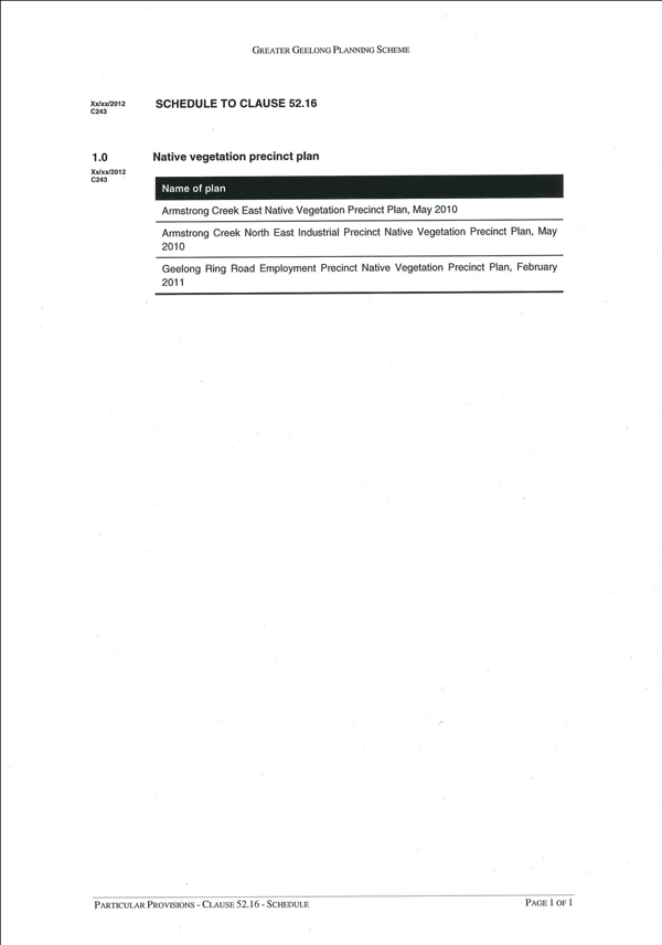
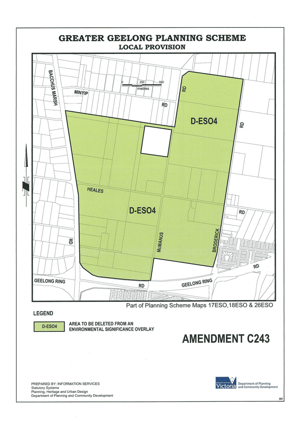
1 E Additions to ESO Map 26
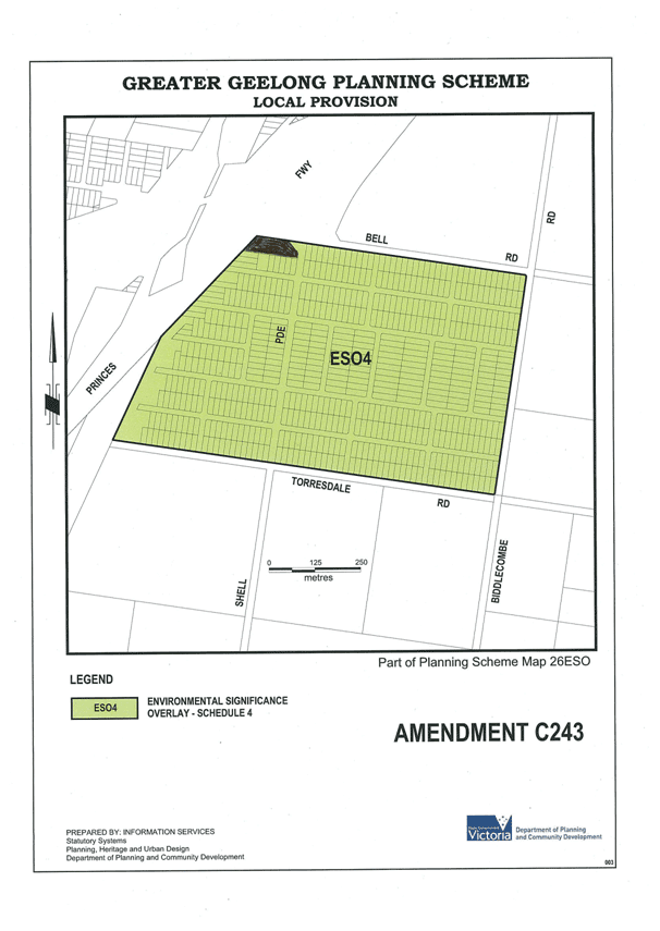
Appendix 7-2 A – GREP Native Vegetation Precinct Plan
Table of Contents
1 Native Vegetation Precinct Plan
1.3 Vegetation Objectives to be Achieved
2 Native Vegetation to be Protected
3 Native Vegetation to be Removed, Destroyed or Lopped
4.4 Procedures for the Collection of any Payments
Tables
Table 1: Habitat Zones to be protected
Table 2: Habitat Zones which may be removed
Acknowledgements
We thank the following people for their contribution to the project.
Bill Johnsen (City of Greater Geelong) for project information.
Donna Burns and Nathan MacDonald (Department of Sustainability and Environment) for planning information.
Ecology Partners Pty Ltd personnel who contributed to the project include:
Mark Stockdale, Robyn Giles and Andrew Hill.
Project #2176
Copyright © Ecology Partners Pty Ltd
This document is subject to copyright and may only be used for the purposes for which it was commissioned. The use, or copying of this document in whole or part without the permission of Ecology Partners Pty Ltd is an infringement of copyright.
Disclaimer
Although Ecology Partners Pty Ltd have taken all the necessary steps to ensure that an accurate document has been prepared, the company accepts no liability for any damages or loss incurred as a result of reliance placed upon the report or its content.
This is the Geelong Ring Road Employment Precinct (GREP) Native Vegetation Precinct Plan (NVPP) listed under the Schedule to Clause 52.16 of the City of Greater Geelong Planning Scheme. The Relevant Authority for the implementation of conditions specified within the NVPP is the City of Greater Geelong.
The removal, destruction or lopping of native vegetation in accordance with this NVPP, does not require a permit provided conditions and requirements specified in this NVPP are met.
Map 1: Area to which the NVPP applies
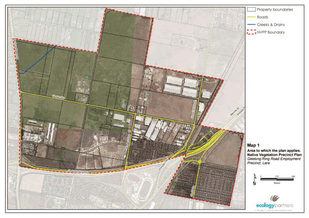 [insert ]
The purpose of the GREP NVPP is to:
Specify the native vegetation to be protected and the native vegetation that can be removed, destroyed or lopped;
Ensure that areas set aside to protect native vegetation are managed to conserve ecological values;
Ensure that the removal, destruction or lopping of native vegetation specified to be protected is consistent with conserving the ecological values of these areas and is in accordance with the three-step approach to net gain as set out in Victoria’s Native Vegetation Management – a Framework for Action (DSE 2002);
Set out the works or other necessary actions required to offset the removal, destruction or lopping of native vegetation; and,
Streamline the planning approvals process through a landscape approach to native vegetation protection and management.
The objectives for native vegetation protection are to:
Protect and manage floristic communities listed under the Environment Protection Biodiversity Conservation Act 1999 (Natural Temperate Grassland of the Victorian Volcanic Plain).
Protect and manage floristic communities listed under Victoria’s Flora and Fauna Guarantee Act 1988 (Western (Basalt) Plains Grassland).
Protect and manage Ecological Vegetation Classes listed as endangered in the Victorian Volcanic Plain bioregion(Heavier-soils Plains Grassland (EVC 132_61) and Plains Grassy Wetland (EVC 125).
Develop a land management plan to improve the condition and habitat value of native vegetation specified to be retained for nationally listed significant flora (i.e. Spiny Rice-flower Pimelea spinescens subsp. spinescens) and fauna (i.e. Golden Sun Moth Synemon plana).
Implement specific environmental objectives outlined in Environmental Significance Overlay – Schedule 4 (ESO 4) to the Greater Geelong Planning Scheme, including:
Prevent a decline in the extent and quality of native vegetation and native fauna habitat of the Victorian Volcanic Plain;
Enable areas of environmental significance, due to their native vegetation or habitat values, to be identified; and,
Enhance the environmental and landscape values of the area.
Native vegetation to be protected is shown in Map 2 and described in Table 1. This vegetation should not be removed.
Table 1: Habitat Zones to be protected
| Property Address |
Habitat Zone |
EVC no and initials |
Size (Hectares) |
Habitat Hectares |
Conservation Status |
Conservation Significance |
New Corio Estate |
PG3 |
PG 132_61 |
0.06 ha |
0.03 Hh |
Endangered |
Very High |
New Corio Estate |
PG 1, 2 & 4 |
PG 132_61 |
29.31 ha |
9.79 Hh |
Endangered |
High |
137-207 McManus Road, Lara |
PGW 1 |
PGW 125 |
3.06 ha |
0.52 Hh |
Endangered |
High |
Notes: PG = Plains Grassland, PGW = Plains Grassy Wetland
Native vegetation shown in table 1 and map 2 as to be protected should not be removed as a landscape approach to native vegetation retention and removal has been adopted in the preparation of this NVPP, rather than using a site by site approach.
Decisions relating to removal of areas of native vegetation have been made in a holistic manner taking into account areas of native vegetation which are proposed to be protected. The adhoc removal of native vegetation which is identified as to be protected may undermine the holistic and landscape wide approach to the preparation of this NVPP.
The native vegetation described in Table 2 and shown in map 2 as vegetation that can be removed may be removed subject to the requirements and conditions in this NVPP, as allowed under Clause 52.16 of the Greater Geelong Planning Scheme. Note: Native vegetation required for the removal within the GREP and the Elcho Channel has been identified as ‘modified treeless vegetation’ (DSE 2010a).
Table 2: Habitat Zones which may be removed
| Property Number |
Property Address |
Habitat Zone |
EVC number and initials |
Size (Hectares) |
284334 |
220A Heales Road, Lara |
Modified Treeless Vegetation |
N/A |
6.5 |
299269 |
120 Heales Road, Lara |
Modified Treeless Vegetation |
N/A |
0.1 |
282220 |
21-79 McManus Road, Corio |
Modified Treeless Vegetation |
N/A |
0.45 |
294838 |
310A Bacchus Marsh Road, Corio |
Modified Treeless Vegetation |
N/A |
0.63 |
284331 |
130 Heales Road, Lara |
Modified Treeless Vegetation |
N/A |
0.14 |
284333 |
137-207 McManus Road, Lara |
PGW1 |
PGW 125 |
0.18 |
Notes: PGW = Plains Grassy Wetland
Map 2: Native Vegetation to be Protected and Removed
No vegetation offsets are required for the removal of ‘modified treeless vegetation’ (DSE 2010b).
Requirements of the GREP NVPP include:
A Land Management Plan is required for areas of native vegetation to be protected, specifically for weed control and to improve vegetation condition and habitat value for significant flora and fauna species.
The following conditions apply from the gazettal of the NVPP:
Any native vegetation to be removed (in accordance with this NVPP) must be clearly marked on site to the satisfaction of the Responsible Authority whilst works are being undertaken within the vicinity.
All earthworks must be undertaken in a manner that will minimise soil erosion and adhere to Construction Techniques for Sediment Pollution Control (EPA 1991).
Any construction stockpiles, fill and machinery must be placed away from areas supporting native vegetation and drainage lines to the satisfaction of the responsible authority.
Water run-off must be designed to ensure that native vegetation to be protected is not compromised.
Only indigenous plants of local provenance may be used in revegetation works of conservation areas.
No payments are necessary or specified.
Referral to the Department of Sustainability and Environment for the removal of native vegetation under ESO 4 of the Greater Geelong Planning Scheme is not required, provided works are in accordance with this Native Vegetation Precinct Plan.
DPCD 2010. Planning Schemes Online: Department of Planning and Community Development.
DSE 2010a. ‘Determining the requirements of degraded treeless vegetation’, Department of Sustainability and Environment.
DSE 2010b. ‘Clarifying when an offset may not be required’, Department of Sustainability and Environment.
Earth Tech 2005. ‘Proposed Industrial Development, O’Brien’s Road, Lara - Flora and Fauna Assessment’. Unpublished report to the City of Greater Geelong, Earth Tech Pty Ltd.
Ecology Partners 2010. Net Gain Assessment of Geelong Ring Road Employment Precinct. Unpublished report to the City of Greater Geelong.
Ecology Partners 2010. Vegetation Assessment of 240 Heales Road, Lara. Unpublished report to the City of Greater Geelong.
Ecology Partners 2010. Vegetation Assessment of O’Briens Road, Lara. Unpublished report to the City of Greater Geelong.
Ecology Partners 2011. General Fauna Assessment and Targeted Golden Sun Moth Survey, Lara. Unpublished report to the City of Greater Geelong.
MWH 2007. ‘Flora, Fauna and Net Gain Assessment of Council Land’. Unpublished report to the City of Greater Geelong, MWH Pty Ltd.
Appendix 7-2 B – Ecological Values New Corio Estate
Appendix 7-3 A NCE Real Estate Brochure 1962
Appendix 7-3 B “Special Conditions”, New Corio Estate Contract of Sale - 1962
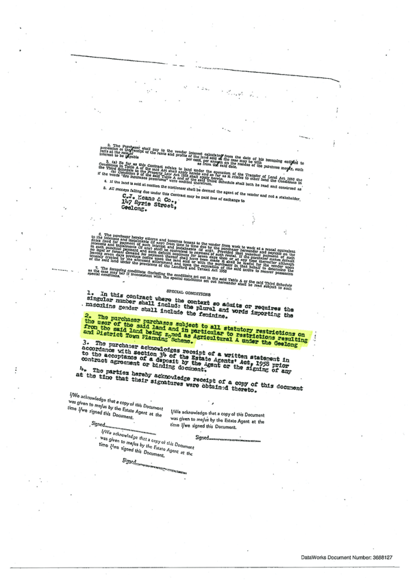
Appendix 7-3 C Planning Certificate, New Corio Estate - 1977
Appendix 7-4 List of Submittors
No. |
Submittor |
Affected Property |
1 |
Snezana Akinola |
3 Wiora Rd Corio (NCE) |
2 |
Keith Allender |
87 – 89 Lansell Rd Corio (NCE) |
3 |
Barwon Water |
None Specified |
4 |
Violetta Boyd |
21 Wiora Rd Corio (NCE) |
5 |
Country Fire Authority (CFA) |
None Specified |
6 |
Corangamite Catchment Management Authority (CCMA) |
None Specified |
7 |
Corio Maltings Pty Ltd |
580 Princes Highway Corio (NCE) |
8 |
Joe Cotroneo |
51 Lansell Rd Corio (NCE) |
9 |
Eddy Komadina |
30 – 32 Selbourne Rd Corio (NCE) |
10 |
Otavio Secen |
66 Orrong Rd Corio (NCE) |
11 |
Paul Secen |
19 Stanhope St Corio (NCE) |
12 |
TGM Group Pty Ltd (on behalf of Bisinella Developments Pty Ltd) |
275 Bacchus Marsh Rd Corio |
13 |
Chris Valcek |
12 Orrong Rd Corio (NCE) |
14 |
VicRoads |
None Specified |
15 |
Department of Sustainability and Environment (DSE) |
None Specified |
Portfolio: |
Community Development – Cr Fisher |
Source: |
Community Services – Family Services |
General Manager: |
Jenny McMahon |
Index Reference: |
Subject: Projects/Programs – Community Services – Family Services Events |
The purpose of this report is to present to Council the outcomes of the 2012 Geelong Children’s Week celebrations, held between 20 and 28 October, 2012.
Children’s Week is an international event designated by the United Nations and celebrated annually. The focus of Children’s Week is to recognise and promote the unique role and contributions to the community of young children.
Council has been responsible for the coordination, planning and promotion of Children’s Week in Geelong since 2005. The annual development and implementation of the Children’s Week program represents a positive collaboration between a wide range of local community organisations, groups and Council services.
The program of events conducted throughout Geelong during Children’s Week has demonstrated continued participation and interest from the local community. This year, the Children’s Week program incorporated 66 separate events hosted by 50 local organisations.
A total of 22 grants of up to $300 each were provided to local services and community groups to support and facilitate local Children’s Week events, in addition to funding of key events provided through Council services.
Geelong’s Children’s Week, 2012 was advertised via community billboards and local newspapers. This included the distribution of more than 42,000 Children’s Week Calendars through the Geelong Advertiser’s GT Magazine and a further 10,000 copies directly to early years services, schools and customer service centres.
The Geelong Australia website and social media were also used to promote Children’s Week, including the Ranger Roo, Where are You?, an online competition in partnership with Parks Victoria and Geelong Regional Libraries.
The diverse range of local events held during Children’s Week 2012 targeted children aged between 0–12 years, and resulted in high levels of participation by children and adults, including involvement by more than 400 paid staff and volunteers.
Council’s support for Children’s Week is consistent with key objectives contained within the Municipal Early Years Plan.
Cr Fisher moved, Cr Irvine seconded -
That Council acknowledges the success of Children’s Week in Geelong, October 2012, and the contribution by volunteers and local organisations.
Carried.
In 1954 the United Nations General Assembly proclaimed Universal Children’s Day as a day to promote friendship and understanding amongst children of the world. Since then, Universal Children’s Day has been incorporated into Children’s Week which is celebrated annually in Australia in the fourth week of October, supported by the Children’s Week Council of Australia.
Council, through the Family Services Department, has been responsible for the coordination, planning and promotion of Children’s Week in Geelong since 2005. Children’s Week in Geelong has continued to grow strongly, and provide enhanced opportunities to encourage children’s civic participation, and the promotion of the unique contributions children make to the local community.
Geelong’s Children’s Week program represents one of the largest Children’s Week celebrations currently hosted by any municipality in Victoria. Its success is evidenced by strong participation from local children and families in a wide range of events and activities held throughout the week.
Children’s Week generates significant good will and is truly unique in that it is a community driven event. While Council coordinates the local planning, promotion and funding for the event program, the majority of the events and activities held during Children’s Week are hosted by local community groups and organisations.
Promotion and Advertising
Children’s Week event calendars were circulated via the Geelong Advertiser’s GT Magazine on 6 October. This equated to a distribution of more than 42,000 calendars with an estimated readership of 87,000. In the lead up to Children’s Week 2012, advertisements also appeared in Geelong Advertiser, the Geelong Independent, the Bellarine Times and on community billboards in North Geelong and Kardinia Park.
A further 10,000 copies of the Children’s Week Calendar were distributed to local early childhood services, primary schools, community groups and Council Customer Service Centres. Individual organisations promoted their respective activities and events through the distribution of flyers, posters, newsletters, notice boards, invitations, radio and social media.
The Geelong Australia website and social media were also used to promote the week’s activities, resulting in more than 160 ‘likes’ on Facebook. Approximately 1,500 visits were made to the Geelong Australia website during the campaign, with activity peaking around the launch date of 19 October.
Both the Geelong Independent and Geelong Advertiser newspapers published details and photographs of various events and activities held throughout Children’s Week.
Children’s Week Grants and Participation
Approximately 450 local organisations, including: early childhood services, toy libraries, playgroups, child care centres, kindergartens, schools, maternal and child health centres, family support agencies, and community groups were invited to participate in the Children’s Week Program.
More than 50 local organisations registered 66 separate events and activities targeted at children aged 0-12 years. Children’s Week grants of up to $300 each were provided to 22 of the 50 organisations to support their activity.
Funding was also provided to a range of Council services to hold Children’s Week activities, including: the Maternal and Child Health Service, Waterworld, Bellarine Sport and Aquatic Centre, Splashdown Aquatic Centre, City Learning and Care Centres at Ariston and Ocean Grove and Supported Playgroups. A list of funding and grant recipients can be found at Attachment 6-1.
Estimates received from participating community groups and organisations indicate that almost 12,000 adults and children attended events across the municipality, including approximately 400 paid staff and volunteers (see Attachment 6-2 for a complete list of participating organisations and estimated attendance).
Activities and events delivered by Family Services
The former Mayor, Cr John Mitchell launched Geelong’s Children’s Week, 2012 at the Waurn Ponds Library on 19 October. Approximately 60 children and 40 adults attended the special story-time event jointly hosted with Geelong Regional Libraries.
In 2012, the ‘Ranger Roo – where are you?’ online competition was held in partnership with Geelong Regional Libraries and Parks Victoria to promote Children’s Week more broadly and increase attendance at the Playgroup in Park, twilight event held at the Botanical Gardens’ Playspace.
More than 150 competition entries were received during the promotional period. In 2012, Playgroup in the Park was attended by more than 450 people. This was more than double the attendance of the previous year.
Early Years Expos were held at the Potato Shed, Drysdale and at Centenary Hall, Corio to promote services available to the local community. Both events were well supported by local organisations with 17 stallholders present at the Potato Shed, and 20 at Centenary Hall. The latter was funded by the Corio-Norlane, LSEY/Best Start Partnership.
Both events were well attended with 80 adults accompanying more than 100 children to the Potato Shed, and approximately 108 people (37 families) visiting Centenary Hall.
Participant Feedback
Family Services received feedback forms from 30 participating organisations following Children’s Week, 2012. Key points are summarised below:
Organisations indicated that Geelong’s Children’s Week was highly valued and used as a platform to promote their services or programs and engage with children and families.
“A great opportunity to promote services and provide fun activities for children and for the community to have the opportunity to enjoy activities they normally couldn’t afford.”
The majority (87 per cent) of respondents rated the level of support from Council as excellent or very good.
The Children’s Week Program distributed through early years services and GT Magazine in the Geelong Advertiser was rated by 94 per cent of respondents as excellent or very good.
Approximately half (54 per cent) of the responding organisations indicated they would continue with a Children’s Week activity in future years if the grants program was unavailable, while 18 per cent said they would not, and 29 per cent were unsure.
In 2013, Children’s Week will be celebrated from 19 – 27 October.
All events and activities conducted during Children’s Week attempt to promote and operate according to good environmental sustainability practices and principles, including appropriate waste management and recycling wherever possible.
The cost to Council of this year’s Children’s Week Program was $51,820.
A contribution of $500 was received from the Victorian State Government through the Department of Education and Early Childhood Development.
All applicants were successful in receiving a Children’s Week grant. A full list of grant recipients can be found at Attachment 6-1.
The sustainability of Council’s role in coordinating and promoting future Children’s Week programs and activities remains subject to continued funding and resources being provided through Council.
Council’s role in supporting the provision of local programs and activities for children and families is consistent with local government requirements stipulated under Section 3E (a); (b); (c); and (d) of the Victorian Local Government Act 1989 and also the Victorian Charter of Human Rights and Responsibilities.
Council’s City Plan 2010–14 also details corporate planning objectives, service delivery priorities and commitments that are consistent with and closely aligned to the matters contained in this report, especially in relation to the development and provision of opportunities to facilitate community participation and engagement.
Council’s role and responsibilities toward the hosting and support of Children’s Week are consistent with key recommendations endorsed by Council in the existing Municipal Early Years Plan and Children’s Services Policy (2006).
Key recommendations within the Municipal Early Years Plan reflect Council’s commitment to: “Continue to provide opportunities for children and families to actively participate in the community and civic activities”. This includes: ‘Promotion of community events for children and families throughout the municipality’. (Municipal Early Years Plan: recommendation 20, page 26.)
No officers or contractors involved in the preparation of this report have a direct or indirect interest in matters to which this report relates.
The future planning and promotion of Children’s Week in Geelong remains subject to continued financial support from Council. Any reduction in available funding is likely to significantly curtail and diminish the potential to support future events and participation by local children and families.
Risk assessment planning is routinely completed for all Council hosted events in accordance with Council event planning guidelines.
Children’s active engagement and participation in their community has significant social and developmental benefits that are shared by children, families, and the whole community. Children’s Week provides a unique opportunity to promote civic participation by young children.
Growth in participation in Children’s Week by a large and diverse range of organisations and community groups (including schools, kindergartens, childcare services, family support agencies, playgroups, toy libraries, neighbourhood houses, and churches) provides a positive platform for partnership – building the further development of major local events.
The communication of this report along with material produced in relation to the development and promotion of Children’s Week in Geelong is the responsibility of Council’s Family Services Department.
Funding and grants provided to events and organisations for Children’s Week 2012
| Event/Organisation | $ |
Funding recipients - CoGG |
|
Bellarine Sport & Aquatic Centre |
1,500 |
Bellarine Early Years Expo |
1,138 |
CLAC Ariston |
300 |
CLAC Ocean Grove |
300 |
Maternal and Child Health |
1,500 |
Playgroup in the Park (Supported Playgroup & Parenting Initiative) |
2327 |
Splashdown Leisure Centre |
1500 |
Supported Playgroup & Parenting Initiative (Portarlington & Little Blossoms Playgroups) |
630 |
Waterworld |
5000 |
Children’s Week grant recipients - Community Organisations |
|
Association of Geelong and District Angling Clubs |
300 |
Allanvale Preschool |
300 |
Bellarine Community Health |
300 |
Belmont Toy Library |
300 |
Bluebird Foundation |
300 |
CatholicCare |
300 |
Club Italia |
300 |
Friends of Geelong Botanic Gardens |
250 |
Foodskil |
300 |
Fyans Park Kindergarten |
300 |
Geelong YMCA |
300 |
Glastonbury Community Services |
300 |
Lara Kindergarten |
100 |
Leopold Toy Library |
300 |
Newtown Primary School |
300 |
MIS Polish Playgroup |
200 |
Ocean Grove Neighbourhood Centre |
300 |
Paddington Toy Library |
300 |
People & Parks Foundation |
473 |
Portarlington Preschool/Portarlington Playgroup |
1,100 |
Rix Street Kindergarten |
300 |
St Laurence Community Services |
300 |
Total: |
$21,418 |
| Location |
Event |
Estimated Participation |
Belmont |
Belmont Toy Library Open Day |
100 |
Bell Post Hill |
Leisuretime Centre - Sports Expo |
* |
Bell Post Hill |
Little Blossoms Multicultural Playgroup |
33 |
Corio |
Bluebird Foundation Muddy Musical Adventures |
50 |
Corio |
Best Start - North Early Childhood Expo |
110 |
Norlane |
FoodSkil - Healthy Lunches and snacks for kids |
60 |
Corio |
Children's Fun Day @ Waterworld |
322 |
Drysdale |
The Potato Shed - Family Fun Day |
3023 |
Drysdale |
Bellarine Community Health - Children's Garden Event |
90 |
Drysdale |
Bellarine Early Years Expo |
210 |
Drysdale |
Bellarine Community Health - Childhood behaviour and sleeping presentation |
* |
Drysdale |
CLAC Drysdale - Literacy Week |
65 |
Geelong |
Free child restraint fitting |
65 |
Geelong |
MIS Polish Playgroup |
18 |
Geelong |
Playgroup in the Park |
451 |
Geelong |
Deakin University - Literacy Panel |
90 |
Geelong |
GPAC - Poppykettle Kinder Day |
1,302 |
Geelong |
GPAC - Poppykettle Primary Day |
330 |
Geelong |
Friends of Geelong Botanic Gardens - Follow your nose x 2 |
105 |
Geelong |
Market Square Shopping Centre - Humphrey B Bear |
100 |
Geelong |
CatholicCare - Creating a feelings book |
186 |
Geelong |
Maternal and Child Health Centres - Children's Week Activities |
140 |
Geelong |
People & Parks Foundation - Ranger Roo |
* |
Geelong |
Carousel - 2 for 1 rides |
15 |
Geelong |
Bluebird Foundation - Wild Moves dance and drumming workshops |
86 |
Geelong West |
Geelong West Toy Library - 11th Annual Toy sale |
80 |
Grovedale |
Paddington Toy library - Open Day |
50 |
Herne Hill |
Road to Reading - Open Day |
* |
Herne Hill |
Rix Street Kindergarten - Fun Day |
* |
Herne Hill |
GAMBA - Playgroup for families with multiples |
* |
Lara |
Serendip Sanctuary - Back to the bush story time in the park |
18 |
Lara |
Lara Kindergarten - Mask making |
50 |
Lara |
St Laurence - Spark in the Park Community Fair |
373 |
Leopold |
Leopold Toy Library - Teddy Bear's Picnic |
326 |
Leopold |
Allanvale Preschool - Animal Farm Visit |
79 |
Moolap |
Club Italia - Children's Halloween |
366 |
Newtown |
Fyans Park Kindergarten |
123 |
Newtown |
YMCA Preschool Gymnastics Class x 4 |
171 |
Newtown |
CLAC Ariston - Aboriginal Involvement |
50 |
Newtown |
Celebrating the arts at Newtown Primary School |
585 |
Norlane |
FoodSkil - Healthy Lunches and snacks for kids |
42 |
Norlane |
CLAC Trudy Moritz - Jungle Party |
* |
North Geelong |
Centre Court Indoor Tennis - Have a Ball |
* |
North Geelong |
Ron Nelson Memorial Junior Fishing Clinic |
410 |
North Geelong |
One World For Children - Cultural Music and Dance |
* |
Ocean Grove |
Ocean Grove Toy Library Open Day x 2 |
52 |
Ocean Grove |
Ocean Grove Neighbourhood Centre - Magical Hour of Play |
107 |
Ocean Grove |
Friends of Ocean Grove Nature Reserve - Picnic with the Wallabies |
15 |
Ocean Grove |
BASC - Children's Fun Day |
267 |
Ocean Grove |
CLAC Ocean Grove - Animal Farm Visit |
82 |
Portarlington |
Celebrating belonging at Portarlington Preschool and Playgroup |
112 |
Waurn Ponds |
Children's Week Launch |
103 |
Waurn Ponds |
Child & Infant CPR Workshops x 3 |
82 |
Whittington |
Early Learning & Family Centre @ Apollo - Playgroup Farm Day |
69 |
Whittington |
Flamefest |
1,200 |
Whittington |
Early Learning & Family Centre @ Apollo Outdoor fun |
158 |
Whittington |
Splashdown - Children's Fun Day |
380 |
* Estimates were not available for these events.
Contents | Previous Page: Section A - Procedural Matters | Next Page: Section B - Reports - 9-16 - 29 January 2013
