Council Minutes - Section B: Reports - 23 July 2013
Contents | Previous Page: Section A - Procedural Matters | Next Page: Section C - Common Seal Register
Contents | Previous Page: Section A - Procedural Matters | Next Page: Section C - Common Seal Register
Reports tabled at the Ordinary Meeting of Council on Tuesday date held at City Hall, Little Malop Street in Geelong.
Cr Fagg declared a Conflict of Interest in Agenda Item 1 - Amendment C268 and Permit 337/2012 – Masters Store and Business Park Bacchus Marsh Road, Corio – Adoption, in that he is a director of one of the companies which lodged a submission. Cr Fagg left the meeting room prior to discussion at 7:16pm.
Cr E Kontelj declared a Conflict of Interest in Agenda Item 1 - Amendment C268 and Permit 337/2012 – Masters Store and Business Park Bacchus Marsh Road, Corio – Adoption, in that he owns greater than $10,000 worth of Woolworths shares and his wife is employed by Woolworths. Cr E Kontelj left the meeting room prior to discussion at 7:16pm.
Cr Harwood (Deputy Mayor) assumed the Chair at 7:16pm
Portfolio: |
Planning – Cr Macdonald |
Source: |
Economic Development, Planning and Tourism - Strategic Implementation |
General Manager: |
Peter Bettess |
Index Reference: |
Application: Amendment C268, Permit 337/2012 |
Amendment C268 resulted from a combined Planning Scheme Amendment and Planning Permit application made by Urbis on behalf of Hydrox Nominees Pty Ltd for a Masters Home Improvement Store on Bacchus Marsh Rd Corio.
The Masters site (known as the “northern site”) fronts on to Bacchus Marsh Rd and is the western half of a property owned by L. Bisinella Developments.
Reachy Pty Ltd owns land at 240 Bacchus Marsh Road (known as the “southern site”) directly south of the Masters site. Council officers included the Reachy land in Amendment C268 consistent with Council’s Corio Norlane Structure Plan 2012.
The amendment proposes to:
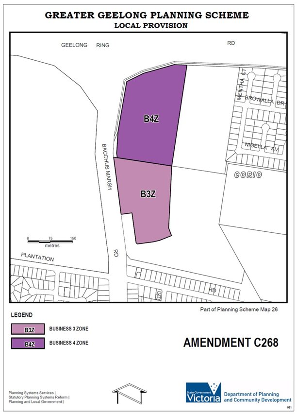
Rezone the northern site from Residential 1 to the Business 4 Zone;
Rezone the southern site from Residential 1 to the Business 3 Zone;
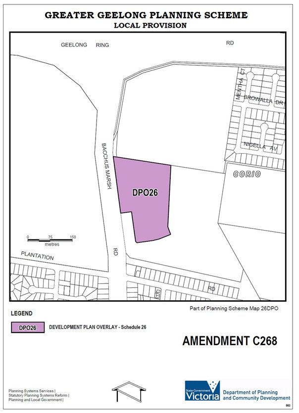
Introduce and apply a Development Plan Overlay (DPO26) to the southern site;
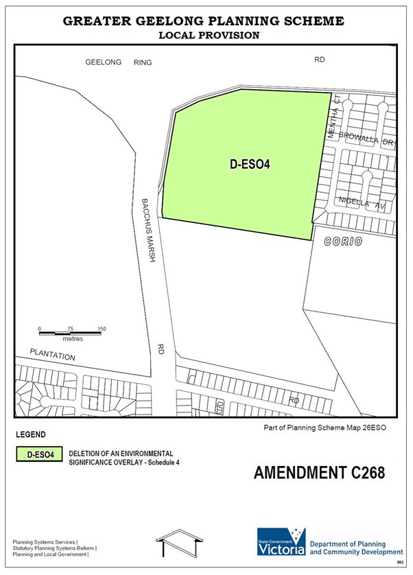
Delete the Environmental Significance Overlay (ESO4) from the northern site;
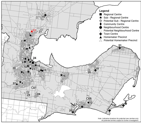
Amend the City of Greater Geelong Retail Activity Centre Hierarchy contained in Clause 21.07-8 to include the site as a Homemaker Centre.
The planning permit is primarily for a Masters Store of 13,701 square metres of gross floor area and four restricted retail premises totalling 4,770 square metres.
The Minister for Planning authorised the preparation and exhibition of Amendment C268 on 25 October 2012.
The Amendment and Permit were exhibited for a 4 week period closing on 24 December 2012.
A total of 16 submissions were received. 8 submissions in support or offering no objection and 8 submissions objecting to the proposal.
The key issues raised in objecting submissions include: strategic planning merit, economic impacts and consistency with the Greater Geelong Retail Strategy, impacts on MC Herd Abattoir, traffic, car parking, flooding, building design and a proposed Section 173 Agreement for a new signalised intersection.
Council resolved on 26 February 2013 to refer the submissions to an Independent Planning Panel appointed by the Minister for Planning.
A Panel Hearing was held on 29, 30 April and 2 May 2013. Council officers provided a detailed presentation to the Panel in support of the proposal.
Five submitters made presentations to the Panel and all were represented by either lawyers or planning consultants. Supporting submissions were made by Hydrox Nominees (Masters), Bisinella Developments and Reachy Pty Ltd. Masters were represented by a QC who called four experts witnesses in the fields of planning, economics, traffic and drainage.
Objecting submissions were made by Faggs Geelong Pty Ltd and MC Herd.
Overall, the Panel considers that the subject land represents an excellent opportunity for the development of a Masters Home Improvement Store. It has good site exposure, it provides a use that is complementary to all adjacent land uses, it provides an effective buffer between the MC Herd abattoir and the existing and proposed residential development to the east, it sits at the juxtaposition of the Geelong Ring Road and the Bacchus Marsh Road, and it is part of a strong developing community in Corio Norlane and Lara further to the north.
The Panel placed importance on the proposal being well supported by the Corio Norlane Structure Plan, which provides for restricted retail and business uses in this location. The site should therefore be formally recognised as a Homemaker Precinct within the City of Greater Geelong Retail Activity Centre Hierarchy contained in Clause 21.07-8.
The Panel has found that the subject site is suitable for the proposed development and recommends that the Amendment be adopted and a planning permit issued.
Council officers recommend that the Amendment be adopted and a planning permit issued, subject to a revised Development Plan Overlay schedule and revised planning permit conditions as recommended by the Panel.
It is noted that the Business 3 and 4 zones proposed in this amendment will be replaced by the new Commercial 2 zone when the new suite of zones are implemented by the Minister (anticipated to be in July 2013).
Cr Macdonald moved, Cr Ansett seconded -
That Council:
Adopts Amendment C268 in the form as outlined in Appendix 4 of this report;
Recommends to the Minister for Planning that Planning Permit 337/2012 be granted pursuant to Section 96G of the Planning and Environment Act 1987 (a copy of the planning permit is in Appendix 5 of this report);
Submits the adopted amendment with the prescribed information to the Minister for Planning requesting approval;
Notes that the Business 3 and 4 zones proposed in this Amendment will be replaced by the Commercial 2 zone when the new commercial zones are introduced in July 2013.
Carried.
Amendment C268 has been prepared by the Greater Geelong City Council which is the planning authority for this amendment. This amendment is partially Council initiated and partially at the request of Urbis on behalf of Masters Home Improvement Australia Pty Ltd.
The amendment applies to two sites: the western portion of land at the south-eastern corner of the intersection of Geelong Ring Road and Bacchus Marsh Road (the Masters or “northern site”) and the western portion of 240 Bacchus Marsh Road, Corio (the Reachy or “southern site”).
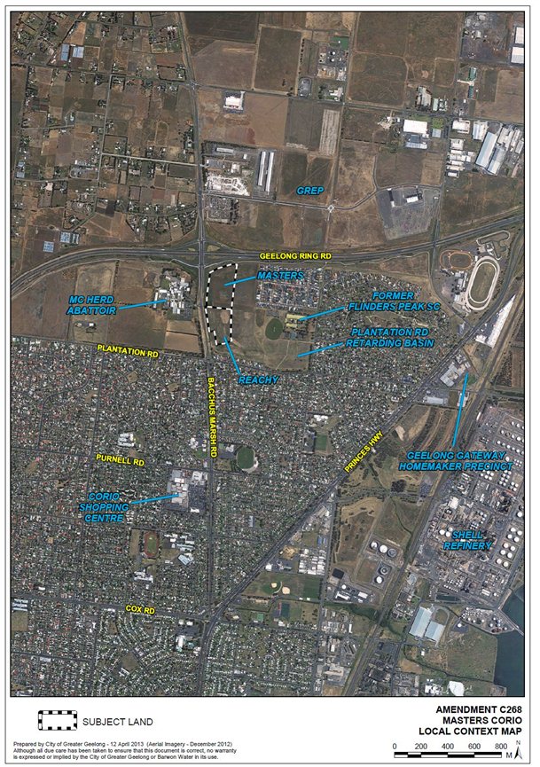
Appendix 1 is an aerial photo showing the two parcels of vacant land and the surrounding land uses such as MC Herd Abattoir.
The amendment proposes to:
Rezone the northern site from Residential 1 to the Business 4 Zone;
Rezone the southern site from Residential 1 to the Business 3 Zone;
Introduce and apply a Development Plan Overlay (DPO26) to the southern site;
Delete the Environmental Significance Overlay (ESO4) from the northern site;
Amend the City of Greater Geelong Retail Activity Centre Hierarchy contained in Clause 21.07-8 to include the site as a Homemaker Centre.
The Corio Norlane Structure Plan July 2012 identifies the Reachy and Masters sites for rezoning from Residential 1 zone to Business 3 and Business 4 respectively. This is due to the sites not being suitable for residential uses as they are located within the 500 metre odour emissions buffer from the MC Herd Abattoir.
Concurrent with the planning scheme amendment, a planning permit application lodged by Masters is being considered for the northern site.
The planning permit application (337/2012) proposes:
Use of the land for Landscape Gardening Supplies and Food and Drink Premises;
Buildings and works associated with the Woolworths Masters store and the four restricted retail premises (inclusive of car parking and business identification signage);
Advertising signage for major promotional signage, signage with a total area exceeding 8 sqm, and internally illuminated signage with a total area greater than 1.5m;
The creation of a new access onto a Category 1 road;
A dispensation in the number of staff showers provided for bicycle end-of-trip facilities;
The use land in a Public Acquisition Overlay for Section 1and 2 uses in the Business 4 Zone;
Buildings and works in a Public Acquisition Overlay;
The proposed development plans indicate:
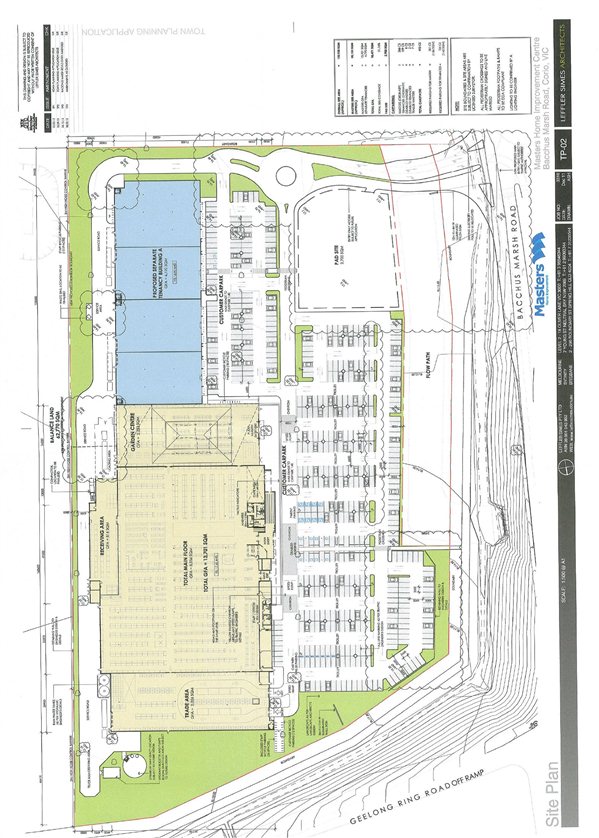
A Woolworths Masters store with 13,701 square metres of gross floor area.
Four restricted retail premises totalling 4,770 square metres of leasable floor area. The tenancies range from 1,120 to 1,400 square metres in size.
A total of 487 car spaces (381 associated with Masters and 106 associated with the individual restricted retail tenancies).
A copy of the final site layout plan for the Masters site is in Appendix 2.
The Minister for Planning authorised the preparation and exhibition of Amendment C268 on 25 October 2012.
The Amendment and Permit were exhibited for a 4 week period closing on 24 December 2012.
A total of 16 submissions were received. Eight submissions in support or offering no objection and eight submissions objecting to the proposal.
The key issues raised in objecting submissions include: strategic planning merit, economic impacts and consistency with the Greater Geelong Retail Strategy, impacts on MC Herd Abattoir, traffic, car parking, flooding, building design and a proposed Section 173 Agreement for a new signalised intersection.
Council resolved on 26 February 2013 to refer the submissions to an Independent Planning Panel appointed by the Minister for Planning.
A Panel Hearing was held on 29, 30 April and 2 May 2013. Council officers provided a detailed presentation to the Panel in support of the proposal.
Five submitters appeared at the Panel Hearing and all were represented by either lawyers or planning consultants.
Supporting submissions were made by Hydrox Nominees (Masters), Bisinella Developments and Reachy Pty Ltd. Masters were represented by a QC who called four experts witnesses in the fields of planning, economics, traffic and drainage.
Objecting submissions were made by Faggs Geelong Pty Ltd and MC Herd Pty Ltd.
The Panel was chaired by Chief Panel Member Kathy Mitchell and Mr Kevin Breen. The Panel provided its report to Council on 31 May 2013.
The Panel has found that the subject site is suitable for the proposed development and recommends that the Amendment be adopted and a planning permit issued.
Overall, the Panel considers that the subject land represents an excellent opportunity for the development of a Masters Home Improvement Store. It has good site exposure, it provides a use that is complementary to all adjacent land uses, it provides an effective buffer between the MC Herd abattoir and the existing and proposed residential development to the east, it sits at the juxtaposition of the Geelong Ring Road and the Bacchus Marsh Road, and it is part of a strong developing community in Corio Norlane and Lara further to the north.
A copy of the Panel Report’s Executive Summary, Conclusions and Recommendations is in Appendix 3.
The issues raised during the Panel hearing, the Panel’s conclusions and Council officers response are outlined below using the headings from the Panel report:
Strategic Planning and Justification
The key issues to be resolved are whether there is an economic or strategic planning basis for the rezoning, and whether the Business 3 and 4 Zones are the appropriate zones for the subject land.
The submission from Mr Bartley (lawyer for Faggs Geelong Pty Ltd) maintained that the application is opportunistic to enable the development of a Masters store and contrary to the Retail Strategy which does not identify the subject site as a Homemaker Precinct. He argued that little weight should be given to the Corio Norlane Structure Plan as it has not been independently reviewed, and it is not incorporated within the planning scheme.
The Panel states it “is satisfied that strategic planning justification has been properly demonstrated both within the scope of the existing planning scheme and in particular under Clauses 21.07 (Economic Development and Employment) and 22.03 (Assessment Criteria for Retail Planning Applications), as well as through the Corio Norlane Structure Plan.”
The Panel comments that the “evidence supporting the strategic planning justification for this Amendment relied on the Corio Norlane Structure Plan. Planning scheme Amendments can be considered as ‘seriously entertained’ when they have been adopted by Council and where there has been a high degree of consultation. In this matter the Panel gives weight to the Structure Plan because of its advanced process for approval.”
Ms Bisucci (lawyer for MC Herd), argued that the objectives of the Planning and Environment Act 1987 recognise that communities are entitled to pleasant and safe working as well as living environments, and the development of the uses on the subject site will attract significant numbers of staff and visitors, more than for a residential use. The resulting complaints may place operational restrictions on the abattoir. MC Herd disputed that the concept of net community benefit is met, as the disbenefits may outweigh the benefits. This was due to the threat of future viability of the facility, and the potential loss of 270 jobs on-site if it closed.
In response the Panel states it “… does not accept that restricted retail and business park uses qualify as sensitive uses, and no convincing argument or evidence was tendered that the existing operation [MC Herd] would be seriously compromised by the development.”
At a broader level, the Panel accepts the planning expert’s evidence that the land needs to be rezoned due to the constraint associated with the abattoir buffer that ‘sterilises’ it from residential development.
The Panel therefore concludes that “the strategic planning justification of the Amendment is satisfied”.
Council Officer response
Council officers agree with the Panel’s comments and conclusions. An amendment to implement the Corio Norlane Structure Plan into the Planning Scheme is currently awaiting approval by the Minister for Planning
Economic Impacts
The key issue to be resolved is whether there is economic justification for the Amendment, and whether it is consistent with the Council’s Retail Strategy and Clauses 21.07 and 22.03 of the Greater Geelong Planning Scheme.
Council, the proponent, L Bisinella Development and Reachy made submissions supporting economic justification for the Amendment, with expert evidence provided on the proponent’s behalf by Mr Ganly of Deep End Services. Opposed were Faggs Geelong Pty Ltd. MC Herd did not dispute or challenge the economic evidence.
Council’s assessment of the economic justification included a peer review by Urban Enterprise of the proponent’s economic statement of January 2012 provided as part of the Amendment information.
Council supported the economic impact analysis undertaken by Mr Ganly in demonstrating that the adverse impacts on retail centres in the area and the hierarchy are well within the acceptable level of being below 10%.
Submissions for Faggs Geelong Pty Ltd in relation economic matters was limited to challenging the ‘sequential test’ concerning the suitability of the subject site, and in particular maintaining that the former Bunnings store site in the Corio provided an alternative to the subject site.
The Panel comments that “Mr Bartley devoted a significant (and seemingly disproportionate) part of his submission to matters of primary relevance to MC Herd (who were represented at Panel) and whose key issues had little connection with the substantive grounds for objections put forward on behalf of Fagg Bros. That is, retail policy and economic impacts. He argued that the proposed development undermines industrial land uses in Geelong and threatens the future viability of the abattoir. He further argued that the ‘agent of change’ principle should apply and the burden of proof rests with the proponent that the proposals are acceptable”.
The Panel believes that “the tests of need and economic impact assessment to support the Masters store and associated restricted retail outlets have been well met through the economic evidence provided by the proponent”.
The Panel also endorses the site be formally recognised as a Homemaker Precinct by amending the Retail Centre Hierarchy under Clause 21.07-8.
In relation to objecting submissions put to it the Panel states: “the contention by Mr Bartley for the Fagg Bros that the former Bunnings site in the Corio (Geelong Gate) Homemaker Centre could be considered as an alternative site is found by the Panel to have no basis. At best it could only be characterised as a lost opportunity”.
In relation to the Faggs Geelong Pty Ltd support for the abattoir the Panel’s view is “the ‘agent of change principle’ is not a factor in this case, as it is not demonstrated through evidence that the abattoir is under real threat. The position and arguments put by Mr Bartley on behalf of his client did not resonate with the Panel”.
In relation to the MC Herd submission the Panel states “…little tangible evidence was provided to the Panel for MC Herd to convince the Panel that the abattoir’s operation would be in any significant way compromised by the development to threaten the viability of the business”..
Council Officer response
Council officers agree with the Panel comments and conclusions in relation to the economic impact of the proposal. Council strongly supports the continued operation of the MC Herd Abattoir as a major employer in Corio. However, it agrees with the Panel that there is little evidence that the Masters store or business park would compromise or threaten the business.
Traffic and Access
The key issue to be resolved is whether the proposed traffic access arrangements for the intended uses on the subject site through the construction of a signalised intersection on Bacchus Marsh Road and an associated access road to the site are satisfactory.
The proponent provided a Transport Impact Assessment undertaken by GTA Consultants as part of the initial application. This was supplemented by expert traffic and transport evidence by Mr Kiriakidis of GTA at the Hearing.
A key feature of the traffic management response to the proposed development is the construction of a single signalised intersection on Bacchus Marsh Road, opposite and in alignment with the existing access to the MC Herd facility.
A draft Section 173 Agreement between the Council, Hydrox Nominees and Reachy was tendered as part of the Amendment information. It described the access road project and a cost sharing arrangement to cover the construction costs between the two owners of the subject site. The requirement for a Section 173 Agreement was originally included in the draft DPO26 for the Reachy land.
Reachy is not supportive of the S173 agreement being required as part of the rezoning or as a planning permit condition requirement under DPO26.
The Panel says “Reachy sought a change in the proposed DPO that reflected its concerns. This was accepted by Council as expressed in the final version of the DPO by removing the requirement for a Section 173 Agreement, and making the payment of a contribution to the cost of intersection and access road works triggered by the Road Network and Traffic Management Plan under the DPO.”
MC Herd’s submission argued that the intersection proposed would provide direct line of sight exposure to its business’ front gate, and so contribute to the potential operational problems with heightened public scrutiny identified earlier.
The written submission to the Amendment by Faggs Geelong Pty Ltd raised issues about the adequacy of on-site parking but was not further argued at the Hearing.
The Panel “is satisfied that the traffic and parking arrangements for the site, particularly the northern part, have been resolved through a detailed assessment and design process and in consultation with VicRoads and Council.”
The Panel places little weight on the issues raised by MC Herd in relation to increased exposure to their site by having a signalised intersection opposite their main gate. It already exists on a reasonably busy road and has a treed screen around the Bacchus Marsh Road frontage to the abattoir.
The Panel finds that the representations made for Reachy that it should not be required to financially contribute to traffic management solution prior to the development of a Road Network and Traffic Management Plan (RNTMP) as required under DPO26 to be reasonable.
The Panel states “The final DPO26 was changed to exclude the requirement for a Section 173 Agreement while final draft conditions for the planning permit added provision for a Section 173 Agreement between Council and Hydrox Nominees. These changes were supported by Council.”
Council Officer response
Council officers agree with the Panel recommendations on traffic, access and the DPO. However, the statement in the Panel report that says the final DPO26 was changed to exclude the requirement for a Section 173 Agreement appears to be an oversight by the Panel. The Panel attached a copy of the final DPO26 as an appendix to its report. The requirement for a S173 Agreement still remains but it has been shifted to Clause 2.0 and the wording changed (as described by the Panel) to refer to a Road Network and Traffic Management Plan. A copy of the final DPO schedule from the Panel Report and recommended for adoption is in Appendix 4.
Impacts on Adjacent Uses
The main concern regarding adjacent uses already noted was the possible impact on the operation and future viability of the MC Herd abattoir. Another issue to be addressed is the interface between the proposed uses on the subject site and the residential uses to the east of the site on the balance lot.
Submissions for MC Herd stated that its operations could potentially be compromised “by the proposed development and use (and) will place further pressure on the abattoir complex to close or relocate”.
The Panel states: “The owner of the abattoir attended the Hearing and answered questions relating to trends in complaints and operational management of the facility. As noted earlier, it was acknowledged that there has been no pattern or incidence of complaints to the EPA regarding the facility since the rendering component of the business closed some five years ago. Concerns over increased exposure to the public are not evidence based, but exist as a general overarching worry about encroachments on the operating freedom of the facility”
The Panel recognises the importance of the role the MC Herd abattoir plays as a significant employer in North Geelong. However it says “ no evidence was presented that the proposed development on the subject site opposite is likely to generate the adverse outcomes that would precipitate a closure or relocation of the facility”.
In relation to the amenity of future residential development to the east, the Panel is “satisfied that this has been properly considered and provided for through the DPO26 for the Reachy land, the subdivision permit conditions for the Bisinella/Masters land, and the planning permit for the Masters store and restricted retail premises.”
The Panel recommended Planning Permit conditions and the DPO26 that are in Appendices 4 and 5.
Council Officer response
Council officers support the Panel recommendations.
Flooding
The key issue is whether existing drainage and flooding issues can be adequately resolved or mitigated to allow the proposed development to proceed.
The Panel states: “Drainage and flooding issues have been the subject of extensive modelling analysis, and the design of engineered mitigation strategies were provided in significant detail. In the Panel’s view, the issues have been thoroughly considered by the proponent’s consultants, as well as reviewed by Council and the Corangamite Catchment Management Authority. The Panel is satisfied that drainage and flooding matters can be properly resolved”.
The Panel concludes that the various planning controls are necessary and adequate to respond not only to the technical complexities associated with flooding, but also the various ownerships and development prospects and horizons for the different sites.
The Panel is satisfied that drainage and flooding issues are able to be adequately resolved and do not provide basis to prevent the Amendment from proceeding.
Council Officer response
Council officers agree that the planning controls proposed will deal with drainage and flooding across the subject site and related sites. The controls include permit conditions, a Section 173 Agreement, a DPO and a Special Building Overlay.
Planning Permit Conditions
Prior to the Hearing, the proponent liaised with Council in the preparation of a draft set of planning permit conditions for the Masters site.
The proponent provided a revised set of draft planning permit conditions at the Panel hearing and Council stated that it was satisfied with the draft permit conditions
The Panel recommends that the draft Planning Permit is satisfactory to issue to control the development of the northern land on the subject site.
Council Officer response
Council officers believe the permit conditions are well resolved and recommend adoption of the final conditions from the Panel report (see Appendix 5).
The Panel also provided comments in support of the removal of the Environmental Significance Overlay and the Public Acquisition Overlay that currently apply to the northern site but are now redundant.
The Amendment will not impact negatively on the environment. Whilst the site is located in the Environmental Significance Overlay – Schedule 4, there is no native vegetation present and hence this overlay is proposed for removal.
The site is currently vacant, and the proposed built form will improve the visual amenity of the site and immediate area.
The proponent is responsible for the costs associated with the Panel hearing. Construction of any infrastructure such as the road intersection and drainage works will be borne by the developers.
The amendment has been found to be broadly consistent with the State Planning Policy Framework and the Local Planning Policy Framework, in particular the clauses relating to retail activity centres and economic impact.
The amendment has strong policy support from Corio Norlane Structure Plan.
In terms of legal implications, the permit for the Masters site and the DPO for the Reachy site both require Section 173 Agreements between the landowners and Council. The Agreements relate to the construction and funding of a signalised intersection.
In accordance with Section 80 (c) of the Local Government Act, Peter Bettess, General Manager, Economic Development, Planning and Tourism declares an indirect financial interest in that he owns Woolworths and Wesfarmers shares.
There are no notable risks associated with implementing the recommendation contained in this report.
The amendment will bring about a range of social benefits as it will facilitate the provision of a new trade supplies and bulky goods retail offering, with improved accessibility and increased retail competition for the community. The amendment is also expected to bring about a range of ongoing local employment opportunities.
Council officers have written to submitters to the amendment to advise of the Panel recommendations. Submitters will be notified of the final decisions of Council and the Minister for Planning.
Planning and Environment Act 1987
GREATER GEELONG PLANNING SCHEME
AMENDMENT C268
INSTRUCTION SHEET
The planning authority for this amendment is the City of Greater Geelong.
The Greater Geelong Planning Scheme is amended as follows:
Planning Scheme Maps
The Planning Scheme Maps are amended by a total of 3 attached map sheets:
Zoning Maps
Planning Scheme Map No. 26 is amended in the manner shown on the attached map marked “Greater Geelong Planning Scheme, Amendment C268”.
Overlay Maps
Planning Scheme Map No.26 ESO is amended in the manner shown on the attached map marked “Greater Geelong Planning Scheme, Amendment C268”.
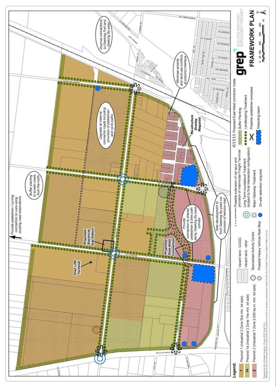
Insert new Planning Scheme Map No.26 DPO in the manner shown on the attached map marked “Greater Geelong Planning Scheme, Amendment C268”.
Planning Scheme Ordinance
The Planning Scheme Ordinance is amended as follows:
In the Local Planning Policy Framework replace Clause 21.07 with a new Clause 21.07 in the form of the attached document. The changes are as follows:
Sub Clause 21.07-8 has been amended.
In Overlays – following Clause 43.04, insert a new Schedule DPO26 in the form of the attached document.
In General Provisions – Clause 61.03, replace the Schedule with a new Schedule in the form of the attached document.
End of document
SCHEDULE 26 TO THE DEVELOPMENT PLAN OVERLAY |
|
Shown on the planning scheme map as DPO26 |
|
240 BACCHUS MARSH ROAD, CORIOA development plan is required to guide the future subdivision, use and development of land at 240 Bacchus Marsh Road Corio which is proposed for a business park. |
|
1.0 |
Requirement before a permit is granted |
A permit may be granted before a development plan has been prepared to the satisfaction of the responsible authority for the following: |
|
If the approved Road Network and Traffic Management Plan requires access to the subject land from the signalised intersection on Bacchus Marsh Road and the access road immediately to the north of the subject land, then before a permit is granted the owner must enter into an agreement with the Responsible Authority pursuant to Section 173 of the Planning and Environment Act 1987 containing a requirement to make:
|
|
2.0 |
Conditions and requirements for permits |
A permit must contain conditions or requirements which give effect to the provisions and requirements of the approved Development Plan. |
|
3.0 |
Requirements for development plan |
The Development Plan must include the following: |
|
An Urban Design Masterplan that includes:
An Economic Impact Assessment for retail components if the combined total leasable floor space is more than 2,000 sq m. A Road Network and Traffic Management Plan that includes:
A detailed Flooding, Stormwater and Drainage Management Plan that adopts an integrated approach to stormwater system management, including:
|
|
4.0 |
Decision guidelines |
Before approving a development plan, in addition to the decision guidelines in Clause 65, the responsible authority must consider, as appropriate, the views of VicRoads, Barwon Water and the relevant catchment management authority. |
21.07 |
ECONOMIC DEVELOPMENT AND EMPLOYMENT |
21.07-1 |
Key issues and influences |
Economic Role and FunctionGeelong is the largest regional city in Victoria and the primary service and employment hub for the G21 Geelong Region Alliance. The City’s infrastructure base includes Avalon Airport, the Geelong Port and major road and rail connections to Metropolitan Melbourne and Victoria’s western regions. The provision of high quality living, working and recreational environments is critical to attracting and retaining highly skilled people and the businesses in which they work. |
|
IndustryThere is a need to provide support for ongoing employment and economic development in the Geelong region. There is a need to provide a diverse range of appropriately located, well serviced industrial land which meets the needs of a range of industry types and minimises land use conflicts. Traditional manufacturing industries will continue to be key economic and employment drivers in the municipality, however at the same time the City’s economy will need to focus on emerging industry sectors that underpin economic development, prosperity and employment growth in the new economy. The changing nature of industrial development means that most industrial development now requires high amenity land that offers a high quality environment for workers and visitors. There is a need to support industry through the maintenance and improvement of infrastructure including the road, rail, Avalon Airport, deep water port and associated facilities. The extractive industry operations in the municipality make a vital contribution to the building and construction industries and are of major economic importance to the Geelong region. |
|
RetailThe City of Greater Geelong Retail Activity Centre Hierarchy has been established to articulate the role and function fulfilled by centres of different sizes. The retail hierarchy supports the primacy of Central Geelong as the focus of retail activity in the region. There is a need to ensure a mix of commercial uses in activity centres. The retail hierarchy will be enhanced through high quality urban design and improved pedestrian and public transport accessibility. There is increasing development pressure for sites located away from activity centres, particularly for bulky goods and other large format retail development types that seek large sites with the capacity for significant car parking. Greater Geelong exhibits a number of factors that contribute to an increased vulnerability to problem gambling which requires sensitive consideration of their location. |
|
RuralAgricultural production is modest, but locally important and economically significant for landowners. There is potential for growth in agricultural production, particularly aquaculture. Farming activity and the rural landscape are very significant elements to the identity, image and liveability of the City of Greater Geelong. Farming and rural landscapes form non urban breaks and are a critical element to the settlement strategy, tourism function and lifestyle of the region. Farming and agriculture are important and valued activities in the northern area of the municipality, particularly in the Anakie area. Rural land in a number of urban fringe areas accommodates a range of uses and developments which require buffers from residential areas. The City’s rural areas contain important environmental assets. |
|
TourismTourism is a key part of the economy of the Geelong region. The region includes major tourism destinations such as the Bellarine Peninsula and the coast. Tourism activities in rural and coastal areas must be carefully managed so as not to compromise the natural environment and/or agricultural activities. |
|
21.07-2 |
Industry |
Objectives
|
|
Strategies
|
|
21.07-3 |
Retail |
Objectives
|
|
Strategies
|
|
21.07-4 |
Economic growth sectors |
Objective
|
|
Strategies
|
|
21.07-5 |
Rural Areas |
Objectives
|
|
Strategies
|
|
21.07-6 |
Tourism in rural areas |
Objectives
|
|
Strategies
|
|
21.07-7 |
Implementation |
These strategies will be implemented by: |
|
Using policy and the exercise of discretionWhere appropriate, referring applications for the development of land in the Heales Road Industrial Estate to Worksafe. Using the Discretionary Uses in Residential Areas Policy at Clause 22.01. Using the Sexually Explicit Adult Entertainment Venues, Adult Sex Bookshops and Adult Cinemas Policy at Clause 22.02. Using the Assessment Criteria for Retail Planning Applications Policy at Clause 22.03. Using the Agriculture, Rural Dwellings and Subdivision Policy at Clause 22.05. Using the Tourism Development in Rural Areas Policy at Clause 22.06. Using the Racing Dog Keeping and Training Policy at Clause 22.07. Using the Materials Recycling Policy at Clause 22.08. Using the Gaming Policy at Clause 22.57. |
|
Applying zones and overlaysApplying the Rural Activity Zone to major tourism proposals in accordance with Clause 22.06 – Tourism Development in Rural Areas. Applying Schedule 1 to the Urban Growth Zone to the Armstrong Creek North East Industrial Precinct area in accordance with the North East Industrial Precinct, Precinct Structure Plan, May 2010. Applying Schedule 1 to the Development Contributions Plan Overlay to the Armstrong Creek North East Industrial Precinct area in accordance with the North East Industrial Precinct, Precinct Structure Plan, May 2010. |
|
Further workSupport the development of a masterplan for the Avalon Airport site. Implement Coastal Spaces Landscape Assessment Study (Department of Sustainability and Environment, 2006). As a priority, commence an investigation into the future residential and industrial land use needs for Geelong, as a basis for future growth area planning that would include:
|
|
ReferencesHeales Road Industrial Estate Framework Plan, MacroPlan Australia and the City of Greater Geelong, 2007. Armstrong Creek Urban Growth Plan, City of Greater Geelong, 2006. City of Greater Geelong Retail Strategy, Essential Economics and Hansen Partnership, 2006. City of Greater Geelong Economic Development Strategy, City of Greater Geelong, 2005. Geelong Seafood Industry Strategy, City of Greater Geelong, 2003 . City of Greater Geelong Rural Land Use Strategy, City of Greater Geelong, 2007. Coastal Spaces Landscape Assessment Study, Department of Sustainability and Environment, 2006. North East Industrial Precinct, Precinct Structure Plan, May 2010. North East Industrial Precinct, Development Contributions Plan, May 2010 Greater Geelong Gaming Policy Framework, City of Greater Geelong, 2007. |
|
City of Greater Geelong Retail Activity Centre Hierarchy |
|
Level in Hierarchy |
Identified Centres |
Indicative floorspace and example key tenants |
|
Regional Centre |
Central Geelong (1) |
More than 100,000 sqm Department store, discount store(s), mini major(s), supermarkets(s) and extensive range of specialties |
|
Sub-regional Centres |
Belmont (2), Corio Village (3), Waurn Ponds (4) Leopold (16) |
15,000 sqm to 35,000 sqm Discount department store(s), mini major(s) supermarket(s) and specialties |
|
Community Centre |
Pakington Street (Geelong West) (5) |
10,000 sqm to 25,000sqm Supermarket(s), mini major(s) and specialties |
|
Neighbourhood Centres |
Highton (6), Shannon Avenue (Geelong West) (7), Shannon Avenue (Newtown) (8), Bellarine Village (9), Newcomb Central (10), Bell Post (11), Ocean Grove marketplace (12), Separation Street (13), Pakington Street (Newtown) (14), Geelong East (15) |
2,500 sqm to 25,000 sqm Supermarket (small or full line), primarily convenience oriented specialties |
|
Town Centres |
Ocean Grove (Town Centre) (17), Drysdale (18), Lara (19), Barwon Heads (20), Portarlington (21) |
1,500 sqm to 15,000 sqm Supermarket, mini major(s), specialties |
|
Homemaker Precincts |
Waurn Ponds (22), Moorabool/Fyans (23), Geelong West (24), North Geelong (32), Bacchus Marsh Road (Corio) (33) |
5,000 sqm to 50,000 sqm Large restricted retail type tenants |
|
Potential Subregional Centres |
Armstrong Creek (25) |
|
|
Potential Neighbourhood Centres |
Armstrong Creek East (26), Armstrong Creek Horseshoe Bend Rd (27), Jetty Road Growth Area (28), Ocean Grove north east growth corridor (29), Wandana Heights (30) |
|
|
Potential Homemaker Precincts |
Corio (31) |
|
27 | SCHEDULE TO CLAUSE 61.03 |
Maps comprising part of this scheme: |
|
|
|
PLANNING
(DRAFT/ PANEL VERSION)
GRANTED UNDER DIVISION 5 OF PART 4 OF THE PLANNING AND ENVIRONMENT ACT 1987 |
|
Permit No.: 337/2012 |
|
ADDRESS OF THE LAND: |
Browallia Drive, Corio (Lot A on Plan of Subdivision 540915K) |
|
THE PERMIT ALLOWS: |
Buildings and Works Associated with a Woolworths Masters Store and Four (4) Restricted Retail Premises, Use of Land for Landscape Gardening Supplies and Food and Drink Premises, Use and Development of Land in the Public Acquisition Overlay, Business Identification Signs including Internally Illuminated Signage, Dispensation in the Number of Shower Staff Showers, Creation of Access to a Road Zone Category 1, Generally in Accordance with the Endorsed Plans. |
THE FOLLOWING CONDITIONS APPLY TO THIS PERMIT:
Amended Plans
Prior to the commencement of buildings and works, amended plans to the satisfaction of the Responsible Authority must be submitted to and approved by the responsible authority. When approved, the plans will be endorsed and then form part of the permit. The plans must be drawn to scale with dimensions and three copies must be provided. The plans must be generally in accordance with the plans dated 5 March 2012 and numbered TP00 (Rev TP1), TP01 (Rev TP1), TP05 (Rev TP1), TP06 (Rev TP1) TP07 (Rev TP1), TP08 (Rev TP1), TP09 (Rev TP1), TP11 (Rev TP1) and TP12 (Rev TP1), the revised plans dated 14 March 2013 and numbered TP03 (Rev TP2), TP04 (Rev TP2), TP10 (Rev TP2) and TP13 (Rev TP2), and the revised plan dated 18 March 13 numbered TP02 (Rev TP4) but modified to show:
Future Road Connection/s to the land to the south and indicative boundary of internal road to be transferred to Council as a road reserve which includes the internal roundabout;
A schedule and sample panel of all external materials and finishes showing materials, colours and finishes, roof and glazing treatment;
Any alteration required by any condition of this permit or any requirement specified in any Section 173 Agreement registered to the land.
The introduction of a drainage basin generally in accordance with the drainage strategy submitted prepared by BMT WBM P/L dated 13 December 2012. The size and location of the basin must take into account the future development and water storage requirements for the land and landscaping provision.
A 3.5m wide verge along the northern side of the site access road located between Bacchus Marsh Road and the internal roundabout generally in accordance with GTA Sketch Plan 12M1310300-SK01. This verge will accommodate a 1.5m wide footpath separated from site access road by 2.0m.
A 1.5m wide footpath separated from the car park access road by 0.15m along the eastern edge of the PAD Site generally in accordance with GTA Sketch Plan 12M1310300-SK01. The 1.65m width will increase to 2.7m at the internal accessible pedestrian crossing.
A change room(s) containing five (5) showers in a facility to be shared between the Masters store and the restricted retail premises.
Layout not altered and satisfactory completion
The development as shown on the endorsed plans must not be altered without the written consent of the Responsible Authority.
Once the development has started it must be continued and completed to the satisfaction of the Responsible Authority.
Landscaping
Prior to the commencement of buildings and works, Landscape Plans MD3224-LA-001-RevC and MD3224-LA-002-RevC must be revised by a person suitably qualified or experienced in landscape design to the satisfaction of the Responsible Authority and must be submitted to and approved to the satisfaction of the Responsible Authority. The plan must be drawn to scale with dimensions and three copies must be provided. The plans must be generally in accordance with the plans submitted with the application but modified to include:
Pedestrian paths including along the site frontage (Bacchus Marsh Road), north side of the site access road including crossings and connection to Bacchus Marsh Road and connection/s to the adjoining property to the south in the vicinity of the roundabout. When approved, the plan will be endorsed and will then form part of the permit.
Unless otherwise agreed in writing by the Responsible Authority, prior to the occupation of the building or commencement of the use, the landscaping works shown on the endorsed plans must be carried out and completed to the satisfaction of the Responsible Authority.
The landscaping shown on the endorsed plans must be maintained to the satisfaction of the Responsible Authority and used for no other purpose, including that any dead, diseased or damaged plants are to be replaced.
Construction Management
Prior to the commencement of buildings and works, a Construction Management Plan must be submitted to and approved to the satisfaction of the Responsible Authority. The Construction Management Plan must include the following:
Measures to minimise and control noise, sediment, and dust and litter escaping from construction works;
Measures to minimise the impact of construction vehicles arriving and departing from the land;
Measures to minimise the impact upon local amenity;
The management of waste collection and soil removal from the construction site; and
Access routes for construction vehicles.
Management of construction activities to be in accordance with EPA Publication 480 Environmental Guidelines for Major Construction Sites.
Construction and post-construction activities to be in accordance with EPA Publication 275 Construction Techniques for Sediment Pollution Control 1991 or as amended.
Construction noise to be in accordance with EPA publication 1254 Noise Control Guidelines 2008 or as amended.
Waste Management
Prior to the occupation of the building or commencement of the use, a Waste Management Plan for the site must be prepared by suitably qualified professionals and must be submitted to and approved to the satisfaction of the Responsible Authority. When approved, the plan will be endorsed and will then form part of the permit. The Waste Management Plan must apply to all development and ongoing uses on the site. The plan should include the following:
Adequate areas set aside for storage and disposal of waste;
The type of waste and recyclable materials, bins and containers;
The location and space allocated for storage of waste and recyclable materials, bins and containers;
Collective service arrangements including the frequency and times of collection;
The path of access for both users and collection vehicles; and
Measures to manage and minimise noise, odour and litter.
Visual Impacts
Unless with written consent from the Responsible Authority, goods or packaged materials (with the exception of goods that are for sale) must not be stored or left exposed outside the building so as to be visible to the public from a road or other public place.
No plant, equipment, services or architectural features other than those shown on the endorsed plans are permitted above the roof level of the building(s) without the prior written consent of the Responsible Authority.
All external building elevations, fixtures and works must be maintained in good condition at all times in accordance with the schedule of finishes shown on the endorsed plans to the satisfaction of the Responsible Authority.
Drainage and Flood Mitigation
Unless otherwise agreed in writing by the Responsible Authority, prior to the commencement of buildings and works, the owner must submit a drainage strategy in the form of a Site Stormwater Management Plan (SSMP) for approval to the satisfaction of the Responsible Authority. The SSMP must be generally in accordance with the report prepared by BT WEBMD P/L dated 13 December 2012 and must include the following:
Demonstration of how the proposed drainage meets appropriate water quality and flood management objectives, principles, strategies and policies to the satisfaction of the Responsible Authority;
Floor levels of proposed buildings and finished site levels relative to the HAD;
Technical reports consisting of a Drainage Feasibility Report, a Water Quality Impact Report and Flood Impact Report;
Site analysis and survey of existing drainage system in and adjacent to the site, existing services, and any other constraints;
Details of proposed cut and fill works;
Drainage design for the development including layout plans, design details and calculations and hydraulic grade lines;
Pipe sizes and grades, location of pits, and details of outlet(s);
On-site detention or off-site detention to Council’s satisfaction with capacity for runoff generated by the critical storm event up to and including 100 year ARI rainfall event, with the discharge rate limited to equivalent pre-development levels; (Note: A portion of the ‘surplus land’ area may be required to accommodate such features);
Water Sensitive Urban Design (WISED) features to achieve current best practice pollutant removal targets;
A fee of 3.25% of the total cost of any civil works external to the site, up to a maximum $20,000, excluding GST, is payable to Council for design checking and supervision; and
Staging of the construction of a drainage basin with consideration given to future development on the residential portion of the land.
Unless otherwise agreed in writing by the Responsible Authority, prior to the occupation of the building or commencement of the use, the site must be drained and works completed including the construction of a drainage basin and in accordance with the approved SSMP to the satisfaction of the Responsible Authority.
Section 173 Agreement
Unless otherwise agreed in writing by the Responsible Authority, prior to the commencement of buildings and works, the owner must enter into an agreement under Section 173 of the Planning and Environment Act 1987 with the Responsible Authority in relation to the provision of access from Bacchus Marsh Road to the subject land and from Bacchus Marsh Road to the land to the south of the subject land. The agreement must provide that the owner must transfer the internal road and roundabout to council subject to payment by council to the owner of the contribution made by the adjoining landowner to the south pursuant to the Development Plan Overlay which applies to that land. The agreement may also provide for any other matter in relation to the provision of access from Bacchus Marsh Road to the subject land and from Bacchus Marsh Road to the land to the south of the subject land.
Vehicle Access and Car Parking
Any redundant vehicular crossings are to be replaced with kerb and channel to match existing construction in the street to the satisfaction of the Responsible Authority.
Prior to the occupation of the building or commencement of the use, the areas set aside for the parking of vehicles and access lanes as shown on the endorsed plans must be:
Constructed and properly formed to such levels that they can be used in accordance with the plans;
Surfaced with an all weather seal coat;
Drained, and
Line marked to indicate each car space and all access lanes,
The internal road and roundabout proposed to be transferred to Council as a road reserve as part of the section 173 agreement required by condition 14 must be constructed in accordance with Council’s public road construction standards which includes drainage, lighting, footpath construction, signage and any other matter deemed necessary by the Responsible Authority.
Car spaces, access lanes and driveways must be kept available for these purposes at all times to the satisfaction of the Responsible Authority.
Bicycle spaces must be provided near the entrance and in accordance with the endorsed plans.
Car parking spaces for the sole use of vehicles suitably identified as those of disabled persons must be provided to the satisfaction of the Responsible Authority.
Unless otherwise agreed in writing by the Responsible Authority, prior to the occupation of the building or commencement of the use, pedestrian access and linking to existing pathways on Bacchus Marsh Rd must be provided and designed to link to the access road traffic signals and other pathways to the satisfaction of the Responsible Authority.
Noise and Lighting
Noise emitted from the premises must not exceed limits prescribed by the State Environment Protection Policy (Control of Noise from Commerce, Industry and Trade) No N-1 and/or the noise levels as set out in EPA Publication 1411 Noise from Industry in Regional Victoria (NIRV 2011).
Noise from Deliveries to the premises and Waste Collection from the must be in accordance with EPA Publication 1254 Noise Control Guidelines 2008 (or as amended)
Unless otherwise agreed in writing by the Responsible Authority, prior to the occupation of the building or commencement of the use, a 3m high acoustic fence must be constructed along the eastern site boundary generally in accordance with the specification outlined in the Report prepared by Marshall Day Acoustics dated 3 September 2012.
All external lighting must be appropriately baffled to the satisfaction of the Responsible Authority.
Hours of operation, Loading/Unloading
The uses may operate only between the hours of:
Monday to Friday: 6.00am to 10:00pm
Saturday: 6.00am to 10:00pm
Sunday: 6.00am to 10:00pm
Public Holidays: 6.00am to 10:00pm
Loading and unloading of vehicles may only occur between the hours of:
Monday to Friday: 7.00am to 10:00pm
Saturday: 7.00am to 10:00pm
Sunday: 9.00am to 10:00pm
Public Holidays: 9.00am to 10:00pm
The loading and unloading of goods from vehicles must only be carried out on the land.
Limited Use - Food and Drink Premises/Cafe
The Food and Drink Premises/Cafe must be limited to the area as shown on the endorsed plans unless otherwise approved by the Responsible Authority.
Signage
Before any signage is installed for the restricted retail tenancies, signage plans must be submitted to and approved to the satisfaction of the Responsible Authority. When approved, the plans will be endorsed and will then form part of the permit.
No business identification or advertising signs are permitted to be erected outside the site or locations designated on the endorsed plans unless otherwise approved in writing by the Responsible Authority.
The location and details of signs, as shown on the endorsed plans must not be altered without the written consent of the Responsible Authority unless exempt under the provisions of the Greater Geelong Planning Scheme.
Approval for the signage allowed under this permit expires 15 years from the date of issue unless otherwise extended by the Responsible Authority.
Servicing Authorities
All reticulated services must be provided to the satisfaction of the relevant servicing authorities.
The owner of the land must enter into agreements with the relevant authorities for the provision of water supply, drainage, sewerage facilities, electricity, gas and telecommunication services to each lot shown on the endorsed plan in accordance with the authority’s requirements and relevant legislation at the time.
All existing and proposed easements and sites for existing or required utility services and roads on the land must be set aside in the plan of subdivision submitted for certification in favour of the relevant authority for which the easement or site is to be created.
Tying Subdivision with the Development on the land
Unless otherwise agreed in writing by the Responsible Authority, prior to the commencement of the use, Lots A and B on PS 713959B will have been subdivided in accordance with permit number 1301/2012.
VicRoads (VicRoads Ref. SY030 GLG 001)
Prior to the development coming into use a signalised intersection inclusive of turn lanes shall be provided at the new access to the subject land to be located adjacent the existing MC Herd access road intersection.
The intersection design shall cater for all expected vehicle turning movements associated with the new development and with the MC Herd site and shall be to Austroads and VicRoads standards and to VicRoads satisfaction.
Prior to the commencement of detail design, a functional layout plan for the signalised intersection must be approved in writing by VicRoads.
The design and construction of specified works must provide for meeting clear zone requirements to all structures for the designated speed zone.
Installation of all advisory and regulatory signage, line marking and street lighting to provide for safe operation shall be in accordance with VicRoads Traffic Engineering Manual Volume’s 1 and 2 and other appropriate standards.
All mitigating works specified by VicRoads shall be at full cost to the applicant and be completed prior to the development coming into use.
A road safety audit must be carried out for the intersection treatment at the detailed design stage by a suitably qualified auditor in accordance with Austroads “Road Safety Audit” (2002). The finding of the audit must be resolved in writing by the applicant to the satisfaction of VicRoads.
The discharge of any concentrated drainage or sullage onto to declared arterial road reserves (Geelong Ring Road and Bacchus Marsh Road) shall not be permitted unless approved in writing by VicRoads.
The applicant must contact VicRoads Manager Program Delivery (telephone number 5225 2525) at least 14 days prior to the commencement of works within the Thompson Road reserve.
The applicant must not commence any works in, on, under or over the Bacchus Marsh Road reserve without having first applied for and received written consent from VicRoads for the works in accordance with section 63 of the Road Management Act 2004 (Note: When issuing its consent, VicRoads will include requirements that certification auditing of the works is to be undertaken and that a security deposit is to be lodged for the works).
Prior to commencing work within the Bacchus Marsh Road reserve, the applicant or the applicants contractor must:
Ensure the detailed design plans for all mitigating works are forwarded to VicRoads’ South Western Regional Office for approval.
Obtain VicRoads approval to the proposed pavement design.
Prepare a specification for the works in accordance with relevant sections of the VicRoads Standard specification for Roadworks.
Ensure that any consultants and or contractors engaged in the design or construction process are prequalified by VicRoads at Level R1.
Provide evidence that the applicant/applicants’ contractor has public liability insurance acceptable to VicRoads for the duration of the proposed works.
Demonstrate that all works will be administered in accordance with the quality assurances principles, including but not limited to Safety, Environmental and Quality.
Ensure that work site practices are in accordance with the Road Management Act 2004, Work Safety – Traffic Management, code of Practice.
General
The owner shall create easements for Pipelines or Ancillary Purposes and or reserves in favour of Barwon Region Water Corporation on the plan of subdivision in accordance with Barwon Water's Land Development Manual, without cost to Barwon Water, over existing and proposed water and sewerage infrastructure within the land. If further easements or reserves are required following design of water and sewerage infrastructure these must be added to the plan of subdivision prior to seeking Barwon Water's consent to the issue of a statement of compliance for the subdivision.
The plan of subdivision must be referred to Barwon Water in accordance with the Subdivision Act 1988 and any subsequent Amendments to the plan provided to Barwon Water.
Water
The provision and installation of individual water services to all lots in the subdivision in accordance with Barwon Water's requirements and Victorian Plumbing Regulations. Note that tappings and services are not to be located under existing or proposed driveways.
The payment of New Customer Contributions for each additional lot created and/ or each additional metered connection for water supply within the subdivision.
An additional tapping(s) is to be supplied to service the proposed development. A dimensioned plan showing location of all new tappings relative to the allotment boundaries, and its number(s), is to be submitted, where a meter is not being fitted. Note that tappings and services are not to be located under existing or proposed driveways.
Reticulated water mains or a water extension are required to service the proposed development.
Sewer
Reticulated sewer mains or a sewer main extension are required to service the proposed development.
The provision of a separate sewer connection branch to all lots within the in accordance with Barwon Water's requirements, Victorian Plumbing Regulations, and all relative statutory regulations. Note that sewer connection branches are to be provided by a Barwon Water approved confined space plumber and the list of approved plumbers can be provided upon request.
Expiry
This permit will expire if any of the following circumstances applies:
The development is not started within two (2) years of the date of issue of this permit.
The development is not completed within four (4) years of the date of the issue of this permit.
The Responsible Authority may extend the periods referred to if a request is made in writing before these controls expire or within three (3) months afterwards.
The approval contained in this permit for the signs shown on the endorsed plans expires 15 years from the date of this permit.
Crs Fagg and E Kontelj re-entered the meeting room at 7:27pm
Cr Fagg resumed the Chair at 7:27pm
Portfolio: |
Planning – Cr Macdonald |
Source: |
Economic Development, Planning and Tourism – Strategic Implementation |
General Manager: |
Peter Bettess |
Index Reference: |
Application: Amendment C277, Permit 944/2012 Subject: Council Reports 2013 |
This report seeks Council approval to prepare and exhibit Planning Scheme Amendment C277 and Planning Permit 944/2012 to facilitate the expansion of the existing Leopold Gateway Plaza to a sub regional activity centre.
The Greater Geelong Planning Scheme at Clause 21.14 “Bellarine Peninsula” includes a strategy to: “Support Leopold as a Sub Regional Retail Activity Centre for the Bellarine Peninsula that also provides local community, recreational and employment facilities to Leopold’s residents”.
The Leopold Structure Plan 2011 (amended 2013) and the Leopold Urban Design Framework 2011 provide guidance on how the centre should be developed.
The amendment and permit application was made by consultants Environmental Resources Management Australia on behalf of Lascorp Developments (Australia) Pty Ltd. It seeks to rezone Lascorp’s vacant land at 613-639 Bellarine Hwy, Leopold from Farming Zone to Business 1 Zone with a planning permit application that also applies to the existing shopping centre at 641-659 Bellarine Highway.
Council officers have expanded the amendment to include a Development Plan Overlay to cover the Lascorp sites and land to the north (92-100 Melaluka Road).
The amendment now proposes to:
Rezone 621-639 Bellarine Highway, Leopold from Farming Zone (FZ) to either Business 1 Zone (B1Z) or Commercial 1 Zone (C1Z) – whichever zone applies at the time;
Amend the Schedule to the Business 1 (B1Z) or Commercial 1 Zone (C1Z) to include a floor space limit of 30,000 sq m for Shop for 621-639 and 641-659 Bellarine Highway, Leopold;
Insert and apply a Development Plan Overlay (DPO26) to all three sites;
Amend Schedule 3 to Clause 52.28 Gaming to prohibit gaming machines;
The Commercial 1 Zone is referred to throughout this report because it is likely that, by the time the amendment is exhibited, the existing business zones will be replaced by the State Government’s new suite of commercial zones.
The planning permit application (944/2012) is primarily for building and works to expand Lascorp’s existing neighbourhood activity centre to a sub-regional size.
The application is supported by a series of architectural plans and a number of reports including: town planning, economic impact, stormwater drainage, traffic engineering, flora and fauna and retail planning.
Council officers reviewed the application in detail and feedback was provided to the applicant who submitted a revised set of plans and reports in April 2013.
There are still a number of detailed matters that can be dealt with through revised plans, planning permit conditions or the Development Plan Overlay.
The more significant issues that need resolution prior to exhibition are stormwater management, developer contributions, economic impact and staging.
The stormwater system is not yet resolved. Lascorp proposed the use of Gateway Sanctuary for stormwater retention and water quality treatment. This proposal was not supported by Council officers and alternatives are being considered.
A Section 173 Agreement is required to be put in place to deal with developer contributions and works in kind including a new intersection at Clifton Ave/Bellarine Highway, Melaluka Rd upgrades and off-site stormwater management.
Council’s retail policies limit a sub regional activity centre to 35,000 sq m of “shop” floor area. The proposed shopping centre is very large and economic impacts need to be thoroughly assessed. The plans submitted show an expansion of close to 30,000 sq m of “shop” floor area including a 2nd supermarket, two discount department stores and speciality shops in an internal mall.
This is a larger centre than the existing well established sub regional centres at Waurn Ponds (21,000 sq m), Belmont (13,200 sq m) and Corio (27,513 sq m).
Council needs to understand how the expansion will be staged to ensure acceptable impacts on existing activity centres including Central Geelong.
Council officers engaged consultant Tim Nott, to independently assess the proposal. The assessment raises a serious concern that, if the sub regional centre was developed to its full extent without staging, the impact on centres such as Newcomb and Central Geelong would be significant (a decline in trade of 10%).
Mr Nott suggests that, based on current demand, a sub-regional centre of 22,500 sq m (a similar size to Waurn Ponds) would be sufficient for sub-regional retailing, including one large discount department store, supermarkets and specialty stores.
In June 2013 Lascorp submitted a draft Stage 1 plan showing deletion of one of the discount department stores reducing the ‘shop’ floor space to 22,375 sq m.
Council officers recommend that the planning permit be limited to the Stage 1 plans but the Development Plan Overlay and Business 1 Zone Schedule allow development of up to 30,000 sq m subject to a further permit.
This means a further planning scheme amendment will not be required if Lascorp wants to move forward with Stage 2 in the future. This provides investor certainty for Lascorp’s ultimate plans but allows Council to properly assess the economic impacts of any Stage 2 plans through a future planning permit process.
The plans submitted by Lascorp are considered to meet the principles of both the Leopold Structure Plan and the UDF, and if staged appropriately, will result in an overall net community benefit.
It is recommended the Planning Scheme Amendment and permit is supported and exhibited as outlined in this report subject to Ministerial authorisation.
Cr Macdonald moved, Cr Richards seconded -
That Council:
Resolves to support the preparation and exhibition of Amendment C277 to the Greater Geelong Planning Scheme to:
Rezone 621-639 Bellarine Highway, Leopold from Farming Zone (FZ) to either Business 1 Zone (B1Z) or Commercial 1 Zone (C1Z) - whichever zone applies at the time;
Amend the Schedule to the Business 1 (B1Z) or Commercial 1 Zone (C1Z) to include a floor space limit of 30,000 sq m for Shop for 621-639 and 641-659 Bellarine Highway, Leopold;
Insert and apply a Development Plan Overlay (DPO26) to 621-639 and 641-659 Bellarine Highway and 92-100 Melaluka Road, Leopold;
Amend Schedule 3 to Clause 52.28 Gaming to prohibit gaming machines in the Leopold Sub Regional Activity Centre.
Apply the Public Acquisition Overlay (PAO12) and the Public Purpose and Recreation Zone (PPRZ) to approximately 6,000 sq m of land west of the Gateway Sanctuary if required for drainage purposes.
Agrees to consider the application for a planning permit for the use and development concurrently with the Amendment in accordance with Section 96A of the Planning and Environment Act subject to the permit being based on the Stage 1 plan of approximately 22,375 sq m of ‘Shop’ floor area;
Resolves to prepare and exhibit a draft Planning Permit 944/2012 with the Amendment;
Resolves to prepare and exhibit a draft planning permit for a 2 lot subdivision of land west of the Gateway Sanctuary to create a reserve for drainage purposes.
Requests the Minister for Planning authorise the preparation of Amendment C277, Planning Permit 944/2012 and the 2 lot subdivision permit;
Finalise all the amendment and permit documentation prior to seeking the Minister’s authorisation; and
Prepare an Agreement under Section 173 of the Planning and Environment Act 1987 in relation to developer contributions (including works in kind) towards key infrastructure including:
A new signalised intersection at Clifton Avenue and Bellarine Highway;
Upgrades to Melaluka Road and Clifton Avenue adjoining the site;
Construction of the new central east-west street;
Extensions and improvements to the existing, off-site footpath and shared pathway network; and
Off site stormwater management systems.
Carried.
Application
A combined amendment and permit application was lodged on 3 August 2012 by consultants Environmental Resources Management Australia on behalf of Lascorp Developments (Australia) Pty Ltd.
The amendment application is to rezone Lascorp’s land at 613-639 Bellarine Hwy, Leopold (next to the existing shopping centre) from Farming Zone to Business 1 Zone with an accompanying planning permit application.
The planning permit application (944/2012) is primarily for building and works associated with the expansion of the existing neighbourhood activity centre to a sub-regional size activity centre.
The application is supported by a number of reports and plans:
Architectural plans by Clarke Hopkins Clarke July 2012;
Planning Report and Application by ERM August 2012;
Economic Impact Assessment by MacroPlan Dimasi August 2012;
Ecological Assessment by Paul Kelly and Associates August 2012;
Stormwater and Drainage Reports by Cardno August 2012;
Traffic Engineering Assessment by Traffix Group July 2012;
Retail Planning report by BMDA Development Advisory August 2012; and
Landscape Plan by John Patrick Landscape Architects Pty Ltd.
A number of these reports and plans were revised in April 2013 as discussed later in this report.
Leopold Structure Plan and Urban Design Framework- Amendment C254
The application was put on hold soon after its receipt as Council was processing Amendment C254 which implemented a revised Leopold Structure Plan and Leopold Urban Design Framework into the Planning Scheme. Both documents provide direction for expansion of the activity centre. It was not possible to process the amendment initially until the results of the C254 process became clearer.
The main issue that needed clarity from C254 was the town boundary and whether the activity centre expansion should extend west along Bellarine Highway beyond Clifton Avenue (Lascorp’s preference) or be contained by Clifton Avenue and focus on Melaluka Rd (Council’s preference). A debate was held on this issue before an Independent Panel which provided its report to Council in November 2012.
The Panel for Amendment C254 supported Council’s position. Council adopted the amendment in January 2013 and it was approved by the Minister and came into operation on 16 May 2013. The planning scheme now includes a revised Leopold Structure Plan Map at Clause 21.14 which shows the town boundary at Clifton Avenue and clearly shows the future sub regional expansion sites (see Appendix 1).
The C254 amendment process also referenced the Leopold Sub Regional Activity Centre Urban Design Framework (UDF) June 2011 in the planning scheme. Any future development of the centre must be generally in accordance with the UDF in particular the preferred Concept Plan (see Appendix 2).
In December 2012 the Lascorp permit and amendment application was circulated to Council’s internal departments for comment. A number of issues were raised by Council officers and these were provided to Lascorp’s planning consultants.
A response to the issues raised and a revised set of plans and technical report were lodged with Council on 12 April 2013.
Site description
Council officers have expanded the area of the amendment to the full sub regional centre site as nominated in the Leopold Structure Plan.
The amendment will apply to three land titles as shown on the map below:
100 Melaluka Road (“northern expansion site” owned by the Perez family).
621-639 Bellarine Highway (“southern expansion” site owned by Lascorp).
641-659 Bellarine Highway (existing shopping centre owned by Lascorp).
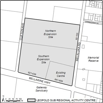
An aerial photo of the future sub regional centre land is in Appendix 3 and existing zoning is shown in Appendix 4.
The land at 100 Melaluka Road (northern expansion site) is 6.5 hectares in area and contained within the Farming Zone. It is generally cleared of native vegetation and contains a dwelling, sheds and a dam.
The land at 613-639 Bellarine Highway (southern expansion site) is also 6.5 hectares in area and contained within the Farming Zone. It is largely vacant with the exception of a weatherboard dwelling and large shed located in the north east corner of the site, addressing Melaluka Road. A dam is located towards the Bellarine Highway frontage and the land is generally devoid of native vegetation with the exception of river red gums in the north east corner.
The land at 641-659 Bellarine Highway (existing centre) is contained with the Business 1 Zone and is currently occupied by the Gateway Plaza Shopping Centre, which was constructed by the permit applicant in 2007. The centre comprises a Coles Supermarket, various speciality stores and a medical centre. The buildings which comprise the existing shopping centre complex are modern in architectural form and are predominately single storey in height, with the exception of some double storey architectural elements. The remainder of the site is occupied with car parking and landscaping, with a recently constructed McDonalds restaurant located in the south east corner.
The topography of the land is very flat with a slight “ridge” or high point running east-west midway through the northern expansion site. The land north of the “ridge” drains to the north along Melaluka Road and across farmland eventually making its way to Port Phillip Bay. The southern portion of the Perez land and all the Lascorp land drains south to the Gateway Sanctuary via a culvert under the Bellarine Highway. From the Sanctuary the drainage follows a channel and discharges to Reedy Lake.
The future sub regional site is bounded by the Bellarine Highway to the south, Melaluka Road to the east, Clifton Avenue to the west and farmland to the north. The sporting fields of the Leopold Memorial Reserve are directly opposite to the east of Melaluka Road. The Gateway Sanctuary is located immediately to the south of the Bellarine Highway.
A shared pathway (walking/cycling) has recently been constructed by Council along the west side of Melaluka Road from the Bellarine Rail Trail to the existing shopping centre.
Description of the amendment
The amendment as recommended for exhibition is to:
Rezone 621-639 Bellarine Highway, Leopold from Farming Zone (FZ) to either Business 1 Zone (B1Z) or Commercial 1 Zone (C1Z) - whichever zone applies at the time;
Amend the Schedule to the Business 1 (B1Z) or Commercial 1 Zone (C1Z) to include a floor space limit of 30,000 sq m for Shop for 621-639 and 641-659 Bellarine Highway, Leopold;
Insert and apply a Development Plan Overlay (DPO26) to 621-639 and 641-659 Bellarine Highway and 92-100 Melaluka Road, Leopold;
Amend Schedule 3 to Clause 52.28 Gaming to prohibit gaming machines in the Leopold Sub Regional Activity Centre.
The Commercial 1 Zone is referred to throughout this report because it is likely that, by the time the amendment is exhibited, the existing business zones will be replaced by the State Government’s new suite of commercial zones.
A map showing the proposed rezoning to Commercial 1 Zone is in Appendix 5. A map showing the proposed Development Plan Overlay is in Appendix 6.
Description of the Lascorp plans
The expanded sub regional shopping centre proposed by Lascorp is branded the “Bellarine Gateway Plaza”. The Planning Report submitted by ERM describes the proposal as follows:
The construction of an additional 30,725 square metres of floor space, resulting in on overall floor area of 35,660 square metres…
The development of a town square area, directly abutting Melaluka Road.
The provision of a range of tenancies abutting the town square which are intended to fulfil a ‘local’ role, including takeaway food premises and restaurants.
The development of two new discount department stores.
Expansion of the existing Coles Supermarket.
The addition of a Woolworths Supermarket.
The construction of a new east-west mall accommodating a range of speciality stores.
The development of showrooms along the western façade of the building.
The development of a gymnasium at first floor level adjacent to the western entry.
The development of a three storey office building in the south west corner of the building with frontage to the Bellarine Highway.
The centre has been designed to fulfil a local town centre role at the eastern end of the centre where it abuts Melaluka Road and the sporting precinct, with the sub-regional role services (including the two discount department stores and office floor space) located centrally and in the western portion of the site.
The centre will be predominantly single storey with two and three storey built form proposed along the western façade.
The eastern entry point has been designed to be a feature of the proposal comprising a large covered town square area and a feature entry based upon a ‘beehive’ theme with a restaurant incorporated as part of the entry feature.
The western entry point has also been the focus of careful design work utilising the same form of roofing as the town square and continuing the ‘beehive’ theme at the western end of the centre - whilst also incorporating seating and eating areas.
The two entries are linked via a meandering east-west internal mall area. The mall has been designed with a portal frame roof structure which is intended to provide a feeling of ‘openness’ to pedestrians, whilst maintaining the advantages associated with a temperature controlled enclosed area.
The building materials that are proposed have been selected to complement the form of the existing building whilst providing a more modern architectural response. Thus features of the building materials include timber styled cladding, expressed steel columns, metal screening battens, feature graphic glass and feature cladding.
Along with the eastern and western entry features, particular attention has been paid to the western and southern facades to ensure the centre will appear as an attractive and articulated form to passing traffic.
In particular, the three storey office building in the south west corner of the centre has been designed to ‘anchor’ that corner and to provide a string visual presence along the Bellarine Highway.
A copy of the overall layout plan is in Appendix 7 and a series of perspective images are in Appendix 8.
A full breakdown of the floor space proposed for the Bellarine Gateway Plaza is shown in the table below (sourced from the BMDA Retail Planning Report)
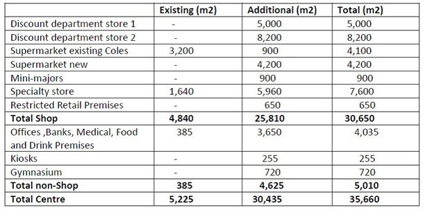
During the preparation of this report Lascorp submitted a revised plan showing stage 1 of the development with a reduced floorspace area. This is discussed in more detail later in this report.
The Greater Geelong Planning Scheme clearly nominates Leopold as the location for a Sub Regional Retail Activity Centre for the Bellarine Peninsula. The relevant state and local planning policy is outlined in the Policy/Legal/Statutory Implications section of this report.
The Leopold Structure Plan and the UDF give guidance on how the sub regional centre should be developed.
In addition to providing a sub regional centre, the UDF seeks to ensure that Leopold is given a local “main street” focussed on Melaluka Road. Council officers have been working closely with Lascorp to ensure that this is achieved in the Lascorp plans and that it will flow through to the Perez land when it is developed at a later stage.
The plans show the section of the activity centre fronting onto Melaluka Road as a pedestrian friendly environment with a town square/plaza, cafes, restaurants and shops providing a true “main street” strip that is currently lacking in Leopold. The shops will front on to a wide footpath suitable for outdoor dining and there are two rows of car parking provided on the developer’s land. The Melaluka Road reserve contains the newly constructed shared pathway and improvements will be required to the road itself. Trees planted along the roadside will help create the main street feel and soften the impact of the development. A direct pedestrian connection is provided from the town plaza across Melaluka Rd to the sporting grounds of the Leopold Memorial Reserve.
The large sub regional component of the shopping centre is focused back to the west with large car parking areas and access from a new signalised intersection on the corner of Clifton Avenue and Bellarine Highway.
The plans submitted by Lascorp are considered to meet the objectives of the UDF and the overall design is generally well resolved but still requires some refinement. The design issues to be dealt with include: the interface with the Perez land to the north, car parking arrangements, pedestrian connections, public art, landscaping, native vegetation retention etc. These issues will be dealt with by requesting revised plans or as planning permit conditions.
In addition to these detailed design issues there are six key outstanding issues that require resolution as part of the processing of this amendment. These issues are addressed below:
Economic Impact
Council officers engaged consultant Tim Nott to review the proposal and Macroplan Dimasi’s Economic Impact Assessment (Aug 2012). Mr Nott was part of the team that prepared the Leopold UDF providing a retail and commercial report in 2010.
Mr Nott has provided a report to Council titled “Review of economic evidence in support of expanding Bellarine Gateway Plaza June 2013”. The summary of the report states:
“The City of Greater Geelong and other stakeholders have been engaged for a number of years in developing plans for a new sub-regional activity centre in Leopold. The centre is designed to be an expansion of an existing neighbourhood activity centre located on the corner of the Bellarine Highway and Melaluka Road. The land is in two parcels – a southern parcel owned by Lascorp and a northern parcel owned by the Perez family.
Lascorp, the owner of the existing shopping centre on the site, has now submitted a rezoning application and permit application to allow the development of its site for a sub-regional shopping and activity centre. The proposed centre would be 35,660 sq m including 30,650 sq m of retail space. Key tenants would include two discount department stores, two full-line supermarkets and a wide variety of specialty stores as well as provision for offices, gym and showrooms.
The development application is accompanied by an economic impact assessment report by Macroplan Dimasi. The report finds that there is sufficient market demand to accommodate the proposed new centre and that it will generate net community benefits in terms of employment and improved service to residents of the Bellarine Peninsula.
I have undertaken a separate impact assessment and find that, although the development would improve the provision of retail goods and services to Bellarine residents, the scale of the proposal may generate net disbenefits. In particular, the impacts on Geelong CBD may be significant (likely to be a decline in retail trade of around 10%). The centres of Newcomb and Ash Road (Leopold) also face a decline in retail trade of 10%.
I have suggested that a sub-regional centre of 22,500 sq m (a similar size to Waurn Ponds, for example) would be sufficient to provide sub-regional retailing, including a single large discount department store, supermarkets and many specialty stores. Such a centre would have a more manageable impact on Geelong CBD and other centres. I have noted that there are no other double DDS sub-regional centres in the Geelong region. It would be more appropriate to wait until there was sufficient demand for a two DDS centre and not “lock-up” demand that, in the event, may be more appropriately satisfied elsewhere. The current average number of people to support a full-scale DDS in regional Victoria is around 42,000. On this basis, and using the present population forecasts for the Bellarine Peninsula, that level of population would be achieved in the mid-2020s.
I note that Council has received a potential staging plan for the centre from the proponent which proposes a first stage with a single DDS and total retail space of around 22,000 sq m. However, at the time of writing, it is unclear whether this will form the basis of a revised proposal. In my view, such a development would have a much more manageable impact on the network of other centres in the region.
In other ways, the design of the centre appears to respond well to the requirements of the planning scheme. The design provides a sub-regional centre at an approved location. It is for a moderately multi-functional centre, creating a main street feel on Melaluka Road which will integrate land to the north and west of the site.
If the proposal is approved as presented, there will not be sufficient demand to support conventional retail development elsewhere in the centre. The northern parcel of land fronting Melaluka Road may be suitable for development as an office or entertainment precinct with a cinema and limited number of restaurants, for example. If the development is approved at a smaller scale, there would be room for, say, 1,500 to 2,000 sq m of retailing on Melaluka Road, likely to be in conjunction with other uses.
I would expect that a bulky goods precinct of 15,000 to 20,000 sq m on Clifton Avenue could be developed, including 10,000 sq m of bulky goods retailing.
The assessment in this present report updates and supersedes that which I provided in 2010 for the Leopold Sub-Regional Centre Urban Design Framework.”
The assessment raises a serious concern that, if the sub regional centre was developed to its full extent without staging, the impact on centres such as Newcomb and Central Geelong would be significant (a decline in trade of around 10%).
Mr Nott recommends that one of the Discount Department Stores (DDS) is removed from the plans and they are scaled back to around 22,500 sq metres of retail floor space rather than the 30,650 sq m proposed. The impact on Central Geelong and Newcomb would then be reduced to around 7%.
The other concern with the Lascorp plans being developed to their full extent is that there would not be sufficient demand for retailing (except bulky goods) on the Perez land to the north. It is important that the eastern part of the Perez land has potential for viable commercial development as this will continue the Melaluka Road “main street” effect.
Staging
The permit application lodged by Lascorp as part of this process did not provide any staging information, although it was indicated by Lascorp that the development would most likely be staged. Information on staging was requested but this was not provided until June 2013 late in the assessment process.
Council’s consultant, Tim Nott, says it is understandable that the owner/developer of the Gateway Plaza would wish to lock in the potential to develop a large sub-regional centre in order to create certainty about future investment conditions. However, he believes it would be more appropriate for a further DDS to be the subject of a subsequent application (amendment) in order to meet demand. The following extract from Mr Nott’s report provides further background:
“It is likely that the development of Gateway Plaza would in any case be staged, with a single DDS additional supermarket and some specialty stores developed in the first phase followed by a second DDS and more specialty stores in a subsequent stage. Around Geelong, no centre has expanded in a single bound to be a double DDS centre; in fact there are presently no double DDS sub-regional centres in the region (although Waurn Ponds centre has an outstanding permit for a further DDS which has not yet been acted upon). Presently the other sub-regional centres are:
Waurn Ponds (major stores - Target, Coles and Woolworths) – 21,000 sq m in total
Belmont (Kmart and Coles) – 13,200 sq m of retail space
Corio (Kmart, Coles and Woolworths) – 27,513 sq m in total
None of these well-established centres has a floorspace of the 30,000 sq m proposed at Leopold.”
Lascorp has now submitted a plan showing its proposed Stage 1 and a revised floor space schedule (see Appendix 9). The plans and schedule show deletion of the western Discount Department Store and basement parking and replacement with at grade ground car parking. The plans have reduced the shop floorspace to 22, 375 sq m which is within the acceptable limits as suggested by Tim Nott’s independent assessment.
Council officers recommend that the planning permit be limited to the Stage 1 plans in Appendix 9 but the Development Plan Overlay and Commercial 1 / Business 1 Zone Schedule allow development of up to 30,000 sq metres subject to a further permit. The Development Plan Overlay will also require a further economic impact assessment to ensure there is sufficient retail demand for expansion beyond Stage 1.
This means a further planning scheme amendment will not be required if Lascorp wants to move forward with Stage 2 in the future. This provides investment certainty for Lascorp’s ultimate plans but allows Council to properly assess the economic impacts of any Stage 2 plans through a future planning permit process.
The Lascorp plans take 30,000 sq m of the total 35,000 sq m of ‘shop’ floor space recommended for a Sub Regional Centre. This leaves 5,000 sq m of ‘shop’ floor space for the Perez land to the north. Other non-shop use such as restaurants, cafes, a tavern, offices and entertainment are also permitted on the Perez land and are not subject to any floor space caps. The western half of the Perez land is also earmarked for a bulky goods / hardware / employment precinct.
Stormwater management
A revised Stormwater Management Plan was prepared by Cardno in April 2013. The proposal is to utilise Council owned land at the Gateway Sanctuary for an above ground retarding basin and water quality treatment via a Biofilta System. The proposal has been reviewed in detail by Council engineers, environmental planners and recreation and open space planners.
Council officers appreciate that Cardno is looking at a holistic management strategy that also deals with runoff from the Perez land at 92-100 Melaluka Rd. However, there are significant implications associated with the transfer of stormwater quality treatment to the Gateway Sanctuary.
The Gateway Sanctuary is primarily a passive recreation reserve and has a secondary role of capturing stormwater from the surrounding area into a series of wetlands. The wetlands were constructed several decades ago and are not designed in accordance with modern day best practice for stormwater treatment and water quality management. The proposal will require a number of pumps and ongoing maintenance. The Council officers responsible for the management of the Gateway Sanctuary are concerned at the proposed maintenance arrangements via a body corporate.
Council engineers have undertaken a thorough review of the proposal and have some serious concerns. The preliminary hydraulic modelling of Cardno’s stormwater management system for the critical storm of 1.5 hour duration has produced peak water levels within the two storages (shopping centre expansion and Gateway Sanctuary) significantly higher than the levels indicated in the Cardno report. Hence the City has little confidence that the Cardno system would function or perform as suggested in the Cardno report.
For the reasons stated above, Council officers are not able to provide ‘in principle’ support for the stormwater proposal.
Council officers have proposed alternative options with Cardno and Lascorp, including:
Storage and water quality treatment contained within the Lascorp and Perez properties and then discharging under the Bellarine Highway to either the Gateway Sanctuary or directly to the channel leading from the Sanctuary to Reedy Lake.
Potential acquisition of land next to the Gateway Sanctuary to construct a retarding basin / water quality treatment wetland and discharge into the channel that runs south to Reedy Lake.
The stormwater management strategy is an important issue that will need to be resolved “in principle” prior to exhibition of Amendment C277.
Development Plan Overlay (DPO)
A DPO schedule is proposed to apply to all the three sites that make up the future sub regional centre. This includes the Perez land which is not being rezoned at this point and will remain in the Farming Zone.
The aim of the DPO is to ensure development occurs generally in accordance with the objectives of the Leopold Sub Regional Activity Centre Urban Design Framework 2011, and to coordinate the expansion of the centre across the three properties outlined above.
The DPO requires that any Development Plan must be generally consistent with the Leopold Sub Regional Activity Centre Concept Plan (to be inserted in the schedule) and the objectives of the Leopold Sub Regional Activity Centre Urban Design Framework 2011. The Concept Plan was prepared by Council officers and is more detailed than the UDF concept plans and reflects the Lascorp plans.
Planning Permit Conditions
A set of planning permit conditions for the Lascorp application (944/2012) are being prepared and will be exhibited with the amendment.
Section 173 Agreement - Developer Contributions / Infrastructure.
The expansion of the centre will require new infrastructure and improvements to existing infrastructure immediately surrounding the site. Discussions are underway with Lascorp regarding an Agreement under Section 173 of the Planning and Environment Act 1987 to deal with developer contributions to off site infrastructure. The type of infrastructure that may be required includes:
A new signalised intersection at Clifton Avenue and Bellarine Highway;
Upgrades to Melaluka Road and Clifton Avenue adjoining the site;
Construction of the new central east-west street;
Extensions and improvements to the existing, off-site footpath and shared pathway network; and
Off site stormwater management systems.
The Development Plan Overlay will require that a similar agreement is entered into by the landowners to the north (currently the Perez family) prior to any planning permits being issued. This will ensure that contributions are spread equitably across the land holdings.
It is anticipated that this infrastructure would be provided directly by the developer. However, in some cases Council may collect contributions and deliver infrastructure itself.
The proposed development is not expected to result in any adverse environmental impacts because the subject land is substantially vacant and contains no significant vegetation. Any impacts on the Gateway Sanctuary will need to be managed and water quality will need to be of a high standard due to the environmental sensitivity of the receiving water body (Reedy Lake).
Approval of the proposed development is unlikely to result in any financial implications for Council. The cost of constructing the necessary off site infrastructure required to support the expansion will be borne by the developers under a Section 173 Agreement.
The Amendment supports the relevant policies of the State Planning Policy Framework, as outlined below.
Clauses 11.01 Activity Centres - the proposal seeks to expand an existing activity centre that will enable the provision of a concentration of retail, commercial, medical and recreational facilities in a highly accessible location with convenient access available via walking, cycling, public transport and private vehicle
Clause 11.05 Regional Development - promotes the sustainable growth of one of Victoria’s major regional cities and further promotes development of Regional Victoria.
Clause 15 Built Environment and Heritage – the Amendment will result in an expanded activity centre that will contribute positively to the local urban character and public realm through the provision of a new town plaza, activation to Melaluka Road and carefully designed interfaces with surrounding land uses.
Clause 17.01-1 Business – the proposal meets the Objective to “encourage development which meet the communities’ needs for retail, entertainment, office and other commercial services and provides net community benefit…”. The Strategy “A five year time limit for commencement should be attached to the planning approval for all shopping centres or expansions of over 1,000 square metres in floorspace” will be dealt with by the planning permit.
Clause 18.01 Integrated Transport – the proposal broadly complies with the objectives and strategies for land use and transport planning, movement networks, cycling, public transport, management of the road system and car parking.
The Amendment responds appropriately to the MSS clauses and Local Policies of the Scheme, as follows:
Clause 21.07-3 Retail - the proposal meets the objectives of this clause including: “to facilitate the development of vibrant and viable retail activity centres..” that provide a “..clear net community benefit” and “avoid the risk of exacerbating problem gambling”.”.
Clause 21.07-8 City of Greater Geelong Retail Activity Centre Hierarchy - the Amendment will facilitate a sub-regional activity centre at Leopold which is nominated for this purpose in the Retail Hierarchy Table and Map.
Clause 21.14 - 2 The Bellarine Peninsula – the specific strategies relating to Leopold include:
Support Leopold as a Sub Regional Retail Activity Centre for the Bellarine Peninsula that also provides local community, recreational and employment facilities to Leopold’s residents.
Encourage the northerly expansion of the Sub Regional Retail Activity Centre, ensuring any development integrates with the existing centre and surrounding community facilities, and enhances its appearance and functionality.
Clause 21.14-3 Implementation – the amendment is generally consistent with the “applying zones and overlays” section in relation to Leopold which includes: “apply a combination of business zones, a Design and Development Overlay and a Development Plan Overlay to facilitate the expansion of the Leopold Sub Regional Activity Centre”.
Clause 21.14 References – the amendment and permit application are consistent with two of the reference documents listed at this clause being the Leopold Structure Plan 2011 (amended 2013) and the Leopold Urban Design Framework 2011.
Clause 22.03 Assessment Criteria for Retail Planning Applications – this policy requires that issues of retail demand, retail supply, escape spending, impact on existing retail facilities, net community benefit, and design and location be addressed in all retail development proposals. The economic assessment submitted with the application and Council’s independent assessment indicate the proposal can proceed (in a staged manner) without major impact on existing centres.
Clause 22.57 Gaming - the addition of the site to Schedule 3 to Clause 52.28 Gaming will prohibit gaming machines in the Leopold Sub Regional Activity Centre consistent with the Gaming policy at Clause 22.57 which discourages gaming machines on sites within the main transport, shopping, community and civic functions of an activity centre.
No Council Officers have any direct or indirect interest, in accordance with section 80(c) of the Local Government Act, to which this report relates.
There are no notable risks associated with implementing the recommendation contained in this report.
The amendment will bring about a range of social benefits as it will facilitate the provision of a sub regional activity centre, with improved accessibility and increased retail competition for the community. The creation of a “main street” for Leopold will be a significant social benefit. The amendment is also expected to bring about a range of ongoing local employment opportunities.
As referred to in the Policy section of this report, gaming machines will be prohibited in this activity centre due to the potential social impacts and consistent with Council policy.
It is proposed that this Amendment and accompanying permit be exhibited in accordance with the provisions of the Planning and Environment Act 1987 to provide the opportunity for full public comment (and potentially referral to an Independent Panel appointed by the Minister for Planning). Exhibition is subject to the Minister’s authorisation.
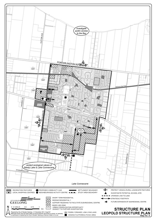
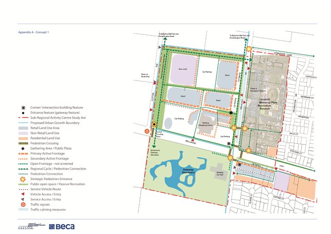
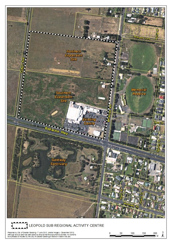
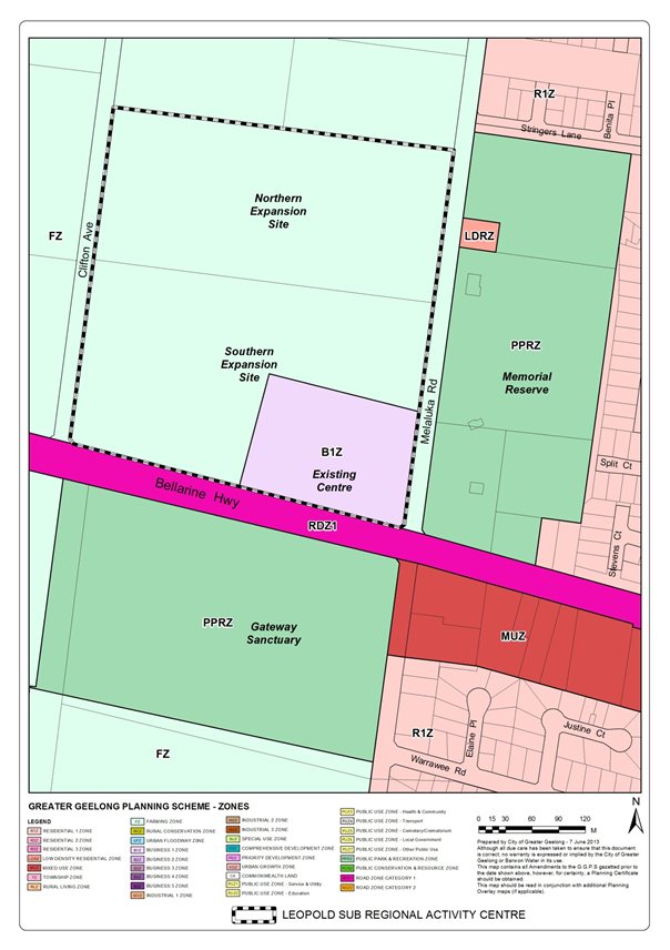
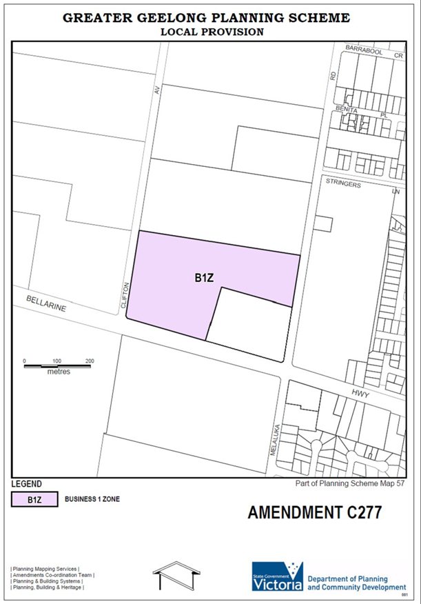
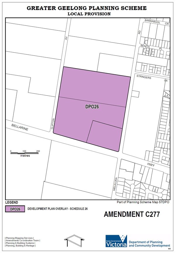
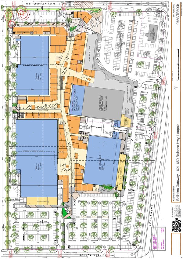
Entry point off Melaluka Road / Town Square
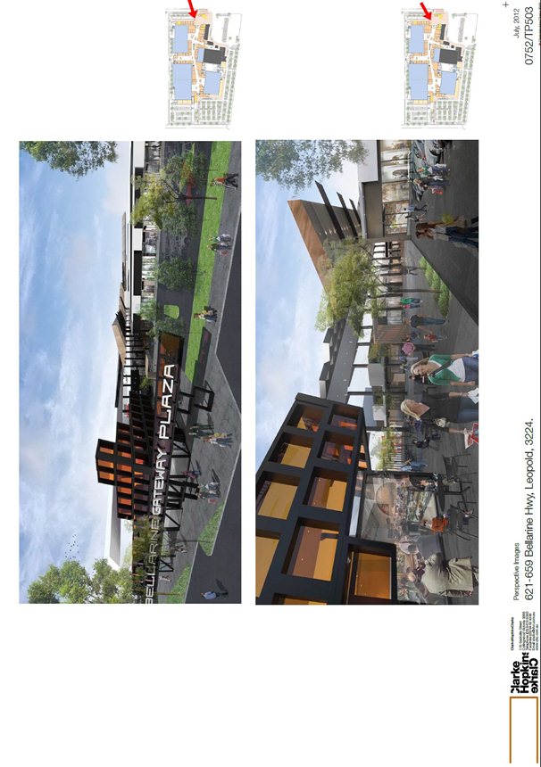
Internal mall
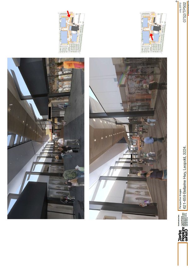
West and South West Corner – Bellarine Highway / Clifton Ave
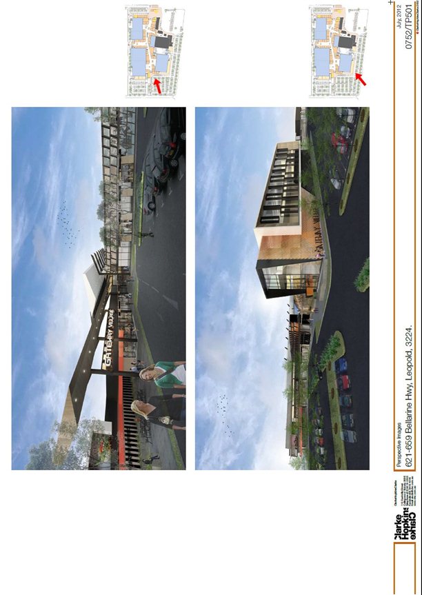
Melaluka Road
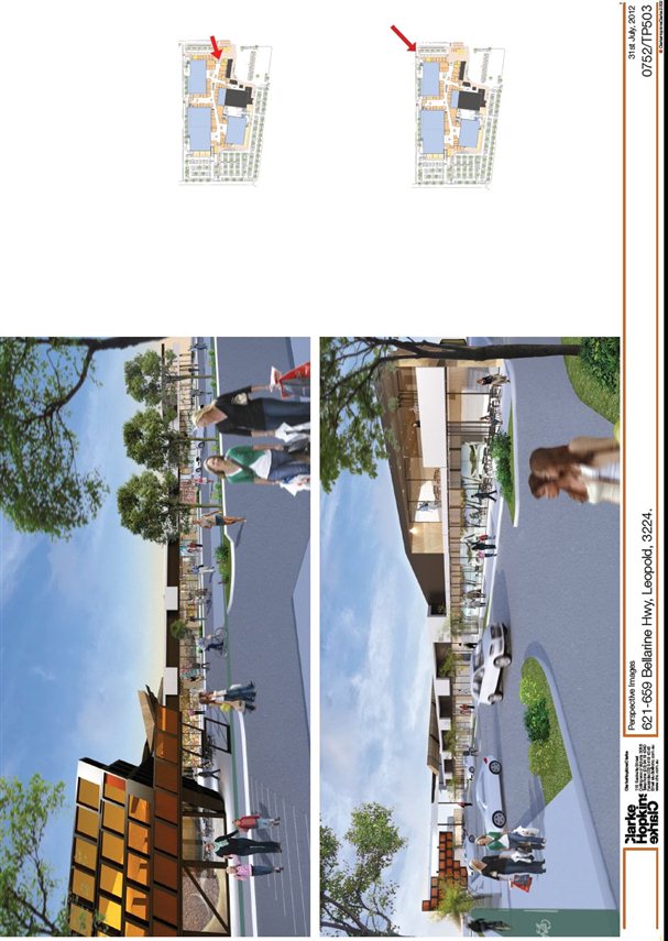
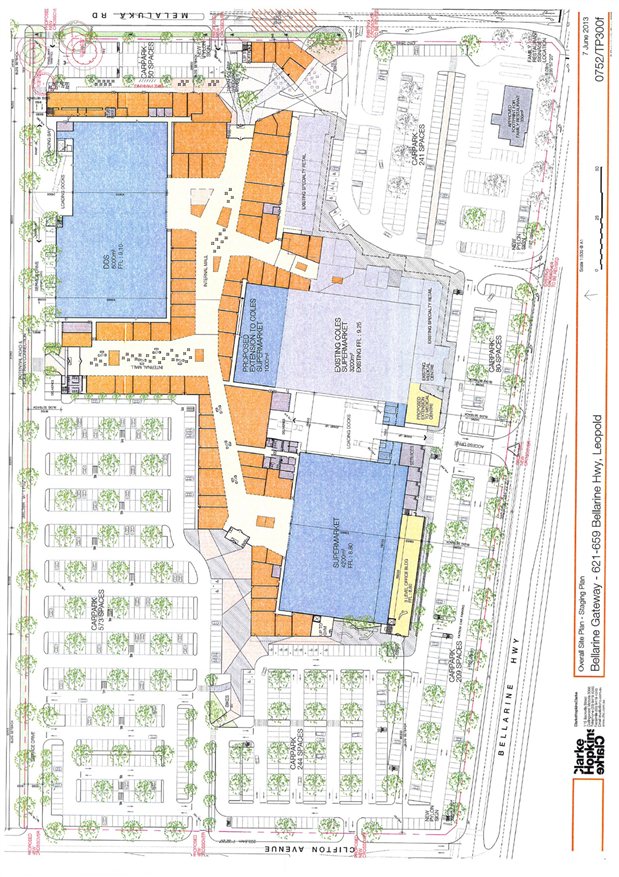
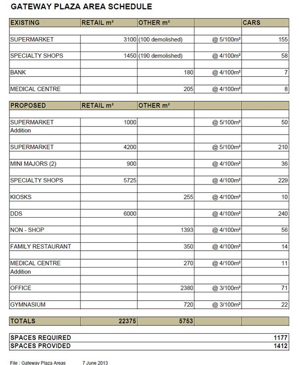
Portfolio: |
Planning - Cr Macdonald |
Source: |
Planning Strategy and Economic Development |
General Manager: |
Peter Bettess |
Index Reference: |
Avalon Airport |
Avalon Airport Pty Ltd released for consultation the Avalon Airport Master Plan, Land Use Plan and Environment Strategy. Comments on the plan are invited until 31 August 2013.
The Master Plan and Land Use Plan are an important step towards setting the strategic direction for the future development of the airport.
The Plans have a broad time horizon from 2013-2033. Four key tenets for the future development of the airport are defined; passenger operations; technical aviation operations; freight; and retail and commercial developments.
The Master Plan identifies potential future infrastructure improvements required, including the extension of the existing runway, an additional parallel runway, one cross runway, a direct rail link, new freeway overpass and expansion of the passenger terminal to accommodate international passengers. The timing or funding of infrastructure is not detailed.
A range of land uses are envisaged on the airport site including retail development, industrial development, office development, freight handling facilities and hotel accommodation in addition to airport related uses such as terminals.
The Master Plan outlines the need for the continued curfew free operation of the airport, the continued provision of general aviation services and the continuation of the Australian International Airshow until at least 2015 and likely to 2025.
Council it is recommended make a submission about the Master Plan and Land Use Plan welcoming the opportunities identified and the growth directions for the airport in the future. The submission should also request that Council’s status as responsible authority be retained and that retailing in the Princes Precinct, closest to the highway, be limited to restricted retail uses only.
Cr Macdonald moved, Cr Harwood seconded -
That Council makes a submission in support of the Avalon Airport Master Plan and Land Use Plan 2013 subject to the following changes:
That the land use directions for the Princes Precinct be clarified to note that the only form of retailing supported in this precinct is restricted retailing.
That the Land Use Plan be changed to reflect the ongoing role of Council as the responsible authority for Avalon Airport.
Carried.
Avalon Airport is located between Lara and Little River on the southern side of the Princes Highway. It was previously used by the Federal Department of Defence and is leased from the Federal Government by Avalon Airport Australia Pty Ltd which is owned by Linfox Airports Group. The lease requires the airport operator to prepare a Master Plan detailing proposals for development of the airport and other associated land uses for a planning period of 20 years.
The existing layout of the airport is shown on Attachment 1. The land is 1753 hectares in area. It features one north south runway with a parallel unsealed runway to the east. The passenger terminal is located to the north of the runway with an adjoining car park with 1500 spaces. To the east of the runway there are four large hangars which are used for aircraft maintenance and other uses ancillary to the airport.
The airport has significant scope for expansion in the future given the availability of land, curfew free status, separation distance from sensitive uses and excellent access to road and rail transport infrastructure.
A draft Master Plan for the airport was provided for comment to Council in 2012. It was considered at a Council meeting on 21 August 2012. Council made a submission to the Draft Plans based on the following resolution:
“That Council authorise the Mayor to make a submission in support of the Draft Avalon Airport Land Use Plan and the Draft Avalon Airport Master Plan. The submission should request modification of the Plans
To limit the location and the amount of retailing in the Princes Precinct to the area south of the Princes Freeway and north of the multi fuel pipeline which traverses the site being no more than 22 hectares in area
To limit the type of retailing allowable in the Princes Precinct to restricted retail (“big box”) type uses which will not compete with Central Geelong and
To recognise Council’s continuing role as the responsible authority”.
The Master Plan divides the airport site into 8 precincts each with a different purpose. The precinct map is provided in Appendix 1. The land use intentions for each of the eight precincts are detailed in the Plan.
The Princes Precinct closest to the Princes Highway is 22 hectares in area and proposed to be developed as a commercial and retail precinct.
The Terminals Precinct is 350 hectares in area and proposed to be developed as the main location for domestic and international terminals, car parking, hotel accommodation and other retail activities.
The Runway Precinct contains the existing runway and taxiways and will retain that use. Land uses not directly related to the servicing and operation of aircraft will be directed to other precincts.
The Beach Precinct is 340 hectares in area and its primary purpose will be to provide for light industry. The four on site hangars are located in this precinct.
The Green Precinct is 620 hectares in area. A definitive future use is not identified other than to protect it for long term expansion of the airport.
The Dandos Precinct is 245 hectares in area and similar to the directions for the Green Precinct, it is to be retained for future long term expansion.
The Avalon East Precinct is 235 hectares in area and will provide for the short term expansion of general aviation activities at the airport. This will be the ultimate site for the second parallel runway, which may not be required for a further 20 years.
Retail Development
The scale of retailing at Avalon is a key issue. The Draft Master Plan considered by Council in August 2012 proposed a retail precinct of over 200 hectares. The City commissioned expert economic advice which concluded that the amount of retailing at Avalon should be no more than 10,000 square metres (1 hectare).
In August 2012 Council decided to support retail development on a larger scale at Avalon, up to 22 hectares, provided it was restricted retail or “big box” uses which would not compete with Central Geelong. This was the basis of Council’s submission to the Draft Master Plan.
Restricted retailing is a defined term in the planning scheme and includes the sale of amongst other things; camping goods, sporting goods, and furniture but excludes the sale of food, clothing and footwear (unless ancillary to another use).
In the latest iteration of the Master Plan, the size of the retail precinct has been reduced from 200 hectares to 22 hectares; this was in response to Council’s submission on the Draft Master Plan. However the Master Plan does not limit the type of retailing to restricted retailing only which is inconsistent with Council’s position. Council’s submission to the Master Plan should seek to have this included.
Responsible Authority
The Land Use Plan indicates the desire of the airport operator to assume the role of the responsible authority for issuing planning permits on the airport site. This would remove Council’s decision making role and its ability to influence the future development of the airport land.
The Land Use Plan also indicates that there would be no avenue of appeal against decisions, affecting the ability to appeal to VCAT and in relation to the giving of notice of applications the seeking of “informal comment” would be at the discretion of the airport operator. This contrasts to the existing planning controls whereby Council may give notice of an application if it believes that the grant of a permit would result in adverse amenity impacts. Similarly the right to lodge an appeal with VCAT is also currently provided.
It is considered that a significant review of the planning controls relating to Avalon Airport is appropriate to minimise the necessity for planning permits and expedite development approvals. This will enhance Avalon Airport in respect to investment attraction generally and demonstrate the status of Avalon Airport as a key regional economic driver. The City of Greater Geelong has previously committed to delivering a planning regime of this nature. It is however considered that the complete removal of any public process associated with the planning and approval of development may not serve the communities long term interests.
International Airport
The Master Plan notes that it is anticipated that Avalon will continue to attract increased numbers of domestic passengers. Scheduled international flights are expected to begin by the end of 2013/14. The Master Plan includes forecasts passenger movements of 7.25 million domestic passengers and 2.19 million international passenger movements by 2030/31.
Rail Link
The State Government is continuing its work on the proposed rail link to Avalon. Three potential alignments were released for consultation earlier this year. The Master Plan and Land Use Plan make provision for the rail connection.
The lodgement of a submission on the Master Plan and Land Use Plan will not have any adverse environmental impacts. Future development proposals which may result following completion of the plans will require examination of environmental impacts in greater detail. The Environment Management Strategy prepared by the airport operator will be considered by the Commonwealth Government.
The City will continue to encourage the airport operator to introduce an Airport Environs Overlay to the land around the airport to document the identified noise contours from existing and proposed flight paths.
The lodgement of a submission on the Master Plan and Land Use Plan will not have financial implications for Council.
The lodgement of a submission has no statutory implications for Council
No Council officer involved in the drafting of this report has any direct or indirect interest, in accordance with Section 80(c) of the Local Government Act in the land to which this report relates.
There are no risks associated with lodging submission to the Master Plan and the Land Use Plan.
Relevant social considerations in the submission to the Draft Avalon Airport Land Use Plan and the Draft Avalon Airport Master Plan include the need to provide services such as retailing in close proximity to where people live and work.
The response from Council to Avalon will be made public, and a detailed release in relation to Council’s position will be made available to the press. Avalon is undertaking its own consultation process
Portfolio: |
Arts & Culture – Cr Heagney |
Source: |
Projects, Recreation & Central Geelong / Capital Projects |
General Manager: |
Dean Frost |
Index Reference: |
Project: Geelong Library & Heritage Centre and Geelong Future Cities Projects/Arts & Cultural Precinct |
The purpose of this report is to seek Council consent to delegate to the Chief Executive Officer, the power to accept or reject tenders for the construction of the Geelong Library & Heritage Centre.
The design process for the Geelong Library & Heritage Centre is nearing completion and Council will soon be inviting tenders for the construction of this facility.
The $45.5M project is funded through a $15M State Government grant, $10M Federal Government grant and Council’s budget.
The Capital Projects and Procurement Services departments are exploring prudent and expeditious mechanisms to complete the tender process to provide the best opportunity for the successful contractor to be on site before the end of 2013.
Cr Heagney moved, Cr Macdonald seconded -
That Council delegate to the Chief Executive Officer its powers and functions to accept or reject a tender and sign the contract documents for the construction and associated works of the Geelong Library & Heritage Centre, provided tenders are within budget.
Carried.
In April 2012 Council appointed architecture firm Ashton Raggatt McDougall (ARM) as its lead design consultant for the $45.5m Geelong Library Heritage Centre project.
In addition to the architectural consultancy, Council also engaged Davis Langdon AECOM as the project manager and Slattery Australia as the quantity surveyor.
A Project Control Group (PCG), which includes five (5) Councillors, has been overseeing and reviewing the design process. This group has been ensuring that the designs developed by the architect meet with Council’s expectations for a contemporary Library and Heritage Centre.
In September 2012 Council endorsed a ‘domed’ concept proposal for the Geelong Library & Heritage Centre.
Following the endorsement of the concept, Council has moved through the design development phases of the project and has now finalised the design of the facility. Having now completed the design phases of the project we will soon be inviting construction tenders for the facility.
The Capital Projects and Procurement Services departments are exploring prudent and expeditious mechanisms to achieve opening deadlines, noting that the construction contract amount will be beyond officer delegations.
Council have recently completed an Expression of Interest process for construction contractors and has shortlisted six (6) construction firms who will be invited to tender for the works package.
These firms are:
Adco Constructions Vic Pty Ltd
J. Hutchinson Pty Ltd
Cockram Construction Limited
Kane Constructions (Aust) Pty Ltd
Probuild Constructions (Aust) Pty Ltd
Watpac Construction (Vic) Pty Ltd
The current project plan will see the full documentation and contract specifications for this project finalised in August.
The Tender for the construction of the facility will be advertised in August 2013 and will close in September 2013. Following an evaluation process which should take between 4-8 weeks to complete the tender will be ready for awarding in late 2013.
These timelines mean that a contractor could establish themselves on site prior to the 2013 Christmas shut down period. This would allow the construction contractor a full 24 month contract period to complete the works.
The timing for the appointment of a contractor means that the Chief Executive Officer may need to enter into the contracts under delegation. This is because the process to prepare and present a formal tender report to Council takes approximately 4 to 6 weeks. Whilst this in itself is not problematic, the Council meeting cycle goes into recess in late December and early January and therefore opportunities to present the report are limited.
Environmentally Sustainable Design (ESD) outcomes have been incorporated into this project, and the building is being designed to a 5 Star Greenstar rating.
The project is being funded through a $15M State Government grant, $10M Federal Government grant and $20M from Council.
Against the above background and timeframes to handle tender submissions, there may be inadequate time for Council to formally determine the outcome of the tender through the formal Council process.
No council officers involved in this project or report have declared a direct or indirect interest in this matter.
As with any project of this nature, there are a number of risks that have been identified which are being mitigated through various control measures.
This project will improve the community’s access to information through printed collection and via the latest multi-media platforms, and will serve as a community hub for central Geelong.
There are no communication issues or requirements associated with the acceptance of the proposed recommendation.
Portfolio: |
Women in Community Life – Cr Fagg, Mayor |
Source: |
Community Services |
General Manager: |
Jenny McMahon |
Index Reference: |
Subject: Human Rights |
The purpose of this report is to advise Council about the establishment of a Women in Community Life Advisory Committee to support the role of the Portfolio holder currently the Mayor, Keith Fagg.
In October 2010, Council became a signatory to the Victorian Local Government Women’s Charter, which is supported by around 60 local governments.
The three key principles of the Women’s Charter are:
Gender Equity
Diversity
Active Citizenship.
The Victorian Local Government Women’s Charter will inform the direction of the Advisory Committee. The Committee will provide ongoing advice and support to the Portfolio holder and Council.
The establishment of the Advisory Committee will assist Council to meet each identified action area of the Victorian Local Government Women’s Charter.
The Advisory Committee will provide advice to Council on matters relating to women and their participation, representation and leadership in community life through:
Seeking, encouraging, building on and providing opportunities for a greater number of women of diverse backgrounds in decision making processes and activities
Promoting and celebrating successes, milestones and participation of women
Providing advice to Council on emerging women’s issues, aspirations and initiatives.
The Advisory Committee membership will comprise representation from organisations and individuals, and two Council representatives (including the Chairperson).
The Committee will be supported by a Council officer.
Advisory Committee members are expected to be active and to report, share, and promote actions and deliberations from and to the organisations which they are connected.
Cr Fagg moved, Cr Fisher seconded -
That Council:
approves the establishment of a Women in Community Life Advisory Committee
endorses the Terms of Reference (refer Appendix 1)
notes the process of recruitment for Committee members (refer Appendix 2)
appoints Cr Jan Farrell to the Women in Community Life Advisory Committee.
Carried.
The establishment of a Women in Community Life Advisory Committee:
Furthers the activities of the Women’s Participation in Local Government Coalition, as funded by the Victorian Government, to work with local governments to adopt the Victorian Local Government Women’s Charter.
Builds on the community forum, Women in Local Democracy, convened by the City of Greater Geelong in March 2012, which provided the opportunity to recognise and celebrate the significant work and participation by women in Geelong.
Will complement the newly formed Council portfolio, Women in Community Life, and provide opportunity for Council to show active support in increasing the participation of women.
The Advisory Committee will identify gaps and opportunities for further initiatives, service planning and delivery.
Membership of the Advisory Committee will include both women and men and seek representation across a range of demographics.
The establishment the Advisory Committee further emphasises the basic human right to full and equal participation in power and decision making. Participation of women includes being part of the process of influencing and shaping decisions and policies that affect women themselves, families, and communities; at a local, regional, national and international level.
From 1 January 2008, all public authorities (including local governments) have been required to act in accordance with the Human Rights Charter, and to consider human rights when making a decision.
The Charter provides standards and a framework to assist in the consideration of the rights of all interested parties, and to be better able to strike a balance between an individual’s rights and those of competing public interests. The twenty rights listed in the Charter promote the principles of freedom, respect, equality and dignity. These are incorporated in the Victoria Local Government Women’s Charter.
Women vote, run for office, lead civil society groups, shape peace talks and contribute to peace talks through the media. Around the world, growing numbers of women are engaged in all of these activities, but at levels much lower than men.
(UN Women, National Committee Australia)
In the pursuit of equality for women, all efforts and participation of community, business, and government is required.
Council’s encouragement and support for equity will be affirmed through the establishment of a Women in Community Life Advisory Committee, and through Council advocating for gender balance in decision making processes.
The role of the Advisory Committee is supported by Council’s community consultation processes and reflective of the IAP2 (Institute of Australia Public Participation) spectrum of participation. This recognises that the ‘level’ at which people participate can vary and change at any given time. The degree of participation is based on where people are at, their availability, and surrounding factors.
Whether a person participates in decision making processes in a passive role or through lobbying and advocating, all levels of participation are valued as part of local democratic processes. Examples of such participation are community groups, school boards, and businesses or organisations’ boards of management.
Through identification of barriers and resistant attitudes for women to participate, and the creation of opportunities and access, an increased number of women will actively participate in decision making and the processes that can influence and direct change.
A Terms of Reference for the Women in Community Life Advisory Committee has been drafted for Council’s endorsement (Appendix 1).
Not applicable.
A Women in Community Life Advisory Committee will be supported by a Council officer. On average this support is estimated to be in the order of two to three hours per week, and will be managed through Council’s Community Development Department. As this is an additional project for the team, priorities will be adjusted to accommodate meeting cycles.
In addition, Council has allocated $15,000 through Councillor Community Ward Priorities, in the 13/14 budget to support the activities of the committee.
In 2010/11, the non-party political Women’s Participation in Local Government Coalition received funding from the Victorian Government to work with local governments to adopt the Victorian Local Government Women’s Charter and create three action areas for each of the three key principles of Gender Equity, Diversity and Active Citizenship.
No Council officer involved in the preparation of this report has a direct or indirect interest in the matter to which the report relates.
Not applicable.
Through the establishment of a Women in Community Life Advisory Committee, Council will publicly demonstrate and affirm its support for gender equality. The Committee will provide opportunity to further work with a range of community groups, businesses and organisations in advocating for, planning and influencing service delivery impacting on women’s lives.
The Community Services Division is responsible for communication relating to this report.
Portfolio: |
Enterprise Geelong – Cr Harwood |
Source: |
Chief Executive’s Office |
General Manager: |
Stephen Griffin |
Index Reference: |
Enterprise Geelong |
Cr Harwood moved, Cr Macdonald seconded -
That in accordance with Section 89 (2) (a) of the Local Government Act 1989, this personnel matter be considered at the conclusion of all other business at which time the meeting be closed to members of the public.
Carried.
Contents | Previous Page: Section A - Procedural Matters | Next Page: Section C - Common Seal Register