
Council Minutes - Section B: Reports - 11 February 2014
Contents | Previous Page: Section A - Procedural Matters | Next Page: Section C - Notice of Motion
Contents | Previous Page: Section A - Procedural Matters | Next Page: Section C - Notice of Motion
Reports tabled at the Ordinary Meeting of Council on Tuesday date held at City Hall, Little Malop Street in Geelong.
Amendment C296 – Simonds Stadium Kardinia Park – Consideration of Submissions
Proposed Rezoning 1681 – 1729 Bellarine Highway, Marcus Hill
The Avenue, Ocean Grove – Proposed Road and Drainage Construction SRC327 – Declaration Report
Portfolio: |
Planning - Cr Heagney |
Source |
Planning and Tourism - Strategic Implementation |
General Manager: |
Peter Bettess |
Index Reference |
Council Reports 2014 |
This report considers submissions received to Amendment C290 and recommends the submissions be referred to an Independent Planning Panel.
Amendment C290 is Council-initiated and seeks to apply the Public Acquisition Overlay 4 (Proposed Road) to part of three private landholdings that front the Patullos/ O’Hallorans/ Elcho Road intersection, Lara.
The Amendment will reserve land necessary for the future upgrade of the intersection. The intersection upgrade is part of the wider strategic planning of the Lara West Growth Area under Amendment C246.
The future intersection upgrade is an infrastructure item in the adopted Lara West Development Contributions Plan, September 2013.
The land proposed to be acquired is part of 165 Patullos Road, part of 180 Patullos Road and part of 5 Elcho Road, Lara.
A delegated authority report was prepared on 20 February 2013, which resolved to support the preparation and exhibition of Amendment C290.
Public exhibition of Amendment C290 commenced on 2 May 2013 and closed on 3 June 2013.
There were two submissions. One submission was received from APA GasNet Australia. APA made no objection but requested that Council liaises with them prior to works being undertaken to upgrade the road intersection. It is noted that this Amendment is about reserving land for acquisition and any future road works are subject to a separate approvals process.
The other submission came from a directly affected landowner at 180 Patullos Road, who submitted an alternative road intersection design that seeks to spread the land acquisition equitably across all affected landowners.
In considering the submission from the landowner at 180 Patullos Road, advice was sought from Council’s Traffic Engineer and VicRoads. Both identified a number of negative impacts of the suggested alternative intersection design.
Council officers therefore do not recommend any changes from what was exhibited.
This report addresses the issues raised in the submissions and recommends they be referred to an Independent Panel appointed by the Minister for Planning.
Cr Heagney moved, Cr Ansett seconded -
That Council, having considered all submissions to Amendment C290 to the Greater Geelong Planning Scheme, resolves to:
Request the Minister for Planning to appoint an Independent Panel under Part 8 of the Planning and Environment Act 1987;
Refer all submissions that have not been resolved to the Panel; and
Submit to the Panel its response to the submissions generally as outlined in this report.
Carried.
This Amendment is the result of future planning for the Lara West Growth Area, where the intersections of Patullos Road with O’Hallorans Road and Patullos Road with Elcho Road (referred to as the Patullos/ Elcho/ O’Hallorans Road intersection) were assessed as inadequate and in need of upgrading to cater for the predicted long term traffic volumes and to provide safe and functional use by pedestrians and cyclists.
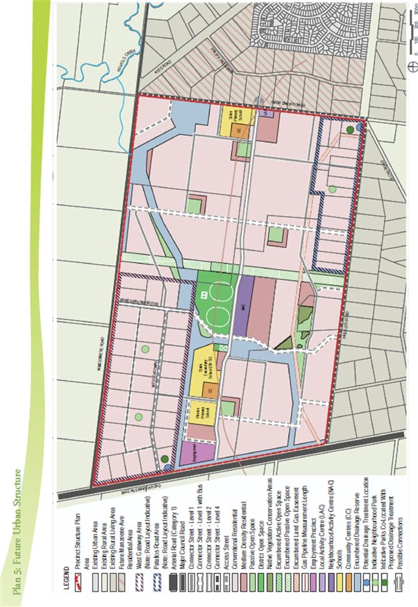
The Lara West Growth Area sits on the western edge of the Lara Township and Amendment C246 seeks to rezone 390 hectares of farming and rural living zoned land to the Urban Growth Zone supported by a Precinct Structure Plan (see Appendix 1). Amendment C246 was adopted by Council on 22 October 2013 and is currently before the Minister for Planning for approval
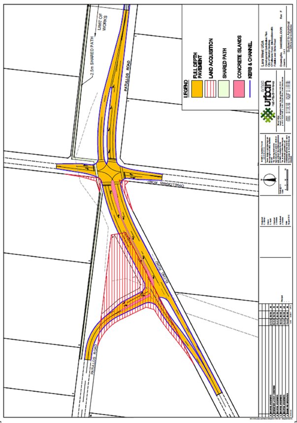
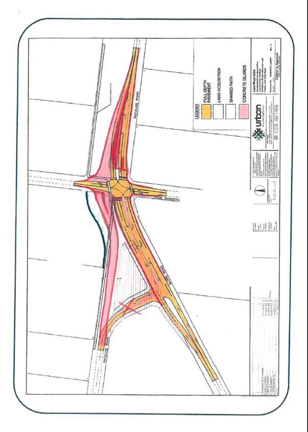
The upgrade of the intersection is an infrastructure item in the adopted Lara West Development Contributions Plan, September 2013, which forms part of Amendment C246. The design of the intersection in the Lara West Development Contributions Plan is shown at Appendix 2.
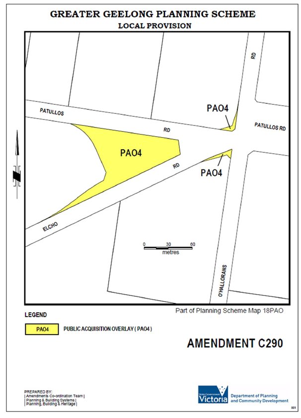
The design of the new Patullos/ Elcho/ O’Hallorans Road intersection will require the acquisition of private land. The most appropriate planning tool to identify and acquire the land is the Public Acquisition Overlay 4 (Proposed Road)
The land to be acquired is as follows:
Part of 165 Patullos Road: 0.01 hectares
Part of 180 Patullos Road: 0.56 hectares
Part of 5 Elcho Road: 0.01 hectares
These areas are shown at Appendix 3 as part of the exhibited planning scheme map change
The purpose of the Public Acquisition Overlay 4 (PAO4) is to reserve land for a public purpose and to ensure that changes to the use or development of the land do not prejudice the purpose for which the land is to be acquired
On 20 February 2013 Council resolved, via delegated powers, to prepare and exhibit Amendment C290. On 27 February 2013 Council wrote to the Minister for Planning requesting authorisation to prepare and exhibit Amendment C290 to the Greater Geelong Planning Scheme. Authorisation by the Minister was received on 5 March 2013 (Authorisation No. 02492).
A notice of preparation of the amendment appeared in the Victorian Government Gazette on 2 May 2013. Notices were also advertised in the Geelong Independent on 26 April 2013 and the Geelong Advertiser on 27 April 2013
Letters and notices were sent to relevant State Government Departments, statutory authorities and to directly affected landowners on 25 April 2013.
The exhibition resulted in a total of two submissions. Subject to the Minister for Planning appointing an Independent Panel to hear all submissions, the issues and responses discussed below will form the basis of Council’s submission to the Panel Hearing.
APA GasNet Australia (Operations)
APA lodged a submission stating that they own and operate a high-pressure gas transmission pipeline (the Iona to Lara Pipeline) located within the Amendment C290 land. The pipeline is located within a 20 metre wide easement running north-south though the western portion of 180 Patullos Road
APA made no objection but requested that Council liaises with them prior to works being undertaken to upgrade the road intersection
Officer response
The submission is noted. The Amendment seeks to reserve land for acquisition and any future road works are subject to a separate approvals process.
Private landowner, 180 Patullos Road
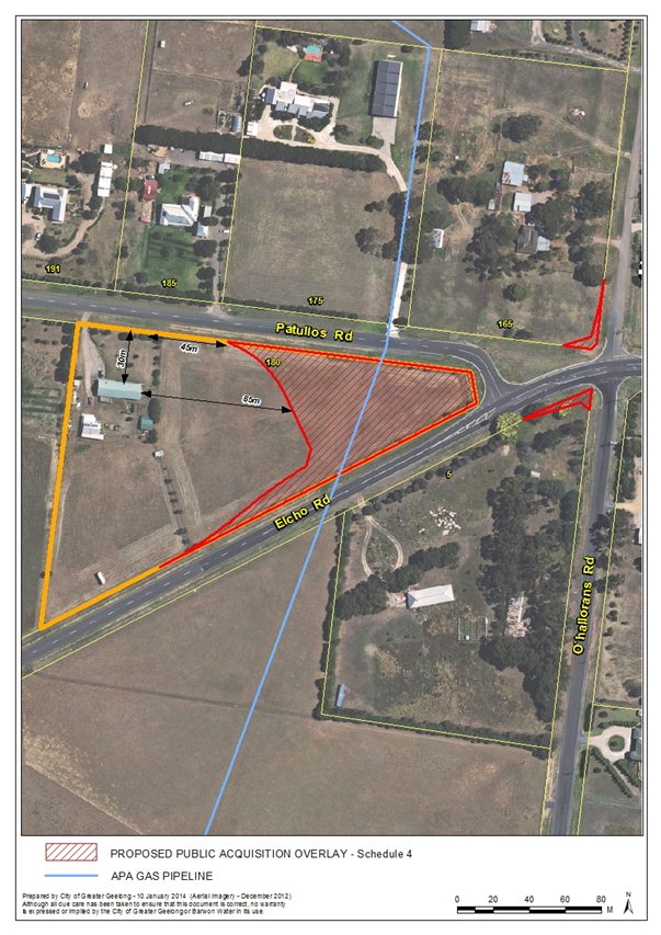
A submission was received from Whyte, Just & Moore Lawyers acting on behalf of the landowners of 180 Patullos Road. The Amendment proposes to apply the PAO4 to 0.56 hectares of the western portion of the property (note aerial map at Appendix 4)
The submission is supported by a traffic engineering assessment by GHD Pty Ltd. The GHD assessment in summary states that: ‘the proposed signalised intersection configuration will provide the best engineering outcome for the network’ (this is referring to the exhibited intersection design). The assessment then goes on to summarise potential options for further investigation
In the submission, after reviewing the GHD assessment, the submitter proposes the ‘five-leg’ intersection design, as it would consolidate the Patullos/ Elcho/ O’Hallorans Road junctions and would have a layout similar to Kew junction. The submission includes a rough sketch to demonstrate the preferred design (see Appendix 5).
The submission states that this design would also significantly reduce the total land acquisition requirement (to the land at 180 Patullos Road) and spread the burden of land acquisition more evenly and equitably across the affected land owners.
Officer response
Following receiving the submission, advice was sought from VicRoads about the proposed alternative intersection design. VicRoads advise that although the ‘five-leg’ option can be built to accommodate traffic, it would be an inefficient, restrictive intersection with very long delays for vehicles. The intersection would be seen as a barrier by cyclists and pedestrians due to road pavement widths.
VicRoads also advise that given the very wide road pavement area required, it is potentially an unsafe intersection.
Review of the submission and VicRoads advice was then undertaken by Council’s traffic engineer. Council’s traffic engineer does not support the ‘five-leg’ option and advises that the exhibited four-leg signalised intersection is the best engineering design for this intersection.
Council’s traffic engineer further comments that in the context of the Lara West Growth Area and the Lara Township in general, Patullos Road (i.e. east of the intersection) and Elcho Road will eventually become the main east-west arterial road through Lara. Patullos Road (i.e. west of the intersection) will function as a collector road and include a number of traffic management devices to discourage through traffic and control speeds. The ‘five-leg’ option is at odds with the planned road network.
A copy of the memo from Council’s traffic engineer is at Appendix 6.
Having considered the advice from VicRoads and Council’s traffic engineer, officers are not in a position to support the ‘five-leg’ option. The exhibited intersection design is considered to be the best solution to manage the expected increase in traffic volumes over time and allow for safe passage by cyclists and pedestrians
Furthermore, the alternative road intersection design has not been supported by any technical analysis to justify its equal or superior ability to accommodate the foreseen traffic demand once the growth area has been delivered. Without any technical analysis, it is difficult for Council to comprehensively assess the benefits of the proposed alternative scheme
While it is acknowledged the impact (i.e. loss of land) is disproportionately burdened on the submitter, officers are conscious of the fact that the area to be applied with the PAO4 is not developed with any buildings or used for outdoor living/recreational purposes in association with the existing dwelling – refer to the aerial map at Appendix 4. The dwelling is sited approximately 80 metres west of the land proposed to be acquired which will provide a suitable buffer distance from the new intersection
The existence of the APA gas transmission pipeline and easement through the western portion of the property also means that it is highly unlikely that the land could be developed with buildings into the future
The Lara West Development Contributions Plan includes an indicative trigger for the land acquisition: “1,000 dwellings occupied within the Main Catchment Area or when development commences within the vicinity of the intersection”. Assuming a take-up of 200 lots per year (approximate average within growth areas) with construction to commence in 2015, the 1,000 dwelling threshold would be reached in 2020-21. In the meantime, the landowner can continue using the land for amenity purposes or low-scale animal grazing. The landowner will be compensated at the time of acquisition in accordance with the Land Acquisition and Compensation Act 1986.
There are no environmental implications as a result of the amendment.
The Lara West Development Contributions Plan (DCP) includes the cost of the land to be acquired by the Council for the intersection upgrade. The cost for the land will be collected from developers in the Main Catchment Area.
DCP Infrastructure Item DI_LA_3/4/5 Intersection – O’Hallorans Rd/ Patullos Rd/ Elcho Rd – land acquisition, has established a project cost of $113,200 to acquire the land. The project cost is expressed in July 2012 dollars and is based on a land valuation undertaken in 2012 (Bertacco Ferrier 16/10/2012). When the Council formally engages in the land acquisition process i.e. the process of purchasing the land, the affected area will be re-valued to provide an updated cost for the land.
The DCP funds only cover the value of the land to be acquired. Associated costs such as legal fees, conveyance fees etc. are not included in the DCP project cost. Council has been advised by its DCP consultants that legal costs cannot be included when preparing a DCP.
The Amendment is considered to be consistent with the State Planning Policy Framework. Clause 19 states that growth and redevelopment of settlements should be planned in a manner that allows for the logical and efficient provision of infrastructure, including the setting aside of land for the construction of future transport routes. The clause also identifies the use of Development Contributions Plans to manage contributions towards infrastructure
Clause 45.01 Public Acquisition Overlay forms part of the Victoria Planning Provisions. The purpose of this clause is to identify land which is proposed to be acquired by a Minister, public authority or municipal council and to reserve land for a public purpose
Council, in its role as the planning authority, is bound by the provisions of the Land Acquisition and Compensation Act 1986 in its pursuit of land for the above purpose.
The Amendment supports the ‘Growing our Economy’ and ‘Sustainable Built and Natural Environment’ strategic directions of City Plan. The land to be acquired will facilitate an improved road intersection to accommodate the long term residential growth of Lara.
No Council officer involved in the report has any direct or indirect interest, in accordance with Section 80(c) of the Local Government Act.
There are no notable risks associated with implementing the recommendation contained in this report.
The Amendment is an important step in the long term redevelopment of the Patullos/ Elcho/ O’Hallorans Road intersection to cater for the predicted increase in traffic volumes and to provide safe and functional use by pedestrians and cyclists.
The Amendment will not impact on any basic rights, freedoms and responsibilities as set out in the Charter. Planning legislation ensures an open community consultation process occurs, enabling people to freely express their views and if necessary obtain a fair hearing before an Independent Panel.
The Amendment was exhibited in accordance with the provisions of the Planning and Environment Act 1987. Planning Panels Victoria will notify all submitters of the Panel dates and invite requests to be heard at the Panel Hearing.
It is noted that on 15 August 2012 Council officers wrote to the directly affected landowners about the Lara West Growth Area (Amendment C246), informing them that:
“…Integral to the development is the design of a safe and appropriate road network. Attached is the proposed Road Hierarchy and concept layout for the Patullos / Elcho / O’Hallorans Road intersection. Part of … is identified for this intersection. The plan does not impose any costs on you however the plan reflects what the future use of the land is likely to be.
The planning tool used to identify and acquire the land is a Public Acquisition Overlay (PAO). The timing for construction of this intersection is yet to be determined which will influence when the PAO is to be applied. It will be the responsibility of Council to apply the PAO and buy the land.”
Following discussions with the landowners of 180 Patullos Road, Council agreed to provide financial assistance for legal and engineering advice in relation to amendments C246 and C290. A meeting was held between Council officers and the landowners and their representatives on 12 June 2013 to further address their concerns
Officers wrote to the landowners of 180 Patullos Road on 5 November 2013 informing them that after considering the GHD assessment, and VicRoads and Council’s traffic engineer’s advice, the proposed alternative intersection design was not supported. The letter advised that a report would be prepared for a Council Meeting in early 2014, seeking a resolution to refer the submission to an Independent Planning Panel. An offer to meet again with the landowners was declined as they prefer to raise their concerns directly at the Panel Hearing
The submitter was notified in writing prior to this Council Meeting to alert them of the consideration and recommendation of the Amendment
Council officers also held personal discussions with the three directly affected landowners prior to the exhibition of Amendment C290.
|
I refer to your email requesting a response to the proposed ‘five-leg option’ associated with the intersection treatment at the complex intersection of Elcho Rd/Patullos Rd/O’Hallorans Rd, Lara. In the context of the Lara West growth area and the Lara township in general, Patullos Rd (i.e. east of the intersection) and Elcho Rd will eventually become the main east-west arterial road through Lara. Patullos Rd (i.e. west of the intersection) will form the southern boundary of the Lara West growth area, and its road hierarchy is to be that of a collector road carrying in the order of 2500 – 5000 vehicles per day. The road will have direct residential lot frontages along its north side, with a number of intersecting roads such as local streets (300 – 600 vehicles per day) and lower order collector roads (1500 – 3000 vehicles per day). It is intended to implement a number of traffic management devices along the road (e.g. T intersection roundabouts) at intersections with lower order collector roads to discourage through traffic (especially trucks) and control speeds. O’Hallorans Rd to the north of the intersection will act as a higher order collector road to be the main connection between the Elcho Rd/Patullos Rd arterial and the main east-west collector road through the Lara West growth area and the Manzeene Av precinct. O’Hallorans Rd to the south of the intersection may, in time, also act as a lower order collector road, as it has a connection to the Grand Lakes Estate. Intersection Options The original option of how to address the five-leg intersection was by constructing two roundabouts. This treatment was not supported, as it was contrary to VicRoads’ guidelines for intersections for arterial and collector roads (assuming Elcho Rd and Patullos Rd east will be an arterial road and fall under VicRoads’ management), and did not address safe options for cyclists or pedestrians. A signalised option was considered the best option; this involves a four-leg intersection of Elcho Rd/Patullos Rd and O’Hallorans Rd. Patullos Rd west was to be diverted to the west of the intersection and form an unsignalised T intersection. This option would require some land acquisition at No. 180 Patullos Rd. On both approaches and departure sides of Elcho Rd and Patullos Rd east, a divided carriageway was required to enhance traffic safety on the curve, provide additional through and right turning lanes, provide for a pedestrian refuge and to provide a storage area for traffic signal hardware and lighting. The owner of 180 Patullos Rd has engaged a solicitor on their behalf to put forward a new option where the signalised intersection remains, however Patullos Rd west forms a fifth leg to the intersection (in their words, a similar layout that exists at Kew Junction in Melbourne). Five-leg Option The five-leg option as proposed the solicitor has a number of negative impacts:
Four-leg signalised intersection (as exhibited) The four-leg signalised intersection, as exhibited, is the best engineering design for this intersection. The benefits include:
I hope these comments will help you frame Council’s position on the preferred intersection design that will serve the Lara West area well and will be of benefit to all road users. |
Portfolio: |
Planning - Cr Heagney |
Source: |
Planning and Tourism |
General Manager: |
Peter Bettess |
Index Reference: |
Application C299 |
The purpose of this report is to enable Council to consider submissions made as a result of exhibition of Amendment C299 which proposes the rezoning of the ex-netball courts in Draper Street & Asbury Street East, Ocean Grove.
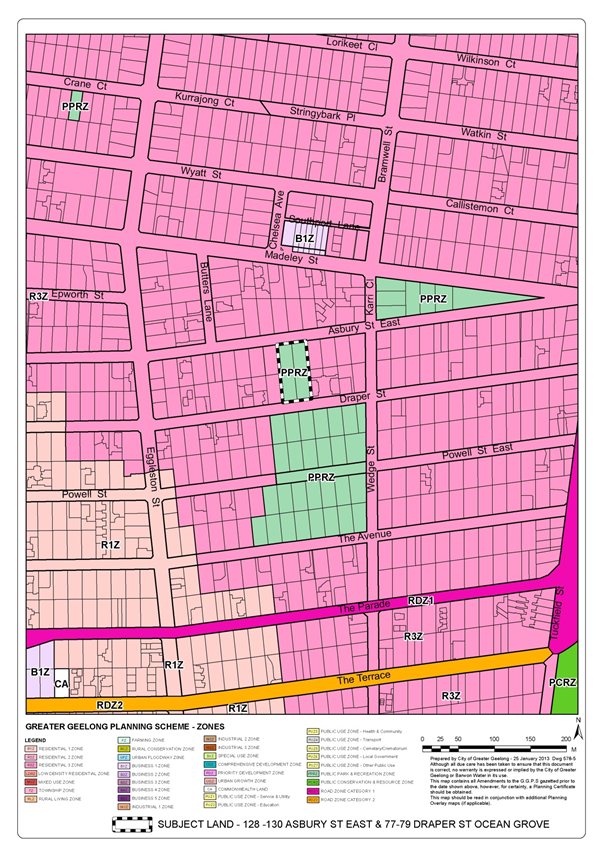
Amendment C299 proposes the rezoning of 4 Council owned residential properties situated at 77 – 79 Draper Street and 128 – 130 Asbury Street East, Ocean Grove from Public Park and Recreation zone to General Residential zone. It is also proposed to extend the Design and Development Overlay (DDO14) over the land to be rezoned.
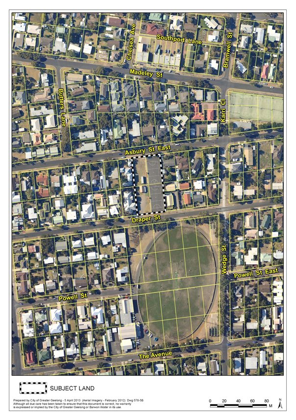
These properties have been utilised for netball courts and a small clubroom which are no longer required following the construction of a new facility at the Shell Road Recreation Reserve. Each lot has an area of approximately 807 sq metres.
Following the rezoning of land the Council intends to offer the land for sale as it is no longer required for recreational purposes. There is ample other land currently available for open space usage in the immediate area.
Amendment C299 was placed on public exhibition from 31 October 2013 to 2 December 2013. A total of 18 submissions have been received of which 4 either support or offer no objection and 14 which object to the amendment.
The three supporting submissions argue that the land is very suitable to provide for future residential development for people with a disability which will be a benefit to the Ocean Grove Community.
Objecting submitters consider there has been inadequate community consultation and that with the continuing growth of the town the land should be retained for future recreational and/or community use.
The issues raised in the submissions have been addressed in this report and it is recommended all submissions be referred to an Independent Panel appointed by the Minister for Planning.
Cr Heagney moved, Cr Farrell seconded -
That Council having considered all submissions to Amendment C299 to the Greater Geelong Planning Scheme, resolves to:
request the Minister for Planning to appoint an Independent Panel under Part 8 of the Planning and Environment Act 1987;
refer all submissions to the Panel; and
submit to the Panel its response to the submissions generally as outlined in this report.
Carried.
Council is the proponent for Amendment C299 which seeks to rezone 4 residential properties situated at 77 - 79 Draper Street & 128 – 130 Asbury Street, Ocean Grove from Public Park and Recreation zone to Residential 1 zone. It is also proposed to extend Design and Development Overlay 14 (the 7.5 metres permit height trigger) over the land to be rezoned
For many years these properties have been used for recreational purposes and are occupied by netball courts and a small clubrooms. The courts have protective mesh fencing on 3 sides and six pole mounted lights. Each of the 4 separately Titled lots is approximately 807 sq metres (total area 3228 sq metres)
As a result of the construction of the new netball facility at the Shell Road Recreation facility the old courts are no longer required. Following the rezoning of this land it is Council’s intention that it be sold. (Item 4, Council Minutes of meeting 27 August 2013)
The Council has given public notice of its intention to sell the land pursuant to Section 189 of the Local Government Act. One submission has been received which will be heard by the Submissions Hearing Panel followed by a report to Council
Appendix 1 shows the land subject of the rezoning application and existing zonings
Appendix 2 shows the subject land and the surrounding area which is predominantly used for residential purposes other than the substantial Memorial Reserve (2.4ha) located on the south side of Draper Street opposite the subject land
In considering whether to pursue this rezoning proposal, Council had regard to whether or not this immediate area would be adequately served with local open space. In this case, it is considered there is no shortage of open space in the immediate area with residents having easy access to:
Memorial Park (2.4ha) containing an oval and surrounding parkland, opposite the subject land.
Arthur Powell Reserve (7000 sq m) containing tennis courts and surrounding parkland, approximately 100 metres to the east of the subject land.
The rezoning proposal is consistent with the Ocean Grove Sporting Infrastructure Plan dated May 2010 which proactively plans for the formal outdoor sporting needs of current and future residents of Ocean Grove, with particular emphasis on the town’s major active recreation reserves i.e. Shell Road, Collendina and Memorial Reserves
As part of the background research, this report notes (page 17) that the Bellarine Peninsula Recreation and Leisure Needs Study 2005 refers to selling the old netball courts following their relocation to Shell Road to help offset the costs of the new facility developments. The Infrastructure Plan (page 34) also makes reference to the inadequate facilities and amenities at the existing site and the constraint on further development being wedged between residential properties.
Amendment C299 was placed on public exhibition between 31 October 2013 and 2 December 2013. Notices were placed in the Geelong Advertiser, Independent and Ocean Grove Voice and sent to all nearby owners and occupiers and all relevant public authorities
As a result of the exhibition of the Amendment the Council received a total of 18 submissions. Of these, 4 either supported the Amendment or offered no objection and 14 objected to the Amendment
Appendix 3 is a schedule which summarises all submissions received
The following section of this report outlines the major issues raised in the submissions followed by the officers response to them
Supporting Submissions
Karingal and two other submitters support the Amendment on the basis that the subject land provides a very suitable site to establish residential accommodation for people with a disability, thus enabling the land to continue to be used to benefit the Ocean Grove community
Karingal is a community service organisation based in Geelong which offers a range of housing and support options to people with a disability in the Barwon region. It advises there are currently no such long-term housing options on the Bellarine Peninsula
Officer Response
The Council has given notice of intention to sell the land under Section 189 of the Local Government Act and one submission has been received which, following a hearing, will be considered in a report to Council on the same agenda as a report relating to Amendment C299 panel hearing outcome. Subject to the land being rezoned the Council will decide on the method of sale either being through a public process or directly to a purchaser
From a planning viewpoint, as pointed out by Karingal and other supporting submitters, the subject land appears to be ideal for disabled housing because:
It is centrally located and close to shops, public transport and other community services.
The site is relatively flat.
It is located in an established residential area.
Objecting Submissions
All objecting submitters oppose the rezoning on the grounds that Council should retain the land for use either as open space or community purposes. Many consider the increase in housing density which has and is likely to continue to occur in “old” Ocean Grove warrants the retention of all existing open space and that, once lost, it is gone forever
Many objecting submitters consider there has been inadequate local community consultation on this matter and request that the amendment be abandoned and the future use of the Council owned site be further discussed with nearby residents
These submissions are further detailed in Appendix 3.
Officer Response
The Council has undertaken comprehensive strategic recreational planning studies of the Bellarine Peninsula and the Ocean Grove township being the Bellarine Peninsula Recreation and Leisure Needs Study 2005 and the Ocean Grove Sporting Infrastructure Plan dated May 2010
The former study notes that “overall, Ocean Grove is well serviced by a range of recreational options, ranging from formal sporting clubs, indoor facilities, community centres, library, foreshore, river and conservation areas”. As some submitters have pointed out, it notes “distinct gaps in certain categories including Landscape & Amenity, Linear Link and to a lesser extent, Informal Park.” (page 55). This Study makes a wide range of detailed recommendations, one of which is particularly relevant to the current rezoning proposal (page 57), as follows:
8. The current Ocean Grove Netball facilities (Draper Street) are in fairly poor condition and lack necessary support facilities such as female toilet, shower and change rooms. Therefore, the Netball Club should relocate to the new facilities proposed as part of the Shell Road Reserve development including use of three new netball courts and access to the new pavilion. Opportunities to sell the existing Draper Street site could be explored to help fund the development of new facilities
The Council acted in accordance with the recommendations contained within these two reports in determining that the land is no longer required for recreational purposes. With the existence of Memorial Park and Arthur Powell Reserve (referred to earlier in this report) in the immediate locality, it would be expected that they would very adequately satisfy local recreational requirements of neighbourhood residents. In particular, the Memorial Reserve Masterplan indicates that this parkland will be retained and enhanced as an important active reserve, primarily catering for junior sport, with improved community open space access
Both of the strategic documents referred to above were subject of a community consultation process. The current sale and rezoning process have been subject to community notification processes pursuant to the Local Government Act and Planning and Environment Act respectively. The views of some nearby residents have been conveyed to the Council as outlined in this report and at this stage there appears little to be gained by embarking on further consultation as requested by some submitters.
Whilst all of the objecting submitters have clearly indicated their strong preference for Council to retain these properties for open space/community purposes, there is no suggestion that as an alternative use the site is in any way unsuitable for residential development.
The proposed rezoning has no environmental implications.
The proposed rezoning provides a positive financial outcome for Council in that it will enable it to sell land no longer required for recreational purposes.
Expenditure: Development of the land for residential purposes will not require any Council expenditure
Under the Local Government Best Practice Guideline for the Sale and Exchange of Land, the Council is required to ensure that “….prior to being offered for sale, property should be appropriately zoned. This will ensure that the ultimate use of the land is determined by that zone and the highest possible sale price is achieved.”
The proposed amendment is not inconsistent with any State or Council planning policies. To the extent which these policies advocate the benefits of urban consolidation, this amendment will enable infill development to occur in a location which excellent accessibility to all urban facilities and services
This proposal is consistent with the Community Wellbeing strategies of City Plan which are directed at delivering a network of open space and sporting facilities to keep people active. It is consistent with the Municipal Strategic Statement and Bellarine Peninsula Strategic Plan which are listed strategies in delivering community wellbeing priorities.
No Council Officers have any direct or indirect interest, in accordance with Section 80 (c) of the Local Government Act to which this Amendment relates.
No risks have been identified regarding the rezoning of this land.
There is ample existing remaining recreational land in the immediate neighbourhood to meet the requirements of surrounding residents.
The site is well located for infill residential development with good accessibility to the town’s community and commercial facilities and services
The proposal does not impact on any human rights and responsibilities set out in the Charter. Planning legislation ensures an open community consultation process occurs enabling people to freely express their views and if necessary obtain a fair hearing before an Independent Panel.
The Amendment has been exhibited in accordance with the provisions of the Planning and Environment Act to provide for full public comment. As part of this process direct written notification was provided to all adjoining and nearby property owners potentially affected by the Amendment.
If Council accepts the recommendation contained in this report all submitters will be provided with an opportunity to appear before an Independent Panel appointed by the Minister for Planning.
Portfolio: |
Planning - Cr Heagney |
Source: |
Planning and Tourism - City Development |
General Manager: |
Peter Bettess |
Index Reference: |
Application C296 |
The purpose of this Council report is to consider submissions to Amendment C296 to the Greater Geelong Planning Scheme and refer the submissions to an Independent Panel for review.
Amendment C296 is a Council initiated Planning Scheme Amendment.
The amendment proposes to amend the schedule to the Public Park and Recreation Zone (clause 36_02s) to identify the applicable advertising sign Category for Simonds Stadium as Category 2.
The amendment has been prepared to enable consideration of a planning permit application for the display of promotion and/or major promotion advertising signage at Simonds Stadium Kardinia Park. This includes the ability to apply for a permit to display promotion advertising signs on the Simonds Stadium light towers.
At its meeting of 11 December 2012, Council resolved to exhibit the amendment, subject to authorisation from the Minister for Planning. Authorisation was received on 27 May 2013.
Exhibition of the amendment occurred between 5 September and 7 October 2013.
Council has received 7 written submissions, comprising 4 letters of objection from residents, 1 from a sporting organisation seeking involvement in the design and placement of advertising and 2 letters from service authorities raising no objection.
The main issue raised in objecting submissions is the negative impact of signage on the light towers.
In accordance with the Planning and Environment Act 1987, Council must now either: change the Amendment in the manner requested by the objecting submissions; refer submissions to an Independent Panel appointed by the Minister for Planning; or abandon the Amendment or part of the Amendment.
Council officers have considered all submissions and recommend changes to the exhibited amendment to allow for the placement of any advertising on the light towers only up to 20 metres above natural ground level. This will keep signage generally below the height of the roof line of the higher stands around Kardinia Park.
This report addresses the issues raised in the submissions and recommends they be referred to an Independent Panel appointed by the Minister for Planning.
Cr Heagney moved, Cr Harwood seconded -
That Council having considered all submissions to Amendment C296 to the Greater Geelong Planning Scheme, resolves to:
change the exhibited schedule to the PPRZ to describe the land that is subject to Advertising Sign Category 2 as the land “up to a height of 20 metres above natural ground level…” as shown in Appendix 2;
request the Minister for Planning to appoint an Independent Panel under Part 8 of the Planning and Environment Act 1987;
refer to all submissions to the Panel;
submit to the Panel its response to the submissions generally as outlined in this report.
Carried.
Simonds Stadium, Kardinia Park is a significant Geelong asset with the capacity to seat approximately 33,500 patrons for AFL and other sporting/entertainment/community events and uses. The installation of light towers at the Stadium is expected to facilitate increased usage by a wide variety of sports/outdoor activities
Council seeks to generate revenue from the installation of signage on the light towers to meet the costs of providing electricity capacity for the light towers
The Public Park and Recreation Zone applying to Simonds Stadium, Kardinia Park prohibits the display of promotion and major promotion signs, as advertising signage requirements are in the default Category 4 – Sensitive areas
The exhibited amendment proposes to amend the advertising signage category applicable to Simonds Stadium Kardinia Park to facilitate the display of promotional signage at the Stadium, which would otherwise be prohibited under the advertising controls of clause 52.05. This change will allow Council discretion to consider a planning permit application for the display of promotion and major promotion signs at this major Geelong sporting/entertainment venue, including on the light towers.
At the conclusion of the formal exhibition period of Amendment C296, seven submissions were received. The submissions received can be categorised as follows:
4 written submissions objecting to the proposal. Objections raised issues in relation to impacts on visual amenity of the city, impact on road safety, opposition to any more changes at Kardinia Park and dispute about the operational costs of the light towers and need for advertising.
1 written submission from Kardinia Park based sporting club seeking involvement in the location and design of advertising signs to ensure it does not interfere with sight lines for cricketers.
2 submissions from Government agencies with no objections.
Pursuant to the Planning and Environment Act 1987, the Council is required to consider all submissions made to an Amendment and must:
Change the Amendment as requested by the submissions; or
Refer the submissions to an Independent Panel appointed by the Minister for planning; or
Abandon the Amendment, or part of the Amendment.
Appendix 1 contains a schedule providing a summary of the submissions and officer recommended responses.
Subject to the Minister for Planning appointing an Independent Panel to hear all submissions, the themes discussed below, in addition to the responses provided in Appendix 1, will form the basis of Council’s submission to the Panel Hearing. A summary of the issues is outlined below:
Issue - Impact on visual amenity
Submittors have expressed their objection to the installation of signage on the Simonds Stadium light towers. Submittors have identified that the towers are elegant, an icon for the City and considered to be more or less a piece of art. Sponsorship on them will only detract from their aesthetic appeal and create an unsightly eyesore in the form of advertising in the heart of Geelong.
Officer comment
The light towers have made an impact on the skyline of the City with their elegant, slender design and profile. Compared with other stadium around Australia, the towers themselves are a design feature and not just a functional element for the Stadium.
The light towers have an elegant design and are very visible as opposed to trying to reduce their visual impact. They can be seen from many vantage points across the City but they have been reasonably well accepted because of their simple and clean but strong design.
The submissions seem to echo the sentiment of many in the community that have embraced the upgrades to the football ground to improve amenities for patrons and attractiveness for future and varied users in the future.
The placement of advertising on them is a difficult task if Council does not wish to destroy these qualities. Some of the issues for Council to consider are height of signage, how the signage reads in the context of the light tower design, the area on the light towers that is available for signage and who the signage is directed towards.
As the purpose of Amendment C296 is to amend the Planning Scheme to allow for a planning permit application to be made for promotion/major promotion signs at Simonds Stadium, there is no planning permit application yet that shows exactly where any advertising signs will be placed, or what form they will comprise such as typeface, colours, logos etc. The report to Council on 11 December 2012 outlined the following about potential light tower signage:
“The signage could include: A full wrap around the bottom of the pole. Approximately six metres high. Pole signage above the roof lines of the stadium and only facing inwards.”
The 11 December 2012 report was prepared prior to the installation of the light towers which have become a significant presence and architectural feature on the City skyline. They are highly visible and the placement of advertising above the stadium roofline will similarly be highly visible. Even if signage above the roof lines of the stadium only faces inwards, they will be visible from an extensive area outside the stadium. At a height of approximately 73 metres, the light towers dominate the Geelong skyline and signage will be seen from all directions.
Using Council’s 3D model of the City, officers have prepared images of advertising blocks on the light towers to assist in assessing the visual impact on the City. To maintain the goodwill and community acceptance of the light towers, it will be important that any advertising on them be sensitively designed and implemented. Advertising above the roof line of the Stadium would represent a visual intrusion into the City. The position and scale of signs on the light towers above stadium height would dominate the host structures and would be seen in multiple views silhouetted above the stadium and above most other built form of Geelong. The urban design outcome is not ideal and should be avoided.
Signage that is designed and configured appropriately and generally below stadium roof height could be sensitively treated and implemented without impacting upon the broader skyline of urban Geelong. Council sought legal advice from Harwood Andrews on how to limit the height of potential advertising signage up the light poles. The advice was that a height (metre) figure should be inserted in the schedule to the Public Park and Recreation Zone.
The map of Simonds Stadium in Appendix 2 shows the variation in the heights of the rooflines of the different stands. 20 metres is the height of the Reg Hickey Stand on Moorabool St. The new Premiership and Players Stadiums are higher at almost 25 metres and there are lower stadiums on the north sides. Council officers believe that 20 metres is a reasonable average height limit for signage.
Council officers recommend the amendment is changed to allow for signage only up to 20 metres above natural ground level. The revised schedule to the PPRZ to give effect to this change is in Appendix 3.
Issue - Impact on road safety
One submittor considers that advertising signage on the light towers will be a major distraction to drivers, given the Stadiums location and proximity to major roads, encouraging drivers to take their eyes from the road to look at advertising. The submittor considers this to be a gross neglect of Council’s duty of care to all road users and pedestrians.
Officer comment
There is often a lot of concern about the issue of advertising signs and its impact on road safety and driver distraction. Clause 52.05 of the Planning Scheme deals with advertising signs with the purposes:
To regulate the display of signs and associated structures.
To provide for signs that are compatible with the amenity and visual appearance of an area, including the existing or desired future character.
To ensure signs do not contribute to excessive visual clutter or visual disorder.
To ensure that signs do not cause loss of amenity or adversely affect the natural or built environment or the safety, appearance or efficiency of a road. (added emphasis)
There are a number of decision guidelines to be considered when assessing an application for signage. Under Clause 52.05-3 there are particular decision guidelines around the impact of signs on road safety which Council as a Responsible Authority would need to address in considering any permit application. This includes a 10 point road safety checklist that was developed by VicRoads and which is a statutory requirement that a responsible authority must consider potential road safety concerns when assessing an application for advertising signs.
The amendment was referred to VicRoads for comment. As the Authority concerned with the safe and efficient operation of major roads in the vicinity of Simonds Stadium, it is noted that the Authority has not opposed the Amendment and raised no concerns on traffic safety grounds.
In the absence of a specific proposal it is unknown at this time exactly how signs would impact on road safety. Any future planning permit application will need to ensure that advertising signs at Simonds Stadium be of a scale, form and function that is appropriate in the location and be able to demonstrate that they do not adversely affect the efficiency of a road.
The impact on road safety will be a matter for any permit application to determine in accordance with the provisions and purposes of Clause 52.05. It is noted that VicRoads is not a statutory referral authority for any subsequent planning permit application.
The recommended change to the amendment to limit advertising to below the stadium roof line is expected to have both amenity and road safety benefits.
Issue - Changes to Kardinia Park
One submittor is against any thing to change, alter or interfere with any part of Kardinia Park. The submittor considers there has been too much done already to destroy the park as he knew it as a child and wants Kardinia Park left alone.
Officer comment
Kardinia Park covers an area of approximately 28,300 square metres and comprises many different functions and caters to a variety of activities including Simonds Stadium, Geelong Cricket Ground, West Kardinia Oval, Kardinia Park Netball Complex, Legends Plaza, Kardinia Aquatic Centre, Kardinia Senior Citizens Centre, playgrounds and passive recreation spaces.
There has been significant change to Kardinia Park over the past few years including the multi-million dollar redevelopment of the football ground. Simonds Stadium has been developed into a significant asset for the region and has become a national sporting and entertainment venue.
Simonds Stadium is well known as the home of the Geelong Football Club, but the City plans to build the awareness and versatility of the Stadium through procuring unique and special events to Geelong. Council hopes that Simonds Stadium becomes recognised as the most premier boutique stadium in Victoria.
This amendment is an enabling amendment that will allow the opportunity for planning permission to be sought for the display of promotion/major promotion signs at Simonds Stadium. Changes to the advertising provisions are restricted to Simonds Stadium with the balance of Kardinia Park unaffected. Advertising will be located on existing structures at Simonds Stadium.
Further development of the Stadium is anticipated in the future, pending Federal funding.
Changes to Kardinia Park are inevitable to ensure Council provides quality and engaging services and experiences for the community. Council has commenced the process of preparing a new Master Plan for Kardinia Park to provide a consistent, overall strategic plan for the Park’s future. This will involve opportunities for public participation and is expected to be finalised in late 2014.
Issue - Electricity Costs
One submission disputes the motivation behind the amendment; seeking revenue from advertising to offset electricity costs of the light towers. The submittor contends that the power consumption of the lights is easily computable and would have been calculated during the planning stage. The suggestion that the power usage is higher than expected is completely misleading and easily disputed by anyone with knowledge of electrical power usage. The fact that Council was negligent when assessing running costs of the light towers is no justification to create an eyesore for the City with advertising signage.
Officer comment
The redevelopment of Simonds Stadium was a federally funded project with the funds going to the Geelong Football Club to implement. A condition of that funding was that the City assume ownership post development (which it has).
The power issue does not relate directly to the consumption of electricity when the lights are in use. Rather, the demand charge levied by the electricity provider which is an annual charge to deliver power to the site. No matter how much power is used, payment for capacity in the grid is required. This amounts to around $160,000 per annum.
In the design on site generators were considered amongst other options to avoid this charge however it was resolved to proceed with the towers funded by grid power.
Issue - Involvement of Geelong Cricket Club in advertising design and layout
The Geelong Cricket Club is concerned about the impact on player safety from the placement of advertising signage on the northwest tower. The Geelong Cricket Ground is adjacent to Simonds Stadium and the venue for Geelong Cricket Club games. The northwest tower is directly behind the bowlers are on the western wicket. The Club wishes to be involved in the advertising design and placement on this tower to ensure that player safety is not compromised.
Officer comment
In its role as land manager, it is appropriate for Council to consult with the Geelong Cricket Club if any advertising is to be placed on the northwest tower. In determining any sponsorship of the light towers public safely needs to be considered. The issue raised by the Geelong Cricket Club can be addressed via the location of a site screen and the prevention of any logos facing the cricket ground at a level lower than the existing sight screens.
Noting that the existing background to the area has a significant amount of existing colours and signage, the application of the Club’s mobile sight screen and the avoidance of low level cricket ground facing logos should address the concerns.
The proposed amendment will facilitate a planning permit to be issued for promotion and major promotion signs. The visual impact of any proposed signs will be assessed at the time of consideration of a planning permit application.
The costs associated with a Panel Hearing are able to be met within Council’s current budget for Council initiated amendments.
The State Planning Framework encourages quality urban design. Clause 15 Built Environment and Heritage, states that “Land use and development planning must support the development and maintenance of communities with adequate and safe physical and social environments for their residents, through the appropriate location of uses and development and quality of urban design.” Council will need to ensure that the signage at Simonds Stadium is consistent with and complements the character of the area in which Kardinia Park sits and due to the high visibility of the light towers, to the broader Geelong urban area.
It is an objective of Clause 15.01-2 to “achieve architectural and urban design outcomes that contribute positively to local urban character and enhance the public realm while minimising detrimental impact on neighbouring properties.” The amendment will enable Council to consider this as part of a future permit application
Clause 18.01 relates to development along highways, railways and tramways, with the following relevant policy guideline:
“The design of transport routes and nearby areas should be planned and regulated to achieve visual standards appropriate to the importance of the route with particular reference to landscaping, the control of outdoor advertising and, where appropriate, the provision of buffer zones and resting places.”
As Kardinia Park is bound by significant roads within road zones and a major railway line, the amendment was referred to VicRoads and PTV, with VicRoads responding that it had no objection
Specific reference to advertising signage in the MSS is at Clause 21.06-6 which addresses the implementation of the Settlement and Housing policies, “Ensure all advertising signage complies with the City of Greater Geelong Advertising Sign Guidelines.” These Guidelines provide both general and specific guidance on the siting, set backs, design, safety, size and scale of all types of signage.
‘Guideline A4 Category 4 sign control areas’ advises that advertising signs in the Public Park and Recreation Zone must be appropriate to their setting and must not detract from the character of the site, the adjoining streetscape, or the surrounding area. ‘Guideline B12 Promotion Sign’, notes that a promotion sign is prohibited in Category 4 areas, including the Public Park and Recreation Zone
This amendment does not seek to change the Advertising Sign Guidelines as they remain applicable for the majority of land in the Public Park and Recreation Zone throughout the municipality. Simonds Stadium within Kardinia Park is a special circumstance within Geelong. It is a national, commercially operated facility that hosts events broadcast across Australia. In these circumstances it is to be expected that significant advertising signage would be displayed at the Stadium. The use of advertising promotes branding of the facility on the national stage to generate funds towards the existence and operations of the Stadium
The context of the Stadium is now starkly contrasted with that of its surrounds, having undergone a multi-million dollar revamp over the past few years. The location of Simonds Stadium in the Public Park and Recreation Zone can’t be compared with other areas of open space within PPRZ which are not commercialised, internalised and retain closer connections with their surrounding natural systems
The Guidelines will be taken into account when assessing promotion signage permit applications at Simonds Stadium, whilst acknowledging that Simonds Stadium is a unique entity in Geelong
Simonds Stadium is sited alongside the commercial strip of Moorabool Street, which is a major north south transport route connecting the Waterfront, City Centre, Barwon River and Belmont. There is a variety of advertising on display along Moorabool Street, and promotion signage along this eastern side of the Stadium is unlikely to be out of place or context
Council is updating the Advertising Sign Guidelines but this project is incomplete at the time of this Amendment.
The Amendment supports the Growing our Economy strategic direction of City Plan, in particular the priorities of supporting the growth of Greater Geelong as a leading city for tourism, arts, culture and events and promoting the unique strength of the region such as our world class sporting facilities.
Through the action of completing the new Players Stand and associated lighting, and the ongoing growing of the management of Simonds Stadium, the amendment will take the next step to enable promotion and major promotion advertising signs to be considered for display at this national sporting and entertainment venue.
In accordance with section 80(c) of the local Government Act no Council officers have any direct or indirect interest in the matters to which this amendment relates.
The processing of this amendment is considered to be low risk.
Simonds Stadium, Kardinia Park is a significant Geelong asset with the capacity to seat approximately 33,500 patrons for AFL and other sporting/entertainment events and community uses. The installation of light towers at the Stadium is expected to facilitate increased usage by a wide variety of sports/outdoor activities.
The amendment will enable Council to consider a planning permit application for the proposed signage on the light towers. Elevated signage on the light towers could negatively impact on the natural and built environment of Kardinia Park and the broader Geelong urban area. It will be important that any light tower signage complements the role of Simonds Stadium, the aesthetic of the light towers and does not detract from the quality of the urban environment of Geelong.
The Amendment will not impact on any basic human rights, freedoms and responsibilities as set out in the Charter. Planning legislation provides for exhibition of amendment proposals and to obtain a fair hearing before an Independent Panel.
This amendment has been formally exhibited in accordance with the provisions of the Planning and Environment Act 1987 and in accordance with exemptions provided by the Minister for Planning. This process provided the opportunity for public comment on the amendment. As a consequence of the formal exhibition period and the receipt of a number of submissions, which have not been resolved, referral to an independent panel is required, subject to agreement by the Minister for Planning.
All submittors will be advised of the appointment of a Planning Panel by Panels Victoria and will be afforded an opportunity to appear at the Panel Hearing in support of their submissions.
Cr Harwood declared an Indirect Interest by Close Association in Agenda Item 4 - Green Organics Site – Expression of Interest, in that he works in the same vicinity as the existing Council Green Waste Contractor, and left the meeting room at 7:25pm prior to discussion.
Portfolio: |
Environment and Sustainability - Cr Richards |
Source |
City Services |
General Manager: |
Gary Van Driel |
Index Reference |
Waste Management |
To seek approval to call for expressions of interest for sites capable of accommodating a composting facility.
Under its three bin kerbside residential collection service Council collects some 32,000 tonne of green organics every year for processing rather than disposal at landfill.
Since the introduction of this service in 2003 Council has pursued a number of options for the processing of green organics but ultimately, due primarily to the immaturity of the industry, has struggled to establish sustainable processing.
One contributing factor has been the lack of sites with adequate buffer distances, as required by Victorian Environment Protection Authority guidelines.
Council has recently called tenders and is establishing contracts with a number of green organics processors to receive varying quantities of green organics over the next three years.
In addition to these contracts, to provide a more sustainable green organics collection and processing service it is considered necessary to identify potential locations where Council could carry out composting either itself or under contract.
Recent planning zone reforms allow for industry within farm zones and as composting is defined as ‘Industry’ it is now possible to locate a composting facility in a Farm Zone. A planning permit is required.
In order to identify potential sites, including sites within Farm Zones, within reasonable distance of Geelong it is proposed to call for expressions of interest from property owners that may be willing to lease portion of their land to establish a composting facility.
Under Sustainability Victoria’s Building Victoria’s Organics Recovery Program $500k is available for the development of a composting facility provided this facility is operating by mid 2015.
Cr Richards moved, Cr Ellis seconded -
That Council approve the calling of expressions of interest from owners of land within a reasonable distance of Geelong that is capable of accommodating a composting facility.
Carried.
Under its three bin kerbside residential collection service Council collects some 32,000 tonne of green organics every year for processing rather than disposal at landfill.
Since the introduction of this service in 2003 Council has pursued a number of options for the processing of green organics but ultimately has struggled to establish sustainable processing. This has been due primarily to the immaturity of the industry in terms of proven processing options, end product markets and regulatory controls. One such control is the Victorian Environment Protection Authority requirement that a low technology composting facility must have at least a 2 km buffer distances to the nearest sensitive use (eg: a single residence including a farm house). Under the planning provisions prior to September 2013 composting facilities could only be located in industrial zones or some special use zones. In most cases these locations do not provide adequate buffer distances.
Recent planning zone reforms allow for industry within farm zones and as composting is defined as ‘Industry’ it is now possible to locate a composting facility in a Farm Zone. A planning permit is required.
It is considered that the short term solution to green organics processing is to have multiple options so that Council is not reliant upon one means of processing or one facility.
Council has recently called tenders and is establishing contracts with a number of green organics processors to receive varying quantities of green organics over the next three years.
While the processors under these contracts are capable of processing the quantity of material that Council collects, past experience indicates that there is no certainty that this will continue to be the case. Issues such as weather conditions limiting access to processing facilities or limiting the ability to produce compost within regulations, seasonal variations in material quantities and end product market requirements along with operational break downs are just some of the issues that can impact on the ability to process this quantity of material.
To provide a more sustainable green organics collection and processing service and to protect against the possible disposal of this material to landfill, in addition to these contracts, it is considered necessary to identify potential locations where Council may carry out composting, either itself or under contract.
In the longer term it may be an option to establish a larger facility to process this Council’s and other neighbouring council’s material utilising high technology processing at significant capital cost that would be recovered through a long term commitment. This will require a more strategic approach for the development of such a facility, an issue that is currently being addressed through the development of a state wide waste and resource recovery strategic framework under the recently released Getting Full Value – Victorian Waste and Resource Recovery Policy. However, this approach is not likely to provide a sustainable solution within the next five years and therefore will not address Council’s immediate concerns.
In order to identify potential sites, including sites within Farm Zones, within reasonable distance of Geelong it is proposed to call for expressions of interest from property owners that may be willing to lease portion of their land to establish a composting facility. What is a reasonable distance from Geelong will ultimately be determined by the suitability of the site and the cost of hauling material to the site. To ensure all potential opportunities are identified the expression of interest will be directed at properties within 150 km of Geelong.
The urgency around pursuing a site, and it may eventuate to be a number of sites, comes from the need to provide surety around green organics processing as soon as possible but also to secure Sustainability Victoria funding under the Building Victoria’s Organics Recovery Program. Under this program $500k is available to assist Council in establishing a processing facility provided the facility is operating by mid 2015. To meet this timeline the expressions of interest will need to be called within the next two months
The underlying objective of the recommendation in this report is to enable the establishment of a composting facility to process green organics that otherwise may be disposed of at landfill. Organics in landfill produces methane and carbon dioxide. Minimising the potential for some 32,000 tonne per annum of this material reaching landfill will have a significant beneficial impact on the environment.
There are no direct financial implications as a result of the recommendation to call for expressions of interest.
Should the current processing options fail to continue to receive the material and it has to be disposed of at landfill this cost of disposal will far exceed the cost of processing
The removal of green organics from landfill is a critical element of the state government’s Getting Full Value – Victorian Waste and Resource Recovery Policy. The recommendation in this report is directed at providing sustainability in the processing of green organics collected by Council from residential properties and ensuring that this material does not enter landfill.
While the primary purpose of calling expressions of interest is to identify any potential sites this process also places Council in a good position in terms of a potential perception to comply with the Local Government Act. While the Act does not require the calling of tenders/expressions of interest prior to entering into a lease for the use of land it does require these processes for the purchase of goods or services in excess of $150,000. As rental associated with a lease as proposed in this report is likely to significantly exceed this amount over a five year period an expression of interest process will unsure that good governance processes are followed.
It should also be noted that, as the process is likely to be one of the first to test the new planning zone reforms in terms of the potential to locate an ‘Industry’ in a Farm Zone, ongoing consultation with Council’s Statutory Planning Unit will be a key element of the process
Support our community to live sustainably: Leading the way in waste management practices and continue to reduce the amount of waste to landfill.
Sustainable Built and Natural Environment: Partnering with our community to protect and enhance our natural ecosystems as well as encouraging reduced resource consumption.
No Council staff involved in the preparation of this Report has a direct or indirect interest in the matter to which the report relates.
As the recommendation in this report will place the concept of ‘Industry’ being located in a Farm Zone in the public arena there may be some community concern. It is proposed that a media release be issued at the time of the calling of expressions of interest to outline the benefits of locating a composting facility in rural areas along with the regulatory requirements under the EPA guidelines that are designed to ensure that any impact on the community is controlled.
One outcome of the recommendation is that it establishes an appropriate public notice procedure prior to entering into a lease arrangement that may involve significant expenditure over the likely period of the lease
There are no social considerations as a result of the recommendation in this report.
There are no human rights issues as a result of the recommendation in this report.
As part of the expression of interest process a media release will be issued to outline the benefits of establishing a composting facility and the regulatory requirements that must be met.
While the expression of interest process is intended to ultimately address only this Council’s green organics processing needs the Barwon Regional Waste Management Group and its member councils will be consulted throughout the process. Also, Sustainability Victoria will be consulted to ensure that the process aligns to the requirements of the Building Victoria’s Organics Recovery funding program.
Consultation with Council’s Statutory Planning Unit will continue throughout the expression of interest process.
Cr Harwood re-entered the meeting room at 7:28pm.
[Back to Top]Portfolio: |
Planning - Cr Heagney |
Source: |
Planning and Tourism - Planning Strategy |
General Manager: |
Peter Bettess |
Index Reference: |
Corio Norlane Structure Plan |
The purpose of this report is to provide an update to Council on the progress of the implementation of the Corio Norlane Structure Plan, adopted by Council in July 2012.
In the eighteen months since Council adopted the Corio Norlane Structure Plan, significant progress has been made in implementing the agreed actions.
The Planning Scheme Amendment C281 was approved by the delegate of the Minister for Planning in October 2013. The Corio Norlane Structure Plan (via a local strategy) was implemented into the Greater Geelong Planning Scheme on 21 November 2013.
Cr Fisher moved, Cr Farrell seconded -
That Council:
he significant progress achieved on the implementation of the Corio Norlane Structure Plan;
writes to the Minister for Education, Martin Dixon, requesting a current status and any proposed land use of the four surplus schools sites (Rosewall Primary School, Flinders Peak Secondary College, Norlane High School and Vermont Avenue Campus).
Carried.
The Corio Norlane Structure Plan was prepared in 2011/12 by the City of Greater Geelong (CoGG) with the former Department of Planning and Community Development (DPCD). This was part of the broader Corio and Norlane Urban Renewal Project, a whole-of-state government approach led by DPCD.
The Plan identified initiatives with strong potential to transform the image and identity of Corio and Norlane and in turn, stimulate investment and create local employment. As well as planning scheme amendments, this Structure Plan was unusual in that the Implementation Plan included ‘non-planning’ actions requiring support across Council and across government.
Council has been working hard to deliver many of the ‘planning’ and ‘non-planning’ actions identified, as well as the key initiatives, and has invested significantly above the ongoing and recurrent budget allocations. It is significant that the Corio Norlane Structure Plan is being widely used both within and outside Council, and that it has created a momentum for activity in the Northern Suburbs.
The Corio Norlane Structure Plan identified key initiatives for priority action. The current status of these key initiatives are as follows:
Implement a new local strategy ‘Corio Norlane’ into the MSS of the Greater Geelong Planning Scheme.
One of the key ‘planning’ actions of the Corio Norlane Structure Plan was to implement a new local policy for Corio Norlane into the Municipal Strategic Statement (MSS) of the Greater Geelong Planning Scheme. Given the partnership arrangement with the DPCD and extensive public consultation undertaken in preparing the Structure Plan, Council requested the Minister for Planning to prepare and approve a planning scheme amendment using powers available under section 20 (4) of the Planning and Environment Act.
The Ministerial Request (known as Amendment C281) was approved in October 2013 and the Corio Norlane Structure Plan (via the ‘Corio Norlane’ local strategy) was implemented into the Greater Geelong Planning Scheme on 21 November 2013.
Develop large vacant sites.
Baptcare have purchased the former Isik College site in Norlane and are progressing with plans for retirement and aged care and possible affordable housing options.
A large site on Plantation Road, adjacent to Sutcliffe Reserve, has been zoned Residential 1 (adopted by Council June 2013, gazetted and rezoned on 12 Sept 2013).
12-20 Fairbairn Drive (next to Aldi) is proposed to be rezoned to Business Zone as a Neighbourhood Activity Centre (adopted by Council Oct 2013, currently with the Minister for approval).
The Department of Education, Early Childhood and Development (DEECD) have made three school sites surplus (Rosewall Primary School, Flinders Peak Secondary College, Norlane Secondary College). The Norlane site tender closed November 27. Council is in negotiation with DEECD regarding small portions of land on the Rosewall and Flinders Peak sites and is currently rezoning part of Council land (Rosewall Neighbourhood Centre) to facilitate the land exchange. A fourth school site (Vermont Avenue Campus) was vacated end 2013.
Action: Support future owners of vacant school sites to encourage possible community benefit.
Provide a greater mix of quality public and private housing.
The Department of Human Services (DHS) is undertaking the $80m four year New Norlane project, which envisages 160 public housing and 160 private housing units, in partnership with local builders, across areas of Norlane. As of November 2013, 63 new public housing residences have been completed. A Display Village of seven houses has been constructed on the Princes Highway. There have been 15 private land sales, with 15 contracts in progress.
Engineering Services has worked with DHS to deliver four drainage upgrade projects as part of this project. ($245,000).
Action: Support ongoing progress of New Norlane project
Expand the Corio Sub-Regional Activity Centre.
Barwon Health (operating a community health centre on DHS land at the south-east corner of the site) has commenced a Masterplan process and outcomes are expected early in 2014.
The draft new Residential Zones, currently on exhibition, indicate a Residential Growth Zone around the Corio Shopping Centre of 800 metres.
Action: Meet with Corio Shopping Centre management for discussion
Develop a new business precinct on Bacchus March Road in northern Corio.
On 7 Nov 2013, the Minister for Planning approved the rezoning of vacant land on Bacchus Marsh Rd Corio (opposite the MC Herd Abattoir) from residential to Business Zone 3 and 4 (consistent with the Structure Plan). This is to facilitate a Masters Home Improvement Store for the land closest to the Ring Road and a business park for the land closer to Plantation Road.
Action: Continue to support Masters development
Renew local shopping centres.
Streetscape upgrades at Alkira Avenue and Robin Avenue in Norlane, and Detroit Crescent and Donnybrook Road in Corio have been completed ($50k). Kerb outstands on Forster Street have been constructed for DDA compliance. The improvements have resulted in increased rental activity, particularly in Alkira Avenue. Funding has been allocated for upgrades to Nevada Avenue (Corio), and Rose Avenue (Norlane) in 2013/14
Labuan Square has been the focus of efforts by Community Development (including art projects) and will also host a ‘Better Blocks Norlane’ event in February 2014
An application has been received to rezone the Geelong Homemaker Precinct on Melbourne Road to Commercial 2 Zone
Action: Seeking funding for further upgrades and investigate Economic Development opportunities
Develop a formal landscape boulevard along Bacchus Marsh Road between the Corio Sub-Regional Centre and Waterworld.
A major active transport treatment – an off-road cycle path – has been constructed on the West outer separator of Bacchus Marsh Road between Cox and Plantation Roads as part of a $2.6m DPCD/CoGG project. This includes safer intersection treatments and significant landscaping.
VicRoads indicate that duplication of Bacchus Marsh Road continues to be a priority in the medium to long term.
Action: Seek funding to complete the connection of the off-road cycle path from Plantation Rd to existing path and direct to Waterworld
Create a landmark multi-purpose centre at the Waterworld Precinct.
Council have successfully applied for a DPCD grant to undertake masterplanning of the Waterworld Precinct. Selection for the consultant to manage the $150k project has been completed.
Action: Ensure successful stakeholder engagement during masterplanning process to enable best outcomes
Create green streets.
330 trees have been planted along key routes ie Cox, Goldsworthy, Plantation and Princess Rds in Corio and Forster St in Norlane. New bus shelters, seats and lighting for key internal greenways have been installed. This was funded via the $2.6m DPCD/CoGG project.
The ‘adopt-a-tree’ program has been implemented, where the tree is provided by Council and planted, and residents are responsible for the watering and ongoing maintenance. This has enabled planting of 13 trees along the north end of Princess Street and 26 trees planted in the adjacent reserves, and 24 residences along Sharland Avenue and Plantation Road in Rosewall.
Action: Develop ongoing partnerships, for example with Trade Training Centre, for future street furniture manufacture
Landscape recreational reserves.
Implementation of Master Plans includes:
Stead Park - playground ($140 CoGG, $50k State), toilet block, landscaping, paths (estimated $220k) hockey pitch construction due to start in 2014 (total $1.8m CoGG, State, Geelong Hockey Association) and new ‘Pet Park’ under construction.
Windsor Park - new multi-purpose rooms for North Shore Little League ($354,479); storage facility at the netball courts construction to begin in 2014.
Evans Reserve - infrastructure upgrade funded for 2013 ($100,000 State, $100,000 CoGG) works have commenced to provide additional playing/training facilities for soccer including the installation of irrigation and sports lighting, and the expansion of the sports field to allow for two full size soccer pitches.
Goldsworthy Reserve – the new storage shed at has been completed, providing a larger, more secure storage facility.
Playground upgrades include Banksia Reserve, Cohuna Street, Donnax Street, Clooneys Court and Moorpanyul Park ($187,000)
Upgrades have also been completed to the Corio Sporting Club ($662,738)
Action: Ongoing implementation of Master Plans via normal budget processes
In addition to significant progress against these key initiatives, other Council activities related to the Corio Norlane Structure Plan include:
Council was successful in achieving DEECD funding ($1.5m) for the Windsor Park Early Childhood Hub and has allocated $5.2m in the 2013-14 budget. Architectural plans have now been completed and works will commence shortly.
Community precinct planning for Rosewall/Hendy St ($60,000) has been undertaken to plan for future integration of early childhood and community needs. Outcomes are expected shortly.
Centenary and Hendy St Halls and the fOrt youth space have been upgraded ($600k). Activities at the fOrt have increased with drop in programs every night and specific programs with a range of partners, eg Operation Newstart with Victoria Police, and another successful SKAART event held November 10th with approximately 800 attendees.
Upgrades have been completed to Leisuretime ($81,994) and Waterworld ($248,730).
‘Best Start’ programs in Corio and Norlane continue ($131k in 2011/12) as well as work from the ‘Healthy Together Geelong’ team.
Corio Norlane Bike Loop is close to completion, linking existing paths including shared paths on the Boulevard, Broderick Road, Fountain of Friendship Park, School and Shell Roads (part of the $2.1m DPCD grant, substantial in-kind contribution from CoGG). This will link Corio Bay (Moorpanyul Park) with Princes Highway, Cowies Creek and the Ted Wilson Trail along the ring road.
A significant wayfinding/signage project for the Bike Loop is underway as part of overall Geelong recreational facilities project ($60,000).
Engineering Services & Environment is preparing to install three litter traps in Bacchus Marsh Road with Stage 1 works currently being programmed (estimated $120,000). Planning for new upgrades is also underway in the area upstream of Stead Park.
Other noteworthy issues include:
In the May 2013 budget, DEECD announced $8M funding for ongoing works at four Northern Bay College campuses, which comprises Stage 3 of the Regeneration Project.
The Trade Training Centre at Goldworthy St Campus of Northern Bay College is operating successfully with local schools and is developing partnerships for ongoing management.
The DHS funded Work and Learning Centre at Norlane Community Centre is achieving good outcomes for long term unemployed residents (505 registered, 326 actively involved, 227 employed, 137 ongoing employment as per November 2013).
Shell is currently in negotiations with a potential buyer for its North Shore site.
Barwon Water Northern Water Plant was officially opened in April 2013, and held a public open day at on November 24, 2013. The $94m plant treats up to 7.5 million litres of domestic sewage and trade waste daily from Geelong’s northern suburbs and uses advanced technologies to produce high quality Class A recycled water.
The various components of the Corio Norlane Structure Plan support the general “greening” of the area and seek to reduce heavy vehicle, industry and stormwater pollution impacts on residents and waterways.
The Structure Plan may have future implications in relation to implementing the “planning” actions into the Greater Geelong Planning Scheme (for instance, Panel and expert witness costs as necessary).
The range of “non-planning” actions are attributed to a variety of Council and State Government Departments and Agencies. At this stage, Council has already invested significantly as identified in the Discussion section, above.
$500k has been allocated in the 2013/14 Council Budget for ongoing works related to the Active Transport Project.
The State Planning Policy Framework supports structure planning to facilitate the orderly development of urban areas. A key strategy of Clause 11 Settlement is to ensure effective planning and management of the land use and development of an area through the preparation of strategic and statutory plans.
The Corio Norlane Structure Plan will closely align with City Plan 2013-17 in particular Community Wellbeing, Growing our Economy and Sustainable Built and Natural Environment strategic directions.
No Council Officers have any direct or indirect interest, in accordance with section 80(c) of the Local Government Act, to which this Structure Plan relates.
There are not expected to be any notable risks associated with implementing the recommendations contained in this report.
The Corio Norlane Structure Plan is part of an ongoing initiative across government to improve the outcomes for residents of Corio and Norlane.
No elements of the Structure Plan contravene the Human Rights Charter.
The draft Corio Norlane Structure Plan was placed on public exhibition for a 10 week period from 1 December 2011 to 17 February 2012 using the following methods:
Notices were placed in The Independent and Geelong Advertiser on Friday 2 December 2011 and Saturday 3 December 2011 respectively.
Hard copies of the draft Plan were made available at the Corio Shopping Centre, Corio Library, Waterworld, Northern Bay College, Diversitat and local neighbourhood houses for view, together with summary brochures (inclusive of feedback forms) freely available for distribution.
A second round of notices was placed in The Independent and Geelong Advertiser on 20 & 27 January 2012 and 21 & 28 January 2012 respectively. These notices included information about up-coming information sessions.
Two information sessions at the Corio Library on Monday 30 January 2012 – 6 pm to 7 pm and Tuesday 31 January – 2 pm to 3 pm.
An “open-house” interactive display at the Corio Shopping Centre on Friday 3 February 2012 between 3 pm and 7 pm, staffed by Council and DPCD officers.
Comments were also sought from the Enquiry by Design participants as part of the exhibition process
The Geelong Australia website has a dedicated site called “Corio Norlane Community Planning”. The site is continually updated to provide information about new developments, community programs, media releases and consultation forums. There are also links to the State Government New Norlane and Education Regeneration projects.
Portfolio: |
Transport - Cr Richards |
Source: |
City Services - Engineering Services |
General Manager: |
Gary Van Driel |
Index Reference: |
G21 |
To provide an overview of the development of the final draft G21 Region Public Transport Strategy for public exhibition. The report recommends that the Strategy be noted for exhibition.
In January 2013 G21 commenced preparation of a G21 Region Public Transport Strategy to replace the 2009 G21 Integrated Public Transport Strategy which has largely been implemented.
The G21 Region Public Transport Strategy has been developed through an inclusive process. The key steps have been:
Background policy/project review, including review of 2009 strategy
Development of strategic frameworks, addressing public transport network design approaches and tradeoffs in service planning
Conversation with community on trade-offs and priorities
Application of data analysis to develop evidence base for change
Development of Strategy and Action Plan, comprising a long-term (20 year horizon) Strategy and a short-term four-year Action Plan
The G21 Region Public Transport Strategy is aligned with the Transport Integration Act, the Regional Growth Plan and the Implementation Plan.
The four Themes of the Strategy are:
Access for all: The G21 Region advocates that a base level of service should be available to all across the region, and that all services should be accessible to potential users.
A well connected region: The G21 Region seeks a public transport network that will serve the need for access to and between the Region’s centres.
Urban public transport for an urban centre: The G21 Region supports developing a ‘go anywhere’ public transport network in Geelong by reshaping and simplifying the current network.
Improving information, planning and partnerships: The G21 Region will take a leadership role in finding new ways to implement better public transport, sooner.
The proposed next steps to finalise the Strategy are:
Exhibit the final draft strategy publicly. The Strategy exhibition process is proposed to be supported with a media release, reactivation of the project website, and supporting communication in Council publications.
Submissions will be received through various channels including the project website, email and hard copy. The proposed exhibition program is from late February to March.
G21 will collate the submissions and a report to G21 on the final strategy’s adoption will be submitted in April 2014.
Cr Richards moved, Cr Harwood seconded -
That Council note the final draft G21 Region Public Transport Strategy for public exhibition.
Carried.
In January 2013 G21 commenced preparation of a G21 Region Public Transport Strategy to replace the G21 Integrated Public Transport Strategy which has largely been implemented
A comprehensive strategy development process including data analysis and extensive stakeholder consultation in each local government area of the G21 region has been undertaken by AECOM, the consultants appointed for the project, working under the oversight of a project steering committee comprising representatives of each Council, G21 and Public Transport Victoria
The G21 Transport Pillar has been briefed three times, and the G21 Board also briefed, during the course of the project to keep members informed and to shape the strategy development process
The state government recognised the need and importance of this study and has supported the project with a grant of $100,000. Each municipality also contributed both cash and in kind support towards the project
Timelines
Key milestones in the project have been:
Project inception: January 2013
Stakeholder workshop: March 2013
Completion of strategic context review: May 2013
Community forums: early May 2013
Summit: late May 2013
First draft strategy: June 2013
Final draft strategy: September 2013
Formatting and draft document design: November 2013
The G21 Region Public Transport Strategy has been developed through a rigorous process. The key steps have been:
Background policy/project review, including review of 2009 strategy
Development of strategic frameworks, addressing public transport network design approaches and tradeoffs in service planning
Conversation with community on trade-offs and priorities (discussed below under Consultation and Communication)
Application of data analysis to develop evidence base for change
Development of Strategy and Action Plan, comprising a long-term (20 year horizon) Strategy and a short-term four-year Action Plan
The G21 Region Public Transport Strategy is aligned with the Transport Integration Act, the Regional Growth Plan and the Implementation Plan.
The core of the Strategy addresses the tradeoffs inherent in public transport planning.
There was strong support (upwards of 80 percent) for the four Themes of the Strategy:
Access for all: The G21 Region advocates that a base level of service should be available to all across the region, and that all services should be accessible to potential users.
A well connected region: The G21 Region seeks a public transport network that will serve the need for access to and between the Region’s centres.
Urban public transport for an urban centre: The G21 Region supports developing a ‘go anywhere’ public transport network in Geelong by reshaping and simplifying the current network.
Improving information, planning and partnerships: The G21 Region will take a leadership role in finding new ways to implement better public transport, sooner.
Specific actions that benefit City of Greater Geelong that are included in the Action Plan are:
Support trialling a flexible service that uses a smaller vehicle. This trial could be undertaken as part of simplifying the Bellarine Peninsula or Surf Coast bus network.
Encourage the building of transport hubs, particularly the urban interchange at North Shore station.
Advocate to PTV to provide a high quality connection between central Werribee, East Werribee Employment Precinct and the G21 region when Regional Rail Link opens.
Support a network of principal grid services for urban Geelong.
Support simplification of the bus network, beginning in Grovedale.
Support initiatives to improve the operation of the Moorabool Street interchange.
Support an increase in urban bus frequencies to 20 minute services where not already operating at this level or better.
Encourage Council and the Department of Transport, Planning and Local Infrastructure to pilot a Corridor Planning Study to consider long-term transport and land use integration opportunities along a major public transport route.
Following review by all members of the Project Steering Committee, the draft Strategy has now been recommended for noting by Councils in advance of formal exhibition.
The G21 Region Public Transport Strategy recognises the environmental value of public transport. Its key environmental measure is to support increased public transport mode share through network improvement initiatives such as increased service frequency and availability. A number of supporting measures are targeted at facilitating public transport access by sustainable modes such as bicycles.
The G21 Region Public Transport Strategy does not commit Council to specific financial expenditures, however it includes actions to enhance bus stop infrastructure under Council management and control without specific timeframes. The action identifies that this should be done through an evidence-based prioritised bus stop improvement program developed in conjunction with Public Transport Victoria. Council will manage its future financial outlays in line with normal Council budget processes.
No impact to budget
The G21 Region Public Transport Strategy is an advocacy document, explicitly aligned with the Transport Integration Act framework for the development of transport strategy and policy in Victoria. The stakeholder engagement process was undertaken in accordance with the principles of the Act and is considered to be a good example of community engagement approaches.
The policy implications of the Strategy are considered to be positive
The G21 Region Public Transport Strategy aligns with the City Plan themes of Community Wellbeing, Growing our Economy, and Sustainable Built and Natural Environment. These themes are addressed by identifying a public transport network strategy that supports increased public transport use to access employment and community services.
Officers involved in the development of the Implementation Plan or the preparation of this report do not have a direct or indirect interest in this matter.
There are no notable residual risks associated with the report recommendation or G21 Region Public Transport Strategy.
Stakeholder risk has been mitigated throughout the process by a documented and transparent public engagement process, and by inclusion of key State government agency Public Transport Victoria in the project steering committee
The G21 Region Public Transport Strategy recommends extensive improvements in the availability and quality of public transport and explicitly recognises that the social objectives of public transport services in Regional Victoria are critically important. The first Theme of the Strategy “Access for All” addresses social inclusion through disability access improvements and enhancements to service availability generally.
The Strategy advocates for PTV to develop and implement policy to provide a minimum level of service to all townships in the G21 Region
The G21 Region Public Transport Strategy enhances a number of human rights considerations including: freedom of movement, through a focus on improved public transport services and active transport linkages; freedom of expression and taking part in public life, by providing a range of opportunities for the community to view, inform and make comment on the Plan; right to privacy by protecting confidentiality or release of personal information received through submissions or feedback.
The strategy development process placed community engagement central to the process, and delivered a structured and staged process. The key elements were:
A stakeholder engagement workshop was held with stakeholders from across the Region who had a direct interest in the Strategy.
Community forums were held in each local government area with an audience selected and invited from the community. Approximately one-third of participants were local stakeholders; one-third were specially invited on the basis that they were part of social groups who usually did not attend forums (for example, students); and one-third responded to advertising and information about the forums.
The website provided a discussion forum, survey and background information on the Strategy, and provided another forum to explore the key strategic questions asked at the stakeholder engagement workshop and community forums.
The Summit brought together participants from the stakeholder engagement workshop, community forums and website as well as other members of the G21 Region. It tested the strategic objectives and Action Plan presented in this Strategy through interactive voting technology.
The strategy development has been supported by:
Media releases and doorstops from G21 Region Chief Executive Elaine Carbines
Newspaper advertising
Flyers and brochures
Active promotion of word of mouth and social media uptake to drive turnout at the community forums and the Summit
Process for exhibition and adoption
The Strategy exhibition process is proposed to be supported with a media release, reactivation of the project website, and supporting communication in Council publications.
Submissions will be received through various channels including the project website, email and hard copy. The proposed exhibition program is from late February to March.
G21 will collate the submissions and a report to G21 on the final strategy’s adoption will be submitted in April 2014.
Portfolio: |
Central Geelong - Cr Heagney |
Source |
Projects, Recreation and Central Geelong / Events, Central Geelong and Waterfront |
General Manager: |
Dean Frost |
Index Reference: |
Property: 74-80 Western Foreshore Road, Geelong (ID# 219122) |
The purpose of this report is to seek endorsement to proceed with Expressions of Interest for development opportunities of the former Western Beach Boat Yard and to refer environmental remediation cost of the site to the budget process.
The Central Geelong Waterfront Master Plan identifies the former Western Beach Boat Yard as an opportunity for a medium sized development.
Industrial use for the site as a boat yard is no longer considered economically and environmentally sustainable.
There is interest from the private sector to invest into recreational/tourist developments on the site.
Environmental reports have revealed that the site has contaminated soil from former use as a boat yard.
A private sector development on the site is considered the best outcome to rehabilitate the site and deliver the Central Geelong Waterfront Master Plan outcomes.
A public Expression of Interest process will be used to attract prospective businesses.
The cost of remediation works to be referred to the 2014/15 budget process.
Cr Heagney moved, Cr Harwood seconded -
That Council:
endorse the Expression of Interest process to select a new business opportunity for the Waterfront;
refer remediation costs to the 2014/15 budget process.
Carried.
The Western Beach Boat Yard has been used primarily for marine related purposes including construction and maintenance since the early 1900’s. The site has not been used as a boat yard for several years and is no longer considered economically or environmentally suitable for industrial use
The waterside site of approximately 3000m² has been subject to significant land reclamation and recent Environmental Assessments have identified soil contamination from past uses.
The site can be considered for new recreational uses provided that remediation works are carried out.
The site currently sits unused and in its present state does not compliment the surrounding high quality Waterfront precinct
The Central Geelong Waterfront Master Plan identifies this site as one of the few remaining undeveloped areas in the precinct that has the capacity for medium sized development that accommodate a development of reasonable scale due to its land size and location
Specific actions of the Master Plan aim to facilitate greater public use of the site and provide direct access to the water by a water-edge path. The Master Plan prescribes guidelines to ensure any development and use is complementary and compatible with their Waterfront location
Based on recent Environmental Assessments, the site in its current state is considered to be unsuitable for recreational open space land use. Council as Land Manager for the area is responsible under the Environment Protection Act 1970 to rehabilitate the land. The cost of remediation is dependant on the future uses and what landscape/building treatments that can be used to seal the land
Options for the site are:
|
Pros:
Cons:
|
|
Pros:
Cons:
|
|
Pros:
Cons:
|
There is interest from the private sector to invest into recreational and tourist developments on the site.
Given this interest, it is considered that option 3 delivers the most cost effective and social objectives of the Master Plan. It also provides the opportunity to support existing Central Geelong businesses by attracting a new unique business to the precinct
A public Expression of Interest process would be used to attract prospective businesses. It is proposed to use this process to select the preferred new business then work together to develop a cost effective remediation plan for the site
Objectives of the Expression of Interest are:
To provide a range of high quality and unique visitor experiences that will establish the area as a major tourism attraction and contribute to Central Geelong’s position as a significant destination.
To provide employment opportunities.
To increase visitation to, and length of stay in, Central Geelong.
To provide appealing recreation and cultural opportunities for City of Greater Geelong’s residents including sports, leisure, culture and arts.
To ensure an attractive, active and safe pedestrian environment that strengthens the visual and function linkages from Western Beach to the Central Geelong Waterfront.
A new business opportunity should compliment existing Central Geelong businesses. The Expression of Interest will not support proposals for accommodation or restaurants apart from small food kiosk to support the primary new activity.
The business will need to demonstrate how it proposes to minimise levels of noise, water, air and land pollution and damage to the environment and Council assets. Levels of damage to both the natural and built environment will be assessed
Under EPA guidelines, the site requires environmental assessment to understand the nature and extent of any contamination that may be present and whether that contamination poses a risk to the environment.
Council as Land Manager is responsible to ensure the site is safe for any new proposed use. Working with the proposed business will provide an approach for understanding whether there are any risks and how they might be mitigated.
The cost to rehabilitate the site is subject to the methodology used to remediate contaminated soils by either sealing with paved surfaces or capping with clean material. Substantial cost is required should contaminated material be required to be removed and disposed to a licenced land fill facility. The best outcome for Council is to work with the business proponent to reduce remediation costs by agreeing on surface treatments and location of improvements etc.
Preliminary soil characterisation and assessment of the site indicate remediation costs of approximately $300,000 for a recreation/leisure/tourist facility. Further assessment is underway to gain a better understanding of the various options for remediation and level of financial certainty and risk.
Should the site be returned to open public space, the total cost of remediation and landscape development would exceed $1,000,000.
Council would receive rental income from lease of the area for a commercial business. A market valuation would be sought to set the rent.
The Expression of Interest process does not obligate Council to proceed with any proposal should the funding of remediation costs not be approved in the budget.
The remediation costs of $300,000 would be referred as a future budget proposal for 2014/15. Council eligibility for State Government funding for remediation costs will be investigated
The area is Crown Land with the City of Greater Geelong appointed as Land Manager. Coastal Management Act consent will be required to proceed with any development proposal. The Expression of Interest process will meet the State Government’s requirements to have a competitive selection process for granting of Crown Land leases.
Any new business proposal will be subject to obtaining a Planning Permit.
Council, in taking the course of action to agree to the Expression of Interest application, is not giving approval to the proposal. The Planning Permit will be the approval process following the consideration of all relevant requirements and public consultation. This will allow the application to be assessed on its merits, and does not limit or predict a decision regarding a Planning Permit
This report aligns with the 2013-2017 City Plan strategic direction of Growing Our Economy. This initiative helps meet the priorities:
A successful and vibrant city centre;
Support existing businesses and encourage new and emerging growth sectors; and
Greater Geelong is a leading city for tourism, arts, culture and events.
There are no officer direct or indirect interests in this report.
The Expression of Interest process to select a preferred business operator will not obligate Council in any way and will only proceed at the sole discretion of Council. This is to reduce the financial risk to Council of excessive remediation costs.
The successful business operator must be able to demonstrate a commitment to and if possible, an excellent safety record / history. They will need to supply safety and business plans for approval
Any new business will assist in activating the Western Beach area and provide a complementary service to the Youth Activity Area.
It will add to the Waterfront experience and a unique attraction to entice visitation to the area. The ability of proposals to provide free public access to its facility will be strongly sought
There are no Human Rights Charter issues to be considered in this report.
The Central Geelong Waterfront Master Plan review document was developed in consultation with several Council departments including Events, Central Geelong & Waterfront, Environment, Sport and Recreation, Strategic Projects, Planning Strategy, and Statutory Planning. The Master Plan was placed in the public eye including some coverage from the Geelong media and adopted based on the feedback of interested parties.
Further public notification and consultation will be undertaken as part of the Planning Permit process.
Cr Heagney declared an Indirect Interest by a Conflicting Duty in Agenda Item 8 Proposed Rezoning 1681-1729 Bellarine Highway, Marcus Hill, in that she is on the Board of the Geelong Cemeteries Trust, and left the meeting room at 8.03pm prior to discussion.
Portfolio: |
Planning - Cr Heagney |
Source |
Planning and Tourism |
General Manager: |
Peter Bettess |
Index Reference |
Project: Proposed Rezonings |
The purpose of this report is to enable Council to consider a proposal by Geelong Cemeteries Trust to rezone land at 1681 – 1729 Bellarine Highway Marcus Hill for cemetery purpose use.
Geelong Cemeteries Trust is seeking Council support to the rezoning of land at 1681 – 1729 Bellarine Highway Marcus Hill to enable the land to be used for cemetery purpose use.
The 39.7 hectare site falls within the Farming zone and its rezoning to Public Use Zone 5 Cemetery/Crematorium would enable the land to be used for cemetery purposes without the need for any further planning permit.
The land has already been purchased by the Government and a Ministerial Amendment pursuant to Section 20 (4) of the Planning and Environment Act will be the most expeditious means of rezoning the land.
The subject land, which is currently occupied by a eucalypt plantation is centrally located to all towns on the Bellarine Peninsula to meet their future cemetery requirements. Within this immediate area of the Peninsula there already exists a variety of non-farming uses.
The property is sufficiently large for all funeral and cemetery activities to be conducted without any impact on surrounding property owners. Provided all VicRoads requirements are complied with regarding access arrangements no objection is seen to the proposal.
Cr Macdonald moved, Cr E Kontelj seconded -
It is recommended Council advise Geelong Cemeteries Trust it would support a rezoning application to the Minister for Planning pursuant to Section 20 (4) of the Planning and Environment to rezone land at 1681 – 1729 Bellarine Highway, Marcus Hill for cemetery purpose use.
Carried.
A considerable amount of development has taken place in Bailey Street, Grovedale in recent years and progressively, developers have provided the necessary road pavement, kerb & channel and footpaths to service the subdivisions.
This scheme provides for infill infrastructure in Bailey Street. The footpath provides an important pedestrian link for the nearby school which generates a considerable amount of pedestrian activity. As indicated, these projects were administered as two schemes:
Scheme A – 207-211 & 212 Bailey Street
Scheme B – 134 Bailey Street and 182 – 188 Torquay Road.
Scheme A was objected to from both property owners and an adjustment was made to the apportionment of charges in order for the scheme to proceed under the Act. In summary, the contribution by the property owners was reduced to two thirds of the total scheme cost.
The footpath and kerb and channel works for the two schemes have been completed and costs have been accounted for. The schemes can now be finalised by Council.
Additional work has resulted in additional Council funding towards the projects.
The proposed site is intended to provide the cemetery/crematorium requirements for Bellarine Peninsula residents for the foreseeable future. It is centrally located on the Peninsula between the two largest designated growth centres (Ocean Grove and Drysdale) and only a short 5-10 minutes drive from Leopold.
The property itself is already densely planted with eucalypts as a commercial plantation which provide excellent opportunities for all future activities to be fully screened from surrounding farming properties. As such it is expected that all cemetery/crematorium activities will be able to be conducted without any adverse amenity impacts on neighbours.
Potentially the major issue likely to arise will relate to traffic and whether or not any highway upgrades will be required by VicRoads to provide for vehicles entering and exiting the property. Provided all VicRoads requirements are complied with by Geelong Cemeteries Trust with regard to future access arrangements, no objection is seen to this proposal.
The most expeditious means of rezoning the land being sought by Geelong Cemeteries Trust is for it to seek a Ministerial amendment pursuant to Section 20 (4) of the Planning and Environment Act (which enables the Minister to exempt himself from normal notification requirements). Given that the Government has already purchased the land for this purpose and having regard to the planning factors outlined above, this course of action is considered to be appropriate
The proposed rezoning has no environmental implications.
This proposal has no financial implications to Council
The rezoning proposal is supported by the overall thrust of State and Council planning policies which advocate the long-term planning of community facilities. The subject land is outside the settlement boundary of Ocean Grove as shown in the adopted Ocean Grove Structure Plan 2007.
The proposal is consistent with the Community Wellbeing Strategies of City Plan which are directed at delivering the whole range of community facilities and services to meet the needs of the City’s growing population.
No Council Officer involved with this process has any direct or indirect interest in the properties.
No risks have been identified regarding the rezoning of this land.
Construction of this facility on the subject land will ensure all cemetery/crematorium requirements of Bellarine Peninsula residents are catered for well into the future
The proposal does not impact on any human rights and responsibilities set out in the Charter.
It is understood the Geelong Cemeteries Trust has advised adjoining property owners of its future intentions with respect to the subject land.
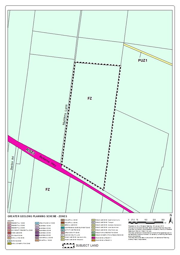
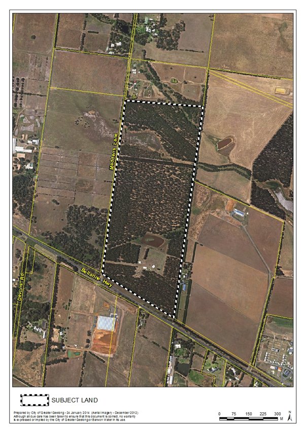
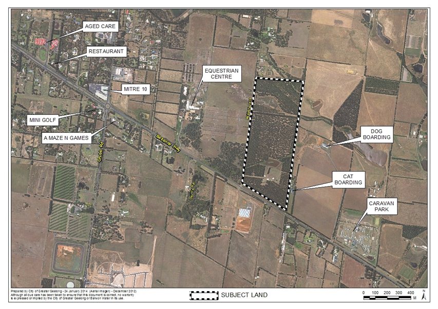
Cr Heagney re-entered the meeting room at 8:04pm.
Portfolio: |
Infrastructure, Parks and Gardens - Cr Ellis |
Source: |
City Services - Emergency Management and Fire Prevention |
General Manager: |
Gary Van Driel |
Index Reference: |
Emergency Management |
To inform the Council on proposed changes to Victoria’s emergency management system/arrangements bought about by the Emergency Management Bill 2013.
As a result of the State Governments White Paper titled ‘Victorian Emergency Management Reform, (December 2012)’, the drafting of a new piece of legislation, that is, the Emergency Management Bill 2013 has began the legislative reform process;
The Bill is the commencement of the first major overhaul of Victoria’s emergency management system/arrangements in twenty seven years and will reshape the way Victoria prepares for, responds to and recovers from an emergency;
This new legislation focuses on the establishment of new governance arrangements for emergency management in Victoria;
Under Part 1, section 4, the Emergency Management Bill 2013 must be read and construed as one with the Emergency Management Act 1986. That is, the provisions of the 1986 Act still prevail unless repealed by the 2013 Act. These repeals are detailed by Part 9, section 78 of the 2013 Act; and
An examination of section 78 revealed that Part 4 Responsibilities of Municipal Councils of the Emergency Management Act 1986 currently remain unchanged.
Cr Ellis moved, Cr Richards seconded -
That Council:
notes this report; and
receives additional report(s) as further recommendation of the State Government’s White Paper titled ‘Victorian Emergency Management Reform, (December 2012)’ are implemented.
Carried.
As a result of the State Governments White Paper titled ‘Victorian Emergency Management Reform, (December 2012)’, the Emergency Management Bill 2013 has began the legislative reform process.
This new Bill is the commencement of the first major overhaul of Victoria’s emergency management system/arrangements in twenty seven years and will reshape the way Victoria prepares for, responds to and recovers from an emergency.
Councils currently have a number of responsibilities under Part 4, of the Emergency Management Act 1986. These include:
Prepare and maintain a Municipal Emergency Management Plan (MEMPlan). The MEMPlan must:
include resources owned or under the direct control of the Council as well as other resources that are available and how such resources are to be used for emergency prevention, response and recovery;
for councils located wholly or partly in the country area of Victoria, identify all designated safer places and/or municipal refuges.
Appoint a person or persons to be the Municipal Emergency Resource Officer (MERO) or officers. The MERO is:
responsible to the municipal council for ensuring the co-ordination of municipal resources to be used in emergency response and recovery.
Appoint a Municipal Emergency Planning Committee (MEMPC). The MEMPC must:
prepare a draft municipal emergency management plan for consideration by the municipal council.
Once the new Emergency Management Bill 2013 receives royal ascent it will:
Introduce a genuine all hazards all agencies framework with a focus on community, collaboration and capability;
Establish the State Crisis and Resilience Council as the peak emergency management advisory body responsible for emergency management policy and strategy;
Establish Emergency Management Victoria as the new overarching body for emergency management in Victoria;
Establish the position of Emergency Management Commissioner; and
Establish the position of Inspector – General for Emergency.
The Objectives of the Bill under Part 1, section 5 are:
Foster a sustainable and efficient emergency management system that minimises the likelihood, effect and consequences of emergencies;
Establish efficient governance arrangements that:
Clarify the roles and responsibilities of agencies;
Facilitate cooperation between agencies;
Ensure coordination of emergency management reform within the emergency management sector; and
Implement an ‘all hazards-all agencies’ approach based on networked arrangements and greater interoperability.
The State Crisis and Resilience Council under Part 2, section 7, will be responsible for providing advice to the Minister in relation to:
Whole of government policy and strategy for emergency management; and
The implementation of that policy and strategy.
The Chief Executive Officer of the Municipal Association of Victoria is a nominated representative for local government on the State Crisis and Resilience Council.
Emergency Management Victoria under Part 3, section 17, has the following functions:
To act as the agency responsible for the coordination of the development of the whole of government policy for emergency management in Victoria;
Provide policy advice to the Minister;
To implement reform initiatives;
To liaise with the Commonwealth Government; and
To provide support to the Emergency Management Commissioner.
Emergency Management Victoria will consist of 2 members being –
The Chief Executive, Emergency Management Victoria; and
The Emergency Management Commissioner.
Note: Part 4, section 24(2) states ‘…The Emergency Management Commissioner is the successor in law to the Fire Services Commissioner under the Fire Services Act 2010…’
The functions of Inspector-General Emergency Management are contained in Part 7, section 64 and include:
Develop an assurance framework against which the capacity, capability and performance of the emergency management sector (1) is to be assessed;
Undertake system-wide reviews that include reviewing the functions of responder agencies and Departments
Evaluate state-wide training and exercising arrangements
Monitor and report to the Minister on the implementation of the Strategic Action Plan which is a rolling 3-year works program for each agency that must include in respect of that agency (Part 2, section 12):
Things to be done;
Projects to be undertaken; and
Measures to be met that will enhance the agency’s operational capacity.
Impact on the Local Government Sector
Under Part 1, section 4, the new Emergency Management Act 2013 must be read and construed as one with the Emergency Management Act 1986. That is, the provisions of the 1986 Act still prevail unless repealed by the 2013 Act. These repeals are detailed by Part 9, section 78 of the 2013 Act.
An examination of section 78 revealed that Part 4 Responsibilities of Municipal Councils of the Emergency Management Act 1986 currently remain unchanged.
There are no environmental implications associated with this report.
There is no financial impost on the Council once the Emergency Management Bill 2013 receives royal ascent
No impact to budget
Council continues to meet its legislative responsibilities under the Emergency Management Act 1986. There are no provisions within the new Emergency Management Bill 2013 that apply to the Local Government Sector.
Emergency Management ties into City Plan 2013-2017 Community Wellbeing strategic direction. Under this strategic direction there is a direct link to the Municipal Emergency Management Plan (MEMPlan) which is listed as a master plan to assist in delivering Community Wellbeing priorities.
No officer involved in the preparation of this report has any direct or indirect interest relative to the advice provided in this report.
There are no risks associated with the recommendations contained within this report.
Once the Emergency Management Bill 2013 receives royal ascent, the new Act will enact changes at the upper echelon on emergency management planning and governance arrangements in Victoria
The application of the new Act will have a positive impact on the community by ensuring that the City continues to maintain and enhance the support role it fulfils during an emergency event.
An emergency, depending upon its size and nature can affect the whole community and, once again, depending upon the type of emergency can have long lasting community impact. The implementation of this new Act strives to improve high level governance arrangements thus enhancing community safety.
The Municipal Association of Victoria will continue to keep the local government sector informed not only on the progress of this new Bill through the Parliament but on other changes as the State Government introduces other recommendations from the White Paper titled ‘Victorian Emergency Management Reform, (December 2012)’.
Portfolio: |
Infrastructure – Cr Ellis |
Source |
City Services - Engineering Services |
General Manager: |
Gary Van Driel |
Index Reference |
Special Rates and Charges; Colite Street |
This report seeks a resolution by Council to declare the revised charges for the construction of Colite Street and the unconstructed sections of Margate Street and Grandview Parade and a small portion of Challis Street east of Margate Street in Barwon Heads (See plan – Appendix 4).
Council has received complaints from property owners over a period of time which includes dust and flooding. In particular, the intersection layout at Colite Street and Grandview Parade is considered to encourage dangerous driver behaviour.
It is proposed to construct Margate Street to a width of 7.5 metres, Colite Street to a width of 6.0 metres and Grandview Parade to a width of 4.4 metres.
Challis Street is a no through road and provides access to eleven (11) properties. It is proposed to leave this laneway unsealed.
There are 23 properties involved in the scheme. The total revised estimated project cost is $244,661 and includes a scheme cost of $165,389. Council is contributing $79,272 towards the intersection design and transition works which is considered to be renewal works and an intersection safety improvement. Council’s contribution to the scheme is an additional $35,440.
Property owners receive benefit from the works by way of improved vehicular access, removal of nuisance dust and mud, drainage and general amenity improvement.
The scheme was advertised and ten (10) submissions including three (3) objections were received. A Submissions Panel considered all matters and recommended that Council review the cost apportionment and carry out a safety audit on the proposed intersection design for the intersection of Margate and Colite Streets and Grandview Parade prior to adopting the scheme. The review and safety audit have been carried out with outcomes detailed within this report.
The scheme has been prepared in accordance with the Special Rate and Charges provisions of the Local Government Act along with Council’s Special Rates and Charges Policy.
Cr Ellis moved, Cr Richards seconded -
That; having considered property owner submissions, Council:
Resolves to declare the Special Charge Scheme as amended as follows:
An amended special charge be declared for a period of four (4) years until the work has been completed and the scheme finalised.
The amended special charge be declared for the purpose of defraying any expenses incurred by Council in relation to the construction of Colite Street and the unconstructed sections of Margate Street and Grandview Parade, Barwon Heads which project:
Will provide proper vehicular access, improved drainage, removal of nuisance dust and mud and enhancement to the general safety and amenity for each of the properties included in the scheme;
Council considers is or will be a special benefit to those persons required to pay the special charge (and who are described in succeeding parts of this Resolution); and
arises out of Council’s function of planning for and providing infrastructure for property owners.
The total cost of project, be recorded as $244,660.58.
It be recorded that, for the purposes of Section 163 (2A) of the Local Government Act 1989 (The Act), the special charge proceeds will not exceed the amount calculated in accordance with the prescribed formula (R x C = S), the:
‘benefit ratio’ (R) being calculated at 0.786 represents the special benefits to all persons liable to pay the special charge;
‘total cost’ (C) of performing the function described in part 1 (b) of this resolution based on estimated cost be recorded as $165,388.52; and
‘maximum levy’ (S) be recorded as $129,948.12
the following be specified as the area for which the special rate is so declared:
the area within municipal district of Council highlighted in the plan attached to this Resolution (“the area”).
the following be specified as the land in relation to which the special charge so declared:
land within the area shown on the plan.
the following be specified as the criteria which form the basis of the special charge so declared:
ownership of any land described in Part 1(e) of this Resolution.
the following be specified as the manner in which the special charge so declared will be assessed and levied:
Each lot has been allocated a single access unit;
Corner lots with construction on both frontages and sideage, and not reconstruction of existing pavement, allocated access units of 1.33;
Each lot with no abutting construction assessed on access units only;
Total cost divided equally on area and access unit basis;
For unit development the cost to total lot is assessed on area and access unit. Cost to individual units is based on individual unit frontage to works and cost of common property allocated to all units in accordance with the Schedule of Entitlements and Liabilities as shown on the plan of subdivision; and
The special charge will be levied by sending a notice to the person who is liable to pay, pursuant to section 163(4) of the Act.
having regard to the preceding parts of this Resolution but subject to Section 166 (1) of the Act, it be recorded that;
the owners of the land described in column 2 of Schedule C to the resolution are estimated liable for the respective amounts set out in column 4 of Schedule C; and
such owners may, subject to any further resolution of Council pay the special charge in the following manner;
the charge will become due and payable within one month of the issue of the notice requesting payment pursuant to Section 167 (3) of the Act and may be paid in sixteen (16) quarterly instalments from that date;
interest will not be charged for six months after the issue of the notice provided the person liable makes timely payment in accordance with any repayment arrangements that may be agreed on by Council; and
In accordance with Section 172 of the Act, the interest rate payable on the special charge which has not been paid by the specific date is set at Council’s overdraft rate, reviewed every three months (provided that it shall not exceed the rate fixed by the Governor in Council by Order for the purposes of Section 172 (2A) in which case the rate of interest shall be the maximum rate fixed by the Governor in Council by Order for the purposes of this section).
Council’s Chief Executive Officer be authorised to levy the Special Charge in accordance with Section 163 (4) of the Act.
Carried.
This project involves some remnant sections of roads in Barwon Heads and part of an original subdivision which dates back as early as 1849. The project initially involved Colite Street, Challis Street, and the southern unconstructed portion of Margate Street.
As discussions evolved however, Challis Street has been omitted.
A number of enquiries have been received by Council over time, with the main concern being errant driver behaviour through the intersection. Some instances of fences being knocked over have been reported.
In 2003 a survey of owners was undertaken with only 9 responses from the owners of 18 properties and no clear direction for Council regarding street construction. In more recent years the number of enquiries and complaints has increased and in 2009 a concept plan for the construction of the various roads was prepared.
In late 2011 Council officers met with property owners. The group generally supported construction however owners of Challis Street properties felt that construction of their street, in any form, was unnecessary. The road construction project was then shown as various options, being full construction to part construction. These were sent out in late 2011 and responses supported an option which removed Challis Street and the eastern portion of Colite Street from the scheme.
In the same mail out, details of the proposed method of apportionment were provided.
A temporary delineation of the intersection has been carried out and appears to be slowing traffic as it passes through the intersection. A traffic count has also undertaken in late 2011 with results as follows.
|
LOCATION |
24 HOUR VOLUME |
SPEED KM/HR |
|
Margate Street |
397 |
47.5 |
|
Grandview Parade |
443 |
45.7 |
|
Colite Street |
144 |
26.3 |
A submissions panel hearing was held on 2 July 2013 and after considering all submissions, both verbal and written, further considerations have come to light.
A review of the Benefit Ratio of the scheme has been made and it was found that there is a benefit to the wider community in constructing the roads. This benefit is defined as the benefit to properties outside the scheme boundaries, in particular the property owners who may use Colite and Margate Streets and Grandview Parade to access other areas. This benefit is confirmed by the above traffic counts for these streets in that it may be reasonably assumed that it is not just the affected property owners who use these streets. The community benefit and the associated Benefit Ratio is detailed at Appendix 2.
The final concern for this Special Charge Scheme is that of the intersection design for Colite and Margate Street and Grandview Parade. Concerns were made by the affected property owners that the existing intersection design may not be the safest and most appropriate for the area
A revised concept design showing an offset “T” arrangement was developed, audited and compared by an independent traffic engineer, the results of which were presented to Council panel members and the affected property owners in turn. A follow up informal survey to property owners and the traffic safety audit result confirmed the offset “T” intersection was the more appropriate for the intersection and a redesign was carried out. This resulted in an increase in project cost which is shown in the revised cost estimate and cost apportionment documents attached with this report. Due to an increase in Council contribution to the scheme however, the cost apportioned to property owners has reduced.
An examination of the subdivision layout of this area indicates a range of lot sizes and configurations. The unit cost method of apportionment was ruled out in this instance due to the irregularity of the lot sizes. Lot area was considered to be an important element as it governs the level of future development and the manner in which the road may be utilised by a lot developed at some future stage.
It was considered appropriate to apportion costs by means of area (50% of the cost) and access units (remaining 50% of the cost). This results in an equitable cost distribution with corner lots with works to both frontage and sideage given a one third loading.
As indicated the proposal commenced with the inclusion of Challis Street. The property owners in Challis Street were strongly of the opinion their street should not be constructed however redevelopment of properties in this street at some future stage may necessitate its construction. Properties in Challis Street use either Colite Street or Margate Street for access and it is standard practice for all properties benefiting to share the costs. In this instance, Challis Street properties have no works fronting the property via the proposed works, but benefit via the improved access and consequently a charge has been levied. A fair means to make this charge is to apply one access unit to each property, which represents $3,391.13. Correspondence to owners has mentioned this unusual circumstance.
Property owners benefit as a result of road construction in the following manner:
Proper sealed access to properties;
Improvements to drainage of the area;
Removal of nuisance, being dust and mud at various times of the year;
Improvements to road safety for vehicular and pedestrian traffic;
Enhancement to the general amenity of the area; and
Likely increase in property values.
There are no Council properties in this scheme
Grandview Parade south of Colite Street is already constructed but needs to be redesigned for approximately 20m to suit the intersection layout. Given this is existing construction, it is reasonable for Council to pay for this section and it is unlikely that owners have paid for this in the past
The actual intersection works are also proposed to be funded by Council. This is the deviation from Grandview Parade through to Margate Street as the road reserves are offset. This decision is based on the consideration that the intersection upgrade is a safety improvement to the public which have traditionally been funded by Council. This approach has been conveyed to property owners
Drainage capture is by means of drainage pits at the intersection with a pipe connection to an existing system in Margate Street. Colite Street has been graded to discharge storm water to Hitchcock Avenue and this approach is expected to mitigate the nuisance flooding currently experienced.
The provision of a sealed road surface provides a permanent and safe means of access. Dust is eliminated and storm water runoff is less contaminated with silt prior to final discharge
During the course of construction and the manufacture and procurement of materials energy is expended resulting in some greenhouse gas emissions. This ceases when construction is complete.
The project does not create waste with the exception of some excavated material.
The proposal does not affect any natural habitats.
The project is a one off capital cost and there will be minimal ongoing maintenance costs. If approved, the scheme could proceed in the next financial year.
Financial details are as follows:
|
Maximum scheme levy to Property Owners (income) |
$129,948.12 |
|
Scheme levy to Council |
$35,440.40 |
|
Direct funding by Council |
$ 79,272.06 |
|
Total Project Cost |
$244,660.58 |
The scheme has been prepared in accordance with the Special Rate and Charge provisions of the Local Government Act 1989 along with Council’s Special Rates and Charges Policy. The project does not impinge on any Human Rights Charter issues.
This report aligns with the City Plan as follows:
Community Wellbeing:
Healthy Lifestyles – Facilitating and promoting physical activity
Healthy Environments – Safe, hazard and nuisance free environments
Sustainably Built and Natural Environment
Enhance and protect natural areas and ecosystem health – Limiting the loss of native species and natural areas and continuing indigenous planting
Support our Community to live – Encourage increased use of alternatives to car transport
Advocate for and promote sustainable design and development – Promoting sustainable design and retrofitting and acknowledging the communities desire to have their say.
No Council Officer involved with this process has any direct or indirect interest in the properties.
Provision of a sealed road will provide safer driving conditions for motorists with a defined intersection treatment and standard road profile. Walking conditions for pedestrians will also be enhanced by minimising the risk of personal injuries through conflict with vehicles. The additional drainage infrastructure will minimise the hazards associated with water over roads. There are no identified risks for Council in declaring the scheme.
The provision of properly sealed and drained roadways is aligned to Council’s City Plan as described above and provides improved connectivity and safety for motorists and pedestrians.
In developing this report to Council, the subject matter has been considered to determine if it raises any human rights issues. In particular, whether the scope of any human right established by the Victorian Charter of Human Rights and Responsibilities is in any way limited, restricted or interfered with by the recommendations contained in this report. It is considered that the subject matter does not raise any adverse human rights issues.
It is further considered that the construction of the Colite Street group of streets upholds the right to freedom of movement (Section 12 of the Human rights Charter) by enhancing a person’s ability to move freely within the area they choose to live.
Community consultation for the Road Construction Special Charge Scheme has been carried out as follows:
18 December 2003 – Initiation letter and survey of property owners.
December 2008 to 4 October 2011 – Various advisory letters including concept plans.
7 October 2011 – Public meeting held at the community hall in Barwon Heads.
19 December 2011- Advisory letter outlining options.
6 July 2012 – Letter to property owners advising of Council’s Intention to Declare a Special Charge Scheme.
7 July 2012 - Media Notice of Council’s intention.
9 October 2012 – Advisory letter to property owners outlining next steps.
17 June 2013 – Advisory letter with notification on Submissions Panel Hearing date.
26 July 2013 – Advisory letter explaining results of panel hearing of 2 July 2013
December 2013 – Advisory letter showing revised costs, Benefit Ratio calculation and revised intersection plan.
The works for the construction of road pavement in Colite Street, Margate Street and Grandview Parade, Barwon Heads which consists of excavation, reinstatement of nature strip, pavement works, sealing, miscellaneous construction works, legal advice and professional services associated with survey, engineering design, drafting, supervision and administration of the project all as included in the cost estimate shown below.
|
ITEM |
DESCRIPTION |
QUANTITY |
UNIT |
RATE |
AMOUNT |
|
Section A – Owner Funded Works |
|||||
|
1.00 |
GENERAL |
|
|
|
|
|
1.01 |
Initial site establishment |
|
item |
|
$12,167.85 |
|
1.02 |
Traffic Management |
|
item |
|
$6,759.92 |
|
1.03 |
Setting out |
|
item |
|
$ 338.00 |
|
1.04 |
Service/Cable Locations |
|
item |
|
$675.99 |
|
2.00 |
EARTHWORKS |
|
|
|
|
|
2.01 |
Excavation |
350 |
cm |
$60.00 |
$21,000.00 |
|
2.02 |
Saw cutting of asphalt paving |
25 |
m |
$10.00 |
$250.00 |
|
3.00 |
PAVEMENT WORKS |
|
|
|
|
|
3.01 |
Supply and place 150mm compacted depth of Class 3 40 CR, sub base |
80 |
cm |
$100.00 |
$8,000.00 |
|
3.02 |
Supply and place 150mm compacted depth of Class 2 20 CR, base |
80 |
cm |
$120.00 |
$9,600.00 |
|
3.03 |
Supply and place 30mm compacted depth asphalt |
550 |
sqm |
$35.00 |
$19,250.00 |
|
4.00 |
DRAINAGE |
|
|
|
|
|
4.01 |
90mm dia sub-soil drains including excavation, supply, placement and provision of approved backfill |
200 |
m |
$48.00 |
$9,600.00 |
|
4.02 |
Supply and place 300mm pipe |
100.8 |
m |
$120.00 |
$12,096.00 |
|
4.03 |
Supply and place 300mm pipe and backfill with approved FCR |
7.5 |
m |
$160.00 |
$1,200.00 |
|
4.04 |
Supply and place900mm by 600mm grated pit 1.2m deep with HD type cover |
2 |
no |
$1,950.00 |
$3,900.00 |
|
4.05 |
Supply and place 900mm by 600mm SE pit 1.5m deep with gatic type cover |
1 |
no |
$1,600.00 |
$1,600.00 |
|
4.06 |
Tap into existing drainage pit or pipe |
1 |
no |
$385.00 |
$385.00 |
|
5.00 |
CONCRETE WORKS |
|
|
|
|
|
5.01 |
Supply and place SM1 mountable kerb |
10 |
m |
$118.00 |
$1,180.00 |
|
5.02 |
Supply and place SM2 semi-mountable kerb and channel |
115 |
m |
$124.00 |
$14,260.00 |
|
5.03 |
Concrete open invert 600mm wide |
15.5 |
m |
$145.00 |
$2,247.50 |
|
5.04 |
Supply and place concrete layback |
12 |
no |
$300.00 |
$3,600.00 |
|
5.05 |
Pram crossing @1.5 m wide |
2 |
no |
$250.00 |
$500.00 |
|
5.06 |
125mm concrete paving with SL72 mesh |
57 |
sqm |
$135.00 |
$7,695.00 |
|
6.00 |
LANDSCAPING |
|
|
|
|
|
6.01 |
Topsoiling and seeding nature strips |
320 |
sqm |
$ 8.00 |
$2,560.00 |
|
7.00 |
Contingency 10% |
|
|
|
13,886.53 |
|
8.00 |
Design |
|
|
|
8,054.18 |
|
9.00 |
SRC Administration |
|
|
|
4,582.55 |
|
|
TOTAL |
|
|
|
165,388.52 |
|
Section B – Council Funded Works |
|||||
|
1.00 |
GENERAL |
|
|
|
|
|
1.01 |
Initial site establishment |
|
item |
|
$5,832.15 |
|
1.02 |
Traffic Management |
|
item |
|
$3,240.08 |
|
1.03 |
Setting out |
|
item |
|
$162.00 |
|
1.04 |
Service/Cable Locations |
|
item |
|
$324.01 |
|
2.00 |
EARTHWORKS |
|
|
|
|
|
2.01 |
Excavation |
70 |
cm |
$60.00 |
$4,200.00 |
|
3.00 |
PAVEMENT WORKS |
|
|
|
|
|
3.01 |
Supply and place 150mm compacted depth of Class 3 40 CR, sub base |
50 |
cm |
$100.00 |
$5,000.00 |
|
3.02 |
Supply and place 150mm compacted depth of Class 2 20 CR, base |
50 |
cm |
$120.00 |
$6,000.00 |
|
3.03 |
Supply and place 30mm compacted depth asphalt |
315 |
sqm |
$35.00 |
$11,025.00 |
|
4.00 |
DRAINAGE |
|
|
|
|
|
4.01 |
90mm dia sub-soil drains including excavation, supply, placement and provision of approved backfill |
98 |
m |
$48.00 |
$4,704.00 |
|
5.00 |
CONCRETE WORKS |
|
|
|
|
|
5.01 |
Supply and place SM2 semi-mountable kerb and channel |
183 |
m |
$124.00 |
$22,692.00 |
|
6.00 |
LANDSCAPING |
|
|
|
|
|
6.07 |
Topsoiling and seeding nature strips |
110 |
sqm |
$8.00 |
$880.00 |
|
7.00 |
SIGNING AND LINEMARKING |
|
|
|
|
|
7.01 |
Erection of permanent signs and posts |
2 |
no |
$250.00 |
$500.00 |
|
7.02 |
Linemarking |
|
item |
|
$2,000.00 |
|
8.00 |
Contingency 10% |
|
|
|
6,655.92 |
|
9.00 |
Design |
|
|
|
3,860.44 |
|
10.00 |
SRC Administration |
|
|
|
2,196.46 |
|
|
TOTAL |
|
|
|
$79,272.06 |
|
BENEFIT RATIO CALCULATION |
|||||
A |
Purpose |
|
|||
To construct the roads in Colite Street, Margate Street and Grandview Parade, Barwon Heads to provide a sealed access and improved drainage for property owners. |
|||||
B |
Coherence |
|
|||
The works will provide a physical connection between sealed streets and will provide a special benefit to adjoining and remote properties. |
|
||||
C |
Total Cost C |
|
|||
|
Total Estimated cost of works - Asphalt road construction |
$244,660.58 |
||||
|
Direct contribution by Council to fund intersection works |
$79,272.06 |
||||
|
|
TOTAL COST |
$165,388.52 |
|||
D |
Identify Special Beneficiaries |
|
|||
| 14 properties with frontages to the proposed roads to be constructed are considered to receive access and amenity benefits. 10 properties remote from the works are considered to receive a reduced access benefit. | |||||
E |
Properties to include |
|
|||
| We will consider the total benefits to each property in terms of Benefit Units (BU). The construction of the local streets is considered to provide special benefit to the abutting properties in terms of access (0.5BU) and amenity(0.5BU). There are 14 properties receiving full benefit (access and amenity) from the scheme at a total of 1BU each and 10 properties receiving a reduced access benefit at 0.25 BU each. | |||||
F |
Estimate of Total Special Benefits |
||||
The 24 properties receiving benefit from the scheme give a total Benefit Unit of (14 X 1) + (10 X 0.25) to give a total BU of 16.5 BU |
|||||
Properties Included |
TSB (in) = | 16.5 | BU | ||
There are no properties excluded from the scheme |
|||||
| Properties out of scheme | TSB (out) = | 0 | BU | ||
G |
Estimate of Total Community Benefit -TCB |
|
|||
It is considered that people in the community will receive a benefit from the works as the roads are used to access other areas. There are no amenity benefits considered for the general community. Based on the number of properties (11 in Margate Street and 25 in Grandview Parade), it is considered that these properties will gain a reduced access benefit. The access benefit has been allocated at 0.125BU per property representing a Total Community Benefit of 36 X 0.125 = 4.5 BU |
|||||
|
TCB = |
4.5 |
BU |
|
||
H |
Calculate "Benefit Ratio" - R |
|
|||
Benefits Ratio = |
TSB (in) = | 16.5 | 0.786 | ||
| TSB (in) +TSB (out) + TCB | 16.5 + 0 + 4.5 | ||||
I |
Maximum Total Levy (S) |
|
|||
Maximum Total Levy S = R X C |
$129,948.12 |
||||
Council Contribution to Special Charge Scheme |
$35,440.40 |
||||
|
COL 1 |
COLUMN 2 |
COLUMN 3 |
COLUMN 4 |
|
Prop Key |
Address |
Legal Details |
Revised Estimated Cost |
|
Refer to Below |
72 Hitchcock Avenue, Barwon Heads VIC 3227 |
SP 20332 |
$ 18,123.07 |
|
224211 |
10 Colite Street, Barwon Heads VIC 3227 |
Lot 1 TP 388549 |
$ 9,043.65 |
|
224210 |
8 Colite Street, Barwon Heads VIC 3227 |
Lot 16 LP 1773 |
$ 14,587.39 |
|
224206 |
4 Colite Street, Barwon Heads VIC 3227 |
Lot 1 PS 404952 |
$ 10,892.79 |
|
224204 |
2 Colite Street, Barwon Heads VIC 3227 |
Lot 1 TP 6385 |
$ 3,391.13 |
|
238123 |
3 Seaview Avenue, Barwon Heads VIC 3227 |
Lot 6 LP 9338, TP 0000Ppsd PC 366301 |
$ 1,695.57 |
|
238121 |
1 Seaview Avenue, Barwon Heads VIC 3227 |
Lot 5 LP 9338 |
$ 3,391.13 |
|
226689 |
27 Flinders Parade, Barwon Heads VIC 3227 |
Lot 3 LP 1773 |
$ 3,391.13 |
|
223461 |
4 Challis Street, Barwon Heads VIC 3227 |
Lot 2 LP 144579 |
$ 3,391.13 |
|
223459 |
1A Challis Street, Barwon Heads VIC 3227 |
Lot 1 TP 430856, |
$ 3,391.13 |
|
223460 |
1B Challis Street, Barwon Heads VIC 3227 |
Lot 1 TP 574345, |
$ 3,391.13 |
|
335499 |
3 Challis Street, Barwon Heads VIC 3227 |
Lot 2 PS 606280 |
$ 3,391.13 |
|
333968 |
5 Challis Street, Barwon Heads VIC 3227 |
Lot 2 PS 538383 |
$ 3,391.13 |
|
333967 |
1 Colite Street, Barwon Heads VIC 3227 |
Lot 1 PS 538383 |
$ 3,391.13 |
|
224205 |
3 Colite Street, Barwon Heads VIC 3227 |
Lot 8 LP 1773 |
$ 10,747.14 |
|
224207 |
5 Colite Street, Barwon Heads VIC 3227 |
Lot 1 TP 431793 |
$ 11,023.69 |
|
224209 |
7 Colite Street, Barwon Heads VIC 3227 |
Lot 1 TP 414471 |
$ 9,043.65 |
|
347406 |
70 Hitchcock Avenue, Barwon Heads VIC 3227 |
Lot 1 PS 640546 |
$ 6,853.43 |
|
347407 |
9 Colite Street, Barwon Heads VIC 3227 |
Lot 2 PS 6405476 |
$ 7,417.58 |
|
|
|
|
$ 129,948.12 |
|
Sub Distribution For Units At 72 Hitchcock Avenue |
|||
|
229809 |
1/72 Hitchcock Avenue, Barwon Heads VIC 3227 |
Lot 1 SP 20332 |
$ 656.91 |
|
229810 |
2/72 Hitchcock Avenue, Barwon Heads VIC 3227 |
Lot 2 SP 20332 |
$ 656.91 |
|
229811 |
3/72 Hitchcock Avenue, Barwon Heads VIC 3227 |
Lot 3 SP 20332 |
$ 1,944.35 |
|
229812 |
4/72 Hitchcock Avenue, Barwon Heads VIC 3227 |
Lot 4 SP 20332 |
$ 7,597.66 |
|
229813 |
5/72 Hitchcock Avenue, Barwon Heads VIC 3227 |
Lot 5 SP 20332 |
$ 6,696.38 |
|
|
Council Contribution. Refer to report for detail |
|
$ 570.86 |
|
|
|
|
$ 18,123.07 |
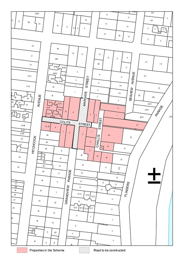
|
Stage |
Status |
Description |
|
Approval to prepare scheme |
 |
Decision made to prepare scheme following consideration of surveys of property owners and feed back from the community. Council may then place the project in the budget system or proceed immediately to prepare a scheme. Scheme preparation involves survey, design and preparation of an apportionment of costs. |
|
Intention to Declare Scheme |
|
Report to Council providing information on scheme including advice of impending advertising of scheme and declaration of charge. Seeks Council approval by resolution to proceed with process. 26 June 2012 |
|
Advertisement |
|
The scheme is advertised in the local newspaper and all allotted property owners are notified by mail. This advertisement indicates Council’s intention and notification to ‘declare’ a scheme in a month’s time. 7 July 2012 |
|
Submissions |
|
From the time of advertising property owners have 28 days (as set down by the Local Government Act) to lodge submissions, either in support or opposition to the scheme. |
|
Submissions Review Panel Hearing |
|
A Submissions Review Panel is convened (quorum of three Councillors) and meets to consider submissions. Some submissions are written only, and other submitters may wish to be heard before the Panel. The Panel makes a recommendation to Council regarding the scheme. 2 July 2013 |
|
Declaration Report |
|
Any time 28 days after advertising the scheme and after the Submissions Review Panel has met and considered submissions, Council considers a report and may proceed to “declare” the charges in accordance with its advertised intent. Subsequent to this the Finance Manager issues the levy notices and there is a formal charge placed on the property. This is the final step in the process for Council to make a decision on the scheme. |
|
Appeal |
|
Property owners may lodge an application for review with the Victorian Civil and Administrative Tribunal (VCAT) within one month of issue of the levy notice. An appeal is listed, heard and determined by the Tribunal and this process generally takes three to four months. Decisions made by VCAT are binding on all parties. |
|
Construction |
|
Council may then proceed to construct the works. Invoices are issued seeking payment of the estimated cost within one month of commencement. |
|
Final Cost Report |
|
At the completion of the works the scheme is “finalised” taking into account actual costs incurred and payments are adjusted accordingly. |
Cr Farrell declared an Indirect Interest by Close Association in Agenda Item 11 – The Avenue, Ocean Grove – Proposed Road and Drainage Construction SRC297 – Finalisation of Scheme, in that the report affects several of her close friends and professional colleagues, and left the room at 8.12pm prior to discussion.
Portfolio: |
Infrastructure - Cr Lindsay Ellis |
Source: |
City Services - Engineering Services |
General Manager: |
Gary Van Driel |
Index Reference: |
Special Rates and Charges: Reports The Avenue, Ocean Grove |
This report seeks a resolution by Council to give notice of its “Declaration” of a special charge scheme for road construction in The Avenue, Ocean Grove in accordance with the special charge scheme provisions of the local Government Act 1989.
This report relates to a proposed Special Charge Scheme for construction of road pavement, kerb & channel and drainage in The Avenue between Field Street and Newcomb Street, Ocean Grove. (See Plan Appendix 3)
After an extensive community consultation process and subsequent panel hearing held on 6 August 2013, the scope of work has been reduced from the original proposal. Field Street North and Hill Street have now been excluded from the scheme.
The area is residential with several lots having been subdivided in recent years.
The total revised estimated cost of the project is $1,157,900 with a property owner contribution of $712,072 and total Council contribution of $445,828 which includes direct and scheme funding.
There are a number of large lots and also multiple lot ownership. The estimated charges to property owners range between $8,682 and $45,080.
The scheme has been prepared in accordance with the Special Rate and Charge provisions of the Local Government Act, along with Council’s Special Rates and Charge policy.
Cr Ellis moved, Cr Macdonald seconded -
That Council:
Gives notice of it’s declaration of a Special Charge Scheme in accordance with Section 163 (1A) of the Local Government Act 1989 (‘the Act’) as follows:
Special charge be declared for a period of four (4) years commencing upon completion of the works and scheme finalisation.
the special charge be declared for the purposes of defraying any expenses incurred by Council in relation to construction of road pavement, drainage and kerb & channel in The Avenue between Field Street and Newcomb Street, Ocean Grove which project:
will provide proper sealed road access, kerb & channel, drainage, improved nature strips and enhancement to the general amenity for each of the properties included in the scheme;
Council considers is or will be a special benefit to those persons required to pay the special charge (and who are described in succeeding parts of this Resolution); and
arises out of Council’s function of planning for and providing infrastructure for property owners.
it be recorded that, for the purposes of Section 163 (2A) of the Act, the special charge proceeds will not exceed the amount calculated in accordance with the prescribed formula (R x C = S), the:
‘benefit ratio’ (R) being calculated at 0.829 represents the special benefits to all persons liable to pay the special charge; and
‘total cost’ (C) of performing the function described in Part 1 b) of this resolution based on estimated cost be recorded as $858,937.
‘maximum levy’ (S) being the total amount of Special Charge to be levied to property owners be recorded as $712,072.
the following be specified as the area for which the special rate is so declared:
the area within municipal district of Council highlighted in the plan attached to this Resolution (“the area”).
the following be specified as the land in relation to which the special charge so declared:
all land within the area shown on the plan.
the following be specified as the criteria which form the basis of the special charge so declared:
ownership of any land described in Part e of this Resolution.
the following be specified as the manner in which the special charge so declared will be assessed and levied:
the costs to be apportioned with a 50% allocation to lot frontage and a 50% allocation to lot area.
The special charge will be levied by sending a notice to the person who is liable to pay, pursuant to section 163(A) of the Act.
having regard to the preceding parts of this Resolution but subject to Section 166 (1) of the Act, it be recorded that;
the owners of the land described in column 1 of Schedule B to the Resolution are estimated liable for the respective amounts set out in column 2 of Schedule B; and
such owners may, subject to any further resolution of Council pay the special charge in the following manner:
the charge will become due and payable within one month of the issue of the notice requesting payment pursuant to Section 167 (3) of the Act and may be paid in sixteen (16) quarterly instalments from that date;
interest will not be charged for six months after the issue of the notice provided the person liable makes timely payment in accordance with any repayment arrangements that may be agreed on by Council; and
in accordance with Section 172 of the Act, the rate of interest which is payable on the special charge which has not been paid by the specified date is set at Council’s overdraft rate, reviewed every three months (provided that it shall not exceed the rate fixed by the Governor in Council by Order for the purposes of Section 172 (2A) in which case the rate of interest shall be the maximum rate fixed by the Governor in Council by Order for the purposes of this section).
Council’s Chief Executive Officer be authorised to levy the Special charge in accordance with Section 163 (4) of the Act.
Carried.
This report relates to the proposed construction of The Avenue, Ocean Grove
Council has received complaints and enquiries in regards to the state of the road over an extended period and many of these relate to drainage, flooding of adjacent properties and the condition of the road.
style="margin-top:12pt;margin-bottom:6pt;">An initial survey of property owners to construct the road was undertaken in June 2005 however there was insufficient support from property owners to initiate a scheme at this time. Over the years however, the level of enquiry and complaint has increased. A more recent survey undertaken in April 2012 provided the following results:
In Favour: - 47.5%
Not in favour: - 27.5%
No response: - 25%
This survey provided a more positive indication that a street construction scheme was viable and a scheme was therefore initiated on 28 August 2012
Newcomb Street, between The Avenue and The Parade was considered in the original scheme; however there was no support from the abutting property owners for this section of road to be constructed and was therefore excluded from the scheme
A scheme review was carried out in April 2013 and introduced the concept of the Benefit Ratio calculation which included a consideration of the Community Benefit. The Community Benefit is the benefit the new road will provide to the wider community as property owners outside the scheme boundaries use the road to access other areas. The Community Benefit is funded by Council and forms part of the Benefit Ratio calculation as shown at Appendix 2
A final survey was sent to all affected property owners in May 2013 and provided the following results:
In favour: - 52.5%
Not in favour – 32.5%
No response – 15%
Of these latest results, there is a clear majority of support for construction of The Avenue. The two intersecting streets of Hill Street and Field Street North were included in the proposed scheme for the sake of completeness. In the community consultation process carried out in April 2013 however, there was little support for these streets to be constructed and they have subsequently also been removed from the proposed scheme.
Existing Conditions
The Avenue road reserve is situated in an elevated position that runs generally parallel to the contours. The terrain is heavily vegetated and falls away to the south quite steeply, making access to developing lots challenging. The existing road surface is unsealed and is subject to the usual corrugations, dust and mud issues associated with unsealed roads in residential areas. There are some existing un-drained low points in the road reserve particularly near the smaller streets of Hill Street and Field Street North that connect to The Avenue. These cause some nuisance flooding during rain events
The road width of The Avenue is restricted in various locations and the open drains on either side of the road, coupled with the natural slope and vegetation, provides for a narrower pavement than standard and a meandering alignment. This is generally considered as a positive by the abutting property owners as they enjoy the informality of the area
Scope of Work
The length of road to be constructed equates to 500 metres. It is proposed to construct the road with a meandering alignment with semi mountable concrete kerb and channel and an asphalt seal to facilitate the drainage component of the project and to help preserve the roads structural integrity into the future
During the panel hearing of 6 August 2013 a location was identified adjacent to No 21-23 The Avenue where the existing road came in very close proximity to the property boundary. Due to the road alignment and overhanging shrubs, sight distance is considered to be unsatisfactory at this location so a redesign has been completed to relocate the road away from the property boundary and ‘straighten’ the road. A concrete retaining wall structure is now required to support the road edge on the south side and some vegetation removal is required to facilitate its construction. The retaining wall and associated landscaping will be funded by Council due to the safety enhancement the structure will provide.
The main drainage system for The Avenue discharges down the Hill Street road reserve to The Terrace. Once this drainage system extends further south to The Parade, it collects storm water from other areas and becomes remote to the scheme. This major drainage section is also funded directly by Council.
Property owners receive benefit from the planned infrastructure as follows
proper sealed road access;
improved drainage and reduced likelihood of nuisance flooding;
removal of nuisance, dust and mud;
improvements to the general amenity and safety of the area; and
Likely increase in property values.
Method of apportionment
The area was subdivided by the Methodist Church in 1888. Essentially, blocks are of frontage 20.12 (66’) and one 822sq metres in area
The most common, simplest and effective means of distributing costs for a relatively regular subdivision is the unit cost method. This allocates one unit of cost equally to all properties. In this instance, although a number of the original blocks remain, there are a number of irregular shaped and subdivided lots. Land value in this area is at a premium and lot area is extremely important in realising future potential
An apportionment method using frontage and area was adopted which provided the most equitable result. Most “private sheet schemes” using the provisions of the Local Government Act 1958 used this method. Half the cost is allocated to area and half to frontage. The standard lot referred to above, 20.12m frontage and 822sqm area was used as a basis. Any frontage over this was divided by 3 and added to 20.12 to give the apportionable frontage. Areas were treated similarly. Corner lots were considered on the basis of the sum of frontage plus sideage and treated in the above manner. Large corner lots where only one frontage is to be sealed were also treated in this manner in recognition that future charges may apply to these lots. Where frontage and/or area were less than the standard, these dimensions/areas were used without adjustment
Where large lots could obviously be subdivided into two or more standard blocks, this was the basis in which they were treated
Panel Hearing
19 submissions were received during the submissions period after Council’s Intention to declare the scheme and these included nine objections to the proposal. A panel hearing was held on 6 August 2013 to hear submissions and eight (8) property owners requested to be heard. Many of the concerns have been addressed during the subsequent review period of the scheme and all property owners have been notified of the latest changes.
The road infrastructure proposed, provides proper sealed access, drainage and a generally safer environment for pedestrian and vehicular traffic. Dust is eliminated and storm water runoff is less contaminated with silt prior to final discharge into the Barwon River.
One of the major concerns raised by property owners during the consultation phase of this scheme was that of vegetation preservation. An independent arborist report was produced and some trees within the area have been identified for removal due to health and/or species related reasons. It is considered appropriate however, to leave the majority of vegetation in place unless it is posing a direct threat to property.
During the course of construction and the manufacture and procurement of materials, there is expenditure of energy sources and greenhouse gas emissions. This does cease, however, when construction is complete.
The project does not create waste with the exception of some excess spoil.
The proposal does not affect any natural habitats.
The project has a one off capital cost and there will be minimal ongoing maintenance costs. The scheme could proceed in the 2014/15 financial year if approved.
A breakdown of costs is as follows:
|
Estimated scheme cost to property owners |
$712,071.93 |
|
Estimated scheme cost to Council |
$146,864.84 |
|
Estimated direct cost to Council for major drainage and safety improvements. |
$298,962.96 |
|
Total Project Cost |
$1,157,899.73 |
Total Council funding for this project is $445,828 and will need to be budgeted for in the 2014/15 financial year, this would be funded from the core program C02301 – Special Rates and Charges Construction
The scheme has been prepared in accordance with the Special Rate and Charge provisions of the Local Government Act 1989 along with Council’s Special Rates and Charges Policy.
This report aligns with the City Plan as follows:
Community Wellbeing:
Healthy Lifestyles – Facilitating and promoting physical activity
Healthy Environments – Safe, hazard and nuisance free environments
Sustainably Built and Natural Environment
Enhance and protect natural areas and ecosystem health – Limiting the loss of native species and natural areas and continuing indigenous planting
Support our Community to live – Encourage increased use of alternatives to car transport
Advocate for and promote sustainable design and development – Promoting sustainable design and retrofitting and acknowledging the communities desire to have their say.
No Council Officer involved with this process has any direct or indirect interest in the properties.
Provision of a sealed road will provide safer driving conditions for motorists with a defined and more standard road profile. Walking conditions for pedestrians will also be enhanced by minimising the risk of personal injuries through conflict with vehicles and a reduction of tripping hazards. The additional drainage infrastructure will minimise the hazards associated with water over roads and the affects of nuisance flooding to property. There are no identified risks for Council in declaring the scheme.
The provision of properly sealed and drained roadways is aligned to Council’s City Plan as described above and provides improved connectivity and safety for motorists and pedestrians.
In developing this report to Council, the subject matter has been considered to determine if it raises any human rights issues. In particular, whether the scope of any human right established by the Victorian Charter of Human Rights and Responsibilities is in any way limited, restricted or interfered with by the recommendations contained in this report. It is considered that the subject matter does not raise any adverse human rights issues.
It is further considered that the construction of The Avenue upholds the right to freedom of movement (Section 12 of the Human rights Charter) by enhancing a person’s ability to move freely within the area they choose to live.
Community consultation since the intention to declare the road construction Special Charge Scheme has been carried out as follows:
4 April 2013 – Invitation to attend public meeting at Ocean Grove Customer Service Centre including detailed information sheet
20 April 2013 – Public meeting (open forum)
May 2013 – Final survey to property owners
6 August 2013 – Submissions Panel Hearing
19 August 2013 – Update letter to property owners outlining process post panel hearing. Letter included information on the removal of Field Street and some Hill Street properties from the scheme
28 October 2013 – Update letter to remaining Hill Street property owners advising that they were no longer included in the scheme
17 December 2013 – Letter to property owners detailing review changes to scheme
Further correspondence will be sent to all affected property owners following Council’s resolution.
The works for the construction of The Avenue between Field Street and Newcomb Street, Ocean Grove which consist of excavation, reinstatement of nature strip, pavement works, kerb & channel, sealing, drainage, miscellaneous construction works, legal advice and professional services associated with survey, engineering design, drafting, supervision and administration of the project all as included in the cost estimate shown below.
|
ITEM |
DESCRIPTION |
QUANTITY |
UNIT |
RATE $ |
AMOUNT $ |
|
Section A – Owner Funded Works |
|||||
|
1.00 |
General |
|
|
|
|
|
1.01 |
Initial site establishment |
|
item |
|
$57,860.85 |
|
1.02 |
Traffic Management |
|
item |
|
$35,606.68 |
|
1.03 |
Setting out |
|
item |
|
$3,709.03 |
|
2.00 |
Earthworks |
|
|
|
|
|
2.01 |
Excavate and remove spoil offsite |
965 |
cm |
$60.00 |
$57,900.00 |
|
2.02 |
Spread and compact fill on site |
125 |
cm |
$60.00 |
$7,500.00 |
|
2.03 |
Trim and prepare subgrade |
2841 |
sqm |
$ 5.00 |
$14,205.00 |
|
2.04 |
Supply and place topsoil including seeding |
3124 |
sqm |
$ 8.00 |
$24,992.00 |
|
3.00 |
Pavement works |
|
|
|
|
|
3.01 |
Supply, place and prepare for seal, 150mm depth, CL 2 , 20mm FCR base |
2062 |
sqm |
$18.00 |
$37,116.00 |
|
3.02 |
Supply, place and compact, 150mm depth, CL 3 ,40mm CR subbase |
2062 |
cm |
$18.00 |
$37,116.00 |
|
3.03 |
Supply and place 30mm compacted depth Type N asphalt |
2062 |
sqm |
$35.00 |
$72,170.00 |
|
3.04 |
Supply and place 150mm Cl 4 FCR driveways |
135 |
cm |
$50.00 |
$6,750.00 |
|
4.00 |
DRAINAGE |
|
|
|
|
|
4.01 |
Supply and place 100mm dia subsoil drains |
1054 |
m |
$48.00 |
$50,592.00 |
|
4.02 |
Supply and place Cl 2 375mm pipe CR backfill |
435 |
m |
$180.00 |
$78,300.00 |
|
4.03 |
Connect house drains |
21 |
no |
$250.00 |
$5,250.00 |
|
4.04 |
Connect house drains to existing pit or pipe |
2 |
no |
$250.00 |
$ 500.00 |
|
4.05 |
Construct 900 by 600mm side entry pits less than 1.5m deep |
7 |
no |
$1,400.00 |
$9,800.00 |
|
4.06 |
Construct double side entry pits 1800 by 600 less than 1.5m deep |
7 |
no |
$2,310.00 |
$16,170.00 |
|
4.07 |
Construct 900 by 900mm junction pits less than 1.5m deep |
1 |
no |
$2,200.00 |
$2,200.00 |
|
4.08 |
Construct 1200 by 900mm junction pits less than 1.5m deep |
3 |
no |
$2,500.00 |
$7,500.00 |
|
4.09 |
Construct 1200 by 900mm junction pits 1.5 - 2.5m deep |
1 |
no |
$2,500.00 |
$2,500.00 |
|
4.10 |
Construct 900 by 600mm grated pits in kerb SM2 less than 1.5m deep SD 420 |
11 |
no |
$1,600.00 |
$17,600.00 |
|
4.11 |
Construct 1200 by 600mm grated pits less than 1.5m deep SD 420 |
2 |
no |
$2,500.00 |
$5,000.00 |
|
5.00 |
CONCRETE WORKS |
|
|
|
|
|
5.01 |
Supply and place semi mountable kerb and channel |
1054 |
m |
$124.00 |
$130,696.00 |
|
5.02 |
150mm concrete driveways with 75mm FCR sub base |
21 |
sqm |
$136.00 |
$2,856.00 |
|
5.03 |
100mm FCR driveways |
630 |
sqm |
$30.00 |
$18,900.00 |
|
5.04 |
Timber edging |
740 |
m |
$10.00 |
$7,400.00 |
|
6.00 |
SERVICES |
|
|
|
|
|
6.01 |
Supply and place conduits under road |
1 |
no |
$400.00 |
$400.00 |
|
7.00 |
MISCELLANEOUS WORKS |
|
|
|
|
|
7.01 |
Supply and place double street sign on pole |
5 |
no |
$300.00 |
$1,500.00 |
|
7.02 |
Linemarking |
|
item |
$1,000.00 |
$1,000.00 |
|
7.03 |
Supply and place RRPM's |
|
item |
$500.00 |
$500.00 |
|
7.04 |
Environmental management |
|
item |
|
$2,000.00 |
|
7.05 |
Construct timber retaining wall to max. 1m height |
20 |
m |
$150.00 |
$3,000.00 |
|
8.00 |
PROVISIONAL ITEMS |
|
|
|
|
|
8.01 |
Excavation of soft spots and replace with 200mm min, 40mm CL 3, CR |
15 |
cm |
$120.00 |
$1,800.00 |
|
9.00 |
Contingency 10% |
|
|
|
$72,118.96 |
|
10.00 |
Design |
|
|
|
$41,828.99 |
|
11.00 |
SRC Administration |
|
|
|
$23,799.26 |
|
|
TOTAL |
|
|
|
$858,936.77 |
|
Section B – Council Funded Works |
|||||
|
1.00 |
GENERAL |
|
|
|
|
|
1.01 |
Initial site establishment |
|
item |
|
$20,139.15 |
|
1.02 |
Traffic Management |
|
item |
|
$12,393.32 |
|
1.03 |
Setting out |
|
item |
|
$1,290.97 |
|
2.00 |
EARTHWORKS |
|
|
|
|
|
2.01 |
Supply and place topsoil including seeding |
1000 |
sqm |
$8.00 |
$8,000.00 |
|
3.00 |
PAVEMENT WORKS |
|
|
|
|
|
3.05 |
Construct speed hump |
1 |
no |
$5,000.00 |
$5,000.00 |
|
4.00 |
DRAINAGE |
|
|
|
|
|
4.01 |
Supply and place Cl 2 450mm pipe CR backfill |
6 |
m |
$275.00 |
$1,650.00 |
|
4.02 |
Supply and place Cl 2 600mm pipe CR backfill |
27 |
m |
$440.00 |
$11,880.00 |
|
4.03 |
Supply and place Cl 4 525mm pipe CR backfill |
155 |
m |
$375.00 |
$58,125.00 |
|
4.04 |
Supply and place Cl 4 750mm pipe CR backfill |
74 |
m |
$510.00 |
$37,740.00 |
|
4.05 |
Supply and bore twin 300mm pipe |
1 |
item |
$30,000.00 |
$30,000.00 |
|
4.06 |
Construct 200mm nom hard rock beaching |
35 |
sqm |
$100.00 |
$3,500.00 |
|
4.07 |
Construct 900 by 600mm junction pits less than 1.5m deep SD420 |
8 |
no |
$2,200.00 |
$17,600.00 |
|
4.08 |
Construct 900 by 900mm junction pits greater than 2.5m deep SD 420 |
1 |
no |
$2,500.00 |
$2,500.00 |
|
4.09 |
Construct 900 by 900mm junction pits 4.0m deep |
2 |
no |
$4,000.00 |
$8,000.00 |
|
4.10 |
Construct 1200 by 900mm junction pits less than 1.5m deep |
2 |
no |
$2,500.00 |
$5,000.00 |
|
4.11 |
Construct 1200 by 900mm grated pits less than 1.5m deep SD 420 |
1 |
no |
$2,500.00 |
$2,500.00 |
|
5.00 |
MISCELLANEOUS WORKS |
|
|
|
|
|
5.01 |
Environmental management |
|
item |
|
$500.00 |
|
5.02 |
Concrete Retaining Wall to max 1m height |
63 |
m |
$400.00 |
$25,200.00 |
|
6.00 |
Contingency 10% |
|
|
|
$25,101.84 |
|
7.00 |
Design |
|
|
|
$14,559.07 |
|
8.00 |
SRC Administration |
|
|
|
$8,283.61 |
|
|
TOTAL |
|
|
|
$298,962.96 |
|
COL 1 |
COL 2 |
COL 3 |
COL 4 |
|
LEGAL DETAILS |
TOTAL ESTIMATED COST |
PROPERTY REFERENCE |
ADDRESS |
|
Lot 266 LP 1857 |
$17,692.35 |
264046 |
2-4 The Avenue, Ocean Grove |
|
Lot 267 LP 1857 |
$13,895.71 |
264046 |
2-4 The Avenue, Ocean Grove |
|
Lot 1 TP138626, Lot 1 TP139130 |
$19,178.43 |
244044 |
6 The Avenue, Ocean Grove |
|
Lots 269,270 & Pt Lot 271 LP1857 |
$45,081.03 |
257505 |
8 - 10 The Avenue, Ocean Grove |
|
Lot 2 LP 203637 |
$15,234.88 |
244045 |
12 The Avenue, Ocean Grove |
|
Lot 1 PS 409554 |
$17,626.75 |
302161 |
14 The Avenue, Ocean Grove |
|
Lot 2 PS 409554 |
$10,002.96 |
302162 |
16 The Avenue, Ocean Grove |
|
Lot 274 LP 1857 |
$17,363.14 |
244046 |
18 The Avenue, Ocean Grove |
|
Lot 275 LP 1857 |
$17,363.14 |
244047 |
20 The Avenue, Ocean Grove |
|
Lot 1 PS 513038 |
$8,681.57 |
323135 |
1/22 The Avenue, Ocean Grove |
|
Lot 2 PS 513038 |
$8,681.57 |
323136 |
2/22 The Avenue, Ocean Grove |
|
Lot 1 PS 426401 |
$16,707.81 |
304113 |
24 The Avenue, Ocean Grove |
|
Lot 2 PS 426401 |
$8,899.27 |
304114 |
1/26 The Avenue, Ocean Grove |
|
Lot 3 PS 426401 |
$8,996.99 |
304115 |
2/26 The Avenue, Ocean Grove |
|
Lot 279 LP 1857 |
$23,149.93 |
244049 |
28 The Avenue, Ocean Grove |
|
Lot 1 PS 431687 |
$22,677.16 |
310411 |
30-32 The Avenue, Ocean Grove |
|
Lot 282 LP 1857 |
$17,363.14 |
244051 |
34 The Avenue, Ocean Grove |
|
Lot 283 LP 1857 |
$17,363.14 |
244052 |
36 The Avenue, Ocean Grove |
|
Lot 284 LP 1857 |
$17,363.14 |
244053 |
38 The Avenue, Ocean Grove |
|
Lot 285 LP 1857 |
$17,363.14 |
244054 |
40 The Avenue, Ocean Grove |
|
Lot 286 LP 1857 |
$17,363.14 |
244055 |
42 The Avenue, Ocean Grove |
|
Lot 1 LP 95076 |
$15,040.98 |
244056 |
44 The Avenue, Ocean Grove |
|
Lot 1 PS 539521 |
$23,760.98 |
331688 |
1-3 The Avenue, Ocean Grove |
|
Lot 2 PS 539521 |
$16,130.79 |
331689 |
5 The Avenue, Ocean Grove |
|
Lot 1 PS 422975 |
$11,952.81 |
303993 |
7 The Avenue, Ocean Grove |
|
Lot 2 PS 422975 |
$18,809.95 |
303994 |
9 The Avenue, Ocean Grove |
|
Lot 305 LP 1857 Lot 317 LP 1857 into Ppsd Lots 1-2 PS 607947 |
$17,363.14 |
243985 |
11 The Avenue, Ocean Grove |
|
Lot 304 LP1857, Lot 318 LP 1857 |
$17,363.14 |
243986 |
13 The Avenue, Ocean Grove |
|
Lot 319 LP1857, Lot 303 LP 1857 |
$17,363.14 |
243987 |
15 The Avenue, Ocean Grove |
|
Lot 1 PS 500590 |
$22,542.09 |
243988 |
17 The Avenue, Ocean Grove |
|
Lot 2 PS 500590 |
$9,531.13 |
264254 |
19 The Avenue, Ocean Grove |
|
Lot 299 LP1857, Lot 323 LP1857, Lot322 LP1857, Lot300 LP 1857 |
$34,726.28 |
264255 |
21-23 The Avenue, Ocean Grove |
|
Lot 1 LP 216301 |
$31,153.26 |
268839 |
25-29 The Avenue, Ocean Grove |
|
Lot 1 CP 104876 |
$23,152.27 |
243990 |
31-33 The Avenue, Ocean Grove |
|
Lot 1 PS 308933 |
$19,263.82 |
270442 |
35 The Avenue, Ocean Grove |
|
Lot 2 LP 219400 |
$15,460.50 |
269549 |
37 The Avenue, Ocean Grove |
|
Lot 2 PS 444091 |
$8,617.23 |
313368 |
1/39 The Avenue, Ocean Grove |
|
Lot 1 PS 444091 |
$8,617.23 |
313367 |
2/39 The Avenue, Ocean Grove |
|
Lot 1 PS 62777 |
$13,813.68 |
340788 |
41 The Avenue, Ocean Grove |
|
Lot 2 PS 62777 |
$13,798.71 |
340789 |
43 The Avenue, Ocean Grove |
|
Lot 288 LP 1857 |
$15,562.40 |
243993 |
45 The Avenue, Ocean Grove |
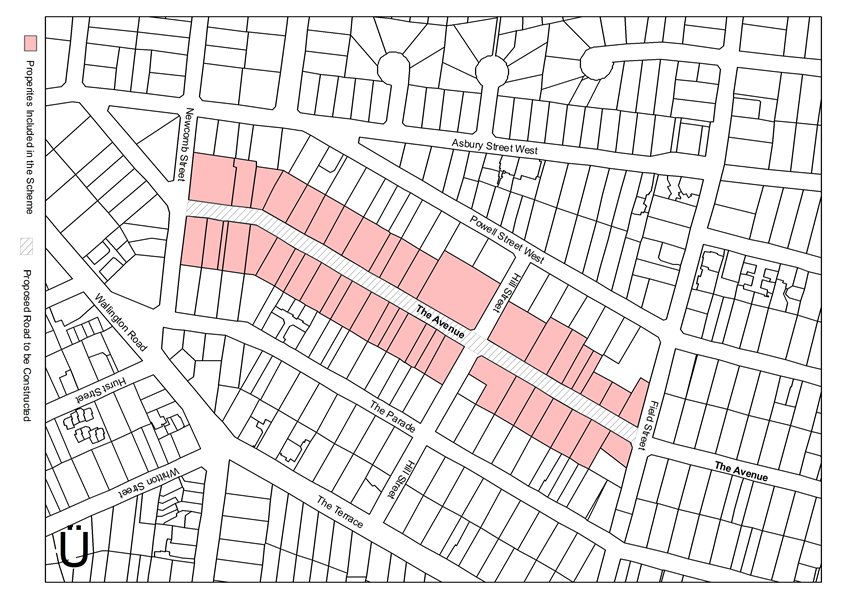
|
Stage |
Status |
Description |
|
Approval to prepare scheme |
|
Decision made to prepare scheme following consideration of surveys of property owners and feed back from the community. Council may then place the project in the budget system or proceed immediately to prepare a scheme. Scheme preparation involves survey, design and preparation of an apportionment of costs. |
|
Intention to Declare Scheme |
|
Report to Council providing information on scheme including advice of impending advertising of scheme and declaration of charge. Seeks Council approval by resolution to proceed with process. 28 August 2012 |
|
Advertisement |
|
The scheme is advertised in the local newspaper and all allotted property owners are notified by mail. This advertisement indicates Council’s intention and notification to ‘declare’ a scheme in a month’s time. 8 September 2012 |
|
Submissions |
|
From the time of advertising property owners have 28 days (as set down by the Local Government Act) to lodge submissions, either in support or opposition to the scheme. |
|
Submissions Review Panel Hearing |
|
A Submissions Review Panel is convened (quorum of three Councillors) and meets to consider submissions. Some submissions are written only, and other submitters may wish to be heard before the Panel. The Panel makes a recommendation to Council regarding the scheme. 6 August 2013 |
|
Declaration Report |
|
Any time 28 days after advertising the scheme and after the Submissions Review Panel has met and considered submissions, Council considers a report and may proceed to “declare” the charges in accordance with its advertised intent. Subsequent to this the Finance Manager issues the levy notices and there is a formal charge placed on the property. This is the final step in the process for Council to make a decision on the scheme. |
|
Appeal |
|
Property owners may lodge an application for review with the Victorian Civil and Administrative Tribunal (VCAT) within one month of issue of the levy notice. An appeal is listed, heard and determined by the Tribunal and this process generally takes three to four months. Decisions made by VCAT are binding on all parties. |
|
Construction |
|
Council may then proceed to construct the works. Invoices are issued seeking payment of the estimated cost within one month of commencement. |
|
Final Cost Report |
|
At the completion of the works the scheme is “finalised” taking into account actual costs incurred and payments are adjusted accordingly. |
Portfolio: |
Infrastructure – Cr Ellis |
Source: |
City Services – Engineering Services |
General Manager: |
Gary Van Driel |
Index Reference: |
Ocean Throughway and Bonnyvale Road, Ocean Grove, Special Rates and Charges, Council Reports 2014 |
The purpose of this report is to finalise the Ocean Throughway and Bonnyvale Road footpath Special Charge Scheme, Ocean Grove between Lockyer Court and Pembroke Road as shown at Appendix 1.
The Special Charge Scheme was declared by Council at its meeting of 31 January 2012.
The scheme affects 55 properties and the cost estimate was $231,754. Owner’s costs vary between $260.50 and $3,514.56.
The works have now been completed and the scheme can be finalised by Council. The final cost of the project was $179,841.04. The cost saving of $51,913 from the project estimate results in a charge reduction for property owners.
The scheme has been administered in accordance with the Special Rates and Charges provisions of the Local Government Act 1989, along with Council’s Special Rates and Charges Policy.
This report seeks a resolution by Council to confirm the Special Charge Scheme for the footpath construction in Ocean Throughway and Bonnyvale Road, Ocean Grove in accordance with the Special Charge Scheme process as shown in the Process Chart – Attachment 1.
Cr Ellis moved, Cr Richards seconded -
That Council having declared a special charge on 31 January 2012 for the purposes of defraying the expenses in relation to the construction of a footpath in Ocean Throughway and Bonnyvale Road, Ocean Grove, between Lockyer Court and Pembroke Road (Appendix 1 – Plan) in accordance with Section 163 of the Local Government Act 1989 (the Act) resolves that:
the amended special charges to property owners be confirmed as required by Section 166 of the Act as shown in Schedule A – Appendix 2;
the reduction of actual cost of $51,913 from the project estimate contribute to a charge reduction to property owners;
the General Manager of Corporate Services is authorised to levy and recover the special charges by sending notices to the persons who are liable to pay in accordance with Section 166 of the Act; and
in accordance with Section 172, the rate of interest which is payable on the special charges which have not been paid by the specified date is set at Council’s overdraft rate, reviewed every three months (provided that it shall not exceed the rate fixed by the Governor in Council by Order for the purposes of Section 172 2A in which case the rate of interest shall be the maximum rate fixed by the Governor in Council by Order for the purposes of the Section). The interest is to be calculated from the date the special charge is due, with a six months interest free period, providing those persons who choose to pay by instalments adhere to their repayment plan.
Carried.
Council has had approaches from property owners and residents in the past for a footpath in this area. Ocean Throughway and Bonnyvale Road service a considerable residential area and are relatively close to the ocean foreshore, Collendina Reserve, bus stops and sports club as destinations
The original nature strip had a worn pedestrian path evident in the turf that reinforced the need for a constructed footpath. The new pathway is 1,130m long and 1.5m in width
The footpath works have been completed as part of a pedestrian link and costs have been accounted for. The scheme can now be finalised by Council.
The actual cost of construction was less than the project estimate due to efficiency of construction and minimal contingencies encountered during construction. The price reduction will be partly passed on to property owners as detailed in the Financial Implications section below.
There are no environmental implications in regards to energy consumption, emissions, water use, storm water quality, waste generation or natural habitats in Councils decision to finalise the scheme.
The financial details of the project are detailed as follows:
|
|
Estimate |
Actual |
|
Cost to Property Owners |
$105,971.74 |
$$82,234.05 |
|
Cost to Council |
$105,971.74 |
$$82,234.05 |
|
Cost to Council for two properties |
$19,810.52 |
$$15,372.94 |
|
Total |
$231,754.00 |
$$179,841.04 |
The final costs of the project are lower than estimated by $51,912.96. Property owners will be advised of the final costs which represent a 22% reduction when compared with the ‘as declared’ estimated charges.
The Special Charge Scheme has been administered in accordance with the Special Charge Scheme provisions of the Local Government Act 1989 as well as Council’s Special Rates and Charges policy.
This report aligns with the City Plan as follows:
Community Wellbeing:
Healthy Lifestyles – Facilitating and promoting physical activity
Healthy Environments – Cycling and walking paths
Sustainably Built and Natural Environment
Support our Community to live – Encourage increased use of alternatives to car transport
No Council Officer involved with this process has any direct or indirect interest in the properties.
The provision of a footpath has provided safer walking conditions for pedestrians by minimising the risk of personal injuries through trip hazards and conflict with vehicles. There are no identified risks for Council in finalising the scheme.
The provision of footpaths is aligned to Council’s City Plan as described above and provides improved connectivity and safety for pedestrians.
In developing this report to Council, the subject matter has been considered to determine if it raises any human rights issues. In particular, whether the scope of any human right established by the Victorian Charter of Human Rights and Responsibilities is in any way limited, restricted or interfered with by the recommendations contained in this report. It is considered that the subject matter does not raise any human rights issues.
Communication with property owners has taken place during the course of the project and Special Charge Scheme process. Council will advise the property owners of the final cost.
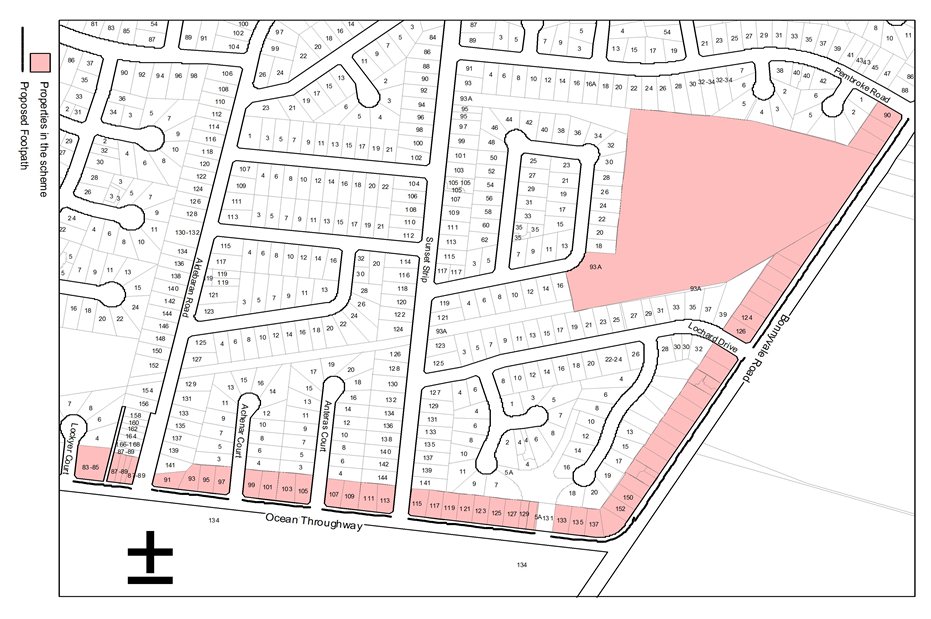
|
COL 1 |
COL 2 |
COL 3 |
COL 4 |
COL 5 |
|
DESCRIPTION OF PROPERTY |
ESTIMATED COST ($) |
ACTUAL COST ($) |
PROPERTY REFERENCE |
PROPERTY DETAILS |
|
Lot 17 LP 84004 |
$7,088.91 |
$5,500.99 |
245797 |
110-114 Bonnyvale Road, Ocean Grove |
|
Lot 16 LP 84004 |
$1,952.65 |
$1,515.26 |
245798 |
116 Bonnyvale Road, Ocean Grove |
|
Lot 15 LP 84004 |
$1,952.65 |
$1,515.26 |
245799 |
118 Bonnyvale Road, Ocean Grove |
|
Lot 14 LP 84004 |
$1,952.65 |
$1,515.26 |
245800 |
120 Bonnyvale Road, Ocean Grove |
|
Lot 13 LP 84004 |
$1,952.65 |
$1,515.26 |
245801 |
122 Bonnyvale Road, Ocean Grove |
|
Lot 12 LP 84004 |
$1,952.65 |
$1,515.26 |
245802 |
124 Bonnyvale Road, Ocean Grove |
|
Lot 11 LP 84004 |
$1,952.65 |
$1,515.26 |
245803 |
126 Bonnyvale Road, Ocean Grove |
|
Lot 10 LP 84004 |
$1,952.65 |
$1,515.26 |
245804 |
128 Bonnyvale Road, Ocean Grove |
|
Lot 9 LP 84004 |
$1,952.65 |
$1,515.26 |
245805 |
130 Bonnyvale Road, Ocean Grove |
|
Lot 1 SP 36000 |
$976.86 |
$758.04 |
269380 |
1/132 Bonnyvale Road, Ocean Grove |
|
Lot 2 SP 36000 |
$976.86 |
$758.04 |
269381 |
2/132 Bonnyvale Road, Ocean Grove |
|
Lot 7 LP 84004 |
$1,952.65 |
$1,515.26 |
245807 |
134 Bonnyvale Road, Ocean Grove |
|
Lot 6 LP 84004 |
$1,952.65 |
$1,515.26 |
245808 |
136 Bonnyvale Road, Ocean Grove |
|
Lot 5 LP 84004 |
$1,952.65 |
$1,515.26 |
245809 |
138 Bonnyvale Road, Ocean Grove |
|
Lot 4 LP 84004 |
$1,952.65 |
$1,515.26 |
245810 |
140 Bonnyvale Road, Ocean Grove |
|
Lot 3 LP 84004 |
$1,952.65 |
$1,515.26 |
245811 |
142 Bonnyvale Road, Ocean Grove |
|
Lot 2 LP 84004 |
$1,952.65 |
$1,515.26 |
245812 |
144 Bonnyvale Road, Ocean Grove |
|
Lot 1 PS 439079 |
$1,606.75 |
$1,246.84 |
312451 |
1/146 Bonnyvale Road, Ocean Grove |
|
Lot 2 PS 439079 |
$345.90 |
$268.42 |
312452 |
2/146 Bonnyvale Road, Ocean Grove |
|
Lot 3 LP 111001 |
$1,708.17 |
$1,325.54 |
245814 |
148 Bonnyvale Road, Ocean Grove |
|
Lot 2 LP 111001 |
$1,708.17 |
$1,325.54 |
245815 |
150 Bonnyvale Road, Ocean Grove |
|
Lot 1 LP 111001 |
$1,708.17 |
$1,325.54 |
245816 |
152 Bonnyvale Road, Ocean Grove |
|
Lot 14 LP 94054 |
$3,199.62 |
$2,482.90 |
257069 |
139 Ocean Throughway, Ocean Grove |
|
Lot 13 LP 94054 |
$2,320.98 |
$1,801.08 |
257068 |
137 Ocean Throughway, Ocean Grove |
|
Lot 12 LP 94054 |
$1,939.84 |
$1,505.32 |
257067 |
135 Ocean Throughway, Ocean Grove |
|
Lot 11 LP 94054 |
$1,939.84 |
$1,505.32 |
257066 |
133 Ocean Throughway, Ocean Grove |
|
Lot 1 PS 623628 |
$934.16 |
$724.90 |
339553 |
1/129 Ocean Throughway, Ocean Grove |
|
Lot 2 PS 623628 |
$933.09 |
$724.08 |
339554 |
2/129 Ocean Throughway, Ocean Grove |
|
Lot 8 LP 94054 |
$1,867.24 |
$1,448.98 |
257063 |
127 Ocean Throughway, Ocean Grove |
|
Lot 7 LP 94054 |
$1,867.24 |
$1,448.98 |
257062 |
125 Ocean Throughway, Ocean Grove |
|
Lot 6 LP 94054 |
$1,867.24 |
$1,448.98 |
257061 |
123 Ocean Throughway, Ocean Grove |
|
Lot 5 LP 94054 |
$1,867.24 |
$1,448.98 |
257060 |
121 Ocean Throughway, Ocean Grove |
|
COL 1 |
COL 2 |
COL 3 |
COL 4 |
COL 5 |
|
DESCRIPTION OF PROPERTY |
ESTIMATED COST ($) |
ACTUAL COST($) |
PROPERTY REFERENCE |
PROPERTY DETAILS |
|
Lot 4 LP 94054 |
$1,867.24 |
$1,448.98 |
257059 |
119 Ocean Throughway, Ocean Grove |
|
Lot 3 LP 94054 |
$1,850.16 |
$1,435.73 |
257058 |
117 Ocean Throughway, Ocean Grove |
|
Lot 64 LP 55384 |
$1,952.65 |
$1,515.26 |
257057 |
115 Ocean Throughway, Ocean Grove |
|
Lot 65 LP 55384 |
$1,952.65 |
$1,515.26 |
257056 |
113 Ocean Throughway, Ocean Grove |
|
Lot 66 LP 55384 |
$2,149.09 |
$1,667.70 |
257055 |
111 Ocean Throughway, Ocean Grove |
|
Lot 233 LP 55384 |
$2,149.09 |
$1,667.70 |
257054 |
109 Ocean Throughway, Ocean Grove |
|
Lot 232 LP 55384 |
$1,952.65 |
$1,515.26 |
257053 |
107 Ocean Throughway, Ocean Grove |
|
Lot 213 LP 55384 |
$1,952.65 |
$1,515.26 |
257052 |
105 Ocean Throughway, Ocean Grove |
|
Lot 212 LP 55384 |
$2,149.09 |
$1,667.70 |
257051 |
103 Ocean Throughway, Ocean Grove |
|
Lot 211 LP 55384 |
$2,149.09 |
$1,667.70 |
257050 |
101 Ocean Throughway, Ocean Grove |
|
Lot 210 LP 55384 |
$1,952.65 |
$1,515.26 |
257049 |
99 Ocean Throughway, Ocean Grove |
|
Lot 195 LP 55384 |
$1,855.50 |
$1,439.87 |
257048 |
97 Ocean Throughway, Ocean Grove |
|
Lot 194 LP 55384 |
$1,855.50 |
$1,439.87 |
257047 |
95 Ocean Throughway, Ocean Grove |
|
Lot 193 LP 55384 |
$2,382.90 |
$1,849.13 |
257046 |
93 Ocean Throughway, Ocean Grove |
|
Lot 192 LP 55384 |
$3,156.91 |
$2,449.76 |
257045 |
91 Ocean Throughway, Ocean Grove |
|
Lot 4 PS 403882 |
$893.59 |
$693.42 |
301420 |
1/87-89 Ocean Throughway, Ocean Grove |
|
Lot 3 PS 403882 |
$649.11 |
$503.71 |
301421 |
2/87-89 Ocean Throughway, Ocean Grove |
|
Lot 2 PS 403882 |
$649.11 |
$503.71 |
301422 |
3/87-89 Ocean Throughway, Ocean Grove |
|
Lot 1 PS 403882 |
$886.11 |
$687.62 |
301423 |
4/87-89 Ocean Throughway, Ocean Grove |
|
Lot 2 PS 629838 |
$1,127.39 |
$874.86 |
342307 |
1/83 Ocean Throughway, Ocean Grove |
|
Lot 3 PS 629838 |
$804.98 |
$624.66 |
342308 |
2/83 Ocean Throughway, Ocean Grove |
|
Lot 4 PS 629838 |
$807.11 |
$626.32 |
342309 |
1/83 Ocean Throughway, Ocean Grove |
|
Lot52 PS 629838 |
$775.08 |
$601.46 |
342310 |
1/83 Ocean Throughway, Ocean Grove |
|
Res LP 97336, Res LP 94054 |
$260.50 |
$202.14 |
269058 |
5A Achilles Court, Ocean Grove |
|
Lot 2 LP 125689, 1/2 Share of LP 84004, |
$9,644.76 |
$7,484.33 |
260735 |
93A Sunset Strip, Ocean Grove |
|
Lot 20 LP84004 |
$1,952.65 |
$1,515.26 |
270305 |
1,2/90 Bonnyvale Road, Ocean Grove |
|
Lot 19 LP84004 |
$1,952.65 |
$1,515.26 |
245795 |
92 Bonnyvale Road, Ocean Grove |
|
Lot 18 LP84004 |
$1,952.65 |
$1,515.26 |
245796 |
94 Bonnyvale Road, Ocean Grove |
|
|
$115,877.00 |
$89,920.52 |
|
|
|
Stage |
Status |
Description |
|
Approval to prepare scheme |
|
Decision made to prepare scheme following consideration of surveys of property owners and feed back from the community. Council may then place the project in the budget system or proceed immediately to prepare a scheme. Scheme preparation involves survey, design and preparation of an apportionment of costs. |
|
Intention to Declare Scheme |
|
Report to Council providing information on scheme including advice of impending advertising of scheme and declaration of charge. Seeks Council approval by resolution to proceed with process. 22 September 2009. |
|
Advertisement |
|
The scheme is advertised in the local newspaper and all allotted property owners are notified by mail. This advertisement indicates Council’s intention and notification to ‘declare’ a scheme in a month’s time. 3 October 2009. |
|
Submissions |
|
From the time of advertising property owners have 28 days (as set down by the Local Government Act) to lodge submissions, either in support or opposition to the scheme. |
|
Submissions Review Panel Hearing |
|
A Submissions Review Panel is convened (quorum of three Councillors) and meets to consider submissions. Some submissions are written only, and other submitters may wish to be heard before the Panel. The Panel makes a recommendation to Council regarding the scheme. 22 March 2010. |
|
Declaration Report |
|
Any time 28 days after advertising the scheme and after the Submissions Review Panel has met and considered submissions, Council considers a report and may proceed to “declare” the charges in accordance with its advertised intent. Subsequent to this the Finance Manager issues the levy notices and there is a formal charge placed on the property. This is the final step in the process for Council to make a decision on the scheme. 31 January 2012 |
|
Appeal |
|
Property owners may lodge an application for review with the Victorian Civil and Administrative Tribunal (VCAT) within one month of issue of the levy notice. An appeal is listed, heard and determined by the Tribunal and this process generally takes three to four months. Decisions made by VCAT are binding on all parties. 30 October 2012 |
|
Construction |
|
Council may then proceed to construct the works. Invoices are issued seeking payment of the estimated cost within one month of commencement. |
|
Final Cost Report |
|
At the completion of the works the scheme is “finalised” taking into account actual costs incurred and payments are adjusted accordingly. |
Cr Farrell re-entered the meeting room at 8:12pm
Portfolio: |
Sport & Recreation – Cr Irvine |
Source: |
Projects, Recreation & Central Geelong – Sport & Recreation |
General Manager: |
Dean Frost |
Index Reference: |
Subject: Facilities – The Arena |
Cr Harwood moved, Cr Macdonald seconded -
That in accordance with Section 89 (2) (d) of the Local Government Act 1989, this contractual matter be considered at the conclusion of all other business at which time the meeting be closed to members of the public.
Carried.
Contents | Previous Page: Section A - Procedural Matters | Next Page: Section C - Notice of Motion

Copyright CoGG 2012
Last Update: 19 February 2014