
Council Minutes - Section B: Reports - 22 April 2014
Contents | Previous Page: Section A - Procedural Matters | Next Page: Section C - Assembly of Councillors
Contents | Previous Page: Section A - Procedural Matters | Next Page: Section C - Assembly of Councillors
Reports tabled at the Ordinary Meeting of Council on Tuesday date held at City Hall, Little Malop Street in Geelong.
Amendment C297 and Permit 765/2013 – Proposed Coles Supermarket on Murradoc Road, Drysdale
2015/16 Sport and Recreation Victoria Funding Program Submissions
Amendment C310 – Implementation of New Zones to the Armstrong Creek Urban Growth Area
Central Geelong Marketing Committee – Annual Activities Report 2012-2013
Colac Road, Highton – Proposed Pathway SRC335 – Declaration of Charge
Portfolio: |
Infrastructure, Parks & Gardens – Cr Ellis |
Source |
Projects, Recreation and Central Geelong - Sport and Recreation |
General Manager: |
Dean Frost |
Index Reference |
Property: ID# 277626. 34-66 Calvert Street, Hamlyn Heights |
The purpose of this report is to present a summary of public submissions received in relation to a proposed lease of land to Telstra for the development of a communications facility and associated equipment at Hamlyn Reserve at 34-66 Calvert St Hamlyn Heights.
The report also seeks Council’s decision to enter into a lease with Telstra for this proposed facility.
On 5 September 2013, a Council Development Hearings Panel issued a Notice of Decision to grant a planning permit to Telstra for the development of mobile phone equipment including cabinets, an antenna tower and sports lighting at Hamlyn Reserve.
Following the Notice of Decision, an appeal was lodged by local residents with VCAT. The hearing was conducted on 17 March 2014 and the decision on 25 March 2014 directed Council to issue a planning permit for this facility.
Aligned with the resident appeal, Councillor Richards presented a Notice of Motion to Council which initiated a five week public submission process to seek further community feedback on the proposed lease of land at Hamlyn Reserve. Six hundred and thirty one (631) objections to the lease were received through this process.
The development of telecommunications infrastructure at Hamlyn Reserve is consistent with numerous other facilities located within Council reserves throughout the Municipality. These installations form part of a modern communications network that relies on infrastructure located in close proximity to population centres in order to provide an effective service to these populations.
Council officers have, under delegation, provided landowner consent to lodge a planning permit application following consultation with the Bell Park Sports and Recreation Club and negotiations with Telstra regarding the installation of sports lighting to the reserve.
Advice from Council’s Property Legal Advisor is that a decision to refuse a lease may result in Telstra commencing legal proceedings against Council as it is unreasonable to refuse a lease at this late stage given the previous negotiations, consents, Development Hearings Panel and VCAT proceeding undertaken to date.
Cr Ellis moved, Cr Fisher seconded -
That Council:
Enter into a lease with Telstra for the development and use of this facility; and
Note the summary of public submissions received in relation to a proposed lease of land to Telstra for the development of a communications facility and associated equipment at Hamlyn Reserve, 34-66 Calvert Street, Hamlyn Heights.
Lost.
In February 2012, Telstra approached Council seeking approval to install a mobile phone antenna within the Hamlyn Heights area to improve service coverage in this locality.
The proposed facility includes a concrete monopole tower with antennas mounted on top to an overall height of 35.3m. Installation of new telecommunications facilities with a height greater than 5m requires a planning permit under the Telecommunications Act 1997.
In order to proceed with the planning permit application, Telstra was required to obtain the land owner’s consent. This consent was provided by the Sport and Recreation Department on 16 November 2012 following negotiations with Telstra and the tenant, Bell Park Sport and Recreation Club.
Telstra identified two alternate sites at Hurst Reserve and Herne Hill Reserve, which Council’s Sport and Recreation Department rejected as they were considered too small, providing an insufficient buffer to surrounding residences.
Hamlyn Reserve was considered to be the most suitable location due to its level of existing development, large physical area and capacity to site the antenna central to the reserve, with a significant buffer to surrounding residences. This location also provided an opportunity to co-locate improved sports lighting in conjunction with the Telco infrastructure.
In negotiating the land owner’s consent required to proceed with this planning permit application, the Sport and Recreation Department sought a community benefit from Telstra, who have committed to undertaking a sport lighting design for Hamlyn Reserve, as well as supplying and installing new lighting fixtures on the tower. The value of these works has been estimated at around $30,000, in addition to the $13,000 annual rental income from the proposed lease.
The proposed facility includes an antenna to 35.3m, mounted on a 30m pole above sports lights at 27m, which is a standard height for sport lighting within Council reserves.
Council has 16 existing mobile phone antennas located within recreation reserves across the municipality. The combined rental income from these facilities is $289,095. Examples of Public Open Space reserves with telecommunications antenna towers located within their boundaries include:
|
|
|
|
|
|
|
|
|
|
|
|
|
|
The public submissions period ran for five (5) weeks and concluded on 14 February 2014.
Six hundred and thirty one (631) objections were received, comprising of 495 form letters, 124 individual responses and a petition containing 12 signatures from teachers at the nearby Western Heights College.
One (1) submission was received from an individual in support of the lease and the Bell Park Sport and Recreation Club confirmed their support for the proposed lease.
A summary of objections received through the public submissions process and relevant VCAT findings is outlined in Appendix 1-1.
The telecommunications facility is designed to operate within Australian Communications and Media Authority (ACMA) mandated standards. The ACMA sets standards that limit human exposure to Electromagnetic energy (EME). There are numerous VCAT decisions which have found that health issues are not a relevant planning consideration if the operation of the phone tower complies with the relevant standard.
In Heland v Kingston CC [2005] VCAT 2927 (8 March 2005), Deputy President Gibson stated:
“With respect to the concern about electromagnetic radiation being a health hazard, again the Tribunal has rejected this ground in a number of cases…Any telecommunications facility of the type proposed will be required to meet relevant standards and the responsible authority has ensured this by the inclusion of condition 4 which requires:
The telecommunications facility hereby permitted must be designed and installed so that the maximum human exposure levels to radio frequency emissions comply with Australian Standard AS/NZS 2772.1:1999”.
The proposed lease for this facility will generate an annual income of $13,000. Furthermore, Telstra have agreed to undertake a lighting design and supply and install new lighting fixtures for use of the tenant sporting club. These asset and services are estimated to have a value of approximately $30,000.
Council currently has 16 Telecommunications facility leases within recreation reserves. These generate a combined annual income of $289,095.
Land owner’s consent was required, sought and obtained by Telstra prior to the submission of a planning permit application for this proposal.
In providing land owner’s consent, Council’s Sport and Recreation Department liaised with the Bell Park Sport and Recreation Club and successfully negotiated for Telstra to commission a sports lighting plan for the reserve as well as the supply and installation of new lighting fixtures on the antenna tower.
Given the land owner’s consent has been negotiated and provided in good faith, the Planning Permit has been approved by Council’s Development Hearings Panel and VCAT has upheld the Panel’s decision, it would be unreasonable to refuse a lease at this late juncture. If a lease were refused it is likely that Telstra would initiate legal proceedings against Council.
Advice from Council’s Property Legal Advisor is that there is a principle called ‘promissory estoppel’ which basically states that even though there isn’t a signed lease in place, one party has held out or done things (ie like negotiating and providing a land owner’s consent and the terms and conditions on which the proposed lease would be granted) which indicates that a lease will be granted and the other party (Telstra) has done things (ie applied for a planning permit, attended VCAT proceedings, incurred costs etc) on the ‘promise’ that a lease will be granted. On this principle, the ‘landlord’ could not turn around and say that because a lease document hasn’t been signed (formalised) that there is no lease in place.
It is important to note that the objections received though this public submissions process have relevance to all Council open space and sporting reserves.
A decision to refuse a lease based on these objections creates a significant precedent for the future implementation of current and emerging communications technologies throughout the Municipality. A decision to refuse a lease could trigger retrospective complaints from residents related to previously approved installations. This may result in the need to undertake a review of existing Council sites which currently accommodate telecommunications facilities and possibly lead to removing any existing infrastructure that may reasonably be subject to the same objections as those expressed through the Hamlyn Park public submissions process.
The proposed lease to Telstra for a new mobile phone antenna and cabinetry aligns with the following City Plan priorities:
Community Wellbeing: Connected, creative and strong communities.
Growing our Economy: Support existing businesses and encourage new and emerging growth sectors.
Facilitate major infrastructure and investment to enable economic growth.
Modern communications systems rely on a connected and integrated communications network with infrastructure strategically located to provide maximum service coverage for the population.
Telstra advises that telecommunication networks are experiencing substantial increases in their loads, particularly data, as people and businesses increasingly utilise social media and the internet via smart phones and tablet devices.
The existing telecommunications infrastructure in the Hamlyn Heights area is near capacity and will exceed capacity within two months. Local residents and businesses will soon experience relatively slow data speeds, and calls will drop out or connections will be unavailable. Telstra has received a high level of complaints for the past five years about the service level in Hamlyn Heights, with many lodged in the past six months. The network will soon be unable to provide a contemporary level of service.
No Council officers involved in the preparation of this report have a direct or indirect interest in matters for consideration.
A decision to approve a lease may upset those residents that lodged an objection during the public submissions period.
A decision not to approve lease may lead to legal action by Telstra which may result in the ultimate construction of this facility.
The recent public submission process may have created an expectation among those who submitted objections that this lease would not be approved. However, providing for a modern communications network will provide benefits to many more individuals and businesses within the area than the relative few objectors.
There are no Human Rights Charter implications associated with this report.
Following the Development Hearings Panel Notice of Decision to grant a permit, Council undertook a public submissions process to seek further community feedback in relation to the proposed lease for this facility.
The public submissions period commenced on Monday 13th of January 2014 and ran for 5 weeks, concluding on Friday 14th of February 2014. Public notices advertising the submissions process were placed in the Geelong Advertiser and City News from the weekend of 11th and 12th January and each subsequent weekend up to and including the 8th and 9th of February. The public submissions process was also advertised online, with an outline of the issue, site plan and a feedback form created on the ‘Have Your Say’ page of the Geelong Australia website.
A local resident who has coordinated the submission of form-letters claims to have submitted in excess of 600 form-letter responses. Council can only confirm receipt of 495 form-letters.
Council officers have replied to all individuals who provided a response during this process to thank them for their submission and to advise Council’s pending consideration of this matter. Council’s decision in this matter should now be communicated via the Geelong Australia website and a press release prepared.
|
Objection |
Response |
Comments |
VCAT Finding |
|
Visual intrusion of the structure within the parkland – Loss of amenity |
The telecommunications facility is sited within an existing sporting ground. The proposal seeks to replace an existing 15m high lighting pole with a new pole which will mount an antenna at 30m and sports lighting at 27m. This will remove the need for another vertical structure within the reserve. It is acknowledged the facility has an overall height of 34.3m which will be significantly higher than the existing poles within the ground. However, the tower is considered to be appropriately sited given it is located centrally within an existing sporting ground. The pole will be constructed of concrete and include upgradeable sporting lights. The proposal will be co-located with other utilities and structures within the sporting ground which will assist with its visual compatibility. The facility will also be located greater than 100m from surrounding dwellings and community centres thereby reducing the visual impact. |
The higher sports lighting will reduce spillover of light into adjacent properties. Standard sports lighting is commonly mounted at a height of 25 – 30m high within recreation reserves. The following are a few examples of the heights of sports lighting for comparison purposes:
|
The VCAT decision in this matter included the following findings: The landscape is not a highly sensitive one that contains views, vistas or structures of high significance. It is in fact generally a robust, unremarkable and utilitarian landscape seen in many municipal reserves. |
|
Incompatible use/character with the recreation values of the reserve |
There are numerous examples of reserves within the City of Greater Geelong which have telecommunications equipment located in conjunction with sports lighting within sporting reserves. |
The co-location of sports field lighting on this pole is a compatible use that will provide an improved lighting outcome for the tenant sporting club and result in less spill-over of light into surrounding properties. |
The monopole would be located so it would not constrain or prevent any part of the recreation reserve being used for its primary purpose. |
|
Not part of the Master Plan for Hamlyn reserve |
The need for improved mobile communications coverage in this area had not been identified by Telco’s at the time of the Hamlyn Reserve Master Planning process. |
The identification of kiosks, power upgrades and substations are not normally captured within Master Plans. |
The Masterplan is silent about telecommunications facilities within the reserve, hence it cannot be said to not comply. |
|
Lack of broad community consultation prior to the initial planning permit application |
Notification of the application occurred with letters sent to all adjoining owners and occupiers (including opposite) and the display of 5 signs on site (to capture regular users of the park). This is considered to be consistent with Section 52 of the Planning and Environment Act 1987. |
As a result of the planning permit public notification process, 12 objections and one 1 petition containing 353 signatures were submitted and considered by the Development Hearings Panel on 5 September 2013. The findings of this panel was that the objections raised did not provide sufficient reason to refuse the application which was found to accord with the relevant State and Local Planning Policy Framework, the Particular Provision relating to the facility and the Public Park and Recreation Zone of the Greater Geelong Planning Scheme. |
With regard to community consultation the Applicants made no submissions that any parties have been excluded from participation in this review, or that further determinative issues would have been put forward had other parties participated. |
|
Perceived negative impacts on the Tom McKean walking trail |
The tower is located over 10m away from the path and is adjacent to the football oval, in an already developed setting. The tower is replacing an existing light tower and will have no impact on users of the walking trail other than improving mobile phone signal strength in this area. |
The Trail itself follows a disused railway line and traverses major roads including Thompson Rd and Ballarat Rd. It connects industrial land in North Geelong through to an old cement works site in Fyansford. The trail is largely bounded by rear fences. |
With regard to impact on users of the rail trail, people walking along the former rail bed would see little of the monopole as it would be screened by the adjacent trees and buildings. People walking south along the adjacent asphalt path would see the monopole. I consider that its height would be above the normal angle of view of most people so they would see only the lower part of the structure. I also consider that it would be one element in a very open landscape. I do not consider that it would be so large to be dominant or intrusive. |
|
Better located in a less populated space |
The antenna needs to be located central to the area for which it is providing mobile network coverage. |
The location chosen for this facility was determined in negotiation with Council’s Recreation and Open Space officers, who considered and rejected alternate proposed sites at Hurst Reserve and Herne Hill Reserve. These two sites were considered to be too small, which provided less buffer to surrounding residences and they did not have the same level of development as Hamlyn Reserve which has existing sports lighting structures. The selected Hamlyn Reserve site is considered to be the most suitable location as it is central to a large reserve with an existing level of compatible development including buildings, carparks, fencing, paths and sports lighting. The antenna site is further than 100m from surrounding dwellings. |
I am satisfied that the proposed upgrade is an urgent issue in this area, the monopole has to be 30 metres and this location is one of a few options that are suitable in this locality. In my view, planning policy unambiguously supports the provision and upgrade of telecommunications to ensure that residents and businesses have access to an acceptable level of service so they can participate in social and economic life. |
|
Perceived health impacts from electromagnetic radiation |
The telecommunications facility is designed to operate within Australian Communications and Media Authority (ACMA) mandated standards. The ACMA sets standards that limit human exposure to Electromagnetic energy (EME). The facility is considered to have the highest level of EME at a distance of 109m away from the proposed telecommunications facility and will have a level of 1.14% of the standard. The predicted EME is 0.045% of the Standard between 0m and 50m from the site, 1.075% between 50m to 100m of the site and 0.1% between 400m – 500m from the site. |
The proposal is within the allowable standards set. There are numerous VCAT decisions which have found that health issues are not a relevant planning consideration if the operation of the phone tower complies with the relevant standard. In Heland v Kingston CC [2005] VCAT 2927 (8 March 2005), Deputy President Gibson stated:< With respect to the concern about electromagnetic radiation being a health hazard, again the Tribunal has rejected this ground in a number of cases… Any telecommunications facility of the type proposed will be required to meet relevant standards and the responsible authority has ensured this by the inclusion of condition 4 which requires: The telecommunications facility hereby permitted must be designed and installed so that the maximum human exposure levels to radio frequency emissions comply with Australian Standard AS/NZS 2772.1:1999. |
In December 2013 the Tribunal struck out grounds lodged by the Applicants regarding the alleged effects of electromagnetic radiation on public health. The Tribunal ruled that the hearing would be confined to Legitimate planning issues such as the visual impact of the proposed telecommunications facility and the location of the development of the facility in and adjacent to a public park. |
|
Shade on the netball courts |
Shadow from the tower will not impact on the netball courts to any significant extent. |
There may be potential for minor shadow in the very early morning during summer months, but this will not be any more significant then the shadow which will be projected from the netball courts own light towers. |
Not considered |
Crs S and E Kontelj re-entered the meeting room at 7:51pm.
Portfolio: |
Planning - Cr Heagney |
Source: |
Strategic Implementation |
General Manager: |
Peter Bettess |
Index Reference: |
Subject – Council Reports 2014 - Application C283 |
The purpose of this report is to enable Council to consider submissions to combined Planning Scheme Amendment C283 Drysdale Urban Design Framework and Planning Permit Application1060/2013 for McHarrys Buslines, 97-105 Murradoc Rd, Drysdale.
Combined Amendment C283 and Permit 1060/2013 proposes to introduce a number of Ordinance and Zone changes to the Planning Scheme to reflect the recommendations of the adopted Drysdale Urban Design Framework (UDF) and enable McHarrys to establish a bus depot at 97-105 Murradoc Rd, Drysdale.
The Drysdale UDF applies to the Drysdale town centre and immediately surrounding land. The Amendment updates the Municipal Strategic Statement, introduces Commercial 1 & 2 zones in Murradoc Road and Collins Street and applies new Design and Development Overlays over the town centre commercial areas to reflect the recommendations of the UDF.
Permit 1060/2013 which accompanies the amendment would enable McHarrys to establish a new bus depot on a 1.2 hectare property (to be rezoned Commercial 2) at 97-105 Murradoc Road, Drysdale. This property is occupied by a detached house and some scattered vegetation.
Amendment C283 was placed on public exhibition from 23 January 2014 until 24 February 2014. A total of nine submissions have been received of which six either support or offer no objection and three of which object to parts of the amendment and/or draft permit.
Two submissions (one objecting) have been made about the provisions of the new Design and Development Overlays, in particular DDO33 as it applies to land at 26-32 Murradoc Road on which a new Coles supermarket is being proposed. These Overlays have received wide community acceptance and this report argues there is no justification for changes to be made to the exhibited provisions.
There is one supporting submission and two objecting submissions to the McHarrys bus depot which essentially request that no permit issue. However given that the proposed Commercial 2 zoning of this part of Murradoc Road is consistent with the recommendations of the UDF, refusal of the permit would be difficult to justify. One of these submitters also objects to the proposed Commercial 2 zoning in Murradoc Road.
In such circumstances where submissions are unable to be resolved, Council must refer them to an Independent Panel to be appointed by the Minister for Planning.
Cr Heagney moved, Cr Macdonald seconded -
That Council having considered all submissions to Amendment C283 to the Greater Geelong Planning Scheme resolves to:
Request the Minister for Planning appoint an Independent Panel under part 8 of the Planning and Environment Act 1987.
Refer all submissions to the Panel; and
Submit to the Panel its response to the submissions generally as outlined in this report.
Carried.
This proposal is a combined Amendment and Planning Permit application pursuant to section 96A of the Planning and Environment Act.
Amendment C283 has been initiated by Council and proposes to make changes to the following zone, overlay and ordinance provisions of the Greater Geelong Planning Scheme.
Update to the Municipal Strategic Statement to:
Amend clause 21.14 The Bellarine Peninsula by changing the Drysdale/Clifton Springs Structure Plan map at sub-clause 21.14-10, including the Drysdale UDF as a reference document, together with related ordinance changes.
Amend the Planning Scheme maps to:
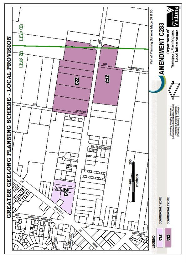
Rezone land at 8-14 and 20-22 Collins Street and 19-23 Murradoc Road, Drysdale from Residential 1 Zone and Commercial 2 zones to Commercial 1 zone.
Extend the existing business area along Murradoc Road up to the Drysdale Bypass by rezoning land from Rural Living and Farming zones to Commercial 2 zone.
Amend the Planning Scheme overlay maps and associated schedules to:
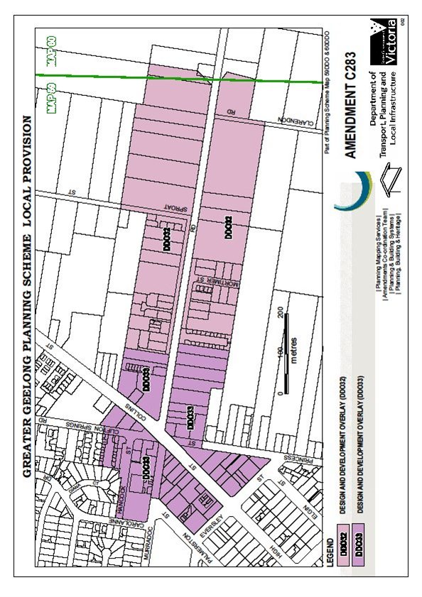
Insert new Design and Development Overlay map and associated Schedule 32 to apply to the Commercial 2 Zone.
Insert new Design and Development Overlay map and associated Schedule 33 to apply to the Commercial 1 Zone.
Draft Permit 1060/2013 resulted from an application by McHarrys Buslines to construct buildings and works and create new road access in association with a proposed new bus depot at 97-105 Murradoc Road, Drysdale.
Amendment C283 will give effect to the objectives and guidelines contained within the Drysdale Urban Design Framework. In order for the new objectives and guidelines to have statutory weight in the consideration of planning permits and rezoning requests, it is necessary for the Drysdale Urban Design Framework to be included in the Greater Geelong Planning Scheme. The accompanying zone and overlay changes give effect to the recommendations contained within the Urban Design Framework.
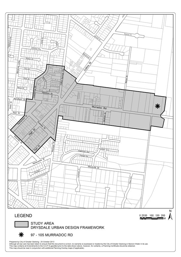
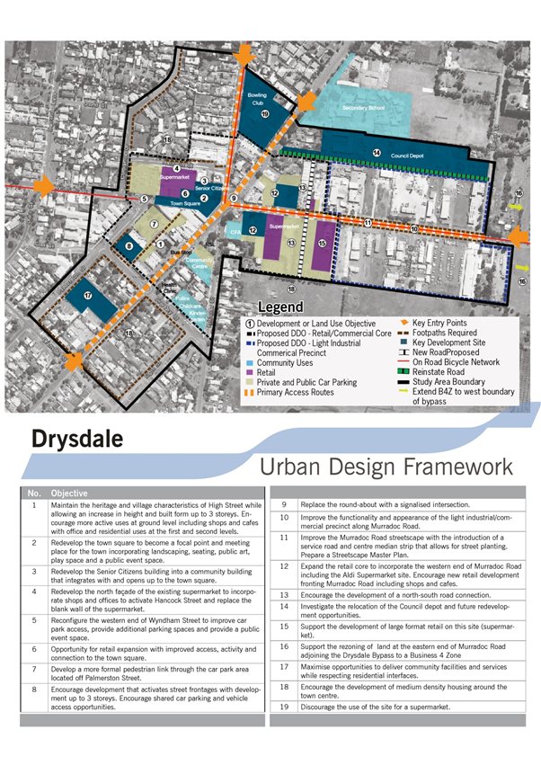
The Amendment applies to all the land within the Drysdale Urban Design Framework study area boundary as shown in Appendix 1. Appendix 2 is a copy of the overall framework plan from the UDF. Appendix 3 shows land subject to proposed rezonings and Appendix 4 shows land over which the new Design and Development Overlays are intended to apply.
The site of the proposed McHarrys bus depot at 97-105 Murradoc Road is shown by an asterisk in Appendix 1. This land, which is currently zoned Rural Living forms part of the area at the eastern end of Murradoc Road proposed to be included in a Commercial 2 zone, extending as far east as the Drysdale Bypass.
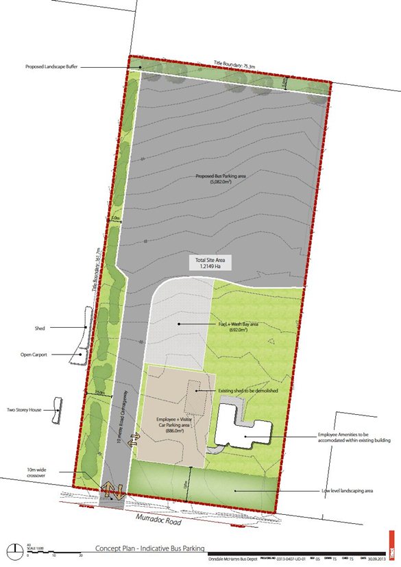
Appendix 5 is a plan showing an indicative layout of the buildings and works being proposed for the new depot.
Amendment C283 was placed on public exhibition from 23 January 2014 until 24 February 2014. Notices were placed in the Geelong Advertiser, The Independent and the Springdale Messenger. They were also sent to all owners and occupiers of land affected by the proposed zone changes and new overlays together with any affected surrounding owners and occupiers.
As a result of the exhibition of the Amendment /draft permit the Council received a total of nine submissions. Six submissions either support or offer no objection and three object to parts of the amendment and/or the draft permit. Appendix 6 is a schedule which summarises all submissions received.
The following section of the report discusses the main points raised in the submissions.
Submissions to Proposed new DDO’s 32 & 33
Two submissions have been received which relate to the provisions of DDO33 and in particular its application to 26-32 Murradoc Road, the site of the proposed Coles supermarket (to be subject of combined Amendment C297/permit 765/2013 to be considered for exhibition at the Council meeting on 8 April 2014)
Coles supports the application of the new supermarket site in the UDF but believes a proposed north south road affecting the site as shown in the UDF should be deleted.
Algo Properties (owners of the proposed Jetty Rd neighbourhood shopping centre) supports the application of the new DDO’s 32 & 33 to guide future development. However it requests that DDO33 be further strengthened as detailed in Appendix 6 to ensure elements of the adopted UDF are complied with.
Officer Response
DDO’s 32 & 33 set out the design objectives to be achieved in the Drysdale Town Centre and commercial areas along Murradoc Road and operate by applying a permit trigger for new buildings and works.
Some 300 owners and occupiers were directly notified about these new provisions. A response of only two submissions seeking a change affecting the proposed Coles supermarket site would indicate widespread general support for the new provisions.
The Drysdale UDF is a conceptual and aspirational planning document prepared with widespread community consultation and support. Whilst it is important that the design and built form objectives are incorporated into the new developments whenever possible, it is recognised that over time some site-specific factors may mitigate against implementation of all the UDF recommendations.
The DDO’s are not intended to rigidly apply any of the design concepts contained in the UDF; rather, they are to be applied wherever possible having regard to the whole range of specific circumstances which may apply at the time of any development proposal.
For these reasons, the proposals being put forward by Algo Properties which would have the effect of strengthening the urban design requirements contained in the UDF which apply to the proposed Coles supermarket site cannot be supported.
All detailed design issues, including whether or not a new north south road should from part of the new supermarket proposal, can be addressed as part of the combined Amendment C297 permit 765/2013 referred to earlier.
It is not proposed to make any changes to the adopted UDF, as requested by Coles, as part of this amendment.
Submissions to Murradoc Road Proposed Rezoning and McHarrys Bus Depot
One submission supports McHarrys because it is consistent with the goals of the UDF.
The owners of land situated at 95 Murradoc Road (adjoining the western boundary of McHarrys site) have strongly objected to both the rezoning of their property and adjoining land to Commercial 2 zone and the proposed bus depot permit. They consider the proposals will seriously impact on their residential amenity particularly from a noise and visual viewpoint, will seriously affect their property value and exacerbate the existing traffic problems in Murradoc Road. They submit that any new commercial zone should be located on the east side of the Drysdale Bypass Road and that there are far more suitable locations within the township for a bus depot to be located. These points are further detailed in Appendix 6.
An existing business owner in the Murradoc Road commercial strip has also objected to the bus depot because it will exacerbate traffic problems in Murradoc Road.
Officer Response
Over the past 18 months, with the assistance of Council officers, McHarrys Buslines has been seeking a site within Drysdale township to establish a bus depot for its future operational expansion. McHarrys Buslines is the public transport provider for the Bellarine Peninsula.
The land which McHarrys has subsequently purchased for its future bus depot falls within the area recommended for rezoning to Business 4 (now Commercial 2) Zone in the Drysdale UDF.
Separate specialist reports addressing stormwater, traffic and flora and fauna issues were submitted as part of the McHarrys permit application. These reports were jointly financed by the Council and McHarrys because they dealt with both the wider area being rezoned as part of the UDF recommendations (financed by Council) and site specific issues resulting from the bus depot development at 95-105 Murradoc Road (financed by McHarrys).
Under the provisions of the proposed new Commercial 2 zone being applied to the extended Murradoc Road business area, no permit will be required for the use of the subject land for a bus depot (nested under Store, then Warehouse – section 1 use).
However, a permit is required, pursuant to Clause 34.02-4 to construct a building or to carry out works, although any such application is exempt from the normal notification requirements on the subject land.
Exhibition of the development plans for the McHarrys site with the amendment documentation has provided nearby owners with an opportunity to make a submission in the full knowledge of the intended future proposals on the land.
From a strategic planning viewpoint, the adopted Drysdale Urban Design Framework provides a strong policy basis for the rezoning of the land along Murradoc Road, up to the Drysdale Bypass route, to Commercial 2 zone. The alternative location suggested in one submission - that the future commercial area should be situated east of the Bypass - cannot be supported. Apart from being outside the Settlement Boundary of the town as shown on the adopted Drysdale/Clifton Springs Structure Plan, such a proposal would be inconsistent with the overall Bellarine Peninsula planning philosophy of restricting urban development to within townships to prevent sprawl into surrounding farming areas.
It is acknowledged that potential exists for the owners of the property adjoining to the west of the proposed bus depot to be affected by some adverse amenity impacts. The 10 metres wide landscape buffer strip along the western boundary of the proposed bus depot should, in a relatively short time, provide a good visual barrier. The issue of the noise of buses starting early in the morning and arriving back late at night appears more difficult to address, particularly as the submitters house (bedroom) is only 20 metres from the common property boundary.
The EPA recommends that consideration be given to including a permit condition requiring McHarrys to install acoustic fencing to protect the existing neighbouring dwelling.
In response to the submission from the neighbouring residents, McHarrys have initiated the preparation of a noise impact assessment report. This report will determine potential noise levels and measures which need to be undertaken to ameliorate impacts. McHarrys are prepared to accept additional conditions being applied to their permit as recommended by this assessment. It is proposed that this report be completed prior to the Panel hearing so that its outcomes can be assessed by the Panel.
VicRoads has been consulted as part of the preparation of the UDF, the preparation of Amendment C283 and the McHarry”s permit application. VicRoads has offered no objection to the Amendment and the permit includes access conditions as required by VicRoads. McHarrys traffic consultants have concluded that Murradoc Road will be able to accommodate the additional traffic generated by buses and staff (drivers).
The future implementation of the UDF and DDO provisions is not expected to result in any adverse environmental impacts. The UDF supports the development of water sensitive urban design treatments to improve the quality of storm water runoff being generated from new development in the industrial precinct along Murradoc Road. This should help to improve the water quality at Lake Lorne.
The eventual implementation of the UDF is likely to require Council funding contributions for several projects identified within the UDF including streetscape works, the re-development of the town square and public buildings. The UDF projects will need to be fully costed and may result in future budget bids to Council and to external funding agencies. There are also aspects of the plan that could be delivered through developer contributions.
Referral of Amendment C283 and the accompanying permit to a Panel will have no financial implications for Council.
Amendment C283 complements a range of State and Council planning policies. In particular, Council’s adopted Drysdale Clifton Springs Structure Plan, as referred to in Clause 21.14 specifically recommends that an Urban Design Framework for the town centre be prepared. Clause 21.14 also includes a number of objectives that relate specifically to the recommendations of the UDF and this amendment.
Amendment C283 supports the Growing our Economy strategic direction of City Plan, in particular the priority of supporting the growth of new and existing businesses. It also supports the Sustainable Built and Natural Environment strategic direction with its emphasis on sustainable development and urban design.
In accordance with section 80C of the Local Government Act Peter Bettess, General Manager, Planning and Tourism declares an indirect financial interest in that he owns Woolworths and Wesfarmers shares.
No risks have been any identified in preparing and exhibiting Amendment C283 and accompanying permit and referring the submissions to an Independent Panel.
Amendment C283 implements the UDF which will deliver long term social benefits to the Drysdale community. These include increased retail choice and offer through expansion of the shopping centre and industrial precincts and providing improved streetscapes, traffic and pedestrian access throughout the town centre. The UDF proposes creation of a new civic precinct including a town square so that it becomes a focus for social interaction within the town.
Amendment C283 does not impact on any basic rights, freedoms and responsibilities set out in the charter. Planning legislation ensures an open community consultation process enabling people to freely express their views and obtain a fair hearing before an Independent Panel.
The Drysdale UDF was subject to an extensive consultation process.
The combined Permit/Amendment C283 was subject to full public notification in accordance with the provisions of the Planning and Environment Act. All owners and occupiers affected by the new DDO’s or any change of zoning were provided with direct public notification.
|
No |
Name |
Address |
Suburb |
Summary of Submission |
|
1 |
EPA Victoria |
GPO Box 4395 |
MELBOURNE VIC 3001 |
No concerns with the amendment. Recommends Council consider additional permit conditions to address odour, dust and noise issues, installation of sediment traps for any contaminated stormwater or wastes. Recommends consideration be given to condition to install acoustic fencing along the western boundary to protect the existing neighbouring dwelling. |
|
2. |
Mr D White |
1/35 – 39 Murradoc Road |
DRYSDALE VIC 3222 |
Objects to bus depot. No economic benefit to existing businesses. Buses will exacerbate traffic issues and turn customers away. Coles will further add to the problem. VicRoads is out of touch. |
|
3. |
E and R Hoyer |
95 Murradoc Road |
DRYSDALE VIC 3222 |
Strongly opposed to rezoning of this area from Rural Living to Commercial 2 and proposed bus depot which are neither warranted nor needed. The value of their property will be seriously reduced by these proposals. Their property is the asset base for their future retirement. This is a rural living area they and other residents have chosen to live in. Better sites exist around Drysdale e.g. Grubb Road or east of the Bypass. Poor planning to convert access to tourist towns into a commercial strip. Bus depot should be located away from residential areas. Buses will exacerbate the dangerous traffic conditions which already exist in Murradoc Road and the roundabout in town, being increased with new supermarkets. Issue made more difficult because the Bypass has not been constructed. Commercial developers should not be hemmed in by the Ring Road but planned to go to the east of the Ring Road. A bus depot will seriously impact on their residential amenity from early morning until late at night with buses passing within 20 metres of their bedroom. Proposal will generate increased activity to a residential area, does not respect neighbourhood character or protect views and will require increased fencing costs. |
|
4. |
CFA |
P O Box 586 |
NORTH GEELONG VIC 3215 |
No Objection |
|
|
Coles Supermarket |
P O Box 2000 |
GLEN IRIS VIC 3146 |
Supports. Amendment facilitates new supermarket in Murradoc Road. Does not support new north south road affecting its site as shown in the UDF. |
|
6. |
Tract Consultants on behalf of Algo Properties, owners of Jetty Rd Neighbourhood Centre |
P O Box 1716 |
GEELONG VIC 3220 |
Supports overall intent of new DDO’s but has some objections to the proposed DDO’s and submits DDO33 is insufficiently clear, and should include a plan, the exemption from notice and review should be modified and further decision guidelines added. These changes would have the effect of strengthening the urban design requirements on the Coles site and improve traffic flow in Drysdale. |
|
7. |
VicRoads |
P O Box 775 |
GEELONG VIC 3220 |
No Objection |
|
8. |
Barwon Water |
P O Box 659 |
GEELONG VIC 3220 |
No Objection. Water supply is currently available to the area to be rezoned to Commercial 2 along Murradoc Road. Reticulated sewerage services, at the developers cost, could be provided to service this area. |
|
9. |
Ms A Brackley |
Springdale |
DRYSDALE VIC 3222. |
Supports McHarrys. Consistent with the goals of the UDF, ring road and additional cycle and footpaths. |
Portfolio: |
Planning - Cr Heagney |
Source: |
Planning and Tourism - Strategic Implementation |
General Manager: |
Peter Bettess |
Index Reference: |
Council Reports 2014 |
This report seeks Council approval to exhibit a combined planning scheme amendment and permit to facilitate the development of a supermarket on Murradoc Road, Drysdale.
A planning scheme amendment request and planning permit application was made by ERM Australia on behalf of Coles Group Property for land at 24-32 Murradoc Road, Drysdale.
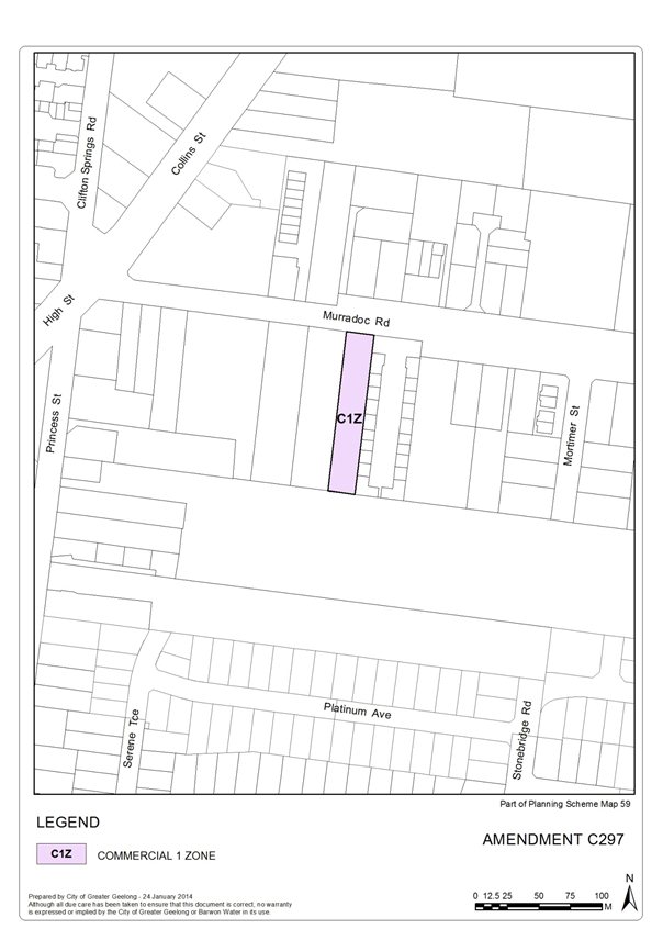
The amendment proposes to rezone 32 Murradoc Road from the Commercial 2 Zone to the Commercial 1 Zone. The remainder of the subject land is presently in the Commercial 1 Zone.
The permit application (765/2013) is for buildings and works to construct a supermarket, the display of identification signage, a reduction of car parking requirements, the alteration of access to a road in a Road Zone Category 1 and to create a carriageway easement.
The proposed supermarket has a total floor area of 3,892 sq metres, is of contemporary design and provides good connectivity with the adjacent ALDI store. Vehicle access is from Murradoc Road and a dedicated pedestrian path will connect the newly developing residential estate to the south, through the site, to Murradoc Road.
The proposal is supported by Council’s adopted Drysdale Urban Design Framework August 2012, which identifies the site for a supermarket.
Relevant to the consideration of this application is the likely opening date of the supermarket and how this would impact on the nearby Jetty Road Neighbourhood Activity Centre, where a 3,200 sq metre Woolworths supermarket is to be constructed and operational by April 2015.
The economic assessment submitted as part of the Amendment request concluded that the economic and social benefits from the Coles supermarket significantly outweigh any impacts on commercial competitors. The assessment however failed to factor-in the new Jetty Road Centre (instead expecting it to be developed over the medium to long term).
Council officers commissioned consultant Tim Nott to provide an independent review of the likely economic impact of the proposal.
The review clearly demonstrates that if the two supermarkets are developed as planned, the food and grocery segment throughout the trade area is likely to experience a very low level of turnover. Mr Nott finds that there is likely to be room for two supermarkets by the mid-2020s, in line with expected population growth.
Mr Nott estimates that the Jetty Road NAC would suffer a significant loss of around 16% in total retail sales compared with what is currently anticipated.
It would appear that both Coles and Woolworths are well aware of the likely economic challenges over the coming 10 year period, but still committed to establishing new supermarkets in the locality as soon as possible.
The net community benefit of the proposed Coles, particularly in strengthening the role of the Drysdale Town Centre and improving the level of competition in the local food and grocery sector, is considered to outweigh the short to medium term negative impact on the Jetty Road NAC and potential reorganisation of retail space in the trade area.
It is recommended that the Amendment be placed on public exhibition to allow interested parties, including other business owners and operators in the trade area, an opportunity to make submissions.
Cr Heagney moved, Cr Macdonald seconded -
That Council resolves to:
support the preparation and exhibition of Amendment C297 to the Greater Geelong Planning Scheme to rezone the land at 32 Murradoc Road, Drysdale, from the Commercial 2 Zone to the Commercial 1 Zone;
consider the application for a planning permit for a Coles supermarket on the land at 24-26, 28-30 and 32 Murradoc Road, Drysdale, concurrently with the preparation of the Amendment in accordance with the Planning and Environment Act, and that draft Planning Permit 765/2013 be prepared and exhibited with the Amendment, subject to resolution of the detail of the permit conditions; and
request the Minister for Planning to authorise the preparation and exhibition of Amendment C297 and Planning Permit 765/2013.
Carried.
On 28 June 2013 a combined Planning Scheme Amendment request and Planning Permit application was lodged by Environmental Resources Management (ERM) Australia on behalf of Coles Property Group, pursuant to Section 96A of the Planning and Environment Act 1987.
It is proposed to rezone the land at 32 Murradoc Road, Drysdale, from the Commercial 2 Zone to the Commercial 1 Zone and obtain a planning permit (765/2013) to construct a full-line supermarket on 24-26, 28-30 and 32 Murradoc Road, Drysdale. These three contiguous land parcels are currently vacant and sit between an ALDI store and an industrial storage building built to the common boundary with high concrete walls extending along its length. The properties are owned by Coles.
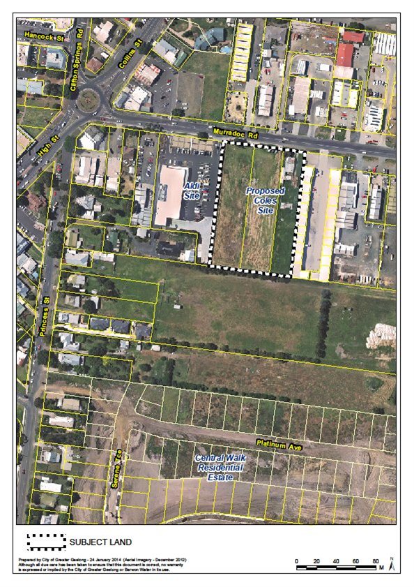
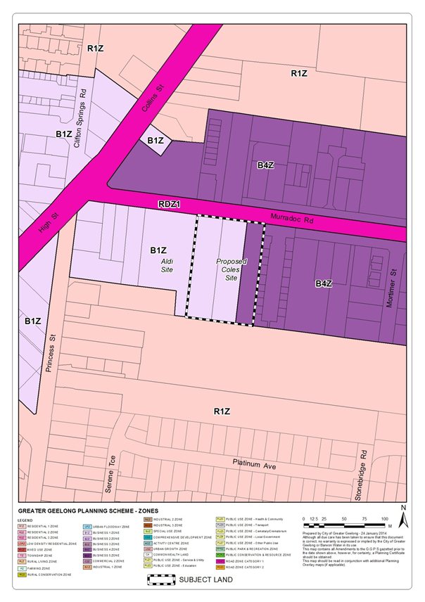
An aerial map of the subject land is shown at Appendix 1 and a current zoning map is shown at Appendix 2. The proposed rezoning map is shown at Appendix 3.
In addition to the buildings and works, the permit is to allow the display of identification signage, a reduction of car parking requirements, the alteration of access to a road in a Road Zone Category 1 and to create a carriageway easement.
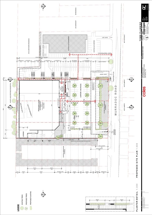
The site plan (Appendix 4) shows that the proposed Coles supermarket, including a Liquorland, will have a total floor area of 3,892 square metres supported by 146 car parking spaces. The car parking layout is integrated with the adjacent ALDI store, as are entry/exit arrangements off Murradoc Road. A 2 metre wide dedicated pedestrian boardwalk is located parallel to the supermarket and parking areas to provide direct thru-access from Murradoc Road to the newly developing residential estate to the south. The path will also provide for the conveyance of overland stormwater flows under the boardwalk.
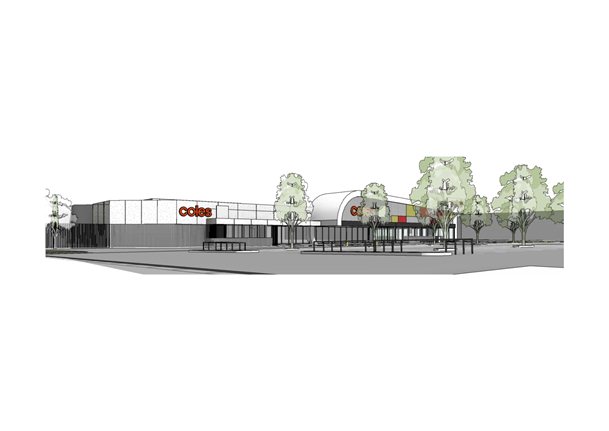
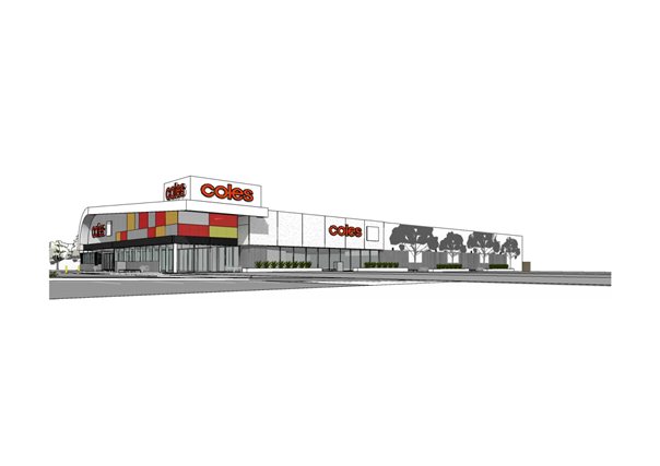
The building is of contemporary design as shown in perspective drawings at Appendix 5.
The rezoning request and permit application was supported by a planning report (ERM), economic impact assessment (MacroPlan Dimasi) and traffic assessment (Cardno) as well as site, development and landscaping plans. Following internal review by various Council departments, a number of changes were made to the plans and the addition of a stormwater management report (Cardno) was submitted in November 2013.
The application lodged in June 2013 followed a number of meetings between Council officers and representatives of Coles about the preferred design and layout for the supermarket.
Strategic planning merits
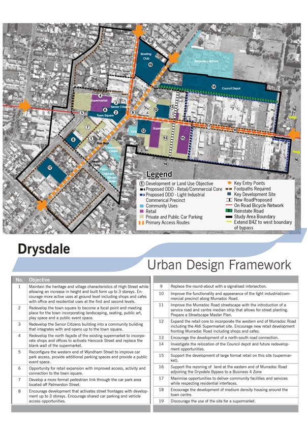
In August 2012 Council adopted the Drysdale Urban Design Framework (UDF). The framework seeks to improve the functionality of the Drysdale Town Centre by providing guidance on future growth and development, built form, streetscapes, traffic and pedestrian movements, car parking and land use.
Planning Scheme Amendment C283 to implement the key recommendations of the Drysdale UDF was recently on exhibition. The overall framework plan is shown at Appendix 6. The plan identifies the subject land for retail, with objective No. 15 stating “Support the development of large format retail on this site (supermarket)”.
Added to this is the fact that two-thirds of the subject land is currently zoned Commercial 1 Zone (C1Z). The purpose of the C1Z is to create vibrant mixed use commercial centres for retail, office, business, entertainment and community uses. The use of the land for a supermarket in the C1Z is an ‘as-of-right’ use in the Greater Geelong Planning Scheme. The remainder of the subject land (to be rezoned) is a natural extension and end-point to the C1Z.
In this context, the proposal has overwhelming policy support. The Coles supermarket will consolidate the role of the Drysdale Town Centre and is consistent with the City’s retail strategy and activity centre hierarchy. The development will assist in the ongoing revitalisation of Murradoc Road within the core business district and “book-end” the convenience retail options for shoppers.
There are however concerns about the timing of the proposal in relation to the recently approved Jetty Road Neighbourhood Activity Centre (NAC). The Drysdale UDF Part B. (Background Report) notes that: “The immediate demand for an alternative supermarket has now been met by the development of the Aldi supermarket along Murradoc Road and the approval of a new full line supermarket within the Jetty Road Growth area. However in the long term (10+ years) as the population of Drysdale and the surrounding catchment grows there is likely to be demand for a fourth supermarket”.
A planning permit was issued on 22 January 2013 to develop land at 148-166 Jetty Road, Drysdale for a 3,200 sq metre supermarket and eleven specialty shops. The land is owned by Woolworths and Council officers have been advised that construction will commence in May/June 2014 and the anticipated opening date for the supermarket is April/May 2015.
The planning report submitted in support of the Jetty Road NAC outlined the extensive planning history of the Jetty Road Growth Area, commencing with Council adopting the Jetty Road Urban Growth Plan in June 2007. The growth area will ultimately accommodate a population of more than 8,000 people. The plan was implemented into the Greater Geelong Planning Scheme via Amendment C129 and then Amendment C188 further rezoned land to the Business 1 Zone for a NAC with provision for 6,000 sq metres of retail floor space. The NAC land was subsequently subject to a master planning phase, which was approved by Council in July 2011.
Irrespective of the policy arguments for and against the early establishment of the Jetty Road NAC, the fact remains that there is a valid planning permit allowing the buildings and works to construct a supermarket, with construction imminent.
What is relevant is the consideration of the economic impacts of the proposed Coles supermarket on the Drysdale Town Centre and other affected centres – primarily the Jetty Road NAC, and contribution to net community benefit.
Economic impact assessment
An economic impact assessment was submitted in support of the amendment request, dated February 2013 and prepared by MacroPlan Dimasi. The assessment identified the main trading area as the northern half of the Bellarine, including the townships of Drysdale, Clifton Springs, Portarlington, St Leonards and Indented Head.
The MacroPlan Dimasi assessment concludes that the economic and social benefits that are likely to arise from the proposed Coles Drysdale significantly outweigh any impacts that may occur to commercial competitors.
The assessment however failed to properly consider impacts on the nearby Jetty Road NAC, which includes a 3,200 sq metre Woolworths supermarket with construction to commence this year. The assessment stated: “Whilst there is a supermarket proposed to establish within this growth area over time, on current development patterns a supermarket anchored centre in this growth area is some time off. A major supermarket generally requires around 3,000 households before it is developed. With the current growth rate of the Jetty Road growth area it may be at least 10 years until the Jetty Road area has sufficient residents to establish its own supermarket anchored centre”.
Clause 22.03 of Council’s Municipal Strategic Statement provides assessment criteria for retail planning applications. It is policy that an economic impact assessment provides an assessment of any likely impact on existing or planned (i.e. approved) retail facilities.
In response to officer concerns about the proposed timing of the Coles application, an independent review of the MacroPlan Dimasi assessment and Clause 22.03 was commissioned from Mr Tim Nott. Mr Nott specialises in economic analysis and strategy and is familiar with retail economics on the Bellarine, having provided Council with advice on structure planning including preparation of the Drysdale Clifton Springs Structure Plan.
The review clearly demonstrates that if the two supermarkets are developed as planned, the food and grocery segment throughout the trade area is likely to experience a very low level of turnover. Mr Nott finds that there is likely to be room for two supermarkets by the mid-2020s, in line with expected population growth.
In his summary, Mr Nott states that:
I have prepared an alternative impact assessment in this report. I have assumed that the Jetty Road NAC and the proposed Coles development would have their first full year of operation in 2016 and I have provided detail about the likely impact on individual centres in the local and regional network.
The present retail supply and demand situation in the Drysdale trade area indicates that there is now demand for a new full line supermarket. This would be satisfied to a very large extent by the planned NAC at Jetty Road. The planned Woolworths supermarket at Jetty Road, at 3,200 square metres, would be the largest supermarket in the trade area (without the proposed Coles development). The developers anticipate that this supermarket will open in mid-2015. Because the Jetty Road Growth Area is far from fully established, in order to be viable, the supermarket would need to serve the whole of the Drysdale trade area, effectively competing at the same level as the Drysdale town centre.
If both the Coles development and the Jetty Road NAC were opened at around the same time, the food and grocery segment in the Drysdale trade area would suffer from very low sales per square metre by comparison with typical levels for major supermarkets. This would be likely to cause significant reorganisation of retail space in the trade area, with potential closures of food and grocery stores, particularly in Drysdale.
The Coles proposal does not appear likely to challenge the role of existing centres in the trade area or elsewhere. The proposal will affect retail sales in surrounding centres, particularly Portarlington, Leopold and St Leonards. However, I estimate that in each case the loss of sales would be less than 5% of total sales, which is well within the 10%-15% loss that is usually considered significant.
The impact of the Coles proposal on existing food and grocery facilities in Drysdale itself would be severe with potential for a loss of 35% in sales (and 22% of retail sales for the centre as a whole). However, including the Coles development as part of the mix, the retail sales in the centre would rise from $64 million per year to $89 million. The role of Drysdale as a large town centre would be maintained even though there may be some individual store closures.
I estimate that the Jetty Road NAC would suffer a loss of around 16% in total retail sales compared with what is currently anticipated. This is significant and could mean that the investment as currently planned would not proceed.
In my view the net gain in ongoing jobs as a result of the Coles proposal would be around 15, with total full time equivalent jobs of 134. The remaining jobs would effectively be transferred from other food and grocery providers in the district.
To mitigate the impact of the Coles development, it may be possible to stage the growth of the activity centre serving the Jetty Road Growth Area, starting with a local centre and developing a supermarket facility in increments to match the growing neighbourhood demand. This would at least provide some service for Jetty Road residents.
The retail assessment presented here updates that provided for the Drysdale Clifton Springs Structure Plan in 2008. However, the two are broadly consistent; that is, there is only sufficient demand for one additional full-line supermarket in the Drysdale trade area in the short to medium term.
Mt Nott provides an estimate of the impact on existing retail centres, noting the impact will be felt most by the centres that have large food and grocery offerings and which are closest to Drysdale.
The findings are presented on the following table:
|
Centre
|
Sales at existing centres without Coles development $m |
Share of sales at Coles Drysdale that would otherwise have gone to this centre % |
Change of sales at each centre $m |
Sales to existing retailers with Coles development
|
Proportional impact on total retail sales of centre % |
Notional transfer of eft jobs to Coles development no. |
|
Drysdale |
$64.3 |
37% |
-$13.9 |
$50.4 |
-22% |
-50 |
|
Jetty Road NAC |
$38.8 |
17% |
-$6.3 |
$32.4 |
-16% |
-23 |
|
Portarlington |
$35.8 |
2% |
-$0.7 |
$35.0 |
-2% |
-3 |
|
St Leonards |
$15.0 |
1% |
-$0.3 |
$14.8 |
-2% |
-1 |
|
Leopold |
$138.5 |
16% |
-$6.0 |
$132.5 |
-4% |
-21 |
|
Newcomb |
$135.8 |
7% |
-$2.5 |
$133.3 |
-2% |
-9 |
|
Geelong City Centre |
$646.4 |
7% |
-$2.7 |
$643.7 |
0% |
-10 |
|
Belmont |
$107.6 |
2% |
-$0.8 |
$106.8 |
-1% |
-3 |
|
Waurn Ponds |
$285.7 |
4% |
-$1.6 |
$284.1 |
-1% |
-6 |
|
Other Geelong |
|
7% |
-$2.6 |
|
|
-9 |
|
Total |
|
100% |
-$37.5 |
|
|
-134 |
The review also outlines the net community benefits of the Coles proposal as follows:
“The Coles proposal will reduce the level of escape spending from the Drysdale trade area, meaning that local residents will not have to travel so far, so often for their shopping. This will result in travel time savings, reduce energy use and create more local jobs. However, most of these benefits would be achieved by the planned expansion of retail floor space at Jetty Road.
The proposed Coles development will improve the level of competition in the local food and grocery sector since there is presently no Coles within the trade area (although there is a Coles at Leopold nearby).
The proposed development would strengthen the Drysdale town centre, making that centre more attractive to shoppers and reinforcing the hierarchy of centres in the trade area.
Should the Jetty Road NAC be significantly delayed (because, for example, the investors feel that the NAC is not in a good location to attract a substantial share of its trade from beyond the growth area) then the Coles development would satisfy the demand that is undoubtedly present and growing.”
Ultimately the review finds that with the addition of the Coles, the Drysdale commercial centre as a whole would expand its sales from a notional $64 million to $89 million in 2016, although this may result in the closure of other food and grocery traders. Council officers note that the only independent ‘fruit and vegetable’ retailer in town closed some 12 months ago, while other small traders – two convenience stores, a bakery and a boutique butcher, offer a very limited range of products.
To the extent that existing operators are “overtrading” (namely the Woolworths on Wyndham Street and possibly the ALDI store), Mr Nott says that a reduction in the extra sales would be offset by a benefit from the introduction of more competition and greater choice in the local market, particularly in the food and grocery sector.
Mr Nott finds that the trading impact on Jetty Road would be entirely negative – suggesting the Coles development is in a better position to capture the spending of the trade area because of its more central location and larger size. Council officers however consider the Jetty Road NAC to be easily accessible with less vehicle congestion, offering an attractive alternative to residents in Clifton Springs and parts of Drysdale in particular.
The prospect of the Jetty Road NAC effectively competing at the same level as the Drysdale Town Centre, inclusive of the largest supermarket in the trade area (should the Coles not go ahead), is also likely to have negative impacts to town centre traders.
Therefore the net community benefit of the proposed Coles supermarket in strengthening the role of the Town Centre is considered to outweigh the short to medium term negative impacts on the Jetty Road NAC.
Mr Nott’s review has been passed on to Coles so that MacroPlan Dimasi can revise their original economic impact assessment as part of the exhibition documents for Amendment C297.
Jetty Road Activity Centre Proprietors
On 20 February 2014 Council received an email from John Cicero of Best Hooper Solicitors, acting on behalf of the registered proprietors of land comprising the Bayview Activity Centre (i.e. the Jetty Road NAC). The email confirms that the first stage of the Activity Centre is scheduled to commence in March 2014 and comprises of a full line supermarket of 3,200 sq metres plus 11 specialty shops.
Best Hooper has reviewed the economic impact assessment from MacroPlan Dimasi and Mr Nott’s independent review. Best Hooper submits that the Council should not proceed with the Amendment. A copy of the email is shown in Appendix 7.
Council officers do not support the abandonment of the Amendment. Officers consider the Amendment should proceed to exhibition to allow any interested party an opportunity to make a submission – and have that submission considered by Council and potentially an Independent Planning Panel.
Built form and design
As noted above, there were several discussions between representatives of Coles and Council officers prior to the lodging of the application in June 2013. The design has been further revised post-lodgement.
The permit application (765/2013) is for buildings and works to construct a supermarket, the display of identification signage, a reduction of car parking requirements, the alteration of access to a road in a Road Zone Category 1 and to create a carriageway easement.
The design is considered to be generally in accordance with the adopted Drysdale UDF August 2012. The UDF (Part A) includes guidelines for the ‘Business Corridor’ along Murradoc Road – which includes the subject land. Key objectives and guidelines relevant to the site include to setback buildings a minimum of 12 metres from Murradoc Road to allow for future road widening and to encourage the development of a full line supermarket along Murradoc Road close to the town centre core.
The proposed design incorporates the following features:
The construction of a full line Coles branded supermarket of 3,892 square metres inclusive of a Liquorland.
An integrated car parking layout and access arrangements with the adjoining ALDI store, including the creation of a carriageway easement.
A dedicated north-south 2 metre wide unencumbered boardwalk to provide convenient pedestrian and cycle access from Murradoc Road, through the Coles site, to the newly developing residential estate to the rear.
A contemporary building design achieving a maximum height of 8.96 metres with clear glazing and entry façade fronting Murradoc Road and glazing along the western elevation (fronting the pedestrian walkway).
A site stormwater management plan that captures and treats runoff and 100 year ARI overland flows by using a bio-retention lineal treatment system under the boardwalk.
A 12 metre wide open landscaped setback from Murradoc Road consistent with the neighbouring ALDI store and Drysdale UDF guideline.
Sheer concrete eastern boundary wall and loading bay to visually offset the existing industrial warehouse building on the adjoining property to the east and minimise amenity impacts.
Landscaping and lighting to ensure the site provides adequate safety, surveillance and visual amenity.
The proposed design does not include a new north-south road from Murradoc Road to the developing Central Walk residential estate. The Drysdale UDF encourages the development of this connection. Due to the constraints of the site a road (or more realistically – a laneway) was not pursued. It is considered that a safe and attractive pedestrian connection, together with future road connections from the land to the south of the Coles site to Mortimer Street and Princess Street, will similarly improve access opportunities.
The Planning Permit to be prepared for exhibition will include conditions to address issues relating to built form, drainage, lighting, noise, access and car parking, loading, landscaping and signage.
There are no environmental implications as a result of the Amendment.
No impact to budget.
Zone provisions
Two-thirds of the subject land is currently zoned Commercial 1 Zone (C1Z). The purpose of the C1Z is to create vibrant mixed use commercial centres for retail, office, business, entertainment and community uses. The use of the land for a supermarket in the C1Z is an ‘as-of-right’ use in the Greater Geelong Planning Scheme. A permit is required for buildings and works.
The remainder of the land is in the Commercial 2 Zone (C2Z). The purpose of the C2Z includes encouraging commercial areas for offices, appropriate manufacturing and industries, bulky goods retailing, other retail uses, and associated business and commercial services.
The use of the land for a supermarket in the C2Z is considered to be prohibited in the Greater Geelong Planning Scheme. The Section 2 Use condition for a ‘Supermarket’ states: “The leasable floor area must not exceed 1800 square metres if located on land outside an urban growth boundary and in metropolitan Melbourne”.
Unfortunately, the condition is open to misinterpretation and officers have been informed by the Department of Transport, Planning and Local Infrastructure that a forthcoming Ministerial amendment will correct the wording. The intention of the condition is that supermarkets in the C2Z greater than 1800 sq metres are prohibited in non-metro Melbourne planning schemes.
The anomaly in this particular instance however is that while the leasable floor area is greater than 1800 sq metres (3,892 sq metres is proposed), the floor area located on land zoned C2Z is under 1800 sq metres. It is considered the intention of the condition is to prohibit supermarkets greater than 1800 sq metres irrespective of whether the building is in two zones.
A permit is also required for buildings and works in the C2Z.
Regardless of the interpretation of the C2Z, an amendment to rezone 32 Murradoc Road to the C1Z, combined with a permit to construct the Coles supermarket, most appropriately meets the objective of the Planning and Environment Act to provide for the fair, orderly, economic and sustainable use, and development of land.
Clause 21.07 Economic Development
The strategy notes that the City of Greater Geelong Retail Activity Centre Hierarchy has been established to articulate the role and function fulfilled by centres of different sizes. A key objective is to facilitate the development of vibrant and viable retail activity centres in accordance with the retail hierarchy.
The proposed Coles supermarket will strengthen the role and function of the Drysdale Town Centre. Town Centres are identified in the Hierarchy as the focus for convenience shopping and community facilities serving the surrounding township and rural hinterland. Neighbourhood centres play an important role in providing for the regular shopping needs of residents of their respective surrounding catchments.
Clause 21.14 The Bellarine Peninsula
Drysdale/Clifton Springs is recognised as a hub for development and service provision on the Bellarine. One of the strategies for Drysdale/Clifton Springs is to reinforce the Drysdale Town Centre as the primary retail centre including the development of an additional supermarket. The clause, under ‘further work’, identifies the bowling club site for a supermarket however this location was not considered suitable in the Drysdale Urban Design Framework 2012.
Another strategy is to support the development of the Jetty Road Urban Growth Area. A number of stages for residential subdivision have been approved and constructed or are under construction. Likewise, land has been rezoned to the Commercial 1 Zone for a neighbourhood activity centre.
Clause 22.03 Assessment Criteria For Retail Planning Applications
This local policy sets out retail assessment criteria which are to be used as a basis for considering applications for new or expanded retail floor space. The information submitted to support the Amendment and Permit, particularly with an updated economic impact assessment that captures the Jetty Road NAC, is considered appropriate.
The Amendment supports the ‘Growing our Economy’ strategic direction of City Plan, subject to a comprehensive assessment of the economic impacts and contribution to net community benefit and consideration of submissions from affected parties.
In accordance with Section 80C of the Local Government Act Peter Bettess, General Manager, Planning and Tourism, declares an indirect financial interest in that he owns Woolworths and Wesfarmers shares.
There are no notable risks associated with implementing the recommendation contained in this report.
The proposed Coles supermarket is considered to result in a net community benefit by improving retail competition – particularly in the fresh food and groceries sector, reducing escape expenditure and securing additional employment opportunities for local residents.
The Amendment will not impact on any basic rights, freedoms and responsibilities as set out in the Charter. Planning legislation ensures an open community consultation process occurs, enabling people to freely express their views and if necessary obtain a fair hearing before an Independent Panel.
The Amendment will be exhibited in accordance with the notice provisions of the Planning and Environment Act 1987.
Dear Sir/Madam,
We act on behalf of Dalgo Pty Ltd and Libnom Pty Ltd which companies are the registered proprietors of the land comprising the Bayview Activity Centre (“the Activity Centre”).
The first stage of this Activity Centre is to comprise of a full line supermarket of 3200m2 plus, 11 speciality shops comprising approximately 1244m2.
Construction of the first stage of the Activity Centre is scheduled to commence in March 2014.
We understand that Council will, at its meeting, most likely to occur, on 8 April 2014, consider a request to seek authorisation for Amendment C297 to the Greater Geelong Planning Scheme (“the Amendment”) and to exhibit the Amendment, assuming that authorisation is granted. As we understand it, the Amendment is required to facilitate the development of a full line Coles Supermarket on land adjoining the existing ALDI Store in Drysdale (“the Coles site”).
We have been provided with documentation in relation to the Amendment, including an economic impact assessment report from MacroPlan Dimasi (“Macro Plan”). We have also been provided with a copy of a report, commissioned by the Council, from Tim Nott, to review the matter generally and to make specific comment on the economic impact assessment of Marco Plan.
Our reading of Mr Nott’s report would support the proposition that Council should not resolve to proceed with the Amendment which our clients oppose. We have set out below a summary of the grounds upon which our clients rely in support of their position.
There is no evidence that has been submitted which make the case for the need for a supermarket at the Coles site in the short to medium term. Mr Nott’s assessment confirms that this.
Indeed, past analysis on the need of the fourth supermarket in Drysdale (allowing for the supermarket proposed at the Activity Centre) does not identify a need for any such supermarket until sometime after 2024.
The economic impact statement that accompanied the rezoning request and application for planning permit is fundamentally flawed as it proceeds on the basis that there will be no supermarket in the Activity Centre for at least 10 years. Accordingly, the economic impact assessment report filed in support of the application cannot be relied upon. Again, Mr Nott’s assessment supports this submission.
If a proper analysis were done the economic impact upon other trade area retailers would be at a level which would be deemed to be unacceptable. Again, the unacceptability of the economic impact is confirmed by Mr Nott.
Our clients have provided to the Council a preliminary assessment by Mr Ian Schimmin of Urbis, which supports the above submission.
A substantial investment has been made by the community in the Jetty Road Growth Area. That significant amount of investment has been predicated on assumptions including that a supermarket would be able to be established within the Activity Centre without the economic impact that would be occasioned if a third supermarket in the Drysdale Township was permitted prematurely. Such decisions have been made on the basis of strategic planning that has occurred to date and it would be contrary to that strategic planning to allow a fourth supermarket as proposed by Amendment C297 at this stage.
Traffic and Connectivity
The UDF provides strong guidance in relation to the future development of the Coles site, including the provision of a new north-south road connection.
In the plans submitted with the rezoning request, no such connection has been provided, which, it is submitted, will undermine the outcome sought under the UDF.
The north-south road between Murradoc Road and the Central Walk Estate is to provide an appropriate pedestrian and vehicle connectivity for residents within that estate and further to the south.
The absence of this road has also resulted in car parking being located primarily to the front of the Coles site, instead of within the site as, it is submitted, is intended by the UDF.
The Coles site has poor pedestrian connectivity with the existing Town Centre, and until substantial improvements are made to that connectivity, including the roundabout at the intersection of High and Murradoc Roads, this poor pedestrian connectivity will continue.
There is nothing in the application for permit that addresses the issue of connectivity to the existing Town Centre.
Car parking
No case has been made for requiring a lesser provision of car parking spaces than the statutory rate of 5 spaces per 100m2.
Urban Design
The UDF provides strong guidance for the future development of the Coles site, including locating car parking to the side or rear of the development, active frontages and perimeter block development.
The layout of the proposed supermarket fails in each of these respects.
The introduction of a new north-south road between Murradoc and the Central Walk Estate would at least advance those objectives by allowing the supermarket building to be moved closer to Murradoc Road and provide an active frontage with specialty retail shops and by locating a car park along the western side of the Coles site adjacent to the new road.
Our clients’ submit that the Council should not be proceeding with the Amendment.
Regards
John Cicero
Principal
Sent by:
Jessica Farrugia
Legal Secretary
On behalf of John Cicero, Principal
563 Little Lonsdale Street, Melbourne VIC 3000
Portfolio: |
Planning – Cr Heagney |
Source |
Planning & Tourism |
General Manager: |
Peter Bettess |
Index Reference |
Armstrong Creek |
This report considers the Independent Panel Report to Greater Geelong Planning Scheme - Amendment C267 and recommends adoption of the Amendment.
The amendment applies to land referred to as the Armstrong Creek Town Centre Precinct. The land is approximately 92 hectares and bounded by Boundary Road to the north, Surf Coast Highway to the west, Barwarre Road to the east and Burvilles Road to the south.
The amendment proposes changes to the Greater Geelong Planning Scheme to facilitate development of the Armstrong Creek Town Centre. These changes include a new schedule to the Urban Growth Zone and incorporation of a Precinct Structure Plan which provides explicit planning direction, urban design and sustainability guidelines, a Development Contributions Plan and Native Vegetation Precinct Plan to guide future development.
Public exhibition of Amendment C267 commenced on 6th June 2013 and concluded on the 8th July 2013.
A total of 23 submissions were received to the exhibited amendment. These submissions were from landowners within the precinct, parties with an interest in the precinct, landowners from adjacent precincts, other individuals and government agencies.
The issues raised in submissions included infrastructure planning, specific requests for further discretion in the planning controls and the Sustainability and Design Guidelines, changes to the Development Contributions Plan, modification to the planned local traffic network, drainage / stormwater management both internal and external to the precinct, and other requests for modification to the exhibited amendment package.
Council resolved on 27 August 2013 to refer the submissions to an Independent Planning Panel appointed by the Minister for Planning.
An Independent Panel was appointed to consider submissions. A Panel hearing was held between 6 – 15 November 2013, with a Report completed and provided to Council on the 17 January 2014. Council was represented at Panel by Maddocks Lawyers.
The Panel report was released to the general public by Planning Panels Victoria on 17 February 2014.
The Panel concluded that the Amendment has strong strategic planning justification. The Panel made findings about design and development, retailing, transport and movement, native vegetation and greenways, development contributions and other general matters. In total the Panel made 21 recommendations requesting specific modifications to the Amendment.
The Panel Report supports a range of Council directions, however it does detail a number of recommendations that are strongly disputed. These include, but are not limit to:
Removal of retail (shop) floor space caps from the schedule to the Commercial 1 Zone.
Allowance of a right turn access point from Surf Coast Highway in and out of Parking Street B.
Deletion of the Transit Corridor from the Development Contributions Plan (DCP).
Nomination of the transit corridor as an investigation area with an applied zoning of Farm Zone (FZ).
Relegation of all mandatory provision within the Precinct Structure Plan (PSP) to discretionary.
Council officers recommend that Amendment 267 be adopted as outlined in this report.
Cr Richards moved, Cr Farrell seconded -
That Council having considered the Independent Panel Report to Amendment C267 to the Greater Geelong Planning Scheme, resolves to:
adopt Amendment C267 in the form as outlined in Appendix 5 of this report;
submit the adopted Amendment with the prescribed information to the Minister for Planning requesting approval.
Procedural Motion:
Cr Heagney moved, Cr Ansett seconded -
That the report be deferred.
Carried.
Division Requested:
For: Crs Ansett, S Kontelj, Nelson, Harwood, Macdonald, Heagney, Irvine
Against: Crs Ellis, Fisher, Richards, Farrell
Cr E Kontelj re-entered the meeting room at 8:00pm.
Portfolio: |
Planning - Cr Heagney |
Source: |
Planning & Tourism |
General Manager: |
Peter Bettess |
Index Reference: |
Armstrong Creek |
The purpose of this report is to seek Council’s support for the application of the new zones to development within the Armstrong Creek Urban Growth Area.
This report is to recommend that Council request the Minister for Planning act as planning authority and prepare and finalise Amendment C310 to the Greater Geelong Planning Scheme.
This amendment applies to the Armstrong Creek Urban Growth Area and, more particularly, the Precinct Structure Plan areas known as the North East Industrial Precinct (NEIP), Armstrong Creek East Precinct (ACEP) and Armstrong Creek West Precinct (ACWP).
The amendment introduces the new Residential and Commercial zones in accordance with the requirements of Planning Scheme Amendments VC100 and VC8.
Amendment C310 proposes a direct translation of the existing zones as they apply to the Armstrong Creek Urban Growth Area.
The Amendment requires the updating of three (3) Schedules to the Urban Growth Zone, that nominate applied zones for these precincts, and the insertion of Schedule 3 to the General Residential Zone
It is proposed that the Minister for Planning will be the Planning Authority for the amendment and approve the amendment under Section 20(4) of the Planning and Environment Act 1987.
It is recommended that Council support the proposal and the Minister for Planning as the Planning Authority.
Cr Heagney moved Cr Richards seconded -
That Council resolve to:
Support the application of the zones to the Armstrong Creek Urban Growth Area
Request the Minister for Planning act as the planning authority for Amendment C310 to the Greater Geelong Planning Scheme and to approve the amendment under Section 20(4) of the Planning and Environment Act 1997.
Carried.
On the 1st July 2013, the Minister for Planning introduced a suite of new planning zones along with the mandate that Council’s introduce the new zones into their respective planning schemes within 12 months.
To enable this, Victorian Council’s have been required to review their existing policies and strategic work, or undertake significant additional work, to inform decisions about the way the zones would be applied.
For the purposes of new zones, the City of Greater Geelong took an approach that excluded the easily defined urban growth area of Armstrong Creek from the larger body of strategic work that has been required to facilitate the introduction of the new zones across a municipality as large and diverse in its land-uses as the City of Greater Geelong.
As a result, this amendment focuses only on the application of the zones within the Armstrong Creek Urban Growth Area.
The amendment represents a ‘direct translation’ between existing and new zones and looks to introduce the following:
General Residential Zone (GRZ) as a replacement for the Residential 1 Zone,
Commercial 1 Zone (C1Z) as a replacement for the Business 1 Zone and,
Commercial 2 Zone (C2Z) as a replacement for the Business 4 Zone.
As noted above, Amendment C310 to the Greater Geelong Planning Scheme seeks to translate the new zone provisions into the Armstrong Creek Urban Growth Area (ACUGA) only.
The ACUGA has clearly defined planning principles including density requirements. These principles, which are implemented through the Precinct Structure Plans, mandate a mix of housing densities throughout the growth area thereby ensuring that the state defined minimum, of 15 dwellings per hectare, is achieved.
For the purposes of implementation of the zones, the need to separate the Armstrong Creek Urban Growth Area from the balance of the municipality is borne of the differences in the planning scheme implementation of Precinct Structure Plans.
A Precinct Structure Plan (PSP) is the key document that guides the structure of all new urban development within nominated growth areas. The PSP provides detail on land uses and nominates the location of key community infrastructure such as active and passive recreation, education and community facilities and retail centres.
The PSP is enabled through the application of ‘applied zones’ in the schedules to the Precinct Structure Plans. This means that the entire ACUGA is zoned Urban Growth Zone (UGZ) with development proceeding upon incorporation of a PSP into the Planning Scheme.
Once a PSP is incorporated into the planning scheme planning permits can be issued without the requirement for advertising as long as the application is considered by Council to be ‘generally in accordance’ with the outcomes nominated in the PSP.
As a result, the primary benefit of a PSP is that it gives certainty and confidence to Council, developers, investors and the community regarding development expectations.
The Metropolitan Planning Authority (MPA) facilitated a Ministerial Amendment for each of the metropolitan growth area Council’s to apply the new zones. Whilst the MPA is not a component of urban growth area planning within Geelong, it is considered that this approach is appropriate for the application of this amendment.
Attached at Appendix 1 are the proposed modifications to the relevant Schedules.
The amendment is generally policy neutral and does not propose any changes to the Precinct Structure Plans currently incorporated in the Greater Geelong Planning Scheme. Environmental issues were considered by Council during the preparation and incorporation of the Armstrong Creek East, Armstrong Creek North East Industrial and Armstrong Creek West Precinct Structure Plans.
There are no financial implications directly related to this amendment.
No impact to budget.
The amendment makes proper use of the Victoria Planning Provisions by updating the relevant schedules to the Urban Growth Zone and General Residential Zone to reflect the new zones.
The Armstrong Creek Growth Area is nominated as a funding priority in the 2013-2017 City Plan. The amendment does not seek to modify any provisions in the Greater Geelong Planning Scheme that would result in modification to Council’s intention to deliver a well planned and well resourced community within Armstrong Creek.
In accordance with Section 80C of the Local Government Act no Council officers involved in this amendment have a direct or indirect interest.
The translation of the new zones into the relevant Precinct Structure Plan schedules within the Armstrong Creek Urban Growth Area does not represent any major risk to Council.
The new zones will allow Council to continue to implement the vision for the Armstrong Creek community with regard to provision of services and infrastructure that are required to meet their needs.
Officers have taken into consideration the Human Rights Charter relative to the subject matter of this report.
This report is seeking Council approval of the Minister for Planning as the planning authority for this amendment. The Minister for Planning will determine any communication requirements for this amendment.
Portfolio: |
Planning - Cr Heagney |
Source: |
Planning & Tourism |
|
General Manager: |
Peter Bettess |
Index Reference: |
C259 - Armstrong Creek Horseshoe Bend |
The public exhibition period for Amendment C259 concluded on January 17 2014 with a total of 42 submissions received. The purpose of this report is to present a summary of the issues raised in submissions and seek a Council Resolution to request that the Minister for Planning appoint an independent Panel.
This report considers submissions to Greater Geelong Planning Scheme – Amendment C259 Horseshoe Bend Precinct Structure Plan.
The amendment has been initiated by Council.
The amendment seeks to incorporate the Horseshoe Bend Precinct Structure Plan, Horseshoe Bend Development Contributions Plan and Horseshoe Bend Native Vegetation Precinct Structure Plan into the Greater Geelong Planning Scheme. The Horseshoe Bend Urban Structure Plan is included at Appendix 1 of this report.
The amendment was exhibited between 5 December 2013 and 17 January 2014.
A total of 42 submissions to the amendment were received. A summary of submissions, and Council officer responses, is included at Appendix 2 of this report.
These submissions cover a broad array of issues, of both a major and minor nature. The significant issues have been discussed in some detail within this report and include, but are not limited to:
Housing Density
Powercor sub-station location
Application of Public Acquisition Overlay for proposed Sparrovale wetlands, Powercor sub-station and transit corridor
Barwon Water Sewer easement
Development Contributions
Sparrovale wetlands implementation costs
Greenways
In accordance with the Planning & Environment Act 1987, Council must either modify the Amendment documents in accordance with submissions, refer submissions to an independent Panel appointed by the Minister for Planning or abandon the amendment as a whole, or in part.
Council officers have met with submitters and have not been able to resolve all submissions. As a result, it is recommended that Council request the Minister for Planning appoint an independent Panel to hear submissions and that Council refer all submissions to the Panel for review and consideration.
Cr Heagney moved, Cr Richards, seconded -
That Council, having considered all submissions to Amendment C259, resolves to:
Request the Minister for Planning appoint an independent Panel under Part 8 of the Planning & Environment Act 1987 to consider submissions relating to the Amendment;
Refer all submissions to the Panel; and,
Submit to the Panel its response to the submissions as outlined in this report and in Appendix 2 – Summary and Consideration of Submissions.
Carried.
The Horseshoe Bend Precinct Structure Plan has been prepared by St Quentin Consulting on behalf of the Horseshoe Bend landholders group. The Horseshoe Bend Precinct is the fifth of seven precincts that make up the Armstrong Creek Urban Growth Area (ACUGA). To date, Council has incorporated three precincts into the Greater Geelong Planning Scheme – Armstrong Creek East, North East Industrial Precinct and Armstrong Creek West.
The fourth precinct, the Armstrong Creek Town Centre (ACTC), is currently the subject of a Panel Report with the intention to incorporate the document into the Greater Geelong Planning Scheme towards the end of 2014.
The Horseshoe Bend Precinct is the largest residential precinct within the ACUGA and applies to 88 properties ranging in size from .024 hectares to 35.63 hectares.
As noted above, a total of 42 submissions have been received, with the breakdown of origin as per below:
30 submissions have been received from landholders both within and external to the Horseshoe Bend Precinct Structure Plan area
12 submissions have been received from state government agencies and servicing authorities.
Amendment C259 proposes to incorporate the Horseshoe Bend Precinct Structure Plan, Horseshoe Bend Development Contributions Plan and Horseshoe Bend Native Vegetation Precinct Plan into the Greater Geelong Planning Scheme.
The Horseshoe Bend Precinct Structure Plan details the forward planning that will guide the future urban development of approximately 638 hectares of currently rural land. The precinct is bounded by Reserve Road to the north, an irregular eastern boundary comprising Sparrovale Road, Charlemont Road and Batten Road, Burvilles and Boundary roads to the south and the Surf Coast Highway and Geelong Railway line to the west and north-west.
The Amendment was formally exhibited between 5 December 2013 and 17 January 2014. A total of 42 submissions were received from landholders, developers, servicing authorities and other government and non-government agencies.
A detailed summary of submissions and Council officer’s responses is included in Appendix 2 of this report.
Key issues raised by submissions
Housing Density
A number of the smaller landholders within the PSP area submitted on the issue of the lower housing density nominated for their landholdings. The submitters believe that the reduction in nominated density for their landholdings, from the conventional rate of 15 dwellings per net developable hectare to 12 dwellings per net developable hectare, ultimately makes their land less valuable and less likely to be developed.
In response to these concerns, Council notes that the nomination of 12 dwellings per net developable hectare is a minimum only and the subject of further detailed design when a sub-precinct plan (as required by the PSP) is prepared and endorsed by Council.
In better understanding Councils nomination of 12 dwellings per hectare, it must be noted that the landparcels contained within the sub-precincts are significantly constrained by title size, shape and land-specific encumbrances. Council officers were concerned, during the preparation of the PSP that the ability to achieve the conventional residential density of 15 dwellings per hectare is limited, subject to more detailed site assessment and design than a PSP provides.
Should 15 dwellings per hectare be nominated as a minimum for these parcels there is a very real possibility that the parcels cannot be developed.
Requirement for the Powercor Substation
The requirement for a Powercor substation was identified and endorsed by both Powercor and Council, as a component of the Integrated Infrastructure Delivery Plan (IIDP) for the ACUGA (2009).
The site was located having regard to current and future servicing requirements for the wider Armstrong Creek Urban Growth Area.
A number of submissions request that the PSP be amended to show the proposed Powercor sub-station in an alternate location that is less visually sensitive. In addition, a number of submissions nominate the Geelong Cemetery and Crematorium or a site on the north side of Boundary Road but closer to the Surfcoast Highway as more appropriate for the Powercor facility.
In response, the location of the sub-station has been determined based on Powercor’s network planning and servicing requirements and, as such, relocation of the sub-station significantly compromises cost-effective servicing of the ACUGA.
Application of Public Acquisition Overlay on Sparrovale wetlands, Powercor sub-station site and the transit corridor
The issue of the application of a Public Acquisition Overlay (PAO), rather than funding through the Development Contributions Plan (DCP) or via individual purchase agreements, has been raised in submissions. For the purpose of the discussion, each of the PAO requests are dealt with separately below:
Sparrovale wetlands
The securing of the properties at 1-87 Groves Road, Armstrong Creek and 109-215 Sparrovale Road, Charlemont (more commonly known as the Sparrovale and Cold Winds properties) is necessary to facilitate the stormwater management needs for the Horseshoe Bend Precinct. Whilst the precinct Stormwater Management Plan acknowledges that there is limited development potential possible in advance of the Sparrovale wetland being brought on-line, ultimately the facility is critical to unlocking development of all the urban land within the precinct.
As a result of the nexus between development of the precinct and the wetlands, the purchase of the land is an appropriate item to be included in the Horseshoe Bend Development Contributions Plan. The cost of acquisition will be equally apportioned between all the Horseshoe Bend landholders.
Submitters have requested the application of a PAO across the two properties to facilitate the timely acquisition of this land as nominated in DCP items DI_LA_22 and DI_LA_23.
Council officers believe that the acquisition of the properties, as detailed in the exhibited DCP, is the most appropriate method of securing the land for its role in the management of stormwater in the Horseshoe Bend precinct and does not necessitate the implementation of a PAO.
Powercor sub-station
Despite being raised as a possibility during the preparation of the PSP, relevant officers of Powercor would not agree to the application of a PAO on the sub-station site. It is understood that the acquisition of the site for the Powercor substation will necessitate a private purchase agreement between the landholder and Powercor.
Transit Corridor
Despite the importance of the transit corridor in securing an alignment for a major piece of transport infrastructure through the growth area, there has been no Federal or State Government funding commitment.
A number of submitters have requested the application of a PAO with the State Government nominated as the acquiring authority.
To date, the alignment has been secured through Development Contributions Plans for both the Armstrong Creek East and Armstrong Creek Town Centre (draft) precinct structure plans and similar corridors have also been secured in other DCP’s across metropolitan Melbourne.
The funding of this corridor through the DCP is also supported by the State Governments Development Contributions Guidelines (2003) and the Ministerial Direction on Development Contributions.
Development Contributions - General
A number of submissions raise questions about the type and extent of infrastructure items nominated in the Horseshoe Bend Development Contributions Plan. These items include the athletics facility, indoor recreation centre, regional playground and lawn bowling greens.
Most of the items being questioned in the submissions have been accepted and incorporated as DCP funded infrastructure within existing PSP areas in the ACUGA.
The exception is the Athletics facility, which is unique to this precinct and has been described in detail during past panels as part of the distribution of regional facilities in home-of sites around the growth area. Funding of these facilities is an outcome of their location and the inclusion of the Athletics facilities in the Horseshoe Bend Precinct is simply an outcome of its nominated site on Boundary Road.
Other precincts within the ACUGA have included similar unique facilities for other sporting codes such as, soccer/hockey within the Armstrong Creek West regional active open space and AFL, netball and soccer in the Armstrong Creek East regional active open space. This model has been presented to several Panels confirming the implementation of the ACIIDP and the delivery of critical sporting facilities that service the ACUGA.
Development Contributions – Sparrovale wetlands
Several submitters from the development industry have raised concerns about the Development Contributions Plan, including the capital costs associated with the environmental implementation of the proposed Sparrovale wetlands (referenced in the DCP as project DI_DR_13 – Sparrovale Wetlands – Management Plan and Implementation Works).
The DCP includes the costs of both the engineering works to facilitate the delivery of the wetlands in project DI-RD-12 – Sparrovale Wetlands Construction whilst DI_DR_13 includes the costs associated with transitioning this degraded farm land area into a sustainable wetlands system.
The Sparrovale wetland will be the largest single drainage/environmental asset that has ever been delivered within the Geelong Region and the need to include the project within the DCP for the Horseshoe Bend Precinct is clearly justified and has a direct nexus with the catchment it serves.
The wetlands environmental implementation works are also proposed to be staged over a 10 year period, to reflect the realistic requirements of implementing such a unique and complex environmental system, in parallel with the progressive subdivision development of the Horseshoe Bend Precinct.
Council officers strongly support the inclusion of the project and believe that without these funds, the project would present a significant financial risk to Council associated with the delivery of Sparrovale wetlands project.
Greenways
The greenway concept was developed as a response to a number of areas of native vegetation that were nominated as having high conservation significance, during the earliest planning for the ACUGA, and reinforced during detailed ecological assessment for the PSP. Outside of the Armstrong Creek corridor, some of the best examples of this vegetation were located along existing local roads. The importance of the vegetation was acknowledged via the application of Vegetation Protection Overlays (VPO) in the Greater Geelong Planning Scheme. As a result, every effort was needed to ensure long-term protection of this vegetation in support a of quality urban design outcome.
The vision for the Armstrong Creek Urban Growth Area highlighted the importance of the Greenways concept which has been actively, and successfully, defended by Council. The greenway concept has resulted in the preservation of large areas of remnant native vegetation and will ultimately deliver a high quality pedestrian and cycling network that connects every precinct within the Armstrong Creek Urban Growth Area.
A number of submissions suggest that the greenways are an unfair impost on the development community as a result of the additional costs associated with the construction of a local road that enables the greenways to be closed to vehicular traffic.
Council officers disagree with the submissions and will continue to defend the role of greenways throughout the growth area.
Sewer Easements
There is a disused Barwon Water sewer easement running in a north-south direction on the east side of Barwon Heads Road. A number of submissions questioned why this easement was not shown in the PSP and the area of the easement not removed from the total developable area.
Previous discussions with officers from Barwon Water, during the development of the IIDP, confirmed that the easement, and the infrastructure contained in it, is redundant. Barwon Water agree that, if all risks associated with the easement are accepted by landholders the easement would be relinquished by Barwon Water. Assuming that the pipe infrastructure within the easement can be rendered innocuous the land may be developable.
It is the Council officers position that this land should be nominated as encumbered and any development potential be confirmed during detailed design.
Other items
The summary of issues and responses noted above is a snapshot of a number of issues that have been raised in multiple submissions. A detailed table of submissions and responses is attached at Appendix 2 which will form the basis for Council’s presentation to the Independent Panel. This table contains a summary and response to every issue raised in the 42 submissions Council received by the conclusion of the exhibition phase of the amendment.
This amendment gives effect to the Armstrong Creek Urban Growth Plan. The planning for the Horseshoe Bend Precinct has addressed potential environmental implications of the development including retention of remnant native vegetation, through the incorporation of the Horseshoe Bend Native Vegetation Precinct Plan, and the purchase and development of the Sparrovale wetlands for the purposes of stormwater and environmental management. In addition, the Horseshoe Bend Precinct Structure Plan nominates large areas of passive and active open space for the benefit of the Armstrong Creek community.
The amendment will require the engagement of legal counsel, various expert witnesses and other supporting consultants to represent Council’s interests during the Panel Hearing.
Funds have been allocated in the 2013-2014 budget to fund the external consultants during the Panel Hearing and amendment implementation phase.
The Horseshoe Bend Development Contributions Plan identifies all the capital financial requirements for the provision of infrastructure across the Horseshoe Bend Precinct. The Horseshoe Bend Development Contributions Plan details the specifics of the developer contribution to relevant infrastructure.
Future budget proposal.
With Council responsibility for the management of the DCP there will be decisions required across this precinct and other precincts within the Armstrong Creek Urban Growth Area, regarding managing the income stream from contributions under the DCP and the provision of required infrastructure. These will be matters which will be assessed via a multi-division committee with recommendations coming to Council as part of the annual consideration of the budget.
A limited number of DCP projects will require co-funding by Council, including a multipurpose stadium and minor road and traffic projects. These costs have been identified in Council’s long term financial plan and will be refined (if required) once the DCP has been approved.
The planning scheme amendment to incorporate the Precinct Structure Plan for the Horseshoe Bend precinct into the Greater Geelong Planning Scheme is in accord with the broader structure for the Armstrong Creek Urban growth area as established under Greater Geelong Planning Scheme Amendment C138 – Armstrong Creek Urban Growth Plan. Amendment C170 implemented the rezoning of the entire Armstrong Creek Urban Growth Area from Farming Zone to Urban Growth Zone.
The Horseshoe Bend Precinct Structure Plan and Development Contributions Plan are in line with the Council’s adopted position on the Armstrong Creek Integrated Infrastructure Delivery Plan (IIDP).
The amendment is also considered to meet the relevant requirements of both State Government and Council.
The Armstrong Creek Urban Growth Area is one of Council’s priority projects.
In particular, the Horseshoe Bend Precinct Structure Plan will ensure that the project is continuing the meet the needs of the community and the growth of the economy. In addition, a number of Council’s sustainability principles will also be met.
In accordance with Section 80C of the Local Government Act no Council officers involved in this report have a direct or indirect interest.
Issues raised in submissions are not considered to represent a major risk to the progress of the planning scheme amendment. It is considered that there are no major risks to Council in referring this planning scheme amendment to an Independent Panel for review.
The Horseshoe Bend Precinct Structure Plan will ensure a considered and well planned approach to the development of additional residential communities within the Armstrong Creek Urban Growth Area. It will also ensure, through the application of the DCP, that the infrastructure required to service the community meets their needs and expectations
Officers have taken into consideration the Human Rights Charter relative to the subject matter of this report. This includes ‘ratepayer’s property rights and a right to a fair hearing’
Formal exhibition of Amendment C259 occurred between 5 December 2013 and 17 January 2014 via the following:
Notices sent to affected landholders and occupiers.
Notices published in the Geelong Advertiser and Geelong Independent notifying readers of details of the amendment.
Notice published in the Victorian Government Gazette.
Notices sent to Government Departments and Statutory Authorities.
Notices sent to relevant State Government Ministers in accordance with the requirements of the Planning and Environment Act 1987.
Documents available for viewing at Council Customer Service Centres.
Documents available for viewing on the Council and State Government websites
Portfolio: |
Community Development - Cr Fisher |
Source |
Community Services – Family Services |
General Manager: |
Jenny McMahon |
Index Reference: |
Municipal Early Years Plan |
The purpose of this report is for Council to formally adopt the Municipal Early Years Plan (MEYP) 2013-2017 (see Appendix 1 – previously distributed with briefing papers).
The purpose of the Municipal Early Years 2013-2017 is to provide a clear strategic direction for the City of Geelong to improve the early development, health, and wellbeing of young children over the next four years.
The Municipal Early Years 2013-2017 - ‘A Place for Us’, sets out a range of key objectives and action strategies to address relevant local needs and priorities associated with improving support for young children and families throughout the municipality
The draft Municipal Early Years Plan was released for public consultation from 29 January to 28 February 2014.
During the consultation period, one submission was received which supported the content of the Plan, and no changes were requested.
Cr Fisher moved, Cr Richards seconded -
That Council adopt the Municipal Early Years Plan 2013-2017 and approve for publication.
Cr Macdonald left the meeting room at 8.05pm
Cr Macdonald re-entered the meeting room at 8.06pm
Carried.
The 2013-2017 Municipal Early Years Plan builds on the foundations of Council’s previous plan ‘Communities for Children’ and also related State and Federal Government policy and planning priorities.
The Municipal Early Years Plan is a local area plan designed to provide a strategic direction and framework for the development and coordination of early childhood programs, activities and other local community development processes that impact on children aged from 0 – 8 years.
Council, at its meeting on 28 January 2014, approved the draft Municipal Early Years Plan 2013-2017 to be released for public comment for a period of four weeks. The public comment period closed on 28 February 2014.
Over the past decade, the attention of all Australia’s Governments, Commonwealth, State/territory, and local, has increasingly focused on the importance of young children.
This focus has arisen because of the clear evidence of the profound significance of the early years of a child’s life for their future wellbeing; increases in poor outcomes for some children in key developmental areas and growing inequalities in outcomes among groups of children; impacts on family functioning from social changes and difficulties for children’s and family support services in meeting needs; and the increasing reliance of families on early childhood services to enable parents to participate in the workforce.
Local government across Victoria is acknowledged as the leader in local area early childhood planning. The new Victorian Early Years Strategic Plan 2014-2020 recently released by the Victorian State Government specifically identifies the important role of MEYP’s and the intention to strengthen the status of Municipal Early Years Plans....
“strengthen planning by formalising the status of Municipal Early Years Plans with the Department of Education and Early Childhood Development and the Municipal Association of Victoria, including joint agreement about the role of councils in early childhood service delivery and infrastructure planning.”
The 2013-2017 Municipal Early Years Plan has been developed following consultation with relevant stakeholder groups including children, parents, service providers, and Council officers from across various Council Departments.
The 2013-2017 Municipal Early Years Plan reflects the many changes that have occurred within the broader landscape of local, State and Federal policy and programming since Council’s first MEYP was developed.
The 2013-2017 MEYP has been formulated around six key themes:
Safeguarding the best interests of all young children
Building community
Services working together
Celebrating diversity
Promoting a healthy community
Planning for now and in the future
The six themes align with the four key principles of the UN Convention on the Rights of the Child, the foundations for building a Child Friendly City, and key government and community, policy and program priorities. The Municipal Early Years Plan also aligns with the Council City Plan 2013-2017 and Municipal Health and Wellbeing Plan 2013-2017.
It is expected that key actions and priorities outlined within the plan will become part of departmental business plans and will be reported to Council on an annual basis. It is also anticipated that the plan will be adopted by other community partner organisations in relation to their own strategic planning priorities and directions.
During the public comment period, copies of the draft plan were made available at all City of Greater Geelong Customer Service Centres and via Geelong Australia website.
One submission was received during this period from the Geelong Kindergarten Association, seeking clarifications in response to a number of questions and matters referred to within the content of the draft plan. The matters were subsequently addressed to the satisfaction of the Geelong Kindergarten Association and no changes were requested to the content of the plan.
With the conclusion of the public comment period, it is recommended that Council formally adopt the Municipal Early Years Plan 2013-2017 and approve the plan for publication.
Increasing evidence identifies a wide range of environmental factors influence and directly impact on children’s early development, health and well-being. These factors can have both immediate and cumulative affects on children, with increasing evidence that links children’s health conditions to adverse environmental factors.
Environmental considerations are therefore critical and integral to Council’s MEYP and development of future environmental management strategies and controls.
Any financial implications arising from the Geelong Municipal Early Years Plan will be referred for consideration to future budgets.
The preamble to the Convention on the Rights of the Child (CRC) recognises the family “...as the fundamental group of society and the natural environment for the growth and well-being of all its members and particularly children, should be afforded the necessary protection and assistance so that it can fully assume its responsibilities in the community”.
The CRC also recognises that the role of parents is not one to be carried out solely as an individual responsibility, and requires governments to take all appropriate measures to ”... render appropriate assistance to parents and legal guardians in the performance of their child-rearing responsibilities”.
The development of the Municipal Early Years Plan is not a statutory requirement. However, the MEYP is intended to be closely integrated with the corporate planning processes of Local Government.
Local government’s planning role is legislated in the Local Government Act (1989), Planning and Environment Act (1987) and the Health Act (1958). Corporate Plans, Municipal Public Health Plans, and the Municipal Strategic Statement are required by statute. Early childhood development clearly fits within a social health framework and therefore it is intended that the MEYP is closely integrated with Council’s Municipal Public Health Plan.
There are strong policy and potential funding implications associated with the creation of a MEYP for Geelong. Increasingly Victorian State Government funding initiatives for early childhood support are being integrated with key priorities identified within local government Municipal Early Years Plans.
The endorsement of the MEYP therefore strengthens Council’s position to potentially attract additional funding and resources for the future, along with establishing a cohesive planning and policy framework for further development and planning of early children’s services.
The development of a new MEYP has been identified as a key strategic priority within Council’s City Plan 2013-2017. The MEYP is also acknowledged as an important strategic planning and policy framework by both State and Federal Governments.
The 2013-2017 MEYP also aligns closely with the following Council policy and planning frameworks:
Community Consultation Policy
Municipal Public Health and Wellbeing Plan 2013-2017
Multicultural Action Plan 2011-2014
Disability Action Plan 2009 -2013
Karreenga Aboriginal Action Plan 2012 - 2015
No officer involved in the preparation of this report has any direct or indirect interest relative to the advice provided in the report.
Council has a shared responsibility with the Victorian State and Australian Governments to ensure that locally accessible family and children’s services are provided which support families in the care, protection, development and well being of young children.
Early childhood research clearly indicates that the quality of service provision is integral to ensuring positive outcomes for children. Where children are subject to a range of risk factors that are not addressed through the provision of appropriate support and intervention, the subsequent impact on their health, development and quality of life can have significant, long-term costs that are detrimental to individuals, families and the community as a whole.
Development of the MEYP has identified a wide range of critical challenges in strengthening local support for children and families especially in relation to improving outcomes for vulnerable children and providing affordable and accessible support for parents and families.
The MEYP provides a coherent framework within which the various issues, challenges and potential risks for children, families and local service providers can be progressively addressed and mitigated.
Failure to endorse and implement the MEYP will perpetuate current service fragmentation, disadvantage opportunities to attract additional funding and resources, and reduce the capacity of the local community to adequately and effectively support children and families.
The provision of strong and effective support to children and families in the early years of children’s development and family formation is widely recognised as having significant positive benefits and implications for children, families, and the community.
Evidence clearly indicates that preventative support and intervention in the early stages of child development and family formation can significantly reduce the incidence of more complex problems arising in the later stages of children’s lives. The provision of effective support to families with young children inevitably has broader social benefits in contributing to strengthening the capacity of local communities.
The results from the 2012 Australian Early Development Index Project (AEDI) indicate that while most children throughout Geelong are performing well against the developmental indicators, 18.8 per cent of children are performing poorly and identified as vulnerable or at significant risk on one or more of the development domains. In some Geelong communities the rate of vulnerability is as high as 49 per cent or over twice the national average.
Consequently, continuing focus on improving support to strengthen the outcomes for young children is warranted.
The 2013-2017 MEYP is informed by key policies, reforms and initiatives, internationally, nationally and locally. From an international perspective, this includes a commitment to uphold children’s rights, drawing on the UN Convention of the Rights of the Child. It also includes awareness of international enterprises, such as the Child Friendly Initiative, which is seen as the embodiment of the Convention at a local level.
The Municipal Early Years Plan 2013-2017 will be published and distributed to relevant local organisations and stakeholder groups. Copies of the document will also be made available via the Geelong Australia website and at Customer Service Centres in the required format.
During the public exhibition period, copies of the draft plan were made available at all City of Greater Geelong Customer Service Centres and online, with the consultation period then being promoted in the following ways:
Media release
City News
‘Have Your Say’ sections of the Geelong Australia website
Greater Geelong Childhood and Education e-bulletin
Portfolio: |
Central Geelong – Cr Heagney |
Source |
Projects, Recreation and Central Geelong / Events, Central Geelong & Waterfront |
General Manager: |
Dean Frost |
Index Reference |
Subject: Marketing & Communications – Central Geelong Marketing / Committee Management |
To provide a report on activities undertaken by Central Geelong Marketing Committee 2012-13 and a review of the Committee’s terms of reference.
This report provides an overview of Central Geelong Marketing Committee (CGMC) activities for the period June 2012 to July 2013, being the second year of the third five year term of the special rate. In March 2011, Council resolved to continue the Central Geelong Marketing Committee special rate for a further five year term until 2016.
The objective of Central Geelong Marketing (CGM) is to market and promote Central Geelong in a coordinated and integrated manner aimed at enhancing its economic and social viability and its general amenity, making it an exciting, and vibrant focus for the whole of the Geelong region.
The Central Geelong Marketing Committee has reviewed its current Terms of Reference and has endorsed some minor administrative amendments to its Terms of Reference for consideration.
Cr Heagney moved, Cr Irvine seconded -
That Council notes the Central Geelong Marketing Committee Annual Activities Report 2012-13 and accepts the changes to the Central Geelong Marketing Committee Terms of Reference.
Carried.
The Special Rate in Central Geelong has been in operation since 2001 via three five year terms. This Committee has delegated authority to administer the proceeds of a five year special rate on non-residential properties for marketing and promoting Central Geelong.
The Special Rate in 2012-2013 raised $671,000 from 1441 businesses. Additional income from farmers’ market stallholder fees and partnerships took total income for 2012-13 to $692,000. The Committee is responsible for organising activities such as the Central Geelong Sidewalk Sales, the Central Geelong School Holiday Program, the Central Geelong Magic Meter Elves, May Magic, Tastes of Central Geelong and the Christmas in Central Geelong promotion and ran the Central Geelong Farmers Market until June 2013.
The estimated economic benefit of the flagship activities listed above to Central Geelong Business Operators in 2012-2013 has grown substantially and has been measured to be in excess of $5 million in 2012-13.
In addition, CGM provides a range of business development activities including a professional development and training program for business operators, conducts regular networking opportunities, has developed and maintains a website www.centralgeelong.com.au which provides an online business directory for all businesses within the special rate area.
The committee delivers a consolidated advertising campaign to promote the range of businesses on offer in Central Geelong throughout the Geelong region and surrounding areas. Social media and digital communications are recognised as key areas of future growth with the introduction of Central Geelong Marketing’s Facebook and twitter pages.
The Central Geelong Marketing Committee special rate is one of the largest operating within Australia and received Mainstreet Australia awards in 2012 for ‘Council that best supports a special rate’ and Best Activity/ Initiative with a special rate above $100,000 for the inaugural Tastes of Central Geelong event.
The Central Geelong Marketing Committee met 11 times in the period between 1 July 2012 and 30 June 2013. All were ordinary meetings. Issues relating to strategic planning, finance and administration were dealt with at full committee level. To ensure objectives were met, specific programs and activities were driven through sub-committees for Marketing and Evaluation and overseen by the full committee.
Strategic Framework 2012-2015
In April of each year, the Committee meets to review the three year rolling Strategic Framework and to establish the next Annual Activities Plan.
The Central Geelong Marketing Committee Strategic Framework focuses on three key questions and addresses the challenges and opportunities within each key focus area.
- Where we are going? – Our Vision;
- What we are doing? - Our Key Focus Areas;
- What are we attempting to achieve – Our Key Outcomes
This was developed into the Central Geelong Marketing Committee Strategic Framework 2012-15. A broad outline of this framework follows:
CGM’s Vision - ‘Central Geelong – a vibrant place of choice’
Key Focus Area 1 – More People – Growing the number of customers, workers, residents, students and visitors experiencing and enjoying Central Geelong through
Marketing
Promotions
Events
Communications
Key Focus Area 2 – More business – Creating business opportunity through
Business Presentation
Business Capability
Networking
Business Attraction
Marketing opportunities to business operators
Key Focus Area 3 – More support – Growing CGM’s capability to provide effective leadership through a coordinated approach to robust strategic planning, the delivery of valued programs, effective communication and advocacy through
Stakeholder communications
Research
Strategic Influence
Strategic Planning
Governance
Increasing financial and in-kind support
Marketing to raise key stakeholders appreciation of CGM activities.
Annual Activities Plan 2012-2013
The annual activities plan for 2012-2013 consisted of 72 specific programs within the key focus areas with more than 300+ delivered activities.
These programs were developed into a program of events and activities which have been delivered according to the agreed Annual Activities Plan.
Key Focus Area 1 - More People: Growing the number of customers, workers, residents and visitors experiencing Central Geelong
Marketing – raise the community’s appreciation of Central Geelong
Consolidated Marketing – development of a consolidated advertising program via print and electronic media to raise the awareness of Central Geelong and the range of businesses on offer. In excess of 120 advertisements throughout 2012-13.
Central Geelong Television Commercial – A television commercial for Central Geelong was produced in 2012-13 and screened in cinemas in Geelong, Werribee and regional centres, and on regional television. The commercial is also Youtube with links appearing on the Central Geelong website and aligned websites for events, activities and businesses.
Promotion of www.centralgeelong.com.au – ongoing development of the Central Geelong website, inclusion in all advertising and monitoring usage and relevance of information. Statistics relating to unique users, bounce rates and click thrus tracked to demonstrate
Sponsorship of the Central Geelong Shuttle – CGM funded the provision of the Central Geelong Shuttle for key events including the Sidewalk Sales and Seniors Week.
Central Geelong Parking Initiatives – the continued update, printing and distribution of the Central Geelong Parking Map to assist visitors, workers and business operators. Maps available on-line, distributed to business operators and made available electronically for event organisers and distributed to all business operators to assist Central Geelong workers locate all-day parking options.
Promotions - Undertake promotions that attract people to Central Geelong and raise the profile of Central Geelong businesses.
Central Geelong Sidewalk Sales – this flagship event was developed further in 2012-13 with 170 participating businesses and expansion of the entertainment component to include the Pamper Marquee. Pedestrian counts undertaken estimated over 28,000 people attended the Sidewalk Sales in 2012. Estimated economic benefit from this one day activity in 2012-2013 event was $1.5 million.
Central Geelong School Holiday Program – Three programs ran in 2012-13 – winter, spring and autumn. The school holiday fun program has seen an increase in activities being undertaken in Central Geelong businesses and includes a range of free and paid activities to attract families into Central Geelong each school holidays. Over 5880 families registered with approximately 18,000 participants per year. The program is highly sought after with activities requiring bookings filling within days of program release. CGM has delivered additional free activities that do not require bookings to meet demand. The estimated economic benefit from the July 2012, September 2012 and March 2013 program was $647,000 up from $432,000 in 2011-12.
Central Geelong Magic Meter Elves - the Magic Meter Elves continued to grow in popularity in 2012 and provided 48,000 minutes of free parking. The team of 8 elves greeted approximately 20,000 shoppers and traders. 85% of Central Geelong businesses surveyed said the elves were effective in promoting Central Geelong in the lead up to Christmas.
Christmas in Central Geelong –2012 saw 3465 up from 3185 participants in 2011 with over $170,000 in estimated economic benefit from attendance at CGM delivered events. 90,000 brochures distributed to all homes in the region, customer services and visitor information centres and businesses in Central Geelong. Increased decorations at eye level included parking meter stickers, up-lights and window decals.
Sponsorship of the Park and Ride service – to support through financial and in-kind sponsorship the provision of Park and Ride services to provide Central Geelong workers and visitors alternative parking options. 2012-13 was the second of a three year commitment to the Central Geelong Park & Ride service by CGM. Central Geelong Marketing has promoted the Park & Ride services extensively to businesses and their employees via its newsletters, website and networking events.
Tastes of Central Geelong – the second annual 21 day food event for Central Geelong saw 108 activities in 2012 (85 in 2011) activities over 21 days with 7400 participants (up from 5400 in 2011). 100% of participants surveyed wanted the event to return in 2013-14. Estimated economic benefit to Central Geelong businesses was $428,000 up from $330,000 in 2011.
May Magic in Central Geelong – A month long proof of purchase promotion with a new car as the major prize. Significant sponsorship obtained including print and electronic media, vehicle partner and redemption locations partners. 3400 entries with surveys with 88% saying they encouraged their customers to enter. Sponsorship value for this promotion exceeded $50,000. Electronic entry options for 2013 reduced double up of entries.
Events - Develop, support and/or implement events that grow Central Geelong’s reputation as a leading business and cultural precinct
Central Geelong Farmers Market – The Central Geelong Farmers Market was reviewed during the 2012-13 financial year in light of the increased number of farmers markets in the Geelong region and feedback from stallholders and general public. Site logistics was an issue for many stallholders. Following the review, discussions commenced with the Geelong Central Rotary Club to merge the Steampacket Market and the Central Geelong Farmers Market. An agreement was formed in May 2013 and the Central Geelong Farmers Market ceased its operations following the May 2013 market. The new Geelong Waterfront Makers and Growers Market launched in July 2013 and CGM will provide sponsorship and marketing assistance to the Geelong Central Rotary Club in return for sponsorship benefits.
Sponsorship – Central Geelong Marketing supported the QVM Night Markets in Johnstone Park both financially and in-kind. CGM also supported GPAC Family Magic, The Pier Festival, Open House Geelong, Street Are Alive, Geelong Revival, Geelong Food and Wine Festival and participated in the Poppykettle Festival and Gala Day.
Central Geelong Promotional Team: Uniformed staff promoted Central Geelong Marketing activities and the range of Central Geelong businesses at CGM delivered events and at sponsored activities.
Key Focus Area 2- More Business: Growing the capability of Central Geelong’s businesses
Business Presentation - Foster improved business presentation and appearance;
Visual Merchandising Toolkits – continued production and distribution of toolkits to assist Central Geelong retail and professional service businesses present their premises more effectively. Distribution at VM workshops and to all participants in the Gordon window theming program.
Business Numbers – a program to make street numbers more visible in Central Geelong was again offered to all business operators. To date, over 280 Central Geelong businesses have requested & received a professional printed and installed sign indicating street name and number.
Business Capability - Support improved business capability through education, training and the dissemination of relevant information
Innovative Training Opportunities – CGM offered a joint training program with Tourism Geelong and Bellarine Tourism to run throughout 2012-13. A varied range of topics were offered in 25 sessions to assist Central Geelong business operators including marketing to your database, event leverage, e-business, barista training, developing marketing plans, negotiating your lease with your landlord, building your nest egg and other topics. A training program flyer was produced and distributed to all business operators with regular reminders via email and newsletters. Businesses owners were able to attend themselves as well as sending staff.
Networking - Foster effective networking between Central Geelong businesses, business organisations and key agencies
Networking Events - Central Geelong hosted quarterly networking events in 2012-2013 with over 700 Central Geelong business operators attending. These networking events provide an opportunity for business operators to network with other central Geelong businesses and to promote their products and services to Central Geelong workers. These networking events attract a broad range of business operators from all business types including retail, professional services, and hospitality. In-kind sponsorship for these events obtained from venue providers, cinema, and door prize providers.
New Business Welcome Kits – Central Geelong produces and distributes a new business welcome kit when new businesses are identified in Central Geelong. Kits include information on how to benefit from Central Geelong Marketing’s range of programs and activities and information on how to access the dedicated Central Geelong website and update information in the online business directory.
Business Attraction - Attract new business to Central Geelong
Information Kit for potential new businesses - CGM produces information kits for potential new businesses that are available for distribution by real estate agents and prospective new businesses.
Key Focus Area 3- More Support. Growing CGM’s capability to provide effective leadership through robust strategic planning, the delivery of valued programs and effective communication.
Stakeholder Communication – Develop a high level of awareness and understanding amongst key stakeholders through effective communication;
Central Focus Newsletter: Quarterly newsletters provided to all Central Geelong business operators informing them of the activities of the committee. Sent to all Business Operators in Central Geelong via a mix of mail and email.
Information Updates – CGM continued to inform business operators of items that may be of interest to their business, such as notification of applications for planning permits, consultation opportunities for businesses, upcoming events etc. Updates are electronic via email.
Website updates – centralgeelong.com.au continues to be a key tool for CGM. All Central Geelong Business Operators receive a free listing within the business directory that can be linked to their own website. Key features also include a special offers page, events calendar, business development, marketing and training opportunities. Information is updated regularly to ensure all information is current and informative. All advertising includes website address. Window decals for www.centralgeelong.com.au are provided within all new business kits.
Tenancy Database – CGM maintains a database of business operators in Central Geelong to ensure accurate and effective information flow to stakeholders. This is regularly updated to ensure accuracy through tenancy audits. It provides an effective communication tool to the appropriate decision maker at each business within Central Geelong and provides increasingly accurate information within the Central Geelong Business Directory.
Research - Gather and disseminate relevant information about Central Geelong
Evaluation – Evaluation of specific activities undertaken with general public via face to face and electronic survey methods. Feedback sought from participating businesses for specific events. Pedestrian counting undertaken at Farmers Market and Sidewalk Sales. Electronic survey undertaken for stakeholder feedback.
Review of Best Practice within Australia & Overseas – regular review of Mainstreet and activity centre best practice is undertaken through association with other similar bodies. Member of Mainstreet Australia. Seek information from UK and US peer organisations. Opportunities to speak at workshops, forums and conferences undertaken to promote the activities of CGM to peer organisations. and ensure Central Geelong is seen as a leader in this field. CGM presented at Mainstreet Australia National Conference at Federation Square in March 2013.
Strategic Influence – Influence the agenda for economic development, tourism, events and infrastructure relevant to Central Geelong
Make submissions on policies or strategies relevant to Central Geelong – CGM provided feedback & submissions on relevant policies or strategies in 2012-2013 including Vision2 and the Central Geelong Task Force.
Contribution to Councillor Newsletter – CGM has provided consistent feedback to Councillors via the Councillor newsletter regarding activities and events funded from the special rate program.
Strategic Planning – Develop, implement and evaluate an effective strategic plan
Strategic Plan – A rolling strategic framework for the third five year term of the special rate was developed.
Annual Activities Plan – A one year activity plan was established to meet the priorities of the strategic plan.
Marketing Plan – An annual marketing plan was established to meet the priorities of the annual activities plan.
Governance - Ensure the ongoing and effective administration of CGM
Staffing – CGM was supported in 2012-2013 by an Executive Officer (PT), Assistant Executive Officer (FT), Administration Officer (PT) & two Project Officers (PT) with a total EFT of 2.8.
Office administration - General office requirements including access to telephones, photocopiers, fax, PC’s and office items and stationery.
Training & development - Staff training and development included regular attendance at Mainstreet Australia workshops, LG Pro activities and internal COGG training as required.
CGM fully expended its budget within the 2012-13 financial year with some activities associated with the 2013 Tastes of Central Geelong event (July 2013) included within the 2012-13 expenses within the following broad areas.
| Marketing & Promotions (including project delivery) | $538,000 |
| Evaluation | $14,000 |
| Administration | $140,000 |
| TOTAL | $692,000 |
There are no environmental considerations associated with the special rate program.
There are no financial implications associated with this report.
The flagship Central Geelong Marketing activities of Central Geelong Farmers Market, Sidewalk Sales, Christmas in Central Geelong, May Magic, Tastes of Central Geelong and the School Holiday Fun Program and supported events and activities bring an estimated economic benefit of over $5 million to Central Geelong business operators which is more than seven times the monies generated from the special rate.
Central Geelong Marketing, through its consolidated approach is able to leverage its programs to obtain significant financial and in-kind support and bulk purchasing discounts that greatly increases the benefits obtained with the special rate funds. This is estimated at over $100,000 in 2012-13.
There are no Policy/Legal/Statutory implications associated with this report. All activities undertaken were within the Committee’s terms of reference as specified by Council.
In the City Plan 2013-2017, Council has identified Growing Our Economy as one of its four key strategic objectives. City Plan tells us that one of the important priorities in this area is to see a successful and vibrant city centre; to support existing businesses and encourage new and emerging growth sectors and that Geelong is a leading city for tourism, arts, culture and events. The Central Geelong Special Rate and the role of Central Geelong Marketing Committee as a s86 Committee of Council is identified as a key strategy that will assist Council in delivering Growing Our Economy priorities.
Nil.
There are no risk assessment implications associated with this report.
The activities and programs that result from the special rate add significantly to the vibrancy and exciting experience of Central Geelong.
There are no social considerations associated with the on-going special rate.
The ongoing success of Central Geelong as the “heart” of the region is an essential element of broader community benefit.
This report has no impact on human rights.
The Committee regularly communicates with business operators and property owners in the Central Geelong area via newsletters, regular emails, a dedicated website, workshops, networking, surveys and personal visits. The Committee also seeks feedback from business operators and activity participants on a regular basis and use this information in the planning of future activities and programs.
Portfolio: |
Sport & Recreation – Cr Irvine |
Source: |
Projects, Recreation & Central Geelong – Sport & Recreation |
General Manager: |
Dean Frost |
Index Reference: |
Subject: Sports Standards and Guidelines |
To determine the conditions for the temporary renaming of sports grounds within Council reserves.
A number of sporting clubs have requested permission to provide temporary naming rights for sports grounds within Council owned/managed reserves as a benefit for club sponsors.
While the Geographic Place Names Act 1998 provides guidance on the procedure for the permanent naming of reserves, Council’s Place Names Policy is silent on the temporary renaming of sports grounds. The Place Names Policy states that Council may establish procedures relating to the place naming related to the sponsorship of sporting or cultural facilities.
Guidelines for Geographic Names 2010, provided for in the Geographic Place Names Act 1998, state that Councils should not name places after commercial entities. Council policy and the Guidelines for Geographic Names 2010 are silent on the temporary renaming of sports grounds within a reserve.
Temporary renaming of sports grounds is currently managed by Council on a case-by-case basis.
Guidelines are required for the temporary renaming of sports grounds to ensure fair and equitable consideration is given to all relevant proposals.
Cr Irvine moved, Cr Ansett seconded -
That Council endorse the following conditions to be included in the Recreation Reserve Advertising Signage Policy relating to the temporary renaming of sports grounds in connection to sporting club sponsorship agreements:
Naming rights are limited to sports grounds only;
The Naming Rights Sponsor should be the Club’s top tier sponsor;
The term of the sponsorship is limited to the term of the club’s licence/lease agreement over the sports ground;
The proposed name of the sports ground should not be offensive or discriminatory in any way;
Funds raised are allocated to sports development or facility development, and are specifically not permitted to be allocated to player payments;
All tenants that use the renamed sports ground during the period of the sponsorship share in the proceeds;
The proposed sponsor is not associated with alcohol, cigarettes (including tobacco products) or gambling;
The sports ground is only referred to by the approved ‘sponsored name’ in club, association, competition or league promotions and marketing only;
Any signage installed must meet Councils Recreation Reserve Advertising Signage Policy and be approved by Council; and
The terms of the temporary renaming of a sports ground may be reviewed by Council at any time.
Carriedl
A number of sporting clubs have requested permission to provide temporary naming rights for sports grounds within Council owned/managed reserves as a sponsorship benefit for club sponsors. Council currently manages requests for temporary renaming of sports grounds on a case-by-case basis.
A request for the temporary renaming of a sports ground is generally sought as a means of generating operational income for a sporting club.
For the purposes of the temporary renaming of sports grounds, “temporary” refers to the length of tenure of a club at a Council managed sports ground, which is generally for a six month period. Sports that are programmed over a 12 month period are generally required to make consecutive ground bookings.
Council has an existing Place Names Policy. While the permanent renaming of reserves based on a commercial sponsorship arrangement is not permitted, the policy is silent on requests for temporary naming rights in sponsorship agreements between sporting clubs and commercial enterprises. Reserve naming rights remain vested with Council as the asset owner and manager. As such, sporting clubs are not entitled to enter into commercial agreements to alter venue names or install signage pertaining to the naming of a reserve or sports ground without the formal written permission of Council.
Pursuant to the Geographic Place Names Act 1998, Council is a Naming Authority, and as such, is required to name all geographic features, localities and public roads in the municipal district.
Guidelines for Geographic Names 2010, provided for in the Geographic Place Names Act 1998, are mandatory for naming authorities in Victoria. The guidelines have been developed through detailed consultation with municipal councils, government departments and emergency response and public service providers. The guidelines are based on national standards and policies and provide a strong basis for standardised and unambiguous naming procedures across the state.
The Guidelines for Geographic Names state that naming authorities should not name places after commercial businesses, trade names and non-profit organisations. This guidance is particularly pertinent to prohibiting the permanent naming of a reserve or sports ground in connection with a commercial sponsorship agreement.
Council’s Place Names Policy is silent on requests for temporary naming rights in sponsorship agreements between local clubs and commercial enterprises. Sporting reserve naming rights remain vested with Council as the owner and manager.
Sporting clubs are not entitled to enter into commercial agreements for the naming of a reserve or sports grounds without the formal written permission of council. The Place Names Policy states that Council may establish procedures for place naming related to sponsorship and cultural facilities.
A number of sporting clubs have requested permission to provide temporary naming rights for sports grounds within Council owned/managed reserves as a sponsorship benefit for club sponsors. Council currently manages requests for temporary renaming of sports grounds on a case-by-case basis as a formal procedure has not been adopted.
Allowing sports ground naming rights to be offered to club sponsors will provide sporting clubs with additional opportunities to generate income. It is proposed that clubs that raise funds in such commercial relationships would be required to assist all sections of the relevant sporting club with sports development, junior programs and/or capital improvements. Use of sponsorship funds for operational expenditure/player payments will not be supported.
There are few Council’s that have a clear policy position on the “temporary” naming of sports grounds by tenant sporting clubs. There are a number of Councils that do permit temporary arrangements.
As part of the development of this report, contact was made with officers from Surf Coast Shire, Colac Otway Shire, Wyndham City, Melton Shire, City of Hobsons Bay and City of Port Phillip. The majority of Councils consulted had, or have had, an example of a commercial arrangement which involved the temporary naming of a sports ground. All examples related to Australian Rules Football.
Most Councils consulted had a policy regarding “naming” but generally temporary commercial sponsorship arrangements of active sporting reserves were not covered and are generally managed on an ad hoc basis. Two of the Councils consulted did not permit commercial arrangements. The following table is a summary of the examples at different local government authorities.
|
Local Government Authority |
Example within the municipality |
Comments |
|
Surf Coast Shire Council |
Alcoa Oval - Ellimatta Reserve |
Council endorsed the naming of an oval at Ellimatta Reserve, Anglesea as “Alcoa Oval” in connection with a naming rights sponsorship between Alcoa and the Anglesea Football & Netball Club. |
|
Hobsons Bay City Council |
Burbank Oval (Williamstown Cricket Ground) |
Generally allow but the sportsground is only referred to by the approved ‘sponsored name’ in club, association, competition or league promotions and marketing. Council name for the reserve was used in all other public documents e.g. Council reports, engineering / road plans, directories, web‐sites etc |
|
Wyndham City Council |
Avalon Airport Oval - Chirnside Park |
Generally allow but the sportsground is only referred to by the approved ‘sponsored name’ in club, association, competition or league promotions and marketing. Council name for the reserve was used in all other public documents e.g. Council reports, engineering / road plans, directories, web‐sites etc |
|
Melton City Council |
No known example |
Oval named based on the suburb. Do not encourage commercial relationships. |
|
Colac Otway Shire |
Wheadons Transport Central Reserve, Colac |
Colac Otway Shire deals with temporary naming request on a case by case basis. In the example Council required Central Reserve to be in the title. Funds raised through the commercial arrangement were required to go to facility development and contributions and specifically not player payments |
|
City of Casey |
No Example |
Do not accept the naming of places/features after corporate names or service clubs. As a general rule will not name places/features after living persons. |
Most Councils allow the temporary naming of sports grounds to be used in the publication of the sponsors name in club/competition fixturing. In all cases, where an example existed, the Council name for the reserve was used in all other public documents e.g. Council reports, engineering / road plans, directories and websites.
To strengthen Councils current policy position on this issue, based on legislative requirements and consistency with other local government authorities and policy positions, the following provisions should be included in Recreation Reserve Advertising Signage Policy to provide guidance for the temporary naming of sports grounds:
Naming rights are limited to sports grounds only and not the reserve, pavilion or any other public building/facility;
A sponsorship arrangement between a sporting club and a commercial entity must be for $50,000 or greater* per year to be significant enough for temporary renaming to be considered. Pro rata amounts per season will not be considered.
The term of the sponsorship (i.e. naming) agreement is limited to the term of the club’s licence/lease agreement over the sports ground. Agreements over multiple seasons are allowed at the discretion of Council;
The proposed name of the sports ground should not be offensive or discriminatory in any way;
Funds raised through the commercial arrangement are allocated to sports development or facility development, and are specifically not permitted to be allocated to player payments;
All tenants that use the renamed sports ground during period of the sponsorship (generally the season) share in the proceeds of the commercial arrangement;
The proposed sponsor is not associated with alcohol, cigarettes (including tobacco products) or gambling;
The sports ground is only referred to by the approved ‘sponsored name’ in club, association, competition or league promotions and marketing. Council’s name for the reserve is to be used in all other public documents e.g. Council reports, engineering / road plans, directories, websites etc;
Any signage installed in relation to the temporary renaming of the sports ground must meet Councils Recreation Reserve Advertising Signage Policy and be approved by Council; and
The terms of the temporary renaming of a sports ground may be reviewed by Council at any time.
* The minimum sponsorship amount reflects the approximate annual Council expenditure per ground on maintenance activities. Council also maintains other infrastructure within reserves, including pavilions, hard court surfaces, playgrounds, public toilets, landscaping and open space areas. This level of funding is deemed appropriate to ensure that the offering is only considered as a premium sponsorship level and ensure that competing clubs do not undervalue this offering. It is also noted that this is one of a range of sponsorship opportunities available to sporting clubs and should be considered as a premium in the suite.
There are no environmental implications associated with this report.
There are no direct financial implications for Council.
Allowing sports field naming rights to be offered to club sponsors will provide sporting clubs with additional opportunities to generate income. The funds raised in such commercial relationships are to assist all sections of the relevant sporting club with sports development, junior programs and/or capital improvements.
These funds are not available from Council and represent a significant boost in income that cannot be generated through other traditional avenues of sponsorship.
Pursuant to the Geographic Place names Act1998, Council is a Naming Authority, and as such, is required to name all Geographic features, localities and public roads in the municipal district.
Guidelines for Geographic Names 2010, provided for in the Geographic Place Names Act 1998, are mandatory for naming authorities in Victoria. The guidelines have been developed through detailed consultation with municipal councils, government departments and emergency response and public service providers. The guidelines are based on national standards and policies and provide a strong basis for standardised and unambiguous naming procedures across the state.
Changes to place names have implications for emergency services, as emergency responses are directed by address and location name. When the place name is misrepresented by an informal or temporary arrangement, emergency services personnel may find it difficult to find the location of the emergency. This has the potential to impact on emergency response times and effectiveness, and therefore renaming of reserves is generally only supported when deemed absolutely necessary.
Council policies that relate to the temporary naming of sports grounds include:
Place Names Policy – regards the naming of places as required under the Geographic Place Names Act 1998. The relationship of this policy to the temporary naming of sports grounds is limited, as no sports grounds that are proposed to be renamed on a temporary basis would be registered as a geographic place name under the Act.
The policy is silent on the temporary renaming of sports grounds in association with naming rights sponsorship arrangements.
The Place Names Policy states that Council may establish procedures for place naming relating to sponsorship of sporting or cultural facilities.
Recreation Reserve Advertising Signage Policy – regards advertising/sponsorship signage within Council sporting reserves. This policy does not directly impact on the ability of Council to permit the temporary renaming of sports grounds. Any signage associated with a naming rights sponsor would be required to meet the requirements of the Recreation Reserve Advertising Signage Policy. The policy is silent on the temporary renaming of sports grounds in association with naming rights sponsorship arrangements.
Plaques and Memorials Policy – any plaques associated with a naming rights sponsorship agreement would be required to comply with the Plaques and Memorials Policy.
Sponsorship of Council Assets, Services and Activities Policy – is not relevant to this report, as sporting clubs, community groups or Incorporated Associations who hold a lease, licence or user agreement to occupy or use City facilities are excluded from the scope of the policy and managed under the Recreation Reserve Advertising Signage Policy.
Naming of Kardinia Park Stadium
Kardinia Park Stadium has been registered as a feature under the Guidelines for Geographic Names. The stadium can be registered as a feature due to it’s nature as an easily distinguishable, unique place within the landscape.
In line with the guidelines, the base name of Kardinia Park is registered with VICNAMES for the Stadium’s lifespan. The naming rights sponsors name will only be “recorded” in VICNAMES for the duration of the sponsorship contract. Base names are generally only applied for the purposes of private sponsorship contracts to features that attract high visitor numbers.
The status of ‘recorded’ is applied to features for which private entities have naming rights, which implies that they fall outside the scope the Guidelines for Geographic Names 2010 and cannot be registered. They are included in VICNAMES in the interests of public safety and information.
Participation in sport and recreation has long been recognised as an important contributor to improved health and community well being. Benefits of physical exercise and recreation are well documented and include improved health and fitness, and decreased rates of disease.
Sporting clubs provide opportunities for active sport and recreation, encouraging healthy lifestyle amongst participants and improve the health and well-being of the wider community. Sponsorship income assists sporting clubs in reducing costs to the community for providing physical activity opportunities.
No Council staff or persons engaged in the writing of this report have a direct or indirect interest in the matters considered within the report.
As Emergency Services are often directed to sites by name, it is important that any temporary naming is the sports ground only and not the reserve.
The ‘sponsored name’ is only to be used in club, association, competition or league promotions and marketing only.
The Council name for the reserve is to be used in all other public documents e.g. Council reports, engineering / road plans, directories, web‐sites.
In addition to the previously listed health benefits of physical activity, sporting clubs provide participants with opportunities to develop social skills and increase levels community connectedness and self-esteem. Sporting clubs are hubs for community interaction and reinforce healthy behaviours amongst their participants and the wider community.
This report has no Human Rights Charter implications for Council or the community.
For internal discussion only.
Portfolio: |
Environment and Sustainability – Cr Richards |
Source |
Environment and Waste Services |
General Manager: |
Gary Van Driel |
Index Reference |
Subject: Council Reports 2014 |
The purpose of this report is to gain Council approval to name the unnamed reserve that is located between the southern boundary of the Balyang Par 3 Golf Course and Riversdale Rd in Newtown.
In June 2011 the Reserve was landscaped and now provides increased access, new habitat for native fauna and primarily acts as a carbon sink to partly offset Council’s greenhouse emissions.
The Reserve is currently unnamed, it is proposed to name it ‘Phoenix Reserve’.
The proposed name reflects the historical significance of the site and its associations and contribution to the development of the wool industry in Geelong.
The proposed naming was advertised in The Independent newspaper on 31 January 2014 and the Geelong Advertiser newspaper on 1 February 2014 and two submissions were received.
Cr Richards moved, Cr Macdonald seconded -
That Council approves the naming of the Reserve that is located between the southern boundary of the Balyang Par 3 Golf Course and Riversdale Rd in Newtown to ‘Phoenix Reserve’.
Carried.
A key action within the City of Greater Geelong’s Greenhouse Response 2008-2011 was to establish a tree planting site to offset Council’s carbon emissions. In June 2011 the 1.5 hectare parcel of land that is located between the southern boundary of the Balyang Par 3 Golf Course and Riversdale Rd in Newtown was landscaped with paths and fencing and has been revegetated using native species. The Reserve now provides a new community space, new habitat for native fauna and is acting as a carbon sink. The Reserve now provides important wildlife habitat and a recreational linkage from the Barwon River and Balyang Sanctuary.
Prior to the recent works being undertaken the parcel of land had remained disused after a history associated with industries including landfill, quarrying and wool scouring. At the end of World War One, wool scouring played a major role in the historical use of the site and significantly contributed to Geelong’s woollen industry through until the 1970’s.
It is proposed the Reserve be named Phoenix Reserve to reflect the historical significance of the site and its associations and contribution with the development of the wool industry in Geelong. The Reserve and immediate surrounding land contains buildings which relate to the former Phoenix Wool Scouring Works which was the first business in Victoria to make a separate industry of this kind of work. The former Phoenix Wool Scouring Works therefore is considered a valuable and intact survivor of an important phase in the development of Geelong's Woollen Industry.
The suggested name for the Reserve is unique and there is no duplicate name within the City of Greater Geelong or adjoining municipalities. The suggested name meets the requirements of the Geographic Place Names Act 1998 and the Guidelines for Geographic Names 2010.
In accordance with the City’s Community Consultation Policy, the suggested name was advertised in The Independent newspaper on 31 January 2014 and 7 February 2014 and the Geelong Advertiser newspaper on 1 February 2014. The Corangamite Catchment Management Authority (CCMA), Department of Environment and Primary Industries (DEPI) and the Wathaurung Aboriginal Corporation were notified at this time. Council received two submissions from Geelong residents regarding this naming.
One submission was in favour of the proposed name i.e. Phoenix Reserve and the other submission suggested the site be named in memory of a World War One veteran from the Newtown area. This resident was informed that Council has an established ANZAC register of suitable road names that they could contribute to. The resident was satisfied with this response and supported the suggested naming.
As the Reserve is currently unnamed it is recommended that it be named Phoenix Reserve to compliment the historical significance of the site.
There are no environmental implications arising from this report.
The Environment and Waste Services Department is responsible for the Reserve signage and associated advertising costs during the public consultation phase.
Current approved budget.
To undertake design and installation of signage at the site, $8,000 has been allocated from the Environment and Waste Services budget.
This proposal is in accordance with The Local Government Act 1989, Geographic Place Names Act 1998 and The Guidelines for Geographic Names 2010.
The proposal was advertised in The Independent newspaper on 31 January and 7 February 2014 and the Geelong Advertiser newspaper on 1 February 2014.
The revegetation project and associated naming of the Reserve aligns to key priorities listed under the Community Wellbeing and Sustainable Built and Natural Environment sections of the City Plan, in particular:
Healthy Environments
Enhance and Protect Natural Areas and Ecosystem Health
Minimise Our Environmental Footprint
There is no officer conflict of interest related to this project.
Should an emergency situation occur within this reserve, Council’s proposal to name the Reserve will minimise the risk of emergency services not being able to locate the emergency.
The naming of this Reserve will assist in the identification of the Reserve for the general public and any utility services.
Future visitors to the Reserve will be informed of the historical significance of the site via signage that will be installed this financial year.
The cultural rights of the traditional owners of the land, the Wathaurung have been taken into consideration in the preparation of the proposal for naming the Reserve. The Wathaurung Aboriginal Corporation were invited to consider the proposal and agreed to the new name.
The proposed naming of this Reserve was advertised in The Independent newspaper on 31 January 2014 and 7 February 2014 and the Geelong Advertiser newspaper on 1 February 2014 and on the Geelong Australia website.
Subject to Council approval, a submission will be sent to The Registrar of Geographical Names for approval. Once approval is received, the relevant authorities will be notified of the new name.
Portfolio: |
Community Safety – Cr Farrell |
Source: |
City Services - Engineering Services |
General Manager: |
Gary Van Driel |
Index Reference: |
Emergency Planning - Flood Warning |
This report seeks Council approval of Council Policy CPL 275.1 Flood Warning following a standard review process.
The review date for Council Policy on Flood Warnings expired in December 2013.
A review of the policy has been carried out and minor updates of the most relevant reference documents and reference to a new state wide Emergency Alert (EA) system were included.
Cr Farrell moved, Cr Fisher seconded -
That the report be deferred.
Carried.
Portfolio: |
Governance - Cr Lyons (Mayor) |
Source: |
Corporate Services - Administration & Governance |
A/General Manager: |
Michael Kelly |
Index Reference: |
Customer: MAV |
To submit motions for the 2014 Municipal Association of Victoria State Council meeting to be held 16 May. Notices of motion must be received by the MAV no later than 18 April 2014.
The Municipal Association of Victoria (MAV) State Council meeting will be held on 16 May 2014 and Councils have been requested to submit motions for consideration.
Decisions made at the meeting constitute policy direction of the MAV for the immediate future.
Issues proposed by the City of Greater Geelong are set out in this Report.
The State Council meeting is primarily for Council appointed representatives and Cr Richards will be attending on behalf of the City of Greater Geelong.
Cr Richards moved, Cr Farrell seconded -
That the motion “To Seek Amendment of Food Premise Registration Requirements Under the Food Act” (Appendix 1) be submitted to the MAV State Council.
Carried.
At the State Council Meeting, there is an opportunity for Councils to submit motions for consideration. If supported, the motions form part of the policy direction of the Association. The MAV requested input from Councils, with a closing date of 18 April 2014.
Motions must be of state-wide significance to Local Government and must be accompanied by background information which provides the rationale behind the motion.
Nil
There are no financial implications in presenting motions to the MAV. However, if some of the proposals achieve success, financial benefits may result.
If supported at State Council, the issues raised by Council will have the backing of the MAV whose role includes lobbying other levels of government to promote the views of Local Government.
Aligns to How we do business in City Plan.
No officers involved in the preparation of this report have any direct or indirect interest
There are no risks associated with endorsement of these proposals by the MAV.
Nil.
No Human Rights are impacted by the contents of this report.
The issues will be canvassed with other Councils through State Council, and if endorsed, will be pursued with the State or Federal Government by the MAV
Portfolio: |
Governance – Cr Lyons (Mayor) |
Source: |
Corporate Services – Administration and Governance |
|
A/General Manager: |
Michael Kelly |
|
Index Reference: |
Procurement |
The Local Government Act 1989 (LGA) requires Council to annually review its policy and amend as appropriate.
The Local Government Act 1989 (LGA) requires Council to review each financial year, the current procurement policy and amend as appropriate.
Proposed amendments to the policy take into consideration the Victorian Local Government Best Practice Procurement Guidelines 2013, industry trends and recommendations arising from the recent CT Management Review.
The proposed amendments reflect further Department improvements including the development of an organisational wide procurement strategy, refer appendix 1.
A copy of the current procurement policy must be available for inspection by the public –
at the Council office; and
on the Council’s Internet website.
Cr Farrell moved, Cr Nelson seconded -
That Council approves the proposed amendments to the Procurement Policy.
Carried.
The LGA requires Council to review each financial year their current procurement policy and amend as appropriate.
The procurement policy provides a framework for the purchase of goods, works and services that emphasises value for money while conducting business in a fair and equitable manner.
The purpose of the policy is to:
Provide guidance, consistency and control over procurement activities
Demonstrate accountability to rate payers
Provide guidance on ethical behaviour in public sector purchasing
Demonstrate best practice elements in purchasing
Increase probity of obtaining the right outcome when purchasing goods and services.
This year’s review has taken into consideration the recent CT Management review, developments in the industry and alignment of some terminology with the Victorian Local Government Best Practice Procurement Guidelines 2013.
Two amendments worthy of note are the development of a Council Procurement Strategy a copy of which is attached at appendix 1 and the introduction of best and final offer as a procurement option.
The procurement strategy has been developed to support to delivery of Council’s strategic directions and achieve value for money outcomes. There are eight strategic elements within the strategy which the procurement department will incorporate within their annual business plan. These elements focus on technology, process and governance, people and skills, strategy and organisation, leadership and influence, sourcing and collaboration, supplier management and sustainability.
One of CT Management’s recommendations was introduce a best and final offer stage into our tendering process. It was considered this stage would ensure commerciality was incorporated into decision making and that further savings may be realised.
A best and final offer process is utilised during a tender process which allows Council to invite shortlisted tenderers to submit their best and last technical and priced offer on the basis of the tender requirements.
The main advantage of utilising a best and final offer process is that it allows Council the opportunity to extract further value out of the competitive tender process. Anecdotal evidence provided to Council suggests further savings off the tenderers submitted tender price, may be realised through the use of a best and final offer process.
In summary the principle aspects of the best and final offer process are outlined below:
The evaluation panel having undertaken our initial assessment and scoring of submissions will invite shortlisted tenderers to participate in the best and final offer process. The process will allow Council to explore:
Issues where a tenderers submission does not fully meet Council’s needs. This discussion cannot give rise to materially changing the scope of the project as this would likely invoke a retendering scenario
How the tenderer could improve the competitiveness of their submission, and
How Council can improve our value for money objective.
This stage would involve representation from respective shortlisted tenderers with the view to some potential amendment to their technical and commercial terms. Upon completion of this stage the evaluation panel will review the initial scores of these tenderers and recommend to Council acceptance of the proposed winning tender.
Council will not apply this option to all tenders, rather select type of tenders where it would be prudent to incorporate this stage.
Council’s tender documentation has been revised to reserve our right to negotiate by this method.
The weighting criteria applied to supporting local business is operating satisfactorily and no change is proposed. Council’s spend with local businesses remains high and compares very favourably with similar size regional Councils.
The policy states that sustained value must be demonstrated in Council’s purchasing, including the built and natural environment.
Application of this policy will reaffirm Council’s objective of value for money outcomes.
The review of this policy accords with section 186a of the LGA.
How We Do Business
No officer involved in the preparation of this report has either a direct or indirect interest.
The policy requires that risk management is applied at all stages of procurement activities.
The policy encourages the design and use of products and services which have minimal impact on the environment and community wellbeing.
Council’s tendering processes provide for community consultation as appropriate.
Once endorsed by Council, the policy will be uploaded to the internet as a public policy and a copy of the policy made available at Council.
Portfolio: |
Infrastructure – Cr Ellis |
Source: |
City Services - Engineering Services |
General Manager: |
Gary Van Driel |
Index Reference: |
Special Rates and Charges; Colac Road |
This report seeks a resolution by Council to declare the charges for the construction of a pathway along the north side of Colac Road between the Ring Road and South Valley Road, Highton. (See plan – Appendix 4).
Since 2010, Council has considered the provision of the continuation of a footpath to provide the pedestrian link between South Valley Road and the Ring Road in Highton. In addition to this work, kerb and channel and road widening work is proposed to complete the ‘missing pieces’ and finalise the project. VicRoads has provided $238,100 towards funding the section of pathway fronting its land as part of the State Governments Bicycle Path program.
It is proposed to construct the pathway 2.0 metres wide to provide an off road shared pathway along the north side of Colac Road. Since standard footpaths are 1.5 metres wide, Council will directly fund the extra 0.5 metres width of pathway.
There are twelve (12) properties abutting the proposed pathway works including the VicRoads parcel at 174-212 Colac Road. Because VicRoads has made a direct contribution to the project, it is not considered part of the Special Charge Scheme. The property at 158 Colac Road is also not in the scheme due to a recent bus stop and pathway section constructed as part of the permit conditions attached to the new shopping centre on the south side of Colac Road.
Council considered separate report on 28 January 2014 and resolved to advertise an intention to declare the scheme.
The scheme was advertised on 8 February 2014 and no submissions have been received. A Submissions Panel hearing is therefore not required.
The scheme has been prepared in accordance with the Special Rate and Charges provisions of the Local Government Act 1989 along with Council’s Special Rates and Charges Policy.
Cr Ellis moved, Cr Nelson seconded -
That Council:
Resolves to declare the Special Charge Scheme as follows:
A special charge be declared for a period of four (4) years until the work has been completed and the scheme finalised.
The special charge be declared for the purpose of defraying any expenses incurred by Council in relation to the construction of pathway between the Ring Road and South Valley Road, Highton which project:
Will provide proper pedestrian access, improved pedestrian safety and enhancement to the general amenity for each of the properties included in the scheme;
Council considers is or will be a special benefit to those persons required to pay the special charge (and who are described in succeeding parts of this Resolution); and
arises out of Council’s function of planning for and providing infrastructure for property owners.
The total cost of project, be recorded as $286,851(Schedule A).
It be recorded that, for the purposes of Section 163 (2A) of the Local Government Act 1989 (The Act), the special charge proceeds will not exceed the amount calculated in accordance with the prescribed formula (R x C = S), the:
‘benefit ratio’ (R) being calculated at 0.455 represents the special benefits to all persons liable to pay the special charge;
‘total cost’ (C) of performing the function described in part 1 (b) of this resolution based on estimated cost be recorded as $92,660; and
‘maximum levy’ (S) be recorded as $42,118
the following be specified as the area for which the special rate is so declared:
the area within municipal district of Council highlighted in the plan attached to this Resolution (“the area”).
the following be specified as the land in relation to which the special charge so declared:
land within the area shown on the plan.
the following be specified as the criteria which form the basis of the special charge so declared:
ownership of any land described in Part 1(e) of this Resolution.
the following be specified as the manner in which the special charge so declared will be assessed and levied:
Each lot has been allocated a single access unit;
The total cost is divided equally on a frontage share basis;
The special charge will be levied by sending a notice to the person who is liable to pay, pursuant to section 163(4) of the Act.
having regard to the preceding parts of this Resolution but subject to Section 166 (1) of the Act, it be recorded that;
the owners of the land described in column 3 of Schedule C to the resolution are estimated liable for the respective amounts set out in column 6 of Schedule C; and
such owners may, subject to any further resolution of Council pay the special charge in the following manner;
the charge will become due and payable within one month of the issue of the notice requesting payment pursuant to Section 167 (3) of the Act and may be paid in sixteen (16) quarterly instalments from that date;
interest will not be charged for six months after the issue of the notice provided the person liable makes timely payment in accordance with any repayment arrangements that may be agreed on by Council; and
In accordance with Section 172 of the Act, the interest rate payable on the special charge which has not been paid by the specific date is set at Council’s overdraft rate, reviewed every three months (provided that it shall not exceed the rate fixed by the Governor in Council by Order for the purposes of Section 172 (2A) in which case the rate of interest shall be the maximum rate fixed by the Governor in Council by Order for the purposes of this section).
Council’s Chief Executive Officer be authorised to levy the Special Charge in accordance with Section 163 (4) of the Act.
Carried.
The current redevelopment of the Waurn Ponds Shopping Centre and the Cities Leisure facilities has seen a noticeable increase in the number of pedestrians walking along Colac Road.
This project involves the construction of the remaining section of pathway between the Ring Road and South Valley Road, Highton. As part of this project, it is considered advantageous to construct the missing sections of kerb and channel on the north side of Colac Road to improve road safety and drainage.
In late 2010, this pathway scheme proposal was introduced to the affected property owners abutting the proposed pathway works. There was no response from property owners at the time.
A scheme initiation letter was sent to all affected property owners on 20 November 2013. This letter included estimated charges and detailed information on Special Charge Schemes. No queries were received from property owners at this time.
Council made its Intention to Declare a Special Charge Scheme on 28 January 2014 and no submissions were received during the subsequent submissions period. A submissions panel hearing is therefore not required in this case.
The scope of work includes the construction of 340 metres of 2.0 metre wide shared pathway and 90 metres of kerb and channel. The kerb and channel works include road shoulder widening to match the existing pavement on the north side of Colac Road.
Late last year, a section of pathway was completed on the north side of Colac Road, fronting the property at 158 Colac Road. This section was constructed as part of the Waurn Ponds Shopping Centre redevelopment and subsequently resulted in the property at 158 Colac Road being excluded from the scheme.
On 7 November 2013, VicRoads confirmed that it will be contributing $238,100 towards the project. VicRoads owns the property at 174-212 Colac Road, Highton which has a frontage of 189 metres to Colac Road. The funding provided therefore is more than adequate to cover the cost of its pathway and also excludes the property from the scheme.
The remaining VicRoads funds have been distributed to offset the costs of the Special Charge Scheme in accordance with Council policy. The funds are adequate to cover the costs of kerb and channel and offset the pathway construction costs for the remaining property owners in the scheme.
The provision of a sealed pathway surface provides a permanent and safe means of access. During the course of construction and the manufacture and procurement of materials, energy is expended resulting in some greenhouse gas emissions. This ceases when construction is complete.
The project does not create waste with the exception of some excavated material.
The proposal does not affect any natural habitats.
The project is a one off capital cost and there will be minimal ongoing maintenance costs. If approved, the scheme could proceed this financial year.
Financial details are as follows:
|
Maximum scheme levy to Property Owners (income) |
$42,118.18 |
|
Scheme levy to Council |
$50,541.82 |
|
Direct Funding by Council to widen the path to 2.0 metres |
$33,000.00 |
|
Direct funding by VicRoads |
$238,100.00 |
|
Total Project Cost |
$363,760.00 |
From the above table, the net financial contribution by Council is $83,542.
The scheme has been prepared in accordance with the Special Rate and Charge provisions of the Local Government Act 1989 along with Council’s Special Rates and Charges Policy. The project does not impinge on any Human Rights Charter issues.
This report aligns with the City Plan as follows:
Sustainably Built and Natural Environment
Support our Community to live sustainably – Encourage increased use of alternatives to car transport and seek efficient traffic movement throughout the municipality.
Advocate for and promote sustainable design and development – Promoting sustainable design and retrofitting.
Acknowledge the community’s desire to have their say and be involved in planning for the future of Greater Geelong.
No Council Officer involved with this process has any direct or indirect interest in the properties.
Provision of a sealed pathway will provide safer walking and cycling conditions for pedestrians and cyclists by minimising the risk of personal injuries through conflict with vehicles and the elimination of uneven and slippery surfaces. The additional drainage infrastructure will minimise the hazards associated with water over pathways. There are no identified risks for Council in declaring the scheme.
The provision of properly sealed and drained pathways is aligned to Council’s City Plan as described above and provides improved connectivity and safety for pedestrians and cyclists..
In developing this report to Council, the subject matter has been considered to determine if it raises any human rights issues. In particular, whether the scope of any human right established by the Victorian Charter of Human Rights and Responsibilities is in any way limited, restricted or interfered with by the recommendations contained in this report. It is considered that the subject matter does not raise any adverse human rights issues.
It is further considered that the construction of the pathway upholds the right to freedom of movement (Section 12 of the Human rights Charter) by enhancing a person’s ability to move freely within the area they choose to live.
Community consultation for the pathway construction Special Charge Scheme has been carried out as follows:
19 November 2010 – Introductory letter to property owners
22 November 2013 – Initiation letter including Special Charge Scheme brochure and estimated charges to property owners.
3 February 2014 – Letters to property owners advising Council’s Intention to Declare a Special Charge Scheme.
8 February 2014 - Media Notice of Council’s intention.
The works for the construction of pathway in Colac Road Highton which consist of excavation, pathway, reinstatement of nature strip, miscellaneous construction works, legal advice and professional services associated with survey, engineering design, drafting, supervision and administration of the project all as included in the cost estimate shown below.
|
ITEM |
DESCRIPTION |
QUANTITY |
UNIT |
RATE |
AMOUNT |
|
1.00 |
GENERAL |
|
|
|
|
|
1.01 |
Initial site establishment and set up, decamping and site cleanup and other fixed costs up to time of completion of works. |
|
ITEM |
|
$23,000.00 |
|
1.02 |
Traffic management costs. |
|
ITEM |
|
$3,750.00 |
|
1.03 |
Setting out of works. |
|
ITEM |
|
$600.00 |
|
2.00 |
EARTHWORKS & DEMOLITION |
|
|
|
|
|
2.01 |
Excavation and disposal of all materials to limits of work as indicated on plan, including trimming for new road pavement. |
166.4 |
m3 |
$60.00 |
$9,984.00 |
|
2.02 |
Placement and consolidation of engineered fill with approved materials in preparation for new works. |
33 |
m3 |
$60.00 |
$1,980.00 |
|
2.03 |
Trimming and disposal of trees. |
|
ITEM |
$1,000.00 |
$1,000.00 |
|
2.04 |
Remove and dispose of existing drainage wing wall. |
|
ITEM |
$300.00 |
$300.00 |
|
3.00 |
SERVICE AUTHORITIES |
|
|
|
|
|
3.01 |
Raise existing fire plug |
2 |
ITEM |
$1,150.00 |
$2,300.00 |
|
3.02 |
Raise water meter |
1 |
ITEM |
$600.00 |
$600.00 |
|
3.03 |
Raise S/V surround |
1 |
ITEM |
$67.00 |
$67.00 |
|
3.04 |
Raise Telstra pit to match design level |
1 |
ITEM |
$1,500.00 |
$1,500.00 |
|
4.00 |
DRAINAGE |
|
|
|
|
|
|
PIPES |
|
|
|
|
|
4.01 |
300mm dia RC pipe, supplied, laid and jointed including excavation, placement of approved fine crushed rock bedding and back-filling with approved material. |
39 |
m |
$120.00 |
$4,680.00 |
|
|
BOX CULVERTS |
|
|
|
|
|
4.02 |
1200 x 300 RC box culverts, supplied, laid and jointed including excavation, placement of approved fine crushed rock bedding and backfilling with approved material. |
10.98 |
m |
$500.00 |
$5,490.00 |
|
4.03 |
1200 x 900 RC box culverts, supplied, laid and jointed including excavation, placement of approved fine crushed rock bedding and backfilling with approved material. |
7.32 |
m |
$1,030.00 |
$7,539.60 |
|
|
PITS : SEP |
|
|
|
|
|
4.04 |
900mm x 600mm side entry pit, less than 1.5m deep with gatic type cover, supplied and placed including excavation, placement of approved fine crushed rock bedding and back-filling with approved material. |
2 |
No. |
$1,400.00 |
$2,800.00 |
|
|
PITS : JP |
|
|
|
|
|
4.05 |
900mm x 600mm junction pit, less than 1.5m deep with Gatic type cover, supplied and placed including excavation, placement of approved fine crushed rock bedding and back-filling with approved material. |
2 |
No. |
$1,600.00 |
$3,200.00 |
|
4.06 |
Tap into box culverts, lay 300 dia. drainage pipe into culvert with flush end and mortar joint. |
2 |
No. |
$700.00 |
$1,400.00 |
|
4.07 |
Modify existing pit to match finished surface level and supply and fit Gatic type cover. |
2 |
No. |
$770.00 |
$1,540.00 |
|
4.08 |
Modify existing depressed grated pit to junction pit. Supply and fit Gatic type cover to match finished surface level. |
1 |
No. |
$1,000.00 |
$1,000.00 |
|
5.00 |
CONCRETE WORKS: |
|
|
` |
|
|
|
KERBING |
|
|
|
|
|
5.01 |
Concrete pram crossing 2.0m wide, including fine crushed rock bedding. |
5 |
No. |
$250.00 |
$1,250.00 |
|
|
PAVING |
|
|
|
|
|
5.02 |
75mm concrete paving with SL62 mesh including crushed rock bedding and reinstate nature strip. (Based on 2 metre wide path) |
1060 |
m2 |
$127.00 |
$134,620.00 |
|
5.03 |
125mm concrete paving with SL62 mesh including crushed rock bedding and reinstate nature strip. (At driveways) |
57.5 |
m2 |
$135.00 |
$7,762.50 |
|
6.00 |
LANDSCAPING |
|
|
|
|
|
6.01 |
Top soiling and seeding nature strips. |
150 |
m2 |
$8.00 |
$1,200.00 |
|
6.02 |
Construction of fence with 2.4 metre long x 1.2 metre high wire panels (A.R.C. or similar) to match fence at Medical Centre entrance. Install between path and existing retaining wall. |
64.6 |
m |
$160.00 |
$10,336.00 |
|
7.00 |
SIGNING, LINE-MARKING AND FENCING |
|
|
|
|
|
7.01 |
Re-locate existing sign to central road island on frangible wooden posts. |
|
ITEM |
$1,100.00 |
$1,100.00 |
|
SUB-TOTAL : A |
$228,999.00 |
||||
|
8.00 |
PROVISIONAL ITEMS |
|
|
|
|
|
8.01 |
Re-locate Telstra in section fronting No. 132-138 to allow retaining wall to be constructed. |
|
ITEM |
|
$5,000.00 |
|
8.02 |
Tactile Ground Surface Indicator Tiles supplied and placed. |
4.5 |
m2 |
$250.00 |
$1,125.00 |
|
SUB-TOTAL : B |
$6,125.00 |
||||
|
SUB-TOTAL : C (=A+B) |
$235,124.00 |
||||
|
10% CONTINGENCY : D |
$23,512.00 |
||||
|
DESIGN |
$11,756.00 |
||||
|
SRC ADMINISTRATION |
$16,459.00 |
||||
|
CONSTRUCTION COST ESTIMATE : E (=C+D) |
$286,851.00 |
||||
|
ITEM |
DESCRIPTION |
QUANTITY |
UNIT |
RATE |
AMOUNT |
|
1.00 |
GENERAL |
|
|
|
|
|
1.01 |
Initial site establishment and set up, decamping and site cleanup and other fixed costs up to time of completion of works. |
|
ITEM |
|
$8,000.00 |
|
1.02 |
Traffic management costs. |
|
ITEM |
|
$11,250.00 |
|
1.03 |
Setting out of works. |
|
ITEM |
|
$400.00 |
|
2.00 |
EARTHWORKS & DEMOLITION |
|
|
|
|
|
2.01 |
Excavation and disposal of all materials to limits of work as indicated on plan, including trimming for new road pavement. |
41.6 |
m3 |
$60.00 |
$2,496.00 |
|
2.02 |
Saw-cutting of asphalt paving. |
100 |
m |
$50.00 |
$5,000.00 |
|
2.03 |
Saw-cut of concrete kerb and channel |
2 |
ITEM |
$80.00 |
$160.00 |
|
3.00 |
PAVEMENT WORKS |
|
|
|
|
|
3.01 |
40mm compacted depth 10mm nominal size type N Asphalt spread and compacted including emulsion prime & grit using a paver. |
171.4 |
m2 |
$27.00 |
$4,627.80 |
|
3.02 |
Prepare existing pavement for sealing using profiler. |
|
ITEM |
$4,400.00 |
$4,400.00 |
|
3.03 |
Supply, place and compaction of 20mm Class 2 FCR in pavement area in front of kerb and channel to 300mm deep including, 40mm compacted depth 10mm nominal size type N Asphalt spread and compacted including emulsion prime & grit. |
35.6 |
m2 |
$160.00 |
$5,696.00 |
|
4.00 |
DRAINAGE PIPES |
|
|
|
|
|
4.01 |
100mm dia Sub-Soil drains including excavation, supply, placement and provision of approved backfill. |
100 |
m |
$48.00 |
$4,800.00 |
|
5.00 |
CONCRETE WORKS |
|
|
` |
|
|
5.01 |
SM2 Semi-mountable kerb and channel 600mm wide, including fine crushed rock bedding. |
94 |
m |
$124.00 |
$11,656.00 |
|
5.02 |
Remove existing concrete kerb and construct SM2 Semi-mountable kerb and channel 600mm wide and reinstate nature strip. |
9 |
m |
$156.00 |
$1,404.00 |
|
5.03 |
Concrete layback for vehicle crossing 4m wide, including bedding & formwork. |
2 |
No. |
$400.00 |
$800.00 |
|
5.04 |
Concrete layback for vehicle crossing 6.5m wide, including bedding & formwork. |
1 |
No. |
$650.00 |
$650.00 |
|
6.00 |
LANDSCAPING |
|
|
|
|
|
6.01 |
Top soiling and seeding nature strips. |
150 |
m2 |
$8.00 |
$1,200.00 |
|
7.00 |
SIGNING, LINE-MARKING AND FENCING |
|
|
|
|
|
7.01 |
Line-marking |
|
ITEM |
$500.00 |
$500.00 |
|
SUB-TOTAL : |
$63,040 |
||||
|
10% CONTINGENCY |
$6,304 |
||||
|
DESIGN |
$3,152 |
||||
|
SRC ADMINISTRATION |
$4,413 |
||||
|
CONSTRUCTION COST ESTIMATE |
$76,909 |
||||
A |
Purpose |
|||||
|
To construct a footpath in Colac Road, Warne Ponds to provide all weather pedestrian access for property owners and the wider community. |
|||||
|
B |
Coherence |
|||||
|
The works will provide a physical pathway connection between the Ring road and South Valley Road and will provide a special benefit to adjoining and remote properties. |
|||||
|
C |
Total Cost C |
|||||
|
|
Total Estimated cost of works - footpath construction |
$286,851.00 |
||||
|
|
Direct contribution by Vic Roads to fund pathway works adjoining their property. |
$161,191.00 |
||||
|
|
Direct contribution by Council to fund the additional width of pathway |
$33,000.00 |
||||
|
|
TOTAL COST |
$92,660.00 |
||||
|
D |
Identify Special Beneficiaries |
|||||
|
|
10 properties with frontages to the proposed pathway are considered to receive access benefits. The Vic Roads land at 174-212 receives a benefit but is out of the scheme due to direct funding by Vic Roads. The property at 158 Colac Road is also not included in the scheme due to a recently completed pathway along its entire frontage. |
|||||
|
E |
Properties to include |
|||||
|
|
We will consider the total benefits to each property in terms of Benefit Units (BU). The construction of the pathway is considered to provide special benefit to the abutting properties in terms of access. There are 10 properties receiving a full benefit from the scheme at a total of 1BU each. |
|
||||
|
F |
Estimate of Total Special Benefits |
|||||
|
|
The 10 properties receiving benefit from the scheme give a total Benefit Unit of 10 BU |
|
||||
|
|
Properties Included |
TSB (in) = |
10 |
BU |
|
|
|
|
There are two properties excluded from the scheme |
| ||||
|
|
Properties out of scheme |
TSB (out) = |
2 |
BU |
|
|
|
G |
Estimate of Total Community Benefit -TCB |
|||||
|
|
It is considered that people in the community will receive a benefit from the works as the pathway is used to access other areas. It is estimated that 50% of the use of the pathway will be from pedestrians from other areas considering potential destinations such as the Warne Ponds shopping precinct, Deakin University and the aquatic centre. This equates to an estimated 10BU |
|||||
|
H |
Calculate "Benefit Ratio" - R |
|||||
|
|
Benefits Ratio = |
TSB (in) |
= |
10 |
0.455 |
|
|
|
|
TSB (in) +TSB (out) |
+ TCB |
10 + 2 + 10 |
|
|
|
I |
Maximum Total Levy (S) |
|||||
|
|
Maximum Total Levy S = R x C |
$42,118.18 |
||||
|
|
Council Contribution to Special Charge Scheme |
$50,541.82 |
||||
|
COLUMN 1 |
COLUMN 2 |
COLUMN 3 |
COLUMN 4 |
COLUMN5 |
COLUMN6 |
|
Prop Key |
Address |
Legal Details |
Total Frontage |
Apportionable frontage |
Pathway |
|
224141 |
140-150 Colac Road, Highton VIC 3216 |
Lot 2 TP 851204 |
110.9 |
110.90 |
$13,625.35 |
|
298209 |
152-156 Colac Road, Highton VIC 3216 |
Lot 1 PS 331074, Lot 1 TP 851204 |
50.41 |
10.00 |
$1,228.62 |
|
334219 |
160-172 Colac Road, Highton VIC 3216 |
1/2 Share of PC 370739 |
131.7 |
56.50 |
$6,941.68 |
|
343603 |
Suite No. 1/160-172 Colac Road, Highton VIC 3216 |
1/2 Share of PC 370739 |
131.7 |
56.50 |
$6,941.68 |
|
325304 |
Shop No. 1/132-138 Colac Road, Highton VIC 3216 |
1/5 Share of Lot 4 PS 404306 |
71.71 |
11.60 |
$1,425.19 |
|
325305 |
Shop No. 2/132-138 Colac Road, Highton VIC 3216 |
1/5 Share of Lot 4 PS 404306 |
71.71 |
11.60 |
$1,425.19 |
|
325306 |
Shop No. 3/132-138 Colac Road, Highton VIC 3216 |
1/5 Share of Lot 4 PS 404306 |
71.71 |
11.60 |
$1,425.19 |
|
325312 |
Shop No. 5/132-138 Colac Road, Highton VIC 3216 |
1/5 Share of Lot 4 PS 404306 |
71.71 |
11.60 |
$1,425.19 |
|
325313 |
Shop No. 4/132-138 Colac Road, Highton VIC 3216 |
1/5 Share of Lot 4 PS 404306 |
71.71 |
11.60 |
$1, 425.19 |
|
302381 |
126-130 Colac Road, Highton VIC 3216 |
Lot 3 PS 404306 |
50.91 |
50.91 |
$6,254.88 |
|
|
|
|
|
342.81 |
$42,118.18 |
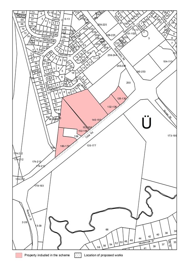
|
Stage |
Status |
Description |
|
Approval to prepare scheme |
ü |
Decision made to prepare scheme following consideration of surveys of property owners and feed back from the community. Council may then place the project in the budget system or proceed immediately to prepare a scheme. Scheme preparation involves survey, design and preparation of an apportionment of costs. |
|
Intention to Declare Scheme |
ü |
Report to Council providing information on scheme including advice of impending advertising of scheme and declaration of charge. Seeks Council approval by resolution to proceed with process. 28 January 2014 |
|
Advertisement |
ü |
The scheme is advertised in the local newspaper and all allotted property owners are notified by mail. This advertisement indicates Council’s intention and notification to ‘declare’ a scheme in a month’s time. 8 February 2014 |
|
Submissions |
N/A |
From the time of advertising property owners have 28 days (as set down by the Local Government Act) to lodge submissions, either in support or opposition to the scheme. |
|
Submissions Review Panel Hearing |
N/A |
A Submissions Review Panel is convened (quorum of three Councillors) and meets to consider submissions. Some submissions are written only, and other submitters may wish to be heard before the Panel. The Panel makes a recommendation to Council regarding the scheme. |
|
Declaration Report |
ü |
Any time 28 days after advertising the scheme and after the Submissions Review Panel has met and considered submissions, Council considers a report and may proceed to “declare” the charges in accordance with its advertised intent. Subsequent to this the Finance Manager issues the levy notices and there is a formal charge placed on the property. This is the final step in the process for Council to make a decision on the scheme. |
|
Appeal |
|
Property owners may lodge an application for review with the Victorian Civil and Administrative Tribunal (VCAT) within one month of issue of the levy notice. An appeal is listed, heard and determined by the Tribunal and this process generally takes three to four months. Decisions made by VCAT are binding on all parties. |
|
Construction |
|
Council may then proceed to construct the works. Invoices are issued seeking payment of the estimated cost within one month of commencement. |
|
Final Cost Report |
|
At the completion of the works the scheme is “finalised” taking into account actual costs incurred and payments are adjusted accordingly. |
Portfolio: |
Finance - Cr Lyons (Mayor), Cr S Kontelj, Cr E Kontelj |
Source: |
Corporate Services - Financial Services |
A/General Manager: |
Michael Kelly |
Index Reference: |
Subject: EMT and Avalon Airport |
Cr Nelson moved, Cr Fisher seconded -
That in accordance with Section 89 (2)(d) of the Local Government Act 1989, this contractual matter be considered at the conclusion of all other business at which time the meeting be closed to members of the public.
Carried.
Contents | Previous Page: Section A - Procedural Matters | Next Page: Section C - Assembly of Councillors

Copyright CoGG 2012
Last Update: 29 April 2014