
Council Minutes - Section B: Reports - 13 May 2014
Contents | Previous Page: Section A - Procedural Matters | Next Page: Section C - Notice of Motion
Contents | Previous Page: Section A - Procedural Matters | Next Page: Section C - Notice of Motion
Reports tabled at the Ordinary Meeting of Council on Tuesday date held at City Hall, Little Malop Street in Geelong.
Adoption of Amendment C302 - 302-306 Aberdeen Street, Manifold Heights
Melville Avenue, Newtown - Proposed Footpath Construction SRC336 - Intention to Declare
The Esplanade, Indented Head - Proposed Footpath Construction SRC337 - Intention to Declare
The Esplanade, Indented Head - Proposed Footpath Construction SRC338 - Intention to Declare
Portfolio: |
Finance - Cr Lyons (Mayor), Cr S Kontelj & Cr E Kontelj |
Source: |
Corporate Services - Administration & Governance |
General Manager: |
Michael Kelly |
Index Reference: |
Council Reports 2014 |
To declare any conflicts of interest that Councillors may have with the 2014-2015 Budget.
The proposed 2014-2015 Budget contains items in which a Councillor has indicated they have a conflict of interest.
The Local Government Act 1989 exempts a Councillor from a conflict of interest when Council has previously approved the matter in which the Councillor has an interest, including funding, and the Councillor has disclosed the conflict of interest at the time the matter was approved by Council.
Any items proposed for inclusion in the Budget in which a Councillor has indicated a conflict of interest are to be dealt with by separate resolution.
Once all declarations have been made and the item which is the subject of any declaration is determined by Council, all Councillors are able to vote on Agenda Item 2, being the Proposed 2014-2015 Budget.
Declarations are made under the General category for the 2014-2015 Budget.
Cr S Kontelj moved, Cr E Kontelj seconded -
That the Councillors who have a Conflict of Interest in items proposed for the inclusion in the 2014-2015 Budget declare the nature of that interest:
Cr Farrell declared an Indirect Interest in the Victorian Local Governance Association (VLGA) Membership in that she works as a contractor for the VLGA.
Cr Farrell left the meeting room at 8:40pm
Cr Fisher moved, Cr Nelson seconded -
That funding of VLGA Annual Membership be approved for inclusion in the 2014-2015 Council Budget.
Carried.
In developing the 2014-2015 Budget an extensive range of activities and initiatives have been considered for funding. Councillors who may have a conflict of interest in any items to be considered are required to disclose the nature of any conflict of interest.
The Local Government Act 1989 requires a Councillor to declare any conflict of interest in relation to matters to be considered by Council and to leave the meeting for the duration of discussion and vote on that matter.
A Councillor has indicated a conflict of interest in an item contained within the proposed budget.
There are no environmental implications relative to this report.
Financial implications are addressed in the 2014-2015 Proposed Budget.
This report has been prepared to address requirements of the Local Government Act 1989, specifically section 79C(2) which deal with conflicts of interests in the Budget adoption process.
Aligns to How We do Business in City Plan.
No officer involved in the preparation of this report has an interest relative to the advice provided.
The declaration of any interests ensures transparency.
There are no social considerations relative to this report.
This report has no impact on Human Rights.
Councillors have been consulted in the preparation of this report and the report is available as a public document.
Cr Farrell re-entered the meeting room at 8:43pm.
Portfolio: |
Finance – Cr Lyons (Mayor), Cr S Kontelj & Cr E Kontelj |
Source: |
Corporate Services – Financial Services |
A/General Manager: |
Michael Kelly |
Index Reference: |
Financial Management / Budget – Fin Yr 2013/2014 |
Adopt the Proposed 2014-2015 Budget to allow for a 28 day public submission period prior to adoption of the final budget.
The Proposed 2014-2015 Budget has been prepared in accordance with the requirements of the Local Government Act 1989 (LGA) and the Best Practice Guidelines that were developed by a Local Government industry taskforce.
The Proposed Budget (Appendix 1) includes:
The Budgeted Statements of Comprehensive Income, Cash Flows, Balance Sheet, Capital Works, Changes in Equity and Human Resources.
The Strategic Objectives to be undertaken during the financial year and Service Performance Outcome Indicators in relation to each Strategic Objective;
The relationship between the activities and initiatives in contributing to achieving the strategic objectives specified in the City Plan, and
Details of the activities and initiatives to be funded in the budget.
As required under the LGA a schedule declaring the differential rates and charges (Appendix 2) has been provided for public scrutiny and comment.
The Rating Strategy for 2014-2015 contains the Council Policy, Procedure, rate assistance and information on the City’s approach to the raising of property rates updated to reflect the outcome of Council’s budget deliberations.
Cr S Kontelj moved, Cr E Kontelj seconded -
That Council:
Pursuant to Section 127 of the LGA, the Council:
Receive and consider the Proposed 2014-2015 Budget document, (Appendix 1), which includes the Budgeted Statements of Comprehensive Income, Cash Flows, Balance Sheet, Capital Works, Changes in Equity and Human Resources.
Receive and consider the Four Year Strategic Resource Plan (Appendix 1, Section 3) including Budgeted Statements of Comprehensive Income, Cash Flows, Balance Sheet, Capital Works, Changes in Equity and Human Resources (under Section 126 of the LGA).
Receive and consider the Rates, Municipal Charge, Waste Collection & Recycling charge and other income (required to meet the appropriate financial requirements as proposed in the 2014-2015 Budget package).
Receive and consider the proposed declaration of Rates and Charges (Appendix 2), for the purpose of:
public scrutiny and comment, and
inclusion within the Rating Strategy 2014-2015 of Rate waivers under section 171of the LGA as detailed therein.
inclusion within the Rating Strategy 2014-2015 of Rate rebates, under section 169 of the LGA as detailed therein.
Receive and consider Councillor allowances in accordance with the notification published under section 73B of the LGA in the Victorian Government Gazette on 24 December 2013.
Advertise the Proposed Budget and make it available for inspection at Customer Service Centres and the Council website. The advertisement be placed in the Geelong Advertiser on Wednesday, 14 May, 2014 inviting written submissions from the public by 5pm on Tuesday, 10 June 2014.
Appoint a Budget Submissions Panel to hear submissions made in relation to the Budget, Differential Rating, and Councillor allowances, such Panel to:
consist of councillors each of whom shall have voting rights, with the quorum being three members;
meet on Friday, 13 June 2014 to consider any written submissions and to hear any person who wishes to address the Panel in support of a submission; and
report to Council in relation to the submissions that have been received and any recommended amendments to the Proposed Budget.
After considering the report of the Budget Submissions Panel, adopt the budget, declare the rates, and also adopt the Councillor allowance, the Deputy Mayor allowance and also the Mayoral allowance, at a Council Meeting to be held on Tuesday, 24 June 2014.
Advertise the adoption of the budget, declaration of the rates, and Councillor allowances, following the Council meeting on 24 June 2014.
Carried.
Division Requested:
For: Crs Ansett, S Kontelj, Nelson, E Kontelj, Ellis, Fisher, Lyons, Harwood, Macdonald, Heagney, Farrell, Irvine
Against: Cr Richards
In accordance with Section 127 of the LGA, Council is required to prepare a budget for each financial year and must ensure that it contains:
The budgeted statements in the form and containing the matters required by the regulations;
A description of the activities and initiatives to be funded in the budget;
A statement as to how the activities and initiatives described under paragraph (b) will contribute to achieving the strategic objectives specified in the Council Plan;
Separately identified Strategic Objectives to be undertaken during the financial year and service performance outcome indicators in relation to each Strategic Objective;
Any other details required by the regulations.
In addition, Council must ensure the budget considers the following:
The information the Council is required to declare under section 158(1);
If the Council intends to declare a differential rate under section 161, the details listed in section161(2), and
If the Council intends to declare a differential rate under section 161A, the details listed in section 161(2).
The Proposed 2014-2015 Budget for the financial year commencing 1 July 2014, as reviewed during recent Councillor Budget sessions, has been completed.
The Proposed 2014-2015 Budget document (Appendix 1) has been prepared on the basis of the Best Practice Guidelines as developed by a Local Government industry taskforce and issued to all municipalities across Victoria. The Proposed Budget document has been developed under the following sections:
Overview,
Budget Analysis,
Budget Strategies and
Appendices, including Activities and Initiatives linked with City Plan.
In accordance with the LGA, the Proposed 2014-2015 Budget also includes clear linkages to Council’s Proposed “City Plan 2013-2017, (2014-2015 Update)”, and its supporting Key Strategies and Actions.
Specific inclusions in the Proposed Budget are a summary by Strategic Directions:
The activities and initiatives to be funded in the Budget.
How the activities and initiatives will contribute to achieving the strategic objectives, and,
The service performance outcome indicators in relation to each strategic objective.
In addition, a component of the Proposed Budget is the setting of Rates and Charges. The Declaration of Rates and Charges for 2014-2015 is attached (Appendix 2). The formal Rating Strategy document will be updated that reflects Council’s statements of policy, procedure, general information and historical trends.
Council has declared a special rate in respect of the central business district of Geelong applicable to non-residential, non-exempt properties. The special rate is the Central Activities Area (CAA) Rate and is in addition to other rates and charges. The purpose of the special rate is to promote the CAA as a commercial shopping precinct using events, marketing and media.
Mayor and Councillor Allowances
The LGA regulates the allowance payable to the Mayor and Councillors of Local Governments in Victoria.
By notice in the Government Gazette published on 24 December 2013 the Minister for Local Government implemented an annual adjustment of allowances payable to Mayor, Deputy Mayor and Councillors effective from 24 December 2013. For the City of Greater Geelong the Mayoral Allowance is $182,425.65, the Deputy Mayoral Allowance is $57,111.53 and for Councillors $30,059. These allowances have been provided for in the 2014-2015 Budget.
Rating Strategy 2014-2015
The Rating Strategy document will be updated to reflect the outcome of Council’s Budget deliberations.
Rates and Charges are the major source of Council revenue accounting for 62% of the total Council revenue annually. An increase in rate income is required to meet the objectives of Council aspirations and community expectations for new infrastructure.
The Strategic Resource Plan advocates sustainable rate increases over the next four years, required to fund new initiatives and maintain existing service levels.
Current Year Rate Increases
Changes proposed for 2014-2015 are:
Rates and Charges on a residential property will increase overall by 4.51%, including rate in $ movement 1.7%, Municipal Charge movement 3%, and Waste Collection Service Charge 5.12%. The residential rate has been set at $0.002710 per $ of CIV valuation.
Vacant Land rate in the dollar will increase to 145% of residential in order to encourage building activity and development.
The Waste Collection Service charge is calculated based on a fee for service, including direct, indirect and overhead costs. The charge is impacted by cost estimates of EPA levy $27.70 per tenement. The Carbon tax has not been costed into the charge. The charge for 2014-2015 will increase from $234.50 to $246.50 or 5.12%.
The Municipal Charge represents a fee on all rateable assessments as a contribution to the fixed and unavoidable costs of governance. The Municipal Charge is to increase from $88.90 to $91.55 or 3%.
The Farm rebate will be reduced to 30.7% with average rates increasing by 4.42% (lower than residential) and represents a cost to Council of $1.181M.
The Housing Support Waiver for eligible Charitable Housing will be maintained for 2014-2015 and is available upon application.
The transitional rebate introduced in 2010-2011 for nominated charitable housing properties will be reduced to a 25% rebate in 2014-2015.
A rates waiver introduced for the New Corio Estate from 2013-2014 recognising this inappropriate subdivision and Planning Scheme Amendment C243 will be maintained.
The pensioner concession will increase from $202.90 in accordance with movement in CPI for Melbourne as advised by the Australian Bureau of Statistics to an estimated $207.95.
These increases are required in order to fund increases to recurrent expenditure, and the continuing capital works program.
Residential Rates and Charges
The average Capital Improved Value of residential properties within the municipality has increased from $365,610 to $375,674. This reflects a 1.9% growth in the number of residential properties together with growth of 2.16% in Residential Capital Improved Value.
The total increase in rates and charges for the average property with a capital improved value of $375,674 is $58.50 or 4.51%. This increase is made up of $43.85 for General Rates, $2.65 for Municipal Charge and $12.00 for the Waste Collection Service.
Residential Properties |
|
2013-2014 |
2014-2015 |
Increase % |
|
Rates on Average |
Budget Rates on Average |
||
|
CIV $ |
CIV $ |
||
General Rates CIV x Rate in $ |
|
974.25 |
1,018.10 |
4.50% |
Municipal Charge |
|
88.90 |
91.55 |
2.98% |
Waste Collection Service |
|
234.50 |
246.50 |
5.12% |
Total Rates and Charges |
|
1,297.65 |
1,356.15 |
4.51% |
Rate Waiver
Council declares a waiver under Section 171 of the LGA for residential land and farm land properties where the valuation of the assessment has increased between the 2012 valuation and the 2014 valuation by 50% or more and that increase is purely attributable to market factors, not attributable, in whole or in part, to improvements made to the assessment by the owner (or occupier). The amount of the waiver be set at:
between 25% and 49.99% of the general rates payable for the 2014-2015 financial year, increasing pro rata according to the valuation increase, for valuation increases between 50% and 59.99%; and
50% of the general rate payable for the 2014-2015 financial year for valuation increases of 60% or more.
The waiver is designed to mitigate the rates shock of a valuation increase and is only claimable once in a two year valuation cycle.
Council declare a Housing Support waiver under section 171 of the LGA of 100% of general rates and municipal charge for the following types of housing. Transitional, Emergency, Crisis Housing, Housing for Legatees or War Widows provided by the Geelong Legacy Club or provided by RSL, and supported Housing for disabled people. This waiver recognises that these properties provide specific needs within the community. Application can be made to Council to have land classified as being eligible for the waiver.
The New Corio Estate is an old and inappropriate subdivision within an established farming zone in Corio. Since the land is zoned as farming land it cannot be developed for residential use with no services available for the area. There is no prospect of these services becoming available in the future. In addition, environment reports in recent years have shown that the land contains significant native vegetation which Council is obligated to protect for future generations. Council has recently adopted Planning Scheme amendment C243 which formally protects the native vegetation and provides some certainty over the future of the land. The native vegetation identified within this Estate is of high conservation significance and the application of the overlay to this area will ensure its ecological value is protected indefinitely. This amendment was approved by the Minister of Environment & Climate Control on 30 April 2013.
From 2013-2014 Council declared a waiver under section 171 of the LGA of 100% of general rates and municipal charge for privately owned properties. This rates assistance waiver recognises the financial burden associated with ownership of the land and the encumbrances that prevents property owners from making any demands on Council services now and into the future.
Council also provides a range of assistance measures to suit individual needs including pension rebates, farm rebates, rates deferral, and payment options such as regular Direct Debit, and Centrepay.
Rate Rebates
Council has declared a Farm rebate to support the continuation of broad acre farming at 30.7% of general rates.
For 2014-2015 Council declare a Transitional rebate under section 169 of the LGA of 25% of general rates and municipal charge. This rebate benefits the community by allowing a smooth transition from “exempt” to “rateable” status for these properties.
Rate Structure
Council has 13 rating or tariff groups with the application of differential rates to each of these groups in accordance with Section 161 of the LGA. The finalised Ministerial Guidelines for Differential Rating were gazetted on 26 April 2013 and came into effect from 1 July 2013.
The intention of the Guidelines is to provide clarity, consistency and transparency. Council needs to consider the objectives, the suitable uses and the types of classes of land when introducing a differential rate. The Guidelines establish three groups of types and classes of land categories for differential rates – those which are considered ‘appropriate’, those which must be ‘carefully considered’ by a council and those which would ‘not be appropriate’.
During the 2014-2015 Budget deliberations the introduction of a derelict, investment and retirement village differential were discussed. None of these differentials were recommended for 2014-2015.
Fire Services Property Levy
The Fire Services Property Levy Act 2012 (FSPL) came into effect from 1 July 2013 and requires Local Government to bill, receipt and collect FSPL on rateable and non-rateable properties. It is estimated that Council will levy $24M in 2014-2015 ($23M in 2013-2014) and remit to the State Revenue Office.
The FSPL rates applicable for 2014-2015 will be released in May.
The Proposed Budget identifies the sources and allocation of the resources to implement the many environmental initiatives that impact on the community as outlined with Council’s 2013-2017 City Plan, (2014-2015 Update).
The budget has been prepared in accordance with the direction provided by Council. Changes in rates, fees and charges have been structured to meet the financial requirements as proposed for the 2014-2015 financial year.
Expenditure includes the continuation of Council services to the community.
The Budget includes a recurrent operating surplus of $0.2M.
The gross capital expenditure of $132.3M includes new funding of $13.5M on Infrastructure Leisure, $27.2M on roads, footpaths, kerb & channel and drains and $44.8M on buildings.
New loans of $52.6M are proposed for 2014-2015 including $16.5 deferred loans from 2014-2015. The projected total amount of borrowings as at 30 June 2015 is $77.7M.
The timetable is compliant with the provisions of the LGA, which deals with the preparation and adoption of budgets.
The timetable also recognises the need to align the Annual Budget to the direction and allocation of resources identified within the proposed City Plan.
This report contributes to responsible and sustainable financial management as aligned in Council’s City Plan objective on How We Do Business.
No Council officers involved in the preparation of this report have a direct or indirect interest in any matter to which this report relates.
Although not required to adopt the Annual Budget until August there are adverse implications if the process is delayed. These include:
A lack of internal control to monitor the financial position of the City into the new financial year.
Delays in commencing (and therefore completion) of projects identified within the Annual Budget.
Delaying the issuing of the first rate instalment notices (due in early September) and possible breach of the LGA.
The Proposed Budget identifies the sources and allocation of resources to implement the many social initiatives that impact on the community as outlined with Council’s 2013–2017 (2014-2015 Update) City Plan.
There are no known positive or negative effects.
A Public Notice is scheduled to be published in the Geelong Advertiser on Wednesday, 14 May 2014 advising that the Proposed 2014-2015 Budget will be available for public scrutiny and inviting written submissions to be made.
Following the closing date for the written submissions, it is proposed to convene a Budget Submissions Panel on Friday, 13 June 2014 to review any submissions that have been received and put forward to Council a report on any recommended amendments to the Proposed Budget.
Council is scheduled to meet on Tuesday, 24 June 2014 at which time the report from the Budget Submissions Panel will be considered.
Public Notice of the adopted budget and declaration of rates and charges will be advertised following the Council Meeting.
Amount Intended to be raised by General Rates, Municipal Charge, and Annual Service Charge for the period 1 July 2014 - 30 June 2015.
An amount of $179,662,879 be declared as the amount which Council intends to raise by General Rates, Municipal Charge and the Annual Service Charge, which amount is calculated as follows:
General Rates $144,565,705
Municipal Charge $10,258,471; and
Annual Service Charge $24,838,703.
General Rates
2.1 A general rate be declared for the period 1 July 2014 to 30 June 2015.
2.2 It be further declared that the general rate be raised by the application of differential rates.
2.3 A differential rate be respectively declared for rateable land having the respective characteristics specified below, which characteristics will form the criteria for each differential rate so declared.
2.3.1. Farm Land – means any land which:
is not less than 2 hectares in area; and
is used predominantly for the business of grazing (including agistment), dairying, pig-farming, poultry farming, fish farming, tree farming, bee-keeping, viticulture, horticulture, fruit growing or the growing of crops of any kind or for any combination of those activities; or
satisfies the criteria for municipal purpose benefit for large holdings to the extent that it is, for example, land that is predominantly used and maintained for heritage, cultural or environmental purposes, or land that is held as natural bushland under a trust for nature covenant, or land that is held under some other type of similar formal undertaking.
To avoid doubt, 'business' for the purposes of identifying Farm Land has the same meaning as that given to it by section 2(1) of the Valuation of Land Act 1960 for the same purpose, being a business that:
has a significant and substantial commercial purpose or character; and
seeks to make a profit on a continuous or repetitive basis form its activities on the land; and
is making a profit from its activities on the land, or that has a reasonable prospect of making a profit from its activities on the land if it continues to operate in the way that it is operating.
2.3.2 Residential Land - means any land:
that is used exclusively for residential purposes; or
on which a habitable building is erected, which building is unoccupied, and which is zoned residential under the Greater Geelong Planning Scheme.
2.3.3 Vacant Land - means any land:
that does not have the characteristics of Farm Land; and
on which no building is erected, save for any uninhabitable shed or shelter, the size of which does not exceed 5% of the total area of the land.
2.3.4 Petroleum Production Land – means any land that is:
used primarily for the production or conveyance of petroleum and/or petroleum by-products; and
is described as such in Schedule A.
2.3.5 Industrial Land – means any land that:
does not have the characteristics of
Vacant Land; or
Commercial Land; or
Petroleum Production Land; or
Aluminium Production Land; or
Automobile Manufacture Land; and
is used predominately for industrial purposes, which includes manufacturing, repairing, servicing, processing and reprocessing.
2.3.6 Commercial Land – means any land that:
does not have the characteristics of:
Farm Land; or
Industrial Land; or
Petroleum Production Land; or
Aluminium Production Land, or
Automobile Manufacture Land; and
is used predominately for the sale of goods or services or other commercial purposes; or
on which a habitable building is erected, which building is unoccupied, and which is zoned other than residential under the Greater Geelong Planning Scheme.
2.3.7 Aluminium Production Land - means any land that is:
used primarily for the manufacture or production of aluminium or aluminium products and
is described as such in Schedule A.
2.3.8 Automobile Manufacture Land – means any land that is:
used primarily for the manufacture of automobiles or automobile products;
andis described as such in Schedule A.
2.3.9 Mixed Use Land – means any land that:
has the characteristics of Residential Land combined with the characteristics of Commercial Land or Industrial Land; and
is used partly for residential purposes and partly for commercial and/or industrial purposes.
2.3.10 The Point – Residential Land - means any land that:
is used exclusively for residential purposes; or
on which a habitable building is erected, which building is unoccupied, and which is zoned residential under the Greater Geelong Planning Scheme; and
is described as such in Schedule A.
2.3.11 The Point – Vacant Land - means any land:
that does not have the characteristics of Farm Land; and
on which no building is erected save for any small uninhabitable storage shed or shelter, the size of which does not exceed 5% of the total land area; and
is described as such in Schedule A.
2.3.12 The Point – Commercial Land - means any land that:
does not have the characteristics of:
Farm Land; or
Industrial Land; and
is used predominantly for the sale of goods or services, or other commercial purposes; or
on which a habitable building is erected, which building is unoccupied, and which is zoned other than residential under the Greater Geelong Planning Scheme; and
is described as such in Schedule A.
2.4 A rate pursuant to the Cultural and Recreational Lands Act 1963 be declared for rateable land having the respective characteristics specified below.
2.4.1 Cultural and Recreational Land -
Any land which -
has the characteristics of Recreational land as defined by the Cultural and Recreational Lands Act 1963; and
is described as such in Schedule A.
2.5 Each differential rate and Cultural and Recreation Lands Rate will be determined by multiplying the Capital Improved Value of each rateable land (categorised by the characteristics described in paragraph 2.3 and 2.4 by the relevant percentages indicated in the following table:
CATEGORY %
Farm Land .002710 (or .2710 percent of Capital Improved Value).
A rebate of 30.7% of the CIV by rate in dollar in accordance with Council policy for farm rating.
Residential Land .002210 (or .2210 percent of Capital Improved Value)
Vacant Land .003930 (or .3930 percent of Capital Improved Value)
The Point Residential Land .002710 (or .2710 percent of Capital Improved Value)
The Point Vacant Land .003930 (or .3930 percent of Capital Improved Value)
The Point Commercial Land .005654 (or .5654 percent of Capital Improved Value)
Petroleum Production Land .009946 (or .9946 percent of Capital Improved Value)
Industrial Land .007542 (or .7542 percent of Capital Improved Value)
Commercial Land .005654 (or .5654 percent of Capital Improved Value)
Aluminium - Manufacture Land .009946 (or .9946 percent of Capital Improved Value)
Automobile - Production Land .009946 (or.9946 percent of Capital Improved Value)
Mixed Use Land .004146 (or .4146 percent of Capital Improved Value)
Cultural and Recreational .001702 (or .1702 percent of Capital Improved Value).
2.6 It be recorded that Council considers that each differential rate will contribute to the equitable and efficient carrying out of Council functions; and that
2.6.1 the respective objectives of each differential rate be those specified in Schedule B;
2.6.2 the respective types or classes of land which are subject to each differential rate be those defined in Schedule B;
2.6.3 the respective uses and levels of each differential rate in relation to those respective types or classes of land be those described in Schedule B; and
2.6.4 the relevant
uses of; and
geographical locations of; and
planning scheme zonings of; and
types of buildings on the respective types or classes of land be those identified in Schedule B; and
2.7 It be confirmed that no amount is fixed as the minimum amount payable by way of general rate in respect of each rateable land within the municipal district.
Rebates
3.1 Farm Rebate
For 2014-2015 Council declare a rebate under section 169 of the LGA of 30.7% for all land classified and rated as farm land. Properties defined as farms will be entitled to a rebate recognising that there is a benefit to the community in encouraging the retention of large lot primary producing holdings. An application can be made to Council to have land classified as Farm land.
3.2 Transitional Rebate
For 2014-2015 Council declare a rebate under section 169 of the LGA of 25% of general rates and municipal charge for the following listed properties. This rebate benefits the community by allowing a smooth transition from “exempt” to “rateable” status for these properties.
Properties having the benefit of the Transitional Rebate for 2014-2015:
Owners |
Location |
Housing Associations |
|
|
Winteringham Housing Association / Alexander Miller Homes |
7 Culbin Avenue, Belmont |
|
4-10 Malvern Grove, Manifold Heights |
|
|
22A Park Street, Geelong |
|
|
Housing Choices Australia (previously known as Melbourne Affordable Housing Association) |
22 Saffron Street, Newtown |
|
22-31 Noble St, Newtown |
|
|
4-6 Wendover Avenue, Norlane |
|
|
Royal Freemasons |
159-165 Wilsons Road, Whittington |
Retirement Villages |
|
|
St Laurence Community Services Inc. |
30-38 Isabella St, Geelong West |
|
1-5 McKenzie Street, Belmont |
|
|
215-221 Yarra Street, Geelong |
|
|
8-14 Mundy Street, Geelong |
|
|
13-25 Carr Street, Geelong |
|
|
90 Station Lake Road, Lara |
|
|
Uniting Care |
87 Francis Street, Belmont |
|
7 Spring Street, Belmont |
|
|
48 Settlement Road, Belmont |
|
|
Multicultural Aged Care Services Geelong Inc. |
16 De Stefano Drive, North Geelong |
|
St Peter Court / Melbourne Anglican Trust Corporation |
110 West Fyans St, Newtown |
|
Noble St Uniting Church |
31A Noble St, Newtown |
4. Waivers
4.1 Rates Assistance Waivers
Council declares a waiver of general rates under Section 171 of the LGA for the class of persons comprised of ratepayers in respect of assessments which are categorised as Residential Land or Farm Land where the valuation of the assessment has increased, between the 2012 valuation and the 2014 valuation, by 50% or more and that increase is purely attributable to market factors, not attributable, in whole or in part, to improvements made to the assessment by the owner (or occupier). The amount of the waiver is set at:
4.1.1 between 25% and 49.99% of the general rates payable for the 2014-2015 financial year, increasing pro rata according to the valuation increase, for valuation increases between 50% and 59.99%; and
50% of the general rates payable for the 2014-2015 financial year for valuation increases of 60% or more.
The waiver is designed to mitigate the rates shock of a valuation increase and can only be claimed in respect of an assessment once in a two year valuation cycle.
4.2 Council declares a Housing Support waiver of 100% of general rates and municipal charge under section 171 of the LGA for the class of persons comprised of ratepayers in respect of assessments which contain the following types of housing:
4.2.1 transitional, emergency or crisis housing;
4.2.2 housing for Legatees or War Widows, provided by the Geelong Legacy Club or provided by RSL; and
4.2.3 supported housing for disabled people.
This waiver recognises that these properties provide for specific needs within the community. Application can be made to Council to have land classified as being eligible for the waiver.
4.3 New Corio Estate (Inappropriate Subdivision)
For 2014-2015 financial year, Council declares a waiver of 100% of general rates and municipal charge under Section 171 of the LGA for the class of persons comprised of ratepayers in respect of assessments which are in private ownership within the inappropriate subdivision known as New Corio Estate. This rates assistance waiver recognises the financial burden associated with ownership of this land. Land within the New Corio Estate is zoned as farming land and the area has been determined to be an inappropriate subdivision due to the difficulty of providing utilities and drainage and due to its distance from other residential areas. The Minister for Environment & Climate Change has approved a native vegetation plan for this land in support of natural temperate grassland of the Victorian Volcanic Plains. The waiver recognises the ongoing encumbrances on the land that prevent owners from making any demands on Council services now and into the future.
Municipal Charge
5.1 An annual municipal charge be declared for the period commencing 1 July 2014 to 30 June 2015.
5.2 The purpose of the municipal charge is to recover some of the administrative costs of the Council.
5.3 The charge be the sum of $91.55 for each rateable property in the municipality.
5.4 Applications for exemption for farm land in accordance with section 159 of the LGA, is to be made within two months from the date of issue of annual rate notice.
Annual Service Charge
6.1 An Annual Service Charge be declared for the period commencing 1 July 2014 to 30 June 2015.
6.2 The Annual Service Charge be declared for the collection and disposal of refuse.
6.3 The Annual Service Charge be $246.50 for each rateable land and non-rateable land (or part) in respect of which the Annual Service Charge may be levied.
6.4 The criteria specified below, be the criteria, which form the basis of the Annual Service Charge, so declared:
Geographic existence within those areas of the municipal district in which Council provides a domestic refuse collection and disposal service. The charge will be raised irrespective of whether the service is used or not.
Central Activities Area Rate
Council has declared a special rate in respect of the central business district of Geelong applicable to non-residential, non-exempt properties. The special rate is the Central Activities Area (CAA) Rate and is in addition to other rates and charges. The purpose of the special rate is to promote the CAA as a commercial shopping precinct using events, marketing and media.
For 2014-2015 the rate will raise $804,400 ($736,000 in 2013-2014). The rate in dollar for 2014-2015 is set at $0.0006310 and $0.0001899 for Cultural & Recreation (Cultural and Recreation properties are charged a reduced CAA rate, in accordance with the ratio of the recreation rate to the commercial rate).
Incentives
No incentives be declared as the incentives to be given by Council for the payment of General Rates, Municipal Charge and the Annual Service Charge (described earlier in this document) before the dates fixed for their payment under Section 167 of the LGA.
Consequential
8.1 Notwithstanding anything said in any earlier Resolution of Council, the Geelong Advertiser and the Geelong Independent be chosen, as the newspapers in which the public notice will appear.
8.2 The Responsible Officer of Council be authorised to levy and recover the General Rates, Municipal Charge and the Annual Service Charge described earlier in accordance with the LGA.
Interest
Interest on unpaid rates and charges will be charged in accordance with Section 172 of the LGA. Interest will be charged at the penalty interest rate. In proven cases of hardship where Council allows rates to be deferred, interest will be charged at 6.19% for 2014-2015.
Petroleum Production Land
All that land generally bounded more or less by Princes Highway, Shell Parade, Corio Bay Foreshore, Wharf Road, Station Road and neighbouring land.
Aluminium Production Land
All that land generally bounded more or less by Point Henry Road, Corio Bay Foreshore and Stoddart Lane.
Automobile Manufacture Land
All that land generally bounded more or less by Cowies Creek, Melbourne Road, North Shore Road and Geelong – Melbourne Railway, excluding the land known as 60-80 North Shore Road being the Ford Research and Development Facility.
All that land generally bounded more or less by Sea Beach Parade, St Georges Road, Geelong-Melbourne Railway and neighbouring southern land.
All the residential land formerly described in Certificate of Title Volume 11423 Folio 073 and 074 and also described in Lot C PS 638301 and Lot Y PS 638300.
The Point Vacant Land
All the vacant land formerly described in Certificate of Title Volume 11423 Folio 073 and 074 and also described in Lot C PS 638301 and Lot Y PS 638300.
All the commercial land formerly described in Certificate of Title Volume 11423 Folio 073 and 074 and also described in Lot C PS 638301 and Lot Y PS 638300.
Any land reserved under the Cultural and Recreational Lands Act 1963 including the following:
|
Ratepayer Name |
Property Address |
|
Bareena Bowling Club Incorporated |
89 Noble Street, Newtown VIC 3220 |
|
Drumcondra Bowling Club |
9 Glenleith Court, Geelong VIC 3220 |
|
Geelong Race Course Trustees |
99 Breakwater Road, Breakwater VIC 3219 |
|
Geelong Agricultural & Pastoral Society |
79 Breakwater Road, Breakwater VIC 3219 |
|
Royal Geelong Yacht Club |
25 Eastern Beach Road, Geelong VIC 3220 |
|
Eastern Park Bowling Club Inc |
51-55 Garden Street, East Geelong VIC 3219 |
|
Geelong Football Club Incorporated |
360-380 Moorabool Street, South Geelong VIC 3220 |
|
East Geelong Golf Club |
Eastern Park Circuit, East Geelong VIC 3219 |
|
Highton Bowling Club Inc |
204 Roslyn Road, Highton VIC 3216 |
|
Barwon Heads Golf Club Incorporated |
Golf Links Road, Barwon Heads VIC 3227 |
|
Belmont Bowling Club Incorporated |
16-36 Reynolds Road, Belmont VIC 3216 |
|
Geelong Lawn Tennis Club Incorporated |
12-20 Sommers Street, Belmont VIC 3216 |
|
Geelong Bowls Club Incorporated |
4-10 Sommers Street, Belmont VIC 3216 |
|
Beckley Park Committee of Management Inc |
40 Broderick Road, Corio VIC 3214 |
|
Bell Park Sport & Rec Club Inc |
68 Calvert Street, Hamlyn Heights VIC 3215 |
|
St Leonards Golf Club Inc |
79-175 Harvey Road, St Leonards VIC 3223 |
|
Clifton Springs Golf Club Incorporated |
86-88 Clear Water Drive, Clifton Springs VIC 3222 |
|
Clifton Springs Bowling Club |
Clifton Street, Clifton Springs VIC 3222 |
|
Drysdale Bowling & Croquet Club inc |
19-29 Collins Street, Drysdale VIC 3222 |
|
Lonsdale Golf Club |
31-69 Fellows Road, Point Lonsdale VIC 3225 |
|
Portarlington Bowls Club Incorporated |
Harding Street, Portarlington VIC 3223 |
|
Portarlington Golf Club |
92-160 Hood Road, Portarlington VIC 3223 |
|
Leopold Sportsmans Club Inc |
131-139 Kensington Road, Leopold VIC 3224 |
|
Ocean Grove Bowling Club |
16-24 The Terrace, Ocean Grove VIC 3226 |
|
St Leonards Bowling Club |
1274 Murradoc Road, St Leonards VIC 3223 |
|
Curlewis Golf Club Incorporated |
1201-1419 Portarlington Road, Curlewis VIC 3222 |
|
Australian Croatian Sporting Centre |
15 Gibbons Road, Lara VIC 3212 |
|
Bell Park Sports Club Inc |
515 Ballarat Road, Batesford VIC 3221 |
|
Geelong West Bowling Club Incorporated |
12 Bowlers Avenue, Geelong West VIC 3218 |
|
Barwon Rowing Club Inc |
2 Barwon Terrace, South Geelong VIC 3220 |
|
Geelong Grammar School Rowing |
6 Barwon Terrace, South Geelong VIC 3220 |
|
Geelong Rowing Association |
8 Barwon Terrace, South Geelong VIC 3220 |
|
Corio Bay Rowing Club |
10 Barwon Terrace, South Geelong VIC 3220 |
|
East Geelong Uniting Church Tennis Club Inc |
39 Denman Street, East Geelong VIC 3219 |
|
East Geelong Recreation Reserve Committee |
137-139 McKillop Street, Geelong VIC 3220 |
|
Portarlington Sailing Club |
219 Point Richards Road, Portarlington VIC 3223 |
|
Indented Head Boat Club |
The Esplanade, Indented Head VIC 3223 |
|
Indented Head Yacht Club |
The Esplanade, Indented Head VIC 3223 |
|
St Leonards Yacht Club & Motor Squadron |
Lower Bluff Road, St Leonards VIC 3223 |
|
Geelong Watersports Club Incorporated |
493-499 Wilsons Road, St Albans Park VIC 3219 |
|
Geelong College Rowing Club |
4 Barwon Terrace, South Geelong VIC 3220 |
|
Geelong Pistol Club |
70-80 Williams Road, Mount Duneed VIC 3216 |
|
Geelong Table Tennis Association |
84-88 Church Street, North Geelong VIC 3215 |
|
Western Beach Boat Club Incorporated |
74-90 Western Foreshore Road, Geelong VIC 3220 |
|
Lagoon Boat Club Inc |
Foreshore Road, Corio VIC 3214 |
|
Lara Sporting Club Incorporated |
4 Walkers Road, Lara VIC 3212 |
|
Western District Car Club |
55 Beach Road, Avalon VIC 3212 |
|
Corio Bay Sailing Club |
Foreshore Road, Corio VIC 3214 |
|
North Shore Sports & Community Club Inc |
39 Rose Avenue, Norlane VIC 3214 |
|
Herne Hill Bowls Club Inc |
180 McCurdy Road, Fyansford VIC 3221 |
|
Norlane Bowling Club Incorporated |
26-36 St Georges Road, Corio VIC 3214 |
|
Lara Bowling Club Inc |
10 Alkara Avenue, Lara VIC 3212 |
|
Barwon Heads Bowling Club |
18 Geelong Road East, Barwon Heads VIC 3227 |
|
Geelong & Dist Angling Club & Fish Protect Society |
9 Yuille Street, Geelong West VIC 3218 |
|
Seabrae Boat Owners Club Inc |
302 Clifton Avenue, Leopold VIC 3224 |
|
Geelong Speedway Drivers Club Inc |
1/4 Wood Street, South Geelong VIC 3220 |
|
Wood Street Public Recreation Reserve COM Inc. |
2-3/4 Wood Street, South Geelong VIC 3220 |
|
Geelong Transport Drivers Social Club Inc |
4/4 Wood Street, South Geelong VIC 3220 |
Properties granted Cultural & Recreational Rate status include any other not-for-profit clubs or associations having similar characteristics and objectives to Cultural & Recreational land as defined which is extended to include indoor sporting, recreational and cultural activities. To be considered, each property should have limited venue hire, restricted liquor licensing provisions and have little impact on neighbouring amenity.
|
Ratepayer Name |
Property Address |
|
Geelong Bridge Club |
148-152 Portarlington Road, Newcomb Vic 3219 |
|
Austrian Club Geelong Incorporated |
258 Plantation Road, Lovely Banks Vic 3221 |
|
Serbian Parish Youth Club |
256 Plantation Road, Lovely Banks, Vic 3221 |
|
Polish Community Association in Geelong |
35 Ryrie Street, Geelong Vic 3220 |
Farm Land
Rating Objectives:
To ensure that all rateable land makes an equitable and efficient financial contribution to the cost of carrying out the functions of Council generally, including the:
construction and maintenance of public infrastructure;
development and provision of health and community services; and
provision of general support services.
To encourage and support the business of primary production and, where appropriate, expand the business of primary production.
These objectives will be met by setting the Farm Land differential at 100% of the Residential Land differential and by the provision of a farm rebate under Section 169 of the LGA.
Types and Classes
Rateable land having the relevant characteristics described previously in 2.3.
Use and Level of Differential Rate
The differential rate will be used to fund some of those items of expenditure described in the Budget adopted by Council.
The level of the differential rate less the applicable rebate is the level, which Council considers it necessary to achieve the objectives specified above.
Geographic Location
Wherever located within the municipal district.
Use of Land
Any use permitted under the Greater Geelong Planning Scheme.
Planning Scheme Zoning
The zoning applicable to each rateable land within this category, as determined by consulting maps referred to in the Greater Geelong Planning Scheme.
Types of Buildings
All buildings which are now constructed on the land or which are constructed prior to 30 June 2015.
Residential Land
Rating Objective:
To ensure that all rateable land makes an equitable and efficient financial contribution to the cost of carrying out the functions of Council generally, including the:
construction and maintenance of public infrastructure;
development and provision of health and community services; and
provision of general support services.
Types and Classes
Rateable land having the relevant characteristics described previously in 2.3.
Use and Level of Differential Rate
The differential rate will be used to fund some of those items of expenditure described in the Budget adopted by Council.
The level of the differential rate is the level which Council considers is necessary to achieve the objectives specified above.
Geographic Location
Wherever located within the municipal district.
Use of Land
Any use permitted under the Greater Geelong Planning Scheme.
Planning Scheme Zoning
The zoning applicable to each rateable land within this category, as determined by consulting maps referred to in the Greater Geelong Planning Scheme.
Types of Buildings
All buildings which are now constructed on the land or which are constructed prior to 30 June 2015.
Vacant Land
Rating Objectives:
To ensure that all rateable land makes an equitable and efficient financial contribution to the cost of carrying out the functions of Council generally, including the:
construction and maintenance of public infrastructure;
development and provision of health and community services; and
provision of general support services.
To encourage the prompt development of vacant land to attract new residents and businesses to the City of Greater Geelong.
To discourage untimely and unnecessary divisions of land.
These objectives will be met by setting the Vacant Land differential at 145% of the Residential Land differential.
Types and Classes
Rateable land having the relevant characteristics described previously in 2.3.
Use and Level of Differential Rate
The differential rate will be used to fund some of those items of expenditure described in the Budget adopted by Council.
Geographic Location
Wherever located within the municipal district.
Use of Land
Any use permitted under the Geelong Regional Planning Scheme.
Planning Scheme Zoning
The zoning applicable to each rateable land within this category, as determined by consulting maps referred to in the Geelong Regional Planning Scheme.
Types of Buildings
No building must be located on the land or constructed prior to 30 June 2014 save for any uninhabitable shed or shelter that does not exceed more than 5% of the total area of the land.
Petroleum Production Land
Rating Objective:
To ensure that all rateable land makes an equitable and efficient financial contribution to the cost of carrying out the functions of Council generally, including the:
construction and maintenance of public infrastructure;
development and provision of health and community services; and
provision of general support services.
The Petroleum Production Land differential is set at 367% of the Residential Land differential with the long term intention that the Petroleum Production Land differential will move closer to the Industrial Land differential over time.
Types and Classes
Rateable land having the relevant characteristics described previously 2.3.
Use and Level of Differential Rate
The differential rate will be used to fund some of those items of expenditure described in the Budget adopted by Council.
Geographic Location
As described in Schedule A.
Use of Land
Any use permitted under the Greater Geelong Planning Scheme.
Planning Scheme Zoning
The zoning applicable to each rateable land within this category, as determined by consulting maps referred to in the Greater Geelong Planning Scheme.
Types of Buildings
All buildings which are now constructed on the land or which are constructed prior to 30 June 2015.
Industrial Land
Rating Objective:
To ensure that all rateable land makes an equitable and efficient financial contribution to the cost of carrying out the functions of Council generally, including the:
construction and maintenance of public infrastructure;
development and provision of health and community services; and
provision of general support services.
Types and Classes
Rateable land having the relevant characteristics described previously in 2.3.
Use and Level of Differential Rate
The differential rate will be used to fund some of those items of expenditure described in the Budget adopted by Council.
Geographic Location
Wherever located within the municipal district.
Use of Land
Any use permitted under the Greater Geelong Planning Scheme.
Planning Scheme Zoning
The zoning applicable to each rateable land within this category, as determined by consulting maps referred to in the Greater Geelong Planning Scheme.
Types of Buildings
All buildings which are now constructed on the land or which are constructed prior to 30 June 2015.
Commercial Land
Rating Objective:
To ensure that all rateable land makes an equitable and efficient financial contribution to the cost of carrying out the functions of Council generally, including the:
construction and maintenance of public infrastructure;
development and provision of health and community services; and
provision of general support services.
Types and Classes
Rateable land having the relevant characteristics described previously in 2.3.
Use and Level of Differential Rate
The differential rate will be used to fund some of those items of expenditure described in the Budget adopted by Council.
Geographic Location
Wherever located within the municipal district.
Use of Land
Any use permitted under the Greater Geelong Planning Scheme.
Planning Scheme Zoning
The zoning applicable to each rateable land within this category, as determined by consulting maps referred to in the Greater Geelong Planning Scheme.
Types of Buildings
All buildings which are now constructed on the land or which are constructed prior to 30 June 2015.
Aluminium Production Land
Rating Objective: To ensure that all rateable land makes an equitable and efficient financial contribution to the cost of carrying out the functions of Council generally, including the:
construction and maintenance of public infrastructure;
development and provision of health and community services; and
provision of general support services.
The Aluminium Production Land differential is set at 367% of the Residential Land differential with the long term intention that the Aluminium Production Land differential will move closer to the Industrial Land differential over time.
Types and Classes
Rateable land having the relevant characteristics described previously in 2.3.
Use and Level of Differential Rate
The differential rate will be used to fund some of those items of expenditure described in the Budget adopted by Council.
Geographic Location
As described in Schedule A.
Use of Land
Any use permitted under the Greater Geelong Planning Scheme.
Planning Scheme Zoning
The zoning applicable to each rateable land within this category, as determined by consulting maps referred to in the Greater Geelong Planning Scheme.
Types of Buildings
All buildings which are now constructed on the land or which are constructed prior to 30 June 2015.
Automobile Manufacture Land
Rating Objective:
To ensure that all rateable land makes an equitable and efficient financial contribution to the cost of carrying out the functions of Council generally, including the:
construction and maintenance of public infrastructure;
development and provision of health and community services; and
provision of general support services.
The Automobile Manufacture Land differential is set at 367% of the Residential Land differential with the long term intention that it will move closer to the Industrial Land differential over time.
Types and Classes
Rateable land having the relevant characteristics described previously in 2.3.
Use and Level of Differential Rate
The differential rate will be used to fund some of those items of expenditure described in the Budget adopted by Council.
Geographic Location
As described in Schedule A.
Use of Land
Any use permitted under the Greater Geelong Planning Scheme.
Planning Scheme Zoning
The zoning applicable to each rateable land within this category, as determined by consulting maps referred to in the Greater Geelong Planning Scheme.
Types of Buildings
All buildings which are now constructed on the land or which are constructed prior to 30 June 2015.
Mixed Use Land
Rating Objective:
To ensure that all rateable land makes an equitable and efficient financial contribution to the cost of carrying out the functions of Council generally, including the:
construction and maintenance of public infrastructure;
development and provision of health and community services; and
provision of general support services.
Types and Classes
Rateable land having the relevant characteristics described previously in 2.3.
Use and Level of Differential Rate
The differential rate will be used to fund some of those items of expenditure described in the Budget adopted by Council.
Geographic Location
Wherever located within the municipal district.
Use of Land
Any use permitted under the Greater Geelong Planning Scheme.
Planning Scheme Zoning
The zoning applicable to each rateable land within this category, as determined by consulting maps referred to in the Greater Geelong Planning Scheme.
Types of Buildings
All buildings which are now constructed on the land or which are constructed prior to 30 June 2015.
The Point – Residential Land
Rating Objectives:
To ensure that all rateable land makes an equitable and efficient financial contribution to the cost of carrying out the functions of Council generally, including the:
construction and maintenance of public infrastructure;
development and provision of health and community services;
provision of general support services; and
management of environmentally sensitive land.
To ensure that, following the development of the Point Land, and transfer to Council of the management of environmentally sensitive land, including the provision of a range of services around an existing waterway, constructed lake and canal system, an equitable and efficient financial contribution to the cost of Council's management responsibilities will be made by the ratepayers in respect of that land.
Types and Classes
Rateable land having the relevant characteristics described previously in 2.3.
Use and Level of Differential Rate
The differential rate will be used to fund some of those items of expenditure described in the Budget adopted by Council.
Geographic Location
As described in Schedule A.
Use of Land
Any use permitted under the Greater Geelong Planning Scheme.
Planning Scheme Zoning
The zoning applicable to each rateable land within this category, as determined by consulting maps referred to in the Greater Geelong Planning Scheme.
Types of Buildings
All buildings which are now constructed on the land or which are constructed prior to 30 June 2015.
The Point – Vacant Land
Rating Objectives:
To ensure that all rateable land makes an equitable and efficient financial contribution to the cost of carrying out the functions of Council, generally including the:
construction and maintenance of public infrastructure;
development and provision of health and community services;
provision of general support services; and
management of environmentally sensitive land.
To ensure that, following the development of the Point Land, and transfer to Council of the management of environmentally sensitive land, including the provision of a range of services around an existing waterway, constructed lake and canal system, an equitable and efficient financial contribution to the cost of Council's management responsibilities will be made by the ratepayers in respect of that land.
Types and Classes
Rateable land having the relevant characteristics described previously in 2.3.
Use and Level of Differential Rate
The differential rate will be used to fund some of those items of expenditure described in the Budget adopted by Council.
Geographic Location
As described in Schedule A.
Use of Land
Any use permitted under the Greater Geelong Planning Scheme.
Planning Scheme Zoning
The zoning applicable to each rateable land within this category, as determined by consulting maps referred to in the Greater Geelong Planning Scheme.
Types of Buildings
All buildings which are now constructed on the land or which are constructed prior to 30 June 2015.
The Point – Commercial Land
Rating Objectives:
To ensure that all rateable land makes an equitable and efficient financial contribution to cost of carrying out the functions of Council, generally including the:
construction and maintenance of public infrastructure;
development and provision of health and community services;
provision of general support services; and
management of environmentally sensitive land.
To ensure that, following the development of the Point Land, and transfer to Council of the management of environmentally sensitive land, including the provision of a range of services around an existing waterway, constructed lake and canal system, to ensure that an equitable and efficient financial contribution to the cost of Council's management responsibilities will be made by the ratepayers in respect of that land.
Types and Classes
Rateable land having the relevant characteristics described previously in 2.3.
Use and Level of Differential Rate
The differential rate will be used to fund some of those items of expenditure described in the Budget adopted by Council.
Geographic Location
As described in Schedule A.
Use of Land
Any use permitted under the Greater Geelong Planning Scheme.
Planning Scheme Zoning
The zoning applicable to each rateable land within this category, as determined by consulting maps referred to in the Greater Geelong Planning Scheme.
Types of Buildings
All buildings which are now constructed on the land or which are constructed prior to 30 June 2015.
Has the characteristics of Recreational land as defined by the Cultural and Recreational Lands Act 1963.
Types and Classes
Rateable land having the relevant characteristics described previously in 2.4.
Use and Level of Differential Rate
The differential rate will be used to fund some of those items of expenditure described in the Budget adopted by Council.
Geographic Location
As described in Schedule A.
Use of Land
Any use permitted under the Greater Geelong Planning Scheme.
Planning Scheme Zoning
The zoning applicable to each rateable land within this category, as determined by consulting maps referred to in the Greater Geelong Planning Scheme.
Types of Buildings
All buildings which are now constructed on the land or which are constructed prior to 30 June 2015.
Cr Stretch Kontelj declared an Indirect Interest in City Plan 2013-2017 (2014-2015 Update) in that his wife is a member of the Board of GPAC and left the meeting room at 9:22pm prior to discussion.
Cr Heagney declared an Indirect Interest in City Plan 2013-2017 (2014-2015 Update) in that she is an independent member of the Board of GPAC and left the meeting room at 9:22pm prior to discussion.
Cr Eddy Kontelj declared an Indirect Interest in City Plan 2013-2017 (2014-2015 Update) in that his sister-in-law is a member of the Board of GPAC and left the meeting room at 9:22pm prior to discussion.
Portfolio: |
Governance - Cr Lyons (Mayor) |
Source: |
Corporate Services - Corporate Strategy |
A/General Manager: |
Michael Kelly |
Index Reference: |
Subject: Corporate Strategy |
City Plan 2013-2017 has been reviewed as per section 125(7) of the Local Government Act 1989. This report is to advise Council of the proposed amendments/update.
Following the October 2012 Council Election, Council was required to prepare a new Council Plan and have it submitted to the Minister for Local Government by 30 June 2013 as per the Local Government Act 1989. Section 125(7) also provides that at least once in each financial year, a Council must consider whether the current Council Plan requires any adjustment in respect of the remaining period of the Council Plan.
City Plan 2013-2017 (2014-2015 Update) contains the following amendments:
As in previous years, City Plan has been updated to include the 2014-2015 City Plan Actions under each priority within each strategic direction.
The Strategic Resource Plan has also been updated to include the proposed 2014-2015 Annual Budget as the base year.
A revised Mayor’s message has also been included explaining that City Plan 2013-2017 has been reviewed.
The Council Funding Priorities have also been updated where required.
The remainder (and majority) of City Plan 2013-2017 remains unchanged.
A draft ‘City Plan 2013-2017 (2014-2015 Update)’ has been developed and will be available at Customer Service Centres and on Council’s website.
Pursuant to section 125(10) of the Local Government Act 1989, the Minister will be notified of these adjustments and receive a copy of the updated City Plan.
Cr Nelson moved, Cr Richards seconded -
That Council note that:
In accordance with section 125(7) of the Local Government Act 1989, City Plan 2013-2017 has been reviewed and as a result:
2014-2015 City Plan Actions have been added under each Strategic Direction/Priority;
Strategic Resource Plan has been updated using the draft 2014-2015 Annual Budget as the base year; and
Revised message from the Mayor.
Council adopt the adjustments to City Plan 2013-2017 (2014-2015 Update) (as per Appendix 1) and take the necessary steps to advise the Minister of these adjustments pursuant to section 125(10) of the Local Government Act 1989.
Add to the Revitalising Central Geelong priority, under benefits, support for the implementation of the Central Geelong Cultural Precinct Master Plan, which includes expansion and refurbishment of the Geelong Performing Arts Centre, subject to State Government funding.
Cr Macdonald left the meeting room at 9:23pm
Cr Macdonald re-entered the meeting room at 9:24pm
Carried.
The Local Government Act 1989 requires that a Council must prepare and approve a Council Plan within the period of 6 months after each general election or by the next 30 June, whichever is later.
Section 125 of the Local Government Act also prescribes that a Council Plan must include:
The strategic objectives of the Council,
Strategies for achieving the objectives for at least the next four years,
Strategic indicators for monitoring the achievement of these objectives,
A Strategic Resource Plan, and
Any other matter prescribed by the regulations.
In subsequent years, councils are required to, at least once in each financial year; consider whether the current Council Plan requires any adjustment in respect of the remaining period of the Council Plan.
The Council’s performance and results in achieving the strategic indicators of the City Plan are required to be reported in the Council’s Annual Report.
City Plan 2013-2017 was developed to reflect the results of the extensive community engagement which was undertaken, Council’s current priorities and the supporting resource allocation.
The framework for the City Plan 2013-2017 incorporates the planning framework based on the on the Quadruple Bottom Line framework and features four strategic directions (Community Wellbeing, Growing our Economy, Sustainable Built and Natural Environment and How We Do Business), supporting internal objectives and the Council’s Vision, Mission, Values and Behaviours section.
City Plan identifies the key priorities, strategies and progress indicators that are currently planned over the said four-year period, as well as detailed actions associated with implementing this four-year City Plan.
The priorities under each of the four strategic directions are as follows:
Community Wellbeing
Healthy lifestyles
Healthy environments
Connected, creative and strong communities
Growing our Economy
Support existing businesses and encourage new and emerging growth sectors
Facilitate major infrastructure and investment to enable economic growth
A prosperous and innovative Geelong
A successful and vibrant city centre
Greater Geelong is a leading city for tourism, arts, culture and events
Sustainable Built and Natural Environment
Enhance and protect natural areas and ecosystem health
Support our community to live sustainably
Advocate for and promote sustainable design and development
Minimise our environmental footprint
How We Do Business
Lead by advocating and collaborating on issues important to the Greater Geelong community
Efficient and customer focused organisation
Responsible and sustainable financial management
Informed and engaged community
Motivated and skilled staff in a safe work environment
All the actions within City Plan have been developed collaboratively across the organisation and support the long-term social, environmental and economic benefits for the community articulated through the Vision, Mission and Objectives established by the Council.
City Plan 2013-2017 (2014-2015 Update) has been reviewed pursuant to section 125(10) of the Local Government Act 1989.
Amendments to City Plan 2013-2017 (2014-2015 Update) include:
2014-15 City Plan Actions included (refer to Strategic Directions and Annual Action Plan section);
Updated Strategic Resource Plan as legislatively required, taking into account the proposed 2014-2015 Annual Budget as the base year and contains the financial and non-financial (human resources) information for the next four years;
Update on the Council Funding Priorities; and
Updated Mayor’s message.
A draft ‘City Plan 2013-2017 (2014-2015 Update)’ has been developed and will be available at Customer Service Centres and on Council’s website.
Pursuant to section 125(10) of the Local Government Act 1989, the Minister will be notified of these adjustments and receive a copy of the updated City Plan.
City Plan 2013-2017 (2014-2015 Update) outlines the objectives and strategies to deliver the environmental benefits to the community. Details of these can be found within the Sustainable Built and Natural Environment Strategic Direction.
City Plan 2013-2017 (2014-2015 Update) includes Council’s four-year financial strategy and plan. The proposed 2014-2015 Annual Budget is the base year in the Strategic Resource Plan in this revised City Plan.
The Local Government Act 1989 requires that a Council must prepare and approve a Council Plan within the period of 6 months after each general election or by the next 30 June, whichever is later.
Section 125(2) of the Local Government Act also prescribes that a Council Plan must include:
The strategic objectives of the Council,
Strategies for achieving the objectives for at least the next four years,
Strategic indicators for monitoring the achievement of these objectives,
A Strategic Resource Plan, and
Any other matter prescribed by the regulations.
If a Council makes an adjustment to the Council Plan, the Council must within 30 days of making the adjustment advise the Minister of the details of the adjustment to the Council Plan.
The draft City Plan 2013-2017 (2014-2015 Update) complies with the Local Government Act, 1989.
Not applicable.
There is no direct or indirect officer interest to which this report relates.
Failing to notify the Minister of any adjustments would result in non-compliance.
City Plan 2013-2017 (2014-2015 Update) outlines the objectives and strategies to deliver the social benefits to the community.
City Plan 2013-2017 (2014-2015 Update) will be made available on Council’s website and on request at Council’s Customer Service Centres. There are no known positive or negative effects.
City Plan 2013-2017 (2014-2015 Update) will be available for inspection at Council’s Customer Service Centres and on Council’s Internet site www.geelongaustralia.com.au
Public submissions on the revised City Plan are not required as per the Local Government Act 1989, these are only required when the new Council Plan is prepared post a general Council election.
The Minister will be notified of any amendments to City Plan following review each subsequent year.
Crs Heagney, E Kontelj and S Kontelj re-entered the meeting room at 9:31pm
Portfolio: |
Community Development – Cr Fisher |
Source: |
Community Services / Community Development |
General Manager: |
Jenny McMahon |
Index Reference: |
Geelong – East Timor Friendship Committee |
The purpose of this report is to update Council on the level of community involvement and successes of the Council supported Geelong Friends of Viqueque (in East Timor).
The City of Greater Geelong formally established the Geelong Friends of Viqueque (GFoVQQ) in 2003.
Council’s role is to provide a secretariat to the GFoVQQ, which in turn facilitates:
annual planning
fundraising activities conducted by GFoVQQ member organisations
community development activities in Viqueque.
GFoVQQ has had another successful year in 2013 engaging the broader Geelong community in assisting in the development of the Viqueque District of East Timor. Refer Attachments 1a and 1b.
Much of the work of the GFoVQQ during 2013 focussed on improving health and education for the people of Viqueque.
During 2013 over 90 individuals (including 30 nurses, pathologists and teachers), representing health and education groups associated with GFoVQQ, have visited East Timor. This resulted in more than $170,000 being raised and expended in the District of Viqueque or in the broader East Timor economy. This has assisted in the training of local professionals and contributed to an improved understanding between the Geelong and Viqueque communities.
Friendship Health (member organisation of GFoVQQ) has contributed over $30,000 towards health and wellbeing in Viqueque. This includes hospital infrastructure and equipment upgrades as well as increasing community resources to achieve better nutrition.
Over $50,000 has been contributed towards improving the education system in Viqueque (this includes building refurbishments, equipment purchases, teacher training and student scholarships).
More than 50 secondary school students have visited the region as part of their studies or as part of a cultural awareness program that serves as an alternative activity to ‘schoolies’ week. It is estimated that these visits have contributed approximately AU$70,000 to the East Timor economy.
Due to the successes of Geelong Viqueque Friendship Schools (member organisation of GFoVQQ) a Geelong benefactor donated $120,000 to their cause in 2013.
The current GFoVQQ Strategic Plan is due to expire in 2015. Council currently has a Memorandum of Understanding between the City, GFoVQQ and the District Administrator of Viqueque. In accordance with developing a new Strategic Plan (in 2015), it would be beneficial for Council to arrange for a renewed Memorandum of Understanding between the respective parties.
Cr Richards moved, Cr Fisher seconded -
That Council:
notes the 2013 actions undertaken by the Geelong Friends of Viqueque;
endorses the commencement of planning for a renewed Memorandum of Understanding to be signed by the City of Greater Geelong, the Geelong Friends of Viqueque and the District Administrator of Viqueque, East Timor.
Cr Irvine left the meeting room at 9:35pm
Cr Irvine re-entered the meeting room at 9:37pm
Carried.
The Victorian Local Governance Association (LGA) initiated the formation of Friendship Relationships between the Districts of East Timor and Australian local governments at the time of East Timor Independence in 2002. The City of Greater Geelong formally established the Geelong Friends of Viqueque (GFoVQQ) in 2003. There are now approximately 45 councils participating in this program Australia wide.
The original request for the development of these relationships was initiated because representatives of East Timor were interested in modelling community participation on the Australian Local Government Model. Council has a relationship with the District of Viqueque which is 195 kilometres from Dili, the capital of East Timor.
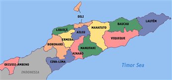
Council has been integral to the development of the Geelong Friends of Viqueque. Council provides a Committee chair and is a key advocate for the activities and work of the Committee. The City also provides administrative support for the conduct of the GFoVQQ bi-monthly meetings, strategic and business plans and has funded visits by Councillors to East Timor to sign a Memorandum of Understanding (MOU) with the Viqueque District Office (the original MOU being signed in 2004).
Council has also funded visits by Councillors and staff as members of GFOVQQ on two occasions in the past (2004 and 2011) to assist in the planning and development of projects to support the communities of Viqueque.
Council and Geelong based organisations have provided ongoing support to Viqueque since the formation of the Geelong Friends of Viqueque. This is reflected in the GFoVQQ Strategic Plan 2011–2014.
The GFoVQQ Committee renewed its Terms of Reference, including the composition of its membership in early 2012. The current committee has representatives from thirteen organisations and networks that operate across the Geelong Region.
These organisations have contributed greatly to fundraising for East Timor. An example of this being the Tri UMPH festival, which is an event run mainly by students from St Joseph’s College, Sacred Heart College, Clonard College and Saint Ignatius College with the aim of contributing funds to East Timor and other countries requiring assistance. The event, which is run approximately every three years, was last held in 2011 and raised $43,000.
Another example is a Trivia Night conducted by Libraries for Timor Leste which raised over $30,000 in 2013 to go towards improving library facilities in East Timor.
Timor-Leste is one of the world's poorest nations. Life expectancy is 67 years and 45 per cent of children in Timor-Leste are underweight for their age. Overall, 37 per cent of Timorese live below the international poverty line of USD1.25 a day. There are more than 40 Friendship Groups connected to the 13 Districts of East Timor. The groups aim to assist Australia’s nearest neighbour in its growth towards sustainable independence.
The Geelong Friends of Viqueque (GFoVQQ) provides an opportunity for members of the greater Geelong community to contribute to the development of East Timor, Australia’s nearest neighbour. Membership of the Committee currently includes the City of Greater Geelong (as chair), Christian College Geelong, Geelong Viqueque Friendship Schools, Geelong Friendship Health, St John of God Pathology (Vic), Barwon Water, Geelong Regional Library Corporation, St Mary’s Parish, Deakin University, Gordon Institute of Technology, Rotary, a community representative, Geelong Friends and Midwives of East Timor and the Australia East Timor Association (Geelong Branch).
Geelong Viqueque Friendship Schools (GVFS) include a membership of 10 secondary schools within the Geelong region. GVFS in an incorporated body but has representation on the GFoVQQ to avoid a duplication of effort by other organisations in the Geelong Region.
Geelong Friendship Health has recently become incorporated under the Associations Incorporation Reform Act 2012 (Vic). Members include staff from the St John of God Hospital and St John of God Pathology as well general community members.
GFoVQQ has adopted a strategic plan for the period of 2011–2015. This plan guides the allocation of the Committee’s fundraising into priority areas of work, which include improving education (of young people), health, water and sanitation, commerce, and public administration and governance. In the context of providing a new strategic plan for the following four years it may be beneficial to sign a renewed Memorandum of Understanding with the District of Viqueque Administration Officer.
Attachment 1A provides a list of activities carried out by the GFoVQQ during 2013, and that and are measured against the objectives of the GFoVQQ Strategic Plan. Attachment 1B details which month these activities were carried out and the associated costs. The main achievements of the Geelong Friends of Viqueque during 2013 include:
Contributing over $50,000 towards improving the education system in Viqueque (this includes building refurbishments, equipment purchases, teacher training and student scholarships. It should be highlighted that due to the successes of Geelong Friendship Schools a Geelong benefactor donated $120,000 to their cause.
Contribution of over $30,000 towards health and wellbeing in Viqueque (this includes hospital infrastructure and equipment upgrade as well as increasing community resources to achieve better nutrition).
Over 30 education and health professionals connected to GFoVQQ have visited Viqueque to assist in training and improved understanding between the Geelong and Viqueque communities. Added to this, more than 50 secondary school students have visited the region as part of their studies or as part of a cultural awareness program which provides an alternative to ‘schoolies’ week for students. It estimated that these visits have contributed over AU$80,000 to the East Timor economy.
Not applicable.
Council supports the activities of the Geelong Friends of Viqueque by providing venue, administrative and officer support for Committee meetings as well as key events such as East Timor Independence Day Celebrations, fundraising events and public forums relating to East Timor.
Activities and initiatives in Viqueque are funding by fundraising activities carried out by GFoVQQ member organisations.
During 2013 member organisations raised more than $170,000, which was expended either in Viqueque or in broader East Timor economy.
Not applicable.
One of the aims of Council’s City Plan is to develop the rate of volunteerism within the community. The City of Greater Geelong supports this objective by providing a facilitator role in the engagement of the Geelong community with the activities of the Geelong Friends of Viqueque.
No Council Officer has direct or indirect interest in the outcome of this report.
Not applicable.
The purpose of the City’s friendship relationship is to support the development of East Timor including the development of democratic processes and encouraging community participation in planning and decision making. The concept encourages community development activities in both Geelong and in East Timor.
The recommendation of this report does not run counter to Council’s Human Rights Charter.
The Community Development Department is responsible for the communication of this report.
Cr E Kontelj declared an Indirect Interest in Amendment C267 – Armstrong Creek Town Centre Precinct Structure Plan – Approval, in that one of the parties associated with the Development has a close association with his employer company and left the meeting room at 9:39pm prior to discussion.
Portfolio: |
Planning - Cr Heagney |
Source |
Planning & Tourism |
General Manager: |
Peter Bettess |
Index Reference |
Armstrong Creek |
This report considers the Independent Panel Report to Greater Geelong Planning Scheme - Amendment C267 and recommends adoption of the Amendment.
The amendment applies to land referred to as the Armstrong Creek Town Centre Precinct. The land is approximately 92 hectares and bounded by Boundary Road to the north, Surf Coast Highway to the west, Barwarre Road to the east and Burvilles Road to the south.
The amendment proposes changes to the Greater Geelong Planning Scheme to facilitate development of the Armstrong Creek Town Centre. These changes include a new schedule to the Urban Growth Zone and incorporation of a Precinct Structure Plan which provides explicit planning direction, urban design and sustainability guidelines, a Development Contributions Plan and Native Vegetation Precinct Plan to guide future development.
Public exhibition of Amendment C267 commenced on 6th June 2013 and concluded on the 8th July 2013.
A total of 23 submissions were received to the exhibited amendment. These submissions were from landowners within the precinct, parties with an interest in the precinct, landowners from adjacent precincts, other individuals and government agencies.
The issues raised in submissions included infrastructure planning, specific requests for further discretion in the planning controls and the Sustainability and Design Guidelines, changes to the Development Contributions Plan, modification to the planned local traffic network, drainage / stormwater management both internal and external to the precinct, and other requests for modification to the exhibited amendment package.
Council resolved on 27 August 2013 to refer the submissions to an Independent Planning Panel appointed by the Minister for Planning.
An Independent Panel was appointed to consider submissions. A Panel hearing was held between 6 – 15 November 2013, with a Report completed and provided to Council on the 17 January 2014. Council was represented at Panel by Maddocks Lawyers.
The Panel report was released to the general public by Planning Panels Victoria on 17 February 2014.
The Panel concluded that the Amendment has strong strategic planning justification. The Panel made findings about design and development, retailing, transport and movement, native vegetation and greenways, development contributions and other general matters. In total the Panel made 21 recommendations requesting specific modifications to the Amendment.
The Panel Report supports a range of Council directions, however it does detail a number of recommendations that are strongly disputed. These include, but are not limit to:
Removal of retail (shop) floor space caps from the schedule to the Commercial 1 Zone.
Allowance of a right turn access point from Surf Coast Highway in and out of Parking Street B.
Deletion of the Transit Corridor from the Development Contributions Plan (DCP).
Nomination of the transit corridor as an investigation area with an applied zoning of Farm Zone (FZ).
Relegation of all mandatory provision within the Precinct Structure Plan (PSP) to discretionary.
Council officers recommend that Amendment 267 be adopted as outlined in this report.
Cr Heagney moved, Cr Macdonald seconded -
That Council having considered the Independent Panel Report to Amendment C267 to the Greater Geelong Planning Scheme, resolves to:
adopt Amendment C267 in the form as outlined in Appendix 5 of this report;
submit the adopted Amendment with the prescribed information to the Minister for Planning requesting approval.
Carried.
The Precinct
The Armstrong Creek Town Centre (ACTC) is the centrepiece of the Armstrong Creek Growth Area and will provide a variety of civic, commercial and retail facilities to service the growth area and beyond.
The vision for the ACTC is:
The Armstrong Creek Town Centre will be the civic, commercial and social heart of the Armstrong Creek Urban Growth Area. It will be a sustainable, pedestrianised and vibrant transit oriented place which encourages people to shop, live, work and play. The Town Centre will be an attractive place, creating a destination for Armstrong Creek residents and visitors.
The Precinct is bounded by Boundary Road, Surf Coast Highway, Burvilles Road and Barwarre Road was previously referred to as the Armstrong Creek Major Activity Centre within the Armstrong Creek Urban Growth Plan. In recognition of the town centre’s role within the growth area, the Precinct is now more commonly known as the Armstrong Creek Town Centre.
In 2009 Council adopted the Armstrong Creek Integrated Infrastructure Delivery Plan (IIDP) as the key plan that details the infrastructure requirements of the future communities within Armstrong Creek. The IIDP is also a critical background document in the preparation of each Precinct Structure Plan (PSP) for the Armstrong Creek Growth Area.
The Armstrong Creek Town Centre (ACTC) has progressed through the Precinct Structure Plan development phase with a different methodology to that which has been applied to other precincts across the Armstrong Creek Urban Growth Area. In the case of the ACTC the land ownership arrangement did not lend itself to meeting the 70% control requirement which has been applied to other precincts. As such the development of the precinct structure plan has been led by the Armstrong Creek Growth Team via the Armstrong Creek Town Centre Steering Committee involving all landowners.
The development of the Precinct Structure Plan and its associated documentation has been funded by three of the landowners who will receive credit under the future Development Contributions Plan for costs incurred in preparing the Precinct Structure Plan/ Other landowners will make contributions under the Development Contributions Plan at their time of subdivision / development.
ACTC Enquiry by Design
The master planning for the ACTC commenced during 2009 with the preparation of the Armstrong Creek Town Centre Enquiry By Design Report. The report was the output of fours days of detailed workshops, design and testing, and utilised the input of a large array of stakeholders, landowners and leading professionals in the fields of urban design, retail planning and town centre planning.
The Enquiry by Design continued the implementation of the Armstrong Creek Urban Growth Plan (Volume 1, May 2008, amended May 2010 & September 2012) in the planning for a true main street based ‘town centre’ and not simply another “big box” style shopping centre. The Armstrong Creek Urban Growth Plan also envisaged the development of a town centre that delivered an innovative and unique urban design outcome, supported by an array of sustainability initiatives that set the town centre apart from similar centres across the State.
Armstrong Creek Town Centre Steering Committee
In late 2010 the Armstrong Creek Town Centre (ACTC) Steering Committee was formed to guide and inform the planning process for the development of the C267 amendment documentation. Membership of the steering committee comprised two representatives from all titles within the Armstrong Creek Town Centre, the Armstrong Creek Project Team and representatives from the Department of Transport, Planning and Local Infrastructure (formerly known as Department of Planning and Community Development). A copy of the exhibited Urban Structure Plan for the Armstrong Creek Town Centre is attached as Appendix 1 to this report.
Key Stakeholders
In delivering the ACTC Precinct Structure Plan, Council has also been fortunate to have strong involvement by the two major supermarket players (Coles and Woolworths) who represent an even split of the retail heart of the Town Centre.
One of the challenges in developing the ACTC Precinct Structure Plan has been to ensure the vision for the growth area (and more specifically the town centre) is not diluted via the push for more traditional retail layouts and models via the major retailers and stakeholders.
Merged Precinct Structure Plan and Urban Design Framework
The ACTC Precinct Structure Plan (PSP) has also been prepared in a unique and innovative way, in that it combines both the structure and content of a traditional Precinct Structure Plan as well as an integrated Urban Design Framework. An Urban Design Framework (UDF) is a document usually prepared post the approval of a PSP and sets out the more detailed elements and urban design requirements for the town centre (including, but not limited to, built form and public realm design principles).
A UDF can often take 12 – 18 months to prepare and approve, and its this time that will be saved via the implementation of the current PSP model based on a more detailed and integrated PSP document.
The Armstrong Creek Project Team has, in close consultation with the ACTC Steering Committee, prepared a Precinct Structure Plan (PSP) and Native Vegetation Precinct Plan (NVPP) for the Armstrong Creek Town Centre.
The Development Contributions Plan (DCP) for the Armstrong Creek Town Centre was prepared by Urban Enterprises Pty Ltd on behalf of Council.
Amendment C267
The ACTC Precinct Structure Plan, Native Vegetation Precinct Plan and Development Contributions Plan were exhibited between 6th June 2013 and 8th July 2013 during which time public submissions to the Amendment were sought.
The exhibition of Amendment C267 received a total of 23 submissions.
Submissions included:
6 from landowners within the ACTC (includes submissions from the primary retail stakeholders of Coles and Woolworths).
8 from landowners within the Armstrong Creek Growth Area
1 from a landowner outside the Armstrong Creek Growth Area boundary
1 from an industry network group
7 from State Government Agencies (Minister for Public Transport and Roads, Barwon Region Water Corporation, Department of Transport, Planning and Local Infrastructure together with VicRoads and Public Transport Victoria, Country Fire Authority, Department of Environment & Primary Industries, EPA, Corangamite Catchment Management Authority).
Council Officers met with several submitters to discuss their submissions and attempted, where appropriate, to resolve matters of concern.
The Amendment was referred to an independent Panel to consider all submissions, with a hearing held between 6 – 15 November 2013.
The key themes discussed at the Panel hearing included:
Urban Design and Development
Retail Uses and Floor Space
Transport and Movement
Native Vegetation and Greenways
Development Contributions
Other General Matters (including drainage management and Gaming provisions)
At the conclusion of the Panel hearing Council officers tabled a revised package of documentation that addressed submissions and concerns raised during the Panel hearing. These documents included a tracked changes Precinct Structure Plan and Urban Growth Zone Schedule 5, along with notated project sheets included in the Development Contributions Plan.
A number of concessions were made in an effort to resolve matters raised primarily by Coles and Woolworths, while still protecting the fundamental components of the amendment to realise the vision for the Town Centre.
The Panel report was received on the 17th January 2014 and released to the public on 17th February 2014. The report included 21 recommendations for changes to the amendment package (inclusive of the Precinct Structure Plan, Development Contributions Plan, Native Vegetation Precinct Plan and general amendment documentation).
A summary of these recommendations are attached in Appendix 2, with Council officers responses to these recommendations detailed in Appendix 3.
Reformed Zones
In July 2013 the State Government released a package of zoning reforms that sought to transition the existing residential and commercial zones into three new residential zones (general, neighbourhood and growth zone), two new commercial zones (Commercial 1 and 2) and a modified Mixed Use Zone.
Prior to the Panel hearing Council officers tabled revised amendment documents that highlighted how the new zones would impact on the ACTC (the changes focused on the translations of the proposed Business 1 and 2 Zones within the Precinct to Commercial 1 Zone and the revised provisions of the Mixed Use Zone).
The new zones raised a number of concerns during the panel hearing relating to the “intent” of the new zones and particularly their focus on relaxing the controls on various retail uses. Council officers raised concerns with the Panel regarding confusion between intent and what the new zone actually says and how it aligns to the current policies in place for the City of Greater Geelong. This was particularly important as it relates to regional areas and the need for a strong retail hierarchy and controls such as retail (shop use) floor space caps.
The Panel report details 21 recommendations covering various themes and issues contained within submissions to the amendment and further matters discussed during the Panel hearing.
Out of the 21 recommendations Council consider nine (9) are appropriate to support either in full or in part. Council’s concern with the remaining 12 recommendations / issues was clearly articulated during the Panel hearing and much of the Panels discussion and findings support Council’s position. However, in many cases the recommendation takes a different view from that detailed in the Panel’s discussion and findings, and has not been substantiated relating to the grounds of the recommendation (eg: precedence, Government policy, etc).
To outline the nature of these 12 recommendations and why they shouldn’t be supported, the following section of the report details a response to the eight (8) key recommendations and justification for the Council officer recommendation. The remaining four (4) recommendations not supported by Council officers are less significant in nature and a summary of these responses are detailed in Appendix 3.
RECOMMENDATION 2
Delete PSP BF1-01 Standard dot point 2 and revise PSP BF1-01 Guideline dot point 1 to direct that:
50% of the Main Street development should be double storey and the remaining 50% should have double storey facades; and
The exhibited ACTC Precinct Structure Plan detailed the below provision that ‘must’ be met:
“Precinct 1 – BF-01 (Built Form)
Main St built form must-
Be developed as a minimum of two storeys along the length of Main Street”
At the conclusion of the Panel hearing, and after ongoing discussion with various submitters, Council proposed the below new wording.
“Precinct 1 – BF-01 (Built Form)
Main St built form must-
Comprise two (or more) storeys along Main Street of which at least 50% is to be occupiable space”
The recommendation of the Panel, and more particularly the Panel’s tracked changes version of the PSP (attached to the Panel Report as Appendix E) agrees with this wording. However it’s the position of the Panel that the provision should be a Guideline (ie: should be met) and not a Requirement (ie: must be met).
During the Panel hearing Craig Czarny, of Hansen Partnerhsip (acting for Council) described the importance of delivering a minimum two storey built form along Main Street, stating:
“the legitimacy of the minimum two storey form along the streetscape is widely acknowledged in urban design terms, for activation and sense of enclosure”.
Also in Mr Czarny’s expert evidence conclusion he confirmed:
“In particular I note that the necessary rigour of the proposed development controls and Standards, which in my view are warranted at this embryonic stage of the Centre’s establishment and growth. Given the precedence for adhoc suburban commercial centre development in some Growth Area Centres and the considerable threat that such outcomes could have on the long term capacity and image of the precinct, I believe that it is appropriate to establish a strong and unambiguous urban structure, around which more organic growth may in the future occur.”
This approach to strong controls is also reflected in the recently approved Officer Precinct Structure Plan, 2011 (containing the Officer Town Centre). In this PSP key planning and design guidelines included:
Planning and design guidelines that must be met:
“Buildings along street frontages are to be a minimum of two storeys”
Planning and design guidelines that should be met:
“Buildings are to be a minimum of three storeys”.
Extract from Officer Precinct Structure Plan, 2011 (Page 68)
There are also many examples of recently constructed town centres that have also delivered a minimum two storey outcome along main streets, including Rouse Hill Town Centre in western Sydney, Point Cook Town Centre and Craigieburn Town Centre.
Council Officer Recommendation:
ACTC Precinct Structure Plan should be amended to reflect:
Precinct 1 – BF-01 (Built Form)
Main St built form must-
Comprise two (or more) storeys along 50% of Main Street within Precinct 1, with the remaining 50% being double storey façade
Comprise occupiable floor space for any upper levels along Main St.
RECOMMENDATION 3
Delete the overall retail floor space cap for the Armstrong Creek Town Centre from the schedule to the Commercial 1 Zone (exhibited as Business 1 Zone).
The Panel makes the following remarks in support of the retail offering with in the ACTC:
“The Panel agrees that there is a role for floor space caps in some instances and that they should be applied based on the individual circumstances of the subject site and its broader catchment.”(page 32)
The Panel also made the following assessment in relation to the new Commercial 1 Zone being utilised for the ACTC, whereby:
“A schedule to this zone (Commercial 1 Zone) in a planning scheme outside of metropolitan Melbourne can specify the maximum leasable floor area for Office and shop (other than restricted retail premises).”(page 15).
This point was strongly reinforced by Council officers during the Panel hearing and confirms the intent of the new zones being implemented across Victoria, and their specific application in regional Cities such as Geelong, including growth areas where a retail hierarchy has yet to be established.
To establish a retail hierarchy for the Armstrong Creek growth area the Greater Geelong Planning Scheme confirms the role of the ACTC as a sub-regional centre within Clause 21.04 – Municipal Framework Plan, while also reinforcing within Council’s local policy 21.07 Economic Development and Employment (relevant extracts detailed below).
21.07 Economic Development and Employment
21.07-1 Key Issues and Influences
Retail
The City of Greater Geelong Retail Activity Centre Hierarchy has been established to articulate the role and function fulfilled by centres of different sizes.
The retail hierarchy supports the primacy of Central Geelong as the focus of retail activity in the region.
21.07-3 Retail
Objectives
To facilitate the development of vibrant and viable retail activity centres in accordance with the Geelong Retail Activity Centre Hierarchy included at Clause 21.07-8.*
*Note – Clause 21.07-8 is a map and schedule of the retail hierarchy showing ACTC as a sub regional centre.
The removal of floor space caps for Geelong’s sub regional activity centres goes against the above local policy and will potentially jeopardise the retail hierarchy across the City, particularly the significant role of Central Geelong within this hierarchy.
The Reformed Zones Ministerial Advisory Committee assessed the matter of floorspace caps in detail as part of their assessment of new zoning provisions across Victoria, particularly in relation to the new commercial zones and capping of uses such as Shop (ie: retail) and Office.
In the Advisory Committee’s report they confirm the following position regarding the use of floorspace caps in Melbourne and Regional Victoria.
“Floorspace caps
Floorspace caps on land uses are a mechanism to regulate the leasable floorspace related to various uses such as shop, office, restricted retail premises and trade supplies in commercial zones. Such caps have sometimes been used in conditions against specific uses in the table of uses of various zones; other caps have been used in schedules in commercial and industrial zones. Leasable floor area is defined as ‘that part of the net floor area able to be leased. It does not include public or common tenancy areas, such as malls, verandahs, or public conveniences’.
The Government’s proposal with the reformed zones is to remove floorspace caps for all uses in the new commercial zones and to remove the 500 square metres restriction against office in the industrial zones and allow office floorspaces to be specified in the schedule. This is to enable greater competition with the provision of commercial uses to better service local communities and to ensure greater efficiency of the Victorian planning system.
The Committee generally supports this approach but with an exception for interface areas around the fringe of Metropolitan Melbourne, non-metropolitan Melbourne and regional areas of Victoria. In these locations, it felt that the ability to retain floorspace caps could help to prevent leakage from centres and support the establishment of a robust retail hierarchy in developing growth areas and non-metropolitan locations and make best use of often scarce existing infrastructure.
Regional Victoria
There are a range of differences in regional Victoria which need to be considered when planning for growth including:
the hierarchy of centres in regional Victoria differs to that in metropolitan Melbourne.
the broader range of community functions a regional town centre provides.
the different levels in demand and growth for new retail facilities, which in some cases means there may be infrequent but major proposals put forward.
There are two instances where a greater level of planning control may be appropriate:
In newly developing areas where there is concern that ‘lower-order’ centres might expand and take on greater importance at the expense of other ‘higher-order’ centres, and this is contrary to policy objectives. In this case, a council policy may support increased retail development in a centre as an ‘anchor’ tenant to support a broader range of public infrastructure in that centre such as a local library or improved transport interchange. If the ‘anchor’ tenant was able to establish in a ‘lower-order’, newly establishing centre, it may limit the ability for councils to achieve policy outcomes sought for the ‘higher-order’ centre. This will ultimately undermine broader objectives. In growth areas and regional areas impacts of these developments can be more significant and long-term than in established metropolitan areas. This is because these developments can divert community activity away from the town centre and result in adverse trading impacts for retailing in that centre and subsequently co-located services.
Where unrestrained growth of a large centre on the outskirts of a regional Victorian town may prevent the growth of the existing town centre to the overall detriment of decisions by governments to invest in public infrastructure or deliver local employment opportunities.
In these instances, it may be necessary to limit the overall amount of retailing.”
(Page 33 – 34, Commercial and Industrial Zones Report, Reforms Zones Ministerial Advisory Committee Report, 28 February 2013. Emphasis added by author)
In response to these comments and the below recommendation of the Advisory Committee the State Government confirmed the following position.
Recommendation 1 – “That the ability to apply floorspace caps through the use of schedules should be available for use in the Commercial 1 Zone for shop and office uses by rural and interface councils”
Government Response – “The ability for rural and regional councils to introduce schedules to allow for floor space caps for shop and office in the Commercial 1 Zone is supported. Existing floorspace caps for shop and office in regional and rural councils will undergo a neutral translation to the new Commercial 1 Zone on 1 July 2013.
Floorspace caps in the Commercial 1 Zone will not be applied to any metropolitan council. In metropolitan Growth Areas, floorspace caps for new suburbs that exist for land in an Urban Growth Zone will remain.
The Ministerial Direction on The Form and Content of Planning Schemes will be amended to clarify that the Schedule to the Commercial 1 Zone can only apply a shop or office floorspace cap in a regional or rural planning scheme”
(Page 3, Government Response to the Recommendations of the Reformed Zones Ministerial Advisory Committee Report, May 2013)
Finally, the Panel also confirmed:
“The Panel accepts the evidence of Mr Stephens (Council’s economics expert) that demonstrates demand to support a 40,000 m2 of retail (shop) in the ACTC by 2031.” (page 32).
Council Officer Recommendation:
A 40,000 m2 retail (shop) indicative floor space cap should be maintained within the activity centre hierarchy as shown in Clause 21.07-8.
The 40,000 m2 retail (shop) cap should be retained in the schedule to the Commercial 1 Zone for the Armstrong Creek Town Centre.
RECOMMENDATION 7
Preserve the option to provide direct right turn access from Surf Coast Boulevard into Parking Street B and make the appropriate amendments to the relevant PSP provisions (MA2-01 and MA3-01).
The Surf Coast Boulevard (Highway) is the principle transport corridor between Geelong and Torquay and is predicted to carry significant traffic volumes over the life of the Armstrong Creek development.
To maximise the local characteristics of the road the Armstrong Creek West and ACTC (precincts either side of the road) proposed a high quality boulevard treatment between Boundary Road (in the north) and Burvilles Road (in the south). The aim is to create a tree lined arterial road that has strong access control along its length via the provision of four signalised intersections and service roads either side (as shown in the below Figure 1 – Surf Coast Boulevard Cross Section and Plan View).
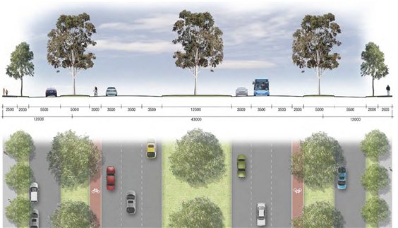
Figure 1 - Surf Coast Boulevard Cross Section and Plan View
The Coles Group Property Development P/L (owners of 500 Torquay Road, Armstrong Creek or Property 7 within the ACTC PSP) submitted a request to the Panel for the creation of a right-turn access into and out of Parking Street B that runs East-West through their property. The street currently T-intersects with the Surf Coast Boulevard (Highway) service road and does not connect directly to the main traffic lanes.
The Panel made the below comments as part of their discussion and findings within the Panel report:
“In planning for a new Town Centre, a balance must be reached between providing roads and access points to safely meet a reasonable degree of traffic demands (and public transport services) and the desire to create a pedestrian friendly environment and to provide safe routes for cyclists.”(Page 41)
“The Panel is mindful of the potential to create an additional traffic conflict should right turns be permitted across the Surf Coast Boulevard, a busy arterial road which will eventually carry 40,000 to 50,000 vpd. The Panel considers that safety and minimisation of traffic conflict points to be paramount,”(page 41)
“The Panel considers that the proposed road network and access points substantially meet this objective. The Panel notes that the road network was developed with stakeholder input through the Enquiry by Design process.
With this in mind, and assuming that the intersections function as predicted, the Panel considers that allowing right turns by north bound traffic from the Surf Coast Boulevard into Parking Street B* is not warranted at this time.”(page 43)
*. Note - the Panel report references Parking Street A in error
Council has also consulted with VicRoads regarding this matter (refer Appendix 4, VicRoads response letter).
In this letter VicRoads reinforce their position presented at Panel, confirming they do not support the proposed right-turn access, based on:
Safety of right turns across Surf Coast Boulevard (Highway)
Insufficient separation from the Burvilles Road intersection
Difficulty in accessing land south of Parking Street B
The above position is supported by Council officers based on the high quality of access proposed via four new signalised intersections along Surf Coast Boulevard (Highway), along with the significant impact the intersection would have on street tree avenue planting along Surf Coast Boulevard (Highway).
Council Officer Recommendation:
Not to support the preservation / allowance of a direct right turn access from Surf Coast Boulevard (Highway) into Parking Street B.
RECOMMENDATION 10
Revise the relevant PSP greenway guidelines to make them flexible enough to consider alternative greenway design and cross section options at the design stage.
Greenways across the Armstrong Creek Growth Area are a series of existing local roads comprising significant areas of native vegetation currently protected within the Greater Geelong Planning Scheme via Vegetation Protection Overlays.
The Greenway concept proposes the utilisation of the existing road as a shared path corridor and protects this native vegetation as part of a natural design feature of future urbanised environment.
The Dennis Family Corporation (under the name DFC Armstrong Creek) lodged a submission on the use of these greenways for provision of local infrastructure such as local roads, utilities, etc (including an alternative cross section), as well as the prescriptive nature of some road cross section within the PSP illustrating the interface with the proposed greenway.
The Department of Environment and Primary Industries are the State Government department responsible for the development and implementation of native vegetation policy across the State. At the Panel hearing DEPI confirmed:
“Mr Brooks stated to the Panel that DEPI supported the consistent and wide adoption of greenways within the Growth Area. He advised that in the greenway alternative suggested by Mr Wyatt, the retention of vegetation annexed from the greenway into the narrow road verge, would be impractical in the long term. This is due to the need to maintain clearance for vehicles using the local roads and the impact of works associated with the construction of paved roads and the development of residential lots.”(page 52, emphasis added by author)
Council, in response to an alternative cross section proposed by DFC Armstrong Creek that included a local road within the greenway, confirmed:
“The utilisation of these areas for the construction of road infrastructure significantly compromises both the health and the biodiversity of these corridors. Tree protection zones and the mix of groundcover and over-story vegetation makes these corridors significant in their biodiversity role and their long term sustainability.
Council does not support the alternative cross-sections proposed by Mr Wyatt on behalf of the DFC. The options put forward fail to consider the practical implications of implementing such a cross-section, including significant constraints relating to constructing/reconstructing a road within such close proximity to high value native vegetation and the need to provide driveways every 12-18 metres” (page 52)
The greenway concept has also been debated during previous Panel hearings for the Armstrong Creek East and West Precinct Structure Plans (PSP), and both these PSPs include significant lengths of proposed greenways that form part of the approved plans.
Within the Warralily Estate (Armstrong East Precinct) the Lake Road greenway has already been delivered for half its length. This concept has been strongly embraced by the developer, and the community now using the shared paths, and highlights the benefit of protecting these valuable areas of native vegetation.
Council Officer Recommendation:
Retain the existing greenways proposed within the ACTC along Barwarre and Boundary Road
Modify the typical greenway cross section within the Precinct Structure Plan (Appendix 7, Cross Section 20) to clearly show the minor local road interface.
RECOMMENDATIONS 11 - 13
11. Change the Armstrong Creek Town Centre Development Contributions Plan to remove land for the regional transit corridor.
12. Change the Armstrong Creek Town Centre Precinct Structure Plan to identify the land as a ‘regional transit corridor investigation area’.
13. Apply the Farming Zone in Schedule 5 to the Urban Growth Zone to land identified as the ‘regional transit corridor investigation area’.
As part of Amendment C214 – Armstrong Creek East Development Contributions Plan a precedence was set regarding the funding model for the transit corridor land through the entire Armstrong Creek Urban Growth Area. No submissions were received disputing the inclusion of the transit corridor in the DCP, nor did the Advisory Committee (Panel) challenge its inclusion.
In relation to the above ACTC Panel recommendations regarding the protection, funding and naming of the Transit Corridor through the Precinct, the Panel made the below comments:
“The Panel commends the City of Greater Geelong for taking the initiative to reserve land for a possible Geelong-Torquay transit corridor.”(page 58)
“The Panel agrees with Mr Ainsaar (Council’s expert witness of Development Contributions) that the Ministerial Direction allows land for a transit corridor to be included in a DCP”(page 58)
“Applying the Farming Zone in UGZ5 for the regional transit corridor would allow land owners to continue to use their land under the current planning provisions without placing financial burden on them or on Council. The Panel believes that this is a fairer and more practical approach because:
- The Farming Zone is the current underlying zone for land in the ACTC (in the absence of the PSP), therefore landowners would be able to continue to use or develop their land under current circumstances;
- The use and development of land under the Farming Zone is unlikely to compromise the ability to consider the land for a transit corridor; and
- Should the regional transit corridor no longer be considered an option there would be no need to refund any collected contributions.”
(page 59)
The Panel has acknowledged the ability to fund the Transit Corridor via the DCP and the important role taken by Council in preserving the corridor, however the comments relating to the use of the Farming Zone appear at odds with the purpose of the zone and the practical implementation of the PSP.
When the land is developed either side of the transit corridor, the proposed zone would provide little to no opportunity to utilise the land for farming purposes (noting the corridor is only 37m wide) and would provide no incentive to embellish the land for urban purposes. The recommendation would also remove the landowners right for compensation for land formally or informally reserved for a public purpose.
It was presented to the Panel that this type of preservation of a future transit / rail corridor has already been done several times across Melbourne and within the neighbouring Armstrong Creek East Precinct.
This position was also strongly supported by the Department of Planning, Transport and Local Infrastructure and Public Transport Victoria (PTV) as part of their joint submission to the Panel, and also reinforced more recently in their submission to the exhibited Horseshoe Bend PSP and DCP (Refer below extract).
“PTV supports the inclusion of the land for the transit corridor within the DCP for the Horseshoe Bend Precinct. This is consistent with the Ministerial Direction on the preparation and content of DCPs date 15 May 2003, and has occurred in the Armstrong Creek East PSP, as well as DCPs in Melbourne’s growth areas (Epping North, Coopers St Industrial Area, etc) “
The nature of the Panel recommendations was not debated during the Panel hearing and those landowners who submitted on the transit corridor did so on the basis of it being funded by State Government via a Public Acquisition Overlay (PAO). These landowners all sought to have an avenue of compensation made available to them, with their first preference being a PAO and then reluctantly the DCP.
The significance of the recommendation may, in the eye of many landowners impacted by such a recommendation, constitute a transformation of the amendment due to the inability of landowners to comment on such a major change to the amendment without a right of reply.
An additional concern with this recommendation is the potential to set a precedent for the future Horseshoe Bend Precinct which has been recently exhibited, aswell as the previously approved Armstrong Creek East Precinct. Both these Precincts include the transit corridor within their Development Contribution Plans. This recommendation could also expose Council and / or State Government to significant land compensation claims for this corridor due to the need to preserve it for public purposes.
Council Officer Recommendation:
Retain the Transit Corridor in the ACTC Development Contributions Plan to ensure impacted landowners are compensated for this land and the costs are apportioned across all landowners within the Precinct.
Retain the labelling of the corridor as being “Transit Corridor” on plans and tables within the PSP, DCP and amendment documentation.
Retain the Transit Corridor as having an applied zone of Mixed Use Zone with Schedule 5 of the Urban Growth Zone and as being available for embellishment for community use (ie: shared trails, landscaping, etc).
RECOMMENDATION 19
Remove any reference to Gaming premises in the table of uses.
The Panel, in its discussion, questioned Council whether it had the ability to prohibit gaming machines in an Activity Centre and whether such a proposal was consistent with State policy.
The current State Policy relating to gaming is contained within Clause 52.28 – Gaming in the State section of the Greater Geelong Planning Scheme. The Policy’s purpose states:
52.28 GAMING
52.28-1 Purpose
To ensure that gaming machines are situated in appropriate locations and premises.
To ensure the social and economic impacts of the location of gaming machines are considered.
To prohibit gaming machines in specified shopping complexes and strip shopping centres.
The Clause also provides an ability to nominate specific sites within two schedules relating to the prohibition of gaming with strip shopping centre and shopping complexes. This is a direct implementation of the third purpose of the policy (dot point 3 above) and ensures these gaming facilities are not located within, or in close proximity to, shopping complexes and convenience services.
All other sub-regional activity centres across Geelong are nominated in the shopping centre schedule that prohibits gaming (eg: Corio, Leopold, Waurn Ponds, etc). This confirms the consistent approach within the ACTC in implementing State policy.
The Urban Growth Zone provides an ability to prohibit specific uses that are seen as being inappropriate and / or incompatible with the particular area of development. In the context of an Armstrong Creek Town Centre (ACTC) that will ultimately contain significant civic, community, retail / commercial and general convenience services it was identified as an area being appropriate to prohibit the use of gaming facilities.
The Greater Geelong Planning Scheme contains two local policies relating to the need for strong planning controls to prohibit the establishment of gaming facilities / venues, supported by the Geelong Gaming Framework. Relevant extracts of these polices are detailed below.
Clause 22.57 - Gaming
22.57-1 Policy Basis
Research has concluded that there are links between social disadvantage, problem gambling and proximity to gaming venues. Although gaming machines may be accessible to the community as a form of entertainment, they should not be convenient so that a predetermined decision is required to gamble.
Clause 21.07 - Economic Development and Employment
This clause includes the following objectives under Sub-Clause 21.07-3 (Retail):
To avoid the risk of exacerbating problem gambling.
Geelong Gaming Policy Framework – October 2007.
The resolution of these conflicting issues to produce a net community benefit suggests that gaming venues should have the attributes of ‘destination gaming’, but embody principles of sustainable development. (Page 6)
Gaming is often a significant risk within new growth area communities, particularly when these developments have limited, or no, social infrastructure during the early phases of the growth areas life. Gaming establishments located within close proximity to shopping and civic facilities often lead to informal gaming behaviour rather than a clear decision to travel to a gaming venue and participate.
During the exhibition of the Amendment only one submission was received regarding gaming within the ACTC (Geelong Lutheran College, located immediately south of the Precinct), and this submission supported the prohibition of gaming in the Precinct. No other parties (landowners or developers) submitted an objection to the proposal to prohibit gaming within the Precinct.
The Panel report also made reference to an informal recommendation to amend local gaming policy to include the ACTC. Council officers are supporting of this further work and would also include the necessity to review the whole Armstrong Creek growth area, and potential other growth areas, regarding the development of clear policy for these now and emerging communities.
Council Officer Recommendation:
Retain the prohibition on Gaming Premises as a use with the ACTC Precinct, and in particularly within the tables of uses within Schedule 5 to the Urban Growth Zone.
RECOMMENDATION 21
Amend the Armstrong Creek Town Centre Precinct Structure Plan (Part B) to convert mandatory standards into discretionary guidelines with other modifications, as included in Appendix E of the Panel’s report.
During the Panel hearing multiple submitters (particularly Woolworths and the Coles Group) raised concerns with approximately 10 or 11 prescriptive provisions within the ACTC Precinct Structure Plan (Appendix 5 – Planning and Design Guidelines).
Council continuously reinforced to the Panel the unique model that was adopted for the ACTC, whereby rather than an Urban Design Framework (UDF) being required as an additional step post a Precinct Structure Plan being approved, the ACTC PSP integrates both a PSP and UDF into one document.
The result is a traditional PSP that includes:
A Vision for the total Precinct and specific sub-precincts
Objectives (that must be met)
Requirements (that must be met) and
Guidelines (that should be met).
This traditional model is then strengthened by the addition of concept plans and specific provisions regarding the delivery of a quality public realm (eg: Main Street, High Street (pedestrian street), Town Square, etc) and the design of key areas of built form.
The Panel made the below comments regarding the model adopted by Council:
“the City of Greater Geelong’s high level vision for the Armstrong Creek Town Centre was supported by all submitters and the Panel. The Panel commends Council for including relevant PSP vision, objectives, design guidelines and associated details in one document because it allows a prospective developer, authority or member of the community to easily access this information in a single location. This model should be considered for future PSPs.”(page 73. Emphasis added by author)
In response to concerns raised by submitters, Council tabled a tracked changes version of the Planning and Design Guidelines (Appendix 5 within the PSP) late in the Panel hearing to capture many of the matters that had been resolved / agreed with submitters. The document went a long way in providing flexibility in appropriate areas to address the prescriptive wording of the major developers.
The recommendation of the Panel makes no reference to the State Government Precinct Structure Planning Guidelines (Growth Areas Authority 2009) that set out the structure, content and templates for Precinct Structure Plans.
The guidelines are referenced within Clause 11 – Settlement (refer extract below) of the State Planning Policy Framework and must be followed when preparing Precinct Structure Plan to ensure consistency and create clear expectations within the development community.
11 - Settlement (extract of areas relevant to amendment C267)
11.02-2 Planning for growth areas
Policy guidelines
Planning must consider as relevant:
Precinct Structure Planning Guidelines (Growth Areas Authority, 2009).
11.02-3 Structure planning
Strategies
Develop precinct structure plans consistent with the Precinct Structure Planning Guidelines
(Growth Areas Authority, 2009) approved by the Minister for Planning to:
Establish a sense of place and community.
Create greater housing choice, diversity and affordable places to live.
Create highly accessible and vibrant activity centres.
Provide for local employment and business activity.
Provide better transport choices.
Policy guidelines
Planning must consider as relevant:
Precinct Structure Planning Guidelines (Growth Areas Authority, 2009).
The position of the Panel to revert all Requirements (ie provisions that must be met) to Guidelines will create significant problems in trying to implement the vision for the ACTC and enforcing simple matters such as road cross sections, mandating 3rd pipe recycled water, applied zone boundaries, road network / layout, size, shape and orientation of public open space, etc.
The adoption of this recommendation would also clearly signify a transformation of the amendment, in relation to the expectations of Council, landowners and the community when the amendment was exhibited. Creating such open flexibility in the PSP significantly changes the intent of the document and the ability for Council to effectively implement the PSP through the statutory planning phase of the development.
VicRoads have also identified their concerns with the Panel recommendation (refer VicRoads letter included in Appendix 4, dated 5 February 2014), confirming that key provisions relating to the design and function of their arterial roads should remain mandatory to ensure they are implemented during the subdivision / development process.
Council officers are also not aware of any Precinct Structure Plan across Victoria that is structured in accordance with the Panel’s recommendations, rather than containing a balance of mandatory provisions (ie: must be met) and discretionary provisions (ie: should be met). If this recommendation was accepted, it would create an unacceptable precedence for the City of Greater Geelong and many other growth Council’s across the State dealing with the challenges of growth area planning.
Council Officer Recommendation:
Retain the structure of the Precinct Structure Plan (Appendix 5 – Planning and Design Guidelines) as exhibited and included in this report relating to:
Objectives
Requirement (that must be met)
Guidelines (that should be met)
Supported by other tables and cross sections
FINAL AMENDMENT PACKAGE
Council officers have reviewed the Panel Report in detail and need to provide a balanced approach regarding the assessment of all 21 recommendations contained within it.
Consideration needs to be given to the consistency of the final amendment documentation with other Armstrong Creek Precinct Structure Plans and Development Contribution Plans, as well as potential precedent some of these recommendations could have for other growth councils across metropolitan Melbourne.
The Armstrong Creek Town Centre is the centre piece of a planned 60,000 residents masterplan growth area and has been planned to deliver a town centre that provides more than just convenience shopping. The ACTC will be home to significant community facilities, inclusive of a town square, regional library, town green, aquatic centre, multipurpose stadium, arts and cultural space and a high quality public realm along the future Main and High Streets. Therefore, Council is also strongly invested in the success of the centre and the need for it to be an economical and socially sustainable centre in the short and long-term.
This amendment gives effect to the Armstrong Creek Urban Growth Plan and the Armstrong Creek Town Centre Precinct Structure Plan. The planning for the growth area and precinct has addressed potential environmental implications of the development. The preparation of the PSP has been supported via the development of detailed technical reports in respect to stormwater management, native vegetation and sustainability management.
The environmental implications in respect to the Armstrong Creek Town Centre Native Vegetation Precinct Plan (NVPP) relate to the protection of significant vegetation scattered across the precinct. The NVPP has been endorsed by the Department of Environment and Primary Industries and confirms the protection of proposed greenways (existing road reserve) surrounding the Precinct.
The ACTC Precinct Infrastructure Plan (PIP) identifies all the capital financial requirements for the provision of infrastructure across the ACTC. The Development Contributions Plan (DCP) details the specifics of the development contribution to relevant infrastructure.
The DCP includes two projects that commit Council to co-contributions. The projects relate to the acquisition of land for the new Burvilles Road and a signalised intersection for the new Burvilles Road and Surf Coast Highway. The value of Council contribution is $1.523M (in July 2012 dollars). This contribution has remained constant between the exhibited DCP and the final DCP.
There are also significant costs to the City of Greater Geelong Council in relation to the final realisation of the Armstrong Creek Town Centre. The major contributions relate to the provision of a regional library, community facilities, and in the longer term an Indoor Stadium, Indoor Aquatic Centre and arts and cultural space.
The cost of these facilities is beyond those that can be funded by a DCP. Council will be responsible for assembling the finances via its own revenue streams, together with potential State and Federal grants to deliver this infrastructure.
All these major infrastructure items will require funding during the medium to long term as the community grows and a demand for these facilities is established.
The provision of these infrastructure items has been identified in Council's long-term financial plan, and will need to be further assessed as part of ongoing reviews of the long-term financial plan and associated funding strategies.
With Council responsibility for the management of the DCP there will be decisions required across this precinct and other Armstrong Creek precincts, managing the income stream from contributions under the DCP, and the provision of required infrastructure. These will be matters which will be assessed via a multi-division committee, with ultimate recommendations coming to Council as part of the annual budget consideration.
In addition to these higher order infrastructure items, the ACTC will deliver an array of public assets requiring increases in recurrent maintenance and operating budgets. This is particularly relevant in relation the creation of a high quality public realm assets along the proposed Main Street and High Street corridors, inclusive of street furniture, paving, landscaping, wi-fi, etc.
The planning scheme amendment to incorporate the Precinct Structure Plan for the Armstrong Creek Town Centre into the Greater Geelong Planning Scheme is in accord with the broader structure for this growth area as established under Greater Geelong Planning Scheme Amendment C138. Amendment C138 implemented the rezoning of the entire Armstrong Creek Growth Area from Farming Zone to an Urban Growth Zone.
The Armstrong Creek Town Centre Precinct Structure Plan and Development Contributions Plan is in line with the Council's adopted position on the Armstrong Creek Integrated Infrastructure Delivery Plan (IIDP).
In all respects the amendment is considered to meet the relevant State and Local policies and requirements of the Greater Geelong Planning Scheme, the Precinct Structure Planning Guidelines and specific Ministers directions applicable to the Amendment.
The approval of this amendment would be in line with the established hierarchy of activity centres across the Geelong region and City of Greater Geelong with the Armstrong Creek Town Centre identified as a subregional centre in the 2006 Retail Strategy for Geelong.
The approval of this amendment will further add to the approved commercial activity / retail opportunities at Waurn Ponds which is under development, Highton which was recently approved by Council, and Leopold which again has been approved for exhibition by Council in recent times.
This significant additional retail offering is in accord with this adopted strategy and will not undermine the ultimate revitalisation of the Geelong city centre. The provision of the retail services as contemplated under this amendment within the Armstrong Creek Town Centre are necessary to provide for the convenience and some of the higher order requirements of an ultimate population of 55,000 to 65,000.
What is intended to drive the continued revitalisation of Geelong City Centre is a further higher order retail offer, the higher order services offered across the health professional services sector, and tertiary education offer and related higher density residential development. The facilitation of the Armstrong Creek growth corridor with its inevitable retail offer will provide for the additional population which will help to drive this higher-order offer which will effectively deliver the revitalisation of Geelong city centre.
The Armstrong Creek growth corridor has a positive alignment with City Plan as one of Council’s priority projects.
The realisation of the Town Centre is key to the overall delivery of the Armstrong Creek development. The Town Centre will facilitate the delivery of major commercial and retail facilities for the whole growth area with the provision of major community and cultural facilities also planned to service the now establishing and projected significant population of Armstrong Creek.
In accordance with Sec 80C of the Local Government Act Peter Bettess, General Manager - Planning & Tourism declares an indirect financial interest in that he owns Woolworths and Wesfarmers shares.
No other Council officers involved in this report have any direct or indirect interest, in accordance with Section 80C of the Local Government Act.
The PSP and DCP are in line with the broader strategy for the Armstrong Creek growth area. Both the PSP and DCP have been subject to extensive negotiations with the land owners who control the land within the identified Town Centre. This includes the establishment of the Armstrong Creek Town Centre Landowner Steering Committee to assist with the development of an amendment that considers all parties concerns and development vision for their land.
Issues raised through submissions which have been the subject of this report are not considered to represent major risk to the planning scheme amendment proceeding.
In saying this there are several recommendations made by the independent Panel that could present major risks to Council relating to:
Deleting the transit corridor from the DCP, resulting in either Council and / or State Government being the compensation authority for the land.
Removal of all Requirements (must be met) from the PSP. This would significantly impair Council’s ability to implement the vision for the ACTC and enforce fundamental components of the plan.
The Armstrong Creek Town Centre will provide for the principal retail and commercial focus for the entire Armstrong Creek Growth Area. In the medium to longer term the Town Centre will provide for regional facilities, and major community, cultural and sporting facilities. This precinct will ultimately provide for the social heart of the growth area.
With the significant development that is already on the ground at the Armstrong Creek East Precinct (Warralily) where some 800 people are now residing, and the continued growth of this precinct, along with the now quickly progressing Armstrong Creek West precinct (Armstrong Mt Duneed) immediately adjacent to the Town Centre the necessity for this precinct to be delivered is very clear. It is an important policy initiative to have this Town Centre approved to facilitate private sector investment into the precinct and ultimately public sector investment to provide the level of service which will be necessary for the future population of the Armstrong Creek growth area.
Officers have taken into consideration the human rights relative to the subject matter of this report, such as “ratepayer’s property rights and a right to a fair hearing.
However, in light of the risk identified in relation to a potential transformation of the amendment (if it were not approved as proposed by this report). The Council is mindful of the right of landowners who have not had the ability to comment on significant changes to the amendment such as removing the Transit corridor from the DCP and applying a Farming Zone to the land.
This creates significant uncertainty for landowners regarding sterilisation of their land and the removal of an appropriate compensation avenue; particularly when the Panel’s recommendation was not discussed during the Panel hearing and landowners lacked any opportunity to submit on this significant change to the amendment.
All Armstrong Creek Town Centre Steering Committee members and Landowners have been consulted on the findings of the Panel report with feedback received used to refine the final approved amendment package.
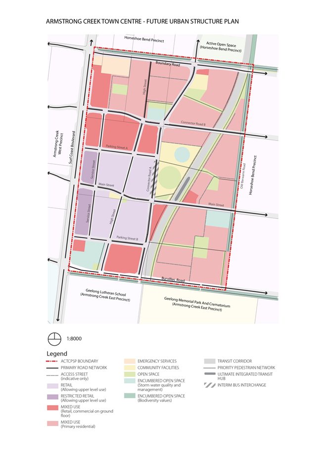
Based on the reasons set out in this Report, the Panel recommends that should be adopted as exhibited, subject to the following modifications:
Delete the first Standard of BF5-01 and add the following Guideline:
Provide housing with a maximum lot size of generally not more than 350 square metres for single dwellings on single allotments.
Delete PSP BF1-01 Standard dot point 2 and revise PSP BF1-01 Guideline dot point 1 to direct that:
50% of the Main Street development should be double storey and the remaining 50% should have double storey facades; and
Any single storey development (with double storey facade) along Main Street provides the ability to add a second storey.
Delete the overall retail floor space cap for the Armstrong Creek Town Centre from the schedule to the Commercial 1 Zone (exhibited as Business 1 Zone).
Delete individual floor space caps for land uses in Precinct 1 in Schedule 5 to the Urban Growth Zone.
Amend the table of uses in Schedule 5 to the Urban Growth Zone so that no permit is required for a Restricted retail premises of up to 2,000 square metres in Precincts 2, 3 and 4, and that a permit be required if the floor space area is exceeded.
Amend the table of uses in Schedule 5 to the Urban Growth Zone so that no permit is required for Trade supplies of up to 13,000 square metres in Precinct 4, and that a permit be required if the floor space area is exceeded.
Preserve the option to provide direct right turn access from Surf Coast Boulevard into Parking Street B and make the appropriate amendments to the relevant PSP provisions (MA2-01 and MA3-01).
Change the cross section of Main Street between Service Street and Surf Coast Boulevard to match the cross section which applies east of Connector Road A (PSP Cross Section 11).
Amend the NVPP, as recommended by DEPI, to reflect the reformed native vegetation provisions introduced into the Victoria Planning Provisions in December 2013.
Revise the relevant PSP greenway guidelines to make them flexible enough to consider alternative greenway design and cross section options at the design stage.
Change the Armstrong Creek Town Centre Development Contributions Plan to remove land for the regional transit corridor.
Change the Armstrong Creek Town Centre Precinct Structure Plan to identify the land as a ‘regional transit corridor investigation area’.
Apply the Farming Zone in Schedule 5 to the Urban Growth Zone to land identified as the ‘regional transit corridor investigation area’.
Change the Armstrong Creek Town Centre Development Contributions Plan to apportion half the cost of the Boundary Road and Connector Road A intersection to land identified as Property 4 in Plan 19 of the Armstrong Creek Town Centre Precinct Structure Plan.
Apportion the cost of the northern half of Boundary Road and Connector Road A intersection to land owned by DFC Armstrong Creek in a future Horseshoe Bend Development Contributions Plan.
Change the Armstrong Creek Town Centre Development Contributions Plan to offset the cost of constructing the Town Square with the 10% open space contribution provided by the relevant land owner.
Include the following section in the Armstrong Creek Town Centre Development Contributions Plan:
Scope Creep
During the implementation of the DCP, a development proponent may propose material changes to the demand profile scenario leading to increased requirement for infrastructure. In these cases there should be no negative net financial impact on the DCP by requiring the developer to bear the additional costs associated with the provision of the infrastructure item over and above the standard required by the DCP.
Equally, the Council or other authority is responsible for any additional costs that result from a requirement on a developer to the infrastructure item at a ‘Standard Provision’ higher than that provided in the DCP that requirement should only be imposed if the net cost increase is borne by that authority.
Amend the PSP at clause 4.11.1 and PR3-03 to include similar text used for the emergency services precinct at clause 4.7.1 regarding flexibility for alternative development of the land.
Remove any reference to Gaming premises in the table of uses.
Amend Schedule 5 to the Urban Growth Zone to allow more flexible provisions, as included in Appendix D of the Panel’s report.
Amend the Armstrong Creek Town Centre Precinct Structure Plan (Part B) to convert mandatory standards into discretionary guidelines with other modifications, as included in Appendix E of the Panel’s report.
|
. |
PANEL RECOMMENDATION |
COUNCIL POSITION |
|
1 |
Delete the first Standard of BF5-01 and add the following Guideline:
|
Supported |
|
|
|
|
|
2 |
Delete PSP BF1-01 Standard dot point 2 and revise BF1-01 Guideline dot point 1 to direct that:
|
Not Supported - 2(a) Supported - 2(b) |
|
|
|
|
|
3 |
Delete the overall retail floor space cap for the Armstrong Creek Town Centre from the schedule to the Commercial 1 Zone (exhibited as Business 1 Zone). |
Not Supported The Panel did note that the nomination of a 40,000 m² sub-regional centre was certainly justified by all evidence provided and would support the centre being established at this scale. It was also noted by the Panel, and recognised by the new planning reforms, that retail floor-space caps are still applicable within growth areas and regional areas as opposed to existing areas of metropolitan Melbourne as these areas are more susceptible to an imbalance in activity centres and require a need to protect the central activity area for each particular township. The Panel also didn't provided commentary regarding why the use of an overall floor space cap as a planning tool was not appropriate in this situation (noting that it is supported as part of the new planning reforms). |
|
|
|
|
|
4 |
Delete individual floor space caps for land uses in Precinct 1 in Schedule 5 to the Urban Growth Zone. |
Supported |
|
|
|
|
|
5 |
Amend the table of uses in Schedule 5 to the Urban Growth Zone so that no permit is required for a Restricted retail premises of up to 2,000 square metres in Precincts 2, 3 and 4, and that a permit be required if the floor space area is exceeded. |
Support |
|
|
|
|
|
6 |
Amend the table of uses in Schedule 5 to the Urban Growth Zone so that no permit is required for Trade supplies of up to 13,000 square metres in Precinct 4, and that a permit be required if the floor space area is exceeded. |
Supported Council officers support the recommendation, noting a permit is still required for larger developments > 13,000m². |
|
|
|
|
|
7 |
Preserve the option to provide direct right turn access from Surf Coast Boulevard into Parking Street B and make the appropriate amendments to the relevant PSP provisions (MA2-01 and MA3-01). |
Not Supported The Panel report states “The Panel is mindful of the potential to create an additional traffic conflict should right turns be permitted across the Surf Coast Boulevard, a busy arterial road which will eventually carry 40,000 to 50,000 vpd. The Panel considers that safety and minimisation of traffic conflict points to be paramount” The Panel also noted that the plan provides appropriate distribution of access points into parking areas and that the volume of Main Street would not be compromised by the current access arrangements and no further access points were required to manage an effective pedestrian friendly Main Street environment. |
|
|
|
|
|
8 |
Change the cross section of Main Street between Service Street and Surf Coast Boulevard to match the cross section which applies east of Connector Road A (PSP Cross Section 11). |
Support |
|
|
|
|
|
9 |
Amend the NVPP, as recommended by DEPI, to reflect the reformed native vegetation provisions introduced into the Victoria Planning Provisions in December 2013. |
Support |
|
|
|
|
|
10 |
Revise the relevant PSP greenway guidelines to make them flexible enough to consider alternative greenway design and cross section options at the design stage |
Not Supported Finally, the Panel noted that alternatives proposed by DFC Armstrong Creek had the potential to impact other landowners beyond just that of DFC Armstrong Creek and the potential for this impact would reduce the quantum of developable land available for collection of development contributions (ie: reduce fund Council collects to fund DCP projects). To respond to the issue, Council has modified the greenway "typical" cross-section (showing only minor local roads either side), and based on guidance already being provided within the Precinct Structure Plan to ensure active frontages are provided to all greenways and that their environmental and recreational values are protected during the development process. |
|
|
|
|
|
11 |
Change the Armstrong Creek Town Centre Development Contributions Plan to remove land for the regional transit corridor. |
Not Supported In addition, the Panel's recommendation is inconsistent with the Ministerial Direction - Development Contributions Plans (2003) that confirms this type of infrastructure as being appropriate to fund within a DCP. Council also strongly disagrees with the notion provided by the Panel that due to a lack of commitment to the corridor by State Government that development contributions cannot be used to fund this land. In the context of Government funding, its quite rare to have these types of commitments for long-term projects. On this basis, Council believes the corridor has a direct relationship / nexus with the Precinct and as such is appropriate for funding with the DCP. Alternatively, if the corridor was not funded by the DCP, this would place a significant financial risk on Council as the likely compensation party for any landowner claims. |
|
|
|
|
|
12 |
Change the Armstrong Creek Town Centre Precinct Structure Plan to identify the land as ' regional transit corridor investigation area'. |
Not Support |
|
|
|
|
|
13 |
Apply the Farming Zone in Schedule 5 to the Urban Growth Zone to land identified as the 'regional transit corridor investigation area'. |
Not Supported.
The Panel makes reference to the Officer Precinct Structure Plan as an example of where such a strategy was used in applying the farming zone to protect a future area of the Princess Highway. Panels, in general, regularly make comments on the need for PSPs / DCPs to be tested through the panel environment before using these amendments as a precedence. The Officer PSP is one such example that has not been tested through a panel process (ie: was approved directly by the Minister) and is at odds with their assessment of PSP / DCP decision precedence elsewhere in the report.
Council considers that the application of the Farming Zone along the length of the transit corridor also signifies a transformation of the amendment as this was never considered during the exhibition and Panel hearing process, and was not transparent to all land owners that such a control / zone would be put in place. It also creates significant uncertainty for landowners to have no direction or clarity regarding the compensation means for their land.
The use of the Farming Zone, and uncertainty for landowners, also creates a significant risk to council in relation to potential compensation claims if landowners sought to force a compensation process for the encumbrance of their land (ie: reserved for 'public purposes). |
|
|
|
|
|
14 |
Change the Armstrong Creek Town Centre Development Contributions Plan to apportion half the cost of the Boundary Road and Connector Road A intersection to land identified as Property 4 in Plan 19 of the Armstrong Creek Town Centre Precinct Structure Plan. |
Not Supported The model for all of Geelong’s DCPs is for the major arterial road intersections (controlled or to be controlled by VicRoads) to be fully funded due to their significant scale, design requirements and cost, while lower order signalised intersections have only the land and traffic signals funded within the DCP. Examples of similar DCP projects for lower order intersections include three other intersections within the Armstrong Creek Town Centre (along Connector Road A), two internal intersections for the Lara West Growth Area, the internal intersection for the Jetty Road growth area and several intersections within the neighbouring Horseshoe Bend Precinct. The further submissions on behalf of the landowner and a proforma letter (copy attached) supporting sharing the costs of the intersection between landowners in the Horseshoe Bend Precinct and the ACTC Precinct have been considered and do not alter the recommendation. |
|
|
|
|
|
15 |
Apportion the cost of the northern half of Boundary Road and Connector Road A intersection to land owned by DFC Armstrong Creek in a future Horseshoe Bend Development Contributions Plan. |
Not Supported |
|
|
|
|
|
16 |
Change the Armstrong Creek Town Centre Development Contributions Plan to offset the cost of constructing the Town Square with the 10% open space contribution provided by the relevant land owner. |
Not Support (in part) |
|
|
|
|
|
17 |
Include the following section in the Armstrong Creek Town Centre Development Contributions Plan: Equally, the Council or other authority is responsible for any additional costs that result from a requirement on a developer to the infrastructure item at a 'Standard Provision' higher than that provided in the DCP that requirement should only be imposed if the net cost increase is borne by that authority. |
Not Supported Its also acknowledged that developers regularly sign works-in-kind agreements for delivery of DCP projects many years in advance, knowing that such an agreement places a responsibility on the developer to meet the relative standards of the day (ie: changes in legislation, permit requirements, design and safety standards, etc). All DCP projects also have contingency costs built into the DCP cost to assist in protecting the party delivering the works (be this Council or a private developer). The other incentive for developer works-in-kind also extends to financing costs; whereby rather than a developer paying a cash contribution to meet their DCP liability they can defer this obligation until the project is required. Council officers have also raised the issue with the Ministerial Advisory Committee on Standard Development Contributions to be considered as part of any new Development Contributions system. It is likely that this issue would need to be considered by Government across all growth areas to ensure a consistent state wide policy position. |
|
|
|
|
|
18 |
Amend the PSP at clause 4.11.1 and PR3-03 to include similar text used for the emergency services precinct at clause 4.7.1 regarding flexibility for alternative development of the land. |
Support |
|
|
|
|
|
19 |
Remove any reference to Gaming premises in the table of uses. |
Not Supported The issue of gaming was not debated during the Panel process and as such provided little to no opportunity to consider the issue in detail. Council is also about to commence a review of its Municipal Strategic Statement to ensure is currency, however this does not negate the need to implement strong planning controls during the implementation of the Precinct Structure Plan consistent with Council current local gaming policy; Clause 22.57 - Gaming, Greater Geelong Planning Scheme. |
|
|
|
|
|
20 |
Amend Schedule 5 to the Urban Growth Zone to allow more flexible provisions, as included in Appendix D of the Panel's report. |
Supported |
|
|
|
|
|
21 |
Amend the Armstrong Creek Town Centre Precinct Structure Plan (Part B) to convert mandatory standards into discretionary guidelines with other modifications, as included in Appendix E of the Panel's report. |
Not Supported The recommendation removes all standards (i.e. musts) and moves these to guidelines (shoulds), significantly diluting their importance and ability to be implemented. This recommendation is also at odds with the Precinct Structure Planning Guidelines prepared by the Growth Area Authority (State government planning authority), as they quite clearly stipulate that the structure should reflect key mandatory requirements to implement the precinct structure plan and then more general guidelines that guide decision-making and designed within the Precinct. Finally, it should be noted that the recommendation doesn't align with the expectations of submitters who never sought this degree of change in the PSP and that Council's still have discretion relating to mandatory provisions regarding their explicit implementation. |
Cr E Kontelj re-entered the meeting room at 9:59pm
Portfolio: |
Planning - Cr Heagney |
Source: |
Planning and Tourism - City Development |
General Manager: |
Peter Bettess |
Index Reference: |
Application: C302 |
The purpose of this report is to adopt Amendment C302.
Amendment C302 proposes to rezone the western portion of the land at 302-306 Aberdeen Street, Manifold Heights to correct an anomalous Planning Scheme zoning.
The zoning of the land is unusual in that over half of the title (that fronting Shannon Avenue) is in the Commercial 1 Zone whilst the rear portion is in the Residential 1 Zone.
It is accepted practice for zoning boundaries to follow title boundaries. This anomaly has featured in the new format planning scheme since its inception in July 2000.
Amendment C302 proposes to only partially rezone the land. No permit application accompanies the Amendment.
The Amendment also proposes to delete the Design and Development Overlay 14 from the land being rezoned and to include the whole of the land within the description of the Shopping Centre in clause 52.28-4 of the Planning Scheme as one where gaming machines are prohibited.
The Amendment was exhibited between 27 February and 31 March 2014.
Three submissions have been received. Coles made a submission supporting the Amendment. Both the EPA and VicRoads have advised there is no objection to the Amendment but have raised matters to be considered in future planning permit applications for the subject land.
As there are no submissions opposing or seeking changes to the exhibited Amendment, Council is able to proceed to adoption without changes.
It is recommended that that Amendment be adopted and forwarded to the Minister for Planning seeking approval.
Cr Heagney moved, Cr S Kontelj seconded -
That Council:
adopts Amendment C302 in the form outlined in Appendix 2 of this report, and
submits the adopted Amendment together with the prescribed information to the Minister for Planning requesting approval.
Carried.
Amendment C302 has been prepared by the City of Greater Geelong which is the planning authority for this Amendment. The Amendment was initiated by Environmental Resources Management Australia Pty Ltd consultants on behalf of Coles Group Property, owner of the subject land.
The land affected by this Amendment is located at the north western corner of Aberdeen Street and Shannon Avenue, Manifold Heights. An aerial map of the area is shown in Appendix 1.
The Amendment proposes to rezone the western portion of the land from Residential 1 Zone to Commercial 1 Zone; remove the Design and Development Overlay (Schedule 14) from the western portion of the land; and amend the schedule to clause 52.28-4 to include the whole of the land at 302-306 (even numbers) Aberdeen Street in the strip shopping centre where a gaming machine is prohibited.
The zoning of the land is an anomaly as over half the title (that fronting Shannon Avenue) is in the Commercial 1 Zone while the rear portion is in the Residential 1 Zone. This existing zoning arrangement is anomalous and the 890 square metres of land proposed to be rezoned will facilitate the orderly planning of the area and allow he full commercial potential of the site to be realised. The deletion of the DDO14 is appropriate as it only applies to dwellings over 7.5 metres with access to views in a Residential 1 Zone.
The proposal was deemed to proceed without authorisation from the Minister for Planning. Exhibition of Amendment C302 took place between 27 February and 31 March 2014 with notices in local newspapers and the Government Gazette. Notice of the Amendment was sent to surrounding land owners and occupiers and to prescribed Ministers under the Planning and Environment Act 1987.
In response to the exhibition of the Amendment C302, three submissions have been received. One has been received from Coles Group Property Developments Ltd supporting the rezoning. The other two submissions are from public authorities advising of no objection.
VicRoads commented on the proposed amendment as part of the initial referral of the rezoning application and provided their previous comments are taken into account, does not object to the rezoning of the subject land. VicRoads’ earlier comments related to how access to and egress from the subject land should be managed to maintain the efficient and safe functioning of the adjoining roads. In response to the 2009 proposal to develop the land as a liquor shop, VicRoads specifically outlined that ingress to the subject site via a right turn from Aberdeen Street and egress to Shannon Avenue via a right turn could not be supported and would need to be restricted, and that they be designed to prevent patrons making the unauthorised turning movements. Council officers endorsed these comments during the initial referral process. The matter of access/egress will need to be addressed in any future planning permit application for use and development of the land.
The Environment Protection Authority advised it had no concerns with the proposed amendment with the information that has been provided. However, the EPA provides the following comments:
“It is noted from the Environmental Site Assessment for the property (Douglas Partners, 5 February 2009) that the former underground fuel storage tanks have been removed. Soil samples taken from the site indicate that contamination is present however at a level considered not to represent a risk to human health within a commercial land use setting. Likewise the report identifies groundwater contamination however the beneficial use Buildings and Structures in accordance with the State Environmental Protection Policy – Groundwaters of Victoria is considered to be protected.
In light of the Environmental Site Assessment it is considered that the rezoning of the site will not have a further impact on the beneficial uses of the site. However prior to any future development EPA recommends that Council reassess the suitability of the site for the given application as a result of the findings of this report.
Future construction and ongoing use will need to be managed appropriately to ensure the remaining beneficial use is not impacted upon.”
As the submissions do not seek to change or abandon the Amendment, Council is now able to adopt the Amendment and forward it to the Minister for Planning seeking approval. The Amendment to be adopted is in Appendix 2.
The EPA has commented that in light of the environmental assessment undertaken for the site in 2009 (the Douglas Report), the rezoning will not have any further impact on the beneficial uses of the site. It recommends that prior to any future development that Council reassess the suitability of the site for the given application as a result of the findings of the Douglas Partners Report.
Future construction and ongoing use will need to be managed appropriately to ensure the remaining beneficial use is not impacted upon.
These matters can all be dealt with at the planning permit stage.
There are no financial implications arising from this Amendment.
The Amendment implements the objectives of Planning in Victoria by addressing the Planning and Environment Act 1987, the State Planning Policy Framework and the Local Planning Policy Framework.
The Amendment aligns with the City’s strategic direction, Growing Our Economy. The Amendment will rezone land which will facilitate sustainable development of an existing centre.
In accordance with Section 80(c) of the Local Government Act Peter Bettess, General Manager, Planning and Tourism, declares an indirect financial interest in that he owns Westfarmers shares.
There are no notable risks associated with implementing the recommendation contained in this report.
No adverse social impacts are expected to result from this Amendment. Rezoning will correct an anomaly and allow full commercial use of the site removing any urban blight from this prominent corner within the shopping centre.
The Amendment does not impact on any human rights and responsibilities set out in the Charter. Planning legislation ensures an open community consultation process occurs enabling people to freely express their views and if necessary obtain a fair hearing before an independent Panel.
The Amendment was exhibited in accordance with the Planning and Environment Act 1987, including notices in the City News Section of the Geelong Advertiser and the Geelong Independent newspapers, letters to surrounding land owners and occupiers, letters to prescribed Ministers and relevant authorities, online and hard copy of the amendment documents at the Brougham Street offices of Council.
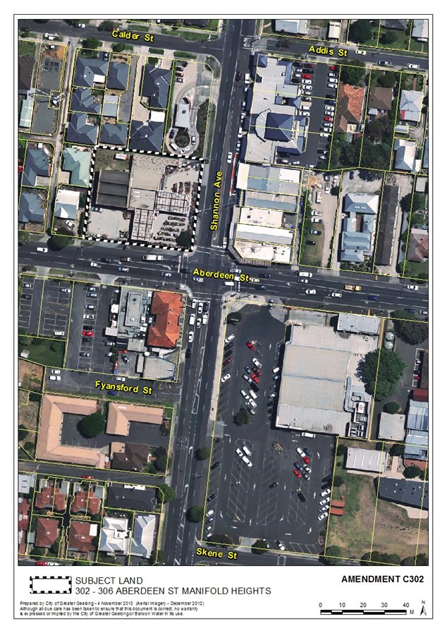
The planning authority for this amendment is Greater Geelong Planning Scheme.
The Greater Geelong Planning Scheme is amended as follows:
The Planning Scheme Maps are amended by a total of 2 attached maps.
Zoning Maps
Amend Planning Scheme Map No.49 in the manner shown on the attached map marked “Greater Geelong Planning Scheme, Amendment C302”.
Overlay Maps
Amend Planning Scheme Map No. 49DDO14 in the manner shown on the attached map marked “Greater Geelong Planning Scheme, Amendment C302”.
The Planning Scheme Ordinance is amended as follows:
In Particular Provisions – Clause 52.28-4, replace the Schedule with a new Schedule in the form of the attached document.
End of document
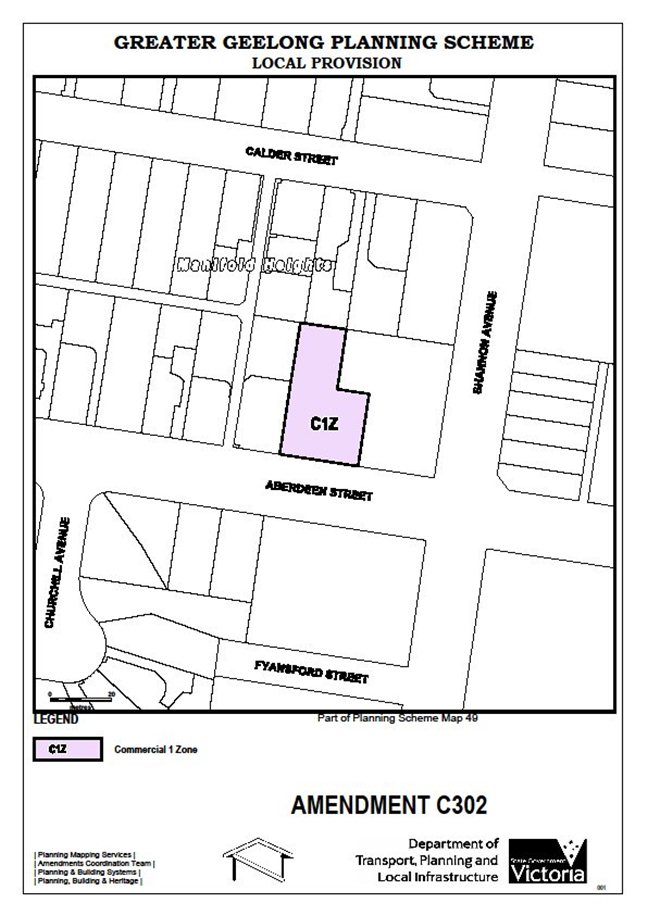
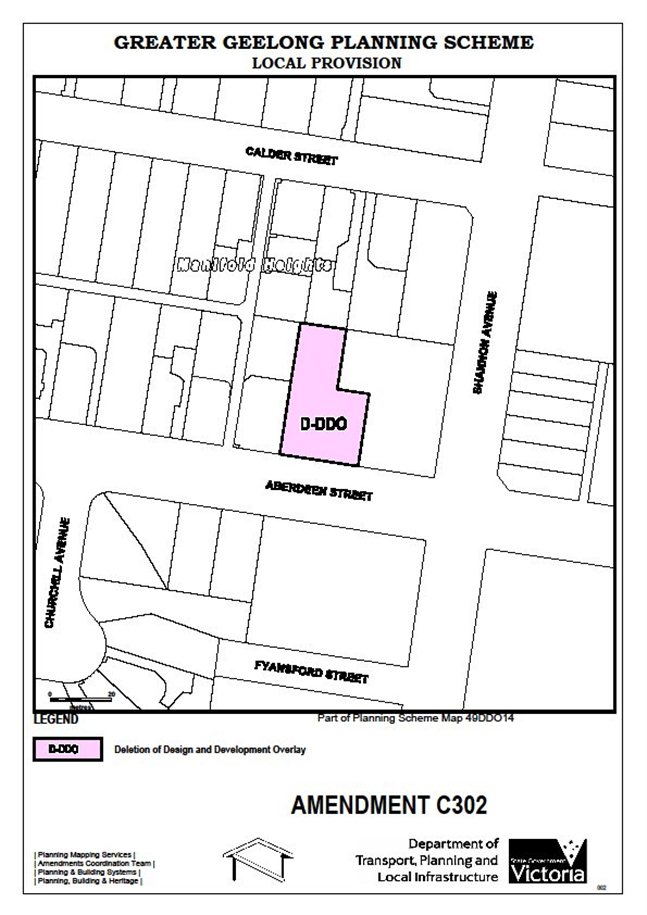
|
SCHEDULE TO CLAUSE 52.28-4 |
|
24/03/2011 C221 |
Prohibition of a gaming machine in a strip shopping centreA gaming machine is prohibited in a strip shopping centre specified in this schedule. |
|
|
Land description |
Name of strip shopping centre and locality |
|
|
Aberdeen Street Shopping Centre, Newtown |
262-288 (even numbers) and 251-255 (odd numbers) Shannon Ave; eastern part of302-306 (even numbers) Aberdeen St |
|
|
Alkira Avenue Shopping Centre, Norlane |
37-59 (odd numbers) Alkira Ave |
|
|
Anakie Shopping Centre, Bell Park |
222-226 (even numbers) Anakie Rd |
|
|
Apollo Place Shopping Centre, Whittington |
21 Apollo Place |
|
|
Ash Road Shopping Centre, Leopold |
29-49A (odd numbers) Ash Rd |
|
|
Barwon Heads Shopping Centre, Barwon Heads |
44-56 (even numbers), western part of 58, 76-84 (even numbers) and 37-51 (odd numbers) Hitchcock Ave; 1-3 (odd numbers) and rear part of 5 Clifford Parade; 8-10 (even numbers) and 1-7 (odd numbers) Bridge Rd; 2-4 (even numbers) Golightly St (excluding the southern part of the land which is in a residential zone); 2-8 (even numbers) Ewing Blyth Drive (excluding the southern part of the land which is in a residential zone) |
|
|
Beauford Avenue Shopping Centre, Bell Post Hill |
2-24 (even numbers) Beauford Ave |
|
|
Belmont Shopping Centre, Belmont |
1-211 (odd numbers) and 98A-196 (even numbers) High St; 75-77A (odd numbers) and 42-46 (even numbers) Roslyn Rd; 1-3 (odd numbers) Corio St; 33-37 (odd numbers) Thomson St; 20-22 (even numbers) Regent St; 21-25 (odd numbers) Mt Pleasant Rd |
|
|
Boundary Road (North) Shopping Centre, East Geelong |
20-28 (even numbers) Boundary Rd |
|
|
Boundary Road (South) Shopping Centre, East Geelong |
162-172 (even numbers) Boundary Rd |
|
|
Breakwater Shopping Centre, Breakwater |
216-226 (even numbers) St Albans Rd |
|
|
Central Activities Area, Geelong |
Land bounded by Cavendish St, Smyth St, Gheringhap St and Brougham St; land bounded by Brougham St, Gheringhap St and Mercer St; land bounded by Gheringhap St, Brougham St, Yarra St and Myers St (excluding 13-15 (odd numbers) Brougham St; the former Little Malop St road reservation between Moorabool St and Yarra St; and 125 Malop St); land bounded by Yarra St, Brougham St; Bellerine St and Ryrie St (excluding land on the southwest corner of Bellerine St and Brougham St commonly known as Harding Park; excluding 17A and 19 Yarra St; and excluding 2-12 (even numbers)) Bellerine St); Yarra St, Ryrie St, Argyle St and Little Ryrie St; 109-131 (odd numbers) Yarra St; 147-149 (odd numbers) Myers St |
|
|
Charles Street Shopping Centre, Newcomb |
52-74B (even numbers) Charles St |
|
|
Chilwell Village Shopping Centre, Chilwell |
315-337 (odd numbers), 361 and 361A (odd numbers) and 312-364 (even numbers) Pakington St; 57 Sharp St |
|
|
Clifton Springs Shopping Centre, Clifton Springs |
9-29 (odd numbers) Springs St; 44-54 (even numbers) Clifton St |
|
|
Detroit Crescent Shopping Centre, Corio |
11-33 (odd numbers) Detroit Cr |
|
|
Donnybrook Road Shopping Centre, Norlane |
13-31 (odd numbers) Donnybrook Rd |
|
|
Dorothy Street Shopping Centre, Leopold |
8-26 (even numbers) Dorothy St |
|
|
Drumcondra Shopping Centre, Drumcondra |
1-31 (odd numbers) Melbourne Rd; 31 Glenleith Ave |
|
|
East Geelong Shopping Centre, East Geelong |
1-29 (odd numbers), 2-10 (even numbers) and 10A Ormond Rd; 88 Sydney Pde; 68-78 (even numbers) Garden St; 263-275 (odd numbers) and 256-274 (even numbers) Myers St |
|
|
Fairlie Street Shopping Centre, Hamlyn Heights |
7-11 (odd numbers) and 21-29 (odd numbers) Fairlie St |
|
|
Francis Street Shopping Centre, Belmont |
50-58 (even numbers) Francis St |
|
|
Highton Village Shopping Centre, Highton |
63-95 (odd numbers) Barrabool Rd; 2-12 (even numbers) and 1-19 (odd numbers) Belle Vue Ave |
|
|
Holyrood Avenue Shopping Centre, Newtown |
11-19 (odd numbers) Holyrood Ave |
|
|
Hughes Street Shopping Centre, Bell Park |
31-59 (odd numbers) Hughes St; 70-74 (even numbers) Thorburn St |
|
|
Kidman Avenue Shopping Centre, Belmont |
46-54 (even numbers) Kidman Ave |
|
|
Labuan Square Shopping Centre, Norlane |
1-21 (all numbers) Labuan Square |
|
|
Latrobe Terrace Shopping Centre, Newtown |
344-382 (even numbers) Latrobe Terrace; 2 Bond St |
|
|
Madeley Street Shopping Centre, Ocean Grove |
65-75 (odd numbers) Madeley St |
|
|
Milton Street Shopping Centre, Bell Park |
9-35 (odd numbers) and 18-30 (even numbers) Milton St |
|
|
Minerva Road Shopping Centre, Geelong West |
1-29 (odd numbers) Minerva Rd; 219-219B (odd numbers) Church St |
|
|
Mt Pleasant Road Shopping Centre, Belmont |
108-114 (even numbers) Mt Pleasant Rd |
|
|
Nicholas Street Shopping Centre, Newtown |
91-99 (odd numbers) Nicholas St; 17-19 (odd numbers) Stinton Ave |
|
|
Ormond Road Shopping Centre, East Geelong |
136-146 (even numbers) Ormond Rd |
|
|
Pakington Street Community Shopping Centre, Geelong West |
81-205 (odd numbers) and 102-246 (even numbers) Pakington St; 84-90 (even numbers) Autumn St; 80-88 (even numbers) and 63 Hope St; 72 Weller St; 1A Lawton Ave; 69 O’Connell St; 2-4 (even numbers) Clarence St; 80-82 (even numbers) Spring Street; 69-71 (odd numbers) Autumn Street; 47 Gordon Avenue; 48-50 (even numbers) Gordon Avenue. |
|
|
Patullos Road Shopping Centre, Lara |
2-20 (even numbers) Patullos Rd; 1-11 (odd numbers) Station Lake Rd; 1 Forest Rd Sth (excluding that part on the eastern boundary zoned residential and that part on the western boundary reserved for road widening) |
|
|
Perrett Street Shopping Centre, Grovedale |
286 Torquay Rd; 1A Perrett St |
|
|
Peter Street Shopping Centre, Grovedale |
11-21 (odd numbers) Peter St |
|
|
Portarlington Main Shopping Centre, Portarlington |
16-96 (even numbers) Newcombe St; land at the north-east corner of Harding and Newcombe St having a frontage of approximately 40 metres to both streets; 1-5 (odd numbers) Harding St; 2-12 (even numbers) and 1-9 (odd numbers) Brown St; 45-49 (odd numbers) Fenwick St |
|
|
Porter Avenue Shopping Centre, Highton |
2-24 (even numbers) Porter Ave |
|
|
Robin Avenue Shopping Centre, Norlane |
60A-74B (even numbers) Robin Ave |
|
|
Rose Avenue Shopping Centre, Norlane |
22-44 (even numbers) Rose Ave |
|
|
Separation Street Shopping Centre, Geelong North |
67-141 (odd numbers) Separation St |
|
|
Shannon Avenue Shopping Centre, Geelong West |
103-163 (odd numbers), northern part of 165 and 80-188 (even numbers) Shannon Ave; 127-131 (odd numbers) Clarence St |
|
|
Shannon/Autumn Shopping Centre, Geelong West |
197-209 (odd numbers) Shannon Ave |
|
|
Shell Road Shopping Centre, Ocean Grove |
91-139 (odd numbers) Shell Rd |
|
|
Sproat Street Shopping Centre, Portarlington |
1-13 (odd numbers) Geelong Rd |
|
|
St Albans Road Shopping Centre, East Geelong |
57-63B (odd numbers) and 60 St Albans Rd; 29-31 (odd numbers) Darling St; 1-5 (odd numbers) Martin St; 2-8 (even numbers) Breakwater Rd |
|
|
St Georges Road Shopping Centre, Norlane |
48-62 (even numbers) St Georges Rd |
|
|
St Leonards Main Shopping Centre, St Leonards |
1 and 2 Bluff Rd; 495 and 496 The Esplanade; 1355-1391 (odd numbers) and 1370-1376 (even numbers) Murradoc Rd |
|
|
Stephen Street Shopping Centre, Belmont |
1-19 (odd numbers) Stephen St |
|
|
The Terrace Shopping Centre, Ocean Grove |
96-98 (even numbers) The Parade; 63A-87 (odd numbers) and 62-82 (even numbers) The Terrace; 99 Presidents Ave; 2-15 (all numbers) Park Lane |
|
|
Torbreck Street Shopping Centre, Corio |
23-29 (odd numbers) Koscuisko Ave |
|
|
Tuckfield Street Shopping Centre, Ocean Grove |
2-16 (even numbers) Grubb Rd |
|
|
Vines Road Shopping Centre, Bell Park |
63-119 (odd numbers) Vines Rd |
|
|
Walsgott Street Shopping Centre, North Geelong |
27-41 (odd numbers) Walsgott St |
|
|
Watsons Road Shopping Centre, Newcomb |
38-58 (even numbers) Watsons Rd |
|
|
Wilsons Road Shopping Centre, Newcomb |
134, 136, 138, 138B, 140 and 142 Wilsons Rd |
|
Portfolio: |
Planning - Cr Heagney |
Source: |
Planning and Tourism-Planning Strategy |
General Manager: |
Peter Bettess |
Index Reference: |
Bellarine Peninsular Strategic Planning |
The purpose of this report is to seek Council’s approval to release the draft Bellarine Peninsula Localised Planning Statement to inform the community and seek their endorsement of its directions.
The State Government determined that Localised Planning Statements should be prepared for four areas in Victoria. The areas affected are Macedon Ranges, Yarra Valley, Mornington Peninsula and the Bellarine Peninsula.
The drafting of the Localised Planning Statements (LPS) is required to be undertaken by local government in collaboration with the Department of Transport, Planning and Local Infrastructure (DTPLI). Funding of $25,000 was provided for each Council to assist with community engagement on the LPS consultation and project processes.
The draft Bellarine Peninsula Localised Planning Statement (BPLPS) is included in Appendix 1. The draft BPLPS was prepared jointly with officers at the Borough of Queenscliffe. It consolidates the existing planning policies in the Greater Geelong Planning Scheme and the Queenscliff Planning Scheme and reflects previous strategic plans prepared by the City of Greater Geelong and the Borough of Queenscliffe.
The objectives in the BPLPS are; to protect rural and coastal environments and non-urban breaks between townships, support the ongoing use of rural land for agriculture, to protect environmentally significant areas, to protect built heritage and character of townships, facilitate planned growth of Leopold, Ocean Grove and Drysdale/Clifton Springs and ensure all townships have facilities to serve the local needs of their communities including employment opportunities and to support tourism activity in towns and in rural areas where it is respects the open farmed landscape and is ancillary to an existing farming activity.
The draft BPLPS is proposed to be made available on Council’s website with hard copies available at customer services centres on the Bellarine. As the BPLPS is based on existing strategies and policies which underwent separate public consultation processes the intention of the communication strategy is to inform the community that the BPLPS has been prepared and seek endorsement of its directions.
The community will be invited to complete an online survey about the draft BPLPS during a four week period. This will be supplemented with a fact sheet prepared by DTPLI about Localised Planning Statements.
Completed surveys will be reviewed and the BPLPS amended in response if necessary. A report to Council with the final BPLPS is intended to be provided in August 2014. After this time the BPLPS will be sent to the Minister for Planning for his consideration and inclusion in the Planning Scheme.
Cr Heagney moved, Cr Ellis seconded -
That Council approve the release of the draft Bellarine Peninsula Localised Planning Statement to inform the community and to seek their endorsement of the directions via an online survey.
Carried.
In the 1970’s Statements of Planning Policy were prepared for eight areas around the State. These were essentially superseded by the State-wide reforms to the planning system in 2000 and the development of the State Planning Policy Frameworks which are included in all planning schemes in the State.
The State Government made a pre election commitment to establish Localised Planning Statements for four areas;
Macedon Ranges,
Yarra Valley,
Mornington Peninsula
Bellarine Peninsula.
This was also restated as an initiative of Plan Melbourne, the State Government’s new planning strategy for Melbourne.
Currently the State Government is also reviewing the structure of planning schemes with the assistance of a Ministerial Advisory Committee. They have developed a new Planning Policy Framework which includes the following preamble for the Localised Planning Statements and provides insight as to the selection of these areas.
“The distinctive areas of the Bellarine Peninsula, Macedon Ranges, Mornington Peninsula and Yarra Valley have significant geographic and physical features which contribute to the quality of life for Victorians and are a distinctive part of our State. These areas play an important role in the State as tourist destinations and have strong economic bases driven by tourism, agribusiness and lifestyle, with all areas linking strongly with Melbourne.
Because of their attractiveness, accessibility and proximity to metropolitan Melbourne these areas are increasingly coming under pressure for growth and change. This could potentially undermine the long-term natural or non-urban uses of land in these areas and needs to be carefully managed.”
The BPLPS is not changing planning policies or settlement boundaries on the Bellarine Peninsula. It consolidates existing policies and ensures they will be given appropriate consideration following endorsement by the Minister for Planning.
The Localised Planning Statements will appear in the State section of planning schemes and will be supported by a new Ministerial Direction and a guideline or advisory note. This means that preparation of planning scheme amendments on the Bellarine would have to have regard to the LPS. The inclusion of the LPS in the State section of planning scheme is seen to be of benefit. The LPS will be adopted State Government policy which will consequently give it more weight in planning decisions and more certainty for Council and the community as only the State Government can change the State section of planning schemes.
The LPS may also be used as part of a broader justification for the application of new zones or overlays should Council wish to consider additional controls on the Bellarine. This was attempted in 2007 when a proposal to apply the Rural Conservation Zone to the Bellarine was rejected by a planning panel appointed by the Minister for Planning.
The process to deliver the LPS was formulated by DTPLI. A working group with officers from all five councils was established. Each council is drafting their LPS, the exception being the Bellarine, which will be jointly authored by the City and officers from the Borough of Queenscliffe. Each Council has been provided with a $25,000 grant to assist with community engagement, consultation and project processes.
The content of the LPS is prescribed by DTPLI and must include:
An introductory section which provides context-this has been prepared by DTPLI
An outline of valued characteristics of the location
A map that identifies the area where the LPS applies
The draft BPLPS included at Appendix 1 defines the valued characteristics:
“The Bellarine Peninsula is significant for its visual landscape characteristics. With its individually distinct coastal settlements in a rural setting with sweeping views across rolling hills, coastlines, wetlands and open farmed landscapes the Bellarine is a sought after location”.
The key principles in the draft BPLPS are:
To protect and enhance rural and coastal areas and maintain non-urban breaks between towns;
To support agriculture on the Bellarine and maintain the open farmed landscape;
To protect environmentally sensitive locations including wetland, coastal and vegetated areas;
To protect built heritage and urban character values in townships.
To facilitate the planned growth of designated areas and ensure towns provide services to meet local communities. The designated growth areas are Leopold, Ocean Grove and Drysdale/ Clifton Springs.
To support tourism in towns and in rural areas only where it is ancillary to existing farming activities and does not impact upon the rural landscape.
These principles were derived from existing polices in the Greater Geelong Planning Scheme; Clause 20.6 Settlement, Clause 21.14 Bellarine Peninsula, Clause 22.05 Agriculture, Rural dwellings and Subdivision and Clause 22.06 Tourism Development in Rural Areas.
The draft BPLPS also reflects additional information from township structure plans, the Rural Land Use Strategy 2007, the Coastal Spaces Landscape Assessment (2006), the Bellarine Peninsula Strategic Plan (2005) and the Bellarine Peninsula Strategic Plan-Five Year Progress Audit (2012). All of these strategies were subject to extensive community consultation processes with residents on the Bellarine.
The communications strategy prepared in support of the draft BPLPS acknowledges that its content is a consolidation of existing policies which were subject to prior consultation processes. The draft BPLPS does not represent a change in direction or contain new initiatives. The intention of the communications plan is to inform the community about the direction from the State Government to prepare Localised Planning Statements and to seek their endorsement of the directions in the draft.
The draft BPLPS is proposed to be made available on Council’s website with hard copies available at customer services centres on the Bellarine.
The community will be invited to complete an online survey about the draft BPLPS during a four week period. This will be supplemented with a fact sheet prepared by DTPLI about Localised Planning Statements. Hard copies of the survey will also be made available at customer service centres.
The draft BPLPS includes objectives about protecting the environment, vegetation and coastal and wetland areas.
The preparation and release of the draft BPLPS will have no financial impact on Council. The costs of advertising and consultation will be met through the grant funding provided by DTPLI.
Current approved budget.
Income of $25,000 has been provided from DTPLI to cover projects costs and consultation costs.
The draft BPLPS is derived from policies in the Greater Geelong Planning Scheme, as such it will reinforce existing Council policies. When approved the BPLPS will have to be considered in the preparation of planning scheme amendments on the Bellarine.
The preparation of the draft BPLPS aligns with the Sustainable Built and Natural Environment strategic directions in City Plan. Specific objective about protecting sensitive wetlands and coastal areas are included. It also responds to the Growing our Economy direction in that it promotes the use of rural land for agricultural uses such as viticulture, cropping and grazing and horticulture which contribute to Geelong’s economy.
No Council officers have a direct or indirect interest in accordance with Section 80 (C) of the Local Government Act in the issue to which this report relates.
There are no known risks associated with the draft BPLPS.
The draft BPLPS is derived from existing planning scheme policies. It includes directions derived from previous strategies which were developed in consultation with the community. Provision is made for social considerations including the need to ensure that towns on the Bellarine provide services and community infrastructure to service the local population.
The draft BPLPS will not impact on any basic rights, freedoms and responsibilities as set out in the Charter. The directions in the draft BPLPS are based on other adopted policies which were subject to extensive community consultation processes.
The draft BPLPS and supporting explanatory information will be made available on Council’s website with a targeted questionnaire to invite feedback for a four week period. The communications strategy has been developed acknowledging that the draft BPLPS is consolidating existing policies already in the planning scheme-the directions in the LPS are not new.
The draft BPLPS and the survey will be advertised in City News and in the local community papers on the Bellarine. Hard copies of the draft BPLPS and the survey will be made available at customer service centres at Drysdale and Ocean Grove. The City is working with the Borough of Queenscliffe to explore opportunities to jointly undertake the consultation processes.
Portfolio: |
Transport – Cr Richards |
Source: |
City Services |
General Manager: |
Gary Van Driel |
Index Reference: |
Heavy Vehicle, Transport |
The purpose of this report is to seek Council endorsement for the creation of a G21 Regional Road Group of councils.
The Municipal Association of Victoria has written to Councils in Victoria providing an update on the Heavy Vehicles Charging and Investment (HVCI) project and is seeking feedback on the formation of Local Government Regional Road Groups
Local roads funding will be allocated to priorities as agreed by regional groupings of Councils working in conjunction with other stakeholders. This is likely to open up a new stream of funding towards local roads
In discussions regarding the process, role and expectation of these new entities it is obvious that the current framework for the G21 Regional Alliance provides an excellent governance structure to accommodate the requirements of a new Road Group. The Board includes Local Government representatives both Mayors and CEO’s from each Council together with several independent community representatives, The G21 Transport Pillar includes State and Local Government officers, industry, business and community representatives.
Cr Richards moved, Cr Irvine seconded -
That Council supports the establishment of a G21 Region Roads Group of Councils in response to the changes identified through the funding allocations for road funds under the National Heavy Vehicle Charging and Investment project.
Carried.
In 2006, the Council of Australian Governments (COAG) outlined a national reform agenda which included the COAG Road Reform Plan (now known as the Heavy Vehicle Charging and Investment Reform or HVCI).
COAG's objective for this reform is to promote a more efficient, productive and sustainable provision and use of heavy freight infrastructure. The Council of Australian Governments (COAG) Road Reform Plan Feasibility Study, released in 2011, found that reform was feasible if charges were linked to road funding and investment changes.
The Municipal Association of Victoria has written to Councils in Victoria providing an update on the Heavy Vehicles Charging and Investment (HVCI) project and is seeking feedback on the formation of Local Government Regional Road Groups.
In what will be the most significant change to local roads funding in decades, the Federal Governments’ Heavy Vehicle Charging and Investment project has been indentified by the Council of Australian Governments (COAG) in late 2013 as an urgent major transport reform priority project.
A final report from the HVCI Reform Group will be presented to the Federal Government in late 2014.
At the Council of Australian Governments (COAG) meeting in December, 2013, the NHVR reform project was identified as an urgent major transport reform priority project.
The Prime Minister and Premiers of COAG issued a call to action on a number of priority infrastructure projects designed to improve productivity, competition and economic growth.
The HVCI project is planned to introduce key reports in the next few years involving:
Establishment of National legislation for heavy vehicles under management by the National Heavy Vehicle Regulator (NHVR).
Substantial change to existing road funding arrangements, with local roads included in Heavy Vehicle funding distributions for the first time – based on a regional level and requiring asset planning to gain access to the new funds.
Heavy vehicle charges ($3 billion annually) dedicated to entirely to road improvements and including local roads projects for the first time.
Local roads funding will be allocated to priorities as agreed by regional groupings of Councils working in conjunction with other stakeholders.
Currently Victoria is the only State without regional road groups in place. The HVCI Reform Group has approached the MAV and has asked that Victoria establish Local Government Regional Road Groups as a matter of urgency.
The project is seeking run trials involving selected regional groups of Councils in 2014 to identify how the scheme as proposed can best operate in each state.
Regional Road Groups will have responsibilities including:
Establishment of regional road asset management plans
Establishing levels of service and asset condition forecasting
Forecasting future heavy vehicle demand
Identifying local road priorities for the region.
The regional roads groups are made up of Mayors and CEO’s from each Council and are supported by a technical reference group.
Senior Infrastructure Mangers from Surf Coast Shire Council, City of Greater Geelong, Colac Otway Shire, Borough of Queenscliffe, Golden Plains Shire and Vicroads have met with a representative from the MAV to discuss the way forward in establishing a regional road group for this region.
In discussions regarding the process, roles and expectations of these new entities it became obvious that the current framework for the G21 Regional Alliance provides an excellent structure to accommodate the requirements of a new Road Group. The Board includes Local Government representatives both Mayors and CEO’s from each Council together with several independent community representatives, The G21 Transport Pillar includes State and Local Government officers, industry, business and community representatives.
It was generally felt that there would be little advantage in establishing yet another forum for Mayors, CEO’s and officers in a separate road group.
This matter has been discussed at the G21 Transport Pillar and there was general support for this position.
Effective road networks play a vital role in moving freight and goods in an efficient manner – regional planning enables a broader understanding of movement of particular commodity streams and provides a more holistic perspective on transport needs. This ultimately provides a better environmental outcome in maximising the efficiency of the freight task.
In what will be the most significant change to local roads funding in decades, the Federal Governments’ Heavy Vehicle Charging and Investment project has been indentified by the Council of Australian Governments (COAG) in late 2013 as an urgent major transport reform priority project.
Heavy vehicle charges of around $3 billion annually will be dedicated entirely to road improvements and including local roads projects for the first time.
Local roads funding will be allocated to priorities as agreed by regional groupings of Councils working in conjunction with other stakeholders. This will have implications for the way projects are prioritised and funded under the new model arrangements.
Council has responsibility for management and maintenance of local roads in accordance with the Road Management Act. Additional funding provides an opportunity for Council to address the asset renewal gap associated with road and related infrastructure.
This report aligns with the City Plan as follows:
Sustainably Built and Natural Environment
Support our Community to live sustainably – Encourage increased use of alternatives to car transport and seek efficient traffic movement throughout the municipality
Growing our Economy
Facilitate Major Infrastructure and Investment to enable Economic Growth -Advocating on Local, State and Federal Government infrastructure priorities and funding submissions
There is no Council Officer direct or indirect interest involved in this report.
It is important for Council to engage in the changes proposed under the new guidelines for funding allocations from the Federal Government. Council has secured funding through the Roads to Recovery program and will need to participate in the new regional road groupings to access funding through the new process.
The development of comprehensive integrated regional road transport plans will provide efficient and better aligned planning for the community road infrastructure. G21 has been active in compiling infrastructure needs at a regional level as part of the development of the Regional Growth Plan.
In developing this report to Council, the subject matter has been considered to determine if it raises any human rights issues. In particular, whether the scope of any human right established by the Victorian Charter of Human Rights and Responsibilities is in any way limited, restricted or interfered with by the recommendations contained in this report. It is considered that the subject matter does not raise any adverse human rights issues.
The National Heavy Vehicle Charging and Investment project is initiated through agreement from COAG. Industry briefings and engagement through State representative bodies provides feedback and opportunity for input. The most recent correspondence from the MAV has provided a status update on the project to date and has foreshadowed the need to create the regional road groups.
Portfolio: |
Infrastructure – Cr Ellis |
Source: |
City Services - Engineering Services |
General Manager: |
Gary Van Driel |
Index Reference: |
Special Rates and Charges; Melville Avenue |
This report seeks a resolution by Council to consider an intention to declare a Special Charge Scheme to partially fund the construction of a footpath along both sides of Melville Avenue between Queens Park Road and Layton Crescent, Newtown. (See plan – Appendix 4)
Property owner concerns in regards to the lack of a footpath in Melville Avenue have been filtering in to Council for many years. Council considers the footpath will provide the pedestrian link between Queens Park Road and Layton Crescent in Newtown and be an important safety initiative. In addition to this work, a concrete retaining wall and replacement pram crossings are proposed to complete the project from an engineering perspective.
It is proposed to construct the footpaths a standard 1.5 metres wide to provide for pedestrian access along both sides of Melville Avenue.
There are twenty two (22) properties abutting the proposed footpath that will receive special benefit. There are no Council owned properties in the proposed scheme.
The total estimated project cost is $158,210. This includes direct funding by Council estimated at $20,357 for the construction of a concrete retaining wall associated with the footpath construction past No 2 Melville Avenue and four (4) replacement pram crossings. The net scheme cost is estimated to be $137,853.
A Benefit Ratio of 0.28 has been calculated in accordance with Section 163 of the Local Government Act. This equates to a Council contribution to the scheme of $99,254 and a property owner contribution of $38,599
Property owners are considered to receive benefit from the works by way of improved pedestrian access and general amenity including pedestrian safety improvements.
The scheme has been prepared in accordance with the Special Rate and Charges provisions of the Local Government Act 1989 along with the 2004 Ministerial Guidelines and Council’s Special Rates and Charges Policy.
(Items 9, 10 and 11 were moved and seconded in block)
Cr Ellis moved, Cr Richards seconded -
That Council:
Gives notice of its intention to declare a Special Charge Scheme in accordance with Section 163 (1A) of the Local Government Act 1989 (The Act), as follows:
The Special Charge is declared for a period of four (4) years commencing upon completion of the works and scheme finalised.
The Special Charge be declared for the purpose of defraying any expenses incurred by Council in relation to the construction of the footpath between Laytons Crescent and Queens Park Road, Newtown which project:
Will provide proper pedestrian access, improved general amenity including pedestrian safety for each of the properties included in the scheme;
Council considers is or will be a special benefit to those persons required to pay the special charge (and who are described in succeeding parts of this Resolution); and
Arises out of Council’s function of planning for and providing infrastructure for property owners.
The total cost of project, be recorded as $158,210(Schedule A).
It be recorded that, for the purposes of Section 163 (2A) of the Act, the special charge proceeds will not exceed the amount calculated in accordance with the prescribed formula (R x C = S), the:
‘benefit ratio’ (R) being calculated at 0.28 represents the special benefits to all persons liable to pay the special charge (Schedule B);
‘total cost’ (C) of performing the function described in part 1 (b) of this resolution based on estimated cost be recorded as $137,853; and
‘maximum levy’ (S) be recorded as $38,599
the following be specified as the area for which the special rate is so declared:
the area within municipal district of Council highlighted in the plan attached to this Resolution (Appendix 4).
the following be specified as the land in relation to which the special charge so declared:
land within the area shown on the plan.
the following be specified as the criteria which form the basis of the special charge so declared:
ownership of any land described in Part 1(e) of this Resolution.
the following be specified as the manner in which the special charge so declared will be assessed and levied:
Each lot receives a primary access and amenity benefit;
Corner lots with multiple frontages receive reduced access benefits;
The maximum levy is apportioned 80% on access benefit and 20% on a frontage share basis (amenity benefit);
The special charge will be levied by sending a notice to the person who is liable to pay, pursuant to section 163(4) of the Act.
having regard to the preceding parts of this Resolution but subject to Section 166 (1) of the Act, it be recorded that;
the owners of the land described in column 3 of Schedule C to the resolution are estimated liable for the respective amounts set out in column 8 of Schedule C; and
such owners may, subject to any further resolution of Council pay the special charge in the following manner;
the charge will become due and payable within one month of the issue of the notice requesting payment pursuant to Section 167 (3) of the Act;
interest will not be charged for six months after the issue of the notice provided the person liable makes timely payment in accordance with any repayment arrangements that may be agreed on by Council; and
in accordance with Section 172 of the Act, the interest rate payable on the special charge which has not been paid by the specific date is set at Council’s overdraft rate, reviewed every three months (provided that it shall not exceed the rate fixed by the Governor in Council by Order for the purposes of Section 172 (2A) in which case the rate of interest shall be the maximum rate fixed by the Governor in Council by Order for the purposes of this section).
Council’s Chief Executive Officer be authorised to levy the Special Charge in accordance with Section 163 (4) of the Act.
Carried.
In the 1980’s (approximate date only based on resident recollection), Layton Crescent was controversially closed to through traffic by the then Newtown and Chilwell Council. Anecdotal evidence suggests that the closure may have been a consequence of “Rat Running” between Shannon Avenue and Minerva Road. This subsequently caused a net increase in the traffic volumes for Melville Avenue.
Compounding the Layton Crescent closure, the location of schools in the vicinity of Melville Avenue causes relatively high traffic volumes of approximately 4000 plus vehicle per day. The curving alignment and steep decline of the road near Queens Park Road causes restrictions to sight distance and an increase in safety implications for pedestrians and cyclists that may use the road for access.
In 2007 a footpath scheme proposal was initiated with a survey to abutting property owners that showed insufficient support to progress the scheme at that time. In late 2010, another scheme proposal was introduced and was also followed up with a survey. Twelve (12) property owners responded to the survey representing a 55% response rate with five (5) in favour of the proposal and seven (7) opposed.
Due to the continued safety concerns as the prime consideration, it is considered appropriate to have the road upgraded to contemporary standards in terms of pedestrian access as calls for new footpaths in Melville Avenue continue.
Council Officers have now developed a detailed Special Charge Scheme proposal including a cost estimate, Benefit Ratio calculation and cost apportionment spreadsheet. The estimated charges, along with more detailed information on the scheme, were shown to all potentially affected property owners who were again asked to respond to the proposal via survey.
The final survey had seventeen (17) property owners respond representing a 74% response rate with seven (7) in favour and ten (10) opposed to the scheme proposal.
Melville Avenue is initially very steep at the Queens Park Road end with a grade of 1 in 5 up to Whyte Court. It then flattens out to a gentler grade for the remainder of its length to Layton Crescent.
This proposed project involves the construction of 470 metres total length of 1.5 metre wide footpath between Layton Crescent and Queens Park Road, Newtown. It is proposed to construct the footpath on both sides of Melville Avenue and is expected to be a safety improvement for pedestrian traffic.
Property owner concerns include the amount of vehicular traffic now using Melville Avenue as a thoroughfare for Geelong and St Josephs College. It is further alleged that the opening of the Ring Road has actually increased the traffic volumes in the area however this claim is unconfirmed. Other concerns include the “steep, uneven and slippery surface” at the southern end near Queens Park Road, lack of protective barriers for pedestrians and the ‘hazardous conditions for pedestrians and cyclists’.
Of the latest survey results, some of the comments by property owners opposing the proposed footpath include:
‘A footpath on the Eastern side of Mellville Avenue would be dangerous due to lack of barriers’;
‘A footpath should be constructed on the West side only’;
“I do not use the footpath”;
‘Council should pay as it is for the wider public and a Council responsibility’;
‘Cost apportionment is not clear’;
“A footpath would spoil the streetscape “and “terrain is too steep”;
“It is safer with a grass surface”; and
“Footpath is not needed here”.
Conversely, some of the comments by property owners supporting the footpath include:
‘Footpath on the West side is dangerous and needs constructing for safety reasons regardless of the outcome of the survey’;
‘Existing conditions cause pedestrians and school children to walk on the roadway during wet months to avoid the muddy nature strips’;
“A footpath would discourage vehicles parking on the nature strip”;
‘Current situation is an embarrassment to residents’
Cost apportionment for the scheme has been divided into access and amenity benefits. It is considered that all abutting properties with direct frontages to the proposed new footpath, regardless of size and shape, receive the same access benefit. An exception to this rule is corner properties with dual frontages where a reduction of the access benefit has been applied.
80% of the total benefit has been apportioned to access considering the purpose of the scheme. The access benefit includes the provision of an all weather sealed surface that reduces the risk of accidents caused by uneven and slippery surfaces. A new footpath also eliminates the nuisance affect of dust and mud. In simple terms, a new footpath improves accessibility for all abutting properties.
The remaining 20% of benefit is attributed to amenity and this can best be described as the benefit the pathway provides to an abutting property by way of improved aesthetics, safety, enjoyment, comfort and property value. The amenity benefit is based on the actual footpath frontage to a property when existing driveways and footpath extents are taken into consideration. This is known as the apportion-able frontage and is shown at Column 4 of Schedule C.
The provision of a sealed pathway surface provides a permanent and safe means of access. During the course of construction and the manufacture and procurement of materials, energy is expended resulting in some greenhouse gas emissions. This ceases when construction is complete.
The project does not create waste with the exception of some excavated material.
The proposal does not affect any natural habitats.
The proposal will require some nature strip and property trees and shrubs to be trimmed but removal of vegetation is not expected.
The project is a one off capital cost and there will be minimal ongoing maintenance costs. If approved, the scheme could proceed next financial year.
Financial details are as follows:
|
Maximum scheme levy to Property Owners (income) |
$38,599 |
|
Scheme levy to Council |
$99,254 |
|
Direct Funding by Council to construct a concrete retaining wall and replacement pram crossings |
$20,357 |
|
Total Project Cost |
$158,210 |
From the table above, the total net cost to Council for this project is estimated to be $119,611.
The scheme has been prepared in accordance with the Special Rate and Charge provisions of the Local Government Act 1989 along with the 2004 ministerial guidelines and Council’s Special Rates and Charges Policy.
This report aligns with the City Plan as follows:
Sustainably Built and Natural Environment
Support our Community to live sustainably – Encourage increased use of alternatives to car transport and seek efficient traffic movement throughout the municipality.
Advocate for and promote sustainable design and development – Promoting sustainable design and retrofitting.
Acknowledge the community’s desire to have their say and be involved in planning for the future of Greater Geelong.
No Council Officer involved with this process has any direct or indirect interest in the properties.
Provision of a sealed pathway will provide safer walking and cycling conditions for pedestrians and cyclists by minimising the risk of personal injuries through conflict with vehicles and the elimination of uneven and slippery surfaces.
There is an identified risk in the steep section of footpath proposed between Whyte Court and Queens Park Road. Due to the existing terrain, it is not possible for this section of footpath to comply with the Disability Discrimination Act (DDA) in terms of grade. The required grade for compliance is 1 in 14 however the actual grade will be up to 1 in 5. Due to the existing slope and constraints of the nature strips in this section, it is an unrealistic expectation to achieve DDA compliance in this case. It is further considered however, that the new footpath will provide a great improvement on the existing conditions.
There are no identified risks for Council in making its intention to declare the scheme.
The provision of properly sealed and drained pathways is aligned to Council’s City Plan as described above and provides improved connectivity and safety for pedestrians and cyclists. It is further considered that the footpaths will enhance the general amenity of the area.
In developing this report to Council, the subject matter has been considered to determine if it raises any human rights issues. In particular, whether the scope of any human right established by the Victorian Charter of Human Rights and Responsibilities is in any way limited, restricted or interfered with by the recommendations contained in this report. It is considered that the subject matter does not raise any adverse human rights issues.
It is further considered that the construction of the footpaths upholds the right to freedom of movement (Section 12 of the Human rights Charter) by enhancing a person’s ability to move freely within the area they choose to live.
Community consultation for the footpath construction Special Charge Scheme has been carried out as follows:
July 2007 – Initial property owner survey that indicated insufficient support for a proposed footpath Special Charge Scheme
October 2010 – Due to increasing concerns a further survey was carried out but still indicating a minority of support to a proposed Special charge Scheme.
March 2014 – Final correspondence to property owners included an explanatory letter, plan, Special Charge Scheme brochure, cost apportionment spreadsheet and final survey. The survey results still indicated a minority of support.
The works for the construction of footpaths in Melville Avenue Newtown which consist of excavation, footpath, retaining wall, reinstatement of nature strip, miscellaneous construction works, legal advice and professional services associated with survey, engineering design, drafting, supervision and administration of the project all as included in the cost estimate shown below.
|
TOTAL COST OF SPECIAL CHARGE SCHEME |
|||||
|
|
|
Qty |
Unit |
Rate |
Amount |
|
1.00 |
GENERAL |
|
|
|
|
|
1.01 |
Initial site establishment and set up, decamping and site cleanup and other fixed costs up to time of completion of works. |
|
ITEM |
|
$8,915.79 |
|
1.02 |
Traffic management costs. |
|
ITEM |
|
$4,457.90 |
|
2.00 |
EARTHWORKS & DEMOLITION |
|
|
|
|
|
2.01 |
Excavation and disposal of all materials to limits of work as indicated on plan, including trimming for new road pavement, excavation of soft spots and removal of concrete. |
132 |
m3 |
$60.00 |
$7,920.00 |
|
2.02 |
Trimming / Removal and disposal of trees. |
1 |
ITEM |
|
$1,000.00 |
|
3.00 |
CONCRETE WORKS: |
|
|
` |
|
|
|
KERBING |
|
|
|
|
|
3.01 |
Concrete pram crossing 1.5m wide, including fine crushed rock bedding. |
4 |
No. |
$250.00 |
$1,000.00 |
|
|
PAVING |
|
|
|
|
|
3.02 |
125mm concrete paving with SL72 mesh including crushed rock bedding and reinstate nature strip. |
660 |
m2 |
$135.00 |
$89,100.00 |
|
4.00 |
LANDSCAPING |
|
|
|
|
|
4.01 |
Top soiling and seeding nature strips, medians and outer separators. |
200 |
m2 |
$8.00 |
$1,600.00 |
SUB-TOTAL |
$112.994 |
||||
10% CONTINGENCY |
$11,299 |
||||
| DESIGN |
$5,650 |
||||
| SRC ADMINISTRATION |
$7,910 |
||||
CONSTRUCTION COST ESTIMATE |
$137,852 |
||||
|
ESTIMATED COST OF CONCRETE RETAINING WALL AND PRAM CROSSINGS (COUNCIL FUNDED) |
|||||
|
|
|
Qty |
Unit |
Rate |
Amount |
|
1.00 |
GENERAL |
|
|
|
|
|
1.01 |
Initial site establishment and set up, decamping and site cleanup and other fixed costs up to time of completion of works. |
|
ITEM |
|
$1,084.21 |
|
1.02 |
Traffic management costs. |
|
ITEM |
|
$542.10 |
|
2.00 |
CONCRETE WORKS: |
|
|
` |
|
|
|
KERBING |
|
|
|
|
|
2.01 |
Concrete pram crossing 1.5m wide, including fine crushed rock bedding. |
4 |
No. |
$250.00 |
$1,000.00 |
|
|
RETAINING WALL |
|
|
|
|
|
2.02 |
Reinforced Concrete Retaining Wall and Footing with F62 mesh including 75mm compacted depth Class 3 FCR bedding and reinstate nature strip. |
38 |
m |
$370.00 |
$14,060.00 |
|
3.00 |
LANDSCAPING |
|
|
|
|
|
3.01 |
Top soiling and seeding nature strips, medians and outer separators. |
|
m2 |
|
|
| SUB-TOTAL |
$16,686 |
||||
10% CONTINGENCY |
$1,669 |
||||
| DESIGN |
$834 |
||||
| PROJECT ADMINISTRATION |
$1,168 |
||||
CONSTRUCTION COST ESTIMATE |
$20,357 |
||||
A |
Purpose | |||||
|
To construct a footpath in Melville Avenue, Newtown to provide all weather pedestrian access for property owners and the wider community. |
|
||||
B |
Coherence |
|
||||
|
The works will provide a physical pathway connection between Layton Crescent and Queens Park Road and will provide a special benefit to adjoining and remote properties. |
|
||||
C |
Total Cost C |
|
||||
|
Total Estimated cost of works - footpath construction |
$158,210.00 | ||||
|
Direct contribution by Council to fund retaining wall and pram crossing construction. $20,357.00 |
|
||||
|
TOTAL COST |
$137,853.00 |
||||
D |
Identify Special Beneficiaries |
|
||||
|
22 properties with frontages to the proposed pathway are considered to receive access and amenity benefits. |
|
||||
E |
Properties to include |
|
||||
|
The 22 abutting properties receive both access and amenity benefits. Therefore: |
|
||||
|
Total Special Benefits (in) is apportioned to 22 properties |
|
||||
|
There are no Council owned properties in the scheme. Therefore: |
|
||||
|
Total Special Benefits out of the scheme | TSB (out) = | 0 |
|
||
F |
Estimate of Total Special Benefits |
|
||||
|
For this scheme it is considered that the greater proportion of benefit is for pedestrian access given the purpose of the scheme. It is therefore further considered that 80% of the benefits relate to access and 20% to amenity. Estimated pedestrian use of the paths is 90% for the wider community and 10% for abutting property owners. Amenity benefits are based on frontage with 100% of the footpaths fronting benefiting properties. TSB (in) is therefore calculated as follows: |
|
||||
|
TSB (in) = 80% X 10%(access) + 20% X 100% (amenity) = |
|
28% |
|
||
G |
Estimate of Total Community Benefit -TCB |
|
|
|
||
|
It is considered that people in the community will receive a benefit from the works as the pathways are used to access other areas considering potential destinations such as the primary and secondary schools in the vicinity, Geelong Golf Course and the Barwon River reserve. There is no amenity benefit associated with the wider community benefit. TCB is calculated as follows: |
|
|
|
||
|
TCB = 80% X 90% = |
|
72% |
|
||
H |
Calculate "Benefit Ratio" - R |
|
|
|
||
|
Benefits Ratio = | TSB (in) |
= | 28 |
0.28 |
|
|
|
TSB (in) + TSB (out) + TCB |
28 + 0 + 72 |
|
||
I |
Maximum Total Levy (S) |
|
|
|
|
|
|
Maximum Total Levy S = R X C |
|
|
|
|
$38,598.84 |
|
Council Contribution to Special Charge Scheme |
|
|
|
|
$99,254.16 |
|
COLUMN 1 |
COLUMN 2 |
COLUMN 3 |
COLUMN 4 |
COLUMN 5 |
COLUMN 6 |
COLUMN 7 |
COLUMN 8 |
|
Prop Key |
Address |
Legal Details |
Apportionable frontage |
Access Benefit |
Access Charge (80%) |
Amenity Charge (20%) |
Estimated Cost |
|
204206 |
30 Queens Park Road, Newtown |
Lot 6 LP 124676 |
34.8 |
0.5 |
$735.22 |
$614.01 |
$1,349.23 |
|
302499 |
1/32 Queens Park Road, Newtown |
Lot 1 PS 411155 |
17.86 |
0.5 |
$735.22 |
$315.12 |
$1,050.34 |
|
302500 |
2/32 Queens Park Road, Newtown |
Lot 2 PS 411155 |
17.95 |
0.5 |
$735.22 |
$316.71 |
$1,051.93 |
|
302499 |
10 Whyte Court, Newtown |
Lot 7 LP 124676 |
14.49 |
0.75 |
$1,102.82 |
$255.66 |
$1,358.49 |
|
202334 |
1-3 Whyte Court, Newtown |
Lot 14 LP 124676, Lot 15 LP 124676, Lot 16 LP 124676, Lot 17 LP 124676 |
39.24 |
0.75 |
$1,102.82 |
$692.35 |
$1,795.17 |
|
202871 |
10-12 Melville Avenue, Newtown |
CP 156386 |
30.33 |
1 |
$1,470.43 |
$535.14 |
$2,005.57 |
|
202872 |
8 Melville Avenue, Newtown |
Lot 20 LP 124676 |
11.06 |
1 |
$1,470.43 |
$195.14 |
$1,665.57 |
|
202657 |
22 Layton Crescent, Newtown |
Lot 40 LP 20083, Lot 21 LP 124676 |
20 |
1 |
$1,470.43 |
$352.88 |
$1,823.31 |
|
202873 |
4 Melville Avenue, Newtown |
Lot 22 LP 124676 |
6.24 |
1 |
$1,470.43 |
$110.10 |
$1,580.53 |
|
348169 |
1/2 Melville Avenue, Newtown |
Lot 2 PS 644018 |
10.275 |
1 |
$1,470.43 |
$181.29 |
$1,651.72 |
|
348170 |
2/2 Melville Avenue, Newtown |
Lot 1 PS 644018 |
39.515 |
1 |
$1,470.43 |
$697.20 |
$2,167.63 |
|
202860 |
1-3 Melville Avenue, Newtown |
CP 167785 |
33.63 |
2 |
$2,940.86 |
$593.37 |
$3,534.23 |
|
202861 |
5 Melville Avenue, Newtown |
Lot 26 LP 124676 |
11.76 |
1 |
$1,470.43 |
$207.49 |
$1,677.93 |
|
202862 |
7 Melville Avenue, Newtown |
Lot 27 LP 124676 |
15.06 |
1 |
$1,470.43 |
$265.72 |
$1,736.15 |
|
202863 |
9 Melville Avenue, Newtown |
Lot 28 LP 124676 |
15.39 |
1 |
$1,470.43 |
$271.54 |
$1,741.97 |
|
202864 |
11 Melville Avenue, Newtown |
Lot 29 LP 124676 |
13.25 |
1 |
$1,470.43 |
$233.78 |
$1,704.21 |
|
202865 |
13 Melville Avenue, Newtown |
Lot 30 LP 124676 |
13.75 |
1 |
$1,470.43 |
$242.60 |
$1,713.04 |
|
202866 |
15 Melville Avenue, Newtown |
Lot 31 LP 124676 |
18 |
1 |
$1,470.43 |
$317.59 |
$1,788.02 |
|
303732 |
17 Melville Avenue, Newtown |
Lot 1 PS 419099 |
13.65 |
1 |
$1,470.43 |
$240.84 |
$1,711.27 |
|
303733 |
19 Melville Avenue, Newtown |
Lot 2 PS 419099 |
13.5 |
1 |
$1,470.43 |
$238.19 |
$1,708.63 |
|
202869 |
21 Melville Avenue, Newtown |
Lot 34 LP 124676 |
13.5 |
1 |
$1,470.43 |
$238.19 |
$1,708.63 |
|
202870 |
23 Melville Avenue, Newtown |
Lot 35 LP 124676 |
34.28 |
1 |
$1,470.43 |
$604.84 |
$2,075.27 |
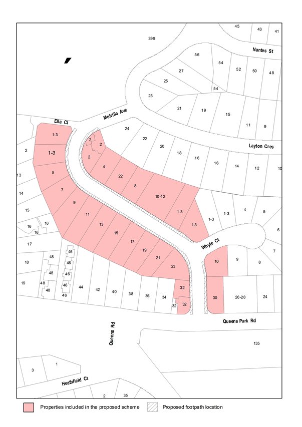
|
Stage |
Status |
Description |
|
Approval to prepare scheme |
ü |
Decision made to prepare scheme following consideration of surveys of property owners and feed back from the community. Council may then place the project in the budget system or proceed immediately to prepare a scheme. Scheme preparation involves survey, design and preparation of an apportionment of costs. 7 March 2014. |
|
Intention to Declare Scheme |
ü |
Report to Council providing information on scheme including advice of impending advertising of scheme and declaration of charge. Seeks Council approval by resolution to proceed with process. |
|
Advertisement |
|
The scheme is advertised in the local newspaper and all allotted property owners are notified by mail. This advertisement indicates Council’s intention and notification to ‘declare’ a scheme in a month’s time. |
|
Submissions |
|
From the time of advertising property owners have 28 days (as set down by the Local Government Act) to lodge submissions, either in support or opposition to the scheme. |
|
Submissions Review Panel Hearing |
|
A Submissions Review Panel is convened (quorum of three Councillors) and meets to consider submissions. Some submissions are written only, and other submitters may wish to be heard before the Panel. The Panel makes a recommendation to Council regarding the scheme.. |
|
Declaration Report |
|
Any time 28 days after advertising the scheme and after the Submissions Review Panel has met and considered submissions, Council considers a report and may proceed to “declare” the charges in accordance with its advertised intent. Subsequent to this the Finance Manager issues the levy notices and there is a formal charge placed on the property. This is the final step in the process for Council to make a decision on the scheme. |
|
Appeal |
|
Property owners may lodge an application for review with the Victorian Civil and Administrative Tribunal (VCAT) within one month of issue of the levy notice. An appeal is listed, heard and determined by the Tribunal and this process generally takes three to four months. Decisions made by VCAT are binding on all parties. |
|
Construction |
|
Council may then proceed to construct the works. Invoices are issued seeking payment of the estimated cost within one month of commencement. |
|
Final Cost Report |
|
At the completion of the works the scheme is “finalised” taking into account actual costs incurred and payments are adjusted accordingly. |
Portfolio: |
Infrastructure – Cr Ellis |
Source: |
City Services - Engineering Services |
General Manager: |
Gary Van Driel |
Index Reference: |
Special Rates and Charges; The Esplanade, Indented Head |
This report seeks a resolution by Council to consider an intention to declare a Special Charge Scheme to partially fund the construction of a footpath along The Esplanade between Jubilee Avenue and Batman Road, Indented Head. (See plan – Appendix 4)
It is proposed to construct 285 lineal meters of 1.5 metre wide footpath to provide for pedestrian access along The Esplanade, Indented Head.
There are sixteen (16) properties abutting the proposed footpath that will receive special benefit. There are no Council owned properties in the scheme.
The total estimated project cost is $102,240. This includes direct funding by Council estimated at $7,779 for the reestablishment of existing crushed rock driveways to match new footpath levels. The net scheme cost is estimated to be $94,461.
A Benefit Ratio of 0.35 has been calculated in accordance with Section 163 of the Local Government Act, which equates to a Council contribution to the scheme of $61,313 and property owner contribution of $33,148.
Property owners are considered to receive benefit from the works by way of improved pedestrian access and general amenity including pedestrian safety improvements.
The scheme has been prepared in accordance with the Special Rate and Charges provisions of the Local Government Act 1989 along with the 2004 Ministerial Guidelines and Council’s Special Rates and Charges Policy.
Cr Ellis moved, Cr Richards seconded -
That Council:
Gives notice of its intention to declare a Special Charge Scheme in accordance with Section 163 (1A) of the Local Government Act 1989 (The Act), as follows:
The Special Charge is declared for a period of four (4) years commencing upon completion of the works and scheme finalisation.
The Special Charge be declared for the purpose of defraying any expenses incurred by Council in relation to the construction of the footpath on The Esplanade between Jubilee Avenue and Batman Road, Indented Head which project:
Will provide proper pedestrian access, improved pedestrian safety and enhancement to the general amenity for each of the properties included in the scheme;
Council considers is or will be a special benefit to those persons required to pay the special charge (and who are described in succeeding parts of this Resolution); and
Arises out of Council’s function of planning for and providing infrastructure for property owners.
The total cost of project, be recorded as $102,240(Schedule A).
It be recorded that, for the purposes of Section 163 (2A) of the Act, the special charge proceeds will not exceed the amount calculated in accordance with the prescribed formula (R x C = S), the:
‘benefit ratio’ I being calculated at 0.35 represents the special benefits to all persons liable to pay the special charge (Schedule B);
‘total cost’ I of performing the function described in part 1 (b) of this resolution based on estimated cost be recorded as $94,461; and
‘maximum levy’ (S) be recorded as $33,148.
the following be specified as the area for which the special rate is so declared:
the area within municipal district of Council highlighted in the plan attached to this Resolution (Appendix 4).
the following be specified as the land in relation to which the special charge so declared:
land within the area shown on the plan.
the following be specified as the criteria which form the basis of the special charge so declared:
ownership of any land described in Part 1(e) of this Resolution.
the following be specified as the manner in which the special charge so declared will be assessed and levied:
Each lot receives a primary access and amenity benefit;
The maximum levy is divided equally on a access and frontage share basis;
The special charge will be levied by sending a notice to the person who is liable to pay, pursuant to section 163(4) of the Act.
having regard to the preceding parts of this Resolution but subject to Section 166 (1) of the Act, it be recorded that;
the owners of the land described in column 3 of Schedule C to the resolution are estimated liable for the respective amounts set out in column 6 of Schedule C; and
such owners may, subject to any further resolution of Council pay the special charge in the following manner;
the charge will become due and payable within one month of the issue of the notice requesting payment pursuant to Section 167 (3) of the Act;
interest will not be charged for six months after the issue of the notice provided the person liable makes timely payment in accordance with any repayment arrangements that may be agreed on by Council; and
in accordance with Section 172 of the Act, the interest rate payable on the special charge which has not been paid by the specific date is set at Council’s overdraft rate, reviewed every three months (provided that it shall not exceed the rate fixed by the Governor in Council by Order for the purposes of Section 172 (2A) in which case the rate of interest shall be the maximum rate fixed by the Governor in Council by Order for the purposes of this section).
Council’s Chief Executive Officer be authorised to levy the Special Charge in accordance with Section 163 (4) of the Act.
Carried.
In 2009/10 Council facilitated the Northern Bellarine Walkability Study where extensive consultation with the local community of Indented Head including the Locomote Walking Group was carried out. The method of consultation included public advertising, resident surveys and community meetings.
The study identified the priority pathway networks of which The Esplanade was listed as a high priority for construction. It is considered that the proposed new footpath will provide the missing pedestrian link between Jubilee Avenue and Batman Road, Indented Head and become a valuable community asset.
Due to the Walkability Study as the driving mechanism for this footpath link, the traditional survey to affected property owners has not taken place on this occasion. It is anticipated that detailed correspondence will be sent to all affected property owners should Council make its intention to declare a Special Charge Scheme.
This project involves the proposed construction of 285 metres total length of 1.5 metre wide footpath. It is expected to be a safety improvement for pedestrian traffic and fulfil part of the footpath priority obligations of the Northern Bellarine Walkability Study.
It is evident that only two of the affected properties within this scheme are occupied by the property owners on a full time basis. Due to the lack of permanency the vehicle driveways, although in place, have sunken slightly and been substantially overgrown by the local nature strip grass. Should the footpath be constructed, a level discrepancy between the new footpath and driveway will most likely result. For this reason, Council will reinstate the driveway levels with compacted crushed rock to match the new footpath levels at its cost.
The section of The Esplanade between Jubilee Avenue and Batman Road is relatively flat and the footpath construction should not pose any difficulty for the selected contractor.
Cost apportionment for the scheme has been divided into access and amenity benefits. It is considered that all abutting properties with direct frontages to the proposed new footpath, regardless of size and shape, receive the same access benefit. An exception to this rule is corner properties with dual frontages where a reduction of the access benefit has been applied.
50% of the total benefit has been apportioned to access. The access benefit includes the provision of an all weather sealed surface that reduces the risk of accidents caused by uneven and slippery surfaces. In simple terms, a new footpath improves accessibility for all abutting properties.
The remaining 50% of benefit is attributed to amenity and this can best be described as the benefit the pathway provides to an abutting property by way of improved aesthetics, safety, enjoyment, comfort and property value. The amenity benefit is based on the actual footpath frontage to a property when existing driveways and footpath extents are taken into consideration.
The provision of a sealed pathway surface provides a permanent and safe means of access. During the course of construction and the manufacture and procurement of materials, energy is expended resulting in some greenhouse gas emissions. This ceases when construction is complete.
The project does not create waste with the exception of some excavated material.
The proposal does not affect any natural habitats.
The proposal will require some nature strip trees and shrubs to be trimmed but removal of vegetation is not expected.
The project is a one off capital cost and there will be minimal ongoing maintenance costs. If approved, the scheme could proceed this financial year.
Financial details are as follows:
|
Maximum scheme levy to Property Owners (income) |
$33,148 |
|
Scheme levy to Council |
$61,313 |
|
Direct Funding by Council to re-establish crushed rock driveways. |
$7,779 |
|
Total Project Cost |
$102,240 |
From the table above, the total cost to Council for this project is estimated to be $69,092.
The scheme has been prepared in accordance with the Special Rate and Charge provisions of the Local Government Act 1989 along with the 2004 ministerial guidelines and Council’s Special Rates and Charges Policy.
This report aligns with the City Plan as follows:
Sustainably Built and Natural Environment
Support our Community to live sustainably – Encourage increased use of alternatives to car transport and seek efficient traffic movement throughout the municipality.
Advocate for and promote sustainable design and development – Promoting sustainable design and retrofitting.
Acknowledge the community’s desire to have their say and be involved in planning for the future of Greater Geelong.
No Council Officer involved with this process has any direct or indirect interest in the properties.
Provision of a sealed pathway will provide safer walking and cycling conditions for pedestrians and cyclists by minimising the risk of personal injuries through conflict with vehicles and the elimination of uneven and slippery surfaces.
There are no identified risks for Council in making its intention to declare the scheme.
The provision of properly sealed and drained pathways is aligned to Council’s City Plan as described above and provides improved connectivity and safety for pedestrians and cyclists. It is further considered that the footpaths will enhance the general amenity of the area.
In developing this report to Council, the subject matter has been considered to determine if it raises any human rights issues. In particular, whether the scope of any human right established by the Victorian Charter of Human Rights and Responsibilities is in any way limited, restricted or interfered with by the recommendations contained in this report. It is considered that the subject matter does not raise any adverse human rights issues.
It is further considered that the construction of the footpaths upholds the right to freedom of movement (Section 12 of the Human rights Charter) by enhancing a person’s ability to move freely within the area they choose to live.
Community consultation for the proposed footpath construction was carried out during the 2009/ 2010 Northern Bellarine Walkability Study. Ongoing meetings are held between Council and the regional Locomote Walking Group. Further correspondence to the affected property owners will be sent should Council make it’s intention to declare a Special Charge Scheme.
The works for the construction of footpaths in The Esplanade, Indented Head which consist of excavation, footpath, reinstatement of nature strip and driveways, miscellaneous construction works, legal advice and professional services associated with survey, engineering design, drafting, supervision and administration of the project all as included in the cost estimate shown below.
|
ESTIMATED TOTAL COST OF FOOTPATH CONSTRUCTION |
|||||||||
|
ITEM |
DESCRIPTION |
QUANTITY |
UNIT |
RATE $ |
AMOUNT $ |
||||
|
1.00 |
GENERAL |
|
|
|
|
||||
|
1.01 |
Initial site establishment and set up, decamping and site cleanup and other fixed costs up to time of completion of works. |
1 |
ITEM |
$10,300.00 |
$10,300.00 |
||||
|
1.02 |
Traffic management costs. |
1 |
ITEM |
$3,000.00 |
$3,000.00 |
||||
|
1.03 |
Setting out of works. |
1 |
ITEM |
$1,000.00 |
$1,000.00 |
||||
|
1.04 |
Service / Cable locations |
1 |
ITEM |
$1,000.00 |
$1,000.00 |
||||
|
1.05 |
Internal supervision fee (COGG construction) |
1 |
ITEM |
$3,000.00 |
$3,000.00 |
||||
|
2.00 |
EARTHWORKS & DEMOLITION |
|
|
|
|
||||
|
2.01 |
Excavation and disposal of all materials to limits of work as indicated on plan, including trimming for new road pavement, excavation of soft spots and removal of concrete. |
124.8 |
m3 |
$60.00 |
$7,486.50 |
||||
|
2.02 |
Trimming / Removal and disposal of trees/shrubs as per plan. |
5 |
ITEM |
$500.00 |
$2,500.00 |
||||
|
3.00 |
PAVEMENT WORKS |
|
|
|
|
||||
|
3.01 |
100mm compacted depth Class 1 20mm crushed rock, supplied, spread and compacted. |
|
m3 |
$120.00 |
$0.00 |
||||
|
4.00 |
DRAINAGE |
|
|
|
|
||||
|
|
PITS |
|
|
|
|
||||
|
4.01 |
Adjust existing Junction Pit lid to match finished surface level. |
1 |
No. |
$770.00 |
$770.00 |
||||
|
5.00 |
CONCRETE WORKS: |
|
|
` |
|
||||
|
|
PAVING |
|
|
|
|
||||
|
5.01 |
75mm concrete paving with SL62 mesh including crushed rock bedding and reinstate nature strip. |
247.30 |
m2 |
$105.00 |
$25,966.50 |
||||
|
5.02 |
125mm concrete paving with SL62 mesh including crushed rock bedding and reinstate nature strip. |
185.20 |
m2 |
$110.00 |
$20,372.00 |
||||
|
6.00 |
LANDSCAPING |
|
|
|
|
||||
|
6.01 |
Top soiling and seeding nature strips, medians and outer separators. |
254 |
m2 |
$8.00 |
$2,032.00 |
||||
SUB-TOTAL |
$77,427 |
||||||||
10% Contingency |
$7,743 |
||||||||
Design |
$3,871 |
||||||||
Project administration |
$5,420 |
||||||||
CONSTRUCTION COST ESTIMATE |
$94,461 |
||||||||
|
ESTIMATED COST FOR DRIVEWAY REINSTATEMENT |
|||||
|
ITEM |
DESCRIPTION |
QUANTITY |
UNIT |
RATE $ |
AMOUNT $ |
|
1.00 |
GENERAL |
|
|
|
|
|
1.02 |
Traffic management costs. |
1 |
ITEM |
$1,000 |
$1,000 |
|
2.00 |
PAVEMENT WORKS |
|
|
||
|
2.01 |
100mm compacted depth Class 1 20mm crushed rock, supplied, spread and compacted. |
50.6 |
m3 |
$120 |
$6,072 |
SUB-TOTAL |
$7,072 |
||||
10% CONTINGENCY |
$707 |
||||
CONSTRUCTION COST ESTIMATE |
$7,779 |
||||
A |
Purpose |
|
||||||
|
To construct a footpath in The Esplanade, Indented Head to provide all weather pedestrian access for property owners and the wider community. | |||||||
B |
Coherence |
|
||||||
|
The works will provide a physical pathway connection between Jubilee Avenue and Batman Road and will provide a special benefit to adjoining and remote properties. |
|
||||||
C |
Total Cost C |
|
||||||
|
Total Estimated cost of works – footpath construction |
$102,240.00 |
||||||
|
Direct funding by Council to reinstate driveways |
$7,779.00 |
||||||
|
TOTAL COST |
$94,461.00 |
|||||||
D |
Identify Special Beneficiaries |
|
||||||
16 properties with frontages to the proposed footpath are considered to receive access and amenity benefits. |
|
|||||||
E |
Properties to include |
|
||||||
|
The 16 abutting properties receive both access and amenity benefits. Therefore: |
|
||||||
|
Total Special Benefits (in) is apportioned to 16 properties |
|
||||||
|
There are no Council owned properties in the scheme. Therefore: |
|
||||||
|
Total Special Benefits out of the scheme | TSB (out) = |
0 |
|
||||
F |
Estimate of Total Special Benefits |
|
||||||
|
For this scheme it is considered that the greater proportion of benefit is for pedestrian access given the purpose of the scheme. Therefore it is estimated that 80% of the benefits relate to access and 20% to amenity. Estimated pedestrian use of the paths is 80% for the wider community and 20% for abutting property owners. Amenity benefits are based on frontage with 93% of the footpaths fronting benefiting properties and 7% within Council’s road reserves. TSB (in) is therefore calculated as follows: |
|
||||||
|
TSB (in) = 80% X 20%(access) + 20% X 93% (amenity) = | 34.6% |
|
|||||
G |
Estimate of Total Community Benefit –TCB |
|
||||||
|
It is considered that people in the community will receive a benefit from the works as the pathway is used to access other areas considering the walkability study for the area. There are no amenity benefits considered for the wider community. TCB is calculated as follows: |
|
||||||
|
TCB = 80% X 80% = | 64% |
|
|||||
H |
Calculate “Benefit Ratio” – R |
|
||||||
|
Benefits Ratio = | TSB (in) |
= |
34.6 |
0.351 |
|
||
|
TSB (out) + TCB |
34.6 + 0 + 64 |
|
|||||
I |
Maximum Total Levy (S) |
|
||||||
|
Maximum Total Levy S = R X C |
$33,147.57 |
||||||
|
Council Contribution to Special Charge Scheme |
|
|
|
|
$61,313.43 |
||
|
COLUMN 1 |
COLUMN 2 |
COLUMN 3 |
COLUMN 4 |
COLUMN 5 |
|
Prop Key |
Address |
Legal Details |
Total Frontage (m) |
Footpath Cost |
250803 |
289 The Esplanade, Indented Head |
Lot 3 LP 26830 |
18.40 |
$1,723.44 |
250804 |
290 The Esplanade, Indented Head |
Lot 4 LP 26830 |
19.26 |
$2,330.63 |
250805 |
291 The Esplanade, Indented Head |
Lot 1 LP 42116 |
15.63 |
$2,099.61 |
250806 |
292 The Esplanade, Indented Head |
Lot 2 LP 42116 |
15.47 |
$2,089.43 |
250807 |
293 The Esplanade, Indented Head |
Lot 1 TP 616630 |
18.40 |
$2,275.90 |
250808 |
294 The Esplanade, Indented Head |
Lot 1 TP 226281 |
15.47 |
$2,089.43 |
250809 |
295 The Esplanade, Indented Head |
Lot 3 LP 42116 |
19.32 |
$2,334.45 |
331040 |
1/296 The Esplanade, Indented Head |
Lot 1 PS 531149 |
13.03 |
$1,934.15 |
331041 |
2/296 The Esplanade, Indented Head |
Lot 2 PS 531149 |
5.69 |
$1,467.03 |
331841 |
1/297 The Esplanade, Indented Head |
Lot 1 PS 533316 |
12.07 |
$1,873.05 |
331842 |
2/297 The Esplanade, Indented Head |
Lot 2 PS 533316 |
12.30 |
$1,887.69 |
250812 |
298 The Esplanade, Indented Head |
Lot 6 LP 42116 |
16.26 |
$2,139.71 |
265682 |
299 The Esplanade, Indented Head |
Lot 7 LP 42116 |
16.70 |
$2,167.71 |
250813 |
300 The Esplanade, Indented Head |
Lot 8 LP 42116 |
16.70 |
$2,167.71 |
250814 |
301 The Esplanade, Indented Head |
Lot 9 LP 42116 |
16.93 |
$2,182.35 |
250815 |
302 The Esplanade, Indented Head |
Lot 10 LP 42116 |
28.80 |
$2,385.29 |
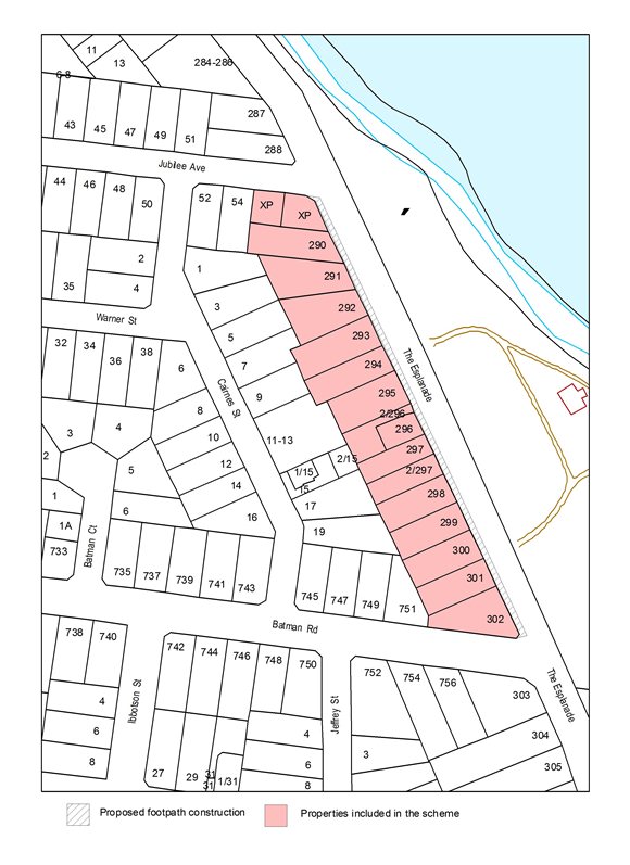
|
Stage |
Status |
Description |
|
Approval to prepare scheme |
ü |
Decision made to prepare scheme following consideration of surveys of residents and feed back from the community via the Northern Bellarine Walkability Study. Council may then place the project in the budget system or proceed immediately to prepare a scheme. Scheme preparation involves survey, design and preparation of an apportionment of costs. |
|
Intention to Declare Scheme |
ü |
Report to Council providing information on scheme including advice of impending advertising of scheme and declaration of charge. Seeks Council approval by resolution to proceed with process. |
|
Advertisement |
|
The scheme is advertised in the local newspaper and all allotted property owners are notified by mail. This advertisement indicates Council’s intention and notification to ‘declare’ a scheme in a month’s time. |
|
Submissions |
|
From the time of advertising property owners have 28 days (as set down by the Local Government Act) to lodge submissions, either in support or opposition to the scheme. |
|
Submissions Review Panel Hearing |
|
A Submissions Review Panel is convened (quorum of three Councillors) and meets to consider submissions. Some submissions are written only, and other submitters may wish to be heard before the Panel. The Panel makes a recommendation to Council regarding the scheme. |
|
Declaration Report |
|
Any time 28 days after advertising the scheme and after the Submissions Review Panel has met and considered submissions, Council considers a report and may proceed to “declare” the charges in accordance with its advertised intent. Subsequent to this the Finance Manager issues the levy notices and there is a formal charge placed on the property. This is the final step in the process for Council to make a decision on the scheme. |
|
Appeal |
|
Property owners may lodge an application for review with the Victorian Civil and Administrative Tribunal (VCAT) within one month of issue of the levy notice. An appeal is listed, heard and determined by the Tribunal and this process generally takes three to four months. Decisions made by VCAT are binding on all parties. |
|
Construction |
|
Council may then proceed to construct the works. Invoices are issued seeking payment of the estimated cost within one month of commencement. |
|
Final Cost Report |
|
At the completion of the works the scheme is “finalised” taking into account actual costs incurred and payments are adjusted accordingly. |
Portfolio: |
Infrastructure – Cr Lindsay Ellis |
Source: |
City Services - Engineering Services |
General Manager: |
Gary Van Driel |
Index Reference: |
Special Rates and Charges; The Esplanade, Indented Head |
This report seeks a resolution by Council to consider an intention to declare a Special Charge Scheme to partially fund the construction of a footpath along west side of The Esplanade between No 270 The Esplanade and Walpole Avenue, Indented Head. (See plan – Appendix 4)
It is proposed to construct 200 lineal metres of 1.5 metre wide footpath to provide for pedestrian access along The Esplanade, Indented Head. Further work includes a modified intersection layout for Pigdon Street and The Esplanade which includes new kerb and channel with associated vehicle laybacks and drainage provision.
It is further proposed that the section of The Esplanade adjacent to properties 270, 271 and 272 The Esplanade be widened. The proposed work will include new kerb and channel and vehicle laybacks. This work will provide 40 metres of kerb and channel section and complete the ‘missing link’ for The Esplanade North of Pigdon Street.
There are ten (10) properties abutting the proposed footpath that will receive special benefit. There are no Council owned properties in the scheme.
The total estimated project cost is $143,284. This includes a net Council contribution of $112,046 which includes scheme costs and direct funding and a property owner contribution of $31,238.
A Benefit Ratio of 0.34 has been calculated in accordance with Section 163 of the Local Government Act, which equates to a Council contribution to the scheme of $41,167 and property owner contribution of $21,484. A summary of costs is provided at the financial implications section below.
Property owners are considered to receive benefit from the works by way of improved pedestrian access and general amenity including pedestrian safety improvements.
The scheme has been prepared in accordance with the Special Rate and Charges provisions of the Local Government Act 1989 along with the 2004 Ministerial Guidelines and Council’s Special Rates and Charges Policy.
Cr Ellis moved, Cr Richards seconded -
That Council:
Gives notice of its intention to declare a Special Charge Scheme in accordance with Section 163 (1A) of the Local Government Act 1989 (The Act), as follows:
The Special Charge is declared for a period of four (4) years commencing upon completion of the works and scheme finalisation.
The Special Charge be declared for the purpose of defraying any expenses incurred by Council in relation to the construction of the footpath on The Esplanade between No 270 The Esplanade and Walpole Avenue, Indented Head which project:
Will provide proper pedestrian access, improved pedestrian safety and enhancement to the general amenity for each of the properties included in the scheme;
Council considers is or will be a special benefit to those persons required to pay the special charge (and who are described in succeeding parts of this Resolution); and
Arises out of Council’s function of planning for and providing infrastructure for property owners.
The total cost of project, be recorded as $143,284(Schedule A).
It be recorded that, for the purposes of Section 163 (2A) of the Act, the special charge proceeds will not exceed the amount calculated in accordance with the prescribed formula (R x C = S), the:
‘benefit ratio’ (R) being calculated at 0.34 represents the special benefits to all persons liable to pay the special charge (Schedule B);
‘total cost’ (C) of performing the function described in part 1 (b) of this resolution based on estimated cost be recorded as $62,651; and
‘maximum levy’ (S) be recorded as $21,484.
the following be specified as the area for which the special rate is so declared:
the area within municipal district of Council highlighted in the plan attached to this Resolution (Appendix 4).
the following be specified as the land in relation to which the special charge so declared:
land within the area shown on the plan.
the following be specified as the criteria which form the basis of the special charge so declared:
ownership of any land described in Part 1(e) of this Resolution.
the following be specified as the manner in which the special charge so declared will be assessed and levied:
Each lot receives a primary access and amenity benefit;
The maximum levy is divided 50% on access and 50% amenity on a frontage share basis;
The special charge will be levied by sending a notice to the person who is liable to pay, pursuant to section 163(4) of the Act.
having regard to the preceding parts of this Resolution but subject to Section 166 (1) of the Act, it be recorded that;
the owners of the land described in column 3 of Schedule C to the resolution are estimated liable for the respective amounts set out in column 7 of Schedule C; and
such owners may, subject to any further resolution of Council pay the special charge in the following manner;
the charge will become due and payable within one month of the issue of the notice requesting payment pursuant to Section 167 (3) of the Act;
interest will not be charged for six months after the issue of the notice provided the person liable makes timely payment in accordance with any repayment arrangements that may be agreed on by Council; and
in accordance with Section 172 of the Act, the interest rate payable on the special charge which has not been paid by the specific date is set at Council’s overdraft rate, reviewed every three months (provided that it shall not exceed the rate fixed by the Governor in Council by Order for the purposes of Section 172 (2A) in which case the rate of interest shall be the maximum rate fixed by the Governor in Council by Order for the purposes of this section).
Council’s Chief Executive Officer be authorised to levy the Special Charge in accordance with Section 163 (4) of the Act.
Carried.
In 2009/10 Council facilitated the Northern Bellarine Walkability Study where extensive consultation with the local community of Indented Head including the Locomote Walking Group was carried out. The method of consultation included public advertising, resident surveys and community meetings.
The study identified the priority pathway networks of which The Esplanade was listed as a high priority for construction. It is considered that the proposed new footpath will provide the missing pedestrian link between Pigdon Street and Walpole Avenue, Indented Head and become a valuable community asset.
Due to the Walkability Study as the driving mechanism for this footpath link, the traditional survey to affected property owners has not taken place on this occasion. It is anticipated that detailed correspondence will be sent to all affected property owners should Council make its intention to declare a Special Charge Scheme.
This project involves the proposed construction of 200 metres total length of 1.5 metre wide footpath. It is expected to be a safety improvement for pedestrian traffic and fulfil part of the footpath priority obligations of the Northern Bellarine Walkability Study.
It is evident that one of the affected properties within this scheme is occupied by the property owners on a full time basis. Due to the lack of permanency the vehicle driveways, although in place, have sunken slightly and been substantially overgrown by the local nature strip grass. Should the footpath be constructed, a level discrepancy between the new footpath and driveway will most likely result.
For this reason, Council will reinstate the driveway levels with compacted crushed rock to match the new footpath levels at its cost.
Another aspect of this project is the intersection modification of Pigdon Street and The Esplanade. This intersection is being re-aligned to ‘square up’ the intersection to slow traffic turning movements as a safety initiative. It is proposed that this work will also be funded by Council with the exception of the proposed new vehicle laybacks which will be funded by property owners in accordance with Council Policy.
A 40 metre section of road way north of Pigdon Street is also proposed to be constructed. This work involves the widening of the road pavement, new kerb and channel and three new vehicle crossovers. It is proposed that the road widening work will be funded by Council but the new kerbing and vehicle laybacks will be funded by benefiting property owners in accordance with Council policy.
Cost apportionment for the scheme has been divided into access and amenity benefits. It is considered that all abutting properties with direct frontages to the proposed new footpath, regardless of size and shape, receive the same access benefit. An exception to this rule is corner properties with dual frontages where a reduction of the access benefit has been applied.
In this case 50% of the total benefit has been apportioned to access. The access benefit includes the provision of an all weather sealed surface that reduces the risk of accidents caused by uneven and slippery surfaces. In simple terms, it is considered that a new footpath improves accessibility for all abutting properties.
The remaining 50% of benefit is attributed to amenity and this can best be described as the benefit the pathway provides to an abutting property by way of improved aesthetics, enjoyment, comfort and property value. The amenity benefit is based on the actual footpath frontage to a property when existing driveways and footpath extents are taken into consideration. This is known as the apportion-able frontage and is shown at Column 5 of Appendix 3.
The section of The Esplanade between Pigdon Street and Walpole Avenue is relatively flat and the footpath construction should not pose any difficulty for the selected contractor.
The provision of a sealed pathway surface provides a permanent and safe means of access. During the course of construction and the manufacture and procurement of materials, energy is expended resulting in some greenhouse gas emissions. This ceases when construction is complete.
The project does not create waste with the exception of some excavated material.
The proposal does not affect any natural habitats.
The proposal will require some nature strip shrubs removal.
The project is a one off capital cost and there will be minimal ongoing maintenance costs. If approved, the scheme could proceed this financial year.
Financial details are as follows:
|
Maximum scheme levy to property owners (income) |
$21,484 |
|
Scheme levy to Council |
$41,167 |
|
Direct Funding by owners to construct new kerb and channel including laybacks. |
$9,754 |
|
Direct funding by Council to reinstate gravel driveway, construct new kerb and channel for intersection modification at Pigdon Street and reinstatement of asphalt pavement. |
$70,879 |
|
Total Project Cost |
$143,284 |
From the table above, the total net cost to Council for this project is estimated to be $112,046
The scheme has been prepared in accordance with the Special Rate and Charge provisions of the Local Government Act 1989 along with the 2004 ministerial guidelines and Council’s Special Rates and Charges Policy.
This report aligns with the City Plan as follows:
Sustainably Built and Natural Environment
Support our Community to live sustainably – Encourage increased use of alternatives to car transport and seek efficient traffic movement throughout the municipality.
Advocate for and promote sustainable design and development – Promoting sustainable design and retrofitting.
Acknowledge the community’s desire to have their say and be involved in planning for the future of Greater Geelong.
No Council Officer involved with this process has any direct or indirect interest in the properties.
Provision of a sealed pathway will provide safer walking and cycling conditions for pedestrians and cyclists by minimising the risk of personal injuries through conflict with vehicles and the elimination of uneven and slippery surfaces.
There are no identified risks for Council in making its intention to declare the scheme.
The provision of properly sealed and drained pathways is aligned to Council’s City Plan as described above and provides improved connectivity and safety for pedestrians and cyclists. It is further considered that the footpaths will enhance the general amenity of the area.
In developing this report to Council, the subject matter has been considered to determine if it raises any human rights issues. In particular, whether the scope of any human right established by the Victorian Charter of Human Rights and Responsibilities is in any way limited, restricted or interfered with by the recommendations contained in this report. It is considered that the subject matter does not raise any adverse human rights issues.
It is further considered that the construction of the footpaths upholds the right to freedom of movement (Section 12 of the Human rights Charter) by enhancing a person’s ability to move freely within the area they choose to live.
Community consultation for the proposed footpath construction was carried out during the 2009/ 2010 Northern Bellarine Walkability Study. Consultation with the Locomote Walking Group was included during this study and is ongoing. Further correspondence to the affected property owners and the Locomote Walking Group will be sent should Council make its intention to declare a Special Charge Scheme.
The works for the construction of footpaths in The Esplanade, Indented Head which consist of excavation, footpath, kerb and channel, road widening, reinstatement of nature strip and driveways, miscellaneous construction works, legal advice and professional services associated with survey, engineering design, drafting, supervision and administration of the project all as included in the cost estimate shown below.
|
COST ESTIMATE - FOOTPATH CONSTRUCTION |
|||||
|
ITEM |
DESCRIPTION |
QUANTITY |
UNIT |
RATE |
AMOUNT |
|
1.00 |
GENERAL |
|
|
|
|
|
1.01 |
Initial site establishment and set up, decamping and site cleanup and other fixed costs up to time of completion of works. |
1.0 |
ITEM |
$6,317.00 |
$6,317.00 |
|
1.02 |
Traffic management costs. |
1.0 |
ITEM |
$3,000.00 |
$3,000.00 |
|
1.03 |
Setting out of works. |
1.0 |
ITEM |
$540.00 |
$540.00 |
|
1.04 |
Service / Cable locations |
1.0 |
ITEM |
$700.00 |
$700.00 |
|
1.05 |
Internal supervision fee (COGG construction) |
1.0 |
ITEM |
$3,340.00 |
$3,340.00 |
|
2.00 |
EARTHWORKS & DEMOLITION |
|
|
|
|
|
2.01 |
Excavation and disposal of all materials to limits of work as indicated on plan, including trimming for new road pavement, excavation of soft spots and removal of concrete. |
57.9 |
m3 |
$60.00 |
$3,476.13 |
|
2.02 |
Trimming / Removal and disposal of shrubs as indicated on plan. |
1.0 |
ITEM |
$1,000.00 |
$1,000.00 |
|
3.00 |
DRAINAGE |
|
|
|
|
|
3.01 |
Adjust existing Junction Pit lid to match finished surface level. |
1 |
No. |
$770.00 |
$770.00 |
|
4.00 |
CONCRETE WORKS: |
|
|
` |
|
|
|
KERBING |
|
|
|
|
|
4.01 |
Concrete pram crossing 1.5m wide, including fine crushed rock bedding. |
4.0 |
No. |
$250.00 |
$1,000.00 |
|
|
PAVING |
|
|
|
|
|
4.02 |
75mm concrete paving with SL62 mesh including crushed rock bedding and reinstate nature strip. |
193.3 |
m2 |
$105.00 |
$20,295.45 |
|
4.03 |
125mm concrete paving with SL62 mesh including crushed rock bedding and reinstate nature strip. |
78.6 |
m2 |
$110.00 |
$8,649.30 |
|
4.04 |
Tactile Ground Surface Indicator Tiles, supplied and placed. |
3.0 |
m2 |
$250.00 |
$750.00 |
|
5.00 |
LANDSCAPING |
|
|
|
|
|
5.01 |
Top soiling and seeding nature strips. |
265.2 |
m2 |
$8.00 |
$2,121.60 |
|
6.00 |
SIGNING AND LINE-MARKING |
|
|
|
|
|
6.01 |
Relocate existing permanent sign and post as per plan. |
1.0 |
No |
$250.00 |
$250.00 |
SUB-TOTAL |
$52,209.48 |
||||
|
10% CONTINGENCY |
$5,220.95 |
||||
Design |
$3,132.57 |
||||
|
Project administration |
$2,088.38 |
||||
CONSTRUCTION COST ESTIMATE |
$62,651.38 |
||||
|
OWNER FUNDED WORKS - KERB AND CHANNEL |
|||||
|
ITEM |
DESCRIPTION |
QUANTITY |
UNIT |
RATE |
AMOUNT |
|
1.00 |
GENERAL |
|
|
|
|
|
1.01 |
Initial site establishment and set up, decamping and site cleanup and other fixed costs up to time of completion of works. |
1.0 |
ITEM |
$941.00 |
$941.00 |
|
1.02 |
Traffic management costs. |
1.0 |
ITEM |
$500.00 |
$500.00 |
|
1.03 |
Setting out of works. |
1.0 |
ITEM |
$70.00 |
$70.00 |
|
2.00 |
EARTHWORKS & DEMOLITION |
|
|
|
|
|
2.01 |
Excavation and disposal of all materials to limits of work as indicated on plan, including trimming for new road pavement, excavation of soft spots and removal of concrete. |
5.4 |
m3 |
$60.00 |
$321.30 |
|
2.02 |
Saw-cutting of concrete and/or Asphalt paving. |
22.4 |
m |
$10.00 |
$223.50 |
|
2.03 |
Saw-cut of concrete kerb and channel |
1.0 |
ITEM |
$10.00 |
$10.00 |
|
2.04 |
Removal and disposal of 125mm thick concrete as per plan. |
4.2 |
m3 |
$60.00 |
$251.40 |
|
3.00 |
CONCRETE WORKS: |
|
|
` |
|
|
|
KERBING |
|
|
|
|
|
3.01 |
B2 Barrier kerb and channel 450mm wide, including fine crushed rock bedding. |
24.3 |
m |
$136.00 |
$3,302.08 |
|
3.02 |
Concrete layback for vehicle crossing 3.0m - 3.75m wide, including bedding & formwork. |
5 |
No. |
$350.00 |
$1,750.00 |
|
|
PAVING |
|
|
|
|
|
3.04 |
125mm concrete paving with SL62 mesh including crushed rock bedding and reinstate nature strip. |
6.9 |
m3 |
$110.00 |
$759.00 |
SUB-TOTAL |
$8128.28 |
||||
|
10% CONTINGENCY |
$812.83 |
||||
Design |
$487.70 |
||||
Project administration |
$325.13 |
||||
CONSTRUCTION COST ESTIMATE |
$9,753.94 |
||||
|
COUNCIL FUNDED WORKS |
|||||
|
ITEM |
DESCRIPTION |
QUANTITY |
UNIT |
RATE |
AMOUNT |
|
1.00 |
GENERAL |
|
|
|
|
|
1.01 |
Initial site establishment and set up, decamping and site cleanup and other fixed costs up to time of completion of works. |
1.0 |
ITEM |
$6,182.00 |
$6,182.00 |
|
1.02 |
Traffic management costs. |
1.0 |
ITEM |
$500.00 |
$500.00 |
|
1.03 |
Setting out of works. |
1.0 |
ITEM |
$390.00 |
$390.00 |
|
1.04 |
Service / Cable locations |
1.0 |
ITEM |
$300.00 |
$300.00 |
|
1.05 |
Internal supervision fee (COGG construction) |
1.0 |
ITEM |
$3,000.00 |
$3,000.00 |
|
2.00 |
EARTHWORKS & DEMOLITION |
|
|
|
|
|
2.01 |
Excavation and disposal of all materials to limits of work as indicated on plan, including trimming for new road pavement, excavation of soft spots and removal of concrete. |
105.8 |
m3 |
$60.00 |
$6,349.53 |
|
2.02 |
Saw-cutting of concrete and/or Asphalt paving. |
278.1 |
m |
$10.00 |
$2,781.30 |
|
2.03 |
Saw-cut of concrete kerb and channel |
34.0 |
ITEM |
$10.00 |
$340.00 |
|
3.00 |
PAVEMENT WORKS |
|
|
|
|
|
3.01 |
150mm compacted depth Class 1 20mm crushed rock, supplied, spread and compacted. |
39.4 |
m3 |
$120.00 |
$4,725.72 |
|
3.02 |
200mm compacted depth Class 3 40mm crushed rock, supplied, spread and compacted. |
52.5 |
m3 |
$100.00 |
$5,250.80 |
|
3.03 |
100mm compacted depth Class 1 20mm crushed rock, supplied, spread and compacted. |
11.8 |
m3 |
$120.00 |
$1,420.32 |
|
3.04 |
30mm compacted depth 10mm nominal size type N Asphalt spread and compacted including emulsion prime & grit using a paver. |
262.5 |
m3 |
$35.00 |
$9,188.90 |
|
4.00 |
DRAINAGE |
|
|
|
|
|
|
PIPE |
|
|
|
|
|
4.01 |
Connect existing household storm water to kerb and channel. Including excavation, supply and placement of kerb adapters. |
6.0 |
No. |
$250.00 |
$1,500.00 |
|
4.02 |
100mm dia Sub-Soil drains including excavation, supply, placement and provision of approved backfill. |
100.0 |
m |
$48.00 |
$4,800.00 |
|
|
PITS |
|
|
|
|
|
4.03 |
900mm x 600mm SEP, less than 1.5m deep with Gatic type cover, supplied and placed including excavation, placement of approved fine crushed rock bedding and back-filling with approved material. |
1.0 |
No. |
$1,400.00 |
$1,400.00 |
|
4.04 |
Modify ex 900mm x 600mm SEP to 900mm x 1200mm SEP, less than 1.5m deep with Gatic type cover, supplied and placed including excavation, placement of approved fine crushed rock bedding and back-filling with approved material. |
1.0 |
No. |
$1,400.00 |
$1,400.00 |
|
4.05 |
Tap into existing drainage pit or pipe. |
1.0 |
No. |
$385.00 |
$385.00 |
|
5.00 |
CONCRETE WORKS: |
|
|
` |
|
|
|
KERBING |
|
|
|
|
|
5.01 |
B2 Barrier kerb and channel 450mm wide, including fine crushed rock bedding. |
52.2 |
m |
$136.00 |
$7,101.92 |
|
5.02 |
Concrete layback for vehicle crossing 3.0m - 3.75m wide, including bedding & formwork. |
1 |
No. |
$350.00 |
$350.00 |
|
6.00 |
DEMOLITION |
|
|
|
|
|
6.01 |
Remove and dispose existing SEP and abandon ex 300mm dia RCP backfill with approved materials as per plan. |
1 |
No. |
$1,200.00 |
$1,200.00 |
|
7.00 |
SIGNING AND LINE-MARKING |
|
|
|
|
|
7.01 |
Line-marking |
1.0 |
ITEM |
$500.00 |
$500.00 |
SUB-TOTAL: |
$59,065.49 |
||||
10% CONTINGENCY : D |
$5,906.55 |
||||
Design |
$3,543.93 |
||||
Project administration |
$2,362.62 |
||||
CONSTRUCTION COST ESTIMATE |
$70,878.59 |
||||
A |
Purpose |
|
||||
|
To construct a footpath in The Esplanade, Indented Head to provide all weather pedestrian access for property owners and the wider community. |
|
||||
B |
Coherence |
|
||||
|
The works will provide a physical pathway connection between Pigdon Street and Walpole Avenue and will provide a special benefit to adjoining and remote properties. |
|
||||
C |
Total Cost C |
|
||||
|
Total Estimated cost of works |
$143,283.90 |
||||
|
Direct funding by Owners to new kerb and channel construction |
$9,753.94 |
||||
|
Direct funding by Council to reinstate gravel driveways, new kerb and channel for intersection modification at Pigdon Street and asphalt pavement reinstatement |
$70,878.59 |
||||
TOTAL SCHEME COST of Footpath Construction |
$62,651.37 |
|||||
D |
Identify Special Beneficiaries |
|
||||
|
|
10 properties with frontages to the proposed footpath are considered to receive access and amenity benefits. |
|
||||
E |
Properties to include |
|
||||
|
The 10 abutting properties receive both access and amenity benefits. Therefore: |
|
||||
|
Total Special Benefits (in) is apportioned to 10 properties |
|
||||
|
There are no Council owned properties in the scheme. Therefore: |
|
||||
|
Total Special Benefits out of the scheme | TSB (out) = |
0 |
|
||
F |
Estimate of Total Special Benefits |
|
||||
|
For this scheme it is considered that the greater proportion of benefit is for pedestrian access given the purpose of the scheme. Therefore it is estimated that 80% of the benefits relate to access and 20% to amenity. Estimated pedestrian use of the paths is 80% for the wider community and 20% for abutting property owners. Amenity benefits are based on frontage with 87% of the footpaths fronting benefiting properties and 13% within Council's road reserves. TSB (in) is therefore calculated as follows: |
|
||||
|
TSB (in) = 80% X 20%(access) + 20% X 87% (amenity) = |
33.4% |
|
|||
G |
Estimate of Total Community Benefit -TCB |
|
||||
|
It is considered that people in the community will receive a benefit from the works as the pathway is used to access other areas considering the walkability study for the area. There are no amenity benefits considered for the wider community. TCB is calculated as follows: |
|
||||
|
TCB = 80% X 80% = |
64% |
|
|||
H |
Calculate "Benefit Ratio" - R |
|
||||
|
Benefits Ratio = | TSB (in) |
= |
33.4 |
0.343 |
|
|
TSB (in) +TSB (out) + TCB |
33.4 + 0 + 64 |
|
|||
I |
Maximum Total Levy (S) |
|
||||
|
Maximum Total Levy S = R X C |
$21,484.15 |
||||
|
Council Contribution to Special Charge Scheme |
$41,167.22 |
||||
|
COLUMN 1 |
COLUMN 2 |
COLUMN 3 |
COLUMN 4 |
COLUMN 5 |
COLUMN 6 |
COLUMN 7 |
|
Prop Key |
Address |
Legal Details |
Apportionable frontage |
Footpath Cost |
Kerb and layback costs |
Total Cost |
|
311634 |
270 The Esplanade, Indented Head |
Lot 1 PS 435184 |
10 |
$1,947.98 |
$3,726.83 |
$5,674.81 |
|
311635 |
271 The Esplanade, Indented Head |
Lot 2 PS 435184 |
8.74 |
$1,861.77 |
$3,477.79 |
$5,339.56 |
|
311636 |
272 The Esplanade, Indented Head |
Lot 3 PS 435184 |
7.66 |
$1,155.99 |
$1,709.32 |
$2,865.31 |
|
250791 |
273 The Esplanade, Indented Head |
Lot 9 TP 827456 |
12.96 |
$1,518.62 |
$420.00 |
$1,938.62 |
|
250792 |
274 The Esplanade, Indented Head |
Lot 1 TP 1408 |
16.76 |
$2,410.51 |
$420.00 |
$2,830.51 |
|
250793 |
275 The Esplanade, Indented Head |
Lot 10 TP 827456 |
16.76 |
$2,410.51 |
|
$2,410.51 |
|
250794 |
276 The Esplanade, Indented Head |
Lot 1 TP 118689 |
16.76 |
$2,410.51 |
|
$2,410.51 |
|
250795 |
277 The Esplanade, Indented Head |
Lot 11 TP 827456 |
16.76 |
$2,410.51 |
|
$2,410.51 |
|
250796 |
278 The Esplanade, Indented Head |
Lot 12 TP 827456 |
24.4 |
$2,933.24 |
|
$2,933.24 |
|
250797 |
279 The Esplanade, Indented Head |
Lot 1 TP 14712 |
26.2 |
$2,424.51 |
|
$2,424.51 |
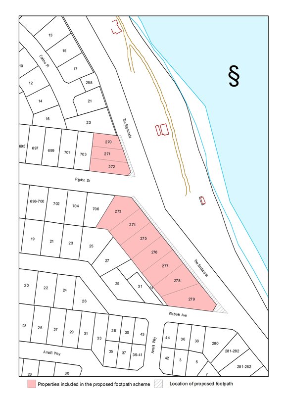
|
Stage |
Status |
Description |
|
Approval to prepare scheme |
ü |
Decision made to prepare scheme following consideration of surveys of residents and feed back from the community via the Northern Bellarine Walkability Study. Council may then place the project in the budget system or proceed immediately to prepare a scheme. Scheme preparation involves survey, design and preparation of an apportionment of costs. |
|
Intention to Declare Scheme |
ü |
Report to Council providing information on scheme including advice of impending advertising of scheme and declaration of charge. Seeks Council approval by resolution to proceed with process. |
|
Advertisement |
|
The scheme is advertised in the local newspaper and all allotted property owners are notified by mail. This advertisement indicates Council’s intention and notification to ‘declare’ a scheme in a month’s time. |
|
Submissions |
|
From the time of advertising property owners have 28 days (as set down by the Local Government Act) to lodge submissions, either in support or opposition to the scheme. |
|
Submissions Review Panel Hearing |
|
A Submissions Review Panel is convened (quorum of three Councillors) and meets to consider submissions. Some submissions are written only, and other submitters may wish to be heard before the Panel. The Panel makes a recommendation to Council regarding the scheme. |
|
Declaration Report |
|
Any time 28 days after advertising the scheme and after the Submissions Review Panel has met and considered submissions, Council considers a report and may proceed to “declare” the charges in accordance with its advertised intent. Subsequent to this the Finance Manager issues the levy notices and there is a formal charge placed on the property. This is the final step in the process for Council to make a decision on the scheme. |
|
Appeal |
|
Property owners may lodge an application for review with the Victorian Civil and Administrative Tribunal (VCAT) within one month of issue of the levy notice. An appeal is listed, heard and determined by the Tribunal and this process generally takes three to four months. Decisions made by VCAT are binding on all parties. |
|
Construction |
|
Council may then proceed to construct the works. Invoices are issued seeking payment of the estimated cost within one month of commencement. |
|
Final Cost Report |
|
At the completion of the works the scheme is “finalised” taking into account actual costs incurred and payments are adjusted accordingly. |
Contents | Previous Page: Section A - Procedural Matters | Next Page: Section C - Notice of Motion
