
Council Minutes - Section B: Reports - 8 July 2014
Contents | Previous Page: Section A - Procedural Matters | Next Page: Section C - Notice of Motion
Contents | Previous Page: Section A - Procedural Matters | Next Page: Section C - Notice of Motion
Reports tabled at the Ordinary Meeting of Council on Tuesday date held at City Hall, Little Malop Street in Geelong.
Portfolio: |
Planning – Cr Heagney |
Source: |
Planning & Tourism – City Development |
General Manager: |
Peter Bettess |
Index Reference: |
Application: 288/2014 |
The purpose of this report is to enable Council to consider the Panel Report to Planning Scheme Amendment C288 applying to the Adventure Park land at Wallington and to adopt the Amendment.
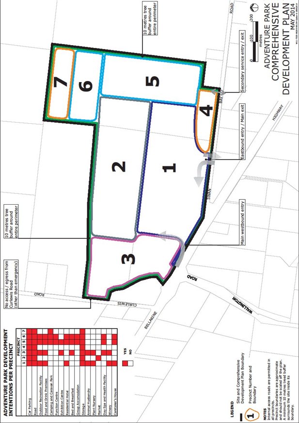
Amendment C288 resulted from the application on behalf of Adventure Park P/L (owned by the Salmon family) to rezone their 72.4ha site fronting Bellarine Highway and Swan Bay Road, Wallington from Farming zone to Comprehensive Development zone (CDZ), insert a new Schedule to the CDZ and incorporate the Adventure Park Comprehensive Development Plan into the Planning Scheme.
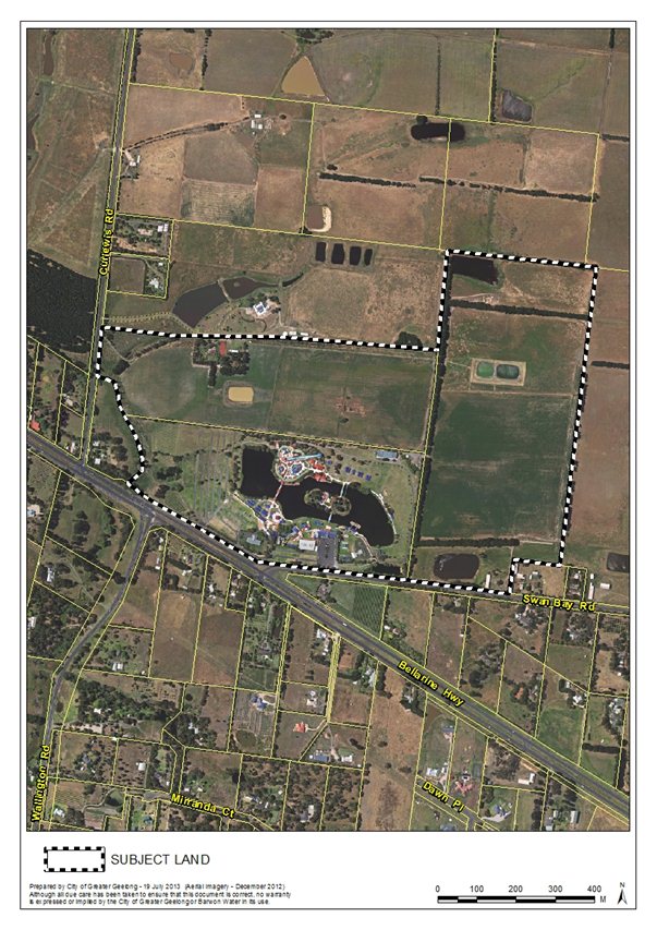
The subject land is occupied by a major water-based theme park along the Bellarine Highway/Swan Bay Road frontages whilst the balance of the site is generally cleared ex-farmland.
The Amendment recognises the substantial recreation and tourist facility on the land and rationalises the planning approval process for the on-going future development of the site.
Amendment C288 was placed on Public exhibition from 12 December 2013 until 27 January 2014. A total of 10 submissions were received of which 5 either supported or offered no objection (applicant and service authorities) and 5 which either objected or raised points of objection to the amendment.
The Council considered the submissions at its meeting on 11 March 2014 and resolved to refer them to an Independent Panel appointed by the Minister for Planning.
Council’s presentation to the Panel proposed the inclusion of additional provisions in the new Schedule to the zone and changes to the Comprehensive Development Plan aimed at addressing concerns raised by nearby landowners.
The Panel report recommends the Amendment be adopted with the additional provisions proposed by Council (agreed to by the applicant) together with some additional minor modifications.
The Panel’s recommendations are supported and the modified amendment can now be adopted.
Cr Macdonald moved, Cr Ellis seconded -
That Council:
adopts Amendment C288 as outlined in Appendix 4 of this report; and
submits the adopted Amendment with the prescribed information to the Minister for Planning requesting approval.
Carried.
Amendment C288 resulted from an application made by Collie Planning P/L on behalf of Adventure Park P/L (owned by the Salmon family) to rezone their 72.4 ha site from Farming Zone to Comprehensive Development (CDZ) zone, insert a new Schedule 3 to the CDZ and incorporate the Adventure Park Comprehensive Development Plan into Clause 80.01 of the Planning Scheme.
The subject land is occupied by a major water based theme park along the Bellarine Highway/Swan Bay Road frontages whilst the balance of the site is generally cleared ex-farming land. Adventure Park is already a major tourist attraction on the Bellarine Peninsula and is Victoria’s biggest theme park. It currently operates between October and April each year, with the busiest time being warm summer days at weekends and in holiday periods.
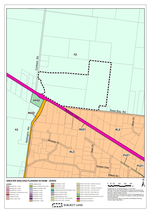
Adventure Park is in an area generally surrounded by farmland within a Farming zone. On the south side of both Swan Bay Road and the Bellarine Highway the land is zoned Rural Living and occupied by dwellings on 2 – 4 ha lots. Immediately opposite the site at Bellarine Highway Swan Bay intersection Council has recently issued a permit for a cidery/restaurant.
Appendix 1 shows the current zoning of the land and surrounding area. Appendix 2 is an aerial photo of the same area. Amendment C288 recognises the substantial recreation and tourist facility on the land and rationalises the planning approval process for the ongoing future development of the land.
Amendment C288 was placed on exhibition from 12 December 2013 until 27 January 2014. Notices where placed in the Geelong Advertiser and Independent and sent to all nearby owners and occupiers and all relevant public authorities.
As a result of the exhibition of the Amendment the Council received a total of 10 submissions of which 5 either supported or offered no objection (applicant and public authorities) and 5 nearby landowners who either objected or raised some points of objection to the amendment.
The main points raised in the objecting submissions were:
The proposed Schedule to the zone and the accompanying Comprehensive Development Plan do not provide a clear indication of the future development likely to occur on the land (i.e. it is too open – ended).
The three metres landscape buffer strip around the periphery of the site is totally inadequate.
Concern about security arrangements with the prospect of Adventure Park visitors trespassing onto adjoining properties and disrupting farming operations.
Increase in traffic in both Curlewis Road and Swan Bay Road.
The provisions of the zone do not provide for any further input from local residents when future planning permit applications are lodged with Council.
Concern about the venue operating on a year-round basis, extensions of operating hours and the impact on the amenity from visual and noise resulting from new “Gold Coast Style” developments.
Concern about future building heights, particularly the 30 metres permit trigger in Precinct 1.
The Council considered the submissions at its meeting on 11 March 2014 and resolved to refer them to an Independent Panel appointed by the Minister for Planning.
The main thrust to the Council’s resolution and its subsequent presentation to the Panel proposed the inclusion of additional provisions in the accompanying zone Schedule and changes to the Comprehensive Development Plan to directly address the above concerns raised by nearby landowners.
A Directions Hearing on 10 April 2014 and the Panel Hearing on 1 May 2014 were both conducted at Council offices. The Council, applicant and two nearby residents made presentations to the Panel.
The Panel report recommends the Amendment be adopted with the additional provisions proposed by Council (which have been agreed to by the applicant) together with some additional minor modifications.
A copy of the Panel’s report has previously been circulated to all Councillors. Appendix 3 is Section 7 Conclusions and Recommendation of the Panel’s report.
The Panel’s recommendations are supported and the modified Amendment can now be adopted. Appendix 4 is the Amendment recommended for adoption. Appendix 5 is the updated Comprehensive Development Plan.
Changes made to the exhibited amendment documentation to address issues raised in the submissions include:
Providing a requirement for Council to notify adjoining neighbours about all requests for approval of a masterplan; and
Enabling neighbours to comment on all masterplan proposals and require Council to take into account all comments received in deciding whether or not to approve any masterplan.
Requiring the masterplan to outline security fencing arrangements with neighbouring property owners (which it would be expected to be chain-mesh fencing at least 2 metres in height installed at the developers cost).
Requiring the Masterplan to specify the maximum building height of all buildings and works (i.e. potential future amusement rides and attractions) and building setbacks from neighbouring properties.
Reducing the 30 metres permit height trigger in Precinct 1 to 15 metres for Accommodation Uses.
Increasing the width of the tree buffer around the perimeter of Adventure Park land from 3 metres to 10 metres as shown on the exhibited Comprehensive Development Plan to ensure an adequate visual buffer between future developments on Adventure Park land and neighbouring properties.
Adding a notation on the Comprehensive Development Plan that no access or egress to Adventure Park patrons is to be provided to Curlewis Road (other than emergency access).
The subject land comprises the existing Adventure Park surrounded by cleared land previously used for farming. Future development of the site will have no adverse environmental impacts.
Amendment C288 has no financial implications.
The Panel concurs with Council that the Amendment is generally consistent with State and Council planning policies which are supportive of tourist development and protection of high quality natural landscapes. The Adventure Park site is well clear of any future planned urban settlements on the Bellarine Peninsula and as such the proposed Amendment is consistent with planning strategies in Clause 21.14 Bellarine Peninsula.
Amendment C288 supports the Growing our Economy strategic direction of City Plan, in particular the priorities of supporting the growth of existing businesses and promotion of tourism to attract visitors to the region.
No Council Officers have any direct or indirect interest, in accordance with Section 80 (c) of the Local Government Act, to which this Amendment relates.
No risks have been identified in processing Amendment C288 and adopting it as recommended by an Independent Panel.
Adventure Park is an already popular recreation and tourism facility. Its expansion will further increase the recreational opportunities for Geelong residents and visitors, create further short and long term employment opportunities and generate benefits to the wider Geelong economy.
Amendment C288 does not impact on any basic rights, freedoms and responsibilities as set out in the Charter. Planning legislation ensures an open community consultation process enabling people to freely express their views and obtain a fair hearing before an Independent Panel.
Full public notification of the Amendment has been given in accordance with the provisions of the Planning and Environment Act. All adjoining and nearby residents received direct notification of the exhibition of the Amendment and provided an opportunity to present their submission to an Independent Panel appointed by the Minister for Planning.
Adventure Park is an established, high quality tourist establishment located on a highly accessible site on the Bellarine Peninsula. Although it is located within a predominantly rural area it does not detract from the character of that area.
Amendment C288 has been proposed in order to facilitate the ongoing operation and development of Adventure Park under a more appropriate zoning and control regime. The Amendment proposes to include land in the ownership of Adventure Park in a Comprehensive Development Zone, which will provide a degree of certainty as to the land onto which Adventure Park can expand and the general locations on that land where recreational activities and ancillary uses may be developed.
Given that future development will occur over an extended period, it is unreasonable to expect that the precise detail of that development be provided at this stage. As a consequence, the zoning the Amendment proposes provides a degree of flexibility as to the form and precise location of future development. However, the detail lacking at this stage will be required at the time new development is proposed in the form of precinct masterplans. In the assessment of these masterplans, an opportunity will be provided for community input.
The Panel, having considered the submissions and evidence put to it, has concluded as follows:
Amendment C288 is supported by, and implements, the relevant sections of the State and Local Planning Policy Frameworks. As such it enjoys strategic support.
There is sufficient detail in the CDP (as revised), when coupled with the requirements for detailed masterplans, traffic management plans and permits before further development may take place, to ensure that any such future development will occur in a manner that respects the amenity of neighbouring properties and the rural character of the surrounding area.
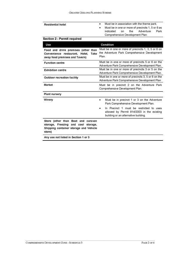
The inclusion of the matrix of permissible uses as shown on the revised CDP is a useful addition to the CDP and will provide greater clarity about the future development and use intentions for the subject land.
The ‘Adventure Park Comprehensive Development Plan April 2014’ as appended to the report of Mr Collie should replace the exhibited version of the CDP. In addition to the inclusion of the land use matrix it also provides for a 10m tree buffer around the perimeter of the subject land.
Subject to minor changes, the amendments suggested by Council as shown in its Post Exhibition Version of CDZ3 (which have been accepted by Adventure Park) are appropriate additions which will:
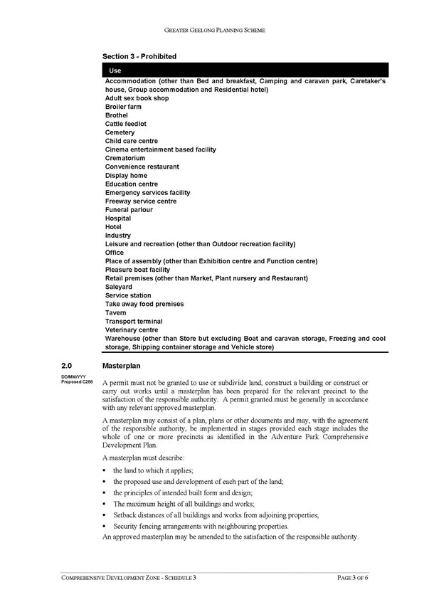
Require the masterplan to explicitly provide for details regarding the maximum height of all buildings and works, the setback distances of all buildings and works from adjoining properties, the security fencing arrangements with neighbouring properties and the details of the timing for the delivery of the identified road network upgrades; and
Provide an opportunity for the owners and occupiers of adjoining land and others likely to be impacted by the future development of Adventure Park to comment prior to the approval of any masterplan.
Based on the reasons set out in this Report, the Panel recommends:
Greater Geelong Planning Scheme Amendment C288 should be adopted as exhibited, subject to changes set out in the following recommendations:
The Comprehensive Development Plan should be replaced by the version attached to the evidence of Mr Collie entitled ‘Adventure Park Comprehensive Development Plan April 2014’. This version should be properly referenced in Schedule 3 to the Comprehensive development Zone and in the Schedule to Clause 81.01
The exhibited version of Schedule 3 to the Comprehensive development Zone should be replaced by the Council’s ‘Post Exhibition Version’ but amended further to:
Alter the condition in the Table of uses, Section 1, applying to Camping and caravan park to read “must be in the form of cabins (and not tents, caravans or campervans”.
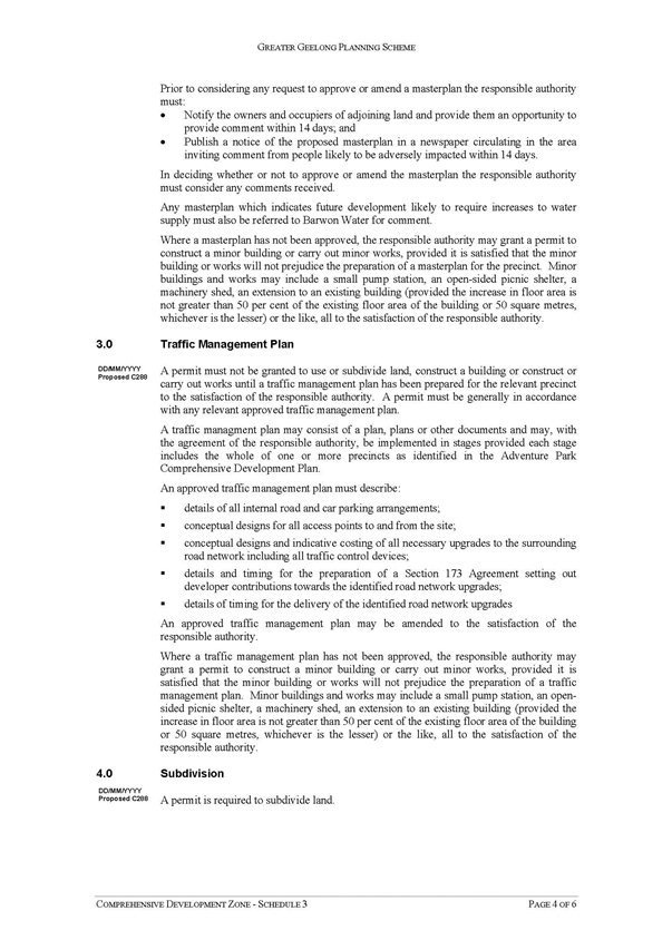
Alter the provisions of Clause 2.0 Masterplan, to include the following requirement:
“Prior to considering any request to approve or amend a Masterplan the responsible authority must:
notify the owners and occupiers of adjoining land and provide them an opportunity to provide comment within 14 days; and
publish a notice of the proposed Masterplan in a newspaper circulating in the area inviting comment from people likely to be adversely impacted within 14 days.
In deciding whether or not to approve or amend the Masterplan the responsible authority must consider any comments received.”
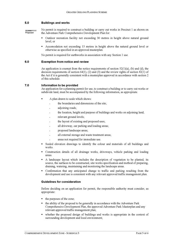
Alter the wording of the final dot point in Clause 5.0 Buildings and works, to read:
“Accommodation not exceeding 15 metres in height above the natural ground level or otherwise as specified in an approved Masterplan"
Number the sections titled ‘Exemption from notice and review’ and ‘Information to be provided’ as Clauses 6.0 and 7.0 respectively.
The planning authority for this amendment is Greater Geelong City Council
The Greater Geelong Planning Scheme is amended as follows:
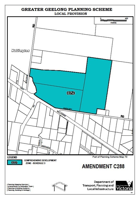
The Planning Scheme Maps are amended by a total of one attached map.
Zoning Maps
Planning Scheme Map No. 70 in the form of the attached map marked “Greater Geelong Planning Scheme, Amendment C288”
The Planning Scheme Ordinance is amended as follows:
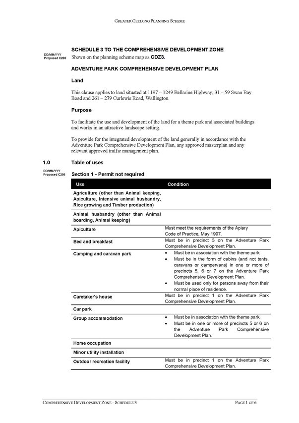
In Zones – following Clause 37.02, insert a new Schedule 3 in the form of the attached document.
In Incorporated Documents – Clause 81.01, replace the Schedule with a new Schedule in the form of the attached document.
End of document
SCHEDULE TO CLAUSE 81.01 |
||
|
12/09/2013 |
Name of document |
Introduced by: |
|
14 Shepherd Court, North Geelong, Cotton On Office Redevelopment, July 2011 |
C257 |
|
|
Adventure Park Comprehensive Development Plan May 2014 |
C288 |
|
|
Advertising Sign Guidelines, City of Greater Geelong, November 1997. |
NPS1 |
|
|
Armstrong Creek East Native Vegetation Precinct Plan, May 2010 |
C206 |
|
|
Armstrong Creek East Precinct Structure Plan, May 2010 Amended November 2011. |
C214 |
|
|
Armstrong Creek East Precinct Development Contributions Plan, Version 4.1 Alternate Version November 2011. |
C214 |
|
|
Armstrong Creek North East Industrial Precinct Development Contributions Plan, May 2010. |
C207 |
|
|
Armstrong Creek North East Industrial Precinct Growling Grass Frog Conservation Management Plan, May 2010. |
C207 |
|
|
Armstrong Creek North East Industrial Precinct Native Vegetation Precinct Plan, May 2010. |
C207 |
|
|
Armstrong Creek North East Industrial Precinct, Precinct Structure Plan, May 2010. |
C207 |
|
|
Armstrong Creek Urban Growth Plan Framework Plan, November 2008, Updated September 2012 |
C240 |
|
|
Armstrong Creek West Precinct Development Contributions Plan, February 2013 |
C240 |
|
|
Armstrong Creek West Precinct Native Vegetation Precinct Plan, November 2012 |
C240 |
|
|
Armstrong Creek West Precinct Structure Plan, September 2012 |
C240 |
|
|
Australian Standard AS 2021-1994, Acoustics - Aircraft Noise Intrusion - Building Siting and Construction. Standards Association of Australia 1994. |
NPS1 |
|
|
Environmental Weeds, City of Greater Geelong, September 2008 |
C129 (Part 1) |
|
|
Geelong City Urban Conservation Study Vol. 1 Restoration and Infill Guidelines, Commercial and Civic Buildings, Graeme Butler for the City of Geelong, 1993 |
C258 |
|
|
Geelong Library and Heritage Centre Redevelopment, March 2013 |
C287 |
|
|
Geelong Ring Road – Section 4C Incorporated Document, June 2010. |
C232 |
|
|
Geelong TAC Office Development, October 2006. |
C142 |
|
|
Heritage and Design Guidelines, City of Greater Geelong, 1997. |
NPS1 |
|
|
Key Development and Increased Housing Diversity Areas, July 2009, updated 2012. |
C254 |
|
|
Jetty Road Urban Growth Area Development Contributions Plan, September 2011 |
C230 |
|
|
Melbourne Geelong Interconnection Project, June 2010. |
C229 |
|
|
Native Vegetation Precinct Plan, Geelong Ring Road Employment Precinct, March 2013 |
C243 |
|
|
Newtown Heritage Study Review Report, Volume 3, City of Greater Geelong, 2008 |
C191 |
|
|
New Station Estate Restructure Plan, July 2010 |
C187 |
|
|
Rail Infrastructure Projects (comprising the Rail Gauge Standardisation Project, the Regional Fast Rail Project and the Fibre Optic Project), December 2002. |
VC17 |
|
|
Rail Upgrades at Geelong Port Project, May 2010. |
C211 |
|
|
Rippleside Comprehensive Development Plan, February 2000. |
C2 |
|
|
Rippleside Urban Design Guidelines, June 2000. |
C2 |
|
|
Thirteenth Beach Golf Resort Barwon Heads, Barwon Heads Comprehensive Development Plan, Land Design Partnership, Anthony Cashmore & Associates and the Planning Group, May 2001 amended September 2006. |
C54 |
|
|
Waterfront Geelong Design and Development Code, Keys Young, July 1996 |
NPS1 |
|
|
West Fyans-Fyans Street Precinct Structure Plan, June 2009 |
C205 |

Portfolio: |
Planning - Cr Heagney |
Source: |
Planning and Tourism |
General Manager: |
Peter Bettess |
Index Reference: |
Application: 299/2014 |
The purpose of this report is to enable Council to consider the Panel report for Amendment C299 which proposes the rezoning of the ex-netball courts in Draper Street and Asbury Street East, Ocean Grove and to adopt the Amendment.
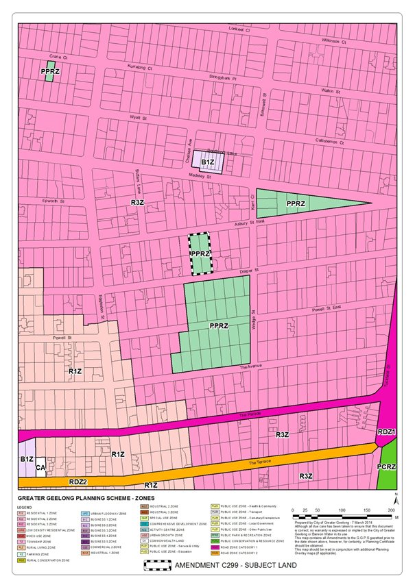
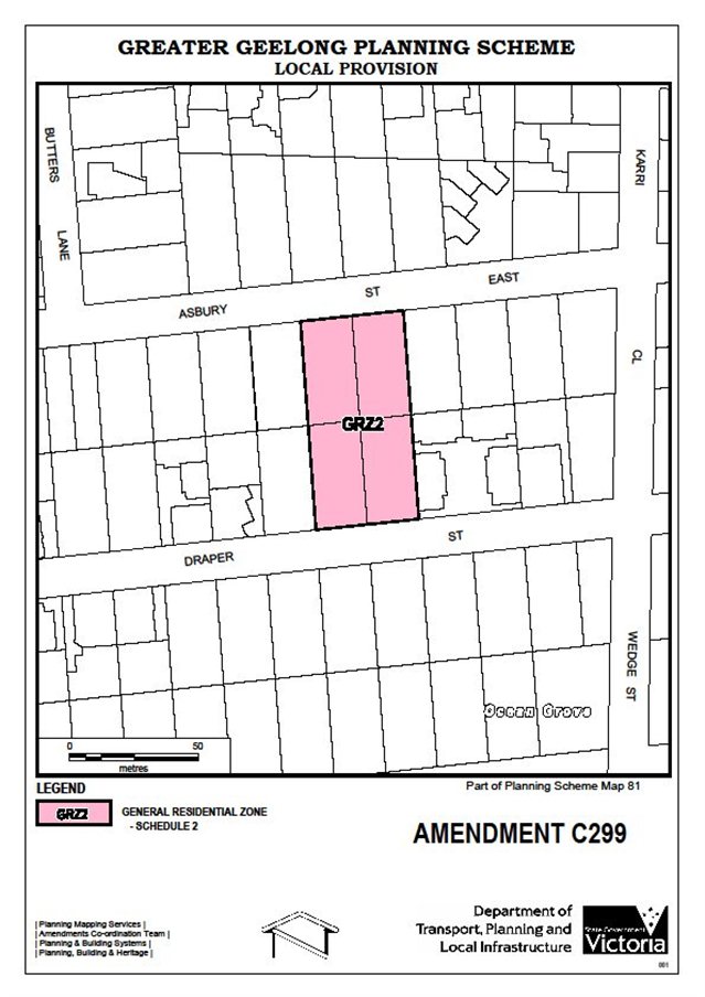
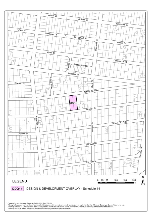
Amendment C299 proposes the rezoning of 4 Council owned residential properties situated at 77 – 79 Draper Street and 128 – 130 Asbury Street East, Ocean Grove from Public Park and Recreation zone to General Residential 2 zone. It is also proposed to extend the Design and Development Overlay (DDO14) over the land to be rezoned.
These properties have been utilised for netball courts and a small clubroom which are no longer required following the construction of a new facility at the Shell Road Recreation Reserve. Each lot has an area of approximately 807 sq metres.
Following the rezoning of the land the Council intends to offer the land for sale as it is no longer required for recreational purposes. There is ample other land currently available for open space usage in the immediate area.
Amendment C299 was placed on public exhibition from 31 October 2013 to 2 December 2013. A total of 19 submissions were received of which 4 either supported or offered no objection and 15 which objected to the amendment.
Council considered the submissions at its meeting on 11 February 2014 and resolved to refer them to an Independent Panel appointed by the Minister for Planning.
The Panel has recommended the Amendment be adopted. It finds the Amendment is consistent with Council’s recreational strategies for Ocean Grove and the Bellarine Peninsula and that there is very adequate remaining open space to serve the surrounding residential community.
The Panel’s recommendations are supported and the Amendment can now be adopted.
Cr Farrell moved, Cr Macdonald seconded -
That Council:
Adopts Amendment C299 as outlined in this report; and
Submits the adopted Amendment together with the prescribed information to the Minister for Planning requesting approval.
Carried.
Council is the proponent for Amendment C299 which rezones 4 residential properties situated at 77 – 79 Draper Street & 128 – 130 Asbury Street, Ocean Grove from Public Park and Recreation zone to General Residential 2 zone. It is also proposed to extend Design and Development Overlay 14 (the 7.5 metres permit height trigger) over the land to be rezoned.
For many years these properties were used for recreational purposes and are occupied by netball courts and a small clubrooms. The courts have protective mesh fencing on 3 sides and six pole mounted lights. Each of the 4 separately Titled lots is approximately 807 sq metres (total area 3228 sq metres).
As a result of the construction of the new netball facility at the Shell Road Recreation facility the old courts are no longer required. Following the rezoning of this land it is Council’s intention that it be sold. (Item 4, Council Minutes of meeting 27 August 2013).
The Council has given public notice of its intention to sell the land pursuant to Section 189 of the Local Government Act. Submissions were heard by the Submissions Hearing Panel on 3 June and are subject to a separate report to a Council meeting.
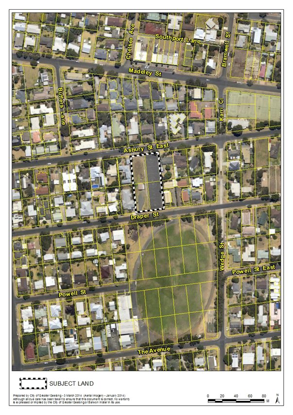
Appendix 1 shows the land subject of the rezoning application and existing zonings.
Appendix 2 shows the subject land and the surrounding area which is predominantly used for residential purposes other than the substantial Memorial Reserve (2.4ha) located on the south side of Draper Street opposite the subject land.
In considering whether to pursue this rezoning proposal, Council had regard to whether or not this immediate area would be adequately served with local open space. In this case, it is considered there is no shortage of open space in the immediate area with residents having easy access to:
Memorial Park (2.4ha) containing an oval and surrounding parkland, opposite the subject land.
Arthur Powell Reserve (7000 sq m) containing tennis courts and surrounding parkland, approximately 100 metres to the east of the subject land.
The rezoning proposal is consistent with the Ocean Grove Sporting Infrastructure Plan dated May 2010 which proactively plans for the formal outdoor sporting needs of current and future residents of Ocean Grove, with particular emphasis on the town’s major active recreation reserves i.e. Shell Road, Collendina and Memorial Reserves.
As part of the background research, this report notes (page 17) that the Bellarine Peninsula Recreation and Leisure Needs Study 2005 refers to selling the old netball courts following their relocation to Shell Road to help offset the costs of the new facility developments. The Infrastructure Plan (page 34) also makes reference to the inadequate facilities and amenities at the existing site and the constraint on further development being wedged between residential properties.
Amendment C299 was placed on exhibition between 31 October 2013 and 2 December 2013. Notices were placed in the Geelong Advertiser, Independent and Ocean Grove Voice and sent to all nearby owners and occupiers and all relevant public authorities.
As a result of the exhibition of the Amendment the Council received a total of 19 submissions. Of these, 4 either supported the Amendment or offered no objection and 15 objected to the Amendment.
Three supporting submissions argue that the land is very suitable to provide for future residential development for people with a disability which will be a benefit to the Ocean Grove community.
Objecting submitters consider there has been inadequate community consultation and that with the continuing growth of the town the land should be retained for future recreational and/or community use.
The issues raised in the submissions where considered by Council at its meeting on 11 February 2014. Council resolved to refer all submissions to an Independent Panel appointed by the Minister for Planning.
A Directions Hearing on 14 March 2014 and the Panel Hearing on 16 March 2014 were both conducted at Council offices in Geelong. The Council, as both applicant and planning authority, made presentations to the Panel, as did five residents (one supporting use of the land for housing people with disability, four objecting and arguing the land should be retained for open space/recreational purposes).
The Panel report recommends that the Amendment be adopted. It finds that the rezoning of the land is consistent with adopted Council strategic recreational strategies being the Bellarine Peninsula Recreation and Leisure Needs Study 2005 and the Ocean Grove Sporting Infrastructure Plan, both of which make reference to the prospect of selling the land occupied by the old netball courts when the new facility at the Shell Road Recreation Reserve is completed. It also finds that this area is well served by existing open space at Memorial Reserve and Arthur Powell Reserve.
A copy of the Panel’s report has previously been circulated to all Councillors. Appendix 3 is Section 6 Conclusions and recommendations of the Panel’s report. The Panel’s report was publicly available on the Council’s website.
The Panel’s recommendation is supported and therefore the Amendment can be adopted. Appendix 4 is the Amendment recommended for adoption. The subject land is proposed to be included in the GRZ2 zone (as distinct from the exhibited GRZ) in accordance with the future zoning of the surrounding R3 zoned area and as per Council’s presentation to the Panel.
The proposed rezoning has no environmental implications
The proposed rezoning provides a positive financial outcome for Council in that it will enable it to sell land no longer required for recreational purposes.
Under the Local Government Best Practice Guideline for the Sale and Exchange of Land, the Council is required to ensure that “…….prior to being offered for sale, property should be appropriately zoned. This will ensure that the ultimate use of the land is determined by that zone and the highest possible sale price is achieved”.
The proposed amendment is not inconsistent with any State or Council planning policies. To the extent which these policies advocate the benefits of urban consolidation, this amendment will enable infill development to occur in a location which excellent accessibility to all urban facilities and services.
The Panel has determined that “the Amendment has been prepared following a thorough strategic planning process”.
The proposal is consistent with the Community Wellbeing strategies of City Plan which are directed at delivering a network of open space and sporting facilities to keep people active. It is consistent with the Municipal Strategic Statement and Bellarine Peninsula Strategic Plan which are listed strategies in delivering community wellbeing priorities.
No Council Officers have any direct or indirect interest, in accordance with Section 80 (c) of the Local Government Act to which this Amendment relates.
No risks have been identified regarding the rezoning of this land.
There is ample existing remaining recreational land in the immediate neighbourhood to meet the requirements of surrounding residents.
The site is well located for infill residential development with good accessibility to the town’s community and commercial facilities and services.
The proposal does not impact on any human rights and responsibilities set out in the Charter. Planning legislation ensures an open community consultation process enabling people to freely express their views and if necessary obtain a fair hearing before an Independent Panel.
The Amendment has been exhibited in accordance with the provisions of the Planning and Environment Act to provide for full public comment. As part of this process direct written notification was provided to all adjoining and nearby property owners potentially affected by the Amendment.
All submitters have been provided with an opportunity to appear before an Independent Panel appointed by the Minister for Planning.
The Panel finds that the Amendment is consistent with the Council’s strategic recreational strategies for Ocean Grove and the Bellarine Peninsula area. The Amendment has been prepared following a thorough strategic planning process.
The decision to rezone the land (and potentially sell) has been based on the recommendations of well researched reports that have undergone extensive public consultation. Many of the recommendations in the reports have been implemented, or are soon to be.
The Council has determined that the land is no longer required as a netball facility, particularly as the new facilities have been completed and expanded at the Shell Road site. The land is within very close proximity to, and well served by, existing open space at Memorial Reserve and the Arthur Powell Reserve.
The task of the Panel has been to determine whether the proposed General Residential Zone is the most appropriate zone for the land at 77-79 Draper Street and 128-130 Asbury Street East, Ocean Grove, if the land is to be sold.
For the reasons outlined in this report, the Panel recommends that Amendment C299 to the Greater Geelong Planning Scheme should be adopted as exhibited.
The planning authority for this amendment is Greater Geelong City Council.
Planning Scheme is amended as follows:
The Planning Scheme Maps are amended by a total two (2) attached map sheets.
Zoning Maps
Amend Planning Scheme Map No 81 in the manner shown on the one attached map marked “Greater Geelong Planning Scheme, Amendment C299”.
Overlay Maps
Amend Planning Scheme Map No 81 DDO14 in the manner shown on the one attached map marked “Greater Geelong Planning Scheme map marked Greater Geelong Planning Scheme, Amendment C299”.
End of Document
Portfolio: |
Planning - Cr Heagney |
Source: |
Planning and Tourism - City Development |
General Manager: |
Peter Bettess |
Index Reference: |
Application C059 |
The purpose of this report is to seek Council’s support for an amendment to the Greater Geelong Planning Scheme to implement design and development overlays to protect the flight paths to the current and future emergency helipads at the Geelong Hospital.
The Emergency Medical Services (EMS) helipad plays a vital part in the operations of the Geelong Hospital. The EMS helicopter services are used to assist critically ill patients or people who have been involved in road trauma incidents.
This is an essential service serving a large catchment around Geelong and regional areas west of Melbourne and operates on an as needs basis with about 2 EMS operations each week.
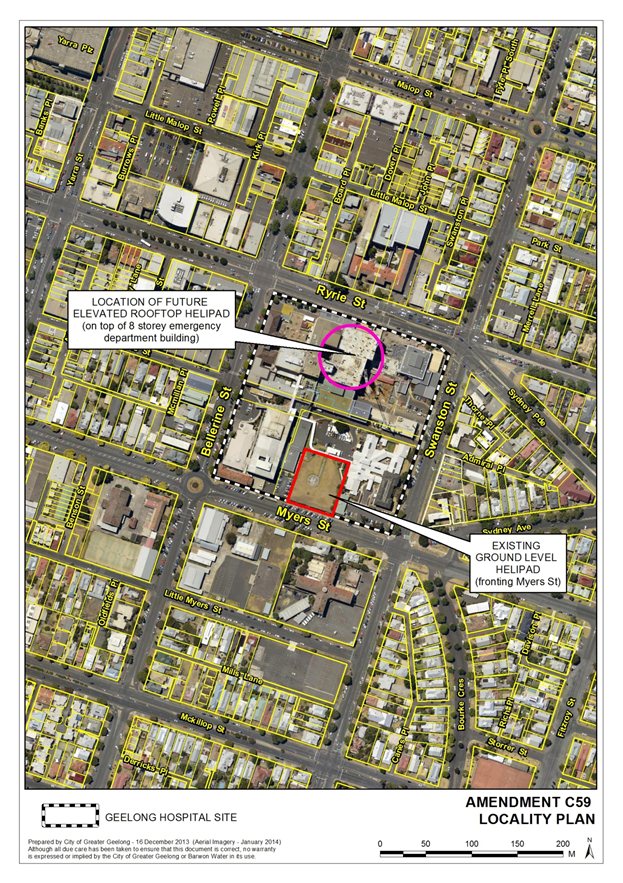
An existing helipad is located at ground level fronting Myers Street. A new helipad is proposed (subject to funding) on top of the new Emergency Department building fronting Ryrie Street.
Long term protection of the operational areas of the EMS helicopter flight paths will ensure that this essential service is available for current and future community.
The amendment proposes the application of three design and development overlays (DDOs) to the flight paths for the current and future emergency helipads to protect the operational airspace for helicopter medical transport flights. They have been defined to reflect the operating environment for the existing and future helipad.
The proposed DDOs will ensure that air ambulance helicopter operators will be aware of the location and height of objects within the approach, departure and manoeuvring area of the Geelong Helipad EMS, all essential information for the safe and efficient conduct of the EMS flights.
The Department of Health (DoH) has identified the need for the amendment due to the increasing development occurring in Geelong as well as the potential for the redevelopment of the existing helipad site.
The Minister for Planning is being asked by the DoH to undertake a ministerial amendment under section 20(4) of the Planning and Environment Act.
Council’s support for the amendment and process is sought.
Officers recommend that the Department of Health undertakes a consultation process with the local community to ensure that they are fully informed about the proposal and its impact on the areas within the flight paths of the helipads.
There are immense benefits to residents of the Region of maintaining clear and safe access to the helipads and this outweighs any potential impact on properties within their flight paths.
Cr Macdonald moved, Cr E Kontelj seconded -
That Council:
supports the preparation of a planning scheme amendment C59 to apply design and development overlays to the flight paths of the emergency helipads at the Geelong Hospital;
supports the amendment being considered by the Minister for Planning and proceeding as a section 20(4) amendment under the Planning and Environment Act 1987;
recommends that the Department of Health undertake a consultation process with the local community about the project.
Carried.
Council has received correspondence from the Department of Health seeking the support of the City of Greater Geelong to undertake a Section 20 (4) Ministerial amendment to protect the flight paths of the Emergency Medical Services (EMS) helicopters that fly to and from Geelong Hospital. Appendix 1 shows the location of the helipad.
The DoH seeks Councils support on the planning controls amendment process as these controls have been tested and have used successfully throughout the State.
As outlined in the correspondence,
“The Department has developed a state−wide helipad strategy that has as a key objective the protection of the long−term viability of the air ambulance helicopter network in Victoria. Geelong Hospital is part of this state−wide network of public facilities that provide vital air ambulance services to trauma and seriously ill members of the community. Therefore it is important to protect the safety, availability and efficiency of this vital emergency medical service provided by the air ambulance helicopters.
Geelong Hospital is currently serviced by air ambulance helicopters using a ground level concrete helipad on the southern side of the hospital, adjacent to Myers Street. Whilst helicopter EMS flights continue to use the existing ground level facility, the location and proximity of adjacent buildings and trees create operational constraints on helicopter flights.
Given the impetus to promote growth within Geelong and its strategic location as one of the largest regional areas west of Melbourne, the EMS helipad will serve a large and growing catchment. Long term protection of the EMS helicopter flight paths will ensure that this essential service is available for current and future generations. A key injection of investment into community infrastructure has occurred on site with Barwon Health currently undertaking major extension works to Geelong Hospital. The new Emergency Department located on Ryrie Street will include the potential to provide a future rooftop helipad to serve the hospital. The provision of a future rooftop facility will overcome the current restrictions and permit flights to be conducted in Performance Class 1 helicopters. However the realisation of a future rooftop facility is dependent upon funding. Once this has occurred and the helipad has been constructed, the proposed controls relating to the ground level helipad will no longer be applicable.
The Department seeks to protect this airspace through the Greater Geelong planning scheme via a Design and Development Overlay (DDO) control. Discussion has occurred with your officers on this matter as well as planners at the regional office of the Department of Transport, Planning and Local Infrastructure and we understand a recommendation is to be put to Council to approve the proposed Ministerial amendment process.
It must be noted that the Department does not seek to inhibit development surrounding the hospital. Rather we seek to be a referral authority to ensure that the overall usability of the helipad meets the 98% value adopted for EMS helicopters. In most cases, provided the overall usability of the helipad is maintained, referred applications will generally be accepted with the position and height of the building incorporated into the Australian Air ambulance database.
The EMS helicopters play a key role in providing medical and trauma services to patients who are critically ill and involved in accidents within the Greater Geelong and wider area. The service is one of regional significance and achieves regional planning objectives by ensuring safe access to community infrastructure for all members of the wider area. We consider that whilst the facility may be located in Geelong, the ability to transport critically ill and injured people to hospital has impacts far beyond the immediate area.
Prior to approval we would support consultation with the community in relation to the proposed controls and will work with your officers on the format of how this information is provided to the properties impacted by the overlay controls. Any responses to the views of affected parties will be provided to Council and the Department of Transport, Planning and Local Infrastructure prior to consideration by the Minister for Planning.
The matter is one where the Department of Health seeks to ensure the future health of Victorians is protected by delivering an important trauma service. By allowing the Department of Health to consider the heights of potential structures within the helicopter flight paths through the referral process, the DDO's will ensure the long term protection of this community service for the benefit of Greater Geelong and the wider area.”
The DoH has identified the need for the amendment due to the increasing development occurring in Geelong as well as the potential for redevelopment of the existing helipad site. The current helipad occupies valuable space that can be developed for other hospital related purposes.
Amendment C59 will trigger a planning application for high development and referral to the DoH within the boundaries of three new Design and Development Overlays (DDOs) into the Planning Scheme as follows:
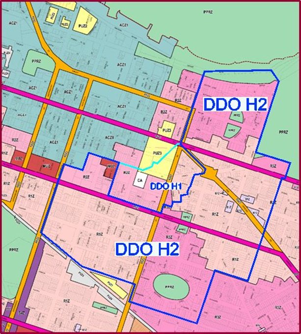
DDO (H1) relates to the “inner areas” of the ground level helipad
DDO (H2) relates to the “outer area” of the ground level helipad
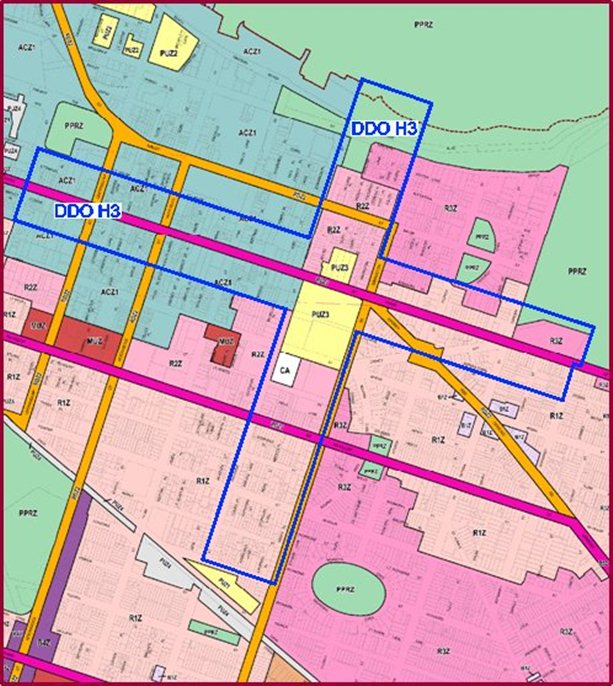
DDO (H3) relates to the proposed new elevated helipad.
It should be noted that the DDOs for the ground level helipad will not be required once a new rooftop helipad is operational.
There is precedence for this type of control, with it being successfully implemented in other planning schemes including at Ballarat, Traralgon, Cowes, Kilmore and Seymour.
The areas proposed to be affected by the DDOs were mapped by applying standard requirements for EMS helipad flightpath protection and then tailored to suit local conditions around the Geelong Hospital in terms of wind, topography and existing buildings.
The key purpose of each DDO is to trigger a planning permit requirement for structures over a certain height and to include a mandatory referral to the Department of Health for assessment and comment. The DDOs are considered the most effective and proven method for protecting the EMS flightpaths from any obstructing structures.
DDO Boundaries
Three DDOs are proposed. The boundaries for these have been selected on the technical advice provided by PSNK Aeronautical Services (technical report to DoH).
The associated flightpath footprints have been defined relative to the helipad location with reference to three separate areas:
Area H1
The area in the immediate proximity to the ground level helipad within which the initial take-off phase of flight and the approach phase of flight are performed. This nominated area is a circular region within 250 metres of the helipad which has been truncated to reflect the location of existing buildings to the north and west of the helipad.
Area H2
The area in the approach and take-off flightpath extending from the boundary of the ground level helipad H1 area to a nominal distance of 926 metres (0.5 nautical miles) from the helipad where the protected airspace associated with the helicopter flight paths would exceed an elevation of 40 metres above the helipad.
Area H3
The area adjacent to the approach and take-off flightpaths tracks extending from the rooftop helipad to a nominal distance of 926 metres (0.5 nautical miles) from the helipad where the protected airspace associated with the helicopter flightpaths would exceed an elevation of 40 metres above the helipad.
The boundaries of the DDOs generally follow block, street and zone extents for ease of reference by landowners and Council.
Appendix 2 shows the extent of the proposed overlay areas. The areas affected include residential, commercial and mixed use land uses, and affected both public and private land.
DDO requirements
Any application for buildings and works over certain heights are to be referred to the Department of Health. The specialist advice to be provided by the DoH will help guide Council in assessing the application.
In large part, all three DDOs contain the same information in the design objectives, buildings and works, referral of applications and decision guidelines sections. Where they differ is in the height for which a planning permit is triggered. The planning permit trigger for development in each of the three DDOs is:
H1 – Inner Area = 8.1 metres above natural ground level
H2 – Outer Area = 13.5 metres above natural ground level
H3 – Rooftop = 25.0 metres above natural ground level
All applications for development at or above these heights will be referred to the Department of Health for consideration.
Applications made under the DDO will be exempt from the notice and review requirements of the Planning and Environment Act. With this provision in mind, officers recommend that the Department of Health undertakes a consultation process with the community about the project.
The amendment will provide protection for the flight paths used by emergency medical service helicopters servicing the Geelong Hospital from encroachment by future developments that could prejudice the safety or efficiency of the helipad at the Geelong Hospital. Protection of the flight paths are crucial to ensure that the Geelong community and wider region have the benefit of a helicopter service that is safe and efficient and responsive to emergency medical needs. Controls on high new buildings and works within the flight paths are essential to protect the long term viability of the helipads and associated flight paths.
Referral of an application for new buildings and works to exceed the designated heights is required to allow the Department of Health to determine if an application might affect the safety of helicopter operations.
Appendix 3 outlines the proposed Design and Development Overlay Schedules.
Officers have reviewed the proposed Design and Development Overlay Schedules and have suggested some improvements to simplify the clauses without changing the intent or the provisions. These will be considered by the Department of Health.
Design and development overlays similar to this proposal have recently (2013) been incorporated into the Ballarat Planning scheme to protect the flight paths of the Ballarat Base Hospital. It is a technique that will allow for development to continue but for high development to obtain a planning permit and to have input from the Department of Health.
The applicant advises that in the other areas around Victoria with similar DDOs, there have been few applications made with a negligible number refused. In most cases the referral to DoH will not result in a refusal or any required changes to a proposal.
Drafting of the DDOs has sought to reduce the extent of administrative burden on Council by exempting the notice and rights of review provisions and including the views of the DoH as a decision guideline.
Conclusion
The proposed amendment is considered essential to provide long term protection of the EMS helicopter flight paths of the Geelong Hospital. The EMS helicopters provide important trauma related services to the operation of the Geelong Hospital.
The areas affected by the proposed DDOs have been reviewed in relation to Council’s strategic vision for the area and sought to minimise any potential impact on the Geelong Central Activities Area.
It is not expected that the amendment will have any undue environmental implications.
The Department of Health will bear the costs of the planning scheme amendment and a community consultation process.
The amendment supports the strategies in the State Planning Policy Framework at Clause 18.04-3 Planning for airfields that seek to plan for area around airfields to preclude development which could prejudice the safety or efficiency on an airfield. This strategy is equally applicable to the flight paths for a helipad.
The ‘How we do business’ priority on lead by advocating and collaborating on issues important to the Greater Geelong community is relevant to this proposal and Council supporting the protection of the helipad flight paths for helicopter medical transport flights. The priority for an informed and engaged community will also be met by asking the Department of Health to undertake a consultation process for the proposal.
No Council Officers have any direct or indirect interest, in accordance with Section 80 (C) of the Local Government Act to which this Amendment relates.
There are no risks with either implementing or not implementing the recommendations of this report.
Continued safe helicopter access will provide benefits to the Geelong community and the wider western region of the State.
Support for the Department of Health undertaking a consultation process with the local community will ensure that the proposal can be fully explained and views can be heard and addressed. The Planning and Environment Act 1987 provides for the Minister for Planning to prepare an amendment.
Consultation and engagement with the local community about the project should be undertaken by the Department of Health as part of the preparation for making the amendment application to the Minister for Planning.
--/--/20-- |
SCHEDULE [NUMBER] TO THE DESIGN AND DEVELOPMENT OVERLAY |
Shown on the planning scheme map as DDO [number]. |
|
EMS HELICOPTER FLIGHTPATH AREA (H1 – INNER AREA) |
|
1.0 |
Design objectives |
--/--/20-- |
To ensure that the height of new development does not encroach on the flight path airspace areas associated with the Geelong Hospital ground level helipad. To ensure that the height of new development avoids creating a hazard to EMS helicopters operating in the vicinity of the Geelong Hospital helipad and to facilitate safe emergency medical service helicopter flight operations. |
2.0 |
Buildings and works |
--/--/20-- |
A permit is not required to:
For the purposes of this clause, buildings and works include fences, radio masts, television antennae and flagpoles and any construction equipment associated with the buildings and works. |
3.0 |
Referral of applications |
--/--/20-- |
An application must be referred in accordance with Section 55 of the Act to the referral authority specified in Clause 66.04 or a schedule to that clause. Referred applications must include details of proposed development height expressed as elevations above the Australian Height Datum.The Geelong Hospital helipad is at an elevation of 32.35 metres above Australian Height Datum. Applications will be assessed against the Department of Health (Vic) guidelines for helicopter landing sites which incorporate the requirements of the International Civil Aviation Organisations ‘Standards and Recommended Practices’ Annex 14 Volume 11 Helicopters (as amended). |
4.0 |
Exemption from Notice and Review |
--/--/20-- |
An application under this overlay is exempt from the notice requirements of Section 52(1)(a), (b) and (d) and the decision requirements of Section 64(1), (2) and (3) and the review rights of Section 82(1) of the Act. |
5.0 |
Decision guidelines |
--/--/20-- |
Before deciding on an application, the responsible authority must consider the views of the Secretary of the Department of Health. |
EMS HELICOPTER FLIGHTPATH AREA (H2 – OUTER AREA) |
|
1.0 |
Design objectives |
--/--/20-- |
To ensure that the height of new development does not encroach on the flight path airspace areas associated with the Geelong Hospital ground level helipad. To ensure that the height of new development avoids creating a hazard to EMS helicopters operating in the vicinity of the Geelong Hospital helipad and to facilitate safe emergency medical service helicopter flight operations. |
2.0 |
Buildings and works |
--/--/20-- |
A permit is not required to:
For the purposes of this clause, buildings and works include fences, radio masts, television antennae and flagpoles and any construction equipment associated with the buildings and works. |
3.0 |
Referral of applications |
--/--/20-- |
An application must be referred in accordance with Section 55 of the Act to the referral authority specified in Clause 66.04 or a schedule to that clause. Referred applications must include details of proposed development height expressed as elevations above the Australian Height Datum. The Geelong Hospital helipad is at an elevation of 32.35 metres above the Australian Height Datum. Applications will be assessed against the Department of Health (Vic) guidelines for helicopter landing sites which incorporate the relevant requirements of the International Civil Aviation Organisations ‘Standards and Recommended Practices’ Annex 14 Volume 11 Helicopters (as amended). |
4.0 |
Exemption from Notice and Review |
--/--/20-- |
An application under this overlay is exempt from the notice requirements of Section 52(1)(a), (b) and (d) and the decision requirements of Section 64(1), (2) and (3) and the review rights of Section 82(1) of the Act. |
5.0 |
Decision guidelines |
--/--/20-- |
Before deciding on an application, the responsible authority must consider the views of the Secretary of the Department of Health. |
EMS HELICOPTER FLIGHTPATH AREA (H3 – ROOFTOP HELIPAD) |
|
1.0 |
Design objectives |
To ensure that the height of new development does not encroach on the flight path airspace areas associated with the Geelong Hospital rooftop helipad. To ensure that the height of new development avoids creating a hazard to EMS helicopters operating in the vicinity of the Geelong Hospital helipad and to facilitate safe emergency medical service helicopter flight operations. To ensure that the height of new development does not encroach on the flight path airspace areas associated with the Geelong Hospital rooftop helipad. To ensure that the height of new development avoids creating a hazard to EMS helicopters operating in the vicinity of the Geelong Hospital helipad and to facilitate safe emergency medical service helicopter flight options. |
|
2.0 |
Buildings and works |
A permit is not required to:
For the purposes of this clause, buildings and works include fences, radio masts, television antennae and flagpoles and any construction equipment associated with the buildings and works. |
|
3.0 |
Referral of applications |
An application must be referred in accordance with Section 55 of the Act to the referral authority specified in Clause 66.04 or a schedule to that clause. Referred applications must include details of proposed development heights expressed as elevations above the Australian Height Datum. The design level for the Geelong rooftop helipad is at an elevation of 58.44 metres above the Australian Height Datum. Applications will be assessed against the Department of Health (Vic) guidelines for helicopter landing sites which incorporate the relevant requirements of the International Civil Aviation Organisations ‘Standards and Recommended Practices’ Annex 14 Volume 11 Helicopters (as amended). |
|
4.0 |
Exemption from Notice and Review |
| An application under this overlay is exempt from the notice requirements of Section 52(1)(a), (b) and (d) and the decision requirements of Section 64(1), (2) and (3) and the review rights of Section 82(1) of the Act. | |
5.0 |
Decision guidelines |
| Before deciding on an application, the responsible authority must consider the views of the Secretary of the Department of Health. |
Portfolio: |
Planning - Cr Michelle Heagney |
Source: |
Planning and Tourism |
General Manager: |
Peter Bettess |
Index Reference: |
Central Geelong Taskforce |
To facilitate changes to the zoning provisions applying to Central Geelong to stream line decision making consistent with the Central Geelong Action Plan.
The adopted Central Geelong Action Plan flagged changes to the zoning provisions relating to Central Geelong, specifically the Activity Centre Zone, to provide for a more facilitative development framework consistent with the objectives and principles of the Action Plan.
The Minister for Planning has recently identified the opportunity to apply new state wide VicSmart provisions, a new streamlined application process, to Central Geelong. The key elements of VicSmart are 10 day turnaround times for permits (except where further information is required), the CEO or delegate is the responsible authority for the application (not the council) and notice and third party appeal rights do not apply.
Apply the new state-wide VicSmart provisions to the Activity Centre Zone. It is recommended that state-wide VicSmart provisions for commercial zones and the Capital City Zone relating to subdivision, signage, loading provisions apply to Central Geelong. It is also recommended to increase the state-wide dollar value for buildings and work applications to be considered under VicSmart from $50,000 to $250,000 to reflect the higher costs associated with commercial centre works for shop front alterations etc. The state-wide standard for parking reduction is also proposed to be increased above 5 bays for existing building reuse in Central Geelong while an additional provision for liquor licenses associated with restaurants and cafes is proposed between 7.00am and 11.00pm.
A substantial review of the Activity Centre zone so that it is more in keeping with the Capital City Zone and recently reformed Commercial 1 zone is proposed. Recommended changes include:
Simplification of permit triggers so that Section 1 uses (uses which do not require permits) are less constrained by precinct location conditions;
Removal of all notice and review provisions;
Restructure of the zone schedule to make it easier to navigate and interpret key provisions;
Simplify some of the application requirements.
The report recommends a staged process to implement VicSmart and Activity Centre Zone changes to Central Geelong. Stage 1 includes the introduction of local VicSmart provisions for land in Activity Centre Zone via a Ministerial Amendment process. Stage 2 is recommended to comprise the Activity Zone changes to be implemented through a separate amendment process.
Cr Macdonald moved, Cr Harwood seconded -
That Council requests:
the Minister for Planning, pursuant to Section 20(4) of the Planning and Environment Act 1987, to prepare, adopt and approve a planning scheme amendment to the Greater Geelong Planning Scheme to introduce local VicSmart provisions to the Activity Centre Zone as identified in Appendix 1; and
the Minister for Planning pursuant to Section 20(4) of the Planning and Environment Act 1987 to prepare and approve an amendment to the Greater Geelong Planning Scheme to amend the schedule to the Activity Centre Zone provisions as generally identified in this report; and in the event this request is not supported;
authorisation from the Minister for Planning to prepare an amendment to the Greater Geelong Planning Scheme, and subject to authorisation, exhibit the amendment to change the schedule to the Activity Centre Zone provisions as generally identified in this report.
Carried.
The adopted Central Geelong Action Plan recommended a review of the current zoning provisions relating to Central Geelong (Activity Centre Zone predominantly) with a specific focus on reviewing the notice provisions to establish a zone which is more facilitative for development in terms of timeliness and cost associated with application assessment. This was considered consistent with the broader objectives of stimulating investment and streamlining the approvals process and necessary to achieve the principle of more people living, working, living and playing in Central Geelong.
The Activity Centre Zone (ACZ) was introduced in May 2013. The zone was prepared by the state government and introduced into the planning scheme via a ministerial amendment process. The Zone combined a number of different zones and overlays applying over Central Geelong and included new Urban Design Guideline provisions. Intending to simplify planning controls in Central Geelong to a ‘one stop shop’ to make it clearer and simpler for all sectors with an interest in Central Geelong and strengthen Central Geelong as the region’s primary business and retail precinct whilst encouraging complementary mixed uses including residential.
Feedback indicates that the zone is overly complex, difficult to navigate and apply. As with all major zone changes there are some minor unintended consequences with some poorly worded decision guidelines. Since its introduction there has been a policy position shift with the development of the Action Plan and Vision 2. There is also misalignment with recent state-wide commercial zone changes which sees the ACZ in some instances being less flexible that the Commercial 1 zone for some land use types, thus disadvantaging Central Geelong. There is now a good opportunity to review the zone provisions to ensure that it operates commensurate with other Commercial zones and applies the most appropriate controls to the regions primary activity centre.
The Minister for Planning is about to introduce VicSmart, a new planning permit process for Victoria which provides for a faster planning permit process for a specific range of application classes. Council was briefed on the VicSmart provisions in August 2013. The identified classes of application are typically simpler more straight forward low impact applications. The key elements of VicSmart are 10 day turnaround times for permits (except where further information is required), the CEO or delegate is the responsible authority for the application (not the council) and notice and third party appeal rights do not apply. An overview of VicSmart is included in Attachment 1.
The VicSmart provisions will automatically apply to a range of residential, commercial and industrial zones and overlays but do not apply to the ACZ. A planning scheme amendment is required to ‘switch on’ VicSmart if they are to apply to the ACZ along with the development of specific decision guidelines. The VicSmart provisions are anticipated to be introduced in October 2014 to all planning schemes.
VicSmart
A range of 12 minor application types will be subject to the new VicSmart provisions. Strategically VicSmart should be applied to the ACZ to ensure Central Geelong benefits from the same streamlined provisions that apply to major activity centres. Local VicSmart applications are proposed to include:
Subdivision boundary realignment, 2 lot subdivision of an approved building and subdivision of an existing building/car space consistent with the State standard applying to commercial zones;
Applications for buildings and works to a value of $250,000 (above the $50,000 State standard), in order to capture a range of minor commercial building alterations and fitouts including shop front alterations, rear extensions, plant and equipment installation etc;
Applications for signs which are not within 30m of a residential zone, and not one of a number of specific signs (including pole, sky, internally illuminated etc) and do not exceed 10m2. This provision is consistent with State provisions for all industrial and commercial zones;
Applications to reduce (including reduce to zero) the number of carparking spaces required associated with a Section 1 use of an existing building and where there is no net loss of existing site carparking. This provision is consistent with existing council endorsed practice and will provide for a greater level of certainty for project proponents;
Applications for a restaurant or café liquor licence within trading hours (7.00am – 11.00pm). This is broadly consistent with the Liquor Control Reform Act ordinary hours of trade for this license type and current Council guidelines. This planning permit application type would no longer be referred to Victoria Police. Council and Victoria Police will still continue to have license applications referred for comment by the Victorian Commission for Gambling and Liquor Regulation.
The application classes identified to apply in the ACZ have been identified on the basis that:
They constitute the major proportion of minor applications in central Geelong (as identified in application statistics identified below) and are typically applications that do not have adverse impacts;
They are not uses or application types which are already exempted from the need for a permit under the current ACZ provisions. For example a range of uses such as office, retail and accommodation in most instances are ‘as of right’ uses. In some instances cafes/restaurants are also ‘as of right uses’. It is proposed that a more simplified consolidation of uses as part of a review of the ACZ would be a better approach initially which potentially results in a subsequent extension of VicSmart application types;
They have limited policy implications or do not require more comprehensive analysis and assessment including internal referrals. The introduction of VicSmart will require some internal referrals (i.e residential and café liquor licenses within defined hours range and parking waivers) to be removed preferably or substantially curtailed in order to meet permit decision making timelines.
An analysis of the 3598 planning permit applications received between January 2012 and 30th April 2014 shows that:
Approximately 101 applications or 2.8% of applications are made within the ACZ;
Of these applications (noting that about 40% of applications had multiple permit requirements i.e for signage, alterations, parking waivers etc):
41 involved for buildings and works. Approximately 50% of buildings and works permits were valued at less than $50,000 and 78% less than $250,000;
40 involved signs, predominantly illuminated and non illuminated business identification signs;
21 involved a new or change in use (including medical centre, hotel/tavern, drycleaners, student accommodation etc);
19 were for liquor licenses, 63% of them for café/restaurant licences;
15 involved parking waivers. Waivers ranged from 1 to 100, but over 50% were for waivers less than 10, 87% for less than 20;
5 were for subdivision;
8 were for other types of proposals.
Of the ACZ applications approximately 38% were required to provide notice, with 34% of these receiving objections. In most instances the number of objections was less than 3.
The recommended application of VicSmart within Central Geelong is summarised in the following table. The first two columns contain the state standard VicSmart classes and zone/overlay application. The third column includes the recommended application of the ACZ including localised variations to support greater development facilitation in Central Geelong. A suggested schedule to VicSmart and associated decision guidelines (generally based on the standard VicSmart guidelines) are included in Appendix 1. Based on the application data identified above, approximately 56% of ACZ applications would be VicSmart applications using this proposed model. based on this proposal.
It should be noted that while VicSmart proposes a faster decision making process for applications this does not imply that permits will be issued in all cases, particularly where they are inconsistent with planning policy.
|
Application class |
State VicSmart application |
Local VicSmart application in ACZ |
|
Subdivision – boundary realignment between 2 lots |
All residential, industrial and commercial zones |
Yes – apply similar decision guidelines as state VicSmart provisions noting objective to avoid site fragmentation. |
|
Subdivision of existing building/car space |
All residential (except low density), industrial and commercial zones |
Yes – apply similar decision guidelines as state VicSmart provisions |
|
2 lot subdivision of approved/commenced development |
All residential (except low density), industrial and commercial zones |
Yes – apply similar decision guidelines as state VicSmart provisions noting objective to avoid site fragmentation. |
|
Construct buildings or works of up to $50,000 |
Mixed use zone and all industrial and commercial zones |
Yes – up to $250,000 – apply variation of ACZ application and decision guidelines |
|
Applications in HO including subdivision classes above, most existing minor applications exempt from notice including external alterations to non contributory buildings, signage, demolition of outbuildings etc and solar energy facility on a dwelling |
Heritage Overlay |
Automatically applies, no change required. Note: current lack of clear designation of ‘non – contributory’ places in heritage study reference documents does not readily enable inclusion of external alterations and repairs and routine maintenance without a review of the heritage reference documents and related policy. |
|
Subdivision (as above) and buildings and works in an SBO |
Special Building Overlay note: requires referral authority advice (CCMA) to be lodged with application |
Automatically applies, no change required.
|
|
To display a sign which is not within 30m of a residential zone, is not one of a number of specific signs (including pole, sky, internally illuminated etc) and do not exceed 10m2 |
All industrial and commercial zones |
Yes – apply decision guidelines as state VicSmart provisions along with ACZ guidelines (including urban design guidelines) for signs. Note: The ACZ currently has the highest category of signage allowance without a permit (conditioned in most cases to a maximum size and number) this includes a single internally illuminated under verandah sign. |
|
Reduce car parking spaces by up to 5 |
All Zones |
Reduce (including reduce to zero) the number of carparking spaces required associated with a Section 1 use of an existing building and where there is no net loss of existing site carparking – apply decision guidelines provisions similar to state VicSmart guidelines. |
|
Reduce loading provisions |
All Zones |
Automatically applies, no change required. |
|
Other non VicSmart identified application types |
|
Restaurant and Café liquor license within the hours of 7.00am to 11.00pm – apply relevant decision guidelines provisions from clause 2.27. |
The Minister for Planning has more recently identified an opportunity to utilise the VicSmart provisions for Central Geelong. Accordingly it is recommended that Council request the Minister to prepare an amendment under Section 20(4) to facilitate the application of the proposed VicSmart provisions to the ACZ within the Greater Geelong Planning Scheme as part of the State implementation of VicSmart later this year. It is considered that this would represent an early first step in reviewing the scheme provisions as they apply to Central Geelong and ensure that the opportunities associated with VicSmart in other zones and centres can be quickly applied to ensure a level playing field and opportunity for further testing and enhancement.
There is a strong legislative and policy basis for the amendment including:
Consistency with the Planning and Environment Act objectives of planning including the economic and sustainable use and development of land;
Alignment to legislative changes to implement VicSmart;
Clause 11.01-2 Activity centre planning – encourage economic activity, improve economic performance, provide a focus for business and shopping and working, encourage diversity of housing and provide clear direction for preferred investment location;
Clause 17.01-1 Business – encourage development which meets the communities need for retail, entertainment, office and other commercial services and support the aggregation and sustainability of commercial facilities;
Clause 21.07-3 ensure Central Geelong remains the primary retail activity centre in the region, encourage mix of retail, office, café and housing facilities in activity centres, support accommodation uses above ground level floor space;
The directions and principles of the adopted Central Geelong Action Plan including streamlining approvals processes and encouraging more people to live, work, learn and play in Central Geelong.
The proposed changes will place Central Geelong on an equal statutory planning footing with other commercial zones, help facilitate faster decision making reducing costs for proponents and providing greater certainty and encourage further investment in central Geelong.
It is considered that there are minimal negative planning implications associated with the changes identified above given the majority of proposed changes are to apply across all commercial zones across the state. However there will be some application class types that are more prevalent in Central Geelong such as parking waivers and liquor licenses that previously may have involved notice being given. Notice and referral provisions for these types will be removed under the proposed amendment changes. Applications of this nature however typically involve few appeals or only a small number of objections with decisions consistently based on policy and planning considerations.
Zone review
The Central Geelong Action Plan flagged changes to the zoning provisions relating to Central Geelong, specifically the Activity Centre Zone, to provide for a more facilitative planning framework consistent with the objectives and principles of the Action Plan.
The current ACZ while cumbersome in its current format has benefits over other planning controls:
It is a purpose specific zone and has been in place for 12 months and is understood by the development community and has provided for a consolidation of controls (zones and overlays);
Does not require the development of a new zone. For example the Capital City Zone which applies to Melbourne’s CBD cannot be used in other centres as its purpose does not fit alternate centres. Developing a variant or new Zone would require a major change to the Victorian Planning Provisions and would need to be developed and introduced by the Minister adding significantly to the implementation timeframe;
Other zones such as a Special Use Zone, Commercial Zone do not either reflect the primacy of Central Geelong’s role over other commercial zones or have the flexibility of the ACZ i.e the ability to exempt notice under other provisions (i.e Heritage Overlay) or exempt requirements under other scheme provisions;
Would not require the reintroduction of a Design and Development Overlay in addition to an alternate Zone.
It is proposed to prepare a planning scheme amendment which provides for a number of major changes to the ACZ to ensure that it is comparable with the purpose with the Capital City Zone and more facilitative of use and development than the Commercial 1 zone. The zone schedule will be simplified making it clearer for developers to understand council’s vision for Central Geelong.
The proposed changes include:
Table of uses – consolidating a range of like uses (accommodation, office, retail premises) and reducing or removing conditions that limit specific uses to specific sub precincts;
Notice and third party appeals – it is proposed to implement the Task Force Special Committee preference to provide for the complete removal of notice, objection and appeal provisions for all applications. This change will significantly reduce permit decision timeframes and minimise costs for applicants and council but represents a significant change in current practice. An alternative approach is to remove notice provisions for specific use or development however this is likely to be less effective;
Schedule content and structure – Simplify schedule provisions relating to application requirements and decision guidelines, include all centre wide provisions at the front of the schedule ahead of the precinct provisions;
Notice provisions for other scheme provisions – remove notice provisions applying to the Heritage Overlay, Car Parking provisions etc;
Other consequential scheme changes to particular provisions such as clause 52.01 to reduce subdivision open space contributions for residential purposes to a maximum of 1%, identifying non contributory buildings, provide for further local VicSmart provisions or MSS/Local Planning Policy applying to Central Geelong to ensure strategic alignment.
Given the nature of changes advice suggests that a full amendment process may be required, however strong support has been identified by the state government to provide for a more facilitative approach to embed major changes to the zone. It will take a number of months to prepare all amendment documents to ensure the most appropriate tool which has sufficient strategic justification. It is also likely that there will be associated changes and enhancements to the VicSmart provisions proposed as part of a first stage as identified in this report. To support a more efficient amendment process it is therefore recommended that the Minister be requested to prepare the amendment under Section 20(4) of the Act or alternatively if that course is not supported by the Minister undertake a standard amendment process with delegated officers seeking authorisation to prepare and exhibit an amendment consistent with the content approach identified above.
The policy justification for the proposed zone changes are similar to those identified above for VicSmart.
The proposed scheme and zone changes do not remove the requirement for consideration of environmental impacts associated with any application.
The proposed staged introduction of the identified VicSmart provisions and ACZ changes are matched to existing resource capacity. A more expansive application of VicSmart to Central Geelong is likely to have implications on resource capacity to meet the reduced timeframes.
No impact to budget through initial introduction of VicSmart provisions.
Policy considerations have been identified in the main body of the report.
The proposed scheme changes are aligned to the City Plan’s priority to support a successful and vibrant city centre (Securing Geelong’s economic future)
No officers involved in the development of this report have a direct or indirect interest the matters identified in the report.
It is considered that there are no significant risks associated with the application of VicSmart to Central Geelong. It is likely that there may be some unintended consequences more broadly with the introduction of VicSmart generally across residential, commercial and industrial zones. The most significant impact to be monitored will be the impact in resources required to manage VicSmart applications. It is considered that the risk is somewhat ameliorated with a more modest application of VicSmart to Central Geelong initially with more extensive changes to the zone to be explored via a subsequent amendment.
The proposed scheme and zone changes do not remove the requirement for consideration of social impacts associated with any application. The proposed changes will have a positive social impact by encouraging a more vibrant and functional centre with stronger investment potential and job creation prospects.
The proposal does not impact on any human rights and responsibilities set out in the Charter. The proposed VicSmart changes provide for consistent provisions across all commercial zones and in the majority of cases comprise more minor applications which are often exempt from notice or third party appeal provisions. The report proposes to implement strategic directions that have been developed through extensive community consultation.
Council consulted widely in the development of the Central Geelong Action Plan. The Department of Planning, Transport and Local Infrastructure also undertook a consultation program for the development of the VicSmart provisions.
The Planning and Environment Amendment (VicSmart Planning Assessment) Act 2012 (the VicSmart Act) was enacted in September 2012 to allow a new streamlined permit process to be set up in planning schemes for straightforward, low impact development proposals. The new VicSmart permit process aims to:
provide a simpler and more consistent permit process through standard statewide requirements
ensure timely and efficient processing of straightforward, low impact applications
ensure the level of assessment is proportional to the nature of the proposal
reduce the regulatory and administrative burden on councils
provide certainty to applicants and councils about the information required and the matters to be considered when making a decision.
The VicSmart Act amends the Planning and Environment Act 1987 (the Act) to enable planning schemes to set out a different procedure for classes of application where:
the notice requirements of Section 52(1) of the Act do not apply
the further information requirements of Section 54 of the Act do not apply
third party review rights in Section 82(1) of the Act do not apply
some decision making considerations in Sections 60(1) and 84B(2) of the Act do not apply
the Chief Executive Officer of the municipal council (or delegate) is the responsible authority for the application.
Once VicSmart is introduced into the Victorian planning system, two permit processes will apply in Victoria – VicSmart and the regular permit process.
VicSmart is a new, shorter permit process designed specifically for simple, straightforward applications. The VicSmart process will be clearly set out in planning schemes so that councils, applicants and the community know in advance where it applies and how it works.
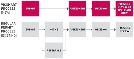
Key features of the VicSmart process are:
A decision within ten business days.
An applicant is expected to submit all the necessary information with the application.
No need for external referrals. An applicant is expected to obtain any referral authority approval before lodging the application with council.
Exempt from advertising.
The application is only assessed against specific pre-set decision guidelines.
The Chief Executive Officer (CEO) of the council or a delegate will decide the application.
An applicant has a right of review to VCAT if there is disagreement about whether the decision guidelines have been met.
While the VicSmart and regular permit processes are ‘merit’ assessments where the responsible authority must use discretion in deciding whether or not to grant a permit, the processes differ in some important ways.
VicSmart has fewer steps than the regular permit process and it involves a more tightly focused planning assessment. A comparison of the differences between the two processes is summarised below.
|
Steps Requesting further information under s.54 of the Act |
Regular permit process Yes. The statutory clock stops and the application will not be considered until the further information is received. |
VicSmart process No. The applicant should submit an application that includes the specified information. If not, the responsible authority can informally ask for any ‘missing’ information but the statutory clock continues to run. |
|
Steps Giving notice of the application under s.52 of the Act |
Regular permit process Yes. If responsible authority considers giving notice is necessary. |
VicSmart process No. The giving of notice is not required as the only consideration is whether or not the decision guidelines are met. |
|
Steps Referring the application under s.55 of the Act |
Regular permit process Yes. If required, the applicant can submit written consent with the application or council can refer the application after it has been received. |
VicSmart process No. If required, written consent from a referral authority must be submitted with the application. |
|
Steps Matters to be considered when assessing the application |
Regular permit process Full assessment against the requirements of s.60 of the Act, SPPF, LPPF and local provisions. |
VicSmart process Only assessed against the VicSmart decision guidelines. |
|
Steps Deciding the application |
Regular permit process Council (or delegate). |
VicSmart process Chief Executive Officer (or delegate). |
|
Steps Third party review rights |
Regular permit process Yes. Unless specifically exempt in the planning scheme. |
VicSmart process No. Only an applicant has a right of review about whether the decision guidelines have been met. |
|
Steps Statutory decision time |
Regular permit process 60 calendar days. Applicant may apply for a review if no decision is made within time. |
VicSmart process 10 business days. Applicant may apply for a review if no decision is made within time. |
New clauses are proposed to be introduced into the Victoria Planning Provisions (VPP) and all planning schemes to implement the VicSmart planning provisions.
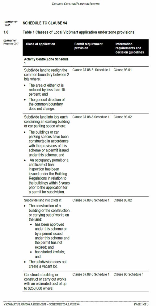
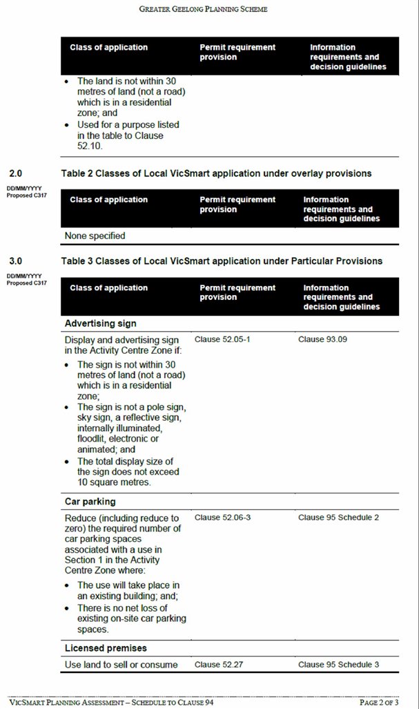
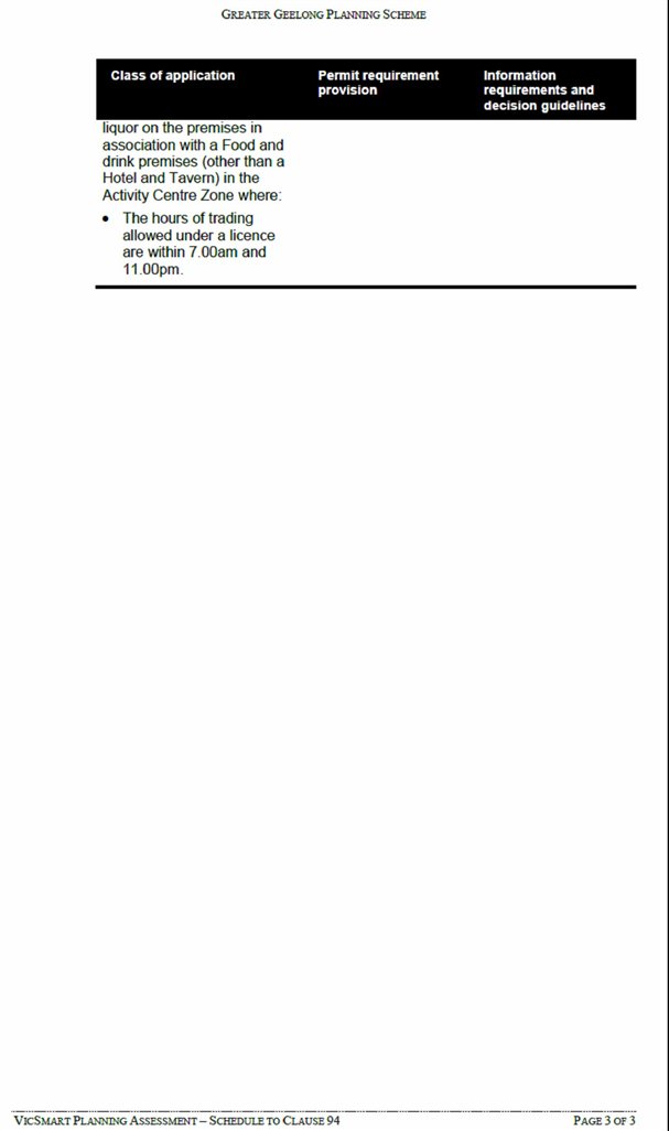
Portfolio: |
Sport and Recreation – Cr John Irvine |
Source: |
Projects Recreation and Central Geelong - Sport and Recreation |
General Manager: |
Paul Jane |
Index Reference: |
Subject: Land Acquisition & Building Purchase |
The purpose of this report is to outline options for the future provision of recreation infrastructure at the former Flinders Peak Secondary College and the adjacent council reserve in Corio. The Department of Treasury and Finance has advised its intention to dispose of the site.
The former Flinders Peak Secondary College site at 95 Hendy Street Corio is to be sold. The land is owned by the Department of Education and Early Childhood Development (DEECD).
The City of Greater Geelong (CoGG) has a Licence Agreement over a sports ground and clubrooms (known as F-Block) at the site. The Licence Agreement expires in 2022. The Geelong Rugby Union Club is based at these facilities in Winter and the Corio Cricket Club uses the sports ground in the Summer season.
Two options to provide for the future of recreation provision at Flinders Peak have been developed:
Subdivide and purchase the parcel of land on which the sports field and clubrooms are located (option 1); or
Develop new facilities on the council-owned reserve immediately adjacent to the site and relocate the rugby club (option 2).
Option 1: an estimated value of $1.7 million has been received from the Valuer-General for the relevant parcel of school land. In addition, council would need to meet all costs associated with the subdivision of the land, services connections and the vendor’s reasonable costs. Total expenditure is estimated at $2 million. Appendix 1.
Option 2 (preferred): an estimate of $1.8 million has been developed for the establishment of a multi-use turf field (two x rugby, and one x cricket), a modular clubroom facility, sports lights, services connections, and car parking at the adjacent council reserve on the corner of Hendy Street and Plantation Road. Appendix 2.
Cr Ansett moved, Cr Harwood seconded -
That Council:
informs the Department of Treasury and Finance that it wishes to retain the former ECA Centre (Education and Community Activity Centre) site to the Hendy Street Road frontage and will not seek to purchase the parcel of land that the Geelong Rugby Club resides on;
pursues Option 2 and establishes a new multi-use turf field and consider the refurbishment of the ECA Centre to fulfil club player amenities;
negotiates with the Department of Treasury and Finance and enters into a lease until 2017 at the existing F Block site, to provide ongoing security of tenancy for the Rugby Club during the transitional period of developing and establishing alternate facilities at the adjacent Council reserve.
Carried.
Flinders Peak Secondary College (formerly Corio North High School) commenced operations in 1978. The Shire of Corio contributed to the cost of construction of sporting facilities at the school site in order to facilitate community use. The Shire of Corio contributed $18,000 in 1979 toward the cost of playing fields, tennis courts, playground, furniture and landscaping and $80,000 in 1983 toward the cost of the ECA centre (Education and Community Activity centre, i.e. stadium). Various formal and informal arrangements between the school council and the Shire of Corio and later the City of Greater Geelong dictated the administrative and maintenance obligations of the parties with regard to these facilities.
Council placed the Geelong Rugby Union Club on the facilities at Flinders Peak in 2005, and subsequently invested approximately $347,000 into floodlight installation and change facilities upgrades between 2005/2006 and 2007/2008. The sports oval is irrigated (installed by CoGG c.1997 at a cost of approximately $48,000), and ongoing sports ground maintenance since 2005/2006 has totalled approximately $264,000.
A Licence Agreement dated 2007 between the CoGG and the Minister for Education is currently in place for use of the sports oval and F-Block, both of which are used as the field and sporting clubrooms of the Geelong Rugby Union Club. The sports oval is also used by Corio Cricket Club as its seconds ground during the cricket season.
This Licence Agreement includes provision for the Minister to terminate the agreement if it is determined that the land is required for reasons including ‘disposal of the Land or part of it’ or ‘any other reason’ (clause 9). In addition, there is a clause allowing the Minister to terminate the agreement if the facility is ‘damaged or destroyed so as to render it... unfit for use and it is... impractical or undesirable to reinstate’.
If the decision is taken to terminate the Licence Agreement, the Minister is required to present one of the following three options to CoGG (clause 10). The choice of options presented is at the discretion of the Minister and cannot be the subject of a dispute:
Subdivision of the whole or part of the land and an offer of sale to the Licensee;
Entering into a lease for the whole or part of the facility with the terms and conditions consistent with the existing Licence Agreement; or
Compensation payable to the Licensee to the amount determined by the Minister at the Minister’s discretion and taking several factors into consideration including the construction contribution made by the Licensee, reduced to reflect the portion of the Licence Term which has expired.
CoGG was notified in a letter from the Department of Treasury and Finance (DTF), dated 21 October 2013, that it has been directed by DEECD to dispose of the Flinders Peak school site. DTF sought to establish whether CoGG had any interest in purchasing the property.
A valuation was subsequently sought by council on the portion of the land that accommodates the sports oval and F-Block, in order that an assessment could be made on the relative benefits of attempting to purchase that particular parcel in which council had invested over the years, as opposed to investing in new recreation infrastructure to serve the tenant sporting club and the broader community at the adjacent council reserve on the corner of Plantation Road and Hendy Street.
Although the Shire of Corio also contributed to the cost of building the ECA centre, the now-disused stadium is in a state of extreme disrepair. The cost to restore the building to a safe and functioning one-court facility is prohibitive. Furthermore, the recently adopted Indoor Recreation Facilities Strategy does not identify a demand for this facility. For these reasons, the stadium site was not included in the footprint of land for which a valuation was sought.
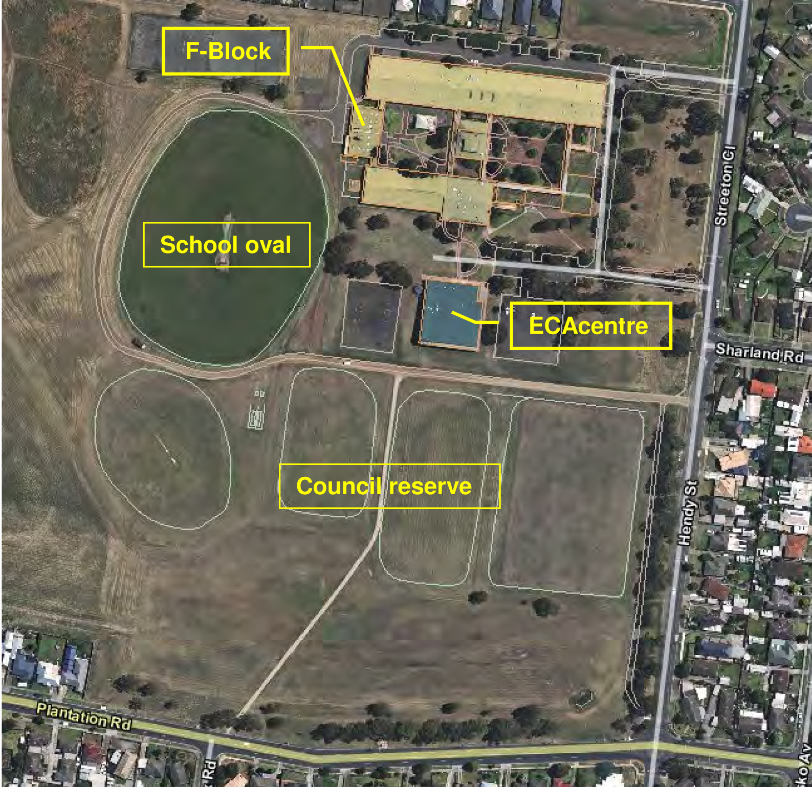
CoGG was advised in email correspondence dated 9 April 2014 that a decision has been taken to demolish the school buildings except F-Block and associated services. Ongoing use of F-Block and services has been subsequently assured, and planning by DEECD’s demolition project manager is being undertaken to ensure there is no disruption to services during the current sporting season while the rugby club is tenant.
To date, CoGG has not been notified that the Minister intends to terminate the existing Licence Agreement.
The Sport and Recreation department has determined that two options exist for the future provision of recreation infrastructure at Flinders Peak:
Purchase approximately 2.8ha of the school site, which includes the sports oval and F-Block. See Appendix 1 (not preferred).
Do not purchase any school land. Invest in new sports fields and a pavilion on the council-owned reserve adjacent to the school site and relocate the tenant sporting club. See Appendix 2 (preferred).
The issues and opportunities associated with the two options are examined below.
Option 1 – purchase
An estimate of value for the 28,185 sqm portion of land that accommodates the sports oval and F-Block was received by council from the Valuer General on 15 April 2014. After allowing for purchase, subdivision, services and other costs, a total cost to council of $2 million has been conservatively assumed.
Issues
F-Block was built in 1977. It was built primarily to house the school’s boiler room and toilet facilities with additional change facilities added at the request of council to increase its suitability for community sporting use. Capital works by council on the internal space were undertaken in 2006 and 2007 to create a social room.
Lack of street frontage and passive surveillance over the oval and F-Block.
The building is subject to high levels of vandalism and is in average condition. It will require roof, gutter and downpipe replacement within the next two to three years and the ceiling of the main social room also requires replacement due to water damage. The hot water service and switchboard require upgrading. The estimated total cost of these works is $60,000.
All services (power, gas, water, sewerage) to the building come through the existing school buildings and would need to be reconnected at subdivision (an estimate of the cost of doing so has been sought though not yet received).
Uncertainty over the future of the balance of the school land. It is zoned in the Residential 1 Zone (soon to be the General Residential Zone) so will presumably be offered as a residential subdivision opportunity. In order to mitigate somewhat for the current poor surveillance over the facilities, any future subdivision must be required to include street frontages to the north, east and west boundaries of the land to be potentially purchased (see Appendix 1).
Even with a subdivision layout delivering street frontages to the reserve, modifications to F-Block would potentially be required to provide a better amenity and presence to the street.
The irregular shape of the balance of the school site and the requirement for a long length of single-sided street development addressing the reserve would potentially reduce its desirability and value as a residential subdivision.
The site may not be subdivided at all, but be developed as a retirement village or multi-unit development under a body corporate model or similar. Under such a scenario, council would not have an ability to require street frontages to the reserve and the current issues of lack of passive surveillance and street presence would continue.
The location of F-Block relative to the sports oval and the adjacent council reserve is not optimal and would not well serve any sports grounds developed in future on the adjacent council reserve. In addition, the potential purchase footprint on which the estimate of value was based does not include any space for car parking near F-Block; space for a car park would potentially need to be sought via the public open space contribution from the subdivision of the balance of the school site (if subdivision was to occur).
Opportunities
There would be minimal disruption to the current users of the reserve and facilities.
Council retains its investments into the sporting infrastructure and clubrooms on the site.
Assuming the balance of the school land was sold as a residential subdivision site, the opportunity to achieve street frontages to the oval and F-Block would significantly improve the amenity, safety and usability of the enlarged reserve by the surrounding community.
Option 2 – relocation (preferred)
The existing council reserve at 93 Hendy St, on the corner of Plantation Road is approximately nine (9) hectares in size, with a drainage basin occupying one third of the site. It includes an unsealed access road off Hendy Street along its northern boundary with the school.
Appendix 2 demonstrates how the northeast corner of the site could be developed into a multi-purpose playing surface of two rugby fields and a cricket wicket, with a small pavilion and car parking on the western boundary accessed via the existing access road.
Issues
The capital cost and lead time to construct new facilities. Similar recent developments in the city suggest that the cost of constructing playing fields (irrigated and with sports lights to training standard), a prefabricated/modular clubrooms building, a car park and services connections could be approximately $1.8 million.
Temporary relocation of the rugby club would be required if DTF is successful in selling the school site and the Licence Agreement is terminated before any new fields are ready for use. There are currently no untenanted pavilions at a ground with sports lights in the city; a pavilion and ground sharing arrangement with training and matches on different grounds would be likely (for example, training at Belmont Common, which has flood lights, and matches at Friers Reserve, which has accommodated rugby competition in the past).
Opportunities
Achieving street frontage to the sporting facilities will improve the security of the assets due to improved passive surveillance from neighbouring residences and passing traffic.
The ability to configure the fields and clubrooms in the ideal arrangement will improve the amenity and multi-use capacity of the reserve.
Significant investment into the underutilised but highly visible reserve could increase the neighbouring community’s sense of ownership over the space and its facilities.
The increased exposure for the rugby club, whose activities are currently hidden away at the back of the school, could see an increase in interest and participation by the local community.
There are no environmental implications associated with either of the options presented in this report.
Each of the two options has financial implications and would require a future budget proposal.
Future budget proposal
|
|
Total capital cost |
Ongoing maintenance & operational costs (approx.) |
|
Option 1 – purchase |
$2,000,000 |
$60,000 (short term repairs) $32,000 p.a. (building & ground) |
|
Option 2 – relocation (preferred) |
$1,800,000 |
$45,000 p.a. (building & grounds) |
There are no statutory notification requirements for the purchase of land. The Local Government Act (“the Act”) and the Best Practice Guidelines for the Sale, Exchange and Transfer of Land are silent on the requirements and procedures for purchasing land.
The ‘Reserve Funds’ Council Policy and the ‘Public Open Space Reserve Fund’ Management Procedure guide the use of funds for acquisition or open space developments from the Public Open Space Reserve Fund; there is no conflict with either.
The options presented in this report support the ‘Community Wellbeing’ strategic direction of City Plan by planning for an environment that supports healthy lifestyles and a connected, creative and strong community.
No officers involved in the preparation of this report have a direct or indirect interest in matters to which this report relates.
A risk associated with Option 1 is that council would not get the opportunity to require a street frontage to the existing facilities in the development of the balance of the school land, which would see a perpetuation of the current situation of poor surveillance and high levels of vandalism to the facilities.
The preferred Option 2 will provide improvements to public safety in an area currently subject to high levels of vandalism and anti-social behaviour, creating a more welcoming and accessible community asset.
This report has no impact on human rights or the Human Rights Charter.
Consultation has been with DEECD, DTF and the internal council departments involved in the delivery of services to the current Flinders Peak facilities and with council’s Property Advisor and has informed the development of the two options presented.
Following direction from Council, consultation with the Geelong Rugby Union Club and Corio Cricket Club will be undertaken to determine the requirements for any temporary facilities, relocation and/or to work through a design for new facilities.
Portfolio: |
Governance – Cr Lyons (Mayor) |
Source: |
Corporate Services - Corporate Strategy |
|
A/General Manager: |
Michael Kelly |
Index Reference: |
Subject: Corporate Strategy / Planning |
This report seeks the endorsement of Council for the revised Community Engagement Policy.
One of the City Plan 2013-2017 Priority areas under the Strategic Direction ‘How We Do Business’ is to have an ‘Informed and Engaged Community’. This policy outlines Council’s approach to achieve this.
Since the endorsement of the existing policy in 2008, Council has done much to improve its engagement processes. Subsequently the Community Engagement Policy has been revised and updated to reflect the changes.
Key changes to the Policy include:
Council’s adoption of the International Association for Public Participation (IAP2) Core Values and Public Participation Spectrum;
The change from using the term ‘community consultation’ to ‘community engagement’;
The expectation that all community engagement activities are logged in Council’s engagement database, Engage (formerly CONSULT);
Reference to the Community Engagement Hub, an internal webpage which provides officers with a resource for community engagement information.
The revised Community Engagement Policy will be communicated to the organisation as part of the launch of the Community Engagement Hub in June/July 2014.
Cr E Kontelj moved, Cr Harwood seconded -
That Council endorse the revised Community Engagement Policy – see Appendix 1.
Cr S Kontelj left the meeting room at 8:07pm
Cr S Kontelj re-entered the meeting room at 8:08pm
Carried.
The current Community Consultation Policy was endorsed by Council in 2008. Since that time, Council has done much to improve its engagement processes including adoption of the International Association for Public Participation (IAP2) Core Values and Public Participation Spectrum, the ongoing development of Council’s community engagement activity database Engage (formerly CONSULT) and the implementation of a Community Engagement Action Plan.
Also currently underway is the development of the online Community Engagement Hub, a one stop shop which provides officers with information on all aspects of community engagement including planning, techniques, using Engage, training opportunities and best practice examples. The Community Engagement Hub will be accessed via CityWeb and is due for completion at the end of May 2014.
The purpose of the Community Engagement Policy is to outline the principles and processes that Council will use to ensure effective engagement with the community. Given the changes that have taken place, it is timely to now revise and update the Policy to reflect these changes.
Changes to the Policy include:
Council’s adoption of the International Association for Public Participation (IAP2) Core Values and Public Participation Spectrum. The adoption of IAP2 demonstrates a clear commitment of Council to actively engage the community using internationally recognised best practise principles in the development and implementation of community engagement processes.
The change from using the term ‘community consultation’ to ‘community engagement’. The term engagement is considered a more inclusive term to describe the many ways in which Council connects with the community, with consultation being one of the many methods used to engage.
Renaming the Policy from ‘Community Consultation’ to ‘Community Engagement’.
The requirement that all community engagement activities are logged in Council’s engagement database, Engage (formerly CONSULT). This will ensure that information on upcoming community engagement activities is made available for publishing approval prior to being posted on Councils website or included in any publications. It will also more readily facilitate the sharing of information of engagement activities across the organisation, enhance community awareness of opportunities to participate through Council’s website and provide more comprehensive performance data on the level and nature Council’s engagement activities.
The inclusion of branding requirements for external community engagement related documentation. Consistent CoGG branding should be used when engaging with the community.
Reference to the Community Engagement Hub, an internal community engagement website designed to provide information and resources for officers conducting engagement activities including how to plan and use Engage, as well as training opportunities and links to other resources. The Community Engagement Hub will go live at the start of June 2014.
Inclusion of a ‘Definitions’ section as required in the current Council Report format.
The revised Community Engagement Policy will be communicated to the organisation as part of the launch of the Community Engagement Hub in June/July 2014.
Nil
Failure to adhere to the Policy requirement to record all engagement activities could potentially result in financial losses due to expenditure on duplicated engagement or lack of identification for opportunities to collaborate.
Section 3D(f) of the Local Government Act 1989 states that the role of Council includes “fostering community cohesion and encouraging active participation in civic life”.
The Local Government Act 1999 Section 208B ensures that Councils continuously look to improve services to the community. In particular, section 208B (e) states that “a Council must develop a program of regular consultation with its community in relation to the services it provides”. Further to this, 208B (f) states that Councils must also report regularly to the community on its services, achievements, improvement opportunities and consultation activities.
Outlining the principles and processes to be used by Council when undertaking community engagement activities by way of the Community Engagement Policy, directly supports the City Plan Priority ‘Informed and Engaged community’ under the Strategic Direction ‘How We Do Business’.
Nil
Lack of a consistent engagement approach across Council departments can lead to inappropriate or ad hoc engagement and subsequently adverse outcomes or negative perceptions of Council.
Effective community engagement facilitates the exchange of views, ideas and information to help guide Councils decision-making processes and will consequently result in the delivery of strategies, projects, services and activities that are more responsive to local needs, concerns and priorities.
The Community Engagement Policy supports specific rights within the Human Rights Charter including:
‘every person in Victoria has the right, and is to have the opportunity, without discrimination, to participate in the conduct of public affairs’ (section 18)
that ‘every person has the right to freedom of expression which includes the freedom to seek, receive and impart information and ideas of all kinds, whether within or outside Victoria’ (section 15).
The revised Community Engagement Policy will be communicated to the organisation as part of the launch of the Community Engagement Hub in June/July 2014. It will be also made available to the community via the Have Your Say section of Council’s website.
Portfolio: |
Finance – Cr Lyons (Mayor) |
Source: |
Capital Projects |
General Manager: |
Paul Jane |
Index Reference: |
Project T1400052 |
To provide Council with the requisite information to facilitate the approval of the tender evaluation panel’s recommendation in relation to the design and construction of an ‘Iconic Christmas Tree’ tender.
Council has sought tenders for the design and construction of an ‘Iconic Christmas Tree’ to be situated in Corio Bay at a Geelong City waterfront location.
A total of twelve companies have provided submissions for the design and construction of an ‘Iconic Christmas Tree’.
Following a detailed evaluation of each of the submissions it is considered that the tender submission of Creative Production Services Pty Ltd is preferred (refer Appendix 1).
Cr Harwood moved, Cr E Kontelj seconded -
That Council:
accept the tender submission from Creative Production Services Pty Ltd for Tender No T140052 – Design and Construction of an Iconic Christmas Tree for the lump sum amount of $450,000 and an annual installation, maintenance and storage component of $135,000 (per year for a four year period) exclusive of GST;
sign and seal the contract documents.
The vote was tied and the Mayor exercised his casting vote.
Carried.
For: Crs Ansett, S Kontelj, Nelson, E Kontelj, Lyons, Harwood
Against: Crs Ellis, Fisher, Macdonald, Richards, Farrell, Irvine
Tenders for the Design and construction of an iconic Christmas tree were invited via public advertisement in The Age and on Tenderlink on Saturday 19 April 2014.
At the close of tenders on Friday, 16 May 2014 the following tender submissions were received:
|
Tenderer |
|
Displaycraft Pty Ltd trading as Chas Clarkson |
|
Citelum Australia Pty Ltd |
|
CNC Design Pty Ltd |
|
Creative Production Services Pty Ltd |
|
Matherson Construction Group Pty Ltd |
|
Mija (Geelong) Pty Ltd as Trustee for D&S Burke Family Trust |
|
Rara Architects and Dimpat Constructions |
|
Rhino Signmakers Pty Ltd |
|
Bryce Grunden Pty Ltd t/a Sound Environment |
|
Cassidy Manufacturing Pty Ltd t/a Universal Manufacturing Australia |
|
Xmas Mil Display Products Pty Ltd |
|
Production Resource Group (Australia) Pty Ltd |
All tenders have been submitted exclusive of GST.
The tender submissions associated with this tender were evaluated by a panel consisting of:
|
Michael Kelly |
Acting General Manager Corporate Services |
|
Scott Cavanagh |
Manager Capital Projects |
|
Shaun Broadbent |
Senior Capital Project Officer |
|
Kelly Ivens |
Marketing Team Leader |
|
Peter Walker |
Senior Contracts Officer (Non Voting) |
|
Jenny McMahon |
General Manager Community Services (Non Voting) |
Stage One – Mandatory Criteria
OHS mandatory requirements apply to this Tender.
Upon review, the submission received from CNC Design Pty Ltd was not an actual tender submission for the full tendered project therefore not evaluated further.
The submission received from Xmas Mil Display Products Pty Ltd was deemed non- conforming due to not addressing a key component of the tendered project that the tree is to be a floating tree on Corio Bay.
All other submissions responded to all mandatory requirements set down in the Tender documents and are considered to conform.
Stage Two –Comparative Criteria
Tender submissions were assessed based on the respondent’s performance or tender response in the following areas:
|
Criteria |
Weighting |
|
Price (Total value for money) |
40% |
|
Technical Capability to meet specification |
55% |
|
Economic Contribution to Region |
5% |
|
|
100% |
At the conclusion of the evaluation the tenderers were ranked in the following order in accordance with the above criteria:
|
Tenderer |
Rank |
|
Creative Production Services Pty Ltd |
1 |
|
Mija (Geelong) Pty Ltd as The Trustee for D&S Burke Family Trust |
2 |
|
Displaycraft Pty Ltd trading as Chas Clarkson |
3 |
|
Citelum Australia Pty Ltd |
4 |
|
Matherson Construction Group Pty Ltd |
5 |
|
Cassidy Manufacturing Pty Ltd t/a Universal Manufacturing Australia |
6 |
|
Rhino Signmakers Pty Ltd |
7 |
|
Bryce Grunden Pty Ltd t/a Sound Environment |
8 |
|
Rara Architects and Dimpat Constructions |
9 |
|
Production Resource Group (Australia) Pty Ltd |
10 |
Council nominated a capital budget of $450,000 for this project in the tender documentation therefore the non price aspects of this tender were the key determinants of the tender outcome.
At the conclusion of the evaluation process, the evaluation panel determined that Creative Production Services Pty Ltd, the highest ranked tenderer and one of the lowest priced within budget tenders, represented best value to Council (Refer Appendix 1).
Creative Production Services Pty Ltd provided an excellent tender for the project. They fully addressed all criteria and produced a concept design that the evaluation panel deem meets the brief of the project.
Creative Production Services Pty Ltd have relevant previous experience with Victoria based Christmas related projects and demonstrated a thorough understanding of the unique nature of these types of projects.
Creative Production Services Pty Ltd also identified an opportunity to utilise local suppliers through the course of this contract.
Reference checks were undertaken which reinforced the panel’s view that Creative Production Services Pty Ltd can successfully deliver the design and construction of an iconic Christmas tree project for Council.
Creative Production Services Pty Ltd is recommended by the evaluation panel to undertake the design and construction of an iconic Christmas tree.
Finally, the submitted project schedule highlights that an official launch of the tree could occur on 22 November 2014, with removal scheduled approximately 15 January 2015.
Any environmental implications associated with this contract will arise from the execution of this service. It is considered that these are the responsibility of the Contractor and will be managed through the contract documentation.
The funding for this project will be drawn from a capital budget allocation (including contingency) of $500,000 (C15830). The provision for an annual installation, maintenance and storage components is $135,000 per annum over a four year term and will be drawn from a new recurrent budget allocation, commencing in 2015-2016.
The total contract cost for the ‘Iconic Christmas Tree’ will be $990,000. This includes the initial capital spend of $450,000 in 2014-2015 and the annual $135,000 allocation in each financial year between 2015-2016 to 2018-2019.
The requirements of Section 186 of the Local Government Act have been complied with for this tender. There is no other policy, legal or statutory implications associated with this tender process.
The Christmas in Geelong program and project delivery models covered in this report align with the Community Wellbeing, Growing Our Economy, and How We Do Business strategic directions of City Plan.
No officers involved in the preparation of this report have a direct or indirect interest in matters to which this report relates.
The most significant risk to the project is timing. If a decision to award the contract to the preferred tenderer is not made immediately, the project will not be able to be delivered for Christmas 2014.
A further detailed project risk profile has been developed and is being maintained by the project manager.
There are no social implications that will arise from the acceptance of this tender. It is envisaged that the iconic Christmas tree will have a positive social impact on the Geelong region.
There are not anticipated to be any Human Rights impacts associated with the acceptance of this tender.
There is no communication issues associated with the acceptance of this tender. Council’s representative will liaise with any affected community groups.
In accordance with Section 89 (2) (d) of the Local Government Act 1989, this Appendix is confidential and is not to be released to the public. The design is the Intellectual Property of the preferred tenderer. |
Contents | Previous Page: Section A - Procedural Matters | Next Page: Section C - Notice of Motion
