Council Minutes - Section B: Reports - 22 July 2014
Contents | Previous Page: Section A - Procedural Matters | Next Page: Section C - Notice of Motion
Contents | Previous Page: Section A - Procedural Matters | Next Page: Section C - Notice of Motion
Reports tabled at the Ordinary Meeting of Council on Tuesday date held at City Hall, Little Malop Street in Geelong.
Amendment C300 New Residential Zones – Consideration of Panel Report and Adoption
Amendment C282: Geelong Gateway Homemaker precinct, Corio – Adoption
Amendment C296 – Simonds Stadium Signage – Consideration of Panel Report and Adoption
Sale of Land Draper and Asbury Streets, Ocean Grove – Consideration of Submissions
International Communication Project – Supporting People with Communication Disabilities
Road Renaming – Western Section of Mandalay Circuit, Armstrong Creek
Road Renaming – Western Section of Boundary Road, Mount Duneed
Consideration of Tender Submissions for Supply and Delivery of Bulk Fuels
Cr Fisher declared an Indirect Interest by a Conflicting Duty in Agenda Item 1 – Amendment C300 – New Residential Zones – Consideration of Panel Report and Adoption in that Cr Fisher signed a petition against C300 and proposed changes to Corio/Norlane and left the meeting room prior to discussion at 8:12pm.
Portfolio: |
Planning – Cr Heagney |
Source: |
Planning & Tourism – City Development |
General Manager: |
Peter Bettess |
Index Reference: |
Application: C300 |
The purpose of this report is to consider the Independent Panel’s report to Planning Scheme Amendment C300 New Residential Zones and the adoption of the Amendment.
Amendment C300 seeks to implement the State Government’s new residential zones into the Greater Geelong Planning Scheme, including updating the Local Planning Policy Framework and making other consequential changes.
The new zones - Residential Growth Zone, General Residential Zone and Neighbourhood Residential Zone - will replace the existing Residential 1, 2 and 3 Zones in the planning scheme. Council is proposing to use all three new residential zones.
Council’s approach to applying the new zones is consistent with its existing Housing Diversity Strategy which has been part of the planning scheme since the approval of Amendment C129 in 2009.
The strategy encourages high density housing in Central Geelong and other key development areas such as the Fyans/West Fyans Mixed Use zone precinct along the Barwon River. The strategy designates ‘Increased Housing Diversity Areas’ within walking distance of suburban and town activity centres and train stations across Greater Geelong. These areas have been proposed for zoning to the Residential Growth Zone under C300.
Amendment C300 was exhibited between 14 November and 16 December 2013 and resulted in over 230 submissions. The majority of submissions were from Geelong West, Newtown and Belmont and were concerned with the proposed Residential Growth Zone being applied around these centres.
As there were objecting submissions, Council requested the Minister for Planning to appoint an Independent Panel.
Amendment C300 went before an Independent Panel between 9 and 14 April 2014. The Panel hearing was well attended by submitters to the Amendment, including a number of key residents groups.
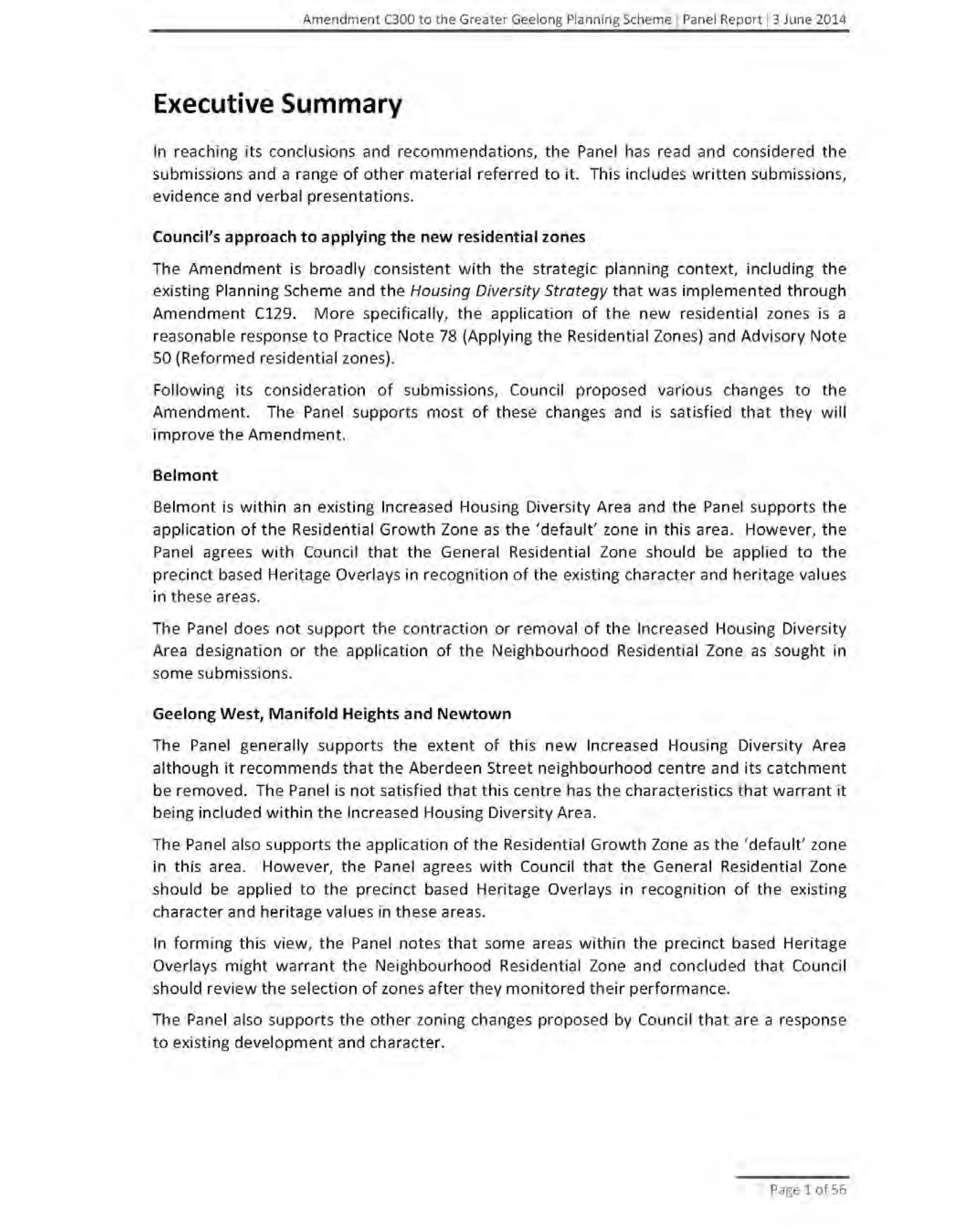
The Panel provided Council with its report on 3 June 2014. The Panel considered all submissions to the Amendment including a range of other material referred to it.
The Panel supports Council’s strategic approach to implementing the new zones, subject to a number of modifications. (A copy of the Panel’s Executive Summary, including recommendations, is attached at Appendix 1).
The Panel commends Council for its comprehensive and considered approach to implementing the new residential zones in a complex planning environment. The Panel is satisfied that the key elements of the Amendment are sound and that the recommended changes will improve its performance.
The Panel also acknowledges the concerns raised by submitters but believed that many of the issues raised were overstated. The Panel is satisfied that the overall planning framework is strategically sound and will address many of the concerns raised in submissions.
For Belmont, the Panel supports the application of the Residential Growth Zone as the ‘default zone’ but supported the application of the General Residential Zone Schedule 1 to those areas affected by a heritage overlay precinct.
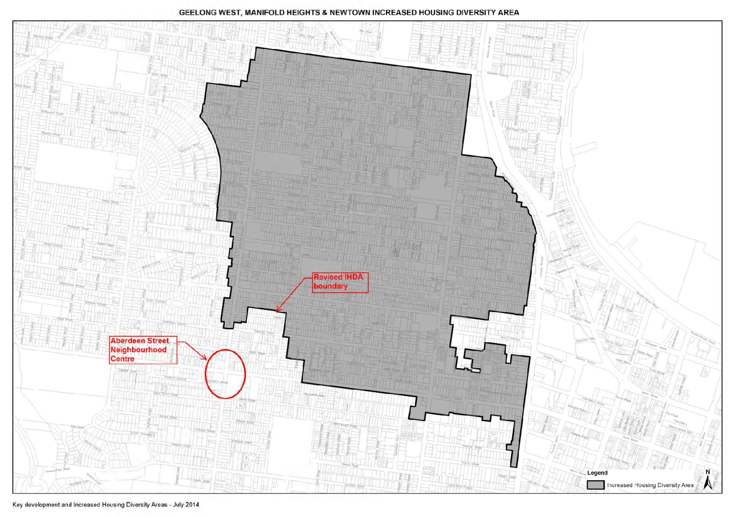
The Panel supports the inclusion of an IHDA for Geelong West, Manifold Heights and Newtown although in a modified form. However, it recommends that the Aberdeen Street/Shannon Avenue activity centre be removed from the IHDA and to apply the General Residential Zone Schedule 2, consistent with Council’s post-exhibition application of the GRZ2 in other areas of Newtown. The Panel supports the application of the Residential Growth Zone as the default zone and also supported the application of the General Residential Zone Schedule 1 to those areas affected a heritage overlay (precinct-based).
The Panel also advises that Council should monitor the performance of the new zones to determine the suitability of the areas and the ability of some areas to achieve the purpose of the new zones. This includes the consideration of the Neighbourhood Residential Zone for areas in Geelong West, Manifold Heights and Newtown affected by Heritage Overlay precincts.
For building heights in the Residential Growth Zone Schedule 2 (Urban areas), the Panel does not support the proposed change by Council to include a mandatory maximum building height of 10.5 metres and believes that Council has not provided adequate strategic justification. The Panel concludes that the discretionary 13.5 metres should be retained but did not provide a formal recommendation. Council officers recommend retention of the 10.5 metres maximum building height consistent with previous advice.
Council, as the Planning Authority, must consider the report of the Panel in making its decision. It is recommended that the Amendment be adopted generally in accordance with the recommendations of the Panel and to submit the adopted Amendment to the Minister for Planning for approval.
Cr Heagney moved, Cr E Kontelj seconded -
That Council resolves to:
accept the Panel’s recommendations, with the exception of:
Recommendation No. 7 relating to additional wording on building height in the proposed Clause 22.63 Increased Housing Diversity Areas policy (General Objectives);
Recommendation No 1 relating to the application of the General Residential Zone Schedule 1 to the precinct based heritage areas in Belmont;
Recommendation No 3 relating to the application of the General Residential Zone Schedule 1 to the precinct based heritage areas within Geelong West, Manifold Heights and Newtown Increased Housing Diversity Area;
Recommendation No 4 relating to the rezoning of the land south-west of Aberdeen Street, Newtown activity centre to General Residential Zone Schedule 2;
Recommendation 6 to include, in addition to Bell Park, North Geelong and Bell Post Hill in the further work requirement.
evaluate and monitor the implications of the application of the new residential zones in the form outlined in Section 4 of this report.
include North Geelong and Bell Post Hill, in addition to Bell Park in the Table in Appendix 8 to this Council report, to be included in the modified Clause 21.06.
add a new Schedule 3 to the Neighbourhood Residential Zone to specify a maximum height of 9 metres (the zone default is a maximum of 2 dwellings).
adopt Amendment C300 in the form outlined in Appendix 10 of this report with the following changes:
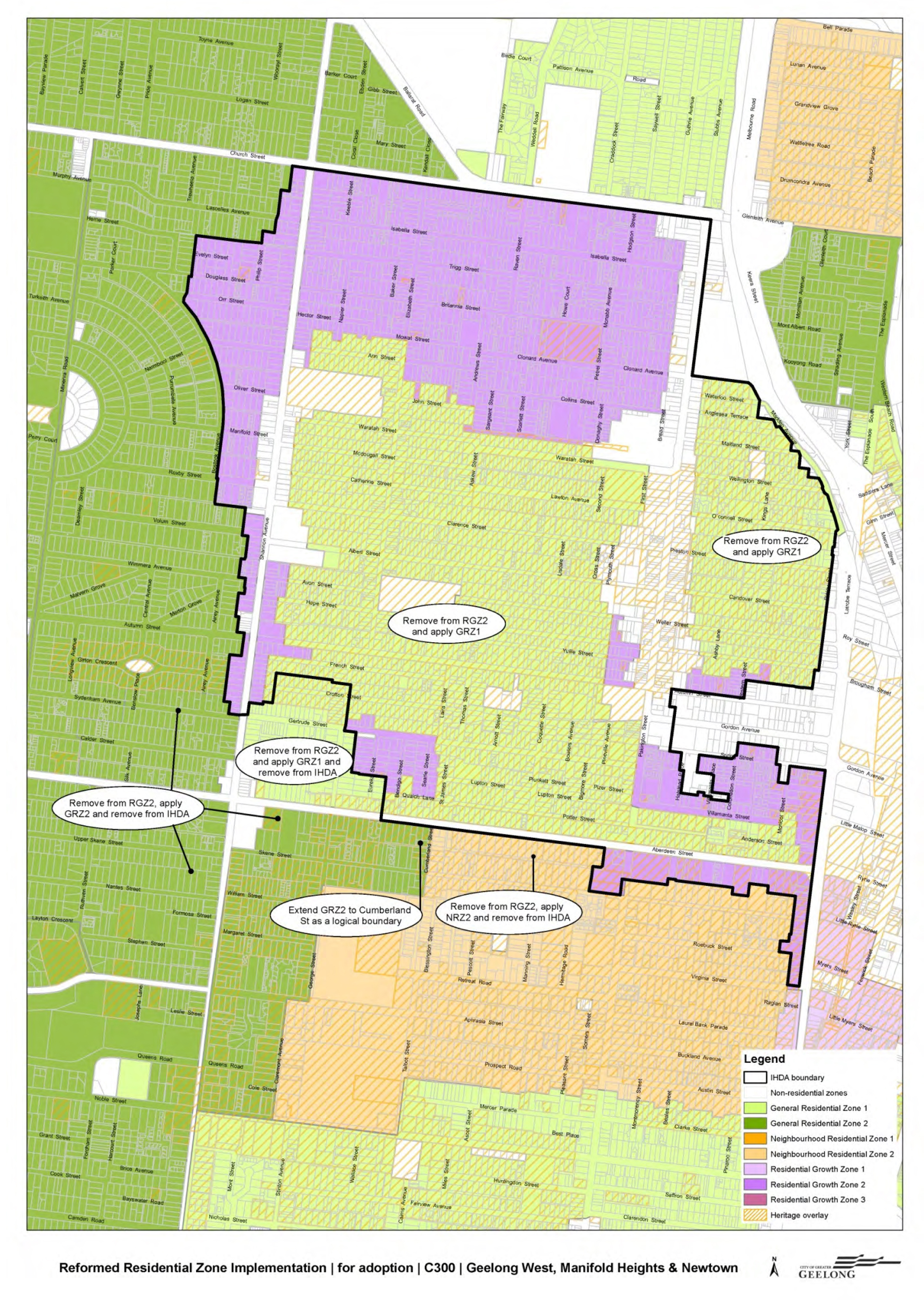
Geelong West with the changes shown on the attached Map 1;
Newtown – apply the Neighbourhood Residential Zone Schedule 2 to the area shown on the attached Map 1;
Belmont – apply the Neighbourhood Residential Zone Schedule 2 to the area bounded by Thomson St, Mt Pleasant Rd (south side), Morris St and Roslyn Rd (north side) shown on the attached Map 2.
submit the adopted Amendment with the prescribed information to the Minister for Planning requesting approval.
Carried.
Amendment C300 to the Greater Geelong Planning Scheme seeks to implement the State Government’s new set of residential zones, namely the Residential Growth Zone, General Residential Zone and Neighbourhood Residential Zone.
The new zones will give more certainty about the type of development that can be expected in any residential area and give Council better tools to identify areas where existing urban character will be protected and areas where appropriate increased urban densities can occur.
As of the 1 July 2014, the State Government removed the Residential 1, 2 and 3 Zones from the Greater Geelong Planning Scheme and applied the General Residential Zone via Amendment VC116. The General Residential Zone now affects all residential zoned land with Schedule 1 applying to former Residential 1 and 2 zoned land and Schedule 2 applying to former Residential 3 zoned land. This is an interim measure until Amendment C300 is approved.
On 22 October 2013, Council considered the new residential zones and their application across the municipality. Council officers proposed to apply all three residential zones.
At this meeting, Council resolved to support the preparation and exhibition of Amendment C300, subject to requesting authorisation from the Minister for Planning. Ministerial authorisation was received on 28 October 2013.
The Amendment was exhibited between 14 November and 16 December 2013 with late submissions accepted up to 10 January 2014.
The exhibited amendment proposed to apply the new residential zones as generally outlined below:
Residential Growth Zone – within walking distance of shopping centres and train stations.
Neighbourhood Residential Zone – to Drumcondra, North Shore and parts of Newtown
General Residential Zone – to all other residential areas.
Each of the above zones has two or three different schedules. In particular, the General Residential Zone has Schedule 1 which is very similar to the former Residential 1 Zone and Schedule 2 which is similar to the former Residential 3 zone.
In addition to applying the new residential zones and making consequential changes to the Planning Scheme, changes will be made to the Planning Scheme maps to reflect the new commercial zones, which have replaced the former Business Zones 1-5.
A total of 231 submissions were received up to 10 January with 4 submissions received after this date.
Council officers recommended and Council accepted a number of changes to the Amendment in its report to Council on 25 February 2014. These changes included:
A reduction in building height in the Residential Growth Zone Schedule 2 (Urban areas) from a discretionary 13.5 metre building height to mandatory 10.5 metre building height;
Rezoning of land abutting the southern side of Aberdeen Street from Residential Growth Zone Schedule 2 to Neighbourhood Residential Zone Schedule 2;
Rezoning of land west of Shannon Avenue and south of Aberdeen Street from Residential Growth Zone Schedule 2 to General Residential Zone Schedule 2;
Updating Clause 21.06 to include a further work relating to the assessment of incremental change areas identified in the adopted Housing Diversity Area to consider the application of the General Residential Zone Schedule 2; and
Update proposed Clause 22.63 Increased Housing Diversity Area policy to reflect changes to building heights and heritage.
Further changes were made to the Amendment by way of a Notice of Motion tabled by Councillor Heagney at Council meeting of 25 March 2014. The Notice of Motion proposed that the parts of Geelong West, Belmont and Newtown that are within precincts covered by heritage overlays and which were to be rezoned Residential Growth Zone should be zoned General Residential Zone Schedule 1 (GRZ1) – the State Government’s standard General Residential Zone. The changes were proposed on a precinct basis and not for individual properties that may be subject to a heritage overlay.
A Notice of Motion was also tabled by Cr S Kontelj on 8 April 2014 supporting a heritage assessment for the Newtown area, west of Shannon Avenue. The Notice of Motion, whilst stimulated by submissions to Amendment C300 for areas south-west of the Aberdeen neighbourhood centre, does not affect the Amendment itself.
Due to the large number of unresolved objecting submissions, at its meeting of 25 February 2014, Council resolved to request the Minister for Planning to appoint an Independent Panel to hear all submissions.
The Minister for Planning appointed an Independent Panel on 27 February 2014. A two person Panel, consisting of Con Tsotsoros (Panel Chair) and Michael Kirsch (Member), was appointed.
The Panel notified all submitters to the Amendment about the Panel hearing process and invited parties to attend. The Panel received 23 requests to be heard including a request from Council.
Council appointed a planning lawyer, John Rantino of Maddocks to present Council’s submission with Council officers during the Panel Hearing. An expert witness (town planning), Stuart McGurn of ERM consultants, was also appointed by Council officers to provide an independent expert review of the Amendment at the Hearing.
The Directions Hearing took place on 21 March 2014 and the Panel Hearing commenced on 9 April 2014 and lasted four days until 14 April 2014.
The Panel Hearing was well attended by submitters to the Amendment, including a number of key residents groups.
The Panel’s report was received on 3 June 2014. A full copy of the report is available on Council’s website. The Panel report was released to Councillors on 4 June 2014 and to the general public on 5 June 2014. Hard copies of the report have been left at Council’s Customer Service Desks and a copy of the Panel report executive summary was sent to all submitters.
Council officers also wrote to key residents groups (Belmont Residents Groups, Newtown Action Group, Geelong Western Residents Action Group) inviting them to attend meetings about the Panel report findings and the planning scheme amendment process. These meetings were held during the week commencing 16 June 2014 with approximately 60 residents attending the Geelong West/Newtown meeting.
In Council’s letter to submitters, which enclosed the Panel report executive summary, submitters were also offered an opportunity to meet individually with Council officers to discuss the Panel report and planning scheme amendment process.
The Panel assessed the Amendment and all submissions made during the formal exhibition period, including other matters raised during the course of the Panel Hearing.
The Panel’s report deals with the issues under the following headings:
Council’s approach to applying the new residential zones;
Area specific issues;
Site specific issues; and
Other submissions and issues.
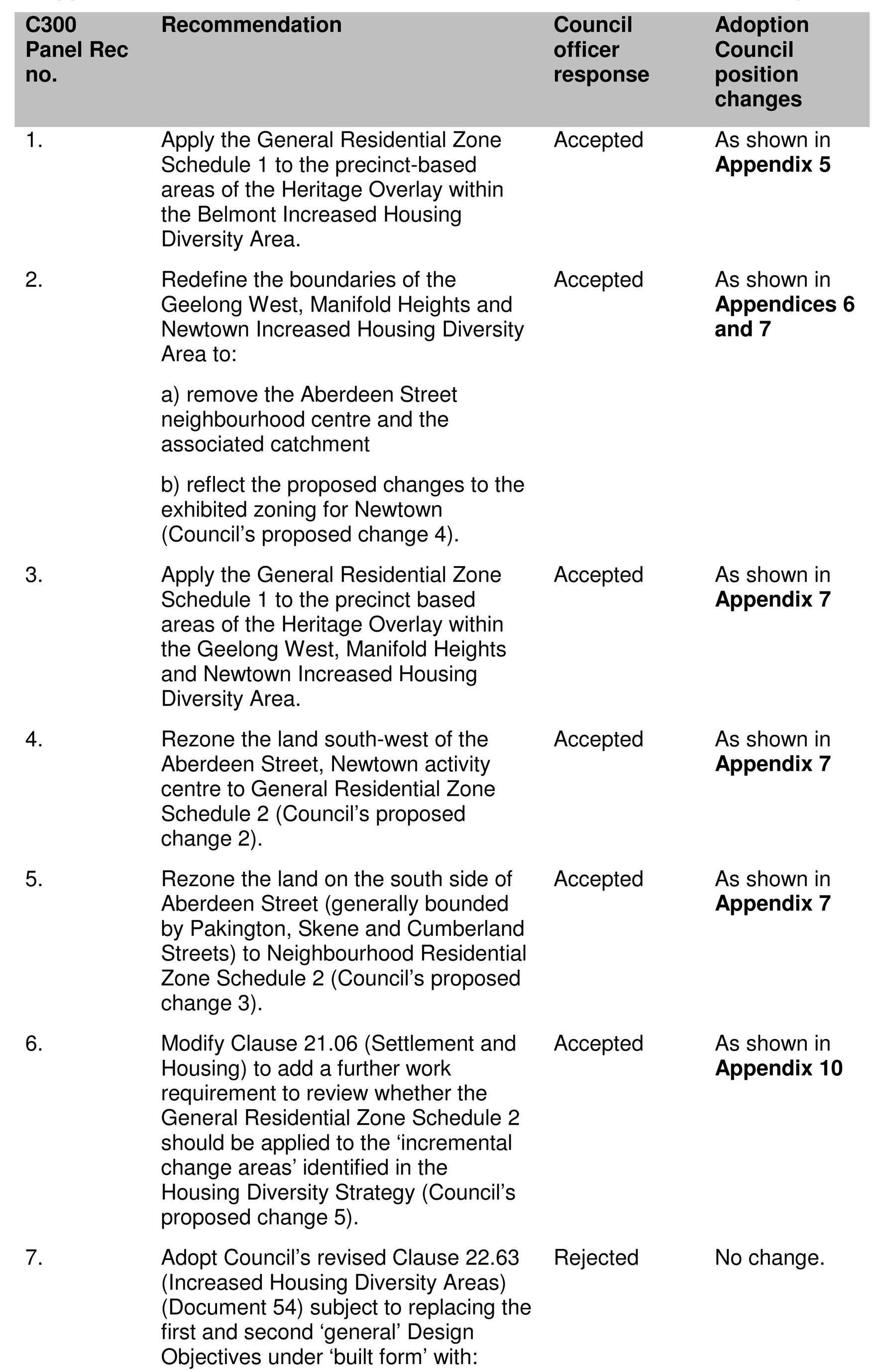
The Panel’s consolidated recommendations are listed in Appendix 2, including a Council officer response to each recommendation. Detailed discussion will be provided in the Discussion section of this report.
Council officers recommend that all of the Panel’s recommendations be accepted, with the exception of Recommendation 7, which relates to the inclusion of additional wording for building heights in the proposed Clause 22.63 Increased Housing Diversity Areas Policy (General Objectives).
1. COUNCIL’S APPROACH TO APPLYING THE NEW RESIDENTIAL ZONES
The Panel considered the strategic planning framework that exists in the Greater Geelong Planning Scheme upon which Council officers proposed to use as a basis to apply the residential zones. The Panel also considered previous planning scheme amendments that implemented the existing strategic planning framework, being Amendment C129, Council’s Reformed Residential Zones Implementation Report (October 2013), and also the State Government’s practice and advisory notes for the new residential zones.
The Panel advises that it is satisfied that Council’s general approach to applying the new zones is consistent with the provisions of the Greater Geelong Planning Scheme and with State Government guidance about the implementation of the new residential zones, including Practice Note 78- Applying the Residential Zones.
The Panel notes that Council’s town planning expert witness, Mr McGurn, reached similar conclusions in his evidence, about the existing strategic framework within the Greater Geelong Planning Scheme providing a solid foundation for the Amendment consistent with the principles outlined in Practice Note 78.
Panel conclusion:
The Panel concludes that it is satisfied that the broad principles underpinning Amendment C300 are consistent with the existing strategic framework in the Greater Geelong Planning Scheme and the adopted Housing Diversity Strategy that were introduced through Amendment C129.
Council officer response:
Council officers welcome the Panel’s conclusion. The conclusion confirms that the approach undertaken by officers to implement the new residential zones is appropriate and in accordance with the guidance provided by the State Government.
The existing strategic framework in the Greater Geelong Planning Scheme enabled Council to engage in a full blown planning scheme amendment process to openly test the merits of the proposed implementation strategy for the new residential zones. This has resulted in a good planning outcome.
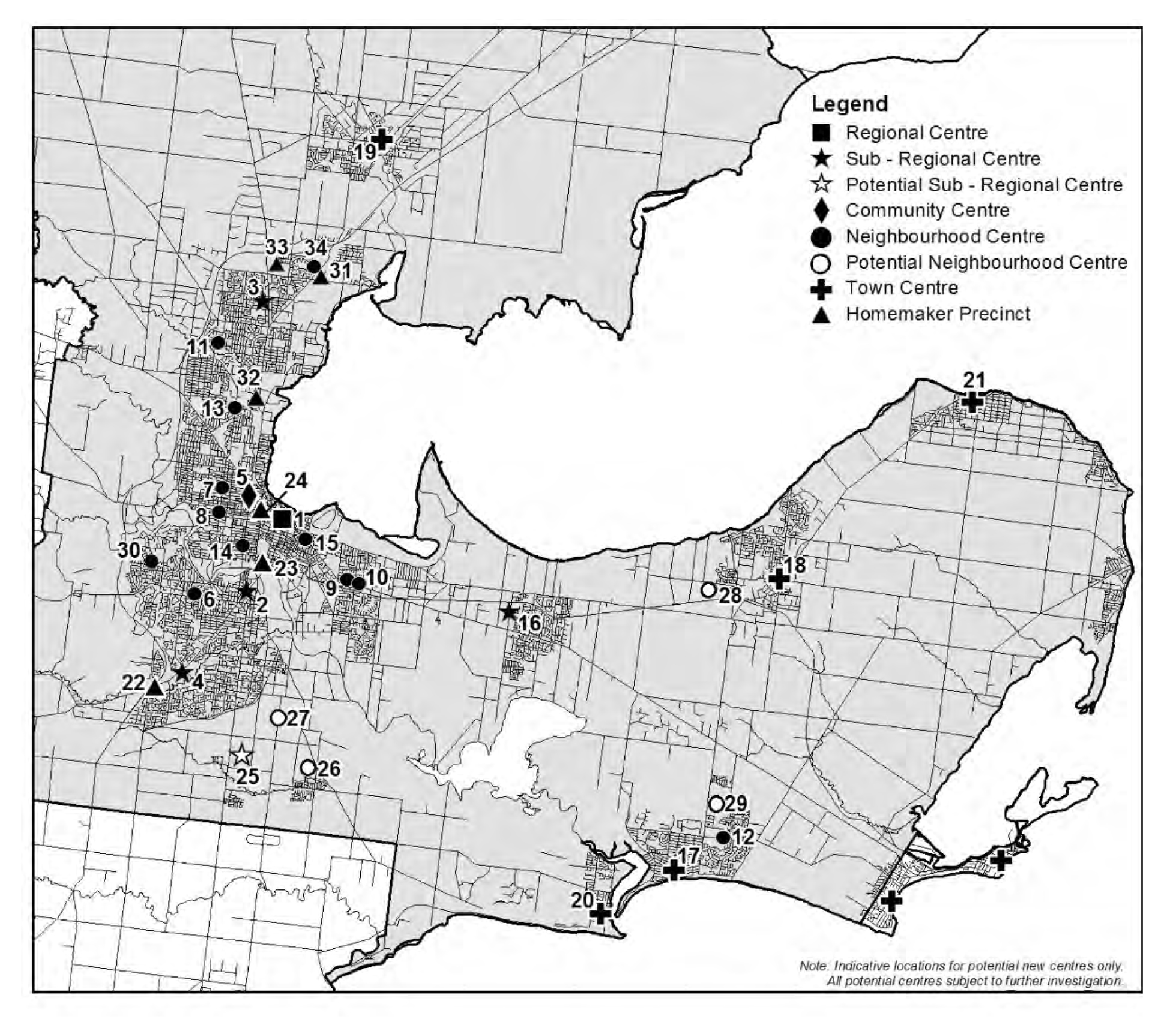
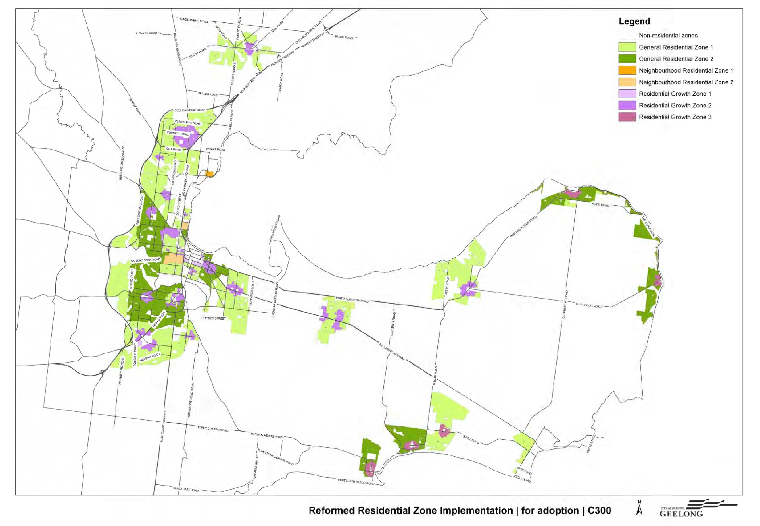
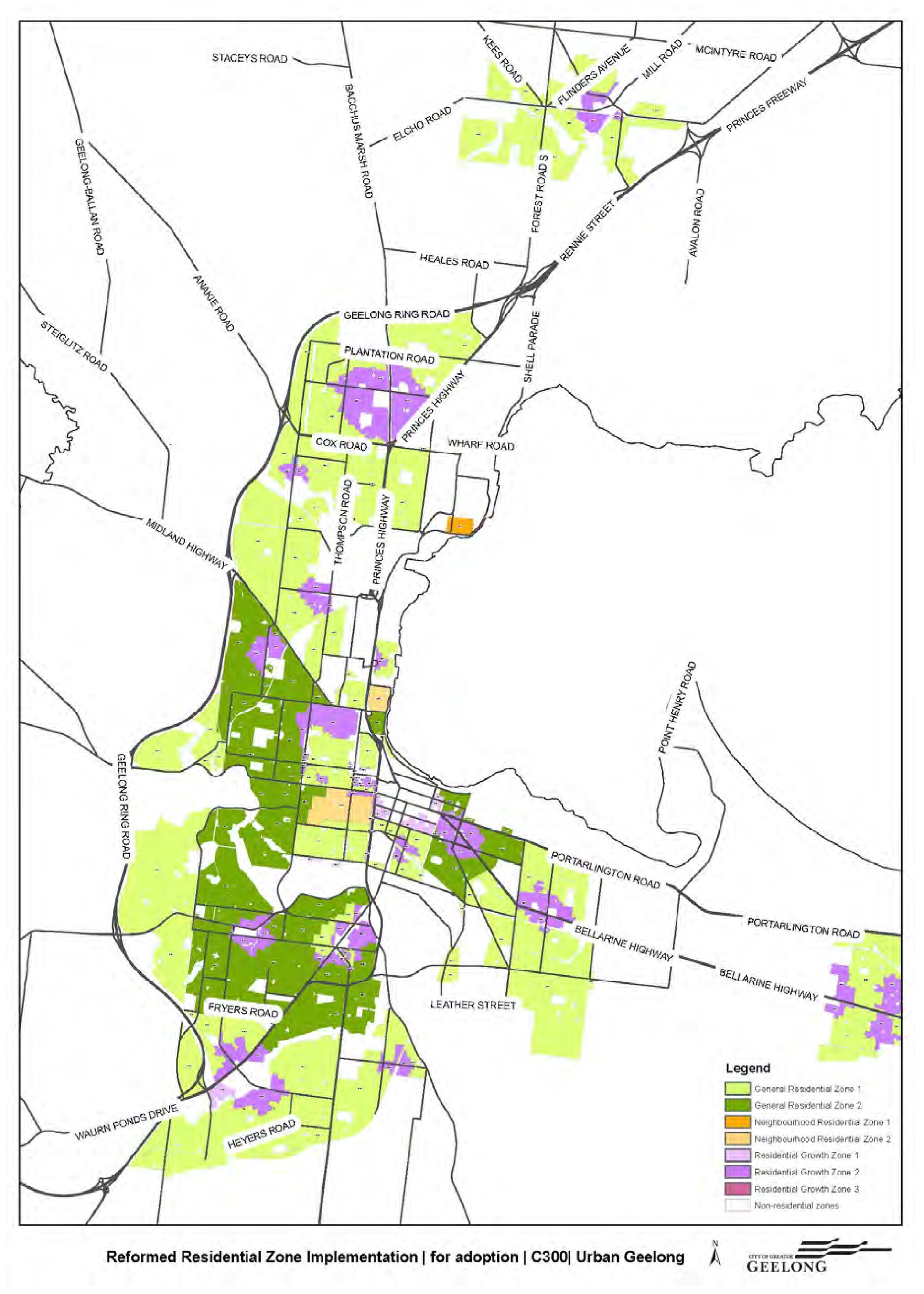
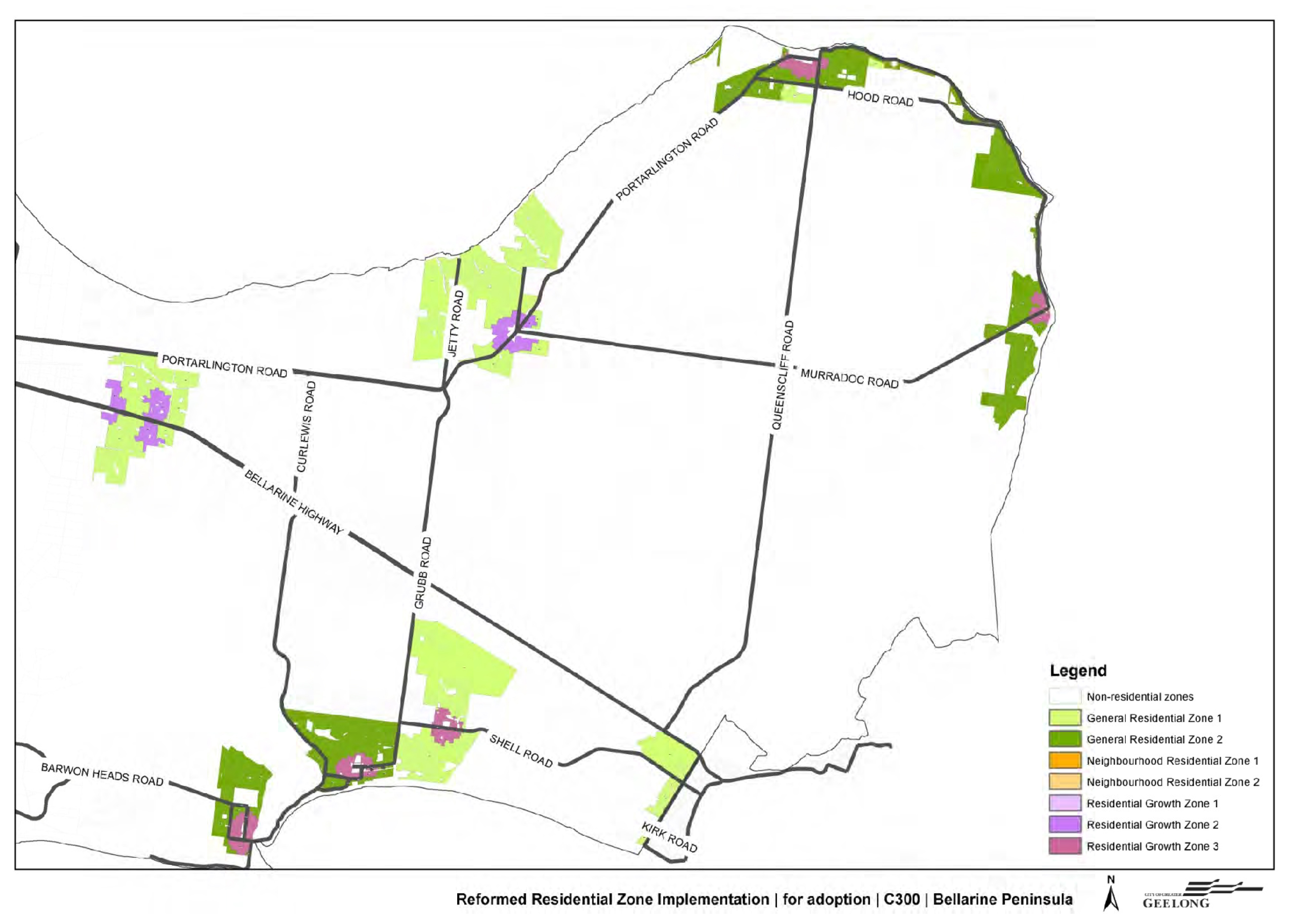
Maps showing the proposed application of the residential zones for adoption are in Appendices 3 and 4.
A breakdown of the total land area across Greater Geelong and the percentage that will go to each new zone is as follows:
Residential Growth Zone – 11.6 %
General Residential Zone – 87.2 %
Neighbourhood Residential Zone – 1.2%
Council has been criticised by submitters and resident groups on the amount of Residential Growth Zone being applied. Council has also been criticised by submitters who feel the Neighbourhood Residential Zone Schedule 2 (NRZ2) – which is the most restrictive zone – should be applied more broadly throughout the municipality. Comparisons have been made with some Melbourne council’s such as Boroondara and Glen Eira who have applied the NRZ extensively and RGZ sparingly.
Council officers believe that such comparisons are not particularly relevant or helpful as each Council is applying the new zones on the basis of their existing housing policies.
Geelong is a growing city but has not achieved the densities that are already apparent in parts of Melbourne. Geelong is a very large municipality and has in the order of 25 different activity centres (including town centres and suburban shopping centres). Application of the RGZ around these centres and train stations has resulted in the 11.6% of the land area going to RGZ. This is advantageous as it spreads the growth zone evenly across the municipality rather than concentrating on one or two areas.
It is important to understand that whilst the NRZ2 is being applied sparingly (only at Drumcondra and parts of Newtown), the General Residential Zone Schedule 2 (GRZ2) has a very similar schedule and is being applied across extensive areas of suburban Geelong and some Bellarine townships which display a “garden character”. The key differences between the NRZ2 and GRZ2 are:
The purpose of the zone: whilst both zones seek to protect existing neighbourhood character, the NRZ seeks to limit opportunities for increased residential development compared to the GRZ which seeks to provide a diversity of housing types and moderate housing growth in locations offering good access to services and transport.
Maximum building height: 8 metres for the NRZ and 9 metres for the GRZ2.
Number of dwellings on a lot: 2 dwellings per lot for the NRZ and none specified for the GRZ2.
Minimum subdivision area: 300 sq metres for the NRZ2 and none specified for the GRZ2.
A copy of the Schedules to be adopted are in Appendix 11.
The GRZ2 strikes a balance between allowing for some infill development that is consistent with the garden character of an area without the blunt and overly restrictive controls of the NRZ2.
2. AREA SPECIFIC ISSUES
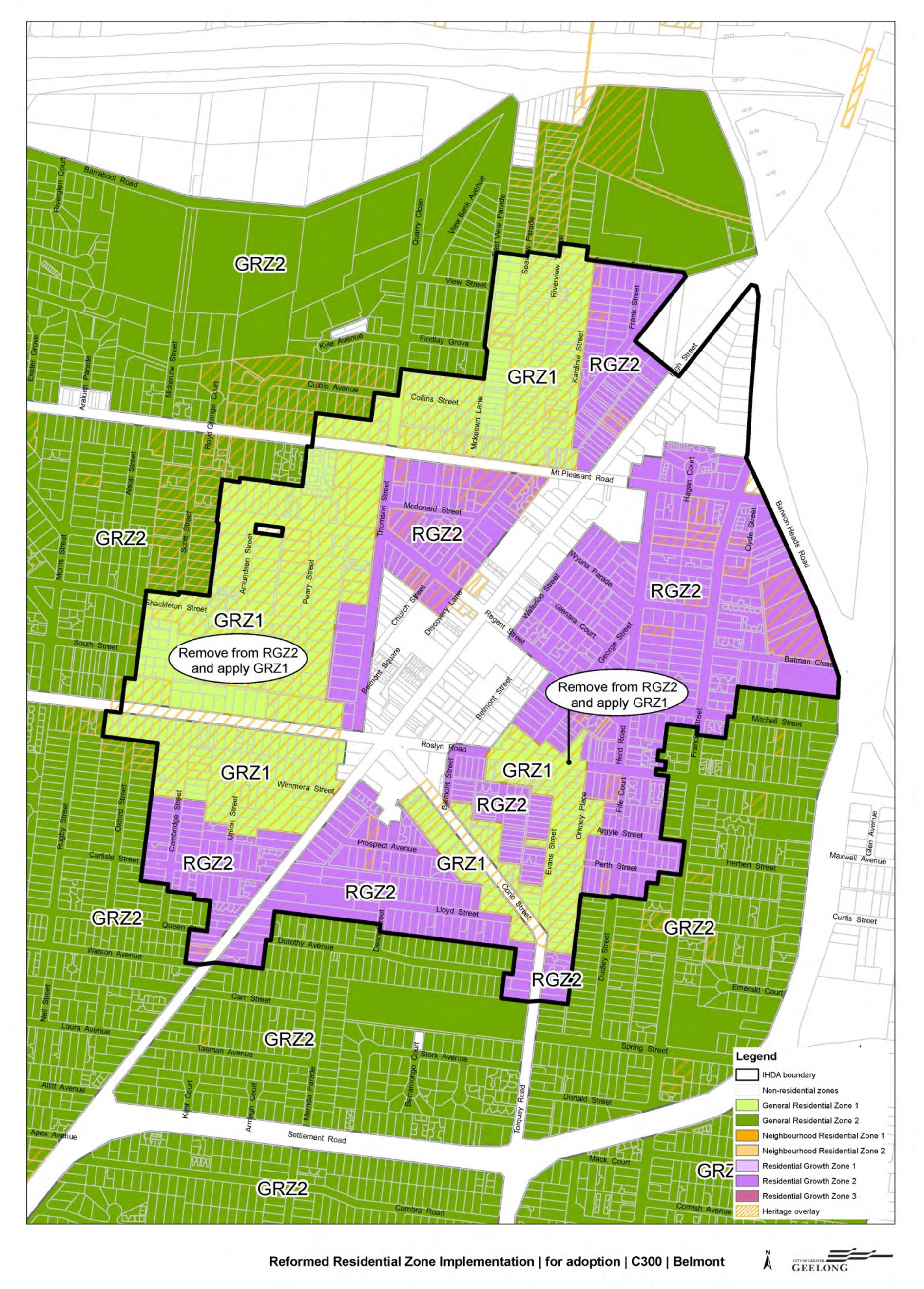
Belmont
The Panel recognised that the key issue is what zone should be applied to the residential areas in the Belmont Increased Housing Diversity Area (IHDA). In doing so, the Panel considered a number of factors: the IHDA boundary; the Belmont activity centre; the implications of the Heritage Overlay; implications of the Belmont Heights Estate single dwelling covenant; the suitability of the General Residential Zone or the Neighbourhood Residential Zone; infrastructure; and building heights.
Belmont IHDA boundary
The Panel notes that:
“Belmont is currently identified in the Planning Scheme as an IHDA and, as such, is already subject to strategies that seek to maximise opportunities for ‘high density housing in the activity centres’ and ‘medium density housing in residential areas with more intensive development’.” (p. 23).
The Panel advises that it places significant weight on Belmont’s role as a sub-regional centre and its existing designation as an IHDA. The Panel is of the opinion that clearly the residential areas around the activity centre should provide for growth and implicit in this is that they will change. The Panel believes that the selection of residential zones should facilitate this process and is satisfied that the Residential Growth Zone is a suitable default zone.
Belmont Activity Centre
The Panel discusses the issue relating to the activity centre’s two distinct retail areas and the physical nature of the activity centre (i.e. rising topography) and how these impact on walkability. The Panel notes that there were calls for the IHDA boundary to be reduced and associated application of the Residential Growth Zone Schedule 2. The Panel does not support these concerns.
Implications of the Heritage Overlay
The Panel agrees with Council’s approach to applying the General Residential Zone Schedule 1 to areas affected by the Heritage Overlay (precinct-based). The Panel advises that there is a potential disconnect between the outcomes sought in the heritage provisions and the application of the Residential Growth Zone and that the General Residential Zone Schedule 1 will provide opportunities for redevelopment, while respecting character and heritage considerations.
Implications of the Belmont Heights Single Dwelling covenant
The Panel advises that strategic planning objectives should be the primary determinant of how the residential zones are applied. The Panel acknowledges that if a covenant has resulted in an identifiable character, particularly one that is recognised and protected by a Heritage Overlay, then that local character should be a factor in applying the zones.
The Panel does not believe that the existence of the covenant should, by itself, be a factor in applying the zones. It agrees with Council that the precinct-based Heritage Overlay areas (including Heritage Overlay No. 1908 that covers most of the covenant area) in the Belmont IHDA should be subject to the General Residential Zone Schedule 1, rather than the Residential Growth Zone Schedule 2 (this includes those lots that are also subject to the Belmont Heights Estate covenant.)
The General Residential Zone or the Neighbourhood Residential Zone
The Panel advises that applying the Neighbourhood Residential Zone throughout an IHDA would be problematic given that the zone places significant emphasis on retaining existing character and limiting increased residential development outcomes that are difficult to reconcile with the role of the IHDA.
Although the Panel accepts there might be circumstances where the Neighbourhood Residential Zone is appropriate within an IHDA, it believes that a detailed analysis of the redevelopment capacity of an area (particularly within a Heritage Overlay) would be required in order to identify such areas. In the absence of such an analysis, the Panel is satisfied that the General Residential Zone Schedule 1 is a suitable zone and that it provides a degree of flexibility without the development expectations associated with the Residential Growth Zone.
Infrastructure
The Panel considered submissions about infrastructure issues but determined that it was not presented with any evidence that infrastructure and amenity issues were of such significance that they would fundamentally limit the scope of redevelopment. The Panel notes that Belmont’s designation as an IHDA means that it will continue to develop and that, consequently, infrastructure and amenity issues will need to be addressed as they arise.
Building Heights
The Panel does not support Council’s post-exhibition resolution to apply a mandatory maximum 10.5 metre building height rather than the default 13.5 metre discretionary maximum building height in the Residential Growth Zone. (This issue will be discussed later in this report.)
Panel conclusion:
The Panel concludes that given Belmont is identified in the current Planning Scheme as a sub-regional centre, there is a general presumption that its residential hinterland (the IHDA) will accommodate growth and change. Applying the Residential Growth Zone Schedule 2 recognises this and will assist Council in achieving its strategic objectives for this activity centre. The Panel also supports the application of the General Residential Zone Schedule 1 to the existing Heritage Overlay precincts as a reasonable response to the existing built form and character of these areas.
The Panel also acknowledges that further analysis of the IHDA might identify sites or areas that could be suitable for a different zoning approach.
Panel recommendation:
Recommendation 1-
Apply the General Residential Zone Schedule 1 to the precinct-based areas of the Heritage Overlay within the Belmont Increased Housing Diversity Area.
(See Appendix 5)
Council officer response:
Council officers acknowledge and support the Panel’s Recommendation 1, which is in line with Council’s post-exhibition change to the exhibited Amendment on 25 March 2014.
The Belmont IHDA will now comprise residential land affected by the Residential Growth Zone Schedule 2 and General Residential Zone Schedule 1. There will be consequential changes to the proposed local planning policy for IHDAs (this will be discussed later in this section).
The Panel’s conclusions relating to the single dwelling covenant are supported. The General Residential Zone Schedule 1 results in a ‘status quo’ outcome for residents affected by heritage overlay precincts and affected by the single dwelling covenant.
The Panel referred to undertaking detailed analysis of the redevelopment capacity of the area (particularly within a Heritage Overlay), in order to justify an alternative zoning approach including the application of the Neighbourhood Residential Zone. This issue will be discussed later in this report.
There have been calls by submitters for the Neighbourhood Residential Zone to be applied in Belmont’s heritage areas or even the General Residential Zone Schedule 2 Council officers agree with the Panel’s position that to apply the Neighbourhood Residential Zone in an IHDA would be problematic and would create an ongoing conflict for Council’s Statutory Planning Department in assessing permit applications.
The Neighbourhood Residential Zone limits housing growth whereas the purpose of an IHDA is to stimulate and support housing growth in and around activity centres. For the General Residential Zone Schedule 2, it is typically applied to incremental change areas where growth is not identified and only incremental development is expected to take place. In addition, Schedule 2 to the NRZ and GRZ require larger private open space requirements. Taking these matters into consideration, the Neighbourhood Residential Zone and General Residential Zone Schedule 2 do not complement Council’s existing IHDAs.
Council officers support the Panel’s conclusion that the General Residential Zone Schedule 1 is a reasonable response to the existing built form and character of these area affected by heritage overlay precincts.
Geelong West, Manifold Heights and Newtown
The Panel noted that the key issues for this area related to what zones should be applied and whether the area, or parts of it, should be included within an IHDA. In doing so, the Panel considered a number of factors: the extent of the IHDA; implications of the Heritage Overlay and existing character; the suitability of the General Residential Zone or the Neighbourhood Residential Zone; and building heights.
The extent of the IHDA
The Panel generally supports the basis on which the IHDA boundary was developed.
However, the Panel agrees with submitters that the Aberdeen Street / Shannon Avenue neighbourhood centre should not be included in the IHDA given its limited size and function. The Panel believes that this centre should be treated similarly to the Pakington Street (Newtown) neighbourhood centre.
The Panel advises that if the Aberdeen Street centre (or the Pakington Street centre, Newtown) is redeveloped in the future and assumes an expanded role, Council can revisit this issue and the boundary of the IHDA.
The Panel notes that there will be consequential zoning changes relating to the re-drawing of the IHDA boundary. Specifically, for those areas removed from the IHDA in Newtown and originally proposed to be zoned Residential Growth, it will be necessary to apply an alternative zone.
Implications of the Heritage Overlay and existing character
As with the approach for Belmont, the Panel believes that there is a potential disconnect between the outcomes sought in the heritage provisions and the application of the Residential Growth Zone. The Panel agrees with Council that the General Residential Zone Schedule 1 is a suitable zone for the precinct-based Heritage Overlays in this area. The General Residential Zone Schedule 1 will provide opportunities for redevelopment, while being respectful of character and heritage considerations.
The Panel also supports Council’s proposed changes to the exhibited Amendment to apply the General Residential Zone Schedule 2 to an area south-west of the Aberdeen Street/Shannon Avenue intersection and to apply the Neighbourhood Residential Zone Schedule 2 to an area along Aberdeen Street (generally bounded by Pakington, Skene and Cumberland Streets).
The Panel acknowledges that “…replacing the Residential Growth Zone Schedule 2 with the General Residential Zone Schedule 2 (in the area south-west of the Aberdeen Street/Shannon Avenue intersection) is consistent with its recommendation to remove the Aberdeen Street activity centre from the IHDA and to apply the General Residential Zone Schedule 2.“ (p.32)
The Panel notes Ms Honman’s expert heritage evidence, on behalf of the Newtown Action Group, that the area south-west of the Aberdeen neighbourhood centre warrants ‘a full heritage assessment’ and encourages Council to give consideration to commissioning this work to investigate whether the Heritage Overlay should be applied.
The General Residential Zone or the Neighbourhood Residential Zone
The Panel notes that submitters’ preferred the Neighbourhood Residential Zone.
For the same reasons discussed for the Belmont area, the Panel considers that applying the Neighbourhood Residential Zone in an IHDA to be problematic as the IHDA policy seeks to promote housing growth and change and the purpose of the NRZ is to limit housing development and retain existing neighbourhood character.
The Panel notes that some Heritage Overlay areas might warrant the Neighbourhood Residential Zone on the basis that it believes some areas did not demonstrate any realistic redevelopment potential or a practical rationale for applying the Residential Growth Zone.
The Panel believes that a more detailed analysis of the redevelopment capacity of the IHDA is necessary to identify any areas where the Neighbourhood Residential Zone might be appropriate and that this could form part a broader review of the application of the new residential zones. The Panel did not make a specific recommendation in relation to this issue. However, in the interim, the Panel is satisfied that the General Residential Zone Schedule 1 is suitable to apply to the Heritage Overlay precincts.
The Panel notes that the General Residential Zone Schedule 1 will not place these areas under threat (as suggested by submitters) nor has this area experienced significant redevelopment under the existing Residential 1 Zone.
Infrastructure
The Panel accepts the anecdotal submissions about infrastructure issues in the area but it was not presented with any evidence to confirm that these were of such significance that they would fundamentally limit the scope of future development envisaged by Council.
The Panel notes that these are issues that Council will need to monitor and respond to as appropriate.
Building Heights
For the same reasons discussed in the Belmont area, the Panel does not support Council’s post-exhibition resolution to apply a mandatory maximum 10.5 metre building height in the Residential Growth Zone.
Panel conclusions:
The Panel states that this is a complex area that presents a number of planning challenges. The Panel is satisfied that Council’s approach is a considered and reasonable response to the opportunities and characteristics of the area.
The Panel states that it generally supports the approach adopted by Council for this area, particularly the use the Residential Growth Zone as the ‘default’ zone, the 800m walkable catchment around the Pakington Street centre and the application of the General Residential Zone Schedule 1 to the precinct based Heritage Overlays.
The Panel also concludes that the Aberdeen Street neighbourhood centre does not warrant being in the IHDA given its small scale and seemingly limited opportunity for significant growth.
The Panel believes that Council should review the IHDA zones once it has had an opportunity to monitor the performance of the new zones and other provisions introduced by Amendment C300.
Panel recommendations:
Recommendation 2
Redefine the boundaries of the Geelong West, Manifold Heights and Newtown Increased Housing Diversity Area to:
remove the Aberdeen Street neighbourhood centre and the associated catchment;
reflect the proposed changes to the exhibited zoning for Newtown (Council’s proposed change 4).
Recommendation 3
Apply the General Residential Zone Schedule 1 to the precinct-based areas of the Heritage Overlay within the Geelong West, Manifold Heights and Newtown Increased Housing Diversity Area.
Recommendation 4
Rezone the land south-west of the Aberdeen Street, Newtown activity centre to General Residential Zone Schedule 2 (Council’s proposed Change 2).
Recommendation 5
Rezone the land on the south side of Aberdeen Street (generally bounded by Pakington, Skene and Cumberland Streets) to Neighbourhood Residential Zone Schedule 2 (Council’s proposed Change 3).
(See Appendices 6 and 7)
Council officer response:
Council officers acknowledge the Panel’s recommendations for the Geelong West, Manifold Heights and Newtown Increased Housing Diversity Area.
The removal of the Aberdeen Street/Shannon Avenue neighbourhood centre from the IHDA boundary, whilst identified as an activity centre in Council’s adopted Retail Strategy, will not significantly impair the strategic planning objectives for the broader IHDA.
Council officers accept Recommendation 2 in so far as removing the Aberdeen Street neighbourhood centre and associated catchment from the IHDA.
Following Recommendation 2, the Panel also refers to the need to reflect the proposed changes to the exhibited zoning for Newtown, in line with Council’s proposed change no. 4 of 25 February 2014. For the purposes of clarity, Council’s proposed change no. 4 related to the proposed zoning change for land south-west of the Aberdeen Street neighbourhood centre from Residential Growth Zone Schedule 2 to General Residential Schedule 2. Council’s change no. 4 also referred to the change of zone for land on the south side of Aberdeen Street from Residential Growth Zone Schedule 2 to Neighbourhood Residential Zone Schedule 2.
Council officers accept the second part of the Panel Recommendation 2 and subsequently, Panel Recommendations 4 and 5.
The Panel recommends that the General Residential Zone Schedule 1 be applied to precinct-based areas of the Heritage Overlay within the Geelong West, Manifold Heights and Newtown IHDA.
Council officers accept Recommendation 3, which is in line with Council’s post-exhibition changes of 25 March 2014.
As a consequence of the Panel’s recommendations for the removal of the Aberdeen Street/Shannon Avenue neighbourhood centre and associated catchment, there are a number zoning changes required beyond those mentioned above. These areas include land north-west, north-east and south-east of the Aberdeen Street neighbourhood centre.
Council officers have considered the post-exhibition changes for this area and the Panel’s recommendations and propose the following:
Apply the General Residential Zone Schedule 2 to land north-west and south-east of the Aberdeen Street neighbourhood centre;
Apply the General Residential Zone Schedule 1 to land north-east of the Aberdeen Street neighbourhood centre (being land located in suburb of Geelong West).
(See Appendix 7)
As a consequence of removing the Residential Growth Zone from the affected areas of Newtown and Manifold Heights, the proposed deletion of Design and Development Overlay 14 will no longer apply.
Council officers acknowledge the Panel’s statement about some areas lacking potential redevelopment capacity. Council officers agree that there will be areas within IHDAs that will not deliver the preferred level of redevelopment/housing growth as sought by the Residential Growth Zone. Nonetheless, Council officers advise the purpose of the IHDA is to support a range of housing types and densities and is not a planning tool that stipulates high growth across the entire IHDA. The General Residential Zone Schedule 1 will result in a ‘status quo’ situation for those areas affected by heritage overlay precincts. As the Panel states, the General Residential Zone Schedule 1 will not place these areas under threat nor has this area experienced significant redevelopment under the existing Residential 1 Zone.
To apply the Neighbourhood Residential Zone on the basis of a lack of potential redevelopment capacity is limited in its justification. In order to consider the application of this zone in this area, particularly to those parts affected by the Heritage Overlay, an evaluation and monitoring exercise, as discussed by the Panel, would be required. This issue will be further discussed later in this report.
Council officers are satisfied that the proposed rezoning for the Geelong West, Manifold Heights and Newtown area is a good planning outcome. The Heritage Overlay will continue to guide new development in parts of these areas.
The Panel’s discussions about encouraging Council to undertake a full heritage assessment for the Newtown area west of Shannon Avenue are noted. Council has committed, by way of Notice of Motion of 8 April 2014, to seeking a budget allocation in the year 2015/2016 to prepare a heritage assessment for this area.
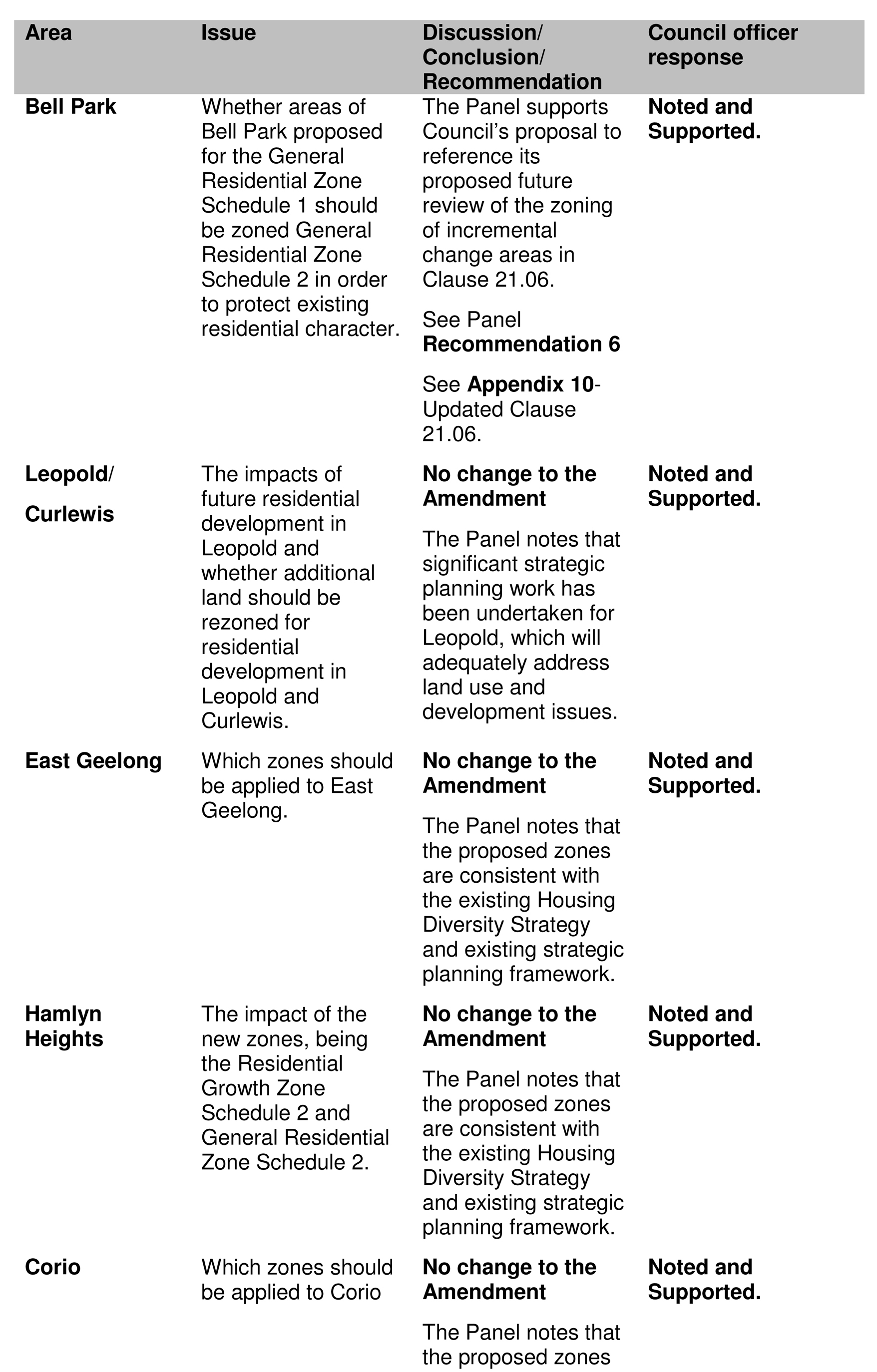
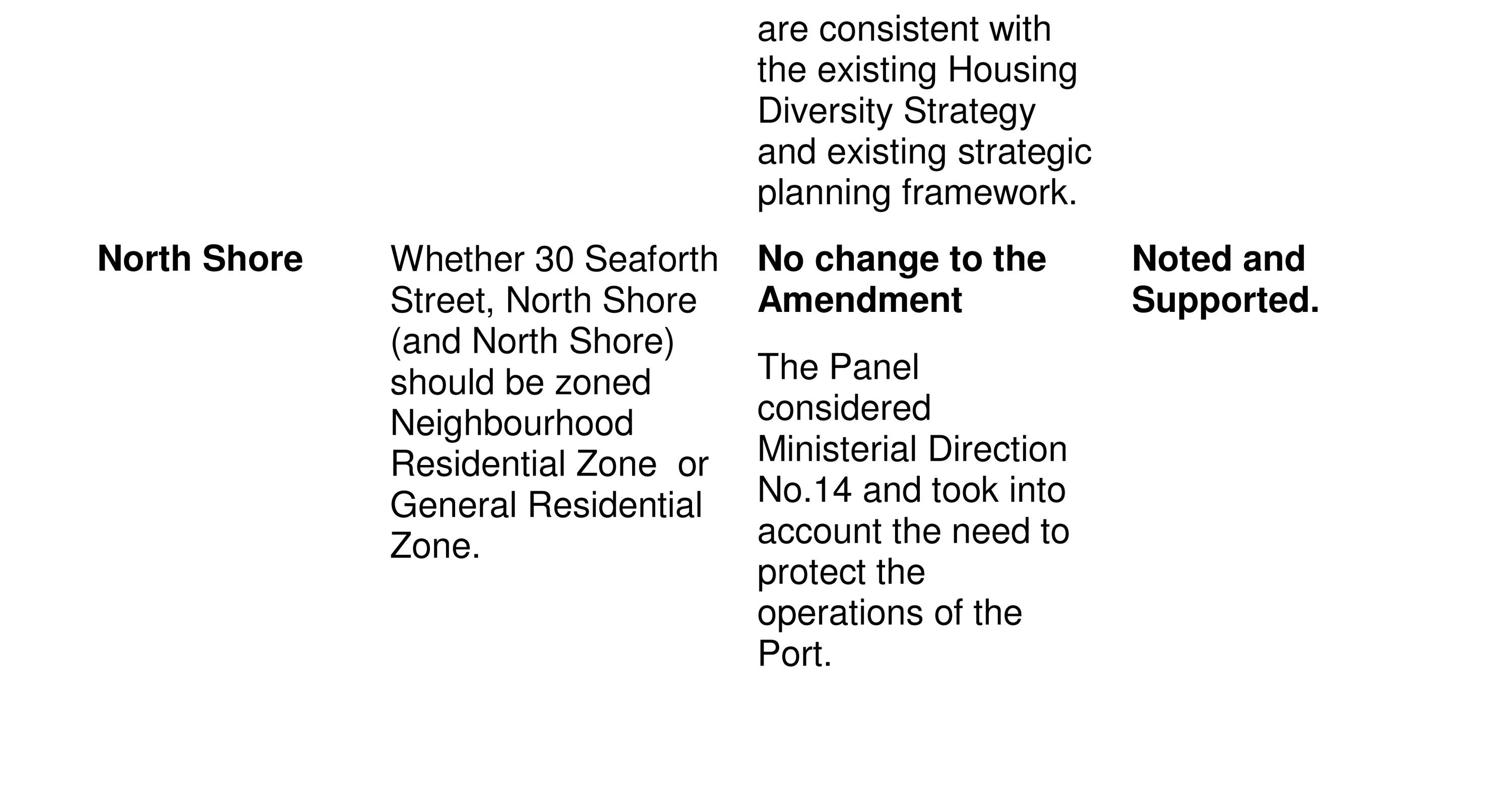
Other Area Specific Issues
The Panel made comments on a number of other area-specific submissions affecting Bell Park, Leopold/Curlewis, East Geelong, Hamlyn Heights, Corio and North Shore.
Appendix 8 provides a table summarising the issue, the Panel’s discussion/conclusions and a Council officer response.
3. RESIDENTIAL GROWTH ZONE SCHEDULE 2- MAXIMUM BUILDING HEIGHTS
This section of the report relates to issues raised by the Panel on building heights in the Belmont and Geelong West, Manifold Heights and Newtown IHDAs. The issue is also of relevance to other areas proposed to be zoned Residential Growth Zone Schedule 2.
The Panel commented on whether the maximum building height in the Residential Growth Zone Schedule 2 should be reduced from a discretionary 13.5m (4 storeys) to mandatory 10.5m (3 storeys).
Panel discussion/conclusion:
The Panel believes that for the IHDAs to serve their intended purpose, the Residential Growth Zone is an appropriate default zone, including the discretionary maximum height of 13.5m.
The Panel believes that applying a 10.5m mandatory maximum height is “a significant departure from what was exhibited and the change has not been supported by an adequate level of analysis and strategic justification.”
The Panel states that Council should proceed with the Residential Growth Zone Schedule 2 as exhibited (discretionary maximum 13.5 metres building height). It also believes that Council should review the IHDA zones once it has had an opportunity to monitor their performance and that of the other provisions introduced by Amendment C300. The review should include an assessment of the Residential Growth Zone Schedule 2 height provisions.
Council officer response:
Notwithstanding the Panel’s extensive discussion about building heights in Residential Growth Zone Schedule 2 areas, it did not make a specific recommendation for the retention of the discretionary 13.5 metre maximum building height.
Council officers do not agree with the Panel’s statement that the change to the exhibited Residential Growth Zone Schedule 2 and associated building heights is a significant departure. Councils must be able to make changes to an exhibited amendment on the basis of its consideration of submissions. This is a fundamental part of the planning scheme amendment process and in this instance, is considered a reasonable response to issues raised by submitters.
In a report to Council on 25 February 2014, Council officers recommended that a mandatory maximum building height of 10.5 metres (3 storeys) be included in Schedule 2 to the Residential Growth Zone (Urban areas). Council officers recommended this change on the basis that achieving increased densities in and around activity centres does not solely rely on increased building height, albeit, it is a important factor. It was considered that including a mandatory maximum building height would still give purpose to the Residential Growth Zone and allow for increased density in areas of predominantly single and double storey streetscapes.
Importantly, Residential Growth Zone Schedule 1 areas (located around the edges of the Central Geelong and West Fyans-Fyans Street Key Development Areas) would retain a discretionary maximum building height of 13.5 metres. This is an important consideration as these areas are fundamentally supportive of high density residential development and in time will yield residential development of this nature, supportive of the Residential Growth Zone objectives.
The revised 10.5 mandatory maximum building height also reflected an appreciation of the established urban character in these areas, the heritage areas and the likelihood of 4 storey developments or higher being built.
For the reasons mentioned above, Council officers do not agree with the Panel’s advice on the issue and recommend that Schedule 2 to the Residential Growth Zone include a mandatory maximum building height of 10.5 metres, as per the Council resolution of 25 February 2014.
4. MONITORING OF THE NEW RESIDENTIAL ZONES
As part of the Panel’s consideration of the suitability of the zones for the Belmont and Geelong West, Manifold Heights and Newtown IHDAs, it also considered the benefit of monitoring the new zones to determine their effectiveness, suitability and capability of the affected areas to deliver redevelopment opportunities.
This report has already summarised and provided a Council officer response to the Panel’s discussions and conclusions about the suitability of the General Residential Zone or the Neighbourhood Residential for the Belmont and Geelong West, Manifold Heights and Newtown IHDAs. However, it is important to consider the implications of the Panel’s conclusions about monitoring.
For the Belmont and Geelong West, Manifold Heights and Newtown IHDAs, the Panel considers that as part of a broader review (monitoring) of the new residential zones, Council should undertake a detailed analysis of the redevelopment capacity of these areas, particularly those affected by a Heritage Overlay precinct. This would assist in determining the suitability of the areas for an alternative zoning approach, such as the Neighbourhood Residential Zone.
The Panel did not make a specific recommendation about its conclusions for the broader review (monitoring) of the new zones.
Council officer response:
Council officers acknowledge the Panel’s discussions about the suitability of the proposed zones, in particular for the Belmont and Geelong West, Manifold Heights and Newtown IHDAs. Whilst the Panel did not make a specific recommendation about the monitoring of the new residential zones, it is clear that they consider it to be an important issue in terms of the transition from the existing zones to the new zones and also, to determine the effectiveness of the new zones in delivering the provisions of the existing strategic planning framework.
Council officers consider that a short-term review of the application of the new zones is unlikely to yield any significant findings. From the time a planning permit is submitted to Council, the granting of permission and the commencement and completion of development, it is unlikely that Council will see a great change in the built environment of these areas in the short-term.
A review timeframe of four years from the gazettal of the new residential zones into the Planning Scheme is considered appropriate. This timeframe would also generally align with the release of new Census data, which would enable Council officers to research statistics in terms of population and dwellings. (The new Census will be published in 2016).
An evaluation and monitoring of the new residential zones could take a similar approach to that adopted for the Increased Housing Diversity Areas Study as part of Amendment C300. Further elements/criteria could be added to the evaluation process, if necessary at that time. This would allow for a transparent process using a number of set criteria to determine the level of change in these areas. Evaluation and monitoring could include a review of planning permits granted, built form analysis- building height, massing etc., completed development, streetscape character, and the effectiveness of the Zone provisions and local policies in assessing new development.
5. SITE SPECIFIC ISSUES
The Panel considered a number of site-specific issues that were raised during the exhibition of the amendment. They related to the following:
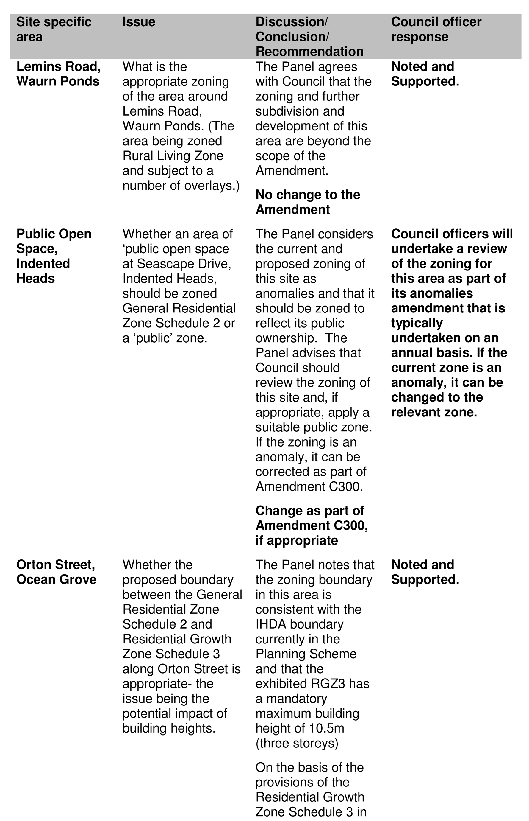
Lemins Road, Waurn Ponds- What is the appropriate zoning of the area around Lemins Road, Waurn Ponds. (The area being zoned Rural Living Zone and subject to a number of overlays.)
Public Open Space, Indented Head- Whether an area of ‘public open space’ should be zoned General Residential Zone Schedule 2 or a ‘public’ zone.
Orton Street, Ocean Grove- Whether the proposed boundary between the General Residential Zone Schedule 2 and Residential Growth Zone Schedule 3 along Orton Street is appropriate- the issue being the potential impact of building heights.
Appendix 9 considers these site-specific issues and provides a Council officer response to each issue.
6. OTHER SUBMISSIONS AND ISSUES
The Panel also discussed a number of other submissions to the Amendment. These included the following:
Clause 21.06 Settlement and Housing
The Panel considered the issue to be whether the exhibited Clause 21.06 should be modified, being the deletion of existing references to the Residential Character Study: Character Precinct Brochures. The Panel also noted Council’s post-exhibition change to Clause 21.06 relating to adding a further work requirement to review the incremental change areas identified in the Housing Diversity Strategy to consider the application of the General Residential Zone Schedule 2.
Panel discussion/conclusion:
The Panel notes that most of the changes to Clause 21.06 are consequential resulting from the introduction of the new residential zones.
The Panel supports Council’s deletion of the reference to the Character Brochures given their limited statutory weight and limited relevance.
The Panel supports Council’s intention to review whether the General Residential Zone Schedule 2 should be applied to the ‘incremental change areas’ identified in the Housing Diversity Strategy that were proposed for the General Residential Zone Schedule 1.
Panel recommendation:
Recommendation 6
Modify Clause 21.06 (Settlement and Housing) to add a further work requirement to review whether the General Residential Zone Schedule 2 should be applied to the ‘incremental change areas’ identified in the Housing Diversity Strategy (Council’s proposed change 5).
Council officer response:
Council officers support the Panel’s recommendation in line with Council’s post-exhibition changes to the Amendment of 25 February 2014.
Clause 22.63 Increased Housing Diversity Policy
The Panel considered the issue to be whether the exhibited Clause 22.63 should be modified.
Panel discussion/conclusion:
The Panel believes that the post-exhibition changes to the local planning policy have improved and helped address concerns in submissions about development in IHDAs.
The Panel believes that the first and second ‘general’ Design Objectives be replaced with versions faithful to the original versions included in the LPP relating to discretionary maximum building height of 13.5 metres.
The Panel is satisfied that applying the revised provisions in Clause 22.63 in combination with the General Residential Zone and the Heritage Overlay gives adequate recognition to protecting heritage areas in the IHDAs.
Panel recommendation:
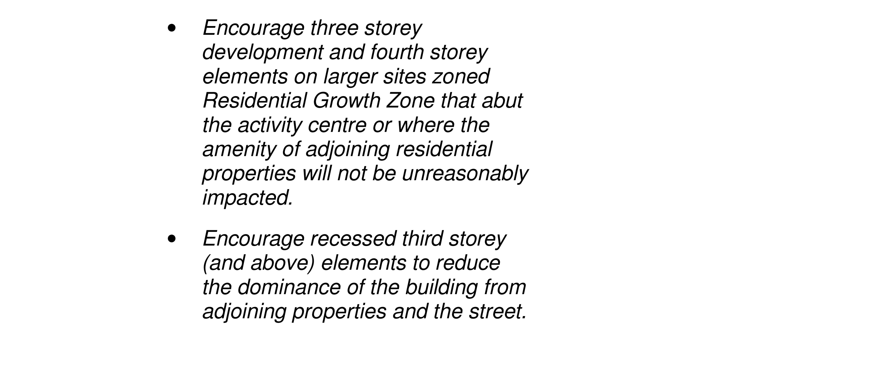
Recommendation 7-
Adopt Council’s revised Clause 22.63 (Increased Housing Diversity Areas) (Document 54) subject to replacing the first and second ‘general’ Design Objectives under ‘built form’ with:
Encourage three storey development and fourth storey elements on larger sites zoned Residential Growth Zone that abut the activity centre or where the amenity of adjoining residential properties will not be unreasonably impacted.
Encourage recessed third storey (and above) elements to reduce the dominance of the building from adjoining properties and the street.
Council officer response:
This report has previously discussed the Panel recommendations in relation to building heights in the Residential Growth Zone Schedule 2. Council officers recommend that a mandatory maximum building height of 10.5 metres be included in the Residential Growth Zone Schedule 2.
Consequently, the Panel’s recommendations for the proposed Clause 22.63 are not supported. Council officers propose to adopt the local planning policy version presented to the Panel on the last day of the Hearing (See Appendix 10).
Consultation
The Panel commented on whether there was adequate consultation around the Amendment.
Panel discussion/conclusion:
The Panel acknowledged the concerns of submitters about the nature and extent of Council’s consultation around the Amendment, but is satisfied that the statutory notification of the Amendment was consistent with the provisions of the Act. The Panel is also satisfied that the Council’s ‘non statutory’ consultation reflected “a genuine intent to inform and involve the community.”
While direct notification to all landowners might have assuaged some of the submitter’s concerns, the Panel noted Council’s advice about the time and cost constraints that led it to adopt a less targeted approach.
The Panel also noted that the consultation strategy resulted in over 200 submissions that raised a comprehensive range of issues. While direct notification might have attracted more submissions, it is not clear that any additional submissions would have raised any further issues.
Council officer response:
The Panel’s discussion/conclusion about consultation is welcomed. Consultation was a key issue raised by submitters to the amendment. Council officers presented on this issue at the Panel Hearing and clearly demonstrated that a genuine attempt had been made to notify residents about the amendment. Council officers also note the Panel’s consideration that 200 plus submissions received to the amendment raised a comprehensive range of issues and that it was not clear that if direct notification had been undertaken, that any additional issues would have been raised in submissions.
This report has positive environmental implications in relation to encouraging more sustainable urban form with medium density housing being located near activity centres, town centres and train stations. The new zones provide for greater clarity in relation to the policy difference for various residential areas, which will provide for better outcomes in terms of directing and managing appropriate levels of residential development in respective areas.
This report does not result in any additional financial implications for Council.
Current approved budget will cover costs associated with this planning scheme amendment.
The recommendations of this report comply with State Planning Policy in relation to the State Government’s Practice Note for applying the new residential zones and processing planning scheme amendments. All submissions to Amendment C300 have been considered by Council and have been before an Independent Panel appointed by the Minister for Planning.
The recommendations of this report are consistent with City Plan, in relation to promoting a sustainable built environment, sustainable land use and development, increased public transport use, liveable neighbourhoods, quality urban design and built environment and the conservation of historic buildings.
There is no direct or indirect officer conflict.
There are risks associated with Council not resolving a position to request the Minister for Planning to approve the adopted Amendment. It is important that the timescales associated with processing this planning scheme amendment are retained. This will ensure the full suite of new residential zones is implemented as soon as possible to best reflect the local planning conditions for Geelong’s residential areas. .
The potential outcome of Amendment C300 will provide for managed residential growth in the municipality. Increased density and infill housing is directed to areas that are well serviced and provide good opportunities to meet the demands for smaller households. Incremental change areas provide a balance between a mix of housing stock while maintaining the garden character of identified areas. A range of housing is important to provide for the different housing needs in our community.
The Amendment will not impact on the basic right, freedoms and responsibilities as set out in the Charter. Planning legislation ensures an open community consultation process occurs enabling the public to freely express their view. The appointment of an Independent panel to hear all submissions to C300 provided submitters with a further platform to present their concerns about the Amendment.
The Panel hearing allowed submitters to present their concerns before an Independent Panel appointed by the Minister for Planning. Council officers have met with key residents groups post-receipt of the Panel report and have also afforded an opportunity to meet with individual submitters. The consultation and communication adopted for Amendment C300 was considered appropriate by the Panel.

See separate attachment
Cr Fisher re-entered the meeting room at 9:00pm
Cr Farrell moved, Cr Heagney seconded –
That the Notice of Motion in relation to Seam Gas Extraction (Fracking) be brought forward for consideration.
Carried.
Council to take public submissions on Coal Seam Gas Extraction.
As part of Council’s Environment Management strategy process, council has received community feedback in regard to concerns around the practice of Coal Seam Gas Extraction, and in particular the practice of hydraulic fracturing or "fracking".
These concerns are as follows:
That fracking operations are horrendously dangerous to the environment and affect all aspects of community life, such as:
The quality and quantity of the region's water supplies;
The health of many people (especially children) in the region due to the toxic chemicals used;
Heavy vehicles moving throughout the community creating excessive noise and increased traffic congestion;
Dangers of toxic chemical spills as a result of chemicals being transported
Council is currently completing its Environmental Management Strategy which is due to come to Council shortly. The issue of Coal Seam Gas Extraction and in particular fracking forms part of the Environmental Management Strategy, and Council should take public submissions on this issue.
Cr Richards moved, Cr Harwood seconded –
That Council take public submissions regarding the issue of Coal Seam Gas Extraction and in particular fracking, for a period of one month commencing 23 July 2014, and that a submission report be presented to Council as part of the Environmental Management Strategy report, by the end of September 2014.
Cr Fisher moved, Cr E Kontelj seconded -
That Council commence a 30 day process to educate Council on ‘Fracking’ followed by Council taking public submissions regarding the issue of Coal Seam Gas Extraction and in particular ‘Fracking’, for a period of one month commencing August 2014, and that a submission report be presented to Council as part of the Environmental Management Strategy report, by the end of September 2014.
Cr S Kontelj moved, Cr E Kontelj seconded –
That consideration of the Notice of Motion be deferred.
Lost.
The amendment was put and carried.
The amendment became the motion
The motion was put and carried.
Portfolio: |
Planning - Cr Heagney |
Source: |
Planning and Tourism - Strategic Implementation |
General Manager: |
Peter Bettess |
Index Reference: |
Amendment C306 |
The purpose of this report is to consider Amendment C306 to the Greater Geelong Planning Scheme to rezone land in the Curletts Road area, Lara, from Rural Living Zone to Low Density Residential Zone.
Amendment C306 proposes to rezone land in the Curletts Road area of Lara from Rural Living Zone to Low Density Residential Zone and apply the Design and Development Overlay to the land to be rezoned.
The Amendment has been prepared by TGM Group (Planning Consultants) on behalf of multiple landowners in the Curletts Road area.
Strategic justification for the Amendment is confirmed by the adopted Lara Structure Plan April 2011 and the State and Local Planning Policy Frameworks contained in the Greater Geelong Planning Scheme.
The Low Density Residential Zone is the most appropriate zone in order to retain the rural-edge feel of the area and due to the inability of the area to connect to the reticulated sewerage network, including other site constraints such as drainage and flooding.
The Design and Development Overlay (DDO) is being applied to guide the subdivision of the land. The DDO will set out requirements to ensure the orderly subdivision of the land mindful of the rural-edge characteristics of the area and existing constraints.
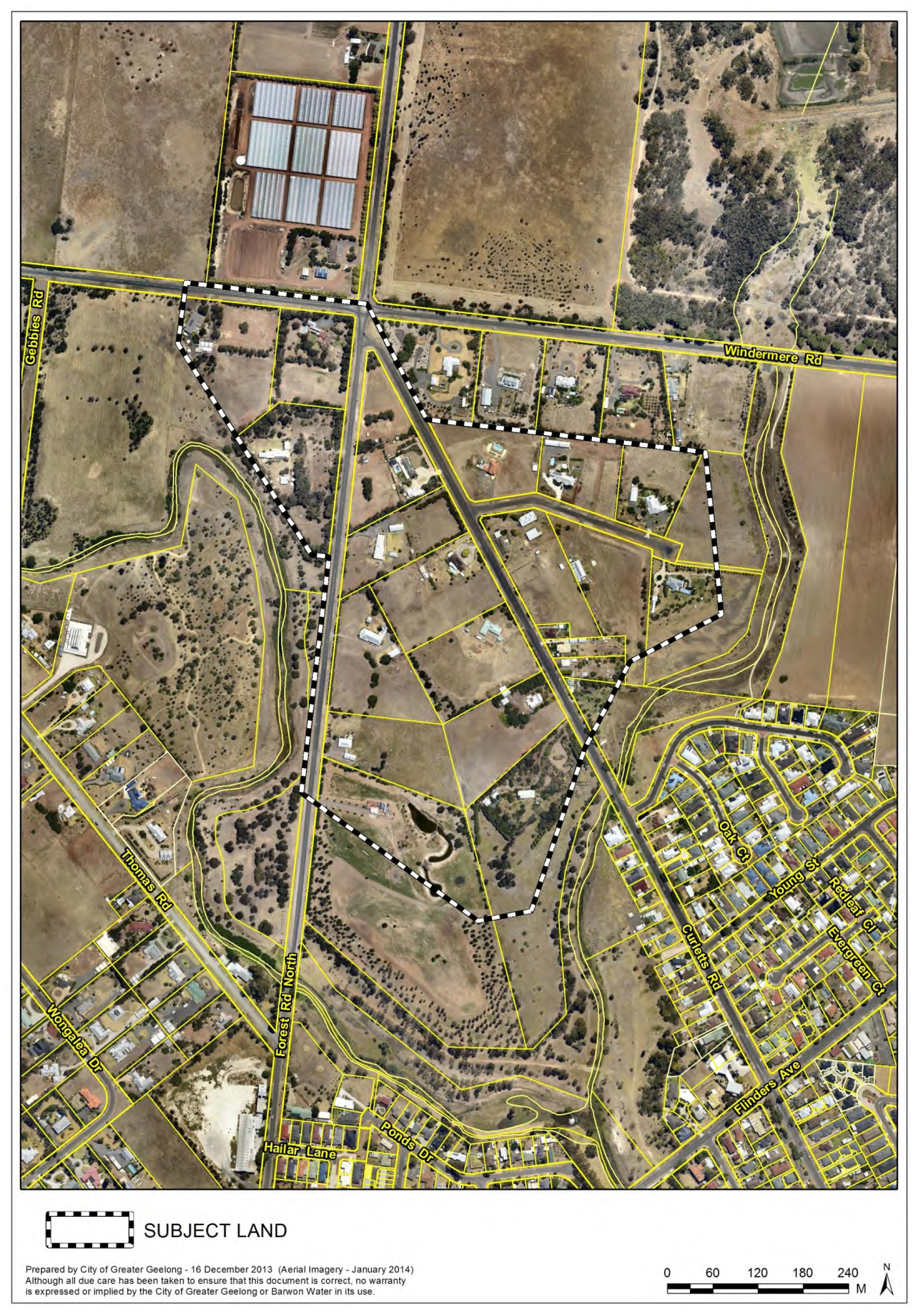
The site area is approximately 31ha and comprises existing rural living lots. Forest Road North, Curletts Road and Osterlund Court comprise the key road network in this area. (See Appendix 1).
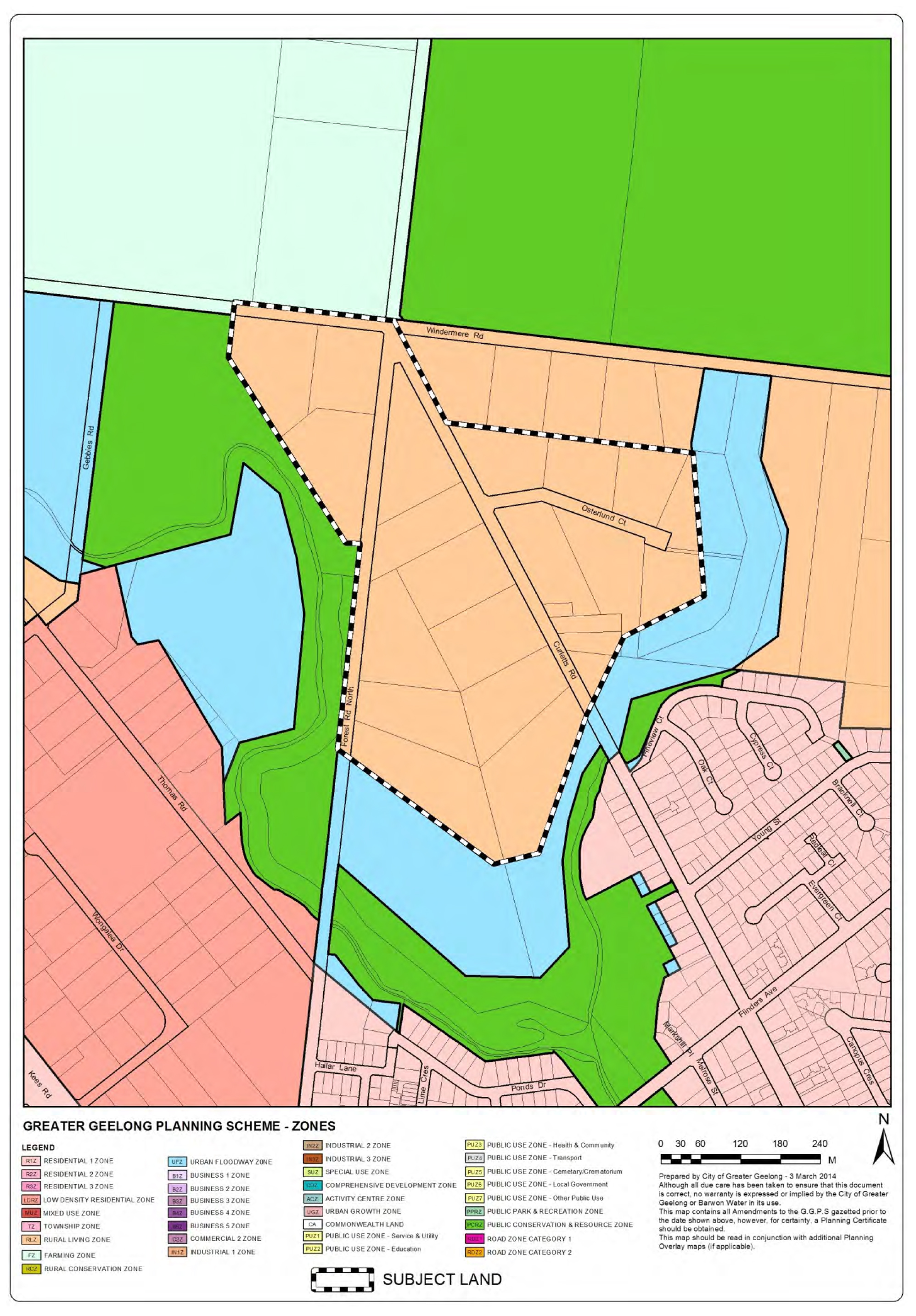
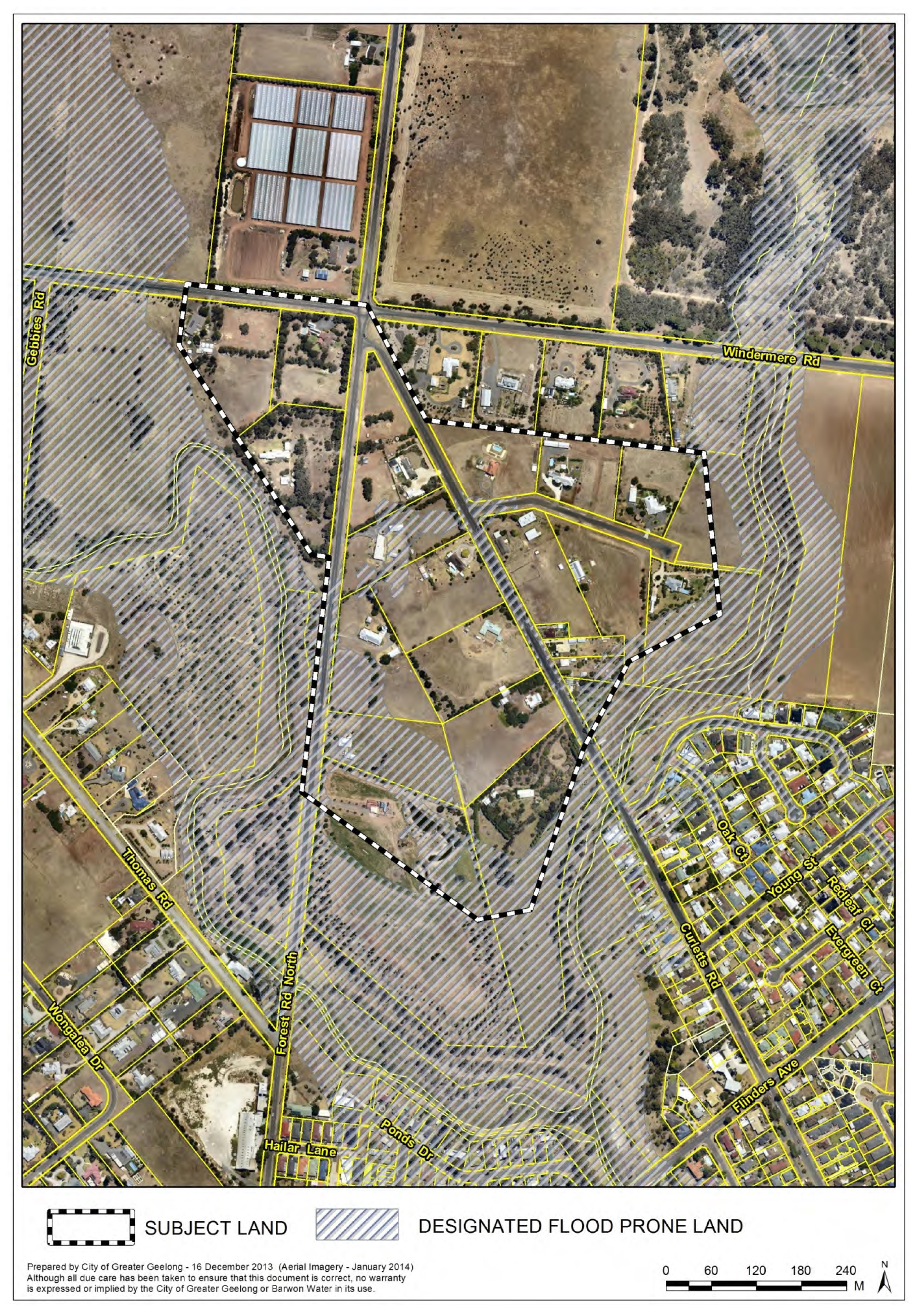
The subject land is zoned Rural Living and is not affected by any overlays. (See Appendix 2). Part of the subject land is designated flood prone under the Building Regulations 2006 (See Appendix 3)
The original application only sought to rezone land that was not affected by the 1 in 100 year flood extent arising from Hovells Creek and Serendip Creek. Council officers propose to rezone a larger area, including that which is designated flood prone, in line with the Lara Structure Plan and as outlined in Appendix 4.
Council officers do not propose to rezone properties fronting Windermere Road opposite the Serendip Sanctuary. This is justified by previous strategic planning work undertaken in relation to the protection of the sanctuary and creation of a buffer between the two land uses.
It is recommended that Council resolves to support the preparation of the Amendment and that Council requests the Minister for Planning authorise the preparation and exhibition of the Amendment.
Cr Heagney moved, Cr Ansett seconded -
That Council, having considered the Amendment, resolves to:
support the preparation and exhibition of Amendment C306 to the Greater Geelong Planning Scheme as described below:
rezone the affected land in the Curletts Road area from Rural Living Zone to Low Density Residential Zone, as per Appendix 4 of this report;
apply the Design and Development Overlay to the land to be rezoned, as per Appendix 5 of this report.
request the Minister for Planning to authorise the preparation and exhibition of Amendment C306 to the Greater Geelong Planning Scheme.
Carried.
Amendment C306 proposes to rezone land in the Curletts Road area of Lara from Rural Living Zone to Low Density Residential Zone and apply the Design and Development Overlay to the land to be rezoned.
The Amendment has been prepared by TGM Group on behalf of multiple landowners in the Curletts Road area. TGM submitted the application to Council in November 2013.
As a consequence of the State Government’s reforms to the Low Density Residential Zone, land can be subdivided to 2,000 sq.m where connected to the reticulated sewerage network. Council’s can prepare schedules to the Zone prescribing a minimum lot size. A schedule to the LDRZ is in the Greater Geelong Planning Scheme restricting these areas to 0.4ha. This is an interim measure. A separate planning scheme amendment process (Amendment C309) is currently underway to introduce two new schedules (Schedule 1 and Schedule 2) to the LDRZ, which will identify LDRZ areas to be subdivided at either a minimum 0.4ha or 0.2ha respectively. Once the Amendment C309 has been approved, the subject land will be zoned Low Density Residential Zone Schedule 1.
The subject land, as outlined in Appendix 1, is in the Rural Living Zone and is approximately 31ha in area. For the most part, existing lots contain a residential dwelling and associated outbuildings.
A number of lots are affected by two zones, being the Rural Living Zone and the Urban Flood Zone. These properties are generally located at the eastern and southern extent of the subject land (See Appendix 2).
The subject land is not affected by any planning overlays.
Part of the subject land is designated flood prone (See Appendix 3).
The broader site context is generally rural living zone land but also includes conventional residential land to the south-east and south-west.
Council officers have been engaged in extensive pre-application discussions with TGM. This involved detailed discussions between Council’s Strategic planners, Engineers and the proponent. During this time, Council officers recommended a simple but logical approach to rezoning the land from Rural Living Zone to Low Density Residential Zone. This approach considered that typical LDRZ requirements would be difficult to achieve on the basis of the existing rural residential subdivision of the land and level of multiple landownership.
The rezoning application is supported by:
Planning report;
Indicative Subdivision Layout;
Land Capability Assessment; and
Drainage and Flooding Assessment.
The Amendment was referred to a number of Council departments and external bodies for initial comments. This led to the request for further information from the proponent, being a preliminary cultural heritage assessment and vegetation assessment.
This section of the report will discuss the key issues that must be assessed in the consideration of the Amendment.
Strategic justification
Principal justification for the Amendment is found at Clause 21.13 Lara of the Greater Geelong Planning Scheme.
Clause 21.13 seeks to ensure an adequate supply of appropriately zoned and located residential land. This is to be achieved by supporting the development of areas identified for rezoning to Low Density Residential in accordance with the Structure Plan map included in the clause. The Curletts Road area is identified on the Structure Plan map as ‘Retain rural residential character (Low density residential)’- See Appendix 6.
The adopted Lara Structure Plan April 2011 provides a discussion about areas identified as future low density residential development. The Structure Plan states:
‘Locations that are currently zoned Rural Living where the physical or environmental constraints are such that conventional residential development is not possible, but for which there is some capacity to better utilise the land, have been considered in this Structure Plan for inclusion in the Low Density Residential Zone.’
For the Curletts Road area (area west of Serendip Creek), the Structure Plan states:
‘The Curletts Road area is also considered appropriate for the Low Density Residential Zone. Flooding and drainage constraints mean conventional residential development may be problematic in this area. Drainage and flooding will have to be addressed as part of any rezoning proposal.
It is recommended that the area be rezoned from Rural Living to Low Density Residential with an accompanying Development Plan Overlay or approved subdivision layout.’
The Policy section of this report provides an overview of relevant sections of the Greater Geelong Planning Scheme to the assessment of this rezoning application.
The Lara Structure Plan identifies a larger area of land than that proposed in the rezoning application and as proposed by Council officers (See Appendix 6). The Amendment excludes properties that front Windermere Road opposite the Serendip Sanctuary. (See Appendix 4 Proposed Zoning). The northern rezoning boundary is justified on the basis of the proximity of these properties to the sanctuary and the potential for adverse impacts of low density residential development on the environmental values of the sanctuary. This effectively leaves a Rural Living Zone setback of some 100 metres between the sanctuary and the proposed land for low density residential rezoning.
Curletts Road Area- Indicative Subdivision Layout
The rezoning application is supported by an indicative subdivision layout (See Appendix 7). TGM prepared the plan to provide an idea of how individual landowners wish to subdivide their land and the extent to which each existing lot could be subdivided for those landowners that have not expressed a desire to be part of the process.
While this is a useful exercise, Council officers consider a less intensive subdivision of the area is required and that the principles outlined during pre-exhibition discussions (for example, avoidance of battle-axe lots and minimising vehicle access points and sharing of access arrangements, where possible) warrant further consideration at the subdivision permit stage. This can be achieved through the use of a schedule to the Design and Development Overlay.
Cultural Heritage
Aboriginal Heritage
Part of the subject land is in an area of cultural heritage sensitivity due to the proximity to Hovells Creek.
A Cultural Heritage Management Plan is not required for the rezoning of the land but may be triggered where sites are located within 200 metres of Hovells Creek and seek to subdivide to 3 lots or more. The determination of the requirement for a CHMP is legislated by the Aboriginal Heritage Regulations 2007.
Historical Heritage
The cultural heritage assessment concludes that there are no European heritage sites within the study area. However, there is low potential for European heritage to survive. The report recommends that a historical heritage survey be undertaken prior to subdivision and development.
Vegetation
The vegetation assessment states that the area contains relatively degraded native vegetation that are assessed as “degraded treeless’ vegetation. The subject land also contains vegetation that is entirely exotic.
The site is rated as having negligible to local significance for biodiversity.
The vegetation assessment concludes that there are no significant limitations to this study.
Land Capability Assessment
The land capability assessment (LCA) considered the proposed subdivision layout as outlined in Appendix 7. The LCA confirms that sustainable on-site wastewater management systems can be built to meet the needs of the new lots created.
It is expected for those sites which were not included in the original assessment, that these will adopt a similar approach to that proposed in the LCA for wastewater disposal treatment, subject to further investigations.
Drainage and Flooding
The subject land is partly affected by the 1 in 100 flood event (1% Annual Exceedance Probability) and consequently, is designated as flood prone under the Building Regulations. Appendix 3 confirms the extent of the designated flood prone land.
For those areas outside the designated flood prone land, it is considered that they can be drained to either the road reserve or existing easements.
For those areas affected by the flood prone designation, it is unlikely that these lots will be subdivided for residential purposes unless they can satisfy a number of requirements. The draft schedule to the Design and Development Overlay (Appendix 8) outlines these requirements and they include that a site must be capable of providing a building envelope and wastewater disposal envelope outside the 1% AEP and that a stormwater management plan be provide to ensure acceptable drainage arrangements without any off-site impact.
Design and Development Overlay
The Lara Structure Plan recommends that a development plan overlay or approved subdivision plan be implemented for this area. Council officers consider that the Design and Development Overlay (DDO) is a better tool to ensure appropriate subdivision of the area. Given the level of fragmented landownership and the technical workings of a development plan overlay, the DDO is a better tool in so far as prescribing a set of design guidelines that can be assessed against individual subdivision permit applications.
Council does not seek to control development in this area beyond that which is triggered by the Low Density Residential Zone. The DDO schedule design guidelines will ensure the retention of the rural-edge feel of the area and guide future subdivision to fit with the existing infrastructure set-up and constraints. This can be achieved by avoiding the use of battleaxe lots, minimising the number of vehicle access points to the road network, and ensuring that areas affected by drainage and flooding constraints satisfy specific subdivision design requirements.
A copy of the draft Design and Development Overlay is included in Appendix 8.
The Amendment is considered justified under the provisions of the Greater Geelong Planning Scheme. It is recommended that the Amendment be exhibited and that Council considers any submissions to the Amendment thereafter.
The intensification of residential land use on the subject land is considered a good environmental outcome in so far as using existing under-utilised rural living land close to existing services.
The Amendment does contain some native vegetation but not to an extent that would preclude the rezoning and subdivision of the affected land.
Part of the affected land is designated flood prone under the Building Regulations 2006. The effect of this comes into force where a landowner seeks to obtain a building permit. In planning terms, Council officers have sought to deal with this matter by way of implementing design requirements to be considered through the assessment of a permit application for subdivision.
The exclusion of properties along Windermere Road opposite the Serendip Sanctuary generally aligns with the principal of creating a setback between the sanctuary and increased residential use of land to the south.
There are no other notable environmental implications.
There are no notable financial implications involved in the processing of the planning scheme amendment.
The Amendment complies with the provisions of the Greater Geelong Planning Scheme.
Clause 11 Settlement states that Planning is to facilitate sustainable development that takes full advantage of existing settlement patterns. The Amendment takes advantage of existing settlement patterns in so far as using existing rural living zoned land for increased residential development in the form of low density development proximate to existing services.
The Amendment supports the objectives and strategies of Clause 15 Urban Design in so far as creating urban environments that are safe, functional and provide good quality environments with a sense of place and cultural identity.
The Amendment supports the objectives and strategies of Clause 19.03 Stormwater in so far as ensuring that future subdivision of the land adopts a sustainable approach to managing stormwater from the site through the incorporation of water-sensitive urban design techniques to reduce run-off and peak flows and integrate stormwater treatment into the landscape.
The Amendment is consistent with the LPPF, including the following policies:
Clause 21.05-7 Flooding- ensures the future subdivision of the land does not impact the function of flood prone land.
Clause 21.06-2 Urban growth- ensures development occurs within designated settlement boundaries.
Clause 21.06-3 Urban consolidation- provides for the consolidation of existing urban areas in a managed way and to encourage an appropriate range of development densities.
Clause 21.08-5 Accessibility- ensures access to existing facilities for all members of the community.
Clause 21.13 Lara- in so far as implementing the Directions of the Lara Structure Plan which supports the rezoning of the subject land from Rural Living Zone to Low Density Residential Zone. The rezoning will retain the rural living character of the area by utilising the Low Density Residential Zone Schedule 1 and will increase residential density in this location providing good access to existing services.
The report aligns with the City Plan’s strategic direction Sustainable Built and Natural Environment. This direction seeks to protect and enhance natural ecosystems and to encourage sustainable design and reduced resource consumption. Specific priorities of the strategic direction included: Enhance and protect natural areas and ecosystems (including waterways); Advocate for and promote sustainable design and development (including the assistance of the planning system).
No Council officers involved in the proposed rezoning application have a direct or indirect interest in matters contained in this report.
There are no notable risks that would inhibit the use of the land for low density residential purposes.
It is noted that the land is currently identified as Bushfire Prone. However, the land is not affected by the Bushfire Management Overlay (BMO). The Minister for Planning has determined that specific areas are designated bushfire prone areas for the purposes of the building control system.
There are no foreseeable negative implications arising from the rezoning of the subject land.
The rezoning will allow for further subdivision of the subject land for residential purposes. Given the proximity of the subject land to Lara Town Centre, the rezoning will facilitate better access to existing services.
The Amendment will not impact on any basic rights, freedoms, and responsibilities as set out in the Charter. Planning legislation ensures an open community consultation process occurs enabling people to freely express their views and if necessary, obtain a fair hearing before an Independent Planning Panel.
Consultation will form part of the exhibition of the planning scheme amendment. The next step in the amendment process will be to request the Minister for Planning to authorise the preparation and exhibition of the amendment. The amendment will be exhibited for a minimum 30 days and this will allow formal submissions to be made to the Amendment. The notice of exhibition for Amendment C306 will be published in local newspapers and proximate landowners will be notified. Consultation with relevant referral authorities will also be undertaken during the exhibition of the Amendment.
Cr Heagney declared an Indirect Financial Interest in Agenda Item 3 – Amendment C282 – Geelong Gateway Homemaker precinct, Corio – Adoption in that a client of Cr Heagney’s family business is the owner of a property in the area involved and left the meeting prior to discussion at 9:13pm.
Portfolio: |
Planning - Cr Heagney |
Source: |
Planning and Tourism - Strategic Implementation |
General Manager: |
Peter Bettess |
Index Reference: |
Amendment C282 |
This report acknowledges submissions to Amendment C282 and recommends adoption of the Amendment.
An Amendment request was made by CBRE Town Planning on behalf of Kervale Investments Pty Ltd, the owner of land at 470-510 Princes Highway, Corio.
The Amendment proposes to rezone the proponents land title and all the land titles that make up the Geelong Gateway Homemaker Precinct, from the Industrial 1 and 3 zones to the Commercial 2 Zone.
In addition to the rezoning the Amendment will:
Apply the Environmental Audit Overlay to the land being rezoned;
Remove the Design and Development Overlay Schedule 20 from the land being rezoned; and
Amend the Retail Activity Centre Hierarchy Map and Table at Clause 21.07-8 to show a new Homemaker Precinct and remove its current status as a Potential Homemaker Precinct.
Public exhibition of Amendment C282 commenced on 8 May 2014 and closed on 9 June 2014.
Submissions were received from VicRoads, Barwon Water, the Environment Protection Authority and Earth Resources Regulation Victoria. None of these agencies objected to the Amendment.
The proposal is supported by Clause 21.18 Corio Norlane of the Municipal Strategic Statement, which identifies the site for rezoning to the Commercial 2 Zone.
The Amendment therefore will bring forward Council’s preferred land use vision and zoning outcome for this area, and provide clarity for future planning and investment on the site.
The Amendment can now be adopted with no need to refer the Amendment to an Independent Planning Panel.
Cr Macdonald moved, Cr Harwood seconded -
That Council resolves to:
adopt Amendment C282 in the form as outlined in Appendix 1 of this report; and
submit the adopted Amendment with the prescribed information to the Minister for Planning requesting approval.
Carried.
In October 2013 CBRE Town Planning acting on behalf of Kervale Investments Pty Ltd lodged Amendment C282 to the Greater Geelong Planning Scheme. The Amendment seeks to rezone all the land known as the Geelong Gateway Homemaker Precinct to the Commercial 2 Zone.
Kervale Investments Pty Ltd is the owner of land located at 470-510 Princes Highway, Corio. The applicant has requested that the rezoning be applied to all properties that form the homemaker precinct. The precinct is partly in the Industrial 1 Zone and partly in the Industrial 3 Zone and developed with a mix of bulky goods retailing and commercial services and industrial uses.
The land to which the rezoning applies is shown in the aerial map at Appendix 2.
A profile of the Geelong Gateway Homemaker Precinct is shown in the following table:
Property Address |
Land Use |
Zone |
470-510 Princes Hwy, Corio 3214 |
Bulky Goods Retailing |
IN3Z |
452-458 Princes Hwy, Corio 3214 |
Vacant |
IN3Z |
446-450 Princes Hwy, Corio 3214 |
Service Station |
IN3Z |
420-444 Princes Hwy, Corio 3214 |
Bulky Goods Retailing |
IN1Z |
17-73 Railway Avenue, Corio 3214 |
Gas Works |
IN1Z |
2 School Road, Corio 3214 |
Motor Vehicle Sales |
IN1Z |
4-50 School Road, Corio 3214 |
Motor Vehicle Sales |
IN1Z |
17-19 School Road, Corio 3214 |
Vacant |
IN1Z |
21-29 School Road, Corio 3214 |
Vacant |
IN1Z |
70 School Road, Corio 3214 |
Warehouse/Showroom |
IN1Z |
It is noted that an isolated Barwon Water utility installation is located on Railway Avenue within the homemaker precinct. The land area is 73 square metres and zoned Public Use Zone 1. This site does not form part of Amendment C282.
Council resolved under delegation on 28 March 2014 to place the Amendment on exhibition.
The subject land currently provides for a variety of uses – the majority being bulky goods retailing and commercial services. These include Harvey Norman, Fantastic Furniture, BCF, Derrimut Gymnasiums, Winter & Taylor Isuzu Trucks, Ultra Tune and a Caltex Service Station. There is a current planning permit application for a United Service Station at 452-458 Princes Highway.
These uses are better suited to the Commercial 2 Zone, the purpose of which includes:
“To implement the State Planning Policy Framework and the Local Planning Policy Framework, including the Municipal Strategic Statement and local planning policies.
To encourage commercial areas for offices, appropriate manufacturing and industries, bulky goods retailing, other retail uses, and associated business and commercial services.”
Part of the subject land is owned by SPI Networks (Gas) Pty Ltd and used for gas processing and distribution. This use is not inconsistent with the purpose of the Commercial 2 Zone.
Minister’s Direction No.1 requires that in the preparation of an amendment which has the effect of allowing (whether or not subject to the grant of a permit) potentially contaminated land to be used for a sensitive use, a planning authority must satisfy itself that the environmental conditions of that land are or will be suitable for the sensitive use.
Rezoning industrial land to the Commercial 2 Zone requires consideration of potentially contaminated land. The application of the Environmental Audit Overlay will ensure contamination issues are addressed should a permit be sought for a sensitive use allowable in the zone.
Exhibition of Amendment C282 took place between 7 May 2014 and 9 June 2014 with notices in local newspapers and the Government Gazette. Notice of the Amendment was sent to relevant Ministers under the Planning and Environment Act and to surrounding residents and nearby commercial land owners.
All landowners and occupiers within the Geelong Gateway Homemaker Precinct were directly notified.
Submissions were received from VicRoads, Barwon Water, the Environment Protection Authority and Earth Resources Regulation Victoria. None of these agencies objected to the Amendment. Because there are no objecting submissions, the Amendment does not need to be heard by an Independent Planning Panel.
Council is now able to adopt the Amendment and forward it to the Minister for Planning seeking approval.
There are no environmental implications as a result of the Amendment. Any potentially contaminated land issues would be addressed at such time that a ‘sensitive use’ is proposed.
There are no financial implications for the Council.
No impact to budget.
Amendment C282 is consistent with Council’s Municipal Strategic Statement.
The Amendment seeks to change the City of Greater Geelong Retail Activity Centre Hierarchy contained in Clause 21.07-8 to include the site as a Homemaker Precinct in place of a ‘Proposed Homemaker Precinct’.
The Amendment will implement one of the actions of Clause 21.18 Corio Norlane by applying the Commercial 2 Zone and removing the DDO20 from the Geelong Gateway Homemaker Centre.
The Amendment supports the ‘Growing our Economy’ strategic direction of City Plan, by consolidating the role and function of the Geelong Gateway Homemaker Centre.
No officers involved in this report have any direct or indirect interest In accordance with Sec 80 (c) of the Local Government Act.
There are no notable risks associated with implementing the recommendation contained in this report.
The Amendment is not expected to generate any significant social impacts.
The Amendment will not impact on any basic rights, freedoms and responsibilities as set out in the Charter. Planning legislation ensures an open community consultation process occurs, enabling people to freely express their views and if necessary obtain a fair hearing before an Independent Panel.
The Amendment was exhibited in accordance with the Planning and Environment Act 1987, including direct notification to all landowners and occupiers within the homemaker precinct.
Planning and Environment Act 1987
The planning authority for this amendment is the Greater Geelong City Council.
The Greater Geelong Planning Scheme is amended as follows:
The Planning Scheme Maps are amended by a total of 3 attached map sheets.
Zoning Maps
Amend Planning Scheme Map No. 26 in the manner shown on the 1 attached map marked “Greater Geelong Planning Scheme, Amendment C282”.
Overlay Maps
Insert a new Planning Scheme Map No. 26EAO in the manner shown on the 1 attached map marked “Greater Geelong Planning Scheme, Amendment C282”.
Delete Planning Scheme Map No. 26DDO in the manner shown on the attached 1 map marked “Greater Geelong Planning Scheme, Amendment C282”.
The Planning Scheme Ordinance is amended as follows:
In Local Planning Policy Framework – replace Clause 21.07 with a new Clause 21.07 in the form of the attached document.
In General Provisions – Clause 61.03, replace the schedule with a new Schedule in the form of the attached document.
End of document
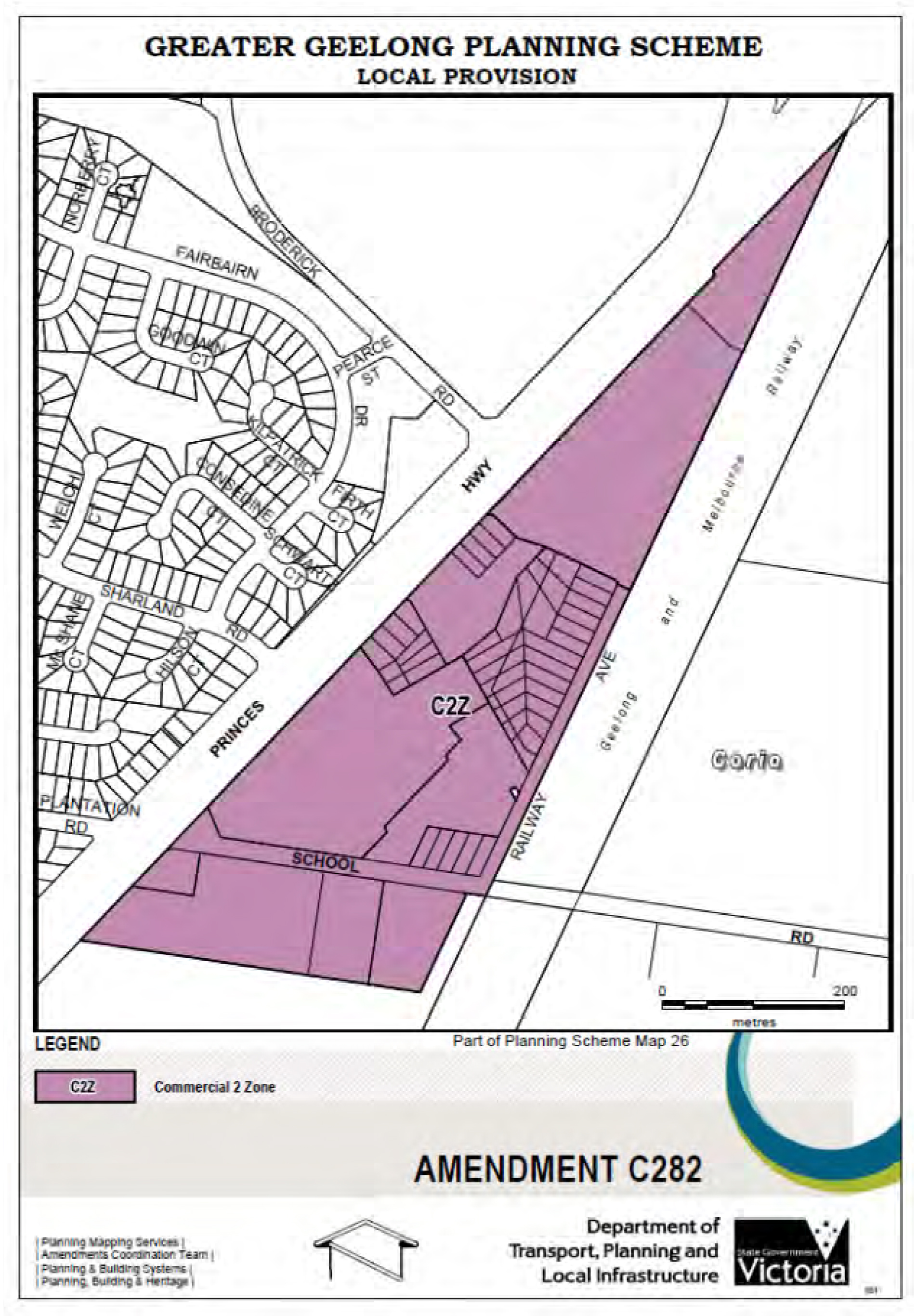
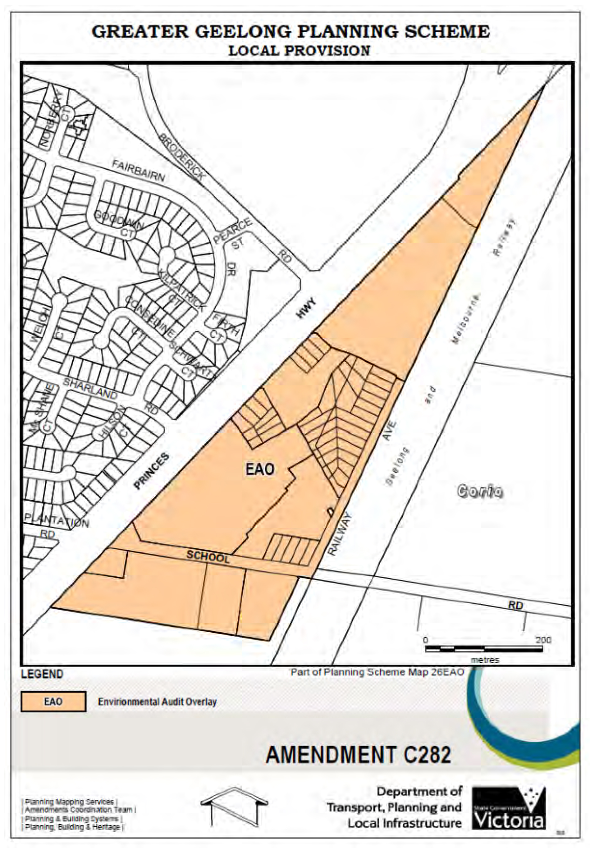
21.07 |
ECONOMIC DEVELOPMENT AND EMPLOYMENT |
21.07-1 |
Key issues and influences |
14/10/2010 |
Economic Role and FunctionGeelong is the largest regional city in Victoria and the primary service and employment hub for the G21 Geelong Region Alliance. The City’s infrastructure base includes Avalon Airport, the Geelong Port and major road and rail connections to Metropolitan Melbourne and Victoria’s western regions. The provision of high quality living, working and recreational environments is critical to attracting and retaining highly skilled people and the businesses in which they work. IndustryThere is a need to provide support for ongoing employment and economic development in the Geelong region. There is a need to provide a diverse range of appropriately located, well serviced industrial land which meets the needs of a range of industry types and minimises land use conflicts. Traditional manufacturing industries will continue to be key economic and employment drivers in the municipality, however at the same time the City’s economy will need to focus on emerging industry sectors that underpin economic development, prosperity and employment growth in the new economy. The changing nature of industrial development means that most industrial development now requires high amenity land that offers a high quality environment for workers and visitors. There is a need to support industry through the maintenance and improvement of infrastructure including the road, rail, Avalon Airport, deep water port and associated facilities. The extractive industry operations in the municipality make a vital contribution to the building and construction industries and are of major economic importance to the Geelong region. RetailThe City of Greater Geelong Retail Activity Centre Hierarchy has been established to articulate the role and function fulfilled by centres of different sizes. The retail hierarchy supports the primacy of Central Geelong as the focus of retail activity in the region. There is a need to ensure a mix of commercial uses in activity centres. The retail hierarchy will be enhanced through high quality urban design and improved pedestrian and public transport accessibility. There is increasing development pressure for sites located away from activity centres, particularly for bulky goods and other large format retail development types that seek large sites with the capacity for significant car parking. Greater Geelong exhibits a number of factors that contribute to an increased vulnerability to problem gambling which requires sensitive consideration of their location. RuralAgricultural production is modest, but locally important and economically significant for landowners. There is potential for growth in agricultural production, particularly aquaculture. Farming activity and the rural landscape are very significant elements to the identity, image and liveability of the City of Greater Geelong. Farming and rural landscapes form non urban breaks and are a critical element to the settlement strategy, tourism function and lifestyle of the region. Farming and agriculture are important and valued activities in the northern area of the municipality, particularly in the Anakie area. Rural land in a number of urban fringe areas accommodates a range of uses and developments which require buffers from residential areas. The City’s rural areas contain important environmental assets. TourismTourism is a key part of the economy of the Geelong region. The region includes major tourism destinations such as the Bellarine Peninsula and the coast. Tourism activities in rural and coastal areas must be carefully managed so as not to compromise the natural environment and/or agricultural activities. |
21.07-2 |
Industry |
19/07/2012 |
Objectives
Strategies
|
21.07-3 |
Retail |
14/10/2010 |
Objectives
Strategies
|
21.07-4 |
Economic growth sectors |
28/01/2010 |
Objective
Strategies
|
21.07-5 |
Rural Areas |
28/01/2010 |
Objectives
Strategies
|
21.07-6 |
Tourism in rural areas |
28/01/2010 |
Objectives
Strategies
|
21.07-7 |
Implementation |
19/07/2012 |
These strategies will be implemented by: Using policy and the exercise of discretionWhere appropriate, referring applications for the development of land in the Heales Road Industrial Estate to Worksafe. Using the Discretionary Uses in Residential Areas Policy at Clause 22.01. Using the Sexually Explicit Adult Entertainment Venues, Adult Sex Bookshops and Adult Cinemas Policy at Clause 22.02. Using the Assessment Criteria for Retail Planning Applications Policy at Clause 22.03. Using the Agriculture, Rural Dwellings and Subdivision Policy at Clause 22.05. Using the Tourism Development in Rural Areas Policy at Clause 22.06. Using the Racing Dog Keeping and Training Policy at Clause 22.07. Using the Materials Recycling Policy at Clause 22.08. Using the Gaming Policy at Clause 22.57. Applying zones and overlaysApplying the Rural Activity Zone to major tourism proposals in accordance with Clause 22.06 – Tourism Development in Rural Areas. Applying Schedule 1 to the Urban Growth Zone to the Armstrong Creek North East Industrial Precinct area in accordance with the North East Industrial Precinct, Precinct Structure Plan, May 2010. Applying Schedule 1 to the Development Contributions Plan Overlay to the Armstrong Creek North East Industrial Precinct area in accordance with the North East Industrial Precinct, Precinct Structure Plan, May 2010. Further workSupport the development of a masterplan for the Avalon Airport site. Implement Coastal Spaces Landscape Assessment Study (Department of Sustainability and Environment, 2006). As a priority, commence an investigation into the future residential and industrial land use needs for Geelong, as a basis for future growth area planning that would include:
ReferencesHeales Road Industrial Estate Framework Plan, MacroPlan Australia and the City of Greater Geelong, 2007. Armstrong Creek Urban Growth Plan, City of Greater Geelong, 2006. City of Greater Geelong Retail Strategy, Essential Economics and Hansen Partnership, 2006. City of Greater Geelong Economic Development Strategy, City of Greater Geelong, 2005. Geelong Seafood Industry Strategy, City of Greater Geelong, 2003 . City of Greater Geelong Rural Land Use Strategy, City of Greater Geelong, 2007. Coastal Spaces Landscape Assessment Study, Department of Sustainability and Environment, 2006. North East Industrial Precinct, Precinct Structure Plan, May 2010. North East Industrial Precinct, Development Contributions Plan, May 2010 Greater Geelong Gaming Policy Framework, City of Greater Geelong, 2007. |
21.07-8 |
City of Greater Geelong Retail Activity Centre Hierarchy |
30/01/2014 |
|
|
|
21.07-9 |
Geelong Ring Road Employment Precinct Framework Plan map |
|
|
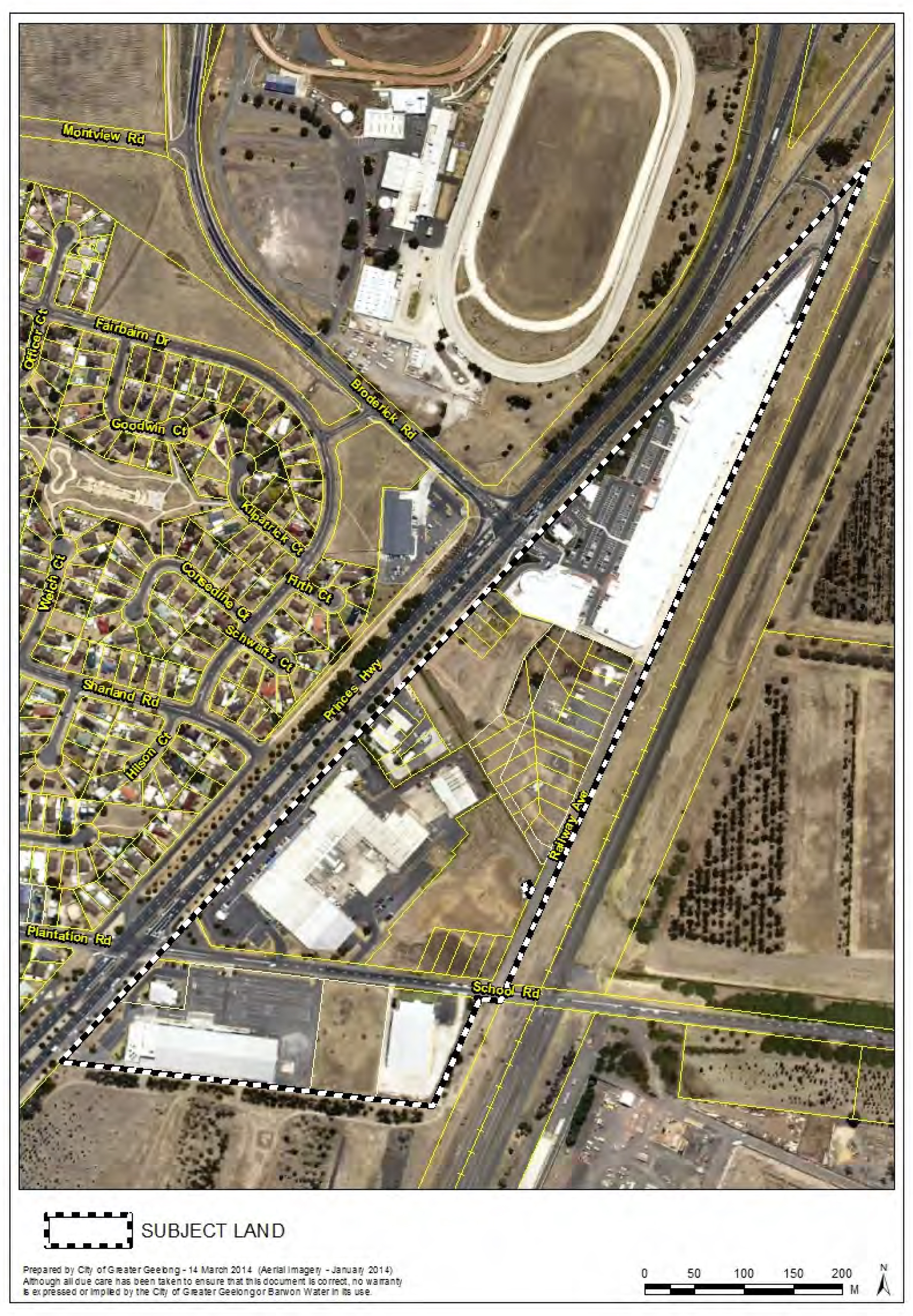
Cr Heagney re-entered the meeting room at 9:15pm
Portfolio: |
Planning - Cr Michelle Heagney |
Source: |
Planning and Tourism - City Development |
General Manager: |
Peter Bettess |
Index Reference: |
Amendment C270 |
The purpose of this report is to consider submissions to Amendment C270 and adopt the Amendment.
Amendment C270 is Council-initiated and seeks to apply the Public Acquisition Overlay 4 (PAO4) on land at Portarlington Road, Curlewis/Drysdale.
Amendment C270 will facilitate the construction of the North South Collector Road and Intersection at Portarlington Road, forming part of the Jetty Road Urban Growth Area, by reserving the land for this purpose. (See Appendix 1).
The affected land forms part of the Curlewis Golf Club at 1201-1419 Portarlington Road and privately owned land at 1421-1423 Portarlington Road. (Appendix 2 provides a plan of the affected land).
The public acquisition overlay will cover an area of 0.39ha. (See Appendix 3).
At its meeting on 29 January 2013, Council resolved to prepare and exhibit the Amendment, subject to authorisation from the Minister for Planning. Authorisation was received on 7 February 2013 (Authorisation No. A02470).
Amendment C270 was exhibited from 14 March 2013 until 15 April 2013.
Three submissions were received. Two submissions were received from the respective affected landowners (including an objection from the Curlewis Golf Club) and a submission from the Department of Environment and Primary Industries.
The private landowner at 1421-1423 Portarlington Road made no comments about the Amendment but sought confirmation as to whether compensation would be provided at the time of acquisition. The Department of Environment and Primary Industries has no objection to the Amendment.
The Golf Club sought to discuss both the planning and land acquisition and compensation processes as part of its submission. Key issues include the impact of the public acquisition overlay on the playability of the course, Golf Victoria rating and the impact of the North South Collector Road alignment.
Council officers have been engaged in extensive discussions with the Golf Club throughout the Amendment process. This included preparation of detailed road layout drawings and concept plans showing possible interface treatments between the new road/intersection and the Golf Club land.
On 20 May 2014, the Golf Club formally withdrew its objection to the Amendment on the basis their key concerns related to the land acquisition and compensation process rather than the planning scheme amendment process.
Council officers have considered all submissions to the Amendment and do not recommend any departures from what was exhibited. It is recommended that the Amendment be adopted as exhibited.
Cr Heagney moved, Cr Macdonald seconded -
That Council, having considered all submissions to Amendment C270 to the Greater Geelong Planning Scheme, resolves to:
Adopt Amendment C270 as per Appendix 6 of this report;
Submit the adopted Amendment C270 with the prescribed information to the Minister for Planning requesting approval.
Carried.
Amendment C270 is Council-initiated. It seeks to facilitate the future construction of the North South Collector Road and Intersection, Portarlington Road, Jetty Road Urban Growth Area by applying the Public Acquisition Overlay 4 (POA4) on the affected land.
The Public Acquisition Overlay reserves land for a public purpose and ensures that changes to the use or development of the land do not prejudice the purpose for which the land is to be acquired.
The affected land comprises the Curlewis Golf Club at 1201-1419 Portarlington Road and privately owned land at 1421-1423 Portarlington Road. The Curlewis Golf Club is in the Special Use Zone. The private land is in the Rural Living Zone.
The total area of affected land is 0.39ha. The areas of land acquisition are detailed in Appendix 4.
At its meeting on 29 January 2013, Council resolved to prepare and exhibit the Amendment.
On 30 January 2013, Council officers wrote to the Minister for Planning requesting authorisation to prepare and exhibit Amendment C270 to the Greater Geelong Planning Scheme. Authorisation was received on 7 February 2013 (Authorisation No. A02470).
A notice of preparation of the Amendment appeared in the Victorian Government Gazette on 14 March 2013. Notices were also advertised in the Geelong Independent on 8 March 2013 and the Geelong Advertiser on 9 March 2013.
Letters and notices were sent to relevant Government Departments, statutory authorities, and to the affected landowners on 7 March 2013.
The exhibition of Amendment C270 resulted in a total of 3 submissions. The two affected landowners made submissions and one statutory authority, being the Department of Environment and Primary Industries.
As of 20 May 2014, the Curlewis Golf Club formally withdrew its objection.
Appendix 5 provides a schedule of submitters.
The owner of the affected land at 1421- 1423 Portarlington Road, Drysdale, did not object to the Amendment but requested confirmation that compensation will be offered by the Council through the land acquisition and compensation process.
Council officers advise that once the planning scheme amendment is approved, Council will initiate the process of acquisition and compensation when the land is required for construction of the new road. The landowner will be offered compensation (fair and reasonable estimate) for the land acquired. The Land Acquisition and Compensation Act 1986 allows for a response by the landowner (claimant) to the first offer of compensation, whether it be a response to accept or dispute the offer. The private landowner will be informed as to the future land acquisition and compensation process once the Council decides to initiate proceedings.
The Department of Environment and Primary Industries raised no objection.
The Curlewis Golf Club’s objection is no longer before Council to consider as part of the Amendment. Notwithstanding this technicality, it is beneficial to discuss the events between Council officers and the Golf Club that have occurred before and after exhibition of the Amendment.
Curlewis Golf Club
The Golf Club’s key concerns related to the impact of the public acquisition overlay on the playability of several holes, the course rating and rating of the affected holes, safety and security. As part of its submission to the Amendment, the Golf Club also expressed concern about the impact of the North South Collector Road alignment along the Club’s eastern boundary. The Golf Club provided a schedule of estimated costs for course repairs and reinstatement, security, safety and incidentals.
Attached to the Golf Club’s submission was a letter previously submitted to Council on 21 January 2013 by the Club. The letter outlines the Club’s historical concerns about the North South Collector Road alignment and the proposed acquisition area. The letter also included costings and a concept plan, prepared by a specialist architect, outlining the necessary works required as a consequence of the construction of the new road and intersection.
In its submission to C270, the Golf Club acknowledged that Council will undertake negotiations with the Club about compensation for the affected land and improvements. The Golf Club advised that it would be willing to withdraw its submission opposing the Amendment in the event that satisfactory compensation is offered by the Council for the land, course reinstatement, consultant fees, security access and solatium.
Since receiving the Golf Club’s objection, Council officers have engaged in extensive discussions with the Club. Council officers have prepared detailed design drawings for the new road and intersection and concept plans showing potential mitigation measures between the new road/intersection and the Golf Club land. The detailed drawings helped Council officers explain the likely impact of the road construction works along Portarlington Road adjoining the Golf Club. Numerous meetings were also held with the Golf Club during this period.
The Golf Club has endeavoured to express its concerns about this Amendment and the construction of the North South Collector Road in a holistic manner. This resulted in their submission focusing on both planning and land acquisition issues, which are governed by separate legislation. Council officers have consistently expressed to the Golf Club the difference between the two processes.
On 20 May 2014, the Golf Club wrote to Council requesting that its objection to Amendment C270 be withdrawn. In its letter, the Club advised that it is mindful of the fact that this is a two-part process under the Planning and Environment Act 1987 and the Land Acquisition and Compensation Act 1986. The letter also included an updated position about potential redesign and costings for land affected by Amendment C270 and the impact of the North South Collector Road alignment. The Golf Club advised that at the time of land acquisition, it will be pursuing compensation for both the land and the loss attributable to disturbance and other factors. Prior to commencing the acquisition process, it will be necessary for Council officers to undertake a review of the Golf Club’s schedule of costings for works and associated plans.
The Amendment will result in a good planning outcome and will lead to the initiation of the land acquisition and compensation process once Council requires the new road and intersection to be constructed.
The construction of the North South Collector Road and intersection will result in the loss of vegetation. Prior to the construction of the new road and intersection, a survey will be undertaken of the affected land to confirm the species and quality of vegetation. Where possible, it is the intention to retain established tress along the alignment of the new North South Collector Road, thus, forming an attractive entrance off Portarlington Road.
The Jetty Road Stage 1 Development Contributions Plan (DCP) includes the cost of the land to be acquired by Council for the new North South Collector Road and intersection. The cost for the land will be collected from the Stage 1 landowners/developers.
DCP Infrastructure Item R002 - North South Collector Road Part A- Land Acquisition has an established project cost of $294,800 to acquire the land. (The project cost is expressed in July 2011 dollars and is based on a land valuation undertaken in 2011. When Council formally engages in the land acquisition process, the affected area will be re-valued to provide an updated cost for the land.) The capital cost assigned to the land acquisition relates to the area covered by the existing PAO and that which is proposed by Amendment C270.
The capital costs for the construction of the North South Collector Road and Intersection are $1,210,900 and $1,559,000 respectively. These figures were confirmed at July 2011. The DCP allows for a contingency of 10% for construction of both these items.
The DCP funds only cover the value of the land to be acquired. Associated costs such as legal fees, conveyancing fees etc. are not included in the DCP project cost. Council has been advised by its DCP consultants that legal costs cannot be included when preparing a DCP.
The Golf Club provided Council with two schedules of estimated costs- a schedule for the Land acquisition, course repairs and reinstatement and a schedule for the North South Collector Road. The schedules include items such as course realignment and reinstatement works, landscaping, irrigation, new vehicular access point, security fencing and consultant fees. Collectively, the costing schedules amount to $188,196.00. Council will need to consider the relevant claims as part of the land acquisition and compensation process for the land to be acquired from the Golf Club. The detailed design and construction of the North South Collector Road adjoining will also need to consider to the existing arrangements at the Golf Club such as vehicular access, fencing and landscaping. The contingency of 10% for the construction of the road and intersection will allow for a level of comfort in terms of any additional works that may be necessary in this area adjoining the Golf Club land.
Amendment C270 is consistent with relevant sections of the State and Local Planning Policy Frameworks of the Greater Geelong Planning Scheme.
It is consistent with the provisions of the Jetty Road Urban Growth Plan (Adopted June 2007; Amended September 2008) in so far as reserving land for the future construction of the North South Collector Road and Intersection.
The planning scheme amendment is being carried out in accordance with the Planning and Environment Act 1987.
This report aligns with City Plan’s Strategic Direction- Sustainable Built and Natural Environment- Priority: Advocate for and promote sustainable design and development. The Amendment will facilitate the use of the Jetty Road Urban Growth Area for residential purposes in so far as providing suitable access arrangements to the designated growth area from Portarlington Road.
No officers involved in the preparation of this report have a direct or indirect interest in matters to which this report relates.
There are no notable risks associated with the implementation of the Public Acquisition Overlay 4 (PAO4). The implementation of the POA4 on the affected land will result in a good planning outcome that will facilitate the future acquisition of the same land.
The Amendment is not expected to generate any significant social impacts.
The Amendment will not impact on any basic rights, freedoms and responsibilities as set out in the Charter. Planning legislation ensures an open community consultation process occurs enabling people to freely express their views. The exhibition of Amendment C270 enabled those parties affected by the Amendment to express their views.
The Amendment has gone through a full planning scheme amendment process, which included formal exhibition. Council officers have considered all submissions to the exhibition of the Amendment. This included discussions with submitters in an attempt to resolve issues.
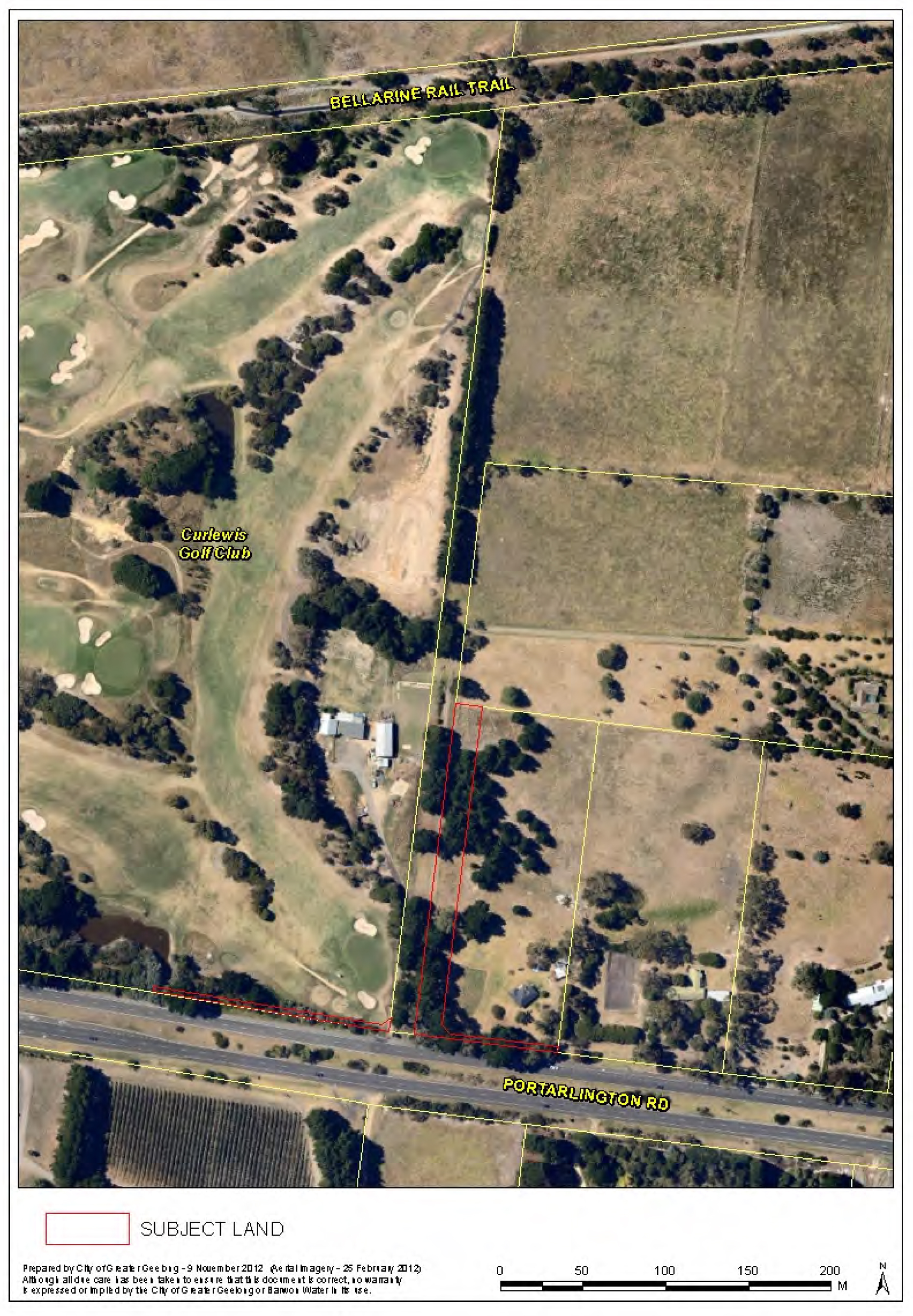
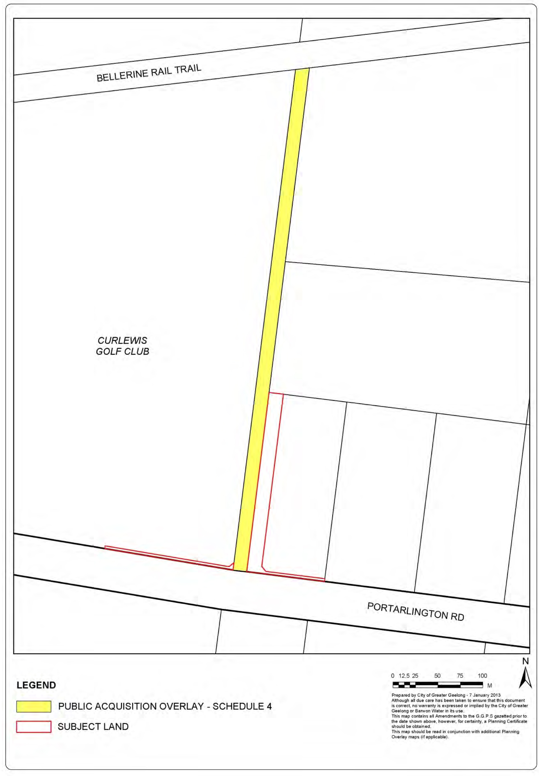
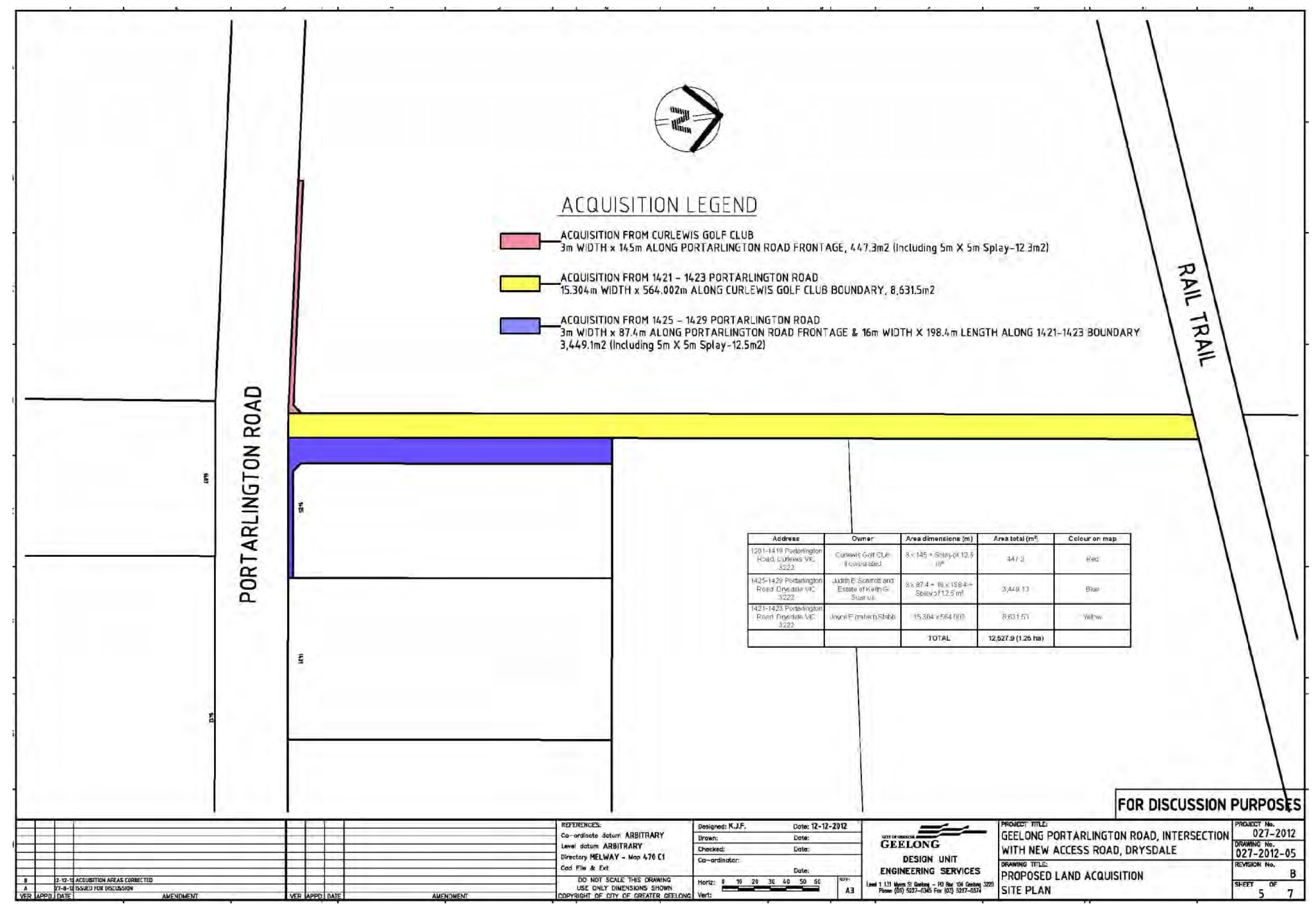
No. |
Name |
Address |
Type |
Summary of Submission |
1. |
Curlewis Golf Club |
1345 Portarlington Road, Curlewis, VIC 3222 |
Objection |
Objection formally withdrawn on 20 May 2014. |
2. |
Department of Environment and Primary Industries |
State Government Offices Cnr Fenwick & Little Malop Streets |
Submission |
No objection. |
3. |
Judith E Scarrott C/O Robertson Hyetts Solicitors |
386 Hargreaves Street PO BOX 337 BENDIGO 3552 |
Submission |
Submission on behalf of affected landowner at 1421-1423 Portarlington Road, DRYSDALE VIC 3220. No objection. It is the landowner’s assumption that when the amendment is approved there will be a compulsory acquisition process. Following this, the landowner will be offered compensation for the land acquired and if they are not happy with the compensation offered, will have the opportunity to obtain their own valuation as to the value of the land acquired. |
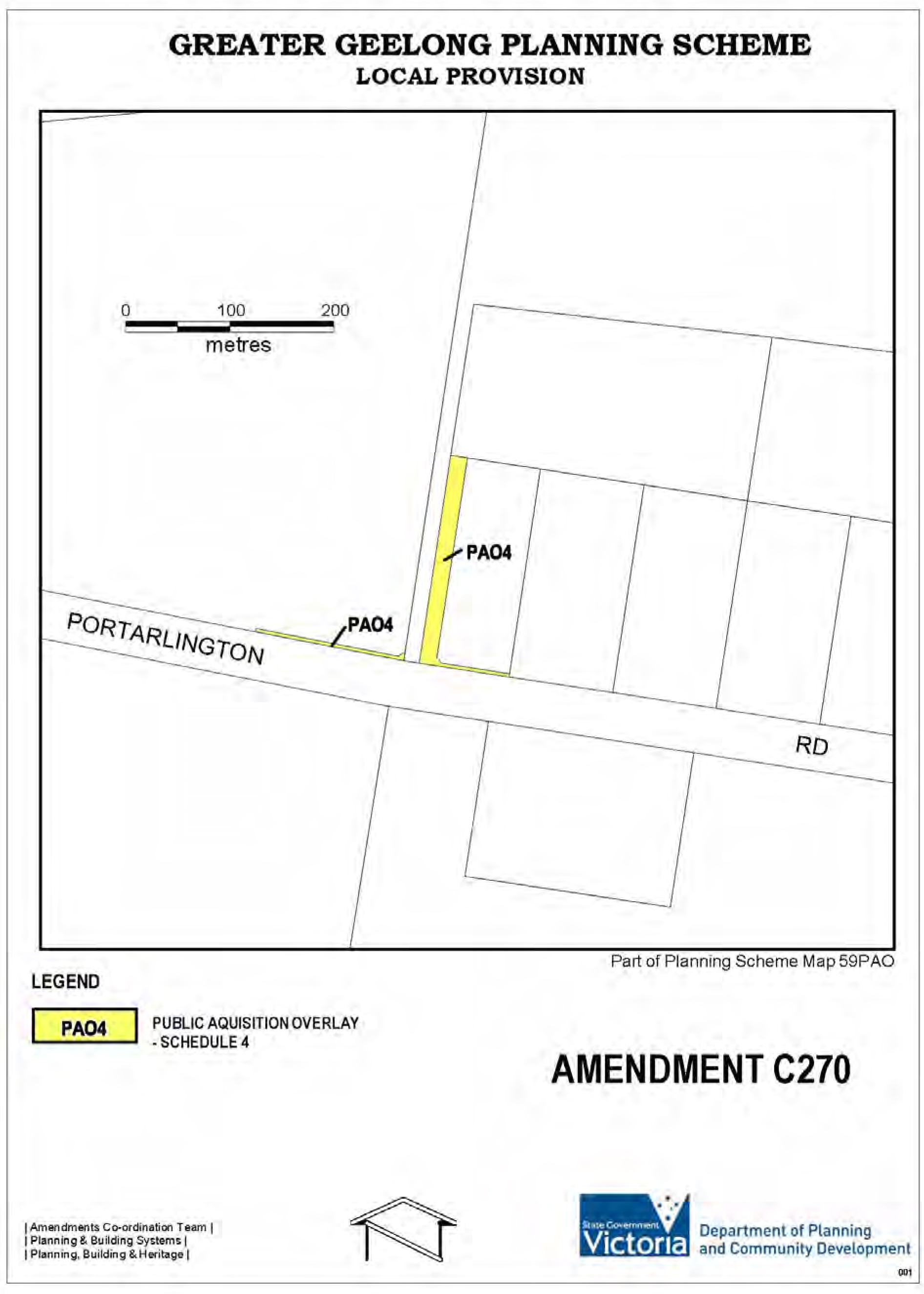
Portfolio: |
Planning - Cr Heagney |
Source: |
Planning and Tourism - Strategic Implementation |
General Manager: |
Peter Bettess |
Index Reference: |
Application: C296 |
This report considers the Panel Report on Amendment C296 and recommends adoption of the amendment with changes.
The Amendment is proposed to allow Council discretion to consider a planning permit application for the display of promotion and major promotion signs at Simonds Stadium, including on the light towers.
The Amendment proposes to amend the schedule to the Public Park and Recreation Zone (clause 36-02) to identify the applicable Advertising Sign Category for 360-380 Moorabool Street and 10 Kilgour Street, Geelong (Simonds Stadium, Kardinia Park) as Category 2.
The purpose of advertising signage is to create a revenue stream towards the cost of operating the lights. This is turn creates a lower price point for the Stadium to attract events and promoters to use the facility.
Amendment C296 was placed on public exhibition from 23 October 2013 to 13 December 2013. Seven submissions were received of which two either supported or offered no objection, one sought involvement in the design and placement of advertising and four objected to the amendment.
Council considered the submissions at its meeting on 11 February 2014 and with the benefit of the light towers being in place, Council supported a change to the exhibited amendment to describe the land that is subject to Advertising Sign Category 2 as the land ‘up to a height of 20 metres above natural ground level’, and based on legal advice, also determined to change the address description to remove reference to the commercial name of Simonds Stadium from the proposed schedule to Clause 36.02.
With these changes supported, Council resolved to refer the submissions to an Independent Panel appointed by the Minister for Planning.
Having considered the amendment, submissions and presentations put to it, the Panel has recommended the Amendment be adopted with changes. The Panel supports Council’s post exhibition change to limit the height of any signage to 20 metres above natural ground level.
The Panel recommends that the amendment clearly identify where the Advertising Sign Category 2 will apply at Simonds Stadium and, to remove the potential for debate about whether promotion signs can be considered, adjust the Advertising Sign Guidelines incorporated document to exclude the area affected by the Amendment C296 from the scope of the Guidelines.
The Panel also recommends that Council consider requesting evaluation of future applications for signs at Kardinia Park that are visible from outside the Stadium by a Planning Application Committee. This is considered unnecessary and as Council administers its role as Responsible Authority professionally and objectively.
Three of the Panel’s recommendations are supported, and the revised Amendment can now be adopted.
Cr Heagney moved, Cr Ansett seconded -
That Council:
adopt Amendment C296 in the form outlined in Appendix 3 of this report; and
submit the adopted Amendment with the prescribed information to the Minister for Planning requesting approval.
Carried.
Council is the proponent for Amendment C296 which seeks to amend the schedule to the Public Park and Recreation Zone (PPRZ) to identify the advertising sign category for Simonds Stadium as Category 2.
In 2012 the Geelong Football Club raised with Council the need to obtain a planning permit for signage to be installed on the then impending four new light towers. It was determined that the type of signage proposed was not permitted within the current provisions of the PPRZ.
Simonds Stadium, Kardinia Park is a significant Geelong asset with the capacity to seat approximately 33,500 patrons for AFL and other sporting/entertainment/community events and uses. The installation of light towers at the Stadium is expected to facilitate increased usage by a wide variety of sports/outdoor activities.
Council seeks to generate revenue from the installation of signage on the light towers to meet the costs of providing electricity capacity for the light towers.
The Public Park and Recreation Zone applying to Simonds Stadium, Kardinia Park prohibits the display of promotion and major promotion signs, as advertising signage requirements are in the default Category 4 – Sensitive areas.
The exhibited amendment proposes to amend the advertising signage category applicable to Simonds Stadium Kardinia Park to facilitate the display of promotional signage at the Stadium, which would otherwise be prohibited under the advertising controls of clause 52.05. This change will allow Council discretion to consider a planning permit application for the display of promotion and major promotion signs at this major Geelong sporting/entertainment venue, including on the light towers.
Appendix 1 shows the land subject of the amendment.
Amendment C296 was placed on exhibition between 23 October and 13 December 2013. Notices were placed in the Geelong Advertiser, the Independent and sent to all relevant public authorities and prescribed Ministers.
As a result of the exhibition of the Amendment the Council received a total of 7 submissions. Of these, 2 either supported the Amendment or offered no objection, 1 from a sporting organisation seeking involvement in the design and placement of advertising and 4 objected to the Amendment.
The key issues raised in objecting submissions include: impacts on visual amenity of the City, impact on road safety, opposition to any more changes at Kardinia Park, dispute about the operational costs of the light towers and need for advertising, sporting club involvement in the location and design of advertising signs.
The issues raised in the submissions were considered by Council at its meeting on 11 February 2014. Council resolved to refer all submissions to an Independent Panel appointed by the Minister for Planning.
A Directions Hearing on 3 March 2014 was conducted at Council offices in Geelong. Other than Council, there were no requests to be heard made to the Panel. Consequently an ‘on the papers’ process was adopted which provided the opportunity for written submissions from Council and the submittors, with a right of reply available to Council. This process was conducted over during March and April. On 17 April the Panel requested further information regarding:
Council's expectation about whether the more liberal advertising opportunities would apply to the Stadium only or would extend to other parts of Kardinia Park.
If the Category 2 extends to other parts of the Kardinia Park, would the Recreation Reserve Advertising Signage Policy or some other policy apply to applications for permits.
The Advertising Sign Guidelines, City of Greater Geelong, November 1997, which is incorporated in the planning scheme (Clause 81) and is referred to in Council's submission. Council's view was sought on:
Its implications for decision making if the Amendment proceeds.
Whether the incorporated document should be amended.
Officers responded to this Panel request on 23 April.
The Panel submitted its report to Council on 12 May 2014.
The Panel report recommends that the Amendment be adopted. Its overall conclusions are that:
Given the nature of Kardinia Park, it is reasonable to provide wider discretion to consider applications for signs on Simonds Stadium and the associated light towers.
The scope of the change to the advertising category applied should be clarified by including a map in the schedule to Public Park and Recreation Zone, rather than relying on the street address, which applies to a much more extensive part of the Kardinia Park.
Council’s response to submissions to apply a 20 metre maximum height of signs appropriately limits the potential visual impact of signs on the towers on the Geelong skyline.
The permit process can address impacts from within the park and its immediate environs.
The Panel recommends including in the schedule to the Public Park and Recreation Zone, a map delineating the Simonds Stadium and associated light towers as the area to which Category 2 advertising controls apply.
Council Officer Response - This is supported and has been included in the amendment for adoption.
The Panel recommends that the Incorporated Document Advertising Sign Guidelines November 1997 should be amended to exclude the area affected by Amendment C296 from the scope of these Guidelines to remove the potential for debate about whether promotion signs can be considered. As the exhibition process for Amendment C296 has enabled relevant issues to be raised and considered, this change should not require further notice or a separate amendment.
Council Officer Response - This is supported and will remove any doubt or ambiguity for Council in its role as Responsible Authority. This change has been included in the amendment for adoption.
The Panel also suggests that perceptions of a conflict of interest in the evaluation of the advertising proposals could be minimised by referring future applications for signs at Kardinia Park (that are visible from outside the Stadium) to a Planning Application Committee.
Council Officer Response - In its role as Responsible Authority, Council deals professionally with planning permit applications from a range of Council departments on a regular basis and has been able to objectively operate and make planning permit decisions. It is considered unnecessary to convene a special Planning Application Committee to evaluate future applications for signage at Simonds Stadium.
A copy of the Panel’s report has previously been circulated to all Councillors. Appendix 2 is the Panel’s Overall conclusions and recommendations section of the Panel’s report.
The Panel’s recommendations are supported and therefore the Amendment with incorporating the changes can be adopted. Appendix 3 is the Amendment recommended for adoption, including the changes recommended by the Panel.
The amendment has no environmental implications. It will facilitate a planning permit to be considered for promotion and major promotion signs. The visual impact of any proposed signs will be assessed at the time of consideration of a planning permit application.
There are no financial implications arsing from adoption of this amendment.
The Panel has supported the amendment including the post-exhibition changes supported by Council. The revision to the Advertising Sign Guidelines 1997 recommended by the Panel will clarify the ambiguity between the proposed amendment provisions and the Guidelines.
The Amendment supports the Growing our Economy strategic direction of City Plan, in particular the priorities of supporting the growth of Greater Geelong as a leading city for tourism, arts, culture and events and promoting the unique strength of the region such as our world class sporting facilities.
Through the action of completing the Players Stand and associated lighting, and the ongoing management of Simonds Stadium, the amendment will take the next step to enable promotion and major promotion advertising signs to be considered for display at this national sporting and entertainment venue.
No Council officers have any direct or indirect interest, in accordance with Section 80(c) of the Local Government Act to which this Amendment relates.
The adoption of this amendment is considered to be low risk.
Simonds Stadium, Kardinia Park is a significant Geelong asset with the capacity to seat approximately 33,500 patrons for AFL and other sporting/entertainment events and community uses. The installation of light towers at the Stadium is expected to facilitate increased usage by a wide variety of sports/outdoor activities.
The amendment will enable Council to consider a planning permit application for the proposed signage on the light towers. Elevated signage on the light towers could negatively impact on the natural and built environment of Kardinia Park and the broader Geelong urban area. It will be important that any light tower signage complements the role of Simonds Stadium, the aesthetic of the light towers and does not detract from the quality of the urban environment of Geelong.
The proposal does not impact on any human rights and responsibilities set out in the Charter. Planning legislation ensures an open community consultation process enabling people to freely express their views and if necessary obtain a fair hearing before an Independent Panel.
The Amendment has been exhibited in accordance with the provisions of the Planning and Environment Act and exemptions provided by the Minister for Planning. All submittors were provided with an opportunity to submit written submissions to an Independent Panel appointed by the Minister for Planning.
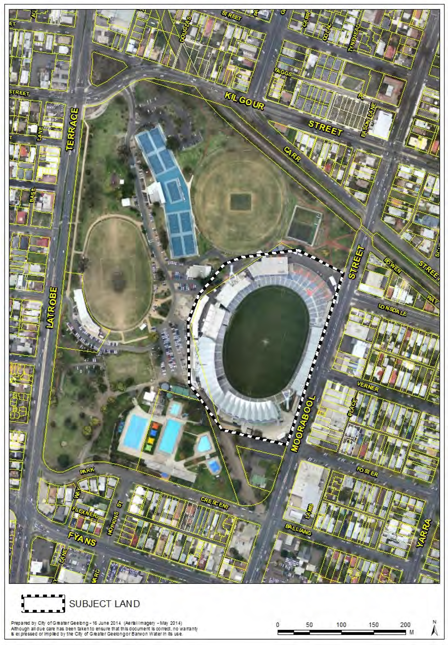
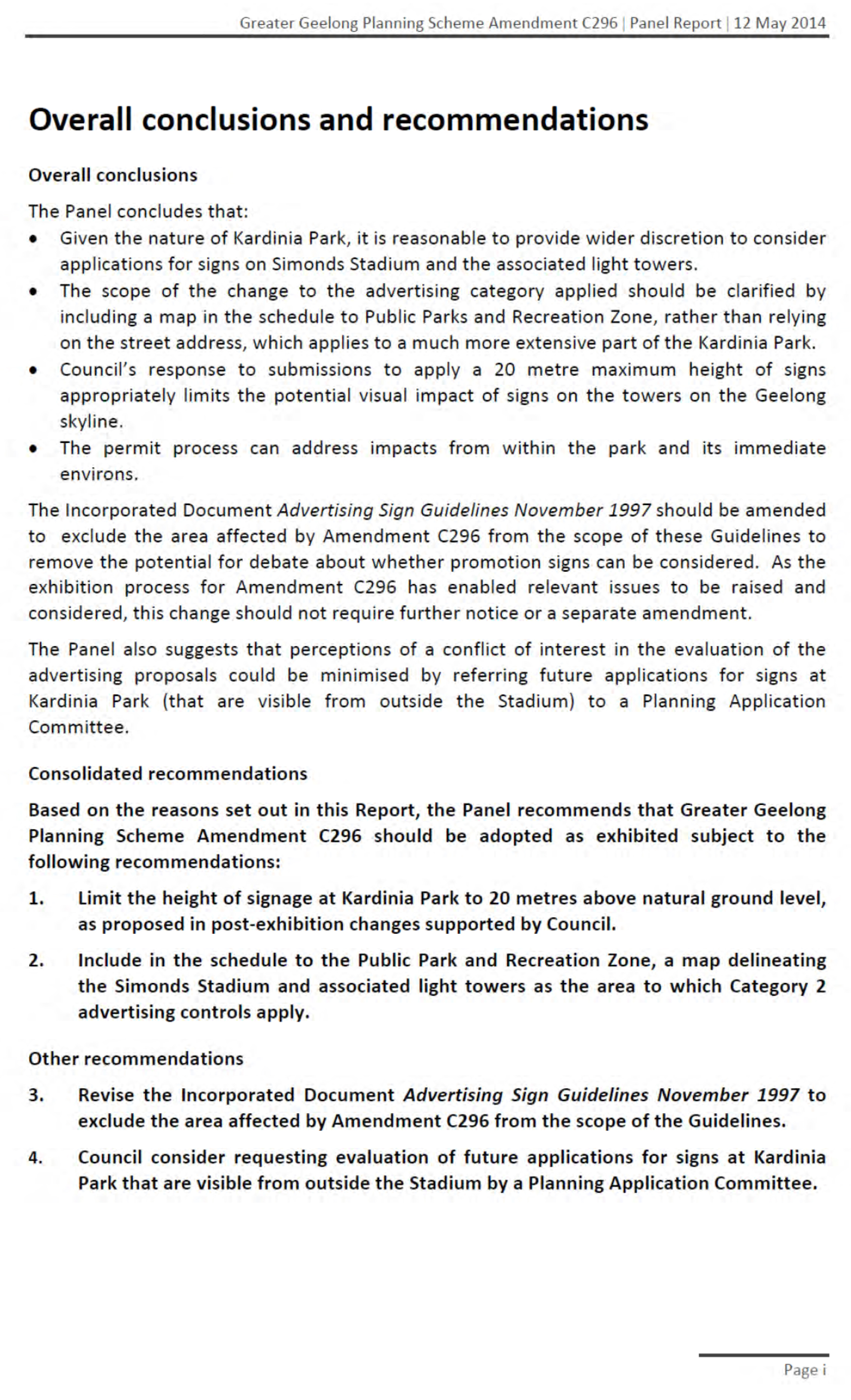
Planning and Environment Act 1987
The planning authority for this amendment is the City of Greater Geelong.
The Greater Geelong Planning Scheme is amended as follows:
The Planning Scheme Ordinance is amended as follows:
In Zones – Clause 36.02s, replace the Schedule with a new Schedule in the form of the attached document.
End of document
|
SCHEDULE TO THE PUBLIC PARK AND RECREATION ZONE |
||
07/03/2013 |
Public land | Use or development | Conditions |
|
Ocean Grove Park, 73-87 Presidents Avenue, Ocean Grove |
Use or development in accordance with the Ocean Grove Park Development and Management Strategy June 2000 prepared by Ocean Grove Park (Ingamells) Inc. |
Must be in accordance with the conditions included in the Ocean Grove Park Development and Management Strategy June 2000 prepared by Ocean Grove Park (Ingamells) Inc. |
|
Armstrong Creek East Precinct |
Use or development in accordance with the Armstrong Creek East Precinct Structure Plan |
None specified |
|
Armstrong Creek West Precinct |
Use or development in accordance with the Armstrong Creek West Precinct Structure Plan |
None specified |
|
Land | Advertising Sign Category | |
|
Ocean Grove Park, 73-87 Presidents Avenue, Ocean Grove | Category 3 |
|
|
Land at the sports stadium at Kardinia Park including the light towers up to a height of 20 metres above natural ground level as shown on Map 1 below | Category 2 |
|
|
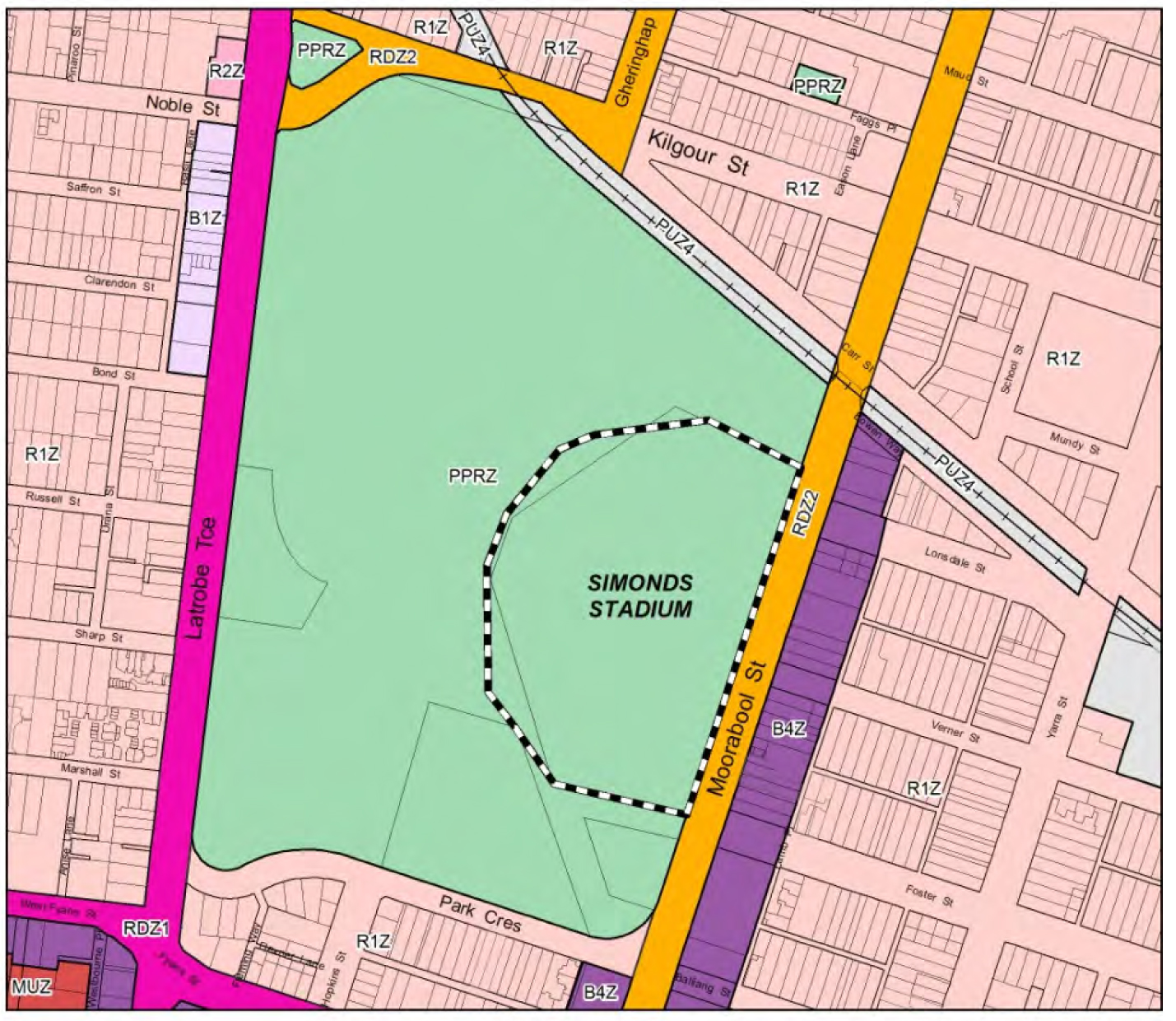
Map 1 to the Schedule to the Public Park and Recreation Zone |
||
The area of the sports stadium and light towers at Kardinia Park, South Geelong as shown on the map below are excluded from the scope of these Guidelines.
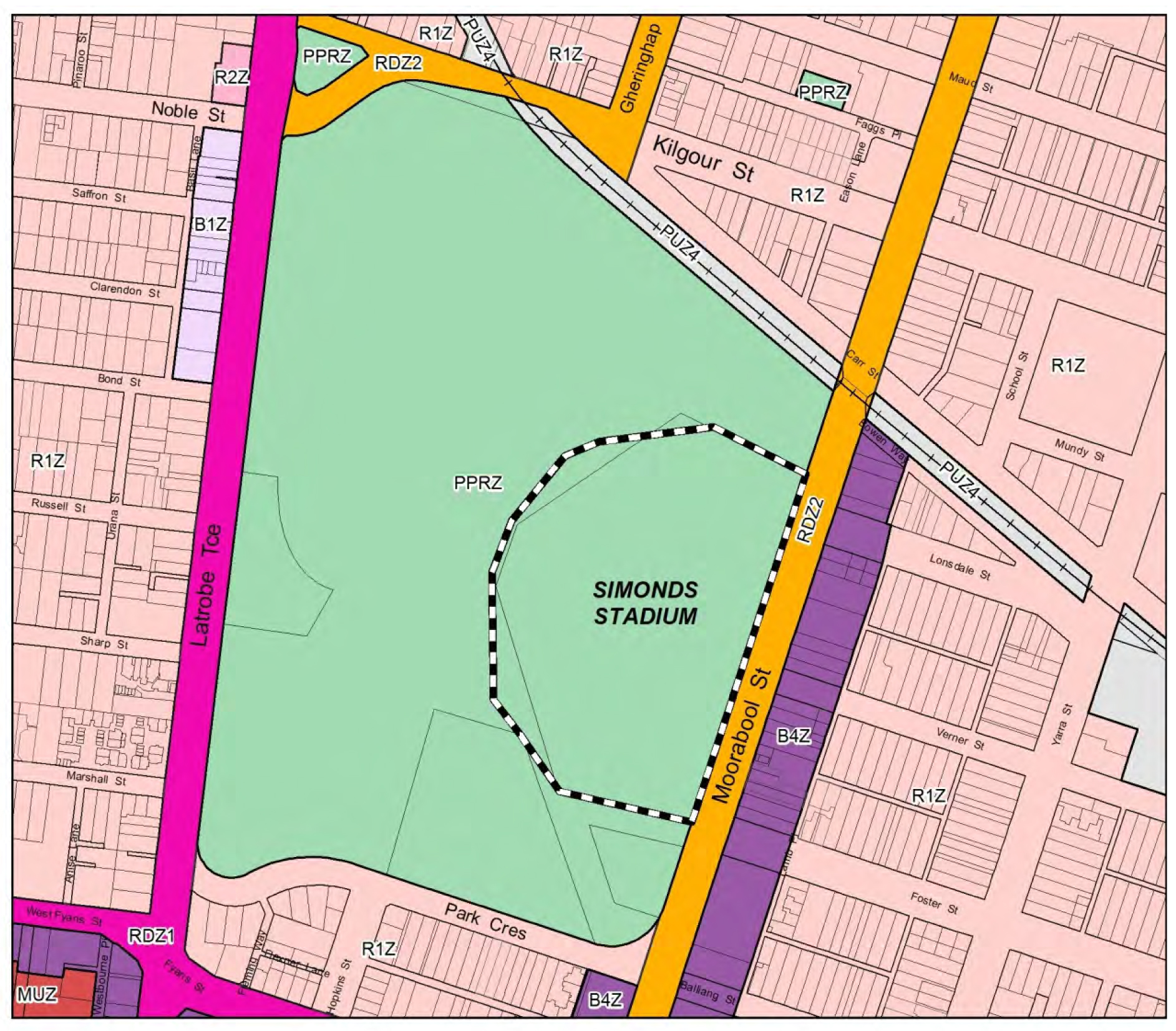
Portfolio: |
Finance – Cr Lyons (Mayor), Cr S Kontelj & Cr E Kontelj |
Source: |
Corporate Service – Property Management |
A/General Manager: |
Michael Kelly |
Index Reference: |
Land Sales |
The purpose of this report is for Council to consider submissions to the notice of intention to sell land at 77-79 Draper Street and 128-130 Asbury Street East, Ocean Grove (‘the land”). It is recommended that Council sell the land.
In September 2014, Council gave public notice of its intention to sell four lots at 77 79 Draper Street and 128 130 Asbury Street, Ocean Grove (“the land”). The land is zoned Public Park and Recreation (PPRZ) and was formerly used for netball before that use was relocated to new courts at the Shell Road Reserve.
Amendment C299 to rezone the land to General Residential Zone is being processed at the same time. At its meeting on 8 July 2014 the Council resolved to adopt Amendment C299 and request Ministerial approval.
At the close of the sale of land notice period one submission had been received and the Submission Review Panel (“the Panel”) met on 3 June 2014 to hear submissions. Following notification of all planning submitters that they could lodge submissions to the sale of land process, a total of five submissions were received and the Panel heard submissions from three submitters.
The objecting submissions included objecting to the sale of open space, wanting the land used for recreation or tennis courts, questioning of the basis of Council’s intention to sell the land, and seeking further consultation.
One submission from a private individual supported by Karingal, was seeking land to be made available for supported accommodation for people with disabilities.
Changing the use of the land from open space to residential has been established through the provision of open space in the immediate area, and supported by the Planning Panel and Council’s approval of amendment C299. The Submissions Review Panel also supports the use of the land for residential purposes. The sale of land formerly used for netball courts is based on the increased investment in sporting infrastructure at Shell Road Reserve, and the establishment of Council’s intention to sell the land in various public reports.
The Submissions Review Panel recommended that two lots be sold and the remaining two lots to be made available at nil consideration for supported accommodation for persons with disabilities. The minutes of the Panel’s meeting are in Attachment 2 to this report.
It is recognised there is demand for supported accommodation, and in the past the Council has sold land to a provider for this purpose, however providing financial support for housing is not a strategic priority for the Council.
Given the Council’s prior commitment to sell the land to offset the significant cost of providing Ocean Grove sporting infrastructure, and the subsequent implementation of that infrastructure, it is recommended that the land be sold.
Cr Farrell moved, Cr Fisher seconded -
That Council in relation to the land at 77 and 79 Draper Street and 128 and 130 Asbury Street East, Ocean Grove, having given public notice of its intention to sell all the land and considered all submissions received:
Calls for expressions of interest from not for profit providers of supported accommodation for people with disabilities (“the intended purpose”) to take ownership of the land at 77 and 79 Draper Street as follows:
The land will be transferred to a provider without consideration.
A s173 Agreement will be attached to the title specifying that:
2.1. The owner will construct a building on the land for the intended purpose;
2.2. The owner must commence to develop of the land for the intended purpose within 12 months from the date a planning permit is issued;
2.3. If the land ceases to be used for the intended purpose the Council has the option to buy back the land by paying appropriate compensation for the owner’s improvements, or cause the land to be sold by the owner with the unimproved land value being paid back to the Council;
That the expressions of interest process be appropriately defined through a terms of reference including the decision making process and selection criteria approved by Council.
That the contract of sale and s173 Agreement contain other appropriate terms and conditions.
Proceeds to sell the land at 128 and 130 Asbury Street East on the market by a public process through an agent as follows:
That the price will be no less than a certified valuation which is made not more than 6 months prior to the date of sale;
That the contracts of sale contain the appropriate terms and conditions.
Notifies in writing each person making a submission of the Council’s decision and reasons for that decision.
Carried.
Division Requested:
For: Crs Ansett, Nelson, Ellis, Fisher, Harwood, Macdonald, Richards, Heagney, Farrell, Irvine
Against: Crs S Kontelj, E Kontelj, Lyons
The Council is the owner of land at 77 79 Draper Street and 128 130 Asbury Street, Ocean Grove (“the land”). The land consists of four residential lots zoned PPRZ which have been used for two netball courts and a club room and was previously occupied under licence from the Council to the Ocean Grove Sporting Club Incorporated.
A new facility has been constructed at the Shell Road Recreation Reserve and it is proposed to rezone the old courts and sell the land (refer to Attachment 1).
The land consists of four residential sized allotments each of which are or are capable of being provided with separate titles. The lots are fully serviced.
At its meeting on 27 August 2013 Council resolved to give notice of its intention to sell the land, and notice under s189 of the Local Government Act was given in City News on 13 and 14 September 2013. One written submission had been received at the close of the submissions period.
All persons making a submission to the planning amendment C299 were advised of the notice of intention to sell the land and invited to make a sale of land submission under the Local Government Act. As a result of this advice two additional submissions were received and two further submitters appeared at the hearing
Council’s decision to given notice of intention to sell the land is based on commitments given in the following reports which were well publicised and involved public consultation processes.
Bellarine Peninsula Recreation and Leisure Needs Study 2005.
Report quote: (Relating to a recommendation to move the netball courts to Shell Road Reserve)..”Opportunities to sell the existing Draper Street site should be explored to help fund the development of new facilities.”
Ocean Grove Sporting Infrastructure Plan 2010.
Report quote: “Relocate netball courts to Shell Road Reserve. Sell existing netball court land.”
The land is currently the subject of amendment C299 to the Greater Geelong Planning Scheme to rezone the land from PPRZ to General Residential Zone. The Planning Panel has heard planning submissions and has submitted its report recommending that the rezoning proceed. At its meeting on 8 July 2014 Council resolved to:
Adopt Amendment C299 as outlined in the report; and
Submit the adopted Amendment together with the prescribed information to the Minister for Planning requesting approval.
The Submissions Review Panel met to hear submissions on 3 June 2014. The Panel consisted of Councillors Heagney (Chair), Farrell, Fisher and Ellis. Submitters appearing at the hearing in support of their submissions are marked with an asterisk *.
The following is the response to written submissions received both prior to and at the hearing.
Bernadette Peterson
1.1 Submission. Objects to the Council’s intention to sell off open space.
Response. The Council’s decision to sell land formerly used for open space is based on two strategies which formed the basis for the extensive investment in sports facilities on the land at Shell Reserve. These reports are:
Bellarine Peninsula Recreation and Leisure Needs Study 2005, and
Ocean Grove Sporting Infrastructure Plan 2010.
Both reports foreshadowed the sale of the land to help offset the cost of the new sports infrastructure at Shell Road Reserve which includes the soccer grounds (existing), swimming pool, football oval, skate park, netball courts, cricket nets, tennis courts and associated parking and lights. The total cost of the new sports infrastructure built on the reserve since 2010 is $6.4m which excludes the soccer grounds, swimming pool and skate park which were constructed earlier.
A new multi purpose pavilion is planned to service much of the new infrastructure and is expected to cost a further $5.5m.
1.2 Submission. Pending Federal and State Elections will resolve financial challenges associated with the relocation of the netball courts (to Shell Reserve).
Response. Of the total amount spent on the new sporting infrastructure at Shell reserve since 2010, approximately 60% has been from government grants. There is no indication that additional Government funding will be received to support the Council’s contribution.
1.3 Submission. The site continues to be used as a pedestrian link to the Memorial Reserve and the neighbourhood shopping centre in Madeley Street.
Response. The Memorial Reserve is located immediately to the south of the land proposed to be sold. While it is acknowledged that some use may be made of the land by residents in Asbury Street to access the Memorial Reserve, convenient access will still be available via Wedge Street some 83 metres to the east.
It does not appear that the land would function as a link to the Madeley Street shops other than providing an alternative access to the existing street pattern.
1.4 Submission. Retaining the land presents an opportunity to extend the Memorial Reserve in future onto the land.
Response. The Memorial Reserve has an area of 2.47ha and there are no plans to extend this reserve which will remain a venue for active sports being available for community casual use at other times. The perimeter fence will also be demolished providing easier casual access.
1.5 Submission. With increasing population and housing density the land should retained and enhanced to service demand.
Response. The retention of the Memorial Reserve presents more than enough land to serve the needs of any foreseeable increase in population density in the immediate neighbourhood.
In terms of the general provision of open space within and immediately adjacent to Ocean Grove it is noted that the township is very well provided for. The existing urban area spans 968ha and within and immediately adjacent to the township there exists 298ha of open space areas of greater than 1ha including various parks, the nature reserve, foreshore and drainage wetlands (smaller parks and school grounds excluded). There are several major reserves with a total area of 66ha located within the conventional housing areas of the township including Memorial Park, Ocean Grove Park, Shell Road Reserve, Kingston Park and the Emperor Drive wetlands. The township has a population of 13,000 and 25% of the existing urban area is developed and zoned for low density development.
Kim McGough*
2.1 Submission. Has the Council assessed the retention of the land for community or public purposes and has the community been consulted on alternative uses for the land?
Response. In making decisions to invest in the major upgrading of the Shell Road Reserve the Council foreshadowed the possible sale of the land in both the 2005 and 2010 reports. Both reports were prepared with public input and both were made available in draft form for public comment prior to being adopted and published. Given the significant investment in upgraded facilities at Shell Road Reserve and the sufficient provision of open space locally and within the township, there exist no compelling reasons for the Council to alter its intentions in relation to the land.
The notice of intention to sell the land represents a further consultation process.
2.2 Submission. What action is the Council taking to address the finding in the 2005 report that there are gaps in categories of open space and poor links.
Response. The finding of the 2005 report referred to in the submission is specifically in relation to Collendina. The report noted that “Overall the provisions of open space is significant” for the whole of Ocean Grove.
2.3 Submission. What action does the Council propose to take to compensate for the significant loss of informal open space at the Shell Road Reserve.
Response. Shell Road Reserve has an area of 13.1 ha and of that approximately 16% is occupied by buildings, access and car parking. While the construction of buildings and car parking on parkland does occupy land that would have otherwise been open space, such facilities are related to and support the use of the land and will support increased use of the Reserve and increase community well being.
The Shell Road Reserve was originally purchased by the former Shire of Bellarine as the future shopping centre for the township, and over time that intention has changed to total use for recreation and sporting purposes.
2.4 Submission. Why hasn’t the Council applied for State funding to assist the construction of the shared use pavilion at Shell Road Reserve?
Response. The Council has received a $3.5m Commonwealth grant to assist with the $5.5m construction cost of the pavilion. The maximum grant on offer from State sources at the time of committing to the project was $650,000 and it was considered unlikely that grants from both sources would be successful.
Anne Treble Ocean Grove Tennis Club Inc
3.1 Submission:
The Club wants the land retained for sporting use including tennis.
The Club and the population continue to grow.
Junior tennis is played at Marcus Hill and Wallington.
New courts will allow the competitions to grow.
Lack of lighting is restricting opportunities to grow.
Response. The Ocean Grove Tennis Club has a strong membership and participation which places pressure on their existing facility in Madeley Street. It is not unusual for successful clubs to use other facilities at peak demand times to satisfy demand. There are 12 tennis courts located at both Madeley Street and Shell Reserve which represents a higher provision of courts to population than indicated by the relevant planning standards.
Evan Hardie*
4.1 Submission. Is the Bellarine Recreation and Leisure Study 2005 still relevant?
Response. The relevance of the Bellarine Recreation and Leisure Needs Study 2005 lies in the framework it provided for more detailed studies such as the Ocean Grove Sporting Infrastructure Plan 2010. Much of the infrastructure that has and continues to be implemented has its origin in the 2005 study.
4.2 Submission. Are the survey results (of that Study) still relevant and accurate?
Response. The purpose of highlighting the surveys and consultation processes undertaken in the course of both the 2005 and 2010 studies is to demonstrate wide community input into formulating needs. Both the 2005 and 2010 studies foreshadowed the sale of the land and both were published as drafts for public comment prior to finalisation.
4.3 Submission. Is the sale of the land based on short term budget consideration?
Response. The sale of the land is based partly on budget considerations being aimed at offsetting the cost of the provision of new sports infrastructure at Shell Road Reserve.
4.4 Submission. Is the (2005) survey potentially misleading to the Planning Panel?
Response. The Planning Panel has provided its own report relating to planning matters within amendment C299.
4.5 Submission. Has the need for informal open space been underestimated?
Council undertakes planning for open space as a network incorporating active and passive open space. Passive (or informal) open space generally consists of a wide range of uses, such as playgrounds, conservation/nature reserves, parks, community gardens, foreshore areas and trails. Passive open space is vital for community health and well-being. The relocation of sporting clubs to Shell Road will allow for increased passive/informal use of Ocean Grove Memorial Reserve at a local level. From a local open space provision perspective, the sale of the land does not impact the ability of residents to access passive open space within a 400 metre walkable catchment.
Ocean Grove generally has a high proportion of existing open space, particularly when passive open space areas such as the foreshore and Barwon River are taken into consideration. All categories of open space are taken into account when planning for the future provision of open space for the community. Active and passive open space is required in all new residential developments to ensure that population growth does not place pressure on the existing open space network.
4.6 Submission. Were the guidelines in the Ocean Grove Sporting Infrastructure Plan 2010 not adequately appreciated by the Planning Panel?
Response. The Planning Panel has provided its own report relating to planning matters within amendment C299.
4.7 Submission. Other sources of funding should be found to fund infrastructure.
Response. The Council makes every effort to access all funding sources for capital projects. It is not unusual for the Council to sell land assets that are no longer required as a result of the construction of replacement and upgraded assets. Such actions are a normal part of the asset management cycle.
Jane Thomas* and Robyn Bradshaw (Karingal)*
Submission. There is a need for supported accommodation in Ocean Grove where specialist housing is provided for people with disabilities to live semi independently. A flat site is being sought with access to community facilities. If land can be made available an organisation will be formed to take ownership and raise funds for construction and operation of the facility.
Response. Refer to Attachment 2 and the Conclusion and Recommendation section below.
Consideration of Submissions by the Submission Review Panel
The minutes of the Submissions Review Panel are in Attachment 2 to this report.
Conclusion and Recommendation
Following consideration of all submissions and the hearing of submissions it is recommended that the Council proceed with the sale of all 4 lots on the market.
The Council has adequately addressed the submissions seeking that the land should be retained for open space through the provision of sufficient open space in the general area, and proposed improvements to the adjacent Memorial Reserve. The use of the land for residential purposes has been supported through the planning amendment process by both the Planning Panel and the Council acting as the responsible planning authority. The Submissions Review Panel also supports the residential use of the land and its eventual disposal.
The sale of the land is established through the planning for and implementation of significant new sporting infrastructure for the township at the Shell Road Reserve. Both 2005 and 2010 reports anticipated the sale of the land to offset the cost of construction of major sports infrastructure, and both reports were widely communicated and enabled public input at the draft report phase.
Once the new multi use pavilion is completed in 2015 a total of $11.9m will have been spent at the Shell Road Reserve since 2010, 38% of which will have been funded directly by the Council with the balance coming from government grants. The earlier construction cost of the soccer grounds and indoor pool at the same reserve are in addition to the more recent expenditure. This is a significant financial commitment to the provision of high value recreation and sporting infrastructure which will contribute to community wellbeing into the future. The sale of the land completes this commitment.
While the Ocean Grove Tennis Club is using courts in other locations to satisfy demand, the current provision of public courts in Ocean Grove more than meets the required standards, and the use of alternative facilities is a normal and adequate means of satisfying demand.
It is recognised that demand exists for supported accommodation for people with disabilities not just in Ocean Grove but around the municipality and, in the past, the Council has sold land to a provider for this purpose. If providers want to purchase the land they have been able to approach the Council up to now or can participate in the pubic sale process in future. Providing financial support for housing is not a strategic priority for the Council.
It is proposed to obtain a preliminary environmental site assessment of the land in relation to its apparent historic use as a Council depot.
There is no significant native vegetation on the land.
Under the former occupancy licence the Ocean Grove Sporting Club paid total annual fees of $359. Income from the sale of the land is expected to exceed $1,400,000.
The proceeds from the sale of the land will be non recurrent income for which provision has been made in the 2014-2015 Budget. If the property is either not sold or partially sold, then this would create a funding gap in Council’s 2014-2015 Budget. As property assets are disposed of, the written down value is adjusted on the asset register.
There are unbudgeted costs associated with returning Memorial Reserve to Public open space. These are estimated at $100,000 and would be included as a 2015-2016 Budget proposal.
Section 223(1)c of the Local Government Act (“the Act”) provides that the Submissions Review Panel is not responsible for making the decision in respect of which the submissions have been made, but must provide a report on its proceedings, including a summary of hearings, to the Council. This report provides the required report from the Panel on proceedings, including the summary, and further provides a commentary on the Panel’s discussion about the sale of the land. The response to the submissions and the recommendation in this report are provided by the management.
Under the Local Government Best Practice Guideline for the Sale and Exchange of Land, the Council is required to ensure that “prior to being offered for sale, property should be appropriately zoned. This will ensure that the ultimate use of the land is determined by that zone and the highest possible sale price is achieved.” Amendment C299 proposes to rezone the land to General Residential prior to sale.
Under the same Guideline land is required to be sold by a public process, the method to be used will be decided in consultation with the appointed agent.
Section 189 of the Local Government Act (“LG Act”) requires that Council obtain a certified valuation dated not more than six months prior to the sale of the land being the date of the contract of sale. Prior to sale a certified valuation of the land will be obtained for each of the lots and the final sale price will not be less than the Council’s valuation.
The recommendation supports the action priority relating to Responsible and Sustainable Financial Management where the sale of assets no longer required will support the identified progress indicators.
No officers or contractors involved in the preparation of this report have a direct or indirect interest in matters to which this report relates.
The risks associated with sale of this land are able to be managed following normal management procedures and processes.
There are no social implications associated with the recommendations of this report.
There are no positive or negative human rights matters associated with the recommendation of this report.
The sale of the land is supported by the Sport and Recreation Department.
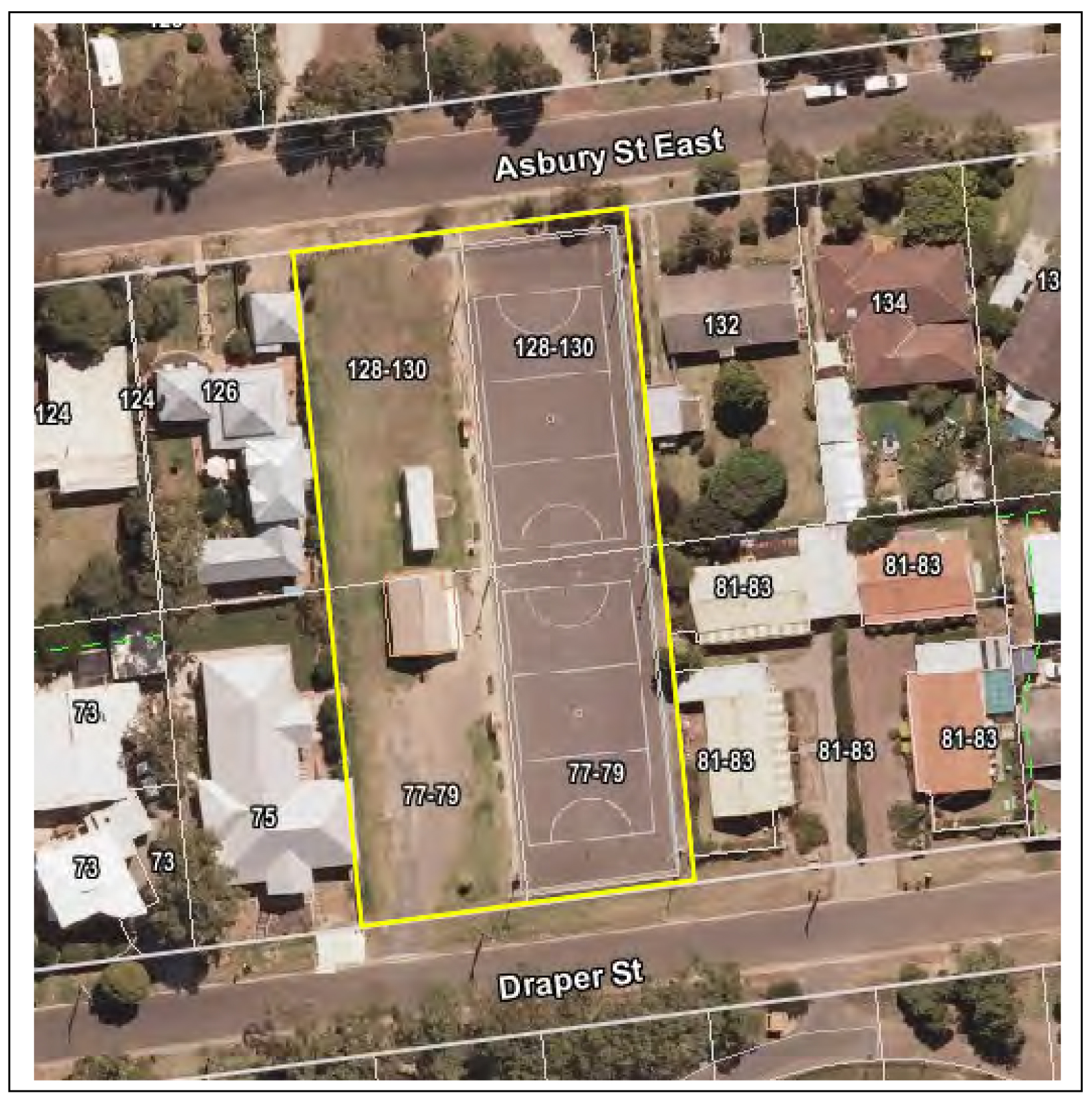
Hearing of Submissions
Notice of Intention to Sell Land at Draper and Asbury Streets Ocean Grove
Report on Proceedings and Summary of Submissions
Present: Crs Heagney (Chair), Farrell, Fisher and Ellis
Also Present: A Grant (CoGG Property Adviser)
Apologies: Crs Ansett, Irvine, E Kontelj, S Kontelj and Richards
Declarations of Interest or Conflicts of Interest: Nil
Items for consideration:
Council’s Notice of Intention to Sell the Land
Alan Grant CoGG outlined the Council’s intention to sell the land.
At its meeting on 27 August 2013 the Council resolved to give notice of its intention to sell the land, and notice under s189 of the Local Government Act was given in City News on 13 and 14 September 2013. One written submission had been received at the close of the submissions period.
The land is currently the subject of amendment C299 to the Greater Geelong Planning Scheme to rezone the land from PPRZ to General Residential Zone. The Planning Panel has heard planning submissions and has submitted its report recommending that the rezoning proceed.
Many of the submissions to amendment C299 objected to the proposed sale of the land. Following the Planning Panel directions hearing the Council was directed to advise all planning amendment submitters of the sale of land process under the Local Government Act to ensure that all parties were aware that the rezoning of land and sale of land are two separate and independent processes. This advice was provided to all planning submitters along with an invitation to make a sale of land submission under the Local Government Act even though the submissions period had ended.
As a result of this advice two additional submissions were received and two further submitters appeared at the hearing. Those submitters appearing at the hearing are marked with an asterisk *.
Summary of Submissions
Bernadette Peterson
1.1 Submission. Objects to the Council’s intention to sell off open space.
1.2 Submission. Pending Federal and State Elections will resolve financial challenges associated with the relocation of the netball courts (to Shell Reserve).
1.3 Submission. The site continues to be used as a pedestrian link to the Memorial Reserve and the neighbourhood shopping centre in Madeley Street.
1.4 Submission. Retaining the land presents an opportunity to extend the Memorial Reserve in future onto the land.
1.5 Submission. With increasing population and housing density the land should retained and enhanced to service demand.
Kim McGough*
2.1 Submission. Has the Council assessed the retention of the land for community or public purposes and has the community been consulted on alternative uses for the land?
2.2 Submission. What action is the Council taking to address the finding in the 2005 report that there are gaps in categories of open space and poor links.
2.3 Submission. What action does the Council propose to take to compensate for the significant loss of informal open space at the Shell Road Reserve.
2.4 Submission. Why hasn’t the Council applied for State funding to assist the construction of the shared use pavilion at Shell Road Reserve?
Anne Treble Ocean Grove Tennis Club Inc
3.1 Submission:
The Club wants the land retained for sporting use including tennis.
The Club and the population continue to grow.
Junior tennis is played at Marcus Hill and Wallington.
New courts will allow the competitions to grow.
Lack of lighting is restricting opportunities to grow.
Evan Hardie*
4.1 Submission. Is the Bellarine Recreation and Leisure Study 2005 still relevant?
4.2 Submission. Are the survey results (of that Study) still relevant and accurate?
4.3 Submission. Is the sale of the land based on short term budget consideration?
4.4 Submission. Is the (2005) survey potentially misleading to the Planning Panel?
4.5 Submission. Has the need for informal open space been underestimated?
4.6 Submission. Were the guidelines in the Ocean Grove Sporting Infrastructure Plan 2010 not adequately appreciated by the Planning Panel?
4.7 Submission. Other sources of funding should be found to fund infrastructure.
Jane Thomas* and Robyn Bradshaw (Karingal)*
5.1 Submission. There is a need for supported accommodation in Ocean Grove where specialist housing is provided for people with disabilities to live semi independently. A flat site is being sought with access to community facilities. If land can be made available an organisation will be formed to take ownership and raise funds for construction and operation of the facility.
Committee Deliberations
The Panel, having heard and considered all written submissions, considers that the land should not be retained for open space use. The Panel recognises the need for supported accommodation for people with disabilities in Ocean Grove and supports offering 2 of the 4 lots for this purpose through a public process which invites providers to make submissions for this purpose. The Panel expressed a preference for the two lots fronting Draper Street to be used for this purpose, with the lots on Asbury Street being sold. The Panel also discussed mechanisms for the lease or transfer of land for this purpose.
Meeting Closed at 6:05pm
Portfolio: |
Transport - Cr Richards |
Source: |
City Services - Engineering Services |
General Manager: |
Gary Van Driel |
Index Reference: |
G21 |
To provide an overview of the development of the final draft G21 Region Public Transport Strategy. The report recommends that the Strategy be adopted.
In January 2013 G21 commenced preparation of a G21 Region Public Transport Strategy to replace the 2009 G21 Integrated Public Transport Strategy which has largely been implemented.
The G21 Region Public Transport Strategy is aligned with the Transport Integration Act, the Regional Growth Plan and the Implementation Plan.
The four Themes of the Strategy are:
Access for all: The G21 Region advocates that a base level of service should be available to all across the region, and that all services should be accessible to potential users.
A well connected region: The G21 Region seeks a public transport network that will serve the need for access to and between the Region’s centres.
Urban public transport for an urban centre: The G21 Region supports developing a ‘go anywhere’ public transport network in Geelong by reshaping and simplifying the current network.
Improving information, planning and partnerships: The G21 Region will take a leadership role in finding new ways to implement better public transport, sooner.
The draft strategy was placed on public exhibition in March 2014. 13 submissions were received and assessed by the G21 Public Transport Working group.
The strategy has now been amended to incorporate recommendations from the working group.
The final strategy is now presented for adoption by all G21 Region councils.
Cr Richards moved, Cr Harwood seconded -
That Council adopt the final G21 Region Public Transport Strategy.
Cr S Kontelj left the meeting room at 10:16pm
Cr S Kontelj re-entered the meeting room at 10:20pm
Carried.
In January 2013 G21 commenced preparation of a G21 Region Public Transport Strategy to replace the G21 Integrated Public Transport Strategy which has largely been implemented.
A comprehensive strategy development process including data analysis and extensive stakeholder consultation in each local government area of the G21 region has been undertaken by AECOM, the consultants appointed for the project, working under the oversight of a project steering committee comprising representatives of each Council, G21 and Public Transport Victoria.
The G21 Transport Pillar has been briefed three times, and the G21 Board also briefed, during the course of the project to keep members informed and to shape the strategy development process.
The state government through Regional Development Victoria recognised the need and importance of this study and has supported the project with a grant of $100,000. Each municipality also contributed both cash and in kind support towards the project.
Timelines
Key milestones in the project have been:
Project inception: January 2013
Stakeholder workshop: March 2013
Completion of strategic context review: May 2013
Community forums: early May 2013
Summit: late May 2013
First draft strategy: June 2013
Final draft strategy: September 2013
Formatting and draft document design: November 2013
Public consultation and Submissions: March – April 2014
Final Strategy prepared: June 2014
The G21 Region Public Transport Strategy has been developed through a rigorous process. The key steps have been:
Background policy/project review, including review of 2009 strategy
Development of strategic frameworks, addressing public transport network design approaches and tradeoffs in service planning
Conversation with community on trade-offs and priorities (discussed below under Consultation and Communication)
Application of data analysis to develop evidence base for change
Development of Strategy and Action Plan, comprising a long-term (20 year horizon) Strategy and a short-term four-year Action Plan
The G21 Region Public Transport Strategy is aligned with the Transport Integration Act, the Regional Growth Plan and the Implementation Plan.
The core of the Strategy addresses the tradeoffs inherent in public transport planning.
There was strong support (upwards of 80 percent) for the four Themes of the Strategy:
Access for all: The G21 Region advocates that a base level of service should be available to all across the region, and that all services should be accessible to potential users.
A well connected region: The G21 Region seeks a public transport network that will serve the need for access to and between the Region’s centres.
Urban public transport for an urban centre: The G21 Region supports developing a ‘go anywhere’ public transport network in Geelong by reshaping and simplifying the current network.
Improving information, planning and partnerships: The G21 Region will take a leadership role in finding new ways to implement better public transport, sooner.
Specific actions that benefit City of Greater Geelong that are included in the Action Plan are:
Support trialling a flexible service that uses a smaller vehicle. This trial could be undertaken as part of simplifying the Bellarine Peninsula or Surf Coast bus network.
Encourage the building of transport hubs, particularly the urban interchange at North Shore station.
Advocate to PTV to provide a high quality connection between central Werribee, East Werribee Employment Precinct and the G21 region when Regional Rail Link opens.
Support a network of principal grid services for urban Geelong.
Support simplification of the bus network, beginning in Grovedale.
Support initiatives to improve the operation of the Moorabool Street interchange.
Support an increase in urban bus frequencies to 20 minute services where not already operating at this level or better.
Encourage Council and the Department of Transport, Planning and Local Infrastructure to pilot a Corridor Planning Study to consider long-term transport and land use integration opportunities along a major public transport route.
Following review of submissions by all members of the Project Steering Committee, the final Strategy has now been recommended for adopting by Councils.
Additions to the document include:
Commentary on light rail and ferries;
Access to public transport by alternate modes, e.g. cycle, park and ride, secure parking at stations;
Inter-regional connections during counter-peak;
Tourism and weekend travel measures;
Commentary on Apps and other means of information provision;
Clarification of use of different sized buses and accessibility;
Emphasis on co-ordinated services for train/bus connections.
Commentary in regard to the Moorabool Street bus interchange. The Central Geelong Action Plan was adopted on 28 January 2014. The plan identified a key action - facilitate convenient, frequent and reliable access by a city loop bus service to key destinations within and close to Central Geelong. The implementation of this action will identify new strategies and locations for interchanging between Geelong’s bus lines. Future interchange arrangements should build on the strengths of the current interchange, in providing simple connections between lines in a compact layout that minimises walking between services.
A copy of the submissions register with recommendations to Accept, Amend or No change is attached. Where possible all submitters will be acknowledged for their feedback.
The G21 Region Public Transport Strategy recognises the environmental value of public transport. Its key environmental measure is to support increased public transport mode share through network improvement initiatives such as increased service frequency and availability. A number of supporting measures are targeted at facilitating public transport access by sustainable modes such as bicycles.
The G21 Region Public Transport Strategy does not commit Council to specific financial expenditures, however it includes actions to enhance bus stop infrastructure under Council management and control without specific timeframes. The action identifies that this should be done through an evidence-based prioritised bus stop improvement program developed in conjunction with Public Transport Victoria. Council will manage its future financial outlays in line with normal Council budget processes.
The G21 Region Public Transport Strategy is an advocacy document, explicitly aligned with the Transport Integration Act framework for the development of transport strategy and policy in Victoria. The stakeholder engagement process was undertaken in accordance with the principles of the Act and is considered to be a good example of community engagement approaches.
The policy implications of the Strategy are considered to be positive.
The G21 Region Public Transport Strategy aligns with the City Plan themes of Community Wellbeing, Growing our Economy, and Sustainable Built and Natural Environment. These themes are addressed by identifying a public transport network strategy that supports increased public transport use to access employment and community services.
Officers involved in the development of the Implementation Plan or the preparation of this report do not have a direct or indirect interest in this matter.
There are no notable residual risks associated with the report recommendation or G21 Region Public Transport Strategy.
Stakeholder risk has been mitigated throughout the process by a documented and transparent public engagement process, and by inclusion of key State government agency Public Transport Victoria in the project steering committee.
The G21 Region Public Transport Strategy recommends extensive improvements in the availability and quality of public transport and explicitly recognises that the social objectives of public transport services in Regional Victoria are critically important. The first Theme of the Strategy “Access for All” addresses social inclusion through disability access improvements and enhancements to service availability generally.
The Strategy advocates for PTV to develop and implement policy to provide a minimum level of service to all townships in the G21 Region.
The G21 Region Public Transport Strategy enhances a number of human rights considerations including: freedom of movement, through a focus on improved public transport services and active transport linkages; freedom of expression and taking part in public life, by providing a range of opportunities for the community to view, inform and make comment on the Plan; right to privacy by protecting confidentiality or release of personal information received through submissions or feedback.
The strategy development process placed community engagement central to the process, and delivered a structured and staged process. The key elements were:
A stakeholder engagement workshop was held with stakeholders from across the Region who had a direct interest in the Strategy.
Community forums were held in each local government area with an audience selected and invited from the community. Approximately one-third of participants were local stakeholders; one-third were specially invited on the basis that they were part of social groups who usually did not attend forums (for example, students); and one-third responded to advertising and information about the forums.
The website provided a discussion forum, survey and background information on the Strategy, and provided another forum to explore the key strategic questions asked at the stakeholder engagement workshop and community forums.
The Summit brought together participants from the stakeholder engagement workshop, community forums and website as well as other members of the G21 Region. It tested the strategic objectives and Action Plan presented in this Strategy through interactive voting technology.
The strategy development has been supported by:
Media releases and doorstops from G21 Region
Newspaper advertising
Flyers and brochures
Active promotion of word of mouth and social media uptake to drive turnout at the community forums and the Summit
The exhibition program ran from 17 February through to the 28 March 2014. The process was supported by a media release, reactivation of the project website, and supporting communication in Council publications.
13 Submissions were received through various channels including the project website, email and hard copy.
The G21 project steering committee reviewed the submissions and included where possible amendments to the final Strategy document.
The final document shall be published for distribution to stakeholders and will be launched by the G21 Transport Pillar.
Portfolio: |
Community Development – Cr Fisher |
Source: |
Community Services – Family Services |
General Manager: |
Karen Pritchard (Acting) |
Index Reference: |
Subject: Planning and Strategy / Family Services Planning |
The purpose of this report is to recommend to Council the future governance and operational arrangements for the new Norlane Child and Family Centre.
Construction of the new Norlane Child and Family Centre commenced in March 2014, with the building scheduled to open for the commencement of the school term in 2015.
The development of the Norlane Child and Family Centre is being jointly funded through a $1.5 million grant received from the Victorian State Government and Council’s $2.6 million contribution.
The new building and facilities have been designed to relocate and replace the existing Maternal and Child Health Centre situated in Plume Street, Norlane and the kindergarten in Gerbera Avenue, Norlane. The building will also provide space for the location of family/parenting support and other allied health services, ensuring that local children and their families receive holistic, ‘joined up’ support from a range of different agencies and services.
The Centre will use a partnership-based, integrated service delivery model that will deliver a range of services to local children and their families. It will ensure that there is a single point of entry to all centre-based services, with children linked into a co-ordinated program of education and support.
A key focus of the new centre will be the engagement of vulnerable children and their families with universal services. This earlier intervention in the lives of children will mean that they are more likely to achieve positive learning, health and development outcomes within safe and supportive family environments.
Extensive community and stakeholder consultation has occurred in relation to the development, including the formation of a Project Reference Group comprising representatives from a number of community service organisations, local community groups and the current kindergarten committee of management.
It is anticipated that the new centre will employ around 2.5 full time equivalent staff (including the existing Maternal and Child Health position) as well as providing opportunities for additional placement of services by other agencies such as family support, counselling, child protection and allied health services.
The initial proposed operational budget estimates indicate an additional cost to Council of $63,000 for the first six months of operation in 2014/2015. This figure includes initial implementation costs but excludes depreciation and the costs of providing maternal and child health services in Norlane. It is anticipated that, from 2016/2017, the additional cost to Council will be $146,000 each year. This ongoing cost can largely be attributed to the need to maximise engagement by vulnerable children with the kindergarten program by maintaining small group sizes and minimising fees (for families who cannot access State Government grants). In addition, the Centre has a very small income base from which to support its operations.
The current Norlane North Shore Kindergarten operates under a parent operated committee of management, with the registered licensee being the Geelong Kindergarten Association. Council is responsible for the existing Maternal and Child Health service.
A range of potential models have been examined in relation to the future governance and management of the new centre. The preferred option is for the Norlane Child and Family Centre to be directly managed by Council as this would provide the best opportunity to deliver an integrated service model across the proposed range of programs. Given the developmental vulnerability of children living in the Norlane community, a Council operated service will also ensure that vulnerable children are proactively targeted for engagement with programs operating from the centre.
The lease agreement for the existing Norlane North Shore Kindergarten in Gerbera Avenue, Norlane will be withdrawn at the end of December 2014. A new licence will need to be secured for the new centre to operate a funded kindergarten program and transition arrangements negotiated with current stakeholders.
Cr Fisher moved, Cr Farrell seconded -
That Council directly manages the Norlane Child and Family Centre and advise relevant parties accordingly.
Cr Harwood left the meeting room at 10:24pm
Cr Richards left the meeting room at 10:24pm
Cr Richards re-entered the meeting room at 10:25pm
Carried.
The development of the Norlane Child and Family Centre has been designed to replace and augment existing children’s service facilities in Norlane-North Shore to meet the needs of local children and their families.
The Centre will use a partnership-based, integrated service delivery model that seeks to deliver a range of services to local children and their families. It will ensure that there is a single point of entry to all centre-based services, with children linked into a co-ordinated program of education and support. A specific focus of the service will be on engaging the most vulnerable children within the local area with universal services and, where needed, targeted support services.
The new centre will bring together a range of services for children, including:
Universal services, such as:
Three year old and four year old kindergarten programs that will operate from the two kindergarten rooms.
Maternal and Child Health service that will operate from dedicated consulting rooms.
Playgroups, parenting programs and other group-based programs and activities that will run from the community room.
A key focus of these services will be on the proactive engagement of families in supporting children’s learning/development, the early identification of vulnerabilities within families and the creation of informal support networks for local parents. Consideration will also be given in the future to the establishment of an occasional care service that would support parents into training and employment.
Secondary or targeted support services for families, including enhanced maternal and child health, family support and allied health services (e.g. speech pathologists, occupational therapists). These services would operate from the three consulting rooms available at the centre.
The focus of these services will be on addressing factors that create vulnerabilities in children and their families (e.g. inadequate housing, child or parent disability, mental illness, drug/alcohol abuse), creating effective partnerships with families and building self-reliance and resilience within families (e.g. through supporting access to employment/training opportunities).
The 2012 Australian Early Development Index (AEDI) results indicate higher proportions of children living in Norlane-North Shore are developmentally vulnerable when compared to local, Victorian and national averages.
Over 31 per cent of children in Norlane-North Shore are developmentally vulnerable in one or more developmental domains. This is almost twice the rate for the children of the City of Greater Geelong, who, as a whole, fare equal to or better than the state and national averages in all areas of development contained in the AEDI. In addition, research consistently links childhood poverty with adverse cognitive, verbal and behavioural outcomes for children.
For this reason, a strong community engagement model would be utilised by centre staff, with proactive engagement of vulnerable or socially excluded families through community networks, primary schools and other local community services. An outcomes based approach to measuring the impact of the centre upon children and families would be used, drawing upon a range of agreed educational, social and health measures.
A number of Victorian Government strategies highlight the importance of early and coordinated action by services as being crucial to ensuring that vulnerable children receive timely and optimal support to meet their developmental and well-being needs. For instance, one of the key goals of Victoria’s Vulnerable Children Strategy 2013-22 is to intervene earlier in families where vulnerabilities are identified, recognising that the needs of vulnerable children are often the result of developmental factors identified in the very early years of life. In fact, research indicates that Intervening early in the lives of children with vulnerabilities by identifying factors that can create problems, and strengthening those that can promote resilience, is likely to produce better learning outcomes for children. Integrated children’s centres are ideally placed to offer a range of targeted, ‘joined up’ early childhood support services to children and families with vulnerabilities.
In order to achieve this cohesive and integrated delivery of services at the Norlane Child and Family Centre, it is essential that effective and efficient governance and management arrangements for the Centre are established.
A range of potential governance and management options for the operation of the new Centre have been examined as background to the recommendations contained in this report (see Attachment 1). In considering the merits of the various alternative options available, this report proposes that the City of Greater Geelong assumes responsibility for the governance and management of the Norlane Child and Family Centre.
Council is already a registered kindergarten cluster manager and is also responsible for the existing Maternal and Child Health service which is to be incorporated into the new Centre. Council successfully manages six long day care centres, two standalone kindergartens and the new integrated children’s centre in Ocean Grove. The Boorai Centre Ocean Grove commenced operation at full service capacity in January 2014 and has already begun to establish a new benchmark in the delivery of integrated early childhood services in the City of Greater Geelong. From January next year, Council will also be operating the new integrated children’s centres in Barwon Heads and Leopold.
The principles on which the new Norlane Child and Family Centre have been developed reflect a strong commitment to providing high quality, integrated early childhood services that will improve outcomes for local children. This will ensure:
Families will find it easier to access early childhood and family support services
Local services will be more effectively integrated, undertaking joint planning and service delivery within an integrated practice model.
Families will have stronger social support networks within their local community.
Parents/carers will be better informed about available local services and community facilities.
Increased accessibility for parents/carers of young children to education and training opportunities that support transition into employment.
Concerns related to parenting capacity and/or children’s health and development will be identified earlier, with earlier access to support that address these needs.
Research indicates that effective centre governance and management is essential to the achievement of these outcomes.
The centre will provide a service to the local community between the core hours of 9.00am to 5.30pm from Monday to Friday. Some programs (e.g. parenting information sessions, counselling services) may be offered in the evenings and on weekends, dependent upon the needs of children and their families.
The following annual service utilisation is estimated for the new centre:-
15 hours of 4 year old kindergarten for 33 children, as well as support from the teaching staff in relation to parenting practices
3-6 hours of 3 year old kinder for 15 children, as well as support from the teaching staff in relation to parenting practices
A minimum of 2 playgroups attended by up to 12 families
25 hours of MCH consultations for up to 110 families
6-12 hours of case coordination to up to 40 families to support their engagement with the centre
A minimum of 6 parenting programs for up to 15 families
Approximately 25 hours of specialist family support or allied health service access for up to 50 families
Governance Options
In recent years, the concept of integrated governance and service delivery has gained wide-spread currency, especially in the field of early childhood service provision and related government policy.
The work undertaken by the Centre for Community Child Health in the ‘Evaluation of Victorian children’s centres: Framework to support the establishment and operation of children’s centres’ established a number of indicators of a governance structure that is able to effectively manage and operate an integrated early childhood service and that has a clear community mandate. These are:
A shared strategic plan has been developed for the entire centre.
Pooled funding is centrally administered for common early learning and care programs.
A single overall planning process is in place that includes a communication strategy, an evaluation plan, a risk management plan and clear reporting processes.
A central intake process is in place that is supported by a common information system, avoiding the need for families to enrol in each separate program.
Parents receive a comprehensive guide to services, programs and facilities. Inadequate resources, absence of joint budgets, lack of flexibility in funding.
A shared philosophy and vision is in place that is based on the core principles of child-centred practice.
The effectiveness and speed with which these aspects of service governance have been able to be implemented at the Boorai Centre has been a direct result of the unified, centralised governance structure that has resulted from the centre being a Council managed service. The positive impact of this structure is evidenced by the following achievements:
A single strategic plan has been developed for the entire centre (in consultation with the centre’s advisory group).
An integrated budget, with the potential to achieve cost efficiencies across programs and services.
The development of a ‘brand’ and communication plan for the centre that is inclusive of all services, programs and agencies engaged with the centre.
Clear reporting and accountability processes have been developed, with a Centre Manager having responsibility for the overall management of the centre’s operations.
A single overall planning process has enabled findings from the first parent/carer survey to inform what services are provided at the centre and how they are configured.
A central intake process is in place, with consideration being given to the development of a common information system.
A shared philosophy and vision for the centre is in place. This will continue to be refined over time with input from children, parents, stakeholders and the centre’s advisory group.
The three governance options available for the Norlane Child and Family Centre are:
Direct Council management through existing service structures.
Establishment of a new management body through an Incorporated Association, potentially comprising members of the different service groups operating from the centre and local community.
Centre management contracted to a lead agency or through a multi-agency agreement via a tender/ expression of interest process.
Each of these governance options has advantages and disadvantages that are identified within the options matrix in Attachment 1. Within each of these options, Council would retain responsibility for the management of the Maternal and Child Health service, and responsibility for overall building management.
Council is a registered kindergarten cluster management agency and has strong strategic planning foundations that are well aligned with key objectives associated with achieving integrated service development within early childhood services and approaches to broader local community building and social planning prioities. Council also has well developed, robust and transparent governance, management, financial and reporting systems that are subject to public scrutiny and internal and external checks and balances.
As the lead agency for the Norlane Child and Family Centre, Council would be responsible for ensuring that services and activities are delivered in accordance with key objectives and community requirements, including financial accountability, quality of service provision, integrated services and management, as well as meeting the targets set out in performance management frameworks and individual service contracts.
Council is uniquely placed to bring together the various stakeholders and key agencies to ensure effective delivery of services through good planning and implementation. For example, Council is currently the leader partner and fund-holder for the Corio-Norlane Best Start Partnership, a partnership of local organisations, Government agencies and community groups that shares a commitment to co-ordinating services so as to improve outcomes for local children.
Council has successfully delivered early childhood services and programs over a long period and has strong community confidence and support. Council also has significant experience of delivering these services within communities where children and their families are more likely to be experiencing a range of social/financial challenges and/or vulnerabilities. A Council operated service will ensure that proactive engagement strategies are used to target children for participation in kindergarten programs and maternal and child health services that will build their emotional and physical resilience, as well as strengthening parenting capacity within their families.
Regular consultation with the local community, parents and partners will ensure local needs are met and resources are used effectively, both throughout the implementation and service delivery phases. For example, local parents, service providers and community stakeholders will be invited to participate in an advisory group for the centre that will provide advice to management in relation to service delivery and ongoing development of the centre.
Negotiation will be required with the existing kindergarten Committee of Management and the Geelong Kindergarten Association in relation to the successful transition of children (who are currently enrolled at the Norlane-North Shore Kindergarten) and their families to the new centre, subject to Council endorsement of the recommendation contained in this report.
The Norlane Child and Family Centre meets the requirements of the Building Code of Australia.
As indicated in Table 1 (below), it is expected that the Norlane Child and Family Centre will generate income of approximately $89,000 in 2014-15 in its initial six months of operation, increasing to $182,000 in subsequent years. The projected income estimates have been conservatively calculated, based on 48 children attending the kindergarten program and approximately 110 children using one or more of the programs available at the centre.
The maternal and child health service will continue to be funded in accordance with existing arrangements.
|
Income |
Expenditure |
Cost to Council (incl. MCH) |
Cost to Council (excl. MCH) |
2014-15 |
$89,000 |
$161,000 |
$72,000 |
|
From 2015-16 |
$182,000 |
$346,000 |
$164,000 |
$146,000 |
Table 1: Estimated Annual Budget for the Norlane Child and Family Centre (excluding depreciation)
Total consolidated expenditure across all Council programs and services operating from the Norlane Child and Family Centre is expected to be $161,000 in the initial six month financial year period 2014-15, increasing to $346,000 in subsequent years.
The additional costs to Council (subtracting the costs for which Council already contributes to the existing maternal and child health service) is expected to be $63,000 in 2014-5 and $146,000 subsequent years.
It is estimated that as many as 110 children and their families will be supported by the centre each year. At a net cost to council of $146,000 per annum, this amounts to $1327 per child each year.
This ongoing cost to Council is attributable to a number of factors, including:
The need to keep group sizes within kindergarten programs to a minimum so as to maximise parent engagement and children’s learning outcomes within the programs
The need to keep kindergarten fees in the 3 year old program to a minimum, so as to maintain its affordability for low-income families who do not meet the criteria for State Government grants.
Inclusion of a community engagement component that will target the most vulnerable families within the community, who would not otherwise engage with universal early childhood health and education services.
It is possible that the operation of an occasional care services at the centre in the future may reduce the overall cost to council.
International economic research clearly demonstrates that the cost-benefit return on public investment in high quality childhood education is substantial.
Future budget proposal.
The budget proposal for the operation of the Norlane Child and Family Centre by Council has been included in the adopted 2014-15 budget.
The provision of integrated service delivery is supported by State and Federal Government policy initiatives and international evidence.
Local government has an intrinsic role in building the capacity and responding to the needs of children in their communities. Council’s role in supporting engagement and participation of vulnerable children and families into universal early childhood and education services is consistent with local government requirements stipulated under Section 3E (a) and (b) of the Victorian Local Government Act 1989 and also the Victorian Charter of Human Rights and Responsibilities.
The provision of early childhood services is regulated by a range of legislated requirements and service standards including the following:
Education and Care Services National Regulations (2011)
Children Youth and Family Act (2005)
Education and Care Services National Law (2010)
Information Privacy Act (2000)
Health Records Act (2001)
Maternal and Child Health Program Standards (2009)
Public Health and Wellbeing Regulations (2009)
Victorian Early Years Learning and Development Framework (2010)
Disability Discrimination Act (1992)
Occupational Health and Safety Act (2004)
The planning role of Local Government in relation to the provision of services for the community is legislated in the Victorian Local Government Act (1989), Planning and Environment Act (1987) and the Health Act (1958).
The development of the Norlane Child and Family Centre aligns with a range of existing Council strategies, policies and plans that inform Council’s role in the provision of children’s services and facilities. These include:
City Plan (2013-2017). An objective in the plan’s priority ‘Connected, Creative and Strong Communities’ is “promoting and providing opportunities for education and lifelong learning”, whilst the ‘Healthy Lifestyle’ priority includes an objective in relation to “investing in prevention and improved health across all communities in Greater Geelong”.
Municipal Public Health and Well-being Plan (2013-2017) states that “We will provide safe and vibrant physical environments and infrastructure to support healthy living and connected communities.”
Corio-Norlane Best Start Partnership – Strategic Plan (2013-16). The central goal of this strategy is a “reduction in the rate of vulnerable children in Corio-Norlane as measured against AEDI indicators’.
Municipal Early Years Plan (2013-2017).
Council’s Asset Management Policy (2012).
Council Asset Management Strategy Version 1.06 – (2010).
No officers or contractors involved in the preparation of this report have a direct or indirect interest in matters to which this report relates.
There are a number of inherent risks with a project of this nature. These risks are being mitigated through various control measures, and include financial, operational, and potential implications for Council’s reputation.
There are a number of demand pressures on Council relating to the provision of family and children’s services in Norlane that will be addressed by completion of the new Norlane Child and Family Centre.
In addition, and as outlined above, there is significant research demonstrating the effectiveness of integrated children’s centres in delivering positive health, wellbeing, learning and development outcomes for young children.
There is also extensive Australian literature that demonstrates the benefits of high quality early learning services for children:-
attendance at pre-school programs is associated with improved educational and social outcomes for children, with the greatest benefit attributed to children from disadvantaged backgrounds
attendance at pre-school programs is associated with higher Year 3 NAPLAN scores
Evidence that family characteristics (e.g. level of income, emotional support provided by parents) can be stronger determinants of childhood development outcomes than the quality of education programs clearly indicates that the provision of early intervention and support to families (that reduces the negative impact of these characteristics) can make a positive difference to children’s development.
Supporting children in the years before school also greatly increases their chances of a successful transition to school and better learning outcomes whilst at school.
The United Nations Convention on the Rights of the Child (CRC) requires governments to take all appropriate measures to “render appropriate assistance to parents and legal guardians in the performance of their child-rearing responsibilities”.
The United Nations CRC, in conjunction with the Human Rights Charter, upholds the rights of children to receive appropriate support and assistance, which protects their welfare, health, and well-being.
Council has undertaken extensive community consultation in relation to the location and development of the Norlane Child and Family Centre. This has included the establishment of a Project Reference Group comprising representatives from a number of community service organisations, local community groups and the current kindergarten committee of management.
Council is currently embarking on a community consultation process with children, parents and relevant community stakeholder to guide the establishment of a children’s centre that is responsive to local community needs, values and diversity.
The following summarises a range of potential options under which integrated children’s centres could be managed. Not all the options referred to in this table would necessarily result in successfully achieving effective integrated outcomes or governance.
Model Structure |
Description |
Example |
Advantages |
Disadvantages |
Preferred Option Rating |
Direct Council Service Management |
Council would assume responsibility for governance and management. Service users, sub-contractors, and parents would have input through ‘advisory groups’ and sub-committees. |
Currently Council directly manages 6 long day care centres with integrated kindergarten programs and 2 stand alone kindergartens. Council directly manages The Boorai Centre, Ocean Grove, which is an integrated children’s centre. Council is also responsible for the direct management of the existing Maternal & Child Health (MCH), School Holiday Programs, occasional care, and Out of School Hours Service (OSHC) services. |
Provides clear and cohesive governance. High level of credibility and community support. Statutory framework and accountability. Strong management and established support systems Direct control over quality and service management. Capacity to sub-contract as required. Large flexible workforce. History of sound business management. Driven by non commercial community interests. Maintains mix economy of local service provision. Ensure cohesion between property and service management. Would not require redeployment, transfer, or redundancy of existing workforce. |
Imposes additional responsibility on Council. Increases Council’s liabilities and potential short term costs. Limits direct community involvement in service management. Net cost to Council is estimated at $146,000 per annum ongoing |
1 |
Establishment of new Incorporated Association |
Requires the establishment of a separate legal entity, incorporated association or a limited liability company that Community Service Organisations (CSO’s) can also become members of. This model increases the accountability of members to each other and legally — either through the Associations Incorporation Act 1981 or the Corporations Act 2001. This structure can provide for contracts to be entered into, property and employment of staff. Increased burden of responsibility for ‘committee or Board’ members, including ensuring compliance with all necessary legal requirements and liabilities. |
Neighbourhood houses and kindergartens generally operate on this model. |
Removes one control of Council or one CSO (lead CSO) as fund holder. Defrays costs and liabilities from Council and individual CSOs. Stronger reporting lines for funded positions and staff to a Committee of Management (COM). Stronger lines of reporting and financial accountability. In-kind support and real costs of partnership are exposed. Encourages community ownership and participation. Supports broader range of organizational interests. Provides opportunities for building social capital within local community. Potential reduction in cost to Council |
Burden of responsibility focused on members of COM. Increased reporting and administrative duties for COM. Increasing difficulty recruiting skilled COM with sufficient skills and capacity. Can be subject to individual interests and completing priorities Lack of continuity for strategic planning. Could not assume capacity of all service components e.g. MCH. Would require redeployment of existing staff or subcontract arrangement back to Council. Does not eliminate Council liabilities and potential costs. Council remains responsible to ensure delivery of quality requirements. |
2 |
Contract Lead Agency or Multi-agency Agreement |
This model would provide for the opportunity to ‘out source’ the governance and management of the centre and service delivery to an established independent provider or consortium of providers. Would possibly require implementation of a tender process to select preferred provider/providers. |
Vines Road; Geelong Family Relationships Centre |
Reduced liability as lead agency take all responsibility. Clearly defined lines of reporting and accountability. |
Control over quality and service management subject to contract arrangements. Would possibly still require financial maintenance arrangements for Council to compensate for any shortfall in funding. Arrangement would be subject to selective tender process. Favours larger well resourced organisations – dominant providers Potential reduction of costs to Council. Reduced community and Council involvement. Diminished control by Council over service quality and management. Reduced local influence on operation of centre. Smaller groups and organisations may have difficulty in negotiating access or be subject to unreasonable costs. Integration requirements are likely to be subject to other financial and operational priorities. |
3 |
Portfolio: |
Community Development - Cr Fishier |
Source: |
Community Services - Aged and Disability Services |
Act/General Manager: |
Karen Pritchard |
Index Reference: |
Subject: Disability |
To provide a background on the International Communication Project 2014 and the opportunity for Council to sign the pledge, confirming its support for the rights and needs of people with communication disabilities.
The International Communication Project 2014 (ICP) was established by an international coalition of speech and language therapists.
Its aim is to highlight that globally there are millions of people who have communication disabilities.
The ICP also seeks to highlight the fact that communication disorders are largely overlooked as disabilities.
The project seeks to raise the profile and status of communication disabilities with international health bodies and policy makers.
It also seeks to increase public awareness of communication disabilities and the severe impact they have on people’s lives.
It seeks to encourage people around the world to proactively make a difference in the lives of people living with a communication disability.
Signing of the pledge would be consistent and reinforce the actions of Council’s Disability Action Plan 2014-17 (DAP). The DAP highlights Accessible Communication as one of the two considerations under Priority 3 – Promoting an inclusive and participatory community.
Cr Fisher moved, Cr Farrell seconded -
That Council support the International Communication Project 2014 and sign the pledge.
Cr Nelson left the meeting room at 10:27pm
Cr Macdonald left the meeting room at 10:28pm
Cr Harwood re-entered the meeting room at 10:29pm
Cr Nelson re-entered the meeting room at 10:29pm
Cr Macdonald re-entered the meeting room at 10:31pm
Carried.
An international coalition of speech and language therapists from Australia, Canada, New Zealand, Republic of Ireland, United Kingdom, and United States, has joined forces to create the International Communication Project 2014. The project seeks to draw attention to the range of communication disabilities experienced by people across the globe and the need for early intervention.
The data on communication disorders indicate for example that 40 million people in the United States are estimated to have communication disorders.
Nearly one third of employed people in Canada who have hearing difficulties report that their conditions limit the amount and/or kind of work that they can perform.
In the United Kingdom, speech, language, and communication needs are the most common type of need among students in the English special educational system in state-funded primary schools. At a more local level more than 1.1 million Australians have difficulty communicating.
Communication is the most fundamental of human capacities. People need to be able to communicate to fulfil their social, educational, emotional and vocational potential. Barriers to communication impair an individual’s ability to relate to and interact with others; understand; learn, share and apply knowledge.
It also impacts on a person’s ability to achieve and maintain good physical and mental health and to participate appropriately and safely in purposeful occupations and/or leisure activities. Further, the inability to communicate well, impacts on a person’s ability to have fair access to the justice system and other public services.
The goals of the ICP are to ensure that communication disability receives deserving and appropriate attention and action from all relevant bodies and systems including: legislators and policymakers; funding bodies and insurers; medical, health, education, disability, aged and community sectors; consumer and advocacy groups; social care, justice and public services; and the media.
To this end the ICP is encouraging the public to sign a pledge, the Universal Declaration of Communication Rights, that outlines the effects of barriers to communication and pledges public support for the millions of people worldwide who experience them. In addition, the ICP urges individuals, communication professionals, and organizations to exchange information and share their experiences with communication disorders on the project website.
Council’s signing of the pledge is consistent with its current activities as outlined in the Disability Action Plan 2014-17. Already Council is providing web information in an accessible format that is W3C compliant. Further there is a commitment by the organisation that all customer service centres and their staff will, by 2017, have received the training and will have met all the requirements to have the Communication Access symbol installed. By signing the pledge Council will indicate its support to the millions of people around the world who have communication disorders that prevent them from experiencing fulfilling lives and participating equally and fully in their communities.
The signing of the pledge will not impact on the environment in any way.
There are no financial implications associated with the signing of this pledge.
Signing of the pledge would be consistent with Council’s activities (section 8.1) as outlined in the 2014-17 Disability Action Plan.
Signing of the pledge would be consistent with Council’s City Plan with regard to the health and wellbeing of all residents and visitors to the City of Greater Geelong.
No Council staff involved in this report have any direct or indirect interest in this matter other than in their role as an officer of Council. This good news story should also be promoted via social media.
No risks have been identified with Council signing the pledge.
Council is already working towards reducing barriers to people with communication disabilities as part of its Disability Action Plan. Signing the pledge would further state that Council is supportive of all residents and visitors to the municipality having full access and inclusion to community life.
The signing of this pledge supports the human rights of people with communication disabilities.
Council is advised that the Disability Advisory Committee has collectively and individually agreed to sign the pledge. Council’s support will be visible to others who visit the ICP site.
Portfolio: |
Finance – Cr D Lyons, Cr S Kontelj, Cr E Kontelj |
Source: |
Corporate Services Administration |
A/General Manager: |
Michael Kelly |
Index Reference |
inancial Management |
Advise Council of the potential impact of the Federal Government’s decision to freeze indexation of the Local Government Financial Assistance Grants for three years and seek approval from Council to support the Australian Local Government Association’s campaign to reverse this decision, by writing letters to local Minister’s of Parliament.
The Federal Budget was released on 13 May 2014, announcing that Financial Assistance Grants (FAG’s) will not be increased in line with CPI or population increases for the next three years until 2017-2018.
The Australian Local Government Association (ALGA) is pursuing the matter directly with Federal Government Ministers, but have also written to all Councils across Australia seeking support for their campaign to have the indexation restored.
The Government’s budgetary decision will cost councils an estimated $925M in FAG’s by 2017-2018 and will cost the City of Greater Geelong $1.8M relative to Strategic Resource Plan assumptions included in the 2014-2015 Budget.
FAG’s are an important source of income for Council, including a general purpose grant of $16.2M, Natural Disaster Assistance of $35K and local roads funding of $3.1M, totalling $19.3M (estimated 2014-2015). Council will be approximately $370K unfavourable to budget for the 2014 2015 allocation and a further reduction of $1.5M in grant income in the remaining three years.
Unless the Federal Government reverses it’s decision, Council may need to consider cutting services or consider further rate rises in order to maintain services.
Cr S Kontelj moved, Cr Ansett seconded -
That Council defer consideration of the report.
Carried.
Portfolio: |
Governance - Cr Lyons (Mayor) |
Source: |
Corporate Services - Financial Services |
A/General Manager: |
Michael Kelly |
Index Reference |
Subject/Financial Management - Reporting |
To seek approval to rename the western section of Mandalay Circuit, Armstrong Creek to Delta Drive, Armstrong Creek and the identifier of the eastern section of Mandalay Circuit to Mandalay Avenue due to the roadways being obstructed.
Mandalay Circuit, Armstrong Creek is an obstructed roadway and does not conform to the Guidelines for Geographic Names 2010.
It is proposed to rename and renumber properties in the western section of this roadway to Delta Drive, Armstrong Creek and rename the identifier of the eastern section to Mandalay ‘Avenue’ (refer Attachment 1).
The Developer has submitted the proposed name for this roadway.
The proposed renaming was advertised in the Independent newspaper on 25 April 2014 and the Geelong Advertiser newspaper on 26 April 2014.
Council received one submission in response to this advertisement, requesting that the eastern section be renamed instead of the western section.
Cr Richards moved, Cr Fisher seconded -
That Council approves the renaming of the western section of “Mandalay Circuit, Armstrong Creek” to “Delta Drive, Armstrong Creek” and renaming the identifier of the eastern section from Circuit to Avenue.
Cr Farrell left the meeting room at 10.34pm
Carried.
The current subdivisional construction of Mandalay Circuit is occurring in three separate stages. Stage 1 (eastern section) and Stage 3 (western section) have been constructed. Stage 2 (southern section) is yet to be constructed. This roadway is currently not joined in the middle (southern section) and is not a navigable road from one section to the other. There is a need to rename one section of roadway and alter the identifier on the other section from “Circuit” to “Avenue”.
An Avenue is defined as “a broad roadway, usually planted with trees on each side”. As the original Mandalay Circuit will have Council reserve land on one complete side, it is appropriate to use the identifier “Avenue”.
The Guidelines for Geographic Names 2010 state that when a proposed road is being constructed and the middle section of road is yet to be built, both sections of constructed roadway must have unique names applied.
This is particularly important so that an emergency service vehicle can navigate the entire course of the road from one end to the other. Once Stage 2 (southern section) is constructed, a unique name will be given to that section of roadway.
Council approached the developer to submit a new name for the western section of this roadway. Delta Drive, Armstrong Creek was submitted. A Drive is defined as “a wide thoroughfare allowing a steady flow of traffic, without many cross streets”. Delta Drive will have four cross streets in the finalisation plans.
Letters have been sent to all affected property owners and residents within the western section of Mandalay Circuit advising them of Council’s intention to rename the section of road to Delta Drive, Armstrong Creek.
To comply with the Guidelines for Geographic Names 2010 one of the sections of Mandalay Circuit requires renaming.
One option is to rename the eastern section. However, the western section would still require renumbering to ensure correct street numbering is in place. If the western section is renamed, the eastern section would not require renumbering. Therefore, it is proposed to rename and renumber the properties in the western section. The current numbering range in the western section is 122-139 Mandalay Circuit.
The suggested renaming complies with the requirement of the Guidelines for Geographic Names 2010.
The proposed renaming was advertised in the Independent newspaper on 25 April 2014 and the Geelong Advertiser newspaper on 26 April 2014. As a result, one submission was received. The submission suggested that the current road name and numbering for the western section of Mandalay Circuit be retained and that the eastern section of this roadway be renamed. A letter was sent to the submitter explaining that if this option was chosen, the western section would still require renumbering.
It is therefore recommended to proceed with the renaming of the western section of “Mandalay Circuit, Armstrong Creek” to “Delta Drive, Armstrong Creek” and change the identifier for the eastern section to “Avenue”.
There are no environmental issues arising from this report.
The approximate cost to Council is $1,100. This includes advertising, assistance packages, notification to authorities and street signage.
The Local Government Act 1989, Geographic Place Names Act 1998 and The Guidelines for Geographic Names 2010 have been followed and met.
Alignment to City Plan
This proposal aligns to City Plan with the encouragement of Community Wellbeing.
There is no Council Officer direct or indirect interest involved in this report.
If an emergency situation occurred, Council’s proposal to rename this section of roadway should minimise the risk of failure in being able to locate the property in a timely manner.
The renaming of this section of roadway will allow for easy identification to the public and utility organisations for service delivery.
It is the right of every resident and property owner for their property to have a unique address in order to receive services and reduce confusion or delay of emergency services.
Correspondence was sent to all adjoining property owners and residents advising them of the proposed renaming of the western section of Mandalay Circuit, Armstrong Creek.
The proposal was also advertised in the Independent newspaper on 25 April 2014 and the Geelong Advertiser newspaper on 26 April 2014. The proposal was published on Council’s Geelong Australia website for 30 days as per the Guidelines for Geographic Names 2010.
One submission was received. This submission requested that the eastern section of Mandalay Circuit be renamed instead of the western section. A response was sent regarding this submission.
Subject to Council and The Registrar of Geographic Names approval, the relevant authorities and abutting owners and residents will be notified of the official registration of this road renaming.
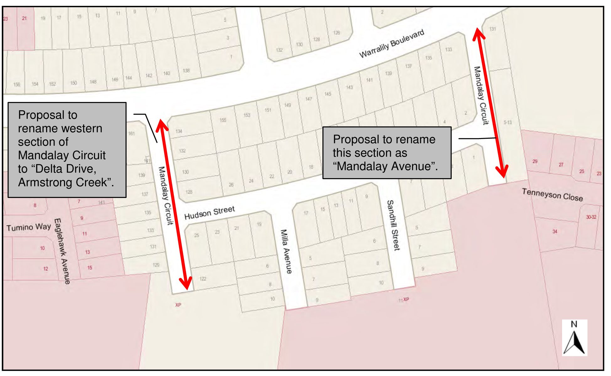
Portfolio: |
Governance - Cr Lyons (Mayor) |
Source: |
Corporate Services - Financial Services |
A/General Manager: |
Michael Kelly |
Index Reference |
Subject/Financial Management - Reporting |
To seek approval to rename the western section of Boundary Road, Mount Duneed to Muir Road, Mount Duneed due to roadway being truncated by the Geelong Ring Road.
Boundary Road, Mount Duneed will be truncated due to the construction of the Ring Road overpass intersecting with Surf Coast Highway.
It is proposed to rename the Western Section to Muir Road, Mount Duneed.
This name has been selected from a recently compiled ANZAC register of suitable road names. The register was compiled as part of the State Government Office of Geographic Names ANZAC Commemorative Naming Project.
The proposed renaming was advertised in the Independent newspaper on 23 May 2014 and the Geelong Advertiser newspaper on 24 May 2014.
Council received one submission in response to this advertisement. The submission received was from Mr Muir’s wife in favour of the naming.
Cr Richards moved, Cr Fisher seconded -
That Council approves the renaming of the western section of “Boundary Road, Mount Duneed” to “Muir Road, Mount Duneed”.
Carried.
Cr Farrell re-entered the meeting room at 10.36pm.
Due to construction of section 4C of the Geelong Ring Road project, Boundary Road Mount Duneed will become truncated.
The Guidelines for Geographic Names 2010 state that when a road becomes disjointed and is not a navigable road from one section to the other, separate road names are required. As the roadway will become disjointed, Council is required to rename a section of roadway. The western section of this roadway was chosen for renaming since this section will cause the least impact on property owners.
Letters have been sent to all affected property owners and residents within the western section of Boundary Road, Mount Duneed advising them of Council’s intention to rename the section of road to Muir Road, Mount Duneed.
The continuing construction of section 4C of the Geelong Ring Road project from Anglesea Road to the Surf Coast Highway will cause Boundary Road, Mount Duneed to truncate as Baanip Boulevard will cross over Boundary Road.
Council is proposing to rename the western section of Boundary Road, Mount Duneed which is accessed from Ghazeepore Road. The name “Muir” has been chosen for this section of roadway which comes from Council’s recently compiled list of ANZAC names in honour of Lance Bombardier Muir who was of Aboriginal decent. Council has obtained written consent from the Wathaurung Aboriginal Corporation to use the name of “Muir Road” for this road renaming.
Leo Maxwell Muir served in Vietnam with the 12th Field Regiment and attained the rank of Lance-Bombardier. During his service with the Army he was a Physical Instructor for the soldiers. After the war, Leo was instrumental in establishing the Geelong Vietnam Veterans Association. He completed further studies and became a Panel Beating teacher at the Geelong East Technical School. He passed away unexpectedly at the age of 42.
The suggested naming complies with the requirement of the Guidelines for Geographic Names 2010.
The proposed renaming was advertised in the Independent newspaper on 23 May 2014 and the Geelong Advertiser newspaper on 24 May 2014. One submission was received from Mr Muir’s widow showing her gratitude in using her late husbands name for this proposal.
There are no environmental issues arising from this report.
The approximate cost to Council is $1,100. This includes advertising, assistance packages, notification to authorities and street signage.
The Local Government Act 1989, Geographic Place Names Act 1998 and The Guidelines for Geographic Names 2010 have been followed and met.
The proposal aligns to City Plan with the encouragement of Community Wellbeing.
There is no Council Officer direct or indirect interest involved in this report.
If an emergency situation occurred, Council’s proposal to rename the western section of Boundary Road, Mount Duneed could minimise the risk of failure in being able to locate the property in a timely manner.
The renaming of this section of roadway will allow for easy identification for the public, enable utility organisations and emergency services to locate the property.
It is the right of every resident and property owner for their property to have a unique address in order to receive services and reduce confusion or delay of emergency services.
Correspondence was sent to all adjoining property owners and residents advising them of the proposed renaming and invited submissions.
This proposal was also advertised in the Independent newspaper on 23 May 2014 and the Geelong Advertiser newspaper on 24 May 2014. The proposal was published on Council’s Geelong Australia website for 30 days as per the Guidelines for Geographic Names 2010.
One submission was received. This submission was from Mr Muir’s widow in favour of the proposal.
Subject to Council and The Registrar of Geographic Names approval, the relevant authorities and abutting owners will be notified of the official registration of this road renaming.
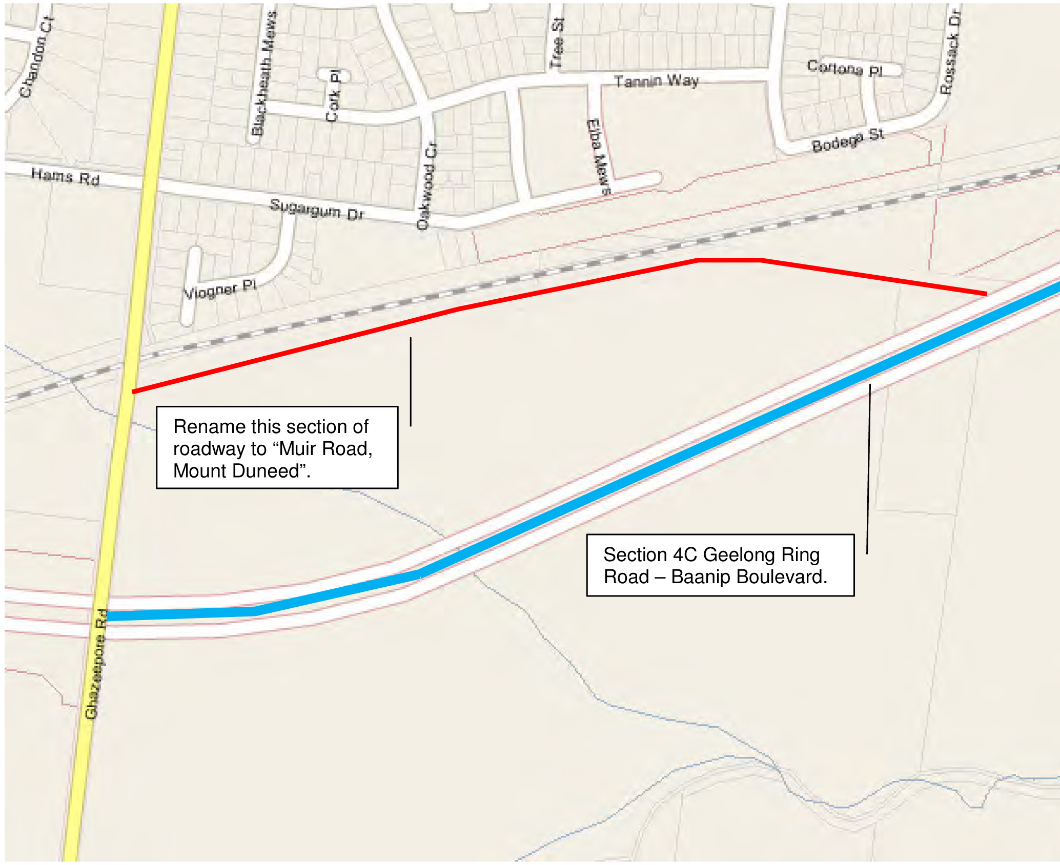
Portfolio: |
Finance – Cr Lyons (Mayor), Cr S Kontelj & Cr E Kontelj |
Source: |
Corporate Services - Property Management |
A/General Manager: |
Mike Kelly |
Index Reference: |
Land Sales |
The purpose of this report is to recommend that the Council give notice of its intention to sell land at 5 Coolidge St, Corio.
Council owns a property at 5 Coolidge Street, Corio which was purchased in 1976 and has been used for child care and community purposes. The building is currently vacant.
The building is a former modified residence and the land is zoned Residential 1.
The property is no longer required for Council purposes and it is recommended that the land be sold.
There exists an agreement between the former Shire and the Commonwealth Minister for Social Security which requires Council to obtain the Minster’s consent if the property is to be sold. The Commonwealth Minister for Education is now the responsible Minister and has been requested to provide consent to sell this land.
Council is also required to give public notice of its intention to sell the land and consider any submissions received. If any submissions are received they will be heard by the Submissions Review Panel followed by a report to Council. If no submissions are received the land will be sold subject to the Minister’s consent.
Cr Fisher moved, Cr Farrell seconded -
That Council:
commence procedures to sell the land at 5 Coolidge Street, Corio (“the land”) on the following terms and conditions:
price being not less than the certified valuation to be obtained;
conduct an EOI process seeking interest from community housing providers;
sell the land by listing with an agent;
obtaining the Commonwealth Minister for Education’s consent to sell the land;
Other appropriate terms.
commence the procedures under section 189 of the Local Government Act 1989 (“the Act”) to sell the land and that public notice of and the right of a person under section 223 of the Act to make a submission in relation to the proposed sale be given in the Geelong Advertiser and Geelong Independent;
appoint the Submissions Review Panel to hear and report to the Council on any submissions in relation to the proposed sale;
sell the land if no submissions are received;
authorise the General Manager – Corporate Services to execute the Contract of Sale;
sign and seal the Transfer of Land.
Cr Heagney moved, Cr Farrell seconded -
That consideration of the report be deferred.
Cr Irvine left the meeting room at 10:36pm
Cr Irvine re-entered the meeting room at 10:40pm
Carried.
Portfolio: |
Infrastructure – Cr Lindsay Ellis |
Source: |
City Services - Engineering Services |
General Manager: |
Gary Van Driel |
Index Reference: |
Special Rates and Charges; The Esplanade, Indented Head |
This project has been before Council at its meeting of 13 May 2014 with a resolution to proceed. Due to affected property owner concerns, this scheme is being re-presented as a two scheme proposal with amended levy charges. The original scheme was subsequently postponed. Referred to as Sub Scheme 1 and 2, the separation of schemes provides more clarity and transparency in the breakdown of cost components for the project as a whole. This report seeks a resolution by Council to consider an intention to declare a Special Charge Scheme to:
Sub Scheme 1 - Partially fund the construction of a footpath along the west side of The Esplanade between No 270 The Esplanade and Walpole Avenue, Indented Head. (See plan – Appendix 4).
Sub Scheme 2 - Partially fund the construction of new kerb and channel and vehicle laybacks between No’s 270 and 274 The Esplanade, Indented Head.
It is proposed to construct 200 lineal metres of 1.5 metre wide footpath to provide for pedestrian access along The Esplanade, Indented Head. Further work includes a Council funded modified intersection layout for Pigdon Street and The Esplanade which includes new kerb and channel and drainage provision.
It is further proposed that the section of The Esplanade adjacent to properties 270, 271 and 272 The Esplanade be widened. The proposed work will also include new kerb and channel and vehicle laybacks. This work will provide 40 metres of new kerb and channel section and complete the ‘missing link’ in kerbing for The Esplanade North of Pigdon Street.
There are ten (10) properties abutting the proposed works that will receive special benefit. There are no Council owned properties in the scheme.
The Scheme has been divided into two sub schemes. Sub Scheme 1 relates to the proposed footpath and intersection modification works at Pigdon Street and Sub Scheme 2 relates to new kerb and channel works and vehicle laybacks for five properties from No 270 to 274 The Esplanade inclusive.
The total estimated project cost is $133,530 for Sub Scheme 1 and $9,754 for Sub Scheme 2. A detailed breakdown of costs is presented in the financial implications section of this report.
A Benefit Ratio of 0.34 for Sub Scheme 1 and 0.53 for Sub Scheme 2 has been calculated in accordance with Section 163 of the Local Government Act (Schedule B).
Property owners are considered to receive benefit from the works by way of improved pedestrian and vehicular access and general amenity improvement including pedestrian and vehicular safety.
The Sub Scheme’s have been prepared in accordance with the Special Rate and Charges provisions of the Local Government Act 1989 along with the 2004 Ministerial Guidelines and Council’s Special Rates and Charges Policy.
Cr Ellis moved, Cr Macdonald seconded -
That Council:
Rescind its Resolution of 13 May 2014 being Item 11 of that agenda, titled The Esplanade, Indented Head – Proposed footpath construction – SRC 338 – Intention to Declare, and substitute the following resolution; and
Gives notice of its intention to declare a Special Charge Scheme consisting of two Sub Schemes in accordance with Section 163 (1A) of the Local Government Act 1989 (The Act), as follows:
The Special Charge is declared for a period of five (5) years commencing upon completion of the works and scheme finalisation.
The Special Charge be declared for the purpose of defraying any expenses incurred by Council in relation to the construction of the footpath and kerb and channel on The Esplanade between No 270 The Esplanade and Walpole Avenue, Indented Head which project:
b1) Will provide:
Sub Scheme 1 - proper pedestrian access, improved intersection layout, improved pedestrian safety and enhancement to the general amenity for each of the properties included in the scheme;
Sub Scheme 2 – proper vehicular access including improved drainage and vehicular safety
b2) Council considers is or will be a special benefit to those persons required to pay the special charge (and who are described in succeeding parts of this Resolution); and
b3) Arises out of Council’s function of planning for and providing infrastructure for property owners.
The total cost of project for Sub Scheme 1, be recorded as $133,530. The total cost of project for Sub Scheme 2, be recorded as $9,753.94.
It be recorded that, for the purposes of Section 163 (2A) of the Act, the special charge proceeds will not exceed the amount calculated in accordance with the prescribed formula (R x C = S), the:
d1) ‘benefit ratio’ (R) being calculated at 0.34 for Sub Scheme 1 and 0.53 for Sub Scheme 2 represents the special benefits to all persons liable to pay the special charge (Schedule B);
d2) ‘total cost’ (C) of performing the function described in part 1 (b) of this resolution based on estimated cost be recorded as $62,651 for Sub scheme 1 and $7,654 for Sub Scheme 2; and
d3) ‘maximum levy’ (S) be recorded as $21,484 for Sub Scheme 1 and $4,018 for Sub Scheme 2.
the following be specified as the area for which the special rate is so declared:
e1) the area within municipal district of Council highlighted in the plan attached to this Resolution (Appendix 4).
the following be specified as the land in relation to which the special charge so declared:
f1) land within the area shown on the plan.
the following be specified as the criteria which form the basis of the special charge so declared:
g1) ownership of any land described in Part 1(e) of this Resolution.
the following be specified as the manner in which the special charge so declared will be assessed and levied:
h1) Each lot receives a primary access and amenity benefit;
h2) The maximum levy is divided:
Sub Scheme 1 - 50% on access and 50% amenity on a frontage share basis;
Sub Scheme 2 – on a frontage share basis
h3) The special charge will be levied by sending a notice to the person who is liable to pay, pursuant to section 163(4) of the Act.
having regard to the preceding parts of this Resolution but subject to Section 166 (1) of the Act, it be recorded that;
i1) the owners of the land described in column 3 of Schedule C to the resolution are estimated liable for the respective amounts set out in column 8 of Schedule C; and
i2) such owners may, subject to any further resolution of Council pay the special charge in the following manner;
i2a) the charge will become due and payable within one month of the issue of the notice requesting payment pursuant to Section 167 (3) of the Act;
i2b) interest will not be charged for six months after the issue of the notice provided the person liable makes timely payment in accordance with any repayment arrangements that may be agreed on by Council; and
i2c) in accordance with Section 172 of the Act, the interest rate payable on the special charge which has not been paid by the specific date is set at Council’s overdraft rate, reviewed every three months (provided that it shall not exceed the rate fixed by the Governor in Council by Order for the purposes of Section 172 (2A) in which case the rate of interest shall be the maximum rate fixed by the Governor in Council by Order for the purposes of this section).
Council’s Chief Executive Officer be authorised to levy the Special Charge in accordance with Section 163 (4) of the Act.
Cr S Kontelj left the meeting room for the evening at 10.43pm
Carried.
In 2009/10 Council facilitated the Northern Bellarine Walkability Study where extensive consultation with the local community of Indented Head including the Locomote Walking Group was carried out. The method of consultation included public advertising, resident surveys and community meetings.
The study identified the priority pathway networks of which The Esplanade was listed as a high priority for construction. It is considered that the proposed new footpath will provide the missing pedestrian link between Pigdon Street and Walpole Avenue, Indented Head and become a valuable community asset.
Due to the Walkability Study as the driving mechanism for this footpath link, the traditional survey to affected property owners has not taken place on this occasion. It is anticipated that detailed correspondence will be sent to all affected property owners should Council make its intention to declare a Special Charge Scheme.
This project has been separated into two sub schemes as follows:
Sub Scheme 1
This part of the project involves the proposed construction of 200 metres total length of 1.5 metre wide footpath. It is expected to be a safety improvement for pedestrian traffic and fulfil part of the footpath priority obligations of the Northern Bellarine Walkability Study.
Another aspect of this project is the intersection modification of Pigdon Street and The Esplanade. This intersection is being re-aligned to ‘square up’ the intersection to slow traffic turning movements as a safety initiative. It is proposed that this work will be funded by Council as an intersection safety initiative. An exception to this is the proposed new vehicle crossing laybacks which will be funded by property owners as 100% beneficiaries.
Cost apportionment for Sub Scheme 1 has been divided into access and amenity benefits. It is considered that all abutting properties with direct frontages to the proposed new footpath, regardless of size and shape, receive the same access benefit. An exception to this rule is corner properties with dual frontages where a reduction of the access benefit has been applied.
In this case 50% of the total benefit has been apportioned to access. The access benefit includes the provision of an all weather sealed surface that reduces the risk of accidents caused by uneven and slippery surfaces. In simple terms, it is considered that a new footpath improves accessibility for all abutting properties.
The remaining 50% of benefit is attributed to amenity and this can best be described as the benefit the pathway provides to an abutting property by way of improved aesthetics, enjoyment, and comfort and property value. The amenity benefit is based on the actual footpath frontage to a property when existing driveways and footpath extents are taken into consideration. This is known as the apportionable frontage and is shown at Column 5 of Appendix 3.
It is evident that one of the affected properties within this scheme is occupied by the property owner on a full time basis. Due to the lack of permanency the vehicle driveways, although in place, have sunken slightly and been substantially overgrown by the local nature strip grass. Should the footpath be constructed, a level discrepancy between the new footpath and driveway will most likely result. For this reason, Council will reinstate the driveway levels with compacted crushed rock to match the new footpath levels at its cost.
The section of The Esplanade between Pigdon Street and Walpole Avenue is relatively flat and the footpath construction should not pose any difficulty for the selected contractor.
Sub Scheme 2
A 40 metre section of road way north of Pigdon Street is also proposed to be constructed. This work involves the widening of the road pavement, new kerb and channel and new vehicle crossovers. It is proposed that the road widening work will be funded by Council but the new kerbing cost will be shared and vehicle laybacks will be fully funded by benefiting property owners.
Cost apportionment for Sub Scheme 2 is based on frontage alone for kerb and channel works and a fixed charge for vehicle laybacks of $420 per layback. Whilst Council is sharing the cost of kerb and channel in accordance with the Benefit Ratio calculation, the cost for laybacks is 100% property owner funded due to the direct benefit the layback provides.
The provision of a sealed pathway surface provides a permanent and safe means of pedestrian access. During the course of construction and the manufacture and procurement of materials, energy is expended resulting in some greenhouse gas emissions. This ceases when construction is complete.
The project does not create waste with the exception of some excavated material. The proposal does not affect any natural habitats. The proposal will require some nature strip shrubs removal.
The project is a one off capital cost and there will be minimal ongoing maintenance costs. If approved, the project could proceed early next financial year.
Financial details are as follows:
Sub Scheme 1 - footpath |
|
Maximum scheme levy to property owners (income) |
$21,484 |
Scheme levy to Council |
$41,167 |
Direct funding by Council to reinstate gravel driveway, construct new kerb and channel for intersection modification at Pigdon Street and reinstatement of asphalt pavement. |
$70,879 |
Total cost Sub Scheme 1 |
$133,530 |
Sub Scheme 2 – Kerb and channel and laybacks |
|
Maximum scheme levy to property owners (income) |
$4,018 |
Scheme levy to Council |
$3,636 |
Direct cost to property owners for vehicle laybacks |
$2,100 |
Total cost Sub Scheme 2 |
$9,754 |
Total Project Cost |
$143,284 |
From the table above, the total net cost to Council for this project is estimated to be $115,682
The two Sub Schemes have been prepared in accordance with the Special Rate and Charge provisions of the Local Government Act 1989 along with the 2004 ministerial guidelines and Council’s Special Rates and Charges Policy.
This report aligns with the City Plan as follows:
Sustainably Built and Natural Environment
Support our Community to live sustainably – Encourage increased use of alternatives to car transport and seek efficient traffic movement throughout the municipality.
Advocate for and promote sustainable design and development – Promoting sustainable design and retrofitting.
Acknowledge the community’s desire to have their say and be involved in planning for the future of Greater Geelong.
No Council Officer involved with this process has any direct or indirect interest in the properties.
Provision of a sealed pathway will provide safer walking and cycling conditions for pedestrians and cyclists by minimising the risk of personal injuries through conflict with vehicles and the elimination of uneven and slippery surfaces.
There are no identified risks for Council in making its intention to declare the scheme.
The provision of properly sealed and drained pathways is aligned to Council’s City Plan as described above and provides improved connectivity and safety for pedestrians and cyclists. It is further considered that the footpaths will enhance the general amenity of the area.
The provision of the modified intersection layout and road widening works will provide safety improvements for both pedestrian and vehicular traffic and provide overall amenity improvements for the area.
In developing this report to Council, the subject matter has been considered to determine if it raises any human rights issues. In particular, whether the scope of any human right established by the Victorian Charter of Human Rights and Responsibilities is in any way limited, restricted or interfered with by the recommendations contained in this report. It is considered that the subject matter does not raise any adverse human rights issues.
It is further considered that the construction of the footpaths upholds the right to freedom of movement (Section 12 of the Human rights Charter) by enhancing a person’s ability to move freely within the area they choose to live.
Community consultation for the proposed footpath construction was carried out during the 2009/ 2010 Northern Bellarine Walkability Study. Consultation with the Locomote Walking Group was included during this study and is ongoing.
Letters postponing the current scheme were sent to all affected property owners on 26 May 2014. Further correspondence to the affected property owners and the Locomote Walking Group including a revised public notice will be sent should Council make its intention to declare a Special Charge Scheme.
The works for the construction of footpaths in The Esplanade, Indented Head which consist of excavation, footpath, kerb and channel, road widening, reinstatement of nature strip and driveways, miscellaneous construction works, legal advice and professional services associated with survey, engineering design, drafting, supervision and administration of the project all as included in the cost estimate shown below.
SUB SCHEME 1 COST ESTIMATE - FOOTPATH CONSTRUCTION |
|||||
ITEM |
DESCRIPTION |
QUANTITY |
UNIT |
RATE |
AMOUNT |
1.00 |
GENERAL |
|
|
|
|
1.01 |
Initial site establishment and set up, decamping and site cleanup and other fixed costs up to time of completion of works. |
1.0 |
ITEM |
$6,317.00 |
$6,317.00 |
1.02 |
Traffic management costs. |
1.0 |
ITEM |
$3,000.00 |
$3,000.00 |
1.03 |
Setting out of works. |
1.0 |
ITEM |
$540.00 |
$540.00 |
1.04 |
Service / Cable locations |
1.0 |
ITEM |
$700.00 |
$700.00 |
1.05 |
Internal supervision fee (COGG construction) |
1.0 |
ITEM |
$3,340.00 |
$3,340.00 |
2.00 |
EARTHWORKS & DEMOLITION |
|
|
|
|
2.01 |
Excavation and disposal of all materials to limits of work as indicated on plan, including trimming for new road pavement, excavation of soft spots and removal of concrete. |
57.9 |
m3 |
$60.00 |
$3,476.13 |
2.02 |
Trimming / Removal and disposal of shrubs as indicated on plan. |
1.0 |
ITEM |
$1,000.00 |
$1,000.00 |
3.00 |
DRAINAGE |
|
|
|
|
3.01 |
Adjust existing Junction Pit lid to match finished surface level. |
1 |
No. |
$770.00 |
$770.00 |
4.00 |
CONCRETE WORKS: |
|
|
|
|
|
KERBING |
|
|
|
|
4.01 |
Concrete pram crossing 1.5m wide, including fine crushed rock bedding. |
4.0 |
No. |
$250.00 |
$1,000.00 |
|
PAVING |
|
|
|
|
4.02 |
75mm concrete paving with SL62 mesh including crushed rock bedding and reinstate nature strip. |
193.3 |
m2 |
$105.00 |
$20,295.45 |
4.03 |
125mm concrete paving with SL62 mesh including crushed rock bedding and reinstate nature strip. |
78.6 |
m2 |
$110.00 |
$8,649.30 |
4.04 |
Tactile Ground Surface Indicator Tiles, supplied and placed. |
3.0 |
m2 |
$250.00 |
$750.00 |
5.00 |
LANDSCAPING |
|
|
|
|
5.01 |
Top soiling and seeding nature strips. |
265.2 |
m2 |
$8.00 |
$2,121.60 |
6.00 |
SIGNING AND LINE-MARKING |
|
|
|
|
6.01 |
Relocate existing permanent sign and post as per plan. |
1.0 |
No |
$250.00 |
$250.00 |
SUB-TOTAL |
$52,209.48 |
||||
| 10% CONTINGENCY Design Project administration |
$5,220.95 |
||||
CONSTRUCTION COST ESTIMATE |
$62,651.38 |
||||
SUB SCHEME 2 COST ESTIMATE - KERB AND CHANNEL AND VEHICLE LAYBACKS |
|||||
ITEM |
DESCRIPTION |
QUANTITY |
UNIT |
RATE |
AMOUNT |
1.00 |
GENERAL |
|
|
|
|
1.01 |
Initial site establishment and set up, decamping and site cleanup and other fixed costs up to time of completion of works. |
1.0 |
ITEM |
$941.00 |
$941.00 |
1.02 |
Traffic management costs. |
1.0 |
ITEM |
$500.00 |
$500.00 |
1.03 |
Setting out of works. |
1.0 |
ITEM |
$70.00 |
$70.00 |
2.00 |
EARTHWORKS & DEMOLITION |
|
|
|
|
2.01 |
Excavation and disposal of all materials to limits of work as indicated on plan, including trimming for new road pavement, excavation of soft spots and removal of concrete. |
5.4 |
m3 |
$60.00 |
$321.30 |
2.02 |
Saw-cutting of concrete and/or Asphalt paving. |
22.4 |
m |
$10.00 |
$223.50 |
2.03 |
Saw-cut of concrete kerb and channel |
1.0 |
ITEM |
$10.00 |
$10.00 |
2.04 |
Removal and disposal of 125mm thick concrete as per plan. |
4.2 |
m2 |
$60.00 |
$251.40 |
3.00 |
CONCRETE WORKS: ` |
|
|
|
|
|
KERBING |
|
|
|
|
3.01 |
B2 Barrier kerb and channel 450mm wide, including fine crushed rock bedding. |
24.3 |
m |
$136.00 |
$3,302.08 |
3.02 |
Concrete layback for vehicle crossing 3.0m - 3.75m wide, including bedding & formwork. |
5 |
No. |
$350.00 |
$1,750.00 |
|
PAVING |
|
|
|
|
3.04 |
125mm concrete paving with SL62 mesh including crushed rock bedding and reinstate nature strip. |
6.9 |
m2 |
$110.00 |
$759.00 |
SUB-TOTAL $8128.28 |
|
||||
10% CONTINGENCY |
$812.83 |
||||
CONSTRUCTION COST ESTIMATE |
$9,753.94 |
||||
COUNCIL FUNDED INTERSECTION WORKS |
|||||
ITEM |
DESCRIPTION |
QUANTITY |
UNIT |
RATE |
AMOUNT |
1.00 |
GENERAL |
|
|
|
|
1.01 |
Initial site establishment and set up, decamping and site cleanup and other fixed costs up to time of completion of works. |
1.0 |
ITEM |
$6,182.00 |
$6,182.00 |
1.02 |
Traffic management costs. |
1.0 |
ITEM |
$500.00 |
$500.00 |
1.03 |
Setting out of works. |
1.0 |
ITEM |
$390.00 |
$390.00 |
1.04 |
Service / Cable locations |
1.0 |
ITEM |
$300.00 |
$300.00 |
1.05 |
Internal supervision fee (COGG construction) |
1.0 |
ITEM |
$3,000.00 |
$3,000.00 |
2.00 |
EARTHWORKS & DEMOLITION |
|
|
|
|
2.01 |
Excavation and disposal of all materials to limits of work as indicated on plan, including trimming for new road pavement, excavation of soft spots and removal of concrete. |
105.8 |
m3 |
$60.00 |
$6,349.53 |
2.02 |
Saw-cutting of concrete and/or Asphalt paving. |
278.1 |
m |
$10.00 |
$2,781.30 |
2.03 |
Saw-cut of concrete kerb and channel |
34.0 |
ITEM |
$10.00 |
$340.00 |
3.00 |
PAVEMENT WORKS |
|
|
|
|
3.01 |
150mm compacted depth Class 1 20mm crushed rock, supplied, spread and compacted. |
39.4 |
m3 |
$120.00 |
$4,725.72 |
3.02 |
200mm compacted depth Class 3 40mm crushed rock, supplied, spread and compacted. |
52.5 |
m3 |
$100.00 |
$5,250.80 |
3.03 |
100mm compacted depth Class 1 20mm crushed rock, supplied, spread and compacted. |
11.8 |
m3 |
$120.00 |
$1,420.32 |
3.04 |
30mm compacted depth 10mm nominal size type N Asphalt spread and compacted including emulsion prime & grit using a paver. |
262.5 |
m2 |
$35.00 |
$9,188.90 |
4.00 |
DRAINAGE |
|
|
|
|
|
PIPE |
|
|
|
|
4.01 |
Connect existing household storm water to kerb and channel. Including excavation, supply and placement of kerb adapters. |
6.0 |
No. |
$250.00 |
$1,500.00 |
4.02 |
100mm dia Sub-Soil drains including excavation, supply, placement and provision of approved backfill. |
100.0 |
m |
$48.00 |
$4,800.00 |
|
PITS |
|
|
|
|
4.03 |
900mm x 600mm SEP, less than 1.5m deep with Gatic type cover, supplied and placed including excavation, placement of approved fine crushed rock bedding and back-filling with approved material. |
1.0 |
No. |
$1,400.00 |
$1,400.00 |
4.04 |
Modify ex 900mm x 600mm SEP to 900mm x 1200mm SEP, less than 1.5m deep with Gatic type cover, supplied and placed including excavation, placement of approved fine crushed rock bedding and back-filling with approved material. |
1.0 |
No. |
$1,400.00 |
$1,400.00 |
4.05 |
Tap into existing drainage pit or pipe. |
1.0 |
No. |
$385.00 |
$385.00 |
5.00 |
CONCRETE WORKS: ` |
|
|
|
|
|
KERBING |
|
|
|
|
5.01 |
B2 Barrier kerb and channel 450mm wide, including fine crushed rock bedding. |
52.2 |
m |
$136.00 |
$7,101.92 |
5.02 |
Concrete layback for vehicle crossing 3.0m - 3.75m wide, including bedding & formwork. |
1 |
No. |
$350.00 |
$350.00 |
6.00 |
DEMOLITION |
|
|
|
|
6.01 |
Remove and dispose existing SEP and abandon ex 300mm dia RCP backfill with approved materials as per plan. |
1 |
No. |
$1,200.00 |
$1,200.00 |
7.00 |
SIGNING AND LINE-MARKING |
|
|
|
|
7.01 |
Line-marking |
1.0 |
ITEM |
$500.00 |
$500.00 |
| SUB-TOTAL : | $59,065.49 |
||||
10% CONTINGENCY : D |
$5,906.55 |
||||
| CONSTRUCTION COST ESTIMATE | $70,878.59 |
||||
A |
Purpose |
|
|
To construct a footpath in The Esplanade, Indented Head to provide all weather pedestrian access for property owners and the wider community. The project also includes intersection modification works to improve vehicular and pedestrian safety. |
|
B |
Coherence |
|
|
The works will provide a physical pathway connection between Pigdon Street and Walpole Avenue and will provide a special benefit to adjoining and remote properties. |
|
C |
Total Cost C |
|
|
Total Estimated cost of works |
$133,529.96 |
TOTAL SCHEME COST of Footpath Construction |
$62,651.37 |
|
D |
Identify Special Beneficiaries |
|
|
10 properties with frontages to the proposed footpath are considered to receive access and amenity benefits. |
|
E |
Properties to include |
|
|
The 10 abutting properties receive both access and amenity benefits. Therefore: Total Special Benefits (in) is apportioned to 10 properties There are no Council owned properties in the scheme. Therefore: Total Special Benefits out of the scheme TSB (out) = 0 |
|
F |
Estimate of Total Special Benefits |
|
|
For this scheme it is considered that the greater proportion of benefit is for pedestrian access given the purpose of the scheme. Therefore it is estimated that 80% of the benefits relate to access and 20% to amenity. Estimated pedestrian use of the paths is 80% for the wider community and 20% for abutting property owners. Amenity benefits are based on frontage with 87% of the footpaths fronting benefiting properties and 13% within Council's road reserves. TSB (in) is therefore calculated as follows: TSB (in) = 80% X 20%(access) + 20% X 87% (amenity) = 33.4% |
|
G |
Estimate of Total Community Benefit -TCB |
|
|
It is considered that people in the community will receive a benefit from the works as the pathway is used to access other areas considering the walkability study for the area. There are no amenity benefits considered for the wider community. TCB is calculated as follows: TCB = 80% X 80% = 64% |
|
H |
Calculate "Benefit Ratio" - R |
|
|
Benefits Ratio = TSB (in) / (TSB (in) + TSB (out) + TCB) = 33.4 / (33.4 + 0 + 64) = 0.343 |
|
I |
Maximum Total Levy (S) |
|
|
Maximum Total Levy S = R X C |
$21,484.15 |
A |
Purpose |
|
To construct kerb and channel including vehicle laybacks in The Esplanade, Indented Head to provide a wider pavement and improved vehicular access for property owners. |
||
B |
Coherence |
|
The works will provide the missing link in road pavement construction between No 270 The Esplanade and the Pigdon Street intersection. Two properties at No 273 and 274 The Esplanade will also receive new vehicle laybacks. |
||
C |
Total Cost C |
|
Total Estimated cost of kerb and channel works including vehicle laybacks |
$9,753.94 |
|
Total cost for kerb and channel work |
$7,653.94 |
|
D |
Identify Special Beneficiaries |
|
5 properties with frontages to The Esplanade are considered to receive access and amenity benefits. The community will also receive benefit by way of a wider road pavement, improved road drainage and safety. |
||
E |
Properties to include |
|
The 5 abutting properties receive both access and amenity benefits. Therefore: Total Special Benefits (in) is apportioned to 5 properties There are no Council owned properties in the scheme. Therefore: Total Special Benefits out of the scheme TSB (out) = 0 |
||
F |
Estimate of Total Special Benefits |
|
For this scheme component it is considered that the benefit is for vehicular access and property amenity. It is estimated that 50% of the benefit relates to access and 50% to amenity. Estimated use of the wider road pavement is 95% for the wider community and 5% for abutting property owners. Amenity benefits are based on frontage with 100% of the new kerb and channel and laybacks fronting benefiting properties. TSB (in) is therefore calculated as follows: TSB (in) = 50% X 5%(access) + 50% X 100% (amenity) = 52.5% |
||
G |
Estimate of Total Community Benefit -TCB |
|
It is considered that people in the community will receive a benefit from the works as the new road pavement is used to access other areas and provides improved safety. There are no amenity benefits considered for the wider community. TCB is calculated as follows: TCB = 95% X 50% = 47.5% |
||
H |
Calculate "Benefit Ratio" - R |
|
Benefits Ratio = TSB (in) / (TSB (in) + TSB (out) + TCB) = 52.5 / (52.5 + 0 + 47.5) = 0.525 |
||
I |
Maximum Total Levy (S) |
|
Maximum Total Levy S = R X C |
$4,018.32 |
|
COLUMN 1 |
COLUMN 2 |
COLUMN 3 |
COLUMN 4 |
COLUMN 5 |
COLUMN 6 |
COLUMN 7 |
COLUMN 8 |
Prop Key |
Address |
Legal Details |
Apportionable frontage |
Footpath Cost |
Kerb costs |
Layback costs |
Total Cost |
311634 |
270 The Esplanade, Indented Head |
Lot 1 PS435184 |
10 |
$1,947.98 |
$1,736.09 |
$420.00 |
$4,104.07 |
311635 |
271 The Esplanade, Indented Head |
Lot 2 PS435184 |
8.74 |
$1,861.77 |
$1,605.34 |
$420.00 |
$3,887.11 |
311636 |
272 The Esplanade, Indented Head |
Lot 3 PS435184 |
7.66 |
$1,155.99 |
$676.89 |
$420.00 |
$2,252.88 |
250791 |
273 The Esplanade, Indented Head |
Lot 9 TP827456 |
12.96 |
$1,518.62 |
|
$420.00 |
$1,938.62 |
250792 |
274 The Esplanade, Indented Head |
Lot 1 TP1408 |
16.76 |
$2,410.51 |
|
$420.00 |
$2,830.51 |
250793 |
275 The Esplanade, Indented Head |
Lot 10 TP827456 |
16.76 |
$2,410.51 |
|
|
$2,410.51 |
250794 |
276 The Esplanade, Indented Head |
Lot 1 TP118689 |
16.76 |
$2,410.51 |
|
|
$2,410.51 |
250795 |
277 The Esplanade, Indented Head |
Lot 11 TP827456 |
16.76 |
$2,410.51 |
|
|
$2,410.51 |
250796 |
278 The Esplanade, Indented Head |
Lot 12 TP827456 |
24.4 |
$2,933.24 |
|
|
$2,933.24 |
250797 |
279 The Esplanade, Indented Head |
Lot 1 TP14712 |
26.2 |
$2,424.51 |
|
|
$2,424.51 |
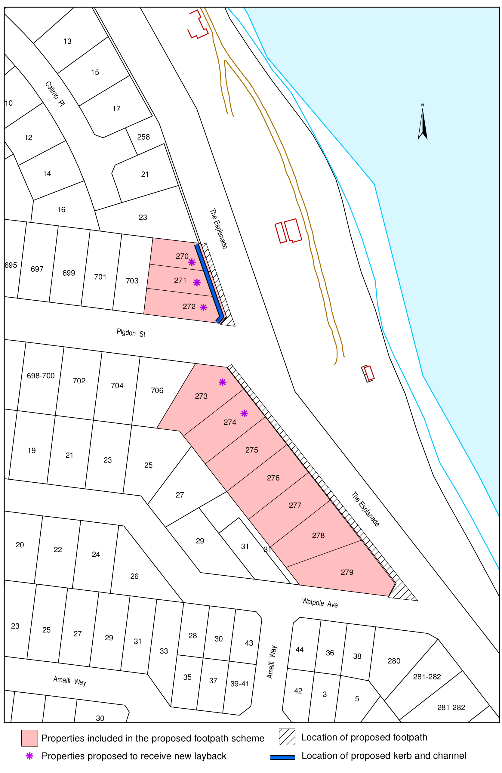
Stage |
Status |
Description |
Approval to prepare scheme |
✓ | Decision made to prepare scheme following consideration of surveys of residents and feed back from the community via the Northern Bellarine Walkability Study. Council may then place the project in the budget system or proceed immediately to prepare a scheme. Scheme preparation involves survey, design and preparation of an apportionment of costs. |
Intention to Declare Scheme |
✓ | Report to Council providing information on scheme including advice of impending advertising of scheme and declaration of charge. Seeks Council approval by resolution to proceed with process. |
Advertisement |
|
The scheme is advertised in the local newspaper and all allotted property owners are notified by mail. This advertisement indicates Council’s intention and notification to ‘declare’ a scheme in a month’s time. |
Submissions |
|
From the time of advertising property owners have 28 days (as set down by the Local Government Act) to lodge submissions, either in support or opposition to the scheme. |
Submissions Review Panel Hearing |
|
A Submissions Review Panel is convened (quorum of three Councillors) and meets to consider submissions. Some submissions are written only, and other submitters may wish to be heard before the Panel. The Panel makes a recommendation to Council regarding the scheme. |
Declaration Report |
|
Any time 28 days after advertising the scheme and after the Submissions Review Panel has met and considered submissions, Council considers a report and may proceed to “declare” the charges in accordance with its advertised intent. Subsequent to this the Finance Manager issues the levy notices and there is a formal charge placed on the property. This is the final step in the process for Council to make a decision on the scheme. |
Appeal |
|
Property owners may lodge an application for review with the Victorian Civil and Administrative Tribunal (VCAT) within one month of issue of the levy notice. An appeal is listed, heard and determined by the Tribunal and this process generally takes three to four months. Decisions made by VCAT are binding on all parties. |
Construction |
|
Council may then proceed to construct the works. Invoices are issued seeking payment of the estimated cost within one month of commencement. |
Final Cost |
|
Report At the completion of the works the scheme is “finalised” taking into account actual costs incurred and payments are adjusted accordingly. |
Portfolio: |
Enterprise Geelong – Cr Harwood |
Source: |
Enterprise Geelong |
General Manager: |
Dr Russell Walker |
Index Reference: |
Subject: Biotech Industry |
The purpose of this report is to provide Council with a summary of Cr Bruce Harwood’s trip to the USA in November 2013 as part of a Bio Science delegation. The delegation travelled to Manhattan, Kansas and Athens Clarke County, Atlanta.
The Bio Geelong network was established in 2005, with key stakeholders coming together to strengthen and support the growth of the bio technology industry in Geelong.
Since the establishment of Bio Geelong, Council has developed a successful formula to promote and attract significant biotechnology industry investment. This is evidenced with the establishment of the Geelong Centre for Emerging Infectious Disease (GCEID).
An invitation was extended to Acting Mayor, Cr Bruce Harwood to form part of a delegation including CSIRO, Deakin University and AAHL personnel to attend a Bio Science Meeting in Kansas, Missouri 14th – 16th November 2013 and Atlanta, Georgia USA 18th – 21st November 2013.
A council report seeking approval to attend this delegation was presented and approved at the 22 October 2013 Council Meeting.
The intent of the delegation was to travel together to strengthen and support the growth of the bio-technology industry in Geelong by utilising varying contacts and opportunities presented in the USA.
Cr Harwood moved, Cr Macdonald seconded -
That Council notes Cr Harwood’s Bio Science USA Trip Report (Appendix 1).
Carried.
Previous delegations to North Carolina and attendance at the World Bio Science conference in Atlanta, Georgia USA provided extensive information in relation to the importance of bio science developments within the world and the opportunities for the Geelong region.
The visit to Atlanta greatly assisted in strengthening Bio Geelong and Council’s commitment to bio science as a future industry. This is reflected in Council’s partnership with AAHL, CSIRO, Deakin University and the realisation of the Geelong Centre for Emerging Infectious Disease at Barwon Health.
The invitation to return to Atlanta Georgia in November 2013 again strengthens Council’s commitment to the bio science industry and willingness to partner with other regions offering genuine commercial development opportunity.
The Mayor of Athens Clarke County, Georgia, Nancy Denson had also put forward a proposal to consider a sister city relationship with the City of Greater Geelong. This resulted in Council raising the issue of a stronger commitment with a Memorandum of Understanding built around the premises of start up business being actively encouraged between the two cities. This was discussed between the two cities and agreed that this presented the best way to be outcome focused
The intent of the delegation was to travel together to strengthen and support the growth of the bio-technology industry in Geelong by utilising varying contacts and opportunities presented in the USA.
The purpose of the meetings was to build relationships and knowledge in the bio science industry sector. This presented a great opportunity for Council, as Atlanta is a world renowned region for bio science and advanced manufacturing with a number of start up companies being created. This intent was clearly achieved with critical personnel met and extensive knowledge exchanged. The visit to Atlanta is extensively covered in the ‘CSIRO Biosecurity Flagship – GCEID – UGA Biodevelopment Report’ (Attachment 1).
Since the establishment of BioGeelong, Council has developed a successful formula to promote and attract significant biotechnology industry investment. This is evidenced with the establishment of the Geelong Centre for Emerging Infectious Disease (GCEID). The GCEID proved to be a valuable asset when discussing bio tech opportunity and the potential for start up industry to come to Geelong. The initial GCEID application for Federal Government funding was completed by the Economic Development Unit of the City Of Greater Geelong. There was significant input from other stakeholders but the city completed the document that was ultimately successful in gaining more than a $3M commitment from the Federal Government.
This is the much need catalyst towards the future development of the One Health Concept that will be the driving force of research into the connection between the health of animals in the wild crossing over the domestic animals and ultimately to humans. The study of Zoonotics is universally recognised as one of the most important areas of health research that we can engage in. But the infrastructure and facilities required are at the highest level of security given the toxicity of the diseases that vaccines are being sought to control.
Already Geelong is experiencing interest from industry and investors from Atlanta, Georgia. The intent being to generate high interest in the bio science industry from all sectors with a view to Geelong presenting high yield potential opportunity. The ultimate goals that the Geelong region becomes world leaders in areas of bio science such as counter measures and vaccines that lead to full commercialisation. This will lead to greater industry and employment opportunity with high yielding jobs and substantial opportunity for growth in these markets. Geelong is well placed to pursue these opportunities.
Geelong is extremely well placed to be a world leader in the field of zoonotics. The growth of the GCEID and our medical precincts will ensure great opportunities. The City of Greater Geelong through Bio Geelong will continue to ensure that all stakeholders are engaged and communicating to take advantage of every opportunity that ultimately leads to commercialisation of medical products.
There are no identified environmental implications relevant to this report.
The cost of attending the delegation in November 2013 was approximately : $5,300.
Councillor attendance is governed by the Councillor Expenses and Facilities policy.
This report aligns with City Plan’s ‘Growing the Economy’.
There is no direct or indirect interest held by Council officers in the preparation of this report.
There are no identified risks associated with this report
The delegation was aimed at further promoting and enhancing Geelong’s Bio Technology industry which will lead to enhanced social and economic outcomes for Geelong with the potential for new job creation and sustainable economic growth.
Bio technology is intended to improve the quality of human life.
As stated in Council report dated 22 October 2013, outcomes of the USA delegation will be the subject of a report to Council.

The intent of the delegation was to travel together to strengthen and support the growth of the bio-technology industry in Geelong by utilising varying contacts and opportunities presented in the USA.
The purpose of the meetings was to build relationships and knowledge in the bio science industry sector. This presented a great opportunity for Council, as Atlanta is a world renowned region for bio science and advanced manufacturing with a number of start up companies being created. This intent was clearly achieved with critical personnel met and extensive knowledge exchanged.
Since the establishment of BioGeelong, Council has developed a successful formula to promote and attract significant biotechnology industry investment. This is evidenced with the establishment of the Geelong Centre for Emerging Infectious Disease (GCEID).
The GCEID proved to be a valuable asset when discussing bio tech opportunity and the potential for start up industry to come to Geelong. The initial GCEID application for Federal Government funding was completed by the Economic Development Unit of the City Of Greater Geelong. There was significant input from other stakeholders but the city completed the document that was ultimately successful in gaining more than a $3M commitment from the Federal Government.
This is the much need catalyst towards the future development of the One Health Concept that will be the driving force of research into the connection between the health of animals in the wild crossing over the domestic animals and ultimately to humans. The study of Zoonotics is universally recognised as one of the most important areas of health research that we can engage in. But the infrastructure and facilities required are at the highest level of security given the toxicity of the diseases that vaccines are being sought to control.
Outcomes
Previous delegations to North Carolina and attendance at the World Bio Science conference in Atlanta Georgia USA, provided extensive information in relation to the importance of bio science developments within the world and the opportunities for the Geelong region.
The first component of the visit to the USA was to Manhattan, Kansas. This is the site of new National Bio and Agro-Defense Facility. A very similar high secure facility to the Australian Animal Health Laboratory where the extensive research of Zoonotics in undertaken.
 |
Extensive meetings between the Geelong delegation and the following members of the University of Kansas State were as follows -
|
 |
The second component of the visit was to the University of Atlanta Georgia. This visit is extensively covered in the ‘CSIRO Biosecurity Flagship -GCEID-UGA Biodevelopment report’ (Attachment 1). This report was compiled by Dr Andrew Bean, Dr John Lowenthal in collaboration with Cr Bruce Harwood. The visits to Manhattan, Kansas and Atlanta, Georgia greatly assisted in strengthening Bio Geelong and Council’s commitment to bio science as a future industry. |
This is reflected in Council’s partnership with AAHL, CSIRO, Deakin University and the realisation of the Geelong Centre for Emerging Infectious Disease at Barwon Health.
The invitation to return to Atlanta Georgia in November 2013 again strengthens Council’s commitment to the bio science industry and willingness to partner with other regions offering genuine commercial development opportunity.
Potential benefits and opportunities sought:
A clearer understanding of links between the NBAF, UGA and Deakin University, the relationship of this with KSU and how student exchanges and other linked arrangements might work;
Interactions with Medical School;
Student placements;
Research and training;
A clear of idea how UGA identifies and assist innovative science reach to the market place. The arrangements, the funding and the training that operates in this space;
Spin off companies - how USA companies might be "enticed" to relocate to Geelong and any contribution GCEID can make to this endeavour.
Already Geelong is experiencing have high interest from industry and investors from Atlanta, Georgia. The intent being to generate high interest in the bio science industry from all sectors with a view to Geelong presenting high yield potential opportunity. The ultimate goals that the Geelong region becomes world leaders in areas of bio science such as counter measures and vaccines that lead to full commercialisation. This will lead to greater industry and employment opportunity with high yielding jobs and substantial opportunity for growth in these markets. Geelong is well placed to pursue these opportunities.
Ralph A. Tripp, Ph.D. Professor and GRA Chair in Vaccine and Therapeutic Development Dept. Infectious Diseases, College of Veterinary Medicine, comments:
"We at the University of Georgia (UGA) have a Venture Labs program where new companies are formed from UGA-based research... Other Georgia universities have similar programs and entities. Much of this is driven by the Georgia Research Alliance (GRA).
“In my discussions with folks I know who are CEO/CSOs and several have expressed interest to know more about the padsite and availability in Geelong.”
There is also extensive activity within Deakin University continuing to explore the potential of a bio science curriculum that has students from Manhattan (Kansas) , Athens Clarke County (Atlanta) and Geelong (Victoria, Australia.) completing a degree that encompasses study components at all three universities. This would potentially produce students with a vast experience of the world's best practice in the study of zoonotics in the world's best facilities.
Geelong is extremely well placed to be a world leader in the field of zoonotics. The growth of the GCEID and our medical precincts will ensure great opportunities. The City of Greater Geelong through Bio Geelong will continue to ensure that all stakeholders are engaged and communicating to take advantage of every opportunity that ultimately leads to commercialisation of medical products.
The Mayor of Athens Clarke County, Georgia, Nancy Denson had also put forward a proposal to consider a sister city relationship with the City of Greater Geelong.
This resulted in Council raising the issue of a stronger commitment with a Memorandum of Understanding built around the premises of start up business being actively encouraged between the two cities. This was discussed between the two cities and agreed that this presented the best way to be outcome focused.
Portfolio: |
Infrastructure, Parks & Gardens – Cr. Ellis |
Source: |
City Services – Parks and Support Services |
General Manager: |
Gary Van Driel |
Index Reference: |
Procurement Australia Bulk Fuel Tender – 1601/0106 |
The purpose of this report is to seek Council approval to enter into a contract for the supply and delivery of bulk fuel to various Council operations centres.
Council engaged Procurement Australia to act as its Tendering Agent for the Supply and Delivery of Bulk Fuels tender.
Tenders were sought, via Procurement Australia, for the Supply and Delivery of Bulk Fuels to the 31 Councils and agencies participating in the tender.
A total of eight (8) companies provided tender submissions for the Supply and Delivery of Bulk Fuels for the City of Greater Geelong.
Following a detailed review by Council of the Supply and Delivery of Bulk Fuels tender conducted by Procurement Australia it is recommended that Council utilise their contract for its bulk fuel requirements as detailed in the Recommendation section of this report.
Cr Ellis moved, Cr Harwood seconded -
That Council:
accept the tender submission from Scotts Agencies Pty Ltd, trading as Scott Petroleum, as a result of the tender process undertaken by Procurement Australia, acting as Tendering Agent on behalf of Council, for the Supply & Delivery of Bulk Fuels for the period ending on the 31st of October, 2016 which includes options for two contract extensions, each of twelve months duration; and
delegate authority to the Chief Executive Officer to sign the agreement with Procurement Australia which allows Council to access the contract with the aforementioned supplier.
Carried.
Public tenders were advertised in the Melbourne Herald Sun, the Sydney Morning Herald, the Adelaide Advertiser and the Hobart Mercury for the Supply and Delivery of Bulk Fuels for the period ending on the 31st of October, 2016. The tender also included a provision for two contract extensions, each of twelve months duration, after the initial contract term expires in October 2016.
At the close of submissions, the following tenders were received for the supply and delivery of bulk fuels to the City of Greater Geelong:
| Tenderer |
BP Regional / Reliance Petroleum |
| Caltex Australia Petroleum |
| Eagle Fuels |
| Maxi Tankers |
I.A. McLennan Electrical |
| National Biodiesel |
Scotts Agencies Pty Ltd trading as Scott Petroleum |
| United Petroleum |
Council engaged Procurement Australia to act as its Tendering Agent for the Supply and Delivery of Bulk Fuels tender. Procurement Australia undertook the initial assessment of tenders.
The following Council officers were involved in the evaluation of tender submissions associated with this supply service:
Bruce Harper |
Co-ordinator Fleet |
Craig Plummer |
Inventory & Purchasing Supervisor |
Tony Kerr |
Coordinator Procurement Services |
Tender submissions were assessed based on the respondent’s performance or tender response in the following areas:
Criteria |
Weighting |
Financial Assessment |
50% |
Compliance with specification |
20% |
Customer Focus |
12.5% |
Contractor Performance |
10% |
Corporate Social Responsibility Profile |
7.5% |
100% |
At the conclusion of the evaluation the tenderers were ranked in the following order in accordance with the above criteria:
Tenderer |
Rank |
Scotts Agencies Pty Ltd trading as Scott Petroleum |
1 |
Eagle Fuels |
2 |
Maxi Tankers |
3 |
BP Regional / Reliance Petroleum |
4 |
United Petroleum |
5 |
Caltex Australia Petroleum |
6 |
National Biodiesel |
7 |
I.A. McLennan Electrical |
8 |
At the conclusion of Procurement Australia’s evaluation of the tenders, the tenders were reviewed by Council to ensure that they met the requirements of Council.
At the conclusion of the evaluation process, the evaluation panel determined that Scotts Agencies Pty Ltd, trading as Scott Petroleum, was the highest ranked and lowest priced tender, which represented best value to Council.
Scotts Agencies Pty Ltd, trading as Scott Petroleum, demonstrated compliance in terms of safety of delivery, capacity and ability to deliver optimum quantities to each of Council’s operations centres.
An inspection of all of Council’s operations centres, which have bulk fuel storage facilities, was undertaken with a representative from Scott Petroleum to ensure that Scott Petroleum could safely and effectively undertake deliveries of bulk fuels to each of the operations centres.
The base cost price of fuel is governed by global oil pricing and is not directly controllable by Council. It is recommended that Council should accept the tender from Scotts Agencies Pty Ltd, trading as Scott Petroleum, in order to take advantage of the most effective and competitive tender for the supply and delivery of bulk fuels.
Any environmental implications associated with this contract will arise from the execution of these works. It is considered that these are the responsibility of the Contractor and will be managed through the contract documentation.
This is a schedule of rates tender whereby services will be drawn from recurrent budgets throughout the term of the contract.
The estimated budget for the supply & delivery of bulk fuels is approximately $1,400,000 per annum over the term of the contract.
The requirements of Section 186 of the Local Government Act have been complied with for this tender. There are no other policy, legal or statutory implications associated with this tender process.
The proposed contract aligns with the “Responsible and sustainable financial management” priority within the “How We Do Business” strategic direction in Council’s 2013 – 2017 City Plan.
Officer Direct or Indirect Interest
No officers involved in the preparation of this report have a direct or indirect interest in matters to which this report relates.
There are not considered to be any risks associated with the acceptance of this tender that cannot be managed through the contract conditions.
There are no social implications that will arise from the acceptance of this tender.
There are no anticipated impacts on human rights which will result from the adoption of the recommendations contained in this report.
There are no communication issues that will arise from the acceptance of this tender.
Portfolio: |
Tourism & Major Events - Cr Nelson |
Source: |
Projects, Recreation & Central Geelong |
Act/General Manager: |
Paul Jane |
Index Reference: |
Geelong Major Events - General |
Cr Farrell moved, Cr Irvine seconded -
That the report be debated in open Council.
Lost.
Cr Macdonald moved, Cr Harwood seconded -
That in accordance with Section 89 (2 )(d) of the Local Government Act 1989, this matter be considered at the conclusion of all other business at which time the meeting be closed to members of the public.
Carried.
[Back to List]
Contents | Previous Page: Section A - Procedural Matters | Next Page: Section C - Notice of Motion