
Council Minutes - Section B: Reports - 12 August 2014
Contents | Previous Page: Section A - Procedural Matters | Next Page: Section C - Assembly of Councillors
Contents | Previous Page: Section A - Procedural Matters | Next Page: Section C - Assembly of Councillors
Reports tabled at the Ordinary Meeting of Council on Tuesday date held at City Hall, Little Malop Street in Geelong.
Amendment C305 Exhibition – Connections Park and (Former) Rosewall Primary School Site, Corio
Amendment C266 – Canterbury Road West, Lara – Consideration of Submissions and Partial Adoption
Early Years Services Management – Grovedale Children and Community Centre
Re-appointment of External Representatives on the Audit Advisory Committee
Surfcoast Highway, Grovedale – Proposed Footpath Construction SRC339 – Intention to Declare
Tender and Award of: 162 McManus Road, Road Construction of Broderick Road and Production Way, Lara
Portfolio: |
Planning - Cr Heagney |
Source: |
Planning and Tourism - Strategic Implementation |
General Manager: |
Peter Bettess |
Index Reference: |
Council Reports 2014 |
This report seeks Council approval to exhibit a planning scheme amendment to rezone part of Connections Park Corio to the General Residential Zone.
This is a Council-initiated amendment supported by the Department of Education and Early Childhood Development.
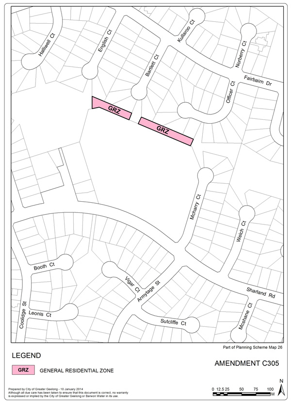
It is proposed to rezone part of Connections Park Corio from the Public Park and Recreation Zone to the General Residential Zone.
The amendment will also apply a Design and Development Overlay to the former Rosewall Primary School site and to the land being rezoned.
The rezoning will provide for the future reallocation of titles owned by the Greater Geelong Council and the Department of Education through a formally arranged land exchange and planning permit application process.
The Department of Education land can then be offered for sale to the private market with improved residential development potential and the land acquired by Council can be used as part of the planned redevelopment of the Rosewall Neighbourhood Centre.
The Design and Development Overlay will ensure public access is maintained to Connections Park.
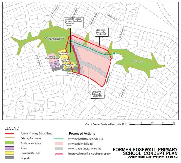
The amendment is supported by the Corio Norlane Structure Plan 2012 which includes the implementation of the Former Rosewall Primary School Concept Plan.
The amendment is consistent with the Corio North Community Infrastructure Plan, noted at the 11 February 2014 Council Meeting to guide the delivery of community service infrastructure in Corio North.
The amendment is an important first step in the redevelopment of the former school site and planned improvements to the Rosewall Neighbourhood Centre.
It is recommended that the amendment be placed on public exhibition.
Cr Heagney moved, Cr Ansett seconded -
That Council resolves to:
Support the preparation and exhibition of Amendment C305 to the Greater Geelong Planning Scheme to:
Rezone part of the land at Connections Park, Corio, from the Public Park and Recreation Zone to the General Residential Zone as shown in Appendix 4; and
Apply the Design and Development Overlay to the land being rezoned and the land at 26-34 Sharland Road, Corio (former Rosewall Primary School Site) as shown in Appendix 6.
Request the Minister for Planning to authorise the preparation and exhibition of Amendment C305.
Carried.
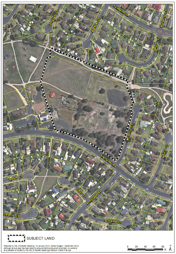
The former Rosewall Primary School site at 26-34 Sharland Road, Corio, ceased operating in 2009 and now stands idle. All buildings have been removed from the site. Closure of the school was part of the former State Government’s Corio Norlane Education Regeneration Project.
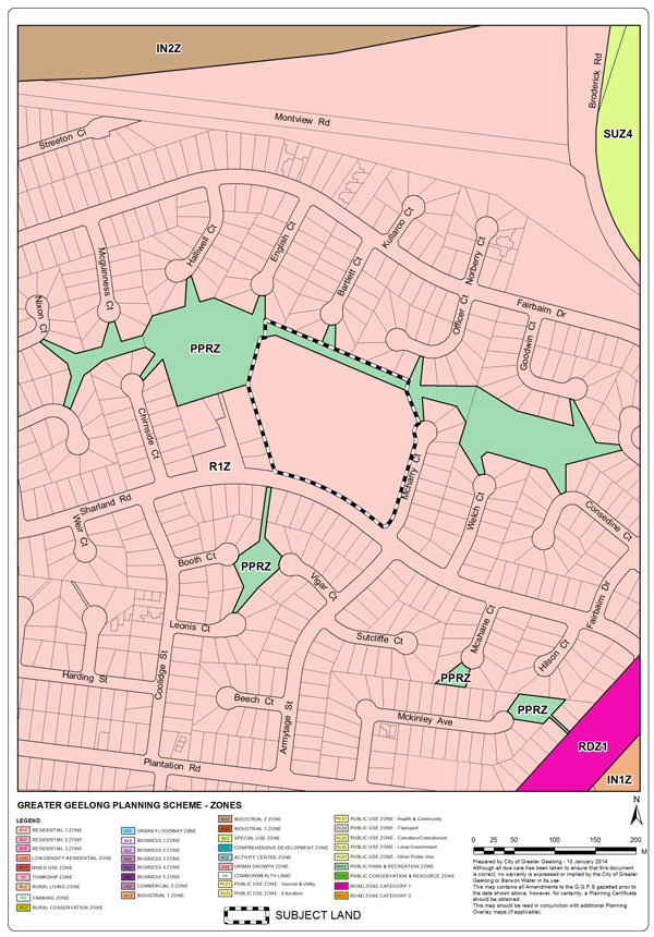
The land is presently owned by the Department of Education and Early Childhood Development and is to be sold to the private market. The land has an area of 3 hectares and is located in the General Residential Zone. The site sits within an established residential area and adjoins Connections Park, an irregular open space reserve owned by the City of Greater Geelong (zoned Public Park and Recreation Zone - PPRZ).
The Rosewall Neighbourhood Centre is directly adjacent to the school site, and in fact, the eastern portion of the building is located on Department of Education land.
An aerial map of the immediate area is shown at Appendix 1 and a current zoning map is at Appendix 2.
The Department of Education originally planned to sell the land in the 2011-12 financial year. However, because a portion of the Neighbourhood Centre building is located on the Department’s land, there needs to be resolution of this matter before any sale can occur.
As part of the preparation of the Corio Norlane Structure Plan, Council officers in collaboration with other agencies, including the Department of Education, worked on a preferred reconfiguration of both the school site and Connections Park. Principle 2 of the Corio Norlane Structure Plan is to support opportunities for sustainable urban renewal and states:
“The planned closure of a number of schools in Corio and Norlane has created an opportunity for new housing development in established neighbourhoods. Redevelopment of the former Rosewall Primary School site provides an opportunity to address the lack of permeability in the existing street layout, as well as improve the surveillance and security of the Connections Park open space area. Part of the former school site could be used to provide an expansion of the Rosewall Neighbourhood Centre and adjacent community garden. The Rosewall Concept Plan (see page 22) represents the preferred redevelopment option for this site and includes the reallocation of land between the CoGG and the Department of Education and Early Childhood Development.”
The former Rosewall Primary School site at 26-34 Sharland Road, Corio, ceased operating in 2009 and now stands idle. All buildings have been removed from the site. Closure of the school was part of the former State Government’s Corio Norlane Education Regeneration Project.
The land is presently owned by the Department of Education and Early Childhood Development and is to be sold to the private market. The land has an area of 3 hectares and is located in the General Residential Zone. The site sits within an established residential area and adjoins Connections Park, an irregular open space reserve owned by the City of Greater Geelong (zoned Public Park and Recreation Zone - PPRZ).
The Rosewall Neighbourhood Centre is directly adjacent to the school site, and in fact, the eastern portion of the building is located on Department of Education land.
An aerial map of the immediate area is shown at Appendix 1 and a current zoning map is at Appendix 2.
The Department of Education originally planned to sell the land in the 2011-12 financial year. However, because a portion of the Neighbourhood Centre building is located on the Department’s land, there needs to be resolution of this matter before any sale can occur.
As part of the preparation of the Corio Norlane Structure Plan, Council officers in collaboration with other agencies, including the Department of Education, worked on a preferred reconfiguration of both the school site and Connections Park. Principle 2 of the Corio Norlane Structure Plan is to support opportunities for sustainable urban renewal and states:
“The planned closure of a number of schools in Corio and Norlane has created an opportunity for new housing development in established neighbourhoods. Redevelopment of the former Rosewall Primary School site provides an opportunity to address the lack of permeability in the existing street layout, as well as improve the surveillance and security of the Connections Park open space area. Part of the former school site could be used to provide an expansion of the Rosewall Neighbourhood Centre and adjacent community garden. The Rosewall Concept Plan (see page 22) represents the preferred redevelopment option for this site and includes the reallocation of land between the CoGG and the Department of Education and Early Childhood Development.”
A key direction of the Structure Plan is then to: “Support the redevelopment of the Rosewall Primary School site for future residential use integrated into a safe and accessible street and open space network (see Rosewall Concept Plan).”
The Former Rosewall Primary School Concept Plan is shown at Appendix 3.
Proposed Rezoning
In order to implement the Rosewall Concept Plan Council planning officers have initiated this amendment. The amendment will rezone a strip of Council-owned PPRZ land wedged between the former primary school land and private properties (3 of which are owned by the Office of Housing) to the General Residential Zone.
A map showing the land proposed to be rezoned is at Appendix 4.
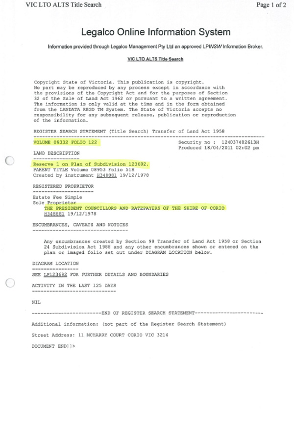
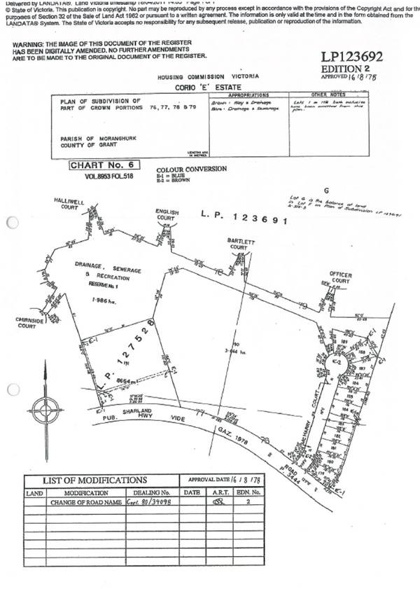
The land to be rezoned is part of Connections Park. A title search states the land description as: Reserve 1 on Plan of Subdivision 123692, Volume 09332 Folio 122 (see Appendix 5).
Residents to the north benefit as the existing PPRZ land to the rear of their properties will become the General Residential Zone. Ultimately, the future development of the land to be rezoned – most likely to form part of new housing – will provide significantly improved safety, security and amenity.
The amendment has support from Council departments, namely Recreation and Open Space, Community Development and Engineering Services. The Community Development department has advised that the rezoning is a high priority in order to facilitate a land transfer and redevelopment of the Rosewall Neighbourhood Centre.
Proposed development controls
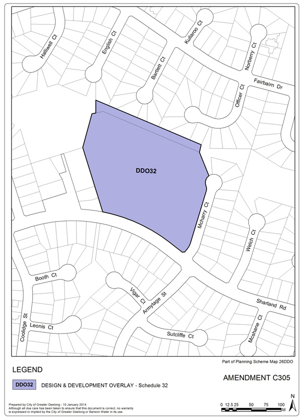
In order to ensure that the future development of the Department of Education land incorporates fundamental design principles, the former school land and PPRZ land to be rezoned will be covered by a Design and Development Overlay. The overlay will include design objectives to maximise surveillance of open space and community facilities and maintain public open space connections.
The land to which the Design and Development Overlay will be applied is shown at Appendix 6.
The western edge of the PPRZ land to be rezoned to the General Residential Zone is impacted by the flood extent determined by the Kosciusko Avenue flood study. Amendment C265 will apply a Special Building Overlay to this land.
Proposed actions to follow Amendment C305
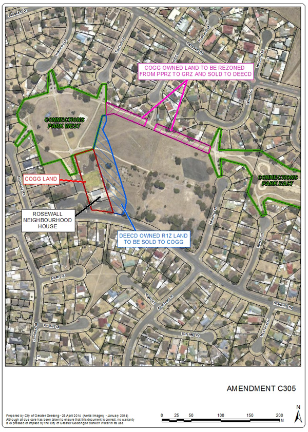
The western portion of the school land will remain in the General Residential Zone (GRZ) and is proposed to be acquired by Council. The land to be rezoned will be sold to the DEECD (subject to Council resolution).
Appendix 7 shows a graphical representation of the proposed land reallocation and consolidation.A future council-initiated planning permit would allow for the subdivision and consolidation of the various land parcels. The permit would also remove the ‘reserve’ status from the land sold. The permit and sale of land process would be aligned.
The rezoning will facilitate the future reallocation of land between Council and the Department of Education. The land exchange is supported by the Department and discussions are ongoing with Council’s Property Advisor. The exchange will benefit the Department as the land rezoned for residential use will make their parcel more attractive to prospective developers.
Similarly, the land to be acquired by Council is needed to support the redevelopment of the Rosewall Neighbourhood Centre. Improvements to the Centre are recommended in the Corio North Community Infrastructure Plan – noted at the 25 February 2014 Council Meeting. Capital expenditure is budgeted for the Rosewall site in Council’s Strategic Resource Plan for 2015-18.
Acquisition of the land will also allow for improved surveillance, access and functionality of Connections Park and the planned community facilities.
There are no environmental impacts as a result of this amendment.
No impact to budget as part of this amendment. Ongoing land exchange negotiations may result in costs to Council to purchase the balance Department of Education land. For this, $150,000 has been allocated in the 2014-15 Budget.
The amendment is directly supported by Clause 22.18 Corio Norlane of the Greater Geelong Planning Scheme. This clause lists as further work: “Support the redevelopment of the former Rosewall Primary School in accordance with the Rosewall Concept Plan including reconfiguration of adjacent public open space”.
The amendment will implement the ‘Former Rosewall Primary School Concept Plan’ contained in the Corio Norlane Structure Plan, July 2012.
The amendment is consistent with the Corio North Community Services Infrastructure Plan prepared by the City of Greater Geelong. The Plan provides a practical vision for Council to plan, design and deliver community services infrastructure at Sharland Road, Rosewall. The Plan identifies additional land required – land currently owned by the DEECD – to achieve this vision.
The Amendment supports the ‘Community Wellbeing’ and ‘Sustainable Built and Natural Environment’ strategic directions of City Plan. The rezoning and built form controls will facilitate the development of the former school land and adjacent open space and community facilities.
No Council officer involved in the report has any direct or indirect interest, in accordance with Section 80(c) of the Local Government Act.
There are no notable risks associated with implementing the recommendation contained in this report.
The amendment is an important step in the long term redevelopment of the former Rosewall Primary School site and planned improvements to the Rosewall Neighbourhood House. These changes will have significant positive benefits for the local community.
The amendment will not impact on any basic rights, freedoms and responsibilities as set out in the Charter. Planning legislation ensures an open community consultation process occurs, enabling people to freely express their views and if necessary obtain a fair hearing before an Independent Panel.
There was extensive community consultation about the former Rosewall Primary School land as part of the Corio Norlane Structure Plan process.
Landowners and occupiers directly abutting the land proposed to be rezoned from the Public Park and Recreation Zone to the General Residential Zone will be informed in writing about this amendment.
Amendment C305 will be exhibited in accordance with the requirements of the Planning and Environment Act 1987.
Portfolio: |
Planning - Cr Heagney |
Source: |
Planning and Tourism- Strategic Implementation |
General Manager: |
Peter Bettess |
Index Reference: |
Application: C266 and 780/2013 |
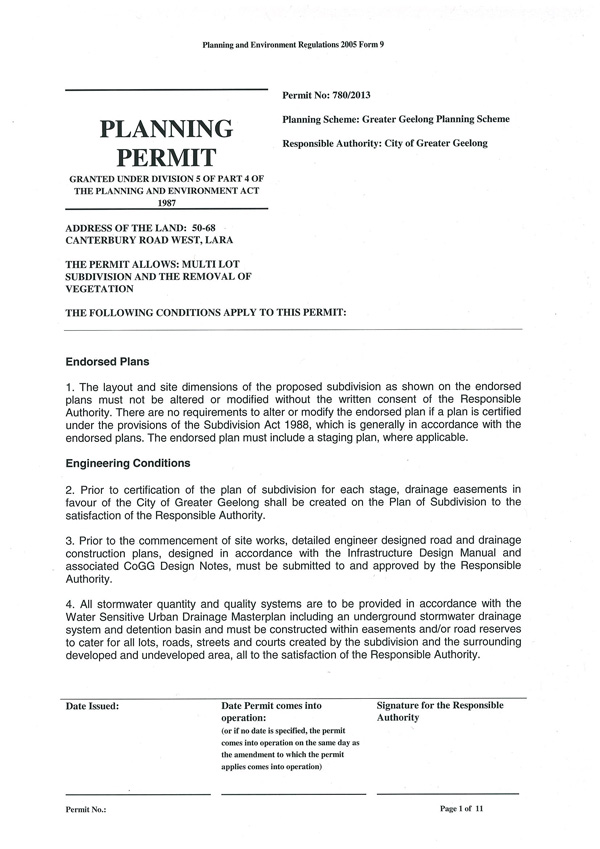
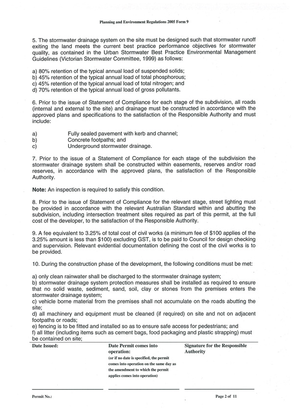
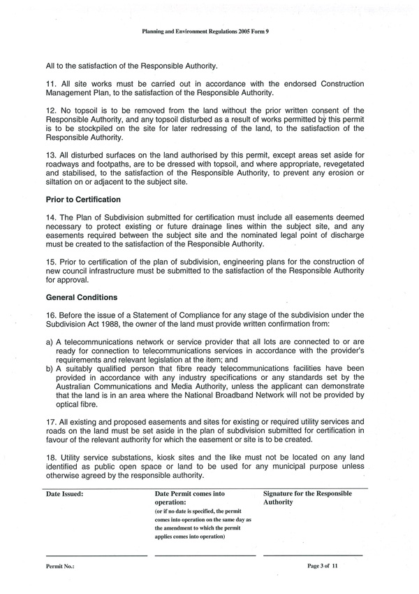
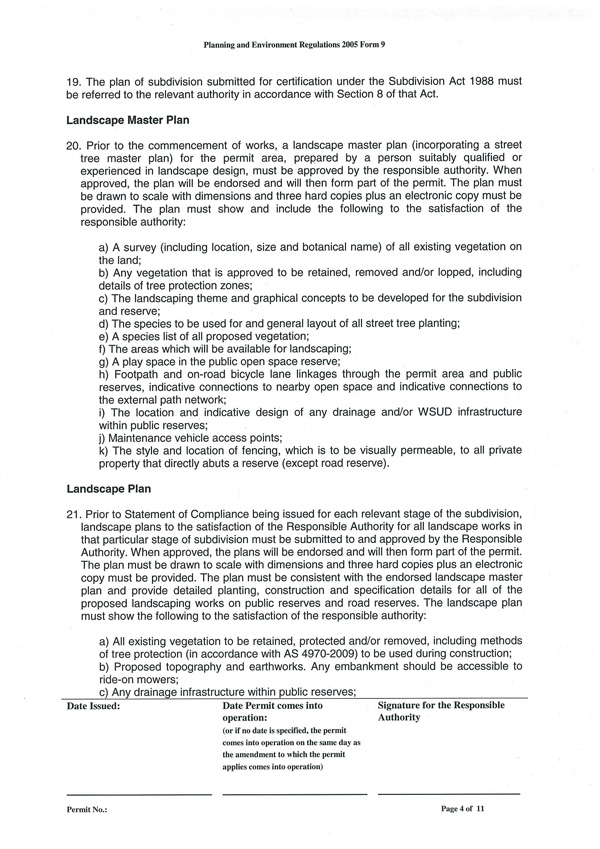
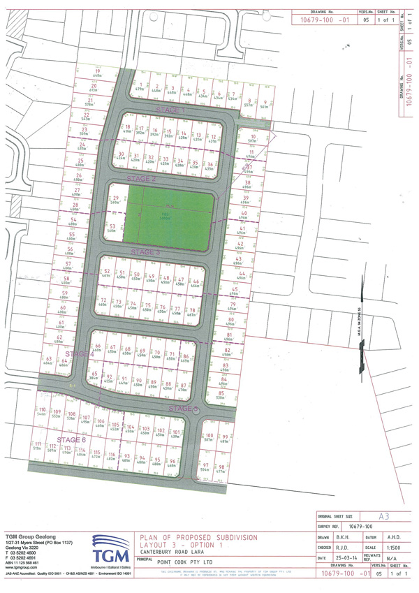
This report acknowledges submissions in response to the exhibition of Amendment C266, which seeks to re-zone land from Farming Zone (FZ) to General Residential Zone (GRZ) Schedule 1, to apply the Special Building Overlay (SBO) and draft Planning Permit 780/2013, which would allow the multi-lot subdivision of the re-zoned land.
A combined Amendment Request and planning permit application was received from TGM Group Pty Ltd on behalf of Point Cook Pty Ltd, the owners of 50 – 68 Canterbury Road West, the land proposed to be re-zoned and in relation to which the permit for multi-lot subdivision has been received.
In addition to the re-zoning of 50 – 68 Canterbury Road West from Farming zone (FZ) to General Residential Zone (GRZ) schedule 1, the amendment also seeks to apply the Special Building Overlay (SBO) together with a Schedule to the SBO (SBO2) to the re-zoned land and adjoining vacant General Residential Zone (GRZ) Schedule 1 land at 26 – 48 Canterbury Road West.
The land at 50 – 68 Canterbury Road West is occupied by a single dwelling and is surrounded to the west and north by residential land in the process of subdivision and staged development (Grand Lakes Estate). The adjoining land to the east, 26 – 48 Canterbury Road West, is vacant land in the GRZ (Schedule 1) and is surrounded to the north and east by established residential development located in the GRZ (Schedule 1).
Following the exhibition of Amendment C266 between 10th April 2014 and 12th May 2014 8 submissions were received; 2 supporting, 1 objecting to the re-zoning and planning permit, and 5 from statutory authorities not objecting.
As the Amendment and draft Planning Permit have been exhibited and submissions received, Council can decide to adopt changes consistent with the submissions, abandon the Amendment and Planning Permit or request the Minister to appoint an Independent Panel to consider and make recommendations to Council.
As no objecting submissions were received in relation to the application of the SBO and schedule, the report recommends that Amendment C266 be split into 2 parts, Part 1 to consist of the application of the SBO and Schedule 2 to 26 – 68 Canterbury Road West and Part 2 to consist of the re-zoning of 50 – 58 Canterbury Road West.
This will enable amendment C266 (Part 1), to permit the application of the Special Building Overlay (SBO) and Schedule 2 to the SBO, to be considered by Council and adopted as exhibited and forwarded to the Minister for approval.
As an objecting submission has been received to the balance of the Amendment C266 (Part 2), which proposes to re-zone land from the Farming zone (FZ) to the General Residential zone (GRZ), Schedule 1 and draft Planning permit, the report recommends that C266 (Part 2) together with draft Permit 780/2013 be referred to a Planning Panel for consideration.
As part of the Panel process all submitters will be notified and given the opportunity to appear before the Panel.
With respect to the application of the SBO, in relation to which no objecting submissions were received, the report recommends that the changes be adopted by Council and Ministerial approval be sought for the application of the SBO as exhibited.
Cr Heagney moved, Cr Ansett seconded -
That Council having considered all submissions to Amendment C266 & Planning Permit 780/2013, resolves in accordance with Section 23 of the Planning and Environment Act 1987 to:
Adopt that part of the amendment relating to the application of the Special Building Overlay and Schedule 2 to the SBO as exhibited;
Request the Minister for Planning to approve the application of the SBO and Schedule 2 to the SBO, to the extent identified in Appendix 1, as C266 (Part 1);
Request that the Minister for Planning appoint an Independent Panel under Part 8 of the Planning & Environment Act 1987 to consider submissions relating to the balance of the Amendment, to be known as C266 (Part 2), and Planning Permit 780/2013, contained in Appendix 2;
Refer all submissions to the Panel; and
Submit to the Panel its response to the submissions as outlined in this report.
Carried.
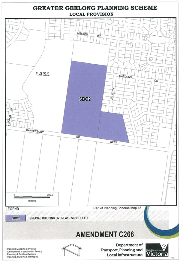
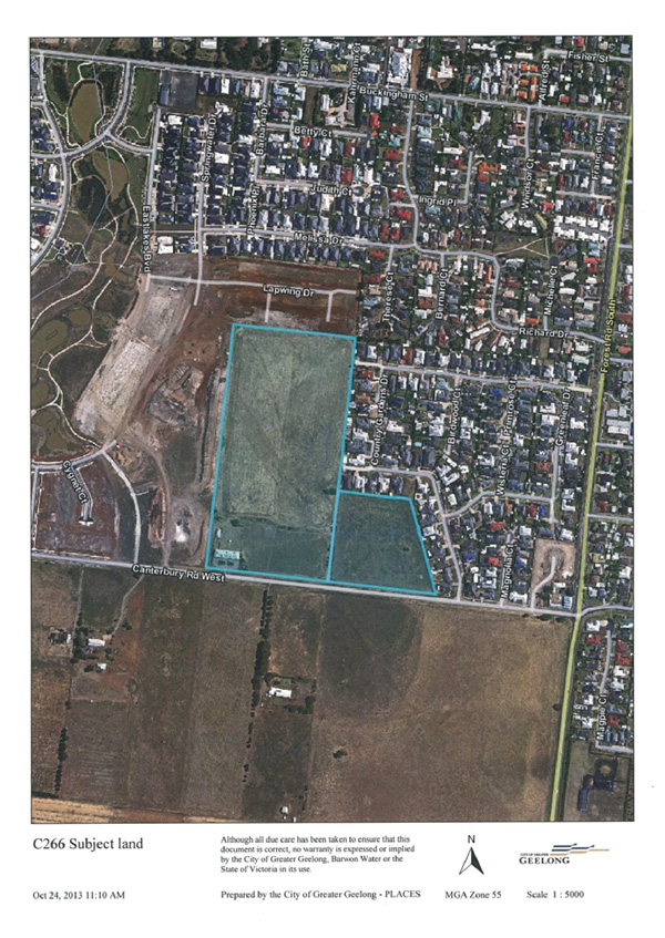
Amendment C266 seeks to apply the Special Building Overlay (SBO) to vacant land in the Farming Zone (FZ) and General Residential zone (GRZ) land subject to overland flow on the north side of Canterbury Road West, located between two residential subdivisions. The location of the subject land and surrounds is identified on Appendix 3.
The amendment also seeks to re-zone the FZ land to GRZ. Each instance of the proposed application of the SBO has previously been the matter of public consultation at the time the respective drainage studies were adopted by Council.
The SBO identifies land that may be subject to flooding when heavy rains cause the capacity of the underground drainage system to be exceeded and overflow. The SBO currently applies to many properties across the municipality, this amendment seeks to extend the coverage to additional areas that have been identified in the flood and drainage study which accompanied the application.
Application of the SBO means that a planning permit is required for most new buildings and works (including some fences) in the area covered by the SBO. Circumstances where a planning permit is not required are specified in the overlay.
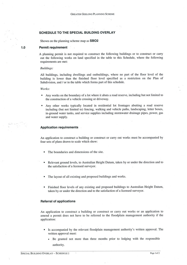
As specified in the overlay, a schedule can specify buildings and works that are exempted from the need for a planning permit. The exhibited schedule 2 to the SBO will exempt the development of a dwelling and associated works from the need for a planning permit where the requirements of the schedule are met.
The application of this overlay will also ensure that the flood risk is disclosed to potential purchasers of affected properties on any Planning Certificate issued by Council and through the provision of this information as part of the Section 32 Statement at the time of purchase.
A total of 8 submissions were received to the amendment. Submissions from the Corangamite Catchment Management Authority, Barwon Water, Vicroads, the Country Fire Authority and the Environment Protection Authority did not object to the Amendment or Draft Planning Permit. Two supporting submission, were received, one from the proponents on behalf of the owner of 50 – 68 Canterbury Road West and one from the owner of 26 – 48 Canterbury Road West. In addition 1 submission objecting to the re-zoning and draft planning permit was also received.
The objecting submission raised the following concerns:
Was told when purchasing the property that the land could not be developed as it was on a flood plain.
Will lose view and privacy.
Officer Response:
The objectors property adjoins 26 – 48 Canterbury Road West, which is already located in the GRZ (Schedule 1).
The draft permit for subdivision does not apply to this land, but to 50 – 68 Canterbury Road West.
The re-zoning and planning permit for subdivision of 50 – 68 Canterbury Road West will not impact on the objectors property, which already abuts land in the GRZ.
Did not receive notice of the subdivision.
Officer Response:
As the draft permit for subdivision is being considered in combination with a Planning Scheme Amendment there is no provision for the erection of a notice on the land to which the permit applies.
In assessing the extent of notification required Council officers determined to notify;
All owners and occupiers of land adjoining or located opposite the land to be re-zoned.
This did not include the objectors land, which is neither opposite nor adjoining 50 – 68 Canterbury Road West, and
The owners and occupiers of all properties affected by the proposed Special Building Overlay.
Again this did not include the objector’s property, which is not included within the SBO.
The round-about at the corner of Forest Road and Canterbury Road will not cope with the additional traffic.
Forest Road is already too busy since the Grand Lakes development was constructed.
Lot sizes are too small.
Inadequate shops and other infrastructure.
Inadequate transport services and services for youth.
Officer Response:
While understanding the objector’s concerns, there are sound planning reasons for supporting the re-zoning and subdivision of the land in the manner set out in the Amendment and draft planning permit.
The permit application was accompanied by detailed reports which have been assessed by Council’s Statutory Planning Unit as complying with the requirements of Clause 56 of the Planning Scheme for subdivisions in excess of 60 lots or more, including the requirements in relation to minimum lot sizes. The conditions contained in the draft permit reflect the assessments of Council officers of the application for subdivision.
The strategic basis for the amendment is also set out under the headings below.
Council can now resolve in one of the following ways:
to abandon the proposed re-zoning and permit in accordance with the objecting submission; or
to adopt the application of the SBO and schedule 2 to the SBO and to request the Minister for Planning to approve the Amendment as C266 (Part 1) see Appendix 1 and
to request the Minister for Planning to appoint an Independent Panel; to consider all submissions in relation to the Re-zoning and draft planning permit as C266 (Part 2) see Appendix 2.
The officer recommendation as to the preferred course is set out in the resolution earlier in this report.
The amendment will not have any adverse effects on the environment. In particular, the application includes reports which show that the extent of application of the SBO and schedule is consistent with best practice.
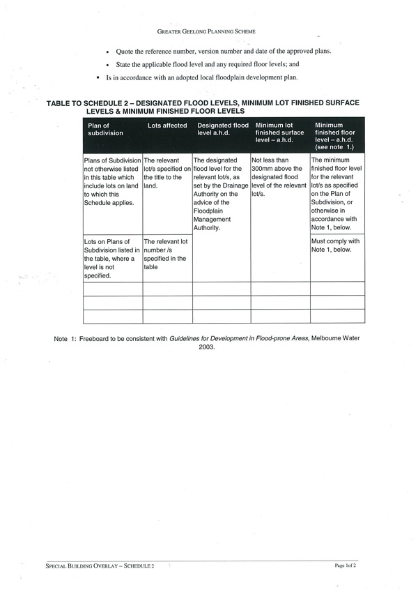
The re-zoning of the land and the application of the SBO will have no adverse financial impact on Council. In particular, the application of Schedule 2 to the SBO will ensure that lots within the resulting residential subdivisions will be created in a manner which ensures that overland flow of water during high rain events is limited to the road ways and drainage system. This will avoid the need for planning permits to be required for the subsequent development of lots within the subdivision in a manner consistent with that specified in the schedule to the overlay.
Amendment C266 is consistent with the following state and local planning policies:
Clause 11 Settlement states that Planning is to facilitate sustainable development that takes full advantage of existing settlement patterns.
The Amendment takes advantage of existing settlement patterns by providing for integrated in-fill residential development within the existing pattern of GRZ subdivision.
The Amendment and permit support the objectives and strategies of Clause 15 Urban Design by creating an urban environment that is safe, functional and provides a good quality environment with a sense of place and cultural identity.
In particular, the re-zoned land will be enhanced by the provision of public open space within the proposed subdivision and excellent connectivity to the adjoining Grand Lakes subdivision and the extensive passive open space contained within that development.
The Amendment supports the objectives and strategies of Clause 19.03 Stormwater by the application of the SBO which will ensure that the subdivision of the land will provide a sustainable approach to managing stormwater from the site by integrating with the existing drainage system through the adjoining Grand Lakes development, which is also affected by the SBO.
Clause 21.05-7 Flooding- ensures the subdivision of the land does not adversely impact the function of flood prone land.
Clause 21.06-2 Urban growth - ensure development occurs within designated settlement boundaries.
Clause 21.06-3 Urban consolidation- provides for the consolidation of existing urban areas in a managed way at an appropriate development density consistent with the zoning of the land.
Clause 21.08-5 Accessibility- ensures access to existing facilities for all members of the community.
Clause 21.13 Lara- in so far as implementing the Directions of the Lara Structure Plan which supports the rezoning of the subject lad fro Rural Living Zone to Low Density Residential Zone. The rezoning will retain the rural living character of the area by utilising the Low Density Residential Zone Schedule 1 and will increase residential density in this location providing good access to existing services.
The recommendations are consistent with the City Plan’s strategic directions Growing our Economy and Sustainable Built and Natural Environment. In particular, both the amendment and permit facilitate sustainable development in accordance with an adopted township Structure Plan and promote sustainable design and development.
No officers involved in the preparation of this report have any direct or indirect interest in the matters under consideration, consistent with the requirements set out in Sec 80 (c) of the Local Government Act.
The re-zoning of the land and application of the Special Building Overlay, together with a schedule which specifies minimum finished floor and surface levels and the subsequent subdivision of the land does not result in any risks to Council.
The amendment will facilitate a number of positive social and economic outcomes including:
Maintaining an adequate supply of residential land in Lara;
Provision of economic development and employment; and
Efficient utilization of existing community infrastructure, services and facilities.
The Amendment and planning permit for subdivision will not impact on any basic rights, freedoms and responsibilities set out in the Charter. Planning legislation ensures an open community consultation process occurs, providing an opportunity for people to freely express their views and, if required, to obtain a fair hearing before an Independent Planning Panel.
The Amendment and draft permit were exhibited in accordance with the requirements of the Planning and Environment Act, 1987, including direct notification to affected owners and occupiers and the placement of a notice in newspapers circulating within the community.
The planning authority for this amendment is the City of Greater Geelong.
The Greater Geelong Planning Scheme is amended as follows:
The Planning Scheme Maps are amended by a total of 1 attached map.
Overlay Maps
Planning Scheme Map No. 18 SBO is amended in the manner shown on the attached map marked “Greater Geelong Planning Scheme, Amendment C266”.
In Overlays – following Clause 44.05, insert a new Schedule 2 in the form of the attached document.
End of document
The planning authority for this amendment is the City of Greater Geelong.
The Greater Geelong Planning Scheme is amended as follows:
The Planning Scheme Maps are amended by a total of 1 attached map.
Zoning Maps
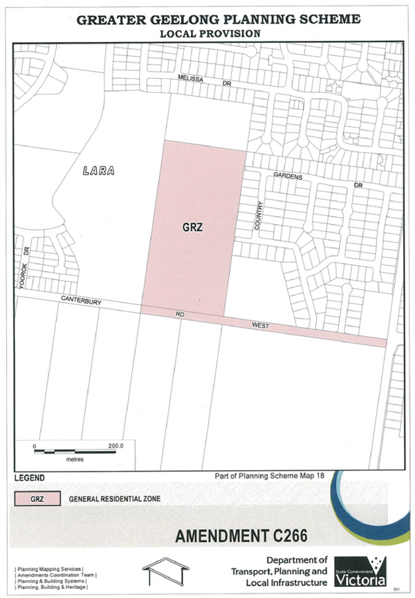
Amend Planning Scheme Map No. 18 in the manner shown on the attached map marked “Greater Geelong Scheme, Amendment C266”.
End of document
Portfolio: |
Planning - Cr Heagney |
Source: |
Planning and Tourism - Strategic Implementation |
General Manager: |
Peter Bettess |
Index Reference: |
Amendment C261 and Planning Permit 1163/2013 |
The purpose of this report is to seek Council approval to prepare and exhibit a combined Planning Scheme Amendment/Planning Permit on land situated at 130-150 Forest Road South, Lara.
An application has been made by TGM Group P/L on behalf of L. Bisinella Developments P/L for a combined Planning Scheme Amendment/Planning Permit on a vacant 8.16ha site situated at the south west corner of Canterbury Road West and Forest Road South, Lara.
The application seeks the rezoning of the land from Farming Zone to General Residential Zone Schedule 1 (GRZ1). The permit application seeks approval for a conventional 108 lot residential subdivision on the northern half of the site and removal of some native grassland . Most of the southern half of the land has been set aside for a retarding basin and open space.
The application includes detailed technical reports addressing all the major issues including planning, stormwater management, vegetation removal, traffic and cultural heritage management as outlined in this report.
The proposal is consistent with State and Council planning policies. The Lara Structure Plan designates land on the south side of Canterbury Road West as “investigation area for increased residential densities” which applies to the northern half of the subject land . The town’s settlement boundary runs through the subject land with its southern half falling within the non-urban buffer to the Geelong Ring Road Employment Precinct.
Support for this application will provide a precedent for consideration of rezoning proposals of other similar properties on the south side of Canterbury Road West which would similarly need to demonstrate an ability to address stormwater management issues applying to these properties and the wider area.
It is recommended Amendment C261 and the accompanying permit be exhibited as described in this report.
Cr Heagney moved, Cr Ansett seconded -
That Council resolves to
Support the preparation and exhibition of Amendment C261 to the Greater Geelong Planning Scheme to rezone land at 130-150 Forest Road South, Lara from Farming Zone to part General Residential Zone Schedule 1, part Public Use Zone 6 and part Public Park and Recreation Zone;
Consider the Application for Planning Permit to provide for the residential subdivision of the land being rezoned to General Residential Zone Schedule 1 concurrently with the preparation of the Amendment in accordance with the Planning and Environment Act, and that the draft Planning Permit 1163/2013 be prepared and exhibited with the Amendment, subject to the resolution of the detail of the permit conditions; and
Request the Minister for Planning to authorise preparation and exhibition of Amendment C261 and Planning Permit 1163/2013.
Carried.
An application has been made by TGM Group P/L on behalf of L. Bisinella Developments P/L for a combined Planning Scheme Amendment/Planning Permit on land situated at 130-150 Forest Road South, Lara, pursuant to section 96A of the Planning and Environment Act.
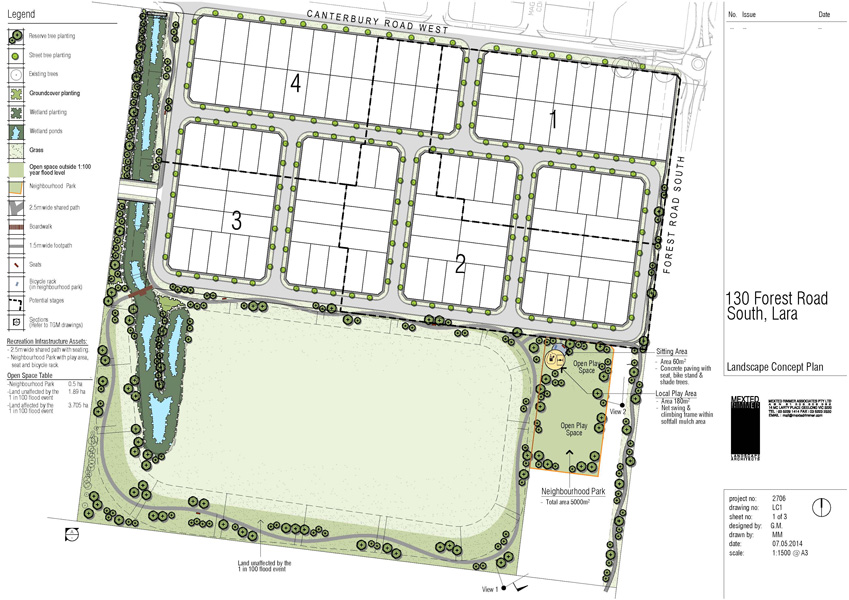
The application seeks the rezoning of the vacant 8.16 hectare site from Farming Zone to General Residential Zone Schedule 1 (GRZ1). The permit application seeks approval for a conventional 108 lot residential subdivision on the northern half of the site and removal of some native grassland . Most of the southern half of the land has been set aside for a retarding basin and open space and will need to be transferred to Council’s ownership. A remnant portion of the land along the Forest Road frontage does not form part of the subdivision development proposal and will remain in the ownership of L. Bisinella Developments. Appendix 1 shows the proposed future subdivision development of the site.
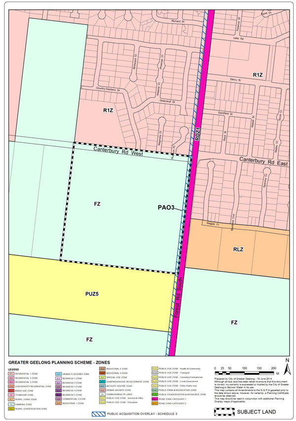
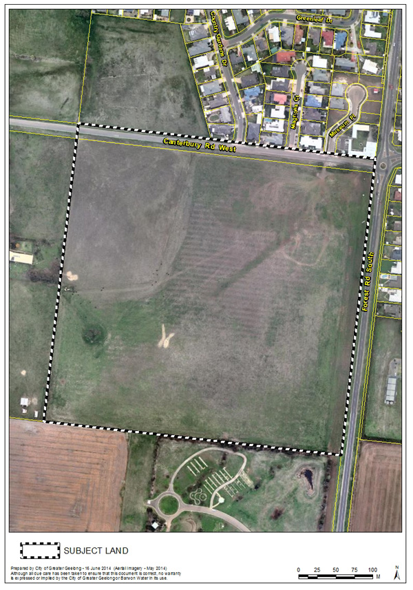
The existing zoning of the subject land and surrounding area is shown in Appendix 2. An aerial photo of the same area is Appendix 3.
The application includes detailed technical reports addressing all major issues including planning, stormwater management, vegetation removal, traffic and cultural heritage management which are addressed in the next section of this report.
The consideration of this application raises a number of issues as follows:
Strategic Planning
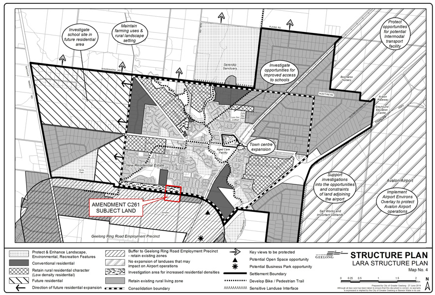
The Lara Structure Plan map (clause 21.13-4 of the MSS) provides strategic guidance regarding the future development of the subject site. It shows the northern half of all properties on the south side of Canterbury Road West, between O’Hallorans Road and Forest Road South, as being within an “investigation area for increased residential densities” and their southern half being part of the “Buffer to Geelong Ring Road Employment Precinct – retain existing zones”. The Lara Township Settlement Boundary runs through these properties and clearly restricts any long term development potential to the northern half. Appendix 4 is a copy of the Lara Structure Plan map showing the location of the subject land.
The Lara Structure Plan provides strategic support for the consideration of this application and proposes residential subdivision of the northern half of the land. Support for this application will set a precedent for the consideration of future similar development proposals on other properties on the south side of Canterbury Road West, which will similarly need to demonstrate that all stormwater management issues can be adequately addressed.
Detailed Planning Issues
As shown in Appendix 1, the proposed residential subdivision virtually occupies the entire northern portion of the site. The proposal neighbourhood park of 0.5 hectares including a children’s playground is located in the southern area as is a major stormwater retarding basin. Agreeing to locate the neighbourhood park outside the proposed residential zoned area will assist the developer in maximising lot yields.
Council officers have indicated to the applicant that as part of the 10% open space provision requirement an unencumbered 0.5 hectare neighbourhood park must be provided. It has also been indicated that Council would be prepared to accept areas around the perimeter of the proposed retarding basin as part of the 10% contribution provided it is satisfied it will constitute usable and functional open space. The applicant proposes to construct a 2.5 metre wide shared path around the edge of the basin.
The open space arrangements which provide for a 0.5 ha unencumbered open space together with the recreational use of land surrounding the retarding basin will satisfy the open space/recreational requirements for the proposed residential subdivision. It is proposed that specific requirements for the planning, delivery and maintenance of open space infrastructure to be provided by the developer will be included as conditions on the residential subdivision permit. An earlier initial proposal by the applicant to construct soccer fields in the base of the retarding basin has been withdrawn at the request of Council officers essentially because of the expensive on-going maintenance costs.
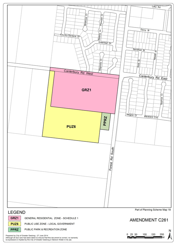
It is proposed that the northern half of the land be included in a General Residential Zone Schedule 1 (GRZ1), the retarding basin land be included in a Public Use Zone 6 (Local Government) and the neighbourhood park be included in a Public Park and Recreation Zone. The small southern portion of the site to be retained by the applicant will remain within the existing Farming Zone for the time being until its future use has been determined. Appendix 5 shows the proposed rezoning of the land.
It is intended that the standard requirement that a developer pays a $900 per lot community contribution be a condition applied to the accompanying residential subdivision permit.
It should be noted that a Public Acquisition Overlay (PAO) to provide for the potential future widening of Forest Road affects the whole eastern edge of the subject land. The current subdivision application shows two residential lots and a local road within the PAO area in an apparent attempt to encourage VicRoads to commence negotiations re their future purchase of the land. It is proposed that permit conditions require amended plans to show the future subdivision layout avoiding the PAO area.
Stormwater Management
The subject land and surrounding area is generally flat with grades of approx 1:100. It drains naturally to the north west into Grand Lakes but there is a localised entrapped low area on the subject land and adjoining properties which plays an important flood storage role. The subject land is also subject to significant sheet flows from the rural and industrial land to the south.
The applicant was also requested, as part of their detailed investigations and modelling, to consider the potential future development of all of the properties on the south side of Canterbury Road South.
The 1% AEP Modelled flood extents are similar in nature to the Grand Lakes Estate and adjoining Amendment C266 land (Point Cook P/L) in that flooding is contained in some of the road reserves.
Whilst the site sits within the same floodplain as Grand Lakes and the major drainage infrastructure forms an extension to the Grand Lakes waterway, the proposed local subdivision road network is only marginally affected by a 1:100 flood event. Rather than apply a Special Building Overlay, it is proposed the subdivision permit include conditions requiring finished levels of residential lots to ensure inundation cannot occur.
A number of detailed drainage and other engineering issues which have been raised are being resolved with the applicant and will be able to be further addressed by the inclusion of detailed conditions on the residential subdivision permit. Provision has been made to allow east-west connectivity with the adjoining land to the west as requested by Council; however design of culverts and bridging structure will need to demonstrate no adverse impact on flood levels.
Vegetation Removal
The Vegetation Assessment prepared by the applicant’s consultant has identified some areas of native grassland which appears to otherwise have a history of cropping and grazing. The site is assessed by the consultant as containing degraded treeless vegetation which is rated as having negligible to local significance for biodiversity conservation.
Council’s Environment and Natural Resources Unit has inspected the site which is being grazed by cattle, making identification of native grasses more difficult. In any areas where native grass species exceed 25% vegetation cover, offsetting will be required.
From a development perspective the areas containing native grasses are heavily modified and degraded. As such the Environment Unit has no objection to the land being developed subject to ensuring that permitted clearing has a neutral impact on Victoria’s biodiversity (i.e. offsetting, if required).
This issue will be addressed in on-going negotiations with the applicant and implemented by the inclusion of conditions on the residential subdivision permit.
Planning Permit
It is proposed that draft planning permit 1163/2013 be prepared and exhibited with the amendment documentation. It will enable the northern part of the land to be subdivided into residential allotments generally as shown in Appendix 1 with a retarding basin and neighbourhood park constructed on the southern half of the land. The permit will include standard conditions as required by internal Council units and external authorities, together with other conditions as referred to in this report.
The Amendment gives effect to recommendations of the Lara Structure Plan which has addressed the wider environmental implications of development of the town.
A Vegetation Assessment report accompanying the application rates the site as having local significance for biodiversity conservation which does not present limitations to development.
All the costs associated with the development and the provision of additional services to the area will be met by the developer. The Council will become responsible for the ongoing maintenance of the new retarding basin and neighbourhood park.
The proposed Amendment is considered to be consistent with a range of State and Council planning policies in the Planning Scheme. In particular, this area has been identified for investigation for future residential growth in the adopted Lara Structure Plan as described in this report.
Amendment C261 supports both the Growing our Economy and Sustainable Built and Natural Environment strategic directions of City Plan, particularly insofar as it is facilitating sustainable development in accordance with an adopted township Structure Plan.
No Council officers have any direct or indirect interest, in accordance with Section 80 (c) of the Local Government Act.
No risks have been identified in exhibiting Amendment C261 and the accompanying planning permit as being recommended by this report.
Whilst the subject land is located on the edge of the town, it is located on a public bus route and is within easy walking distance to Lara Lake primary school. It adjoins existing and developing residential areas and will have good access to the town’s open space network.
Amendment C261 does not impact on any basic rights, freedoms and responsibilities as set out in the Charter. Planning legislation ensures an open Community Consultation process enabling people to freely express their views and obtain a fair hearing before an Independent Panel.
Full public notification of the Amendment has been given in accordance with the provisions of the Planning and Environment Act. All adjoining and nearby property owners will receive direct notification of the exhibition of the Amendment and have an opportunity to present their submission to an Independent Panel appointed by the Minister for Planning.
Portfolio: |
Planning - Cr Heagney |
Source: |
Planning and Tourism - Strategic Implementation |
General Manager: |
Peter Bettess |
Index Reference: |
Application C303 |
This report acknowledges submissions to Amendment C303 and recommends adoption of the Amendment.
An Amendment request was made Fadgyas Planning Associates on behalf of S.C.G. Properties Pty Ltd, the owner of land at 3 – 5 Forest Road South, Lara.
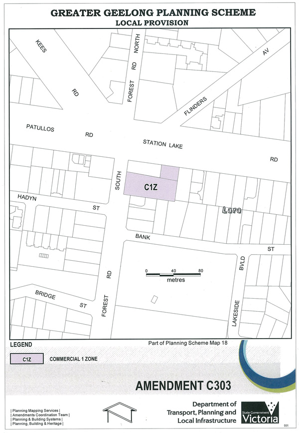
The Amendment proposes to rezone the proponents land from General Residential zone (GRZ), to Commercial 1 zone (C1Z).
The subject land is occupied by recently constructed shops, adjacent to and opposite established shops and related businesses in the C1Z to the north and west.
Public exhibition of Amendment C303 commenced on 8 May 2014 and closed on 9 June 2014.
Two supporting third party submissions were received suggesting that the application of the Commercial 1 zone be extended to the portion of the lot at 1 Forest Road South, to the north of the subject land, which is located in the General Residential zone. The owner of 1 Forest Road South also owns the dwelling located at 10 Station Lake Road, which abuts the eastern boundary of both 1 and 3 – 5 Forest Road South. Council Officers support this request.
Submissions were received from VicRoads and the CFA, together with a combined response from the Department of Transport, Planning and Local Infrastructure and Public Transport Victoria. None of these agencies objected to the Amendment.
No objecting submissions were received from third parties.
The proposal is supported by Clause 21.13-1 & 21.13-2 of the Municipal Strategic Statement, with respect to meeting the commercial and retail needs of Lara residents.
The Amendment can now be adopted with no need to refer the Amendment to an Independent Planning Panel.
Cr Heagney moved, Cr Ansett seconded -
That Council resolves to:
Adopt Amendment C303 in the form as outlined in Appendix 1 of this report; and
Submit the adopted Amendment with the prescribed information to the Minister for Planning requesting approval.
Carried.
The subject land has been recently developed for Commercial use via a planning permit, consistent with the provisions of the Residential 1 zone, which was the zone that applied to the land at the time the permit issued.
The property at 3-5 Forest Road South, is bounded by existing Commercial 1 land to the north and General Residential zone (Schedule 1) land to the East and South.
The proposed re-zoning will bring the zoning of the land into conformity with the purpose for which it has been developed.
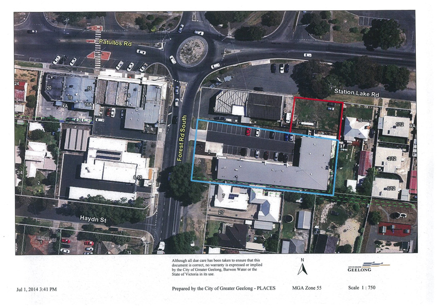
The land to which the exhibited rezoning applies is shown with a blue border in the aerial photo at Appendix 2.
Council resolved under delegation on 14th March 2014 to place the Amendment on exhibition.
The subject land is bounded by an automotive service station to the north and existing dwellings to the east and south. The dwellings are located in the GRZ. The developed (western) portion of the service station is zoned C1Z and the predominantly undeveloped (eastern) portion is zoned GRZ.
Exhibition of Amendment C303 took place between 7 May 2014 and 9 June 2014 with notices in local newspapers and the Government Gazette. Notice of the Amendment was sent to relevant Ministers under the Planning and Environment Act and to surrounding land owners and occupiers.
All adjoining landowners and occupiers were directly notified.
Submissions were received from VicRoads and the CFA, together with a combined response from the Department of Transport, Planning and Local Infrastructure and Public Transport Victoria. None of these agencies objected to the Amendment.
No objecting submissions were received from third parties.
One submission was received from the owner of the adjoining service station at 1 Forest Road South, to the north, requesting that the re-zoning be extended to incorporate the portion of their title currently zoned GRZ. The proposed addition to the extent of application of the C1Z is show outlined in red at Appendix 2.
A submission suggesting the same extension of application of the C1Z was also received from the proprietor of the service station.
In determining whether the extent of application of the C1Z should be increased to include the rear, undeveloped portion of the service station site without further exhibition, in accordance with the two submissions received, Council must consider the potential for detriment to result from such a change to the proposed amendment.
Given the location and size of the area proposed by the submittors to also be included in the re-zoning, together with its current undeveloped state, it is the view of Council officers that the only parcel of land which could be adversely affected by the extension of the re-zoning would be the dwelling located at 10 Station Lake Road. This property is zoned GRZ and abuts both the eastern boundary of the exhibited amendment and the eastern boundary of the land now requested to be included as part of the amendment.
In considering the potential for detriment Council officers are conscious of both the nature of development which can already occur on the vacant land under its current zoning and the limitations which the scheme applies to development with adverse amenity potential occurring on land which abuts residential land. In view of these considerations, Council officers have formed the view that no person would be disadvantaged by the extension of the re-zoning to include the area outlined in red on Appendix 2.
This view is further supported by the provision of written advice from the owner of 10 Station Lake Road, who also owns the service station site, that she does not believe that any detriment would result to her, as the owner of 10 Station Lake Road, by the re-zoning of the undeveloped portion of the service station land to C1Z.
Because there are no objecting submissions, the Amendment does not need to be heard by an Independent Planning Panel.
Council is now able to adopt the Amendment and forward it to the Minister for Planning seeking approval.
The amendment will not have any adverse effects on the environment. The orientation of the recently development site has been designed to locate the car park adjacent to the existing commercial premises to the north and as far as possible from the residential units on the adjoining lot to the south. This will minimise any potential for adverse environmental impacts, especially with regard to car movements on the site.
There are no financial implications for the Council.
No impact to budget.
Amendment C303 is generally consistent with Council’s Municipal Strategic Statement.
At clause 21.13-1 of the planning scheme, Key issues and influences, it is noted that:
“Retail and commercial expansion is required to meet the needs of local residents… “
Clause 21.13-2 Strategies includes the following:
“Limit the Patullos Road shopping strip to the existing Business 1 zoned land.”
Clause 22.03, Assessment Criteria for Retail Planning Applications, specifies selection criteria for the exercise of discretion in regard to applications in specified circumstances, including out-of-centre proposals. These criteria were required to be met at the time the permit was issued for the development of the existing commercial premises on the land.
The Amendment supports the ‘Growing our Economy’ strategic direction of City Plan, by consolidating the role and function of the Patullos Road shopping strip in a manner that will allow it to better meet the needs of local residents .
No officers involved in this report have any direct or indirect interest In accordance with Sec 80 (c) of the Local Government Act.
There are no readily identifiable risks associated with implementing the recommendation contained in this report.
The Amendment is not expected to generate any significant social impacts.
The Amendment will not impact on any basic rights, freedoms and responsibilities as set out in the Charter. Planning legislation ensures an open community consultation process occurs, enabling people to freely express their views and if necessary obtain a fair hearing before an Independent Panel.
The Amendment was exhibited in accordance with the Planning and Environment Act 1987, including direct notification to all adjoining landowners and occupiers.
The planning authority for this amendment is the Greater Geelong City Council.
The Greater Geelong Planning Scheme is amended as follows:
The Planning Scheme Maps are amended by a total of 1 attached map sheet.
Zoning Maps
Amend Planning Scheme Map No. 18 in the manner shown on the 1 attached map marked “Greater Geelong Planning Scheme, Amendment C303”.
End of document
Portfolio: |
Community Development – Cr Fisher |
Source: |
Community Services / Family Services |
General Manager: |
Jenny McMahon |
Index Reference: |
Subject: Community Services / Family Services Planning |
The purpose of this report is to seek endorsement from Council to resubmit an application to the Department of Education and Early Childhood Development for funding of $1.6 million towards the development of an Integrated Children’s Centre in Hendy Street, Corio.
On 25th February 2014 a report was presented to Council seeking endorsement from Council on the project scope for the development of an Integrated Children’s Centre at Hendy Street, Corio and for Council to authorise officers to make a submission for funding to DEECD for $1.6 million.
The application to DEECD was unsuccessful, however CoGG has now been invited to resubmit an application for the current round of Integrated Children’s Centre Grants 2014-15.
The report to Council indicated that the total cost of the project was in the order of $4.7 million. Costs have now escalated by approximately 9.4%, ($450k approx) bringing the total project cost of $5.15 million.
The concept of an Integrated Children’s Centre at the site in Corio has been endorsed by Council in the report Future Provision of Community Services Infrastructure in Norlane/Corio, in November 2010. The proposed facility will replace the previous facility at Rosewall which was burnt down in 2011, incorporates the existing Maternal and Child Health Centre and William Hovell Kindergarten, and allow for expansion of services for this community.
The proposal to develop the Integrated Children’s Centre in Hendy Street is a key finding of the Corio North Community Services Infrastructure Plan, which has been developed through extensive consultation with the community, key stakeholders and community groups.
It is proposed to build a new Integrated Children’s Centre adjacent to the Northern Bay College P–8 School in Hendy Street, Corio that will include: two kindergarten rooms; a multi-purpose room to host playgroup or occasional care; consulting rooms for Maternal and Child Health (MCH) and other family support services such early intervention services.
Grants are available through the State Government for Integrated Children’s Centres. On July 10, 2014, an expression of interest was submitted to DEECD for a $1.6 million grant towards the proposed centre. On July 21, 2014 DEECD invited Council to develop a full proposal for consideration.
The proposed location of the new Integrated Children’s Centre at Hendy Street, will link closely with the Hendy Street campus of the Northern Bay Secondary College, Hendy Street Hall, Scouts and adjacent recreation and open space.
Discussions in regard to governance of the facility and responsibility for service provision are progressing and will be the subject of a future report to Council.
Cr Ansett moved, Cr Fisher seconded -
That Council:
authorises officers to proceed with the submission to DEECD for a contribution of $1.6 million;
commits the $2 million identified in Council’s Resource Plan and the $1.19 million insurance payment and refers the amount of $450,000 to the 2015-2016 budget.
Carried
In November 2010 Council endorsed the concept of developing an integrated community facility on the proposed site at Hendy Street, in the Future Provision of Community Services Infrastructure in Norlane/Corio report.
The proposed new family and children’s centre will replace the existing William Hovell Kindergarten located at the site as well as replace the Rosewall Kindergarten, which was destroyed by fire in 2011. This service is currently operated at the Wathaurong Children’s Centre until such time that the new facility is completed.
Consistent with existing policy directions, the proposed site of the new Integrated Children’s Centre provides the opportunity to co-locate services with the Northern Bay College P–8 School in Hendy Street and to create a more integrated streamlined service for families and children.
The school has previously indicated strong and enthusiastic support for the potential development of an integrated family and children’s centre on the proposed site, which would complement and extend their existing education and community programs.
The location of the proposed Hendy Street Integrated Children’s Service is a key recommendation of the Corio North Community Services Infrastructure Plan. The Plan has had extensive community consultation and aims to provide future direction for the delivery of community services to the Corio North area. The Plan considered a range of service needs and facilities in the area including Rosewall Neighbourhood Centre, MCH, kindergarten and early years’ services, community garden, plus community meeting spaces. The Plan aims to maximise access to services as well as ensure co-location, integration and multi-use.
At this stage it is not proposed to include a long day care service within the scope of the new centre. Current service information suggests that the need for child care in the Hendy Street area is being met through existing service provision.
The operational model for the new centre is being developed and will be the subject of a further report to Council.
The need for integrated services, particularly for families with young children has been clearly articulated in previous reports to Council, including the Municipal Early Years Plan.
Contemporary community facility planning and service development practices in children’s services has shifted away from the provision of single purpose buildings to the development of multi-purpose facilities, which incorporate a wide range of compatible and complementary services and programs.
Integrated children’s centres, partially funded by the state government, are expected to provide a range of services that include long day care, kindergarten, MCH, along with provision for early intervention and family support services.
Services to be included in the design and delivery of the new centre are as follows:
Kindergarten – two rooms and outdoor playground areas (including kitchen, toilets, and storerooms) licensed for up to 66 children (including groups for four and three year old children).
Maternal and Child Health (MCH) – two consulting rooms, waiting room, and storage areas.
Multi-purpose room – for group programs (playgroups, new parent groups, occasional care, and early intervention programs).
Consulting rooms – three flexible consulting rooms for the delivery of child and family support services, paediatric allied health, clinical and therapeutic services for children and families.
The new centre will provide enhanced capacity for the delivery of kindergarten, MCH and family support services beyond the capacity provided by the current facilities. The new facility will accommodate provision for occasional care if local needs require this in the future.
The destruction by fire in 2011 of the Rosewall Kindergarten and closure of the Rosewall Primary School and Flinders Peak Secondary College have impacted on the community and local service provision. The planning and development of new facilities will provide a boost for the local community and enable a range of improved services, programs and activities to be delivered in the local area.
The relocation and expansion of services at this site will encourage strong relationships within the services working with local children and families and will provide a safe stimulating and nurturing environment for children that facilitates their development and actively encourages their potential.
The catchment area of the proposed family and children’s centre is recognised as an area of socio-economic disadvantage with relevant demographic indicators identifying higher proportions of young children being developmentally vulnerable in the Corio North area compared with average local, state and national benchmarks.
The design of the centre combined with governance and management arrangements will act as vehicles for integrated planning and delivery of multi-disciplinary services and activities, enabling parents, children and community members to join together to plan, develop and be part of activities that are comprehensive, local, child centred, welcoming, responsive, non-judgemental, inclusive, sustainable, and, most importantly, engaging.
There are no known environmental implications associated with this project. Environmental Sustainable Design principles will be incorporated into the detailed design of the facility, consistent with contemporary quality and design principles and requirements.
While the proposed facility will be designed to maximise environmental benefits, any costs provided do not include environmental features over those that are required by the building code.
The cost of the Hendy Street Integrated Children’s Centre is estimated to be approximately $5.15 million.
An amount of $3.6 million is included in Council’s Four Year Resource Plan for the Hendy Street project.
As a result of the fire at Rosewall in 2011 Council received a $1.19 million insurance payout to be utilised to redevelop family and children’s services in the local area.
Should Council be successful in achieving the $1.6 million DEECD grant, after applying the $1.19 million insurance payment the net cost to Council for the project would be $2.45 million.
The net additional operating cost to Council of the new facility is expected to be in the order of $6,000 per annum, dependant on centre utilisation and management arrangements. This will be the subject of a further report to Council.
The project is consistent with federal, state and local government policy in relation to the development of integrated children’s services.
The proposal is also consistent with key objectives contained within Council’s Municipal Early Years Plan, Creating Communities for Children, and the Structure Plan for Corio Norlane, along with previous community infrastructure plans endorsed by Council.
This project aligns with, and closely complements existing developments in the area in relation to the Corio Norlane Education Regeneration Project, Extended Schools Hub Project, and Department of Human Services’ Building for the Future Urban Renewal Project.
The draft plan supports previous planning undertaken in relation to community infrastructure provision as a priority for the City of Greater Geelong and local communities. The project is identified for funding as part of Council’s Four Year Strategic Resource Plan.
Community consultation with regard to infrastructure provision is in accordance with City Plan strategic directions – ‘Community Wellbeing’ and ‘Sustainable Built and Natural Environment’.
Pursuant to Section 80(c) of the Local Government Act 1989, no Council staff involved in the preparation of this report have a direct or indirect interest in the matter to which this report relates.
There is a risk to Council’s reputation if it is unable to provide essential early childhood services to the Corio North/Hendy Street community.
Existing facilities in the area provided by Council for children and families do not meet quality and service requirements, with previous reports recommending replacement of these facilities.
The nature of existing service facilities in the area results in staff working in an isolated environment, which increases exposure to potential occupational health and safety risks that are difficult to address or mitigate in the current service locations.
The provision of strong and effective support to children and families in the early years of children’s development and family formation are widely recognised as having significant long-term benefits and implications for children’s early development, family participation and community wellbeing.
Provision of high quality services, facilities and environments that support and encourage positive participation and access by children and families have been identified as being critical to improving children’s early development outcomes, addressing disadvantage, reducing family isolation and contributing to the creation of more vibrant, cohesive and prosperous communities.
The United Nations Convention on the Rights of the Child (CRC) requires governments to take all appropriate measures to “render appropriate assistance to parents and legal guardians in the performance of their child-rearing responsibilities”.
The United Nations CRC, in conjunction with the Human Rights Charter, upholds the rights of children to receive appropriate support and assistance, which protects their welfare, health, and well-being.
Human rights have been considered in the development of this report, particularly in relation to the ‘right to protection of families and children’ and the ‘right to take part in public life’.
Council’s Community Development and Family Services Departments will be responsible for communicating and reporting on the information contained within this report.
Portfolio: |
Community Development - Cr Fisher |
Source: |
Community Services/Family Services |
General Manager: |
Jenny McMahon |
Index Reference: |
Subject: Community Services/Family Services Planning |
The purpose of this report is to seek approval from Council for officers to make a funding application to the Department of Education and Early Childhood Development (DEECD) for $350,000 for an Early Learning Facility Upgrade Grant for Fyans Park Kindergarten.
Fyans Park Kindergarten is located at 204 West Fyans Street, Newtown and provides 29 Kindergarten places to families from a range of socio-economic backgrounds.
Fyans Park Kindergarten has been identified in the West Fyans Street Structure Plan 2010 for an extension/upgrade in response to increased local service demand.
The planned extension will include a second kindergarten room, increasing service capacity to 66 and a shared consulting space/parent room which will allow for expansion of services for this community.
On July 10 2014, an Expression of Interest was submitted to DEECD for a $350,000 grant towards the proposed works. On July 21 2014 DEECD invited Council to develop a full proposal for consideration.
The estimated gross capital cost of the project is $1,213,149. The initial cost to Council was estimated to be approximately $600K, with an anticipated State Government contribution of $650K. The actual amount that Council can apply for is $350K, resulting in a shortfall of $263,149. The net cost to council if the application to DEECD is successful will be $863,149.
The kindergarten is operated by Geelong Kindergarten Association with the building lease being held by Fyans Park Kindergarten Committee. Council officers will work in collaboration with the kindergarten Committee of Management and Geelong Kindergarten Association throughout the development of this project.
Cr Fisher moved, Cr S Kontelj seconded -
That Council:
refer the sum of $863,149 to the 2015/2016 budget;
authorise Council officers to proceed with a funding application to DEECD under the Early Learning Facility Upgrade Grant Program for a contribution of $350,000.
Carried.
Population mapping indicates growth in population of 0-4 year olds in the Geelong suburb of Newtown. Operating from the only council owned kindergarten facility in Newtown, Fyans Park Kindergarten provides the opportunity for Council to plan for growth of kindergarten provision in this large geographic area comprising Newtown and central Geelong.
The kindergarten is situated on a large corner allotment in close proximity to Fyans Park Primary School. An extension to this existing kindergarten building in a location which enables continued strong partnerships with the local primary school, is consistent with existing policy directions enabling streamlined services for families and children.
Council’s West Fyans Street Structure Plan 2010 provides opportunities for social infrastructure in key locations to support the precinct’s growing population including expansion of Fyans Park Kindergarten. The planned expansion/upgrade of Fyans Park Kindergarten will enable the kindergarten to accommodate 66 children, an increase of 37 children from current capacity of 29.
The upgraded facility will provide an additional flexible use room/office that will be able to accommodate visiting Maternal and Child Health services, parent meetings, early childhood intervention and family support professionals. The enhanced service delivery options that this extension will provide are in line with Council’s Municipal Early Years Plan 2013-17 “A Place For Us!” fitting with the themes of: Safeguarding the best interests of children; Services working together; and Planning for now and the future.
DEECD has recently announced the commencement of the 2014-15 round of children’s capital funding grants. City of Greater Geelong has been invited to submit an application for an Early Learning Facility Upgrade Grant of $350,000 for Fyans Park Kindergarten.
To meet the criteria of the grant City of Greater Geelong is required to demonstrate that; planning has been undertaken to determine the need for facility upgrade or extension; the planned work links to the Municipal Early Years Plan; that Council is able to contribute at least 60% of the project cost; the project will provide high quality early childhood infrastructure that will meet the needs of the community and the project is able to demonstrate partnerships that are planned with related early childhood and family services.
The planned works at Fyans Park Kindergarten as included in Council’s West Fyans Street Structure Plan 2010 meets the requirements for an Early Learning Facility Upgrade Grant and provides an ideal opportunity for Council to seek DEECD funding.
In progressing this project council will work in partnership with GKA as the service provider, the kindergarten committee of management as lease holders and other internal and external early years stakeholders.
There are no known environmental implications associated with this project. Environmental Sustainable Design principles will be incorporated into the detailed design of the facility, consistent with contemporary quality and design principles and requirements.
While the proposed facility will be designed to maximise environmental benefits, any costs provided do not include environmental features over those that are required by the building code.
The cost of the capital project is estimated to be $1,213,149.
An amount of $1.3 million is included in Council’s Four Year Resource Plan for Fyans Park Kindergarten extension.
Should Council be successful in achieving the $350,000 DEECD grant, the net cost to Council for the project will be $863,149.
The project is consistent with federal, state and local government policy in relation to the development of integrated children’s services.
The proposal is also consistent with key objectives contained within Council’s Municipal Early Years Plan, Creating Communities for Children, and the Structure Plan for Corio Norlane, along with previous community infrastructure plans endorsed by Council.
The draft plan supports previous planning undertaken in relation to community infrastructure provision as a priority for the City of Greater Geelong and local communities. The project is identified for funding as part of Council’s Four Year Strategic Resource Plan.
Community consultation with regard to infrastructure provision is in accordance with City Plan strategic directions.
Pursuant to Section 80(c) of the Local Government Act 1989, no Council staff involved in the preparation of this report have a direct or indirect interest in the matter to which this report relates.
There is a risk to Council’s reputation if it is unable to provide essential early childhood kindergarten places to the Newtown community.
Existing facilities in the area provided by Council for children and families will not continue to meet quality and service requirements.
The provision of strong and effective support to children and families in the early years of children’s development and family formation are widely recognised as having significant long-term benefits and implications for children’s early development, family participation and community wellbeing.
Provision of high quality services, facilities and environments that support and encourage positive participation and access by children and families have been identified as being critical to improving children’s early development outcomes, addressing disadvantage, reducing family isolation and contributing to the creation of more vibrant, cohesive and prosperous communities.
The United Nations Convention on the Rights of the Child (CRC) requires governments to take all appropriate measures to “render appropriate assistance to parents and legal guardians in the performance of their child-rearing responsibilities”.
The United Nations CRC, in conjunction with the Human Rights Charter, upholds the rights of children to receive appropriate support and assistance, which protects their welfare, health, and well-being.
Human rights have been considered in the development of this report, particularly in relation to the ‘right to protection of families and children’ and the ‘right to take part in public life’.
Council’s Community Development and Family Services Departments will be responsible for communicating and reporting on the information contained within this report.
Portfolio: |
Community Development - Cr Fisher |
Source: |
Community Services / Family Services |
General Manager: |
Jenny McMahon |
Index Reference: |
Project: Grovedale Community Hub |
The purpose of this report is to recommend to Council the future management and operational arrangements for the new integrated early years services located within the new Grovedale Children and Community Centre.
The Victorian Coalition Government, as one of its election commitments in 2010, contributed $2 million towards the construction of a new integrated children’s centre for the Grovedale community. Council approved the construction of this centre on the site of the current Grovedale Community Centre in Heyers Road.
Construction of the early years service infrastructure commenced in March 2014, alongside an upgrade of the current Grovedale Community Centre. Early years service provision is scheduled to commence operation from the centre in January 2015.
Council is contributing $4.7 million to the overall $6.7 million construction costs for the expanded community centre in Grovedale.
Current services and groups based at the Grovedale Community Centre include the Grovedale Neighbourhood House, Grovedale Senior Citizens and the Paddington Toy Library. The new early childhood services that will be based at the expanded community centre include three and four year old kindergarten programs, playgroups, family/parenting support and allied health services. The new facilities will also allow for the relocation of two EFT from the maternal and child centre in Reynolds Road. This will ensure that local children and their families receive holistic, ‘joined up’ support from a range of different agencies and services.
Early years services operating from the centre will use a partnership-based, integrated service delivery model that will deliver a range of services to local children and their families.
Extensive community and stakeholder consultation has occurred in relation to the development of services at the expanded community centre, including the formation of a Project Reference Group that has included representation from a number of community service organisations and local community groups.
The initial proposed operational budget indicates an additional cost to Council of $35,000 for the first six months of operation in 2014/2015. This figure includes initial implementation costs but excludes depreciation and the costs of providing maternal and child health services in Grovedale. Early years service delivery costs are included in the 2014/15 Council budget. It is anticipated that, by 2015/2016 (excluding the cost of operating the maternal and child health services and assuming that the service is at full capacity), the budget for the delivery of the early years’ services will achieve a cost neutral position.
A range of potential models have been examined in relation to the future management of integrated early years’ services at the new centre. The preferred option is for these services to be directly managed by Council as this would provide the best opportunity to deliver an integrated service model across the proposed range of programs, see Attachment 1.
Further work will be undertaken to develop options for an over-arching integrated governance and management model for the expanded centre (incorporating early years and adult service provision). This will take into account ongoing negotiations with State Government in relation to the future management of the Neighbourhood House and will form the basis of a future report to Council.
Due to the termination of their current lease arrangements by the Uniting Church, the GKA operated kindergarten in Grovedale East will not be able to operate kindergarten programs in 2015. Families impacted by the temporary closure of the Grovedale East Kindergarten will be offered priority of placement in a kindergarten program at the Grovedale Children and Community Centre.
Cr Richards moved, Cr Fisher seconded -
That Council directly manages the early childhood services located within the Grovedale Community and Children’s Centre.
Carried.
The expansion of early years services at the current Grovedale Community Centre has been designed to meet the growing community demand for services for local children and their families.
These services will use a partnership-based, integrated service delivery model that seeks to deliver a range of services to local children and their families. It will ensure that there is a single point of entry to all centre-based services, with children linked into a co-ordinated program of education and support. A specific focus of the service will be on engaging vulnerable children within the local area with universal services and, where needed, targeted support services.
The new centre will bring together a range of services for children, including:
Three year old and four year old kindergarten programs that will operate from the two new kindergarten rooms.
A Maternal and Child Health service that will operate from dedicated consulting rooms.
Playgroups, parenting programs and other group-based programs and activities that will operate from the community room.
Paddington Toy library that will be located in a permanent, purpose built space.
Targeted support services for families, including enhanced maternal and child health, family support and allied health services (e.g. speech pathologists, occupational therapists). These services would operate from the consulting rooms available at the centre.
Consideration will also be given in the future to the establishment of an occasional care service that would support parents who are accessing training courses at the Neighbourhood House.
Council currently directly manages the Grovedale Neighbourhood House (by agreement with the Department of Human Services (DHS) until June 2015) that offers a range of adult education opportunities (including accredited training courses) that coordinates a number of other community-based. Ongoing negotiations with DHS will determine the future management arrangements for the Grovedale Neighbourhood House from July 2015.
Given the service and management complexity that will underpin the expanded community centre, it is essential that effective and cohesive governance and management arrangements for the integrated early years’ services are established. This will support not only the achievement of cohesive and integrated delivery of services for children and families but also for the broader community who are accessing education and social support services at the expanded centre. It will also support the establishment of a new benchmark in the delivery of integrated community services across both child/family- and adult-focused services.
A range of potential governance and management options for the operation of the new Centre have been examined as background to the recommendation contained in this report (see Attachment 1). In considering the merits of the various options available, this report proposes that the City of Greater Geelong assumes responsibility for the management of the early years’ services at the Grovedale Children and Community Centre.
Council is already a registered kindergarten cluster manager and is responsible for the existing Maternal and Child Health service which is to be incorporated into the new Centre. Council successfully manages six long day care centres, two standalone kindergartens and the new integrated children’s centre in Ocean Grove. The Boorai Centre Ocean Grove commenced operation at full service capacity in January 2014 and has already begun to establish a new benchmark in the delivery of integrated early childhood services in the City of Greater Geelong. From January next year, Council will also be operating the new integrated children’s centres in Barwon Heads, Norlane and Leopold.
The principles on which the new children’s services at the Grovedale Children and Community Centre have been developed reflect a strong commitment to providing high quality, integrated early childhood services that will improve outcomes for local children. This will ensure:
Families will find it easier to access early childhood and family support services.
Local services will be more effectively integrated, undertaking joint planning and service delivery within an integrated practice model.
Families will have stronger social support networks within their local community.
Parents/carers will be better informed about available local services and community facilities.
Increased accessibility for parents/carers of young children to education and training opportunities that support transition into employment.
Concerns related to parenting capacity and/or children’s health and development will be identified earlier, with earlier access to support that address these needs.
Research indicates that effective centre governance and management is essential to the achievement of these outcomes.
The centre will provide a service to the local community between the core hours of 9.00am to 5.30pm from Monday to Friday. Some programs and services will be offered in the evenings and on weekends, dependent upon the needs of the local community.
The following annual service utilisation is estimated for the new early years’ services:
15 hours of 4 year old kindergarten for 66 children;
3-6 hours of 3 year old kindergarten for 40 children, as well as support from the teaching staff in relation to parenting practices;
A minimum of 3 playgroups attended by up to 30 families;
An average of 3 hours of consultation with a maternal and child health professional for up to 740 families;
A minimum of 6 parenting programs for up to 40 families;
Approximately 25 hours of specialist family support or allied health service access for up to 50 families.
Governance Options
The two governance options available for the integrated early years services at the Grovedale Children and Community Centre are:
Direct Council management through existing service structures.
Early years’ service management contracted to a lead agency or through a multi-agency agreement via a tender/expression of interest process.
Each of these governance options has advantages and disadvantages that are identified within the options matrix in Attachment 1. Within each of these options, Council would retain responsibility for the management of the Maternal and Child Health service and building management for the entire community centre.
Council is a registered kindergarten cluster management agency and is focussed on achieving broader local community building and social planning prioities. Council also has well developed, robust and transparent governance, management, financial and reporting systems that are subject to public scrutiny and internal and external checks and balances.
Given the location of the proposed early years services within a broader community centre (that is currently directly managed by Council), a ‘split’ governance structure within the centre (across child/family- and adult-focused services) would reduce the potential for integrated service delivery across the different programs, as well as creating significant confusion within the local community in relation to overall service management and responsibility at the community centre.
Council is uniquely placed to bring together the various stakeholders and key agencies to ensure effective delivery of services across the whole life span (i.e. from birth to old age) through robust planning and service implementation. Its strong strategic planning foundations are also well aligned with key objectives associated with achieving integrated service development. Cost savings and efficiencies can be achieved due to economies of scale.
Council has successfully delivered early childhood and broader community services and programs over a long period and has strong community confidence and support. Council also has significant experience of delivering these services within communities where children and their families are more likely to be experiencing a range of social/financial challenges and/or vulnerabilities. A Council operated service will ensure that proactive engagement strategies are used to target children for participation in kindergarten programs and maternal and child health services that will build their emotional and physical resilience, as well as strengthening parenting capacity within their families.
Regular consultation with the local community will ensure local needs are met and resources are used effectively, both throughout the implementation and service delivery phases. For example, local parents, service providers and community stakeholders will be invited to participate in an early years’ services advisory group that will provide advice to management in relation to service delivery and ongoing service development.
Negotiation will be required with the existing kindergarten Committee of Management and the Geelong Kindergarten Association in relation to the successful transition of children (who are currently enrolled at the Grovedale East Kindergarten and who choose to enrol in a kindergarten program at the new centre) and their families to the new centre, subject to Council endorsement of the recommendation contained in this report.
Environmental considerations are integral to the development of the service environment and physical infrastructure.
As indicated in Table 1 (below), it is expected that integrated early years services will generate income of approximately $152,000 in 2014-2015 in its initial six months of operation, increasing to $380,000 in subsequent years. The projected income estimates have been conservatively calculated, based on 53 children attending the kindergarten program and approximately 740 children using one or more of the programs available at the centre.
The maternal and child health service will continue to be funded in accordance with existing arrangements.
|
Income |
Expenditure |
Cost to Council (incl. MCH) |
Cost to Council (excl. MCH) |
2014-15 |
$152,000 |
$269,000 |
$117,000 |
$35,000 |
From 2015-16 |
$380,000 |
$549,000 |
$169,000 |
$0 |
Table 1: Estimated Annual Budget for early years services at the Grovedale Children and Community Centre. The above figures do not include Council facilities management costs which will be in the order of 2% of total capital cost.
Total consolidated expenditure across all early years services operating from the Grovedale Children and Community Centre is expected to be $269,000 in the initial six month financial year period 2014-15, increasing to $549,000 in subsequent years.
The additional cost to Council (subtracting the costs for which Council already contributes to the existing maternal and child health service) is expected to be $35,000 in 2014-2015. Costs for the operation of the integrated early years’ services at the new centre are contained in the 2014/2015 Council budget. It is anticipated that the budget for the early years’ services (excluding maternal and child health services) will achieve a cost neutral position in subsequent years.
International economic research clearly demonstrates that the cost-benefit return on public investment in high quality childhood education is substantial.
The provision of integrated service delivery is supported by State and Federal Government policy initiatives and international evidence.
Local government has an intrinsic role in building the capacity and responding to the needs of children in their communities. Council’s role in supporting engagement and participation of vulnerable children and families into universal early childhood and education services is consistent with local government requirements stipulated under Section 3E (a) and (b) of the Victorian Local Government Act 1989 and also the Victorian Charter of Human Rights and Responsibilities.
The provision of early childhood services is regulated by a range of legislated requirements and service standards including the following:
Education and Care Services National Regulations (2011);
Children Youth and Family Act (2005);
Education and Care Services National Law (2010);
Information Privacy Act (2000);
Health Records Act (2001);
Maternal and Child Health Program Standards (2009);
Public Health and Wellbeing Regulations (2009);
Victorian Early Years Learning and Development Framework (2010);
Disability Discrimination Act (1992);
Occupational Health and Safety Act (2004).
The planning role of Local Government in relation to the provision of services for the community is legislated in the Victorian Local Government Act (1989), Planning and Environment Act (1987) and the Health Act (1958).
The development of integrated early years services in Grovedale aligns with a range of existing Council strategies, policies and plans that inform Council’s role in the provision of children’s services and facilities. These include:
City Plan (2013-2017). An objective in the plan’s priority ‘Connected, Creative and Strong Communities’ is “promoting and providing opportunities for education and lifelong learning”, whilst the ‘Healthy Lifestyle’ priority includes an objective in relation to “investing in prevention and improved health across all communities in Greater Geelong”;
Municipal Public Health and Well-being Plan (2013-2017) states that “We will provide safe and vibrant physical environments and infrastructure to support healthy living and connected communities”;
Municipal Early Years Plan (2013-2017);
Council’s Asset Management Policy (2012);
Council Asset Management Strategy Version 1.06 – (2010).
No officers or contractors involved in the preparation of this report have a direct or indirect interest in matters to which this report relates.
There are a number of inherent risks with a project of this nature. These risks are being mitigated through various control measures, and include financial, operational, and potential implications for Council’s reputation.
Given the significant local population growth, there are a number of demand pressures on Council relating to the provision of family and children’s services in Grovedale and surrounding areas that will be at least partly addressed by the expansion of early years services at the Grovedale Children and Community Centre.
In addition, there is significant research demonstrating the effectiveness of integrated children’s centres in delivering positive health, wellbeing, learning and development outcomes for young children.
There is also extensive Australian literature that demonstrates the benefits of high quality early learning services for children:
attendance at pre-school programs is associated with improved educational and social outcomes for children, with the greatest benefit attributed to children from disadvantaged backgrounds;
attendance at pre-school programs is associated with higher Year 3 NAPLAN scores.
Evidence that family characteristics (e.g. level of income, emotional support provided by parents) can be stronger determinants of childhood development outcomes than the quality of education programs clearly indicates that the provision of early intervention and support to families (that reduces the negative impact of these characteristics) can make a positive difference to children’s development.
Supporting children in the years before school also greatly increases their chances of a successful transition to school and better learning outcomes whilst at school.
The United Nations Convention on the Rights of the Child (CRC) requires governments to take all appropriate measures to “render appropriate assistance to parents and legal guardians in the performance of their child-rearing responsibilities”.
The United Nations CRC, in conjunction with the Human Rights Charter, upholds the rights of children to receive appropriate support and assistance, which protects their welfare, health, and well-being.
Human rights have been considered in the development of this report, particularly in relation to the ‘right to protection of families and children’ and the ‘right to take part in public life’.
Council has undertaken extensive community consultation in relation to the location and development of new early years services within Grovedale, as well as in relation to the exploration of possible over-arching governance models for the management of the Grovedale Children and Community Centre as a whole.
Council will also be embarking on a community consultation process with children, parents and relevant community stakeholder to guide the establishment of an expanded centre that is responsive to local community needs, values and diversity.
Portfolio: |
Governance - Cr Lyons (Mayor) |
Source: |
Internal Audit and Ombudsman’s Office |
Acting CEO: |
Dean Frost |
Index Reference: |
Audit- CG - Internal |
To re-appoint Mr Peter Bollen and Mr Ross Fraser to the Audit Advisory Committee.
The Council has an Audit Advisory Committee (AAC) which operates under the Terms of Reference (Charter) which was reviewed and approved by Council in September 2013. Membership of the Committee consists of up to six members, being, three Councillors and three external independent persons.
Mr Ross Fraser and Mr Peter Bollen are seeking re appointment to the Audit Advisory Committee due to their respective terms expiring.
Mr Peter Bollen was first elected to the AAC on 1 June 2008, due to a resignation from Mr Peter O’Callaghan at the end of 2007. Mr Bollen is a previous Chief Executive Officer of the Surf Coast Shire, and has a wealth of Local Government experience. Mr Bollen is seeking a further two year term effective from 1 July 2014.
Mr Ross Fraser was appointed to the Audit Advisory Committee in January 2011. Mr Fraser is an Accountant and his background and experience compliments the skills and Local Government knowledge of the other external members of the Committee. It is proposed that Mr Fraser be re-appointed to the Audit Advisory Committee for a period of three years as from 1 July 2014.
The re-appointment of Mr Peter Bollen and Mr Ross Fraser for the nominated terms has the support of the Acting Chief Executive Officer. External membership appointments have been staggered to provide some continuity of members in future years.
Cr Farrell moved, Cr S Kontelj seconded -
That Council approves the re-appointment of:
Mr Peter Bollen for a further two years as from 1 July 2014;
Mr Ross Fraser for a further three years as from 1 July 2014.
Carried.
The Council has an Audit Advisory Committee (AAC) which operates under the Terms of Reference (Charter) which was reviewed and approved by Council in September 2013. Membership of the Committee consists of up to six members, being, three Councillors and three external independent persons.
Mr Peter Bollen was first elected to the AAC on the 1 June 2008, due to a resignation from the then committee member in Mr Peter O’Callaghan at the end of 2007. Mr Bollen was previously the Chief Executive Officer of Surf Coast Shire, a position which he held for over five years. Mr Bollen is seeking a further two year term as from 1 July 2014.
Mr Fraser has extensive experience in risk management, auditing and financial management. His background and experience compliments the skills and Local Government knowledge of the other external members of the Committee. It is proposed that Mr Fraser be appointed to the Audit Advisory Committee for a period of three years as from 1 July 2014.
It is recommended that Council approves the re-appointment of Mr Peter Bollen and Mr Ross Fraser, current Committee members, for a further two and three years respectfully as from 1 July 2014. External membership appointments have been staggered to provide some continuity of members in future years.
The re-appointments have the support of the Acting Chief Executive Officer.
Not applicable.
External members receive $1,562.50 per meeting (ex GST).
Current approved budget.
Nil.
How we do business.
Not applicable.
The re-appointment of Mr Peter Bollen and Mr Ross Fraser has the support of the Acting Chief Executive Officer.
Not applicable.
Nil.
Not applicable.
Portfolio: |
Governance - Cr Lyons (Mayor) |
Source: |
Corporate Services - Corporate Strategy |
A/General Manager: |
John Brown |
Index Reference: |
Corporate Management |
Council at its meeting on 25 June 2013 adopted City Plan 2013-2017, that outlined the Strategic Directions and Priorities planned by the City over that four-year period, and the Annual Business Plan Actions planned for 2013-2014.
This reports the organisations achievements against these actions.
Attachment 1 details the status and provides commentary against the Annual Business Plan actions. The key to the status of actions is:
On Schedule |
(Green) |
105 |
Completed |
(Black) |
129 |
Major Issue |
(Red) |
1 |
Minor Issue |
(Yellow) |
9 |
Not Started |
(White) |
14 |
Total Actions |
|
258 |
Cr E Kontelj moved, Cr S Kontelj seconded -
That Council receives and notes the City Plan Progress Report to 30 June 2014.
Carried.
That Council at its meeting on 25 June 2013 adopted City Plan 2013-2017, which has been developed within a framework of four strategic directions:
Community Wellbeing
Healthy Together Geelong: to enhance health, wellbeing and quality of life of Greater Geelong Communities.
Growing Our Economy
Securing Geelong’s economic future.
A Sustainable Built and Natural Environment
Partnering with our community to protect and enhance our natural ecosystems and to encourage sustainable design and reduced resource consumption.
How We Do Business
We will focus on developing and maintaining effective working relationships to deliver Council’s strategic directions and cost effective services that meet the changing needs of the community.
This report and attachment indicates the status of the actions in City Plan 2013-2017 for the 2013-2014 financial year as at 30 June 2014.
Attachment 1 provides status and comments for each of the 258 actions within the four strategic directions.
There has been significant progress towards achieving the actions in 2013-2014 including:
Community Wellbeing
Status Summary |
||
On Schedule |
(Green) |
65 |
Completed |
(Black) |
70 |
Major Issue |
(Red) |
1 |
Minor Issue |
(Yellow) |
4 |
Not Started |
(White) |
9 |
Three key strategies that address the well being of our Community were adopted in the June quarter. The 2014-2017 Disability Action Plan, The Physical Activity Strategy and The Karreenga Aboriginal Action Plan 2014-2017.
The 2014-2017 Disability Action Plan, in line with state and federal legislation, outlines the actions Council will take to reduce discrimination of people with disabilities in the areas of goods, services and facilities, employment, community participation and attitudes and practices. The adoption of the Disability Action Plan comes after Council released the draft 2014-2017 Disability Action Plan for public comment earlier this year.
The Karreenga Aboriginal Action Plan 2014-2017 and Statement of Intent were adopted on 27 May 2014. The Karreenga Aboriginal Action Plan documents 50 actions across five focus areas of cultural recognition and respect, employment and economic development, family and community support, Aboriginal cultural heritage, and arts and social enterprise. The Statement of Intent commits Council and the Aboriginal and Torres Strait Islander people in the Geelong region to work together in partnership.
The Physical Activity Strategy was developed as part of the State Government funded ‘Be Active’ program, sets out ways to create an environment that supports physical activity over the next four years. It identifies cost effective physical activity interventions such as facility development, policies, programs and services that are most likely to succeed in getting local people to be more active more often.
Council has endorsed the Geelong Indoor Recreation Facilities Strategy which will guide the future provision and development of indoor recreation facilities for the next 20 years.
Key recommendations of the strategy include, a new regional centre at Brearley Reserve Marshall, expansion to the Leisuretime Centre, development of new courts on the Bellarine and the development of new growth area indoor recreation facilities at Armstrong Creek and Lara West as development is taken up and population triggers are met.
A number of Recreation and Community projects were commenced or completed in the June quarter.
The St Leonards Men’s Shed officially opened its doors. The St Leonards Men’s Shed has more than 50 members with new members encouraged. There are now 10 Men’s Sheds in the Geelong region.
Shell Road Reserve pavilion designs have been revealed. The facilities at Shell Road Reserve are based on the Ocean Grove Sporting Infrastructure Plan which was developed as a long term guide to identify the need for sporting facilities as the population of Ocean Grove grows.
New netball courts were opened at Winter and Herne Hill Reserves in May. The courts are available for the community when not being used by Belmont Lions and St Josephs Netball Clubs for training and games.
Works have started on the new Norlane Children’s and Family Centre, located at Windsor Park and the new Grovedale Children’s Centre. The projects are funded by Council and the State Government.
Geelong West Seniors Community Centre upgrade has been completed which incorporates a new tenant, the Geelong West Neighbourhood House. The upgraded building resulted in enhanced amenities including a ramp and improved access at the rear of the building, a refurbished kitchen, improved internal access, updated office areas and a new storage area.
Council has rolled out their road safety footpath message to all schools. The purpose is to encourage children and their carers to cross safely at school crossings. Council has applied for a $25,000 TAC Community Road Safety Grant to fund the roll out of a painted footpath stencil at all school crossings. Council is also working with every school in the municipality to develop school parking and travel paths, to highlight parking areas, pick up and drop off areas and safest walking and riding options.
The City’s Learn to Swim programs are again achieving outstanding results. In Term Two 2014 the City’s programs attracted 5,874 enrolments across the four indoor leisure centres (Leisurelink, Waterworld, Splashdown and Bellarine Aquatic and Sports Centre).
The community has been called upon to have their say on a new Open Space Strategy developed for Council. The strategy is to provide a long term framework to guide the planning and management of open space.
Mountain to Mouth (M~M2014), Geelong’s extreme arts walk took place in May. The Opening Elders Ceremony took place at the You Yangs Big Rock with an estimated 800 people attending this start to the walk. A total of 550 people pre-registered to walk one or more stages of the 80 kilometre pathway with 110 people carrying the artwork ‘Canoe’ and 200 people carrying Ward Flags. The closing ceremony at Barwon Heads attracted over 2,000 people.
Growing Our Economy
Status Summary |
||
On Schedule |
(Green) |
21 |
Completed |
(Black) |
20 |
Major Issue |
(Red) |
0 |
Minor Issue |
(Yellow) |
2 |
Not Started |
(White) |
3 |
Council appointed six external committee members to the Central Geelong Task Force Special Committee to implement a 15 year blueprint to rejuvenate the city centre. Council agreed to increase the total number of committee members from nine to 11, allowing up to seven external members to be represented.
A report presented by the Central Geelong Marketing Committee to Council has outlined the economic benefits of more than $5 million from the promotions and activities undertaken by the Committee. Major activities included the Central Geelong Sidewalk Sales, the Central Geelong School Holiday program, Tastes of Central Geelong and the Central Geelong Farmers Market. The activities were delivered through three key focus areas: More People, More Business and More Support. More than 300 activities across the three focus areas were provided.
The Geelong region continues to support new and emerging growth sectors with four exciting announcements in the last quarter.
Premier Napthine officially opened the Carbon Nexus research facility at Deakin University in Waurn Ponds. Carbon Nexus is a global standard research centre which will provide research for industry on carbon fibre.
The $90 million Waurn Ponds Shopping Centre Stage One expansion opened on 21 May 2014 with the centre being fully completed in August. The development will provide a huge boost to the Geelong economy creating 700 jobs in total.
Australian Sports Technologies Network officially launched the HeadStart Accelerator Program which will facilitate sport business start ups. HeadStart is expected to create 75 new jobs in Geelong in the first five years of operation.
Crop protection manufacturer Accensi has purchased land at Broderick Road at the Geelong Ring Road Employment Precinct for their Victorian headquarters. This development for Geelong with flow on economic benefit of $100 million when fully operational will provide 45 new jobs in Geelong.
Council has been trialling truck restrictions throughout Central Geelong since March 2014 and is calling for feedback. The trial is designed to reduce the number of trucks using Malop Street as an east-west thoroughfare and does not apply to trucks making deliveries in Central Geelong. Once submissions are received, Council will determine whether to abandon the trial, continue the trial, extend the restrictions to Ryrie or other streets, seek funding for infrastructure works to support the changes or seek funding for safety improvement works.
A number of events showcasing our region were held during the June quarter including Geelong Playgroup Week, Million Paws Walk, Refuge Week, National Volunteer Week, Mothers Day Classic, Jobs Fair, Scarf Festival, Anzac Day Commemorative Services, Open Rooftop Cinema, Autism Awareness Walk, Sheepwash Classic Fun Run, Extravaganza Geelong Launch, National Youth Week, Blanket Geelong and National Celtic Week bringing in valuable economic benefit and showcasing our region.
The City strengthened its focus of pursuing cruise ships into the city. The smaller “boutique” cruise ships can currently access Geelong’s swing mooring area with larger ships preferring deep sea ports such as Portland. Three cruise ship visits have been confirmed for next year, including the fifth visit of the cruise ship “Seabourn Odyssey’ on 5 June 2015. The City intends to encourage large P&O cruise ships once Yarra Street Pier is built. Portuguese Cruise line Portuscale signed a letter of intent to run cruises to Geelong if Geelong is successful in obtaining the Yarra Street Pier.
The construction phase of the Geelong Library and Heritage Centre is now underway with the basement slab poured, 50 tilt slab panels erected, lift shaft installed, underground services in place and the installation of 42 piles to support the new building installed. The new centre will be an impressive addition to Geelong’s architectural and cultural landscape. It will be a six-storey state-of-the-art facility with all the modern conveniences for today’s library user.
Geelong welcomed funding for roads, rail, education and health in the recent State Budget.
$5.8 million was allocated to disability access at Geelong Station, $12.9 million allocated to duplicate Pioneer Road to ease pressure on busy connector road and upgrade to bus interchanges at Moorabool Street and North Shore. $8.5 million was allocated to Geelong High School and $28 million funding for a community hospital in Geelong’s north.
Council also continues to lobby for major funding priorities with the Yarra Street Pier and Land 400 projects top of the list.
Sustainable Built and Natural Environment
Status Summary |
||
On Schedule |
(Green) |
14 |
Completed |
(Black) |
15 |
Major Issue |
(Red) |
0 |
Minor Issue |
(Yellow) |
2 |
Not Started |
(White) |
2 |
The ’Rethink Your Rubbish’ program continues to be a success with various initiatives undertaken in the last quarter. A small electrical appliance drop off day was held in May at The Potato Shed Drysdale where residents could drop off a large range of small appliances. 372 residents utilised the program. This was a free service provided by Council in conjunction with Sustainability Victoria.
Council welcomed the State Government’s announcement that the Geelong Manufacturing Council and Future Proofing Geelong were successful in obtaining a $300,000 grant over a three year period to deliver market development program ‘Cleantech Innovations Geelong’, bringing the total funding to $600,000. Cleantech Innovations Geelong is an alliance of business and industry looking to develop markets for cleantech. Clean technology is defined as economically viable products and processes that harness renewable materials and energy sources, dramatically reduce the use of natural resources and reduce or eliminate emissions and wastes.
Council received a $525,000 grant from State Government to continue its work in planning for and dealing with climate change as part of the Climate Change Adaption Strategy. Significant projects to date have included a partnership with RMIT and NetBalance Foundation in developing a Climate Change Adaption Toolkit and assisted with the development of a national manual to assist councils through the challenges presented by climate change.
A number of environmental reserve maintenance programs have been completed with stage one and two of the Clifton Springs coastal erosion mitigation works completed. This involved the construction of a 150 metre sea wall. Further works in Clifton Springs included the completion of the stormwater slipway and central groyne. The St Helens boat harbour pontoon and fishing platform was completed and the Balyang Sanctuary pathway and fencing was also completed.
The review of the Greenhouse Reduction Strategy commenced in June following the appointment of AECOM as the successful consultant to assist with the project. The first inception meeting of the project team was held and terms of reference have been developed. The review will be completed and an updated Greenhouse Strategy developed by mid-2015.
How We Do Business
Status Summary |
||
On Schedule |
(Green) |
5 |
Completed |
(Black) |
24 |
Major Issue |
(Red) |
0 |
Minor Issue |
(Yellow) |
1 |
Not Started |
(White) |
0 |
Council adopted its first Emergency Management Strategic Plan 2014-2016 which coincides with the release of the 2013-2014 bushfire season report. The Emergency Management Strategic Plan is designed to ensure Council has clear guidelines in place for responding to and recovering from emergency situations. The plan was developed in consultation with council’s internal Emergency Management Group the multi-agency Municipal Emergency Management Planning Committee (MEMPC). The plan focuses on six key objectives and lost over 60 performance measures. The six objectives: are Emergency management planning; Continuous improvement; Knowledge retention and staff development; Resource and service delivery; Community education and stakeholder relationships; and Financial investment.
A number of corporate training programs have been undertaken including Assertiveness Skills, Council and Information Services Induction programs, Effective Management of Employee Performance Training, Stepping up to Leadership, Dataworks training, OHS Training and Plain English.
A new Community Engagement Hub designed to provide a one stop shop for officers conducting community engagement is now available on Council’s intranet. The hub is designed to provide information to better understand, implement and record community engagement activities within Council. It includes a ten step guide to planning engagement activities, an updated community engagement database, Engage (formerly Consult) and links to other resources. From 30 July 2014, a series of training sessions will be available to staff to further their knowledge of community engagement practices. The monthly sessions will form part of Council’s Corporate Training Calendar.
Federal Government funding of $1.5 million has been received for major road upgrades. Improvements will be made in Belmont, Mannerim, Little River and Norlane areas at sites selected as having high rate crash rates. The upgrades will vary from the installation of splitter islands, pedestrian platforms to modification of a roundabout.
Social media continues to be a key communication channel for Council to inform and engage with the community. The City of Greater Geelong and Geelong Mayor's Facebook and Twitter accounts are monitored seven days a week. Between the two pages, Facebook currently has 46,000 likes and Twitter 119,000 followers.
There are several actions under the Sustainable Built and Natural Environment Strategic Direction within City Plan that aim to enhance and protect natural areas and ecosystem health, support our community to live sustainably, advocate and promote sustainable design and development, and minimise our environmental footprint.
The City’s Annual Budget provides the Resource Plan to support the initiatives identified within the adopted Annual Business Plan.
The City’s external auditors will undertake a Performance Audit of the planned Key Strategic Activities and prepare a report as part of the ‘sign off’ of the Annual Accounts.
This report is the progress report of the organisations achievements against the adopted City Plan 2013-2017, 2013-2014 actions.
There is no conflict of interest to be disclosed.
The risks arising from the actions are managed within the framework of the City’s adopted Policies, Procedures and Risk Management strategies.
Several actions identified within City Plan are aimed at improving the quality of life for the resident in the City of Greater Geelong. This is particularly the case for actions within the Community Wellbeing Strategic Direction.
This report provides an update on the implementation of City Plan 2013-2017 and will be made available on Council’s website and on request at Council’s Customer Service Centres as part of the Council meeting minutes. There are no known positive or negative effects.
A comprehensive report on the 2013-2014 City Plan actions will be published in the City of Greater Geelong Annual Report by September 30, 2014, which will be submitted to the Minister for Local Government and available to the public in hard copy and on the City’s website (www.geelongaustralia.com.au).
Portfolio: |
Finance – Cr Lyons (Mayor), Cr S Kontelj & Cr E Kontelj |
Source: |
Corporate Services - Property Management |
A/General Manager: |
John Brown |
Index Reference: |
Geelong West Bowling Club |
The purpose of this report is to recommend that Council removes a covenant from land owned by Geelong West Bowling Club.
Council in 1986 sold land of area 1,728m2 (‘the land”) to the Geelong West Bowls Club (“the Club”) and applied a covenant to the title restricting the use to a bowling green (Refer to Attachment 3).
The Club has requested that Council approve the removal of the covenant.
The Club, along with the Drumcondra Bowling Club, is seeking to move to the former Geelong Golf Club site and seeks to maximise revenue from the sale of its land in Geelong West for this purpose.
Council sold the land to the Club for $48,000 in 1986 and records indicate that a valuation was obtained for this purpose. That valuation has not been located, however, a new valuation at the date of sale has been obtained of $51,000.
It appears the Club at the time, paid close to full market value for the land and it is recommended that Council approve the removal of the covenant without conditions or consideration.
Cr Heagney moved, Cr Ansett seconded -
That Council resolves to:
approve the removal of covenant M262445Q from land located at 12 Bowlers Avenue, Geelong West being the land described in Volume 9645 Folio 694; and
requests the Minister for Planning, pursuant to Section 20(4) of the Planning and Environment Act 1987, to prepare, adopt and approve a planning scheme amendment to the Greater Geelong Planning Scheme to introduce a Design and Development Overlay to the Geelong West Bowls Club as shown in Attachment 1 and generally in the form as outlined in Attachment 2;
provide an opportunity for public submissions on any development proposals received by the Council for the Bowls Club site as part of the planning process;
send a letter to residents within a 2km radius outlining the planning process for submissions when a development is presented to Council, and advising that the covenant would have been able to be removed by the Bowling Club, by application to the Supreme Court.
Carried.
In 1986 the former City of Geelong West sold land known as the old Table Tennis site of area 1,728m2 to the Geelong West Bowling Club (“the Club”) for $48,000. The land is the eastern most part of the Club’s complex adjacent to West Park (Refer Attachment 3).
A covenant was placed on the title at the time requiring that:
“..the.land shall not hereinafter be employed otherwise than for development and use of a bowling green and environs thereon provided however that until such development of a bowling green and environs shall commence the …land shall not be employed otherwise than for offstreet carparking..”
Information on the old file indicates that the purpose of the covenant was to avoid having the land used permanently for car parking as it overlooks the adjacent West Park.
The Club’s solicitor has written to Council seeking agreement to the removal of the covenant.
The Club and the Drumcondra Bowling Club have entered into an agreement with Links Investco No1 Pty Ltd to acquire land and build new clubrooms and greens at the former Geelong Golf Club site. The sale of the Club’s existing land holdings will support the move to and consolidation of the clubs at the new location. While the covenant remains, it limits the Club’s ability to obtain maximum price for its current land holdings.
In deciding to agree to the removal of the covenant, the Council is entitled to consider whether at the time of sale of the land to the Club, the covenant had a restrictive effect on the price at which the land transferred.
The Council’s records indicate that the price paid for the land by the Club was $48,000 and that the Council at the time sought to obtain a valuation from the Valuer General’s Department for the purpose of negotiating the sale with the Club. The Club in agreeing to purchase the land wrote to the Council in 1985 indicating that it agreed “..to accept the valuation of $48,000 made by the Valuer General..”.
The Valuer General’s valuation has not been found and there is no record of the valuer’s brief issued by the Council, therefore there is no direct confirmation as to whether or not the land was sold at full or part market value to account for the covenant.
A new valuation has been obtained from one of Council’s contract valuer’s for the value of the land in 8 May 1986 with the date of inspection being 21 July 2014. That valuation is $51,000.
Given the information available and the new valuation obtained it is reasonably concluded that the Club in purchasing the land from the Council in 1986 paid close to full market value, and the sole purpose of the covenant was to prevent permanent use of the land for parking.
The Club has also raised the issue of formalising existing access to its site across a Council drainage reserve from Bowler’s Avenue to the south (Refer Attachment 1). This can be arranged using the CEO’s delegation to create a road reserve or carriageway easement using the purchase of land procedures.
The recommendations of this report have no environmental implications.
It is recommended that Council approve the removal of the covenant without consideration. The Club will be asked to meet Council’s reasonable costs, if any.
There are no statutory processes for the Council in approving the removal of the covenant, other than dealing with Land Victoria as required.
The land is zoned Residential 1 and is proposed to be included in a Residential Growth Zone 2 under adopted amendment C300 to the Greater Geelong Planning Scheme. Once the covenant is removed the owner of the land is free to use and develop the land subject to the provisions of the Planning Scheme and subsequent planning permit.
In applying for Council approval to remove the covenant the Club’s solicitor points out provisions of the Property Law Act that provide for the courts to remove obsolete covenants. Internal legal advice includes that proceedings in relation to such matters can be costly.
In relation to the formalisation of access from Bowlers Avenue to the Club’s land internal legal advice indicates that from existing information the Club may have prescriptive access rights over this land.
Removal of the covenant will support the bowling clubs to relocate and redevelop their facilities at the new location thereby supporting City Plan’s Community Wellbeing objectives.
No officers or contractors involved in the preparation of this report have a direct or indirect interest in matters to which this report relates.
There are no significant risks associated with the recommendations of this report.
There are no social considerations associated with the recommendation in this report.
The recommendations of this report have no implications relating to the Human Rights Charter.
There are no external consultation processes proposed or required for the Council’s agreement to remove the covenant.
SCHEDULE [NUMBER] TO THE DESIGN AND DEVELOPMENT OVERLAY |
|
--/--/20-- |
Shown on the planning scheme map as DDO[number]. FORMER GEELONG WEST BOWLING CLUB |
1.0 |
Design objectives |
--/--/20-- |
|
2.0 |
Buildings and works |
--/--/20-- |
A building must not exceed a height of 10.5 metres above natural ground level. A permit is required to construct a fence. A fence fronting West Park must be at least 50 per cent transparent and should be no greater than 1.2m in height. |
3.0 |
Decision guidelines |
--/--/ |
Before deciding on an application, the responsible authority must consider, as appropriate:
|
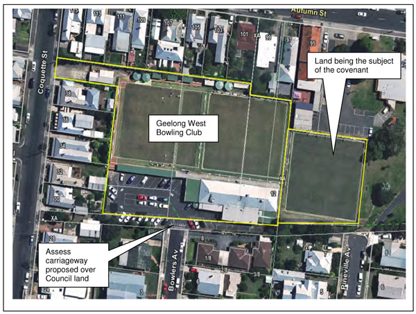
Portfolio: |
Finance – Cr Lyons (Mayor), Cr S Kontelj & Cr E Kontelj |
Source: |
Corporate Services – Financial Services |
A/General Manager: |
John Brown |
Index Reference: |
Financial Management\Reporting |
To reduce costs incurred by the City of Greater Geelong for payments received from customers via third party providers to Council.
The City of Greater Geelong provides a number of customer payment channels for customers, which incur transaction charges.
A review of customer bill payment services has been undertaken to identify potential cost reductions.
Charges incurred by the City of Greater Geelong are associated with the provision of Internet, Interactive Voice Response (Telephone), Australia Post Over the Counter (OTC) payment channels together with Merchant Service Fees (MSF) where payment is made by credit card.
The 2013-2014 annual cost of Australia Post (OTC) is $210,326 and Merchant Service Fees total $213,308.
A review of over the counter payment option with Australia Post is to be completed as part of the customer service face to face service review prior to the end of the current contract. The current charge of $1.89 per transaction is not able to be included in payment transactions.
Charging the MSF for Internet and Interactive Voice Response (IVR) (telephone payments) could result in cost reductions to Council of $121,127 per annum.
The removal of credit card payments from BPay could result in potential savings to Council of $35,768 per annum.
Cr E Kontelj moved, Cr Harwood seconded -
That Council endorse a cost reduction strategy with Bill Payment Service costs by:
review the Australia Post over the counter service as part of the face to face service review and community engagement process, prior to considering renewal of the Australia Post OTC payment option from May 2015;
charging Merchant Service Fees for all Gateway Merchant (Internet & IVR) payments effective from 30 September 2014; to save approximately $121,127 per annum;
remove credit card payment option from BPay effective 30 August 2014, in line with payment options at Australia Post to save approximately $35,768 per annum.
Cr Nelson left the meeting room at 8:25pm
Carried.
Trends show a shift in the way customers are making payments and it is opportune to review the payment options currently available.
On 22 March 2012, the Executive Management Team considered a report on the City’s Bill Payment Services. It was decided to conduct a further review of bill payment options to identify and highlight potential cost reductions and this was supported by the Finance Committee.
Current Payment Options and Costs
Payment options currently available to customers are listed in Table 1 below. All costs relating to payments are borne by Council.
Current Payment Options |
Transaction Fee |
Credit Card & MSF |
Bpay - Westpac |
$0.41 |
✓ |
Internet - SecurePay |
$0.20 |
✓ |
Phone (IVR) - SecurePay |
$0.30 |
✓ |
Direct Debit - Westpac |
$0.03 |
✗ |
Over the Counter - Australia Post |
$1.89 |
✗ |
Cheque - Australia Post |
$0.30 |
✗ |
Cash - Customer Service |
N/a |
✗ |
Cheque - Customer Service |
N/a |
✗ |
EFTPOS - Customer Service |
$0.13 |
✓ |
Centrepay Deductions |
$0.60 |
✗ |
Table 1
Customer payment trends over the last few years can be seen in the following table:
|
|
2011-2012 |
2012-2013 |
2013-2014 |
|||
Service |
Provider |
Number of Transactions |
% of Transactions |
Number of Transactions |
% of Transactions |
Number of Transactions |
% of Transactions |
Over the counter |
Australia Post |
127,783 |
25.53% |
119,850 |
23.29% |
114,932 |
21.15% |
Bpay |
Westpac |
141,325 |
28.23% |
151,525 |
29.44% |
170,561 |
31.39% |
Telephone |
Australia Post |
31,272 |
|
4,081 |
|
3,299 |
|
|
SecurePay |
|
6.25% |
25,856 |
5.82% |
26,228 |
5.43% |
Internet |
Australia Post |
17,056 |
|
980 |
|
1,120 |
|
|
SecurePay |
|
3.41% |
21,056 |
4.28% |
26,287 |
5.04% |
Direct Debit |
Westpac |
36,702 |
7.33% |
38,309 |
7.44% |
42,897 |
7.89% |
Customer Service |
CoGG |
131,807 |
26.33% |
136,351 |
26.49% |
141,335 |
26.01% |
Centrepay |
DHS |
14,662 |
2.93% |
16,632 |
3.23% |
16,715 |
3.08% |
|
|
500,607 |
100.00% |
514,640 |
100.00% |
543,374 |
100.00% |
Table 2
Table 2 highlights the following:
The total number of payment transactions have increased by 7.87% from 2011-2012 to 2013-2014.
The increase in payments is largely attributed to BPay and internet payments. These payment options are efficient with low transaction costs to Council.
The most cost effective payment method per transaction is direct debit from bank accounts. An investigation will be undertaken to streamline the process further and enable customers to sign up for direct debits via Council’s website. This payment option continues to increase in popularity.
Although the number of Australia Post transactions is reducing, the amount paid to Australia Post remains constant due to annual fee increases offsetting the reduction in transaction numbers.
The Australia Post OTC and MSF (associated with credit card payments) cost Council approximately $423,634 per annum in fees for the service.
In 2013-2014 the cost to Council for OTC payments at Australia Post was $210,325.
From May 2013 to April 2014, the cost to Council for MSF was $213,308.
Significant financial resources are required by Council to deliver the variety of current customer payment options. Therefore, Council needs to give consideration as to how it approaches customer billing and collection of revenues as part of cost management.
Due to the high cost associated with third party agencies such as Australia Post OTC, the following strategy aims to influence customers to use the City’s preferred payment channels or be allocated fees associated with using this service.
Contract with Australia Post
Council entered into an agreement with Australia Post from 1 June 2012 to 31 May 2015. Australia Post was the only supplier to tender for the provision of OTC payments and this is unlikely to change in the future.
The OTC payment’s transaction fee is $1.89 per transaction and increases annually on 1 July, as advised by Australia Post.
An additional cost of $0.30 is incurred per transaction for customers paying by cheque. Therefore, processing a cheque via Australia Post costs $2.19 per transaction.
Australia Post has introduced self service kiosks in their agencies, as an option to OTC payment option. Council did not take up the option to pay accounts via self service kiosks at Australia Post, given transaction costs are unchanged.
Table 3 highlights that the number of OTC transactions have been has been slowly reducing over the last five years:
Over the Counter |
2009-2010 |
2010-2011 |
2011-2012 |
2012-2013 |
2013-2014 |
$1.53 |
$1.59 |
$1.64 |
$1.79 |
$1.83 |
|
Number of transactions |
137,742 |
125,704 |
127,783 |
119,850 |
114,932 |
Per transaction |
$210,745 |
$199,869 |
$209,564 |
$214,531 |
$210,325 |
% change in transaction numbers from previous year |
4% |
9% |
-2% |
6% |
4% |
Table 3
Although the number of transactions has reduced by 22,810 from 2009-2010 to 2013-2014, the cost to Council remains the same due to the annual increase in transaction costs.
If the current service remains unchanged, the number of OTC transactions for 2014-2015 is forecast to be 110,000 at a cost of $1.89 per transaction, for a total cost of $207,900.
Australia Post advise the transaction fee cannot be added to the amount of the transaction at the time of payment.
A review of over the counter payment option with Australia Post is to be completed as part of the face to face service review, prior to the end of the current contract. Customers still have the option of face to face contact via Council’s Customer Service Centres, at no charge.
Merchant Service Fee (MSF)
Definition: Transaction-based fees charged to merchants for acquiring credit card transactions, collected either on an ad valorem or flat basis.
Council currently uses two MSF rates:
BPay transactions.
Gateway Merchant (Internet and IVR) and Other Merchant (Customer Service Centres, Leisure Centres, etc.) transactions.
There are three channels on which MSF is charged - BPay, Gateway Merchant and Other Merchant.
MSF paid from April 2013 to March 2014 are as follows:
Bpay |
$ 35,768 |
Gateway Merchant (Internet and IVR) |
$ 121,126 |
Other Merchant (Customer Service Centres, Leisure Centres etc.) |
$ 56,413 |
|
$ 213,308 |
Suppliers are increasingly electing to pass on the MSF costs to customers, eg. Telstra, Qantas and Aldi.
BPay
Bpay payments can be made via bank accounts, cheque accounts and credit card accounts.
The number of transactions made via BPay from April 2013 to March 2014 was 166,666. The number of BPay payments from bank or cheque accounts was 141,679 or 85%. There were 24,987 transactions paid by credit card, representing 15%.
The MSF cost to Council for these credit card payments was $35,768.
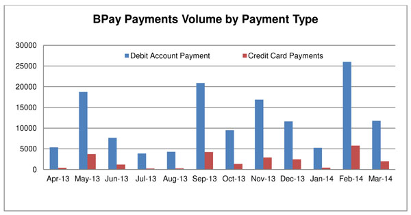
Table 4
It is not possible to on charge the MSF for credit card payments made via BPay.
If Council restricted BPay payments to bank or cheque accounts only, there would be an immediate cost reduction of $35,768 per annum, with minimal impact on customer service.
It is recommended that the ability to pay via credit card is removed from 30 September 2014.
Gateway Merchant
Geelong Australia internet payments and IVR payments are hosted by Advam. These payments form the Gateway Merchant channel.
The number of transactions using internet/IVR has increased from 48,328 in 2011-2012 to 56,934 in 2013-2014, subsequently increasing the amount of MSF paid by Council.
Advam have a MSF recovery module for the internet and IVR and provide hosted payment pages that are able to calculate a surcharge amount based on the value of the transaction. The hosted payment pages can be integrated with ePathway in the same way as the IVR, using the ePathway Authorise Function.
It is recommended that given the increasing cost of MSF that these costs be oncharged on all Gateway Merchant (Internet & IVR) payments where credit cards are used. The potential saving to Council is $121,126.
Customers can avoid this fee if payments are made from bank or cheque accounts.
Other Merchant
Merchant payments are taken using an EFTPOS machine at Leisure Centres, Customer Service Centres and Child Care Centres etc. It is possible to oncharge the MSF to customers.
PC EFTPOS is an integrated EFTPOS system where the EFTPOS terminal is fully integrated into the point of sale (POS) cash register system. An EFTPOS terminal and PC software is integrated into the POS system, allowing communication between the POS and the EFTPOS terminal.
This software can be used with a system that Council’s Leisure Services use (namely, Centaman Systems). Leisure Services are interested in using this software to be able to on charge MSF costs to customers.
Another product called PcBank is offered by Advam. PcBank is a virtual terminal solution that allows merchants to manually process transactions. It can be accessed via Advam’s online Merchant Centre.
Both products will be investigated and costed if the principle of oncharging MSF to customers is approved.
It is recommended that the investigation is completed for implementation in 2015.
Other Council experience
The City of Knox highlighted the issue of increasing costs of credit card MSF as part of its supply of banking tender process in 2006. At this time the City of Knox was paying $140,000 in MSF and this amount was continuing to increase. The City of Knox considered three options:
Remain unchanged and pay the increasing MSF.
Remove or limit the acceptance of credit cards by Council.
Retain the same payment options, but impose a charge to pass on the MSF to the payee.
The City of Knox decided to on charge the MSF to the payee and discontinued the credit card payment option via BPay.
There was minimal customer reaction to the surcharging of the MSF.
There are no environmental issues arising from this report.
The cost of Australia Post OTC and MSF is $423,634 per annum. Cost reductions can be attained by introducing the recommendations of this report.
The cost to introduce MSF on charging for Gateway Merchants is $5,780 for internet and IVR.
There would be a cost to communicate the change to customers.
Councils’ only requirement for the use of cash or credit is to be in line with normal business practices to allow timely payment of accounts.
This proposal aligns to City Plan’s objective on How We Do Business.
There is no Council Officer direct or indirect interest involved in this report.
There are no notable risks in implementing the recommendations in this report.
No specific community groups would be disadvantaged by these changes. Educating customers to move to cost effective payment options benefits both Council and ratepayers.
There are no known positive or negative effects.
Changes to payment options would need to be communicated to all Council customers.
Information regarding the on charging of MSF could be included on the annual rate notice. This would ensure that every ratepayer has been notified of the change.
Portfolio: |
Finance – Cr Lyons (Mayor) Cr S Kontelj & Cr E Kontelj |
Source: |
Corporate Services - Communications and Marketing |
A/General Manager: |
John Brown |
Index Reference: |
Corporate Marketing and Promotions |
The purpose of this report is to update Council on the progress of the procurement of individual elements that make up Light and Decorate Geelong.
The procurement process has commenced for the individual elements that make up Light and Decorate Geelong.
The report outlines the spending of $37,492 (Budget $40,000) to develop concept designs and specifications for a series of Christmas projects.
An overview summary of Light and Decorate Geelong is provided (Appendix 1).
This report provides indicative images of the individual elements Light and Decorate Geelong.
It is intended that the project will deliver street decorations in each ward within the municipality.
The total project budget including the Christmas Tree will be delivered as per the 2014-2015 Budget.
The PCG will provide final advice on locations and other issues that may arise from the Project Working Group (PWG).
Cr S Kontelj moved, Cr Heagney seconded -
That Council notes the procurement progress of the various elements that make up Light and Decorate Geelong.
Cr Nelson re-entered the meeting room at 8:28pm
Carried.
At its meeting on 11 March 2014 Council considered a report relating to Christmas in Geelong and approved expenditure to develop concept designs and specifications for a series of Christmas projects. A budget allocation of $40,000 was made.
The report endorsed the development and investigation of an ‘Iconic Christmas Installation’ that is designed to excite and entertain the community.
Other elements of ‘Light and Decorate Geelong’ are:
Catenary Lighting
Tree Lighting.
Street Decorations
Projections
At a subsequent meeting on 8 April 2014, Council authorised officers to procure an ‘Iconic Christmas Tree’ with a project budget of $500,000.
A procurement report for the Iconic Christmas Tree was adopted by Council on 8 July 2014. This report focuses on the remaining elements that make up Light and Decorate Geelong.
A Christmas Working Group has been established to ensure a coordinated approach across Council for the delivery of the various elements. Meetings are held fortnightly. Membership of this group includes Events, Central Geelong and Waterfront, Communications and Marketing, Arts and Culture, Strategic Projects/Urban Design, Central Geelong Marketing and Capital Projects.
Where possible, permanent installations and multi-use options have been sought, to ensure best value for money.
Catenary Lighting
A budget of $500,000 has been assumed for this element.
The working group determined that the location for the Catenary Lighting would be the intersection of Malop and Moorabool Streets. This aligned with Vision 2 and the Central Geelong Action plan to provide linkages throughout Central Geelong and the Waterfront.
Building owners have been approached and have indicated ‘in principle’ support for the anchoring of wires to their buildings. This is subject to concept design and official agreement with the owners.
After a selective quotation process, GHD were appointed to undertake the concept design and specification drawings to enable the project to be tendered as a construct project. GHD are leaders in their field for catenary design and have designed catenaries for the City of Melbourne, including Bourke Street Mall and Rundle Mall in Adelaide.
The catenary will be a permanent installation, with programmable lighting features. It will also have the ability for decorations and banners to be hung off it for periods such as Christmas.
GHD presented five concept designs on 25 July. One design has been selected and is being presented to building owners for approval. The manufacture of this design will go to Tender in August.
The ongoing maintenance should be minimal, with the bulk of the recurrent cost coming from the installation and removal of decorations and banners for the Christmas period. It is estimated the recurrent cost for this element is $15,000.
Approximately $5,000 from the design and specification budget of $40,000 has been used for the development of this specification. An additional $22,000 has been used for the development of concept designs.
Tree Lighting
A budget of $500,000 has been assumed for this element.
The working group, along with Engineering Services determined a working list of locations for tree lighting across the municipality (listed in the table below). This list will form the basis of a lighting master plan and provide scope for a tender document. It cannot be assumed the entire list can be funded from the budgeted amount of $500,000.
Site |
Region |
Road Name |
Intersecting Rd 1 |
Intersecting Rd 2 |
1 |
Central |
Moorabool St. |
Brougham St. |
Corio St. |
2 |
Central |
Moorabool St. |
Corio St. |
Malop St. |
3 |
Central |
Moorabool St. |
Malop St. |
Lt. Malop St |
4 |
Central |
Moorabool St. |
Lt. Malop St |
Ryrie St. |
5 |
Central |
Ryrie St. |
Yarra St. |
Moorabool St. |
6 |
Central |
Ryrie St. |
Moorabool St. |
Gheringhap St. |
7 |
Central |
Malop St. |
Yarra St. |
Moorabool St. |
8 |
Central |
Malop St. |
Moorabool St. |
Gheringhap St. |
9 |
Central |
Lt. Malop St. |
Yarra St. |
Moorabool St. |
10 |
Ocean Grove |
The Terrace |
Hodgson St. |
Presidents Ave. |
11 |
Portarlington |
Newcombe St. |
Sproat St. |
High St. |
12 |
St. Leonards |
Murradoc Rd. |
The Esplanade |
Blanch St. |
13 |
Highton |
Bell Vue Ave. |
Barrabool Rd. |
Roslyn Rd. |
14 |
Corio |
Bacchus Marsh Rd. |
Purnell Rd. |
Canadian Pde. |
15 |
Geelong West |
Pakington Street |
Wellington Street |
O’Connell Street |
16 |
Newtown |
Pakington Street |
Fairview Street |
Mervyn Street |
17 |
Belmont |
High Street |
Roslyn Road |
Regent Street |
18 |
Lara |
Station Lake Rd |
The Centreway |
Waverly Rd |
*Note, sites are not in priority order.
The City invited lump sum quotations, from suitably qualified electrical engineers and/or expert lighting consultants, to design and document a fully integrated, programmable lighting Master Plan.
Through this process, a primary lighting designer was selected and engaged – Citelum, a worldwide leader in lighting design for Cities.
Citelum has the responsibility to fully design and document a Decorative Lighting Master Plan. Citelum will also be responsible for the supply of specialist decorative lighting specifications. The master plan will then be tendered.
Citelum will provide a cost estimate for each area and priorities can be determined at this stage, prior to going to market. Priority locations will be determined by the working group.
In 2013 Shaun Lloyd and local traders installed tree lighting in Hitchcock Ave Barwon Heads. It has added ambience to the street and has been very well received.
The tree lighting is a permanent installation. The ongoing maintenance should be minimal; vandalism is the unknown factor for recurrent costs. The design will aim to minimise vandalism, but this cannot be removed completely. It is estimated the ongoing recurrent costs are $50,000.
Approximately $5,000 from the design and specification budget of $40,000 has been used for the development of this specification.
Street Decorations
A budget of $250,000 has been allowed. The working group determined the various locations for street decorations across the municipality (listed below). This list formed the basis of the scope for a tender document. It cannot be assumed the entire list can be funded from the budgeted amount.
Central Geelong:
Between Ryrie (north) and Brougham St (south).
Between Gheringhap (west) and Yarra St (east).
Focus areas are Malop St, Ryrie St and Moorabool St.
Other key locations:
Lara Town Centre.
Belle Vue Ave Highton (Between Barrabool and Roslyn Rd).
Pakington St between Marshall St and Fairview Ave.
Pakington St Between Hope St and Wellington St.
High St Belmont between Roslyn Rd and Regent St.
Garden St East Geelong between McKillop St and Myers St.
Labuan Square, North Geelong.
Hitchcock Ave Barwon Heads between Bridge Rd and Colite St.
The Terrace Ocean Grove between Presidents Avenue and Hodgson St.
Newcombe St Portarlington.
Drysdale Town Centre.
*Note, sites are not in priority order.
In addition to the above listed locations, it is planned to replace existing pole decorations with a new design. To save money, the existing brackets and frames can be reused. The locations for these include:
Central Geelong
Vines Rd
Barwon Heads
Belmont
Drysdale
Lara
Pakington St
East Geelong
Minerva Rd
Fyansford
Portarlington
St Leonards
Ocean Grove
Highton
Corio
An EOI was developed for suitable companies with experience in Custom Christmas Decorations to apply. The EOI has been evaluated and companies shortlisted, with these companies selectively tendered for design and construct of street decorations.
Two companies completed the tender and evaluation is currently occurring.
The street decorations are the only element that gives a day time regional presence to the decorations to help activate trade. Street Decorations have the widest coverage and will ensure each Ward has Christmas Decorations.
Linkages to other elements are also important and need to tie together to ensure a consistent suite.
The Street decorations are a seasonal installation. This element will have the highest ongoing recurrent commitment, due to its seasonal nature, and will be determined during the tender stage. It is estimated that the ongoing recurrent costs are $120,000.
No budget from the design and specification budget of $40,000 has been used for the development of this specification.
Reuse of existing decorations
School Tree Program
The School Tree program was a highlight of the 2013 Christmas in Geelong program. It successfully activated Lt Malop Street Central, attracting visitation and engagement by the local community. It consistently received positive coverage in the press and social media.
Schools will again be approached to be involved in this project. Trees from last year will be stripped and refurbished for reuse and schools can be added (subject to demand by the schools).
Reuse of 28 existing trees will cost $5,040 and new trees can be added at a cost of $920 a tree.
Existing Christmas Trees
The City has a number of existing Christmas Trees.
Trees in Highton, Pakington St (Town Hall) and Central Geelong (corner of Gheringhap and Malop St) will be reinstalled.
Two trees, the 9M tree, previously outside the Carousel and the 6M Plywood Tree, previously in Lt Malop St Central can be relocated. Tenderers for the Christmas Street Decorations have been asked to nominate suitable locations for these two trees to tie in with other street decorations. The Plywood tree can be refurbished with a new sticker design and it is proposed to do this with involvement from the local schools in the area to help with community engagement of the tree.
To install, relocate and refurbish existing trees will cost $50,000.
Projections (Arts and Culture)
A budget of $250,000 has been allowed for projections. Arts and Culture, with the endorsement of the working group have approached a projection specialist to determine the specification for the equipment required, best location(s) and curation of the program.
The specialist has identified the Civic Centre Carpark and Busport Carpark as the most suitable sites for installation and projection onto buildings. The specialist will now commence on-site testing to determine technical requirements.
The aim is for Council to own the equipment to allow for use during key events throughout the year, in addition to the Christmas period.
The ongoing recurrent costs will be the annual curation of the program and maintenance to the projectors. It is estimated that the recurrent costs for projections are $60,000.
The amount to be used for the development of this specification is $3,500 from the design and specification budget of $40,000.
Low energy use LED lights are proposed to reduce energy consumption and environmental impact.
There is currently $2,000,000 allocated to the Light and Decorate Geelong project adopted in the 2014-2015 Budget.
The $40,000 approved in 2013-2014 to develop concept designs and specifications for a series of Christmas projects and has been allocated as follows:
$22,000 for concept designs for the Catenary system.
$11,992 for specification development of catenary and tree lighting.
$3,500 for speciation development and site testing for Projections.
The ongoing maintenance, installation, removal, storage and programming cost is unknown, but will be identified as part of the procurement process.
The annual cost will need to be included in future budgets to ensure operation of the program for Christmas 2015, 2016, 2017 & 2018. For years 2015 and beyond, the existing recurrent budget of $98,000 can contribute to the ongoing costs. The 2014-2015 Budget replaces previous capital project sums.
Based on the work to date an estimate of recurrent costs for each element of the Christmas Light and Decorate Geelong program for 2015-2016 is as follows:
Catenary lighting $15,000
Tree lighting $50,000
Street decorations $120,000
Projections $60,000
Reuse of selected existing elements $40,000
Total $285,000
These estimates are a guide only and will be subject to a 2015-2016 budget proposal, for consideration.
The delivery of any project or program of works is governed by a series of policy, legal and statutory obligations.
This report proposes the development of a governance framework that will allow the delivery of the project in a controlled environment which will ensure that all policy, legal and statutory obligations are met.
Using Powercor Infrastructure, we will need to gain annual approval to use their assets. This has been standard process for the last five or so years.
Light and Decorate Geelong and project delivery models covered in this report align with the Community Wellbeing, Growing Our Economy, and How We Do Business strategic directions of City Plan.
No Council officers involved in this project or report have declared a direct or indirect interest in this matter.
This is a high profile project, with very high community expectations. All year round use has been sought where possible to ensure value for money on investment.
Light and Decorate Geelong will help develop a positive community atmosphere.
It is not evident or likely that this report would negatively impact any of the rights contained in the Charter of Human Rights.
Light and Decorate Geelong will be promoted on the City of Greater Geelong’s website, via social media and in local news media.
Councillors will be consulted on their preferred locations for pole decorations in respective Wards.
We will also work with Central Geelong Marketing to ensure consistency of message and activation.
|
Element |
Allocated Budget |
Day/Night activation |
All year around or seasonal only |
Central Geelong |
Regional |
Link to existing policies & projects |
Responsible Department |
Procurement Progress |
Suggested Location |
Budget Allocation from $40,000 Concept Design and Specification Development |
Iconic Christmas Tree |
$500,000 |
Day and Night Presence, |
Seasonal Only |
Waterfront |
No |
Attract visitation – Tourism Central Geelong Marketing Central Geelong Action Plan |
Capital Projects |
Tender awarded |
Steampacket Quay |
NIL |
Street decorations |
Nominally $250,000 |
Day time will be priority |
Seasonal |
Yes |
Yes – this is the main area where regions will get a day time Christmas presence |
Important element of Christmas – this is what social media commentary has been about – it’s important these are replaced. Support traders |
Communications and Marketing |
Tender Evaluation |
CBD Lara Pakington St High St Belmont Garden St East Geelong Labuan Square North Geelong Hitchcock Ave Barwon Heads The Avenue Ocean Grove Drysdale Portarlington St Leonards Vines Rd Minerva Rd Fyansford Corio |
NIL |
Catenary lighting |
$500,000 |
Day and Night Presence |
All year round with ability to program, add decorations, banners and flags |
Yes |
No |
Central Geelong Action Plan Vision2 |
Strategic Projects/Urban Design |
Contract Awarded for Concept Design and Specification. Manufacture to be Tendered. |
Malop and Moorabool St intersection |
$22,000 Concept Design $4,996 for specification development |
Tree lighting |
$500,000 |
Night |
All year round |
Yes |
Yes (subject to priorities and budget) |
Central Geelong Action Plan Vision2 |
Events, Central Geelong and Waterfront |
Primary Lighting Designer for Masterplan has been awarded. Tender for installation to follow. |
Central Geelong Lara Pakington St Corio Ocean Grove Portarlington St Leonards Highton Belmont |
$6,996 for specification development |
Light projections |
Nominally $250,000 |
Night |
At key events/time of year |
Yes |
No |
Central Geelong Action Plan Arts and Culture Strategy |
Arts and Culture |
Specification still to be developed |
City Hall Old Post Office National Wool Museum Other laneway sites |
$3,500 has been allowed for specification development. |
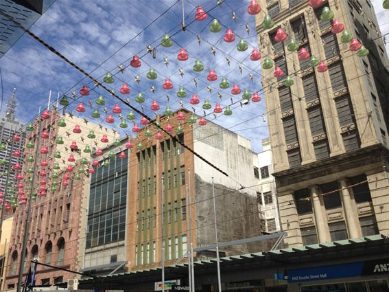
Bourke Street Mall Catenary Lighting Example
Catenary and Tree Lighting Example

Artist Impression of Catenary and Palm Lighting.
Projections

Past Projections on City Hall during UCI event.
School Tree Project
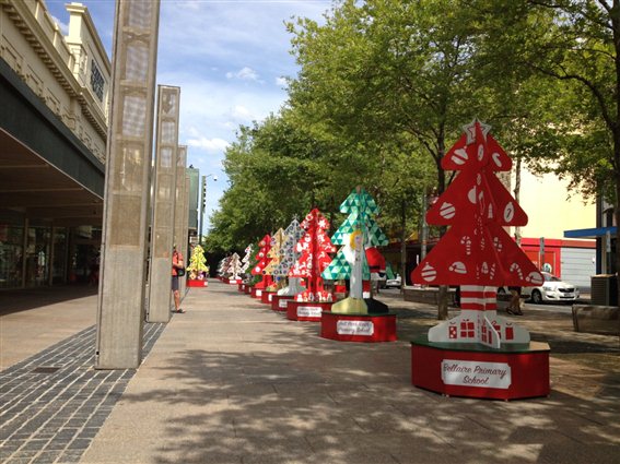
Street Tree Lighting

Example of tree lighting
Street Decorations
Bourke St Mall – use of banners.
Portfolio: |
Finance - Cr Lyons (Mayor) Cr S Kontelj & Cr E Kontelj |
Source: |
Corporate Services – Property Management |
A/General Manager: |
John Brown |
Index Reference |
Land Sales |
The purpose of this report is to recommend that the Council give notice of its intention to sell land at 5 Coolidge Street, Corio.
Council owns a property at 5 Coolidge Street, Corio which was purchased in 1976 and has been used for child care and community purposes. The building is currently vacant.
The building is a former modified residence and the land is zoned Residential 1.
The property is no longer required for Council purposes and it is recommended that the land be sold.
There exists an agreement between the former Shire and the Commonwealth Minister for Social Security which requires Council to obtain the Minster’s consent if the property is to be sold. The Commonwealth Minister has consented to termination of the agreement clearing the way for the sale of the land.
Council is also required to give public notice of its intention to sell the land and consider any submissions received. If any submissions are received they will be heard by the Submissions Review Panel followed by a report to Council. If no submissions are received the land will be sold subject to the Minister’s consent.
At the meeting on 22 July 2014 the Council considered a report recommending the sale of this land and resolved to defer consideration of the report. There was discussion at the meeting relating to the possibility of selling the land to a registered housing authority.
In 2012 the Council sold a property at 12 Bellbird Avenue, Norlane and in the process offered the property to all Victorian registered housing authorities however there was no interest in the property from this sector. The land was subsequently sold on the market.
Cr Ansett moved, Cr Fisher seconded -
That Council:
Being of the opinion that the land situated at 5 Coolidge Street, Corio (“the land”) is no longer required for Council purposes:
Offer the land to Victorian registered housing associations on the terms outlined 2(a), (c) and (d) of this recommendation;
Should the land not be sold to a Victorian registered housing association commence procedures to sell the land on the following terms and conditions:
Price being not less than the certified valuation to be obtained;
Sell the land by listing with an agent;
Obtaining the Commonwealth Minister for Education’s consent to sell the land;
Other appropriate terms;
Commence the procedures under section 189 of the Local Government Act 1989 (“the Act”) to sell the land and that public notice of and the right of a person under section 223 of the Act to make a submission in relation to the proposed sale be given in the Geelong Advertiser and Geelong Independent;
Appoint the Submissions Review Panel to hear and report to the Council on any submissions in relation to the proposed sale;
Sell the land if no submissions are received;
Authorise the Acting / General Manager – Corporate Services to execute the Contract of Sale;
Sign and seal the Transfer of Land.
Carried.
Council purchased a house at 5 Coolidge Street, Rosewall in 1976 which was used for a number of years for child care. Since it ceased being used for that purpose in 1994, it has been used as accommodation by various community groups. The building is currently vacant.
The land is zoned Residential 1 and has a total area of 726m2. The building was formerly a three bedroom residence which has been modified for non residential use over the years. It could be restored to a dwelling with some internal work.
The property is no longer required for Council purposes and it is recommended that the land be sold.
The most appropriate use for the building is to return it to a dwelling, since there are planning restrictions relating to non residential uses.
The building was purchased and converted for child care using a Commonwealth Government grant of approximately $42,000. A formal agreement exists, signed by the former Shire and the Commonwealth Minister for Social Security at the time which, among other things, requires Council to obtain the Minster’s consent if the property is to be sold. The Commonwealth Minister has consented to termination of the agreement clearly the way for sale of the land.
At the meeting on 22 July 2014 the Council considered a report recommending the sale of this land and resolved to defer consideration of the report. There was discussion at the meeting relating to the possibility of selling the land to a registered housing authority.
In 2012 the Council sold a property at 12 Bellbird Avenue, Norlane and in the process offered the property to all Victorian registered housing authorities at a price no less than the valuation. There was no interest in the property from this sector and the property was subsequently sold on the market for a price higher than the valuation.
The land proposed to be sold contains several mature eucalypt trees which will remain in place at the time of the sale.
The price will be set at no less than a certified valuation to be obtained prior to sale.
The proceeds from the sale of the land will be non recurrent income for which provision has been made in the 2014-2015 Budget. As property assets are disposed, the written down value is adjusted on the asset register.
Under the Local Government Best Practice Guideline for the Sale and Exchange of Land, the Council is required to sell the land by a public process and sale by listing through a real estate agent satisfies that requirement.
Section 189 of the Local Government Act (“LG Act”) requires that Council obtain a certified valuation dated not more than six months prior to the sale of the land, being the date of the contract of sale.
Council is also required to give public notice of its intention to sell the land and consider any submissions received. If any submissions are received, they will be heard by the Submissions Review Panel, followed by a report to Council. If no submissions are received, the land will be sold.
The recommendation supports the action priority relating to Responsible and Sustainable Financial Management where the sale of underperforming assets will support the identified progress indicators.
No officers or contractors involved in the preparation of this report have a direct or indirect interest in matters to which this report relates.
The risks associated with the subdivision and sale of this land are able to be managed following normal management procedures and processes.
There are no social implications associated with the recommendations of this report.
The community will have an opportunity to comment on the proposed sale when notice of intention to sell the land is given.
5 Coolidge Street, Corio
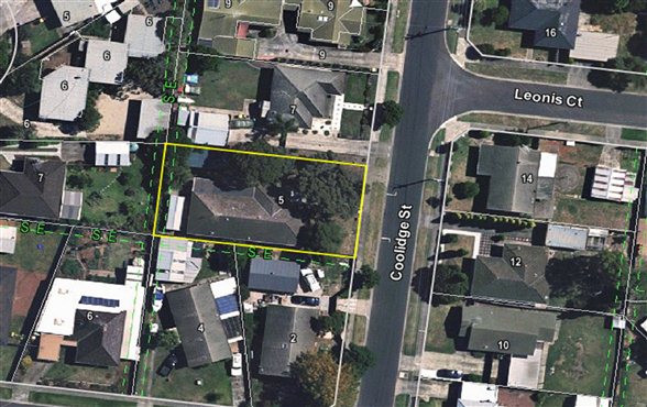
Cr Richards declared an Indirect Interest by Close Association in Agenda Item 14 – Heavy Vehicle Restriction Central Geelong – Review of Trial, in that he is close friends with two current residents and participate in external activity weekly with one of these two people. They have made their views known to me and I believe, as such, I have a Conflict and left the meeting room at 8:44pm prior to debate.
Portfolio: |
Central Geelong - Cr Michelle Heagney |
Source: |
City Services – Engineering Services |
General Manager: |
Gary Van Driel |
Index Reference: |
City Services – Engineering Services |
The purpose of this report is to provide Council with an update on the trial of the restriction of heavy vehicles through Malop and Mercer Streets, Geelong. The report provides a recommendation supporting the next stage of the trial.
Council adopted on the 8th October 2013 to undertake a six month trial from March to September 2014 to restrict heavy vehicles in Malop and Mercer Streets in Geelong.
Data is being collected prior to and during the trial. The following factors were considered: compliance, travel times, traffic volumes, access, safety, noise, air quality and amenity.
Submissions were sought in May 2014 with 97 received. A submissions panel was held on the 12th June 2014 with 15 submitters presenting.
City Officers met with key stakeholders, VicRoads and the freight industry to review the outcomes of the trial.
Cr Heagney moved, Cr Ansett seconded -
That Council support the trial continuing in its current form and continue to:
Work with stakeholders to develop options to allow Stage 2 of the trial to commence. Stage 2 recommended extending restrictions to Ryrie Street in conjunction with potential changes on the broader network including McKillop Street between Latrobe Terrace and Ormond Road.
Implement short term options to mitigate the impacts on both Ryrie Street and McKillop Street as outlined in the table on page 119 of this report.
Seek approval to install Heavy Vehicle restrictions in McKillop Street East Geelong between Ormond Road and Boundary Roads.
Respond to submitters accordingly.
Carried.
On 8th October 2013 Council supported:
A two staged approach to traffic management in Central Geelong, including:
the implementation of a 4.5 tonne weight restriction on Malop and Mercer Street in Geelong pursuant to necessary processes with VicRoads and the Truck Operations Committee on a six month trial basis, with the exemptions necessary for delivery to sites in the Central Geelong; and
working with all stakeholders towards the introduction of weight restrictions for vehicles on Ryrie Street following broader investigation of the traffic network, identification of required changes to the road network and supporting funding for implementation.
Establishing a submissions panel to take written and verbal submissions on the Stage 1 trial. The panel to be made up of the Transport Portfolio Holder, Brownbill Ward Councillor, Austin Ward Councillor and any other Councillor who wishes to attend the panel. The panel will report back to Council. Heavy Vehicle limitations to continue until a final decision is made by Council.
Establish a pre trial monitoring program including but not limited to:
24 hour traffic classifier counts on all East/West Streets, including Mercer, Malop, Ryrie, Myers, McKillop, Kilgour and Fyans Streets;
air and noise monitoring on selected East/West Streets; and
pedestrian and cyclist counts on all routes.
In deciding whether to introduce weight restrictions, a key issue for Council to consider is the positive outcomes delivered to Central Geelong as a result of any heavy vehicle restrictions as well as the potential impacts on amenity of residents immediately adjacent to routes that will carry additional traffic. Further, the efficient functioning of the whole network to provide for a more workable city in the long term is clearly the desired outcome.
In order to inform a long term traffic management strategy for heavy vehicles across Central Geelong and indeed east/west traffic generally it was considered that a trial of heavy vehicle restrictions on Mercer and Malop Streets be introduced as a first stage trial. The heavy vehicle restriction on Ryrie Street would be a Stage 2 trial.
Prior to implementing any trial it was necessary to seek approval from the State Wide Truck Operations Committee and VicRoads. Endorsement was received from the Truck Operations Committee
The trial commenced on the 3rd March 2014 and include truck restrictions to an area bounded by Mercer Street, Ryrie Street and Eastern Park. (refer attachment 1)
Information about the trial included installation of pre warning signage (VMS), advertising in local media, letters to residents and landlords in Malop Street, Ryrie Street and McKillop Street; letters to industrial precincts of North Geelong and Moolap; advice to RACV and Trucking Industry organisations. Information was also placed on the Council website including FAQ’s and three information sessions were held at City Hall prior to the trial commencing with over 100 people attending.
The following data was collected between November 2013 and May 2014; Traffic Volumes, Vehicle Types, Travel Times, Air sampling and Noise sampling.
Customer surveys and feedback was also collected.
The portfolio Councillor and Council officers met with VicRoads and freight groups to discuss the trial and review the data.
Trial Outcomes
The trial has been underway for five months and data has been collected to measure the following factors.
Compliance with restrictions
Enforcement agencies have not issued any infringements since commencement due to overwhelming adherence by most operators and/or drivers. Since commencement of trial, a few early requests were received regarding poor compliance of the area restrictions. This would be attributed to unfamiliar persons driving through the area without knowing limitations.
Travel Times
The truck monitoring survey undertaken by AECOM consultants in association with East West Links Study 2012 indicated that the Malop / Mercer traffic route was preferred by most drivers heading east-west through Central Geelong as it was quicker in total journey times.
With reduced trucks on Malop and Mercer Street’s, traffic flow is more efficient and has led to an increase in car movements yet still takes less time to traverse than before. Additionally the reporting of traffic congestion or complaints on traffic signal timings have not been reported since trial commencement.
Post trial travel surveys revealed that on average journey times on Ryrie Street had not noticeably changed considering the slight increase in truck volumes.
Recent truck time surveys along Boundary Road / McKillop Street route offer comparable times to those experienced on Ryrie Street between Boundary Road and Latrobe Terrace even though the route length is 2km longer.
Traffic Volumes.
Surveys were undertaken in Nov 2013 and May 2014 to measure changes in traffic volumes on key east west routes. Some decline in economic activity may have influenced traffic patterns. Future traffic counts will be undertaken in November 2014 to provide better verification of traffic patterns.
A summary of data on key east west routes revealed that:
Myers Street endured fluctuated patterns due to construction activity related to the St John of God hospital works and through traffic to local businesses.
Malop Street has seen a reduction in truck movements of 394 (25%) trucks, but a 7% increase in 756 (7%) cars due to being a more favourable route. Overall traffic volumes have increased marginally.
Ryrie Street has seen an increase in truck movements of 372 (17%) trucks, and a reduction of 1,133 cars (5.5 %). This is most likely attributed to drivers preferring to use Myers Street or Malop Street. Overall traffic volumes have dropped.
McKillop Street (Latrobe Terrace to Ormond Road) has experienced a decrease of 61 trucks (5%) and a decrease of 1057 cars (8%).
McKillop Street (east of Ormond Road) has experienced a reduction of 2 (1%) in truck and an increase of 15 (0.03%) cars. Truck volumes are similar to those recorded in 2004. Overall traffic volumes have increased 0.3 %
Vehicle Types
Though car movements have largely reduced on Malop, Mercer, Ryrie and McKillop Streets. Drivers have chosen options such as Brougham Street, Myers Street and Kilgour Street and this is reflected in the traffic counts.
Ryrie Street and Fellmongers Road have experienced the largest share of truck movements since the truck trial. Breakwater Road has seen the biggest increase proportionally but this can be attributed to changing land use developments in the Breakwater Estate.
Observations revealed that cyclist volumes have increased in Malop Street.
Access
Vehicle access for trucks into Central Geelong to provide essential services and deliveries was not restricted during the trial. Other than an initial settling in period for truck drivers understanding restrictions there has largely been negligible impact across the City.
Some localised congestion has been observed at Ryrie Street and Latrobe Terrace. Some signal timing adjustments by VicRoads have managed traffic queues similar to pre trial conditions.
Safety
No accidents or near misses have been reported. An independent route assessment audit report was undertaken along Ryrie Street between Latrobe Terrace and Boundary Road. A summary of recommendations have been provided to Council and VicRoads officers to review.
The audit observed that truck drivers travelling on Ryrie Street are changing lanes to avoid trees in the centre median due to narrow lane widths. The audit also observed that trucks need to merge into the adjacent lanes in Ryrie Street and Latrobe Terrace in order to negotiate intersections. On these busy roads this manoeuvre can be challenging dependant on traffic volumes. Measures to reduce impact have been identified and included in this report.
Noise
Noise (dBa) reading sample surveys were undertaken during various times of day prior and during the trial in a number of locations to ascertain any noticeable changes in traffic noise with respect to the increase/decrease of trucks. Observations revealed that trucks were not overwhelmingly noisier than other traffic modes. Poor pavement conditions did however influence sound recordings where trucks crossed over uneven pavement.
The sampling surveys revealed:
Malop Street experienced a drop in truck volumes and correlated with reduction in noise of 2 dBa.
Ryrie Street experienced a slight increase in noise results of 1 dBa. Due to the built environment of 2/3 stories, city and traffic noise was emphasised due to sound bounce/lack of disbursement.
McKillop Street experienced a drop in car volumes and correlated with a reduction in noise of 2 dBa. Observations reveal that traffic flow was very often in waves which was dependant on signal timings at Ormond Road or Yarra Street. On average noise surveys results were very good and results reveal that McKillop Street is nearly half as noisy as Ryrie Street. To note that when waves of traffic travelled through, this exaggerated the difference between quiet and noisy compared to other streets where traffic flow is more consistent or moderated.
Air Quality
Air (dust) quality sample surveys were undertaken during various times of day prior and during the trial in a number of locations to ascertain any noticeable changes in air quality with respect to the increase/decrease of trucks. Localised weather conditions can considerably affect the results and traffic volumes do not have a significant impact on air (dust) quality in the City.
The data was compared to the EPA monitoring station in South Geelong and there was no significant increase in dust particles in Malop Street, Ryrie Street and McKillop Street compared to the monthly changes at the EPA station.
Amenity
Measuring amenity is very difficult to validate and is complicated by the affected persons views/and primary purpose of their presence in Central Geelong. Most persons would agree that reducing unwanted noise or traffic volumes from an area would be positively appreciated. However removal of traffic of a significant nature can be impacting on the business community and needs to be carefully thought through. The measurement of what is deemed a benchmark or a value that is reasonable is not clearly evidenced or easily measured.
Customer Surveys
A total of 588 (297 public / 291 traders) pre trial (Feb 2014) Customer satisfaction surveys were undertaken to determine the views of shoppers and business owners in regard to their awareness of the truck restrictions trial and how satisfied they were with the following:
Safety for pedestrians and road users
Noise level
Air pollution
Traffic congestion level
75%(public) and 50%(traders) were not aware of the trial, 94%(public) and 77%(traders) did believe trucks have an affect on Central Geelong. The main affects included, noise, congestion, pollution and safety.
A new round of surveys will be undertaken in August 2014.
Freight Industry
The City and VicRoads have met with representatives from the freight industry to seek their feedback on the trial. They have supported the trial and wanted it emphasised that they have been compliant with the restrictions. They observed some increase in congestion at the intersection of Ryrie Street and Latrobe Terrace. Travel times have generally not been affected. They were not generally supportive of travelling further south towards Breakwater as this was not economically viable for their business models at this time.
Submissions
Submissions were sought from stakeholders including residents, business owners in Central Geelong, transport operators, industry groups and the general public. 97 online and registered submissions were received up to the 30th May 2014. A submissions review panel was held on the 19th June 2014 to hear submitters and consider the submissions. Minutes of the Submission Panel are attached. (Attachment 2)
General comments raised in submissions were in relation to:
Increased Noise levels – on the street and within properties;
Increased Volumes of heavy trucks in Ryrie and McKillop Streets;
Perceived decrease in safety in Ryrie Street;
Congestion at major intersections – ie Ryrie Street /Latrobe Terrace and McKillop Street at the railway line;
Increased amenity in streets in Central Geelong north of Ryrie Street;
Improved access for cyclists in Malop Street;
Suggested further restrictions on Ryrie Street – Time and truck weight; and
Measuring outcomes of trial.
Assessment
The City’s Engineering officers and VicRoads have met to review the interim results of Stage 1 of the trial which is due to finish in September.
It is recommended that the following short term actions be undertaken:
Action |
When |
Who |
40km/h blanket speed limit for Central Geelong |
2014/15 |
City of Greater Geelong |
Pavement rehabilitation works – Ryrie St |
2014/15 |
VicRoads |
Tree trimming – Ryrie St |
2014/15 |
City of Greater Geelong |
Traffic Management Measures – McKillop St East |
2014/15 |
City of Greater Geelong / VicRoads |
Linemarking changes – various |
2014/15 |
City of Greater Geelong |
East West Freight Linkages Study to inform the 30 year Network Operating Plan |
2014/15 |
VicRoads |
Investigate options to introduce weight restrictions on Ryrie St |
2014/15 |
City of Greater Geelong / VicRoads |
To further support the outcomes of the Network Operation plan the following Medium term (2-5 years) and long term (5-15 year) actions include:
Action |
When |
Who |
Intersection Upgrade – Ryrie St / Latrobe Tce |
Medium Term |
VicRoads |
Intersection Upgrade – Fyans St / Latrobe Tce |
Medium Term |
VicRoads |
Route Alignment upgrade – Fyans St |
Medium Term |
VicRoads |
Intersection Upgrade – Boundary Rd / Fellmongers Rd |
Medium Term |
VicRoads |
Advocate for Bellarine Link – Ring Road extension |
Medium term |
VicRoads / City of Greater Geelong |
Route Alignment Upgrade – Barwon Heads Road, Settlement Rd to Breakwater |
Medium Term |
VicRoads |
Route Alignment Upgrade – Barwon Heads Road, Breakwater Rd to Mt Duneed Rd |
Long Term |
VicRoads |
Construction of Bellarine link |
Long Term |
VicRoads |
A summary of the key findings and results will be submitted to the Central Geelong Task Force Special Committee for their support and to the Truck Operations Committee in accordance with the conditions on the application for approval to run the trial.
Based on the results and findings the trial to restrict heavy vehicles in Central Geelong has supported the original intent of the trial which was to:
Provide Heavy vehicle access across the city;
Service central Geelong with goods and services;
Provide a safe attractive environment for pedestrians and levels of amenity appropriate for a major activity centre; and
Stimulate increased development and activity in central Geelong.
To further support the Central Geelong Action plan it is recommended that the trial continue in its current form and that we work with stakeholders to develop options to allow Stage 2 of the trial to commence. Stage 2 recommended extending restrictions to Ryrie Street. Further that the short term actions be implemented in 2014/15.
The potential significant environmental impacts to central Geelong as a result of removal of heavy vehicle restrictions were assessed as part of this trial.
There were noticeable changes to noise levels on Malop Street with no noticeable change on Ryrie Street and Mckillop Street. Dust sampling also indicated no noticeable change from that of the base level data at the EPA station in South Geelong.
Works arising from the short term actions are estimated at $50,000 and can be supported from the East West Traffic project in 2014/15.
Future budget proposal
A more extensive program of civil works would be required before the Stage 2 trial could be implemented. This will involve future budget submissions through the State Government and Council.
The introduction of weight restrictions for heavy vehicles onto Council’s road network was approved via the Truck Operations Committee with input from VicRoads in December 2013.
Any change to Ryrie Street in relation to heavy vehicle restrictions requires the formal consent of the Truck Operations Committee, and ultimately Vic Roads as Ryrie Street is an arterial road that currently functions as part of the broader state freight network. There will be a necessity to prepare a much more detailed assessment and submission required including full cost benefit analysis, for the implementation of the trial on Ryrie Street to the Truck Operations Committee.
The 2013 adopted City Plan identifies central Geelong revitalisation as one of Councils funding priorities for 2013-17.
The restriction of heavy vehicle movements through the city is considered to be a primary task within the revitalisation of Central Geelong and therefore it is considered that the recommendations of this report are firmly in line with the adopted City Plan of Council.
Officers involved in the preparation of this report from Engineering Services and Planning Strategy own property within the Central Geelong Study area and therefore have an indirect interest in relation to the recommendations of the report or implementation of a heavy vehicle restriction across central Geelong.
There will need to be a detailed risk assessment undertaken as part of the preparation for the staged trial of restricting heavy vehicle movements through Central Geelong. The risk assessment will be undertaken on a detailed basis across each stage of the proposed trial and will include monitoring throughout the trial.
An independent route assessment audit report was undertaken along Ryrie Street between Latrobe Terrace and Boundary Road.
The social implications of heavy vehicle restrictions through central Geelong, and broader implications on areas adjacent to streets which will accommodate the heavy vehicles dislocated as part of the trial will be a primary consideration.
Development of the monitoring program, will also consider impacts on the streets no longer accommodating heavy vehicle traffic.
Further, social considerations will be a fundamental matter which Council will have to consider in reviewing result of the trial and determining a final position in relation to the permanent restrictions on heavy vehicles through central Geelong.
We have taken into consideration the human rights relative to the subject matter of this report, such as rate payer’s property rights and a right to fair hearing.
The trial was widely advertised to all stakeholders including residents, business owners and transport operators.
A detailed communication plan was developed to ensure all stakeholders had input and provided comment and data during the trial to assist in the monitoring and evaluation process.
Information about the trial included installation of pre warning signage (VMS), advertising in local media, letters to residents and property owners in Malop Street, Ryrie Street and McKillop Street; letters to industrial precincts of North Geelong and Moolap; advice to RACV and Trucking Industry organisations. Information was also placed on the Council website, including FAQ’s. Three information sessions were held at City Hall prior to the trial commencing with over 100 people attending.
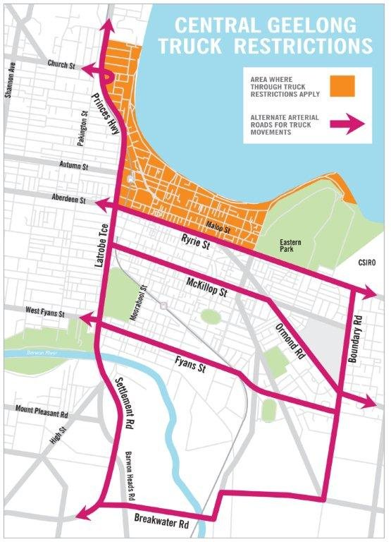

DATE: |
12 JUNE 2014 |
TIME: |
5.00pm |
LOCATION: |
City Hall Council Chamber |
Cr Michelle Heagney (Chair) |
– Brownbill Ward Councillor |
Cr John Irvine |
– Austin Ward Councillor |
Cr Lindsay Ellis |
– Coryule Ward Councillor |
Gary Van Driel |
– General Manager City Services |
Vicki Shelton |
– Manager Engineering Services |
Darren Saunders |
– Central Geelong Transport Engineer |
Dianne Chrimes |
– Minute Taker |
Cr Bruce Harwood |
– Kardinia Ward Councillor |
Introduction – Cr Heagney
Cr Heagney introduced the Panel members, and did a brief instruction regarding the truck trial. Darren Saunders talked about traffic counts, air quality monitoring and the noise survey. Information regarding the trial will be available on the City of Greater Geelong website on a later date.
Submitters
Alan Wilkins – McKillop Street Resident
Has been involved with this issue for 10 years.
Recently spent time in Ryrie Street – impossible to stand outdoors as its was too noisy. Visitor with him from Melbourne could not believe that trucks would be allowed to drive down there.
Amazed at the difference in Malop Street.
Why is Ryrie Street being disadvantaged to benefit Malop Street.
Council can ban trucks on Malop Street, but Ryrie Street is VicRoads.
Ryrie street stakeholders do agree there has been in increase in trucks.
Malop Street is not the whole CBD.
Hold off on all truck trials until there is a bypass.
Trucks are a necessity, trouble is caused when they are confined to one area.
Accept there is an issue.
Look for a long term solution that looks further ahead.
Ben Connoley – McKillop Street Resident
Once stage 2 of the trial commences, trucks being banned on Ryrie Street, trucks will move to McKillop Street – East end of McKillop Street being category 4 road.
What does Council plan to do?
Will the monitoring of truck noise and air conditions continue?
How will the trial be considered a success or failure?
Stage 2 (if it does go ahead) must include Breakwater Bridge option. 8 years ago Council agreed to a whole east west solution.
Good to get trucks out of the city, but don’t send them down our streets.
Suspend until funding is available.
Michael Garvey – McKillop Street Resident
It seems a well thought out plan would have been beneficial.
Trial has increased traffic in Ryrie Street and McKillop Street in his opinion.
Great inconvenience and detriment to residents and local rate payers.
Buildings are very old and have poor soundproofing qualities.
We feel every vibration and every truck which passes, particularly bad in the morning and afternoon peak.
Inequitable and unfair to move traffic to the disadvantage of other 3 streets.
Potential to increase accidents, greater build up of traffic at every set of lights, e.g. Yarra/McKillop Street corner, ridiculous that Council would allow build up of traffic at this corner, there is ambulance and school.
Lack of communication from Council.
Council agreed to trial in October 2013, didn’t hear anything about it until 4 months later.
Council needs to adopt a plan, not a reactive decision.
Far better to Council to establish a group of stakeholders to form a decision.
Terry Slaymaker
Understands the complexities.
Drives along McKillop Street daily, to and from work.
McKillop Street rail crossing, mixing rail and road traffic from east/west perspective, the proposal to use the crossing at McKillop Street has the prospect of major consequences.
Joseph Macula – Ryrie Street Resident
Has been a Ryrie Street resident since 1982.
Where did Council think the trucks would go? Down Ryrie St?
Gets woken at 4.15am, house shakes and vibrates.
Sunday 11.55pm – house vibration for 5 minutes, brakes when accelerate downhill.
Use of gears and brakes when stopping at lights.
Could not have an auction at the front of house due to the noise.
Feels it is a nightmare – halfway up the hill, need to use gears due to the lights.
2006 money spent to upgrade to share the load, could cope with that, Council choose which resident have to take the brunt of the road traffic.
Look for solutions.
Find more routes, put time restrictions on routes to share the load.
Maybe allow trucks in Malop Street from 9pm to 7am.
Use time restrictions to share the load.
Byron Crowe – McKillop Street Resident
Has been a resident of McKillop Street for 10 years.
Would like more information on how Council came up with the monitoring programs.
3 main points of worry, 1. noise pollution, 2. vibration increase, 3. increase in diesel fumes.
Look at Breakwater bridge solutions.
Have discussions with VicRoads.
We are in same place as 8 years ago.
Noise is a major problem.
Not fair to cause increase in noise.
New main road would have to have minimum setbacks but its acceptable to increase these parameters.
Is monitoring vibration increase part of the study?
World Health Organisations say diesel fumes cause affect to health, St Mary’s school is on McKillop Street – diesel fumes long term compares to passive smoking.
Until a permanent solution, keep the status quo – lobby government for funding.
Richard McNay
Pushing problems of Geelong’s layout to the public.
Registration for BDouble is $15,000 per year, why disadvantage these vehicles.
Shifting the burden to others.
Left turn off Latrobe Terrace to Ryrie Street is dangerous in a BDouble.
Truck owners don’t have a voice, they are small business operators.
Timed restrictions.
Different trucks have vastly different needs.
Spread the burden, spread weight across the route.
Ring road extension – Breakwater Bridge is a bridge to nowhere, would cause issues in Felmongers Road.
No knee jerk reactions.
Cr Heagney asked the question:
How would truck drivers cope with different times for different loads?
Richard McNay
Truck drivers will make mistakes, but they learn.
Randall Apps (arrived later and did not hear all other submitters)
There are a lot of 2 hour parking spots in Ryrie Street, this equates to a lot of people getting in and out of their cars every day onto a busy road where there are trucks.
It will affect businesses.
Will affect consumers who come into town.
Early am when driving west trucks drive in the left lane to avoid overhanging trees, and then have to move to the right late to turn to Latrobe terrace.
Also Matthew Flinders school is nearby.
Size of lanes is an issue, there is not much room for error, especially when cars are parked and the doors opening block the bike lanes.
If trucks move to McKillop Street it would be safer.
Frank Kennedy – McKillop Street Resident
Has been a resident of McKillop Street for 11 years.
Has been part of the East/West traffic issue for 10 years.
In 2005 was member of East/West study, pointed out issues of previous consultations.
Commented that he believed there was a lack of communication.
How do you measure success or failure of the trial?
He walked the length of Ryrie Street, he believes that no one really knew what was going on.
Did his own traffic counts on Ryrie St / Latrobe Terrace at 1pm, a number of trucks who want to turn left onto Ryrie Street, they must straddle 2 lanes, he visited shops and eateries along Ryrie Street on south side, the criticised the trial.
Asked the shop owners in Ryrie street what affect the truck trial had on the eateries, no one sitting out the front.
Asked the shop owners if anyone from Council had been to talk to them about the affect on their business, they answered No.
He also asked shops along McKillop Street if they had heard from Council.
Is there a duty of care to the resident of east/west Geelong?
East end of McKillop Street is a category 4 road, local traffic only.
Intersection of Ormond Road and McKillop Street is where the main issue is.
What are the qualifications of the person who did the pollution testing?
6am – 6.30am says there were 8 trucks.
Side streets are not being used, Normandy Road, trucks turn left into this street.
Would the Council consider getting a working group together to approach Government to finish the breakwater bridge road.
Cr Ellis spoke of the impact of sending traffic over the Breakwater Bridge.
John Quniane – Ryrie Street Resident
Has lived in Ryrie Street for 15 years.
Has affected our lives – trucks arrive in Ryrie Street, vibrations all day.
VicRoads seems to be the stumbling block
Nothing seems to advance the situation with VicRoads
VicRoads never present at any meetings
VicRoads needs to be pressured – get them here.
Michael Wood
Has been in contact with Ian Trezise on many occasions, the problem has been around for 10 years or more and nothing seems to be done.
VicRoads are in absence.
From the floor:
What are Council doing with regards to VicRoads
Thank you to Ian Trezise for the Breakwater Bridge.
Helen McCure – Ryrie Street Resident
Where you holding the traffic counting, why are you only monitoring the business area.
What about the residents
Darren Saunders spoke of the traffic counts and why they were done at certain locations.
Helen believes that Council have not taken into consideration the residential streets, looking at the impact in the area in Ryrie Street, residential vibration.
Joseph Macula asked advice on how to contact Ian Trezise.
Fran Walsh – Ryrie Street Resident
Fran feels there is a lot of angst, would like to see that we are on the same page, instead of working against each other.
Cr Irvine commented:
We understood the pressure the trial would cause on other streets, but we needed to collect the data. Need to put pressure on the State and Federal Governments, we wanted to see the impact on residents and roads so we can go to the Government with this impact and data. Cr Irvine wrote to Mr Mulder over 7 months ago and has had no response. Ideally there could be a ring road over the back of Marshall. We need stats and data to take to the Government, the trial will give us this information.
Cr Ellis commented:
He deals with the same issues himself as he drives into Geelong and home most days, having to deal with the traffic and the trucks – down the track we do need a solution.
Cr Heagney commented:
Situation of share the load – pre trial, no one was complaining about the trucks, everyone was tolerating the mid-point, when there have been discussions with VicRoads they say the infrastructure is there to be used.
The only way to start the trial was to begin in Malop Street.
Where to from here?
Will be informing residents and shop keepers to join in a petition.
David Koch MP has agreed to take the petition on board.
Need to gather a working group of approx 10 people
Discussions around time/weight limit on trucks
Try for funding.
Will to work / lobby VicRoads
Comment from floor
Has there been no consultation with VicRoads?
Cr Heagney replied
Yes there has been, VicRoads have been working on $28m of works, including a new roundabout at Fellmongers Road.
Richard McNay
It seems there was not an issue prior to the trial, where did the idea come from?
Michael Garvey
Believes that this was not communicated process was not adequate – there should have been better communication. From October onwards there was no communication until the trial.
Comment from the floor
Was the driver for the decision Green Spine?
Vicki Shelton CoGG officer responded:
There was a study done regarding modes of transport modelled to 20 years ahead.
40 measures to improve access around city, prioritise
We needed data
This is one small part of the bigger picture.
Discussion were held regarding the trucks at the east end of McKillop Street, talked about a treatment being applied at McKillop Street end to restrict the truck movements.
Question from the floor: What is the time scale?
Results from the trial will go to a Council meeting at the end of July 2014 regarding continuing the trial. Seek approval from VicRoads for future trial hopefully for 12 months.
In terms of new infrastructure not sure of budget details, will take on note.
VicRoad has set up an industry group. Councillors want a resident/retail group.
Cr Irvine commented:
Common goal in the room to share the load.
Do not wait for trucks to be forced to use Boundary Road/Breakwater Bridge, this will never happen.
Pressure VicRoads and State Government for funding.
Meeting closed 7:10pm
Cr Richards re-entered the meeting room at 8:59pm.
Portfolio: |
Infrastructure – Cr Ellis |
Source: |
City Services – Engineering Services |
General Manager: |
Gary Van Driel |
Index Reference: |
Special Rates and Charges; Surf Coast Highway, Grovedale |
This report seeks a resolution by Council to consider an intention to declare a Special Charge Scheme to partially fund the construction of a footpath along Surf Coast Highway between Grove Road and Waurn Ponds Creek, Grovedale. (See plan – Appendix 4)
It is proposed to construct 277 lineal meters of 1.5 metre wide footpath to provide for pedestrian access along Surfcoast Highway, Grovedale.
There are fifteen (15) properties abutting the proposed footpath that will receive special benefit. There is one (1) Council owned property in the scheme.
The total estimated project cost is $112,218. This includes direct funding by Council estimated at $1,487 for the reestablishment of existing crushed rock driveways to match new footpath levels and replacement of a damaged pit lid. The net scheme cost is estimated to be $110,731.
A Benefit Ratio of 0.305 has been calculated in accordance with Section 163 of the Local Government Act, which equates to a Council contribution to the scheme of $76,949 and property owner contribution of $33,782.
Property owners are considered to receive benefit from the works by way of improved pedestrian access and general amenity including pedestrian safety improvements.
The scheme has been prepared in accordance with the Special Rate and Charges provisions of the Local Government Act 1989 along with the 2004 Ministerial Guidelines and Council’s Special Rates and Charges Policy.
Cr Ellis moved, Cr Harwood seconded -
That Council:
Gives notice of its intention to declare a Special Charge Scheme in accordance with Section 163 (1A) of the Local Government Act 1989 (The Act), as follows:
The Special Charge is declared for a period of five (5) years commencing upon completion of the works and scheme finalisation.
The Special Charge be declared for the purpose of defraying any expenses incurred by Council in relation to the construction of the footpath on Surf Coast Highway between Grove Road and Waurn Ponds Creek, Grovedale which project:
Will provide proper pedestrian access, improved pedestrian safety and enhancement to the general amenity for each of the properties included in the scheme;
Council considers is or will be a special benefit to those persons required to pay the special charge (and who are described in succeeding parts of this Resolution); and
Arises out of Council’s function of planning for and providing infrastructure for property owners.
The total cost of project, be recorded as $110,731(Schedule A).
It be recorded that, for the purposes of Section 163 (2A) of the Act, the special charge proceeds will not exceed the amount calculated in accordance with the prescribed formula (R x C = S), the:
‘benefit ratio’ (R) being calculated at 0.305 represents the special benefits to all persons liable to pay the special charge (Schedule B);
‘total cost’ (C) of performing the function described in part 1 (b) of this resolution based on estimated cost be recorded as $110,731; and
‘Maximum levy’ (S) be recorded as $33,782.
the following be specified as the area for which the special rate is so declared:
The area within municipal district of Council highlighted in the plan attached to this Resolution (Appendix 4).
the following be specified as the land in relation to which the special charge so declared:
Land within the area shown on the plan.
the following be specified as the criteria which form the basis of the special charge so declared:
Ownership of any land described in Part 1(e) of this Resolution.
the following be specified as the manner in which the special charge so declared will be assessed and levied:
Each lot receives a primary access and amenity benefit;
The maximum levy is divided equally on a access and frontage share basis;
The special charge will be levied by sending a notice to the person who is liable to pay, pursuant to section 163(4) of the Act.
having regard to the preceding parts of this Resolution but subject to Section 166 (1) of the Act, it be recorded that;
the owners of the land described in column 3 of Schedule C to the resolution are estimated liable for the respective amounts set out in column 6 of Schedule C; and
such owners may, subject to any further resolution of Council pay the special charge in the following manner;
the charge will become due and payable within one month of the issue of the notice requesting payment pursuant to Section 167 (3) of the Act;
interest will not be charged for six months after the issue of the notice provided the person liable makes timely payment in accordance with any repayment arrangements that may be agreed on by Council; and
in accordance with Section 172 of the Act, the interest rate payable on the special charge which has not been paid by the specific date is set at Council’s overdraft rate, reviewed every three months (provided that it shall not exceed the rate fixed by the Governor in Council by Order for the purposes of Section 172 (2A) in which case the rate of interest shall be the maximum rate fixed by the Governor in Council by Order for the purposes of this section).
Council’s Chief Executive Officer be authorised to levy the Special Charge in accordance with Section 163 (4) of the Act.
Carried.
Council’s footpath network strategy identifies the footpath construction priorities of which the Surf Coast Highway is listed as a high priority for construction. It is considered that the proposed new footpath will provide the missing pedestrian link between Grove Road and Waurn Ponds Creek, Grovedale and become a valuable community asset.
The footpath will provide a pedestrian link to the Waurn Ponds Valley parklands and pedestrian crossing at the Waurn Ponds Creek. It will also satisfy the requirement of the Planning Scheme for footpath provision on both sides of the road for roads with traffic volumes in excess of 1000 vehicle per day.
Council Officers have developed a detailed Special Charge Scheme proposal including a cost estimate, Benefit Ratio calculation and cost apportionment spreadsheet. The estimated charges, along with more detailed information on the scheme, were shown to all potentially affected property owners who were asked to respond to the proposal via survey.
The survey results had twelve (12) property owners respond representing an 80% response rate with three (3) in favour, eight (8) opposed and one (1) showing neither support nor opposition to the scheme proposal. Of those opposing the scheme, concerns raised included:
Method of apportionment is unclear and/or unfair;
There is an existing footpath on the other side of the road;
Footpath will provide no benefit to me;
Low use pedestrian area used mainly by local residents; and
A footpath here would encourage people to cross the road elsewhere, rather than at current crossing.
This project involves the proposed construction of 277 metres total length of 1.5 metre wide footpath. It is expected to be a safety improvement for pedestrian movements along a highly trafficked road and fulfil part of the footpath priority obligations for Council.
The section of Surf Coast Highway, Grovedale between Grove Road and Waurn Ponds Creek is relatively flat and the footpath construction should not pose any difficulty for the selected contractor.
Cost apportionment for the scheme has been divided into access and amenity benefits. 50% of the total benefit has been apportioned to access. It is considered that all abutting properties with direct frontages to the proposed new footpath, regardless of size and shape, receive the same access benefit. An exception to this rule is the corner property with more than double the frontage of neighbouring properties where an increase of the access benefit has been applied.
The access benefit includes the provision of an all weather sealed surface that reduces the risk of accidents caused by uneven and slippery surfaces. In simple terms, a new footpath improves accessibility for all abutting properties.
The remaining 50% of benefit is attributed to amenity and this can best be described as the benefit the pathway provides to an abutting property by way of improved aesthetics, safety, enjoyment, comfort and property value. The amenity benefit is based on the actual footpath frontage to a property when existing driveways and footpath extents are taken into consideration.
The provision of a sealed pathway surface provides a permanent and safe means of access. During the course of construction and the manufacture and procurement of materials, energy is expended resulting in some greenhouse gas emissions. This ceases when construction is complete.
The project does not create waste with the exception of some excavated material.
The proposal does not affect any natural habitats.
The proposal will require some nature strip trees and shrubs to be trimmed but removal of vegetation is not expected.
The project is a one off capital cost and there will be minimal ongoing maintenance costs. If approved, the scheme could proceed this financial year.
Financial details are as follows:
Maximum scheme levy to Property Owners (income) |
$33,782 |
Scheme levy to Council |
$76,949 |
Direct Funding by Council to re-establish crushed rock driveways. |
$1,487 |
Total Project Cost |
$112,218 |
From the table above, the net cost to Council for this project is estimated to be $78,436.
The scheme has been prepared in accordance with the Special Rate and Charge provisions of the Local Government Act 1989 along with the 2004 ministerial guidelines and Council’s Special Rates and Charges Policy.
This report aligns with the City Plan as follows:
Sustainably Built and Natural Environment
Support our Community to live sustainably – Encourage increased use of alternatives to car transport and seek efficient traffic movement throughout the municipality.
Advocate for and promote sustainable design and development – Promoting sustainable design and retrofitting.
Acknowledge the community’s desire to have their say and be involved in planning for the future of Greater Geelong.
No Council Officer involved with this process has any direct or indirect interest in the properties.
Provision of a sealed pathway will provide safer walking and cycling conditions for pedestrians and cyclists by minimising the risk of personal injuries through conflict with vehicles and the elimination of uneven and slippery surfaces.
There are no identified risks for Council in making its intention to declare the scheme.
The provision of properly sealed and drained pathways is aligned to Council’s City Plan as described above and provides improved connectivity and safety for pedestrians and cyclists. It is further considered that the footpaths will enhance the general amenity of the area.
In developing this report to Council, the subject matter has been considered to determine if it raises any human rights issues. In particular, whether the scope of any human right established by the Victorian Charter of Human Rights and Responsibilities is in any way limited, restricted or interfered with by the recommendations contained in this report. It is considered that the subject matter does not raise any adverse human rights issues.
It is further considered that the construction of the footpaths upholds the right to freedom of movement (Section 12 of the Human rights Charter) by enhancing a person’s ability to move freely within the area they choose to live.
Informal consultation was carried out in May 2014 with an information pack to affected property owners that included an initiation letter, a plan showing the location of works, a Special Rates and Charge Scheme brochure, a detailed cost apportionment spreadsheet and informal survey form. Of the 15 affected property owners included in the scheme, there were 12 responses to the survey. Three (3) supported the scheme, eight (8) opposed and one (1) was neither in support or opposition.
Further correspondence to the affected property owners will be sent should Council make its intention to declare a Special Charge Scheme.
The works for the construction of footpaths in Surf Coast Highway, Grovedale which consist of excavation, footpath, reinstatement of nature strip and driveways, miscellaneous construction works, legal advice and professional services associated with survey, engineering design, drafting, supervision and administration of the project all as included in the cost estimate shown below.
ESTIMATED TOTAL COST OF FOOTPATH CONSTRUCTION |
|||||
ITEM |
DESCRIPTION |
QUANTITY |
UNIT |
RATE $ |
AMOUNT $ |
1.00 |
GENERAL |
|
|
|
|
1.01 |
Initial site establishment and set up, decamping and site cleanup and other fixed costs up to time of completion of works. |
1 |
ITEM |
$10,000.00 |
$10,000.00 |
1.02 |
Traffic management costs. |
1 |
ITEM |
$3,500.00 |
$3,500.00 |
1.03 |
Setting out of works. |
1 |
ITEM |
$1,000.00 |
$1,000.00 |
1.04 |
Service/Cable locations |
1 |
ITEM |
$1,000.00 |
$1,000.00 |
1.05 |
Internal supervision fee (COGG construction) |
1 |
ITEM |
$4,500.00 |
$4,500.00 |
2.00 |
EARTHWORKS & DEMOLITION |
|
|
|
|
2.01 |
Excavation and disposal of all materials to limits of work as indicated on plan, including trimming for new road pavement, excavation of soft spots and removal of concrete. |
118 |
m3 |
$60.00 |
$7,080.00 |
2.02 |
Placement and consolidation of engineered fill with approved materials in preparation for new works. |
30 |
m3 |
$60.00 |
$1,800.00 |
2.03 |
Trimming/Removal and disposal of shrubs as indicated on plan. |
1 |
ITEM |
$3,000.00 |
$3,000.00 |
2.04 |
Saw-cutting of Asphalt paving. |
1.0 |
ITEM |
$250.00 |
$250.00 |
2.05 |
Saw-cut of concrete kerb and channel |
3.0 |
ITEM |
$10.00 |
$30.00 |
3.00 |
CONCRETE WORKS: |
|
|
` |
|
|
KERBING |
|
|
|
|
3.01 |
Concrete pram crossing 1.5m wide, including fine crushed rock bedding. |
1.0 |
No. |
$250.00 |
$250.00 |
|
PAVING |
|
|
|
|
3.02 |
125mm (25 Mpa) concrete paving with SL72 mesh including crushed rock bedding and reinstate nature strip. |
415 |
m2 |
$135.00 |
$56,025.00 |
4.00 |
DRAINAGE - PITS |
|
|
|
|
4.01 |
Remove and replace existing side entry pit lid with gatic type cover. Adjust pit lid to match neatly into new footpath level. |
1 |
No. |
$770.00 |
$770.00 |
5.00 |
LANDSCAPING |
|
|
|
|
5.01 |
Top soiling and seeding nature strips. |
336 |
m2 |
$8.00 |
$2,688.00 |
SUB-TOTAL |
$91,893 |
||||
10% Contingency |
$9,189 |
||||
Design |
$4,595 |
||||
Project administration |
$5,054 |
||||
CONSTRUCTION COST ESTIMATE |
$110,731 |
||||
ESTIMATED COST FOR DRIVEWAY REINSTATEMENT |
|||||
ITEM |
DESCRIPTION |
QUANTITY |
UNIT |
RATE $ |
AMOUNT $ |
1.00 |
GENERAL |
|
|
|
|
1.02 |
Traffic management costs. |
1 |
ITEM |
$500 |
$500 |
2.00 |
PAVEMENT WORKS |
|
|
|
|
2.01 |
100mm compacted depth Class 1 20mm crushed rock, supplied, spread and compacted. |
0.7 |
m3 |
$120 |
$82 |
3.00 |
DRAINAGE PIT |
|
|
|
|
3.01 |
Remove and replace existing Side entry pit lid with Gatic type cover. Adjust pit lid to match neatly into new footpath level. |
1 |
No. |
$770 |
$770 |
SUB-TOTAL |
$1,352 |
||||
10% CONTINGENCY |
$135 |
||||
CONSTRUCTION COST ESTIMATE |
$1,487 |
||||
A |
Purpose |
||||||
|
To construct a footpath in Surfcoast Highway, Grovedale to provide all weather pedestrian access for property owners and the wider community. |
|
|||||
B |
Coherence |
|
|||||
|
The works will provide a physical pathway connection between Grove Road and Waurn Ponds Creek and will provide a special benefit to adjoining and remote properties. |
|
|||||
C |
Total Cost C |
|
|||||
|
Total Estimated cost of works - footpath construction |
$112,218.00 |
|||||
|
Direct funding by Council to reinstate driveway and replace damaged pit lid |
$1,487.00 |
|||||
TOTAL COST |
$110,731.00 |
||||||
D |
Identify Special Beneficiaries |
|
|||||
|
18 properties with frontages to the proposed footpath are considered to receive access and amenity benefits. |
|
|||||
E |
Properties to include |
|
|||||
|
The 18 abutting properties receive both access and amenity benefits. Therefore: |
|
|||||
|
Total Special Benefits (in) is apportioned to 18 properties |
|
|||||
|
There is one Council owned property that is not subject to special charge. Therefore: Total Special Benefits (out) is one Council owned property |
|
|||||
F |
Estimate of Total Special Benefits |
|
|||||
|
Benefit will be apportioned on the basis of access and amenity by way of a Benefit Unit (BU). We shall assume that the makeup of the BU for each of the private properties comprises 1/2 BU of amenity benefits and 1/2 BU of access benefits. The Council owned property shares the same access benefit as the private properties but has five times the average frontage hence five times the amenity benefit. A summary of the special benefits is shown in table form below: |
|
|||||
18 private properties TSB (in) |
1 Council Property TSB(out) |
TSB (in) |
18 BU |
||||
Access |
9 BU |
0.5 BU |
|
||||
Amenity |
9 BU |
2.5 BU |
|
||||
Total Special Benefits |
18 BU |
3.0 BU |
TSB (out) |
3 BU |
3 |
||
G |
Estimate of Total Community Benefit -TCB |
|
|||||
|
It is considered that the wider community will use the footpath 80% of the time and the benefiting property owners 20%. There are no amenity benefits associated with the community benefit. If 20% of access benefits totals 9.5 BU for properties in and out of the scheme, then 80% will represent 38 BU. |
|
|||||
|
|
TCB |
38 |
BU |
|
||
H |
Calculate "Benefit Ratio" - R |
|
|||||
|
|
|
|||||
|
Benefits Ratio = |
TSB (in) = |
18 |
0.305 |
|
||
|
TSB (in) + TSB (out) + TCB |
18 + 3 + 38 |
|
||||
I |
Maximum Total Levy (S) |
|
|||||
|
|
|
|||||
|
Maximum Total Levy S = R X C |
$33,782 |
|||||
|
Council Contribution to Special Charge Scheme |
$76,949 |
|||||
COLUMN 1 |
COLUMN 2 |
COLUMN 3 |
COLUMN 4 |
COLUMN 5 |
COLUMN 6 |
COLUMN 7 |
Prop Key |
Address |
Legal Details |
Apportionable Frontage (m) |
Access Benefit |
Amenity Benefit |
Footpath Cost |
240773 |
1/107-109 Torquay Road, GROVEDALE |
Lot 1 SP36595 |
6.80 |
$1,072.46 |
$556.22 |
$1.628.68 |
240774 |
2/107-109 Torquay Road, GROVEDALE |
Lot 2 SP36595 |
6.80 |
$1,072.46 |
$556.22 |
$1.628.68 |
240775 |
3/107-109 Torquay Road, GROVEDALE |
Lot 3 SP36595 |
6.80 |
$1,072.46 |
$556.22 |
$1.628.68 |
240776 |
4/107-109 Torquay Road, GROVEDALE |
Lot 4 SP36595 |
6.80 |
$1,072.46 |
$556.22 |
$1.628.68 |
240777 |
5/107-109 Torquay Road, GROVEDALE |
Lot 5 SP36595 |
6.80 |
$1,072.46 |
$556.22 |
$1.628.68 |
240778 |
6/107-109 Torquay Road, GROVEDALE |
Lot 6 SP36595 |
6.80 |
$1,072.46 |
$556.22 |
$1.628.68 |
240779 |
111 Torquay Road, GROVEDALE |
Lot 5 LP146296 |
20.00 |
$1,072.46 |
$1,635.55 |
$2,708.01 |
240780 |
113 Torquay Road, GROVEDALE |
Lot 4 LP146296 |
17.95 |
$1,072.46 |
$1,467.91 |
$2,540.36 |
240781 |
115 Torquay Road, GROVEDALE |
Lot 3 LP146296 |
16.90 |
$1,072.46 |
$1,382.04 |
$2,454.50 |
240782 |
117 Torquay Road, GROVEDALE |
1/4 Share of Lot 2 LP146296 |
4.12 |
$1,072.46 |
$1,346.88 |
$2,419.33 |
240783 |
1/119 Torquay Road, GROVEDALE |
Lot 1 SP36507 |
5.08 |
$1,072.46 |
$415.02 |
$1.487.48 |
240784 |
2/119 Torquay Road, GROVEDALE |
Lot 2 SP36507 |
5.08 |
$1,072.46 |
$415.02 |
$1.487.48 |
240785 |
3/119 Torquay Road, GROVEDALE |
Lot 3 SP36507 |
5.08 |
$1,072.46 |
$415.02 |
$1.487.48 |
240786 |
4/119 Torquay Road, GROVEDALE |
Lot 4 SP36507 |
5.08 |
$1,072.46 |
$415.02 |
$1.487.48 |
325335 |
121-131 Torquay Road, GROVEDALE |
1/2 Share of Lot A PS518150 |
74.12 |
$1,876.80 |
$6,061.36 |
$7,938.15 |
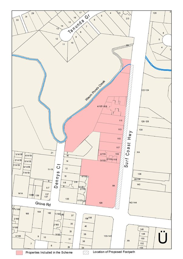
Stage |
Status |
Description |
Approval to prepare scheme |
✓ |
Decision made to prepare scheme following consideration of surveys of residents and feed back from the community via informal survey. Council may then place the project in the budget system or proceed immediately to prepare a scheme. Scheme preparation involves survey, design and preparation of an apportionment of costs. |
Intention to Declare Scheme |
✓ |
Report to Council providing information on scheme including advice of impending advertising of scheme and declaration of charge. Seeks Council approval by resolution to proceed with process. |
Advertisement |
|
The scheme is advertised in the local newspaper and all allotted property owners are notified by mail. This advertisement indicates Council’s intention and notification to ‘declare’ a scheme in a month’s time. |
Submissions |
|
From the time of advertising property owners have 28 days (as set down by the Local Government Act) to lodge submissions, either in support or opposition to the scheme. |
Submissions Review Panel Hearing |
|
A Submissions Review Panel is convened (quorum of three Councillors) and meets to consider submissions. Some submissions are written only, and other submitters may wish to be heard before the Panel. The Panel makes a recommendation to Council regarding the scheme. |
Declaration Report |
|
Any time 28 days after advertising the scheme and after the Submissions Review Panel has met and considered submissions, Council considers a report and may proceed to “declare” the charges in accordance with its advertised intent. Subsequent to this the Finance Manager issues the levy notices and there is a formal charge placed on the property. This is the final step in the process for Council to make a decision on the scheme. |
Appeal |
|
Property owners may lodge an application for review with the Victorian Civil and Administrative Tribunal (VCAT) within one month of issue of the levy notice. An appeal is listed, heard and determined by the Tribunal and this process generally takes three to four months. Decisions made by VCAT are binding on all parties. |
Construction |
|
Council may then proceed to construct the works. Invoices are issued seeking payment of the estimated cost within one month of commencement. |
Final Cost Report |
|
At the completion of the works the scheme is “finalised” taking into account actual costs incurred and payments are adjusted accordingly. |
Portfolio: |
Infrastructure - Cr Ellis |
Source: |
Engineering Services; Enterprise Geelong |
General Manager: |
Gary Van Driel |
Index Reference: |
C15307 162 McManus Road |
The purpose of this report is to seek Council consent to delegate the power to accept or reject tenders to the Chief Executive Officer for the partial construction of Broderick Road and Production Way as part of a GREP subdivision at 162 McManus Road, Lara; provided tenders fall within the adopted budget.
This project is part of a subdivision development project at the Geelong Ring Road Employment Precinct. The design process for the road construction project is completed and Council has invited tenders for the construction of these roads.
Council has made a commitment to deliver this project by November 2014. There will be a risk to Council’s reputation as a developer if this project cannot be completed in time and a potential legal risk should Council fail to deliver on time
Engineering and Procurement Services departments are exploring prudent mechanisms to complete the tender process for this project in order to expedite the commencement date for construction.
This project is running to very tight and ambitious deadlines and the necessity to award tenders early reduces the potential risk to project timelines by bypassing the Council meeting cycle.
Cr Ellis moved, Cr Ansett seconded -
That Council delegate to the Chief Executive Officer its powers and functions to accept or reject a tender and sign the contract documents for the construction and associated works for the following project provided it is within budget:
C15307 162 McManus Road, Lara.
Carried.
The Geelong Ring Road Employment Precinct (GREP) has seen interest in industrial land increase over the past 12 months. Council owned land at 162-200 McManus Road is available for purchase and Lot 1 of a four lot subdivision has recently been sold to Accensi Pty Ltd, a crop product protection manufacturer bringing potential employment and ongoing economic prosperity to the Geelong region. Since the sale of Lot 1, the sale of Lot 2 is under negotiation and another company has interests in Lot 4. The remaining Lot 3 is still on the market.
Accensi Pty Ltd is adamant that they need to be operational by November 2014 and Council, in its capacity as a land developer, has made a commitment to provide the infrastructure to make the subdivision compliant and ready for use by this time.
As all tender documentation has been finalised, Council is about to enter the tender selection phase of the project. The scope of work has been complicated by the need to include main drainage associated with the upcoming Elcho Channel Special Charge Scheme in the form of underground pipes in Broderick Road.
The delegation request provides Council with the shortest possible tender approval timeframe, and if the contract can be awarded under delegation, will allow Council the best opportunity to deliver this project on time.
The Engineering Services and Contracts and Purchasing departments are exploring prudent and expeditious mechanisms to achieve a compliance deadline for the road construction project, noting that the construction contract for the project may be beyond officer delegation. If the contract is within the $2.0Mil delegation of the Chief Executive Officer but in excess of $1.0Mil, there is a further risk that the winning tender may not be the lowest price and a report to Council is therefore triggered.
The current project timelines will see the tender evaluation process carried out in early August 2014. The timing for the appointment of a contractor means that it would be beneficial if the Chief Executive Officer can enter into the contracts under delegation. This is because the Council reporting process generally takes between 4 and 6 weeks to complete.
If awarding of this contract is delayed, it could have a major impact on project delivery as it could limit the ability for the project to commence once the tender evaluation process is complete.
The road infrastructure proposed, provides proper sealed access and greatly improved drainage. Dust is eliminated and storm water runoff is less contaminated with silt prior to final discharge into the Elcho Basin and beyond.
It is anticipated that no vegetation removal will be required to complete the project.
During the course of construction and the manufacture and procurement of materials, there is expenditure of energy sources and greenhouse gas emissions. This does cease, however, when construction is complete.
The project does not create waste with the exception of some excess spoil. The proposal does not affect any natural habitats.
Funding of $3.8 Mil has been allocated in the 2014/15 Financial Year for civil infrastructure related to industrial subdivision development at the GREP, Lara. This project is a standard road and drainage construction project (including all utility services) that will be a once off Capital Cost with minimal ongoing maintenance costs.
Against the above timeframes and expected milestones there may be inadequate time for Council to formally determine the outcome of the tenders in its normal capacity. This report provides the policy and legal mechanisms necessary for the CEO to award or reject tenders.
This report aligns with the City Plan as follows:
Growing our Economy:
Supporting existing businesses and encouraging new and emerging growth sectors:
Facilitate strategies and activities to attract new business investment and generate employment growth; and
Promote Geelong as a great place for business and investment, nationally and internationally.
No council officers involved in this project or report have declared a direct or indirect interest in this matter.
Council has made a commitment to deliver this project by November 2014. There will be a risk to Council’s reputation as a developer if this project cannot be completed in time and a potential legal risk should Council fail to deliver on time.
There is minimal risk to Council from a constructability perspective to allow delegation authority to the Chief Executive Officer. This is due to the well rehearsed standard construction methods employed by contractors during the construction phase of the project that will require direct supervision and approval by Council works inspectors.
The provision of a compliant industrial subdivision is aligned to Council’s City Plan as described above. Opportunities for employment in the region will be enhanced.
In developing this report to Council, the subject matter has been considered to determine if it raises any human rights issues. In particular, whether the scope of any human right established by the Victorian Charter of Human Rights and Responsibilities is in any way limited, restricted or interfered with by the recommendations contained in this report. It is considered that the subject matter does not raise any adverse human rights issues.
There are no communication issues or requirements with acceptance of the proposed recommendation.
Portfolio: |
Infrastructure Parks & Gardens – Cr Ellis |
Source: |
Corporate Services - Corporate Strategy & Property Management |
A/General Manager: |
John Brown |
Index Reference |
T1400050 |
To provide Council with required information in support of the tender evaluation panel’s recommendation for the provision of General Maintenance Services of Council Owned Facilities.
Council has sought tenders for the provision of general maintenance services for Council owned facilities throughout the municipality. This contract will be active for a period of three years from 1 September 2014 to 31 August 2017 with the option to extend the contract for up to two (2) further twelve month periods at sole discretion of Council.
The service is to be provided on a schedule of rates basis.
The range of services required include plastering, bricklaying, carpentry, concreting, paving, painting, gas heater servicing and office fitout’s to be undertaken on a quotation basis. As a minimum, tenders were required to provide carpentry services.
Council will appoint a panel of contractors for the provision of general maintenance services for Council owned facilities.
A total of twelve (12) companies have provided tender submissions for the provision of general maintenance services for Council owned facilities. Tender submissions include an extensive schedule of rates for all manner of services relating to different trades during normal business hours and attending after hours call outs and on weekends.
The estimated annual cost of general maintenance services associated with this contract is $900,000.
Following a detailed evaluation of each of the submissions including interviews it is considered that the three tender submissions of Taronga Arch Pty Ltd, The Trustee for Jones Family Trust trading as Trak Constructions and Management Maintenance & Development Pty Ltd – MMD Trust are preferred.
Cr Ellis moved, Cr Richards seconded -
That Council:
Accept the tender submission’s from:
The Trustee for Jones Family Trust trading as Trak Constructions;
Taronga Arch Pty Ltd;
Management Maintenance & Development Pty Ltd – MMD TRUST;
for Tender No T01400050 – Panel arrangement for Provision of General Maintenance Services for Council Owned Facilities for the associated schedule of rates (exclusive of GST);
Sign and seal the contract documents.
Carried.
The City of Greater Geelong invited tenders for the provision of general maintenance services for Council owned facilities via public advertisement in Tenderlink, the Geelong Advertiser and The Age on Saturday 12 April 2014.
At the close of tenders on 7 May 2014 the following tender submissions were received:
Tenderer |
The Trustee for Jones Family Trust trading as Trak Constructions |
Taronga Arch Pty Ltd |
Management Maintenance & Development Pty Ltd – MMD TRUST |
Harris HMC Interiors Pty Ltd |
The Trustee for the Total Trade Property Services Unit Trust |
Matherson Construction Group Pty Ltd |
Rendine Constructions Pty Ltd |
Surbo Holdings trading as Stickman Contracting |
The Trustee for Hanlon Industries Discretionary Trust |
Dudley & Co Builders Pty Ltd ATF Dudley Family Trust |
D Wright Plumbing & Maintenance Pty Ltd |
Total Maintenance Solutions Pty Ltd |
All tenders have been submitted exclusive of GST.
The tender submissions were evaluated by a panel consisting of:
Lindsay Allan |
Manager Corporate Strategy & Property Management |
Frank Howard |
Coordinator Facilities Maintenance |
Tim Sheringham |
Technical Officer Works |
David Willmott |
Technical Officer Works |
Mandatory requirements applying to this Tender are:
Must comply with OH&S requirements detailed in the tender schedule and have carpentry trade as a core component of their business. |
TD Wright Plumbing & Maintenance failed the mandatory criteria as they did not have carpentry component within their business and were not assessed further. All other tenderers proceeded to the second stage evaluation.
Tender submissions were assessed based on the respondent’s performance or tender response in the following areas:
Criteria |
Weighting |
Flexibility & Responsiveness |
15% |
Capability and experience |
30% |
Proposed Staff, Plant & Equipment, extent of subcontracting |
20% |
Economic Contribution to the Geelong Region |
10% |
Degree of Innovation in proposal |
5% |
Customer Service |
20% |
Total |
100% |
Tenders were assessed against the comparative criteria to determine whether they possess the necessary resources, experience and ability. Suppliers who achieved a rating of acceptable or higher were then evaluated on their ability to provide value for money to Council.
The suppliers who combined the necessary skills while providing market rates were rated suitable for inclusion on the panel for the provision of general maintenance services (refer below).
Recommended Panel Of Suppliers
Tenderer |
Ranking |
Taronga Arch Pty Ltd |
1 |
The Trustee for Jones Family Trust trading as Trak Constructions |
2 |
Management Maintenance & Development Pty Ltd – MMD TRUST |
3 |
Taronga Arch Pty Ltd are an incumbent supplier for this service and they have performed satisfactorily in all aspects of the service to Council. They are very responsive and well resourced to continue to provide this service and their systems are compliant with Councils for after hours service requirements etc. Their subcontractors have all been engaged for a number of years and are compliant with all applicable OH&S procedures of the company. Sound procedures for sub contractor management exist.
Management Maintenance & Development Pty Ltd-MMD TRUST are an incumbent supplier for this service and have been undertaking services of this type for Council for a number of years and are considered reliable and responsive. They currently hold contracts for similar services with other companies in the Geelong region. They are able to supply all trades and equipment etc. required to fulfil this service.
The Trustee for Jones Family Trust trading as Trak Constructions submitted an excellent tender submission and were interviewed by members of the evaluation panel and were able to demonstrate a thorough knowledge of the required services. They have extensive resources - both staffing and equipment and fully understand the after hours requirements of the service. They currently hold contracts for similar services with other companies in the Geelong region. They are fully compliant with Council requirements and are able to provide all trades required. Since their core business is building and construction they have all applicable equipment and materials readily available to fulfil the scope of service.
Any environmental implications associated with this contract will arise from the execution of this service / works. It is considered that these are the responsibility of the Contractor and will be managed through the contract documentation.
This is a schedule of rates tender and will rely upon the funds allocated in Council’s budget code 004736 Recurrent for the 2014-2015 financial year.
The requirements of Section 186 of the Local Government Act have been complied with for this tender. There are no other policy, legal or statutory implications associated with this tender process.
This panel contract assists Council in creating efficiencies for its facilities maintenance operations as well as ensuring value for money outcomes. This outcome positively impacts on Councils strategic direction of “How We Do Business” and the listed goal of being an efficient and customer focused organisation.
No officers or contractors involved in the preparation of this report have a direct or indirect interest in matters to which this report relates.
There are not considered to be any risks associated with the acceptance of this tender that cannot be managed through the contract conditions.
There are no social implications that will arise from the acceptance of this tender.
This report has no impact on human rights.
There are no communication issues associated with the acceptance of this tender. Council’s representative will liaise with affected community groups.
Portfolio: |
Governance – Cr Lyons (Mayor) |
Source: |
Mayor and Councillors Office |
Mayor: |
Cr Lyons |
Index Reference |
Council Reports |
Cr Harwood moved, Cr Fisher seconded -
That in accordance with Section 89 (2) (d) of the Local Government Act 1989, this contractual matter be considered at the conclusion of all other business at which time the meeting be closed to members of the public.
Carried.
Contents | Previous Page: Section A - Procedural Matters | Next Page: Section C - Assembly of Councillors
