
Council Minutes - Section B: Reports - 23 September 2014
Contents | Previous Page: Section A - Procedural Matters | Next Page: Section C - Notice of Motion
Contents | Previous Page: Section A - Procedural Matters | Next Page: Section C - Notice of Motion
Reports tabled at the Ordinary Meeting of Council on Tuesday date held at City Hall, Little Malop Street in Geelong.
Amendment C199 – Changes to Zones and Overlays, ICD Property Land, Fyansford
Amendment C297 and Permit 765/2013 Drysdale Coles – Consideration of Submissions
Amendment C309 Low Density Residential Zone Review – Consideration of Submissions
Shell Road Reserve Pavilion Development – Delegation to Chief Executive Officer
Cr S Kontelj declared an Indirect Interest by Close Association in Agenda Item 1 – Amendment C199 – Changes to Zones and Overlays, ICD Property Land, Fyansford in that the developers have donated to fundraisers associated with his wife’s Election Campaign, and left the meeting room at 7.31pm, prior to discussion of the item.
Portfolio: |
Planning - Cr Heagney |
Source: |
Planning and Tourism - Strategic Implementation |
General Manager: |
Peter Bettess |
Index Reference: |
Subject: C291 - Council Reports 2014 Application: 199 |
The purpose of this report is to consider Planning Scheme Amendment C199 applying to the ICD Property land at Fyansford. The application seeks Council’s support for a Ministerial amendment to modify existing zones and overlays without public exhibition.
Tract Consultants on behalf of ICD Property are seeking Council’s support for Planning Scheme Amendment C199 applying to the company’s land at Fyansford. The request is for the Minister for Planning to act as the planning authority pursuant to 20(4) of the Planning and Environment Act 1987 and to approve the amendment without normal exhibition.
ICD Property has purchased the ex Geelong Cement works land and former CSR Quarry site from Moltoni Corporation. Both properties have already been rezoned to enable major residential and accompanying commercial and community development to occur. The proposed amendment modifies existing zoning and overlay provisions as outlined in this report.
The application for Ministerial intervention is made on the basis that the proposed changes will result in an improved planning outcome, will have no impact on the community or surrounding landowners and will assist in streamlining the planning approval process.
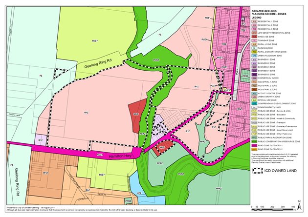
The main change being sought by the amendment is the relocation of the ICD Property owned Commercial 1 and Mixed Use Zones on the north side of Hamilton Highway to the triangular site between Hyland Street and Deviation Road (which would be rezoned from General Residential Zone to Commercial 1 Zone). Other changes include modifying the existing Development Plan Overlays 15 and 16 provisions and reducing the scope of the Heritage Overlay affecting the land.
From a planning viewpoint the proposed changes are supported. In particular, the relocated future neighbourhood shopping centre site provides a more easily-accessible and higher profile site from a traffic perspective and better separation from future more sensitive residential uses.
This amendment is essentially revising the format of previously approved development. It is recognised the new neighbourhood shopping centre is likely to extend its primary trade area into those of existing supermarkets at Newtown and Manifold Heights; however in the interests of streamlining the current planning approval process the proposed Section 20(4) Ministerial Amendment is supported.
In the event the Minister does not agree to approve this amendment as requested, it is proposed the Council prepare and exhibit an amendment in the normal manner. An additional recommended resolution has been included to this effect.
Cr Heagney moved, Cr Macdonald seconded -
That Council:
Advises the Minister for Planning that it supports approval of Amendment C199 to the Greater Geelong Planning Scheme as a Ministerial Amendment with exemptions from notification pursuant to Section 20(4) of the Planning and Environment Act.
In the event the Minister does not approve the amendment as requested, resolves to prepare and exhibit Amendment C199 in the normal manner subject to the Minister’s authorisation.
Carried.
Tract Consultants, acting on behalf of ICD Property, has sought Council’s support for Planning Scheme Amendment C199 applying to the company’s land at Fyansford pursuant to Section 20(4) of the Planning and Environment Act (i.e. the Minister to act as planning authority and approve the amendment without normal public exhibition).
ICD Property is the owner of the ex Geelong Cement works site and the former CSR Quarry, both of which were previously owned by the Moltoni Corporation. These properties were subject of previous Amendments C17 and C119 which where both approved in December 2008 and provide for major residential development and accompanying commercial and community uses. Together with the adjoining Riverlee land (Amendment C18 to the north of the ex-cement works site) it was envisaged that these 3 properties would be developed into a new suburb around the Fyansford town centre capable of supporting a population of some 5000 people.
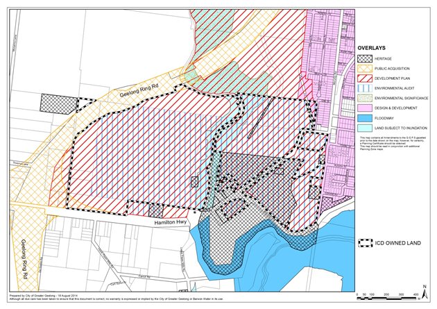
Appendix 1 shows the land owned by ICD property outlined on a map which shows existing zones of their property and the surrounding area. Appendix 2 shows existing overlays which apply to the same area.
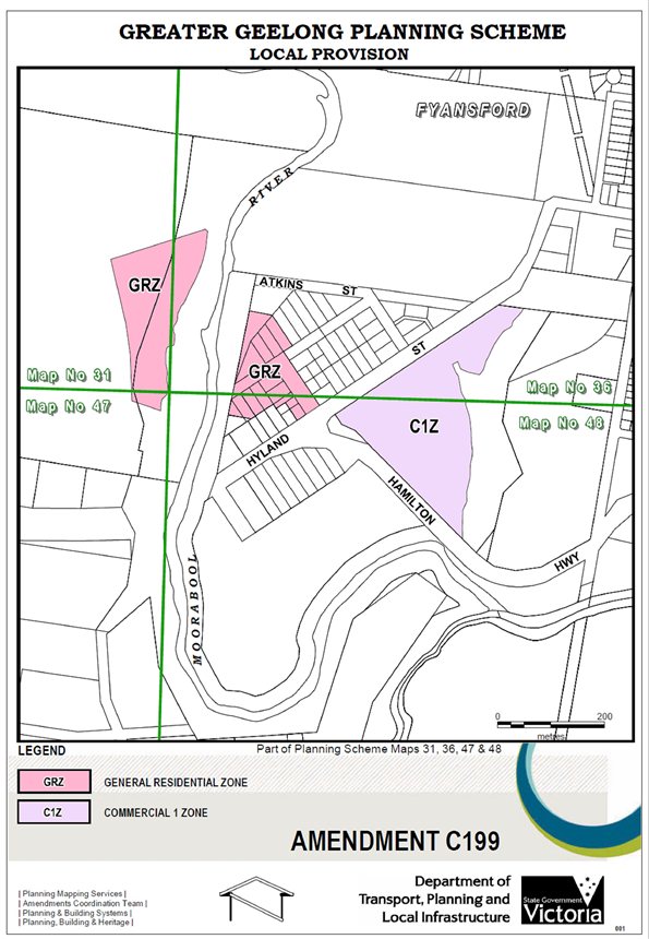
The major change being sought by this Amendment is the relocation of a proposed neighbourhood shopping centre from the north side of the Hamilton Highway to the triangular site between Hyland Street and Deviation Road. It is proposed that this be achieved by:
Rezoning the existing Commercial 1 (C1Z) and Mixed Use (MUZ) Zoned land in ICD Property ownership north of the Highway to General Residential Zone Schedule 1 (GRZ1); and
Rezoning the proposed new activity centre site at Hyland Street/Deviation Road from General Residential to Commercial 1 (C1Z) zone.
Appendix 3 shows the proposed zone changes.
The amendment also proposes to make changes to Development Plan Overlays 15 and 16 (DPO15 & DPO16) which apply to the two ICD Property sites. In particular DPO15 needs to be changed to:
Provide relevant detailed requirements for the new neighbourhood shopping centre site.
Introduce planning requirements for the existing Mixed Use Zone south of Hamilton Highway (previously addressed by a planning permit).
Require details to be provided of proposed community uses.
Update planning provisions to reflect current day requirements (this DPO was originally adopted by Council 10 years ago) and the new owner’s planning intentions.
Other amendments being sought are:
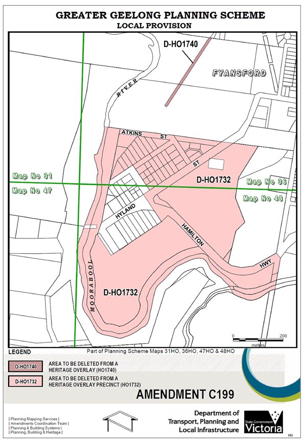
Clarifying and reducing the extent of Heritage Overlay provisions affecting land owned by ICD Property (see Appendix 4 for a map showing the Heritage Overlay changes); and.
Modifying DPO16 provisions required as a consequence of deleting the Mixed Use Zone on the ex-CSR quarry site which was originally planned to include a local shopping/community centre.
Council has previously supported changes to the heritage overlay and policy affecting the Fyansford area. At its meeting of 15 December 2009, it passed the following resolution at the request of the former owner – the Moltoni Corporation:
“That Council:
support Option 3 which seeks to remove the Fyans Heritage Area Policy (Clause 22.49) and Heritage Overlay (HO1732) from residential zoned land at Fyansford and all Moltoni owned vacant land areas within the town centre.
write to the Minister for Planning to confirm Council’s support for the policy and overlay to be amended by a Ministerial planning scheme amendment under Section 20 (4) of the Planning and Environment Act 1987.”
The application for Ministerial intervention is now being sought on the basis that the changes proposed in this amendment (as outlined above) will:
result in an improved planning outcome;
have no impact on the community or surrounding landowners;
update provisions where circumstances have changed;
assist in streamlining the planning approval process.
The amendment does not change the zoning or development potential of any land not in the ownership of ICD Property.
Amendment C199 is essentially proposing to modify and revise the format of previously approved development. A development plan has already been approved by Council for the first stage of residential development on the ex-cement works site pursuant to DPO15 which will only be subject to minor changes.
The main change being proposed - to relocate the neighbourhood shopping centre - is supported in principle. The new site provides a more readily accessible and higher profile location from a traffic viewpoint and will have better separation from future surrounding more sensitive residential uses.
A new neighbourhood shopping centre at this location will eventually be substantially supported by the planned future population of the new Fyansford suburb. In addition, the site is situated in one of the major access roads from the Geelong Ring Road to the City’s western and inner suburbs and as such is likely to pick up considerable passing trade.
Information submitted with the application indicates that the retail component of the town centre is likely to comprise a supermarket and associated specialty shops with a total floor area of around 6,500 square metres.
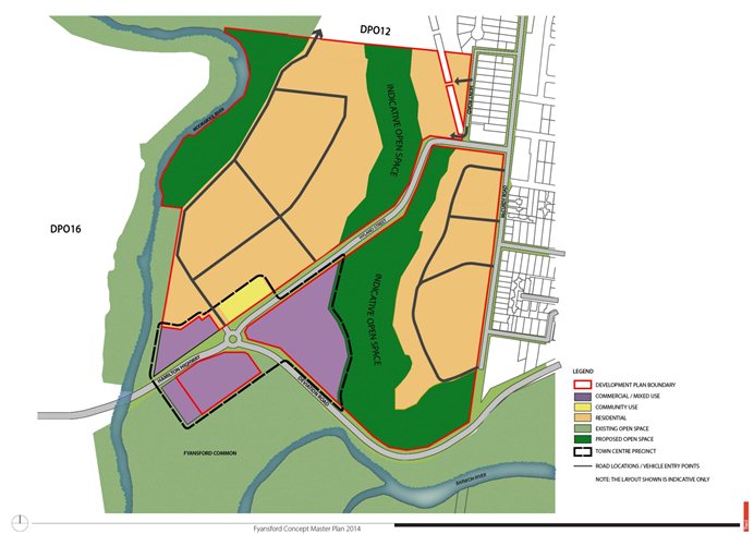
Appendix 5 is the Fyansford Concept Masterplan (Aug 2014) submitted with the application. This plan gives an indication of the overall layout of land uses across the area subject to DPO15. One of the new requirements of the proposed amended DPO15 Schedule is the need for the developer to prepare a Town Centre Masterplan. This plan will contain further details of the development of the neighbourhood shopping centre, mixed use and community use components of the town centre.
The new DPO15 Schedule will also require the applicants to prepare an economic impact assessment for the new shopping centre as part of the development plan approval process. This analysis would also assess potential impacts of the proposed centre on existing shopping centres and make recommendations about timing and staging of the development. The Town Centre Masterplan will also address traffic, urban design/landscaping issues and integration with the existing Fyansford village.
The amended DPO Schedule 15 and 16 are Appendices 6 and 7 with the proposed changes to the existing schedules highlighted. The revised heritage policy (clause 22.38) is in Appendix 8.
Tract Consultants advise that in order to ascertain community views on the proposed amendment changes, it held an informal Community Engagement Session on 3 July 2014. Some 20 local residents and business owners (including submitters to the previous planning scheme amendments) attended. Tract advises there was unanimous community support for the relocation of the neighbourhood shopping centre.
On the basis of the community support received and because the amendment does not fundamentally change the intent of the originally approved amendment, Tract submits that further public notification is not required. They submit that expeditious approval of the amendment will facilitate the timely release of more residential land at Fyansford.
Council officers support the application to the Minister for reasons as set out above. It is acknowledged that the new neighbourhood shopping centre is likely to extend its primary trade area into those of existing supermarkets at Newtown and Manifold Heights. This issue will be addressed as part of the economic impact assessment requirement of the new DPO15 provisions. In addition, the existing Commercial 1 and Mixed Use Zones in the ICD Property land already provide for retail development to the extent being proposed by the new neighbourhood centre.
In the event the Minister does not agree to approve this Amendment as requested, it is proposed that Council will act as planning authority to prepare and exhibit the amendment in the normal manner. This would include public notification with potential for submissions and an independent panel hearing if required. An additional recommendation has been included in this report should this situation arise.
The original Amendments C17 and C199 which apply to the ICD Property land addressed a range of environmental issues and encapsulated the outcomes in the approved amendment provisions.
Amendment C199 does not propose to change any of the environmental outcomes or create new environmental issues.
The changes being proposed by Amendment C199 will have no financial implications for Council.
The development of Fyansford is consistent with a range of State and Local planning policies.
The Planning and Environment Act makes provision for the Minister to act as a planning authority and approve an amendment without public exhibition where it “is not warranted or that the interests of Victoria or any part of Victoria make such an exemption appropriate” (Section 20(4)).
The Amendment supports the ‘Growing our Economy’ strategic direction of City Plan, as it will assist in the development of the new suburb of Fyansford with a range of residential, commercial and community facilities.
No Council officer involved in the report has any direct or indirect interest, in accordance with Section 80(c) of the Local Government Act.
There are no notable risks associated with implementing the recommendation contained in this report.
The Fyansford Community Integration and Services Report dated December 2006, was prepared to address potential social needs resulting from the original Fyansford development proposals. Recommendations from this report are included in the approved (existing) amendment documentation.
Amendment C199 proposes an alternative location for the neighbourhood shopping centre which is a preferred location from a planning perspective and is likely to be better for the future community.
The amendment is unlikely to impact on any basic rights, freedoms and responsibilities as set out in the Charter.
Full public notification of Amendment C199 is not considered necessary for the reasons outlined in this report.
23/12/2008 |
SCHEDULE 15 TO THE DEVELOPMENT PLAN OVERLAYShown on the planning scheme map as DPO 15 FORMER GEELONG CEMENT WORKS LAND- FYANSFORDThis schedule applies to land bound by McCurdy Road/Hyland Street/Deviation Road and the Moorabool River in Fyansford and Herne Hill previously occupied by the Geelong Cement works. This development plan is required to provide for the residential and commercial development on the site and for the integration of services and passive recreational areas that complement the existing surrounding and developing areas. |
1.0 |
Requirement before a permit is grantedWhere no development plan has been approved, the responsible authority may grant a permit to construct a building or carry out works, provided that it is satisfied that the works are minor in nature. |
2.023/12/2008 |
Requirements for development planThe Development Plan may be delivered in two stages to allow the later delivery of the Town Centre Precinct Master Plan. The Town Centre Precinct Master Plan must be lodged with the responsible authority prior to a Statement of Compliance being issued for 220 lots for the development. The development plan must be generally in accordance with The Fyansford Quarry Masterplan 17 July 2008, and must include, to the satisfaction of the responsible authority, the following: An Urban Design Master Plan which includes:
A Town Centre Precinct Master Plan which includes:
A Road Network and Traffic Management Plan which identifies:
A Land Capability Assessment which identifies: For the escarpment and its immediate steep-sloped surrounds:
For the balance of the land:
For land which is subject to fill on the flood fringe:
An Open Space & Landscape Master Plan which includes:
A Water Sensitive Urban Design Plan which: Is consistent with guidelines established using appropriate Australian design standards consistent with Council’s Stormwater Management Plan including:
Is underpinned by a design report for all stormwater quantity and quality treatment systems and aesthetic lakes within the development which:
A Site Management Plan, which includes a plan detailing proposed management and/ or operational practices to prevent adverse amenity and environmental impacts arising from the use of land or buildings and during the construction of buildings and works associated with subdivision, in accordance with Environment Protection Authority (EPA) publication No. 960 Guideline for Environmental Management – “Doing It Right On Subdivisions” Temporary Environmental Protection Measures for Subdivision Construction Sites and Council’s Stormwater Management Plan to the satisfaction of EPA and Council. Staging Plan which identifies the indicative staged delivery of the overall Development Plan area. The documents submitted in response to Section 2.0 of this Schedule may be amended with the written approval of the responsible authority. |
23/12/2008
|
SCHEDULE 16 TO THE DEVELOPMENT PLAN OVERLAYShown on the planning scheme map as DPO16 FORMER CSR QUARRY AND SURROUNDING LAND - FYANSFORDThis schedule applies to land at Fyansford located west of the Moorabool River, south and east of the Princes Highway – Geelong Ring Road (the Geelong Ring Road) and north of the Hamilton Highway. It is intended that this land be redeveloped for residential purposes accompanied by some small-scale commercial uses with significant riparian reserve and a central area of public open space, both with active and passive recreation uses. A development plan is required to ensure the new residential area is planned and developed in a fully integrated and comprehensive manner and that all detailed planning issues are resolved prior to the issue of a permit for the development of the land. |
1.023/12/2008
|
Conditions and requirements for permitsAny permit for development must, as relevant, contain the following conditions:
Section 173 Agreement - Development Contributions:
|
2.023/12/2008
|
Requirements for development planThe development plan must be generally in accordance with The Fyansford Quarry Masterplan 17 July 2008, and must include, to the satisfaction of the responsible authority, the following: An Urban Design Masterplan which identifies, as relevant:
A Land Capability Assessment which identifies: For the quarry and its immediate steep-sloped surrounds:
For the balance of the land:
An Open Space & Landscape Masterplan which includes:
An Environmental Management Plan which includes:
A Site Management Plan, which includes:
An Environmental and Natural Resources Plan, prepared by a suitably qualified person that includes:
A Water Sensitive Urban Design Plan which:
In the event that normal reticulated sewerage is not the chosen option, a Wastewater Recycling System Plan needs to be prepared by a suitably qualified person(s) that would:
A Social Infrastructure Assessment prepared by a suitably qualified person which:
The documents submitted in response to Section 2.0 of this Schedule may be amended with the written approval of the responsible authority. References:The Fyansford Quarry Masterplan dated 17 July 2008. |
22.3828/01/2010 |
22.38 HO1732: FYANS HERITAGE AREAThis policy applies to all that land included in the shaded areas on the Fyans Heritage Area Map.Policy BasisThis precinct is significant for its distinctive nineteenth century semi-rural town character. demonstrate Fyansford’s population growth and decline in the nineteenth century. Objectives
PolicyWhere a permit is required for a proposal, it is policy to:
ReferencesGreater Geelong Outer Areas Heritage Study Volumes 1, 2 & 4, prepared by Authentic Heritage Services Pty Ltd (2000) |
Cr S Kontelj re-entered the meeting room at 7:36pm.
Portfolio: |
Planning – Cr Heagney |
Source: |
Planning and Tourism- Strategic Implementation |
General Manager: |
Peter Bettess |
Index Reference: |
Council Reports 2014 |
This report considers submissions received to Amendment C297 and recommends the submissions be referred to an Independent Planning Panel.
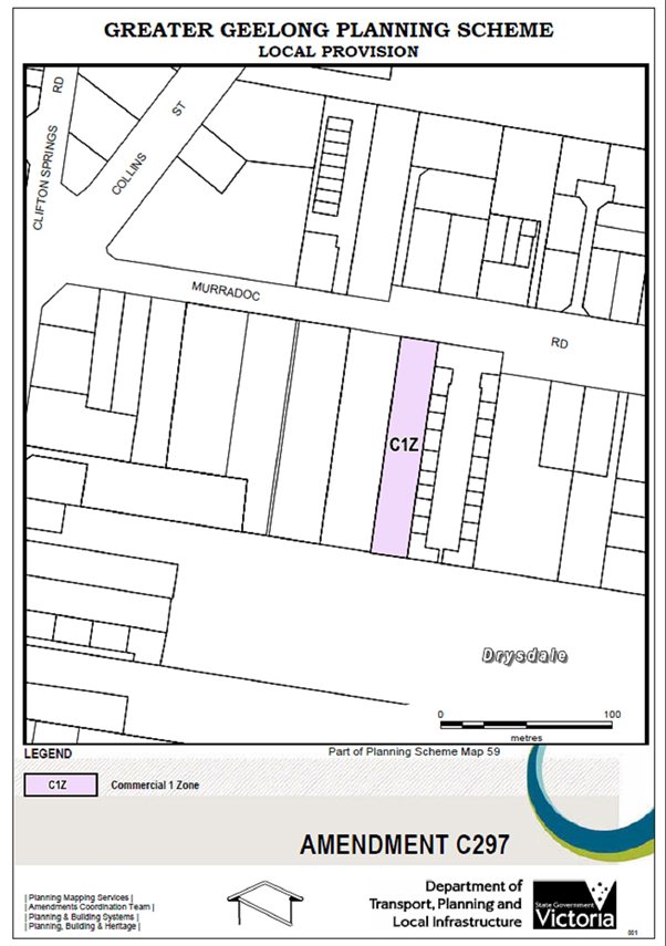
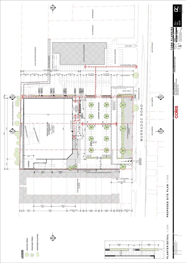
Amendment C297 seeks to rezone vacant land at 32 Murradoc Road, Drysdale, from the Commercial 2 Zone to the Commercial 1 Zone.
The Amendment is combined with a planning permit to construct a full-line Coles supermarket at 24-26, 28-30 and 32 Murradoc Road, Drysdale.
Public exhibition of the Amendment commenced on 3 July 2014 and closed on 4 August 2014. An information session was held at the Springdale Neighbourhood Centre as part of the exhibition period.
Council received 20 submissions, 16 in support or not objecting and 4 opposing the Amendment and Permit.
Key issues arising from the submissions included: improved retail facilities, competition, choice and retention of $ spend in the town; concerns about worsening traffic conditions; insufficient economic justification for another supermarket at this time and consequential impacts to local traders and Jetty Road developers; and urban design flaws.
In accordance with the Planning and Environment Act 1987, Council must now either: change the Amendment in the manner requested by the objecting submitters; refer the submissions to an Independent Panel; or abandon the Amendment or part of the Amendment.
Council officers have considered the submissions and do not recommend any changes from what was exhibited. The number of positive submissions demonstrates that local residents want better food and grocery shopping facilities in the Drysdale Town Centre.
This report addresses the issues raised in the submissions and recommends they be referred to an Independent Panel appointed by the Minister for Planning.
Cr Heagney moved, Cr Macdonald seconded -
That Council having considered all submissions to Amendment C297 to the Greater Geelong Planning Scheme, resolves to:
Request the Minister for Planning to appoint an Independent Panel under Part 8 of the Planning and Environment Act, 1987;
Refer all submissions that have not been resolved to the Panel; and
Submit to the Panel its response to the submissions generally as outlined in this report.
Carried.
On 28 June 2013 a combined Planning Scheme Amendment request and Planning Permit application was lodged by Environmental Resources Management (ERM) Australia on behalf of Coles Property Group, pursuant to Section 96A of the Planning and Environment Act 1987.
It is proposed to rezone the land at 32 Murradoc Road, Drysdale, from the Commercial 2 Zone to the Commercial 1 Zone and obtain a planning permit (765/2013) to construct a full-line supermarket on 24-26, 28-30 and 32 Murradoc Road, Drysdale. The site is vacant and sits along side the Drysdale ALDI store. The titles are owned by Coles.
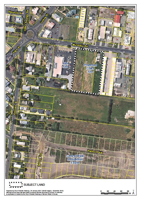
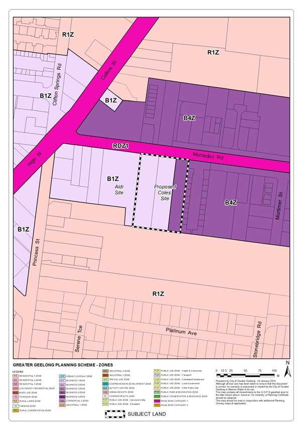
An aerial map of the subject land is shown at Appendix 1 and a current zoning map is shown at Appendix 2. The map in Appendix 2 shows that 24-26 and 28-30 Murradoc Road are in the Commercial 1 Zone where the use of the land for a supermarket is as-of-right.
The proposed rezoning map and development plan are shown at Appendix 3 and 4 respectively.
At its meeting on 22 April 2014, Council resolved to support the preparation and exhibition of Amendment C297 to the Greater Geelong Planning Scheme, subject to authorisation by the Minister for Planning. Council received permission to prepare the Amendment on 23 May 2014.
Public exhibition of Amendment C297 commenced on 3 July 2014 and closed on 4 August 2014. Notices about the Amendment were published in local newspapers, letters were sent to Drysdale traders and developers, surrounding landowners and Government agencies. An information session was also held at the Springdale Neighbourhood Centre.
As a consequence of the Amendment C297 exhibition, a total of 20 submissions were received. Appendix 5 contains a schedule which summarises the submissions and Planning Officer response.
For the purposes of this report, a detailed breakdown shows:
9 supporting submissions from local residents.
An ‘on-balance’ supporting submission from the Drysdale Clifton Springs Community Association Inc.
A supporting submission from the applicant (Coles).
4 submissions received from State Government Departments and Authorities offering no objection.
4 objecting submissions from traders and developers in the Drysdale area.
1 submission from a local Drysdale business stating positives and negatives of the proposed Coles development.
Pursuant to the Planning and Environment Act 1987, the Council is required to consider all submissions made to an Amendment and must either: (1) change the Amendment as requested by the submissions; or (2) refer the submissions to an Independent Panel; or (3) abandon the Amendment.
The next section of this report outlines the key issues raised in the submissions and provides an officer response. In the event the submissions are referred to an Independent Panel, as recommended, the responses in this report will form the basis for Council’s presentation to the Panel.
Improved services, competition and choice, reduced escape expenditure and strengthen the role of the Drysdale Town Centre
Submissions were received from local residents who welcomed the introduction of a full line Coles supermarket. Submitters say that the supermarket will improve retail facilities, competition, choice and retention of $ spend in the Drysdale Town Centre. A common theme amongst submissions is that residents shop at Leopold because they consider the existing food and grocery offering in town to be inadequate.
Officer response
The submissions indicate a general mood amongst residents that the introduction of a new full line supermarket in the Drysdale Town Centre is needed. The absence of any opposing submissions from residents and the fact that nine residents lodged favourable submissions shows that there is strong support for the development.
The proposed Coles will strengthen the role of the Drysdale Town Centre as the primary retail centre on the northern Bellarine, and significantly improve competition and choice in the food and grocery sector in particular.
Activity centre planning and economic impact
The submission from Best Hooper on behalf of Dalgo Pty Ltd and Libnom Pty Ltd (Jetty Road Growth Area landowner/developer) outlines broad economic reasons why the Coles supermarket should not be supported until the mid 2020s. The Jetty Road Growth Area includes a Neighbourhood Activity Centre with planning approval to develop a full line Woolworths supermarket and 11 specialty shops. Construction of the site commenced on 5 August 2014.
Best Hooper note the substantial investment already made by the community in the growth area and that investment has been predicated on assumptions including that a supermarket would be established within the Activity Centre without economic impact from a third supermarket in the Drysdale Town Centre. The submission also highlights that the impact would extend to traders within the Town Centre.
The owner of the Drysdale Hotel has objected on the grounds that a fourth supermarket will have a major impact on the ability of existing local businesses to employ and that Drysdale cannot support another supermarket in the next 5-10 years. The owner of the Drysdale News agency says the town is not ready to support another large supermarket in terms of both trade and infrastructure.
Officer response
The opposing arguments presented by Best Hooper and others are rejected. The number of positive submissions from local residents demonstrates strong support for the new supermarket. The two traders that are concerned about impacts on small businesses need to be weighed against the many other traders who do not oppose the Amendment. The fact that neither Woolworths nor ALDI – the main competitors to Coles – also do not object is compelling.
The independent economic assessment commissioned by Council (T. Nott, Feb 2014) finds that with the inclusion of the Coles supermarket as part of the Drysdale Town Centre retail mix, sales would rise from $64 million per year to $89 million and there will be a net gain of 15 long term jobs. The assessment also finds that the impact on existing food and grocery facilities in Drysdale itself would be severe. However, this effectively refers to Woolworths and ALDI.
The Jetty Road Neighbourhood Activity Centre is estimated to suffer a significant loss of around 16% according to the independent assessment. However, the Jetty Road Centre has always been planned as a neighbourhood centre to serve the retail needs of Jetty Road residents. Given the easy access to this Centre for residents of Clifton Springs and parts of Drysdale, combined with less vehicle congestion, Officers believe the Jetty Road Centre will be an attractive shopping destination even with the introduction of the Coles Drysdale store.
Council has recently (9 September 2014) adopted Amendment C283 to implement the Drysdale Urban Design Framework (UDF) into the Greater Geelong Planning Scheme. The UDF identifies the Coles site for a supermarket. The UDF does not specify the delay of this development to allow for the full utilisation and viability of the Jetty Road Activity Centre. The Coles proposal will strengthen the role of the Drysdale Town Centre as the primary retail Centre on the northern Bellarine.
Traffic issues
Three local traders, the Jetty Road landowner/developer (Dalgo and Libnom) and some of the supportive residents, are concerned about the traffic flow impacts that will be exacerbated by the development. Traders are particularly concerned about the worsening traffic conditions during school pick up/drop off as well as on the weekend.
Objectors note that VicRoads are assessing the traffic situation in Drysdale and therefore the supermarket should be delayed until infrastructure improvements are completed.
Officer response
VicRoads is currently undertaking the Drysdale Road Network Planning Study. The 12 month study will identify community concerns and prepare a business case for improvements to the road network, including investigation of bypass options. The 2012 Drysdale Urban Design Framework identifies the roundabout at High Street/ Clifton Springs Road/ Murradoc Road for replacement with a signalised intersection and improvements to Murradoc Road.
As is often the case in towns experiencing strong growth, the lack of supporting infrastructure as the population grows is a major issue for residents and traders. The existing poorly integrated road network of the town also contributes to the current conditions. However, delaying the construction of the proposed Coles supermarket will not resolve the existing traffic problems. A new supermarket may actually increase pressure on Government and authorities to address the fundamental road network challenges in the Drysdale area.
The Coles application is supported by a traffic assessment by Cardno. The assessment concludes that the level of traffic generated by the proposal is expected to have no significant effect on traffic conditions. As the responsible authority for both Murradoc Road and High Street, VicRoads has not objected to the proposed rezoning and permit subject to conditions to remove redundant crossovers and construct new crossovers.
Urban design
Best Hooper in their submission raised a number of concerns about urban design, connectivity and car parking. These include: inconsistency with the Drysdale UDF particularly the absence of a north-south road connection; car parking being located primarily to the front of the Coles site instead of within the site as intended by the UDF; poor pedestrian connectivity with the Town Centre; and the lesser provision of car parking spaces than the statutory rate.
Officer response
There were no opposing submissions by adjoining and nearby landowners, residents, traders, or shoppers of the Drysdale Town Centre on any of these issues. This indicates general support for the design and location of the Coles supermarket. The fact that ALDI – whose store will share access and car parking with Coles and would be most affected by the development – has not lodged a submission, clearly shows it is satisfied with the proposed design.
Exactly how Dalgo and Libnom as a landowner/developer in the Jetty Road Growth Area will be detrimentally impacted is unclear; perhaps they could argue that their future residents and commercial tenants would benefit from improved amenity and accessibility of the Town Centre. Given that no existing residents or traders objected on these grounds, this would be a tenuous reason.
The submission implies that a new north–south road connecting Murradoc Road to the Central Walk Estate must be constructed on the Coles site in accordance with the Drysdale UDF. While Council officers have worked hard with representatives of Coles to include this road, ultimately the challenges and constraints of the site resulted in the delivery of a dedicated pedestrian walkway instead. This outcome will significantly improve pedestrian access to the site, as will future new road access through the nearby Mortimer Street and potentially Princess Street. Furthermore, the UDF (as with any UDF) is a vision of how the place might develop and provides flexible design principles.
Matters relating to the design of the car park and parking supply are addressed in the traffic assessment by Cardno and supported by Council’s traffic engineer. Car parking is located to the front of the building and provides convenient access to the Coles entry and adjacent ALDI store. The provision of 146 car parking spaces (the statutory requirement is 194 spaces) is appropriate given the co-location with the ALDI car park and walkable proximity to other retail outlets and public bus services.
Concerns about pedestrian connectivity to the existing Town Centre, particularly negotiating the roundabout at the intersection of High Street, Collins Street and Murradoc Road, are valid. With the introduction of the ALDI store and UDF directions to further develop commercial uses along Murradoc Road, the Drysdale retail core is gradually expanding west. The UDF identifies the replacement of this roundabout with a signalised intersection to improve connectivity, as well as improvements to the Murradoc Road streetscape.
There are no environmental implications as a result of the Amendment.
No impact to budget.
Zone provisions
Two-thirds of the subject land is currently zoned Commercial 1 Zone (C1Z). The purpose of the C1Z is to create vibrant mixed use commercial centres for retail, office, business, entertainment and community uses. The use of the land for a supermarket in the C1Z is an ‘as-of-right’ use in the Greater Geelong Planning Scheme. A permit is required for buildings and works.
The remainder of the land is in the Commercial 2 Zone (C2Z). The purpose of the C2Z includes encouraging commercial areas for offices, appropriate manufacturing and industries, bulky goods retailing, other retail uses, and associated business and commercial services.
Clause 21.07 Economic Development
The strategy notes that the City of Greater Geelong Retail Activity Centre Hierarchy has been established to articulate the role and function fulfilled by centres of different sizes. A key objective is to facilitate the development of vibrant and viable retail activity centres in accordance with the retail hierarchy.
The proposed Coles supermarket will strengthen the role and function of the Drysdale Town Centre. Town Centres are identified in the Hierarchy as the focus for convenience shopping and community facilities serving the surrounding township and rural hinterland. Neighbourhood centres play an important role in providing for the regular shopping needs of residents of their respective surrounding catchments.
Clause 21.14 The Bellarine Peninsula
Drysdale/Clifton Springs is recognised as a hub for development and service provision on the Bellarine. One of the strategies for Drysdale/Clifton Springs is to reinforce the Drysdale Town Centre as the primary retail centre including the development of an additional supermarket. The clause, under ‘further work’, identifies the bowling club site for a supermarket however this location was not considered suitable in the Drysdale Urban Design Framework 2012.
Another strategy is to support the development of the Jetty Road Urban Growth Area. A number of stages for residential subdivision have been approved and constructed or are under construction. Likewise, land has been rezoned to the Commercial 1 Zone for a neighbourhood activity centre.
Clause 22.03 Assessment Criteria For Retail Planning Applications
This local policy sets out retail assessment criteria which are to be used as a basis for considering applications for new or expanded retail floor space. The information submitted to support the Amendment and Permit, particularly with an updated economic impact assessment and independent assessment that captures the Jetty Road Neighbourhood Activity Centre, is considered appropriate.
The Amendment supports the ‘Growing our Economy’ strategic direction of City Plan, by improving competition and choice for consumers, providing investment and jobs during the construction phase, and securing long term local employment opportunities.
In accordance with Section 80(c) of the Local Government Act Peter Bettess, General Manager, Planning and Tourism, declares an indirect financial interest in that he owns Woolworths and Westfarmers shares.
There are no notable risks associated with implementing the recommendation contained in this report.
The proposed Coles supermarket is considered to result in a net community benefit by improving retail competition – particularly in the fresh food and groceries sector, reducing escape expenditure and securing additional employment opportunities for local residents.
The Amendment will not impact on any basic rights, freedoms and responsibilities as set out in the Charter. Planning legislation ensures an open community consultation process occurs, enabling people to freely express their views and if necessary obtain a fair hearing before an Independent Panel
The Amendment was exhibited in accordance with the provisions of the Planning and Environment Act 1987.
In accordance with Clause 4(2) of Ministerial Direction No. 15 the following panel hearing dates have been set for this Amendment:
Directions hearing: in the week commencing 13 October 2014.
Panel hearing: in the week commencing 10 November 2014.
It is noted that the panel hearing has been changed to commence in the week beginning 17 November 2014.
Planning Panels Victoria will notify all submitters of the Panel dates and invite requests to be heard at the Panel Hearing.
Portfolio: |
Planning Cr Heagney |
Source |
Planning and Tourism - City Development |
General Manager: |
Peter Bettess |
Index Reference: |
Application: C309 |
The purpose of this report is for Council to consider submissions Amendment C309 which proposes changes to the Low Density Residential Zone.
Amendment C309 proposes to implement into the Greater Geelong Planning Scheme the findings of Council’s Low Density Residential Zone (LDRZ) Review 2013 by making the following changes to the Greater Geelong Planning Scheme:
Amend the existing unnumbered schedule to the Low Density Residential Zone to become Schedule 1 (LDRZ1).
Insert a new Schedule 2 to the Low Density Residential Zone (LDRZ2) to specify a minimum subdivision area of 0.2 hectares.
Rezone existing LDRZ land to either LDRZ1 or LDRZ2. There are 19 areas of LDRZ across Greater Geelong; fifteen of these will be rezoned to LDRZ1 and four will be rezoned to LDRZ2.
Amend Clause 22.04 Discretionary Uses in Rural Living and Low Density Residential Zones to change the clause title, widen the application of the policy, and add a new objective and policy.
The changes have been brought about by the Ministerial reforms to the residential zones which have amended the default subdivision size for land in LDRZ which is connected to reticulated sewerage to 2,000m2 previously 4,000m2. The Victoria Planning Provisions (VPPs) allow for Councils to include schedules to the LDRZ for a different minimum subdivision size where special local circumstances apply.
Council assessed all areas of LDRZ across the municipality in its Low Density Residential Zone Review 2013 to determine which areas would be included in the new minimum subdivision area of 0.2ha and which would be in 0.4ha because of other special circumstances.
Amendment C309 was placed on public exhibition between 19 June and 21 July 2014. A total of 47 submissions have been received of which 8 either support or offer no objection and 39 of which object to the amendment. The majority of the objecting submissions relate to the Tanderra Court area in Clifton Springs.
The supporting submissions contend that the amendment fairly reflects the history and intent of application of the LDRZ in the Geelong Region and maintains a distinct lifestyle choice exercised by landowners.
Objecting submitters consider there are areas connected to reticulated sewerage and which should be included in LDRZ2 with a 0.2ha minimum subdivision size, that retention of the 0.4ha minimum subdivision size is an inefficient use of land, the Wandana Heights area should be included in LDRZ2 as recommended by Council’s Review, that the Tanderra Court area should not be included in the LDRZ2 but retained in LDRZ1.
The issues raised in the submissions have been addressed in this report and it is recommended the submissions which cannot be resolved be referred to an Independent Panel appointed by the Minister for Planning.
Amendment C309 is recommended to be changed to include in LDRZ2 the Cityview Drive area of Wandana Heights, the Cypress Court area of Leopold, part of the Huntingdon Street area of Drysdale, and to include the Tanderra Court area in Clifton Springs in LDRZ1.
Cr Macdonald moved, Cr Ellis seconded -
That Council having considered all submissions to Amendment C309 to the Greater Geelong Planning Scheme, resolves to:
Amend C309 to include in LDRZ2 the Cityview Drive area of Wandana Heights, the Cypress Court area of Leopold, part of the Huntingdon Street area in Drysdale, and to include in LDRZ1 the Tanderra Court area in Clifton Springs.
Request the Minister for Planning to appoint an Independent Panel under Part 8 of the Planning and Environment Act 1987;
Refer all unresolved submissions to the Panel; and
Submit to the Panel its response to the submissions generally as outlined in this report.
Carried.
In June 2011 the Planning Minister commissioned the Victorian Planning System Ministerial Advisory Committee to examine all aspects of the planning system, including possible zone reform.
Council made a submission to DPCD in April 2013 formally requesting that ‘the schedule to the LDRZ for Greater Geelong be amended to limit subdivision to 0.4 hectares for all lots’ as an interim measure to allow Council to undertake a proper investigation to fully test and assess the merits of reducing the lot size in particular locations.
The government released ‘Reformed Residential Zones for Victoria – A discussion paper on reforming Victoria’s Planning Zones’ in July 2013. This report considered the advisory committee’s recommendations and individual submissions and proposed to introduce various zone changes, including changes to the LDRZ into the Victoria Planning Provisions.
The reforms amended the Low Density Residential Zone (LDRZ) to reduce the minimum lot size from 0.4 hectares to 0.2 hectares in areas where reticulated sewer is available. A schedule to the LDRZ was also introduced which allows Council to designate the areas where a higher minimum subdivision size would be allowed.
Officers have prepared a report on the various LDRZ areas in the municipality and have made recommendations in relation to the appropriateness of a 0.2 hectare minimum lot size in areas with reticulated sewerage and where there no other constraints.
Council is the proponent for Amendment C309. The amendment proposes to implement into the Planning Scheme the findings of Council’s Low Density Residential Zone Review 2013. Specific changes include:
Amending clause 22.04 Discretionary Uses in Rural Living and Low Density Residential Zones to change the clause title to Use and Development in Rural Living and Low Density Residential Areas, widen the application of the local planning policy, and add a new objective and policy affecting low density residential subdivision;
Amending the existing unnumbered schedule to clause 32.03 Low Density Residential Zone to Schedule 1. Schedule 1 will continue to specify a minimum subdivision area of 4,000sqm;
Inserting a new schedule 2 to clause 32.03 to specify a minimum subdivision area of 2,000sqm; and
Amending planning scheme maps to rezone existing LDRZ land to either LDRZ1 or LDRZ2.
Amendment C309 was placed on public exhibition between 19 June and 21 July 2014. Notices were placed in the Geelong Advertiser, Independent, the Echo and Bellarine Times and sent to all affected landowners and occupiers and all relevant public authorities.
As a result of the exhibition of the Amendment the Council received a total of 47 submissions. Of these, 8 either supported the Amendment or offered no objection and 39 objected to the Amendment.
Appendix 1 is a schedule which summarises all submissions received.
The following section of this report discusses the Low Density Residential Zone areas subject of the submissions and outlines the major issues raised in the submissions followed by the officer’s response to them.
Woodlands Estate, Ocean Grove
Two submissions support the application of LDRZ1 to this area. The area was included in the LDRZ with a 0.4ha lot minimum lot size in the 1970’s with the aim to protect the high quality natural vegetation which existed at the time. This is an area considered the lungs of Ocean Grove. Inclusion of the land in this zone and lot size has avoided the potential removal of vegetation and the loss of the bushland character of the subdivision. Drainage capacity in the area is limited and is a constraint to more intense subdivision and development.
Officer Response
The planning regime set in place for the Woodlands estate in the 1970s has continued in successive planning schemes and planning strategies such as the Ocean Grove Structure Plans and its bushland character survives today.
No change to the Amendment is required.
Forest Road, Lara
One submission supports the application of the LDRZ2 to the land at 25-45 Forest Road, Lara, but would be concerned if it prejudiced the rezoning to Residential 1 as per the policy of the Lara Structure Plan.
Officer Response
The application of the LDRZ2 to the submitters land and beyond will not prejudice the potential for rezoning to Residential 1 (now General Residential Zone) as outlined in the Lara Structure Plan and clause 21.13 of the Planning Scheme.
No change to the amendment is required.
Cemetery Road (East), Drysdale
One submission supports the application of the LDRZ1 to the eastern part of the Cemetery Road, Drysdale area as it supports the lifestyle choices residents have made for 0.4ha size blocks and will not devalue the property. Sewer capacity does not exist in the area and traffic volumes on Geelong-Portarlington Road would be also be exacerbated by more intense development.
Officer Response
The Cemetery Road eastern area has limited room for additional sewers and has no opportunity to be included in the LDRZ2 so will be remaining in the LDRZ1 with a 0.4ha minimum subdivision size.
No change to the Amendment is required.
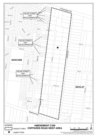
Coppards Road West Area, Moolap
One submission opposes the application of LDRZ1 to this area, instead arguing that LDRZ2 should be applied for the following reasons:
There is an over development of large lots in Helms Street to the west.
An increase in density in Coulter Street would create an opportunity for construction of new medium to large family homes, area beautification and new footpath.
More families would ‘upsize’ into the area and enjoy a semi-rural lifestyle close to the centre of Geelong.
Increased density would provide a better outcome than the development of 1-2 bedroom units 500 metres away.
Overall drainage capacity and load could be more evenly spread across the Coulter Street/Coppards Road West area.
Any concerns about possible flooding on flat land could be engineered with no concrete slabs and strip footing base 600mm off the ground.
Officer Response
The Eastern Boundary Review recommended that this area remain outside the Urban Growth Boundary on the eastern side of Geelong due to drainage and flooding constraints as well as proximity to the industrial areas of Moolap. The areas in Helms Street undergoing a lot of unit development referred to the submission are included in the General Residential Zone and have the capability to be used and developed in this way subject to planning permission.
Council Engineers have a concern with ‘drip feed’ re-subdivision of LDRZ areas in that larger lots offer the opportunity to build a large dwelling, with associated entertainment areas, shedding, etc. that give developed site coverage comparable to conventional residential, without the associated upgrades to drainage infrastructure. Recent low density developments have attracted infrastructure at similar standards to conventional residential to reflect the higher expectations and needs of owners.
The concept of ‘sharing the load’ in drainage capacity is invalidated by the natural drainage pattern, with Helms St considered to be in a different drainage catchment to Coulter Street. Coulter Street discharges to the Coppards Road main drain whilst Helms St has a separate outfall at its northern end.
The submitter is correct in identifying that elevated floors are one method of minimising above floor flooding of dwellings, however this does not address existing dwellings that are constructed with slab on ground. A lot must first be designated flood prone under Building Reg 802(2), or have an applicable planning overlay, in order for Council to mandate minimum floor levels. The ‘Flood Prone Areas’ layer in Council’s GIS identifies lots considered to be designated.
This area is included in Newcomb - Whittington Drainage/Flood Study (BMT WBM, 2011). Of the mitigation options presented in the report, the only one to have any positive impact on flood levels north of the Bellarine Highway involved triplicating all drainage pipes within the study area. The cost and disruption caused by works of this scale make it unfeasible to consider (capital cost >$2M per property saved from flooding during a 1% AEP flood).
No change to the Amendment is recommended.
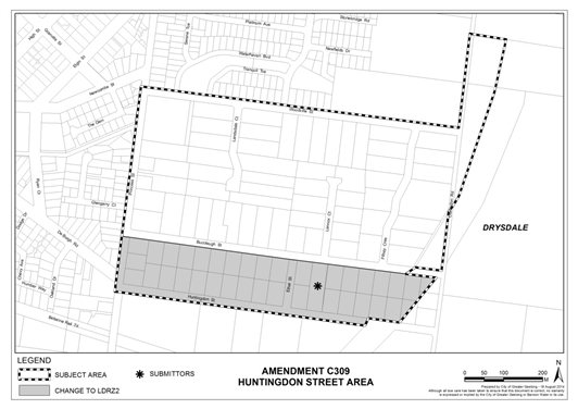
Huntingdon Street, Drysdale
One submission has been received which opposes the application of LDRZ1 to the area, instead arguing that the area bound by Buccleugh Street, Clarendon Road, Huntingdon Street and Princess Street is suited to the application of LDRZ2. The submission states that all lots comply with LDRZ2 requirements, with only one, the submitters, complying with LDRZ1. The submitter would like to be able to subdivide his land into two in the future. This additional subdivision would add rate revenue without costs as all services such as a made road are already in place; that application of LDRZ2 will not affect other landowners in the area; and that other larger areas can be split between LDRZ1 and LDRZ2 as evidenced by Clifton Springs Road and Whitcombes Road area to the north in Drysdale.
Officer Response
The wider Huntingdon Street area assessed in the Review extended northward to Woodville Street. The whole area was described in the Review as being known to flood although it has not been officially mapped. 48 of the 103 lots in this wider area are over 0.4ha and could be subdivided further if the minimum subdivision size was reduced. Reticulated sewerage is available in the area and Barwon Water has no objection to the minimum subdivision size changing in the wider area.
The Review findings outlined concern about the cumulative drainage impacts on the surrounding catchment and therefore recommended the wider area maintain a 0.4ha minimum.
For the smaller, sub-set of the area bounded by Buccleugh Street, Clarendon Road, Huntingdon Street and Princess Street, the area is largely subdivided and developed into lots of about 2,500m2 with the submitters property the only variation from this – remaining as a 4,800m2 lot with one house. This is evident in the subdivision pattern shown below.
The layout of lots in Huntingdon Street and Buccleugh Street, Drysdale, is essentially unchanged since it was first subdivided some time ago. The local drainage system is rudimentary at best, however there does not appear to be much history of resident complaints, and therefore can be considered to be working satisfactorily. As the area can be considered fully developed (one lot currently vacant) and there is only be the prospect of one additional lot to be created, there would appear to be negligible impact in zoning this area LDRZ2.
Officers recommend changing the amendment to include the Huntingdon Road, Drysdale area in LDRZ2 (as shown on the map below).
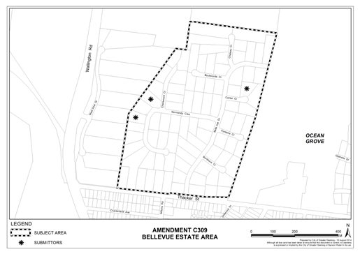
Belle Vue Estate, Ocean Grove
One submission has been received which supports the application of LDRZ1 to the Belle Vue Estate in Ocean Grove on the grounds that the lot sizes are just the right size for looking after whilst keeping distance from neighbours and protecting landscape character. Any change to this would force the submitter to leave and cause considerable stress.
By contrast, two submissions have been received from residents in Normanby Court opposing the application of LDRZ1 as the minimum lot size is an inefficient use of land and infrastructure, instead seeking LDRZ2.
Officer Response
This estate was first subdivided in the late 1980’s and is part of a broader band of low density development north of Thacker Street. The area is serviced with reticulated sewerage.
The area is in the North West corner of Ocean Grove and is not recommended for further subdivision for conventional residential densities given existing drainage issues and the proximity to environmental values. 54 of the 88 properties in this area (61%) could be further subdivided if the minimum subdivision area was reduced.
This estate has three separate catchments. Engineering advice notes that the area partially drains to the outfall of the Blue Waters Lake to the south of the site. Underground and surface drainage infrastructure is present and likely constructed in the 1980’s. It has limited capacity to absorb additional run-off created if over 60% of the area was to double in density. The cumulative effect of adding to the drainage system over time is a concern. Further subdivision of lots may expose Council to undertaking downstream works where it is not desirable or otherwise warranted. Drainage/flood studies carried out by Council in the past have shown that attempting to retrofit mitigation measures into areas with limited vacant land for basins, etc. have significant capital cost for little real benefit. It is a highly urbanised area downstream which would also make acquisition prohibitively expensive.
If this area was to be included in the LDRZ2, it would have a considerable impact on the appearance and feel of the estate. Substantial subdivision potential would only be realised through battle axe style lots which would result in the loss of perimeter planting and other vegetation and introduce significant amount of driveway hard surface space. Observation of the positioning of existing dwellings on lots, many centrally located, would impact on the likelihood of 60% of the estate doubling in density.
The Ocean Grove Structure Plan notes that the “existing Low Density, Special Use and Rural Living zoned land between Wallington and Grubb Roads has significant environmental or landscape attributes given the extent of significant vegetation and exposed coastal views which make these areas unsuitable for further development or residential zoning.
No change to the Amendment is recommended.
Barrabool Crescent, Leopold
One submission has been received from the owner of 45 Melaluka Road objecting to the application of LDRZ1 to the area as the land is connected to reticulated sewerage and does not flood. The submitter does however acknowledge that drainage needs careful consideration in the south east corner and would be subject to engineering design as permit application stage. The submitter also contends that the reasons not to reduce the minimum subdivision size complicate the zone reform and could be dealt with as site specific overlays. Application of LDRZ2 to this area is sought.
Officer Response
This submitter owns the largest property in this area, being a 2.5ha lot fronting Melaluka Road and the Bellarine Rail Trail. Of the 25 lots in this area, nine or 36%, area over 0.4ha and could be further subdivided if the minimum area is reduced.
The Leopold Structure Plan has nominated the submitters land as “rezone to Residential 1” (now the General Residential Zone) and the balance of this area as “urban consolidation opportunity subject to further investigation”, both of which would involve investigation of possible drainage solutions for the overall area.
Changes to the LDRZ by the Minister for Planning have included the opportunity to include in a schedule a different minimum lot size based on local conditions. It is open to Council to vary the provisions according to special circumstances and whilst overlays can be used in some areas to address these, the provisions of the VPPs allow for the zone schedule to also be used.
Engineering advice is that the submitter’s land sits in the flat and low-lying main valley of the North Leopold catchment. Council’s flood mapping has determined a large area of the property (approximately 35%) is susceptible to flooding during the 1% AEP event, and the property is currently designated flood prone pursuant to Building Regulation 802(2). The flat topography limits any opportunity to increase drainage capacity downstream, particularly under Melaluka Road and within the Bellarine Rail Trail, hence the requirement on recent development fronting Melaluka Road to set aside large areas of land for drainage infrastructure. Similar land area would be required for any redevelopment of the subject land (LDRZ or conventional residential).
Whilst the LDRZ1 land in Barrabool Crescent is nominated in the Structure Plan as an urban consolidation opportunity, all lots have been developed and are individually owned. It would be a difficult task to achieve a conventional residential development in this area in the future. Further, the positioning of houses on these lots will make it difficult to achieve the creation of many 2000m2 lots throughout the area if it was changed to LDRZ2.
Rezoning straight to General Residential Zone would meet Council’s policy objective for the submitters land fronting Melaluka Road. Their land is within the Leopold settlement boundary and has been designated to maximise residential development and could be developed for over 20 conventional residential lots. Inclusion of this area in LDRZ2 as part of Amendment C309 would allow for up to 6 lots to be created on the submitters land and would not be out of place with the low density residential development in Barrabool Court to the east and south. However, such a change would seriously prejudice rezoning to General Residential as outlined in the Structure Plan and Municipal Strategic Statement. This comes down to making a judgement call on policy grounds – whilst the land is still in the LDRZ1 it retains more potential to achieve Council’s stated policy for this area as future conventional residential.
No change to the Amendment is recommended.
Melaluka Road (Cypress Crescent), Leopold
The land at 1 Cypress Crescent, Leopold has both the Leopold Swim School and the family home of the owners. Both the business and the owners have made submissions objecting to the application of the LDRZ1 to this site and to Cypress Court, Leopold. The submissions seek the application of LDRZ2 to the land, opposing LDRZ1 for the following reasons:
Intended to separate business from home by subdividing. Plans now in disarray and can’t be achieved with C309. The business should be on separate title for long term security.
Property has never flooded or experienced any drainage issues.
7 properties in Cypress Crescent all serviced with reticulated services – land to the north is unsewered and in 4,000-8,000m2 lots.
Area designated in Leopold Structure Plan and Planning Scheme as “urban consolidation”.
Amendment VC100 made changes to LDRZ – other than availability of reticulated sewerage, it did not identify any other planning restriction that would preclude land being 2,000m2.
Barwon Water accepts a reduction in lot size in this location.
Council’s Review makes a blanket application to this area without considering circumstances of Cypress Crescent properties.
Council’s Review has not outlined how subdivision will impact on overall drainage of the area nor how unsuitable it is for 2,000m2 allotments.
Council’s Review is a strategic planning exercise on the run and based on generalizations and opinions.
Officer Response
The LDRZ has for many years been a feature of the Greater Geelong Planning Scheme with a minimum subdivision size of 4,000m2. At the time of development of the swim school business there was no prospect of the land being subdivided. As it was only last year that the Minister for Planning changed the LDRZ provisions, the owners could not have had a long term expectation to subdivide the business from the family home.
The Advisory Committee report on the changes to the residential zones recommended some flexibility with the LDRZ to allow for Council’s to schedule a different minimum lots size based on special local conditions. Specifically, the Reformed Zones Ministerial Advisory Committee Progress Report December 2012 stated:
“The Low Density Residential Zone allows people to live on larger parcels of land generally near urban areas and often with high environmental amenity. Submitters raised concern about bushfire risk in some areas that might increase with changes to the minimum lot size to 0.2 hectares. The Committee considers that the issue of bushfire risk is predominantly managed by the Bushfire Management Overlay and through building regulations.
Councils may identify minimum lot sizes and use overlays and other provisions to protect areas of environmental significance, identify and mitigate potential hazard.
The Committee considers that there are areas across Victoria where a lower lot size of 0.2 hectares may be appropriate and where a larger lot size is more appropriate a council can use the schedule to the zone to increase the lot size.”
The land is identified in the Leopold Structure Plan as “urban consolidation opportunity subject to further investigation” indicating that the area has provides a reasonable opportunity to increase residential densities within reasonable proximity to the Sub-Regional Activity Centre. The area is largely developed with substantial houses and outbuildings and established gardens. They also provide housing choice in the Leopold market with larger lot sizes available. Should the area be further investigated for consolidation opportunities support from a majority of landholders would be required before considering a rezoning to General Residential Zone.
A review of the points raised in the submission indicate that the Cypress Crescent area is different to the balance of land to the north zoned LDRZ1. The drainage of this area has capacity to accommodate some subdivision if the LDRZ2 is applied. It should be noted that a change to the LDRZ2 and subsequent subdivision may prejudice the ability of this area to be rezoned to General Residential Zone as it will be almost impossible to produce a coherent conventional residential subdivision in this context. Rezoning to LDRZ2 now though is supported.
Officers recommend changing the amendment to include the Cypress Crescent area in LDRZ2 (as shown on the map below).
Cityview Drive, Wandana Heights
Three submissions have been received opposing the application of LDRZ1 to this area, preferring the area be included in LDRZ2 as recommended in Council’s Low Density Residential Zone Review. Submissions contend that:
Council’s Low Density Residential Zone – Minimum Lot Size Review was robust and strategically justifies the recommendation for a reduction in the minimum lot size in the Cityview Drive area.
The exhibited amendment is contrary to these findings and recommendations and there is no methodology in the Council’s resolution to apply a 0.4ha minimum subdivision area rather than 0.2ha as recommended by Council’s review.
Change would ensure that the amendment reasonably and appropriately implements the findings of Council’s review.
There are no reasonable planning grounds to justify retention of the LDRZ1.
Area is serviced; there are no physical constraints, no strategic policy directions and no Engineering constraints to a change to 0.2ha minimum subdivision size.
Current height controls will be maintained in any future subdivision.
As water has become less available, the 0.4ha lots are becoming correspondingly less attractive with community moving toward smart blocks that are easier and less time consuming to maintain.
Officer Response
The Review identified that the Cityview Drive area is sewered, has the ability to provide adequate drainage and has 13 of 32 lots (approximately 41%) that could be subdivided if the minimum lot size is reduced. Consequently the Review recommended that the area be included in LDRZ2.
Concerns were expressed by Council about the impact a change to a lower minimum lot size would have on views and on this basis resolved not to support this change.
The area is affected by DDO14 which is an overlay to ensure that the siting, height and visual bulk of dwellings achieves a reasonable sharing of views between properties to significant landscape and features a permit trigger for buildings and works above 7.5 metres. The five properties closest to Barrabool Road on the southern side of Cityview Drive are also affected by DDO8 – a specific overlay to minimise the impact of buildings and works on these lots upon the views obtainable from Drewan Park and Ceres lookout. These overlays will remain in place and are capable of dealing with development on any new lots and maintaining a sharing of views. As the submissions state there are no reasonable planning grounds to justify retention of the LDRZ1.
Officers recommend changing Amendment C309 to include the Cityview Drive, Wandana Heights area in LDRZ2.
Tanderra Court area, Clifton Springs
The majority of submissions received about C309 have come from landowners of this area. Twenty nine (29) submissions (some submitters have made multiple submissions) oppose the application of LDRZ2 on the following grounds:
Land was purchased for the lifestyle, semi-rural position, low density housing and minimum passing traffic and any increase in density will affect the lifestyle.
Only 10 lots of the 36 in the area are large enough to be able to subdivide and meet the minimum subdivision size of 2,000m2.
Amendment documents do not recognize possibility that blocks less than 0.4ha can be amalgamated and then re-subdivided, creating battle-axe blocks.
Battle-axe blocks will affect lifestyle and are unlikely to be achieved.
Concerned that the Minister’s intent is to increase land for development through subdivision and that this is to be interpreted as a means of increasing rate income for Councils to offset burden of the loss of some grants to Councils. If correct, this is unfair and if not, then Council has no reason for the amendment.
Rezoning could be regarded as being implemented for the sole purpose of increasing the number of rate able properties.
Increase of lots will increase the rate base and income for Council at the expense of the existing lifestyle choice of residents.
Land less than 0.4ha will be unable to subdivide and will be unfairly affected by rate revaluation.
Potential for increased bushfire risk as a result of increased density and vegetation and battle axe shaped allotments.
No forward consultation with landowners was initiated by Council before preparation of the amendment.
Numerous other subdivisions in municipality that are far from capacity or full development.
Land at eastern end of Tanderra Court is similarly connected to sewerage but not included in the proposal with no explanation.
Council has undertaken little research of the area and amendment has been poorly thought through.
Officer Response
The Review did articulate that only 10 of the 36 lots in the area were over 0.4ha and could be further subdivided, but as sewer is available in the area and there are no other physical constraints that the 0.2ha minimum subdivision size should apply. The Ministerial reforms of the residential zones have introduced a ‘default’ minimum subdivision size in the Low Density Residential Zone where reticulated sewerage is available. Having reviewed the area and determining there were no other constraints affecting the area, the Review concluded that the area should be LDRZ2. Strategic planning focuses on the wider area and not sub-sets of an estate. Even though there would only be about 27% of the area capable of being subdivided under the new zone, this is still a legitimate outcome to apply the zone to the whole area.
The exhibition of the amendment is the consultation process for changes to the Low Density Residential Zone. When the project first commenced officers understood that the changes were to be completed and implemented into the Planning Scheme by end of July 2014 in conjunction with the other new residential zones review. Within this time frame it was not possible to undertake any consultation in the preparation of the Review, acknowledging that this would occur in the formal planning scheme amendment exhibition.
The land is not affected by a Bushfire Management Overlay but is within the Bushfire Prone Area designation under the Building Regulations. The CFA has made no comment on the amendment and has not raised any objections on the grounds of an increasing bushfire risk in the area.
The Advisory Committee considering the reformed zones noted that the issue of bushfire risk is predominantly managed by the Bushfire Management Overlay (BMO) and through building regulations. As there is no BMO applying to this area, any new residences will be subject to the Building Regulations to protect life and property. This will be applicable to any new development. Changes to existing residences will not be required under this legislation.
Whilst the land at the eastern end of Tanderra Court is serviced with reticulated sewerage it is not affected by Amendment C309 as it is zoned Rural Living Zone. This amendment focuses solely on land in the current Low Density Residential Zone. So there is no inconsistency in Council’s approach as posed by some submitters.
The LDRZ2 can be applied to land that would not enjoy subdivision potential in its own right - the Zone does not have to be applied to land that is already at least 4,000m2 . For the Tanderra Court area, the fact that not all land is at 4,000m2 or greater does not invalidate the application of the Zone or Amendment C309.
There are no special or particular circumstances affecting this area that would suggest that the area needs to be retained in a zone with a 0.4ha minimum subdivision size. There is no special vegetation or flooding and drainage issues that would be compromised by changing the minimum subdivision size to 0.4ha.
Amendment C309 has not been prepared to increase the rate base of Council. If land is further subdivided as a result of the C309 changes then any increase in the rate base of Council would be a by product, but it is not the intention. Rather, the Amendment has been prepared to implement the findings of the LDRZ Review which itself was responding to the changes implemented by the State Government. These were brought about to create better efficiencies of existing infrastructure and to increase housing opportunities in these areas. Council has fairly and methodically assessed each area of LDRZ across the municipality and determined where the new ‘default’ minimum subdivision could apply and where for reasons of significant vegetation, drainage and flooding constraints, the status quo should remain.
Land use zoning is considered in assessing property valuations. Land that is included in LDRZ2 may be valued differently to that included in LDRZ1 and this will be factored into Council’s general valuation process. Where land does not have the potential to subdivide in its own right, the impact will be lessened. As Council valuations are based on the sale of comparable properties the valuation impact of a zoning change such as this will be hard to calculate until a number of sales occur in a similar area. It is envisaged that these sales will not be available until the data is being sourced for the 2016 General Valuation.
Having noted these facts, there is overwhelming opposition from the affected landowners to the proposed application of LDRZ2 to the Tanderra Court area. Whilst not a constraint that would affect subdivision potential and outcomes in the same way as existence of extensive remnant vegetation of severe flooding potential, maintenance of the current lifestyle blocks in the area is a collective aspiration of the residents. Due to the existing development pattern battle axe configurations would be the most likely outcome if the minimum subdivision size is reduced and the area is only likely to yield 10 additional lots. This does not seem enough of a change to warrant continued support for application of the LDRZ2 to the area.
Officers recommended changing Amendment C309 to include the Tanderra Court area in LDRZ1 (as shown on the map below).
The proposed changes to the schedule of the LDRZ would help to minimise any environmental Impacts on drainage catchment by limiting any increase in lot density to only areas with capacity to accommodate an increase in stormwater flows. The minimum lot size in areas with significant vegetation will remain at 0.4 hectares to ensure there is a minimal loss of vegetation.
The costs associated with conducting a planning scheme amendment process can be accommodated within the existing planning scheme amendments budget.
This review has been initiated by the State Government’s Residential Zones Review process. This report has considered the submissions in the context of State and Local Planning Policy.
The changes to the LDRZ will increase the number of LDRZ lots within Geelong, increasing additional residential land supply. Supporting an increase in lot density in a number of existing LDRZ areas will help to reduce urban sprawl and maintain an appropriate supply of larger life style type properties without significantly impacting on the environment or Council assets.
No Council Officers have any direct or indirect interest, in accordance with Section 80 (c) of the Local Government Act to which this Amendment relates.
There is considered to be a limited risk in implementing the review recommendations. The recommendations will result in changes to planning controls including changes to the LDRZ schedule and associated planning policy.
The planning scheme amendment is unlikely to result in any adverse social impacts on adjoining land owners. A planning permit will be required to subdivide land. Council and adjoining land owners will be given an opportunity to assess any amenity impacts on the surrounding area.
The proposal does not impact on any human rights and responsibilities set out in the Charter. Planning legislation ensures an open community consultation process occurs enabling people to freely express their views and if necessary obtain a fair hearing before an Independent Panel.
The Amendment has been exhibited in accordance with the provisions of the Planning and Environment Act to provide for full public comment. A key element of the exhibition process included written notification to all landowners affected by the Amendment.
If Council accepts the recommendation contained in this report submitters will be provided with an opportunity to appear before an Independent Panel appointed by the Minister for Planning.
Portfolio: |
Planning - Cr Heagney |
Source: |
Planning Strategy |
General Manager: |
Peter Bettess |
Index Reference: |
Bellarine Peninsula Localised Planning Statement |
The purpose of this report is to consider the submissions received from the community about the draft Bellarine Peninsula Localised Planning Statement, consider the proposed changes in response, and adopt the final Statement.
The draft Bellarine Peninsula Localised Planning Statement was prepared in conjunction with the Borough of Queenscliffe and the Department of Transport, Planning and Local Infrastructure.
The Bellarine Peninsula is one of four areas across Victoria chosen by the State Government to have a Localised Planning Statement.
The Statement consolidates existing planning policies on the Bellarine Peninsula and includes six objectives to guide land use and development. The Statement will be used by decisions makers in conjunction with existing structure plans and adopted Council policies for the Bellarine Peninsula.
Public comment on the Statement was sought over a four week period via an online survey. The City received 46 Submissions; 43 completed surveys and 3 written responses. The Borough of Queenscliffe received 7 submissions (2 of which were sent to the City also).
The majority of the submissions were supportive of the Localised Planning Statement with particular emphasis on the desire to contain settlement boundaries around towns and a desire to maintain rural land for agriculture with open landscapes.
The submissions also raised a broad range of other issues which have been grouped under the headings of: infrastructure, environment, townships, rural areas, tourism, and other issues which are discussed in more detail in this report.
Two of the submissions to the City were critical of the consultation process undertaken.
Minor changes are proposed to the Localised Planning Statement in response to the submissions as detailed in this report; this included reference to the protection of waterways, increased reference to pre-European history, separating the descriptions of Indented Head and Portarlington, correcting the reference to tourism in rural areas being ancillary to agriculture to reflect State Government changes to the Farming Zone, and map changes to extend the tourist route around Point Lonsdale, correct the location of Edwards Point, identify greater significant landscape areas to coincide with the planning scheme, and a change to the way non-urban breaks between settlements are shown to provide greater clarity.
In order to give statutory effect to the Localised Planning Statement, both the City and the Borough of Queenscliffe need to adopt the Statement and submit it to the Minister for Planning.
Cr Heagney moved, Cr Macdonald seconded -
That Council:
having considered the submissions to the draft, endorses the changes to the Bellarine Peninsula Localised Planning Statement as outlined in this report;
adopts the Bellarine Peninsula Localised Planning Statement (Appendix 1) and submits it to the Minister for Planning for his consideration and implementation.
Carried.
The State Government determined that Localised Planning Statement should be prepared for four areas in Victoria. The areas affected are Macedon Ranges, Yarra Valley, Mornington Peninsula and the Bellarine Peninsula. The draft Bellarine Peninsula Localised Planning Statement was developed by the City in partnership with the Borough of Queenscliffe with support from the Department of Transport, Planning and Local Infrastructure.
The draft Bellarine Peninsula Localised Planning Statement consolidates the existing planning policies in the Greater Geelong Planning Scheme and the Queenscliff Planning Scheme and reflects previous strategic work undertaken by both councils.
The draft Bellarine Peninsula Localised Planning Statement reflects all of the work undertaken in developing township structure plans, the Rural Land Use Strategy 2007, the Coastal Landscape Assessment 2006, the Bellarine Peninsula Strategic Plan 2006-2015, the Bellarine Peninsula Strategic Plan-Five Year Progress Audit 2012, the G21 Regional Growth Plan and the G21 Regional Growth Plan Implementation Plan.
The draft Bellarine Peninsula Localised Planning Statement was made available for community feedback between 13 June and 11 July 2014. Input was sought via an online survey which was also made available at customer services centres at Drysdale and Ocean Grove.
The survey asked respondents to give their views on non-urban breaks between towns and the use of settlement boundaries, maintaining agricultural land, impacts of certain agriculture uses on the landscape, the most important environmental characteristics and natural features on the Bellarine Peninsula and the most valued characteristics of built heritage and townships.
A total of 46 submissions were received, including 43 survey responses and 3 letters. Appendix 1 is a summary report of the survey results.
The submissions are generally supportive of the Localised Planning Statement. All survey respondents said they supported the current policy of maintaining non-urban breaks and clear settlement boundaries. All but two of the survey respondents supported maintaining land for agriculture. However, it was acknowledged that farming has changed and there are economic challenges facing farmers on the Bellarine, the natural values of rural land were also acknowledged.
The other issues raised in the submissions are discussed in detail below with an officer response.
Infrastructure
desire for more cycling infrastructure,
need for open space and improved beach access at Indented Head,
concern about stormwater outflows near beaches, support for the Drysdale Bypass, desire to reopen the mineral springs at Clifton Springs,
desire for additional community infrastructure at Drysdale,
need to integrate new subdivisions with the Bellarine Rail Trail,
reconnect the Bellarine Railway to Geelong (submission to BoQ),
Officer response
The provision of community infrastructure is beyond the scope of the Localised Planning Statement. These issues have been relayed to the relevant units within the City.
Environment
the need to protect the environment with planning overlays,
need an audit of environmental assets,
more references to local reserves,
reference should be made to native fauna, need for protection through responsible pet ownership,
the need to protect agricultural land from gas extraction/fracking,
food security and the need to protect rural land (submission to BoQ),
lack of reference to climate change (submission to BoQ),
the need to protect waterways and wetlands systems,
the need for stronger protection of environmentally sensitive areas in Point Lonsdale (submission to BoQ),
need to protect coastal areas within settlements,
population growth and the pressure this places on sensitive coastal locations,
the need to protect coastal areas within and on the fringe of towns(submission to BoQ).
Officer response
A range of planning controls are already in place on the Bellarine Peninsula to protect environmentally sensitive locations, these include Vegetation Protection Overlays and Environmental Significance Overlays. Additional controls can be put in place in the future if warranted, by strategic analysis. There are existing polices about the natural environment in the Greater Geelong Planning Scheme which will continue to be considered by decision makers and which address the other issues raised. Comprehensive data on the environmental assets across the Peninsula already exists from the work the State Government undertook in mapping Ecological Vegetation Classes, biodiversity sites and roadside biodiversity sites.
Specific reference to local nature reserves is not appropriate in a regional level document which will appear in the State section of the planning scheme. Responsible pet ownership issues can be addressed though statutory planning processes. Addressing gas extraction is beyond the scope of the Localised Planning Statement and a range of other legislation and assessment criteria would have to be considered by the State Government if an application for this activity were received.
Measures are put in place through the Localised Planning Statement and the planning scheme to protect rural land for agriculture which is a land use planning response to addressing the issue of food security.
Addressing climate change is beyond the scope of the Localised Planning Statement. There are existing planning policies in the planning scheme which refer to sea level rise and the City is developing the Bellarine Peninsula Corio Bay Local Coastal Hazard Assessment which will provide greater detail. This work will continue and may be implemented in the planning scheme at a late date.
Objective 3 in the Localised Planning Statement has been amended to add a strategy to protect waterways, rivers and wetlands. Additional references have been included to vegetation in the description of Point Lonsdale.
Management of coastal foreshore areas is, depending on the location, the responsibility of Council and coastal committees of management appointed by the Minister for Environment. The Localised Planning Statement does not preclude alternative land management measures being put in place.
Townships
concerns about medium density housing,
concerns about the rate of growth in towns, towns are losing their charm,
desire to have settlement boundaries adhered to,
changing the information for Indented Head to differentiate it from Portarlington and note its reliance on St Leonards,
more heritage protection in Portarlington and Queenscliff.
Officer response
The Localised Planning Statement reinforces Council’s existing policies on settlement boundaries around each town on the Bellarine Peninsula. Housing growth is occurring throughout Geelong including on the Bellarine Peninsula in accordance with Council’s adopted structure plans. Changes to settlement boundaries in coastal locations can only be done via a review of a structure plan which would involve further consultation with the community.
These attractive locations are popular and the need to maintain fixed settlement boundaries is assisted by providing for medium density housing in appropriate locations within towns.
The Localised Planning Statement was changed to include Indented Head as a separate township from Portlarlington with a closer relationship to St Leonards.
A detailed analysis of heritage is beyond the scope of the Localised Planning Statement. Heritage studies were previously undertaken in Portarlington and several sites are already included in a Heritage Overlay. The Localised Planning Statement does not preclude further work in this area.
Rural Areas
support for the retention of rural land for agriculture,
want settlement boundaries adhered to,
keep the Peninsula green by having high density in the suburbs.
Officer response
The Localised Planning Statement supports the retention of rural land for agriculture and the retention of settlement boundaries around towns and any proposal to change a settlement boundary in the future would be subject of a structure plan review.
Tourism
the need to ensure tourism developments are sited to avoid adverse impacts on landscapes and rural and environmental assets,
Council should not sell coastal land and no development should be permitted on coastal crown land,
more references to fishing and water based recreation activities,
more references to Queenscliff’s maritime history and beaches and coastlines (submission to BoQ),
the objective requiring tourism in rural areas to be ancillary to agriculture is contrary to State Government reform which removed this requirement,
the desire to prevent tourism development other than in urban growth locations (submission to BoQ)
add an objective under the tourism objective to “ensure tourism uses don’t compromise environmental, heritage and visual values”.
Officer response
The Localised Planning Statement includes an objective relating to the siting and design of development to avoid compromising the rural landscapes on the Bellarine Peninsula. Coastal crown land is managed by committees of management and in some instances by Council. Any sale of coastal crown land is a matter for the State Government and is beyond the scope of the Localised Planning Statement.
References to Queenscliff’s maritime history have been included in the Statement. The Statement has been changed to remove the requirement for tourism uses in rural areas to be ancillary to agriculture which reflects recent changes by the State Government to the Farming Zone.
Tourism development outside of settlement boundaries is provided for by the Localised Planning Statement. The nature of some tourism developments, such as wineries, means they cannot be sited within settlement boundaries. In towns which are not designated growth locations, tourism developments are appropriate as they may offer employment opportunities for residents and support other existing local businesses.
The map in the Localised Planning Statement has been changed to extend the tourist route in Point Lonsdale. The map has also been changed to include larger areas of significant landscapes, which reflects the Significant Landscape Overlays which are in the planning scheme. The suggested addition of an objective to address the environmental, heritage and visual values of tourism development is considered unnecessary as these issues are already addressed under other strategies in the Localised Planning Statement.
Other Issues
Desire to have Coastal Committees of Management and the Department of Environment and Primary Industries involved in the Statement,
additional reference documents in the Statement to include foreshore masterplans
concerns about non-conforming uses in the Farming Zone,
the need to reference pre European history,
and a desire for an integrated development and investment strategy for the Bellarine Peninsula to be used by the City, G21 and the State Government in conjunction with the Committee for Bellarine.
the need to limit aquaculture around Swan Bay (submission to BoQ),
map changes including adding significant view sheds, adding to the areas of visual significance, correction of location of Edwards Point, removing aquaculture symbol at Queenscliff, and extensions of the tourism route(submission to BoQ),
changes to the objectives to delete reference to reasonable sharing of views and replace with “not compromising valued views” (submission to BoQ),
Officer response
The Department of Transport, Planning and Local Infrastructure sought the views of the Department of Environment and Primary Industries (DEPI) on the draft Statement prior to its release. DEPI oversees the coastal committees of management and were supportive of the objectives and strategies in the document. Foreshore masterplans will continue to be developed and implemented alongside the Localised Planning Statement. The specific detail in these masterplans is not appropriate to be included in a regional document which will form part of the State section of planning schemes.
Specific issues on non-conforming uses in the Farming Zone are beyond the scope of this document and are considered regularly by Statutory Planning.
The document has been changed to include more references to pre European history on the Bellarine Peninsula.
The Committee for Bellarine stated that it would like to see an integrated development and investment strategy to be used by the City, G21 and the State Government for the Bellarine Peninsula. This work is beyond the scope of the Localised Planning Statement.
Any proposals to amend or extend aquaculture activities will be considered on their merits and assessed the relevant existing planning controls.
Changes to the map were made to extend the tourism route at Point Lonsdale and correct the location of Edwards Point. The map has been changed to include significant landscape areas which are derived from the Coastal Spaces Landscape Assessment.
The Bellarine Peninsula Localised Planning Statement includes objectives and strategies about protecting the environment.
The adoption of the Bellarine Peninsula Localised Planning Statement will have no financial impact on Council.
No impact to budget.
Income of $25,000 was provided by the Department of Transport, Planning and Local Infrastructure to meet project costs and the cost of consultation.
The Bellarine Peninsula Localised Planning Statement is derived from policies in the Greater Geelong Planning Scheme, as such it will reinforce existing Council policies. When approved by the Minister for Planning the Bellarine Peninsula Localised Planning Statement will have to be considered in the preparation of planning scheme amendments on the Bellarine.
The preparation of the Bellarine Peninsula Localised Planning Statement aligns with the Sustainable Built and Natural Environment strategic directions in City Plan. Specific objectives about protecting the ecology of the Bellarine Peninsula are included. It also responds to the Growing Our Economy direction in that it promotes the use of the rural land for agricultural uses which contribute to Geelong’s economy.
No Council officers involved in the drafting of this report have a direct or indirect interest in accordance with Section 80 (c ) of the Local Government Act in the issues to which the report relates.
There are no known risks associated with the Bellarine Peninsula Localised Planning Statement.
The Bellarine Peninsula Localised Planning Statement is derived from existing planning scheme policies. It includes directions derived from previous strategies which were developed in consultation with the community. Provision is made for social considerations including the need to ensure that towns on the Bellarine provide services and community infrastructure to service the local population.
The Bellarine Peninsula Localised Planning Statement will not impact on any basic human rights, freedoms, and responsibilities as set out in the Charter. The directions in the Bellarine Peninsula Localised Planning Statement are based on other adopted polices which were subject to extensive community consultation processes.

The Bellarine Peninsula Localised Planning Statement and survey questionnaire was made available on Council’s website for four weeks. Advertisements were placed in local newspapers. Hard copies of the Statement and the survey were also made available at Council’s customer service centres in Ocean Grove and Drysdale.
Survey: Draft Bellarine Peninsula Localised Planning Statement Questionnaire
|
Value |
Count |
Percent |
|
Under 18 |
0 |
0.0% |
|
18-24 |
0 |
0.0% |
|
25-34 |
2 |
5.1% |
|
35-49 |
4 |
10.3% |
|
50-69 |
28 |
71.8% |
|
70+ |
5 |
12.8% |
|
Statistics |
|
|
Average |
49.7 |

|
Value |
Count |
Percent |
|
No |
3 |
7.7% |
|
Yes |
36 |
92.3% |
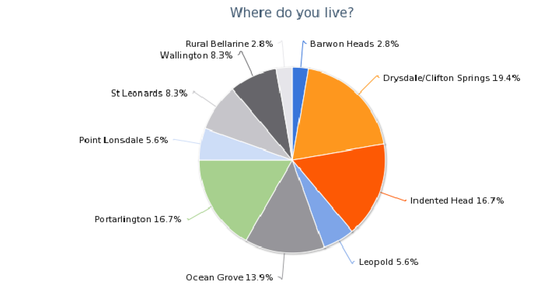
|
Value |
Count |
Percent |
|
Barwon Heads |
1 |
2.8% |
|
Breamlea |
0 |
0.0% |
|
Drysdale/Clifton Springs |
7 |
19.4% |
|
Indented Head |
6 |
16.7% |
|
Leopold |
2 |
5.6% |
|
Ocean Grove |
5 |
13.9% |
|
Portarlington |
6 |
16.7% |
|
Point Lonsdale |
2 |
5.6% |
|
St Leonards |
3 |
8.3% |
|
Wallington |
3 |
8.3% |
|
Rural Bellarine |
1 |
2.8% |
|
Queenscliff |
0 |
0.0% |
|
Count |
Response |
|
1 |
Absolutely - they are essential to retain the environmental characteristics of the area. |
|
1 |
Definitely |
|
1 |
Essential. |
|
1 |
Most definitely |
|
1 |
Please refer to IHCA Committee submission which I fully support and agree with |
|
1 |
Very important |
|
1 |
YES! |
|
6 |
Yes |
|
1 |
Yes This will be challenged by planning applications. I look to COGG to resist this. |
|
1 |
Yes it is |
|
1 |
Yes, I would like to see the individual identities of the town ships maintained. |
|
1 |
Yes, absolutely!! |
|
1 |
Yes, where else will the native fauna live that you haven't mentioned? |
|
1 |
Yes. Vital to maintain the feeling of moving from village to village. |
|
1 |
Vital. |
|
2 |
yes |
|
1 |
Extremely important. I don't believe anyone wants to see continuous merging of towns. Green wedges are important for a huge number of reasons |
|
1 |
Yes it is very important to protect the space between the townships as stated in the draft Localised Planning Statement. We want to be able to see green as we travel between towns. |
|
1 |
Definitely. The character of the Bellarine that makes it attractive to live in and to visit is the open spaces between towns. These green open spaces must be maintained. |
|
1 |
YES, YES, YES - most definitely! And make them kilometres wide. Wall to wall residential developments would destroy the TOTAL environment of the Bellarine Peninsula (general amenity, green space, huge traffic demands, etc) |
|
1 |
Yes. This village type of development, each with its own character, is one of the main attractions of living on the Bellarine Peninsula and something which many residents regard as very important. |
|
1 |
Yes it's very important. Any removal of the breaks and/or clear settlement boundaries would lead to a lack of certainty thereby creating an environment which could lead to the loss of its unique character. It is important that all unique townships be individually evaluated and planned for. Portarlington and Indented Head differ in character, and are separated by a Non-urban Break and therefore should be acknowledged separately in the Planning Statement. IH is also closer to St Leonards Town Centre and is therefore more reliant on St Leonards for most services and community infrastructure as Council provides nothing. Council adopted an Indented Head Structure Plan in 2007. The Structure Plan states under the Implementation and Review Plan in reference to areas of ecological values to “Apply the Environmental Significance Overlay or the Vegetation Protection Overlay to areas of significance”. The settlement boundary between Batman Rd and Church Rd and west of Annemarie Drive, contains EVC 175 Grassy Woodland which should apply an Overlay. Also no residential development should be allowed between the Grassy Woodland and the settlement boundary. |
|
1 |
Yes. This allows each town to retain and capitalise on their unique characteristics. The alternative is a muddled sprawl and loss of local identity (highly valued by residents). |
|
1 |
Yes, it is very important that non-urban breaks are maintained between townships. The coastal towns and larger residential centres all have their own distinct character, which should be recognised and protected. |
|
1 |
Most Definitely. Most people living in this area have chosen to do so because of its charm and character and to get away from inner city living. |
|
1 |
COGG needs to plan to create more public open space in rural Bellarine. It is wrong to expect private landholders to provide these non-urban breaks. |
|
1 |
I think it’s nice to still have open green space, otherwise we become like the other side of Geelong. And even though I love to see development I still love that we have lots of green space, that we see farm animals, ocean views and residential/ commercial development. Keeping it in balance is important. |
|
1 |
Definitely. It is all part of the experience of visiting this peninsula. The breaks of Bay vistas and green/brown farmland make the visitor feel removed from the city confines and I always breathe a sigh of contentment when I come over the Bellarine Hills and home, no matter how often I do it. |
|
1 |
Very important. The recent surge in suburban "developments" has significantly eroded the Bellarine's charm and should cease. |
|
1 |
Yes it's very important, but not applied by Council in Indented Head in regards to Seabreeze Estate on the western boundary of Indented Head. The developer is being allowed to subdivide to a farm property ignoring the IH community's request for a green wedge/ buffer/non-urban break. This strip of land between significant EVC 175 Grassy Woodland and a farm property is being allowed to subdivide, when the community has for over 10 years wanted the land west of the watercourse maintained as Open Space, and included with the 13 hectares of Grassy Woodland, protected and preserved as a Nature Reserve. |
|
1 |
Non-urban breaks and clear settlement boundaries are crucial to maintaining the character of the Bellarine. |
|
1 |
Critical for maintaining healthy waterways, and populations of native fauna and flora for genetic diversity. Non-urban breaks ensure ecosystem services are sustained. Biodiversity connectivity from rural areas to reserves and urban boundaries should be encouraged and supported across the Bellarine. |
|
Count |
Response |
|
1 |
Not as much as preserving the land for native fauna and flora. |
|
1 |
Very! |
|
1 |
YES, absolutely. |
|
10 |
Yes |
|
1 |
Yes, it also very important. |
|
1 |
Yes, it means that there is no development and the raptors can have free range. |
|
2 |
yes |
|
1 |
yes for open space |
|
1 |
Yes. If we want to eat local produce there should be more encouragement of local initiatives such as the Farmer's markets. They make sound economical and environmental sense. |
|
1 |
Not only is it important to maintain land for agriculture but also for Viticulture and Aquaculture as long as those industries do not impact negatively on the environment and community. |
|
1 |
There is nothing more relaxing than driving home looking over the cattle grazing or walking out your back door to see a tractor sewing this year’s crop. |
|
1 |
That what makes it more enjoyable and refreshing compared with the "crowded Mornington Peninsula. |
|
1 |
It is very important but a need to get a balance to improve agricultural productivity whilst maintaining and enhancing natural values on agricultural land. The overview page 4 targets primarily urbanisation and farmland, with a very small mention on natural values. There should be inclusion of the significant native flora and fauna values also in this section. |
|
1 |
Yes, but agriculture is changing on the Bellarine. Gone are the dairy and large vegetable farms, but there is still a lot of cropping and pastoral areas which must not be plundered into housing estates. |
|
1 |
Land that used to be used for agriculture should be developed. Land that is currently viable and used for agriculture should stay in place. So it depends on whether or not it is being used to its close to full potential. When it is not council enforces vegetation into new developments, i.e. trees, shrubs, paths, green spaces, buildings, residential, playground facilities etc. |
|
1 |
Yes, if that is the wish of the farmers. The problem is that the relatively small landholdings are not viable and water supply for agriculture is not sufficient to ensure that agricultural activity can grow to increase its viability. If land is going to be used for agricultural activity then there needs to be a comprehensive recycled water system put in place for use in more intensive agriculture. |
|
1 |
Only in so far as it provides the non-urban breaks. Land values are too high for many forms of agriculture on the Bellarine. |
|
1 |
Yes, maintaining land for agriculture purposes is very important to the overall landscape and heritage of the region but for the biodiversity and economic reasons. Food insecurity is recognised as a significant issue for some sectors of the population on the Bellarine. Ready access to fresh locally grown food is essential if communities are to be more resilient and sustainable whilst reducing food miles and environmental impacts. |
|
1 |
Yes, but also allow other uses that complement and encourage the use of the open spaces for recreation and or tourism. |
|
1 |
Yes This is the attraction of the Bellarine. The Viticulture and associated restaurants, Cheese making, Farmers Markets, and olive farms all add to this attraction. |
|
1 |
Mono-cultural cropping and over grazing destroys bio-diversity and native vegetation. It is important to have buffer conservation areas between paddocks, roadside vegetation reserves and set back new urban and industrial developments. Wildlife corridors and bird life flight paths and clumps of remnant vegetation need to be increased. |
|
1 |
Yes. We love the combination of coastal and farming environment. As stated, 'farming shapes our landscape'. |
|
1 |
Yes. Agriculture and viticulture are a part of what makes the Bellarine so attractive for residents and visitors. |
|
1 |
Yes it is, so long as rural land owners are provided financial support & subsidies in order to maintain & keep their privately held land. |
|
1 |
Yes as per the CoGG Rural Land Use Strategy - yes farming is important and the best farming land still available is important to our survival |
|
1 |
Yes. Maintaining viable agricultural land allows demographic diversity. It is important that employment opportunities are wide and varied, so that The Bellarine is home to a diverse working community and diverse age range of residents and visitors. |
|
1 |
Extremely. And farmers should be supported and encouraged in their provision of a pleasant rural environment for others. Any activities, farming or other, that are inconsistent with a pleasant rural environment should be discouraged. |
|
Count |
Response |
|
1 |
I'm sorry I have read the draft and don't understand this question |
|
1 |
No that important |
|
1 |
These two issues need to blend together. |
|
1 |
Vague question! Farmer should be able to plant trees and protect the environment |
|
7 |
Yes |
|
1 |
Yes, I agree. |
|
1 |
Yes, they can co-exist. |
|
2 |
Yes. |
|
2 |
yes |
|
1 |
What I cannot understand is that this is the policy, which we support, but when a non conforming activity is identified. The planning authorities allow up to 6 months for an application resubmit a permit application. This is too long and 30 days is enough and protects the interests of the existing ratepayers. We have an issue with a truck depot that has been established in a farming zone and has been allowed to continue to operate in spite of our protests. Not right! The location is the corner of Bluff and Murradoc rd and Manifold rd in St Leonards. A danger corner at the best of times and now more dangerous with the large trucks. |
|
1 |
ANY users of land in the rural areas should not impact negatively on the landscape, not just agricultural users. Current activities that are detrimental to the rural ambience should be encouraged to move elsewhere. The statement should discourage ANY development, new or existing, that would have, or has, a negative impact on the rural landscape. (On page 14 the statement only discourages such development that is new). |
|
1 |
Not sure what this means. If 'not impact on the open farmed landscape' means not allowing intensive animal farming such as piggeries and chooks kept in mass cages, I'm all for it. Sorry, I probably haven't expressed that very well. The exception to intensive farming is making the most of our aquaculture industry - mussels and Angasi oysters which don't impact on the landscape and will attract visitors to eateries and to buy direct from farmers. |
|
1 |
Some forms of intensive agriculture may not suit the landscape. Most farmers are aware of their impact on the environment, both from a sustainable aspect as well as a visual effect. Sustainable and environmentally sound diversity should be encouraged. |
|
1 |
There should be encouragement for farmland should have sections where appropriate enhanced for natural values of the Bellarine Peninsula. This would also improve the agricultural overall productivity. |
|
1 |
Generally yes. Support for Viticulture may result in some impact which will necessitate detailed assessment in the approval process to ensure appropriate sighting to minimise the impact to the landscape and community. In respect of Indented Head and Aquaculture, the Great Southern Waters Abalone Farm, operating since 2002, continues to operate while not meeting all the conditions set by VCAT and Council, regarding exposed intake pipes in the water and on the beach causing safety concerns. This impacts negatively on the Indented Head community, as a tourist and camping area. |
|
1 |
We can farm more sensibly than our pioneers who wanted to clear everything and replace it with an English or European model. There is plenty of space to farm and revegetate and regenerate native flora and fauna. This will make the Bellarine something very special. |
|
1 |
I don't feel that the 'open farmed' landscape is important. In fact, as long as farms are viable, I would rather see more areas of bush regeneration amongst the "open" paddocks. I think The Bellarine lends itself to a patchwork of agricultural land. I don't want to see houses popping up everywhere. Perhaps farmers could live in town and commute to their plots. |
|
1 |
Not sure what this means. If you mean that land should not be broken into many small allotments, then I agree. The important factor is the slower pace of activity that broad scale land use brings. |
|
1 |
If this means not filling the land with chicken farms or piggeries then most definitely. On the other hand a nicely laid out winery can complement a piece of land. |
|
1 |
I’m not sure what this means? Are you trying to ensure that agriculture remains pastoral and prevent battery farms? |
|
1 |
It is important to have a balance of both, aesthetically and environmentally. Diversity is a key aspect of sound environmental and ecological management and existence. |
|
1 |
I think this statement is splitting hairs a bit. What does it mean anyway? An agricultural user of rural land is a farmer of some description I presume? So what does a farmer impact on open farmed landscape? I don't get it. |
|
1 |
Yes There are already many instances where agricultural use and the associated uses do not impact and this should guide future planning applications. There will innovative proposals put forward which should receive consideration. |
|
1 |
YES - broad acre farming should be maintained - cropping, grazing, etc. No broiler farms, piggerys, etc (I hope the broad acre farmers are not 'killed off' by excessively high rates). The entire peninsula should not be cut up into hobby farms with no agricultural production - although this would be preferable to covering good arable land with the concrete and bitumen of a housing development - and thus losing it forever. |
|
1 |
Whilst not wanting to stifle any potential new rural development it is important that they are sited to minimise any adverse impact on the charm and beauty of the landscape. The planned extension of the abalone farm at Indented Head will bring employment and economic benefits to the north Bellarine. |
|
1 |
Yes, I believe that one of the things that attract new residents and visitors to the peninsula is the open farmed landscape. |
|
1 |
Open farmed land is a great concept, so long as the community is clear that the farm owners of that land still need to be able to make a reasonable living from that land. It is one thing for the land to look great and visually appealing to the community, but the community and gov't need to also than financially help & support landowners in being able to do things on the land that will produce enough income to keep & maintain it. |
|
1 |
There are very few land holders on the Bellarine who run viable "open farm" (growing grain crops and grazing animal) operations. Olives, grapes, hydroponics, strawberries, blueberries (for example) and the associated tourism opportunities are the viable farms. If these and more intensive farming are not allowed then the landholders are being asked to create a "pleasing" outlook for everyone else at their own expense. Rural land on the Bellarine is expensive. If farmer's ability to run viable operations on their land is restricted then this land will be neglected and become less attractive for others to look at as they drive by. Most of the open land on the Bellarine is owned by "farmers" who live on off farm income. The open farmed landscape of the BP is a myth and is not sustainable. |
|
Count |
Response |
|
1 |
Who has identified what? What are they? |
|
5 |
Yes |
|
1 |
Yes, seems OK. |
|
1 |
You seem to have identified the most valued characteristics. |
|
1 |
yes |
|
1 |
You’ve pretty much ignored the waterfront and foreshore areas. |
|
1 |
No, while the statement refers to many valued features on the Bellarine Peninsula, we believe there are many more that are not listed. Local residents and regular holiday makers have developed lifelong connections to specific features and areas and are often very passionate about their favourite spots. Some other significant reserves include: Edwards Point Wildlife Reserve, St Leonards Salt Lake and Pt Richards Flora & Fauna Reserve. The North-facing aspect of the beaches and foreshore from Curlewis to Clifton Springs to Portarlington and Indented Head enhances their enjoyment but also makes them vulnerable to storms, erosion and the impact of climate change. The statement does not refer to the various water activities which are the main drawcard for many visitors and locals such as fishing, sailing, snorkelling etc. The statement appears to have a Queenscliff focus when it comes to indigenous and early European history and settlement. This is far from correct as the foreshore from St Leonards to Indented Head and Portarlington has a very rich indigenous and early European history. William Buckley walked into John Batman’s camp at Indented Head in 1835 after having lived in the area for thirty years. Bellarine Bayside Foreshore Committee of Management has commissioned a comprehensive indigenous study of its 17km of foreshore under the Aboriginal Heritage Act 2006. Eleven archaeological sites were identified from low density middens, stone artefacts to intact significant camp sites and birthing cave. In the Executive Summary, Cultural Heritage Adviser, Adam Ford describes “the whole foreshore landscape as a cultural artefact”. |
|
1 |
Yes. You do state though, that St Leonards is "not a designated growth location". The sale and subdivision of former farmland would seem to contradict this. We are in danger of outgrowing the existing amenities and losing the character of the village that we all love. |
|
1 |
What has not been protected and preserved for the community is the 13 hectares of significant Grassy Woodland in Indented Head. It's protection from developers must be ensured by Council, by taking responsibility and with the help of residents, support its preservation and maintenance for the long term future of residents and for it's links and history with the local northern Bellarine Bengalut Gulag aboriginal clan. Our foreshore is on Crown Land and under the responsibility of Bellarine Bayside which has for the most part not undertaken real community engagement in regard to the foreshore, as the community is the guardian of the beach and foreshore and wants any development to be undertaken in a sensitive matter and not to be always about how much revenue Bellarine Bayside can get from the foreshore that it is given over to three camping reserves. |
|
1 |
Indented Head is a coastal community which attracts thousands of visitors each year, whether camping, fishing, yachting, boating or swimming. Our beaches are crowded, especially during summer. The key features detailed on Page 13 refer to the “Typically rugged surf coast with sweeping beaches---.” this comment does not adequately identify the extent and importance of the total foreshore. From the point of view of attraction for visitors and high rates of active utilisation, the Bellarine Peninsula has two distinct coastal attractions. The Bellarine Peninsula has both the surf beaches facing Bass Strait – popular for both swimming and surfing – as well as swimming beaches facing Port Phillip Bay which in addition, provide the environment with a wide range of water based sporting activities including particularly yachting, water skiing, rowing and canoeing, that are popular with all age groups. The Port Phillip Bay coast is also the location for numerous Boat Launching Ramps which provide important support for recreational fishing, which historically has been the main driver in the development of Indented Head and is still today a very major activity for not only Indented Head, but for all of the Bellarine Peninsula. These Boat Launching Ramps are features which should be included in the Maps on pages 10 and 11 as should the main surfing and swimming beaches. The residents want regular community engagement with Bellarine Bayside Foreshore Committee of Management, regarding any foreshore development to be undertaken, as the community require, as our population continues to increase. An area of permanent Community Open Space should be allocated in Batman Park for the community and visitors. Bellarine Bayside’s Master Plan for the coast recognises this need and recommends a Placemaking Project be developed in conjunction with CoGG .The Indented Head community has developed a proposal in response which will be formally lodged with Bellarine Bayside when signed off by all of the Indented Head Committees of Clubs and Associations. Recognising that an approved Council Heritage Overlay has application over all the affected area, the changes we are proposing will not only involve Council in the planning phase but will also require Council approval. Head Foreshore. The Heritage Overlay extends from and includes Anderson Reserve for 3 kms to Red Bluff in the south. We also have highly significant EVC 175 Grassy Woodland which is extremely valued by the community, which as stated in the Structure Plan, Council should apply an ESO to protect and preserve as a Nature Reserve for the benefit and well being of the community. 5. Are there more valued characteristics of the built heritage and townships which need to be added? If so, what are |
|
1 |
The Queenscliff and/or Pt Lonsdale description should include mention of the Rip (entrance to Port Phillip Bay) and Queenscliff's military and maritime history. Also the description of Pt Lonsdale should highlight the significant roadside vegetation which is a special characteristic of the town. |
|
1 |
The June 2014 Draft Localised Planning Statement I think has been very well written and presented and covers our features well. Lake Lorne and McLeod's Waterholes at Drysdale are worthy of protection - good bird habitat and green 'exercise space' for population. |
|
1 |
I may have missed it but you haven't mentioned native fauna. The need to protect shore nesting birds whose ancient nesting sites are being trampled on by beach goers and their dogs. Duck shooting should be banned from Lake Connewarre to protect native and migrating bird life. As the suburbs sprawl closer to the wetlands shooting is completely socially inappropriate and driving Leopold and Barwon Heads residents mad. Ocean Grove Nature reserve should not be the only place on the Bellarine to see a wallaby. |
|
1 |
You seem to have done well. I am particularly pleased that RAMSAR areas have been highlighted so as to be protected. Not enough has been done to protect the wetlands at Point Lonsdale where a housing estate has been planned - this estate should not go ahead and the wetlands should be preserved. |
|
1 |
You mention Ocean Grove Nature Reserve but fail to mention that Ocean Grove Park is also listed by the National Trust. |
|
1 |
Depends who defines 'most valued'. We have land designated for development that is home to the Growling Grass Frog (bottom of Lincoln's Farm in Portarlington) and the wetlands at Point Richards for water fowl. The area to the west of Ramblers Road (Port) is a stop-over for migratory birds although not Ramsar rated. Canola in flower is a real drawcard for photographers. |
|
1 |
The incredibly important environmental area of the Salt Marshes of Swan Bay and the Edwards Point Wildlife Reserve don't even feature on your map. Merely the Marine Reserve section of Swan Bay. In fact Edwards Point is misplaced. It is the end of the sand peninsula facing Queenscliff. The whole of the long fingered peninsula from the St Leonards housing area towards Swan Bay is in fact a fantastic Reserve with Walking Trails of up to 3 hr duration. There is also no indication of the walking and bike trail that runs from Edwards Point Reserve all the way to Portarlington along the coast. An absolute gem which needs to be maintained for locals as well as tourists. |
|
1 |
There are no significant features marked on the map for Wallington Rd. This road is very scenic and should be maintained as a scenic drive with views to Lake Connewarre maintained. Preferably all heavy traffic should be regulated to use Grubb Rd to avoid destroying the nature of this road as rural and scenic. |
|
1 |
Yes, stopping urban sprawl is important, access to various trails is important. The communities should be bike / walking friendly and interconnected. |
|
1 |
The significant Aboriginal history is mentioned in regard to Queenscliff, but I feel that it is significant to other areas on the Bellarine also. |
|
1 |
You have done well to identify the valued environmental characteristics and significant features of the Bellarine Peninsula; however, there is one vital aspect of the planning process which is constantly overlooked. It concerns me greatly, the pressure of increased population growth in sensitive coastal areas. Unrelenting development is pushing up against significant wetland habitat for migratory and resident wader birds. This development is occurring without any regulations or restrictions concerning cats, dogs or invasive plants. There isn't even a public awareness policy to educate new residents on the importance and sensitivity of the area in which they have chosen to live. There are no buffer zones and no restrictions on the ownership or confinement of cats and dogs. There is no restriction on plants which may become invasive over time. I have first hand knowledge of these problems as I have witnessed cats wandering daily into the Edwards Point Reserve at St. Leonards. I am also a regular participant at volunteer working bees to extract environmental weeds from numerous locations around the Bellarine coastline. It would be great if planners could give some serious consideration to these issues to ensure that our precious natural environment will be there for future generations to enjoy. |
|
1 |
I believe that more bike paths or improved designated road space should be allocated to bike riders; or create a bike riding trail around the peninsula using back roads to minimise the chaos that occurs during weekends when lots of bike riders and vehicles using the same access roads. Also more areas should be set aside for the creation of various look outs with picnic areas and walking tracks with written boards explaining the area, its history and why it needs to be preserved. More focus on the natural features when attracting visitors to the area would give visitors a reason to stay longer. |
|
1 |
Most of them. There needs to be more emphasis on protecting waterways, wetlands and Ramsar systems. For example, in Strategy #3, about ecology, there should also be a statement “Protect waterways and wetland systems from inappropriate activities that negatively impact on their ecological integrity. Also restore them where they have become degraded." Also Red-Gum and Allocasuarina remnants should also be highly valued. And existing developments should also allow for the protection of these species. |
|
1 |
I’m not sure natural waterways have been covered enough. Wouldn't want to see a swamp like Armstrong creek turned into an urban growth area with the impact of outflow and stormwater destroying the waterways on the Bellarine. Maybe further detail required around duck populations the effect of urban development and maintaining breeding areas at a high quality. This in turn providing for great Duck Hunting areas and drawing business into the region. |
|
1 |
Yes you have, but I'd like to see more about restrictions on new housing developments, especially the Curlewis Rise release, that looks generic and very western suburbs built. Little variance shows amongst housing, rumours of retail and commercial presence without confirmation is abound, waterfront sites are 'prohibited for access and under camera surveillance' with evidence of chopped trees and alterations to the creek that runs behind Clifton Springs Primary School found. New releases therefore must integrate with existing landscapes and township facades i.e. not offer predominant 1/4 or less size blocks, not chop down existing trees (i.e. will the large existing pine trees be preserved?), not install mediocre or even fake grass with large concreted areas as a public space example, and not use unrelated images, symbols and stories in attempt to link spaces to local history. |
|
1 |
The wide vistas as you travel are a breathing space for city visitors. The bird life is significant and precious and maintaining corridors of open land and trees is vital for their survival. |
|
1 |
Yes however the view across Port Phillip Bay from Beacon Point Reserve should be included as a featured viewing point |
|
1 |
Swan Bay is a very special place and not all the town planners are aware if its significance. They need more education and site visits. |
|
1 |
They don't seem to have been listed in the document just generically. We love the Clifton springs and it would be great to have it reopen as a health facility - the community has been asking for support for this for years. The village feel of Drysdale should be preserved by allowing traffic to travel around Drysdale and allow the town centre to thrive with the encouragement of small business and economic development which helps to support a healthy town. |
|
1 |
The document needs to include Lake Connewarre system as this is a listed Ramsar site of international significance. The Barwon Bluff Marine Sanctuary is of State significance Lake Lorne in Drysdale is significant for habitat values for the threatened Freckled Duck which is of State significance. The Ocean Grove Nature Reserve should be mentioned as one of the few remaining natural value reserves on the Peninsula. Lake Victoria should be mentioned as a key supporting wetland area. The Pt Richards Fauna Reserve should be listed as a key location supporting high local biodiversity values. The Swan Bay system should have more emphasis as it is of international significance; of high biodiversity, highly valued and used for educational purposes and ecotourism. The Salt Lagoon Reserve and Edwards Pt Flora and Fauna Reserve are both of local significance and support a diverse range of natural values. All of the above contribute to the overall ecosystem services the Bellarine has to offer. The document does not reflect the natural values assets on private land; such as remnant vegetation, old buildings for habitat value, significant wetlands as these would provide valuable connectivity points for future works. |
|
1 |
There needs to be a thorough audit of the environmental assets of the Bellarine. The lakes, the pockets of remnant vegetation, the water courses, the shoreline and bays are all important however should not be locked up but linked by walk and ride paths that allow them to be shared and actively cared for by the community. |
|
Count |
Response |
|
1 |
Curlewis- great deal of history, heritage listed buildings, etc |
|
1 |
I can't think of any. |
|
2 |
No |
|
1 |
No comment |
|
1 |
Not sure |
|
1 |
The 'walking tour sign-posts' in our area are informative. More of them would be great. |
|
1 |
no really |
|
1 |
It would be nice to keep the Drysdale main street in tact, but the traffic is a real problem. Is there any thought to making it car free and diverting traffic around the centre of town? |
|
1 |
Significant historical buildings in the townships should be protected from being surrounded by ugly, cheap 'townhouses' built simply for builder profit and with no regard to the nature of our rural and beachside suburbs. These developments are destroying the beachside feel of Ocean Grove. |
|
1 |
Fostering diversity between the 'villages' is an important element of the attraction of the Bellarine Peninsula. A one-size-fits-all approach is the last thing we need. |
|
1 |
Cycling is a growing recreation on the Bellarine yet the infrastructure is very poor. Roads are narrow with pot holes, little separated bike paths (or poor gravel ones near the beach). |
|
1 |
The village feel of the townships. A commitment to preserving the seaside feel of the coastline without high rise near the foreshore and not allowing any industry on, in, near or inside our beaches or harbours. An overlay of protection from inappropriate buildings. |
|
1 |
The Indented Head built heritage characteristics have been in the main, lost to inappropriate development and with Council Planners ignoring the Structure Plan and appeals by the IH community. The street vistas and small town character has been overlooked for preservation. Three kilometres of the most utilised sections of foreshore in Indented Head have one and a half kilometres of beach inaccessible to the elderly and disabled, due to only stair access and a non compliant 1:7 ramp to Half Moon Bay. What is urgently needed is more parking, particularly on the foreshore side of The Esplanade adjacent Batman Park and a DDA compliant ramp to Half Moon Bay, especially with the future Community Open Space being negotiated with Bellarine Bayside. Numerous sections of the foreshore north of Batman Park need ramp access due to retaining walls, cliffs and severe erosion. |
|
1 |
The Queenscliff description should include mention of the fort and the military and maritime history - the lighthouses and other navigational devices are also a significant feature. |
|
1 |
I would love to see more interactive boards explaining the history of the various townships and the historic buildings and properties. I would love to see a history/discovery trail linking all townships on the Peninsula with VicRoads signs to guide visitors from one town ship to the next. At each township there could be a self guided walking trail with boards explaining the significance of each property. I am sure that tourism operators would be able to come up with an interesting advertising campaign. |
|
1 |
I don’t think it was appropriate to merge Indented Head with Portarlington as their size, focus and characteristics are different. The key built heritage icon in Indented Head is the wreck of the paddle steamer the Ozone which frames the Melbourne skyline across the bay. The heritage value of its boat sheds along the foreshore has also been formally recognised by CoGG. Portarlington is a much larger town centre which grows five-fold in size during the summer camping season. The Portarlington holiday park is the largest camping reserve on Crown land in the southern hemisphere. The Rotunda is the town has great history. The town also hosts several festivals including the National Celtic Festival which draws 17,000 visitors to the town over the Queen’s birthday weekend. The coastal trail from Portarlington to St Leonards, accessible for walkers and cyclists, acts as a vital connecting spine joining these coastal towns. |
|
1 |
Drysdale / Clifton Springs is an ignored population centre. It needs investment in public infrastructure. For example - a community hub and more sport facilities. The community centre should contain adult education facilities, a decent sized library, community meeting rooms.... These exist in the area however are insufficient and spread out. This area does not have a public swimming pool which is a great failing especially as it has the majority of school students on the Bellarine who need to learn to swim. It can be more than a "supermarket" town if given the support that it deserves. |
|
1 |
The boatsheds at Indented Head, I understand the heritage study which has been done is now on hold by the Bellarine bayside committee while they try to evict all the tenants. I would value your comment |
|
1 |
There are derelict dairies scattered around the peninsula, they tell a history of a past farming use. Perhaps some of them should be preserved. |
|
1 |
This probably isn't the document for this however something about each town's potential - e.g. Portarlington (Jewel of the Bellarine) has the potential to be the primary centre for the Bellarine's aquaculture industry. |
|
1 |
I don't know. Is there a list of "valued characteristics" and are there townships that need to be added? One would have thought that all the townships on the Bellarine have their own unique characteristics, and each should have that recorded somewhere. Who are the custodian of such lists, and what of the towns/places that have virtually died out? |
|
1 |
No but the quality of the Clifton Springs /Drysdale township is under constant pressure due to the ad hoc commercial development and the increasing amount of traffic in the town area which detracts from the friendliness and usability of the town. It does not have the same "feel" as say Barwon Heads (Hancock Ave) or Ocean Grove, (The Terrace) D/CS is not an attractive casual meeting town. |
|
1 |
The historical aspects of some of the townships are celebrated by our community - it shows we are an established community with history and heritage and new comers crave this connection. Those of us who have lived here all our lives also treasure it. |
|
1 |
We need to revisit the heritage listed buildings and spaces. There is some fine examples of weatherboard houses built in the 1900s in Fenwick street that should be protected. |
|
1 |
This has been well covered in general. Individual towns place significance on their own historical structures. |
|
1 |
Reference key documents should include: Landscape Setting Types - Lake Connewarre and Barwon River high conservation values. Barwon Heads - Ocean Grove development compromising the coastal quality. Swan Bay and surrounding Bellarine Hills form major feature of the areas. Not clear on the statement that the Ocean Grove surf beach needs to be enhanced; in what context is the need for enhancement expressed? |
|
1 |
Once townships start to outgrow their township status, they lose their charm and thus their tourist-dollar value. |
|
1 |
Putting tarmac over the Drysdale Village car park bricks was madness and without need or real cause; if it isn't broke, don’t use rate payer money to fix it. Painting the Village exterior much darker also makes little sense or reason. Queenscliff needs more heritage protection, the style of it must not change drastically due to new urban relocations whom are enticed after summer holiday stays; many end up recreating the urbanisation they seek to escape from. Ocean Grove needs to preserve affordable housing; many long-time locals I speak to are being forced out of their 1970's+ housing from rent rises because the owners want to sell the land for units or view capturing housing constructions...not a very good preservation of the original 'alternate lifestyle non-consumer based' social history. |
|
1 |
Maintain their character of discrete townships - i.e. restrict subdivision development on their outskirts. There is far too much urban "development" of good rural land and inappropriate activities which detract from the heritage values of the townships and from the rural character of the Bellarine overall. |
|
1 |
The Indented Head built heritage characteristics have been in the main lost to inappropriate development in constant disagreement with the IH community. The street vistas and small town character has been overlooked with zonings and with developers unwilling to layout housing estates with minimum 500 square metre lots. Many are around 300 sqm. Even streets like Glenrana Drive begin as over acre blocks and finish on the western end at around 300 sqm. The IH community is very disappointed in Council allowing PPA's to succeed with this visually ,ugly vista that destroys the character of a rural and unique small coastal hamlet. |
|
1 |
The Barwon river should be integrated better and the sewerage aqueduct protected as part of the built environment |
|
1 |
Maintain the relevant overlays applying to townships. Critically analyse planning applications to ensure conformity. |
|
Count |
Response |
|
1 |
Better to have higher density in suburban areas and keep the Peninsula green |
|
1 |
I'd like to see more detail around the buffer zones. They appear vague at the moment. |
|
1 |
Looking forward to seeing the final draft |
|
2 |
No |
|
1 |
No more comments. I think everything seems to be OK. |
|
1 |
no |
|
1 |
I am so disappointed that we did not have the chance to have a community discussion about what we value. Drysdale Clifton Springs has had significant growth over the last 15 years and I would believe we had a more significant growth than Leopold during that time as stated in one of the initial paragraphs. Our community is desperate to participate in these sorts of planning exercises which will mould our future. We need to be able to discuss these sorts of decisions. Please please please allow us to be an important part of this decision making. Please let us know how the $25,000 engagement fund for this project was used because it wasn't used to inform us. I have spent the last 15 days trying to let people know of this process. |
|
1 |
I am pleased to see that not-for-growth areas have been identified along with the significance of the natural beauty of the Bellarine, and hope that this planning statement goes a long way to that the future reflects this. |
|
1 |
The Bellarine should become a 'Bike friendly' destination with safe bike links between the towns. This will increase tourism and the viability of new and old businesses, especially in the shoulder seasons of spring and autumn. There should be more emphasis on art & craft activities with cross town festivals such as the wine and food festival. |
|
1 |
Council and government must resist the pressure to increase population growth. This in turn puts pressure to move town boundaries. Space and infrastructure is very limited on the peninsula. |
|
1 |
With more residents expected to move into the Portarlington area, I believe the Drysdale Bypass should be high on the list of projects to be actioned sooner rather than later. Also the proposed road from Portarlington road near the Curlewis Golf Course into the Jetty Road /Curlewis/Clifton Springs housing development area should be actioned now and not 10 years in the future. |
|
1 |
PLEASE consider including reference to areas of significant indigenous cultural heritage or at least make reference to this or did I miss this? Thankyou, this planning statement and recognition of the value of the Bellarine Peninsula is to be applauded. |
|
1 |
No I believe that the document is an excellent document providing guidance for future planning. It is important that it be implemented and followed. |
|
1 |
Would love to see more cycle paths across the peninsula. The Bellarine rail trail is a fantastic ride but opportunities exist for locals and tourists to have a network of trails across in different directions taking in the wonderful vistas and linking on with taste trail. This could become a popular destination for bike touring if off road trails similar to Bright-Beechworth were established. |
|
1 |
Once the policy is agreed make sure that the planning authorities follow and at all times protect the interests of the ratepayers and the important farming community. |
|
1 |
More needs to be done to protect the marine environment around the Bellarine Peninsula. Not enough is done to ensure the waters are free of discarded fishing lines, hooks, nets, etc. More should be done to halt illegal fishing, such as over-fishing. Diving in the area should be further promoted. |
|
1 |
My question is if some people don't like change does it means the rest of us have to miss out on progress and development? |
|
1 |
Indented Head should not be included with Portarlington under TOWN CHARACTERISTICS. IH has a separate Council endorsed Structure Plan. IH is also closer to St Leonards Town Centre and is therefore more reliant on St Leonards for most services and community infrastructure as Council provides nothing. Council has ignored IH in regard to no open space for the community. No ovals, sporting facilities, no BBQ area, as no useable Public Open Space has been set aside for a population that has increased by over 50% in the last census. Parking congestion, especially during summer, is an ongoing problem for residents. With no postal deliveries, all residents including holiday home residents and visitors, and campers in three camping reserves, make accessing the General Store & Post Office extremely difficult. We have requested for many years for parking to be extended north to Batman Rd from the General Store. Council Town Planners have consistently told the community that "the foreshore is your open space" yet with no acknowledgement that it is completely overtaken by campers and visitors for over 2 kms for the during of summer and for six months in regards to Batman Park Camping Reserve which is located directly opposite the General Store, compounding the parking problems for residents. In regards to the Bellarine Peninsula Strategic Plan and how it's applied to Indented Head, we have been ignored. No breaks between housing estates and farmland e.g. Seabreeze Estate and no swap of current POS for the endangered and highly significant EVC 175 Grassy Woodland. Before any further PPA's are approved for subdivisions in Seabreeze Estate, that the area requested by the community is acquired for POS and then important infrastructure, for sports, walking trails around the Nature Reserve and BBQ areas are built. We have been constantly overlooked and with a rapidly growing population, allowed by Council, they have a responsibility to now urgently move to supply the infrastructure. Forcing Indented Head residents to drive to St Leonards and Portarlington to access basic services and infrastructure is detrimental to the health and well being of the community. |
|
1 |
I support the Bellarine Localised Planning Statement as drafted but I believe it could be improved with the additions described above. |
|
1 |
I don't know what this Bellarine Peninsula Localised Planning Statement is about, and what the questions posed have anything to do with the name. To me it sounds like something Historical. |
|
1 |
Land must be released slowly, and to those with a rural/regional focus/contribution. Geelong with the G21 must ensure the area retains its environmental, residential, tourism and business strengths & identity, and refrain from fast progress into little more than a crowded, bland and degraded Melbourne commute/satellite region. |
|
1 |
The rapidly growing population requires that all relevant services grow to keep pace. Some services will grow as a natural response to population but others (e.g. Ambulance, CFA, and SES) are linked to government spending and warrant specific mention and support. |
|
1 |
I am struck by the negative language of this document. It talks about what is not allowed rather than what can be done. I am disappointed that this has not been a more open process. COGG needs to facilitate the development of a Bellarine group that can offer a forum that can "speak" for the Bellarine Peninsula residents and their needs. Unfortunately we have lost our unique voice in tourism as we have been swallowed up by Geelong Tourism. The rhetoric of the newly formed Geelong and Bellarine Tourism Assoc. disputes this however we have lost our voice in this area as we have in many other areas. The Bellarine is different to Geelong and has many wonderful attributes. COGG should allow the Bellarine residents the opportunity to develop these attributes not lock us up at our own expense for the enjoyment of those who do not live here. |
|
1 |
Desirable additions: - No fracking on the Bellarine - A move towards a "clean, green Bellarine" -Undesirable activities (i.e. detracting from ecological or rural values) of any kind, not just agricultural, should be discouraged. -No further urban subdivision |
|
1 |
We feel the need to retain the green spaces We need to add to recreation areas and to continue to maintain and improve existing ones (children's playgrounds, sports ovals etc). Traffic management is becoming an issue with narrow, badly maintained roads particularly during the summer tourist season. |
|
1 |
Thankyou for the opportunity to comment. I have lived at Wallington for much of 76 years - my family coming here in 1943. I know things must change, and good things have happened - however these seemingly never-ending housing developments, and all that goes with them, are a real concern. I know 'town boundaries' have been set - I just hope they are adhered to. |
|
1 |
As Ocean Grove is a designated growth area, Ocean Grove Park is under enormous pressure to change. It must be protected and preserved for future generations. |
|
1 |
The planning statement does not acknowledge the important management role played by the foreshore committee of management, which are appointed by the Minister for the Environment and Climate Change. Bellarine Bayside manages the coastal Crown land from Pt Richards to Edwards Point including the coastal towns of Portarlington, Indented Head and St Leonards. Barwon Coast manages the coastal Crown land from Collendina on the eastern boundary of Ocean Grove, through to Blue Rocks to the west of 13th Beach. These committees have prepared comprehensive strategic management plans with extensive community consultation and ministerial endorsement. These plans set out a framework for the protection, enhancement and development and management of their respective coastal reserves over the next 15-20 years with more detailed master plans focused on the next three years. The background documents to this statement should also list: • The Northern Bellarine Foreshore Plan 2012 (Bellarine Bayside) • Northern Bellarine Foreshore Draft Master Plan 2012 (Bellarine Bayside) • Barwon Coast Coastal Management Plan 2012-2015 (Barwon Coast) • Draft Victorian Coastal Strategy 2013 • Plus relevant State Government legislation. I appreciate the opportunity to contribute to this community engagement process about our cherished area of Victoria. |
|
1 |
I have noticed an inconsistency and error on page 17 of the document regarding tourism developments in farmed rural landscape. This draft document does not reflect the intent and effect of the recently introduced changes to the Farming Zones, which specifically remove the requirement for tourism uses to be ancillary to farming activity. Policy 6 and associated objectives of the Draft Bellarine Peninsula Localised Planning Statement are contrary to both the intent and effect of the State Government’s reforms to the rural zones. The State Governments’ reforms to the rural zones: · Actively encourage private investment in tourism facilities outside of established townships; · Remove permit limitations in the Farming Zone relating to tourism uses, enabling applications to be considered on their merits · Require Council’s to ensure local planning policies do not inhibit tourism investment in rural areas. |
|
1 |
The Bellarine Peninsula is a very popular area for cyclists and is often used for official events. Currently, cyclists are not well catered for due to the lack of independent cycling tracks/lanes and the fact that only very few roads have shoulders. This compromises safety to a concerning level. The Tourist Route through Indented Head, being The Esplanade, has been identified in the ‘map’ on page 11 of the Draft. Currently sections of the Esplanade are in need of major repair. Upgrading the total length to also cater positively for cyclists with at least road shoulders, should be identified along with the Drysdale By-pass. A sealed Ibbotson Street for its full length is also needed as an alternative route through Indented Head which will lessen the traffic congestion on The Esplanade. Council has ignored Indented Head in regard to useable open space for the community. No ovals, sporting facilities, no BBQ area. No useable Public Open Space has been set aside for a population that has increased by over 50% in the last census to just under 1,000. The Council Economic Indicators Bulletin 2008/09 shows the Peak Overnight Population during summer was 5,266, with the IH permanent population for 2009 of 578. Therefore parking congestion, especially during summer, is an ongoing problem for residents. With no postal deliveries, all residents including holiday home residents, visitors, and campers in three camping reserves, make accessing the General Store & Post Office extremely difficult. We have requested for many years for parking to be extended north to Batman Rd from the General Store. Council Town Planners have consistently told the community that "the foreshore is your open space" yet with no acknowledgement that it is completely overtaken by campers and visitors for over 2 kms during summer and for six months in regards to Batman Park Camping Reserve. A health concern of the community is the stormwater that drains onto two very popular beaches. Firstly, Pigdon Street stormwater drains onto the beach at Anderson Camping Reserve, and our only No Boating/Swimming Only beach. The Batman Rd stormwater drains into Half Moon Bay situated between Taylor Reserve and Batman Park Reserve, both camping Reserves during summer. With the Ozone Wreck situated close to shore at Half Moon Bay and an attraction to swimmers, this drain needs to be re-directed to underground stormwater pipes in Batman Park that drain off shore at Batman Park Point. This long term health risk needs to be made a priority by Council and Bellarine Bayside. We have been constantly overlooked and with a rapidly growing population, Council has a responsibility to now urgently move to supply the infrastructure. Forcing Indented Head residents to drive or catch a bus to St Leonards and Portarlington to access basic services and infrastructure is detrimental to the health and well being of the community. |
|
1 |
The Bellarine Aquaculture industry offshore sites are Grassy Point and Clifton Springs. There is no offshore aquaculture at Queenscliff as identified on the map. The Framework Plan map aquaculture points need amending to reflect this. The map also shows Edwards Point in the wrong location. Reference to Wadawurrung for the whole of the Bellarine is not reflected in the document. Policy Objectives and Strategies 1 & 2 does not reflect protecting the coastal environment within a settlement boundary. Property developments directly adjoining coastal reserves are compromising the aesthetic values of the coastline, and are not sympathetic to the natural environment are significantly altering the ambience of the reserves. Policy Objectives & Strategies 3 should include responsible pet ownership to protect native fauna. Such strategies could include no cat zones in new estates near sensitive high biodiversity areas and the provision for new estates to include an open fenced in dog off leash zone. Policy Objective & Strategies 6 does not support the coastal landscape, or local fauna values. The majority of out tourism is heavily coastal dependant and should be reflected and supported in this document in a sympathetic and ecosystem compatible manner. Our natural values are what make the Bellarine special. What is common today will not be common tomorrow and we need to work together to maintain and enhance what we have left. |
|
1 |
The Bellarine Rail trail is excellent and should be fully integrated in the planning of adjoining developments by adequate path designs and appropriate road crossing to protect walkers and cyclists. |
Portfolio: |
Planning – Cr Heagney |
Source: |
Planning and Tourism - Strategic Implementation |
General Manager: |
Peter Bettess |
Index Reference: |
Subject – Council Reports 2014 |
The purpose of this report is to consider proposed changes to the Commercial 2 Zone in relation to planning permit requirements for supermarkets.
Discussions between Councillors and the State Government have raised the possibility of the Commercial 2 Zone being changed to put Greater Geelong on equal footing with Melbourne in relation to planning permit requirements for supermarkets.
The Commercial 2 Zone was introduced by the State Government in July 2013 as part of a broad ranging agenda to reform the state wide planning zones.
The Commercial 2 zone replaced the former Business 3 and Business 4 zones. The Business 4 zone (now Commercial 2) was a zone commonly used for bulky goods, hardware and light industrial uses and is found along main roads in many parts of Greater Geelong.
The new Commercial 2 zone has opened up the ability for a wider range of land uses to be considered including supermarkets.
In Greater Geelong supermarkets are predominantly located within activity centres zoned Commercial 1. They are often the anchor tenant for the activity centre and are co-located with other shops, offices and community uses.
If the Commercial 2 Zone (C2Z) was changed to put Geelong on equal footing with metropolitan Melbourne it would mean smaller supermarkets (less than 1800 square metres floor space) would be “as of right” on main roads and not require a planning permit for the use.
Supermarkets greater than 1,800 square metres in the C2Z on main roads could be considered subject to a planning permit.
A brief desktop review of the issue has been undertaken. The initial concern of Council planners is that supermarkets could proliferate in the Commercial 2 zone areas and undermine the activity centre network across the municipality.
However, the larger sized supermarkets (Coles and Woolworths) tend to be well established throughout the Greater Geelong suburbs and townships and are unlikely to find attractive sites in Commercial 2 zone areas. These larger supermarkets (greater than 1,800 sqm) would also trigger a planning permit for the use and consistency with the Retail Strategy and economic impacts could be assessed.
It is possible that the changes could result in smaller supermarkets (e.g. ALDI) establishing stores in C2Z areas outside of activity centres. This is not ideal but the reality is there are limited sites available in existing centres for newer stores such as ALDI. Council has facilitated “out of centre” rezonings in the past to accommodate ALDI to allow greater competition and choice for consumers.
Cr Heagney moved, Cr Macdonald seconded -
That Council advise the Minister for Planning that it is willing to consider changes to the Commercial 2 zone to place Greater Geelong on equal footing with Metropolitan Melbourne in regards to planning permit requirements for the land use “supermarket”.
Carried.
The Commercial 2 Zone is a state wide planning scheme zone (part of the Victorian Planning Provisions or “VPPs”). The purpose of the zone is:
“To implement the State Planning Policy Framework and the Local Planning Policy Framework, including the Municipal Strategic Statement and local planning policies.
To encourage commercial areas for offices, appropriate manufacturing and industries, bulky goods retailing, other retail uses, and associated business and commercial services.
To ensure that uses do not affect the safety and amenity of adjacent, more sensitive uses.”
A copy of the Commercial 2 Zone is in Appendix 1 with the sections that are proposed to change (Greater Geelong would be added to references to Metropolitan Melbourne) highlighted in yellow.
The zone was introduced by the State Government in July 2013 via Amendment VC100 as part of its reformed zones agenda. The Commercial 2 zone replaced the former Business 3 and Business 4 zones.
The Business 4 zone was traditionally applied to land required for bulky goods and light industrial uses. In the City of Greater Geelong the Business 4 zone (now the Commercial 2 zone) tended to be applied along highways and major roads and for land uses such as homemaker centres (e.g. Waurn Ponds Homemaker Centre), hardware stores, take away food premises, service stations, bulky goods or large format stores (e.g. Harvey Norman, furniture and bed stores, lighting shops etc), car and caravan sales and light industrial uses (e.g. Murradoc Road Drysdale and the industrial estate on Grubb Rd Ocean Grove).
When the State Government reformed the commercial zones in 2013 it freed up land uses that could be permitted in the Commercial 2 zone (along with the industrial and residential zones).
One of the key changes was to provide the ability for planning permit applications to be made for supermarkets in the Commercial 2 zone which was previously a prohibited land use under the Business 4 zone.
If the Commercial 2 Zone (C2Z) was changed to put Geelong on equal footing with metropolitan Melbourne it would mean:
The use of land for a supermarket in the C2Z would be “as of right” and not require a planning permit for the use (only a buildings and works permit) provided the land was on a main road and the leasable floor area did not exceed 1,800 square metres;
Planning permit applications to use land for a supermarket greater than 1,800 square metres of leasable floor area in the C2Z could be considered provided the land was on a main road (currently a supermarket of this size is prohibited in Greater Geelong C2Z areas).
Full line supermarkets such as Coles or Woolworths typically have between 3,500 – 4,500 square metres of leasable floor space. ALDI Stores and smaller IGA supermarkets typically contain between 1,000 to 1,500 square metres of leasable floor space.
In effect the changes would allow the smaller supermarket chains (most likely ALDI) to establish stores in Commercial 2 zones without a permit for the use, and the larger supermarkets (Coles and Woolworths) would be permissible subject to a planning permit.
Council’s 2006 Retail Strategy (currently under review) and the planning scheme provide a well established policy for dealing with new retail floor space proposals (such as supermarkets). The first preference is for new retail uses to be located within existing activity centres, if no sites can be found the next preference is on the edge of a centre and finally (if no sites can be found in or edge of centre) “out of centre” sites may be considered provided there is a “net community benefit”.
A brief desktop review of the issue has been undertaken. The key initial concern of Council planners is that supermarkets could proliferate in the Commercial 2 zone areas and undermine the activity centre network across the municipality.
However, the main supermarket chains (Coles and Woolworths) tend to be either well established throughout the Greater Geelong suburbs and townships or they are being provided for in new activity centres and growth areas. They are unlikely to find attractive sites in Commercial 2 zone areas.
These larger supermarkets (greater than 1,800 sqm) would also trigger a planning permit for the use and issues such as consistency with the Retail Strategy and economic impacts could be assessed.
It is possible that the changes could result in smaller supermarkets (e.g. ALDI) establishing stores in C2Z areas outside of activity centres. This is not ideal but the reality is that there are limited sites available in these centres for stores such as ALDI. Council has facilitated “out of centre” rezonings in the past to accommodate ALDI to allow greater competition and choice for consumers.
The changes being proposed do not have direct environmental implications. However, if supermarkets and associated shops were to emerge in Commercial 2 zones remote from residential areas they would be car-based centres with little incentive for people to use sustainable forms of transport (walking, cycling or public transport). In contrast the existing Commercial 1 zone based activity centres tend to be surrounded by residential catchments which promotes walking/cycling to the centres. They also tend to be better served with public transport.
The changes being proposed do not have financial implications for Council.
The planning policy implications of the changes have been touched on earlier in this report. They primarily relate to potential impacts on the established activity centre hierarchy across Greater Geelong which is in Clause 21.07 of the Greater Geelong Planning Scheme. If the Commercial 2 zone changes were made larger supermarkets would still require a planning permit for the land use and this would trigger assessment against Clause 21.07 and Clause 22.03 Assessment Criteria for Retail Planning Applications.
The most likely statutory process if the Commercial 2 Zone is to be changed is an amendment to the VPPs by the Minister for Planning. The Planning and Environment Act makes provision for the Minister to act as a planning authority and approve an amendment without public exhibition where it “is not warranted or that the interests of Victoria or any part of Victoria make such an exemption appropriate” (Section 20(4)).
The proposed change could support the ‘Growing our Economy’ strategic direction of City Plan, as it will assist in the development of supermarkets in a broader range of locations.
No Council officer involved in the report has any direct or indirect interest, in accordance with Section 80(c) of the Local Government Act.
There are no notable risks associated with implementing the recommendation contained in this report.
The changes potentially would make it easier for new supermarkets to establish and hence promote competition between the supermarket chains. This could have a positive impact by lowering of prices and providing better choice for consumers.
The negative social impacts of more supermarkets establishing in Commercial 2 zones include: potential undermining of the established activity centre network, supermarkets being built distant from residential areas and hence less use of alternative transport (e.g. walking cycling, public transport) and less opportunity to undertake multiple activities in the one shopping trip.
The changes to the zone are unlikely to impact on any basic rights, freedoms and responsibilities as set out in the Charter.
The Minister for Planning would need to determine if any public notification is required to change the state wide Commercial 2 zone.
Portfolio: |
Planning – Cr Michelle Heagney |
Source: |
Planning & Tourism |
General Manager: |
Peter Bettess |
Index Reference: |
Council Reports 2014 |
To provide an action plan to improve service delivery and to market the service improvement program as “Planning for a 21st Century Smart City”.
Councillors were briefed on the actions being taken to improve planning service delivery on 5 November 2013 (a copy of the briefing report is Attachment 1).
Planning staff have reviewed and improved processes resulting in 80% of applications being determined within the statutory 60 days. This compares to the State average of 67%, Growth Areas 62%, Metro Areas 64% and Regional 79%.
On the 1st May 2014 a forum was held with the Urban Development Institute of Australia (UDIA) Geelong Region Chapter and representatives from City of Greater Geelong.
The objectives of the forum were:
To understand what challenges developers are facing when doing business in Geelong
To identify how the system can be improved.
To provide certainty in the decision making process.
To facilitate investment, jobs and improve the business environment in Geelong.
Over 65 people attended the session.
The outcome of the forum was a list of key issues and opportunities to be addressed by the Council for further service improvements. A copy of the outcomes is attached as Attachment 2.
Cr Heagney moved, Cr Ansett seconded -
That Council notes:
the planning process improvement program to be branded as “Planning for a 21st Century Smart City”; and
that there will be regular reports on progress and review of the program.
Carried.
In February 2012, following discussions at a Councillor strategic planning session, a comprehensive review of council’s planning processes was undertaken.
The review comprised a process review and work to develop a more customer-focused culture.
The outcomes of the review were reported to a Councillor briefing on 5 November 2013.
In May 2014, the UDIA held a forum attended by its members and Council officers to provide suggestions for improving planning processes.
The improvement initiatives that were already underway and the suggestions from the UDIA forum can be grouped into a number of major headings:
Communication
Internal Referrals
Resourcing
Industry Support
Over the past 12 months, Officers have been working to improve the various processes within the Statutory Planning area. The following are details of initiatives undertaken either before the forum or since the forum and are summarised in Attachment 3.
Communication
An E-Newsletter is sent out to 37 regular external clients (companies) on a quarterly basis. This newsletter documents various legislative changes, changes/improvements to internal processes, staff changes and various reminders about how applicants can assist in improving the process.
A quarterly customer catch up is held with our regular applicants. This is a chance to hear first hand from regular clients about areas of concern/frustration and suggestions for improvement.
E-Planning, which allows applications to be lodged and paid for electronically, is available for customers. Enhancements are being made to allow applicants to track the progress of their application.
Internal Referrals
A major review of the Internal Referrals process was undertaken and finalised 6 months ago. The major issue discussed was response time frames. Outcomes of the review were:
Streamlined the amount of applications which require referral.
Updated standard conditions.
Continue face to face referral of applications at allocation stage with Engineering, this reduces drastically the amount of applications requiring referral.
Commitment to responding to Planning within the 28 day time frame, otherwise Planning Officers will escalate the referral to Managers and General Managers.
Resourcing
With the introduction of VicSmart, a dedicated VicSmart Planner has been designated.
Two subdivision officers have been appointed to process certifications and statements of compliance as well as the contact for subdivision applications after the planning Permit has issued. This has also resulted in freeing up the planners to process planning permit applications.
An additional senior planner has been appointed to cover for a senior planner on long term leave.
Process Improvements
Officers are relying more on email to contact applicants in order to speed up the process.
The Business Facilitation Group has been re-instigated. This group is made up of senior staff across the organisation including Enterprise Geelong. Applicants and developers have the opportunity to present their proposed development to this group in order to get feedback, advice and support for their proposal. Promotion and advertising of this process is recommended.
Cross-divisional pre-application meetings are held for major applications to ensure the process is streamlined by providing up-front advice on proposals from all areas of Council.
Central Geelong application review meetings are held on a fortnightly basis. These are attended by Management and senior staff in planning to monitor and ensure the timely processing of applications.
VicSmart processes and documentation has been developed in readiness for the 19th September 2014, commencement. An information session has also been held with regular clients to explain VicSmart.
Industry Support
The UDIA is working on drafting a project synopsis template which can be used by applicants to support their application. The synopsis will cover:
Investment details.
Jobs.
Beneficial outcomes.
Economic evaluation.
A workshop is being provided by the UDIA for planning staff to present the developers view and issues of development.
Next Stage
The following are a list of initiatives currently under way:
Officers are developing an IT system which will enable external applicants to track their applications.
Officers are working with Grindstone, a Geelong-based web and graphic design studio, to simplify and enhance our webpage’s.
Grindstone is also working on marketing documents to assist in marketing and perception of the planning process.
A Customer Commitment document is being developed which will detail Council’s commitments to our customers as well as documenting how applicants can assist in the process.
Other areas for Improvement
There are a number of areas where further improvements could be made these include:
Applications with 5 or less objectors: Removing the 5 or less notification to Councillors. On a weekly basis an email is sent to Councillors advising of the applications which have received 5 or less objections and which are about to have a Notice of Decision issued. Over the past 12 months, one application has been requested by Councillors to be heard at the Development Hearings Panel out of 149 applications.
By removing this process, we could reduce the timeframe for these applications between 8 to 14 days.
Mandatory Consultation Meetings: Any application with an objection is required to have a consultation meeting with objectors and the applicant. There are some applications where a consultation meeting will not add any value. The option of providing discretion to the Co-ordinator and Team Leader on whether a consultation meeting is of value is consider beneficial. This could save 2 weeks on an application.
Pre-Application Meetings: The option of holding pre applications meetings on site could assist with the understanding of an application in some instances. This would require additional resources.
The review of the Statutory Planning process does not impact on the local environment.
All initiatives are within the 2014/15 budget. By improving application time frames, there is a financial benefit to the community.
Various timeframes and steps within the Planning process are legislated by the State Government. Council’s Statutory Planning section needs to comply with legislative requirements.
The review of processes within Statutory Planning links most closely to the strategic direction of Growing our Economy. A more streamlined and efficient Planning Process supports this priority of facilitating major infrastructure and investment to enable economic growth.
No Council officers involved in the drafting of this report have a direct or indirect interest in the issue, in accordance with Section 80C of the Local Government Act to which this report relates.
No risks are incurred by Council by way of the proposed process improvements.
The process review does not affect social considerations already taken into account in the planning process.
The Human Rights Charter has been considered as a part of the process review and is consistent with these rights and principles.
A group of regular customers were consulted within the process review as well as the journey map exercise. Regular meetings have been scheduled with critical customers to provide on-going feedback.
|
Portfolio: |
Planning - Cr Macdonald |
|
Location/Context: |
Municipal wide |
|
Source: |
City Development - Statutory Planning Department |
|
General Manager: |
Peter Bettess |
|
Index Reference: |
Council Reports 2013 |
|
Report To: |
Councillor Briefing |
To update Council on the Statutory Planning Department Process Review.
A comprehensive review of Council’s statutory planning processes has been undertaken since Councillors raised concerns in February 2012.
The review has included process improvement; technology upgrades and enhancements; developing a more customer focused approach; staffing changes; and online lodgement of applications.
The results are a culture of continuous improvement and a marked improvement in meeting the target of 80% of applications being processed with the statutory timelines.
In February 2012 following discussions at a Councillor strategic planning session a comprehensive review of council’s planning processes was undertaken.
The review comprised a process review and work to develop a more customer-focused culture.
The City of Greater Geelong Planning Department deals with the third highest number of Planning Applications in Victoria averaging 1600 a year.
The planning department until late 2012 had not been fully staffed due to difficulties in recruiting experienced planners. This was a statewide, if not national, problem. The result was planners having unsustainable workloads that were compounded by the absence of some experienced staff on long term leave. As an example, in 2011, apart from the involvement in policy and structure plan development, planners were dealing with an average of 60-70 applications each. This was well above the industry accepted standard of 25-30 applications per planner.
Staff also work with one of the most complex planning schemes in the state. This reflects community expectations and the regions unique urban, rural and coastal character. There are numerous policies and planning scheme overlays dealing with issues as diverse as flooding, native vegetation, climate change, township and port development.
The State government is also reviewing various aspects of the planning system. The planners, in addition to the day-to-day work, need to keep abreast of these changes and what they may mean for Geelong.
The region is also experiencing a high level of greenfield growth with major expansions in Armstrong Creek, Ocean Grove, Lara and Jetty Road. This growth requires not only permit approvals, but also the development and approval of Precinct Structure Plans, Development Plan overlays and master plan development which Statutory Planning staff are involved in.
Following the process review by independent consultants in July 2012 the following has been achieved:
Staff vacancies have been filled;
Pathway application system has been reviewed to provide enhanced reporting and tracking of applications.
EPathway is continuing to be implemented and enhanced which allows applications to be lodged and paid for on-line.
Old outstanding applications have been reviewed to ensure they have been either closed off appropriately in Pathways or can be withdrawn/finalised.
Quarterly workshops have been instigated with regular customers to discuss issues.
Internal referral workshops have been held to streamline the referral process, including a commitment to respond to referrals within 28 days.
Investigation of a customer survey/feedback on-line system has been undertaken.
Staff process improvement teams have been set up to explore innovations and improvements to systems as well as work on continuous improvements.
A facilitated workshop was held to develop a model for Process Review the teams’ customer service focus and update the values and behaviors for each team.
Around the same time as the Process Improvement Review was being undertaken, the Statutory Planning team undertook a Customer Journey mapping exercise. This exercise, which was undertaken by Customer Services Bench Marketing Australia, involved sessions with staff as well at 12 regular customers of the process. Actions taken as a result of the customer journey mapping were:
Reviewing the process and guidelines for pre-application meetings to ensure the needs of both the Council and customers are catered for;
Assigning a planner to a project early and ensure continuity from the pre-application meeting. The planner should contact the customer to discuss the application as soon as practicable;
Advising customers of the need for further information as soon as possible to minimise project cost overruns. The requests for further information must be clear and explain the reason for the request;
Enabling early discussions with key Council staff where issues are raised through referrals;
Working proactively to minimize the impact and timeframes associated with advertising and managing objections; and
Ensuring there is consistency and understanding between planners and team leaders to avoid late changes to planning permit decisions/conditions.
A major part of the recent work has been to review the Pathways application system. There were two major concerns with the current system:
The reporting on statutory time frames to assess planning applications was not accurate.
The inability for the system to provide staff workload reporting.
A number of changes have been made to the electronic system to resolve the inaccurate figures. This has included re-training of staff to ensure the various steps in the electronic process are completed.
The introduction of the new version of Pathways enables staff to track their own application time frames which in turn enables a more pro-active monitoring of applications. Staff are currently working to ensure that the enhanced reporting capability is fully utilised.
This proactive monitoring of applications is essential as often the delays in the process are outside the planner’s control. This includes delays in the referral process as well as major delays waiting for applicants to respond or provide additional information. Planners need to be able to easily monitor these delays and chase up third parties.
The review and work which has been undertaken over the last 12 months has enabled the team to improve the time frames for assessing planning applications as follows:
|
2012 - % of applications processed within 60 statutory days |
|||||||||||
|
Jan |
Feb |
Mar |
April |
May |
June |
July |
Aug |
Sept |
Oct |
Nov |
Dec |
|
49% |
42% |
49% |
42% |
51% |
58% |
61% |
60% |
61% |
62% |
51% |
52% |
|
2013 |
|||||||||||
|
Jan |
Feb |
Mar |
April |
May |
June |
July |
Aug |
||||
|
60% |
55% |
53% |
67% |
66% |
66% |
73% |
78% |
||||
In comparison, the comparable figures for August 2013 for Rural councils is 73%, Metro Councils - 67%, Peri-urban – 67%, Growth – 71% and Regional – 77%.
Further work to achieve the target of 80% of applications processed within 60 statutory days includes:
Continued development of the electronic reporting system.
Developing example planning applications to demonstrate acceptable standards and encourage better applications.
Reviewing the pre-application process
Implementing a Customer Satisfaction Survey
Developing a Customer Service Charter
Revising delegations.
Development of an E Newsletter for regular customers.
Improving statutory planning services is on-going and the staff have adopted a culture of continuous improvement with regular review meetings both internal and external users of the planning process.
The review of the Statutory Planning section does not impact on the local environment.
By improving application time frames, there is a financial benefit to the community.
Various timeframes and steps within the Planning process are legislated by the State Government. Councils Statutory Planning section needs to adhere to this legislative process.
The review of processes within Statutory Planning links most closely to the strategic direction of Growing our Economy. A more streamlined and efficient Planning Process supports this priority of facilitating major infrastructure and investment to enable economic growth.
No Council officers involved in the drafting of this report have a direct or indirect interest in the issue, in accordance with Section 80C of the Local Government Act to which this report relates.
No risks are incurred by Council by way of the proposed process improvements.
The process review does not affect social considerations already taken into account in the planning process.
The Human Rights Charter has been considered as a part of the process review and is consistent with these rights and principles.
A group of regular customers were consulted within the process review as well as the journey map exercise. Regular meetings have been scheduled with critical customers to provide on-going feedback.
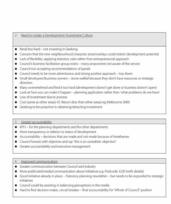
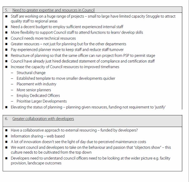
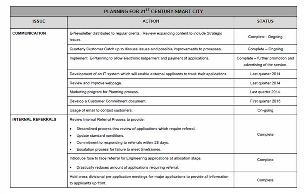
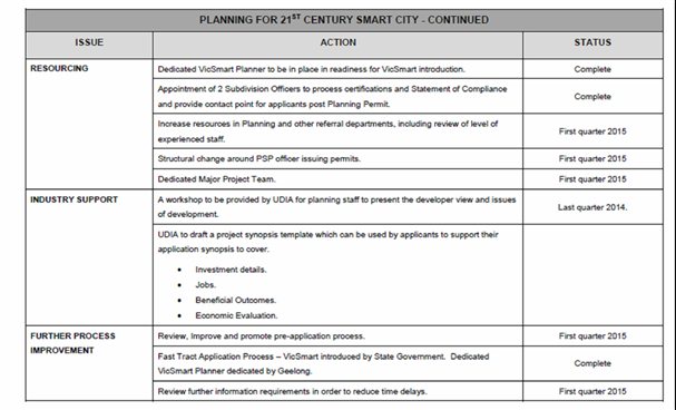
Cr S Kontelj declared an Indirect Interest by Close Association in Agenda Item 7 – Managing Future Growth – Further Investigation Areas in that the developers have donated to fundraisers associated with his wife’s Election Campaign and left the meeting room at 8.08, prior to discussion of the item.
[Back to List]
Portfolio: |
Planning - Cr Heagney |
Source: |
Planning and Tourism-Planning Strategy |
Chief Executive Officer: |
Peter Bettess |
Index Reference: |
Council Reports 2014 |
The purpose of the report is to advise Council on the proposed strategic program of works about to commence in relation to the two Further Investigation Areas identified in the G21 Regional Growth Plan.
The G21 Regional Growth Plan sets the direction for the growth of the region to reach a population of 500,000 by 2050. It examined all of the strategic work done by Councils and reported that there is a 20-30 year supply of zoned and strategically identified residential and employment land in the region.
The Regional Growth Plan identified two Further Investigation Areas (FIAs) to be examined for their potential to provide capacity for the G21 Region to grow beyond 500,000. The two areas are west of the Geelong Ring Road at Lovely Banks and Batesford South. The Regional Growth Plan noted that these areas would only be required in the longer term.
The Minister for Planning wrote to Council in May 2014 to seek Council’s support for the acceleration of land delivery in these areas.
Releasing land for growth imposes a significant cost on both Council and the State Government. Significant capital expenditure is required to deliver essential services to provide for future communities; this includes roads, drainage, sewerage, community centres, sporting facilities, schools, kindergartens, public transport, and health facilities.
A critical question is whether Council and the State Government can fund community infrastructure to an appropriate level for new communities without impacting on service to existing Geelong residents and as a result compromising the liveability of all communities.
The Managing Future Growth project seeks to define the financial obligations to Council which will arise if development in the FIAs is pursued in the short to medium term. The project will define the most appropriate methodology to deliver land for development. The project will also examine how best to manage infrastructure investment to ensure the provision of services does not lag behind population growth and to ensure that Council’s financial viability is not undermined.
The Managing Future Growth project will enable Council to be fully informed before making a decision as to whether the development of land should be accelerated in either of the FIAs.
Cr Heagney moved, Cr Ansett seconded -
That Council notes the scope of the Managing Future Growth Project which will:
define Council’s future financial obligations to service development in the two Further Investigation Areas identified in the G21 Regional Growth Plan;
define the best methodology to deliver land for development, consistent with the objectives and principles of the G21 Regional Growth Plan, with priority given to defining the boundaries of future growth areas, and
investigate how development could be financed, to ensure infrastructure investment does not lag behind population growth and ensure Council has the financial capacity to service development.
Carried.
The Minister for Planning wrote to Council in May 2014 seeking its support for the delivery of additional land supply by accelerating the Lovely Banks and Batesford South FIAs. The letter stated that this would provide diversity in the housing market, drive development in the Geelong Ring Road Employment Precinct, would be consistent with the government’s investment in the Regional Rail Link and meets the intention in Plan Melbourne to direct population growth to regional Victoria.
In response, Council highlighted the availability of sufficient land supply in multiple growth fronts across Geelong to meet the needs of the community for the next 20 years at projected growth rates. The figures for supply are based on detailed land supply analysis developed for the G21 Regional Growth Plan. Concerns were also raised about the inability to apply the Growth Area Infrastructure Contribution (GAIC) in Geelong which is a source of revenue for the State Government used to deliver State infrastructure and services to growth areas. The need for clear policy statements in the planning scheme about the need for additional planning studies as identified in the G21 Regional Growth Plan Implementation Plan, was raised particularly in the event that land was identified for inclusion in the Urban Growth Zone.
The two FIAs combined are larger than Armstrong Creek and provide capacity for over 80,000 people which substantially exceeds current growth forecasts and demand well beyond 2050.
The boundaries of the FIAs are not defined. Further strategic planning work is required before the boundaries can be determined.
The Managing Future Growth project has three key components;
economic analysis to inform Council about the budgetary impacts of delivering additional growth areas,
analysis of the best methodology for Council to deliver land for development and
assessment of and advice on how Council can meet these additional funding obligations to provide timely community infrastructure without jeopardising Council’s financial stability.
Council Funding Infrastructure
To definitively determine Council’s future funding liability for the FIAs, a significant amount of strategic planning work needs to be undertaken as a first step. The approach used with the Armstrong Creek Urban Growth Area was to develop an Integrated Infrastructure Delivery Plan (IIDP) to define what infrastructure was required to service the growth area. This was then used as the foundation for developing a Development Contributions Plan (DCP) which is a means for Councils to defray some of the infrastructure costs to developers for infrastructure such as road, landscaping and streetscape works, sports grounds, stormwater drainage and water quality works, bike paths, kindergartens, childcare centres and maternal child health facilities. Developing an IIDP and a DCP can only be done when a Growth Area Framework Plan has been approved.
Even though Council is applying Development Contributions Plans (DCP) in Armstrong Creek, in growth areas there is always a component of cost which must be met by the Council. The current liability to Council of the Armstrong Creek and Jetty Road growth areas is in the order of $19 million (at 2013 dollar value). This figure comprises our commitments under the DCP but does not include larger regional facilities such as the library, aquatic centre and indoor sport facility in the town centre at Armstrong Creek. Exact costings for these facilities are not available, but they are likely to be an additional $20 million. This figure also doesn’t include the “scaling up” of community infrastructure, where a basic facility might be upgraded to meet the expectations of the community. It also should be noted that part of the DCP is not indexed due to legislative restrictions, therefore if the growth area takes longer to develop, Council’s liability increases as the purchasing power of the capped part of the DCP diminishes over time.
Managing the timing of this type of expenditure is extremely challenging:
significant expenditure is required “up front”,
income streams for Council are dependent on housing take up rates,
Council is liable for compensating landowners whose land has been designated for open space yet we have no control about when compensation claims are lodged, and
increasing land values impact upon the amount of compensation payable.
An additional caveat on the figures mentioned above is that it only includes growth areas where DCP figures were readily available, it therefore doesn’t include Lara, Leopold, St Leonards and Ocean Grove all of which are positioned to accommodate significant population growth.
By way of comparison, Wyndham City Council has experienced significant population growth with up to 5000 new dwellings (12,230 people) per year representing a 7.8% growth rate. The population grew by over 52,000 people between 2006 and 2011. An amendment to the Wyndham Planning Scheme noted that their Council will need to invest $1.5 billion in infrastructure to service their projected growth. The projected growth of Wyndham is from 166,000 residents to about 425,000 in 2040.
State Government Funding Infrastructure
State Government is also responsible for funding infrastructure in growth areas such as state roads, public transport, schools, health care, police and emergency services. This is funded partly by money raised from the GAIC which is not capable of being applied in Geelong without legislative change.
In Melbourne’s growth areas, the rate of State Government investment in infrastructure has not kept pace with population growth. The ten councils on the edge of Melbourne, which contain the growth areas, commissioned independent analysis which revealed that their communities are significantly disadvantaged when compared to inner suburban counterparts using a number of benchmarks including education attainment levels, access to employment, access to hospitals, provision of things like TAFEs and libraries, and have poorer provision of public transport resulting in a reliance on private car travel. The One Melbourne or Two? report was commissioned in 2013 by the Interface councils to identify long term infrastructure requirements to bring livability standards for interface residents up to the standards enjoyed by non-interface metropolitan areas.
There are concerns about State Government investment in Geelong’s major growth area at Armstrong Creek as evidenced by:
lack of funding commitment to funding duplication of the Barwon Heads Road,
lack of funding commitment to the east west connector road from the Surf Coast Highway to the Barwon Heads Road,
lack of funding commitment to construct a primary school, with funding only provided for land acquisition. It is worth noting a recent presentation by the Department of Education showed that across the growth areas in Melbourne 128 new primary schools will be required, they advise that historically they deliver on average 6 schools per annum.
Opening up two new growth fronts at Lovely Banks and Batesford South in the short term will dilute the ability of State Government and Council to fund necessary infrastructure both in the new growth areas and in existing communities in Geelong. This will inevitably lead to a reduction in access to services for Geelong residents.
Avoiding ad hoc development
Base infrastructure such as water, sewerage, public transport, roads, schools, health facilities, libraries and other community services are critical to community health and well being in existing communities and in growth areas.
The G21 Regional Growth Plan-Implementation Plan recognised the importance of ensuring that residential land is supplied to the market at the right time, in the right place and with adequate services. The growth fronts in Armstrong Creek, Leopold, Ocean Grove, Drysdale/ Clifton Springs and Lara provide both sufficient supply of land and a diversity of housing choice. The land supply will also be augmented by the facilitative approach Council took when applying the new residential zones to provide opportunities for more infill housing developments in established areas. It also worth noting in the broader region that additional growth is planned at Torquay through the north Torquay and Spring Creek areas. Growth is managed and timed through structure planning reviews and infrastructure is being provided in most instances using the development contribution tool.
The G21 Regional Growth Plan-Implementation Plan warns against the creation of too many dispersed development fronts or creating an oversupply of residential zoned land. Other service providers for example Barwon Water and Powercor, also have to factor in costs to deliver services to new communities. These agencies were involved in the infrastructure planning underpinning the Regional Growth Plan which set a 20-30 timeframe for the development of the FIAs. The ability of these agencies to bring forward significant capital expenditure to service the FIAs in the short term is untested. Costs associated with delivering services to a new growth front in the FIA will result in will be passed on to consumers through higher costs for essential services like electricity, gas and water.
These agencies already have significant expenditure commitments to Armstrong Creek. Developing an FIA in the short term are likely to result in "stranded assets"; whereby service providers invest capital in infrastructure which becomes redundant because the expected growth does not occur. This non-performing asset effectively represents a lost income to a service provider. The investment uncertainty which results will also undermine the ability of providers to deliver adequate services at a reasonable cost to existing communities in Geelong.
The detrimental impacts of developing the FIAs earlier than required were explored in the Implementation Plan- Background Report. It states "there is potential for new growth areas developing out of sequence to:
divert or defer planning infrastructure rollout for schools or other community facilities from existing and planned communities
create infrastructure lags where communities are not properly serviced
create unsustainable communities which rely on travel outside their communities to use basic infrastructure such as schools, kindergartens or community centres."
For these reasons, in the future a decision will have to be made on which FIA should be developed first.
A clear roadmap to deliver development land
Timing on the release of land within the preferred FIA should have regard to land supply levels. The Implementation Plan recommended that land supply continue to be monitored on an annual basis to ensure Council meets it's obligations under the State Planning Policy Framework of providing a sufficient supply of land (minimum 15 years supply for the municipality). The process to deliver urban land in growth areas is detailed in Ministerial Direction number 12 and the VPP Practice note relating to the Urban Growth Zone. The G21 Regional Growth Plan-Implementation Plan had regard to these State polices and provides direction on a process to deliver urban zoned land.
This process would include assessment of which FIA should be advanced first, detailed land assets and constraints analysis and ultimately a Growth Area Framework Plan to inform Precinct Structure Plans and an Integrated Infrastructure Delivery Plan to determine infrastructure needs to serve the growth area. Council would also need to consider Investment Attraction Strategies to create employment in the growth areas.
Once growth areas are defined appropriate zoning can be applied with strong policy statement outlining timing and the process to deliver land.
A similar roadmap was followed in the Armstrong Creek Growth Area. More detail on how this process should occur will be provided as part of the Managing Future Growth project.
Potential options to fund infrastructure
The third component of the Managing Future Growth Project is the examination of potential funding mechanisms to finance infrastructure in the FIAs, particularly if they are to be delivered ahead of need. As noted previously the GAIC is only able to be in Melbourne’s growth areas. There may be merit in advocating for this charge to be levied in regional areas also. Council could advocate for these changes if it is found to be appropriate.
Recent changes to the DCP system have seen the introduction of an “off the shelf” DCP which effectively applies default contribution rates in growth areas. Councils wishing to apply a higher DCP amount, known as a supplementary rate, can only do so in exceptional cases. The circumstances around this will be explored further in the Managing Future Growth project.
Concerns have been raised about the “off the shelf” DCP system potentially reducing the amounts that Council is able to defray to developers.
Other potential options could include investigations into the use of public private partnerships for community infrastructure, reducing/redefining service delivery levels in growth areas or across the municipality, or advocating for change to legislation to provide betterment levies or some other land value capture arrangement.
Environmental implications will be considered in detail through future work in the FIAs and planning controls to protect the environment will be included in future amendments to the Greater Geelong Planning Scheme.
The G21 Regional Growth Plan-Implementation Plan recommends that the principles of zero carbon, zero waste, sustainable water and sustainable transport be embedded in planning for the FIA’s.
Funding for the “Managing future growth project” was provided in the 2014/15 budget. The scope of this project was to determine Council’s future funding obligations in delivering the two new growth areas and provide some high level analysis of State Government infrastructure that will be required.
Circumstances have changed as a result of the Minister’s letter. In response the scope of the project will now be expanded to include two extra components; analysis of the best methodology for Council to deliver land for development and advice on how Council can meet these additional funding obligations to provide timely community infrastructure without jeopardising Council’s financial viability.
The State Government has established a fund to assist Councils with implementation measures arising from their regional growth plans. Opportunities to secure additional funding from this fund will be explored, this is particularly important as the scope of the project as been broadened.
Future budget proposal.
As detailed in the body of this report, land development in the FIAs will have significant impacts on Council’s budget as infrastructure will be required for new residents. The timing of this is yet unknown. The costs of undertaking the expert technical analysis and strategic planning work will be the subject of future budget proposals. Financing the infrastructure needs of development in one or both of the FIAs, in addition to the existing funding obligations in Armstrong Creek and other growth areas will have serious impacts on Council’s budget. Future decisions should have regard to the viability of the budget.
Council’s adopted policy position on the FIAs is that they are the long term options for Geelong’s growth. Proposals to advance development in the FIAs would necessitate a change to this policy which would be given statutory effect via an amendment to the planning scheme. This would also necessitate a change to the State section of the VPPs which designate the FIAs as long term growth options.
Undertaking the Managing Future Growth project will inform Council’s position on how and when to proceed with in the FIAs. The project will address the legal and statutory requirements including the development contribution scheme, issues around the GAIC and define a roadmap which would deliver development land in a co-ordinated well planned manner.
The Managing Future Growth project aligns with the directions of the Sustainable and Built Environments themes in City Plan.
No Council officer involved in the drafting of this report has any direct or indirect interest, in accordance with Section 80(C) of the Local Government Act in the land to which this report relates.
The key risks in the Managing Future Growth project are related to the need to responsibly manage the budget and appropriately service growth areas without impacting on the service delivery to existing communities. These are the core elements of the project.
Social considerations have been considered recognising the need to provide land for housing and employment and Council’s duty of care to deliver liveable communities not just subdivisions. Providing appropriate community infrastructure will be a key part of the Managing Future Growth project.
We have taken into consideration the human rights relative to the subject matter of this report, including rate-payers property rights and the right to a fair hearing.
The Managing Future Growth project will involve targeted consultation with key stakeholders where appropriate, this will include service providers, land owners, other growth area councils and the State Government.
Cr S Kontelj re-entered the meeting room at 8:27pm.
[Back to List]Portfolio: |
Infrastructure - Cr Ellis |
Source: |
City Services - Engineering Services |
General Manager: |
Gary Van Driel |
Index Reference: |
Subject: Draft Victorian Floodplain Management Strategy |
The purpose of this report is to inform Council on the draft Victorian Floodplain Management Strategy (VFMS) and the impacts that the proposed policies, actions and accountabilities within the report may have on Council.
The Draft Victorian Floodplain Management Strategy was released on the 26 June 2014 by the Victorian Government and is to replace the 1998 Victoria Flood Strategy
The VFMS has been developed by the State Government in response to the flood emergencies within various Victorian communities that followed the significant rainfall events of 2010 and 2011.
The Municipal Association of Victoria (MAV), Association of Bayside Municipalities and Western Alliance for Greenhouse Action provided detailed submissions on the VFMS.
It is recommended that council provide a submission supporting the views of the above organisations as detailed in this report.
Cr Ellis moved, Cr Richards seconded -
That Council prepares a formal submission based on the MAV response to the Draft Victorian Floodplain Management Strategy.
Carried.
This Draft Victorian Floodplain Management Strategy: Living with Floods provides an opportunity for community input to the actions, policies and accountabilities that will set the direction for floodplain management in Victoria over the next decade. It replaces the 1998 Victoria Flood Strategy.
It aligns with the Victorian Government’s responses to the Victorian Floods Review and the parliamentary inquiry into flood mitigation infrastructure. It also aligns with the broader emergency management framework set out in the Emergency Management Act 2013. Importantly, by considering whole-of-water-cycle-management (WWCM) it also helps to integrate floodplain management with the government’s urban water reform agenda, the Victorian Waterway Management Strategy and the ‘yet to be adopted’ Victorian Coastal Strategy./
There are four key parts to this strategy:
ASSESSING FLOOD RISKS AND SHARING INFORMATION sets the framework for assessing and prioritising management linked to the level of flood risks;
AVOIDING OR MINIMISING FUTURE RISKS sets the proposals and accountabilities to avoid making matters worse. Mitigating flood risks through appropriate planning and building and also planning around coastal inundation.
REDUCING EXISTING RISKS clarifies the institutional arrangements for both structural and non-structural measures to mitigate the risk and consequence of floods. It also explains how flood warning systems will be tailored to meet community needs and how the long-term risks of nuisance flooding will be managed through reduced stormwater runoff.
MANAGING RESIDUAL RISKS focuses on how access to better information can reduce the consequence of flood events for individuals and emergency managers in responding to emergencies. The response and recovery activities align the strategy with the broader emergency management framework.
The VFMS addresses many long-standing issues and the MAV supports several of the proposals contained in the strategy. In particular the MAV supports a risk-based approach to floodplain management and investment, greater transparency in decision-making and robust community engagement.
The MAV expresses concern that local government will be bearing much of the decision making responsibility and with it, the cost and risk burden and associated liabilities.
The VFMS is clear in expressing the State’s commitment to closing the gap in the flood data, modelling and mapping but is non-committal on how this can be practically achieved. Considerable reliance is placed on the sound framework provided by Melbourne Water (MW) servicing the Melbourne area but expects a similar contribution from the Catchment Management Authority(CMA) and local government in a regional context.
There is a major concern about the section on sea level rise and coastal flooding. Whilst climate change issues in relation to coastal environments are rightly the domain of the yet to be released Victorian Coastal Strategy, the overlap on matters relating to land subject to inundation from sea level rise and storm surge including flood hazard from flow velocities deserve adequate attention in the VFMS. At this stage there is no defined policy but for coastal councils the pressures and implications of sea level rise and coastal inundation are as serious as other modes of flooding.
The planning process as succinctly defined in the VFMS falls clearly into the broad categories of Strategic Planning and Statutory Planning. In essence, Strategic Planning looks after itself in that the whole process of land capability analysis can rightly seek whatever information, studies etc that is necessary to arrive at an informed recommendation leading ultimately to Structure Plans and Planning Scheme Amendments. On the other hand, Statutory Planning is driven by only what is in the scheme and is exacerbated by legislated timeframes.
Although the draft VFMS identifies shortfalls in coverage, there is an inherent problem where the planning scheme is viewed by planning practitioners and the public as a comprehensive coverage for identifying all hazards.
Given the cost and complexity of flood studies and resulting mapping of a standard capable of inclusion in a planning scheme, complete coverage of a municipality requires time and considerable investment and currently funded largely by council.
Any strategy should therefore account for this issue by providing a strengthened avenue for interim intervention by councils in relation to requesting appropriate analysis in circumstances where it can be reasonably suspected that inundation could affect particular sites, (whether coastal inundation from climate change affects or waterway catchment-related flooding or stormwater flooding).
It is acknowledged that the process of utilising the relevant Regional Emergency Response Planning Committee as a vehicle to prioritise planning scheme amendments goes someway to assist the process. Council believes the need for a strong collaborative partnership between the CMA and local council to be essential. However, unless they are adequately resourced, CMAs will struggle to match MW as the technical experts nor provide the same level of support. CMAs should, by the nature of their stated role, continue to be the project manager of flood studies.
It should be noted that Council have recently adopted a Flood Management Plan for this municipality and which was developed in conjunction with MW
The following are the main recommendations from the MAV in response to the VFMS;
Clarify that the flood map requirements only apply to maps which are to be added to the VFD and that agencies carrying out self-generated flood mapping exercises will be encouraged, but not required, to follow DEPI guidelines.
Flood studies should continue to be shared by CMAs/ MW and councils. They should be project-managed by the CMA/ MW.
The MAV work with DEPI and DTPLI to develop an alternative strategy to address the barriers preventing the planning and building system from reaching its full potential and adequately managing flood risk.
The strategy clarifies that the State is responsible for regional growth plans.
A working group is established to further develop the access and egress proposals.
The strategy should include a clear policy for cost sharing capital works for mitigation infrastructure on the coast.
Local government should not be responsible for funding maintenance of gauges.
The strategy should clarify that it is not a local government responsibility to issue local flood warnings or manage local flood warning systems. Any data collected through local systems should be provided to the Bureau of Meteorology and VicSES to be used in their warnings.
That the strategy provide unambiguous policies for each of the types of levee and flood mitigation infrastructure.
That the State extend its commitment to cost sharing arrangements for major capital works for rural levees that clearly provide public benefit.
The MAV proposes various recommendations relating to Flood Mitigation measures eg Levees which at present do not impact on this municipality as the Levees are managed and maintained by council.
Refer to Appendix 1.
There are no environmental implications in considering this report. Once the Committee hands down its final recommendations to the Minister Council will have to consider any new policy or planning controls which may have environmental implications.
There are no financial implications in considering this report. There may be long term implications depending on what the Minister instigates at the end of this process. This could be in the form of new planning controls which may require more funding and resources.
The City has various statutory responsibilities for drainage management and flood management (prevention, response and recovery) as set out in the Local Government Act 1989, Local Government Regulations 1990, Planning and Environment Act 1987,Building Regulations 2006, Water Act 1989, Subdivision Act 1988 and Emergency Management Act 1986. There are no policy or legal implications in considering the report at this time.
The recommendations of this report are consistent with City Plan, in relation to Growing our Economy and promoting a sustainable built environment, sustainable land use and development.
No officer involved in the preparation of this report has any direct or indirect interest relative to the advice provided in this report.
There are no risks to consider in this report. Once the Committee hands down its final recommendations to the Minister Council will have to consider any associated risks.
There are no social implications to consider in this report. Once the Committee hands
down its final recommendations to the Minister Council will have to consider any new policy or planning controls which may have social implications
The future implementation of this Strategy strives to enhance community safety. and is consistent with the obligation under the Victorian Charter of Human Rights and Responsibility.
The preparation of the submission to the VFMS has had input from the Design Unit and the Environment Unit.
Draft Victorian Floodplain Management Strategy
The following is the City of Greater Geelong Council’s response to the Draft Victorian Floodplain Management Strategy (VFMS) and note that it concurs with the areas of concern espoused by the Municipal Association of Victoria (MAV).
There are areas where MAV concerns could be strengthened, particularly in the assumptions on what could be seen as ‘devolution’ of responsibilities from the state to local government.
This is evident in the domain of responsibility for levees and other flood mitigation infrastructure, and is particularly concerning where reference is made to the impact of rising sea level as an effect of climate change. Responsive actions are clearly defined as local government responsibility, which is concerning from the point of view of leaving local councillors with the decision on ‘….to what extent embarking on a program of building defensive structures should be pursued’. The lead here should be at state level, such as for example where the State planning schemes included the predicted 2100 sea level rise referenced at 0.8 m and with more scrutiny on land below 5.0 m AHD etc. For local councils this has provided some level of certainty and comfort, at least in the short term.
The City of Greater Geelong Council along with the MAV is very concerned at the direction of both the Victorian Coastal Strategy (VCS) and the VFMS that adaptation planning is squarely a local government responsibility. This point is of grave concern for local councils that have significant coastline, and heightened where in some instances this can be all or in part comprised by estuarine, bay side and ocean coast. The fear is founded on the likelihood that there will be a slow, incremental growth in the demand for councils to embark on a program of building and maintaining defensive structures to protect private development, and that without adequate analysis, the options for coastal treatments ranging from natural coast recession (do no defensive structures) through to major defensive seawalls will be pre-empted by the unwitting precedent of taking action.
Local councils should not be expected to fight this battle individually. Similarly, the decision to build defensive or mitigation infrastructure in possible contrast to what a logical and sustainable climate change adaptation strategy might recommend should not rest with local Councils alone.
A summary of the concerns that the City of Greater Geelong have with certain areas of the draft VFMS are as follows:
There is an inherent problem where the planning scheme is viewed by planning practitioners and the public as a comprehensive coverage for identifying all hazards. Given the cost and complexity of flood studies and resulting mapping of a standard capable of inclusion in a planning scheme, complete coverage of a municipality requires time and considerable investment, generally at the financial cost to the local council. Assumptions for ‘developability’ based on the fact that ...‘because it is not identified in the planning scheme, then it is unencumbered land’ can have long term negative impacts. Any strategy should therefore account for this issue by providing a strengthened avenue for interim intervention by councils in relation to requesting appropriate analysis in circumstances where it can be reasonably suspected that inundation could affect particular sites, (whether coastal inundation from climate change affects or waterway catchment-related flooding or stormwater flooding).
The Greater Geelong Planning Scheme (GGPS) is not reflective of all areas where flooding (either storm flooding or catchment (waterway/floodplain) is not complete across the municipality because not all catchments have been either fully or selectively studied. The planning interpretation squarely suggests that if the area is not shown in the scheme either by zone or overlay, then it is in not affected by inundation. This is not the case and hence the scheme and the Planning and Environment Act in general should make allowance for this ‘interim’ nature of the scheme. Further, the GGPS does not account for areas for which a designated flood level (minimum floor level) applies under the Building Regulations, or indeed studies that now need reviewing.
This Council’s approach to defensive or remedial flood mitigation infrastructure is to include costed options including cost-benefit analysis so that the value or feasibility of these options can be assessed. Particularly in relation to storm or flash flooding, to provide 1 % AEP protection, remedial options are seldom justifiable or affordable. These cases often relate to outmoded drainage systems designed on historic parameters would require total system augmentation which almost exclusively are not viable. For flood studies to be of value, it is requested that this approach could be an integral part of all flood studies, unless of course the studies form part of land capability analysis for determining the future potential of undeveloped land.
The primary source of community complaint in relation to designating or enshrining ‘flood-proneness’ within the planning schemes (or designation under the Building Legislation) is to object on the basis of perceived ‘increased insurance premiums, loss of property value and hence a request for compensation’. Local government is ill-equipped to deal with this on an individual council basis.
Attempts to standardise methodology and outputs of flood studies across the state is a reasonable objective. However, this could go further if undertaken in this ‘standardising’ manner. The question is asked, should there also be a streamlined approach to incorporating each study into planning schemes rather than individual amendment for each? Is there a venue via say ministerial amendment to fast track inclusion in planning schemes?
Next review of the City of Greater Geelong flood management plan to take on a multi-stage Regional Floodplain Management Plan type of framework – ie. a coarse grained/scale municipality wide mapping (DEPI/CCMA) to identify areas requiring further investigation, whether waterway/floodplain (CMA) or drainage related (COGG)
Chapter 10 recognises that planning/building controls are an effective method of regulating development within flood plains. Currently there is inconsistency within the planning scheme between the powers of Melbourne Water (MW) and CMA, in that MW is a determining referral authority (right of veto) in flood zones/overlays whereas CMA is a recommending authority. In reference to the first point as well, the recent requirement of providing velocity estimates in order to determine hazard level lacks clarity as to which organisation (Local Government or CMA) is neither responsible or indeed equipped to provide an evaluation.
The document is written in such a way that it appears MW and regional CMA has equal resources and capabilities. Obviously this is not the case, given their original reasons for existence and functions outside of floodplain management.
Flood modelling developed for the purposes of rezoning land is not generally incorporated into planning scheme for a variety of reasons. Should it now be a requirement for every amendment involving a modified floodway/waterway? Generally only the critical 1% AEP flood event is modelled - Developers will be reluctant to undertake additional modelling in order to meet DEPI guidelines covering a range of events – delays, cost, etc. - cost implications for Council to expand the scope.
Section 10.2.4 suggests VICSES provide advice on safe access/egress. I would suggest they could only provide fairly generic advice other than guidelines around the capabilities of rescue vehicles/vessels and what volunteers can/can’t do, and have fewer resources than CMAs at a regional level.
Section 18.2 talks about including a probability of flooding on Land Information Certificates rather than the risk of flooding during the 1% AEP event. Implications on data retention and dissemination for Councils – may require a statewide framework ie. Flood database.
There is a need for DEPI to review all reference to identification and subsequent implementation of ‘flood-proneness’ in all local government, planning and building regulation. For example, reference to ‘specified flood level’ in Local Government regulation in relation to Land Information Certificates is an anomaly.
Finally, I reiterate that the City of Greater Geelong is very concerned that Councils will be burdened will the significant resource and financial cost of flood management particularly of coastal areas.
Portfolio: |
Community Development – Cr Fisher |
Source: |
Community Services / Community Development |
General Manager: |
Jenny McMahon |
Index Reference: |
Subject: Community Grants Documentation 2014 |
The purpose of this report is to present to Council for noting a summary of successful Community Grant applications for the period 1 July to 31 August 2014 to Council for noting.
This forms part of the ongoing accountability framework for managing the Community Grants Program in accordance with the City of Greater Geelong Grants, Contributions, Donations and Sponsorship Policy.
The Community Grants Program has an annual budget allocation of $240,000 that is available to expend on groups which apply and are eligible under this grants program.
As part of the accountability framework for managing the Community Grants, details of applications and allocations are reported to Council.
Thirty applications have been approved for the period 1 July to 31 August 2014, with a combined total of 72,378.60. A summary of these grants is provided in Appendix 1.
Cr Fisher moved, Cr E Kontelj seconded -
That Council:
notes the allocation of funds under the 2014/2015 Community Grants Program to the community groups and organisations as detailed in Appendix 1 for the period 1 July to 31 August 2014;
commends and congratulates the community groups and organisations who have received funding under the Community Grants Program for their efforts and contribution to the Geelong community.
Carried.
The Community Grants Program is available to not-for-profit community groups and organisations which can apply for funds to support either ward based or municipal wide activities or events that will benefit the Geelong community.
In order to receive funds, applicants must comply with the established guidelines which govern the grant program.
The total budget for the grants program for the 2014/15 financial year is $240,000.
In the period 1 July to 31 August, thirty grants were approved, with a combined total of 72,378.60.
The allocation of grants assists with meeting the objectives of Council by providing an opportunity to enhance the wellbeing of the community by building social capital and enabling community engagement through the provision of funds to assist with local activities.
Appendix 1 provides a list of groups, the type of projects and the amounts that were approved during this period.
Some projects supported via this grant program undertake environmental activities.
There are no financial implications. All funds to date have been expended in accordance with the Councillor Community Grants Guidelines and within budget.
The provision of grants to the community supports local, community organisations and supports the aims of City Plan and the G21 Regional Plan.
This report is presented in accordance with the City of Greater Geelong Grants, Contributions, Donations and Sponsorship Policy.
This report is presented in a different format as a new management procedure is being developed as advised by recent audits and proposed changes to the local Government Act outlined in the local Government Amendment (Governance and Conduct) Bill 2014.
The Community Grants Program aims to fund projects that assist in achieving goals and outcomes consistent with City Plan‘s Community Wellbeing objectives.
The provision of grants is offered to assist community organisations to provide opportunities that benefit the wider Geelong community.
Applications are encouraged that demonstrate or promote social inclusiveness, provide broad benefits to the City of Greater Geelong community and respond to environmental issues/impacts.
The provision of grants is carried out in accordance with the Local Government Act 1989 Officer Direct or Indirect Interest.
The Councillor Community Grants Program has provision in the assessment process to record any conflict of interest relating to each grant application that is assessed.
The Community Grants Program is governed in accordance with Council’s monitoring, reporting and accountability framework.
Successful applicants are provided with an evaluation form for their completion and return to Council as a record of the outcome of the grant funding they received. Annual audits are also conducted on a sample group of grant recipients.
The provision of Community Grants provides an opportunity to support and strengthen communities to provide a broad range of activities for the benefit of the Geelong community.
The Grants, Contributions, Donations, and Sponsorship Policy references the Chart of Human Rights and Responsibilities Act 2006.
The Charter states that human rights are essential in a democratic and inclusive society that respects the rule of law, human dignity, equality and freedom.
The provision of grants provides opportunities to assist in promoting social inclusiveness and projects that deliver broad community benefit.
All groups are notified of the outcome of their grant application.
The list of allocations will be reported on the Geelong Australia Website.
The Community Development Department is responsible for communication of all matters relating to this report.
Portfolio: |
Sport and Recreation - Cr Irvine |
Source: |
Recreation, Projects and Central Geelong |
General Manager: |
Dean Frost |
Index Reference: |
C11827 Shell Road Reserve Pavilion Development |
The purpose of this report is to seek Council consent to delegate to the Chief Executive Officer the power to accept or reject tenders for the Shell Road Reserve Pavilion Development project, provided tenders fall within adopted budgets.
The design process for the Shell Road Reserve Pavilion Development has recently been completed and Council has invited tenders for the construction of this facility.
The Capital Projects and Procurement Services departments are exploring prudent and expeditious mechanisms to complete the tender processes for the project.
The project is running to very tight and ambitious deadlines and the necessity to award the tender close to the Christmas and New Year period poses a potential risk to project timelines due to the reduced Council meeting cycle during that period.
Cr Irvine moved, Cr Farrell seconded -
That Council delegate to the Chief Executive Officer its powers and functions to accept or reject a tender and sign the contract documents for the construction and associated works for Project C11827 Shell Road Reserve Pavilion Development provided tenders are within budget.
Carried.
Since receiving funding for the Shell Road Reserve Pavilion Development project, Council has moved through the project development phases and has now finalised the design of the facility.
Council has entered the procurement phase for this project.
This project is being tendered through the State Government Construction Suppliers Register (CSR). The CSR allows local government to enter into contracts for the purchase of building and construction services.
The rules for utilising the panel state that we must seek tenders from a minimum of five (5) pre-qualified contractors registered with on CSR panel. Two of which are to be locally based companies and one of which hasn’t been invited to tender in the last six (6) months.
This process provides council with the shortest possible tendering timeframe, and if they can be awarded under delegation will allow Council the best opportunity to deliver these projects on time.
The Capital Projects and Contracts and Purchasing departments are exploring prudent and expeditious mechanisms to achieve opening deadlines for the facility, noting that the construction contract will be beyond officer delegations.
The current project timeline will see the full documentation and contract specifications for the project finalised and be ready for awarding between November 2014 and January 2015.
The timing for the appointment of a contractor means that it would be beneficial if the Chief Executive Officer can enter into the contracts under delegation. This is because the Council reporting process generally takes between 4 and 6 weeks to complete.
Further, if the project is not ready for a tender award until late December or early January there is limited opportunity to report back to Council on the outcome of the tender process due to the Christmas/New Year holiday period.
If awarding of this contract is delayed it could have a major impact on project delivery, as it could limit the ability for the project to commence once the tender evaluation process is complete.
The building is designed with due consideration given to energy efficiency and achieves Section J compliance.
The building has not been designed to a 5 Star rating as the design process commenced prior to the introduction of Council’s policy.
This project is funded by the Federal Government’s Community Development Grants Programme ($3.5M) and Council budgetary allocations totalling $2.5M in the forward Capital Project program.
The grant commitments are dependent on Council meeting progress milestones and opening dates. Therefore our ability to move through the tender stage under delegation will help us meet funding conditions.
Against the above timeframes and expected milestones there may be inadequate time for Council to formally determine the outcome of the tenders in its normal capacity. This report provides the policy and legal mechanisms necessary for the CEO to award or reject tenders.
This project is contained within Council’s budget and supports the strategic directions in our Community Wellbeing, Growing Our Economy, and Sustainable Built & Natural Environment areas.
No council officers involved in this project or report have declared a direct or indirect interest in this matter.
There will be a risk to Councils reputation and grant funding commitments if this project cannot be completed as per the Funding milestones and in time for the winter 2016 season.
Council’s commitment to the construction of the Shell Road Reserve Pavilion Development project is in response to the Ocean Grove Sporting Infrastructure Plan
If Council is unable to complete this project in a timely manner there is likely to be disruption to the operations of local sports clubs.
It is not evident or likely that this report would negatively impact any of the rights contained in the Charter of Human Rights.
There are no communication issues or requirements with acceptance of the proposed recommendation.
Portfolio: |
Governance - Cr Lyons (Mayor) |
Source: |
Corporate Services - Mayor and Councillor Support |
A/General Manager: |
Michael Kelly |
Index Reference: |
Subject Policies and Procedures |
To update the Councillor Expenses and Facilities policy.
The Local Government Act (1989) requires that Council have a policy for the purposes of dealing with reimbursement of Councillors’ Expenses.
The Council has a policy which supports the requirements of the Act (sections 74 and 75) relating to the payment of allowances and out-of-pocket expenses to the Mayor and Councillor’s.
The Councillor Expenses and Facilities policy has been updated to clarify Council’s position in relation to attendance at political fundraising events and the management and distribution of Mayor and Councillor Invitations.
Approved policies are made available to the public through Council’s website.
Cr Heagney moved, Cr E Kontelj seconded -
That Council endorse the Councillor Expenses and Facilities policy.
Cr Macdonald left the meeting room at 8:46pm
Cr Macdonald re-entered the meeting room at 8:47pm
Carried.
The Council has its own Council Expenses and Facilities Policy to assist Councillors in the discharge of their civic, statutory and policy making functions, Council is responsible for the provision of a range of necessary facilities and the reimbursement of expenses specified within the policy.
The Councillor Facilities and Expenses policy also provides facilities and services that are available to the Mayor and Councillors in the performance of their civic duties.
The Councillor Expenses and Facilities policy has been reviewed and updated regarding political party fundraising events for which payment is required and for the purpose of providing details regarding the management of Mayor and Councillor invitations received.
The purpose of the Councillors Expenses and Facilities Policy is to ensure that there is accountability and transparency in the reimbursement of expenses incurred by the Mayor and Councillors.
The various items covered by the Councillors’ Expenses and Facilities Policy include travel and childcare expense reimbursement, secretarial assistance, communications and office equipment.
The Policy also ensures that the facilities provided to assist the Mayor and Councillors in the effective discharge of their civic duties is reasonable.
The Councillor Expenses and Facilities Policy identifies accountabilities and also clarifies what is eligible expenditure for the purposes of reimbursement.
The existing Council Expenses and Facilities Policy provides the Mayor and Councillors opportunity to attend training programs, meetings conferences and functions etc based on relevance to the role and development of the Councillor with regard to Ward, Portfolio or Mayoral appointed committee or delegate responsibilities.
An annual limit for each Councillor of $3,500, is included in the existing Policy and is indexed in accordance with any movement in the General Consumer Price Index.
The existing Councillor Expenses and Facilities Policy does not define every type of activity that could be offered to the Mayor and Councillors in the application of attending events and functions relevant to responsibilities of civic office.
The updated Councillor Expenses and Facilities Policy attempts to provide greater clarity to the Mayor, Councillors and staff making arrangements regarding the attendance and payment at political fundraising events and the management and distribution of invitations that have been received from external sources.
There are no environmental implications.
The policy has been modified to ensure that attendance at political fundraising events is not covered by Council funds.
The implementation of managing invitations in this policy requires an additional 29 staffing hours per month or $9,135 in the 2014/2105 operational budget.
This policy has been developed in accordance with relevant legislation.
The policy aligns with ”How we do Business”.
No officer involved in the preparation of this report had a direct or indirect interest.
Clearly articulated policies provide Council with a consistent and publicly declared position. This will assist in reducing the risk and negative consequences to Council that may occur through inconsistent decision making, actions or practices.
Social considerations have been taken into account in the development of this policy.
Human Rights are considered in the updated policy.
Once approved, the policy will be accessible through Council’s internet website. Relevant stakeholders were consulted in the update of the policy.
Cr E Kontelj declared an Indirect Interest by Close Association in Agenda Item 12 – Consideration of Tender Submissions for Tender T1400033 – Drysdale landfill Cells 6 and 4A Liner Construction in that one of the tenderers is a customer of his employer and left the meeting room at 8.51pm, prior to discussion of the item.
Portfolio: |
Environment and Sustainability – Cr Richards |
Source: |
Environment and Sustainability |
General Manager: |
Gary Van Driel |
Index Reference: |
Project T1400033 |
To provide Council with the requisite information to facilitate the approval of the tender evaluation panel’s recommendation in relation to the Drysdale Landfill construction of the Cell 6 liner and Cell 4A bund wall tender.
Council has sought tenders for the construction of the Drysdale Landfill Cell 6 liner and Cell 4A bund wall.
A total of three companies have provided tender submissions for the specified works at the Drysdale Landfill.
Following a detailed evaluation of each of the submissions it is considered that the tender submission of Goldsmith Civil and Environmental Pty Ltd is preferred.
Cr Richards moved, Cr Ellis seconded -
That Council accept the tender submission from Goldsmith Civil and Environmental Pty Ltd for a lump sum cost $4,431,094.00 for Tender No T1400033 – Drysdale Landfill Construction of the Cell 6 liner and 4A bund wall. Council to sign and seal the contract documents.
Carried.
Public Tenders were invited in January 2014 for a Registration for Expressions of Interest (REOI) – Cell Construction Works Drysdale Landfill Cell 6 liner & Cell 4a bund wall which resulted in the receipt of eight (8) registrants.
As the works to be undertaken are to be in accordance with strict Environmental Auditor requirements as set out EPA Victoria the EOI included mandatory criteria that Contractors must have the following experience and accreditation:
Recent BPEM compliant landfill cell construction experience (within the past three (3) years) in excess of $1.5 million in value involving an Environmental Auditor Construction Phase process.
Contractor’s own Quality system that is certified ISO9001 or equivalent (equivalent being an industry or independent certification such as the CCF).
The project’s Evaluation Panel determined that based on the information provided by tenderers that three companies Ertech Pty Ltd, Goldsmith Civil & Environmental Pty Ltd and Thompson Brothers Earthmoving Pty Ltd met the mandatory criteria of the EOI.
Following the short listing EOI process tenders were invited on 31 May 2014 from the three companies and at closure of tenders on 2 July 2014 all three bids were registered and forwarded to the panel for consideration.
The tender submissions associated with this project were evaluated by a panel consisting of:
|
Gary Van Driel |
General Manager City Services |
|
Scott Cavanagh |
Manager Capital Projects |
|
Anthony Boseley |
Project Manager Capital Projects |
|
Colin Hatton |
Co-ordinator Capital Projects |
|
Shane Middleton |
Co-ordinator Waste Management |
|
Peter Walker |
Senior Contracts Officer, Procurement Services (non-voting member) |
OHS mandatory requirements applies to this Tender.
All three submissions responded to all mandatory requirements set down in the Tender documents and are considered to conform.
Tender submissions were assessed based on the respondent’s performance or tender response in the following areas:
|
Criteria |
Weighting |
|
Financial Assessment |
50% |
|
Detailed Methodology/Plan for performing contract |
20% |
|
Capability & experience, proposed staffing, equipment & subcontractors |
15% |
|
Past Performance over the past 3 years |
10% |
|
Economic Contribution to the Geelong Region |
5% |
|
|
100% |
At the conclusion of the evaluation the tenderers were ranked in the following order in accordance with the above criteria:
|
Tenderer |
Rank |
|
Goldsmith Civil & Environmental Pty Ltd |
1 |
|
Thompson Brothers Earthmoving Pty Ltd |
2 |
|
Ertech Pty Ltd |
3 |
Goldsmith Civil and Environmental Pty Ltd demonstrated significant experience in landfill works having undertaken similar landfill works at numerous sites including the construction of cells at Boral Western Landfill Deer Park, Fraser Road Landfill Clayton South, Carroll Road Landfill Oakleigh South and the Mugga Lane Landfill Canberra.
Goldsmith Civil and Environmental was then shortlisted and subsequently performed well at interview.
At the conclusion of the evaluation process, the evaluation panel determined that Goldsmith Civil and Environmental Pty Ltd, the highest ranked and lowest priced tender represented best value to Council and believe they have the experience, skills, resources and proven methodology that will enable them to successfully complete the project for Council.
The Evaluation Panel recommend Goldsmith Civil and Environmental Pty Ltd be awarded this tender.
Given the nature of the service provided there are environmental implications associated with this contract that may arise from the execution of this service / works. It is considered that these are the responsibility of the Contractor and will be managed through the contract documentation. However Council will closely manage this contract to minimise potential environmental issues.
The tender amount recommended is within initial budget.
The requirements of Section 186 of the Local Government Act have been complied with for this tender. There are no other policy, legal or statutory implications associated with this tender process.
Councils waste services requirements are incorporated into the key City Plan objectives.
No officers involved in the preparation of this report have a direct or indirect interest in matters to which this report relates.
There are not considered to be many risks associated with the acceptance of this tender that cannot be managed through the contract conditions. Associated risks on site will be closely managed by both Council and the contractor.
There are no social implications that will arise from the acceptance of this tender.
There are not anticipated to be any Human Rights impacts associated with the acceptance of this tender.
There are no communication issues associated with the acceptance of this tender. Council’s representative will liaise with affected community groups.
Cr E Kontelj re-entered the meeting room at 8:54pm
Portfolio: |
Finance – Cr Lyons (Mayor), Cr S Kontelj & Cr E Kontelj |
Source: |
Property Management - Corporate Services |
A/General Manager: |
Michael Kelly |
Index Reference: |
Land Sales |
That in accordance with Section 89 (2)(d) of the Local Government Act 1989, this contractual matter be considered at the conclusion of all other business at which time the meeting be closed to members of the public.
Carried.
Contents | Previous Page: Section A - Procedural Matters | Next Page: Section C - Notice of Motion

Copyright CoGG 2012
Last Update: 1 October 2014