
Contents | Previous Page: Section A - Procedural Matters | Next Page: Section C - Notice of Motion
Reports tabled at the Ordinary Meeting of Council on Tuesday date held at Portarlington Cricket and Football Club, 4-46 Province Boulevard in Highton.
Amendment C312 St Leonards Structure Plan 2014 – Consideration of Panel Report and Adoption
Submission to Central Coastal Board Draft Regional Coastal Plan 2015-2020
Rear 307-313 Pakington Street, Newtown – Proposed Laneway Construction SRC341 – Intention to Declare
Portfolio: |
Major Projects – Cr Macdonald |
Source: |
Planning and Tourism - Planning Strategy |
General Manager: |
Peter Bettess |
Index Reference: |
Bellarine Peninsula Safe Harbour |
The purpose of this report is to provide an update on the progress of the Portarlington Harbour redevelopment.
Council has partnered with the Department of Economic Development, Jobs, Transport and Resources to prepare an Implementation Plan for the redevelopment of the Portarlington Harbour.
The redevelopment of the Portarlington Harbour will grow the local economy through the expansion of the commercial fishing and aquaculture industry and opportunities for tourism development.
The Implementation Plan, incorporating a business case will articulate the social and economic justification for the harbour redevelopment, responsibility for delivery and identify opportunities for private sector investment.
Cr Macdonald moved, Cr Ellis seconded -
That Council notes the progress of the Portarlington Harbour redevelopment.
Carried.
In 2009 Parks Victoria published the “Portarlington Safe Harbour Masterplan”. The masterplan provides direction for the upgrade of the harbour and foreshore and promotes integration of the harbour with the nearby parkland and the town centre. It includes plans for a wider pier that allows for the separation of pedestrians and vehicles, as well as new facilities for boating-related activities including:
up to 45 commercial berths;
up to 100 recreational berths;
a service berth comprising refuelling and pump out; and
capacity to accommodate a possible future ferry service and tall ships within breakwater extensions.
The redevelopment of the harbour will be an economic driver for the Bellarine Peninsula, creating employment in the growing aquaculture industry and generating further opportunities for leisure and tourism.
In July 2014, the City and the Department of State Development, Business & Innovation (DSDBI) now Department of Economic Development, Jobs, Transport and Resources (DEDJTR) agreed to partner to prepare an Implementation Plan for the redevelopment.
The Implementation Plan will articulate the social and economic justification for the harbour redevelopment, responsibility for delivery and identify opportunities for private sector investment.
The scope of the Implementation Plan includes the harbour side infrastructure and the land side infrastructure that directly facilities use of the harbour. The landscape upgrades and community infrastructure components of the masterplan are excluded from this project. The study area and masterplan elements include in the Implementation Plan are shown in Attachment 1.
The Implementation Plan will be underpinned by a business case that will:
Articulate the economic benefit to the region of an expanded commercial fishing and aquaculture fleet from Portarlington:
Test the market demand for recreational berths;
Understand private sector interest to invest in the harbour; and
Develop a staging plan for the infrastructure works and responsibility for delivery.
A Project Steering Group chaired by CoGG, with representatives from DEDJTR, Parks Victoria, Regional Development Victoria, Department of Environment, Land, Water and Planning and Bellarine Bayside Foreshore Committee is overseeing the project.
CoGG has appointed PricewaterhouseCooper to undertake the business case component. The Implementation Plan will be completed by mid 2015.
Parks Victoria is currently constructing a new pier alongside part of the current pier to improve safety and allow existing commercial operators to continue using the pier.
The State Government committed to deliver the commercial berths, ferry berth, refuelling facilities, extension to the pier (beyond the current works) and breakwater extensions to create the safe harbour and stimulating expansion of the aquaculture industry. The State Government has promised a further $12 million towards delivering these works.
Coastal process and environmental impacts were considered as part of the development of the masterplan. Detailed assessments will be undertaken when the individual infrastructure elements are approved.
This project is being funded as part of the 2014/2015 budget and a matched contribution has been provided by the Minister for Ports.
The overall masterplan identifies Harding Street for upgrading to provide safe access to the precinct. Any projects to upgrade Council assets in the precinct will be subject to separate budget bids.
The subsequent construction of the harbour by Parks Victoria will need to address the relevant environmental legislation and seek the appropriate approvals.
The redevelopment of the Harbour is a funding priority for the City and G21 and will result in growth in the local economy and local job opportunities.
No officers involved in the preparation of this report have a direct or indirect interest in matters to which this report relates.
There are no identified risks for Council in noting this report. Subsequent infrastructure upgrades or commercial project will be considered on an individual basis.
Social impacts of the redevelopment of the harbour where considered as part of the preparation of the masterplan.
No human rights are impacted by the contents of this report.
The project includes consultation with the commercial fishing and aquaculture industry and tourism sector.
Portfolio: |
Planning - Cr Heagney |
Source: |
Planning & Tourism - Strategic Implementation |
General Manager: |
Peter Bettess |
Index Reference: |
Council Reports 2015 |
This report considers the Panel Report to Amendment C312 and recommends adoption of the Amendment.
Amendment C312 seeks to implement the key planning directions of the St Leonards Structure Plan 2014 into the Greater Geelong Planning Scheme.
This follows the review of the 2006 St Leonards Structure Plan and the adoption of the 2014 version at the 25 February 2014 Ordinary Meeting of Council.
Public exhibition of the Amendment commenced on 1 August 2014 and closed on 8 September 2014. This included a Notice and information brochure being sent to over 2,500 property owners in the St Leonards area.
Council received 24 submissions; 14 in support or not objecting and 10 opposing the Amendment or requesting changes.
Issues arising from the submissions included: no strategic justification to support immediate rezoning of the two identified growth areas; an oversupply of residential lots; detriment to the town’s seaside village feel; support for Growth Areas 1 and 2; and landowners requesting additional areas be included in the settlement boundary or nominated for future growth.
Council resolved on 28 October 2014 to refer the submissions to an Independent Planning Panel appointed by the Minister for Planning. The Panel Hearing was held on 9, 10 and 11 December 2014.
The Panel concluded that the analysis of land supply issues underpinning the 2014 Structure Plan was robust and support for the rezoning of Growth Areas 1 and 2 raises no strategic concerns. The Panel believes that the location of the Growth Areas away from the coast will limit the impact on the town’s seaside village character.
The Panel did not support the identification of additional land outside the St Leonards settlement boundary for residential expansion nor support the investigation for a tourist use at 390A The Esplanade at this time.
Overall, the Panel has recommended that Amendment C312 be adopted as exhibited subject to minor changes. Two of the recommended changes – applying a Development Plan Overlay to Growth Area 1 and including growth area subdivision principles in the Planning Scheme, are not supported.
Council officers recommend that the Amendment be adopted as outlined in this report.
The 2014 Structure Plan is also recommended to be re-adopted as the St Leonards Structure Plan March 2015. The 2014 version is therefore superseded.
Cr Heagney moved, Cr Ellis seconded -
That Council resolves to:
adopt Amendment C312 in the form as outlined in Appendix 1 of this report;
submit the adopted Amendment together with the prescribed information to the Minister for Planning requesting approval; and
re-adopt the St Leonards Structure Plan (now March 2015) with changes resulting from Amendment C312 as outlined in Appendix 2 of this report and with additional text relating to potential tourist accommodation at 390A The Esplanade, St Leonards as outlined in Appendix 3.
Cr S Kontelj moved, Cr Nelson seconded –
That the report be deferred.
Lost.
Division Requested:
For: Crs Ansett, S Kontelj, Harwood, Nelson, E Kontelj
Against: Crs Heagney, Ellis, Lyons, Fisher, Farrell, Macdonald, Irvine
The motion was then put and carried.
Division Requested:
For: Crs Heagney, Ansett, Ellis, Lyons, Fisher, Macdonald, Farrell, Irvine
Against: Crs S Kontelj, Harwood, Nelson, E Kontelj
The review of the 2006 St Leonards Structure Plan culminated in the Council adopting the St Leonards Structure Plan 2014 at its meeting on 25 February 2014. Council also resolved to prepare and exhibit a planning scheme amendment to implement the necessary planning elements of the Structure Plan into the Greater Geelong Planning Scheme.
Amendment C312 proposes to replace the existing Municipal Strategic Statement for The Bellarine Peninsula at Clause 21.14 with an updated clause. The Amendment was exhibited for a 1 month period closing on 8 September 2014. This included a Notice and information brochure sent to some 2,500 landowners in the St Leonards area.
Council received 24 submissions; 14 in support or not objecting and 10 opposing the Amendment or requesting changes.
Key issues arising from the submissions included: no strategic justification to support immediate rezoning of the two identified growth areas; an oversupply of residential lots; detriment to the town’s seaside village feel; support for Growth Areas 1 and 2; and landowners requesting additional areas be included in the settlement boundary or nominated for future growth.
Council resolved on 28 October 2014 to refer the submissions to an Independent Planning Panel appointed by the Minister for Planning. The Panel Hearing was held on 9, 10 and 11 December 2014.
A two person Panel, chaired by Cathie McRobert, conducted the hearing. The Panel provided its report to Council on 2 February 2015.
The Panel observed that the Amendment does not propose changes to key strategic directions for St Leonards, so the range of issues raised was limited primarily to implications of facilitating the rezoning of two areas designated for long term growth.
The Panel found that the analysis of land supply issues underpinning the 2014 Structure Plan was robust and will support competition and affordability in the residential market. The Panel considers the rezoning of Growth Areas 1 and 2 does not raise strategic concerns but careful consideration of staging and effective land release mechanisms are necessary to ensure out-of-sequence development is avoided.
As the Growth Areas are located well away from the coast, the Panel believes there will be limited impact on the seaside village character of St Leonards.
The Panel did not support the need to foreshadow additional land outside the settlement boundary for residential expansion. Nor did it support identifying 390A The Esplanade as having potential for tourist development in the Municipal Strategic Statement or the 2014 Structure Plan.
The Panel also noted that identification of a community centre on Murradoc Road was not contentious and therefore not addressed in the Report.
A table listing all of the recommendations and other post-exhibition changes, including changes to the 2014 St Leonards Structure Plan, a summary Council response and adopted Council position is in Appendix 2. A copy of the Panel Report’s Overall conclusions and consolidated recommendations is in Appendix 3.
The issues raised during the Panel Hearing, the Panel’s recommendations and Council officers’ response are outlined below using the headings from the Panel Report.
Chapter 2: Does the Amendment have a sound strategic basis?
The Panel reviewed the policy context of the Amendment and whether the structure planning process and methodology were sound.
The Panel highlighted that the 2014 Structure Plan explicitly supports the rezoning of Growth Areas 1 and 2 – a position opposed by submitters Egan and Brock. The submitters questioned the strategic basis for the Amendment, stating that there is already sufficient residential land available within St Leonards.
In its discussion the Panel noted that the changes proposed by the Amendment relating to residential growth do not change the extent or location of either the settlement boundary or land identified for future growth in St Leonards. The Panel accepted Council’s advice that the strategic planning at the local, municipal and regional levels has been on the basis that Growth Areas 1 and 2 will be developed.
The Panel concluded that in view of the limited changes proposed, any potential for inconsistency with planning policy rests with the extent of rezoning for residential development that would be facilitated by the Amendment.
The Panel also considered submissions that expressed concern about the rigour of the analysis underpinning the 2014 Structure Plan and the lack of consultation during its development. At the Hearing Council presented a detailed summary of the Structure Plan process and highlighted the extensive public notice of Amendment C312 to 2,500 landowners in the St Leonards area.
The Panel concluded that exhibition of the Amendment has satisfied the requirements of the Act and the 2014 Structure Plan provides a sound strategic basis for the proposed changes to the Planning Scheme.
Council Officer Response
The findings of the Panel are agreed.
Chapter 3: Is the residential land supply facilitated appropriate?
The considerable extent of residential land supply facilitated by the Amendment was the most contentious issue raised in submissions according to the Panel. Council submitted that it had considered all aspects of policy, particularly Clause 11.02 Supply of urban land, and concluded that the 2014 Structure Plan provides a practical approach to providing land to meet the future needs of St Leonards.
The Panel Report referred to the expert evidence presented at the hearing by Mr McNeill and Mr Ainsaar. Both experts agreed that policy does not indicate a maximum level of residential land supply and supported the immediate rezoning of Growth Areas 1 and 2. They highlighted housing choice and affordability benefits of maintaining competition in the market, referring to lot price increases when supply in St Leonards declined.
The Panel commended Council’s thorough land supply analysis noting its comparable conclusions to the two land supply experts. The Panel agreed with submissions and evidence at the Hearing that policy does not establish a maximum supply level and that the substantial supply of zoned land should only be of concern if it undermines the achievement of planning objectives.
The Panel then turned its mind to whether the immediate rezoning of both Growth Areas 1 and 2 is appropriate. Experts McNeil and Ainsaar agreed that the existing supply will be largely developed by the time Growth Areas 1 and 2 come on line. Planning expert Mr McGurn, and Mr Carey acting for Costa Property Nine P/L, considered that developers will manage lot release to maintain profitability and that Council can manage staging.
The Panel considered that the structure planning process had addressed key issues such as infrastructure availability, environmental constraints and the open space network, and development planning would address more detailed issues. The Panel agreed with Mr McGurn and Mr Carey who stated that the market conditions will ensure the progressive release of residential land.
The Panel concluded that the rezoning of Growth Areas 1 and 2 is not problematic, nor does it raise strategic concerns. However the Panel cautioned that consideration of staging and effective land release mechanisms are necessary to ensure out-of-sequence development or market distortions are avoided.
Council Officer Response
The findings of the Panel are consistent with the policy position of Council and supported.
In its closing submission at the Hearing, Council reiterated its interpretation of Clause 11 and 11.02 in particular:
“Clause 11.02-1 itself has an overarching objective and then a number of strategies, each of which are to be considered. Council submits that, properly understood, that in order to plan for projected population growth over a 15 year period, a planning authority must, first, gain an understanding of what the population growth is likely to be and, secondly, "Ensure that sufficient land is available to meet forecast demand" and to "Ensure the ongoing provision of land and supporting infrastructure to support sustainable urban development".
It does not say that there needs to be at least 15 years of residentially zoned or residentially identified land at any one time (although over the years it has come to be understood as requiring that).
Council submits that there is no planning scheme imperative that treats the 15 year period as some type of target or criteria. It is respectfully submitted that Planning Panels need only concern themselves with the quantity of residential land if there is evidence that the release (a) is prejudicial to specified planning policy (e.g. if it affects ability of other townships to be the focus of population growth), (b) will result in detrimental impacts such as traffic, environmental effects or (c) detrimentally affect the timely and efficient delivery of infrastructure and services (e.g. an out of sequence land release). There is no such evidence in this case.”
Chapter 4: Should additional areas be identified for residential growth?
Submissions at the Hearing sought identification of the St Leonards Golf Course, 522-570 Ibbotson Street and 390A The Esplanade for future development. Council submitted that planning policy does not identify St Leonards as a significant growth front and extensions to the settlement boundary are not supported.
The Panel agreed with Council that the part of the golf course on the eastern side of Ibbotson Street plays an important role as a landscape buffer to the Salt Lagoon Wildlife Reserve and contributes to the character of the Township. Regarding 522 Ibbotson Street, the Panel considered identification of this land for long term growth would be premature.
Overall, the Panel did not support the identification of any land for future residential development outside the settlement boundary.
Mr Watters presented at the Hearing on behalf of Riverlee P/L, owner of 390A The Esplanade. Mr Watters advised that Riverlee was not pursuing a residential rezoning but suggested the opportunity exists to develop the land in the Farming Zone for tourist accommodation. Mr Watters outlined the policy support for tourism enterprises on the Bellarine Peninsula. Council supported this approach, proposing to include additional text in the St Leonards Structure Plan only (Mr Watters was proposing reference in Clause 21.14 of the Greater Geelong Planning Scheme).
In considering Mr Watters submission, the Panel emphasised that Riverlee did not provide any details of the type of accommodation planned, nor had there been any assessments of environmental and amenity impacts. While the Panel acknowledged that there is general policy support for tourism on the Bellarine and the site may or may not be suitable, the Panel said it was a matter for the applicant to determine whether to invest in the work necessary to evaluate the merits of their proposal.
On this basis, the Panel concluded it would be premature to foreshadow tourist development at 390A The Esplanade in either the Structure Plan or Clause 21.14.
Council Officer Response
The findings of the Panel are supported.
Chapter 5: Will impacts on the character of St Leonards be acceptable?
The Panel discussed the concerns of some submitters that the level of residential development facilitated by the Amendment will detract from the ‘village seaside feel’ of St Leonards. The Panel highlighted that its site inspections reinforced earlier analysis of the St Leonards UDF where broad sea views, a low rise town centre, coastal vegetation and environmental assets, and the farming hinterland, all defined the town’s character.
The Panel accepted that the character of the town will change as it grows and activity increases. The Panel noted that new subdivisions and contemporary housing will not mirror the character of a long established seaside town developed over a century.
The Panel concluded that the areas identified for future residential development are located well away from the coast which will limit any impact on the seaside village character of St Leonards.
Council Officer Response
The findings of the Panel are agreed. Subsequent amendments to rezone Growth Areas 1 and 2 will address subdivision design, open space allocation and streetscapes.
Chapter 6: The proposed planning framework
The Panel questioned why it was appropriate for a Development Plan Overlay (DPO) to be proposed for Growth Area 2 but not for Growth Area 1. The Panel noted that the 2014 Structure Plan was drafted on the assumption that both areas would be subject to the overlay. The critical issues concerning the Panel were connectivity and staging.
Council submitted that it was conscious of theses issues and confident that they can be managed for Growth Area 1 through the combined rezoning and permit process. Mr Carey for Costa Properties said that Growth Area 1 is held in single ownership and the requirements of Clause 56 will provide an appropriate framework for assessment and to achieve orderly subdivision.
The Panel ultimately recommended the application of a DPO to Growth Area 1, saying this approach has merit to establish an explicit overall framework for development over an extended timeframe. The Panel further recommended that Clause 21.14-3 be revised to incorporate the subdivision development principles identified in the 2014 Structure Plan.
Finally, the Panel noted that the application of a Development Contributions Plan Overlay or equivalent Section 173 Agreement to the growth areas is not contentious with the landowners directly affected. The Panel recommended a minor revision to Clause 21.14-2.
Council Officer Response
The revision to Clause 21.14-2 is supported. However the recommendations to apply a DPO to Growth Area 1 and incorporate the Structure Plan subdivision development principles in Clause 21.14-3 are not supported.
Applying a DPO to Growth Area 1 is not considered necessary as matters relating to connectivity and staging can be addressed by the Planning Permit. While the Panel rightly note that “…it is conceivable that ownership will change or become fragmented”, the reality is that the land is in single ownership and the proponent has a reputable development history and already significantly invested in technical drainage assessments to support a rezoning application. Other than drainage issues there are no unmanageable or contentious site constraints.
TGM Group P/L wrote to Council on 12 February 2015 reinforcing that Costa Properties is a land developer, who for a considerable period of time has sought the agreement of the City of Greater Geelong to rezone and subdivide their land, and thus fully intends to develop as soon as possible. TGM believe the introduction of a DPO for the purpose of an additional planning control is unwarranted.
Council officers acknowledge that circumstances can change over time and there are good reasons to strengthen the overall framework for Growth Area 1.
It is therefore considered appropriate to include the key development outcomes established during the rezoning and permit process in the Section 173 Agreement (for 321-399 Ibbotson Street). Outcomes include: protection and rehabilitation of the creek co-located with a park; drainage infrastructure as determined by the Stormwater Management Plan, landscape buffers to Ibbotson Street; and external road upgrades to Ibbotson Street, Old St Leonards Road and Murradoc Road.
The recommendation to incorporate the growth area subdivision principles in Clause 21.14-3 is considered to be inconsistent with the Ministerial Direction: The Form and Content of Planning Schemes; and the Department’s Planning Practice Note: Writing a Municipal Strategic Statement. The St Leonards Structure Plan is a reference document in Clause 21.14 and will be given due consideration in the rezoning process for both Growth Area 1 and 2.
St Leonards is surrounded by sensitive waterways including the Salt Lagoon and Swan Bay. Stormwater from the existing residential areas drain to these receiving waterways. As in the majority of older established areas, there is a need to improve drainage infrastructure and water quality outputs. Future developments identified in the St Leonards Structure Plan will need to consider and manage stormwater runoff.
No impact to budget.
The review of the 2006 St Leonards Structure Plan and ultimate adoption of the 2015 version was undertaken with due regard to current policies and strategies. This included state coastal planning policies and the Municipal Strategic Statement, Clause 21.14 The Bellarine Peninsula.
The Amendment supports the ‘Growing our Economy’ and ‘Sustainable Built and Natural Environment’ strategic directions of City Plan. The Amendment implements the 2014 review of the St Leonards Structure Plan which identifies a clear settlement boundary, nominates areas for new residential growth, and protects the surrounding rural landscape, conservation reserves and coastal setting.
No officers involved in this report have any direct or indirect interest in accordance with Sec 80 (c) of the Local Government Act.
There are no notable risks associated with implementing the recommendation contained in this report.
The 2015 St Leonards Structure Plan review has been prepared following consultation with the local community. The structure plan is a strategic framework for the future development of the Township which is to continue its role as a coastal village. The identified need for an Early Years Learning Centre is a key social outcome of the plan.
The Amendment will not impact on any basic rights, freedoms and responsibilities as set out in the Charter. Planning legislation ensures an open community consultation process occurs, enabling people to freely express their views and obtain a fair hearing before an Independent Panel.
Council officers have written to the Amendment submitters to advise them of the release of the Panel Report. Submitters will be notified of the final decision of Council and the Minister for Planning.
The planning authority for this amendment is the Greater Geelong City Council.
The Greater Geelong Planning Scheme is amended as follows:
Planning Scheme Ordinance
The Planning Scheme Ordinance is amended as follows:
In Local Planning Policy Framework – replace Clause 21.14 with a new Clause 21.14 in the form of the attached document.
End of document
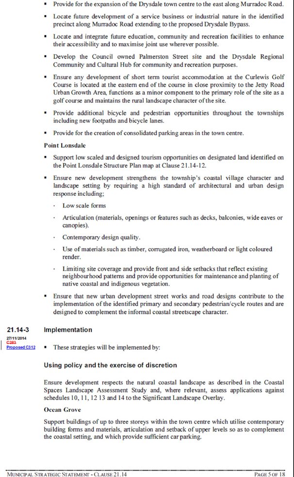
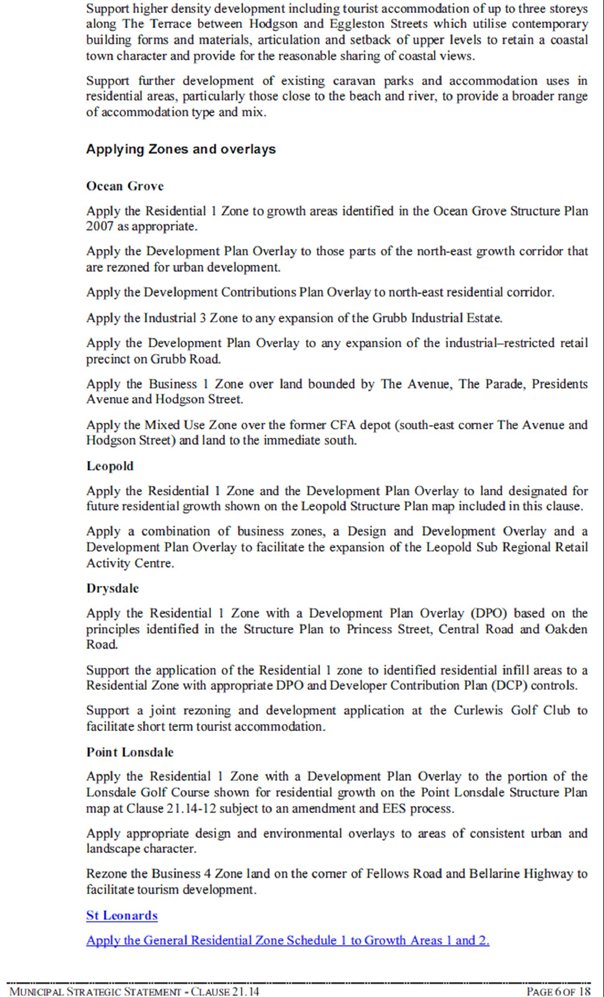
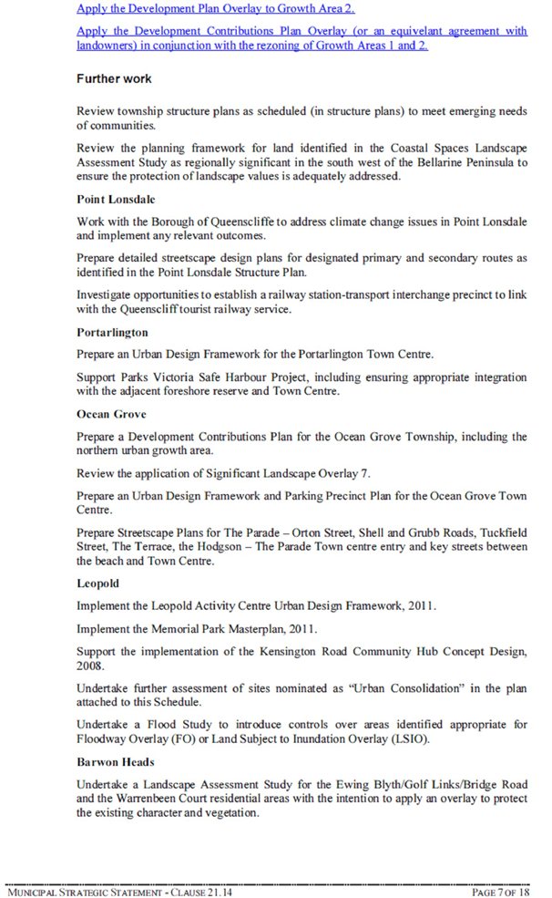
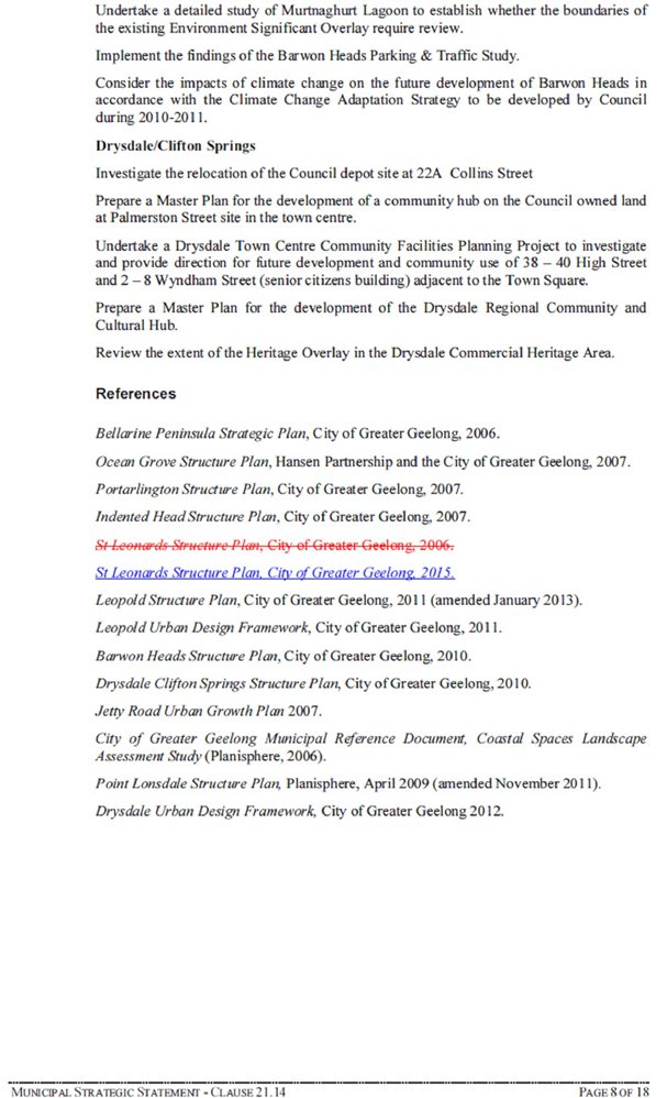
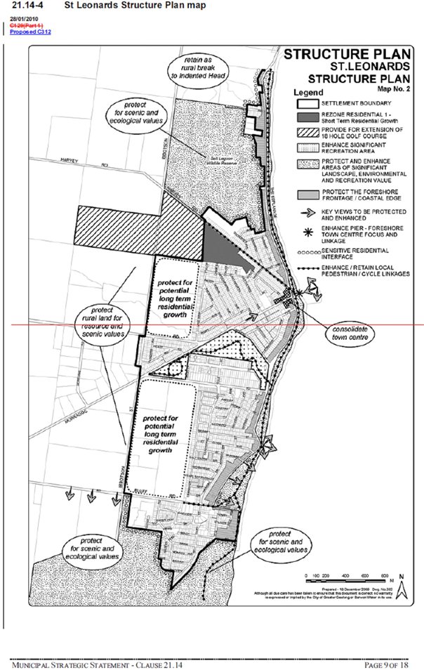
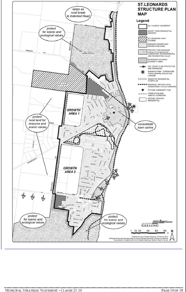
NOTE: The remaining Clause 21.14 Township Structure Plan Maps are not shown for the purposes of this report.
|
Panel Recommendation |
Council Response/ Position |
Adopted Council Position |
No. |
|
Changes to the Greater Geelong Planning Scheme |
|||
|
Amend the Clause 21.14-4 St Leonards Structure Plan map to re-orient the ‘key views to be protected and enhanced’ arrow closest to Margaret Street to reflect the position in the 2006 Structure Plan. |
Supported. |
As per recommendation. |
1 |
|
Apply a Development Plan Overlay to Growth Area 1 (321-399 Ibbotson Street, St Leonards). |
Not supported. |
Applying a DPO to Growth Area 1 is not considered necessary as matters relating to connectivity and staging can be addressed by the Planning Permit. The land is in single ownership and the proponent has a reputable development history and already significantly invested in technical drainage assessments to support a rezoning application. Other than drainage issues there are no unmanageable or contentious site constraints. However there is merit in the Panel’s recommendation and Officers propose to include planning principles established during the permit process in the Section 173 Agreement for 321-399 Ibbotson Street. |
3 |
|
Revise Clause 21.14-3 Implementation St Leonards deleting ‘based on the subdivision development principles identified in the Structure Plan 2014’ and incorporate the subdivision development principles which are identified in the 2014 Structure Plan as Development Plan Overlay requirements. |
Not supported. |
The recommendation to incorporate the growth area subdivision principles in Clause 21.14-3 is considered to be inconsistent with the Ministerial Direction: The Form and Content of Planning Schemes; and the Department’s Planning Practice Note: Writing a Municipal Strategic Statement. The St Leonards Structure Plan is a reference document in Clause 21.14 and will be given due consideration in the rezoning process for both Growth Area 1 and 2. |
4 |
|
Revise Clause21.14-2 St Leonards as follows: ‘Facilitate development of a community facility including an Early Years Centre, preferably at 1345 Murradoc Road supported by contributions from Growth Area 1 and 2 developers.’ |
Supported. |
As per recommendation. |
5 |
|
Changes to the St Leonards Structure Plan 2014 |
|||
|
Add an additional note to the 2014 St Leonards Structure Map 8 Plan Flood and Sea Level rise: ‘This flood extent is designated under the Building regulations and does not show all the flood-prone areas in St Leonards’. |
Supported. |
As per recommendation. |
2 |
|
Post Panel changes to the 2014 St Leonards Structure Plan |
|||
|
n/a |
The Structure Plan, as a result of changes, is to be re-adopted with the March 2015 version. The adopted February 2014 version is therefore superseded. |
Replace all references to ‘February 2014’ with ‘March 2015’. |
n/a |
|
n/a |
The Structure Plan Map (Map 2) has changed during the Amendment C312 process and should match the map to be inserted into the Greater Geelong Planning Scheme. |
Replace the Structure Plan Map 2 with a new Map 2 as shown in Appendix 1 |
n/a |
|
n/a |
An error has been detected on page 15, under ‘Subdivision Development Principles’, which reads: “It is recommended that the land identified within the Structure Plan map as areas 1 and 2 be rezoned to a General Residential Zone Schedule 1 (previously Residential 1) with a Development Contributions Plan Overlay and/or 173 agreement.” |
Sentence to be changed to now read: “It is recommended that the land identified within the Structure Plan map as areas 1 and 2 be rezoned to a General Residential Zone Schedule 1 (previously Residential 1) with a Development Plan Overlay.” |
n/a |
As the Amendment does not propose changes to key strategic directions for St Leonards, the range of issues raised were limited. There was a particular focus at the Hearing on the implications of facilitating the rezoning of two growth areas which have been designated for long term residential growth since the 2006 Structure Plan.
The Panel is satisfied that the analysis of land supply issues underpinning the 2014 Structure Plan was robust, although the suggested 25-33 year supply may be somewhat overstated. The generous residential land supply facilitated by the Amendment easily meets the policy ‘to accommodate projected population growth over at least a 15 year period’ and will support competition and affordability in the residential market.
The Panel does not consider the rezoning Growth Areas 1 and 2, potentially concurrently, for residential development is necessarily problematic or raise strategic concerns but we emphasise that careful consideration of staging and effective land release mechanisms is necessary to ensure out-of-sequence development or market distortions are avoided. However, even in an area currently in one ownership, such as Growth Area 1, we consider that development over an extended timeframe elevates the importance of an explicit overall staging and development plan. This should ensure that the release of land is efficient and that effective movement, drainage and open space networks are integrated with established areas. The Development Plan Overlay would serve this purpose. The Panel also considers the subdivision principles in the 2014 Structure Plan should be included in the MSS, rather than relying on the reference document.
Given the extent of land within the existing settlement boundary, the need to foreshadow additional land for future residential expansion has not been established. We have not supported requests for identification of St Leonards Golf Course Developments land or Gee Dee Nominees land in Ibbotson Street for long term residential development.
The Panel does not support identifying 390A The Esplanade, St Leonards as a ‘Tourist investigation area’ or as having potential for tourism development in either the MSS or the 2014 structure Plan. It would be premature to make changes to either document, in the absence of a proposal or any assessment of the merits of tourism development on this constrained and environmentally sensitive site. Nor has there been any assessment of the merits of this site over other potential sites for tourism development in St Leonards.
Based on the reasons set out in this Report, the Panel recommends that Greater Geelong Planning Scheme Amendment C312 should be adopted as exhibited subject to the following recommended changes:
Amend the Clause 21.14-4 St Leonards Structure Plan map to re-orient the ‘key views to be protected and enhanced’ arrow closest to Margaret Street to reflect the position in the 2006 Structure Plan.
Add an additional note to the 2014 St Leonards Structure Map 8 Plan Flood and Sea Level rise: ‘This flood extent is designated under the Building regulations and does not show all the flood-prone areas in St Leonards’.
Apply a Development Plan Overlay to Growth Area 1.
Revise Clause 21.14-3 Implementation St Leonards deleting ‘based on the subdivision development principles identified in the Structure Plan 2014’ and incorporate the subdivision development principles which are identified in the 2014 Structure Plan as Development Plan Overlay requirements.
Revise Clause21.14-2 St Leonards as follows:
‘Facilitate development of a community facility including an Early Years Centre, preferably at 1345 Murradoc Road supported by contributions from Growth Area 1 and 2 developers.’
Portfolio: |
Community Development - Cr Fisher |
Source: |
Community Services – Family Services |
A/General Manager: |
Linda Quinn |
Index Reference: |
Project: Yarra Street Pier Redevelopment |
The purpose of this report is to present the Municipal Children’s Services Infrastructure Plan (MCSIP) 2013-2030 for Council endorsement. A copy of the Executive Summary from the Municipal Children’s Services Infrastructure Plan 2013-2030 is attached for reference and consideration (previously circulated with Briefing papers).
Council plays a significant role in the planning, development, funding and delivery of children’s service infrastructure. The MCSIP is the first comprehensive infrastructure plan that has been produced by Council, specifically aimed at addressing the future requirements for development, renewal and replacement of Council owned buildings and facilities accommodating children’s services.
In 2009, Council received a total of $50,000 from the former State Government Department of Education and Early Childhood Development to contribute to the cost of producing the MCSIP.
External consultants were engaged to assist Council with the development of the MCSIP with considerable input from Council officers.
The MCSIP has been designed principally as an internal reference document that will guide Council planning decisions regarding future infrastructure planning, development, and asset management of existing Council buildings that provide children’s services.
The recommendations contained within the MCSIP have been incorporated into Council’s (Draft) Social Infrastructure Plan and has been used to provide background evidence for statutory planning.
Council has a total of 62 buildings that currently accommodate over 200 different children’s services. These services include: Maternal and Child Health, child care, kindergarten, health services, family support, playgroups, neighbourhood houses, and other community facilities for young children and families.
These assets represent a total capital investment of over $57 million. Considerable investment has been made by Council over the past 10 years to improve and expand existing children’s service facilities and develop new services to meet future population requirements.
New centres incorporating innovative design have been opened in Ocean Grove, Barwon Heads, Grovedale, Leopold and Norlane. Planning for additional centres to respond to continuing population growth, social disadvantage, and asset renewal priorities are planned for other areas.
The MCSIP has been prepared after an extensive analysis of emerging needs across the municipality, including the status of existing buildings and playgrounds, and the latest policy developments and trends in building design.
The MCSIP also acknowledges the changing policy context of children’s services planning and service delivery. There is a clear international trend toward the consolidation of children’s services and development of integrated centres that accommodate multiple functions. This is reflected in all levels of Australian Government policy which strongly encourages co-location and integration of services.
Meeting the key requirements of population growth; asset renewal and replacement; and accommodating new regulation and service requirements, are key factors that have informed the various priorities and recommendations contained within the MCSIP.
The development and endorsement of the MCSIP will potentially strengthen Council’s position to attract funding and resources for future capital and infrastructure, and provide a cohesive planning and policy platform for the future development of local children’s services and facilities to respond to local population requirements over the next 10 to 20 years.
Cr Fisher moved, Cr Farrell seconded -
That Council:
receives and endorses the Municipal Children’s Services Infrastructure Plan 2013-2030;
provide a copy of the Municipal Children’s Services Infrastructure Plan 2013-2030 to the Victorian State Department of Education and Training, Minister for Education and Minister for Families and Children.
Carried.
Strong research evidence supports the understanding that buildings and facilities accommodating early childhood services represent a vital part of contributing to better outcomes in early childhood development and stronger communities.
The need for Council to strengthen planning associated with the development and management of children’s service infrastructure through the creation of a Municipal Children’s Services Infrastructure Plan was initially identified as a key strategic priority within Council’s Municipal Early Years Plan 2006-2010, and supported by Council’s Asset Management Strategy.
In 2009, Council received a grant of $50,000 from the former State Government Department of Education and Early Childhood Development to assist with the development of a Municipal Children’s Services Infrastructure Plan for the City of Greater Geelong.
The completed Municipal Children’s Services Infrastructure Plan (MCSIP) aims to provide the City of Greater Geelong with a comprehensive and coherent framework for children’s services infrastructure provision that addresses both current and future community needs and priorities to the year 2030.
The MCSIP has been designed principally as an internal reference document, with an Executive Summary (as attached) available for public release.
The MCSIP will be progressively updated as local needs change and asset requirements addressed over time.
The City of Greater Geelong is forecast to experience significant growth with estimates indicating that the population of Greater Geelong and environs is likely to increase by approximately 80,000 residents over the next 20 years (2013-30).
Ensuring adequate provision of children’s services is integral to meeting future population needs, and providing high quality environments that support and facilitate children’s early development and family engagement.
The MCSIP is the first plan of its kind produced by Council, and has been designed to provide a coherent strategy to guide the future development and refurbishment of facilities for early childhood services within the City of Greater Geelong.
The structure of the MCSIP has been organised into four integrated documents (sections) as follows:
Section One: Children’s Infrastructure Background
In addition to providing general background information about existing and future demographics trends across the municipality, this section gives an overview of municipal provision of children’s service infrastructure including average service benchmarks; relevant government policy and children’s services capital funding, and a rationale for the importance of children service environments, and key findings and recommendations for future development.
Section Two: Capacity and Local Priorities
This section provides a detail analysis of existing and future children’s service infrastructure for each designated Planning Area as has been defined by the MCSIP. Specific development recommendations are presented for each Planning Area.
Section Three: Assessment of Existing Infrastructure
This section focuses on the outcomes of technical assessments of the physical state and fit-for-purpose capacity of existing Council children’s service buildings. Again recommendations are presented for the specific buildings that have been included which need to be considered within the context of broader MCSIP recommendations.
Section Four: Appendices
The final section includes the assessment tools that have been specifically developed and used in the background analysis of existing Council buildings, along with a ten-year capital development plan. Other technical and policy information relevant to the development of children’s services infrastructure is also included in this section.
Given the large geographical area and size of the population of the City of Greater Geelong, the MCSIP has been based around the development of 15 specific geographic ‘planning areas’. These areas have been incorporated into the (Draft) Social Infrastructure Plan, and used as the basis for future planning recommendations regarding children’s service infrastructure, to provide a ‘local place-based’ approach that has included examination of the following demographic and service requirements:
Existing geographic service catchment areas for children and families accessing services.
Existing (and future) infrastructure provided by both Council and other non-Council providers in a given area.
Variable provision of and need for service infrastructure across different local and geographic communities.
Differing community environments and demographics including population growth and socio-economic disadvantage.
In each planning area both Council owned and non-Council children’s service facilities are identified and specific recommendations regarding the future development of Council owned facilities included.
The MCSIP has been prepared after an extensive analysis of the emerging needs across the municipality, including the status of existing buildings and playgrounds, and the latest policy, management and design trends. The result is a practical strategy that seeks to balance ideals and innovation in design; changing policy requirements; diversity across the needs of children and families; and distribution of population across both small and large communities.
The MCSIP also acknowledges the changing policy context of children’s services planning and design. There is a clear international trend toward the consolidation of children’s centres and the integration of multiple functions and service delivery models. This is reflected in all levels of Australian Government policy that strongly encourages co-location and integration of services in preference to single purpose ‘stand-alone’ approaches.
A range of additional factors impact on the need to develop a more strategic approach to the provision of children’s service infrastructure including:
Demographic changes such as increasing birth rates, demand on workforce participation by women, and increasing family complexities are all impacting on demand for the expansion of additional services and new facilities.
Population growth generated by new residential developments, sub-division planning, urban renewal, and encouraging increased housing densities within and close to activity centres.
The majority of Council’s early childhood facilities are more than 30 years old and in the main have not been well designed to meet contemporary service requirements and standards.
The importance of environmental sustainability, climate change, and improving functional cost-efficiencies is also profoundly influencing the way new children’s service facilities and buildings are designed and constructed.
New evidence-based approaches have identified the important role that space and building design plays in affecting children’s development.
All of these policy priorities have significant implications for the future development of children’s service infrastructure and the content of the MCSIP.
Council plays a crucial role in the planning, development and provision of local early childhood services, and maintains a large infrastructure portfolio of buildings and facilities that play a crucial part in the delivery of local support, health, and early learning services for children and families.
The MCSIP is designed to complement other work undertaken by Council in relation to infrastructure and asset management, strategic planning and development, and future capital funding planning.
While it is extremely difficult to predict all the various factors that are likely to influence the local infrastructure requirements for young children across the municipality, this plan has sought to collate the best information currently available to identify existing and future priorities and requirements.
Based on current population projections the MCSIP estimates that by the year 2030, approximately 1,124 additional kindergarten places will be required in order to maintain the current ratio of service provision. An increase of 43.3 per cent or 1,391 additional child care places will also be required. This is equivalent to almost 10 additional child care centres, based on existing industry service capacity benchmarks of 120 places per centre.
The estimates referred to above are additional to any refurbishment or replacement of existing children’s services assets that may be required. Refurbishment of existing assets is likely to present opportunities for consolidation and expansion as has already been the case in recent capital development across the municipality. Additional service estimates will also need to be monitored and adjusted as service and population requirements become clearer over the next 10-20 years.
Recommendations contained within the MCSIP in response to development and refurbishment of children’s services facilities have been structured around a hierarchy of provision with different scales of facilities to meet the needs of different and varying sized catchments areas, and populations as follows:
Integrated Children’s Centres – located in major activity areas and communities that have a large population or serve a broad geographic area; e.g. Boorai Centre - Ocean Grove; Leopold and Grovedale Child and Family Centres; Armstrong Creek, etc.
Enhanced Early Learning Centres – integrating services in communities which have smaller populations or have particular requirements in relation to the range of services required in response to community needs or specific target groups; e.g. Barwon Heads and Norlane Child and Family Centres.
Neighbourhood Early Childhood Facilities – specific early years services located in local areas based on existing children’s service provision; e.g. local kindergartens, child care centres, Maternal and Child Health Centre, etc.
The MCSIP makes it clear that Council faces a range of significant challenges to deliver the future development requirements for local early childhood infrastructure and facilities across the municipality. The most obvious challenge is the large costs involved in capital development and the ongoing operational requirements associated with service delivery.
In an environment where the imperative is to improve quality, meet more rigorous performance standards, and respond to higher expectations, costs (including capital construction and operating costs) will increase, exacerbating the financing gap and demand on further Council investment.
Funding and investment will inevitably be required from other levels of government, commercial operators, and community groups to ensure that sufficient service provision is available.
The role of multiple stakeholders in ensuring adequate local service provision and infrastructure investment will require greater coordination, communication and collaboration between stakeholders, particularly amongst local, state, and federal governments. New funding opportunities and delivery models will need to be examined and pursued if provision of required assets is to be sufficient to meet future population demands.
The MCSIP includes a clear focus on the importance of sound environmental design considerations to be incorporated into the development of future children’s service buildings and facilities, in accordance with Council policy and building design guidelines.
The development of Council’s MCSIP 2013-2030 has been funded by Council and a grant of $50,000 received from the Victorian State Government.
The cost of implementation of relevant recommendations contained within the MCSIP will be referred for consideration as part of future Council budgets and specific business case proposals. External sources of funding and alternative financing and procurement measures will also be pursued as and where approved by Council.
Continued investment in new buildings and facilities to accommodate children’s services will be needed to meet future population growth and replacement of old facilities. Current estimates suggest that at least $114,700,000 will be required alone for new facilities to meet the requirements of future population growth in key areas such as Armstrong Creek, Lara West, Jetty Road, etc. While some of the required infrastructure will be funded through Developer Contribution Plans (DCPs), other funding options will need to be considered to meet the extent of future requirements.
Council's maintenance backlog on existing buildings accommodating children’s services is estimated currently to be over $1.4 million. This is likely to continue to increase over time.
Increased attention toward the importance of reducing risk factors that have adverse implications for children, families and communities are acknowledged as providing clear social, economic and developmental benefits to the whole community.
Economic modelling associated with investment in early childhood services concludes that there is at least a 3-1 return in economic benefit to the community. Other longitudinal studies conclude that for every dollar spent on high quality early childhood support, up to seventeen dollars is saved through reducing adverse individual and broader social problems.
The development of the MCSIP enables key priorities for future funding and expenditure in relation to early childhood buildings and facilities to be more clearly identified, and to provide support for applications for external sources funding, based on clear evidence and planning.
The MCSIP is intended to inform and integrate with Council’s strategic and capital planning processes and responsibilities.
The planning role of Local Government is legislated in the Victorian Local Government Act (1989), Planning and Environment Act (1987) and the Health Act (1958). Corporate Plans, Municipal Public Health Plans, and the Municipal Strategic Statement are required by statute.
Council is responsible to ensure compliance of its children’s service buildings and facilities with a range of relevant regulation and service standards including:
Education and Care Services National Regulations (2011)
Maternal and Child Health Program Standards (2009)
Building Code of Australia (2013)
Disability Discrimination Act (1992)
Occupational Health and Safety Act (2004)
Victorian Food Act 1984
The development and endorsement of the MCSIP strengthens Council’s position to potentially attract additional funding and resources for the future, along with establishing a cohesive planning and policy framework for further development and planning of early children’s services and facilities.
The MCSIP takes into consideration other existing Council strategies, policies and plans that play a role in the overall management of the City’s children’s services buildings and facilities and associated community assets. This includes the following:
City Plan (2013-2017) - a major theme within City Plan, is “delivering community infrastructure and managing and supporting our continued growth, whilst delivering services for our community”.
Municipal Public Health and Well-being Plan (2013-2017) “We will provide safe and vibrant physical environments and infrastructure to support healthy living and connected communities.”
Municipal Early Years Plan (2013-2017); “The provision of quality and accessible services and infrastructure is crucial to enabling the City of Greater Geelong to fulfil its vision for the municipality and achieve it goals to improve outcomes for young children.”
Council’s Asset Management Policy (2012)
Council Asset Management Strategy Version 1.06 – (2010)
Asset Disposal Policy (2010)
(Draft) Social Infrastructure Plan
Local Area Urban Design and Structure Plans
Urban Growth Area Social Infrastructure Plans
Sustainable Communities - Infrastructure Development Guidelines (2010)
Sustainable Building Policy (2012)
No officer involved in the preparation of this report has any direct or indirect interest relative to the advice provided in the report.
Council has a shared responsibility with the Victorian State and Australian Governments to ensure that locally accessible family and children’s services are provided which support families in the care, protection, development and well being of young children.
Early childhood research clearly indicates that the quality of service provision and the physical environments in which children are cared for and educated within are integral to ensuring positive outcomes for children.
The MCSIP has identified a range of challenges associated with existing service facilities and future provision of appropriate infrastructure that meets both the needs of local communities and service requirements.
The MCSIP provides a comprehensive and coherent framework within which the various issues, challenges, and future requirements for children’s service buildings and facilities can be progressively addressed.
Public and private investment in social infrastructure is important and contributes to building the essential fabric of local communities, connections, identity and opportunities for participation. For young children and families provision of services and high quality service environments play an essential part in engaging families; the early development outcomes for young children, and access to support.
The provision of strong and effective support to children and families in the early years of children’s development and family formation is widely recognised as having significant positive benefits and implications for children, families, and the community.
Evidence clearly indicates that preventative support and intervention in the early stages of child development and family formation can significantly reduce the incidence of more complex problems arising in the later stages of children’s lives. The provision of effective support to families with young children inevitably has broader social benefits in contributing to strengthening the capacity of local communities.
Equally, provision of high quality service environments are more inclined to attract and retain staff and enable employers to meet their occupational health and safety obligations.
On a broader scale, the development and provision of high quality service environments for children and families directly contributes to the social and economic prosperity of the community. Provision of high quality child care and kindergarten facilities enables parents with confidence to participate in the workforce which in turn contributes to a more economically prosperous and socially cohesive community.
Development of quality service environments for Maternal and Child Health contributes to provision of effective preventative and early intervention health services that mitigate the potential development of more chronic health conditions and problems.
The MCSIP 2013-2030 is informed by key policies, reforms and initiatives, internationally, nationally and locally. From an international perspective, this includes a commitment to uphold children’s rights, drawing on the UN Convention on the Rights of the Child. It also includes awareness of international enterprises, such as the Child Friendly Initiative, which is seen as the embodiment of the Convention at a local level.
Development of the MCSIP 2013-2030 has been informed by extensive research, data analysis and consultation with key stakeholders from across relevant Council departments and service groups.
Given the comprehensive nature of the MCSIP and the continual need to review and update the content of the MCSIP, subject to changing community needs and asset requirements, it is not proposed to release a full copy of the MCSIP publically. An Executive Summary document (as attached) has been produced for public release.
Community engagement and communication with relevant stakeholder groups will occur in relation to specific capital projects and developments as and when projects are approved by Council.
A copy of the final MCSIP 2013-2030 is required by the Department Education and Training following endorsement by Council, in accordance with funding requirements.
Portfolio: |
Environment & Sustainability - Cr Richards |
Source: |
City Services - Environment and Waste |
A/General Manager: |
Jenny McMahon |
Index Reference: |
Foreshore Management |
The purpose of this Report is to inform Council of the Central Coastal Board Regional Coastal Plan 2015-2020 recently released for comment as well as seek endorsement of comments.
The Central Coastal Board (CCB) was formed under the Coastal Management Act 1995 and reports to the Minister for Environment and Climate Change. The CCB is one of three regional coastal planning advisory bodies – the other two are the Western Coastal Board and the Gippsland Coastal Board.
The Central Coastal region of the Victorian coast spans 990 kilometres, from Breamlea to Inverloch and includes greater metropolitan Melbourne and Geelong within its hinterland catchment of 1.6 million hectares.
The role of the CCB is to ensure co-ordination, planning and management of the coast and marine environment for long term sustainability in Victoria’s central coastal region.
The CCB is responsible for developing Regional Coastal Plans that guide and facilitate the implementation of the Victorian Coastal Strategy and approved coastal policy and guidelines in the region.
The Central Coastal Board has released a Draft Regional Coastal Plan 2015-2020 for comment
Appendix 1 provides comments to the Draft Plan
Cr Ellis moved, Cr Macdonald seconded -
That Council:
note the development of the Draft Regional Coastal Plan; and
endorse the submission to the Central Coastal Board in relation to the Draft Plan contained within Appendix 1.
Carried.
The Central Coastal Board (CCB) was formed under the Coastal Management Act 1995 and reports to the Minister for Environment and Climate Change. The CCB is one of three regional coastal planning advisory bodies – the other two are the Western Coastal Board and the Gippsland Coastal Board.
The Central Coastal region of the Victorian coast spans 990 kilometres, from Breamlea to Inverloch and includes greater metropolitan Melbourne and Geelong within its hinterland catchment of 1.6 million hectares.
The role of the CCB is to ensure co-ordination, planning and management of the coast and marine environment for long term sustainability in Victoria’s central coastal region.
The CCB is responsible for developing Regional Coastal Plans that guide and facilitate the implementation of the Victorian Coastal Strategy and approved coastal policy and guidelines in the region. Following consultation with stakeholders the Central Coastal Board has prepared the draft Regional Coastal Plan to meet its obligations under the coastal Management Act 1995 and the direction of the Minister for the Environment and Climate Change. It interprets the desired outcomes, policies and actions of the Victorian Coastal Strategy 2014 at a regional scale.
The Draft Regional Coastal Action Plan provides a regional framework for planning and decision making on both public and freehold land at the local level. It also provides a focus for all agencies with responsibility for coastal management to act together to plan and manage the coast by:
Interpreting and implementing the Victorian Coastal Strategy 2014 at a regional scale;
Facilitating integration across jurisdictions to increase efficiency and effectiveness;
Identifying regional coastal values and strategic priorities to be accounted for; and
Identifying solutions that address systemic gaps in coastal management.
The Regional Coastal Plan will also provide the framework for agencies, community and industry groups working and engaging with decision makers on emerging strategic regional priorities for the Central Coastal Region. The Plan’s primary audience is local government, committees of management, government agencies and peak bodies with a coastal focus. It will also be of interest to landowners, volunteer groups and coastal communities.
The principle of ‘Integrated Coastal Zone Management’ (ICZM) underpins the Central Regional Coastal Plan. ICZM is about working across a geographic area (land to sea), across different land tenures (public and private), across organisations and jurisdictions (national, State, regional and local). ICZM is achieved through both formal and informal collaboration and coordination between the various groups using and managing the coast.
The Central Board has identified eight priority areas as a focus for action. These Regional Priorities reflect:
key issues identified in the Victorian Coastal Strategy 2014 which are relevant for specific attention in the Central Coastal Region;
topics identified by stakeholders during the consultation process as important; and
areas where the Central Coastal Board can provide leadership and influence.
The eight priority areas are:
Population Growth – balancing access and valuing the natural environment
Adapting to a changing climate and increased coastal hazards
Integrated coastal planning and management
Sustainable and equitable funding mechanisms
Oversee the implementation of the Recreational Boating Facilities Framework
Sustainable visitations and tourism infrastructure service level hierarchy
Protecting significant coastal ecosystems and habitats
Promoting leadership, coordination and capacity building
The priority actions apply across both public and private land tenures. None of the regional priorities can be considered in isolation. Each action is linked; recognising these linkages will lead to improved outcomes by implementation of the Regional Coastal Plan. For example, sustainable funding is critical if we wish to retain and maintain infrastructure and improve existing recreation and visitation opportunities on the central coast.
The Plan provides background and context for each of the eight regional priorities and also outlines Priority Actions. A summary of each priority is provides below.
Regional Priority 1; Population Growth – balancing access and valuing the natural environment.
The 4.5 million resident catchment population of the Central Coastal Region is projected to increase by 40 per cent to 6.3 million by 2031 and to almost eight million persons, an increase of greater than 75 per cent, by 2051.This will influence water quality in coastal estuaries and marine areas. Catchment water flows from either point sources (for example sewerage outfalls) or diffuse sources (for example stormwater) can make swimming and other water based recreation unsafe, as well as damaging marine habitats. The challenges in the face of significant projected population growth for the Central Region are to provide equitable access for safe and clean water based recreation and the protection of significant coastal environmental values. A long term response is to concentrate recreation pressures to more resilient areas where increased demand can be accommodated. This will require management of community and user group expectations through engagement and communication about the reasons for change.
|
Priority Actions |
Lead |
Partner agents |
By when |
|
1.1 To ensure catchment and coastal planning and management objectivesand priorities are aligned |
CMA’s, MW |
LC, CoM, PV, TV, EPA, DELWP, CCB |
Ongoing |
|
1.2 Engage and communicate about reasons for change through the development of the Visitation Level of Service Framework (see Regional Priority 6) |
CCB |
LC, CoM, PV, TV, CMAs X 3, MW, EPA, DELWP |
2018 |
Regional Priority 2; Adapting to a changing climate and increased coastal hazards
A changing climate has the potential to make existing coastal hazards more severe and to bring about increased rates of erosion and more extensive flooding. The primary causes of coastal flooding are storm surges combining with high tides (storm tides) and extreme weather events – these extreme events are predicted to be more common in the future. As set out in the Victorian Climate Change Adaptation Plan 2013, adapting to changes in the climate means acting to reduce risks, increase resilience and take advantage of any new opportunities.
The Victorian Coastal Strategy 2014 envisages that this increase in threats from coastal hazards will be strategically managed, on both public and private land, through the development of regional and local adaptation planning. The process will involve identifying areas of public and freehold coastal land at risk from inundation, erosion and recession using a consistent risk management framework, to undertake coastal hazard assessments, and more detailed flood and erosion studies as the evidence for the preparation of adaptive management responses.
Pilot Local Coastal Hazard Assessments have been undertaken in four locations, including, Western Port and the Bellarine Peninsula in the Central Coastal Region. The Bellarine Peninsula/ Corio Bay pilots are nearing completion. The learnings from these pilots will be used to guide future adaptation planning. The results of the local coastal hazard assessments will guide the identification of priority areas for the development of local adaptation plans.
|
Priority Actions |
Lead |
Partner agents |
By when |
|
2.1 Develop a systematic approach to identify regional priorities for adaptation planning |
DELWP |
CCB, LC, CoM, CMAs, MW |
2020 |
|
2.2 Facilitate the development of adaptation planning by local government in priority areas of the region as identified in Action 2.1 |
LC |
CCB, DELWP, CoM, CMAs, MW |
2020 |
|
2.3 Develop methodologies for conducting flood and erosion studies in coastal areas |
DELWP |
CMA’s, MW, CCB |
2020 |
|
2.4 Determine the nature of the desirable outputs of flood and erosion studies which could include:
|
DELWP |
CCB, LC, CoM, CMAs, MW |
2020 |
Regional Priority 3; Integrated coastal planning and management
The Central Coastal Region has many bodies responsible for land and water management along and across the coast. Forty different managers manage the coastline and many more the water, waterways and catchments. The complexity of managers and management responsibilities can at times appear confusing. Application of the principle of integrated coastal zone management is needed to collaborate and co-ordinate coastal management across these boundaries.
The Board will support the Victorian Coastal Council’s work to clarify regional roles and responsibilities and ensure that important initiatives are not delayed by disputes about roles and responsibilities. The Department of Environment, Land, Water and Planning (DELWP) is currently developing guidelines for Coastal Management Plans.
On high community value land such as coastal foreshore, commercial use through leases and licences should generally attract full market rates. One of the desired outcomes for that strategy is for the built environment on foreshores to be confined to structures providing significant community benefit and to those whose functionality depends on them being near the water. Foreshore managers need to work with the lessees of buildings to ensure that the siting and design of facilities do not increase coastal hazards or reduce amenity for other users. Decisions about how to manage the variety of coastal values on the foreshore are made through the development of Coastal management Plans and planning schemes.
|
Priority Actions |
Lead |
Partner agents |
By when |
|
3.1 Prepare guidelines for the development of Coastal Management Plans (CMPs) |
DELWP |
CCB, CoM, LC, PV |
2015 |
|
3.2 Effective planning mechanisms such as CMPs are in place along all of the Central Coastal Region. Where it is sensible a CMP should be developed across multiple land managers. From this, local public land managers can put together precinct or master plans |
DELWP |
CCB, CoM, LC, PV |
2020 |
|
3.3 Clarify roles, responsibilities and expectations for all regional agencies involved in managing the coast especially where operating boundaries overlap |
VCC |
CCB, DELWP, LC, CoM, PV |
2016 |
Regional Priority 4; Sustainable and equitable funding mechanisms
The Central Region’s coast has high costs to manage and maintain. Coastal managers in the Central Region are concerned about how these costs can be sustained in the future, particularly if compounded by a changing climate. There are widely varying levels of resourcing available to different (often adjoining) coastal managers, reflecting their different revenue streams, such as caravan parks and campgrounds.
Investment in asset replacement and maintenance is often dependent on limited government grant programs. Ideally, funding models should account for the benefits all residents and broader users of the Central Region derive from its coast. There should be a proportionate contribution from all these beneficiaries of the coast towards the cost of coastal management. The Victorian Coastal Strategy 2014 has identified this issue as significant across the state. The Strategy calls for broader and long term approaches to setting priorities for, and financing new and existing coastal protection, infrastructure and user facilities, to be explored and analysed to better align funding and capacity with accountability.
|
Priority Actions |
Lead |
Partner agents |
By when |
|
4.1 Analyse options for improved funding arrangements for managing coastal Crown land in the Central Coastal Region |
DELWP |
CCB, CoM, LC, PV, VCC |
2019 |
Regional Priority 5; Oversee the implementation of the Recreational Boating Facilities Framework
The Recreational Boating Facilities Framework 2014 (RBFF) is an example of how the Board has addressed a coastal issue at the regional scale. It shows that there are significant opportunities to provide a strategic approach to servicing demand for recreational boating that accounts for other values and users. The RBFF provides an inventory of the region’s boating facilities, including local port facilities, and classifies each of them into five different categories based on the level of service they provide. The focus is on describing a hierarchy of boating facilities that will assist facility managers with future infrastructure planning and maintenance.
|
Priority Actions |
Lead |
Partner agents |
By when |
|
5.1 Annual monitoring and review of the implementation of the Recreational Boating Facilities Framework |
CCB |
LC, PV, DELWP, CoM, recreational boating industry groups |
ongoing |
Regional Priority 6; Sustainable visitations and tourism infrastructure service level hierarchy
Visitation and tourism is a key economic driver for Victoria. The Central Region experiences consistent high demand for coastal based visitation and tourism experiences. Visitation and tourism to the Central Coastal Region is expected to increase, in part due to Melbourne as a national/ international tourism destination, and the proximity of its significant coastal features and attractions, such as Point Nepean, the Mornington and Bellarine Peninsulas and the Bunurong Coast.
The capacity of the physical infrastructure will be challenged, leading to social pressures and environmental impacts on the coast and how it is used. These challenges can be met by a variety of potential responses using planning, education and regulatory mechanisms. There is also the challenge to respond to emerging coastal tourism source markets (for example Asia and India) and market sectors such as nature based tourism and cruise shipping. Strategically, the key will be to determine the infrastructure that is functionally important to create and maintain access for visitors and tourists – examples may include, car parking, boardwalks and coastal pathways. Where practical, levels of service should be functionally integrated across public and freehold land at particular locations.
|
Priority Actions |
Lead |
Partner agents |
By when |
|
6.1 Develop a Visitation Level of Service Framework to guide local decisions, support investment and communicate with users (refer Actions in Regional Priority 1) |
CCB |
DELWP, LC, PV, CoM, Local Ports, DTPLI |
2018 |
|
6.2
|
CCB |
DELWP, LC, PV, CoM, Local Ports, Tourism Vic |
2018 |
|
6.3 Identify priority areas for visitation and tourism, in particular identify:
|
CCB |
DELWP, LC, PV, CoM, Tourism Vic and Tourism Boards., TOs
|
2018
|
Regional Priority 7; Protecting significant coastal ecosystems and habitats
The Victorian Coastal Strategy 2014 identifies the need to consider the full values of these ecosystem services, when decision making about use and management of coastal and marine ecosystems. It calls for the development and implementation of an environmental value measurement system and environmental accounts that are consistent with international systems. Development of such a system would benefit from having input from the perspective of the Central Coastal Region. The release of this Regional Coastal Plan is an opportunity to identify the regional significant coastal ecosystems in the Central Region.
|
Priority Actions |
Lead |
Partner agents |
By when |
|
7.1 A Central Coastal Regional perspective is factored into the development of an environmental value measurement system and environmental accounts |
DELWP |
VCC, CCB, LC, CoM |
2020 |
Regional Priority 8; Promoting leadership, coordination and capacity building
The Central Coastal Board has a role to support coastal stakeholder representations to the Minister in situations that will further the implementation of the Regional Coastal Plan and the Victorian Coastal Strategy 2014 in the Central Coastal Region. The Board also has a role in providing opportunities for networking and knowledge exchange between different groups and agencies.
Our coastal communities continue to change, and there is an ongoing need to support information sharing, including contemporary research to make the most of our coastal management experience and promote innovation.
|
Priority Actions |
Lead |
Partner agents |
By when |
|
8.1 Leadership to provide support to all Central region stakeholders that will strengthen their capacity for managing our coast in the short and long term. This may include:
|
CCB |
VCC, DELWP |
2016 |
Acronyms:
CCB – Central Coastal Board
CoM – Committee of Management
DELWP – Department of Environment, Land, Water and Planning
DTPLI – Department of Transport, Planning and Local Infrastructure (following recent restructure work to be undertaken by new Department of Economic Development, Jobs, Transport and Resources)
LC – Local Councils
MW – Melbourne Water
PV - Parks Victoria
The implementation of the Central Regional Coastal Action Plan will enable further evaluation of environmental processes, conditions and existing features. It will improve planning processes, and enable a systematic approach to identifying regional priorities to adapt to climate change and increased coastal hazards. It will also enable the appropriate development of infrastructure suited to the environment.
Council relies on state government grants to fund major upgrades and installation of significant coastal infrastructure such as boat ramps. A review of options to improve funding arrangements will provide Council with the opportunity to highlight the significant assets under management and the need for funding support.
The Central Coastal Board has prepared the draft Plan to meet its obligations under the Coastal Management Act 1995.
The draft Plan aligns closely with three of Councils strategic directions i.e.
Community Wellbeing; via the provision of safe and accessible coast and associated infrastructure.
Growing Our Economy; provision of infrastructure to support a wide range of businesses and tourism.
Sustainable Built and Natural Environment; provision of appropriate, sustainable infrastructure, support for initiatives to record and manage environment assets and support comprehensive planning processes.
There is no officer direct or indirect interest in this report.
Council manages significant areas of coast and associated infrastructure. The implantation of the Plan will include research and improved planning for threatening processes such as climate change.
This will result in decreased risk. The Plan also highlights the risks associated with limited infrastructure funding in a region of rapid population growth. A review of funding arrangements as put forward by the Plan will help reduce risks associated with failing infrastructure.
The implementation of the Plan will result in improved infrastructure, planning, recreational and tourism opportunities.
There are no human rights charter issues resulting from the recommendation in this report.
Further consultation will be required with the Central Coastal Board to help ensure that the Plan incorporates the concerns and wishes of local stakeholders.
Council appreciates the opportunity to comment on the Draft Central Region Coastal Plan 2015-2020. The City of Greater Geelong with a population of over 225,000 in close proximately to Corio and Port Phillip Bays as well as open coast plays a critical role in the management and health of these waters. In addition the City is responsible for approximately 45 kilometers of coastline including major coastal infrastructure such as sea walls, jetties and boat ramps. The City is also a partner in one of four pilot Local Coastal Hazard Assessments which will help improve our understanding of climate and other related coastal risks.
The City looks forward to working with stakeholders to ensure a healthy ecosystems, encourage tourism and provide for recreation as well as dealing with challenges such as climate change.
Section 1.1
Figure 1: has no reference to the existing Coastal Action Plans which identify actions based on the local context, these are broader than the specific Coastal Management Plans, however they do address local planning and operational issues.
The Corio Bay Coastal Action Plans extends from St Leonards to Little River and is already 10 years old. It was last revised in 2012 and will be in need of further revision in the next year or two. It is beyond the capacity of local government and in particular the City of Greater Geelong to update all of the existing Coastal Management Plans and establish new ones for the length of coast we manage. The other gap that the Corio Bay Coastal Action Plan addresses are the planning controls on privately owned coastal land.
Figure 2 – pg 7; Need to include the municipal boundary between Geelong and Wyndham.
Figure 3 – pg 8; Need to include City of Greater Geelong management of the area in the vicinity of Ramblers Road, Portarlington.
Section 2.1
This section should include a reference on the value and importance of the ability for near shore environment’s to capture and store carbon.
Section 2.5.2
The Recreational Boating Facilities Framework needs to place more emphasis on managing the expectations of users based on the classification of facilities.
Figure 5 – pg 14; Missing new Big 4 Bellarine Holiday Park
Section 3.1
In response to “Proposals for protective works on the coast should be considered as part of a larger ‘whole of coastal cell system’ rather than as an individual site.”
It should be acknowledged that further information is required to fill current knowledge in Victoria’s ‘whole of coastal cell system.’
Beach renourishment has been extremely effective in addressing coastal erosion and improving access to the foreshore and water. The City of Greater Geelong recommends the existing program continue and State funding be expanded to Council owned foreshore areas.
Section 6
There needs to be a differentiation between the terms “flooding and inundation.” The City of Greater Geelong accepts that it is difficult to separate coastal inundation from riverine flooding near the coast, however some of the major differences should be stated in this section.
The following 2 paragraphs are based on a conference paper in prep.
Pragmatic and innovative methods for considering sea-level rise in coastal hazard assessments. Provis, D.G.1, Braddock, H.1 and Roob, R.2 1Cardno, Melbourne; 2 City of Greater Geelong
A major difference between riverine flooding and coastal inundation is the issue of stationary. For planning purposes, riverine flooding is treated as a stationary process, with natural processes not changing over time. The 1% AEP (Annual Exceedance Probability) flood level is considered as constant over time. Variability due to climate change, this is not well-enough defined to use for planning purposes. Coastal inundation needs to consider variability due to sea-level rise and therefore a given event, such as the 1% AEP level, changes over time, for example the need to consider planning benchmarks of 0.2 m sea-level rise by 2040 and 0.8 m by 2100.
The duration of riverine flooding is generally much longer than coastal inundation. Coastal inundation is caused by the combination of the astronomical tide and storm surge and duration is controlled by the astronomical tide. The timing of high tide means that peak water levels are unlikely to exceed three hours and will generally not last long enough for water to flow inland. The reduction in water level as the tide falls allows the water to flow back into the sea. The consequences of inundation will be different from that normally occurring in riverine flooding and the means of protection or mitigation can also differ from those used for riverine flooding.
In terms of uploading the Government’s Future Coasts coastal inundation mapping to the Victorian Flood Database, the VFMS needs to consider whether the Future Coasts Statewide Inundation Dataset should be superseded with more detailed inundation data in areas where Local Coastal Hazard Assessments have been completed.
The Regional Coastal Plans are yet to be finalised and there is a need to identify a transparent process of identifying priorities and responsibilities as well as adequate resources to deliver works.
In response to the statement that “beneficiaries and local communities can reasonable expect to contribute to the capital and ongoing costs of works that protect their assets,” the amenity that the coast offers is for broad public benefit. It could be challenged that to what degree local beneficiaries contribute and then be solely responsible for ongoing management and maintenance costs.
The results of the local coastal hazard assessments will not only guide the identification of priority areas for the development of local adaptation plans it will also identify information gaps that may impact on addressing additional hazards other than inundation.
Priority Action Table; page 22 – Action 2.2 – recommend that a state planning agency be the Lead agency to help maintain consistency across the entire Victorian coastline.
Figure 7 - page 23; the words ‘Vulnerable locations where coastal hazards assessments have occurred’ implies assessments are complete when they are still in progress.
Section 7 Regional priority 3
“Regional Coastal Plans including the guiding concept of integrated coastal zone management across public and private tenure” who will fund the development of coastal management plans in areas where Council are not the owner or land manager?
Figure 8 – pg 25; Need to include City of Greater Geelong management of the area in the vicinity of Ramblers Road, Portarlington.
Regional Priority 4 – Sustainable Equitable Funding……Could include mention of the rate cap to be introduced on local government which may impact on the ability to service infrastructure.
Section 7 Regional priority 4
“There should be a proportionate contribution from all these beneficiaries of the coast towards the cost of coastal management.”
Suggest a priority action to identify the need for the development of a guideline to assist coastal managers in their implementation of consistent fee structures for the use of foreshore land and its facilities.
Outcomes
“Sustainable and equitable funding mechanisms that reflect the benefits all residents of the Central Region and its hinterland derive from the coast of the Central Region.”
This should include Council owned foreshore and not just Crown Land foreshore.
Section 7 Regional priority 5
The review of the boating CAP needs to include a review of the boating facility hierarchy and improve the interpretation of the standards to the boating public so as to improve their understanding and establish realistic expectations.
Suggest a priority action to develop a strategic approach to funding boating facilities across the region.
Section 7 Regional priority 6
Suggest a priority action to develop a code of conduct amongst tour operators in order to enhance the safety and protection of other bay and open coast users, the marine environment and infrastructure / facilities.
Section 8 Regional priority 7
The regional Coastal Plan needs to note the concept of “coastal squeeze,” i.e. the restriction due to built structures, such as roads and other landforms, on the ability for vegetation communities such as salt marsh to succeed to higher levels along the shore as sea levels rise.
Suggest a priority action that identifies areas where the opportunity exists for significant vegetation communities to succeed to when sea levels rise.
Given the unique and extensive areas of private/freehold on the Corio Bay foreshore within CoGG (largest continuous and largest length in Corio Bay) that there ought be some specific directions/actions relating to the management/planning of this area.
Bay access is major issue at Leopold and many submissions received at the last Leopold Structure Plan review identified that Bay access is wanted. Council has initiated a Land Capability Assessment and investigation into Bay access for land north and west of the Leopold settlement boundary. The purpose of the project is to assess opportunities and constraints in the Study Area and to identify potential developable areas of land north of Portarlington Road, which could facilitate future access to the Bay. Given all of the land in this area is freehold, the best way to deliver access to the Bay would be most likely through private development rather than Council acquisition. There are significant constraints in this area including sea level rise and drainage issues. Council would like to see support within the draft Regional Plan for a specific action to guide planning for the extensive area of coastline which is in freehold and without a management body – and refer to this specific piece of work which reflects current pressures for access.
Appropriately the document at page 12 recognises the role of the G21 RGP (although this is not identified in the references and sources of info section on page 40 or appendix 5 regarding values of Avalon Airport etc..
Support facilitation of adaptation planning and integrated coastal planning and management approaches.
Regional priority 6 - sustainable tourism - opportunity to reinforce role of coastal environs for events and cruise ship activity.
Spelling of Borough of Queenscliffe, “e” on the end missing on pages 34 & 35.
Appendix 4 section 2 Coastal Management Plans. There are a number of management plans missing from the table, these include:
Ramblers Road Foreshore Management Plan
Buckley Park Coastal Management Plan
Limeburners Bay Management Plan
Portfolio: |
Infrastructure , Parks & Gardens – Cr Ellis |
Source: |
City Services – Engineering Services |
A/General Manager: |
Jenny McMahon |
Index Reference: |
Subject: Drainage - Floods |
The purpose of this report is to present a revision to the flood mapping for existing conditions produced within the early stages of the development of the Armstrong Creek Urban Growth Plan (UGP).
The flood mapping is subject to a revision due to the subdivision and development at 50A Whites Road, Mount Duneed. Prior to subdivision the parent lot was considered to be liable to flooding. This development site, which is also known as Armstrong Estate Stage 7, 8 and 9, achieves flood immunity for newly created lots for flood events up to and including the 100 year Average Recurrence Interval (ARI) event due to approved internal earthworks including the reshaping of Armstrong Creek.
The earthworks undertaken have resulted in the floodwaters from the 100 year ARI event being contained within the boundaries of the Armstrong Creek reserve.
Council has a statutory obligation under the Building Regulations 2006 to designate land as liable to flooding where it reasonably knows it to be prone to flooding. Conversely, there is an obligation to remove the encumbrance of designation from land that is no longer considered to be flood-prone.
It should be noted that designation is separate to the creation of flood overlays within the Planning Scheme, which generally follows designation. In the case of the Armstrong Creek UGP area, the planning scheme amendment to create post-development flood zones or overlays is proposed after the design of the proposed precincts.
The current designated flood mapping (refer to Attachment 1) was designated by Council at its meeting of 12 December 2006, under the provisions of the Building Regulations 2006. Designation of land as liable to flooding enables the control of floor levels for acceptable building permit applications, or refusal of consent to building applications where there is likely to be a danger to life, health or safety due to flooding. Designation also enables disclosure of flood status within statutory information certificates.
Cr Ellis moved, Cr Macdonald seconded -
That Council revoke the Council designation of 12 December 2006 of flood affected land as highlighted as Armstrong Estate Stages 7, 8 and 9 on Armstrong Creek Urban Growth Plan Flood Map dated 29 November 2006 as liable to flooding pursuant to Regulation 802(2) of the Building Regulations 2006.
Carried.
As part of the development of the Armstrong Creek Urban Growth Plan (UGP) a flood study was undertaken by specialist consulting engineers to identify the extents of the 100 year Average Recurrence Interval flood event for existing conditions. Following a public exhibition phase, the resultant flood mapping (refer to Attachment 1) was designated by Council at its meeting of 12 December 2006, under the provisions of the Building Regulations 2006.
Designation of land as liable to flooding under Regulation 802 of the Building Regulations 2006 enables the control of floor levels for acceptable building permit applications, or refusal of consent to building applications where there is likely to be a danger to life, health or safety due to flooding. Designation also enables disclosure of flood status within statutory information certificates such as the Land Information Certificate and Building Information Request Form.
The subject of this report is the residential land at Mount Duneed, 50A Whites Road. Prior to subdivision the parent lot was used primarily as farmland.
The subdivision at 50A Whites Road, Mount Duneed was named Armstrong Estate by the developer. The current designated flood extent affects multiple residential lots within the Armstrong Estate Stages 7, 8 and 9.
Overland flows that may occur within the subdivision during the 100 year ARI flood event are now contained within road and drainage reserves in accordance with accepted best practice for development within flood-prone areas. Best practice requires that any overland flows within residential areas satisfy public safety criteria with respect to velocity and depth of flow.
Council has a statutory obligation under the Building Regulations 2006 to designate land as liable to flooding where it reasonably knows it to be prone to flooding. Conversely, there is an obligation to remove the encumbrance of designation from land that is no longer considered to be flood-prone.
Attachment 1 shows the existing flood designation. Attachment 2 shows the change in flood mapping at 50A Whites Road, Mount Duneed after construction of the subdivision.
The revocation of flood-prone areas designation and designation of revised flood data does not result in any known adverse environmental impacts.
The removal of a minimum floor level requirement for new dwellings may result in a minor reduction in energy and material usage during construction. In addition, concrete slab-on-ground construction, which is normally used for a non-elevated floor, achieves the minimum energy rating more readily than a timber floor on stumps.
The costs of proceeding to revoke the existing designation and to designate the revised flood mapping at 50A Whites Road, Mount Duneed in accordance with the requirements of the Building Regulations 2006, are provided for within the annual recurrent budget.
The City has various statutory responsibilities for drainage management and flood management (prevention, response and recovery) as set out in the Local Government Act 1989, Local Government Regulations 1990, Planning and Environment Act 1987, Building Regulations 2006, Water Act 1989, Subdivision Act 1988 and Emergency Management Act 1986.
Regulation 802(2) of the Building Regulations 2006 provides Council with the powers to ‘designate’ land liable to flooding. Regulation 802(3) provides that consent must be obtained from Council for an application to build on land liable to flooding.
Section 27 of the Interpretation of Legislation Act 1984 provides the power for Councils to ‘repeal or amend a subordinate instrument made in the exercise of that power’.
Section 807 of the Building Regulations 2006 requires Council to update the municipality’s designated special area maps at the Building Control Commission in the event of alterations to a designated special area. Designated special areas include areas designated as being liable to flooding.
Section 229 of the Local Government Act and Regulation 326 of the Building Regulations provide for the issue of information certificates containing prescribed information, including the flood status of properties.
The revised flood data for 50A Whites Road, Mount Duneed will assist the City in meeting its statutory obligations with regard to flood data.
The revised flood data will also assist in fulfilling the recommendations of the Municipal Emergency Management Committee adopted by Council in November 1998 (i.e. mapping of 1 in 100 year flood levels).
The recommendations of this report are consistent with City Plan, in relation to Growing our Economy and promoting a sustainable built environment, sustainable land use and development.
There are no officer direct or indirect interests with respect to this report.
Council has a risk exposure through its statutory obligations under the Building Regulations 2006 to:
designate land as liable to flooding where it reasonably knows it to be prone to flooding;
specify minimum floor levels in consultation with the relevant floodplain management authority (CCMA); and
refuse consent to building applications where there is likely to be a danger to life, health or safety due to flooding.
Council also has some risk exposure with any failure to disclose the flood-prone status of a property in a Land Information Certificate.
The designation of the flood data produced by the flood study Armstrong Creek UGP project is a key step toward minimising Council’s exposure to these risks.
Conversely, there is an obligation to remove the encumbrance of designation from land that is no longer considered to be flood-prone. Designation of land as being liable to flooding can result in extra construction costs and concerns regarding saleability, in some cases.
Council has a responsibility to the community to provide the best possible information on areas that are flood-prone.
We have taken into consideration the human rights relative to the subject matter of this report, which improves protection of private property.
The current designation was undertaken following a public exhibition in October 2006 with notification of affected property owners. These owners were sent letters and fact sheets with an invitation for submissions.
A revocation of designation does not warrant public consultation as it constitutes the removal of an encumbrance on land.
The owners of properties affected by the revocation will be notified so they are aware that disclosure of flood status on a Section 32 Vendors Statement is no longer required.
Relevant Council databases and flood maps will be revised and updates sent to the Corangamite Catchment Management Authority and Building Control Commission.
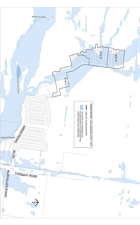
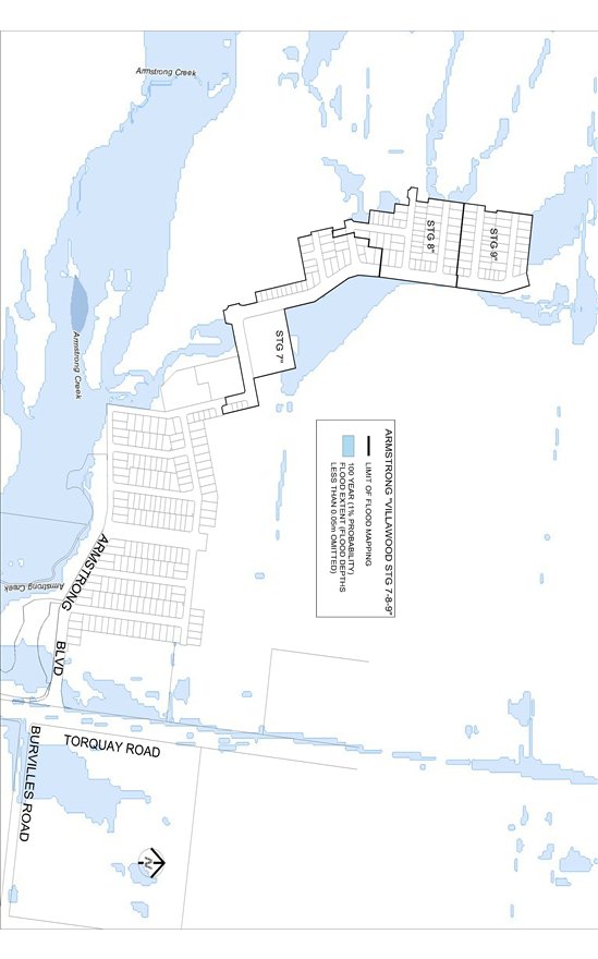
Portfolio: |
Infrastructure – Cr Ellis |
Source: |
City Services – Engineering Services |
A/General Manager: |
Jenny McMahon |
Index Reference: |
Special Rates and Charges: Pakington Street, Newtown |
This report seeks a resolution by Council to consider an intention to declare a Special Charge Scheme to partially fund the construction of a laneway between Noble and Huntington Streets, Newtown. (See plan – Appendix 4).
Concerns in regards to the unsealed laneway at the rear of 307 to 313 Pakington Street have been highlighted by residents in recent times. It is considered that the proposed laneway construction will provide a direct access and amenity benefit for the abutting properties.
It is proposed to construct the laneway with a standard asphalt seal utilising existing drainage infrastructure.
There are eleven (11) properties abutting the proposed laneway that will receive special benefit. There are no Council owned properties in the proposed scheme.
The total estimated project cost is $31,318. A Benefit Ratio of 0.93 has been calculated in accordance with Section 163 of the Local Government Act. This equates to a Council contribution to the scheme of $2,185 and a property owner contribution of $29,133.
Property owners are considered to receive benefit from the works by way of improved vehicular access and general amenity improvements.
The scheme has been prepared in accordance with the Special Rate and Charges provisions of the Local Government Act 1989 along with the 2004 Ministerial Guidelines and Council’s Special Rates and Charges Policy.
Cr Ellis moved, Cr Ansett seconded -
That Council:
Gives notice of its intention to declare a Special Charge Scheme in accordance with Section 163 (1A) of the Local Government Act 1989 (The Act), as follows:
The Special Charge is declared for a period of five (5) years commencing upon completion of the works and scheme finalised.
The Special Charge be declared for the purpose of defraying any expenses incurred by Council in relation to the construction of the laneway between Noble and Huntington Streets, Newtown which project:
Will provide proper vehicular access and improved general amenity for each of the properties included in the scheme;
Council considers is or will be a special benefit to those persons required to pay the special charge (and who are described in succeeding parts of this Resolution); and
Arises out of Council’s function of planning for and providing infrastructure for property owners.
The total cost of project, be recorded as $31,318(Schedule A).
It be recorded that, for the purposes of Section 163 (2A) of the Act, the special charge proceeds will not exceed the amount calculated in accordance with the prescribed formula (R x C = S), the:
‘benefit ratio’ (R) being calculated at 0.93 represents the special benefits to all persons liable to pay the special charge (Schedule B);
‘total cost’ (C) of performing the function described in part 1 (b) of this resolution based on estimated cost be recorded as $31,318; and
‘maximum levy’ (S) be recorded as $29,133.
the following be specified as the area for which the special rate is so declared:
the area within municipal district of Council highlighted in the plan attached to this Resolution (Appendix 4).
the following be specified as the land in relation to which the special charge so declared:
land within the area shown on the plan.
the following be specified as the criteria which form the basis of the special charge so declared:
ownership of any land described in Part 1(e) of this Resolution.
the following be specified as the manner in which the special charge so declared will be assessed and levied:
Each lot receives a primary access and amenity benefit;
The maximum levy is apportioned 50% on access benefit and 50% on a frontage share basis (amenity benefit); and
The special charge will be levied by sending a notice to the person who is liable to pay, pursuant to section 163(4) of the Act.
having regard to the preceding parts of this Resolution but subject to Section 166 (1) of the Act, it be recorded that;
the owners of the land described in column 2 & 3 of Schedule C to the resolution are estimated liable for the respective amounts set out in column 8 of Schedule C; and
such owners may, subject to any further resolution of Council pay the special charge in the following manner;
the charge will become due and payable within one month of the issue of the notice requesting payment pursuant to Section 167 (3) of the Act;
interest will not be charged for six months after the issue of the notice provided the person liable makes timely payment in accordance with any repayment arrangements that may be agreed on by Council; and
in accordance with Section 172 of the Act, the interest rate payable on the special charge which has not been paid by the specific date is set at Council’s overdraft rate, reviewed every three months (provided that it shall not exceed the rate fixed by the Governor in Council by Order for the purposes of Section 172 (2A) in which case the rate of interest shall be the maximum rate fixed by the Governor in Council by Order for the purposes of this section).
Consider any submissions made under section 223 of the Act and the proposed declaration via a Submissions Review Panel, and then by Council at a subsequent meeting, at which time Council will consider whether to make a declaration in the form proposed.
Authorise the Chief Executive Officer to give public notice of the proposed declaration in accordance with sections 163 (1A) and (1B) of the Act and send a copy of the public notice to each person who is liable to pay the special charge in accordance with section 163 (1C) of the Act.
Carried.
Property owner concerns about the condition of this unconstructed laneway have been received in recent times citing issues of dust and poor standards. Following a subsequent inspection of the laneway, it is considered appropriate to have the laneway between Noble and Huntington Streets, Newtown upgraded to contemporary standards.
A detailed Special Charge Scheme proposal including a cost estimate, Benefit Ratio calculation and cost apportionment spreadsheet has been developed. The estimated charges, along with more detailed information on the scheme, were shown to all potentially affected property owners in early October 2014. They were asked to respond to the proposal via survey.
The final survey had seven (7) property owners respond representing a 63% response rate with four (4) in favour and three (3) opposed to the scheme proposal. In this particular scheme, due to the fact that the benefiting property owners are being asked to contribute more than two thirds of the total project cost, a majority approval is required by legislation in order for the scheme to proceed. This situation was explained to the property owners in the initiation letter sent out in October 2014.
This proposed project involves the construction of the laneway at the rear of 307 to 313 Pakington Street, Newtown.
Of the survey results, some of the concerns by property owners include:
The laneway is used by parents dropping and picking up from the school;
A sealed laneway may encourage speeding;
The apportionment is unfair;
The laneway should be made one way from Huntington Street to Noble street northbound;
A speed hump is necessary; and
Laneway is very rarely used;
Cost apportionment for the scheme has been divided into access and amenity benefits. 50% of the total benefit has been apportioned to access. The access benefit includes the provision of an all weather sealed surface.
A sealed laneway also eliminates the nuisance affect of dust and mud. In simple terms, a new laneway improves accessibility for all abutting properties.
The access benefit has been apportioned based on the number of available car parking spaces. All residential properties had the standard allocation of two car parking spaces. The properties between 309 and 313 Pakington Street consist of a combination of retail outlets and medical practices. These properties contain between 4 and 8 car parking spaces. 0.5 Benefit Units (0.5BU) has been assigned to each space. A breakdown of Benefit Units vs. cost allocation is shown at Schedule C.
The remaining 50% of benefit is attributed to amenity and this can best be described as the benefit the laneway provides to an abutting property by way of improved aesthetics, safety, enjoyment, comfort and property value. The amenity benefit is based on the actual laneway frontage to a property. This is known as the apportion-able frontage and is shown at Column 4 of Schedule C.
The provision of a sealed laneway provides a permanent and safe means of access. During the course of construction and the manufacture and procurement of materials, energy is expended resulting in some greenhouse gas emissions. This ceases when construction is complete.
The project does not create waste with the exception of some excavated material.
The proposal does not affect any natural habitats.
The proposal will not require any vegetation removal.
The project is a one off capital cost and will require ongoing maintenance costs. If approved, the scheme could proceed next financial year.
Financial details are as follows:
|
Maximum scheme levy to Property Owners (income) |
$29,133 |
|
Scheme levy to Council |
$2,185 |
|
Total Project Cost |
$31,318 |
From the table above, the total net cost to Council for this project is estimated to be $2,185.
The scheme has been prepared in accordance with the Special Rate and Charge provisions of the Local Government Act 1989 along with the 2004 ministerial guidelines and Council’s Special Rates and Charges Policy.
This report aligns with the City Plan as follows:
Sustainably Built and Natural Environment.
Advocate for and promote sustainable design and development – Promoting sustainable design and retrofitting.
Acknowledge the community’s desire to have their say and be involved in planning for the future of Greater Geelong.
No Council Officer involved with this process has any direct or indirect interest in the properties.
Provision of a sealed laneway will provide safer driving conditions for motorists by the elimination of uneven and slippery surfaces.
There are no identified risks for Council in making its intention to declare the scheme.
The provision of properly sealed and drained laneways is aligned to Council’s City Plan as described above and provides improved connectivity and safety for motorists. It is further considered that the laneways will enhance the general amenity of the area.
In developing this report to Council, the subject matter has been considered to determine if it raises any human rights issues. In particular, whether the scope of any human right established by the Victorian Charter of Human Rights and Responsibilities is in any way limited, restricted or interfered with by the recommendations contained in this report. It is considered that the subject matter does not raise any adverse human rights issues.
It is further considered that the construction of the laneways upholds the right to freedom of movement (Section 12 of the Human rights Charter) by enhancing a person’s ability to move freely within the area they choose to live.
Community consultation for the laneway construction Special Charge Scheme has been carried out as follows:
2 October 2014 – Initiation letter including a plan, Special Rates and Charges brochure, Apportionment spreadsheet and survey forms were sent out to all affected property owners. The survey results indicated sufficient support for the scheme proposal to proceed to the next stage.
Further correspondence will be mailed should Council make its ‘Intention to Declare’ the scheme.
The works for the construction of laneway in the rear of 307-313 Pakington Street Newtown which consist of excavation, pavement works, concrete works, drainage works, sealing, miscellaneous construction works, legal advice and professional services associated with survey, engineering design, drafting, supervision and administration of the project all as included in the cost estimate shown below.
|
TOTAL COST OF SPECIAL CHARGE SCHEME |
|||||
|
ITEM |
DESCRIPTION |
QUANTITY |
UNIT |
RATE $ |
AMOUNT $ |
|
1.00 |
GENERAL |
|
|
|
|
|
1.01 |
Initial site establishment and set up, decamping and site cleanup and other fixed costs up to time of completion of works. |
|
ITEM |
2,000.00 |
$2,000.00 |
|
1.02 |
Traffic management costs. |
2 |
ITEM |
500.00 |
$1,000.00 |
|
1.03 |
Service / Cable locations |
|
ITEM |
250.00 |
250.00 |
|
2.00 |
EARTHWORKS & DEMOLITION |
|
|
|
|
|
2.01 |
Excavation and disposal of all materials to limits of work as indicated on plan, including trimming for new road pavement, excavation of soft spots and removal of concrete. |
54 |
m3 |
60.00 |
$3,210.00 |
|
2.04 |
Saw-cutting of asphalt paving. |
|
Item |
200.00 |
$200.00 |
|
3.00 |
PAVEMENT WORKS |
|
|
|
|
|
3.01 |
30mm compacted depth 10mm nominal size type H Asphalt spread and compacted including emulsion prime & grit using a paver. |
357 |
m2 |
35.00 |
$12,485.00 |
|
3.02 |
150mm compacted depth Class 2 20mm crushed rock, supplied, spread and compacted. |
53.505 |
m3 |
120.00 |
$6,420.60 |
|
SUB-TOTAL |
$25,565 |
||||
|
10% CONTINGENCY |
$2,556.54 |
||||
|
DESIGN |
$1,278.27 |
||||
|
SRC ADMINISTRATION |
$1,917.41 |
||||
|
CONSTRUCTION COST ESTIMATE |
$31,318 |
||||
A |
Purpose |
|
|
|
|
|
|
To construct the laneways at the rear of 307-313 Pakington Street, Newtown to provide all weather vehicular access for abutting property owners. |
|||||
|
B |
Coherence |
|
|
|
|
|
|
The works will provide a physical laneway connection between Noble Street and Huntingdon Street, Newtown and will provide a special benefit to abutting properties. |
|||||
|
C |
Total Cost C |
|
|
|
|
|
|
|
Total Estimated cost of works |
|
|
|
|
|
|
|
Total Cost of Laneway Construction |
$31,318.00 |
|||
|
D |
Identify Special Beneficiaries |
|
|
|
|
|
|
10 properties with frontages to the proposed laneway are considered to receive access and amenity benefits. |
|
|
|
|
|
|
|
E |
Properties to include |
|
|
|
|
|
|
Total Special Benefits (in) is apportioned to 10 properties. Three (3) properties are commercial properties which attract additional access benefits. Seven (7) properties are residential that attract standard access benefits. All properties receive the same amenity benefit. |
|||||
|
|
There are no Council owned properties in the scheme. Therefore: |
|
|
|
|
|
|
Total Special Benefits out of the scheme |
|
TSB (out) = |
0 |
|
|
|
F |
Estimate of Total Special Benefits |
|
|
|
|
|
|
For the purpose of calculating the benefit ratio, a Benefit Unit (BU) will be used and a distinction is made between an access and amenity benefit. We shall assume that the 1 BU consists of 0.5BU for access and 0.5BU for amenity and is equal to the average benefits for each of the private properties. The access benefit for all properties will be considered via the number of car parking spaces available. It is considered that all private properties have provision for two cars at 0.5 BU each (2 X 0.5 = 1BU for access). The retail property at 313 Pakington Street has provision for 4 spaces, 311 Pakington Street has 8 and 309 Pakington Street has 4. The amenity benefit will be the same for all properties at 0.5 BU each. This can be summarised in the table below: |
|||||
|
|
7 Private Properties |
3 Commercial / Retail properties |
|
|
|
|
|
Access |
14 spaces = 7 BU |
16 spaces = 8 BU |
|
|
|
|
|
Amenity |
3.5 BU |
1.5 BU |
|
|
|
|
Total Special Benefits |
10.5 BU |
9.5 BU |
|
|
|
|
|
|
Total Special Benefits in the scheme: TSB (in) = |
20.00 |
BU |
|
||
|
G |
Estimate of Total Community Benefit -TCB |
|
|
|
|
|
|
It is considered that people in the community will receive some benefit from the works as the laneway is used as an access between Huntingdon and Noble Street. It is expected that no more than 10% of laneway users will fit this category and this includes the neighbouring bowling club. There is no amenity benefits considered for the wider community. TCB is calculated as follows: |
|||||
|
|
TCB = 10% X 15 (Total access BU) = |
|
|
2 |
|
|
|
H |
Calculate "Benefit Ratio" - R |
|
|
|
|
|
|
|
Benefits Ratio = |
TSB (in) = |
20 |
|
0.93 |
|
|
|
|
TSB (in) +TSB (out) + TCB |
20 + 0 + 2 |
|
|
|
|
I |
Maximum Total Levy (S) |
|
|
|
||
|
|
Maximum Total Levy S = R X C |
|
|
$29,133.02 |
||
|
|
Council Contribution to Special Charge Scheme |
|
|
|
|
$2,184.98 |
|
COLUMN 1 |
COLUMN 2 |
COLUMN 3 |
COLUMN 4 |
COLUMN 5 |
COLUMN 6 |
COLUMN 7 |
COLUMN 8 |
|
Prop Key |
Address |
Legal Details |
Apportionable Rear Frontage |
Access Benefit (BU) |
Access Charge |
Amenity Charge |
Estimated Total Charge |
|
203761 |
307 Pakington Street, NEWTOWN |
Lot 1 TP 760329 |
15.55 |
1 |
$971.10 |
$1,578.24 |
$2,549.34 |
|
203762 |
309 Pakington Street, NEWTOWN |
Lot 1 TP 698263 |
16.00 |
2 |
$1,942.20 |
$1,623.91 |
$3,566.12 |
|
203763 |
311 Pakington Street, NEWTOWN |
Lot 1 TP 423761 |
16.26 |
4 |
$3,884.40 |
$1,650.30 |
$5,534.71 |
343424 |
1/313 Pakington Street, NEWTOWN |
1/2 Share of Lot 1 TP 902736 |
23.13 |
2 |
$1,942.20 |
$2,347.57 |
$4,289.77 |
|
203764 |
2-3/313 Pakington Street, NEWTOWN |
1/2 Share of Lot 1 TP 902736 |
|||||
|
203307 |
83 Noble Street, NEWTOWN |
Lot 1 TP 704786 |
12.19 |
1 |
$971.10 |
$1,237.22 |
$2,208.32 |
|
203308 |
85 Noble Street, NEWTOWN |
Lot 1 TP 117779 |
12.29 |
1 |
$971.10 |
$1,247.37 |
$2,218.47 |
|
203309 |
87 Noble Street, NEWTOWN |
Lot 1 TP 829448 |
12.19 |
1 |
$971.10 |
$1,237.22 |
$2,208.32 |
|
347341 |
2A Huntingdon Street, NEWTOWN |
Lot 1 PS 703708 |
8.37 |
1 |
$971.10 |
$849.51 |
$1,820.61 |
|
347342 |
2B Huntingdon Street, NEWTOWN |
Lot 2 PS 703708 |
8.39 |
1 |
$971.10 |
$851.54 |
$1,822.64 |
|
202332 |
4 Huntingdon Street, NEWTOWN |
Lot 1 TP 684217 |
19.15 |
1 |
$971.10 |
$1,943.62 |
$2,914.72 |
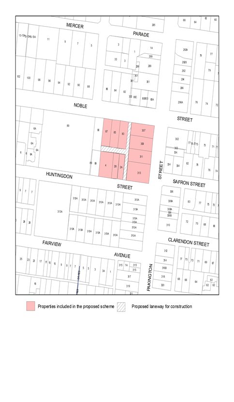
|
Stage |
Status |
Description |
|
Approval to prepare scheme |
✓ |
Decision made to prepare scheme following consideration of surveys of property owners and feed back from the community. Council may then place the project in the budget system or proceed immediately to prepare a scheme. Scheme preparation involves survey, design and preparation of an apportionment of costs. October 2014. |
|
Intention to Declare Scheme |
✓ |
Report to Council providing information on scheme including advice of impending advertising of scheme and declaration of charge. Seeks Council approval by resolution to proceed with process. |
|
Advertisement |
|
The scheme is advertised in the local newspaper and all allotted property owners are notified by mail. This advertisement indicates Council’s intention and notification to ‘declare’ a scheme in a month’s time. |
|
Submissions |
|
From the time of advertising property owners have 28 days (as set down by the Local Government Act) to lodge submissions, either in support or opposition to the scheme. |
|
Submissions Review Panel Hearing |
|
A Submissions Review Panel is convened (quorum of three Councillors) and meets to consider submissions. Some submissions are written only, and other submitters may wish to be heard before the Panel. The Panel makes a recommendation to Council regarding the scheme.. |
|
Declaration Report |
|
Any time 28 days after advertising the scheme and after the Submissions Review Panel has met and considered submissions, Council considers a report and may proceed to “declare” the charges in accordance with its advertised intent. Subsequent to this the Finance Manager issues the levy notices and there is a formal charge placed on the property. This is the final step in the process for Council to make a decision on the scheme. |
|
Appeal |
|
Property owners may lodge an application for review with the Victorian Civil and Administrative Tribunal (VCAT) within one month of issue of the levy notice. An appeal is listed, heard and determined by the Tribunal and this process generally takes three to four months. Decisions made by VCAT are binding on all parties. |
|
Construction |
|
Council may then proceed to construct the works. Invoices are issued seeking payment of the estimated cost within one month of commencement. |
|
Final Cost Report |
|
At the completion of the works the scheme is “finalised” taking into account actual costs incurred and payments are adjusted accordingly. |
Contents | Previous Page: Section A - Procedural Matters | Next Page: Section C - Notice of Motion
