
Council Minutes - Section B: Reports - 14 April 2015
Contents | Previous Page: Section A - Procedural Matters | Next Page: Section C - Assembly of Councillors
Contents | Previous Page: Section A - Procedural Matters | Next Page: Section C - Assembly of Councillors
Reports tabled at the Ordinary Meeting of Council on Tuesday date held at City Hall, Little Malop Street in Geelong.
Adoption of Amendment C307 – Correction of Planning Scheme Anomalies
Private Sporting Infrastructure Capital Co-Contribution Policy
Portfolio: |
Planning - Cr Heagney |
Source: |
Planning and Tourism - City Development |
General Manager: |
Peter Bettess |
Index Reference: |
Application: C307 |
The purpose of this report is to adopt Planning Scheme Amendment C307 to the Greater Geelong Planning Scheme.
Amendment C307 proposes to correct mapping and ordinance anomalies, make changes to the Scheme as a consequence of suggestion from an Independent Panel,
The Amendment is a housekeeping Amendment and has been undertaken to ensure that the Planning Scheme is accurate.
The Amendment applies to a number of different locations across the municipality.
Corrections of these anomalies does not change the intent of any part of the Planning Scheme and is consistent with Council and State policy as it is procedural in nature.
The Amendment was allowed to proceed after 29 January 2015 without Ministerial Authorisation.
The Minister for Planning has given the Amendment exemption from the notification requirements of Section 19 of the Planning and Environment Act 1987, with the exception of the requirement to notify prescribed Ministers.
The three prescribed Ministers from whom exemption from notice cannot be granted have been notified and no submissions have been received.
It is recommended that the Amendment be adopted and forwarded to the Minister for approval.
Cr Heagney moved, Cr Macdonald seconded –
That Council:
adopt Amendment C307 to the Greater Geelong Planning Scheme as contained in Appendix 1 of this report; and
submit the adopted Amendment together with the prescribed information to the Minister for Planning requesting approval.
Carried.
The Amendment is required to correct a number of anomalies in the Greater Geelong Planning Scheme (both maps and ordinance) that have become apparent during the past 12 months of operation. The Amendment is considered to be house-keeping in nature and has been prepared to ‘tidy-up’ the Scheme.
It is incumbent on Council to resolve these anomalies so that the Planning Scheme is relevant, up-to-date, of a high quality and standard, and meets the Department of Environment, Land, Water and Planning (DELWP) requirements. This Amendment will address these matters. This is the eight anomalies amendment since the new format scheme came into operation in July 2000.
Amendment C307 applies to a number of different locations across the municipality including:
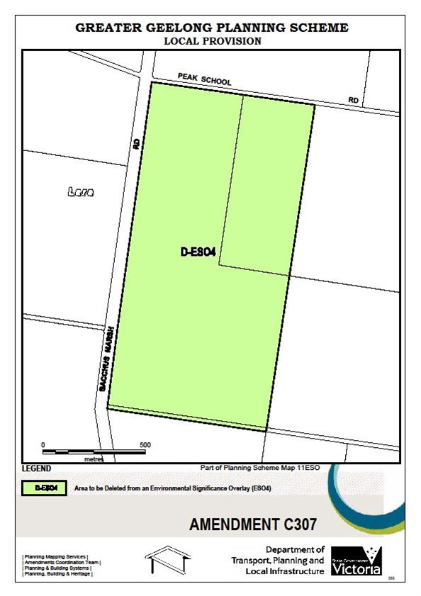
1140 and 1170 Bacchus Marsh Road, Lara (Margoneet Correctional Centre and HM Prison Barwon site)
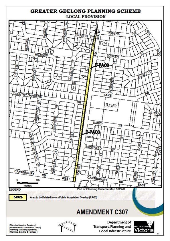
the western side of Forest Road South, Lara between Buckingham Street and Canterbury Road
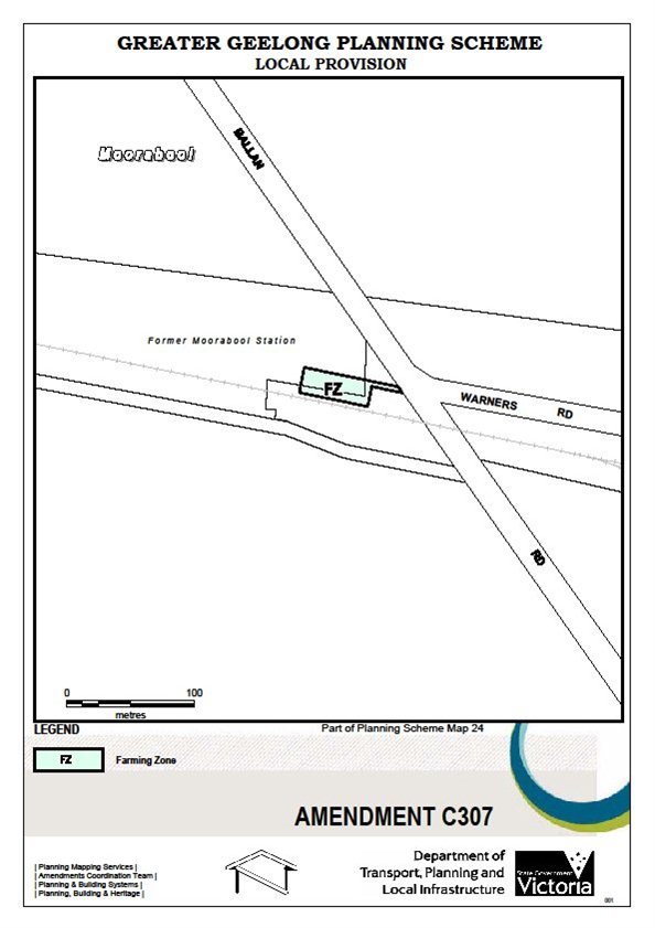
275 Ballan Road, Moorabool
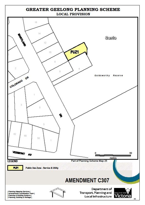
4 Maryland Drive, Corio
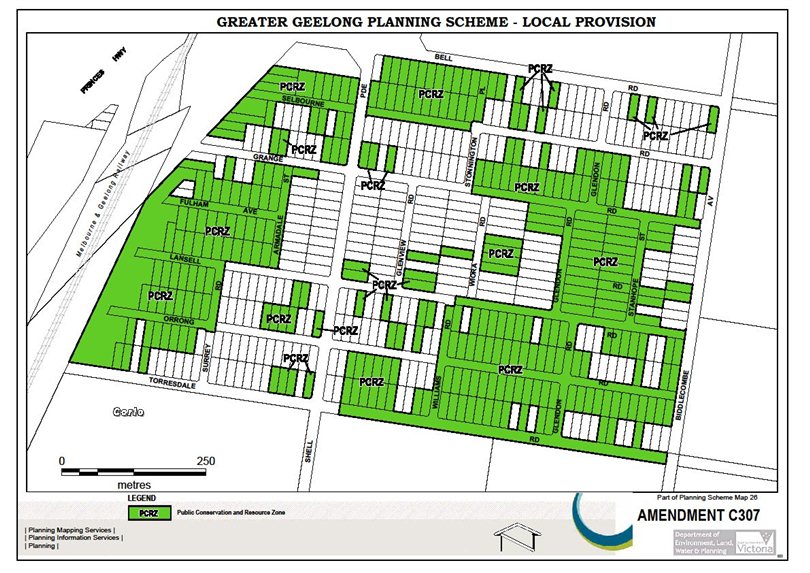
New Corio Estate, Corio
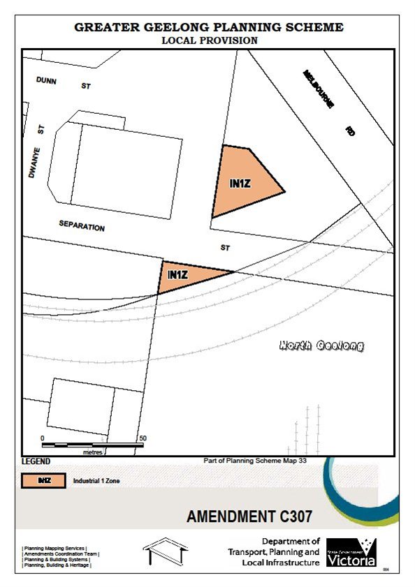
300-302 Melbourne Road, North Geelong
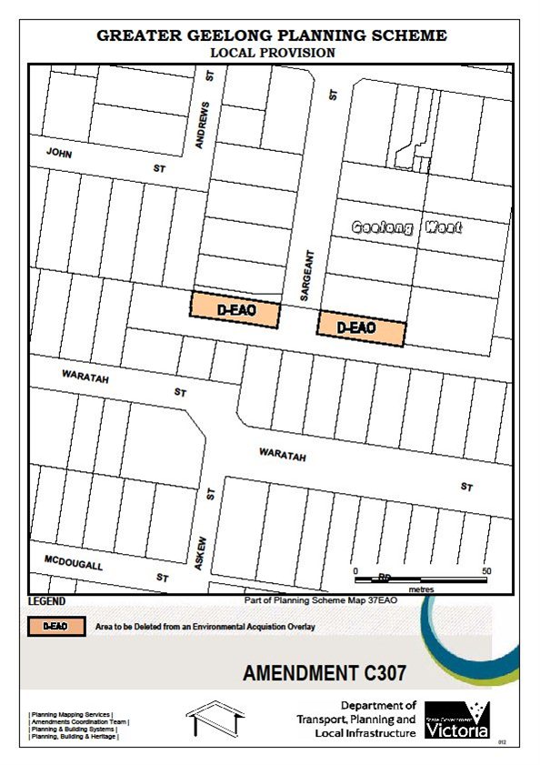
7 and 10 Sargeant Street, Geelong West
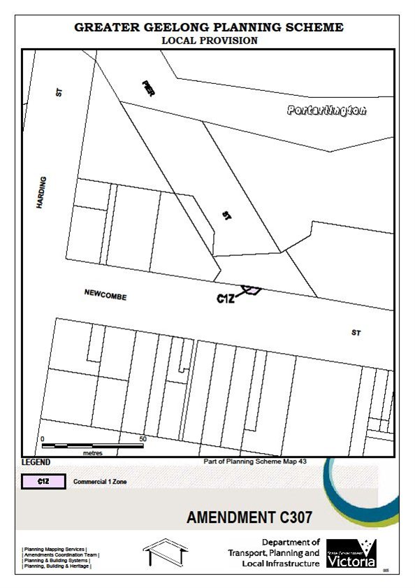
part of 57 Newcombe Street, Portarlington
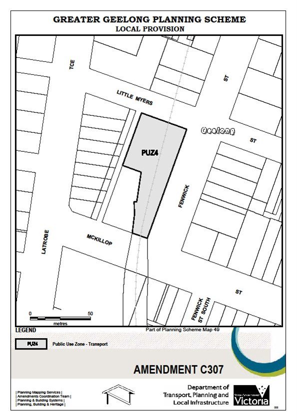
2-4 Little Myers Street, Geelong
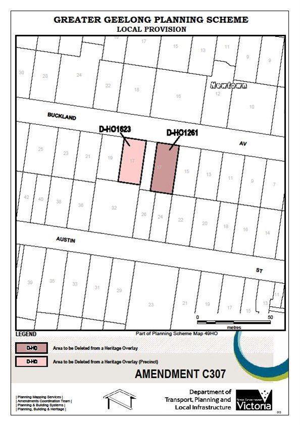
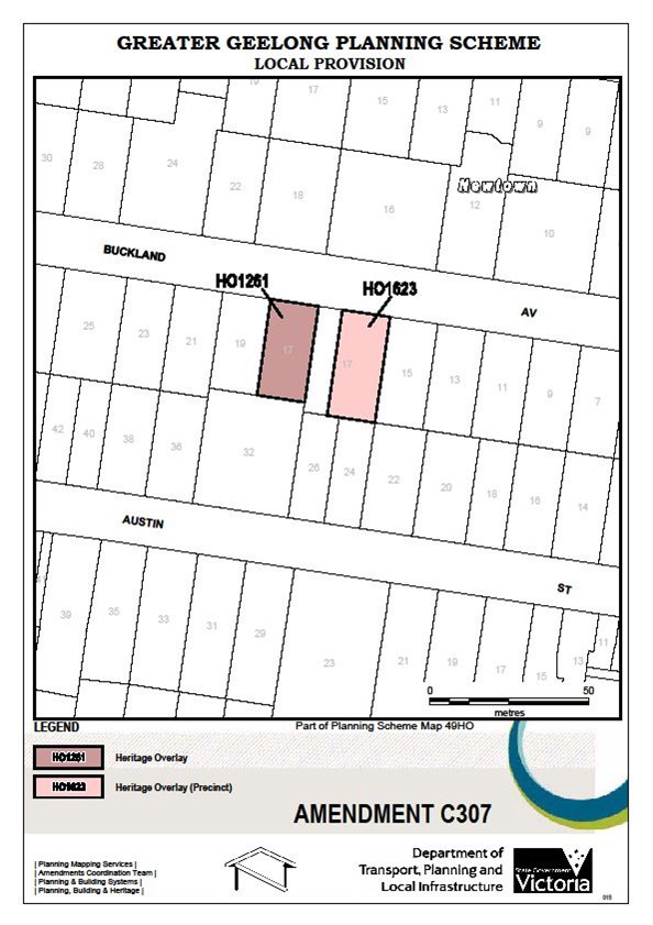
17 Buckland Avenue, Newtown
17A Buckland Avenue, Newtown
Kitchener House, 285-299 Ryrie Street, Geelong
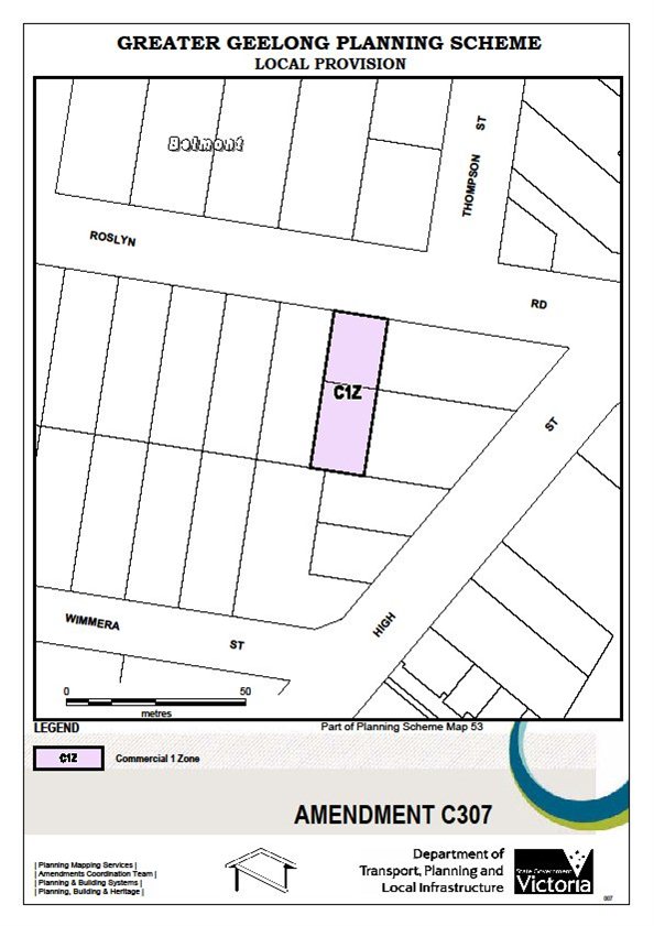
190 and 192 High Street Belmont
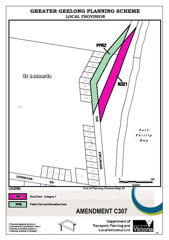
The Esplanade, St Leonards (adjacent to 381 to 389 The Esplanade)
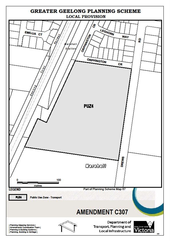
40-60 Drews Road, Marshall
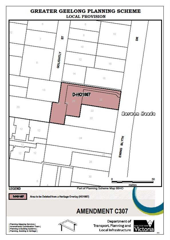
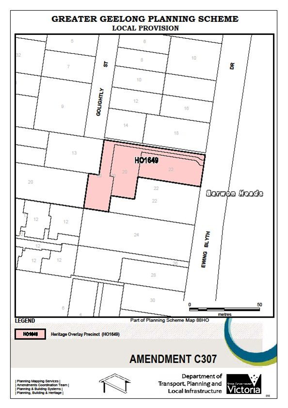
1/20, 2/20 and 1/22 Ewing Blythe Drive, Barwon Heads
land affected by clause 21.18 of the LPPF
land affected by Schedule 2 to the Vegetation Protection Overlay
land affected by Schedule 2 to the Environment Significance Overlay
land affected by Schedule 4 to the Environment Significance Overlay
17 Drysdale Street, Portarlington
Land affected by Schedule 26 to the Design and Development Overlay
Land affected by Schedule 24 to the Development Plan Overlay
On 14 January 2015 Council sought authorisation from the Minister for Planning for this amendment and exemption from notification as per its resolution under delegation on 12 January 2015. DELWP has subsequently advised that Council may proceed to prepare the amendment without authorisation after 29 January 2015. Council is now required to prepare the amendment documents and seek the exemption from notification and the need under Ministerial Direction 15 to pre-set Directions and Panel Hearing dates for this amendment.
The three Ministers (Minsters for ) from which exemption of notice cannot be granted under the Planning and Environment Act 1987, have been notified for a two week period between 16 February and 2 March 2015. No submissions have been received from them.
Amendment C307 proposed for adoption makes the following changes to the Planning Scheme;
Planning Scheme Map Changes:
Delete ESO4 from the land at 1140 and 1170 Bacchus Marsh Road, Lara.
Delete PAO3 from the western side of Forest Road South, Lara between Buckingham Street and Canterbury Road West.
Rezone land at 275 Ballan Road, Moorabool from PUZ4 to FZ.
Rezone the land at 4 Maryland Drive, Corio from PPRZ to PUZ1.
Rezone the publicly owned land in the New Corio Estate, Corio from FZ to PCRZ.
Rezone the land at 300-302 Melbourne Road, North Geelong from RDZ1 to IN1Z.
Rezone the land at 300-302 Melbourne Road, North Geelong from PUZ4 to IN1Z,
Delete the EAO from the land at 7 and 10 Sargeant Street, Geelong West.
Rezone part of the land at 57 Newcombe Street, Portarlington from RDZ1 to C1Z.
Rezone the land at 2-4 Little Myers Street, Geelong from GRZ1 to PUZ4.
Delete HO1261 from the land at 17 Buckland Avenue, Newtown and apply HO1623.
Delete HO1623 from the land at 17A Buckland Avenue, Newtown and apply HO1261.
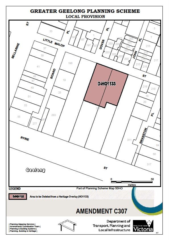
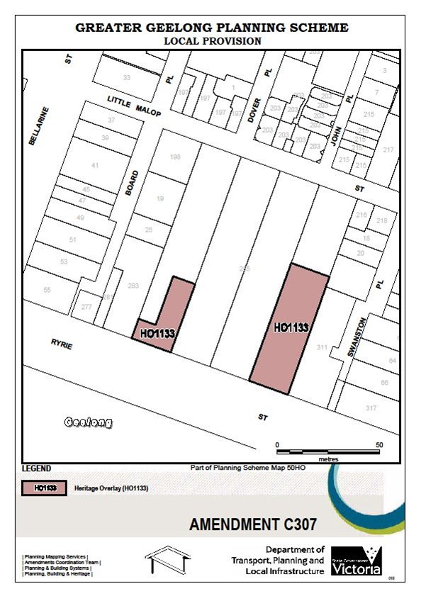
Delete HO1133 from parts of the land at 285-299 Ryrie Street, Geelong and apply HO1133 to parts of the land.
Rezone the rear portions of the land at 190 and 192 High Street, Belmont from GRZ1 to C1Z.
Rezone part of the service road adjacent to 381 – 389 (inclusive) from RDZ1 to PPRZ and rezone the arterial road of The Esplanade from PPRZ to RDZ1.
Rezone the land at 40-60 Drews Road, Marshall from GRZ1 to PUZ4.
Delete HO1667 from the land at 1/20, 2/20 and 1/22 Ewing Blythe Drive, Barwon Heads.
Apply HO1649 to the land at 1/20, 2/20 and 1/22 Ewing Blythe Drive, Barwon Heads.
Planning Scheme Ordinance Changes
Replace Clause 21.18 with a new clause 21.18.
Replace Schedule 2 to Clause 42.01 with a new Schedule 2.
Replace Schedule 4 to Clause 42.01 with a new Schedule 4.
Replace Schedule 2 to Clause 42.02 with a new Schedule 2.
Amend the Schedule to Clause 43.01 to correct the address description for HO 1558.
Replace Schedule 26 to Clause 43.02 with a new Schedule 26.
Replace Schedule 24 to Clause 43.04 with a new Schedule 24.
No adverse environmental implications are expected as a result of this Amendment.
There are no ongoing financial implications for Council arising from this Amendment.
The Amendment is consistent with the format for planning schemes and with the Ministerial Direction on the Form and Content of Planning Schemes. The Amendment is consistent with the State and Local Planning Policy Framework (SPPF and LPPF). As the changes proposed are minor and essentially administrative in nature, there are no implications for the LPPF. Some minor corrections to the LPPF are proposed by this Amendment and will improve its interpretation and relevance.
The Amendment supports the Sustainable Built and Natural Environment and Growing Our Economy strategic directions of City Plan.
No Council officers have any direct or indirect interest, in accordance with Section 80 (C ) of the Local Government Act, to which this amendment relates.
There are no notable risks associated with either implementing or not implementing the recommendations contained in this report. Given its minor, procedural nature, this amendment has been assessed as having a low level of risk.
No adverse social impacts are expected to result from this amendment.
The amendment will not impact on basic human rights, freedoms and responsibilities as set out in the Charter. Planning legislation provides for the exemptions to the usual consultation process for amendments, which the Minister for Planning duly granted.
The Amendment was exempt from the giving of notice with the exception of notification to prescribed Ministers under Section 19(1)(c ) of the Planning and Environment Act 1987.
The planning authority for this amendment is
The Greater Geelong Planning Scheme is amended as follows:
Planning Scheme Maps
The Planning Scheme Maps are amended by a total of 15 attached maps.
Zoning Maps
lanning Scheme Map Nos. 24, 25, 26, 33, 43, 49, 53, 62, 67 are amended in the manner shown on the attached maps marked “Greater Geelong Planning Scheme Planning Scheme, Amendment C307”.
Overlay Maps
lanning Scheme Map Nos. 11ESO, 18PAO, 37EAO, 49HO, 50HO, 88HO are amended in the manner shown on the attached maps marked “Greater Geelong Planning Scheme, Amendment C307”.
Planning Scheme Ordinance
The Planning Scheme Ordinance is amended as follows:
In Local Planning Policy Framework – replace Clause 21.18 with a new Clause 21.18 in the form of the attached document. The changes are as follows:
Subclause 21.18-3 has been amended.
In Overlays – Clause 42.01, replace Schedule 2 with a new Schedule 2 in the form of the attached document. The changes are as follows:
Subclause 3.0 has been amended.
Subclause 4.0 has been amended.
In Overlays – Clause 42.01, replace Schedule 2 with a new Schedule 4 in the form of the attached document. The changes are as follows:
Subclause 3.0 has been amended.
In Overlays – Clause 42.02, replace Schedule 2 with a new Schedule 2 in the form of the attached document. The changes are as follows:
Subclause 1.0 has been amended.
Subclause 3.0 has been amended.
Subclause 4.0 has been amended.
In Overlays – Clause 43.01, replace the Schedule with a new Schedule in the form of the attached document. The changes are as follows:
HO1558 has been amended.
In Overlays – Clause 43.04, replace Schedule 24 with a new Schedule 24 in the form of the attached document. The changes are as follows:
Subclause 3.0 has been amended.
End of document
21.18 |
CORIO NORLANE |
||||||||||||||||||||
21.18-1 |
Key issues and influences |
||||||||||||||||||||
|
21/11/2013 |
Corio and Norlane, including the residential neighbourhood of North Shore, are established northern suburbs of Geelong with a rich industrial, manufacturing, migrant settlement and working class and community history which continue to this day. Corio and Norlane provide affordable housing that is close to the Geelong CBD, Avalon Airport, Geelong Port and surrounding industrial land and the Geelong Ring Road Employment Precinct, with convenient access to Melbourne via road and rail. Ongoing economic restructuring affecting manufacturing is likely to continue to disproportionately impact the Corio and Norlane community. The health and wellbeing challenges facing many residents means there is a greater need to provide high quality, easily accessible social infrastructure and services. There is a stagnant resident population, low housing densities and a marked concentration of ageing public housing stock built from the 1950s onwards. The median weekly household income in Corio and Norlane is significantly less than the Greater Geelong and Victorian average. Corio and Norlane are recognised in the G21 Regional Growth Plan as areas that should be targeted for infill and higher density housing. The Department of Human Services is undertaking the New Norlane project to improve the quality of its housing stock and partner local builders to develop new housing to be made available to both public tenants and home buyers. A significant restructure of the government school system, referred to as the Corio Norlane Education Regeneration Project, is being progressed by the Department of Education. The Corio Sub-Regional Activity Centre (Corio Village) is the focus of retailing in northern Geelong and, together with the Waterworld Precinct to the south, forms a recognisable “heart” of the area. A number of under-performing local shopping centres are unlikely to experience any significant improvement without intervention to address their presentation and function. The management of heavy freight traffic impacts on residents needs to be balanced against competing objectives for diversification and expansion of the Geelong Port. A high proportion of households have no or low access to a private vehicle and a propensity to use public transport. Stormwater drainage infrastructure is generally substandard and coupled with the area’s flat terrain, causes significant drainage-related flooding and runoff problems. Corio and Norlane are well served by areas of active open space however there is a lack of quality, usable passive reserves and smaller parks. There is a noticeable absence of canopy street trees, bushland reserves and landscaped and creative arts spaces that reinforce the perceived negative image of Corio and Norlane. |
||||||||||||||||||||
21.18-2 |
Objectives |
||||||||||||||||||||
|
21/11/2013 |
Land Use and Built Form
Transport and Infrastructure
Communities in Corio and Norlane
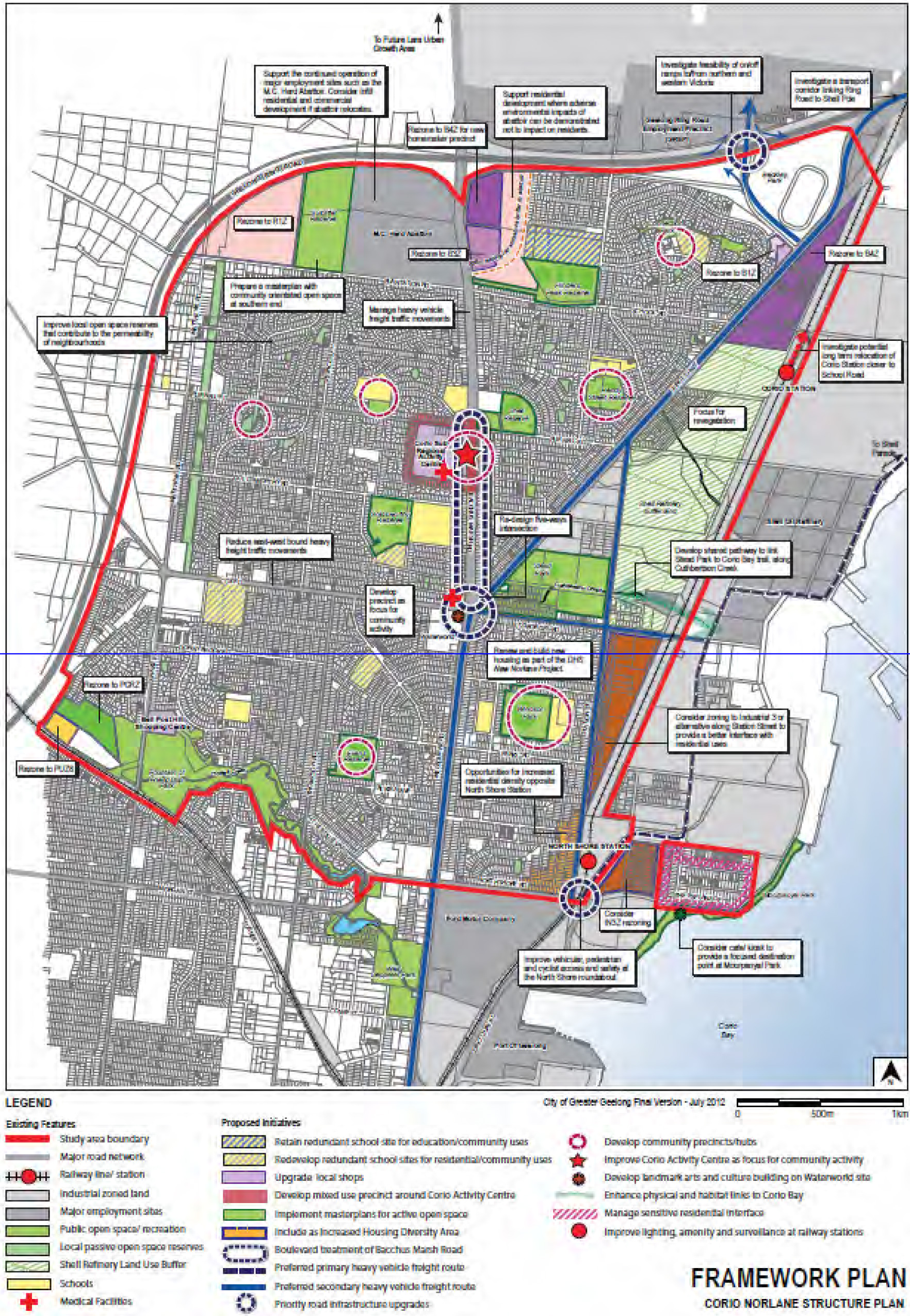
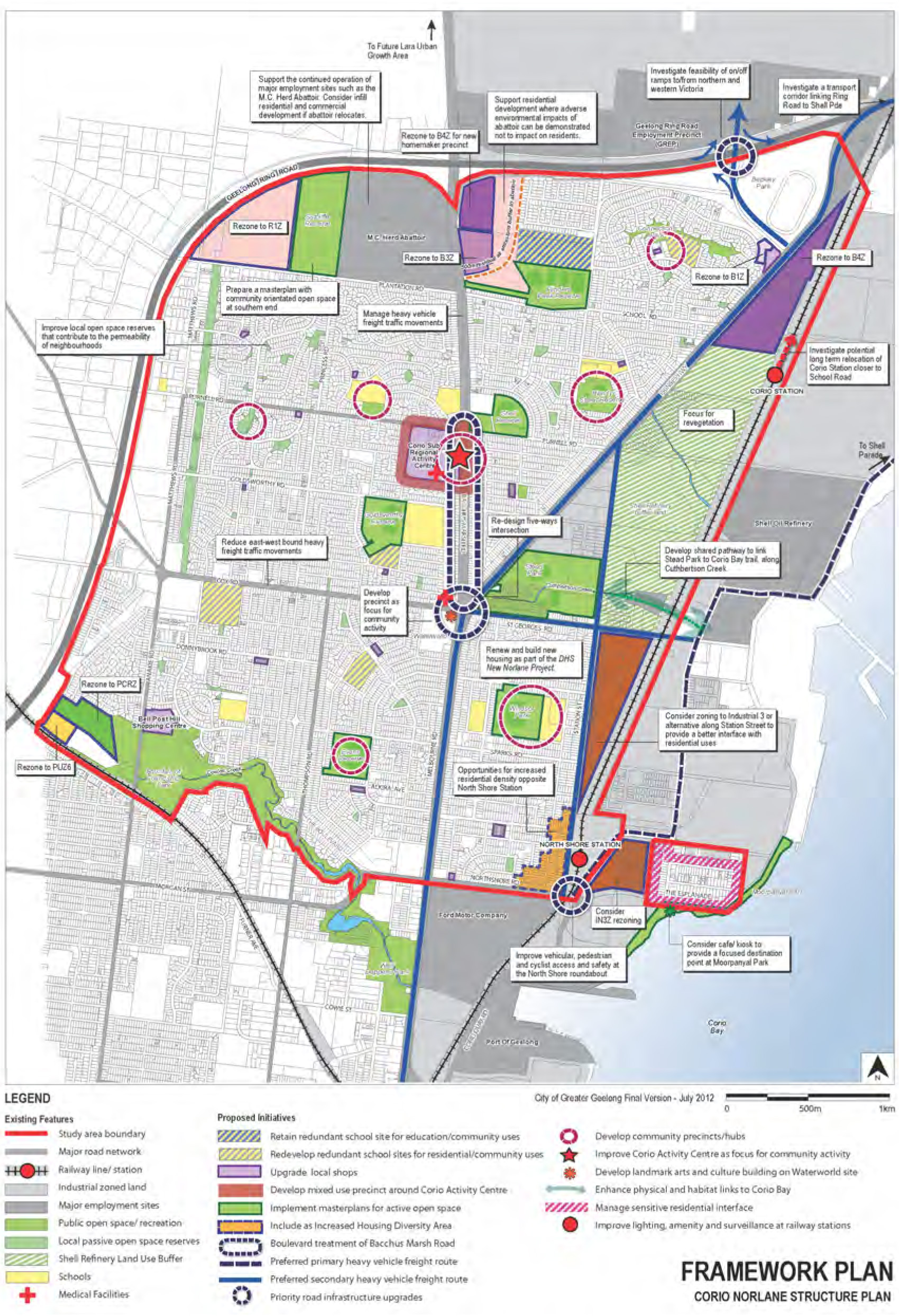
Strategies Ensure land use and development decisions are guided by the Corio Norlane Framework Plan included in this clause, with further direction provided by the Strategy Maps, Concept Plans and Neighbourhood Plans in the referenced Corio Norlane Structure Plan.
|
||||||||||||||||||||
21.18-3 |
Implementation |
||||||||||||||||||||
|
21/11/2013 |
These strategies will be implemented by: Using policy and the exercise of discretion Support higher density residential development in areas identified for increased housing diversity and support higher density residential development in other areas giving consideration to the existing and changing neighbourhood character. Support the Department of Human Services New Norlane housing project. Applying Zones and overlays Apply the Commercial 2 Zone to vacant land opposite the M C Herd Abattoir, east of Bacchus Marsh Road to support office and restricted retail development. Apply the Commercial 1 Zone to vacant land adjacent to the Corio ALDI to establish a neighbourhood shopping centre for the Rosewall community. Apply the Commercial 2 Zone and remove the Design and Development Overlay – Schedule 20 from the Geelong Gateway Homemaker Centre. Amend the Retail Activity Centre Hierarchy Map and Table at Clause 21.07-8 to reflect the above zoning changes. Apply the Mixed Use Zone to land around the Corio Sub-Regional Activity Centre to support the development of retail, offices, cafes/restaurants and health services. Apply the Industrial 3 Zone to service industrial land along Station Street as shown on the Framework Plan. Apply a Special Building Overlay to flood prone land in the Kosciusko Avenue Main Drainage Catchment. Rezone Council-owned land adjoining the Anakie Road Operations Centre to part Public Use Zone 6 and part Public Conservation and Resource Zone as shown on the Framework Plan. Amend Clause 22.63 Increased Housing Diversity Areasthe Incorporated Document Key Development and Increased Housing Diversity Areas to include land identified in the Norlane & North Shore Concept Plan. Further Work Support the redevelopment of the former Rosewall Primary School in accordance with the Rosewall Concept Plan including reconfiguration of adjacent public open space. Prepare structure plans for Increased Housing Diversity Areas to inform new planning provisions to support the policy objectives for these areas. Review the Corio, Norlane and North Shore Residential Character Precinct Brochures. Prepare a master plan and business case to develop a landmark multi purpose centre at Waterworld that provides improved site layout and integration of uses, including the creation of an arts and culture space to service northern Geelong. Prepare a master plan for the Flinders Peak Reserve to better integrate the site with the former Flinders Peak Secondary College and provide improved vehicular and pedestrian access to both sites. Review the Environmental Significance Overlay Schedule 5 to ensure that it appropriately manages the intensification of residential development within the North Shore residential area. Prepare a Pedestrian and Wayfinding Strategy. References Corio Norlane Structure Plan, City of Greater Geelong and the Department of Planning and Community Development, July 2012. Corio Norlane Structure Plan Background Report, City of Greater Geelong and the Department of Planning and Community Development, March 2011. |
||||||||||||||||||||
21.18-4 |
Corio Norlane Framework Plan |
||||||||||||||||||||
|
21/11/2013 |
  |
||||||||||||||||||||
|
|
SCHEDULE 2 TO THE ENVIRONMENTAL SIGNIFICANCE OVERLAY |
||||||||||||||||||||
| 19/01/2006 | Shown on the planning scheme map as ESO2 | ||||||||||||||||||||
HIGH VALUE WETLANDS AND ASSOCIATED HABITAT PROTECTION |
|||||||||||||||||||||
1.0 |
Statement of environmental significance |
||||||||||||||||||||
19/01/2006 |
The areas included within this overlay are considered significant because one or more of the following apply:
For the purposes of this schedule, and in accordance with Article 1.1 of the Ramsar Convention, wetlands are defined as: Areas of marsh, fen, peatland or water, whether natural or artificial, permanent or temporary, with water that is static or flowing, fresh, brackish or salt, including areas of marine water the depth of which at low tide does not exceed six metres. In addition, Article 2.1 of the Ramsar Convention states that: Wetlands many incorporate riparian and coastal zones adjacent to the wetlands, and islands or bodies of marine water deeper than six metres at low tide lying within the wetlands. |
||||||||||||||||||||
2.0 |
Environmental objective to be achieved |
||||||||||||||||||||
19/01/2006 |
|
||||||||||||||||||||
3.0 |
Permit requirement |
||||||||||||||||||||
19/01/2006 |
Buildings and works | ||||||||||||||||||||
| A permit is required to:
A permit is not required for:
Removal, destruction or lopping of vegetation A permit is not required to remove, destroy or lop an exotic species of vegetation, unless this vegetation is deemed to be of importance to:
Application Requirements Any permit application should be referred for advice to the Department of Environment, Land, Water and Planning Natural Resources and Environment. |
|||||||||||||||||||||
4.0 |
Decision guidelines |
||||||||||||||||||||
19/01/2006 |
Before deciding on an application the responsible authority must consider as appropriate:
|
||||||||||||||||||||
SCHEDULE 4 TO THE ENVIRONMENTAL SIGNIFICANCE OVERLAY |
|||||||||||||||||||||
13/03/2014 |
Shown on the planning scheme map as ESO4. | ||||||||||||||||||||
GRASSLANDS WITHIN THE WERRIBEE PLAINS HINTERLAND |
|||||||||||||||||||||
1.0 |
Statement of environmental significance |
||||||||||||||||||||
06/08/2010 |
The areas included within this overlay form part of the Victorian Volcanic Plain Bioregion. The native vegetation of the Victorian Volcanic Plain bioregion is one of the most depleted in the State. Only 4.5 per cent of the State still has a cover of native vegetation, and less than 1.2 per cent is in formal reserves. The Werribee Plains hinterland consists of undulating volcanic plains, a scoria cone and steep gorges formed by the Little and Werribee Rivers. Many elements of the flora reflect the low rainfall of this area, which formerly supported extensive areas of Plains Grassland. Although the native vegetation has been extensively cleared and altered for agricultural, urban and industrial use, there are some large areas of predominantly native vegetation as well as some high quality wetlands, which are important for many threatened fauna species. There are a number of communities and species in this area that do not occur elsewhere in the bioregion. Important species in this area include, for flora, the Button Wrinklewort, Large-fruit Fireweed, Small Golden Moths, Small Milkwort, Small Scurf-pea, Spiny Rice-flower, and the only remaining wild population of Sunshine Diuris; and, for fauna, the Grassland Earless Dragon, Orange-bellied Parrot, Plains-wanderer, Red-chested Button-quail, Striped Legless Lizard and Swift Parrot. The landscape consists of undulating volcanic plains with red duplex soils. The Werribee and Little Rivers have incised steep and sometimes spectacular gorges into the basalt plain. The scoria cone of Mount Anakie is a significant landscape feature. A band of Tertiary sediments is located along the western edge of this area. It has a unique and relatively early history of European settlement due partly to the ease of access of the open grassland plains. Because of this the landscape has been radically altered. The dry plains of the Werribee plains hinterland formerly supported extensive areas of Plains Grassland. These grasslands integrated with Riverina Plains Grassy Woodland (dominated by Grey Box, Buloke and Drooping Sheoak) to the west and south of Melton, and Plains Grassy Woodland in and around the You Yangs and east of the Brisbane Ranges. Riparian areas supported Floodplain Riparian Woodland and Creekline Grassy Woodland with Escarpment Shrubland on steeper escarpments. A variety of wetland communities formerly occurred throughout including Plains Grassy Wetland, Plains Sedgy Wetland, Canegrass Wetland, Lignum Wetland and Aquatic Herbfield. Scoria Cone Woodland was associated with Mount Anakie and other volcanoes. Areas of Coastal Saltmarsh were found along the shores of Port Phillip Bay. Many elements of the flora reflect the low rainfall including White Cypress-pine and Fragrant Saltbush found along the steep escarpments of the Werribee River, and Woolly Buttons at Little River. The native vegetation has been extensively cleared and altered for agriculture and (increasingly) for urban and industrial use. However, there are large areas of predominantly native vegetation including woodlands, wetlands and grasslands. The major issue for biodiversity conservation in the Werribee plains hinterland is loss of native vegetation and habitat through clearing for urban development, cropping and infrastructure. The compounding effects of such clearing are the loss of floristic and habitat diversity and increasing fragmentation of habitats and isolation of remnants. Similarly, changes to management of remnant vegetation and increased urbanisation contribute to the proliferation of weeds and feral animals. Degradation of drainage lines and riparian vegetation through erosion, pollution and uncontrolled grazing, depletion of wetlands and changes to the hydrology of wetlands and streams are also serious threats to biodiversity in the region. However, a range of conservation assets are present and significant opportunities do exist to establish relatively large areas and networks of areas that are managed sympathetically for conservation. Such networks could include a range of vegetation types and land tenures and relatively large and intact areas of open grassland, grassy woodland and wetland communities. |
||||||||||||||||||||
2.0 |
Environmental objective to be achieved |
||||||||||||||||||||
06/08/2010 |
|
||||||||||||||||||||
3.0 |
Permit requirement |
||||||||||||||||||||
13/03/2014 |
A permit is not required to:
|
||||||||||||||||||||
4.0 |
Application requirements |
||||||||||||||||||||
06/08/2010 |
An application must be accompanied by:
An application must also be accompanied by, as appropriate:
If in the opinion of the responsible authority a flora and fauna assessment of the land or a land and environmental management plan is not relevant to the assessment of an application, the responsible authority may waive or reduce the requirement. |
||||||||||||||||||||
5.0 |
Referral of applications |
||||||||||||||||||||
06/08/2010 |
In accordance with Section 55 of the Act, an application must be referred to the relevant referral authority specified in the schedule to Clause 66.04. |
||||||||||||||||||||
6.0 |
Decision guidelines |
||||||||||||||||||||
06/08/2010 |
Before deciding on an application, the responsible authority must consider, as appropriate:
|
||||||||||||||||||||
7.0 |
Reference |
||||||||||||||||||||
06/08/2010 |
|
||||||||||||||||||||
SCHEDULE 2 TO THE VEGETATION PROTECTION OVERLAY |
|||||||||||||||||||||
28/01/2010 |
Shown on the planning scheme map as VPO2 |
||||||||||||||||||||
THACKER STREET, OCEAN GROVE – VEGETATION PROTECTION AREA |
|||||||||||||||||||||
1.0 |
Statement of nature and significance of vegetation to be protected |
||||||||||||||||||||
19/01/2006 |
The Thacker Street Vegetation Protection Area is significant because:
References:
|
||||||||||||||||||||
2.0 |
Vegetation protection objective to be achieved |
||||||||||||||||||||
19/01/2006 |
To protect and ensure the long-term future of the significant remnant vegetation. To ensure development and use do not impact on the significant remnant vegetation. To ensure siting of design of development and works maintains the physical and biological integrity of remnant vegetation community. To encourage regeneration of the significant remnant vegetation. To promote the use of locally indigenous plants for regeneration and revegetation. |
||||||||||||||||||||
3.0 |
Permit requirement |
||||||||||||||||||||
28/01/2010 |
A permit is required to remove, destroy or lop native vegetation, except where:
An application to remove vegetation must:
An application must be referred for advice to the Department of Environment, Land, Water and Planning Natural Resources and Environment. |
||||||||||||||||||||
4.0 |
Decision guidelines |
||||||||||||||||||||
19/01/2006 |
Before deciding on an application for a permit, in addition to the decision guidelines in Clause 42.02-3, the responsible authority must consider as appropriate:
|
||||||||||||||||||||
SCHEDULE 26 TO THE DESIGN AND DEVELOPMENT OVERLAY |
|||||||||||||||||||||
30/01/2014 |
Shown on the planning scheme map as DDO26. |
||||||||||||||||||||
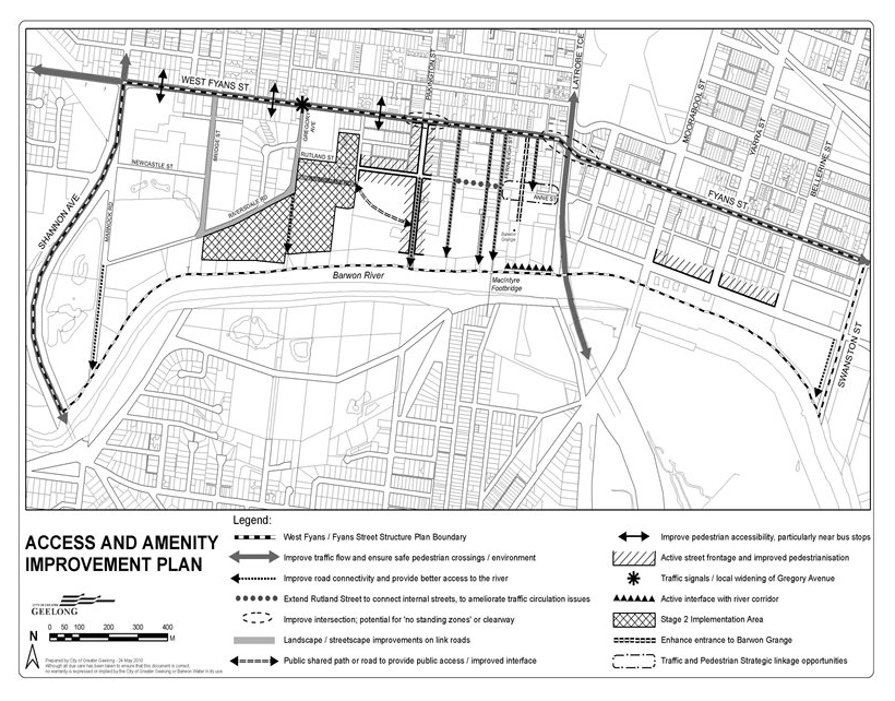
WEST FYANS-FYANS STREET PRECINCT STRUCTURE PLAN AREA |
|||||||||||||||||||||
1.0 |
Design objectives |
||||||||||||||||||||
10/03/2011 |
To encourage high quality, innovative and contemporary design that is contextually relevant and responds to the unique historical and landscape setting of the area.
To encourage building forms, finishes and colours that make a positive contribution to the public realm. To ensure that the height and massing of new development is sympathetic and responsive to the topography of the land To ensure that development adjacent to the Barwon River corridor and open space provides an appropriate interface. To maximise development opportunities through the consolidation of smaller lots. To ensure that subdivision design maximises and enhances the development potential of land. To promote public safety in the public and private realm. To ensure new built form is sensitive to existing heritage sites and areas of high environmental and landscape value. To promote best practise Environmental Sustainable Design including but not limited to energy and water including stormwater quality and reuse initiatives. Promote development which creates a high level of amenity to residents, workers and visitors. To ensure that buildings are designed to allow for adaptive reuse to meet the long term vision for each precinct. |
||||||||||||||||||||
2.0 |
Buildings and works |
||||||||||||||||||||
10/03/2011 |
Permit Requirements
A planning permit is not required to construct or extend a single dwelling on a lot. A permit is required to construct a fence, where the fence is located along a boundary that has a frontage to a street where the fence is:
Design and Built Form Development, where relevant should:
Car Parking and Vehicle Access Car parks and vehicle access to new development should be designed to:
Traffic and Pedestrian Movements The design of new development should incorporate:
Public Spaces Development adjacent to public space (including roads) should:
Landscaping Where a setback is proposed as part of a development landscaping must be incorporated into the design of the site including the provision of canopy trees where appropriate, to improve the appearance of streetscapes and the public realm. Exemption from notice and review
Where it is proposed to extend a building by more than 50% and/or construct a new building and/or carry out buildings and works as a result of a change in use of a building, the following information should be submitted with an application:
The Responsible Authority may waive all or part of this requirement where it considers the proposed use and development will not result in the generation of noise or be impacted by noise from an adjacent property. |
||||||||||||||||||||
3.0 |
Subdivision |
||||||||||||||||||||
30/01/2014 |
A planning permit is required to subdivide land. The subdivision of land:
Exemption from notice and review An application to subdivide land is exempt from the notice requirements of Section 52(1)(a), (b) and (d), the decision requirements of section 64(1), (2) and (3) and the review rights of section 82(1) of the Act. |
||||||||||||||||||||
4.0 |
Advertising signs |
||||||||||||||||||||
10/03/2011 |
Where a permit is required to display an advertising sign, the signage should:
Exemption from notice and review An application to display an advertising sign is exempt from the notice requirements of Section 52(1)(a), (b) and (d), the decision requirements of section 64(1), (2) and (3) and the review rights of section 82(1) of the Act. |
||||||||||||||||||||
5.0 |
Decision guidelines |
||||||||||||||||||||
10/03/2011 |
Before deciding on an application the Responsible Authority must consider:
Reference Document The West Fyans-Fyans Street Precinct Structure Plan 2009. Table 1 to Schedule 26 Refer to the map in Clause 21.17 for the location of the relevant precinct
|
||||||||||||||||||||
 |
|||||||||||||||||||||
SCHEDULE 24 TO THE DEVELOPMENT PLAN OVERLAY |
|||||||||||||||||||||
24/02/2011 |
Shown on the planning scheme map as DPO24 LAND BOUNDED BY PRINCESS STREET, WOODVILLE STREET, CLARENDON ROAD & MURRADOC ROAD, DRYSDALEA development plan must be prepared to the satisfaction of the Responsible Authority to guide the future subdivision, use and development of land generally bounded by Princess Street, Woodville Street, Clarendon Road and to the rear of the business zoned properties fronting Murradoc Road. The objective of this Schedule is to ensure development occurs generally in accordance with the Princess Street Drysdale Concept Plan – 2009, and to require a range of detailed planning issues to be resolved prior to commencement of development of the area. |
||||||||||||||||||||
1.0 |
Requirement before a permit is granted |
||||||||||||||||||||
24/02/2011 |
A permit may be granted before a development plan has been prepared to the satisfaction of the responsible authority for the following:
|
||||||||||||||||||||
2.0 |
Conditions and requirements for permits |
||||||||||||||||||||
24/02/2011 |
A permit must contain conditions or requirements which give effect to the provisions and requirements of the approved Development Plan. A permit for subdivision must contain a condition which requires the owner to enter into an agreement with the Responsible Authority pursuant to Section 173 of the Planning and Environment Act 1987 to provide development contributions for:
as outlined in the approved Development Plan |
||||||||||||||||||||
3.0 |
Requirements for development plan |
||||||||||||||||||||
24/02/2011 |
The Development Plan must include the following: An Urban Design Masterplan that includes:-
A Road Network and Traffic Management Plan that includes:-
The Road Network and Traffic Management Plan is to address all off-site traffic infrastructure requirements associated with the site. The Road Network and Traffic Management Plan must be accompanied by a Road Safety Audit prepared by an appropriately qualified person and must address any safety issues raised by the Audit which arise as a consequence of the development of the land. A detailed Flooding, Stormwater and Drainage Management Plan that adopts an integrated approach to stormwater system management, is designed with reference to the whole of the catchment and includes:
The Flooding, Stormwater and Drainage Management Plan is to address all off-site drainage infrastructure requirements associated with the development of this site and be developed with due consideration of other land in the whole of the catchment containing this site. An Open Space and Landscape Masterplan that includes:
The Open Space and Landscape Masterplan is to ensure that areas set aside for useable public open space are clearly visible and accessible, providing safe and convenient land to serve the recreational needs of current and future residents in the locality. Passive surveillance to such areas shall accord with Crime Prevention Through Environmental Design (CPTED) principles. |
||||||||||||||||||||
Concept Plan – Princess Street, Drysdale 2010 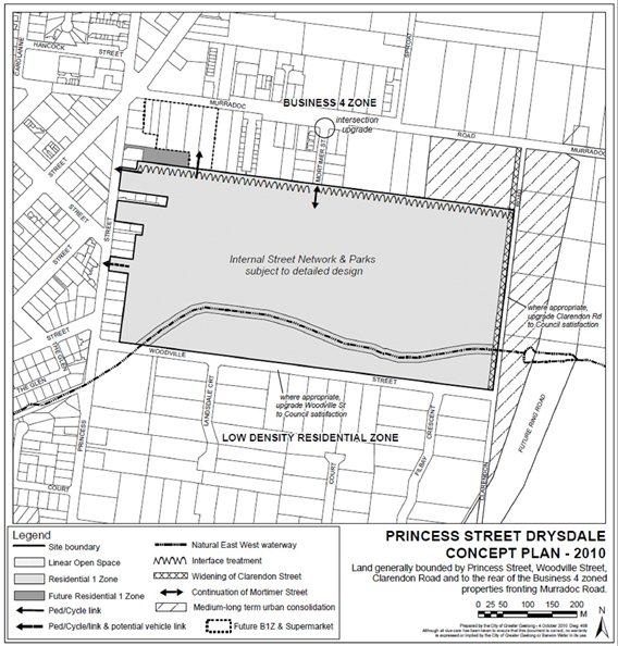 |
|||||||||||||||||||||
Note – only the change to the Schedule to the Heritage Overlay is included (not the full clause) |
|||||||||||||||||||||
1 |
SCHEDULE TO THE HERITAGE OVERLAY |
||||||||||||||||||||
| 30/01/2014 | The requirements of this overlay apply to both the heritage place and its associated land. | ||||||||||||||||||||
|
Cr Macdonald declared an Indirect Financial Interest in Agenda Item 2 – Combined Planning Scheme Amendment C324 and Permit Application 1503/2014 – 357 and 359 Pakington Street, Newtown in that he has an interest in a property within close proximity to this development proposal and left the room prior to discussion at 7.37pm.
Portfolio: |
Planning - Cr Heagney |
Source: |
Planning & Tourism - City Development |
General Manager: |
Peter Bettess |
Index Reference: |
Application: C324 and 1503/2014 |
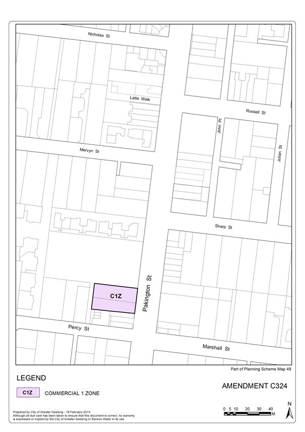
The purpose of this report is to consider Amendment C324 to the Greater Geelong Planning Scheme to rezone land at 357 and 359 Pakington Street, Newtown, from General Residential 1 Zone to Commercial 1 Zone.
Amendment C324 proposes to rezone land at 357 and 359 Pakington Street Newtown from General Residential Zone 1 to Commercial 1 Zone.
The rezoning application for 357 Pakington Street is accompanied by a permit application for buildings and works (associated with an office and two dwellings). Partial reduction in car parking, and a three lot subdivision.
The combined rezoning and permit application has been prepared by Sincock Planning (Planning Consultants) on behalf of Dale Whitford.
At the request of Council officers, the rezoning proposal also encompasses the property to the south at 359 Pakington Street, such that the Commercial 1 Zone would extend from Percy Street northward up to and including 357 Pakington Street.
The Commercial 1 Zone is the most appropriate zone for commercial use and development within an activity centre, and the rezoning will join an existing area of Commercial 1 Zone.
The site area of 357 Pakington Street is approximately 450 sqm. and for 359 Pakington Street it is 376 sqm.
The subject land is currently zoned General Residential Zone 1 and is not affected by any overlays.
The application for a permit applies only to 357 Pakington Street. It seeks approval for buildings and works associated with an office and two dwellings, a partial reduction in car parking and a three lot subdivision.
The state and local planning policy framework support the provision of commercial space within an existing activity centre. This location is classified as an infill development within the extent of the existing commercially zoned land.
It is considered the design and layout of the proposed development complements the existing shopping centre and will integrate well into the function of the retail core.
It is recommended that Council resolves to support the preparation of the Amendment and that Council requests the Minister for Planning to authorise the preparation and exhibition of the Amendment.
Cr Heagney moved, Cr Ansett seconded -
That Council:
supports the preparation and exhibition of Amendment C324 to the Greater Geelong Planning Scheme to rezone the land at 357 and 359 Pakington Street, Newtown, from the General Residential Zone 1 to Commercial 1 Zone;
considers the application for a planning permit for an office and two dwellings on the land at 357 Pakington Street, Newtown, concurrently with the preparation of the Amendment in accordance with the Planning and Environment Act, and that draft Planning Permit 1503/2014 be prepared and exhibited with the Amendment, subject to resolution of the detail of the permit conditions; and
requests the Minister for Planning to authorise the preparation and exhibition of Amendment C324 and Planning Permit 1503/2014.
Carried.
On 26 November 2014 a combined Planning Scheme Amendment request and Planning Permit application was lodged by Sincock Planning on behalf of Dale Whitford, pursuant to Section 96A of the Planning and Environment Act 1987.
It is proposed to rezone the land at 357 and 359 Pakington Street, Newtown, from the General Residential Zone 1 to the Commercial 1 Zone and obtain a planning permit (1503/2014) to construct an office and two dwellings. The land at 357 Pakington Street is currently developed with a single storey weatherboard dwelling and shed, whilst the land at 359 Pakington Street is also developed with a single storey weatherboard dwelling with a paved front setback and gravel rear courtyard, and is used as a café.
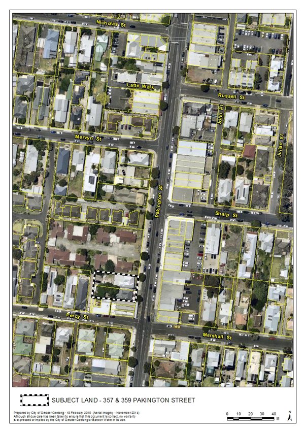
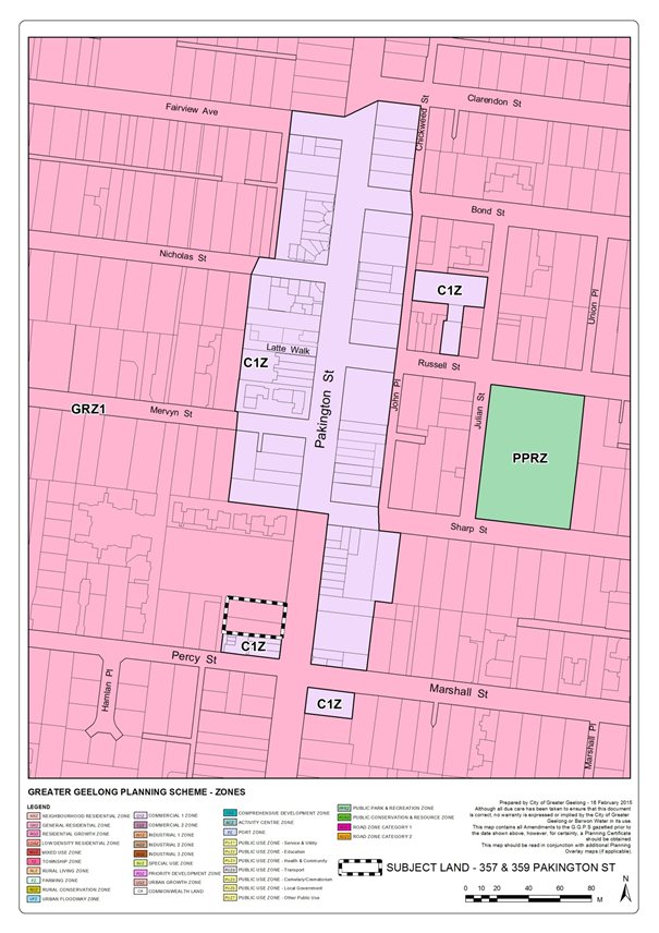
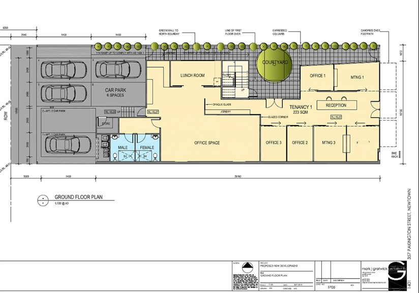
An aerial map of the subject land is shown at Appendix 1 and a current zoning map is shown at Appendix 2. The proposed rezoning map is shown at Appendix 3.
In addition to the buildings and works, the permit is to allow a three lot subdivision and a partial reduction in car parking on the land at 357 Pakington Street.
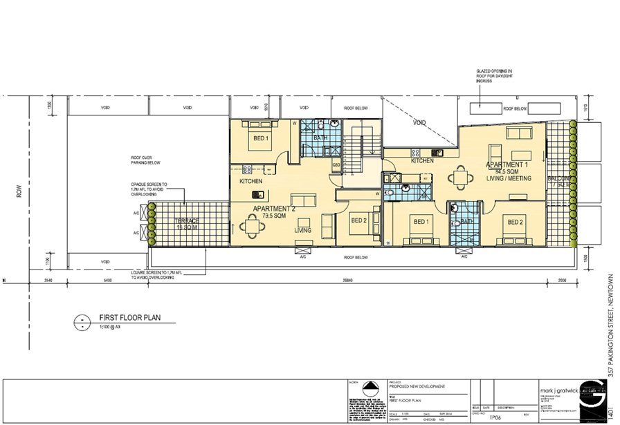
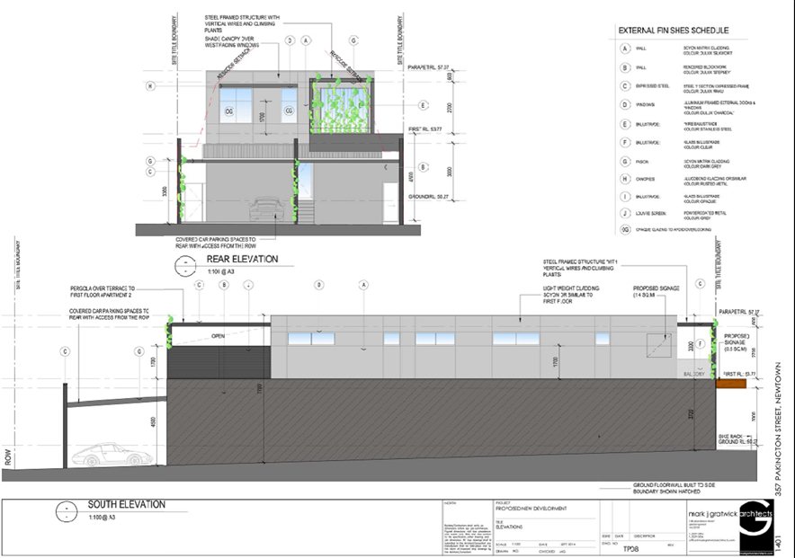
The site plan (Appendix 4) shows that the proposed office at ground floor level will have a floor area of 223sqm supported by 4 car parking spaces accessed from a rear carriageway. The two dwellings are located at the second floor level with floor areas of 79.5sqm and 84.5sqm, each with one on-site car space accessed from the rear carriageway.
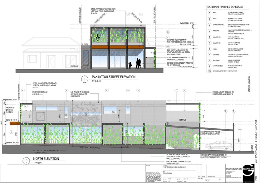
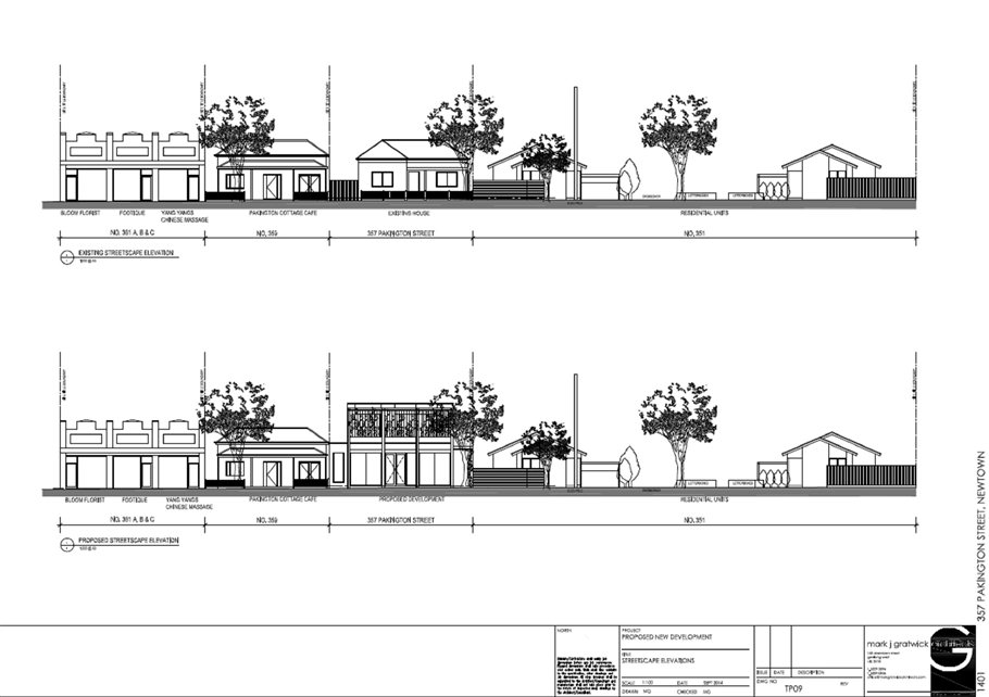
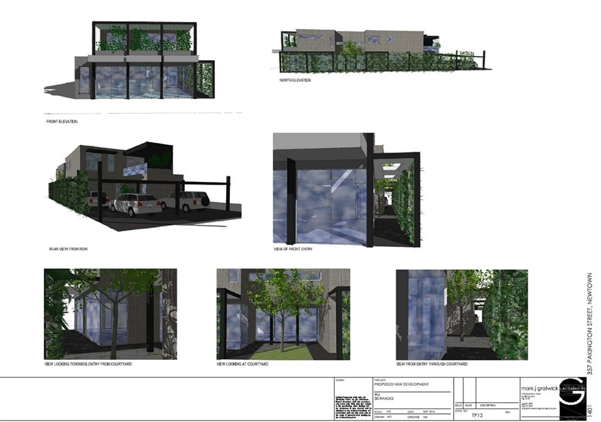
The development is of contemporary design as shown in perspective drawings at Appendix 5.
The rezoning request and permit application was supported by a planning report (Sincock Planning) and traffic assessment (Cardno) as well as site, development and landscaping plans.
Lodgement of the application followed two pre-application meetings between Council officers and the applicant about the layout for the development and access/parking arrangements.
The application seeks to rezone two (2) parcels of land located in Pakington Street containing a dwelling and a café from General Residential Zone 1 to Commercial 1 Zone. It also proposes to construct a two storey office (ground floor) and apartment building (2 apartments at first floor level) on the land at 357 Pakington Street. The proposal will extend the existing Commercial 1 Zone northwards along Pakington Street from Percy Street to encompass the properties from 357-359 Pakington Street.
The property to the south is included in the rezoning at the request of officers to ensure the application appropriately provides for the Commercial 1 Zone to extend in a southerly direction to the boundary of the existing Commercial 1 Zone. The land at 359 Pakington Street is used for commercial activities and is visually strongly connected to the southern end of the existing Pakington Street shopping strip.
The existing neighbourhood centre is uneven in its spatial arrangement, the west side (extending approximately 250m south of the Chilwell Primary School at Fairview Avenue Street to past Mervyn Street, the east side extending approximately 393m south from Clarendon Street (opposite the school) to Marshall Street (extending opposite the subject site). The geographical centre point of the centre’s eastern side is the existing Clarendon Hotel on the corner of Russell Street.
From a purely spatial and centre based approach there is merit in extending the zoning of the Centre on its western edge to include the subject sites. Extension of the Centre is reasonably logical in this location. The adjoining unit developments to the north of the subject site will remain a considerable residential land use within the Centre.
Reason for the Amendment
The core reason for the planning scheme amendment is to enable the mixed use development of the site, primarily the provision of office floor space that is operated independently of any dwelling.
As noted in the application report, “the Pakington Street Newtown shopping centre has limited office space available, and particularly has very few options for office space at a ground floor level. Whilst three residential parcels were rezoned on the south side of Mervyn Street in recent years, the development specifically provided for retail use at the ground floor and office use at the first floor, therefore providing limited opportunity for ground floor frontage for office uses in the centre.” Preliminary works for this project have only recently commenced.
Consistency with Retail Strategy
The Greater Geelong Retail Strategy, June 2006, provides a hierarchy of preferences for the location of new retail development. Preference is given to sites located within existing identified activity centres. If no sites are available within existing activity centres, the next preference is for ‘edge-of-centre’ sites. This proposal constitutes an infill location that is within the defined boundaries of the activity centre.
The proposal is consistent with the City of Greater Geelong Retail Strategy. A very small commercial floor space (223sq.m) is proposed, however this will foster small business development via the opportunity to locate in a successful and vibrant neighbourhood shopping centre and provide office based activity that is in short supply in this centre. The location of the site within the existing boundaries of the centre, with Commercial 1 land in proximity to the north and south, and opposite to the east, effectively means the boundary of the centre doesn’t change, but infill development is occurring and supporting the existing centre and customer base.
The very small growth of the Centre via this development doesn’t change the size or role of the neighbourhood centre, and is therefore consistent with the existing hierarchy. The floor space proposed is insignificant and doesn’t warrant any assessment against Clause 22.03 as it is well under the 2000sq.m threshold for an economic analysis, does not propose a key major tenant, is not considered to be an out of centre proposal and does not increase an existing floor space cap.
The proposal consolidates an existing neighbourhood centre and via the mixed use nature of the proposal, supports vitality and activity at the centre during the day and evening.
The Pakington Street centre is identified as having a Neighbourhood centre role within the identified retail hierarchy which typically serve between a 8,000 – 25,000 population catchment, range from 2,500m2 – 10,000m2 retail floor space are typically based around convenience related shopping needs such as newsagent, chemist, hairdresser, green grocer, butcher, takeaway food and anchored by a supermarket. These activities are all well represented in this centre (with the exception of a supermarket) with the addition of an established hotel. Low vacancy rates would seem to suggest a reasonably well functioning and viable centre. There are low levels of quality office space in the neighbourhood centre; an outcome inconsistent with objectives which seek to support a range of uses and opportunities within activity centres. The combination of office and residential is a desirable outcome from a policy perspective.
Physical Impact on the Centre
The site provides an infill development opportunity that increase commercial floor space and provides for a modern and attractive building form, building on the existing catchment of the centre and being accessible by foot, bicycle, public transport and car.
The proposal also adds to the limited availability of office floor space in the centre which is unlikely to be added to within the existing centre without extensive redevelopment of existing zoned premises or substantial increases in height which will impact on the low scale character of the centre.
The proposed rezoning will change the land from purely residential use to a mix of business and residential use, with a minor net residential increase. The property at 357 Pakington Street is a modest older weatherboard home that is not covered by a heritage overlay and has not been considered to be of historic merit in the latest Newtown Heritage Study. Whist this will be lost in the redevelopment, the dwelling density is increased by the development of two dwellings at the first floor level, therefore compensating for the loss of residential land.
The amendment adds to the Commercial 1 zoning within the shopping centre without compromising the neighbourhood atmosphere nor will it add a significant amount of commercial floor space to the Centre that would change its place in the retail hierarchy. It is not adding any retail floor space.
It is considered an appropriate strategic response to develop a ‘balanced’ Centre on each side of Pakington Street with good pedestrian and visual links between each side of the street. Extending the Commercial 1 Zone northward from Percy Street to include the subject land will achieve this outcome whilst residential uses will be retained in the Centre on both the subject land and to the north.
Protecting and enhancing the interface edges with adjoining residential properties is critical to strip shopping centres such as Chilwell Village, and has been considered and addressed by the proposed design of the development for 357 Pakington Street.
Overall, it is considered that the proposal is consistent with planning policy and requirements and will visually and physically integrate with the existing neighbourhood centre.
Proposed Planning Permit
The proposed development for the 357 Pakington Street site presents a contemporary design utilising a range of building materials that are compatible with those in the adjacent area. Materials include scyon matrix cladding, block work and expressed steel framing along with a steel framed structure along the balconies and pergolas with vertical wires for climbing plants to add interest and design elements to the frontage. The design also integrates pedestrian protection (verandah), utilises clear glazing to the office which allows for a clearly defined entrance and an activated street frontage and provides streetscape continuity.
The site has a residential interface: the residential property to the west is separated by the carriageway easement, whilst the dwelling to the north is setback between 3-5m from the common boundary. To the south is a former dwelling converted to a food and drink premises. The site is proposed to be developed with setbacks to the ground and first floor providing building separation and ensuring no loss of amenity for the occupants of the dwellings. The building will overshadow the food and drink premises but this is acceptable given it is not secluded private open space associated with a dwelling.
The dwellings and office can be accessed from both the street and from the rear, where the entrances are conveniently located close to car parking spaces. The dwellings have either a terrace or balcony providing private outdoor spaces for residents of the dwellings and also providing surveillance over the street and rear laneway. It is considered that the development is responsive to the site and respectful of the adjoining dwelling.
The application was referred to Councils Engineering, Waste and Traffic Units who raised no concerns with the application subject to conditions being placed on the permit. The Waste Unit requires an area indicated on the plan showing sufficient capacity for the four bins for the units and waste and recycling bins for the office use. Assessment of the proposal and examination of internal and external referral comments has determined that issues relating to access, drainage and waste are able to be addressed and included in the draft planning permit conditions prior to exhibition.
The application has been assessed against proposed Commercial 1 Zone where it has been found to comply. The office is an as of right use and the dwelling use is also as of right as the frontage of the dwellings at ground floor does not exceed 2 metres. The subdivision component of the application corresponds with the development and clearly delineates the common areas and the two dwellings from the office.
The proposed reduction in car parking spaces has been assessed against Clause 52.06 ‘Car Parking’. One car parking space for each apartment is provided which complies, but only four spaces are provided for the office where seven are required. One additional space will be created on street and the Car Parking Assessment submitted with the application concluded “…the proposed development is not considered to have a significant impact on the operation of Percy Street or the = surrounding road network and is considered appropriate.” Councils Traffic Engineers commented that there are no traffic engineering issues to not support the proposed amendment, and that all issues identified pre-application will be addressed as conditions on the planning permit.
The dwellings generally comply with Clause 55 (two or More Dwellings on a Lot) with the front setback, site coverage, energy efficiency, side setbacks, walls on boundary and storage requiring variation to the standard but maintain compliance with the relevant objectives.
The subject site is extending the existing neighbourhood shopping centre of Chilwell Village and is conveniently and safely accessible to pedestrians. Located on a major road, the site is also serviced by bus services that operate along Pakington Street.
No impact to budget.
The proposal meets the following strategic objectives:
It supports the strategic intent outlined in the State Planning Policy Framework and Local Planning Policy Framework including the Municipal Strategic Statement;
It provides land for office purposes on a site where any land use conflicts can be minimised;
It respects the existing hierarchy of Activity Centres by simply providing increased opportunity within an existing Neighbourhood Centre context;
It integrates both office and residential use to provide a range of activities on one site; and
It reallocates office use from a residential use, adding supply to the former without a negative impact on provision of residential land.
The site has strategic merit for an extension to the Chilwell Village Shopping Centre in Pakington Street Newtown as a minor expansion of the existing neighbourhood activity centre. It is consistent with state and local planning policy to consolidate existing centres where synergies with adjacent uses can be achieved. In this case, the addition of office space to the Centre can be achieved in conjunction without the need to convert or redevelop established retail sites.
The Amendment supports the ‘Growing our Economy’ strategic direction of City Plan.
No Council Officers have any direct or indirect interest, in accordance with Section 80 (c ) of the Local Government Act to which this Amendment relates.
There are no notable risks associated with implementing the recommendation contained in this report.
The proposed amendment will add further services to the Chilwell Village Shopping Centre in the form of office space.
The Amendment will not impact on any basic rights, freedoms and responsibilities as set out in the Charter. Planning legislation ensures an open community consultation process occurs, enabling people to freely express their views and if necessary obtain a fair hearing before an Independent Panel.
The Amendment will be exhibited in accordance with the notice provisions of the Planning and Environment Act 1987.
Cr Macdonald re-entered the meeting room at 7:39pm.
Portfolio: |
Transport - Cr Richards |
Source: |
City Services, Engineering Services |
Act/General Manager: |
Jenny McMahon |
Index Reference: |
Geelong Transport Strategies, Transport Planning |
To identify current and future transport infrastructure needs for Waurn Ponds.
At its meeting on the 28 October 2014, Council requested a report be presented to Council on the current and future transport infrastructure needs for Waurn Ponds, including State Government and Council Roads.
An assessment of the current and projected traffic volumes in Waurn Ponds has been undertaken based on projected future growth.
This report identifies the present and future transport infrastructure needs for Waurn Ponds area.
Cr Richards moved, Cr Fisher seconded -
The consideration of the report be deferred.
Carried.
Portfolio: |
Sport and Recreation – Cr Irvine |
|
Source |
Projects, Recreation & Central Geelong |
|
Act/General Manager: |
Paul Jane |
|
Index Reference |
Subject: Leisure and Recreation Facilities / Recreation Facility Issues |
To seek endorsement for a Private Sporting Infrastructure Capital Co-contribution Policy for capital works on sporting infrastructure not on Council owned or managed land.
Council regularly receives requests from owner/operator(s) of sport and recreation facilities not on Council owned or managed land regarding opportunities for sporting infrastructure capital works support.
The City of Greater Geelong has a mix of publicly and privately owned/managed sport and recreation facilities throughout the municipality.
Council does not currently have a framework to provide financial support for capital works projects at privately owned/managed sport and recreation facilities.
The Co-contribution Policy provides Council and the community with a clear direction as to the level of contribution it may provide to eligible sporting infrastructure projects.
An application for funding must be received via Council’s annual budgetary process and demonstrate strong community benefit.
Private clubs that are the recipient of Council funds must agree to appropriate mechanisms to protect the community investment.
All requests for Council funding will be subject to approval through Council’s annual budget process.
Cr Irvine moved, Cr Harwood seconded -
That consideration of the report be deferred.
Carried.
Portfolio: |
Arts & Culture - Cr Richards |
Source: |
Community Services |
Act/General Manager: |
Linda Quinn |
Index Reference: |
Subject: Arts & Culture Reports |
The purpose of this report to provide Council with the Geelong Gallery’s 2013-2014 Evaluation Report (Appendix 1) and the Gallery’s 2013-2014 Annual Report (Appendix 2 – previously circulated with briefing papers).
The Geelong Gallery is a key facility in the Geelong Cultural Precinct. It possesses a collection of historical and contemporary art that is widely acknowledged as one of the finest and most valuable held by a regional gallery in Australia. The Gallery continues to provide the region’s residents and visitors with outstanding exhibition, public and educational programmes as well as curatorial services.
In 2013-2014 Council’s contribution to the Geelong Gallery was $1,022,000 representing the first year of the fifth Triennial Funding agreement between the Greater Geelong City Council and Geelong Gallery.
The Gallery’s collection of works of art is held in trust for the region and is managed and developed in accordance with international standards of museum practice and includes iconic works of art such as View of Geelong by Eugene Von Guerard and Bush Burial by Frederick McCubbin.
The Gallery is located in Little Malop Street directly adjacent to the Geelong Library Heritage Centre (GLHC) construction site. As a direct consequence the Gallery’s normal operations were significantly impacted and services disrupted due to the major construction work on the GLHC site including frequent road closures, throughout the 2013-2014 year.
A total of 59,167 in person and 160,132 online visits were made to the Gallery throughout 2013-2014.
Cr Richards moved, Cr Irvine seconded -
That Council note the Geelong Gallery 2013-2014 Annual Report and the 2013-2014 Evaluation Report.
Carried.
The Geelong Gallery’s collection of works of art is held in trust for the Region and is managed and developed in accordance with international standards of museum practice. The Gallery’s holdings of historical and contemporary art are widely acknowledged as one of the finest and most valuable collections held by a regional gallery in Australia. The Gallery’s collection includes iconic works of art such as View of Geelong by Eugene Von Guerard, Ocean Blue, Lorne by Arthur Streeton and A Bush Burial by Frederick McCubbin.
The Geelong Gallery is open to the public seven days a week and entry is free. The Gallery presents art exhibitions, educational and public programmes and curatorial services to the residents of and visitors to the Region.
This evaluation report covers 2013-2014 which is the first year of the fifth Triennial Funding Agreement between the Geelong Gallery and the City of Greater Geelong.
As part of the Agreement, KPI’s are set for the Gallery’s annual performance. Most were met or exceeded in 2013-2014 and have been summarised below:
59,167 visited the Gallery – annual target 60,000
160,132 online visits to the Gallery – annual target 115,000
1,430 memberships – annual target 2,250
24 exhibitions were mounted in total – agreed target 16
21 exhibitions were self initiated – agreed target 10
1,758 exhibition days – agreed target 800
7 exhibitions were held in the Community Access Gallery – agreed target 6
7 exhibitions embraced subjects relating to local/regional history and featured work by artists active in the Geelong region – agreed target 6
30 public programmes, floor talks, external speaking engagements lectures, and presentations – agreed target 30
24 public education programs were presented – agreed target 25
4 access space exhibitions involving schools and community groups were presented – agreed target 5
24,000 Quarterly Newsletters were distributed – agreed target 25,000
The Gallery is located in Little Malop Street directly adjacent to the Geelong Library Heritage Centre construction site. The Gallery experienced impact and disruption to its operations associated with this major construction throughout the 2013-2014 year impacting on visitor numbers.
Exhibition highlights for 2013-2014 include:
The Great War – a graphic legacy which drew upon rarely seen and significant loans from institutional lenders and private lenders in Victoria and interstate and brought together disparate artistic responses to the conflict of WW1. This exhibition featured work by French, British, German as well as Australian artists.
Beyond Bravura –a collaboration with the renowned Jam Factory craft centre in Adelaide featured Stephen Bowers monumental painted ceramics which appealed to a wide audience and supported by well attended public programs.
All breathing in heaven – part of the Geelong region artist program this group exhibition by Gracia Haby, Louise Jennison and Stephen Wickman examined the artists shared interest in the intersection between the animal and human worlds.
The Geelong Gallery is a purpose built gallery designed to make the most of natural light, while keeping within international environment standards for museums. The Triennial funding agreement between Council and the Gallery includes clauses relating to maintenance of the building which enables the Gallery to benefit from contractors already engaged by Council who are encouraged to meet environmentally responsible principles where possible.
The Gallery is investigating a range of more sustainable options for ongoing operation including replacement of current display lighting.
The City of Greater Geelong is the Gallery’s largest funding partner. Council makes an annual contribution to the Gallery in accordance with the Triennial Funding Agreement. In 2013-2014 Council’s contribution in the first year of the fifth Triennial Funding agreement was $1,022,000.
Maintenance of the Geelong Gallery Building forms part of the Triennial Funding Agreement with request referred to and managed by the Property Department. Additional funding for replacement of major plant and ongoing maintenance are considered separately and form part of Council’s annual budgetary considerations. As a Council asset, the Gallery facility is depreciated through Council’s accounting system.
LBW Chartered Accountants have completed their audit of the Gallery’s financial position for 2013-2014 and have given the Gallery a positive assessment.
The Geelong Art Gallery is located on Crown Land with a lease period of 999 years due to expire on the 16th June 2854. The Building is a Council asset, operated by the Geelong Art Gallery Incorporated, as a body associated for artistic and cultural purposes. The Board is composed of 12 persons, elected each year at the Annual General Meeting.
The Board operates under a Charter. Councillor Michelle Heagney was Council’s representative on the Geelong Gallery Board from October 2012 to February 2014. Councillor Andy Richards, Portfolio Holder for Arts & Culture was Council’s representative on the Geelong Gallery Board from February 2014 for the remainder of the 2013-2014 year.
Although not a document intended to create legal relations between the partners, there is a Memorandum of Understanding under the State Government’s Local Partnerships programme between Arts Victoria, City of Greater Geelong and Geelong Art Gallery Incorporated, to support the annual programmes and operations of the Gallery.
The Geelong Gallery is an important cultural facility, which assists the City of Greater Geelong to deliver the actions outlined in Council’s Culture Strategy Creativity +, as well as the Strategy’s Vision: to develop the City of Greater Geelong as a regional centre of innovation and excellence. The Gallery is one of the key Cultural Precinct facilities identified in the Geelong Future Cities Master plan.
The annual operation of the Geelong Gallery supports City Plan Strategic Directions and Priorities:
Community Wellbeing
Connected, creative and string communities
Growing our Economy
A successful and vibrant City Centre;
A leading city for tourism, arts, culture and events
There is no direct or indirect interest by Council Officers involved in the preparation of this report.
The 2013-2014 Financial Statements of the Geelong Gallery have been subject to an independent Financial Audit by LBW Chartered Accountants.
The Triennial Agreement and six month reporting and evaluation measures against KPI’s ensure the Gallery’s performance is regularly reviewed and assessed.
In order to safeguard the Collection on behalf of the Geelong community, the Gallery needs to implement proper security measures and acquire an appropriate level of insurance. The Gallery’s security arrangements are independently assessed on behalf of the Victorian Governments Exhibition Indemnity program. The Gallery currently has a Gold rating (the highest rating) under this program.
The Gallery has an outstanding reputation as a leading regional gallery to maintain. To do so it must be able to continue to develop its educational/public programmes and activities.
The Gallery’s collection of works of art is held in trust for the region’s community at large and is managed and developed in accordance with international standards of museum practice.
Galleries play a significant role in the cultural, social, educational and economic development of the community. The Geelong Gallery plays an important role in the collection, conservation and exhibition of the Region’s material heritage as expressed in works of art. The reputation of the Gallery, as one of the finest regional galleries in Australia, is a source of civic pride. The Galleries exhibitions, educational and public programmes as well as curatorial services, are highly valued cultural resources.
The opportunities that the Gallery provides for our emerging and established artists are crucial to the Region’s cultural development. The Gallery contributes to the amenity and attraction of Central Geelong and, as one of the City’s major cultural attractions in the Cultural Precinct, contributes significantly to cultural tourism.
The Geelong Gallery is an important cultural facility, which assists the City of Greater Geelong to deliver the actions outlined in Council’s current Culture Strategy Creativity +, as well as the Strategy’s Vision: to develop the City of Greater Geelong as a regional centre of innovation and excellence.
The Geelong Gallery respects and provides access for all visitors. It presents artists from a diversity of cultural, linguistic, ethnic and religious diversity respecting the right to express all aspects of the human experience.
The Arts & Culture Department in consultation with Communication and Marketing Unit will be responsible for communicating this report.
Portfolio: |
Arts & Culture - Cr Richards |
Source: |
Community Services - Arts & Culture |
Act/General Manager: |
Peter Bettes |
Index Reference: |
Subject: Arts & Culture/Bellarine Multi Arts - Potato Shed |
The purpose of this report is to provide Council with information relating to the Potato Shed activities and highlights during the 2013/2014 period.
The Potato Shed is a multi-arts venue that presents performing arts, art exhibitions, educational and public programmes to residents and visitors to the Bellarine.
Council, Bellarine Secondary College and St Ignatius College Geelong all make annual contributions to the operation of the Potato Shed based on a Joint Use Agreement.
The Potato Shed continued to experience a high level of community demand in 2013/2014. Over its fourteen years of operation it has experienced a steady increase in general public visitation rates and is now consistently not able to accommodate all requests for bookings.
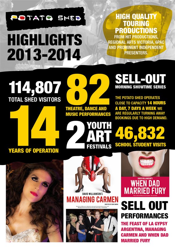
Diverse community engagement activities in 2013/2014 included 82 theatre, dance and music performances and two youth art festivals (Appendix 1, Potato Shed Highlights).
General public visits to the facility increased by over 10% from 61,485 to 67,975 with a decrease of school usage.
Achievements for 2013/2014 included the culmination of the “Class of 2013” Subscription Season in 2013, and first half of the “2014” Season; a diverse array of performances, dance works and original productions were presented. This included high profile touring product from Hit Productions, Regional Arts Victoria, 6PAC and prominent independent presenters. The highlight of the 2014 season was the sell our “La Gypsy Argentina”, involving many groups from the Bellarine, together with international performer Moira Finucane to present a feast of delights of Bellarine produce with an extraordinary performance.
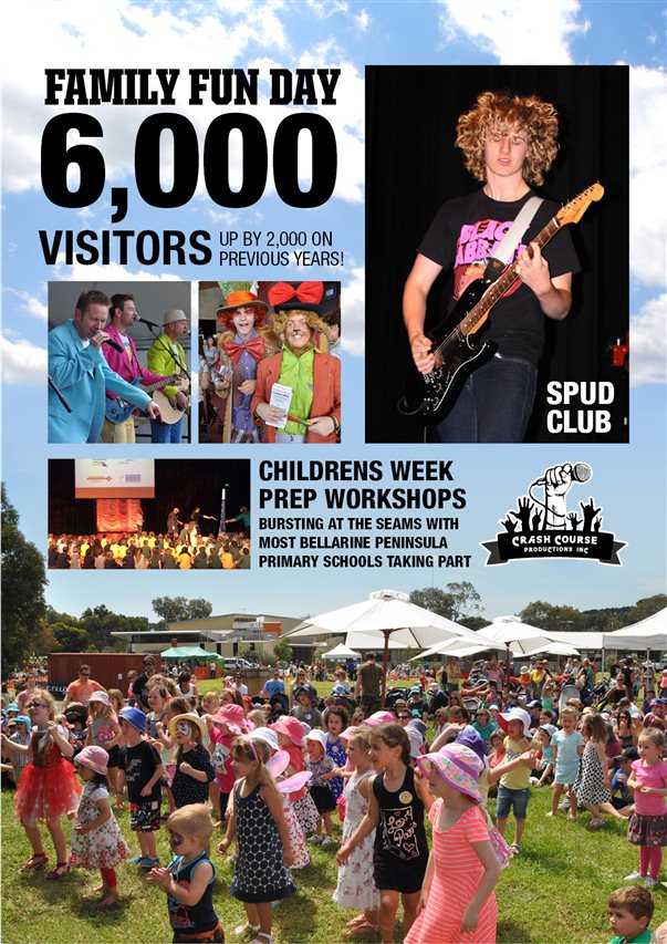
Other highlights included a sell-out Morning Showtime series, attendance of 6,000 at the 2013 Family Fun Day, up 2,000 on the year, and Children’s Week Prep Workshops, which attracted participation from most primary schools on the Bellarine.
The key challenge facing the venue continued to be managing the needs and expectations of schools, hirers and community groups with the ever increasing demand for use.
Cr Farrell moved, Cr Richards seconded -
That Council note the report.
Carried.
The Potato Shed was built as a joint venture by the City of Greater Geelong, Bellarine Secondary College and St Ignatius College Geelong (formally Catholic Regional College) with the State Government providing additional funding from the Community Support Fund. Council established a Committee of Management under Section 86 of the Local Government Act, and a Development and Joint Use Agreement was signed. The venue opened 15 March 2001.
Throughout 2013/2014 the Potato Shed once again experienced a high level of community demand; a total of 114,807 visits were made. The venue operated at near capacity seven days a week, 14 hours a day, and was not able to accommodate all bookings. The key challenge facing the venue continued to be managing the needs and expectations of schools, hirers and community groups within the existing footprint.
General Public attendance totalled 67,975 (an increase of 6,490 visits or over 10%), while school attendances decreased to 46,832, or 11,000 less due to St Ignatius College relocating music classes back within their school. This is a direct result of the lack of space at the Potato Shed with school enrolments growing and an increased demand for rooms which cannot be accommodated within the facility.
Programme highlights over 2013/2014 included several sell out performances including international sensation Moira Finucane with Gypsy Argentina, the smash hit “Managing Carmen” and the award wining “When Dad Married Fury”. Audiences were delighted to experience a number of cabaret style productions along with a host of established actors live on stage locally. Tasmanian Theatre troupe Blue Cow presented a piece called “Art” and Malthouse Theatre Melbourne presented “Blak Cabaret” featuring some of Australia’s top indigenous performers. The popular Morning Showtime Season sold out yet again and featured regular local performers from Drop of A Hat productions along with Christine Middleton and renowned NT Theatre with the production “Highway of Lost Hearts”.
A number of new original works were presented, including a self-devised new work “Burlesco” by Dance Initiative, the very popular “12x12 Plays” by Theatre 3222inc with twelve new works from local writers. Xavier McGettigan presented his new one man show “Man About Town” and Tim Mckew graced the Shed with “Mad about the Buoy” just before his New York season.
Other highlights included Crash Course Productions (CCP) with all-age events. CCP is an award-winning youth-operated production group which comprise members aged between 14 and 24 years. They stage fully supervised and strictly smoke, drug and alcohol-free events for youth of Geelong and the Bellarine Peninsula. CCP have become a positive model for other youth groups. 2013/2104 also saw the introduction of Bellarine Youth Action Crew (BYAC) raising a new profile at the Potato Shed.
Aside from one-off events, a snapshot of regular weekly bookings show an impressive array of community usage which included: multiple ballet classes; martial arts classes; a range of contemporary dance classes; regular rehearsals for amateur theatre companies; community engagement workshops; youth focused activities and band practices. These activities were all conducted within the facility outside school hours and were in addition to school use during Monday to Friday class times.
The Shed also hosted a number of key events and non-theatre related activities, including three conferences, a wedding, sports presentation nights and fourteen private functions. People of all abilities were welcomed and encouraged to participate in all the activities at the venue and view performances and events.
User satisfaction was still high in spite of booking frustrations. However as the venue operates at near capacity there was very little scope for the inclusion of new groups and activities. As the community grows, along with the interest in the venue, some groups may need to find larger spaces to accommodate their needs. Both schools are growing in size so the facility is unable to accommodate any extra classes or workshops.
An accredited Waste Wise process was implemented in 2008 and continues successfully. The Potato Shed encouraged all users and hirers to be waste wise and banned the use of all polystyrene products in the venue. LED lighting has been installed in the foyer, hallways and toilets reducing heat generation and providing a substantial reduction in electricity use.
The Potato Shed is subject to the terms and conditions of a Joint Use Agreement between the City of Greater Geelong, Bellarine Secondary College School Council and The Roman Catholic Trusts Corporation for the Diocese of Melbourne. Under this agreement a formula dictates all parties’ contribution to the daily operation of the facility.
Council’s contribution to the operation of the Potato Shed in 2013/2014 was $197,000 including Family Fun Day with $20,550.00 allocated to capital and building maintenance. In addition to Council’s contribution, Bellarine Secondary College and St Ignatius College Geelong contributed $57,443.00 to the operating costs and an additional $18,190.00 towards capital and building maintenance.
Through a series of resolutions dating back to 1997, Council agreed to participate as a joint venture partner with Bellarine Secondary College and the Roman Catholic Trusts Corporation for the Diocese of Melbourne (representing St Ignatius College Geelong) in the development of the multi-arts facility at the Bellarine Sub-Regional Centre, Drysdale, known as the Potato Shed. Cr Farrell (Chair) was the nominated Council representative on the Potato Shed Committee of Management 2013-2014 financial year.
The Potato Shed aligns well with many of the ideals of the City Plan, promoting Community Wellbeing with participation in the Arts, Sustainability and Environmental initiatives through waste wise and energy saving measures.
There is no direct or indirect interest by Council Officers involved in the preparation of this report.
The Potato Shed has obligations under OH&S legislation to provide appropriate equipment and training for manual handling and to ensure that work stations meet Worksafe requirements.
The Potato Shed consistently operated close to capacity, with a steady increase in visitation rates presenting some risk challenges managing the needs and expectations of the schools, hirers and community groups high level of usage raising the issue of sustainability of the venue.
In 2013/2014 the Potato Shed again provided a valuable cultural resource for the City of Greater Geelong, in particular the Bellarine. The multi-purpose nature of the venue means the Potato Shed played a significant role in the cultural, social and educational development of the community. The venue has a reputation as an affordable and accessible community resource.
The Potato Shed embraced diversity and encouraged participation from all sectors of the community and was a vital hub of arts, social and educational activity for people of all ages and abilities. The venue’s resident groups often collaborate to create positive outcomes within the community.
Collision Dance, Crash Course Productions, Bellarine Jongleurs and Theatre 3triple2 are all excellent examples of how the Potato Shed functioned as a model for social inclusion, providing independent ways for school students (outside school hours) and other young people to benefit from the venue.
Family Fun Day and Children’s Week Prep Workshops formed an important part of the cultural life on the Bellarine Peninsula.
The partnership model between Council and two Secondary schools is widely admired, with other local governments and schools periodically visiting to learn from this successful experience.
The Potato Shed promotes cultural diversity and cultural acceptance and is a vital hub of arts, social and educational activity for people of all ages and abilities on the Bellarine.
The Venue frequently surveys audiences and the broader community to understand needs. The Arts and Culture Department, in consultation with Marketing and Administration, will be responsible for communicating this report.
Portfolio: |
Major Events - Cr Nelson |
Source: |
Projects, Recreation & Central Geelong |
Act/General Manager: |
Paul Jane |
Index Reference: |
Subject: Events / Geelong Major Events |
As per Clause 4.7 of the Geelong Major Events (GME) Terms of Reference, update reports from the GME Committee will be presented to Council each quarter or half-year during the financial year.
Council established the GME committee in August 1998 pursuant to Section 86 of the Local Government Act.
This report provides an overview of GME activities for the period July 1 to December 31 2014.
Nine major events supported by GME were successfully hosted in the Geelong Region including the Australian U16 Basketball Championships, Word 4 Word Festival, Toast to the Coast and the Geelong Revival Motorsport Festival.
The nine events stimulated economic activity and provided social benefits to our community. An estimated $9.7million of event expenditure was generated in our region from local and non local sources which supports the equivalent of 78 full time jobs in the region.
Those events provided additional social benefits for the local community through participation and spectator opportunities with a number of our major events offering free public access and entertainment for all ages. Up to 76,000 spectators are estimated to have attended the nine events staged in the half-year ending 31 December 2014.
Major Events have a diverse and varied environmental legacy and the events staged within this period implemented a range of programs to minimise impacts where required and provide positive outcomes where possible. Council works closely with event organisers to ensure best practices in this regard are achieved at major events staged within our region.
Cr Harwood moved, Cr Irvine seconded -
That Council notes the report detailing the activities of Geelong Major Events for the July to December 2014 period.
Carried.
Council, in August 1998, established a Section 86 Committee under the provisions of the Local Government Act known as Geelong Major Events (GME) as a means of stimulating and encouraging events within the municipality.
The objectives of Geelong Major Events are:
GME will strive to stimulate and encourage events that offer the best opportunity to provide measurable economic benefits, potential to market Geelong outside the municipality and enhance local community life through participation of residents,
GME will support the development and improvement of hallmark, major and developing events while focusing its activities on a clearly defined strategic program,
GME will establish and maintain strong links with the private sector, government and our communities to achieve high levels of stakeholder investment and activity required to realise the events potential of Geelong.
Meetings
GME convened six ordinary meetings in the period between 1 July 2014 and 31 December 2014.
Meetings are currently scheduled for the third Monday of each month commencing at 4.00pm and are generally held at City Hall. The meetings are open to the public and meeting dates are advertised in the Geelong Advertiser.
Details of GME funding decisions for the period
|
Event Title |
Event Date |
Funding Committed (Year One) |
|
2015 Portarlington Mussel Festival |
January |
$5,000 |
|
2015 Motor City Music Festival |
March |
$45,000 |
|
2016-2018 Victorian Open Golf Tournament |
February |
$70,000 |
|
2015 Storm Boy @ GPAC |
May |
$12,000 |
|
2015-2017 Sanitarium Weetbix Kids TRYathlon |
March |
$5,000 |
|
2015 The Globe Theatre’s Hamlet @ Costa Hall |
May |
$12,000 |
|
2017 U19 National Road Cycling Championships |
September |
$10,000 |
|
2015 3 x 3 Basketball Tournament |
March |
$15,000 |
Details of major events staged during the period:
During the period, the following GME supported major events were held in our region:
|
Event Title |
Event Date |
Funding provided |
Pre-Event |
|
2014 Australian U16 Basketball Championships |
July |
$10,000 |
$1.149mil |
|
2014 Geelong Extravaganza |
July |
$5,000 |
$203,000 |
|
*2014 Word 4 Word Festival |
August |
$30,000 |
$642,000 |
|
*2014 The Importance of Being Ernest @ GPAC |
August |
$15,000 |
$280,000 |
|
2014 Australian Inline Skating Championships |
September |
$10,000 |
$583,000 |
|
Geelong Dance Classic |
September |
$5,000 |
$108,000 |
|
Toast to the Coast |
November |
$30,000 |
$1.671million |
|
*Geelong Revival (Motorsport) |
November |
$120,000 |
$4.4million |
|
*New Year’s Eve Fireworks Festival |
December |
$50,000 |
$700,000 |
|
|
|
|
$9,736,000 |
*The Final post event evaluations have not been completed for all of these events, therefore the pre-event estimated economic benefit are used for this report. The GME Annual Report to Council will report the post-event estimated benefits for each event.
GME has adopted a methodology for assessing event funding applications and event evaluations. This methodology measures the triple bottom line effect; Economic Impact, Social Impact and Environmental Impact.
Online surveys are developed for each GME supported event and launched at the conclusion of the Event using CoGG’s social media platforms, websites and other communication tools. This data assists to benchmark a range of impacts and benefits of major events staged in this region.
Each GME funding application is assessed according to the methodology and consideration is given to the perceived environmental benefit relative to the environmental negative impacts associated with the event.
Considerations of positive and negative impact include energy usage, use of renewable sources, water usage, waste and or recycling generated, traffic congestion, use of non-powered transport options, pollution, destruction or damage to natural environments, event legacies of new or reinvigorated nature and resources.
The environmental impact for each event is assessed and where appropriate, actions are identified to protect the environment.
Given the nature and variety of events staged within the Geelong region via GME support, some are environmentally friendly while others manage the environmental impacts as well as possible.
Council plays a leading role in working with external agencies and event organisers to ensure that environmental implications are appropriately managed. Where practicable, event organisers are encouraged to implement a variety of environmentally positive programs such as waste-wise and carbon offsets.
The funding commitments of $174,000 approved during the period were within the allocated GME budget.
The Event Expenditure estimated to be generated by the nine events staged during the period July 1 2014 to December 31 2014 was estimated pre-event to be $9.7million. This event expenditure would support the equivalent of 78* full-time jobs in Greater Geelong.
*EFT calculation is based on methodology detailed in from the Tourism Research & Impact Assessment for the Geelong Otway Region, Feb 2007.
Council established the GME committee in August 1998 pursuant to Section 86 of the Local Government Act. The Committee operates within a defined Terms of Reference and Instrument of Delegation adopted by Council.
In supporting major events, contractual relationships are entered into, generally based on a standard contract prepared by Council’s solicitors.
In the City Plan 2013-2017, Council has identified Growing Our Economy as one of its four key strategic objectives. A key priority of City Plan is to see Greater Geelong as a leading city for tourism, arts, culture and events. The GME Strategy is identified in City Plan as being a key strategy that will assist Council in delivering Growing Our Economy priorities.
In addition, City Plan identifies its key partnerships in this area as including events related groups such as Victorian Major Events Company, Victorian Events Industry Council, along with event owners and operators. These key relationships are maintained and enhanced through the actions of the GME committee.
No officers involved in the preparation of this report have a direct or indirect interest in matters to which this report relates.
The management of risks associated with events is an important aspect to protect the community and Council’s assets. Particular attention is undertaken to identify potential risks with each event and ensure that the appropriate risk management treatments are in place.
Council via its Event Services Unit provides coordination and ongoing support of an Events Multi Agency Working Group (EMAWG) representing key approval bodies and agencies for events in the Geelong region. EMAWG meetings are held on the second Tuesday of each month.
All high risk major events are required to present event plans to the EMAWG. Feedback and advice is given to event organisers from the represented agencies and stakeholders on the working group.
The expertise within Council’s Risk Management unit is also drawn upon to support events as and when required.
GME make a significant contribution to the social, environmental and economic well being of the community. The major events often provide a legacy for future events and community use such as redeveloped or newly constructed infrastructure.
The nine major events were attended by a total estimated 76,000 participants and spectators attended during the year.
Some major events include road closures to allow for the safe delivery of an activity on roads or restrict community access to public areas for limited periods of time.
An individual’s right to freely and securely participate in an event without the risk of injury to themselves or spectators is given the highest priority.
Public events provide significant benefits to the community and major events also provide significant economic benefit.
Strategies are in place to reduce the negative impact while enhancing the positive benefits to our community.
It is considered that any short-term negative impacts encountered by the hosting of these major events are justified and that all reasonable strategies have been put in place to mitigate or minimise the negative impacts wherever possible.
All major events include various levels of consultation with a range of relevant parties, as deemed appropriate in each specific circumstance. Consultation may include key stakeholders, emergency services, businesses and residents in the vicinity of the event site, community groups, trader associations, tourism bodies and a variety of other groups or individuals which may be relevant to the event activity, location or impact.
Portfolio: |
Governance - Cr Lyons (Mayor) |
Source: |
Strategy and Performance - Financial Services |
General Manager: |
Dean Frost |
Index Reference: |
Subject/Roads, Footpaths & Streets |
To seek approval to name two unnamed laneways in Newtown to Dairy Lane and Clydesdale Lane, Newtown.
Two laneways in Newtown, between Pakington Street and Bloomsbury Street are unnamed.
Development has taken place at 2 Bloomsbury Street, creating a unit with access via an unnamed laneway. To comply with legislation this property requires a unique address.
The laneway running west to east between Pakington Street and Bloomsbury Street is proposed to be named “Dairy Lane, Newtown” (refer Attachment A).
The laneway to the rear of properties 376-398 Pakington Street and 2-18 Bloomsbury Street and abutting Rutland Street, is proposed to be named “Clydesdale Lane, Newtown” (refer Attachment A).
The names chosen are in recognition of the dairy that operated at the end of Bloomsbury Street for over 50 years.
The proposed namings were advertised in the Independent newspaper on 7 November 2014 and the Geelong Advertiser newspaper on 8 November 2014.
Council received one submission in response to the advertisements. The submission suggested alternative names of living artists. However, the names do not comply with the Guidelines for Geographic Names 2010.
Cr S Kontelj moved, Cr Ansett seconded -
That Council approve the naming of unnamed laneways in Newtown:
The laneway running west to east between Pakington Street and Bloomsbury Street to be named “Dairy Lane, Newtown”;
The laneway to the rear of properties 376-398 Pakington Street and 2-18 Bloomsbury Street and abutting Rutland Street, to be named “Clydesdale Lane, Newtown”.
Carried.
Council is the responsible authority for naming and renaming roadways under the Local Government Act 1989.
The property at 2 Bloomsbury Street, Newtown has had significant building improvements, including a unit built with access via one of the unnamed laneways. To comply with legislation, this property requires a unique identifying address.
Naming both unnamed laneways will ensure that visitors to the area and emergency services are able to locate the property in a timely manner and alleviate any confusion.
Letters have been sent to all adjoining property owners and residents advising them of Council’s proposal to name the unnamed laneways to “Dairy Lane” and “Clydesdale Lane”, Newtown.
It is proposed to name the unnamed laneway which runs west to east between Pakington Street and Bloomsbury Street as “Dairy Lane, Newtown”.
It is proposed to name the laneway at the rear of the properties 376-398 Pakington Street and 2-18 Bloomsbury Street and abutting Rutland Street, to “Clydesdale Lane, Newtown”. This would result in the newly created property at the rear of 2 Bloomsbury Street to have a unique identifiable address to Clydesdale Lane, Newtown.
Both names have been chosen in recognition of the dairy that operated at the end of Bloomsbury Street for over 50 years and the horse and cart delivery mode that operated in Geelong for milk delivery well into the late 1970’s.
The proposed naming was advertised in the Independent newspaper on 7 November 2014 and the Geelong Advertiser newspaper on 8 November 2014. One submission was received from an adjoining tenant requesting the laneways be named after living artists. However, these suggested names do not comply with the Guidelines for Geographic Names 2010 since they are living people. The submitter has been advised accordingly.
There are no environmental issues arising from this report.
The approximate cost to Council is $1,600. This includes advertising, notification to authorities and street signage.
The Local Government Act 1989, the Geographic Place Names Act 1998 and the Guidelines for Geographic Names 2010 have been followed and met.
The proposal aligns to City Plan with the encouragement of Community Wellbeing.
There is no Council Officer direct or indirect interest involved in this report.
If an emergency situation occurred, Council’s proposal to name these unnamed laneways could minimise the risk of failure in being able to access a property in a timely manner.
The naming of these laneways will allow for easy access and identification for the public and emergency services.
It is the right of every resident and property owner for their property to have a unique address in order to receive services and reduce confusion or delay of emergency services.
Correspondence has been sent to all adjoining property owners and residents advising the proposed namings and inviting submissions.
The proposal was also advertised in the Independent newspaper on 7 November 2014 and the Geelong Advertiser newspaper on 8 November 2014.
The proposal was published on Council’s Geelong Australia website for 30 days as per the Guidelines for Geographic Names 2010.
One submission was received. This submission was from an adjoining tenant who suggested the laneways be named after living artists.
Subject to Council and The Registrar of Geographic Names approval, the relevant authorities and abutting owners will be notified of the official registration of these road namings.
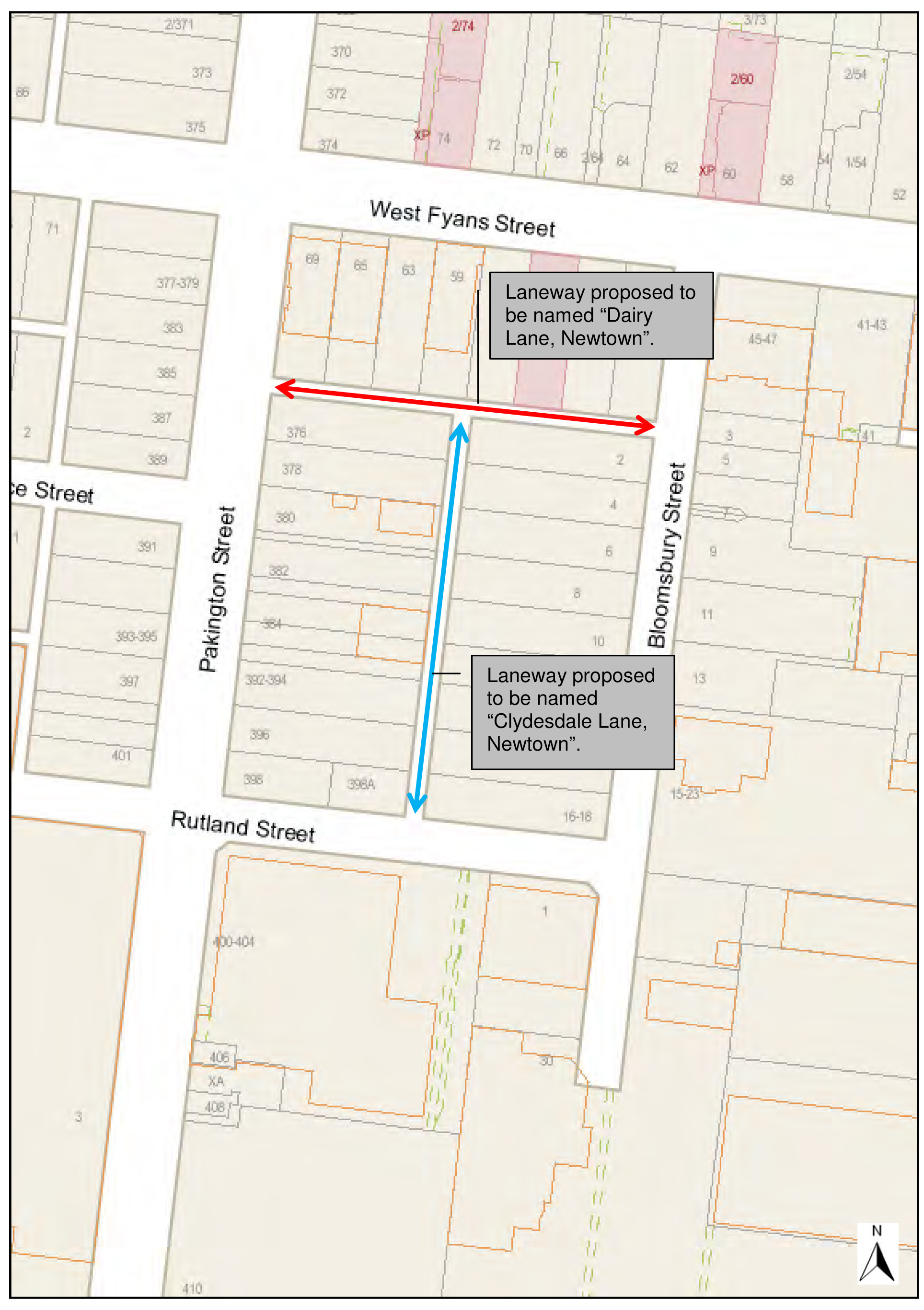
Portfolio: |
Finance - Cr Lyons (Mayor), Cr J Farrell, Cr E Kontelj |
Source: |
Strategy and Performance – Corporate Strategy & Property Management |
General Manager: |
Dean Frost |
Index Reference: |
Sale of land |
The purpose of this report is to recommend that Council commence the procedures to sell the land at 201 Melbourne Road, Rippleside, being a former senior citizens hall.
Council owns the property at 201 Melbourne Road, Rippleside, being a hall formerly used as a senior citizens centre. It is temporarily used for storage and will become vacant early in 2016.
The property is no longer required for Council purposes.
The land is situated within the North Geelong commercial strip fronting the service road to the Melbourne Road and is suitable for retail, commercial or residential use.
It is recommended that the Council give public notice of its intention to sell the land and consider any submissions received. If any submissions are received they will be heard by the Submissions Review Panel followed by a report to Council. If no submissions are received the land will be sold.
Cr E Kontelj moved, Cr Ansett seconded -
That Council:
Commence the procedures to sell the land at 201 Melbourne Road, Rippleside, on the following terms:
The price being no less than the certified valuation to be obtained;
Other appropriate terms and conditions; and
Commence the procedures under section 189 of the Local Government Act 1989 (“the Act”) to sell the land and that public notice of and the right of a person under section 223 of the Act to make a submission in relation to the proposed sale be given in the Geelong Advertiser and Geelong Independent; and
Appoint the Submissions Review Panel to hear and make a report available to the Council on any submissions received; and
In the event that no submissions are received sell the land by listing with an estate agent; and
Authorise the General Manager – Strategy and Performance to execute the Contract of Sale.
Carried.
The property at 201 Melbourne Road is a former senior citizens hall purchased in 1955 by the Shire of Corio. The land is owned freehold by the Council and has a land area of 409m2.
The land is located within the C1 commercial strip with frontage to the Melbourne Road service road opposite the North Geelong railway station.
The premises have not been actively used by senior citizens or the community for a number of years. The Geelong Heritage Centre is temporarily occupying the building while the new library and heritage centre is under construction. It is expected that the property will be vacated early in 2016 at which time it can be placed on the market for sale.
The building itself is an original hall type structure to which additions to the rear and front have been added over the years. The facilities within the building including a kitchen and toilets are barely serviceable and extensive refurbishment would be questionable given the nature and condition of the original building and its additions.
The property is no longer required for Council purposes.
A new owner could convert the existing structure for commercial use or redevelop the site for retail, commercial and residential purposes.
There are no environmental implications associated with the recommendations of this report.
The price will be set at no less than a certified valuation to be obtained prior to sale.
The proceeds from the sale of the land will be non recurrent income for which provision has been made in the 2015/16 budget. As property assets are disposed of the written down value is adjusted on the asset register.
The Local Government Best Practice Guideline for the Sale and Exchange of Land recommends that where ever possible land be sold by a public process such as public auction or listing.
Section 189 of the Local Government Act (“LG Act”) requires that Council obtain a certified valuation dated not more than six months prior to the sale of the land being the date of the contract of sale. A valuation will be obtained and used as a basis for setting a price.
Under the same section of the LG Act the Council is required to give public notice of its intention to sell the land and consider any submissions received. If any submissions are received they will be heard by the Submissions Review Panel followed by a report to Council. If no submissions are received the land will be sold by listing with an estate agent.
The recommendation supports the action priority relating to Responsible and Sustainable Financial Management where the sale of underperforming assets will support the identified progress indicators.
No officers or contractors involved in the preparation of this report have a direct or indirect interest in matters to which this report relates.
The risks associated with the subdivision and sale of this land are able to be managed following normal management procedures and processes.
There are no social considerations relating to the proposed sale of the land.
No human rights will be affected by the recommendation of this report.
The relevant internal departments have been consulted in the preparation of this report. Public submissions on the proposed sale will be invited as described above.
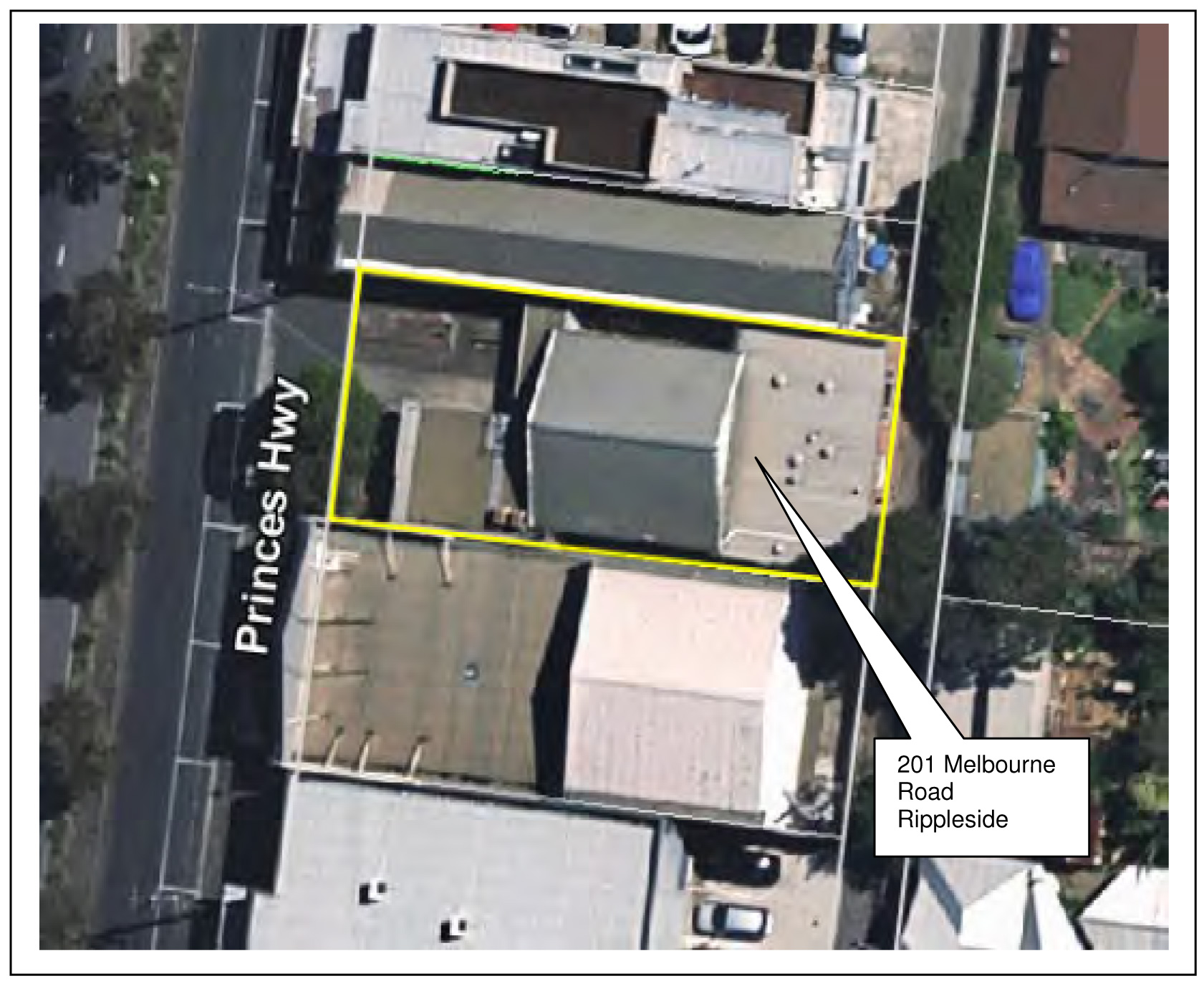
Portfolio: |
Finance - Cr Lyons (Mayor), Cr E Kontelj & Cr Farrell |
Source: |
Strategy and Performance - Property Management |
General Manager: |
Dean Frost |
Index Reference |
Land Sale |
The purpose of this report is to recommend that Council sell the property at 32 Plume Street, Norlane.
The Council owns a disused maternal and child health centre at 32 Plume St, Norlane. These services are now being provided from the nearby Norlane Child and Family Centre.
The property is no longer required for Council purposes.
The land is situated within the Norlane residential area and is suitable for residential use.
It is recommended that the Council give public notice of its intention to sell the land and consider any submissions received. If any submissions are received they will be heard by the Submissions Review Panel followed by a report to Council. If no submissions are received the land will be sold.
Cr Fisher moved, Cr Ansett seconded -
That Council:
Offer the land at 32 Plume Street, Norlane (“the land”) to Victorian registered housing associations and not-for-profit local community service organisations on the terms outlined in 2) below;
If the land is not sold within six months to a Victorian registered housing association or not-for-profit local community service organisation, commence the procedures to sell land at 32 Plume Street, Corio on the following terms and conditions:
The price being no less than a certified valuation of the land obtained no more than 6 months prior to the date of sale;
Other appropriate terms and conditions; and
Commence the procedures under section 189 of the Local Government Act 1989 (“the Act”) to sell the land and that public notice of and the right of a person under section 223 of the Act to make a submission in relation to the proposed sale be given in the Geelong Advertiser and Geelong Independent; and
Appoint the Submissions Hearing Panel to hear and report to the Council on any submissions in relation to the proposed sale; and
If no submissions are received the land will be sold by listing with an agent; and
Authorise the General Manager – Strategy and Performance to execute the Contract of Sale.
Carried.
The Norlane Maternal and Child Health Centre (MCH) is a purpose built brick veneer building constructed in 1954.
The building is no longer used and these services are now provided from the Norlane Child and Family Centre in Tallis Street which was opened in 2014.
The land has an area of 740m2, and is zoned General Residential Zone 1.
The property is no longer required for Council purposes.
The likely future use of the property is for residential purposes and a future owner would have the option of either converting the existing structure or building new housing.
There exists a large eucalyptus tree in the front yard of the property. While not ideally located, the tree appears to be in good health and will require on going management to avoid damage from falling branches.
The proceeds from the sale of the land will be non recurrent income for which provision is intended to be made in the 2015/16 budget. As property assets are disposed of the written down value is adjusted on the asset register.
Section 189 of the Local Government Act (“LG Act”) requires Council to give public notice of its intention to sell the land and consider any submissions received. If any submissions are received they will be heard by the Submissions Hearing Panel followed by a report to Council.
The same section of the LG Act also requires that a certified valuation be obtained dated not more than six months prior to the sale of the land being the date of the contract of sale. Prior to sale a certified valuation of the land will be obtained for the land the sale price will not be less than the valuation.
The land will be sold by listing through a local agent, satisfying the requirement for the land to be sold by a public process.
The title has a covenant restricting building to one dwelling only. Options for removal of the covenant will be investigated prior to sale.
The recommendation supports the action priority relating to Responsible and Sustainable Financial Management where the sale of assets no longer required will support the identified progress indicators.
No officers or contractors involved in the preparation of this report have a direct or indirect interest in matters to which this report relates.
The risks associated with the subdivision and sale of this land are able to be managed following normal management procedures and processes.
The services previously supplied from this facility are being provided from the new Norlane Child and Family Centre.
Any person will have an opportunity to make a submission on the proposed sale of the land when notice of intention to sell the land is published.
Aerial Image of Land at 32 Plume Street, Norlane
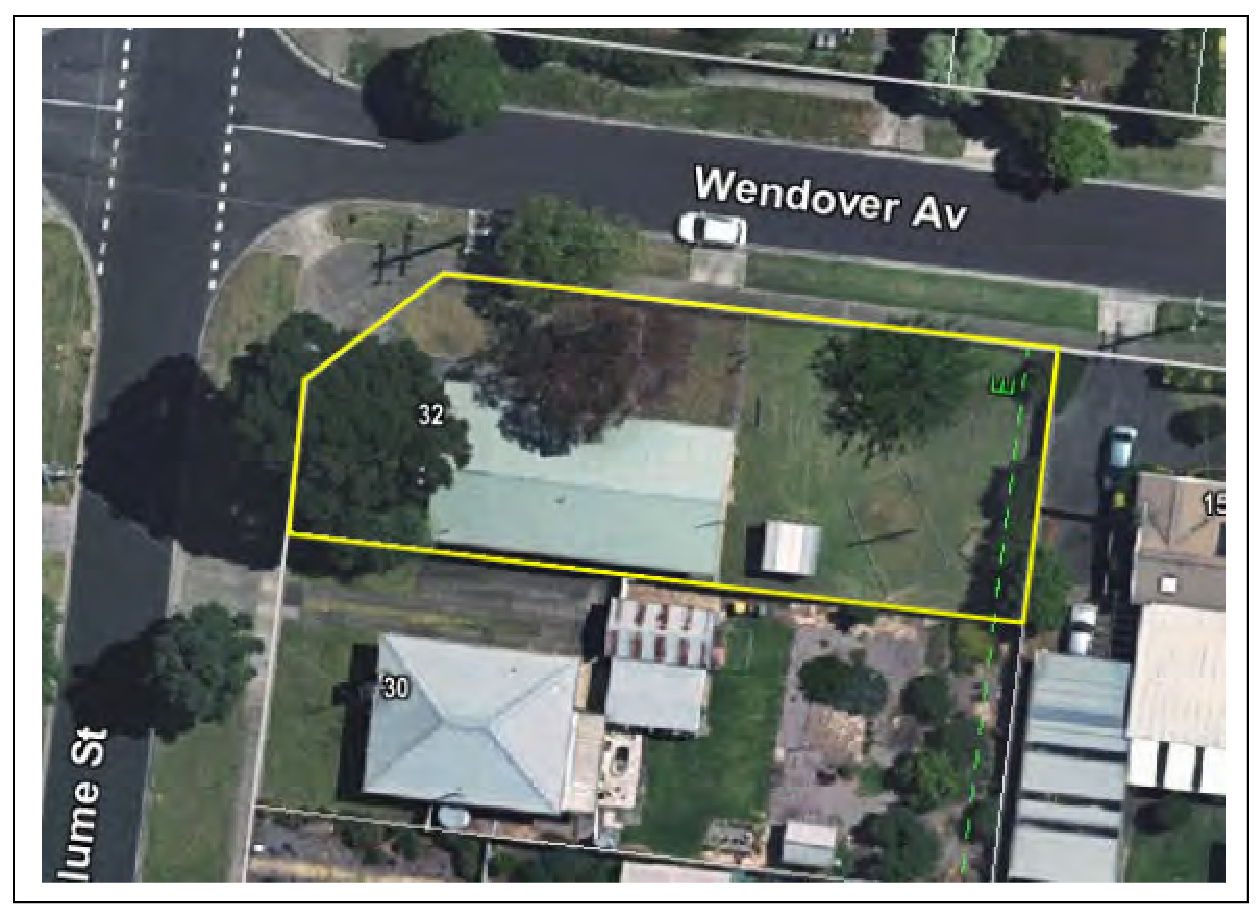
Portfolio: |
Enterprise Geelong - Cr Harwood |
Source: |
Enterprise Geelong |
Act/General Manager: |
Paul Jane |
Index Reference |
Subject: Lease of Land |
Cr Macdonald moved, Cr Farrell seconded -
That in accordance with Section 89 (2) (d) of the Local Government Act 1989, this contractual matter be considered at the conclusion of all other business at which time the meeting be closed to members of the public.
Carried.
[Back to Top]Portfolio: |
Governance - Cr Lyons (Mayor) |
Source: |
Corporate Internal Auditor and Ombudsman |
Chief Executive Officer: |
Gillian Miles |
Index Reference: |
Audit CG - Internal |
Cr Macdonald moved, Cr Farrell seconded -
That in accordance with Section 89 (2) (h) of the Local Government Act 1989, this matter be considered at the conclusion of all other business at which time the meeting be closed to members of the public.
Carried.
Contents | Previous Page: Section A - Procedural Matters | Next Page: Section C - Assembly of Assembly of Councillors
