
Council Minutes - Section B: Reports - 28 July 2015
Contents | Previous Page: Section A - Procedural Matters | Next Page: Section C - Assembly of Councillors
Contents | Previous Page: Section A - Procedural Matters | Next Page: Section C - Assembly of Councillors
Reports tabled at the Ordinary Meeting of Council on Tuesday date held at City Hall, Little Malop Street in Geelong.
Portfolio: |
Planning - Cr Heagney |
Source: |
Planning and Tourism - Strategic Implementation |
General Manager: |
Peter Bettess |
Index Reference: |
Subject: Council Reports 2015 & Application C203 |
The purpose of this report is to enable Council to consider the Independent Panel report for Amendment C203 and to adopt the amendment.
Amendment C203 resulted from an application made by St Quentin Consulting on behalf of the North East Ocean Grove Subdivision Group to rezone 22 properties totalling 45ha from Rural Living to General Residential zone (Schedule 1) together with an accompanying Development Plan Overlay. The subject land is west of Banks Road, north of Shell Road immediately east of the Parks Estate in Ocean Grove.
The Development Plan Overlay (DPO) Schedule has been based on an agreed Outline Development Plan which had been previously prepared to guide the future development of the area. The exhibited documentation also included a draft Shared Infrastructure Funding Plan and accompanying model template Section 173 Agreement to formalise equitable developer contribution arrangements among all landowners.
Amendment C203 was placed on public exhibition from 7 August 2014 until 8 September 2014. A total of twelve submissions were received of which six supported or offered no objection, two authorities suggested additional DPO provisions, three residents from the adjoining Parks Estate objected on amenity and environmental grounds and impact on the integrity of Ocean Grove and a petition containing 31 signatures objected to the rezoning.
The Council considered the submissions at its meeting on 28 October 2014 and resolved to refer them to an Independent Panel appointed by the Minister for Planning.
The Panel acknowledges this amendment is consistent with a range of adopted Council planning policies and the Ocean Grove Structure Plan. The Panel report recommends the Amendment be adopted with additional Development Plan Overlay provisions proposed by Council to protect remnant native vegetation and prevent new vehicular access to Shell Road.
Individual Section 173 Agreements with each of the 22 affected property owners to formalise developer contribution arrangements have been prepared and signed off by 17 of the 22 owners.
The Panel’s recommendations are supported and the amendment can now be adopted.
Cr Heagney moved, Cr Macdonald seconded -
That Council:
adopts Amendment C203 (Appendix 4 of this report);
submits the adopted Amendment with the prescribed information to the Minister for Planning requesting approval; and
signs and seals the Section 173 Agreements with the 22 individual landowners affected by this Amendment to formalise developer contribution arrangements (Appendix 5 is a model template of these Agreements).
Carried.
Amendment C203 resulted from an application made by St Quentin Consulting on behalf of the North East Ocean Grove Subdivision Group to rezone 22 properties totalling 45ha from Rural Living to General Residential Zone Schedule 1 together with an accompanying Development Plan Overlay. The subject land is west of Banks Road, north of Shell Road, immediately east of the Parks Estate in Ocean Grove.
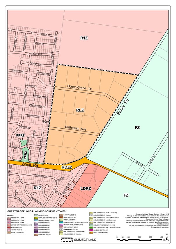
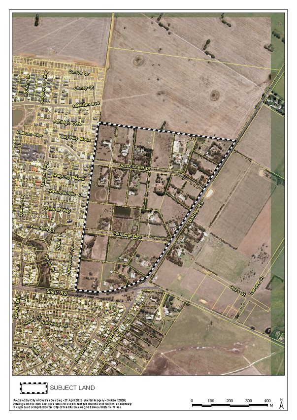
Appendix 1 shows the land subject of Amendment C203 and existing zonings. The vast majority of the lots (each approx 2ha) are individually owned and used for rural residential purposes. They have been substantially cleared of native vegetation apart from scattered remnant trees and some intact indigenous vegetation within the Banks Road roadside reserve. Appendix 2 is an aerial photo of the subject land and surrounding area.
As part of the processing of this application there were extensive discussions and negotiations with the applicant and their consultants about the outline development plan and delivery by the developer(s) of the necessary community infrastructure in a timely manner. In this area these arrangements have been complicated by the relatively large number of individual property owners and the need to fairly and equally apportion developer contribution costs among the individual landowners.
Identified shared infrastructure requirements include:
Provision of 2 stormwater retarding basins.
Provision of 2 local parks (10% of the overall area)
Upgrade of Banks Road intersections with Trethowan Avenue and Ocean Grand Drive.
$900 per dwelling community infrastructure levy.
A Draft Shared Infrastructure Funding Plan (SIFP), which was prepared by the applicant in consultation with Council, sets out the shared developer contribution arrangements in an equitable manner. The SIFP, along with an accompanying model template Section 173 Agreement to formalise these arrangements, were exhibited as part of the amendment documentation.
Amendment C203 was placed on public exhibition from 7 August 2014 until 8 September 2014. Notices were placed in the Geelong Advertiser, Independent and the Government Gazette and sent to all affected adjoining and nearby property owners and occupiers and all relevant Ministers and Public Authorities.
As a result of the exhibition of the Amendment the Council received a total of 12 submissions, as follows:
Three submissions from landowners in the area proposed to be rezoned supporting the Amendment.
Three submissions from public authorities (Barwon Water, DTPLI / now DELWP and EPA) raising no objection to the amendment.
Two submissions from Public Authorities (VicRoads and DEPI / now DELWP) each requesting an additional DPO provision.
Three submissions from residents in the adjoining Parks Estate objecting to the Amendment.
A petition containing 31 signatures (half Ocean Grove residents) objecting to the rezoning and advocating Council “say no to another concrete suburb”.
The main points raised by the objecting submitters are that the future conventional residential development of the area will result in the potential loss of vegetation and wildlife habitat, loss of amenity (including during construction) and the proposal is unsympathetic to the coastal character of Ocean Grove.
The Council considered the submissions at its meeting on 28 October 2014 and resolved to refer them to an Independent Panel appointed by the Minister for Planning.
A Directions Hearing on 28 November 2014 and the Panel Hearing on 15 December 2014 were both conducted at Council offices. The Council, applicant and three residents from the adjoining Parks Estate made presentations to the Panel.
The Panel acknowledges this Amendment is consistent with Council’s long-standing strategic planning policies which have designated the Amendment C203 area for conventional residential development since 1993.
The Panel report recommends the Amendment be adopted with additional Development Plan Overlay Schedule provisions proposed by Council to protect remnant native vegetation and prevent new vehicular access to Shell Road. The Panel acknowledges it is inevitable that there will be some loss of rural or semi-rural outlook for residents on the existing urban fringe as towns expand beyond their existing limits.
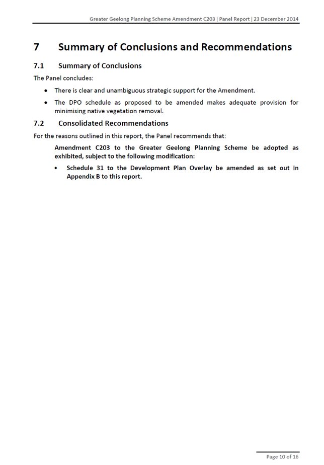
Appendix 3 is a copy of Section 7, Summary of Conclusions of the Panel Report. The Panel’s recommendations are supported and the modified Amendment can now be adopted. Appendix 4 is Amendment C203 recommended for adoption (including the changes to the DPO Schedule referred to in the Panel’s recommendations).
Individual Section 173 Agreements with each of the 22 affected property owners to formalise developer contribution arrangements (as per the exhibited version) have been prepared. At the time of writing this report, 17 out of the 22 owners had signed the Agreement. Appendix 5 is a model template of these Agreements with individual owners.
It is envisaged that developer contributions will be able to be collected from owners/developers who have not yet signed the agreement through planning permit conditions.
It should also be noted the DPO Schedule recommended for adoption removes reference in Clause 2.0 to future Section 173 Agreements, as recommended by DELWP (shown in track changes)
The proposed rezoning and subsequent residential development is not expected to result in any adverse environmental impacts.
The Development Plan Overlay schedule includes requirements relating to protection of remnant vegetation and management of stormwater to prevent downstream pollution. The Schedule has been further strengthened as proposed by DELWP (supported by Council and applicant) to protect remnant vegetation.
All necessary new infrastructure or improvements to existing infrastructure will be funded by developers/land owners as set out in the Shared Funding Infrastructure Plan which formed part of the exhibited amendment documentation.
The Amendment is consistent with the State Planning Policy Framework and the Local Planning Policy Framework, as follows:
State Planning Policy Framework. The Amendment implements the objectives and strategies of Clause 11 Settlement, (in particular Urban Growth Clause 11.02, Open Space Clause 11.03, Regional Development Clause 11.05, and Clause 11.07 Geelong (G21) regional growth), Clause 15 Built Environment and Heritage, Clause 16 Housing and Clause 19 Infrastructure.
Local Planning Policy Framework. Clause 21.06 Settlement & Housing identifies Ocean Grove as one of the City’s designated primary urban growth areas. Clause 21.14 The Bellarine Peninsula sets out objectives and strategies for development of the Peninsula and each of the towns as contained in the adopted Structure Plans.
The proposed rezoning is consistent with the adopted 2007 Ocean Grove Structure Plan and as such is consistent with Clause 21.14 of the Local Planning Policy Framework
The Amendment is also consistent with a range of other environmental, infrastructure, developer contributions and open space policies contained in the Municipal Strategic Statement.
Amendment C203 supports both the Growing our Economy and Sustainable Built and Natural Environment strategic directions of City Plan, particularly as it is facilitating sustainable development in accordance with an adopted township Structure Plan.
No Council Officers have any direct or indirect interest, in accordance with Section 80 (c) of the Local Government Act to which this Amendment relates.
Amendment C203 is not expected to expose Council to any risk or liability beyond that usually associated with facilitating greenfield development.
The Ocean Grove Structure Plan, upon which this Amendment is based, has thoroughly addressed the social implications of identifying areas for future growth.
The Panel has acknowledged that the subject land is centrally located close to some of the town’s major community, retail and educational facilities.
Amendment C203 does not impact on any basic rights, freedoms and responsibilities as set out in the Charter. Planning legislation ensures an open community consultation process to enable people to freely express their views and obtain a fair hearing before an Independent Panel.
Full public notification of Amendment C203 was given in accordance with the provisions of the Planning and Environment Act. All adjoining and nearby property owners received direct notification of the exhibition of the Amendment and had an opportunity to present their submission to an Independent Panel appointed by the Minister for Planning.
Planning and Environment Act 1987
The planning authority for this amendment is Greater Geelong City Council.
The Greater Geelong Planning Scheme is amended as follows:
The Planning Scheme Maps are amended by a total of two (2) attached map sheets.
Zoning Maps
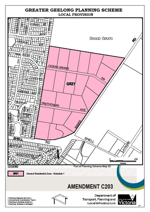
Amend Planning Scheme Map No 82 in the manner shown on one attached map marked “Greater Geelong Planning Scheme, Amendment C203”.
Overlay Maps
Amend Planning Scheme Map No 82 DPO in the manner shown on one attached map marked “Greater Geelong Planning Scheme, Amendment C203”.
The Planning Scheme Ordinance is amended as follows:
In Overlays – following Clause 43.04, insert a new Schedule 31 in the form of the attached document.
End of document
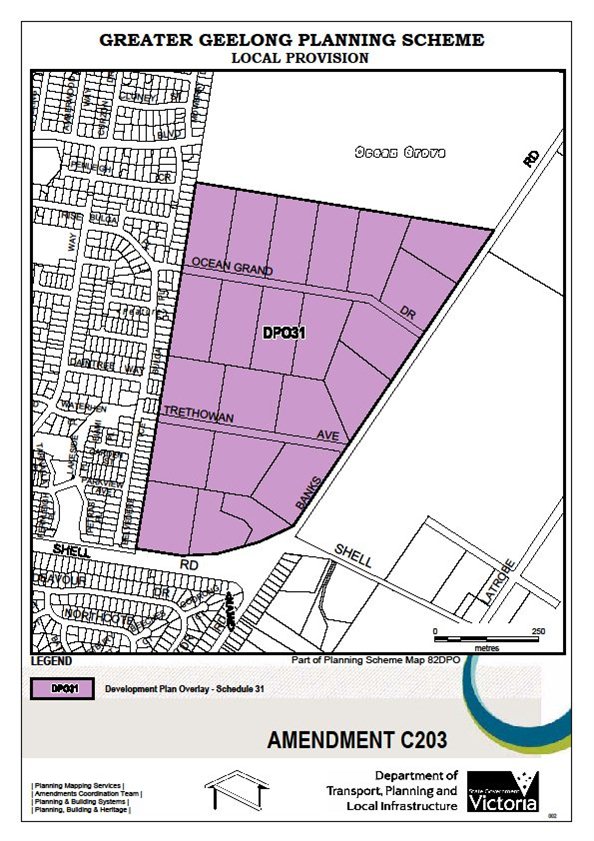
SCHEDULE 31 TO THE DEVELOPMENT PLAN OVERLAYShown on the planning scheme map as DPO31 |
|
24/02/2011 |
TRETHOWAN AVENUE/OCEAN GRAND DRIVE OCEAN GROVEThis Schedule applies to the area generally north of Shell Road, west of Banks Road incorporating properties in Trethowan Avenue and Ocean Grand Drive, Ocean Grove. The aim of this Schedule is to ensure that development occurs in accordance with broad development principles as shown in the Trethowan Avenue/Ocean Grand Drive Outline Development Plan 2014 and to ensure delivery of essential community infrastructure as set out in the TrethowanAvenue Final Shared Infrastructure Funding Plan . |
1.0 |
Requirement before a permit is granted |
--/--/20 |
A permit may be granted before a development plan has been prepared for the following:
|
2.0 |
Conditions and requirements for permits |
--/--/20-- |
A permit must contain conditions or requirements which give effect to the provisions and requirements of the approved development plan including the Trethowan Avenue Final Shared Infrastructure Funding Plan. |
3.0 |
Requirements for development plan |
--/--/20 |
Separate development plans may be prepared and approved for Catchments 1 & 3 combined and Catchment 2 as shown in the Trethowan Avenue Final Shared Infrastructure Plan. The Development Plan must be generally in accordance with Trethowan Avenue/Ocean Grand Drive Outline Development Plan as shown in Clause 5.0, and include the following: An Urban Design Masterplan that includes:-
A Road Network and Traffic Management Plan complying with any VicRoads requirements that includes:-
An Integrated Water Management Plan that takes an integrated approach to flooding, stormwater and drainage management, is designed with reference to the whole of the catchment and includes:
An Open Space and Landscape Masterplan that includes:
A Final Shared Infrastructure Funding Plan (to be identified as the TrethowanAvenue Final Shared Infrastructure Funding Plan) which updates as necessary the Draft Shared Infrastructure Funding Plan. |
4.0 |
Decision Guidelines |
--/--/20 |
In considering whether or not to approve or amend a development plan, the responsible authority must consider:
|
5.0 |
Trethowan Avenue/Ocean Grand Drive Outline Development Plan |
--/--/20 |
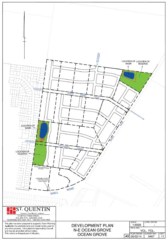 |
Cr Farrell re-entered the meeting room at 7:52pm.
[Back to Top]Portfolio: |
Transport - Cr Richards |
Source: |
City Services - Engineering Services Department |
General Manager: |
William Tieppo |
Index Reference: |
Cycling |
The purpose of this report is to advise Council about the establishment of a Cycling Infrastructure Advisory Committee to support improvements to cycling infrastructure across the City.
The establishment of a Cycling Infrastructure Advisory Committee will assist Council to meet the objectives of the Greater Geelong Cycling Strategy and Priority Bicycle Network (PBN).
The advisory committee membership will comprise representatives from cycling organisations, VicRoads, the Transport Accident Commission, Council officers and two Council representatives (including the Chairperson).
Advisory committee members are expected to be active and report, share, and promote actions and deliberations from and to the organisations which they are connected.
Cr Richards moved, Cr Harwood seconded -
That Council:
approves the establishment of a Cycling Infrastructure Advisory Committee;
endorses the Draft Terms of Reference (refer Appendix 1); and
appoints the Transport Portfolio Holder as the Chair of the Cycling Infrastructure Advisory Committee.
Cr Heagney left the meeting room at 7:53pm
Cr Heagney re-entered the meeting room at 7:54pm
Carried.
The establishment of a Cycling Infrastructure Advisory Committee will identify gaps and opportunities for further initiatives in cycling infrastructure.
Membership will include representatives from across Council and external bodies involved in cycling.
The Greater Geelong Cycling Strategy provides a prioritised bicycle works plan. The Strategy also articulates a coordination, promotion and education strategy designed to encourage more people to cycle more often, to educate motorists about sharing the road with other users; and to educate walkers, cyclists and dog walkers to respect the safety of users on shared paths and trails.
The aim of the Greater Geelong Cycle Strategy is to make the City of Greater Geelong more cycle friendly by creating a strategic plan for the development and improvement of cycle networks for recreational, competition and commuter cyclists.
VicRoads and BikeSafe, a community group, registered as a not-for-profit association that was started by local cyclists in Geelong and the Surf Coast in 2010, initiated the development of the PBN by working with councils and agencies within the G21 region to review existing plans and strategies, such as the Greater Geelong Cycle Strategy (2008), to determine the existing bicycle network, proposed works programs and gaps within current planning.
The primary objective of the PBN is to prioritise cycle routes from these plans and strategies that meet a range of commuter, recreational and sporting needs, and to create a connected network for all forms of cycling.
The PBN provides strategic support to high priority bicycle infrastructure, but does not cover the complete bicycle network within the municipality. The Greater Geelong Cycle Strategy which complements the PBN provides strategic context for the implementation of the complete bicycle network throughout the city, as well as guidance on maintenance, promotion and coordination.
A working group with representatives from Council and VicRoads was created in 2014 to assist with the delivery of programs identified in the Greater Geelong Cycling Strategy and the newly adopted PBN.
External support and input to this group was sought from BikeSafe and Bicycle Network in an adhoc manner as needed.
The absence of core capital allocation has meant that the development of commuter and on road routes has occurred opportunistically rather than through a planned, prioritised strategy. This has resulted in bicycle lane line marking and modest development of the PBN within the City. A further consequence is poor integration and connectivity between the on and off road networks (eg lack of signage, safe connections and crossings).
Creating the Advisory Committee will focus resources on delivering a coordinated approach to the delivery of Cycling Infrastructure.
Ongoing improvement of the bicycle network throughout the City of Greater Geelong supports increased uptake of active transport. Increased cycling for transport will reduce carbon emissions from motor vehicles.
Cars produce an average of 0.3kg of CO2 per kilometre travelled – the equivalent of running a 60 watt incandescent light globe for 5 hours. Increasing the number of people that cycle for transport has a direct impact on reducing the amount of carbon released into the air. Based on an average commute of 5 kms (10 kms per day), should 334 people change their mode of transport from car to bicycle, a tonne of carbon emissions will be saved each day.
The Advisory committee is supported by Council officers from Engineering Services.
The Advisory Committee will recommend projects for consideration in Capital and Recurrent works programs as well as partnering with the State for external funding via Grant opportunities.
There are no Policy, Legal or Statutory Implications in endorsing the Advisory Committee.
The endorsement of the advisory committee has clear connections to Council’s community well-being and sustainable environment objectives. The uptake of cycling as a means of transport and/or recreation provides physical and environmental health benefits to the cyclist and the wider community.
No Council officer involved in the preparation of this report has a direct or indirect interest in the matter to which the report relates.
There are no risks associated with the creation of the Advisory Committee.
Improving cycling infrastructure for recreational, sporting and commuter riders provides a range of social benefits including: mental and physical health benefits; better connected and accessible neighbourhoods and townships; and improving the municipality’s liveability. In the longer term an increase in commuter cycling will contribute to a decrease in traffic congestion.
This report has no direct impact on the human rights of the residents of the City of Greater Geelong.
The Advisory Committee shall report annually on the delivery of Cycling Infrastructure across the City.
Portfolio: |
Community Development – Cr Fisher |
Source: |
Community Services – Aged and Disability Services Department |
General Manager: |
Linda Quinn – Acting |
Index Reference: |
Subject: Disability |
This report seeks to update Council on progress on the 2014–2017 Disability Action Plan, one year following its adoption.
In accordance with the Victorian Disability Act 2006, Council has, since 2002, developed a series of disability action plans.
The Disability Action Plan 2014–2017 (DAP) specifies the actions Council will take to reduce discrimination of people with disabilities in the areas of goods, services and facilities, employment, community participation, and attitudes and practices.
There are 28 objectives and 69 actions contained in the DAP.
Some of the headline actions include: undertaking access audits; prioritising and then undertaking works to improve access to Council community buildings and services; supporting the Street Access and Disability Advisory Committees to advocate on behalf of people with disabilities; identifying training needs of staff to enhance disability awareness; and reviewing Council information in all formats to ensure that it remains accessible.
As at June 2015, 47 (68%) of the actions had been commenced or were completed. A list of these actions/status is provided in Attachment 1.
Cr Fisher moved, Cr Farrell seconded -
That Council notes the progress on the 2014–2017 Disability Action Plan and continues to support activities and initiatives that provide for an inclusive organisation and community.
Carried.
Section 38 of the Disability Act 2006 specifies that a public sector body must ensure that a Disability Action Plan is prepared for the purpose of:
Reducing barriers to people with a disability accessing goods, services and facilities.
Reducing barriers to people with a disability obtaining and maintaining employment.
Promoting inclusion and participation in the community of people with a disability.
Achieving tangible changes in attitudes and practices which discriminate against people with a disability.
Council has, since 2002, developed a series of disability action plans. In 2014 Council adopted the Disability Action Plan 2014–2017 (DAP).
Reporting on the DAP is included within Council’s annual report, City Plan.
A sub group of Council’s Disability Advisory Committee (DAC) meets quarterly to review progress of the DAP and identify any gaps for consideration in the annual plan review.
As at June 2015, 47 (68%) of the DAP actions had been commenced or were completed. A list of these actions/status is provided in Attachment 1.
Activities that demonstrate inclusion of people with disabilities in the community by Council include:
Pako Festa – provide support to Karingal in the provision of personal care and a rest area during this major community event.
Loan items – provide ramps for loan to agencies and organisations staging events.
Vary parking arrangements for the major ‘Having a Say’ conference held in Geelong in February each year.
RECHARGE scheme – provides free recharge points around Geelong and the Bellarine Peninsula for wheelchairs and scooters.
Further to this Council continues to undertake access audits of Council owned buildings and other public spaces; prioritises works to improve access to Council’s community buildings and services; supports the Street Access and Disability Advisory Committees to advocate on behalf of people with disabilities; (to review master plans, building plans, streetscape plans and government policies etc); identifies training needs of staff to enhance disability awareness; review information in all formats provided by Council, both internally and externally, to ensure that it remains accessible; and ensures that arts, sports and cultural events are fully accessible and inclusive.
Activities and developments
In 2014 the International Day of People with Disability (IDPWD) was celebrated in Geelong in conjunction with another major event (the two day Geelong Revival motorsport festival held on the Geelong waterfront). The event attracted large numbers from within Geelong and further afield, and provided a great opportunity for participants and attendees to be aware of and to celebrate IPDWD as part of the motorsport festival. A mobile accessible art installation known as the ‘Nebula’ was a special attraction.
In partnership with the Barwon Disability Resource Council (BDRC) and Access4All, Council continues to support the Central Geelong/Waterfront Map. The map provides access information for users of the City centre. It is widely distributed and is available on the Geelong Australia website. BDRC staff are able to make real time changes to the electronic map (Council provided the IT training to BDRC staff).
Council’s Customer Service (CS) staff have undertaken training and accreditation in access communication skills, which now entitles CS centres to display the recognised and accredited Communication Accessible Symbol. The symbol is used to indicate environments that are communication-friendly.
Geelong Regional Library Corporation undertook a similar process with support and training from Rural Access and now displays the Communication Access Symbol in the Bellarine libraries.
The access checklist ‘Accessible Event Guide for Meeting and Event Organisers’ has been updated and distributed across Council. The checklist is a useful guide for staff involved in booking meeting spaces.
A range of supports are available for people with disability attending meetings for Council business, eg Auslan interpreters, hearing augmentation, personal care for specific events and appropriate catering and cutlery/crockery are made available. Council community buildings have a range of facilities available on request.
DAP actions yet to be undertaken
Identified DAP actions yet to be undertaken include:
Conduct a survey regarding staff attitudes to disability, analyse results and develop strategies for improvement.
Setting of more specific and achievable goals for the Organisation Development department around the conduct of the Employee Opinion Survey, staff attitude focus groups, induction and recruitment; and the role of Council in creating volunteer work opportunities for people with disabilities.
The progress of the DAP does not impact on the environment.
There are no financial implications of the DAP as all activities are within Council’s annual budgets.
The DAP is a requirement of the Disability Act 2006.
The outcomes of the DAP will be reported as a component of the Health and Wellbeing section of City Plan.
No officer involved in the preparation of this report has any vested interest other than as an officer of Council.
Implementation of the DAP ensures that Council is at a reduced risk of any claims of discrimination and subsequent action by the Human Rights and Equal Opportunity Commission.
It is anticipated that there will be considerable ongoing positive impact on people in the community with disabilities and their families as the DAP is progressively implemented. It is also expected that there will be a flow on to the wider community of understanding and consideration for the inclusion of people with disabilities in all aspects of community life. Implementation of the DAP promotes the development of sustainable organisational structures to help minimise issues related to access and inclusion.
There will be enhanced opportunities for people with disabilities to participate in community life and for the community to be enriched by their inclusion. In addition, providing equal access will greatly benefit the growing proportion of ageing residents in the City of Greater Geelong.
The DAP supports the rights of people with disabilities and outlines how Council will act to protect and enhance these rights.
Progress reports on the 2014–2017 Disability Action Plan will provide an opportunity for Council to showcase its ongoing commitment and leadership to the community; its commitment to consult with people; as well as to work towards building equity of access and inclusion in the community.
[Back to Top]Portfolio: |
Infrastructure, Parks & Gardens – Cr Ellis |
|
Source |
City Services – Engineering Services |
|
General Manager: |
William Tieppo |
|
Index Reference |
Subject: Drainage - Floods |
The purpose of this report is to present a revision to the flood mapping for existing conditions produced within the stages of the development of the Armstrong Creek Urban Growth Plan (UGP).
The flood mapping is subject to a revision due to the subdivision and development at 250 Boundary Road, 193 – 237 Boundary Road and 50A Whites Road, Mount Duneed. Prior to subdivision the parent lot was considered to be liable to flooding. This development site, which is also known as Villawood Stages 12, 13 and 17A, achieves flood immunity for newly created lots for flood events up to and including the 100 year Average Recurrence Interval (ARI) event due to approved internal earthworks including the reshaping of Armstrong Creek.
The earthworks undertaken have resulted in the floodwaters from the 100 year ARI event being contained within the boundaries of the Armstrong Creek reserve.
Council has a statutory obligation under the Building Regulations 2006 to designate land as liable to flooding where it reasonably knows it to be prone to flooding. Conversely, there is an obligation to remove the encumbrance of designation from land that is no longer considered to be flood-prone.
It should be noted that designation is separate to the creation of flood overlays within the Planning Scheme, which generally follows designation. In the case of the Armstrong Creek UGP area, the planning scheme amendment to create post-development flood zones or overlays is proposed after the design of the proposed precincts.
The current designated flood mapping (refer to Attachment 1) was designated by Council at its meeting of 12 December 2006, under the provisions of the Building Regulations 2006. Designation of land as liable to flooding enables the control of floor levels for acceptable building permit applications, or refusal of consent to building applications where there is likely to be a danger to life, health or safety due to flooding. Designation also enables disclosure of flood status within statutory information certificates.
Cr Ellis moved, Cr Richards seconded -
That Council revoke the Council designation of 12 December 2006 of flood affected land as highlighted as Armstrong – Mount Duneed Stages 12, 13 and 17A on Armstrong Creek Urban Growth Plan Flood Map dated 29 November 2006 as liable to flooding pursuant to Regulation 802(2) of the Building Regulations 2006.
Carried.
As part of the development of the Armstrong Creek Urban Growth Plan (UGP) a flood study was undertaken by specialist consulting engineers to identify the extents of the 100 year Average Recurrence Interval flood event for existing conditions. Following a public exhibition phase, the resultant flood mapping (refer to Attachment 1) was designated by Council at its meeting of 12 December 2006, under the provisions of the Building Regulations 2006.
Designation of land as liable to flooding under Regulation 802 of the Building Regulations 2006 enables the control of floor levels for acceptable building permit applications, or refusal of consent to building applications where there is likely to be a danger to life, health or safety due to flooding. Designation also enables disclosure of flood status within statutory information certificates such as the Land Information Certificate and Building Information Request Form.
The subject of this report is the residential land at Armstrong - Mount Duneed bounded by Surf Coast Highway and Boundary Road. Prior to subdivision the parent lot was used primarily as farmland.
The subdivision at 250 Boundary Road, 193 – 237 Boundary Road and 50A Whites Road, Mount Duneed was named Armstrong by the developer. The current designated flood extent affects multiple residential lots within the Estate Stages 12, 13 and 17A.
Overland flows that may occur within the subdivision during the 100 year ARI flood event are now contained within road and drainage reserves in accordance with accepted best practice for development within flood-prone areas. Best practice requires that any overland flows within residential areas satisfy public safety criteria with respect to velocity and depth of flow.
Council has a statutory obligation under the Building Regulations 2006 to designate land as liable to flooding where it reasonably knows it to be prone to flooding. Conversely, there is an obligation to remove the encumbrance of designation from land that is no longer considered to be flood-prone.
Attachment 1 shows the existing flood designation. Attachment 2 shows the change in flood mapping at 250 Boundary Road,193 – 237 Boundary Road and 50A Whites Road, Mount Duneed, after construction of the subdivision.
The revocation of flood-prone areas designation and designation of revised flood data does not result in any known adverse environmental impacts.
The removal of a minimum floor level requirement for new dwellings may result in a minor reduction in energy and material usage during construction. In addition, concrete slab-on-ground construction, which is normally used for a non-elevated floor, achieves the minimum energy rating more readily than a timber floor on stumps.
The costs of proceeding to revoke the existing designation and to designate the revised flood mapping at 250 Boundary Road, 193 – 237 Boundary Road and 50A Whites Road, Mount Duneed, in accordance with the requirements of the Building Regulations 2006, are provided for within the annual recurrent budget.
The City has various statutory responsibilities for drainage management and flood management (prevention, response and recovery) as set out in the Local Government Act 1989, Local Government Regulations 1990, Planning and Environment Act 1987, Building Regulations 2006, Water Act 1989, Subdivision Act 1988 and Emergency Management Act 1986.
Regulation 802(2) of the Building Regulations 2006 provides Council with the powers to ‘designate’ land liable to flooding. Regulation 802(3) provides that consent must be obtained from Council for an application to build on land liable to flooding.
Section 27 of the Interpretation of Legislation Act 1984 provides the power for Councils to ‘repeal or amend a subordinate instrument made in the exercise of that power’.
Section 807 of the Building Regulations 2006 requires Council to update the municipality’s designated special area maps at the Building Control Commission in the event of alterations to a designated special area. Designated special areas include areas designated as being liable to flooding.
Section 229 of the Local Government Act and Regulation 326 of the Building Regulations provide for the issue of information certificates containing prescribed information, including the flood status of properties.
The revised flood data for 250 Boundary Road, 193 – 237 Boundary Road and 50A Whites Road, Mount Duneed will assist the City in meeting its statutory obligations with regard to flood data.
The revised flood data will also assist in fulfilling the recommendations of the Municipal Emergency Management Committee adopted by Council in November 1998 (i.e. mapping of 1 in 100 year flood levels)
The recommendations of this report are consistent with City Plan, in relation to Growing our Economy and promoting a sustainable built environment, sustainable land use and development.
There are no officer direct or indirect interests with respect to this report.
Council also has some risk exposure with any failure to disclose the flood-prone status of a property in a Land Information Certificate.
The designation of the flood data produced by the flood study Armstrong Creek UGP project is a key step toward minimising Council’s exposure to these risks.
Council has a risk exposure through its statutory obligations under the Building Regulations 2006 to:
designate land as liable to flooding where it reasonably knows it to be prone to flooding;
specify minimum floor levels in consultation with the relevant floodplain management authority (CCMA); and
refuse consent to building applications where there is likely to be a danger to life, health or safety due to flooding.
Council also has some risk exposure with any failure to disclose the flood-prone status of a property in a Land Information Certificate.
The designation of the flood data produced by the flood study Armstrong Creek UGP project is a key step toward minimising Council’s exposure to these risks.
Conversely, there is an obligation to remove the encumbrance of designation from land that is no longer considered to be flood-prone. Designation of land as being liable to flooding can result in extra construction costs and concerns regarding saleability, in some cases.
Council has a responsibility to the community to provide the best possible information on areas that are flood-prone.
We have taken into consideration the human rights relative to the subject matter of this report, which improves protection of private property.
The current designation was undertaken following a public exhibition in October 2006 with notification of affected property owners. These owners were sent letters and fact sheets with an invitation for submissions.
A revocation of designation does not warrant public consultation as it constitutes the removal of an encumbrance on land.
The owners of properties affected by the revocation will be notified so they are aware that disclosure of flood status on a Section 32 Vendors Statement is no longer required.
Relevant Council databases and flood maps will be revised and updates sent to the Corangamite Catchment Management Authority and Building Control Commission.
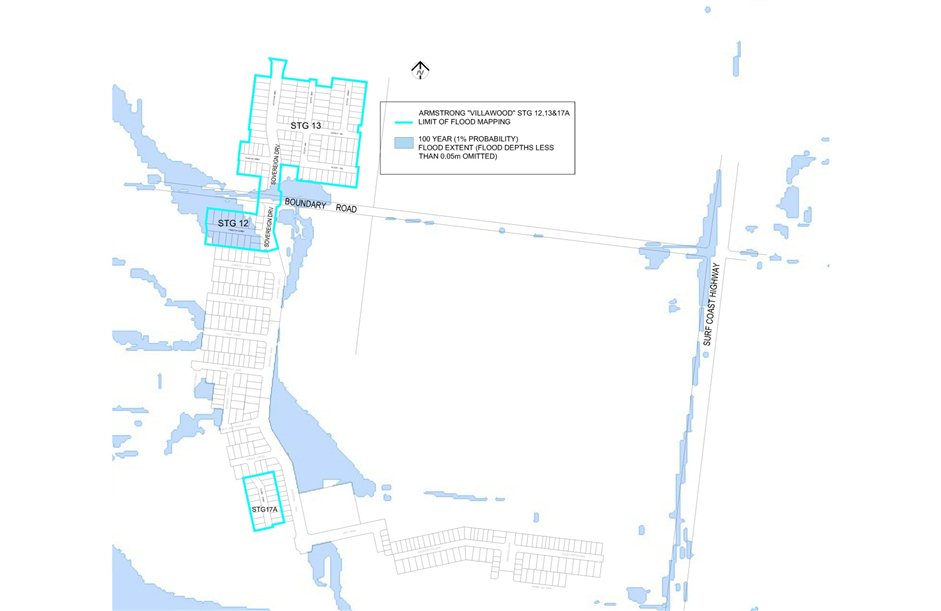
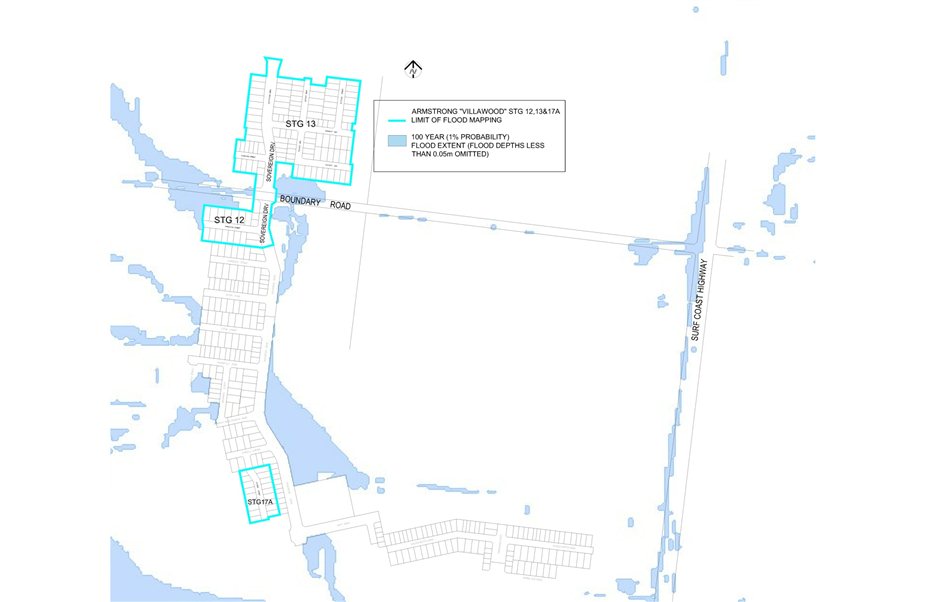
Cr Nelson declared an Indirect Interest by a Close Association in Agenda Item 5 – Exchange of Land – Peninsula Drive, Drysdale and Murradoc Road, St Leonards – Update, in that he has had several confidential meetings with the Principal of St Ignatius about financial decisions pertaining to the land abutting the school, and left the meeting room prior to discussion at 8:16pm.
Portfolio: |
Finance - Cr Lyons (Mayor), Cr Farrell & Cr E Kontelj |
Source: |
Strategy & Performance – Corporate Property |
General Manager: |
Dean Frost |
Index Reference: |
Land Sale |
To provide Council with an update on the proposed exchange of land; Peninsula Drive Drysdale, and Murradoc Road, St Leonards, and for Council to indicate a way forward in the light of submissions received.
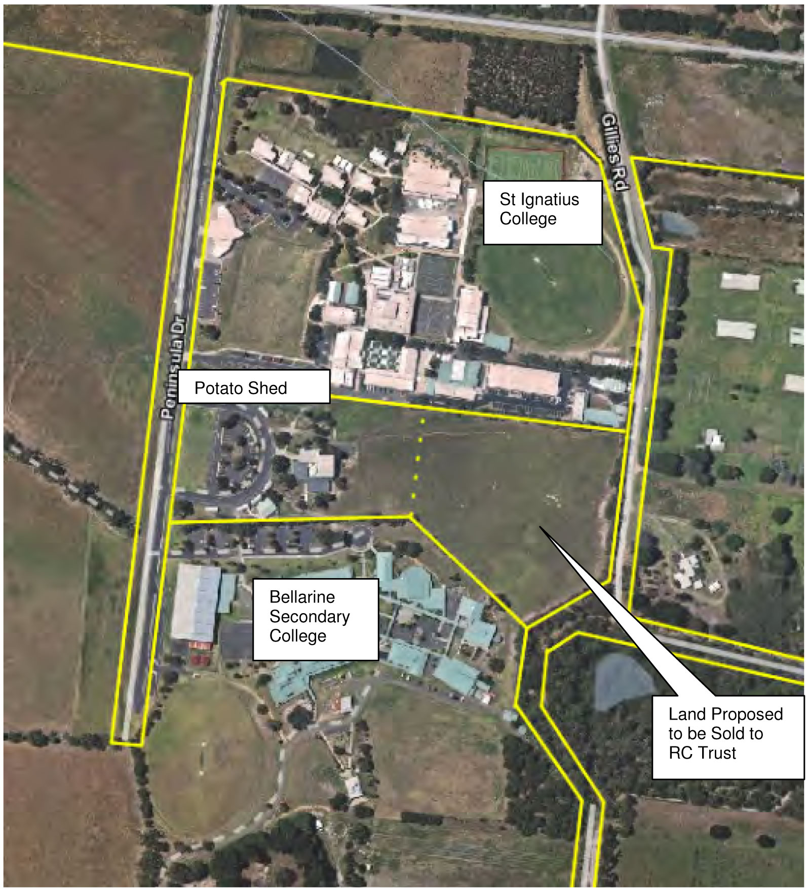
At its meeting on the 28 April 2015 the Council resolved to sell approximately 2.6ha of land in Peninsula Drive, Drysdale at the rear of the Potato Shed to the Roman Catholic Trust Corporation (RCTC) for expansion of St Ignatius Secondary College. Refer to attached diagram.
The sale of the land is conditional upon the RCTC selling to Council 2,500m2 of its land in Murradoc Road, St Leonards to the Council for a future children’s services centre.
Notice of intention to sell the Peninsula Drive land was published on 15 and 16 May 2015 and at the end of the submissions period a total of 38 submissions had been received. The main recurring themes of the objecting submissions are:
Land should not be sold for expansion of St Ignatius but retained for arts, culture and other uses.
Selling the land will prevent the expansion of the Potato Shed.
The exchange of the land in Drysdale for land in St Leonards is inequitable in terms of area and value.
Expansion of St Ignatius College will increase traffic problems in Peninsula Drive.
The Bellarine Secondary College has objected to the land sale.
Submissions supporting the land sale were received from St Ignatius College and the St Thomas Presbytery. The RCTC and St Thomas Presbytery have both advised that the St Leonards land is not available for sale.
Cr Ellis moved, Cr Farrell seconded -
That Council:
notes that 1343 – 1349 Murradoc Road, St Leonards is not for sale;
directs Officers to abandon the sale of land at 29-39 Peninsula Drive Drysdale, on the basis that the land exchange condition linked to the sale could not be met;
requests Officers to report back to Council any future requests to facilitate a land exchange.
Carried.
At Council meeting dated 28 April 2015, Council resolved to sell approximately 2.6ha of land in Peninsula Drive, Drysdale at the rear of the Potato Shed to the Roman Catholic Trust Corporation (RCTC) for expansion of St Ignatius Secondary College. Refer to attached diagram.
The sale of the land is conditional upon the RCTC selling to Council, 2,500m2 of its land in Murradoc Road, St Leonards for a future children’s services centre.
Notice of intention to sell Peninsula Drive land was published 15 and 16 May 2015, at the end of the submissions period a total of 38 submissions had been received. The main recurring themes of the objecting submissions are:
Land should not be sold for expansion of St Ignatius but retained for arts, culture and other uses.
Selling the land will prevent the expansion of the Potato Shed.
The exchange of the land in Drysdale for land in St Leonards is inequitable in terms of area and value.
Expansion of St Ignatius College will increase traffic problems in Peninsula Drive.
Bellarine Secondary College has objected to the land sale.
Submissions supporting the land sale were received from St Ignatius College and the St Thomas Presbytery. The RCTC and St Thomas Presbytery have both advised that the St Leonards land is not available for sale.
In the light of submissions received and the position of both the RCTC and St Thomas Presbytery in relation to the St Leonards land, options for the Council include:
Continue to attempt to gain an agreement from the RCTC for the sale of the St Leonards land and proceed with the land exchange, as per the existing Council position;
Proceed with the sale of the Peninsula Drive land only, and look elsewhere in St Leonards for suitable land;
Abandon the sale of the land accepting that the St Leonards land is not for sale.
With options 1 and 2, which both involve a sale of the land, Council is required to complete the statutory process and provide an opportunity for the submitters to be heard by the Submissions Review Panel with a further report to Council.
The notice of intention to sell provided details of the sale of the land at Peninsula Drive alone, as the Council is only obliged to give such notice when it intends to sell rather than purchase land. Excluding details of the requirement to purchase land at St Leonards, allows the Council flexibility to consider proceeding with either the sale and purchase or sale of land lone without the need to repeat the notice of intention to sell.
It is noted that the purchase and sale received publicity in the print media and is generally understood by submitters.
If Council indicates a willingness to proceed with option 2, being the sale of the Drysdale land without the purchase of the St Leonards land, it is recommended that Council rescind its resolution 28 April 2015 before the hearing of submissions.
One of the submissions has pointed out that sale of the land at Peninsula Drive to St Ignatius will increase pressure on the Basin Reserve. The reserve is a 2.4ha Crown land parcel of native vegetation under the management of the Council with input from community members.
There are no other environmental implications associated with the sale and purchase of the land.
Council’s current resolution is to sell Peninsula Drive land for $700,000 being Council’s valuation dated January 2015. The purchase price of the St Leonards’ land has not been determined, however it will be no more than Council’s valuation (to be obtained).
There are costs involved in subdividing both parcels which will have to be apportioned between the parties as appropriate if a sale and purchase proceeds.
The Local Government Best Practice Guideline for the Sale and Exchange of Land recommends that where ever possible land be sold by a public process such as auction or listing. In this case a direct sale to the Roman Catholic Trust is recommended to assist with its expansion plans.
Section 189 of the Local Government Act (“LG Act”) requires that Council obtain a certified valuation dated not more than six months prior to the sale of the land being the date of the contract of sale. Prior to sale Council’s valuation will have to be refreshed.
Under the same section of the Local Government Act Council is required to give public notice of its intention to sell the land and consider any submissions received.
Council land is a Reserve which is a restriction on the title that needs to be removed prior to sale, and a planning permit is required for this purpose. In addition the land requires subdivision prior to sale.
The sale of the land will provide the best option for the expansion of St Ignatius College to meet its projected demands for education.
No officers or contractors involved in the preparation of this report have a direct or indirect interest in matters to which this report relates.
The risks associated with the subdivision and sale of this land are able to be managed following normal management procedures and processes.
With the sale of the land to the Roman Catholic Trust the Council still has sufficient land in around the Potato Shed and to the west of Peninsula Drive to cater for the medium to long term community and sporting needs of Drysdale and the wider Peninsula.
No human rights will be affected by the recommendation of this report.
The relevant internal departments have been consulted in the preparation of this report.
Cr Nelson re-entered the meeting room at 8:35pm.
Portfolio: |
Infrastructure – Cr Ellis |
Source: |
City Services - Engineering Services |
General Manager: |
William Tieppo |
Index Reference: |
Special Rates and Charges; Pakington Street Newtown |
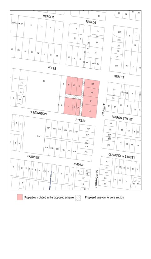
This report seeks a resolution by Council to declare the charges to fund the construction of a laneway between Noble and Huntingdon Streets, Newtown. (See plan – Appendix 4).
Property owner concerns relating to the unsealed laneway at the rear of 307 to 313 Pakington Street have been highlighted in recent times. It is considered that the proposed laneway construction will provide a direct access and amenity benefit for the abutting properties.
It is proposed to construct the laneway with a standard asphalt seal with provisions for drainage already in place.
There are eleven (11) properties abutting the proposed laneway that will receive special benefit. There are no Council owned properties in the proposed scheme.
The total estimated project cost is $31,318. A Benefit Ratio of 0.93 has been calculated in accordance with Section 163 of the Local Government Act. This equates to a Council contribution to the scheme of $2,185 and a property owner contribution of $29,133.
Council considered a separate report on 24 March 2015 and one objection was received during the subsequent submissions period.
The property owner who lodged the objection is not able to attend a panel hearing but has agreed to have the objection tabled at the Council meeting. In lieu of a panel hearing, a copy of the objection is tabled for consideration.
The scheme has been prepared in accordance with the Special Rate and Charges provisions of the Local Government Act 1989 along with the 2004 Ministerial Guidelines and Council’s Special Rates and Charges Policy.
Cr S Kontelj moved, Cr Ellis seconded -
That Council:
Resolves to declare the Special Charge Scheme as follows:
The Special Charge is declared for a period of five (5) years commencing upon completion of the works and scheme finalised.
The Special Charge be declared for the purpose of defraying any expenses incurred by Council in relation to the construction of the laneway between Noble and Huntingdon Streets, Newtown is the project which:
Will provide proper vehicular access and improved general amenity for each of the properties included in the scheme;
Council considers is or will be a special benefit to those persons required to pay the special charge (and who are described in succeeding parts of this Resolution); and
Arises out of Council’s function of planning for and providing infrastructure for property owners.
The total cost of project, be recorded as $31,318(Schedule A).
It be recorded that, for the purposes of Section 163 (2A) of the Local government Act 1989 (the Act), the special charge proceeds will not exceed the amount calculated in accordance with the prescribed formula (R x C = S), the:
‘benefit ratio’ (R) being calculated at 0.93 represents the special benefits to all persons liable to pay the special charge (Schedule B);
‘total cost’ (C) of performing the function described in part 1 (b) of this resolution based on estimated cost be recorded as $31,318; and
‘maximum levy’ (S) be recorded as $29,133.
the following be specified as the area for which the special rate is so declared:
the area within municipal district of Council highlighted in the plan attached to this Resolution (Appendix 4).
the following be specified as the land in relation to which the special charge so declared:
land within the area shown on the plan.
the following be specified as the criteria which form the basis of the special charge so declared:
ownership of any land described in Part 1(e) of this Resolution.
the following be specified as the manner in which the special charge so declared will be assessed and levied:
Each lot receives a primary access and amenity benefit;
The maximum levy is apportioned 50% on access benefit and 50% on a frontage share basis (amenity benefit); and
The special charge will be levied by sending a notice to the person who is liable to pay, pursuant to section 163(4) of the Act.
having regard to the preceding parts of this Resolution but subject to Section 166 (1) of the Act, it be recorded that;
the owners of the land described in column 2 & 3 of Schedule C to the resolution are estimated liable for the respective amounts set out in column 8 of Schedule C; and
such owners may, subject to any further resolution of Council pay the special charge in the following manner;
the charge will become due and payable within one month of the issue of the notice requesting payment pursuant to Section 167 (3) of the Act;
interest will not be charged for six months after the issue of the notice provided the person liable makes timely payment in accordance with any repayment arrangements that may be agreed on by Council; and
in accordance with Section 172 of the Act, the interest rate payable on the special charge which has not been paid by the specific date is set at Council’s overdraft rate, reviewed every three months (provided that it shall not exceed the rate fixed by the Governor in Council by Order for the purposes of Section 172 (2A) in which case the rate of interest shall be the maximum rate fixed by the Governor in Council by Order for the purposes of this section).
Authorise the Chief Executive Officer to levy the Special Charge in accordance with Section 163(4) of the Act.
Carried.
On 24 March 2015, Council resolved to give notice of its intention to declare a Special Charge Scheme for the construction of the laneway between Noble and Huntingdon Streets, Newtown.
During the subsequent submissions period, one objection was received from the affected property owners. This property owner originally requested to attend a panel hearing however a medical condition made this a not possible. The property owner has entrusted Council officers to convey his objection to Council. The objection is tabled as a confidential document with this report.
The concerns raised in the objection and corresponding considerations by Council officers include:
Do not use the laneway
This argument holds true for the current property owner however with all Special Charge Schemes, the considered benefits go to the property and not the owner. As the new laneway will provide improved access and amenity benefits for this property, it is considered appropriate to allocate the charge.
Laneway is of no benefit to me
As per above considerations
Is a waste of money and money could be spent in better ways
This is a personal view held by the property owner that is not necessarily reflected in others.
The provision of a sealed laneway provides a permanent and safe means of access. During the course of construction and the manufacture and procurement of materials, energy is expended resulting in some greenhouse gas emissions. This ceases when construction is complete.
The project does not create waste with the exception of some excavated material.
The proposal does not affect any natural habitats.
The proposal will not require any vegetation removal.
The project is a one off capital cost and there will be minimal ongoing maintenance costs. If approved, the scheme could proceed in the 2015/16 financial year.
Financial details are as follows:
|
Maximum scheme levy to Property Owners (income) |
$29,133 |
|
Scheme levy to Council |
$2,185 |
|
Total Project Cost |
$31,318 |
From the table above, the total net cost to Council for this project is estimated to be $2,185.
The scheme has been prepared in accordance with the Special Rate and Charge provisions of the Local Government Act 1989 along with the 2004 ministerial guidelines and Council’s Special Rates and Charges Policy.
This report aligns with the City Plan as follows:
Sustainably Built and Natural Environment.
Advocate for and promote sustainable design and development – Promoting sustainable design and retrofitting.
Acknowledge the community’s desire to have their say and be involved in planning for the future of Greater Geelong.
No Council Officer involved with this process has any direct or indirect interest in the properties.
Provision of a sealed laneway will provide safer driving conditions for motorists by the elimination of uneven and slippery surfaces.
There are no identified risks for Council in resolving to declare the charges for this scheme.
The provision of properly sealed and drained laneways is aligned to Council’s City Plan as described above and provides improved connectivity and safety for motorists. It is further considered that the laneways will enhance the general amenity of the area.
In developing this report to Council, the subject matter has been considered to determine if it raises any human rights issues. In particular, whether the scope of any human right established by the Victorian Charter of Human Rights and Responsibilities is in any way limited, restricted or interfered with by the recommendations contained in this report. It is considered that the subject matter does not raise any adverse human rights issues.
It is further considered that the construction of the laneways upholds the right to freedom of movement (Section 12 of the Human rights Charter) by enhancing a person’s ability to move freely within the area they choose to live.
Community consultation for the laneway construction Special Charge Scheme has been carried out as follows:
2 October 2014 – Initiation letter including a plan, Special Rates and Charges brochure, Apportionment spreadsheet and survey forms were sent out to all affected property owners. The survey results indicated sufficient support for the scheme proposal to proceed to the next stage.
31 March 2015 – A Scheme letter to property owners advised of Council’s Intention to Declare the Special charges. This letter included an invitation to make a submission.
Further correspondence will be mailed should Council resolve make its ‘Declaration of Charge’ for the scheme.
The works for the construction of a laneway which consist of excavation, asphalt pavement, miscellaneous construction works, legal advice and professional services associated with survey, engineering design, drafting, supervision and administration of the project all as included in the cost estimate shown below.
|
TOTAL COST OF SPECIAL CHARGE SCHEME |
|||||
|
ITEM |
DESCRIPTION |
QUANTITY |
UNIT |
RATE $ |
AMOUNT $ |
|
1.00 |
GENERAL |
|
|
|
|
|
1.01 |
Initial site establishment and set up, decamping and site cleanup and other fixed costs up to time of completion of works. |
|
ITEM |
2,000.00 |
$2,000.00 |
|
1.02 |
Traffic management costs. |
2 |
ITEM |
500.00 |
$1,000.00 |
|
1.03 |
Service / Cable locations |
|
ITEM |
250.00 |
250.00 |
|
2.00 |
EARTHWORKS & DEMOLITION |
|
|
|
|
|
2.01 |
Excavation and disposal of all materials to limits of work as indicated on plan, including trimming for new road pavement, excavation of soft spots and removal of concrete. |
54 |
m3 |
60.00 |
$3,210.00 |
|
2.04 |
Saw-cutting of asphalt paving. |
|
Item |
200.00 |
$200.00 |
|
3.00 |
PAVEMENT WORKS |
|
|
|
|
|
3.01 |
30mm compacted depth 10mm nominal size type H Asphalt spread and compacted including emulsion prime & grit using a paver. |
357 |
m2 |
35.00 |
$12,485.00 |
|
3.02 |
150mm compacted depth Class 2 20mm crushed rock, supplied, spread and compacted. |
53.505 |
m3 |
120.00 |
$6,420.60 |
|
SUB-TOTAL |
$25,565 |
||||
|
10% CONTINGENCY |
$2,556.54 |
||||
|
DESIGN |
$1,278.27 |
||||
|
SRC ADMINISTRATION |
$1,917.41 |
||||
|
CONSTRUCTION COST ESTIMATE |
$31,318 |
||||
A |
Purpose |
|||||
|
To construct the laneways at the rear of 307-313 Pakington Street, Newtown to provide all weather vehicular access for abutting property owners. |
|
||||
|
B |
Coherence |
|
||||
|
The works will provide a physical laneway connection between Noble Street and Huntingdon Street, Newtown and will provide a special benefit to abutting properties. |
|
||||
|
C |
Total Cost C |
|
||||
|
Total Estimated cost of works |
|
||||
|
|
Total Cost of Footpath Construction |
$31,318.00 |
|||
|
D |
Identify Special Beneficiaries |
|
|
|
|
|
|
10 properties with frontages to the proposed laneway are considered to receive access and amenity benefits. |
|
||||
|
E |
Properties to include |
|
|
|
|
|
|
Total Special Benefits (in) is apportioned to 10 properties. Three (3) properties are commercial properties which attract additional access benefits. Seven (7) properties are residential that attract standard access benefits. All properties receive amenity benefits based on actual frontage. There are no Council owned properties in the scheme. Therefore: |
|
||||
|
Total Special Benefits out of the scheme |
|
TSB (out) = |
0 |
|
|
|
F |
Estimate of Total Special Benefits |
|
|
|
|
|
|
For the purpose of calculating the benefit ratio, a Benefit Unit (BU) will be used and a distinction is made between an access and amenity benefit. We shall assume that the 1 BU consists of 0.5BU for access and 0.5BU for amenity and is equal to the average benefits for each of the private properties. The access benefit for all properties will be considered via the number of car parking spaces available. It is considered that all private properties have provision for two cars at 0.5 BU each (2 X 0.5 = 1BU for access). The retail property at 313 Pakington Street has provision for 4 spaces, 311 Pakington Street has 8 and 309 Pakington Street has 4. The amenity benefit will be the same for all properties at 0.5 BU each. This can be summarised in the table below: |
|
||||
|
|
7 Private Properties |
3 Commercial / Retail properties |
|
|
|
|
Access |
14 spaces = 7 BU |
16 spaces = 8 BU |
|
|
|
|
Amenity |
3.5 BU |
1.5 BU |
|
|
|
|
Total Special Benefits |
10.5 BU |
9.5 BU |
|
|
|
|
Total Special Benefits in the scheme: TSB (in) = |
20.00 |
BU |
|
||
|
G |
Estimate of Total Community Benefit - TCB |
|
||||
|
It is considered that people in the community will receive some benefit from the works as the laneway is used as an access between Huntingdon and Noble Street. It is expected that no more than 10% of laneway users will fit this category and this includes the neighbouring bowling club. There is no amenity benefits considered for the wider community. TCB is calculated as follows: |
|
||||
|
TCB = 10% X 15 (Total access BU) = |
|
|
2 |
|
|
|
H |
Calculate "Benefit Ratio" - R |
|
|
|
|
|
|
Benefits Ratio = |
TSB (in) |
= |
20 |
0.93 |
|
|
|
TSB (in) +TSB (out) + TCB |
|
20 + 0 + 2 |
|
|
|
I |
Maximum Total Levy (S) |
|
|
|||
|
Maximum Total Levy S = R X C |
|
|
$29,133.02 |
||
|
Council Contribution to Special Charge Scheme |
|
|
|
|
$2,184.98 |
|
COLUMN 1 |
COLUMN 2 |
COLUMN 3 |
COLUMN 4 |
COLUMN 5 |
COLUMN 6 |
COLUMN 7 |
COLUMN 8 |
|
Prop Key |
Address |
Legal Details |
Apportionable Rear Frontage |
Access Benefit (BU) |
Access Charge |
Amenity Charge |
Estimated Total Charge |
|
203761 |
307 Pakington Street, NEWTOWN |
Lot 1 TP 760329 |
15.55 |
1 |
$971.10 |
$1,578.24 |
$2,549.34 |
|
203762 |
309 Pakington Street, NEWTOWN |
Lot 1 TP 698263 |
16.00 |
2 |
$1,942.20 |
$1,623.91 |
$3,566.12 |
|
203763 |
311 Pakington Street, NEWTOWN |
Lot 1 TP 423761 |
16.26 |
4 |
$3,884.40 |
$1,650.30 |
$5,534.71 |
343424 |
1/313 Pakington Street, NEWTOWN |
1/2 Share of Lot 1 TP 902736 |
23.13 |
2 |
$1,942.20 |
$2,347.57 |
$4,289.77 |
203764 |
2-3/313 Pakington Street, NEWTOWN |
1/2 Share of Lot 1 TP 902736 |
|||||
|
203307 |
83 Noble Street, NEWTOWN |
Lot 1 TP 704786 |
12.19 |
1 |
$971.10 |
$1,237.22 |
$2,208.32 |
|
203308 |
85 Noble Street, NEWTOWN |
Lot 1 TP 117779 |
12.29 |
1 |
$971.10 |
$1,247.37 |
$2,218.47 |
|
203309 |
87 Noble Street, NEWTOWN |
Lot 1 TP 829448 |
12.19 |
1 |
$971.10 |
$1,237.22 |
$2,208.32 |
|
347341 |
2A Huntingdon Street, NEWTOWN |
Lot 1 PS 703708 |
8.37 |
1 |
$971.10 |
$849.51 |
$1,820.61 |
|
347342 |
2B Huntingdon Street, NEWTOWN |
Lot 2 PS 703708 |
8.39 |
1 |
$971.10 |
$851.54 |
$1,822.64 |
|
202332 |
4 Huntingdon Street, NEWTOWN |
Lot 1 TP 684217 |
19.15 |
1 |
$971.10 |
$1,943.62 |
$2,914.72 |
|
Stage |
Status |
Description |
|
Approval to prepare scheme |
✓ |
Decision made to prepare scheme following consideration of surveys of property owners and feed back from the community. Council may then place the project in the budget system or proceed immediately to prepare a scheme. Scheme preparation involves survey, design and preparation of an apportionment of costs. October 2014. |
|
Intention to Declare Scheme |
✓ |
Report to Council providing information on scheme including advice of impending advertising of scheme and declaration of charge. Seeks Council approval by resolution to proceed with process. 24 March 2015 |
|
Advertisement |
✓ |
The scheme is advertised in the local newspaper and all allotted property owners are notified by mail. This advertisement indicates Council’s intention and notification to ‘declare’ a scheme in a month’s time. 4 April 2015 |
|
Submissions |
✓ |
From the time of advertising property owners have 28 days (as set down by the Local Government Act) to lodge submissions, either in support or opposition to the scheme. |
|
Submissions Review Panel Hearing |
✓ |
A Submissions Review Panel is convened (quorum of three Councillors) and meets to consider submissions. Some submissions are written only, and other submitters may wish to be heard before the Panel. The Panel makes a recommendation to Council regarding the scheme. Panel not required in this circumstance. |
|
Declaration Report |
✓ |
Any time 28 days after advertising the scheme and after the Submissions Review Panel has met and considered submissions, Council considers a report and may proceed to “declare” the charges in accordance with its advertised intent. Subsequent to this the Finance Manager issues the levy notices and there is a formal charge placed on the property. This is the final step in the process for Council to make a decision on the scheme. |
|
Appeal |
|
Property owners may lodge an application for review with the Victorian Civil and Administrative Tribunal (VCAT) within one month of issue of the levy notice. An appeal is listed, heard and determined by the Tribunal and this process generally takes three to four months. Decisions made by VCAT are binding on all parties. |
|
Construction |
|
Council may then proceed to construct the works. Invoices are issued seeking payment of the estimated cost within one month of commencement. |
|
Final Cost Report |
|
At the completion of the works the scheme is “finalised” taking into account actual costs incurred and payments are adjusted accordingly. |
Contents | Previous Page: Section A - Procedural Matters | Next Page: Section C - Assembly of Assembly of Councillors
