
Council Minutes - Section B: Reports - 17 November 2015
Contents | Previous Page: Section A - Procedural Matters | Next Page: Section C - Assembly of Councillors
Contents | Previous Page: Section A - Procedural Matters | Next Page: Section C - Assembly of Councillors
Reports tabled at the Ordinary Meeting of Council on Tuesday date held at the Council Conference and Reception Centre in City Hall, 57 Little Malop Street, Geelong.
Annual Review of the Geelong Public Health and Wellbeing Plan 2013-2017
Wyndham Street, Drysdale – Proposed Footpath Construction SRC343 – Intention to Declare
Consideration of Tender Submissions for Tender T15000054 Tree Maintenance Services
Debt Management (Confidential)
Portfolio: |
Major Projects – Cr Macdonald |
Source: |
City Services - engineering Services |
General Manager: |
William Tieppo |
Index Reference: |
Geelong Transport Strategies, Transport Planning |
To identify current and future transport infrastructure needs for Waurn Ponds.
At its meeting on 28 October 2014, Council requested a report be presented to Council on the current and future transport infrastructure needs for Waurn Ponds, including State Government and Council Roads.
An assessment of the current and projected traffic volumes in Waurn Ponds has been undertaken based on projected future growth.
This report identifies the present and future transport infrastructure needs for the Waurn Ponds area.
Cr Richards moved, Cr Harwood seconded -
That:
Council note the proposed transport infrastructure works for Waurn Ponds and that these proposed works be used as the basis for further consultation with residents and consideration in future budget prioritisation;
a consultation and communication plan be developed to ensure Waurn Ponds residents are informed and properly consulted in regard to transport infrastructure issues.
Carried.
Waurn Ponds is experiencing and will continue to experience a large increase in vehicle traffic movements due to a number of recent changes. These changes included:
Construction of the new Waurn Ponds Train Station;
Completion of Rossack Drive, connecting to Waurn Ponds train station;
Continued housing growth in Waurn Ponds, Armstrong Creek and the Surf Coast Shire;
Traffic signals at the intersection of Ghazeepore Road and Baanip Boulevard;
Opening of Baanip Boulevard with shared pathways (between Anglesea Road to Surf Coast Highway);
Further investigation is required for the following roads to determine how they will cater for current and future traffic demands:
Main, Collector and local roads serving the Waurn Ponds area, such as Geelong Ring Road, Anglesea Road, Waurn Ponds Drive, Cochranes Road, Ghazeepore Road, Rossack Drive, Monterey Drive, Bodega Street and Sugargum Drive
To identify current and future transport infrastructure needs for Waurn Ponds, it was necessary to analyse all the roads and intersections within Waurn Ponds with a focus on traffic movement, numbers and capacity of the road network to accommodate the external traffic and local transport needs. Transport in this respect includes all modes from pedestrian, cyclists, public transport and all forms of vehicular movements including freight.
Within Waurn Ponds there are a number of key roads and public transport infrastructure, which provide connectivity to and from this suburb as shown in Table 1 and Figure 1 below.
|
No. |
Road / Location |
Direction |
Responsibility |
|
1 |
Geelong Ring Road (M1) (Primary Arterial) |
East – West |
VicRoads |
|
2 |
Baanip Boulevard (Primary Arterial) |
East – West |
VicRoads |
|
3 |
Anglesea Road (C134) (Secondary Arterial) |
East – West |
VicRoads |
|
4 |
Waurn Ponds Drive (CAT 4 - Main Distributor - Urban ) |
East – West |
Council |
|
5 |
Cochranes Road (Cat 3 – Collector Road Rural) |
North – South |
Council |
|
6 |
Ghazeepore Road (CAT 4 - Main Distributor - Urban ) |
North – South |
Council |
|
7 |
Rossack Drive (CAT 4 - Main Distributor - Urban) |
North - South |
Council |
|
8 |
Monterey Drive (Cat 3 – Secondary Distributor) |
East – West |
Council |
|
9 |
Sugargum Drive / Bodega Street |
East – West |
Council |
|
10 |
Waurn Ponds Train Station |
|
PTV |
Table 1: Key roads / transport infrastructure within Waurn Ponds
Figure 1: Key roads / transport infrastructure within Waurn Ponds (Source: CoGG PLACES Weave)
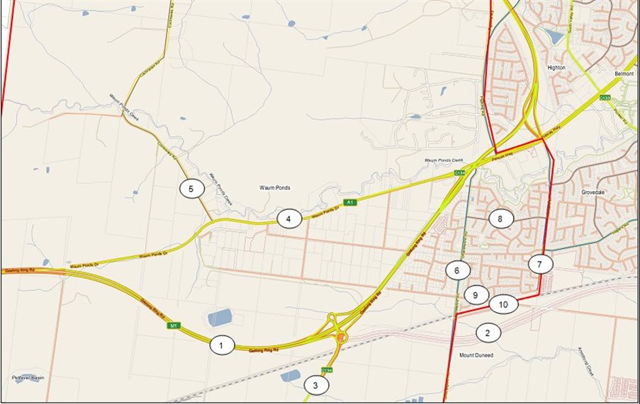
The following locations are highlighted as the key distributors / traffic generators within the area and have been further assessed to identify the future transport infrastructure needs for Waurn Ponds.
Rossack Drive (CAT 4 – Main Distributor –Urban)
Rossack Drive is constructed as a dual carriageway.
|
Current Traffic Volumes |
5,000 vehicles per day |
|
Future Traffic Volumes |
10,000 vehicles per day |
Issues & possible solutions |
Higher through traffic from newly constructed Waurn Ponds Train Station |
Future public transport service connection via Rossack Drive to Waurn Ponds Train Station |
Ghazeepore Road (CAT 4 – Main Distributor –Urban)
Ghazeepore Road is constructed as a single carriageway.
Current Traffic Volumes |
4,000 vehicles per day |
Future Traffic Volumes |
10,000 vehicles per day |
Issues & possible solutions |
Higher through traffic from newly constructed Waurn Ponds Train Station |
Increase in public transport service connections to Waurn Ponds Train Station |
|
Inconsistent carriageway cross section. |
|
Principal Bicycle Network (PBN) identified. |
|
Improve existing intersection treatments with splitter islands, new line marking and signs |
Monterey Drive (CAT 3 – Secondary Distributor)
Monterey Drive is constructed as a single carriageway.
|
Current Traffic Volumes |
2,500 vehicles per day |
|
Future Traffic Volumes |
5,000 vehicles per day |
|
Issues & possible solutions |
Through traffic between Ghazeepore Road and Rossack Drive |
|
Increase in public transport service connections |
|
|
Improve existing intersection treatments with splitter islands, new line marking and signs |
Sugargum Drive / Bodega Street (CAT 2 – Local Access – Urban)
Sugargum Drive is constructed as a single carriageway.
|
Current Traffic Volumes |
600 vehicles per day |
|
Future Traffic Volumes |
2,000 vehicles per day |
Issues & possible solutions |
High traffic volumes between Ghazeepore Road and Rossack Drive via Waurn Ponds Train Station |
Increase in public transport service connections |
|
Improve existing intersection treatments with splitter islands, new line marking and signs |
|
Provision of safe pedestrian and cycle accessibility to Waurn Ponds Train Station |
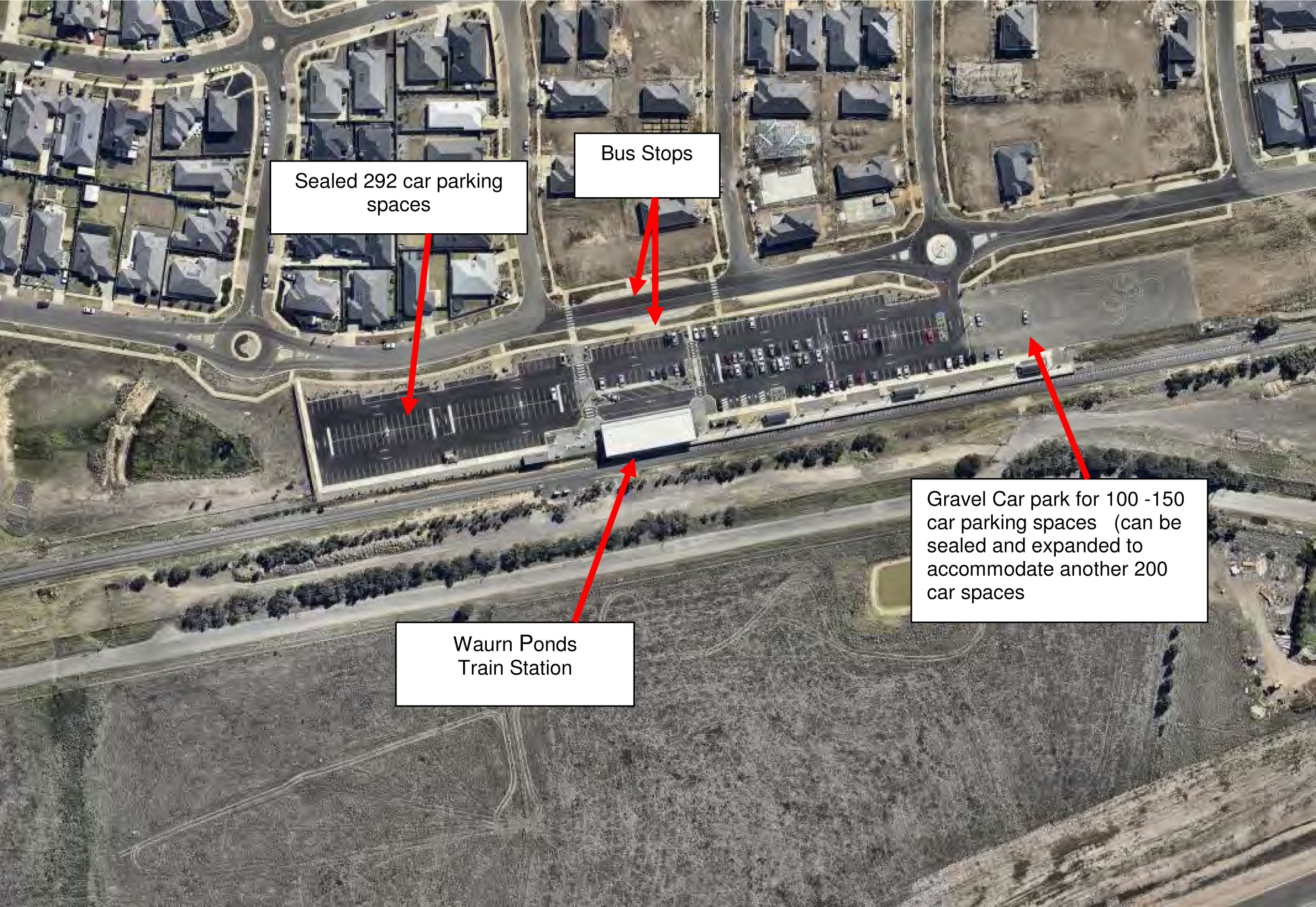
Newly opened Waurn Ponds Train Station (October 2014)
|
Current On site parking provision |
292 sealed and line marked parking bays and another informal 100-150 parking bays on gravel surface |
|
Issues & possible solutions |
Expand the gravel car park ( seal and line mark) to cater to the high demand for on-site parking |
|
Parking overflow will impact residential streets |
|
|
Increase in public transport service connections |
|
|
Improve existing intersection treatments with splitter islands, new line marking and signs |
|
|
Provision of safe pedestrian and cycle accessibility to Waurn Ponds Train Station |
|
|
Need for secure bicycle storage cages |
|
|
Multiple pedestrian and bicycle access connections to the train station from the south side across the railway line. Connections could be from Rossack Drive to Muir Road / Baanip Boulevard Shared Pathway |
|
|
Future demand for parking on the south side from Baanip Boulevard and safe pedestrian access |
Figure 2: Waurn Ponds Train Station and car park (Source: Near Map)
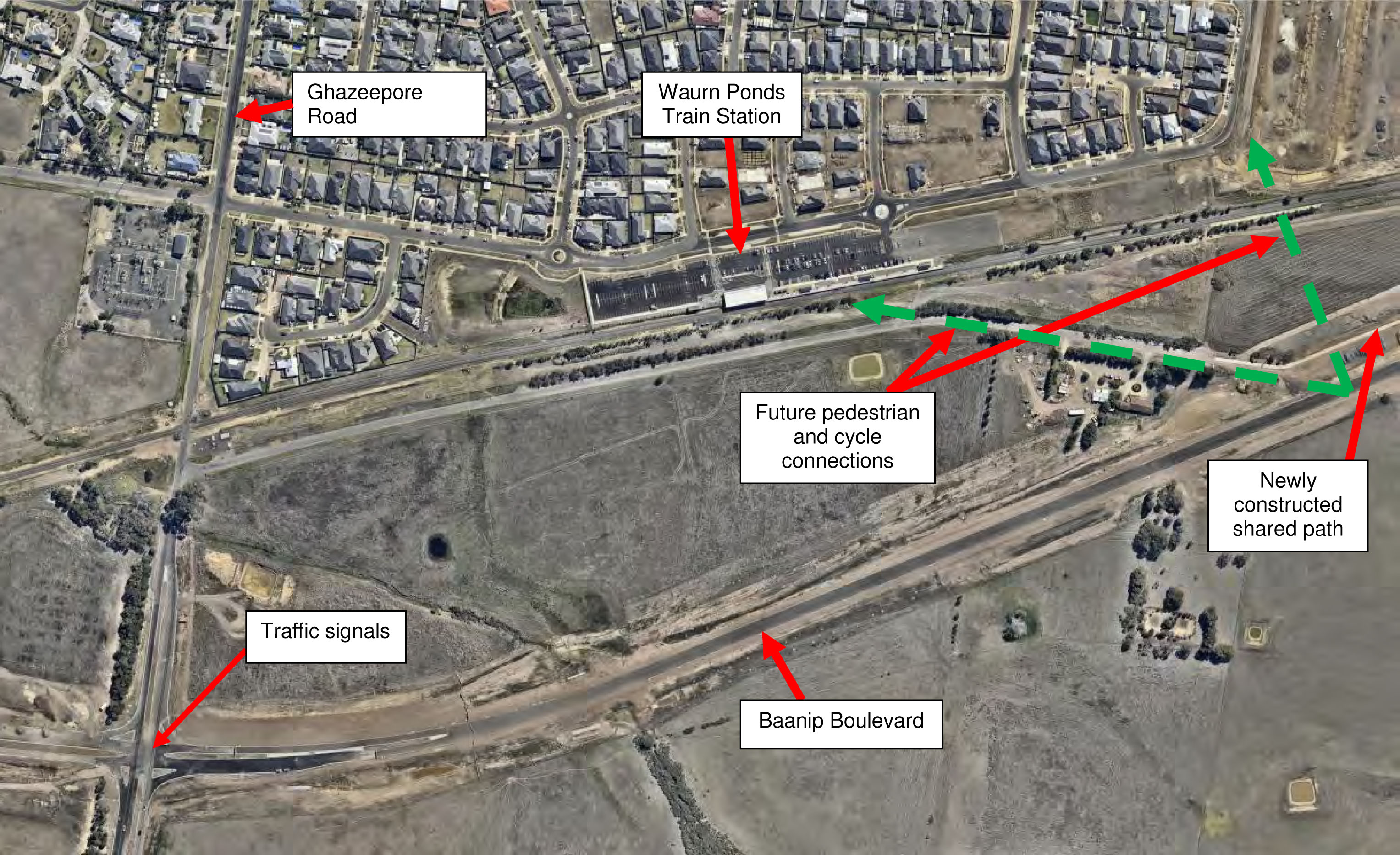
Baanip Boulevard - Figure 3: Baanip Boulevard (Source: Near Map)
|
Current Traffic Volumes |
400 - 1000 vehicles per day |
|
Future Traffic Volumes |
14,000 - 20,000 vehicles per day |
|
Issues & possible solutions |
Parking overflow near train station will create safety issues |
|
Future public transport service connections via Baanip Boulevard and Armstrong Creek |
|
|
Required Safe Multiple pedestrian and bicycle access connections to the train station from the south side across the railway line. Connections could be from Rossack Drive to Muir Road / Baanip Boulevard Shared Pathway Pedestrian and cycle access to the train Station and Rossack Drive ( as shown in figure 3, (green lines) from the existing shared pathway in Baanip Boulevard |
|
|
Future demand for parking on the north side from Baanip Boulevard and safe pedestrian access |
|
|
Future increase in traffic volumes accessing the train station from Armstrong Creek (The growth area will take in the order of 25 years to fully develop, and will realise a population in the order of 55,000 people to be accommodated in 22,000 households.) |
In summary, the key issues identified from each of the key traffic generators include:
Increase in through traffic volumes in local residential streets;
Increase in on-road parking in the vicinity of the train station
Safety of intersections;
Suitable locations of bus stops;
Missing infrastructure e.g. footpaths; and
Poor traffic flow.
To address these key issues the proposed solutions in summary include:
Provide traffic calming works on local roads as required to improve safety;
Review and complete footpaths connections and continuance;
Review and install traffic and parking signs;
Review and improve existing line marking;
Review Principle Bicycle Network (PBN) and provide infrastructure;
Further detail specific to each road is included in Attachment 1.
Development of the infrastructure proposed will enhance the natural and built environment through the consistent improvement of the infrastructure base.
This report identifies traffic infrastructure requirements for Waurn Ponds. The bulk of the major funding to implement the required infrastructure will need to be allocated within future Council budgets with the opportunity to seek supporting funds from VicRoads, PTV and developers.
Council projects will be carried out to maximise community safety and help improve road accessibility. The costs are indicative, and further detailed estimates will be prepared when each project is considered for construction. The estimated costs for the identified projects will be over $800,000 as shown in the attached table.
This report provides direction for the ongoing improvement to transport infrastructure within Waurn Ponds. It will also demonstrate that the City is taking a responsible position on road network management issues.
This report is aligned with the strategic direction of City Plan. Having an integrated approach to transport infrastructure planning is a way forward to influence the land use development planning and to provide sustainable transport infrastructure systems. Transport directly affects the community, economy and the environment and to have an efficient transport system is important for the prosperity of local economies and to improve quality of life within the region. This report will identify transport infrastructure improvements to meet community needs and Council objectives.
No Council officer involved in the preparation of this report has a direct or indirect conflict of interest.
The Development of this report will improve Council’s position in terms of the level of understanding of Transport network infrastructure improvement needs and accessibility issues.
Appropriate transport planning means that social impacts are properly considered during the development and management of the transport issues. This report aims to enhance accessibility, connectivity and mobility of walking, cycling and public transport and improve amenity and reduce road trauma. Appropriate planning of road accessibility and connectivity within the Waurn Ponds will contribute significantly to improving the health and wellbeing of local residents.
Improved safety for ‘active’ travel modes such as walking and cycling and provision of more equitable access for people of all ages and abilities has many documented social benefits, increasing opportunities for social interaction and participation.
The findings of this report do not impact negatively on any basic rights, freedoms and responsibilities as set out in the Charter.
There were two public submissions in 2014 in regards to the new Waurn Ponds station and surrounding transport infrastructure. The City carried out two surveys, one Geelong wide ‘electronic survey’ and a second survey of residents who live within a radius of approximately 500 metres from the new Waurn Ponds Train Station. Both surveys were conducted between 20 June and 18 August 2014
Some of the road related issues raised included cycling infrastructure needs, growth in Armstrong Creek development areas and infrastructure requirements, connectivity between key activity centres, pedestrian connectivity, road safety improvement, lack of capacity on trains to Melbourne, station upgrades, and congestion and community mobility options.
Item |
Main Road |
Intersecting Road |
Existing Treatment |
Future works Required |
Responsible Organisation/s |
Indicative Costs $ |
1 |
Waurn Ponds Drive (CAT 4-Main Distributor – Urban) |
Marendaz Road (CAT2 – Local Road- Rural) |
Functions similar to a T-intersection on a straight, left slip lane in Waurn Ponds Drive |
No |
|
|
2 |
Luggs Road (CAT2 – Local Road- Rural) |
Functions similar to a T-intersection on a straight, left slip lane in Waurn Ponds Drive |
No |
|
|
|
3 |
Lemins Road (CAT2 – Local Road- Rural) |
Functions similar to a T-intersection on a straight |
No |
|
|
|
4 |
Cochranes Road (CAT3 – Collector Road- Rural) |
Functions similar to a T-intersection on a curve |
Left slip lane in Waurn Ponds Drive to be investigated |
Vic Roads/ CoGG |
90,000 |
|
5 |
Mcpherson Road (CAT1 – Fire Access) |
Functions similar to a T-intersection on a straight |
No |
|
||
6 |
Cochranes Road( CAT3 – Collector Road- Rural) |
Luggs Road (CAT2 – Local Road- Rural) |
Functions similar to a T-intersection on a straight |
No |
|
|
7 |
Kingsbury Lane (CAT2 – Local Road- Rural) |
Functions similar to a T-intersection on a curve |
No |
|
|
|
8 |
Ghazeepore Road (CAT 4-Main Distributor - Urban) |
Princes Hwy |
Left in – Left Out |
No |
|
|
9 |
Burgundy Dr / Eden Crt (CAT 2-Local Access -Urban) |
Cross intersection |
Install ‘Stop’ and ‘Give way’ signs at this intersection |
CoGG |
2,000 |
|
10 |
Bourbon Way (CAT 2-Local Access -Urban) |
T- intersection |
Install ‘Stop’ and ‘Give way’ signs at this intersection |
CoGG |
2,000 |
|
11 |
Monterey Drive (CAT 3-Secondary Distributor) |
T- intersection |
Install ‘Stop’ and ‘Give way’ signs at this intersection |
CoGG |
2,000 |
|
12 |
Grange Park Drive (CAT 2-Local Access -Urban) |
T- intersection |
Install ‘Stop’ and ‘Give way’ signs at this intersection |
CoGG |
2,000 |
|
13 |
Delgany Mews (CAT 2-Local Access -Urban) |
T- intersection |
Install ‘Stop’ and ‘Give way’ signs at this intersection |
CoGG |
2,000 |
|
14 |
Oakwood Crescent (CAT 2-Local Access -Urban) |
T- intersection |
Install ‘Stop’ and ‘Give way’ signs at this intersection |
CoGG |
2,000 |
|
15 |
Acacia Lane (CAT 2-Local Access -Urban) |
T- intersection |
Install ‘Stop’ and ‘Give way’ signs at this intersection |
CoGG |
2,000 |
|
16 |
Brentwood Way (CAT 2-Local Access -Urban) |
T- intersection |
Install ‘Stop’ and ‘Give way’ signs at this intersection |
CoGG |
2,000 |
|
17 |
Ghazeepore Road (CAT 4-Main Distributor - Urban) |
Sugargum Drive / Hams Road (CAT 2-Local Access -Urban) |
Cross Intersection |
Traffic signals or a roundabout will be needed with pedestrian refuges |
CoGG |
400,000 |
18 |
Full length |
|
Cross section improvements through pavement widening (project to be scoped). |
CoGG |
Need to cost these works. |
|
19 |
Baanip Boulevard(Primary Arterial – VicRoads) |
Traffic Signals |
No |
|
|
|
20 |
Between Princes Hwy and Railway Line |
|
Install traffic calming works along Ghazeepore Road, Complete the gaps in the footpath network, On-street parking restrictions at selected locations. Review bus stop locations |
CoGG |
140,000 |
|
21 |
Between Railway Line & Mt Duneed Road |
|
Provide edge lines, 80 km/h speed limits signs. |
CoGG |
75,000 |
|
22 |
Between Princes Hwy and Railway Line |
|
Install Bicycle lanes as per ‘Principle Bicycle Network’ |
CoGG |
10,000 |
|
23 |
Rossack Drive (CAT 4-Main Distributor – Urban) |
Princes Hwy |
Traffic Signals |
No |
|
|
24 |
Meadowvale Drive |
Roundabout |
No |
|
|
|
25 |
Monterey Drive & Pit Street |
Roundabout |
No |
|
|
|
26 |
Willesden Drive & Heyers Road |
Roundabout |
No |
|
|
|
27 |
Bodega Street |
Road works have commenced to duplicate Rossack drive |
Roundabout |
Developer contribution |
Need to cost these works |
|
28 |
Between Heyers Road & Mt Duneed Road |
|
Road duplicated to match existing cross section |
Developer contribution |
|
|
29 |
Sugargum Drive (CAT 2-Local Access – Urban) |
Between Ghazeepore Road & Rossack Drive |
|
Install speed limit signs (possible 50 km/h or 40 km/h), All parking bays signed and marked, Pedestrian crossing signed and marked |
CoGG |
25,000 |
30 |
Bodega Street (CAT 2-Local Access – Urban) |
|
|
Footpath on the south side |
Developer contribution |
Need to cost these works |
31 |
Grange Park Drive (CAT 2-Local Access – Urban) |
(due to the Hams Road Development) |
|
Traffic calming treatments will be installed |
CoGG |
50,000 |
32 |
Hams Road (CAT 2-Local Access – Urban) |
|
|
Developer to complete 10m wide road width |
|
Need to costs these works |
33 |
Waurn Ponds Train Station |
‘Directional and Way Finding ‘ signs required |
PTV |
Need to costs these works |
||
|
34 |
Monterey Drive |
Between Ghazeepore Road & Rossack Drive |
|
Splitter Islands at each end |
CoGG |
25,000 |
35 |
Shared path connections |
|
|
From Baanip Boulevard to Rossack Drive and to the Waurn Ponds Train Station |
PTV / VicRoads / CoGG |
Need to cost these works |
|
|
|
|
|
|
831,000+ |
Portfolio: |
Planning - Cr Heagney |
Source: |
Planning and Tourism - Urban Growth |
General Manager: |
Peter Bettess |
| Index Reference: | Armstrong Creek Town Centre |
The purpose of this report is to recommend Council adopt the Armstrong Creek Town Centre implementation package inclusive of Armstrong Creek Town Centre Visual Branding Policy, Guide to Preparing a Sustainability Management Plan and Armstrong Creek Town Centre Guidelines for 3D Digital Modelling (Appendices previously provided with Briefing Papers).
The Armstrong Creek Town Centre (ACTC) Precinct Structure Plan was approved on 23 October 2014 enabling the development of this important retail, commercial and civic heart of the Armstrong Creek growth area. The Precinct includes land bounded by Surf Coast Highway, Boundary Road, Burvilles Road and Barwarre Road (Appendix 1).
The Armstrong Creek Town Centre Precinct Structure Plan (ACTCPSP) includes three unique elements that facilitate the delivery of the Precinct’s vision; namely an application requirement to prepare a Sustainability Management Plan and submit electronic 3D drawing files, and a requirement to align to a common ‘Brand Mark’ for the Precinct.
To support implementation of these three elements, three documents have been prepared to assist the development and consulting industry as well as internal staff implement the ACTCPSP.
The “ACTC - Guide to Preparing a Sustainability Management Plan (SMP)” (Appendix 2) illustrates why a SMP is required, what it should contain (including templates) and how its implemented via the Planning Permit process.
The “ACTC - Guidelines for 3D Digital Modelling” (Appendix 3) provides a short guide for the development and consulting industry to enable a 3D drawing of a proposed development to be submitted with applications and enable detailed assessment of the proposal.
The “ACTC Visual Branding Policy (including ACTC Visual Branding Guide)” (Appendix 4 and 5) establishes a consistent identity for the ACTC as the new commercial and civic heart of the Armstrong Creek Urban Growth Area (ACUGA). The ACTCPSP requires the implementation of the ACTC Visual Branding Policy to deliver the vision for the Precinct.
It is not the purpose of the ACTC Visual Branding Policy to provide explicit controls regarding signage, buildings and works or other components of the development already controlled through the Greater Geelong Planning Scheme.
The ACTC - Guide to Preparing a Sustainability Management Plan (SMP) and ACTC – Visual Branding Guide were both developed following consultation with landowners and relevant stakeholders relating to their vision and aspirations for the ACTC.
The ACTC Brand Mark does not belong to Council. Developers within the ACTC will hold ownership and implementation of the Brand Mark together with the ACTC Visual Branding Guide.
Cr Heagney moved, Cr Richards seconded -
That Council adopt the Armstrong Creek Town Centre (ACTC) Implementation package:
ACTC - Guide to Preparing a Sustainability Management Plan;
ACTC - Guidelines for 3D Digital Modelling, and
ACTC - Visual Branding Policy (including Visual Branding Guide)
to guide development of the ACTC.
Carried.
The Armstrong Creek Town Centre Precinct Structure Plan (ACTC PSP) was approved on 23 October 2014 and sets the vision for the Town Centre as being:
“The Armstrong Creek Town Centre will be the civic, commercial and social heart of the Armstrong Creek Urban Growth Area. It will be a sustainable, pedestrianised and vibrant transit oriented place which encourages people to shop, live, work and play. The Town Centre will be an attractive place, creating a destination for Armstrong Creek residents and visitors”.
The Urban Growth Zone Schedule 5 (ACTC) includes two unique requirements to facilitate the delivery the above vision, specifically relating to sustainability and built form / development assessment. These two application requirements are:
Sustainability Management Plan
Multi-unit residential development, comprising 10 or more dwellings, and any non-residential development comprising more than 500 square metres of gross floor area and any service station must be accompanied by a Sustainability Management Plan (SMP) providing strategies to minimise resource use and waste having regard to Part 1 of Appendix 5 of the Armstrong Creek Town Centre Precinct Structure Plan.
The SMP must be prepared to the satisfaction of the Responsible Authority by a suitably qualified expert. The SMP should:
identify relevant sustainability targets or performance standards;
document the means by which the appropriate target or performance will be achieved;
demonstrate how proposed design elements integrate and respond to precinct level sustainability strategies, opportunities and development context;
identify the different areas of responsibility and provide a schedule for implementation, ongoing management, maintenance and monitoring; and,
demonstrate that the design elements, technologies and operational practices that comprise the SMP can be maintained over time.
CAD drawings
Applications for new development, or extensions of existing development, greater than 50 square metres in Precincts 1, 2, 3 or 4 must provide 3D CAD (MGA Zone 55) drawings of the proposed development to the satisfaction of the Responsible Authority.
Applications for development in Precinct 5, other than for residential purposes, must provide 3D CAD (MGA Zone 55) drawings of the proposed development to the satisfaction of the Responsible Authority.
The provided 3D CAD model must satisfy the requirements of Council’s acceptable 3D model formats document.
The requirement for a SMP as part of the ACTC application process is seen to facilitate early consideration of sustainability initiatives and to also ensure these initiatives are embedded in the ultimate design.
3D CAD (Computer Aided Design) files, are a useful tool in the assessment of development applications, particularly relating to issues such as interaction with the public realm, over shadowing and integration with other approved and / or proposed developments.
In addition to the above two requirements, the ACTCPSP (Section 4.5.3 - Use and Development Implementation and 4.6.3 - Built Form Implementation) requires:
Advertising signs will be controlled through the specific provisions of the Urban Growth Zone Schedule 5 (UGZ5) and will need to be in accordance with any Armstrong Creek Town Centre Visual Branding Policy as prepared by the Council
This provision requires Council to prepare an ACTC Visual Branding Policy to guide the delivery of a consistent visual branding response across the Precinct.
The purpose of the ACTC Implementation Package, inclusive of:
ACTC - Guide to Preparing a Sustainability Management Plan (SMP),
ACTC - Guidelines for 3D Digital Modelling, and
ACTC - Visual Branding Policy (including Visual Branding Guide),
is to provide the development industry, consultants and key internal staff with clear guidance on the implementation of three unique elements of the ACTC Precinct Structure Plan (ACTCPSP).
Sustainability Management Plans
During the development of the ACTC PSP sustainability was a major theme for the Precinct, as is the case for the whole Armstrong Creek growth area. However, the ACTC provides a unique opportunities to deliver best practice sustainability initiatives for major retail, commercial, civic and high density housing developments.
Moreland Energy Foundation prepared a report titled Armstrong Creek Town Centre, Sustainable Urban Development Framework, Moreland Energy Foundation, August 2012. The report provided a clear framework for how best practice environmental sustainable design could be embedded in the ACTC PSP, including the development of a separate section within the PSP relating to sustainability Appendix 6 sets out the general structure and checklist matrix for the ACTC PSP Planning and Design Guidelines.
Following the approval of the ACTC PSP, Council engaged AECOM Consultants to prepare a guide that distilled the requirement of the ACTC PSP into an easy to use document, including SMP templates for both residential and non-residential developments.
A draft Guide was circulated to all landowners / developers within the Precinct for feedback and was adjusted (where appropriate) to response to specific concerns and questions.
The outcome of the project was the ACTC - Guide to Preparing a Sustainability Management Plan (Appendix 2), which includes:
Part 1 – Guide to Preparing a Sustainability Management Plan;
Part 2 – Reference Matrix; and
Appendix – SMP Templates (Residential and Non-Residential).
3D Digital Modelling
The ACTC will include some of the most significant scale and diverse developments across the Armstrong Creek urban growth area. This includes major supermarket, discount department stores, shops and restaurants, office and commercial uses, major public facilities such as a regional library, aquatic centre, arts and cultural facilities and town green, a bus interchange, rail trail (future rail corridor) and medium / high density housing.
To facilitate the processing of these development applications, the Urban Growth Zone - Schedule 5 (ACTC) includes a requirement for applicants to submit a 3D CAD drawing file of their proposed development.
These 3D files enable Council to quickly assess the impact of the proposal on previously approved developments, as well as determine any potential issues with future developments within the Precinct.
To assist this process Council has completed two key projects to assist the development / consulting industry with the preparation of these 3D files. These are:
ACTC 3D Model (full ‘SketchUp’ model with indicative development response), Appendix 7 provides sample model extracts, and
ACTC - Guidelines for 3D Digital Modelling (Appendix 3).
The 3D model was prepared by a local Deakin University student (completing his Masters of Architecture) in partnership with the City’s Urban Growth unit. The output is exceptional and highlights the local talent available within the Geelong region.
The model is illustrative only and aims to provide a potential development response to the ACTC, and allow applicants 3D files to be inserted and tested within a potential development setting.
To assist with the creation of these files, Council has prepared a short guide to preparing these files and what critical requirements are need for Council to utilise these files during the application process.
The creation of these 3D files is not onerous; noting the intention of these 3D drawings is not to be a detailed rendered drawing but a simple representation of the proposed development. It should also be noted that there are several free and low cost options for 3D software packages to allow quick and cost effective development of these files.
ACTC Visual Branding Policy
The ACTC is the commercial and civic heart of the Armstrong Creek growth area and will be developed as an iconic location for people to shop, recreate and access higher order services. Integral to establishing community ownership of the ACTC is the creation of a sense of place that is not dominated by any ownership pattern or commercial activity. Branding is a means of unifying the various uses across the ACTC with a common symbology that resonates with the community, tenants and general users of the ACTC.
The ACTCPSP requires the preparation and implementation of the ACTC Visual Branding Policy to deliver the vision for ACTC Precinct.
In late 2014 Council engaged Grindstone Creative to develop a Brand Mark and style guide for the ACTC, while Council prepared a Visual Branding Policy to assist with it’s implementation. The ACTC Brand Mark was developed following consultation with all landowners and relevant stakeholders relating to their vision and aspirations for the Town Centre, and is reflective of the local environment of Armstrong Creek and the sustainability principles unpinning the vision of the ACTC.
The Brand Mark or logo references four key identifying aspects of the ACTC. These include the natural environment and sustainability; a pedestrianised, interconnected community; a community hub; and the letter ‘a’. The implementation of the Brand Mark may take various different forms including signage, marketing material, public / private art and other innovative components of place making.
The purpose of the ACTC Visual Branding Policy (Appendix 4) is to:
Establish a consistent identity for the ACTC as the new commercial and civic heart of the Armstrong Creek Urban Growth Area (ACUGA); and
Provide clear guidance in the use and implementation of the Brand Mark across the Precinct.
The ACTC Visual Branding Guide, which informs the ACTC Visual Branding Policy, applies to all planning permit applications that seek approval for signage within the ACTC.
The Brand Mark does not belong to Council and will be implemented by developers within the ACTC via the planning permit process.
It is not the purpose of the ACTC Visual Branding Policy to provide explicit controls regarding signage, buildings and works or other components of the development already controlled through the Greater Geelong Planning Scheme.
The ACTC - Guide to Preparing a Sustainability Management Plan provides an important tool for the development and consulting industry, as well as internal staff in preparation, assessment and implementation of sustainability initiatives within the ACTC.
The ACTC Visual Branding Policy has no environmental implications; however the ACTC Brand Mark does reference the Armstrong Creek local indigenous environment.
There are no financial implications to Council with accepting the recommendation in this report.
No impact to budget.
Should Council resolve to adopt the ACTC Visual Branding Policy, it will become part of Council’s suite of policies.
The requirement for the ACTC Visual Branding Policy is incorporated in the Greater Geelong Planning Scheme through the ACTC Precinct Structure Plan.
The Armstrong Creek Urban Growth Area is one of Council’s priority projects. The implementation of the ACTC Visual Branding Policy aligns with “Growing the Economy”.
No officers involved in this report have any direct or indirect interest in accordance with
s80(c) of the Local Government Act 1989 (Vic).
There are no notable risks associated with accepting the recommendation in this report.
There are no significant social considerations as a result of the implementation of the ACTC Implementation package.
This report has no direct impact on human rights.
The ACTC - Guide to Preparing a Sustainability Management Plan and the ACTC Brand Mark were developed following consultation with landowners and relevant stakeholders. This consultation included online surveys, one on one meetings and review of key documentation.
Portfolio: |
Planning - Cr Heagney |
Source: |
Planning and Tourism - Strategic Implementation |
General Manager: |
Peter Bettess |
Index Reference: |
Council Reports 2015 |
This report seeks Council approval to exhibit a planning scheme amendment concurrent with a permit to facilitate the development of a multi-storey accommodation and retail complex on Geelong Road, Portarlington.
A Planning Scheme Amendment request and Planning Permit Application has been made by St Quentin Consulting on behalf of the proponent, Grabble Pty Ltd.
The Amendment proposes to rezone 30-42 Geelong Road, Portarlington, from the Commercial 2 Zone to the Mixed Use Zone. The proponent is the owner of 30 and 32 Geelong Road.
The Amendment will also apply the Environmental Audit Overlay to all the land being rezoned.
The permit application (1234/2014) applies to 30 and 32 Geelong Road, and seeks to allow the development and use of the land for a multi storey accommodation and retail complex together with other permit requirements.
The proposed building will be 4 storeys containing 55 one and two bedroom dwellings, ground floor retail premises and a basement car park. Each apartment will be made available for either short-term accommodation (through a serviced apartment model) or for long term occupancy by owners.
This accommodation use is prohibited in the Commercial 2 Zone hence the need to rezone the land.
The Mixed Use Zone is considered to be the appropriate zone for the proposed use while not restricting the operations of the existing commercial premises in the precinct.
Given the existing role and function of this commercial precinct, the proposed Mixed Use Zone and development will not adversely impact on nearby residents. While the accommodation complex represents a new built form feature for Portarlington, it is of high quality, architecturally appealing and complementary to its coastal setting and prominent town entry location.
The proposal is considered to be consistent with State and Local planning policies and directly supports the local tourism industry by providing quality short term accommodation. The Portarlington map at Clause 21.14-5 of the Greater Geelong Planning Scheme will also be changed to reflect the removal of the commercial zone.
It is recommended that the Amendment and Permit be placed on public exhibition to allow local residents and the business community an opportunity to make submissions.
Cr Heagney moved, Cr Ellis seconded -
That Council resolves to:
Support the preparation and exhibition of Amendment C321 to the Greater Geelong Planning Scheme to:
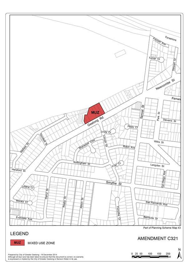
Rezone the land at 30, 32, 34, 36-38, 40 and 42 Geelong Road, Portarlington, from the Commercial 2 Zone to the Mixed Use Zone;
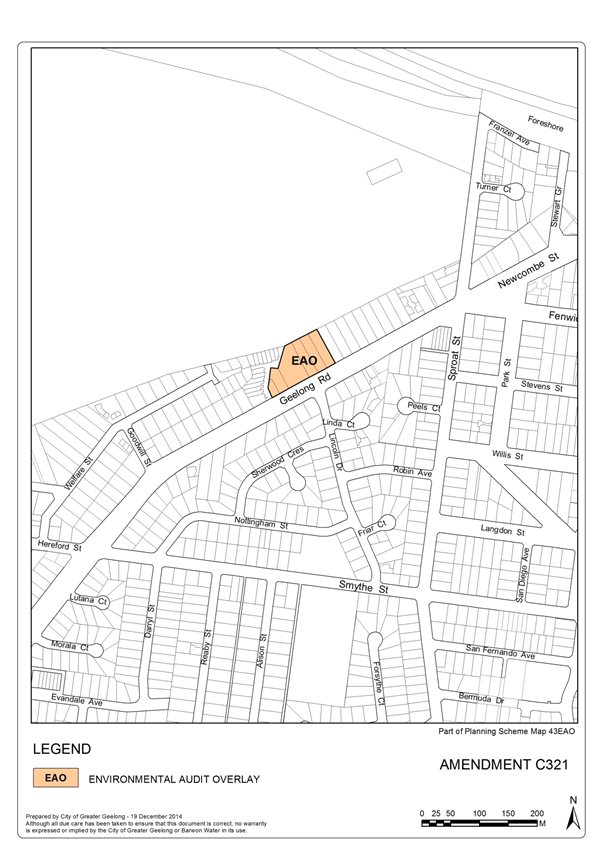
Apply the Environmental Audit Overlay to the land being rezoned; and
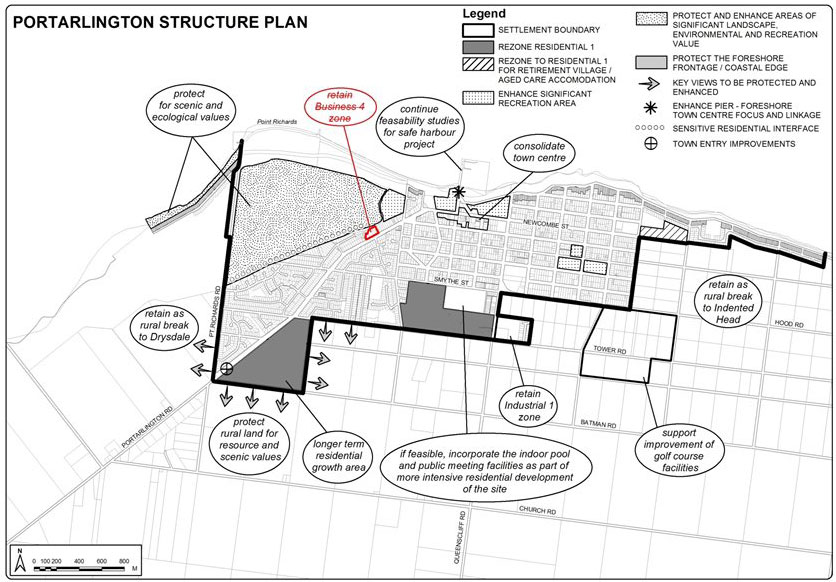
Replace the Portarlington Structure Plan map at Clause 21.14-5 with a new map that removes the notation ‘retain Business 4 Zone’.
Consider the application for a planning permit for a multi storey accommodation complex on the land at 30-32 Geelong Road, Portarlington, concurrently with the preparation of the Amendment in accordance with the Planning and Environment Act, and that draft Planning Permit 1234/2014 be prepared and exhibited with the Amendment, subject to resolution of the detail of the permit conditions; and
Request the Minister for Planning to authorise the preparation and exhibition of Amendment C321 and Planning Permit 1234/2014.
Send the authorisation request immediately following this resolution, and subject to receiving authorisation, exhibit the Amendment and Permit thereafter, including over the summer holiday season.
Carried.
On 25 September 2014 a request from St Quentin Consulting for a combined Planning Scheme Amendment and Permit Application under Section 96A of the Planning and Environment Act 1987 was received by Council. The request was made on behalf of the proponent, Grabble Pty Ltd, owner of the land at 30, 32 and 34 Geelong Road, Portarlington.
The application seeks to rezone the land at 30, 32, 34, 36-38, 40 and 42 Geelong Road, Portarlington, from the Commercial 2 Zone to the Mixed Use Zone. The Amendment also proposes to apply the Environmental Audit Overlay to all the land being rezoned.
The Portarlington Structure Plan map at Clause 21.14-5 of the Greater Geelong Planning Scheme will be changed as part of Amendment C321 to reflect the removal of this commercial zone. The proposed new map is shown at Appendix 1 with the notation: “retain Business 4 Zone” redlined.
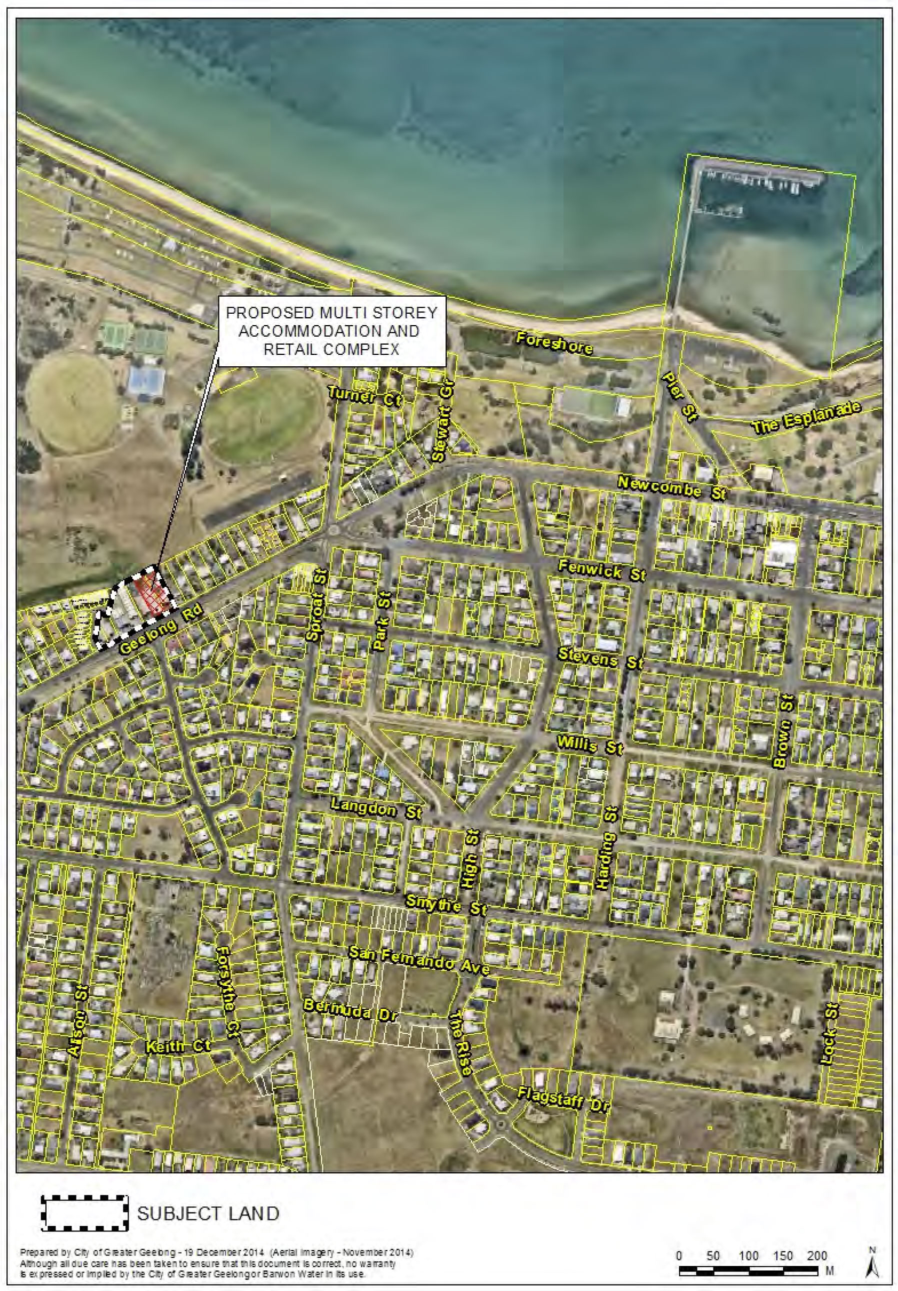
This commercial precinct is developed with buildings used for seafood retail, recycled clothing and furniture, automotive and marine repairs, blinds sales, as well as some vacancies. The precinct is surrounded by residential land other than to the north where the Portarlington Recreation Reserve is located. The precinct gains access from Geelong Road, the primary road into Portarlington.
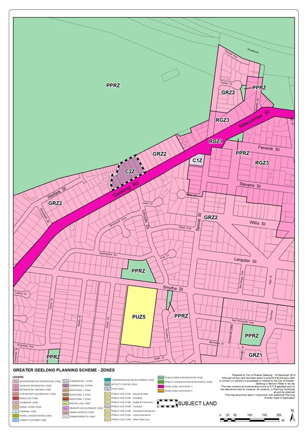
An aerial map of the area is shown at Appendix 2 and a current zoning map is shown at Appendix 3. The proposed rezoning and overlay maps are shown at Appendix 4 and 5 respectively.
Concurrent with the Amendment the request seeks a planning permit (1234/2014) to construct a multi storey accommodation and retail complex on 30 and 32 Geelong Road. More specifically, the proponent seeks approval for:
Development and use of land for Accommodation and Retail premises, subdivision, reduction of car parking requirements, display of advertising signs, waiver requirement for loading and unloading of vehicles, waiver requirement for provision of bicycle facilities and creation of access to a road in a Road Zone, Category 1.
The proponent has advised that the 55 apartments will be made available for either short-term accommodation (through a serviced apartment model) or for longer term occupancy by owners.
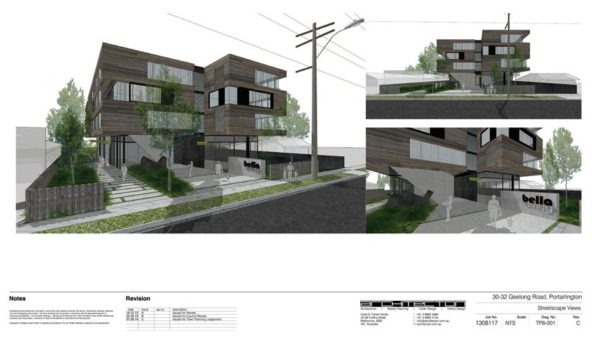
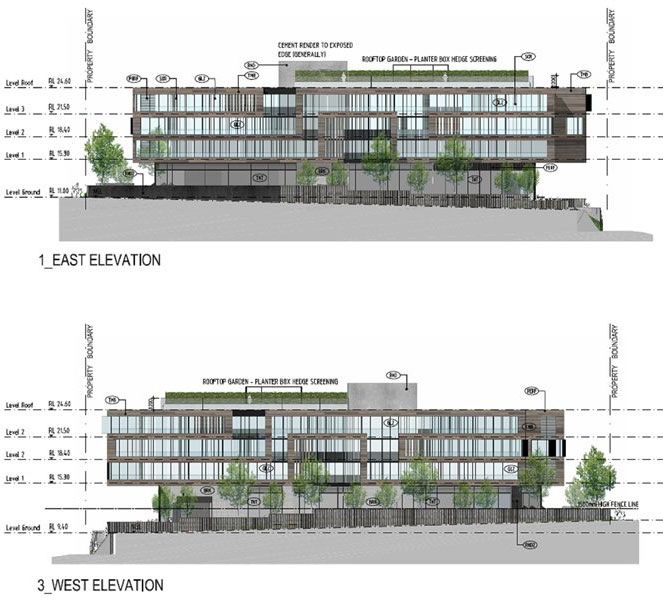
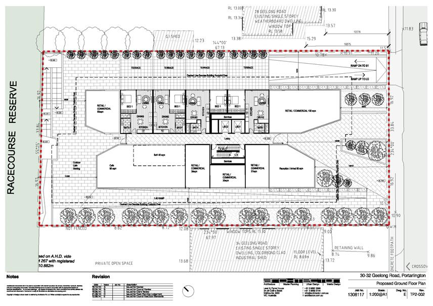
The building is of contemporary design as shown on the plans at Appendix 6 and 7. Access to the complex will be from Geelong Road via a ramp to the basement car park with 57 spaces. The ground floor level includes a lobby, café and retail/office space, as well as 4 apartments. A public walkway along the western edge will activate the shops and provide thru access to the Portarlington Recreation Reserve.
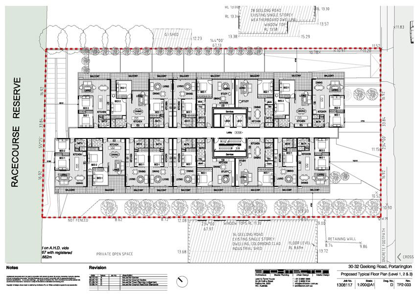
The first, second and third floors will consist of a combination 1 and 2 bedroom apartments and there is a proposed roof top garden. Floor plans are shown at Appendix 8. Materials and finishes will comprise of timber and stone cladding, cement render and performance glazing.
The application lodged in September 2014 followed a number of meetings between Council officers and the proponent’s architect. Officers also advised that the preferred zone would be the Mixed use Zone and that this zone should be applied to all the properties zoned Commercial 2.
The rezoning request and permit application was supported by a planning report (St Quentin) and architectural plans (Architecton Pty Ltd). Following internal review by Council engineers, the proposed basement plan was redesigned in conjunction with the submission of a Traffic Impact Assessment by Civil and Traffic Consulting Pty Ltd.
All landowners and occupiers in the commercial precinct to which this rezoning amendment applies have been informed of the proposal.
Strategic planning merits
The Commercial 2 Zone precinct on Geelong Road is identified in both the Portarlington Structure Plan 2007 and the Greater Geelong Planning Scheme as ‘retain Business 4 Zone’. The Structure Plan says this precinct should be retained to cater for smaller scale local service businesses related to fishing/aquaculture, local produce, tourism and wineries.
More generally, Council’s strategies seek to support a mix of retail, commercial and community uses in the Portarlington Town Centre and to encourage development which respects the coastal landscape setting. For the Bellarine as a whole, policy seeks to protect rural and coastal environments from inappropriate urban encroachment and direct development to locations within existing township boundaries.
Since the preparation and adoption of the 2007 Portarlington Structure Plan, changes to State Planning Policy have resulted in the Business 4 Zone being replaced by the Commercial 2 Zone. The Commercial 2 Zone now allows a greater range of uses including shops and small scale supermarkets, but still prohibits accommodation (other than a motel and residential hotel).
Council has been presented with an innovative and attractive proposal for a multi storey accommodation and retail complex at 30-32 Geelong Road.
In order to support the proposal it is considered appropriate to transition the whole commercial precinct to the Mixed Use Zone. This zone will allow for existing uses to continue and provide for new uses such as the one proposed.
The precinct is ideally located to take advantage of views to the bay; access to the municipal reserve, foreshore and caravan parks; proximity to the Town Centre; and prominent position on Geelong Road. The proposed Mixed Use Zone and development supports the local tourism and business community by providing quality short term accommodation and retail/office opportunities which the northern Bellarine lacks.
The proposal therefore directly supports the diversification of the regions economy and builds on the competitive strength of the Bellarine as a tourist destination. This is a key objective of the G21 Regional Growth Plan.
The loss of Commercial 2 zoned land in Portarlington is offset by opportunities for businesses to establish in the Industrial 1 Zone on Tower Road or the newly expanded Commercial 2 precinct on Murradoc Road in Drysdale. The use of the Mixed Use Zone (and not the Commercial 1 Zone) will also ensure that the Portarlington Town Centre retains its role and function as the primary retail centre in the town.
Critically, the rezoning and development are located within the existing urban settlement boundary of Portarlington meaning no encroachment into the rural and coastal environment. Further still, the investment will assist in the renewal and uplift of this precinct and provide valuable short and long term job opportunities.
The Portarlington Structure Plan makes reference to supporting the local seafood industry. Seafood processing is prohibited in the proposed Mixed Use Zone however there is no seafood processing currently in operation in the precinct. Seafood processing is allowed in the surrounding Farming Zone, where businesses such as Sea Bounty P/L, Advance Mussel Supply and Jade Tiger Abalone P/L are established.
Built form and design
As noted above, there were several discussions between the proponent’s architect and Council officers prior to the lodging of the application in September 2014. The design of the basement car park has been further revised post-lodgement.
The proposed building is a departure from the traditional housing and commercial stock located along Geelong Road and the town more generally. However it is considered to be of high quality and visually appealing. Council’s Urban Design Unit consider the architectural massing offers articulation and interest with a mix of timber, glass, masonry and textured concrete finishes.
There are no planning overlays on the development site though the surrounding residentially zoned land is covered by the Design and Development Overlay Schedule 14. The objective of this control is to ensure that the siting, height and visual bulk of dwellings achieve a reasonable sharing of views.
The properties most affected by views would be 27, 29 and 31 Geelong Road. However all these dwellings are single storey and, while at an elevated level to the subject site, do not command views out to the bay. It is important to note that large commercial buildings such as warehouses can be constructed in the Commercial 2 Zone with little regard to impact on views.
The application includes an assessment against the requirements of Clause 55 of the Greater Geelong Planning Scheme (ResCode) and is found to be compliant. The neighbouring residential property at 28 Geelong Road will not be adversely impacted by overshadowing or overlooking.
The proposed design incorporates the following features which are supported:
Four storeys plus a rooftop garden.
55 one and two bedroom dwellings made available for either short-term accommodation (through a serviced apartment model) or for longer term occupancy by owners.
A basement car park with 57 spaces, areas for storage and waste, and access via a ramp to Geelong Portarlington Road.
A recessed and activated ground floor level containing a lobby, café and specialty shops/office opportunities.
A dedicated north-south path along the western edge of the building to provide convenient public pedestrian access from Geelong Road, through the site, to the Portarlington Recreation Reserve.
Contemporary external materials such as timber and stone cladding, cement render and performance glazing.
The Traffic Impact Assessment finds that traffic generation from the new development will have minimal impact on the performance and safety of the road network. VicRoads, as the Responsible Authority for Geelong Road, does not object to the rezoning or application subject to permit conditions.
The accommodation and retail complex will require a waiver of 37 car parking spaces. The planned 57 basement spaces will satisfy residential demand and it is considered the retail and café component can be provided by the available nearby on-street parking opportunities. The assessment also recommends that bicycle storage facilities be provided within the development for residents and shop employees and customers.
The draft Planning Permit to be prepared for exhibition will include conditions relating to built form, drainage, lighting, vehicle access and car parking, loading, signage, bicycle facilities and public access.
Potentially contaminated land
In preparing an amendment the Planning Authority is required, pursuant to Ministerial Direction No. 1, to satisfy itself that the environmental conditions are or will be suitable for allowable uses. In this case, the proposed new Mixed Use Zone allows ‘sensitive uses’ such as residential accommodation and child care uses.
Review of the zoning history of the precinct shows that it was first zoned Service Business, before changing to the Business 4 Zone and now the Commercial 2 Zone. These zones provide for appropriate manufacturing and industries. Past and present uses include panel beating, metal works, fencing supplies, auto marine services, printing, mussel washing and a plant nursery.
The adjoining land at 44-46 Geelong Road, which was rezoned from the Business 4 Zone to the Residential 1 Zone in 2002, also applied an Environmental Audit Overlay. The land was previously used as a hardware store. A Statement of Environmental Audit was prepared prior to development of the site for dwellings.
It is considered appropriate to apply the EAO to all the properties being rezoned.
The land proposed to be redeveloped at 30-32 Geelong Road contains existing buildings and paved areas and has no environmental values.
However the municipal and conservation reserves located to the north of the development site are environmentally diverse and contain native aquatic vegetation and a large frog population. Conditions have been drafted for inclusion on the permit to ensure appropriate capture and treatment of stormwater runoff from the site.
No impact to budget.
Zone provisions
The Mixed Use Zone is considered to be the most appropriate Victorian Planning Provision zone for the site and proposed development. The existing Commercial 2 Zone prohibits the use of the land for Accommodation as sought in this proposal.
The purpose of the Mixed Use Zone includes:
To provide for a range of residential, commercial, industrial and other uses which complement the mixed-use function of the locality.
To provide for housing at higher densities.
To encourage development that responds to the existing or preferred neighbourhood character of the area.
The Mixed Use Zone supports the proposed development and other businesses located in the precinct. The zone specifically provides for higher density housing. While the proposed 4 level multi purpose building is a departure from the traditional one and two storey dwellings typical along Geelong Road, the built form represents a dynamic and appealing new feature in a precinct that is commercial in nature.
The Mixed Use Zone is also preferred as it will not undermine the primary retail hierarchy role of the Portarlington Town Centre. Any proposed new shop greater than 150 square metres will trigger the need for a ‘use’ planning permit.
State Planning Policy Framework
At a state level, the key relevant policies are Clauses 11.07 and 17.03. Clause 11.07 contains policies about economic growth in the Geelong region and recognises that the region must build on its competitive strengths including tourism. Strategies support infill housing and employment diversity. Clause 17.03-1 encourages the development of a range of well designed and sited tourist facilities.
The proposal will support these policies. The accommodation and retail complex will deliver a significant economic boost to Portarlington during the construction period and then directly support the local tourism industry, as well as offering opportunities for small businesses to establish and greater housing diversity.
Local Planning Policy Framework
Council’s Municipal Strategic Statement contains policy directions in relation to economic development and employment (Clause 21.07).
Clause 21.07 notes that tourism is a key part of the Geelong region’s economy and identifies it as a strategic economic growth sector. Clause 21.07-6 specifically directs that major accommodation facilities establish in urban areas.
Clause 21.14 relates to the Bellarine Peninsula, noting that the area is highly valued for its tourism function and lifestyle appeal.
Objectives include to; provide for sustainable commercial, retail and tourist development in designated locations to service the wider Bellarine community; and to preserve the individual character, identity and role of the townships.
The proposal is considered to be consistent with theses policies and will provide for a diversity of business, employment and housing opportunities.
Portarlington Structure Plan 2007
The Portarlington Structure Plan was prepared in 2006 and adopted by Council in 2007. The Plan is a reference document under Clause 21.14 of the Greater Geelong Planning Scheme. The Structure Plan states that the existing Business 4 zoned land on Geelong Road should be retained to cater for local service uses related to fishing/ aquaculture, local produce and wineries.
A discussion about tourism and holiday accommodation is at Section 5.3, and at Section 5.5, the land at 42 Geelong Road is recognised as the location of a mussel processing business. The processor is no longer operational and has been replaced by a seafood retail business. Rezoning the precinct supports the existing businesses and improves tourist accommodation options consistent with Portarlington’s policy framework.
The Amendment supports the ‘Growing our Economy’ strategic direction of City Plan by providing additional local jobs, tourist accommodation, alternative forms of housing and small business opportunities on the northern Bellarine.
No Council officer involved in the report has any direct or indirect interest, in accordance with Section 80(c) of the Local Government Act.
There are no notable risks associated with implementing the recommendation contained in this report.
The proposed rezoning and development is located in an established commercial area within a wider residential and municipal reserve context. The use of the proposed building for accommodation and retail purposes is compatible with surrounding uses and will generate employment opportunities. The development will also provide for thru public access from Geelong Road to the recreation reserve.
The Amendment will not impact on any basic rights, freedoms and responsibilities as set out in the Charter. Planning legislation ensures an open community consultation process occurs, enabling people to freely express their views and if necessary obtain a fair hearing before an Independent Panel.
The Amendment will be exhibited in accordance with the notice provisions of the Planning and Environment Act 1987
Portfolio: |
Governance – Cr Lyons (Mayor) |
Source: |
Strategy & Performance - Strategy & Program Delivery |
General Manager: |
Dean Frost |
Index Reference: |
Council |
Council at its meeting on 23 June 2015 adopted the 2015-2016 Update of City Plan 2013-2017, which outlines the Strategic Directions and Priorities planned by the Council over the four-year period, and the Annual Business Plan Actions planned for the coming 12 months.
This report is the progress report to Council of the organisation’s achievements against these actions.
Attachment A details the status and provides commentary against the Annual Business Plan actions. The key to the status of actions is:
On Schedule: |
Green |
212 |
Completed: |
Black |
3 |
Major Issue: |
Red |
4 |
Minor Issue: |
Yellow |
10 |
Not Started: |
White |
4 |
Total Actions |
|
233 |
Cr Farrell moved, Cr Harwood seconded -
That Council receives and notes the City Plan Progress Report to 30 September, 2015.
Carried.
Council at its meeting on 23 June 2015 adopted the 2015-2016 Update of City Plan 2013-2017 which outlines the Strategic Directions and Priorities planned by the Council over the four-year period, and the Annual Business Plan Actions planned for the coming 12 months.
Community Wellbeing
Healthy Together Geelong: to enhance health, wellbeing and quality of life of Greater Geelong Communities.
Growing Our Economy
Securing Geelong’s economic future.
A Sustainable Built and Natural Environment
Partnering with our community to protect and enhance our natural ecosystems and to encourage sustainable design and reduced resource consumption.
How We Do Business
We will focus on developing and maintaining effective working relationships to deliver Council’s strategic directions and cost effective services that meet the changing needs of the community.
This report and attachment indicates the status of the actions in City Plan 2013-2017 for the 2015-2016 financial year as at 30 September, 2015.
The attachment provides status and comments for each of the 233 actions within the four strategic directions.
There has been significant progress in the September quarter towards achieving the actions in 2015-2016 including:
Community Wellbeing
Status Summary:
On Schedule: |
106 |
Completed: |
0 |
Major Issue: |
3 |
Minor Issue: |
4 |
Not Started: |
2 |
|
|
During this quarter a number of recreation and community projects were commenced or completed:
Plans for regional cycling pavilion at the Geelong Criterium Circuit are taking shape with flood studies completed and design to commence shortly. Construction on the pavilion is due to start towards the end of the year.
Design for the Anderson Road Sports Precinct, Drysdale is complete. Earthworks will be delivered in a staged approach allowing Council to facilitate early delivery of the first sporting fields and supporting infrastructure at this regional sporting precinct.
New coaches boxes and fences were installed at the Drysdale Recreation Reserve, refurbishment of social rooms at Newcomb Football and Netball Club and Thomson Sports Club were completed.
The new Drysdale Youth Centre was officially opened in August, with the centre ready to operate classes from 13 October. The centre will house classes which will include computer, cooking and art courses in addition to being a place where young people can relax and feel comfortable.
City of Greater Geelong along with 10 local veterinarians, Geelong Animal Welfare Society, Royal Canin and Bayer offered discounts on cat-desexing and other services during the month of July. Council’s Domestic Animal Management Plan requires all cats to be de-sexed at the time of registration and all existing registered cats must be de-sexed by the end of 2017.
Healthy Together Geelong and Engineering Services (Traffic Unit) are working closely with school staff, students, parents and other community organisations to establish active travel routes for children to safely walk or ride to school.
Thirteen active travel routes have been established, of these, three have been launched, with another five to be launched by the end of October and the remaining five to be completed by the end of the year.
An active travel route is a designated route with nominated safe pick up and drop off points, where families can park their cars and let their children safely walk or ride to school.
Council endorsed over $10.5 million in funding to help deliver a range of sporting projects throughout Greater Geelong. A combination of Council and State Government funding will go towards the development of the following seven sporting projects:
Drysdale Sports Precinct (Stage 1)
Leopold Memorial Recreation Reserve – pavilion upgrade
Geelong Soccer Club – pavilion upgrade
Barwon Heads Football Netball Club – facility upgrade
South Barwon Football Netball Club – oval and Lighting upgrade
Barwon Heads Village Park (Cricket) – improved spectator viewing area
Shell Road Reserve – improvements.
These projects will provide a boost to many local sporting clubs and community members who enjoy playing and watching local sport.
Council agreed to proceed with Expression of Interest (EOI) applications for funding for a number of early childhood infrastructure projects identified in the Municipal Children’s Services Infrastructure Plan for Geelong. Major infrastructure projects identified include; Hendy Street Children and Family Centre, Drysdale Family Services Hub, Central Lara Family Hub, Purnell Road Family Services Hub and Jetty Road Early Years. The EOI process seeks information and data to assess the rationale and value of each project as well as scope, cost and timing.
The City’s Learn to Swim programs are again achieving outstanding results. In term three of 2015 the programs attracted 5,586 enrolments across the four indoor leisure centres (Leisurelink, Waterworld, Splashdown and Bellarine Aquatic and Sports Centre).
The introduction of the new Learn to Swim product - Webstars Swim School also occurred across the centres during the term. This gives parents the option to enrol their children in the program all year rather than term based swimming lessons. During the first term of the program approximately 3,670 participants have signed up to the new program.
Growing Our Economy
Status Summary:
On Schedule: |
46 |
Completed: |
0 |
Major Issue: |
0 |
Minor Issue: |
4 |
Not Started: |
0 |
|
|
A number of events were held or announced during this quarter including:
Enterprise Geelong has successfully facilitated its fifth Small Business Festival for the business community. The festival has continued to grow with 2,640 participants attending the events throughout the entire month of August. The Small Business Festival hosted 45 seminars, events and networking opportunities. Most events were free or at low cost and held after normal business hours to make it easier for business owners to attend.
It was announced during this quarter that ‘The Cadel Evans Great Ocean Road Race’ will continue in the Geelong region for the next two years. The event is now one of the City’s premier events along with the Australian International Airshow and Festival of Sails.
The first ever GovHack event held at Deakin University Waterfront campus in July was deemed a very successful event with 60 participants, and seven apps/websites receiving awards.
GovHack is an event where data provided by government and other agencies are turned into useful apps that people can use in their everyday life.
It was also announced that Geelong will host the 2017 Viper World Championships. This will be the first time the championship will be staged in Australia. The prestigious yacht race will set sail on the water of Corio Bay from 7–15 January 2017 and will bring with it a significant number of visitors to the region.
City in a Park is a vision set to become a new reality for Geelong residents. A series of projects will be rolled out around the city dramatically improving the liveability and usability of the Geelong CBD. The key projects for City in a Park are the introduction of a roundabout at the intersection of Mercer and Brougham Streets, expansion of Johnstone Park, Gheringhap Street realignment and Triangle Park, Little Malop street car park redevelopment and Market Square bus interchange.
Council endorsed three sites for the 2015-2016 stage of its five year Town Centre Tree Lighting project. These being Ryrie Street, Geelong (between Yarra and Gheringhap Street), Murradoc Road, St Leonards and Hitchcock Avenue, Barwon Heads. The selection of these sites followed a successful first year of the lighting program. Ryrie Street site contains a substantial centre planting of 160 Port Jackson Figs planted in 2002 which will provide a perfect canvas for the installation of bud lights; St Leonards is a smaller site in the program however it will deliver a significant impact on the local community. A solar solution will enable 16 trees to be lit. The installation of bud lighting in Barwon Heads is intended to support earlier work carried out by the Barwon Heads trader group, bud lights will be installed to 40 trees.
Draft plans for Little Malop Street pedestrian and cycling bridge were endorsed by the Central Geelong Task Force during the quarter; feedback was sought and the concepts were refined accordingly. A new dedicated bike path and separate pedestrian path will link Central Geelong and Geelong West between Latrobe Terrace and Fenwick Street. In addition, significant tree planting and delivery of new pocket parks on either side of the rail line will transform the space into a high amenity gathering space for students and workers in the area, as well as improving the level of shade along this important pedestrian route
M~M2014 (Mountain to Mouth) and Geelong After Dark were awarded a prestigious Community Development National Award at the Australian Regional Development Conference (ARCD) Innovation Awards. Council’s Arts and Culture department in conjunction with its event partners received the Innovation Award for work on M~M2014; Geelong’s Extreme Arts Walk and pop up night arts event Geelong After Dark.
New roads were opened and more than 60 hectares of council land has now been sold, under contract or negotiation for the Geelong Ring Road Employment Precinct (GREP). GREP is a vital piece of the puzzle to Geelong’s economic growth and development as a smart, 21st century city.
The City of Greater Geelong has invested heavily in providing infrastructure and services for the 500 hectare site of prime industrial Corio land.
Sustainable Built and Natural Environment
Status Summary:
On Schedule: |
28 |
Completed: |
1 |
Major Issue: |
1 |
Minor Issue: |
2 |
Not Started: |
1 |
|
|
The City of Greater Geelong has made a submission to the State Government’s inquiry into unconventional gas in Victoria. The submission was based on feedback received from Council’s 2014 public submission into Coal Seam Gas Extraction. Council received a total of 449 submissions, with 447 expressing opposition to onshore gas extraction and hydraulic fracking. The main issues outlined in Council’s submission were the effects of fracking on land, air and water quality as well as highlighting concerns around the health of residents, noise pollution and a potential decrease in property values.
City of Greater Geelong hosted a tree planting day in July as part of the Greenway project, where over 3,600 trees were planted. The Greenway will encompass the ‘Ted Wilson Trail’ a shared walking and cycling path alongside the Geelong Ring Road. The Greenway has the potential for planting of 80,000 indigenous trees.
Over the past 10 months almost 23,000 tonnes of material was collected through the kerbside recycling system. Paper and cardboard products account for 61 per cent of the material collected with glass containers at 20 per cent being the next major contributor. In July alone, recycling efforts throughout the municipality have;
saved almost 6,000 cubic metre of landfill space
saved enough energy to power just under 2,000 households for a year
saved 5,500 barrels of oil
saved 36,000 kl’s of water, equivalent to 14 Olympic swimming pools.
Council kicked off a new recycling and disposal awareness campaign called “Where Does It Go?” identifying items that cannot be recycled through kerbside recycling bins. The campaign will include a series of press and radio advertisements focussing on the correct recycling channels for clothing, footwear, plastic bags and polystyrene items. Currently many of these items are being placed in the household recycling bin.
The Future Proofing Geelong Impact Statement 2011-2014 and the Low Carbon Growth Plan for Geelong 2015 Update identifies actions to achieve a potential carbon emissions reduction of 22 per cent by 2020 and notes that further reduction of nearly 25 per cent are achievable, through energy efficiency measures. Council through the Future Proofing Geelong program supports and encourages new and emerging low carbon industries and sectors to Geelong. The Impact Statement demonstrates that by engaging with commercial building owners and tenants, emissions have reduced by 6,500 tonnes every year leading to $1.62 million in cost savings.
Council’s Mosquito Management program commenced this quarter. Two aerial treatments and ground applications targeting early mosquito larvae infestation areas have been completed. The products used only target specific aspects of mosquito biology and are safe for humans, other animals and the general environment. The program will continue throughout the warmer summer months and could extend past the usual program end date of March.
The second edition of The Sustainability Directory was launched this quarter. The directory has doubled in size with over 500 eco-businesses, community organisations and environmental service providers listed.
This edition highlights the breadth of environmentally aware businesses and organisations in the Geelong region. In this version, the geographic range was expanded to include surrounding shires and includes more categories to better align the directory with the 10 ‘One plant living principles’ adopted by Geelong Sustainability in 2014.
How We Do Business
Status Summary:
On Schedule: |
32 |
Completed: |
2 |
Major Issue: |
0 |
Minor Issue: |
0 |
Not Started: |
1 |
|
|
2014-2015 was the first year for mandatory reporting of the Local Government Performance Reporting Indicators (LGPRI). The reporting system was developed by Local Government Victoria to ensure that all Victorian Councils are measuring and reporting in a consistent way. Results for all indicators for year end were submitted to Local Government Victoria with the results being published on the “Know Your Council” website in November.
The City of Greater Geelong is currently replacing the existing phone system which has been in place for 16 years. The new system Microsoft Skype for Business will bring a host of productivity tools including the ability to integrate with Council ipads and iphones enabling staff to have access to Council information systems from any location. The rollout of this system will commence in October 2015 and be completed by March 2016.
The City of Greater Geelong adopted a trial of a new alternative meeting schedule for Council meetings. The new format is as follows: -
Week one: Council briefing
Week two: Strategic workshop/external presentations
Week three: Council meeting
Week four: Strategic workshop/external presentations.
Social media continues to be a key communication channel for Council to inform and engage with the community. The City of Greater Geelong and Geelong Mayor's Facebook and Twitter accounts are monitored seven days a week. Between the two pages, Facebook currently has 56,402 likes and Twitter 104,266 followers.
A number of corporate training programs have been undertaken by Council staff during this quarter including Engage in Council, Stepping up to Leadership, Manage Conflict through Negotiation, Dataworks (document management system), OHS Training, MS Word and Corporate Induction.
Entries for the City of Greater Geelong 2016 Calendar photo competition closed on 24 September, 2015. 13 photos will be selected and published in the 2016 calendar.
There are several actions under the Sustainable Built and Natural Environment Strategic Direction within City Plan that aim to enhance and protect natural areas and ecosystem health, support our community to live sustainably, advocate for and promote sustainable design and development, and minimise our environmental footprint.
Council’s Annual Budget provides the Resource Plan to support the initiatives identified within the adopted Annual Business Plan.
Council’s external auditors will undertake a Performance Audit of the planned Key Strategic Activities and prepare a report as part of the ‘sign off’ of the Annual Accounts.
This report is the quarterly progress report of the organisation’s achievements against the adopted City Plan 2013-2017, 2015-2016 actions.
There is no conflict of interest to be disclosed
The risks arising from the actions are managed within the framework of the Council’s adopted Policies, Procedures and Risk Management strategies
Several of the actions identified within City Plan are aimed at improving the quality of life for the residents in the City of Greater Geelong. This is particularly the case for actions within the Community Wellbeing Strategic Direction.
This report provides an update on the implementation of City Plan 2013-2017 and will be made available on Council’s website and on request at Council’s Customer Service Centres as part of the Council meeting minutes. There are no known positive or negative effects.
A comprehensive report on the 2015-2016 City Plan actions will be published in the City of Greater Geelong Annual Report by 30 September, 2016, which will be submitted to the Minister for Local Government and available to the public in hard copy and on the Council’s website.
Portfolio: |
Finance – Cr Lyons (Mayor), Cr E Kontelj, Cr Farrell |
Source: |
Strategy & Performance - Financial Services |
General Manager: |
Dean Frost |
Index Reference: |
Financial Management \ Financial Reporting 2015-2016 |
The Quarterly Financial Report for the period ending 30 September 2015 is prepared as a requirement of Section 138 of the Local Government Act 1989.
Council approved amendments to the adopted Budget on 25 August 2015 and variances are reported based on comparing actuals to amended budget.
The recurrent operating surplus for the three-month period is $4.4M, being $8.1M favourable to amended budget and reflects favourable performance and timing issues.
The non-recurrent surplus for the three month period is $8.7M, being ($0.5M) unfavourable to budget with unfavourable Capital Income ($0.7M), Recognition of Infrastructure ($0.4M) and Prior Year Adjustments ($0.4M), offset by favourable Loss on Disposal of Infrastructure $0.8M.
Capital expenditure for the year to date is $15.6M against a year to date projection of $18.8M, which is $3.2M underspent to projection.
The cash and investment balance of $76.9M is $10.0M favourable to budget.
Cr E Kontelj moved, Cr Farrell seconded -
That the Quarterly Financial Management Report to 30 September 2015 be endorsed by Council.
Carried.
The report is prepared as a requirement of Section 138 of the Local Government Act 1989 which requires that at least every three months a statement be presented to Council comparing the budget with the actual revenue and expense for the financial year-to-date.
Operating
The September Management reports are provided in the following table to report year-to-date performance and full-year projection performance versus budget.
Summary |
||||||
|
YTD Actual |
YTD Am. Bgt |
YTD Var |
FY Proj |
FY Am. Bgt |
FY Var |
Recurrent Surplus/(Deficit) |
4.39 |
(3.73) |
8.12 |
(17.79) |
(17.01) |
(0.78) |
Non-Recurrent Surplus/(Deficit) |
8.74 |
9.28 |
(0.54) |
68.67 |
65.77 |
2.90 |
Net Surplus/(Deficit) |
13.13 |
5.55 |
7.58 |
50.88 |
48.76 |
2.12 |
Capital Expenditure |
15.60 |
18.80 |
3.20 |
121.53 |
120.02 |
(1.51) |
Closing Net Cash Positive/(Neg) |
76.86 |
66.88 |
9.98 |
|
64.76 |
|
The Adopted Budget was amended by Council on 25 August 2015 to include Carryover Capital and discretionary projects, plus other Capital and recurrent amendments.
The impact on the Recurrent Expenditure Budget is ($17.76M), consisting of carryover discretionary projects funded in 2014-2015, plus other budget amendments including adjustment for early receipt of first two quarters Grants Commission funding in June 2015.
The impact on Non Recurrent income was $10.34M for carryover of capital income from 2014-2015 projects, plus other budget amendments.
The amended capital expenditure budget included an additional $52.27M to complete 2014-2015 Projects, including Corio Landfill Rehabilitation, Geelong Library & Heritage Centre, Drysdale Landfill Cell 6, Central Geelong Advancement Fund, Drainage Construction Program, Central Road Drainage, Street Construction SRC and Austin Park Redevelopment.
Other budget amendments increased total budget by $0.87M.
1. Recurrent Variance Commentary |
||||||
|
YTD Actual |
YTD Am. Bgt |
YTD Var |
FY Proj |
FY Am. Bgt |
FY Var |
Recurrent Income |
76.90 |
76.10 |
0.80 |
298.62 |
298.45 |
0.17 |
Recurrent Expenditure |
72.51 |
79.83 |
7.32 |
316.41 |
315.46 |
(0.95) |
Recurrent Surplus/(Deficit) |
4.39 |
(3.73) |
8.12 |
(17.79) |
(17.01) |
(0.78) |
YTD Variance - $8.12M Favourable |
||||||
The following major variances to budget contributed to this result:
|
$M |
General Rates and Charges – Favourable rates generation and supplementary rates YTD, expected to be partly offset by objections in full year. |
0.91 |
Government Grants Main favourable variances consist of:
|
0.16 |
User Charges Main unfavourable variances consist of:
|
(1.08) |
Other Fees & Charges Favourable mainly due to :
|
0.30 |
Sundry Income
|
0.34 |
Interest on Investments Higher than budgeted cash balances. |
0.17 |
Recurrent Income Sub-total |
$0.80M |
|
$M |
Employee Related Expenditure – Favourable salary costs $1,419K and Workcover $84K mainly relating to unfilled vacancies and rate variance. Partially offset by unfavourable supplementary labour costs ($339K) (see external services). |
1.50 |
General Works: Materials $442K favourable with the main variances being Road Making Materials $202K (phasing only) and Ground Maintenance Materials $118K (ground renovations yet to commence). Plant / Equip / Vehicle Costs $546K favourable with the main variances being Fuels, Oils & Greases $99K (lower than budget fuel price), External Plant & Equipment Hire $200K (phasing only), Repairs & Maintenance $152K (phasing only). External Services is $2,936K favourable mainly due to:
Offset by:
|
3.93 |
Administration costs $543K favourable mainly due to :
|
0.54 |
|
Professional Services costs $670K favourable mainly due to:
|
0.67 |
Utility costs are $453K favourable mainly due to Water usage costs $65K (seasonal factors) and Electricity $323K (phasing and timing of invoices). |
0.45 |
Depreciation costs $141K favourable (phasing only). |
0.14 |
Gain/(Loss) on Sale of Plant and Equipment $87K favourable. |
0.09 |
Recurrent Expenditure Sub-total |
$7.32M |
Full Year Recurrent Projection – ($0.78M) unfavourable to Amended Budget |
|
|
The main projection changes are favourable / (unfavourable): |
$M |
Transfers to Capital Rates – Supplementary Waste – Cleanaway Contract 2014-2015 adjusted |
0.05 0.10 0.34 |
Transfers from Capital Iconic Xmas Tree – additional cost (no offset) |
(0.01) (0.09) |
Diversion of Waste to Wyndham – additional cost |
(1.19) |
Other |
0.02 |
|
($0.78) |
There is likely to be other offsetting favourable variances which will be indentified in the December quarterly report.
2. Non Recurrent Variance Commentary |
||||||
|
YTD Actual |
YTD Am. Bgt |
YTD Var |
FY Proj |
FY Am. Bgt |
FY Var |
Non-Recurrent Surplus/(Deficit) |
8.74 |
9.28 |
(0.54) |
68.67 |
65.77 |
2.90 |
YTD Variance – ($0.54M) unfavourable |
||||||
|
$ |
Capital Grants & Income ($726K) unfavourable. |
(0.72) |
Recognition of Infrastructure ($409K) unfavourable. |
(0.41) |
Developer Contributions $50K favourable. |
0.05 |
Gain/(Loss) on Sale of Property - $131K favourable. |
0.13 |
Loss on Disposal of Infrastructure - $837K favourable. |
0.84 |
3. Capital Expenditure Variance Commentary |
||||||
|
YTD Actual |
YTD Projection |
YTD Var |
FY Proj |
FY Am. Bgt* |
FY Var |
|
Capital Expenditure |
15.60 |
18.80 |
3.20 |
121.53 |
120.02 |
(1.51) |
YTD Variance – $3.20M favourable |
||||||
The capital program is $3.20M underspent compared to Projection year to date, with the major project variances as follows:
|
|
$M |
| • | Austin Park Redevelopment – behind budget schedule. |
0.84 |
| • | Geelong Library & Heritage Centre – behind budget schedule. |
0.43 |
| • | Drysdale Landfill Stormwater PAN Compliance – behind budget schedule. |
0.32 |
| • | Shell Rd Reserve Masterplan – behind budget schedule. |
0.24 |
| • | Light Fleet Replacement – behind budget schedule. |
0.15 |
| • | Building Renewal Works – behind budget schedule. |
0.13 |
| • | Heavy & Dedicated Plant – behind budget schedule |
0.11 |
| • | Corio Landfill Rehabilitation – behind budget schedule. |
0.10 |
| • | Other |
0.88 |
|
|
|
$ 3.20 |
4. Cash and Investments |
||||||
|
YTD Actual |
YTD Am. Bgt* |
YTD Var |
FY Proj |
FY |
FY Var |
Closing Net Cash Positive/(Neg) |
76.86 |
66.88 |
9.98 |
|
64.76 |
|
YTD Variance – $9.98M favourable |
||||||
The month end cash and investments balance was $76.86M. This was $9.98M favourable to budget, mainly due to favourable recurrent surplus and behind schedule spend on Capital.
Council has future commitments for $25.2M, which are fully cashed back:
Long Service Leave |
$19.2M |
Statutory Reserves |
$ 1.9M |
Refundable Deposits |
$ 1.9M |
Income in Advance |
$ 1.2M |
Asset Development |
$ 1.0M |
Total |
$25.2M |
The Landfill Provision balance is currently $16.9M.
There are no environmental implications arising from this report.
As detailed in the attached report.
The report is provided in accordance with requirements under the Local Government Act 1989.
This report contributes to responsible and sustainable financial management as aligned in Council’s City Plan objective on How We Do Business.
Council staff preparing this report have no direct or indirect interest.
There are no risk implications arising from this report.
There are no social implications arising from this report.
There are no known positive or negative effects.
The attached report is provided for information and public record and is available from the Council Governance or Financial Reporting units.
Portfolio: |
Governance - Cr Lyons (Mayor) |
Source: |
Strategy and Performance - Financial Services |
General Manager: |
Dean Frost |
Index Reference: |
Subject/Financial Management - Reporting |
To seek approval to begin an investigation to realign the locality boundary between Ocean Grove and Wallington due to the expansion of the residential property development into the Wallington locality (Refer Appendix A).
Boundaries previously altered in 2008 have not allowed for the current development.
Current subdivisions are creating properties which have been dissected into two separate localities.
Current property owners are unaware that their property may be in the Wallington locality.
It is appropriate to commence a process of investigation and consultation to realign one section of the locality boundary between Ocean Grove and Wallington. The area for consideration is near the Grubb Road and Bellarine Highway intersection. As a minimum solution, the boundary would need to align to the Urban Growth Boundary, however, investigation will consider all options (Refer Appendix A).
Principal 3(A) of the Guidelines for Geographic Names 2010 stipulates that locality boundary should align with the cadastral fabric, road centre lines or easily distinguishable topographical features.
The Ocean Grove locality is experiencing significant growth and it is important that any changes to locality boundary best represent this growth.
Cr Farrell moved, Cr Macdonald seconded -
That Council begin the process of investigation into the boundary of Ocean Grove and Wallington with the view to realign the locality boundary.
Carried.
In 2007-2008 Council realigned the boundaries between Ocean Grove, Marcus Hill and Wallington. This realignment did not anticipate the extensive residential development that is now occurring.
Current subdivisions are creating properties that have become dissected into two separate localities ie: half of the property is in Ocean Grove and the other half is in Wallington (Refer Appendix A).
Real Estate Agents are incorrectly advertising properties in Wallington as Ocean Grove.
There is a need to realign the current boundary to incorporate newly created properties within the Ocean Grove locality.
The change will need to align the township locality with the residential zoning. The Ocean Grove structure plan, which is currently under review, will need to be taken into consideration.
There is a need to realign part of the boundary between Ocean Grove and Wallington to align the boundary with the current residential planning zone.
As a minimum solution, the boundary would need to align to the Urban Growth Boundary, however, investigation will consider all options (Refer Appendix A). The red dotted line on Appendix A represents the current Urban Growth boundary, but also the Settlement Boundary, as identified in the current Ocean Grove Structure Plan.
Retaining the current boundary alignment will cause confusion with emergency services, owners and visitors to the area in the specification of the correct location.
There are no environmental issues arising from this report.
The approximate cost to Council is $300.00. This includes advertising and notification to adjoining property owners.
The Geographic Place Names Act 1998, the Guidelines for Geographic Names 2010 and Council Policy will need to be followed.
This proposal aligns to City Plan with the encouragement of Community Wellbeing.
There is no Council Officer direct or indirect interest involved in this report.
The realignment of these boundaries will allow for easy identification to the public and utility services in case of an emergency.
The realignment of this section of boundary will minimise confusion to residents and visitors to the area.
It is the right of every resident and property owner for their property to have a unique address in order to receive services and reduce confusion or delay of emergency services.
Following Council approval of the commencement of this investigation, a letter will be sent to all affected property owners seeking their suggestions or alternative views. Advertisements will appear in local newspapers and notification will be placed on Council’s website.
Submissions can be received from property owners and any other interested parties within a 30 day statutory period.
Portfolio: |
Major Events - Cr Nelson |
Source: |
Projects, Recreation & Central Geelong - Events, Central Geelong & Waterfront |
Acting General Manager: |
Paul Jane |
Index Reference: |
Events / Geelong Major Events |
The Geelong Major Events terms of reference requires an annual report to be presented to Council at the conclusion of the financial year. This report provides a summary of the activities supported by the Geelong Major Events Committee (GME) for the period 1 July 2014 to 30 June 2015.
Council established the Geelong Major Events committee in August 1998 pursuant to Section 86 of the Local Government Act.
GME strives to stimulate and encourage major events that offer the best opportunity to provide measurable economic benefits, potential to market Geelong outside the municipality and enhance local community life through participation of residents.
Major Events have a diverse and varied environmental legacy and the events staged within this period implemented a range of programs to minimise impacts where required and provide positive outcomes where possible. Council works closely with event organisers to ensure best practices in this regard are achieved at major events staged within our region.
This report provides an overview of GME’s activities for the period 1 July 2014 to 30 June 2015 including:
29 major events successfully hosted in the Geelong region including new events; Australian Under 16 Basketball Championships, Word for Word Literacy Festival, I14 World Sailing Championships, Cadel Evans Great Ocean Road Race and the Globe Theatre’s touring Hamlet production, to name a few.
The 29 major events stimulated economic activity and provided social benefits to our community. Approximately $84million of economic benefit was generated in our region from local as a result of those events being hosted in Geelong. This is the equivalent of supporting 672 full time jobs.
These events also provide social benefits for our community through participation and spectator opportunities, with 15 of the 29 major events offering some level of free public access and entertainment. An estimated 650,000 participants and spectators attended the 29 events staged throughout Geelong during the 12 month period.
Cr Nelson moved, Cr Harwood seconded -
That Council note the report detailing the activities of Geelong Major Events for the 2014/2015 period.
Carried.
Council, in August 1998, established a Section 86 Committee under the provisions of the Local Government Act known as Geelong Major Events as a means of stimulating and encouraging events within the municipality.
In line with the GME Terms of Reference, an annual report will be presented to Council at the conclusion of the financial year and quarterly reports will be provided throughout the year. This report provides a summary of the activities supported by GME for the period 1 July 2014 to 30 June 2015.
GME support the development and improvement of hallmark, major and developing events whilst focusing its activities on a clearly defined strategic program.
GME has established and maintains strong links with the private sector, government and our communities to achieve high levels of stakeholder investment and activity required to realise the events potential of Geelong.
Meetings
GME convened nine ordinary meetings in the period between 1 July 2014 and 30 June 2015. In addition, the Committee held one Strategic Planning Session.
Meetings are currently scheduled for the third Monday of each month commencing at 4.00pm and are generally held at City Hall. The ordinary meetings are open to the public and meeting dates are advertised in the Geelong Advertiser.
Strategic Outcomes
The 2015 Australian International Airshow and Aerospace & Defence Exposition was held at Avalon Airport, Geelong between 25 Feb and 1 Mar 2015. The event includes both a trade show for aerospace related business and a public event Airshow. The event attracted attendances totalling 169,251 visits with over 20% of those being visitors from outside of Victoria. In addition, over 570 exhibitors from all over the world participated at the event. It is estimated that the 2015 Airshow generates a significant $22 million of expenditure for the region, or 258 full-time equivalent employment positions.
The inaugural Cadel Evans Great Ocean Road Race was successfully delivered in January 2015 in front of an estimated enthusiastic crowd of up to 100,000 spectators. The Sunday men’s elite road race was broadcast nationally live on Channel Seven with a highlights show distributed to 106 countries worldwide.
In partnership with the Royal Geelong Yacht Club, Geelong was host to a sailing World Championship event in January 2015. The International Fourteen class is one of the world’s premier sailing classes and the oldest international dinghy class. The event attracted entries from 8 international countries.
The GME Committee commenced a review of the GME strategic plan, terms of reference and funding assessment model to identify any process improvements to ensure current best practices are applied to all decision making. This process is estimated for completion prior to end of 2015 with a final report to be presented to Council for endorsement of the strategic plan for GME for the next 10 year period.
Via Council’s annual budget allocation, there were 29 events supported with major event sponsorship funding during the period 1 July 2014 – 30 June 2015. Each of those events was measured to estimate the economic benefit for the region generated by the event.
The following table details the outcomes for the period:
|
Event Title |
Event Date |
Funding Amount |
Estimated Economic Benefit |
Aust Under 16 Basketball Championships |
July |
$10,000 |
$1,149,488 |
Geelong Extravaganza Food & Wine Festival |
July |
$5,000 |
$203,126 |
Word for Word Literary Festival |
August |
$30,000 |
$187,658 |
The Importance of Being Ernest |
August |
$15,000 |
$164,696 |
Geelong Classic DanceSport Festival |
September |
$5,000 |
$108,650 |
Australian Inline Skating Championships |
September |
$10,000 |
$583,610 |
Toast to the Coast |
November |
$30,000 |
$1,671,272 |
Geelong Revival Motoring Festival |
November |
$130,000 |
$4,242,106 |
New Years Eve Fireworks Festival |
December |
$41,247 |
$700,000 |
Hyundai A-League Soccer |
January |
$25,000 |
$1,213,026 |
Mitchelton Bay Cycling Classic |
January |
$35,000 |
$2,616,776 |
International 14s World Sailing Championship |
January |
$30,000 |
$1,101,439 |
Portarlington Mussel Festival |
January |
$5,000 |
$2,201,758 |
Festival of Sails |
January |
$177,864 |
$14,659,606 |
Cadel Evans Great Ocean Road Race |
January |
$150,000 |
$13,298,728 |
Oates Victorian Open Men & Women Golf |
February |
$70,000 |
$2,246,455 |
Ironman 70.3 Geelong |
February |
$150,000 |
$2,540,938 |
Great Australian Beer Festival |
February |
$20,000 |
$605,591 |
Pako Festa |
February |
$60,000 |
$4,983,820 |
Australian International Airshow |
February |
$386,078 |
$22,000,000 |
Geelong Highland Gathering |
March |
$16,000 |
$269,780 |
Motor City Music Festival |
March |
$45,000 |
$632,444 |
3 x 3 National Basketball Series Qualifier |
March |
$15,000 |
$92,015 |
Head of the Schoolgirls Rowing Regatta |
March |
$20,550 |
$2,650,995 |
Sanitarium Weet-Bix Kids TRYathlon |
March |
$5,000 |
$416,481 |
Victorian Lifesaving Championships |
March |
$10,000 |
$403,327 |
Storm Boy |
May |
$12,000 |
$250,618 |
The Globe Theatre's Hamle (Underwriting) |
May |
Nil claimed |
$198,056 |
National Celtic Festival |
June |
$40,000 |
$2,587,459 |
GME has adopted a methodology for assessing event funding applications and event evaluations. This methodology measures the triple bottom line effect; Economic Impact, Social Impact and Environmental Impact.
Online surveys are used to obtain benchmark data to measure a range of impacts and benefits of major events staged in this region.
Each GME funding application is assessed according to the methodology and a value is attributed to the perceived environmental benefit relative to the environmental negative impacts associated with the event.
Considerations of positive and negative impact include energy usage, use of renewable sources, water usage, waste and or recycling generated, traffic congestion, use of non-powered transport options, pollution, destruction or damage to natural environments, event legacies of new or reinvigorated nature and resources.
The environmental impact for each event is assessed and where appropriate, actions are identified to protect the environment.
Given the nature and variety of events staged within the Geelong region via GME support, some are environmentally friendly while others manage the environmental impacts as well as possible.
Council plays a leading role in working with external agencies and event organisers to ensure that environmental implications are appropriately managed. Where practicable, event organisers are encouraged to implement a variety of environmentally positive programs such as waste-wise and carbon offsets.
The events staged in this period implemented a range of programs to minimise their environmental impacts and to proactively provide positive legacies from their events.
GME paid $1,508,739 of sponsorship, underwriting and seed funding to 29 major events during the financial period, which was within the allocated budget.
The event expenditure estimated to be generated by the 29 events staged during the period July 1 2014 to June 30 2015 is estimated to be $84million. This event expenditure is estimated to support the equivalent of 672* full-time jobs in Greater Geelong and represents a return on investment for our community of 55:1.
*EFT calculation is based on GOT accepted methodology and sourced from the Tourism Research & Impact Assessment for the Geelong Otway Region, Feb 2007.
Council established the GME committee in August 1998 pursuant to Section 86 of the Local Government Act. The Committee operates within a defined Terms of Reference and Instrument of Delegation adopted by Council.
Via its ‘Councillor Portfolios’ & ‘Committee Representation for 2014/15’, Council endorsed Cr Ron Nelson (Chair), Cr Darryn Lyons, Cr Bruce Harwood and Cr Kylie Fisher as the Councillor representatives on the GME Committee for the period 2014/2015. Cr John Irvine was confirmed as the substitute Councillor Member.
In supporting major events, contractual relationships are entered into, generally based on a standard contract prepared by Council’s solicitors.
In the City Plan 2013-2017, Council has identified Growing Our Economy as one of its four key strategic objectives. A key priority of City Plan is to see Greater Geelong as a leading city for tourism, arts, culture and events. The GME Strategy is identified in City Plan as being a key strategy that will assist Council in delivering Growing Our Economy priorities.
In addition, City Plan identifies its key partnerships in this area as including events related groups such as Victorian Major Events Company, Victorian Events Industry Council, along with event owners and operators. These key relationships are maintained and enhanced through the actions of the GME committee.
No officers involved in the preparation of this report have a direct or indirect interest in matters to which this report relates.
The management of risks associated with events is an important aspect to protect the community and Council’s assets. Particular attention is undertaken to identify potential risks with each event and ensure that the appropriate risk management treatments are in place.
Council via its Event Services Unit provides coordination and ongoing support of an Events Multi Agency Working Group (EMAWG) representing key approval bodies and agencies for events in the Geelong region. EMAWG meetings are held on the second Tuesday of each month.
All high risk major events are required to present event plans to the EMAWG. Feedback and advice is given to event organisers from the represented agencies and stakeholders on the working group.
The expertise within Council’s Risk Management unit is also drawn upon to support events as and when required.
GME make a significant contribution to the social, environmental and economic well being of the community. The major events often provide a legacy for future events and community use such as redeveloped or newly constructed infrastructure.
The events staged within this period provided social benefits for the local community through participation and spectator opportunities with 15 of these major events offering free public access and entertainment for all ages.
The 29 major events were attended by a total estimated 650,000 participants and spectators attended during the year.
Some major events include road closures to allow for the safe delivery of an activity on roads or restrict community access to public areas for limited periods of time.
An individual’s right to freely and securely participate in an event without the risk of injury to themselves or spectators is given the highest priority.
Public events provide significant benefits to the community and major events also provide significant economic benefit.
Strategies are in place to reduce the negative impact while enhancing the positive benefits to our community.
It is considered that any short-term negative impacts encountered by the hosting of these major events are justified and that all reasonable strategies have been put in place to mitigate or minimise the negative impacts wherever possible.
All major events include various levels of consultation with a range of relevant parties, as deemed appropriate in each specific circumstance.
Consultation may include key stakeholders, emergency services, businesses and residents in the vicinity of the event site, community groups, trader associations, tourism bodies and a variety of other groups or individuals which may be relevant to the event activity, location or impact.
Portfolio: |
Community Development – Cr Fisher |
Source: |
Community Services - Aged and Disability Services |
Acting General Manager: |
Linda Quinn |
Index Reference: |
Subject: Municipal Public Health Plan |
The purpose of this report is to provide Council with an update on the progress of the Geelong Public Health and Wellbeing Plan 2013-2017 over the past 12 months.
The purpose of the Geelong Public Health & Wellbeing Plan 2013-2017 is to demonstrate how the City of Greater Geelong will work to improve the health and wellbeing of the local community over a four year period.
The plan fulfils the requirements of the Public Health and Wellbeing Act 2008 that all Victorian councils prepare a Municipal Public Health and Wellbeing Plan within 12 months of council elections.
This report is intended to fulfil Section 26 (4) of the Act which states that: ‘A Council must review its municipal public health and wellbeing plan annually and, if appropriate, amend the plan.’
Of the 73 actions listed in the plan:
11 complete
45 on schedule
14 commenced
3 not started
A review of the actions within the Health and Wellbeing Plan will be undertaken as a result of the termination of funding for Healthy Together Geelong.
Cr Farrell moved, Cr E Kontelj seconded -
That Council notes the progress that has occurred in the implementation of the Geelong Public Health and Wellbeing Plan 2013-2017.
Carried.
The Geelong Public Health and Wellbeing Plan builds on the work of previous Council health and wellbeing plans; and fulfils the requirements of the Public Health and Wellbeing Act 2008.
The plan contains six Action Guides. Whilst Action Guide one is dedicated to ‘improving how we do business in health and wellbeing’, the remaining five focus on the following health and wellbeing priority areas:
Accessible and nutritious food;
Physical activity and active communities;
Social inclusion and community connectedness;
Reducing harm from alcohol, drugs and problem gambling;
Reducing tobacco use.
The Geelong Public Health and Wellbeing Plan actions have been uploaded into Department Business Plans via CorVu. This enables Council managers to report on the progress of each action on a quarterly basis in alignment with City Plan reporting.
Of the 73 actions listed within the plan 11 are complete and a further 45 are on schedule and 14 have commenced, (see Attachment 1).
Healthy Together Geelong (HTG) has been responsible for coordination and monitoring of the actions within the Geelong Public Health and Wellbeing Plan (Plan), which was a funded initiative of the State Government until June 2015. Carryover funding from the HTG budget has allowed the continuation of a reduced staff team until March 2016. A Coordinator will continue until June 2016 to wind up and evaluate the initiative.
Council commits minor resources to the development, coordination and delivery of the Plan and there is no central budget allocated to deliver on the Plan. A review of the actions within the Plan will be undertaken and a further report will be presented to Council detailing options for future implementation.
The Geelong Public Health and Wellbeing Plan 2013-2017 has been developed to meet the requirements of the Climate Change Act 2010, which is in accordance with the Public Health and Wellbeing Act 2008.
A key action in Action Guide 1 is to review the organisation’s preparedness for the challenges presented by climate change and urban heat impacts, particularly in relation to vulnerable populations.
In years one and two, coordination of the Geelong Public Health and Wellbeing Plan 2013-2017 was led by the Healthy Together Geelong team within Aged and Disability Services. Funding for this initiative was terminated in June 2015 and without funding assistance, this initiative will conclude in June 2016.
The City of Greater Geelong has deployed the HTG team and associated funding from Healthy Together Geelong for the development, delivery, review and evaluation of the Plan. Other than the HTG team there is only a 0.4 EFT permanent Council dedicated position allocated to the implementation and monitoring of the Health and Wellbeing plan.
A business case will be put forward for the 2016/17 budget for additional resources to support the implementation, delivery and evaluation of the current and future plans.
The annual review of the Geelong Public Health and Wellbeing Plan 2013-2017 fulfils the requirements outlined under Section 26 (4) of the Public Health and Wellbeing Act 2008.
The Geelong Public Health and Wellbeing Plan 2013-2017 is aligned to City Plan 2013-2017 in that its vision mirrors that of the Community Wellbeing strategic direction and all actions seek to address the City Plan’s three strategic priorities for Community Wellbeing: Healthy Lifestyles, Healthy Environments and Connected, Creative and Strong Communities.
No officer involved in the preparation of this report has any direct or indirect interest relative to the advice provided in the report.
The preparation of this report ensures compliance with the Public Health and Wellbeing Act 2008.
The Geelong Public Health and Wellbeing Plan 2013-2017 reinforces Council’s commitment to addressing the social determinants of health through planned and sustained action and seeks to improve health and wellbeing outcomes for the local community by working at multiple levels across the organisation and beyond to achieve sustainable improvements in health outcomes for the local community.
The guiding principles section of the plan articulates the core values and philosophy that have been used to develop this plan and that will guide the work of Council in all areas. It captures the need to explicitly consider issues relating to diversity, equity and community participation and empowerment.
The Geelong Public Health and Wellbeing Plan 2013-2017 is available via the Geelong Australia Website and at Customer Service Centres in both a designed and accessible formats.
Portfolio: |
Community Development - Cr Fisher |
Source: |
Community Services – Aged and Disability Services |
Acting General Manager: |
Linda Quinn |
Index Reference: |
Subject: General Health Promotion |
To request that Council note and sign the Urban and Regional Food Declaration. (Appendix 1).
The Regional Food Alliance is a not for profit alliance of community organisations, Local Governments, planners, health professionals, academics and food producers who are working towards a better food system.
The Alliance is part of a national and global movement that has been working towards the development of a declaration for almost three years.
The declaration seeks to bring together individuals, community organisations, business and government with a shared vision and to encourage local action that will result in a sustainable, healthy and fair food system.
The declaration includes;
A set of agreed high level principles;
Agreed definitions and common language;
A generalised framework for policy and legislative changes;
A tool for mobilisation and advocacy, and
A set of tools for assessment and analysis.
In essence, the declaration seeks to promote the local production and consumption of healthy and sustainable food. It also seeks to change attitudes, policies and legislation around food based on ethics, food security, health and wellbeing and urban and regional livelihoods.
Council has been invited to sign the declaration as a founding signatory.
The Mayor vacated the Chair for the evening at 8:26pm.
Cr Heagney (Deputy Mayor) assumed the Chair at 8:26pm.>
Cr Farrell moved, Cr Harwood seconded -
That Council request that the Chief Executive Officer sign the Urban and Regional Food Declaration on behalf of Council.
Carried.
The Urban and Regional Food Declaration is consistent with the principles of Council’s food policy that was recently adopted. It seeks to encourage a thriving diversity of food production, valuing food producers as caretakers of the ecosystem and guarantors of our food security.
It also seeks to encourage the local food economy and support health and wellbeing via healthy food consumption as a universal right. Council is being invited to sign the food declaration as a founding signatory.
The implications are that Council would be supporting the stated principles in all decisions and actions affecting food. There is no expectation that Council would extend its role beyond its current functions in the food arena.
The Urban and Regional Food Declaration provides a set of agreed principles, definitions and language from which signatories can determine their ongoing and shared role in the complex food system.
That is, it will provide a framework for Council and other signatories to guide their activities with regard to food.
Specifically the declaration asserts that in relation to food ecology, the food system should actively maintain the health and integrity of the natural environment on which it depends. Food producers should seek to maintain the health of existing ecosystems and enhance biodiversity. Some examples of this include the promotion of organic fertilising, water recycling, maintaining habitat for indigenous flora and fauna and encouraging community gardens. The declaration also seeks to restrict urban encroachment onto fertile farming land, minimising food transport distances between production and consumption, ensuring access to healthy food for all and using green composting and hard rubbish minimisation.
This aspect of the food declaration is generally consistent with Council’s Environmental Policy.
In relation to economics, the food declaration asserts that the local food system should support, create and sustain local and regional livelihoods while building a resilient food industry. This principle is focussed on a shift towards local mixed food economies rather than singularly focussing on production for global export. This principle also considers food as a social good rather than just another commodity. It encourages farmers markets and produce outlets as an important food supply option and supports the redistribution of healthy food to those who cannot afford it.
The food declaration also states that governments and organisations should collaborate and work holistically with communities to inform policy, planning and legislative actions relating to food. This includes environmental stewardship, food security, health and wellbeing, and urban and regional livelihoods. This principle has significant implications for Council as a planner and legislator of land use and food production and exchange. It also impacts Council with regard to the ethics of how we produce and consume food, including the sharing of excess or relief food supplies.
The declaration further recommends that our food system should embrace the diverse and cultural significance of food. This includes recognising foods’ central role in promoting social cohesion, life-long and intergenerational learning, and community health and wellbeing. This will be achieved through festivals and community events, in the arts and in the provision of public spaces and buildings that enhance the sense that food is part of the everyday health and wellbeing of people.
Council has a limited direct involvement in food, but an important leadership role in strengthening the resilience of the region’s food system and its many participants. Council is directly responsible for the regulatory oversight of health and local laws, early childhood education and services, municipal planning and policy, economic development and facilitation, aged care services, procurement, environment and waste services, events, leisure services and sport and recreation facilities.
By signing the declaration there would be an expectation that Council would take into account these high level positions in all decisions it makes that affects local food production, distribution, sale and consumption. In doing, Council would demonstrate leadership in this field. It does not, however imply that Council or other signatories will commit to or achieve all of the recommended actions therein or extend its role or financial commitment.
This declaration supports the maintenance of a healthy ecosystem and enhanced biodiversity.
There are no direct financial implications to Council of signing this declaration.
The declaration acknowledges that community engagement, expert knowledge and public debate will be required in the journey of local food becoming more sustainable, healthy and fair. Council’s legislative rights and responsibilities in relation to food and land use planning will be unaffected.
The Urban and Regional Food Declaration is aligned to City Plan in the Health and Wellbeing, Environmental and Economic development spheres.
No Council officer involved in writing this report had any interest other than as an officer of Council.
Signing this declaration will not directly impact on Council’s risk profile.
The signing of the declaration is consistent with Council’s Food policy.
The food declaration supports the rights of people to safe, sustainable healthy food as a fundamental human right.
The declaration acknowledges the requirement for engagement with the community and debate about all aspects of the food system as it becomes more sustainable and fair.
Portfolio: |
Infrastructure, Parks and Gardens - Cr Ellis |
Source: |
Projects, Recreation and Central Geelong / Sport & Recreation |
Acting General Manager: |
Paul Jane |
Index Reference: |
Subject: Parks, Gardens, Reserves & Foreshore / Bellarine Rail Trail |
The purpose of this report is to seek Council endorsement to amend the Bellarine Rail Trail Advisory Committee (BRTAC) Terms of Reference.
The BRTAC was formed to assist Council with the management and development of the Bellarine Rail Trail in 2004.
BRTAC discussions and activities are communicated to Council through the attendance of delegated Council contacts to BRTAC meetings, through the escalation of management issues through Council’s governance structures and through the preparation of an annual report to Council.
Council’s Sport and Recreation Department, in consultation with the BRTAC, has identified two changes to the Terms of Reference of this committee that would improve the effective and efficient functioning of this Committee.
The first recommended change to the BRTAC Terms of Reference would remove the requirement for the Committee to prepare an annual report for Council consideration.
The second recommended change to the BRTAC Terms of Reference would add a Country Fire Authority (CFA) representative to the Committee membership.
The BRTAC has endorsed the preparation of a submission to Council to seek the amendment of the BRTAC Terms of Reference.
Cr Ellis moved, Cr Macdonald seconded -
That Council endorse the amendment of the BRTAC Terms of Reference (Appendix 1):
to remove the requirement for the Committee to prepare an annual report for Council consideration; and
to include a Country Fire Authority (CFA) representative as an additional member of the Committee.
Carried.
The Bellarine Rail Trail Advisory Committee (BRTAC) was formed in 2004 to assist Council with the management and development of the Bellarine Rail Trail.
The BRTAC Terms of Reference specify that the Committee will have 10 appointed members comprising of the following:
A Councillor appointed by Council to act as the chairperson of the Advisory Committee;
A Council Officer appointed by Council to act as the executive officer of the Advisory Committee;
A representative from the Department of Environment, Land, Water and Planning;
A representative from the Geelong Steam Preservation Society;
Two representatives from the Friends of Bellarine Rail Trail Inc; and
Four community representatives.
The existing BRTAC Terms of Reference specify that the Committee reports to Council through the Sport and Recreation Department and must prepare an annual report to inform Council of the Committees major activities and discussions.
The purpose of this report is to seek Council endorsement for two amendments to the BRTAC Terms of Reference.
The first amendment would see the removal of the requirement for BRTAC to prepare an annual report to Council. The Sport and Recreation Department has identified that the sharing of information relating to BRTAC discussions and activities already occurs between Council and the BRTAC through the attendance of delegated Council contacts to BRTAC meetings, and through the escalation of significant management issues through Council’s existing governance structures. This structure is considered the most effective approach to identifying and responding to issues and opportunities relating to the management and development of the Rail Trail in a timely manner. The preparation of an annual report duplicates the existing reporting structures and is not considered to make best use of the resources available to the Committee.
The second amendment would expand the membership of the BRTAC to include a CFA representative. The Committee has identified the need to involve the CFA in the BRTAC to inform the effective coordination of fire management activities within the Bellarine Rail Trail Reserve.
In addition to these amendments the BRTAC Terms of Reference will be edited to ensure the names of organisations and documents referenced in this document are current. These edits will have no impact on the intent or function of the Terms of Reference.
The members of the BRTAC have considered and endorsed the recommended changes.
The expansion of the Committee to include a CFA representative will improve the identification and management of fire management issues within this reserve.
The recommendations contained within this report will have no detrimental impacts on the environmental management of this reserve.
There are no financial implications arising from the recommendations of this report.
The BRTAC Terms of Reference were approved by Council and the endorsement of Council is required to amend this document.
The BRTAC supports Council in the effective management and improvement of the Bellarine Rail Trail to provide recreational opportunities, economic benefits (resulting from tourism visitation) and natural environment protection benefits. These outcomes support Council’s Community Wellbeing, Growing Our Economy and Sustainable Built and Natural Environment objectives.
The recommendations contained within this report will improve the effective and efficient operation of the BRTAC in achieving these outcomes
No Council staff or persons engaged in the BRTAC are known to have either direct or indirect interests in the matters considered within the report.
There are no notable risks associated with the recommendations of this report.
The BRTAC assists Council in the management and development of the Bellarine Rail Trail through the effective use of community skills, knowledge and resources.
The Bellarine Rail Trail benefits the community by improving connections to community infrastructure, improving social connections, increasing community pride and improving physical and mental health outcomes.
The recommendations contained within this report have no impact on Council’s compliance with the Human Rights Charter.
The BRTAC meets on a quarterly basis and the activities and discussions of the Committee are communicated to all represented organisations via the distribution of meeting minutes.
A Councillor and a nominated Council Officer are delegated members of the BRTAC and provide a direct point of contact between the Committee and Council on issues and opportunities relating to the development and promotion of the Rail Trail. The delegated Council contacts refer significant Rail Trail management and development issues through Council’s existing governance structures as required.
The BRTAC has considered and endorsed the suggested changes to the Committees Terms of Reference.
Portfolio: |
Infrastructure, Parks & Gardens – Cr Ellis |
Source: |
City Services - Parks and Gardens |
General Manager: |
William Tieppo |
Index Reference: |
Trees - Urban Forest Strategy |
The purpose of this report is to seek Council endorsement of the Urban Forest Strategy (previously circulated with briefing papers).
A tree audit confirmed that Geelong has a very low tree canopy cover that is inadequate to meet the environmental and social needs of the City into the future. A range of Council Strategies seek to improve tree canopy cover across the municipality but none to date have detailed how this will happen. The Urban Forest Strategy sets out a vision, key objectives and an action plan for the delivery of the tree management program over a 10 year period to provide a range of social, environmental and economic benefits to the region of Geelong.
The Draft Urban Forest Strategy has undergone extensive internal engagement and incorporates the views and support of all relevant internal staff, teams and managers.
Cr Ellis moved, Cr Richards seconded -
That Council endorse the Urban Forest Strategy.
Carried.
City Plan stipulates that 400 extra street trees will be planted per year. Currently however, Council removes the same amount of trees that are planted each year. This large number of removals is due to an ageing tree population and an inherited legacy of poor species selection.
A nationwide study of tree canopy cover shows that Geelong has a comparatively low canopy cover of 14% compared to other Victorian Councils. For maximum provision of benefits such as shading, cooling, amenity, social equity, air pollution and reduction in stormwater flows, optimum canopy cover is 40%. The City of Melbourne has a canopy cover of 22%.
The Environment Management Strategy 2013-2017 stipulates that Council will develop an Urban Forest Strategy by 2017 to improve environmental outcomes for the City.
A tree audit was conducted in 2014 which highlighted the current status of Councils tree assets and surrounding issues. Council’s strategic framework required the development of an Urban Forest Strategy, however the tree audit detailed why Council needed to be more strategic and targeted in its management and planting of trees.
Other Councils across Australia are developing similar strategies. Sydney, Melbourne and Brisbane have completed and endorsed their Urban Forest Strategies.
Ballarat and Bendigo are investigating the delivery of their own Strategies which places Geelong in a unique regional leadership role. Other regional and rural Councils are already looking towards Geelong in an effort to replicate the work we have completed.
This Strategy is timely as it will work in tandem with the City in a Park project to enhance outcomes across Central Geelong.
There is an enormous opportunity to make a large impact to the liveability of Geelong through a targeted and relatively small investment in street tree planting. Council has 75,000 street trees with the capacity to fill another 45,000 vacant sites, particularly in areas of low social vulnerability such as Corio, Norlane, and Whittington.
The Strategy details the immense environmental benefits that trees provide: air pollution amelioration, energy saving benefits through shading and cooling, stormwater interception, enhancement in biodiversity, carbon storage and sequestration. The Strategy uses an American based modelling tool to attribute dollar values to some of these benefits. By strategically managing the urban tree population in streets and parks and by encouraging the private realm to conserve larger trees in the landscape, Council has the ability to create a dynamic, healthy urban forest that continues to provide these environmental benefits in perpetuity.
The Environment Management Strategy listed the development of an Urban Forest Strategy as an important action to increase canopy cover in urban areas, adapt to climate change, improve habitat and food sources and reduce emissions.
The tree management team will be able to leverage off existing programs such as Capital Works, open space infrastructure upgrades, road upgrades etc to create better outcomes on the ground.
In order to ensure an extra 500 street trees are planted per year (over and above the 1000 already planted) the Urban Forest Strategy will require additional (approx. $200,000) budget per annum to achieve the targets.
Additional bids will be made each year as part of the Capital Works program to renew or plant out whole streets in conjunction with other works required e.g. road or draining upgrades, resurfacing etc.
Council must adhere to Electricity Line Clearance Guidelines as directed by Energy Safe Victoria. All works carried out as part of the Urban Forest Strategy action plan will continue to comply with these regulations. All work will also continue to be managed in line with best practice methods and within all Council policy and legal frameworks.
Sustainable and Built Environment
Priority: Enhance and protect natural areas and ecosystem health.
Indicator: net increase in street trees.
Community Wellbeing
Priority: Healthy Lifestyles.
Indicator: Visit to green space more than once a week.
Priority: Healthy Environments
Indicator: Community satisfaction rating with appearance of public areas
Priority: Connected, creative and strong communities.
Indicator: Percentage of residents who participated in citizen engagement in the last year
Growing Our Economy
Priority: A successful and vibrant City Centre
Indicator: Overall visitor satisfaction with Central Geelong
No conflict of interest exists with any officer in Council in relation to this Strategy.
All tree works will continue to be carried out as per Tree Management best practice procedures.
By adopting the Urban Forest Strategy, the many policy links to trees become stronger. Transport networks are improved, particularly pedestrian and cycling routes. Natural shading of streets, playgrounds, kindergartens, schools and high use pedestrian routes during summer, particularly during heatwaves is a tremendous benefit to the community of Geelong.
The quality of open space is enhanced, neighbourhood character is improved (leafy streets can attract house prices that are up to 30% higher than non-treed streets). Commercial and retail centres will be improved for natural shade and increased amenity. People spend more time and money in green places. The unique character of Geelong will be enhanced through its treed landscapes, improving its liveability and creating a strong sense of place for the community.
This report does not impact on any basic rights, freedoms and responsibilities as set out in the charter.
The development of the strategy has included extensive engagement and input. The process also identified work processes that could be enhanced to improve on-ground outcomes, particularly in ensuring more trees were planted. Engagement has occurred with the following internal and external stakeholder: Council’s Environment, Sport and Recreation, Engineering, Parks and Gardens, Arts and Culture, Urban Design, Traffic, the Central Geelong Taskforce, the G21 Environment Pillar and the Barwon Region Integrated Water Management Group.
The strategy once endorsed by Council will then be available on-line for the public to access.
Portfolio: |
Finance - Cr Lyons (Mayor), Cr Farrell, Cr E Kontelj |
Source: |
Strategy & Performance – Financial Services |
General Manager: |
Dean Frost |
Index Reference: |
Financial Management \ Reporting |
That Council update the Reserve Funds policy governing Council’s statutory and discretionary reserves.
Statutory and discretionary funds are maintained in Council accounts to recognise future funding commitments.
A policy for managing the Reserve Funds has been reviewed.
In the development of future budgets, those projects that will access reserve funds are to be more readily identified.
In reporting cash and investments in the financial statements, the outstanding balances of reserves will be shown as restrictions on available cash to highlight future commitments to be met from cash balances.
The Reserve Funds Council Policy (CPL510.5) has been updated with minor changes to wording for clarity.
Cr Farrell moved, Cr E Kontelj seconded -
That Council adopt the attached Reserve Funds Policy (CPL510.5) for managing Council statutory and discretionary reserves.
Carried.
In respect to a number of Council activities, funds are received that relate to future expenditure commitments. Under Accounting standards these funds are received as income and reserves are created in the Accounts to recognise future expenditure obligations.
The Council maintains Reserve Funds (both statutory and discretionary) in the financial accounts that recognises the future commitment of these funds. Statutory reserves record contributions collected from the public under statutory authority for particular expenditure purposes.
The three Reserves that are required by statute to be maintained include:
Public Open Space Reserve,
Car Parking Reserve, and
Main Drainage Reserve.
Discretionary Reserves are also maintained to record commitments Council has an obligation to fulfil. These Reserves include:
Deferred Works,
Asset Development
Asset Redevelopments, and
Developer Contribution Plans.
In consultation with officers across the organisation, Financial Services have prepared policy and procedures to ensure compliance with current legislation and operational practices.
Reserve Funds Policy
The policy defines the financial Reserves that Council maintains and the purpose of each Reserve.
The policy outlines that:
Expenditure from the Reserves should be planned and form part of the adopted Annual Budget.
The Reserve balances form part of Council’s general cash and investments and are not supported by separate bank accounts.
During the course of the year additional income and expenditure from the reserves will be accounted for and the balance of the reserves recorded in the financial statements as a restriction on available cash balances.
Public Open Space Reserve
Council is authorised under section 18 of the Subdivision Act to collect up to 5% of the value of the subdivision in either land or cash contributions. This applies if a requirement for public open space is not specified in the planning scheme. Geelong’s open space contributions are now all governed under Clause 52.01 of the Greater Geelong Planning Scheme, which stipulates a requirement to provide 10% open space in specific areas.
Under Section 20 of the Subdivision Act the Council must use any funds it receives for public open space to buy or improve public open space or improve other recreation land with the approval of the Minister.
Council records financial obligations regarding these public open space contributions through the Public Open Space reserve.
The Subdivision Manager administers contributions to the public open space reserve.
The Manager Sport & Recreation, in consultation with the Manager Parks & Support Services and the Property Advisor, will identify capital projects that result in the purchase or improvement to public open space and access this reserve.
Main Drainage Reserve
Council collects drainage levies and developer contributions under the Planning and Environment Act 1987.
Collection of levies and expenditure on future projects is to be in accordance with Developer Contribution Plans.
The Manager City Development administers contributions to the Main Drainage Reserve and the Manager Engineering Services is responsible for the establishment of the Developer Contribution Plans and as part of the budget process will identify those capital projects to be funded out of the Drainage Reserve.
Car Parking Reserve
The Car Parking Reserve operates under the same procedures as the Main Drainage Reserve, in accordance with the Planning and Environment Act 1987.
The Manager City Development manages the contributions to the Car Parking Reserves.
The Manager Local Laws will identify those capital projects that result in the purchase or improvement of car parking in the municipality.
Deferred Works
The Deferred Works Reserve is a discretionary reserve maintained by Council to record Council’s future commitments for completion of Capital Works approved in prior years.
The procedure outlines how Financial Services is responsible for coordinating the amount required and that the Chief Executive must approve the amount carried over.
Asset Development Reserve
The Asset Development Reserve is a discretionary reserve maintained by Council to record the receipt of funds from State Government, to be used for development of Council assets.
The procedure outlines how the Manager Engineering Services is responsible for developing a plan as to how the funds are to be allocated. Financial Services will monitor and report the reserve balances.
Asset Redevelopment Reserve
The Asset Redevelopment Reserve is a discretionary reserve maintained by Council to record the receipt of funds from insurance claims, to be applied to repair or rebuild assets.
Developer Contribution Reserves
Developer Contribution agreements result in payments to Council as a contribution towards community assets. A separate discretionary reserve is to be created for each Developer Contribution Plan.
The establishment of Reserves recognises the income received as a future obligation of the City to establish the infrastructure for the social and environmental benefit of the community.
The City will maintain both Statutory and Discretionary Reserves that acknowledge the receipt of funds from particular sources to be applied on programs that are consistent with the purposes of that Reserve fund.
Expenditure from the Reserves should be planned and form part of the adopted Annual Budget.
During the course of the year additional income and expenditure from the Reserves will be accounted for and the balance of the reserves recorded in the financial statements as a restriction on available cash balances.
Compliance with the policy and procedures on reserves will allow Council to meet its statutory obligations in managing the statutory reserves and its financial reporting obligations.
This report contributes to responsible and sustainable financial management as aligned in Council’s City Plan objective on How We Do Business.
No Council officers have any direct or indirect interest in this matter.
There is a risk that due to the timing of delivering the infrastructure projects the income collected from the Developer Contribution Plans which is recognised in the Statutory Reserves may be inadequate to fund the required infrastructure.
The establishment of Reserves recognises the income received as a future obligation of the City to establish the infrastructure for the social and environmental benefit of the community.
There are no known positive or negative effects.
Council policies and management procedures are available to all staff via CityWeb. The reserve procedures outline responsibilities for a variety of departments across the organisation. Financial Services is accountable to coordinate these responsibilities so that the reserves are reported accurately in the monthly reports and the Financial Statements.
Portfolio: |
Infrastructure, Parks and Gardens - Cr Ellis |
|
Source: |
City Services - Engineering Services |
|
General Manager: |
William Tieppo |
|
Index Reference: |
Subject: Policies and Procedures |
To update the Stormwater Harvesting and Tactile Ground Surface Indicators policies.
Council Policies are developed to provide guidance for the various services and functions of the City of Greater Geelong.
The policies presented in this report had review dates of 2009 and 2011 and have been reviewed and updated where necessary.
Approved policies are made available to the public through Council’s internet site.
Cr Ellis moved, Cr Richards seconded -
That Council approve the amendments to the following policies:
Stormwater Harvesting CPL215.4; and
Tactile Ground Surface Indicators CPL320.5.
Carried.
Council policies are reviewed regularly to ensure that they remain current and relevant. Council has approved and reviewed a number of policies. The policies presented in this report are those that have a review date prior to 2011.
The following policies have been reviewed and changes have been made and are summarised below.
Policy |
Stormwater Harvesting CPL 215.4 |
Responsible Manager |
Manager Engineering Services |
Purpose |
To establish the principles to enable connections to Council’s drainage infrastructure for the purposed of stormwater harvesting and reuse. To establish the principles for the enforcement of Neighbourhood Amenity Local Law 2014: Part 4 Business & Building Section 51: Asset Protection – Drainage Tapping. |
Comment |
No major changes proposed other than to amend references to the 2014 Neighbourhood Amenity Local Law. |
Policy |
Tactile Ground Surface Indicators – CPL 320.5 |
Responsible Manager |
Manager Engineering Services |
Purpose |
To enable guidance for Council to meet its legal obligations under the Disability Discrimination Act to assist persons who are blind or with vision impairment. To provide direction regarding the location for placement of Tactile Ground Surface Indicators (TGSI’s). To provide direction regarding the physical placement of TGSI’s. |
Comment |
Major changes to the Policy have been undertaken to streamline its purpose and scope. Detail within the original policy that referred to emerging trends, uniqueness of sites, priority locations, types of materials, stakeholder meetings, colour scheme, advocacy and maintenance have now been incorporated into Design Note No 11 that will guide the use and installation of TGSI’s. Changes to the Policy include amending the scope to encompass all footpaths, roads, assets, buildings and carparks within the municipality which are owned and managed by the City of Greater Geelong. References have been revised to reflect the latest versions. Definitions have been redefined. |
Where relevant, the development of Council Policies addresses environmental issues. Stormwater harvesting provides fit-for-purpose water to replace potable water. As such any stormwater harvesting reduces the demand for potable water and makes Geelong’s water supply more resilient.
The policies provide Council with direction for the effective management and control of its resources, however there is no impact on budget.
No impact to budget.
The policies have been developed with reference to relevant legislation and will enable council to more effectively meet compliance requirements.
In accordance with our strategic objective – Sustainable Built and Natural Environment, the Stormwater Harvesting Policy facilitates stormwater harvesting reducing the demand on Geelong’s potable water supplies.
No officer in the preparation of this report has any direct or indirect interest in the information provided.
Updating the stormwater harvesting policy minimises the risks associated with relying on out-of-date references should enforcement procedures be required.
The updated TGSI policy indentifies hazards and ensures that new developments and on ground works comply with the relevant standards to mitigate risk at these locations.
Social considerations have been taken into account in the development of Council Polices.
The TGSI policy ensures compliance with the Disability Discrimination Act 1992 and all relevant standards in doing so it protects the rights of those people who are blind or have vision impairment.
Consultation was undertaken as part of the original drafting of the Stormwater Harvesting Policy. The TGSI Policy has had extensive consultation and received endorsement from members of the Disability Access and Street Access Committees. Once approved the updated policies will be accessible through Council’s internet and intranet web sites.
Portfolio: |
Infrastructure, Parks & Gardens - Cr Ellis |
Source: |
City Services - Engineering Services |
General Manager: |
William Tieppo |
Index Reference: |
Special Rates and Charges |
This report seeks a resolution by Council to consider an intention to declare a Special Charge Scheme to partially fund the construction of a footpath along Wyndham Street, Drysdale between Jetty Road and Sheileen Court. (See plan – Appendix 4).
It is proposed to construct 840 lineal meters of 1.5 metre wide concrete footpath to provide for pedestrian access along Wyndham Street, Drysdale.
There are eleven (11) rural residential properties abutting the proposed footpath that will receive special benefit. There are no Council owned properties in the scheme.
The total estimated project cost is $242,434. This includes direct funding by Council estimated at $25,739 for the construction of supporting retaining walls. The net scheme cost is estimated to be $216,695.
A Benefit Ratio of 0.095 has been calculated in accordance with Section 163 of the Local Government Act, which equates to a Council contribution to the scheme of $196,057 and property owner contribution of $20,638.
Property owners are considered to receive benefit from the works by way of improved pedestrian access and general amenity including pedestrian safety improvements.
The scheme has been prepared in accordance with the Special Rate and Charges provisions of the Local Government Act 1989 along with the 2004 Ministerial Guidelines and Council’s Special Rates and Charges Policy.
Cr Ellis moved, Cr Macdonald seconded -
That Council:
Gives notice of its intention to declare a Special Charge Scheme in accordance with Section 163 (1A) of the Local Government Act 1989 (The Act), as follows:
The Special Charge is declared for a period of five (5) years commencing upon completion of the works and scheme finalisation.
The Special Charge be declared for the purpose of defraying any expenses incurred by Council in relation to the construction of the footpath on Wyndham Street between Jetty Road and Sheileen Court, Drysdale which:
Will provide proper pedestrian access, improved pedestrian safety and enhancement to the general amenity for each of the properties included in the scheme;
Council considers is or will be a special benefit to those persons required to pay the special charge (and who are described in succeeding parts of this Resolution); and
Arises out of Council’s function of planning for and providing infrastructure for property owners.
The total cost of project, be recorded as $242,434(Schedule A).
It be recorded that, for the purposes of Section 163 (2A) of the Act, the special charge proceeds will not exceed the amount calculated in accordance with the prescribed formula (R x C = S), the:
‘benefit ratio’ (R) being calculated at 0.095 represents the special benefits to all persons liable to pay the special charge (Schedule B);
‘total cost’ (C) of performing the function described in part 1 (b) of this resolution based on estimated cost be recorded as $216,695; and
‘maximum levy’ (S) be recorded as $20,638.
the following be specified as the area for which the special rate is so declared:
the area within municipal district of Council highlighted in the plan attached to this Resolution (Appendix 4).
the following be specified as the land in relation to which the special charge so declared:
land within the area shown on the plan.
the following be specified as the criteria which form the basis of the special charge so declared:
ownership of any land described in Part 1(e) of this Resolution.
the following be specified as the manner in which the special charge so declared will be assessed and levied:
Each lot receives a primary access and amenity benefit;
The maximum levy is divided equally on an access and frontage share basis;
The special charge will be levied by sending a notice to the person who is liable to pay, pursuant to section 163(4) of the Act.
having regard to the preceding parts of this Resolution but subject to Section 166 (1) of the Act, it be recorded that;
the owners of the land described in column 1 of Schedule C to the resolution are estimated liable for the respective amounts set out in column 8 of Schedule C; and
such owners may, subject to any further resolution of Council pay the special charge in the following manner;
the charge will become due and payable within one month of the issue of the notice requesting payment pursuant to Section 167 (3) of the Act;
interest will not be charged for six months after the issue of the notice provided the person liable makes timely payment in accordance with any repayment arrangements that may be agreed on by Council; and
in accordance with Section 172 of the Act, the interest rate payable on the special charge which has not been paid by the specific date is set at Council’s overdraft rate, reviewed every three months (provided that it shall not exceed the rate fixed by the Governor in Council by Order for the purposes of Section 172 (2A) in which case the rate of interest shall be the maximum rate fixed by the Governor in Council by Order for the purposes of this section).
Authorise Council’s Chief Executive Officer to levy the Special Charge in accordance with Section 163 (4) of the Act.
Carried.
Requests from residents and the wider community for the need of a footpath along Wyndham Street, Drysdale have been received by Council over the years and a footpath in this location is considered to be an important strategic link between the newly establishing Jetty Road residential area and the Drysdale township.
The affected property owners were advised of the scheme proposal via a mail out in July 2015. The mail out included relevant information including the cost estimate, estimated charges to property owners, the Benefit Ratio calculation, plan and a Special Rates and Charges brochure. The mail out also included a survey and out of the eleven (11) properties affected by the scheme, nine (9) property owners responded.
The results included two (2) yes votes for the proposed footpath, six (6) no votes and one (1) property owner stating ‘in principal’ support but objecting to the charge.
Wyndham Street is now and important link between the Drysdale township and the fast establishing Jetty Road community of which a new shopping centre has recently been opened to the west of Jetty Road in Centennial Boulevard. The shopping precinct of Drysdale still provides the backbone for services to the area. For this reason, it is anticipated that pedestrian movements between the two centres will increase. A footpath link is warranted and is now a high priority in Council’s strategic footpath network.
When considering the Benefit Ratio for this footpath, it is obvious that a high proportion of cost would be apportioned to the community benefit when investigating the usage catchment. With a calculated Benefit Ratio of 0.095, a high majority of funding for this scheme will be coming from Council. $20,638 has been apportioned to the affected property owners in this case which results in an average cost per property of $1,876. Considering the size of these properties and comparison to other footpath schemes, the estimated charge is considered to be reasonable.
Of the survey results, there is a majority of objection to the scheme. Of those opposing the scheme, concerns raised and corresponding officer considerations include:
Footpath would be better on the south side.
This would require the footpath to cross the road in at least one location. There is no room to fit a footpath on the south side of Wyndham Street at the intersection with Jetty Road. The drainage culvert arrangement prevents this. It is further considered that the most logical choice for the footpath would be the north side where it will provide access to a majority of properties.
Area is under planning proposal for subdivision and the new footpath will be subject to numerous crossovers.
The footpath will be constructed to crossover standard.
The new area to the west of Jetty Road will have its own shopping complex and a new footpath is not needed as people will shop in their own location.
Rationale for footpath previously explained.
A new footpath along our boundary will detract from the rural aspect.
This is a common opinion for footpath schemes not necessarily reflected among all property owners.
Happy to reconsider if/when the area is rezoned to residential A.
Footpath is of no benefit. Happy to walk on the grass.
This is a common opinion for footpath schemes not necessarily reflected among all property owners.
Costs are inequitable.
Costs to property owners have been explained. Council will be funding over 91% of the project.
Footpath should be funded via our rates.
Rationale for funding and the principles behind Special Charge Schemes have been explained via return letter to this objector.
Cost apportionment for the scheme has been divided into access and amenity benefits. It is considered that all abutting properties with direct frontages to the proposed new footpath, regardless of size and shape, receive the same access benefit.
50% of the total benefit has been apportioned to access. The access benefit includes the provision of an all weather sealed surface that reduces the risk of accidents caused by uneven and slippery surfaces. A new footpath also eliminates the nuisance affect of dust and mud. In simple terms, a new footpath improves accessibility for all abutting properties.
The remaining 50% of benefit is attributed to amenity and this can best be described as the benefit the pathway provides to an abutting property by way of improved aesthetics, safety, enjoyment, comfort and property value. The amenity benefit is based on the actual footpath frontage to a property when existing driveways and footpath extents are taken into consideration. This is known as the apportion-able frontage and is shown at Column 4 of Schedule C. As some properties have an irregular shape with extra long frontages, it was considered reasonable from an equity perspective to cap the apportion-able frontage at 80 metres for this scheme.
The provision of a sealed pathway surface provides a permanent and safe means of access. During the course of construction and the manufacture and procurement of materials, energy is expended resulting in some greenhouse gas emissions. This ceases when construction is complete.
The project does not create waste with the exception of some excavated material.
The proposal does not affect any natural habitats.
The proposal may require some nature strip and property trees and shrubs to be trimmed but removal of vegetation is not expected.
The project is a one off capital cost and there will be minimal ongoing maintenance costs. If approved, the scheme could proceed this financial year as funding is currently set.
Financial details are as follows:
Maximum scheme levy to Property Owners (income) |
$20,638 |
Scheme levy to Council |
$196,057 |
Direct Funding by Council to construct sleeper and concrete retaining walls |
$25,739 |
Total Project Cost |
$242,434 |
From the table above, the total net cost to Council for this project is estimated to be $221,796.
The scheme has been prepared in accordance with the Special Rate and Charge provisions of the Local Government Act 1989 along with the 2004 ministerial guidelines and Council’s Special Rates and Charges Policy.
This report aligns with the City Plan as follows:
Sustainably Built and Natural Environment
Support our Community to live sustainably – Encourage increased use of alternatives to car transport and seek efficient traffic movement throughout the municipality.
Advocate for and promote sustainable design and development – Promoting sustainable design and retrofitting.
Acknowledge the community’s desire to have their say and be involved in planning for the future of Greater Geelong.
An indirect conflict of interest exists for Council consideration. The author of this report resides within the Jetty Road residential estate that represents part of the community benefit as described in preceding parts of this report. Although not a direct beneficiary and financial contributor to this scheme, it is considered that the author will gain an indirect benefit as a result of the scheme via the community benefit.
This indirect conflict has not affected the development or funding considerations of this report and the author has no direct or indirect interest in the properties affected by the scheme.
Provision of a sealed pathway will provide safer walking conditions for pedestrians by minimising the risk of personal injuries through conflict with vehicles and the elimination of uneven and slippery surfaces.
There are no identified risks for Council in making its intention to declare the scheme.
The provision of properly sealed and drained pathways is aligned to Council’s City Plan as described above and provides improved connectivity and safety for pedestrians. It is further considered that the footpath will enhance the general amenity of the area.
In developing this report to Council, the subject matter has been considered to determine if it raises any human rights issues. In particular, whether the scope of any human right established by the Victorian Charter of Human Rights and Responsibilities is in any way limited, restricted or interfered with by the recommendations contained in this report. It is considered that the subject matter does not raise any adverse human rights issues.
It is further considered that the construction of the footpath upholds the right to freedom of movement (Section 12 of the Human rights Charter) by enhancing a person’s ability to move freely within the area they choose to live.
Community consultation for the footpath construction Special Charge Scheme has been carried out as follows:
August 2015 – Initiation letter including a concept plan, cost estimate, apportionment of charges and survey to property owners.
Numerous phone calls have been fielded in response to the initial mail out. Further correspondence will be sent to all affected property owners should Council resolve to make its intention to declare the Special Charge Scheme.
The works for the construction of a footpath in Wyndham Street, Drysdale which consist of excavation, concrete footpath, retaining walls, reinstatement of nature strip, miscellaneous construction works, legal advice and professional services associated with survey, engineering design, drafting, supervision and administration of the project all as included in the cost estimate shown below.
TOTAL COST OF FOOTPATH CONSTRUCTION |
|||||
ITEM |
DESCRIPTION |
QTY |
UNIT |
RATE |
AMOUNT |
1.00 |
Initial site establishment and set up, decamping and site cleanup and other fixed costs up to time of completion of works. |
|
Item |
|
$20,000 |
2.00 |
Traffic management costs. |
1 |
Item |
$5,400 |
$5,400 |
3.00 |
Setting out of works. |
1 |
Item |
$1,000 |
$1,000 |
4.00 |
Service / Cable locations. |
1 |
Item |
$1,000 |
$1,000 |
5.00 |
Internal supervision fee (COGG construction). |
|
Item |
|
$11,000 |
6.00 |
Supply, place and consolidation of structural fill for the path construction. 164 & 128-132 Wyndham Street. |
1 |
Item |
$1,000 |
$1,000 |
7.00 |
Trimming / Removal and disposal of trees. 140-144, 134-138 & 96-120 Wyndham Street. |
1 |
Item |
$1,000 |
$1,000 |
8.00 |
Alteration to Telecommunication Assets. |
1 |
Item |
$2,000 |
$2,000 |
9.00 |
Construct Path 1.5m wide 125mm (25 Mpa) concrete paving with SL72 mesh including crushed rock bedding. Jetty to Central Rd 522m & Central to 94 Wyndham 300m. |
1233 |
m2 |
$110 |
$135,630 |
10.00 |
Construct Gravel Aprons 0.4m wide at existing driveways. |
15 |
m3 |
$120 |
$1,800 |
Sub-Total |
$179,830 |
||||
10% Contingency |
$17,983 |
||||
Design |
$8,992 |
||||
Project Administration |
$9,891 |
||||
Construction Cost Estimate |
$216,695 |
||||
ESTIMATED COST FOR RETAINING WALLS |
|||||
ITEM |
DESCRIPTION |
QTY |
UNIT |
RATE |
AMOUNT |
1.00 |
Initial site establishment and set up, decamping and site cleanup and other fixed costs up to time of completion of works. |
|
Item |
|
$3,000 |
2.00 |
Traffic management costs. |
1 |
Item |
$1,000 |
$1,000 |
3.00 |
Internal supervision fee (COGG construction). |
|
Item |
|
$1,000 |
4.00 |
Construction of timber retaining wall maximum height 600mm high. 164 (8m) & 128-132 (30m) Wyndham Street. |
38 |
m |
$150 |
$5,700 |
5.00 |
Reinforced Concrete Retaining Wall and Footing with SL72 mesh including 50mm compacted depth Class 3 FCR bedding and reinstate nature strip.94 Wyndham Street. |
26 |
m |
$410 |
$10,660 |
Sub-Total |
$21,360 |
||||
10% Contingency |
$2,136 |
||||
Design |
$1,068 |
||||
Project Administration |
$1,175 |
||||
Construction Cost Estimate |
$25,739 |
||||
A |
Purpose |
||||||
|
To construct a footpath in Wyndham Street, Drysdale to provide all weather pedestrian access for abutting property owners and the wider community. |
|
|||||
|
|||||||
B |
Coherence |
||||||
|
The works will provide a physical pathway connection between the Jetty Road residential development and the Drysdale township and will provide a special benefit to adjoining properties. |
|
|||||
|
|||||||
C |
Total Cost C |
|
|||||
|
Total Estimated cost of works - footpath construction |
$242,434.00 |
|||||
|
Direct funding by Council to construct supporting retaining walls. |
$25,739.00 |
|||||
|
|||||||
|
TOTAL COST |
$216,695.00 |
|||||
D |
Identify Special Beneficiaries |
|
|||||
|
11 properties with frontages to the proposed footpath are considered to receive access and amenity benefits. |
|
||||||
|
|||||||
E |
Properties to include |
|
|||||
|
Eleven (11) properties receive access and amenity benefits. Therefore: Total Special Benefits (in) is apportioned to 11 properties |
|
|||||
|
There are no Council owned properties receiving benefit. Therefore: Total Special Benefits (out) is apportioned to no property |
|
|||||
|
|||||||
F |
Estimate of Total Special Benefits |
||||||
|
Benefit will be apportioned on the basis of access and amenity by way of a Benefit Unit (BU). We shall assume that the makeup of the BU for each of the private properties abutting the proposed footpath comprises 1/2 BU of amenity benefits and 1/2 BU of access benefits. |
|
|||||
|
|||||||
|
A summary of the special benefits is shown in table form below: |
|
|||||
|
|
11 private properties abutting TSB (in) |
TSB (in) |
|
11 |
BU |
|
|
Access |
5.5 BU |
|
|
|||
|
Amenity |
5.5 BU |
|
|
|
|
|
|
Total Special Benefits |
11 BU |
TSB (out) |
0 |
BU |
||
|
|||||||
G |
Estimate of Total Community Benefit -TCB |
|
|||||
|
It is estimated that the wider community will use the footpath 95% of the time and the benefiting property owners 5% considering the catchment at either end of the footpath. There are no amenity benefits associated with the wider community. If 5% of total access benefits equals 5.5 BU for properties in the scheme, then 95% will represent 104.5 BU. |
|
|||||
|
|
|
TCB |
|
104.5 |
BU |
|
H |
Calculate "Benefit Ratio" - R |
|
|
|
|
||
|
Benefits Ratio = |
TSB (in) |
= | 11 |
|
0.095238095 |
|
|
|
|
TSB (in) + TSB(out) + TCB |
11 + 0 + 104.5 |
|
||
|
|||||||
I |
Maximum Total Levy (S) |
|
|||||
|
Maximum Total Levy S = R X C |
|
$20,637.62 |
||||
|
Council Contribution to Special Charge Scheme |
|
$196,057.38 |
||||
|
COLUMN 1 |
COLUMN 2 |
COLUMN 3 |
COLUMN 4 |
COLUMN 5 |
COLUMN 6 |
COLUMN 7 |
COLUMN 8 |
|
ADDRESS |
FRONTAGE (metres) |
ALLOWANCE FOR DRIVEWAY |
APPORTIONABLE FRONTAGE (metres) |
ACCESS BENEFIT |
ACCESS BENEFIT (50%) |
AMENITY BENEFIT (50%) |
ESTIMATED TOTAL COST |
1 |
94 Wyndham Street, DRYSDALE |
32.14 |
0.00 |
32.14 |
1.00 |
$938.07 |
$461.33 |
$1,399.41 |
2 |
165 -173 Central Road, DRYSDALE |
13.05 |
0.00 |
13.05 |
1.00 |
$938.07 |
$187.32 |
$1,125.39 |
3 |
96-120 Wyndham Street, DRYSDALE |
154.70 |
0.00 |
80.00 |
1.00 |
$938.07 |
$1,148.30 |
$2,086.38 |
4 |
122-126 Wyndham Street, DRYSDALE |
94.35 |
0.00 |
80.00 |
1.00 |
$938.07 |
$1,148.30 |
$2,086.38 |
5 |
128-132 Wyndham Street, DRYSDALE |
44.70 |
0.00 |
44.70 |
1.00 |
$938.07 |
$641.62 |
$1,579.69 |
6 |
134-138 Wyndham Street, DRYSDALE |
80.00 |
0.00 |
80.00 |
1.00 |
$938.07 |
$1,148.30 |
$2,086.38 |
7 |
140-144 Wyndham Street, DRYSDALE |
80.00 |
0.00 |
80.00 |
1.00 |
$938.07 |
$1,148.30 |
$2,086.38 |
8 |
146-150 Wyndham Street, DRYSDALE |
80.00 |
0.00 |
80.00 |
1.00 |
$938.07 |
$1,148.30 |
$2,086.38 |
9 |
152-156 Wyndham Street, DRYSDALE |
80.00 |
0.00 |
80.00 |
1.00 |
$938.07 |
$1,148.30 |
$2,086.38 |
10 |
158-162 Wyndham Street, DRYSDALE |
70.00 |
0.00 |
70.00 |
1.00 |
$938.07 |
$1,004.77 |
$1,942.84 |
11 |
164-168 Wyndham Street, DRYSDALE |
80.00 |
0.00 |
79.00 |
1.00 |
$938.07 |
$1,133.95 |
$2,072.02 |
|
|
|
|
|
|
|
|
$20,637.62 |
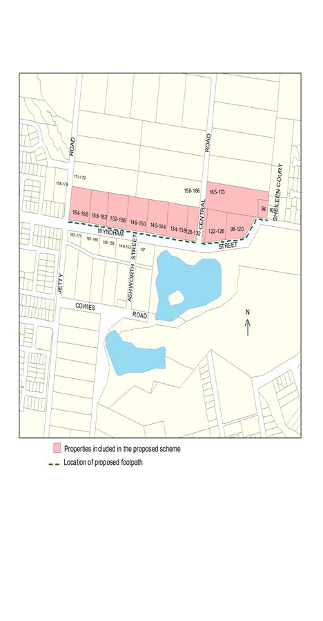
Stage |
Status |
Description |
Approval to prepare scheme |
✓ |
Decision made to prepare scheme following consideration of surveys of residents and feed back from the community. Council may then place the project in the budget system or proceed immediately to prepare a scheme. Scheme preparation involves survey, design and preparation of an apportionment of costs. July 2015 |
Intention to Declare Scheme |
✓ |
Report to Council providing information on scheme including advice of impending advertising of scheme and declaration of charge. Seeks Council approval by resolution to proceed with process. |
Advertisement |
|
The scheme is advertised in the local newspaper and all allotted property owners are notified by mail. This advertisement indicates Council’s intention and notification to ‘declare’ a scheme in a month’s time or at a subsequent meeting. |
Submissions |
|
From the time of advertising property owners have 28 days (as set down by the Local Government Act) to lodge submissions, either in support or opposition to the scheme. |
Submissions Review Panel Hearing |
|
A Submissions Review Panel is convened if required (quorum of three Councillors) and meets to consider submissions. Some submissions are written only, and other submitters may wish to be heard before the Panel. The Panel makes a recommendation to Council regarding the scheme. |
Declaration Report |
|
Any time 28 days after advertising the scheme and after the Submissions Review Panel has met and considered submissions, Council considers a report and may proceed to “declare” the charges in accordance with its advertised intent. Subsequent to this the Finance Manager issues the levy notices and there is a formal charge placed on the property. This is the final step in the process for Council to make a decision on the scheme. |
Appeal |
|
Property owners may lodge an application for review with the Victorian Civil and Administrative Tribunal (VCAT) within one month of issue of the levy notice. An appeal is listed, heard and determined by the Tribunal and this process generally takes three to four months. Decisions made by VCAT are binding on all parties. |
Construction |
|
Council may then proceed to construct the works. Invoices are issued seeking payment of the estimated cost within one month of commencement. |
Final Cost Report |
|
At the completion of the works the scheme is “finalised” taking into account actual costs incurred and payments are adjusted accordingly. |
Portfolio: |
Infrastructure Parks & Garden – Cr Ellis |
Source: |
City Services |
General Manager: |
William Tieppo |
Index Reference: |
T1500054 |
Council seeks to appoint a panel of suitable qualified and experienced contractors for the provision of Tree Maintenance Services for the Parks & Gardens department for various tree maintenance services to be performed throughout the City of Greater Geelong.
Council has sought tenders for the provision of Tree Maintenance Services on a panel arrangement by way of open tender.
The successful tenderers will be appointed as preferred suppliers for the provision of this service commencing 1 December 2015 and concluding 30 November 2017 with the option to extend the contract term by three (3) one year extensions at the sole discretion of Council.
The estimated annual value of these services associated with this contract is $1.4m annually.
A total of nine companies have provided tender submissions for the provision of these services.
Following a detailed evaluation of each of the submissions it is considered that the tender submission/s of Aspect Tree Management Pty Ltd, Bellarine Tree Services Pty Ltd, Steven’s Specialist Tree Services Pty Ltd, Tree Top Tower Hire Pty Ltd and Acorn Tree Services Pty Ltd are preferred.
Cr Ellis moved, Cr Richards seconded -
That Council:
accept the tender submission/s from Aspect Tree Management Pty Ltd, Bellarine Tree Services Pty Ltd, Steven’s Specialist Tree Services Pty Ltd, Tree Top Tower Hire Pty Ltd and Acorn Tree Services Pty Ltd for Tender No T1500054 Tree Maintenance Services for the associated schedule of rates exclusive of GST; and
sign and seal the contract documents.
Carried.
Tenders for the provision of Tree Maintenance Services were invited by public advertisement in the Geelong Advertiser and Tenderlink on Saturday 27 June 2015.
At the close of tenders on 22 July 2015 at 2.00pm the following tender submissions were received:
Acorn Tree Services Pty Ltd
Tree Top Tower Hire Pty Ltd
Steven’s Specialist Tree Services Pty Ltd
Aspect Tree Management Pty Ltd
Bellarine Tree Services Pty Ltd
Active Tree Services Pty Ltd
Cut Above the Rest Tree Surgery Pty Ltd
Vemco Pty Ltd
David Lamont’s Tree Services
The tender submissions associated with this service were evaluated by a panel consisting of:
Grant Baverstock – Manager Parks & Gardens
Alan Dawson – Maintenance Officer Trees
Peter Arundell – Supervisor Tree Management Unit
Jeff McArthur – Contract Officer Property & Procurement
Stage One – Mandatory Criteria
Mandatory requirements apply to this tender.
Each of the submissions did respond to the mandatory requirements set down in the tender documents being OH&S.
Stage Two – Comparative Criteria
Tender submissions were assessed based on the respondent’s performance or tender response in the following areas:
Criteria |
Weighting |
Economic Contribution to the Geelong Region |
10% |
Capability & Experience, Past performance last 3 yrs |
30% |
Proposed staffing, plant & equipment levels |
60% |
Total |
100% |
Tenders were assessed against the comparative Criteria and were ranked in the following order:
Tenderer |
Ranking |
Bellarine Tree Services Pty Ltd |
1 |
Steven’s Specialist Tree Services Pty Ltd |
2 |
Aspect Tree Management Pty Ltd |
3 |
Tree Top Tower Hire Pty Ltd |
4 |
Active Tree Services Pty Ltd |
5 |
Acorn Tree Services Pty Ltd |
6 |
Vemco Pty Ltd |
7 |
David Lamont’s Tree Services |
8 |
Cut Above the Rest Tree Surgery Pty Ltd |
9 |
The evaluation panel agreed that 5 contractors is a satisfactory number of contractors to appoint to the Tree Maintenance Services panel taking into account the services required on an annual basis.
The evaluation panel agreed to recommend the top four (4) ranked tenderers and the 6th ranked tender, Acorn Tree Services Pty Ltd based upon Acorn Tree Services schedule of rates which was more competitive than Active Tree Services Pty Ltd.
The evaluation panel members undertook a rigorous exercise of due diligence by assessing the extensive pricing schedule comparisons for all tenderers and this pricing analysis is attached to this report.
Bellarine Tree Services Pty Ltd whilst submitting rates which are expensive in a number of services are used by Council to undertake specialist services, the majority of these are undertaken on a competitive quote basis through the contract conditions. Bellarine Tree Services Pty Ltd are locally based with the ability to respond quickly to urgent/safety issues that arise and these services will account for 5% of the services undertaken annually.
Any environmental implications associated with this contract will arise from the execution of this service. It is considered that these are the responsibility of the Contractor and will be managed through the contract documentation.
This is a schedule of rates tender and will rely upon the amount of recurrent funds allocated in the Budget Code 63107 in the 2015/2016 financial year budget. The budget allocation for this service is approximately $1.4million per annum
The requirements of Section 186 of the Local Government Act have been complied with for this tender. There are no other policy, legal or statutory implications associated with this tender process.
The provision of this service has a positive impact on all key City Plan objectives.
As noted in the Procurement Plan, a Council Officer Peter Arundell declared an indirect interest in this service noting a family member is employed by Aspect Tree Management who subsequently tendered for this service. Mr Arundell did not participate in the evaluation of Aspect Tree Management’s tender submission.
There are not considered to be any risks associated with the acceptance of this tender that cannot be managed through the contract conditions.
There are no social implications that will arise from the acceptance of this tender.
There are no Human Rights Charter implications that will arise from the acceptance of this tender
There is no communication issues associated with the acceptance of this tender. Council representatives will liaise with affected community groups.
Portfolio: |
Finance – Cr Lyons (Mayor), Cr Farrell, Cr E Kontelj |
Source: |
Strategy & Performance - Financial Services |
General Manager: |
Dean Frost |
Index Reference: |
Financial Reporting 2015/2016 |
Cr Macdonald moved, Cr E Kontelj seconded -
That in accordance with Section 89 (2) (h) of the Local Government Act 1989, this matter, which Council considers would prejudice the Council or any person, be considered at the conclusion of all other business at which time the meeting be closed to members of the public.
Carried.
Contents | Previous Page: Section A - Procedural Matters | Next Page: Section C - Assembly of Councillors
