
Council Minutes - Section B: Reports - 13 December 2016
Contents | Previous Page: Section A - Procedural Matters | Next Page: Section C - Assembly of Councillors
Contents | Previous Page: Section A - Procedural Matters | Next Page: Section C - Assembly of Councillors
Reports tabled at the Ordinary Meeting of Council on Tuesday date held at the Council Conference and Reception Centre in City Hall, 57 Little Malop Street, Geelong.
Development Contributions Plans – Increase in Capped Community Infrastructure Levy
Geelong Waterfront – Safe Harbour Precinct – Funding Extension
Revocation of Flood Prone Area Designation of New Lots at Watermark, Stages 1 and 2
Revocation of Flood Prone Area Designation of New Lots at Charlemont, Stage 1
Baker Street Group Road Construction Special Charge Scheme SRC340 – Declaration of Charge
Montpellier Drive, Highton – Proposed Footpath Construction – SRC345 – Declaration of Charge
Source: |
Community Life - Sport and Recreation |
General Manager: |
Linda Quinn |
Index Reference: |
Sport Leisure and Recreation – Sport – Motor Sports |
To provide the current status of the G21 Motocross Land Suitability Assessment and recommend a future direction for Council’s involvement.
A confidential G21 Motocross Land Suitability Assessment was commissioned by the City of Greater Geelong on behalf of G21 (Geelong Region Alliance). The Assessment was undertaken in response to the recent closure of local motocross facilities and displaced motocross clubs seeking relocation.
The G21 Motocross Land Suitability Assessment has identified 24 potential sites within the G21 region, with six (6) sites being shortlisted for further investigation. Of these six sites, two (2) are publically owned.
The four (4) remaining sites are all privately owned and on the market for sale at the time of writing this report. Two (2) of these properties are located within the preferred 30 minute drive time of the CBD. These sites have been recommended for further investigation and range in value from $800,000 to $2.5M to purchase.
The City of Ballarat and City of Wyndham are currently undertaking similar land searches for motorsport indicating that a broader State-wide solution maybe required.
Council at its meeting on 27 January, 2015 resolved to call upon the State Government and Motorcycling Australia to redirect their respective investments of $500,000 and $100,000 towards a future regional facility. Neither organisation has committed these funds pending the outcome of the Land Suitability Assessment, however these potential funding contributions, along with existing contributions from the City of Greater Geelong at $638,000 and Surf Coast Shire at $90,000, total $1,328,000.
P Dorling moved, L Gardner seconded -
That Council:
request that G21 call on the State Government to lead and establish a formal collaborative working party between G21 and neighbouring Local Government Areas to further investigate best prospective sites and identify whether funds are available to purchase land and build a regional motocross facility;
if insufficient funding is available to achieve a land purchase and site development, Council’s commitment of $638,000 should be returned to consolidated revenue and any future investment be subject to Council’s budgetary process.
acknowledge on request of the Surf Coast Shire Council that McAdam Park was purchased by Motorcycling Australia with contributions from Surf Coast Shire, Sporting Motorcycle Club, and the Victorian State Government for $3.4 million, with the Title held by Motorcycling Australia.
Carried.
Please refer to Timeline of Events (Attachment 2) accounting the actions leading to the closure of the local motocross facilities and the subsequent G21 Motocross Land Suitability Assessment.
In 2006, due to ongoing complaints from local residents, Council resolved to close the Breakwater Road motocross facility which was used by the Geelong Motocross Club.
Post the closure, Council in conjunction with the Geelong Motocross Club undertook a comprehensive review of potential sites for relocation. Aligned with this review, Council allocated $800,000.
The site review of more than 25 locations identified an allotment of Crown Land on Dandos Road, Avalon as being the most suitable.
The Geelong Motocross Club later rejected the Dandos Road site in favour of McAdam Park, located in Surf Coast Shire.
The City of Greater Geelong at its Council meeting on 25 August, 2009 resolved to financially support the McAdam Park purchase. The terms of Council’s Resolution within the report titled ‘Motocross Facilities’ were unacceptable to Motorcycling Australia and the offer lapsed. Motorcycling Australia took ownership of the site on settlement.
The McAdam Park site was jointly purchased by Surf Coast Shire, Sporting Motorcycle Club, Motorcycling Australia and the Victorian State Government for $3.4 million, with the Title held by Motorcycling Australia.
Following the purchase, Council again considered how it would support the efforts of the Geelong Motocross Club. At its meeting on 25 May 2010 Council, in summary, resolved to:
Note that support of McAdam Park is the most effective manner in which Council can assist motocross and the Geelong Motocross Club in the region.
Consider that the funding request from Geelong Motocross Club be deferred until:
Geelong Motocross Club present a more detailed proposal.
Land use planning issues at McAdam Park as they relate to the Geelong Motocross Club development proposal are resolved.
Unfortunately land use issues remained unresolved and following a lengthy dispute with local residents, a settlement was reached between Motorcycling Australia and the Barrabool Hills Community Association Inc. to cease motocross activities at the site as of 16 December 2015.
Prior to the impending closure, at its meeting on 9 December 2014, Surf Coast Shire resolved to:
Support a regional strategic land assessment and contribute financially to that assessment.
Following this resolution, the City of Greater Geelong Council at its meeting on 27 January 2015 resolved to:
Request that surrounding municipalities participate in a regional land assessment to determine the feasibility of placing a motocross facility in the G21 region.
Affirm its support for the development of a regional motocross facility within Geelong and adjoining Council’s; and
Call upon the State Government and Motorcycling Australia to redirect the investments made in McAdam Park for future Geelong regional motocross infrastructure. Following this resolution, it was decided to defer any investment until the regional land assessment had been completed.
In 2016, the G21 Motocross Land Suitability Assessment began. It has utilised a number of processes and sources to identify potential candidate sites including public land searches, expressions of interest, properties currently on the market and those identified during the consultation process with the Project Control Group (PCG).
Using the major and desirable site criteria, 24 potential sites have been identified. Details of these sites, including the top six (6) best prospects are listed within the confidential report. The report remains confidential as many of the sites are privately owned but were on the market for sale at the time of writing this report.
If further site investigations do not identify a suitable location for a regional motocross facility, the user groups have requested the provision of a stand alone club house (without a track) for displaced motorcycle club members be considered.
In relation to future land purchase and development of a motocross facility, the potential funds available following the sale of McAdam Park are as follows:
Motorcycling Australia |
$100,000 |
Sport and Recreation Victoria |
$500,000 |
Surf Coast Shire |
$90,000 |
City of Greater Geelong |
$638,000 |
Approximate funds available |
$1,328,000* |
* subject to contingencies and Land Purchase Agreement **subject to confirmation |
|
The available funds would not be sufficient to purchase both land and develop a regional motocross facility. Cost estimates undertaken through a Quantity Survey by Rider Levett Bucknall (Attachment 3 and 4) have identified that, excluding land purchase, the cost to construct a regional level motocross facility would be $9M - $11M.
The G21 Land Suitability Assessment recommends further investigation of the best prospect sites will be required. Funds will be required for acoustic testing/assessment and potential flora/fauna investigations.
The G21 Motocross Land Suitability Assessment has been driven by a Project Control Group (PCG) whose role was to provide high-level direction on key issues and approve draft and final reports.
A Project Advisory Group – Motocross Users (PAG-MU) was also established to provide an opportunity for key stakeholders (those not already engaged in the PCG) to have input into the development of the study.
As part of the process an emphasis was placed on stakeholder engagement and consultation including ongoing engagement with:
G21 Local Government Representatives
State Government Agency Representatives (e.g. Sport and Recreation Victoria)
Local Motorcycle Clubs (Geelong Motocross Club, Sporting Motorcycle Club, Otways Trail Riders, Colac Motorcycle Club and Meredith Motorcycle Club)
Motorcycling Victoria
Motorcycling Australia
City of Ballarat and City of Wyndham
Land Owners and Managers (public and private)
None that are evident.
This report is aligned to the community well-being objective of City Plan. The provision of sport and recreation facilities promotes healthy lifestyle through physical activity.
No Council officers involved in the preparation of this report are known to have a direct or indirect interest in matters to which this report relates.
Should an alternative location for motocross not be found within the region it may lead to an influx of illegal off road riders, an increase in at risk behaviours and potential environmental degradation. Evidence shows that this occurs in a number of public areas and poses significant risk to community, riders and flora and fauna.
Should desktop investigations indicate that potential sites may serve as a habitat for significant flora and fauna species of State and Commonwealth significance, detailed audits will be required.
At a minimum, this will require further seasonally based investigations over a 12 month period and potential referrals under the Commonwealth Environment Protection and Biodiversity Conservation Act 1999 and the State Flora and Fauna Guarantee Act 1988.
Environment Protection Authority (EPA) Victoria is the State’s independent environmental regulator. Under the powers of the Environment Protection Act 1970, EPA is responsible for protecting the environment from noise pollution.
The best prospect sites identified in the G21 Motocross Land Suitability Assessment will require acoustic testing and assessment to ensure the long term sustainability of the site.
Source: |
City Services - Engineering Services |
Acting General Manager: |
Vicki Shelton |
Index Reference: |
Geelong Saleyards |
For Council to determine the future of the Geelong Saleyards.
On 22 August 2016, the General Manager City Services ordered the closure of the Saleyards following a structural engineering report identifying significant structural and occupational health and safety concerns.
On 27 September 2016 Council reiterated the previous Council’s resolution to transition to closure and requested officers to undertake additional consultation for further consideration at the December 2016 Council meeting.
There has been extensive communication on the future of the Saleyards including a major workshop facilitated by an independent facilitator on 11 November 2016 (refer Attachment 2 for the key themes emerging and Attachment 3 for the independent facilitators report).
On 19 November 2016, the City announced it would reopen the saleyards to stock sales in early January 2017.
Bringing the whole (sheep and cattle yards) facility up to Australian Livestock Code of practice standards is currently estimated at $150,000 for the sheep yards and $300,000 for the cattle yards.
The estimate for the Cattle yards is based on an initial scope prepared by Council officers and includes quotes from contractors for repairs to overhead walkways in accordance with the Engineering structural report completed in August 2016.
An OHS audit inspection by an external OHS consultant has now been completed for the cattle yards. Refer attachment 4. The audit identified 17 recommendations with 8 very high and 7 high hazards that require action prior to reopening of the cattle yards. Costing of these recommendations is yet to be completed and is currently estimated at $320,000 (materials only).
Since the announcement to reopen the facility, further cattle projection analysis taken from the Meat and Livestock Association October 2016 Industry Projection report indicates that from a cattle supply point of view, numbers over the coming two years will fall to levels not seen in more than twenty years in Australia. Regional figures are not available and further localised market analysis is required.
There are other Saleyards within and outside the region already in place or being newly developed. The local community have already accessed these options.
The Geelong Saleyards has become a niche service for small stockholders in the immediate region and also is important as a social meeting place.
Through the consultation, it has been determined that there is no agribusiness strategy for the region to consider the role and ideal location of Saleyards and its priority amongst other possible agribusiness support and investment opportunities.
The engagement of the stakeholders is important in developing any future options for the Saleyards.
K Alexander moved, L Gardner seconded -
That Council:
note the content of the independent OH&S Audit inspection undertaken by SafetyZone (Attachment 4) and the serious range of findings that need to be addressed prior to recommencing cattle sales;
note that repair works are already underway to enable safe operations for small lot sheep sales at the Geelong Saleyards in January 2017;
note that repair works on the cattle pens have not commenced and an initial estimate is in excess of $320,000 for materials only (to date);
defer repair works on the cattle yards until an independent expert local stock market analysis is completed and a full costing estimate is prepared based on the recently completed OH&S Audit inspection;
work with buyer, seller, agent and transporter representatives and other related stakeholders immediately to develop interim support arrangements for small lot cattle sales;
consistent with the previous Council’s resolution of June 2015, work with the G21 group of Councils, the G21 Agribusiness Forum and other agriculture peak bodies to establish an agribusiness strategy for the region which incorporates the resolutions of the Surfcoast Shire Council (see Attachment 5) with a view to this being available for a final decision by mid 2017;
establish a Geelong Saleyards Advisory Committee, with a Terms of Reference consistent with the “Australian Code of Practice for the Selling of Livestock” and work with the proposed Committee to advise Council on user issues at the Saleyards.
Carried.
The Saleyards have been operating at the Weddell Road site since 1869 (148 years). For the last 10 years the yards have been making a loss (avg. $171,000 per annum in the last two years over $200,000) as stock numbers have decreased from (18,675 head of cattle in 2005 to 8,839 in 2015/16 and 65,383 head of sheep in 2005 to 45,092 in 2015/16).
Since the announcement to reopen the facility works have commenced on the sheep pens and are on track for reopening in January 2017.
To prepare for reopening in January, further safety measures are currently underway including the preparation of safety induction procedures and the preparation of a traffic management plan for the site.
In relation to the cattle sales, the City has undertaken further analysis to determine whether it would be financially responsible to spend in the order of $300,000 to repair the cattle yards. As highlighted in the key issues, cattle projections are likely over the coming two years fall to levels not seen in more than twenty years. This alone will more than likely stimulate strong competition between restockers, feedlots and processors for the limited availability. Professional restockers who are travelling from all over the state and from interstate have the demand and resources to purchase the autumn calving cattle offered for sale. They are also picking up the spring calving cattle. This means that much of the potential future stock is being taken from our local markets. Some small scale restockers and local buyers have been able to pay a premium for heifers however it will be 18 months to 2 years before the calves from these heifers will be available if at all depending on the requirements of the owners.
Furthermore, in the Ballarat Courier on 26 November 2016, the Ballarat Stock and Station Agents Association estimate that there could be an extra 30 or up to 40 cattle coming into Ballarat due to the closure of the Geelong Saleyards. The numbers would be similar going to Colac. These are not significant numbers and indicates that the available stock numbers in Geelong are low. These reports together with reports from local livestock experts indicate that there is limited cattle availability in the Geelong region in the immediate and long term future.
Repair works to comply with OH&S standards are underway and are being funded from within the approved 2016/17 approved budget.
Funds are also available to undertake the recommended Agribusiness Strategy.
A workshop attended by 118 stakeholders was held on Friday 11 November 2016. Feedback from the workshop is included in the key themes and attached report from the independent facilitator. Attachment 2 and 3.
A communications plan will be prepared to inform all users of the reopening of the yards and the expectations in regards to access and safety.
It is recommended that the City work with the G21 group of Councils in the proposed development of an agribusiness strategy prepared at a regional level, incorporating the G21 Agribusiness Forum and other agriculture peak bodies. The intended purpose of this group will be for stakeholders to discuss and develop options on future stock selling methods, development of the strategy to highlight agribusiness investment needs into the future. The strategy will also need to consider the changing needs of the agribusiness sector throughout our region.
The Surfcoast Shire Council at their meeting of the 22 November 2016 support the formation of a saleyards stakeholder committee and have allocated $10,000 towards the Agribusiness strategy. Refer Attachment 5 for the full resolution.
This report aligns to City Plan through the strategic direction of ‘How We Do Business’.
The Feasibility Study into the Geelong Saleyards and all subsequent studies reviewed how the service meets the requirements of a growing population through responsible and sustainable financial management as well as ensuring safety to City of Greater Geelong staff and members of the public.
No council officer involved in this report has a direct or indirect conflict of interest.
Early in August 2016 safety concerns were raised regarding the condition of the saleyards facility. An engineers report was received on the overhead and pedestrian walkways and other components including loading ramps which identified risks to users. This prompted immediate temporary closure of the Geelong Saleyards to sheep and cattle sales on the 22 August 2016.
Further inspections of both the sheep yards and cattle yards were completed in November 2016 identifying a number of interventions required to enable yards to reopen. An OHS audit of the cattle yards identified 17 recommendations. Risk ratings identified 8 very high and 7 high hazards that will require action prior to reopening of the Cattle Yards.
Key Themes from Workshop
Participants stated that:
The saleyards play a key role in supporting social connectedness and mental wellbeing within the farming community – it’s a ‘men’s shed’.
The saleyards play a key role in the continuation of agribusiness in the region - many farmers are small producers on small holdings who need a local outlet to buy and sell their stock.
There is widespread distrust regarding many of the financial aspects of the facility presented by Council in terms of income, expenditure and repair costs of the existing facility as well as new facility construction costs.
None of the 3 scenarios presented by Council solve the immediate problem of needing the facility opened urgently.
Of the 3 scenarios presented, that of opening a fully upgraded or new facility with the City of Greater Geelong, was the preferred option. Within this option, there was a preference for an upgrade of the existing facility rather than construction of a new facility. Suggestions included reducing the scale of the current facility. Upgrading the existing facility was considered to be far less expensive than building a new facility
A fourth scenario, that of an independent risk assessment including accurate and itemised costs to bring the current yards up to date, was offered from the floor and positively received by attendees. There was a general willingness by the farming community present to use their many skills in a volunteer capacity to contribute to the facility upgraded yards
A new management structure is needed to guide the future management of the facility either in partnership with City of Greater Geelong or as a privately run enterprise. The management committee should comprise representatives from saleyards users.
KizMet Forward – Independent Facilitator
Geelong Saleyards - Stakeholder Workshop Report of Outputs – November 2016
Occupational Health and Safety Audit Inspection – December 2016
Surfcoast Shire Council
Item 3.3 Geelong Saleyards – Council Resolution – 22 November 2016
Council Resolution
MOVED Cr Heather Wellington, Seconded Cr Clive Goldsworthy
That Council:
Acknowledge the value of the hinterland economy and the importance of the role played by smaller farmers.
Acknowledge that smaller farmers with livestock require ongoing access to market which enables the buying and selling of their livestock.
Note that the marketplace is evolving and that farmers have a range of channels available through which to buy and sell livestock, however not all channels may be suitable for small producers.
Request the City of Greater Geelong to undertake the following immediate actions:
Undertake necessary tactical works to re-open the existing Geelong Saleyards facility as soon as possible to cater for cattle and sheep.
Form a Saleyards Stakeholder Committee as widely canvassed at the stakeholder forum on 11 November 2016.
Commence a ‘Livestock Market Channel Analysis’ (LMCA) as a joint regional project including the identification of the range of livestock buying and selling options and the relative pros and cons of each option including the identification of solutions that meet the needs of small sheep and cattle producers.
Defer any decision as to the long term future of the Geelong Saleyards until consideration of the LMCA.
Authorise the allocation of up to $10,000 to support a Livestock Market Channel Analysis from the Accumulated Unallocated Cash reserve.
Express an interest to collaborate with the City of Greater Geelong, neighbouring Councils, the G21 Agri-business group and Regional Development Victoria on the Livestock Market Channel Analysis and any required infrastructure investment.
Consider a proposal from the City of Greater Geelong for Surf Coast Shire Council to contribute to the operational funding of a regional saleyard service.
Receive a further report after the completion of the Livestock Market Channel Analysis.
Acknowledge and commend the City of Greater Geelong commitment as announced on 16 November 2016 to undertake interim works necessary to re-open the existing Geelong Saleyards facility by early January.
CARRIED 9:0
Source: |
Planning and Development - Urban Growth Area Planning |
General Manager: |
Peter Bettess |
Index Reference: |
Amendment C301 |
This report seeks Council adoption of Greater Geelong Planning Scheme Amendment C301 which has been modified in accordance with the recommendations of the independent Panel appointed by the Minister for Planning to hear submissions.
The amendment applies to approximately 52 hectares of land located at 892-958 and 960-990 Barwon Heads Road, Armstrong Creek.
The amendment proposes the rezoning of the land to Urban Growth Zone – Schedule 2 (UGZ2) and the incorporation of the Armstrong Creek South Precinct Structure Plan (ACSPSP). The amendment also proposes the application of a Public Acquisition Overlay (PAO12) on land required for drainage.
Amendment C301 was formally exhibited in 2015 and twelve (12) submissions were received.
A Panel Hearing was held in February 2016 with the Panel Report received in March 2016. The Panel supports the amendment subject to minor changes. See Attachment 1 for detail on the Panel recommendations.
A Section 173 Agreement has also been developed to fund the infrastructure required to service the new community. This document and recommended amendment modifications are shown in Attachment 2 (previously provided with briefing papers).
A total of five (5) parties, in addition to the City of Greater Geelong, presented to Panel during the Hearing. Key issues raised and considered were:
Storm water management, including the application of the PAO;
Traffic management; and,
Development timing and funding.
L Gardner moved, P Dorling seconded -
That Council, having considered the Panel Report for Amendment C301, resolves to:
Adopt Amendment C301 in the modified form recommended by the Panel and shown in Attachment 1 and;
Submit the adopted amendment to the Minister for Planning.
Carried.
Amendment C301 proposes to incorporate the Armstrong Creek South Precinct Structure Plan into the Greater Geelong Planning Scheme.
Key issues raised by submissions and Panel recommendations
Response to key issues raised in submissions, and the subsequent Panel recommendations are summarised below.
Planning Context
The Panel reviewed the amendment against the relevant policies in both the State Planning Policy Framework (SPPF) and the Local Planning Policy Framework (LPPF).
The Panel concluded that:
The Amendment is supported by, and implements the relevant sections of the State and Local Planning Policy Framework and,
The Amendment is well founded and is strategically justified subject to addressing the more specific issues raised in submissions…..; (Page 5)
Armstrong Creek South Precinct Structure Plan
Submissions were heard from the proponent on the benefits associated with the incorporation of the Armstrong Creek South Precinct Structure Plan into the Greater Geelong Planning Scheme including;
The continued delivery of best practice storm water management;
Utilisation of recycled water for toilet flushing and garden watering; and,
Additional passive open space for the benefit of residents that is linked to the surrounding area via shared paths for both pedestrians and cyclists.
The Panel concluded that:
The ACSPSP is strategically sound and can be included in the Armstrong Creek Urban Growth Area;
The proposed changes to Clause 21.11 – Armstrong Creek Urban Growth Area to include the ACSPSP are supported.
Drainage and Floodplain Management
The issue of whether the proposed ACSPSP Storm Water Management Strategy is appropriate and whether the Public Acquisition Overlay (PAO) proposed as part of the amendment should be applied were both considered by the Panel.
The submission by the land holder whose land is being acquired for the purpose of the diversion channel suggested in their submission that the PAO for the purpose of a diversion channel was not for either a community benefit or a public purpose. The submission also contended that the diversion channel will restrict access to the eastern section of his property and that the dimensions of the diversion channel would result in adverse flooding of the property during extreme rain events.
The Panel heard evidence from Council that the Storm Water Management Strategy, as exhibited, will assist in mitigating flood risk on the subject land and that the proposed diversion channel will also resolve issues of increased Storm Water volume from the entire Armstrong Creek Urban Growth Area.
The Corangamite Catchment Management Authority (CCMA) sought changes to the Floodway Overlay mapping shown in the Armstrong Creek South PSP which were agreed to, and amended by Council, during the Panel Hearing.
The Panel concluded that:
The concept drainage design and storm water management strategy for the subject site is appropriate.
The Public Acquisition Overlay (PAO12) is appropriate.
Changes to Plan 16 should reflect the CCMA requirements as outlined in Council’s Part B submission to align with the Land Subject to Inundation Overlay.
Traffic
The issue of whether the proposed intersection, including a proposed pedestrian crossing, at Barwon Heads Road is appropriate was considered by Panel.
One of the submissions received during exhibition of the amendment indicated concern about the potential for increased traffic flows on Lake Road as a result of the additional residential developed proposed by the Armstrong Creek South Precinct Structure Plan. In response, Council submitted that approximately 75 per cent of the total number of vehicle movements per day will be using Barwon Heads Road. Of the traffic using Barwon Heads Road, the small number of vehicles heading south would not be likely to utilise a low order road, such as Lake Road, over Barwon Heads Road. These assumptions are based on the Traffic Impact Assessment undertaken as a component of the amendment.
Vicroads submitted that their preference was for a roundabout as the access control in to the Armstrong Creek South PSP area rather than a set of traffic lights, as nominated in the exhibited Amendment C301. Council submitted that this change was supported on the condition that a safe pedestrian crossing, such as a signalised crossing near the roundabout, is constructed to allow pedestrians to safely cross to the eastern side of Barwon Heads Road.
Council and the proponent also agreed on the Department of Economic Development, Jobs, Transport and Resources request to provide a 3 metre wide shared path on the east-west internal collector road and a standard footpath on the other side.
The Panel concluded that it supported the roundabout treatment, pedestrian crossing and shared path outcomes.
Other issues
Department of Environment, Land, Water and Planning submission
The Department of Environment, Land, Water and Planning (DELWP) requested that the construction works for the diversion channel be supported by a ‘Construction Environment Management Plan’. Council included additional wording in Schedule 2 to the Urban Growth Zone and Clause 66.04 of the Greater Geelong Planning Scheme to in accordance with DELWP’s requests.
The Panel accepted the proposed changes.
Controlled action under the EPBC Act
The construction of the proposed diversion channel has been determined a Controlled Action for the purposes of the Environment Protection and Biodiversity Conservation Act 1999 (EPBC Act). The Panel determined that the Panel Hearing was not the appropriate forum for discussion of EPBC Act requirements and that both Council and the proponent would be able to progress EPBC Act requirements as a separate process.
Potential for flooding of surrounding land parcels as a result of development
One submitter raised concerns that their land parcel would be flooded as a result of the proposed development.
The proposed engineering solution for the development includes the provision of several drainage channels that will ensure that water is drained away from both the site and the surrounding land parcels. As a result there will be no adverse impact on the surrounding area.
The Panel agreed that Council had written to the submitter to detail that the proposed drainage design for the subject land would mitigate any potential future flooding.
Objection to the application of a Public Acquisition Overlay on land at 82-88 Groves Road, Armstrong Creek for the purposes of a storm water diversion channel in to the Sparrovale Wetlands.
A component of Amendment C301 is the application of a Public Acquisition Overlay over land approximately 22 metres wide across the property at 82-88 Groves Road, Armstrong Creek to accommodate a drainage channel. The purpose of the channel is to convey summer storm water volume and flows from Armstrong Creek waterway, bypassing Hospital Swamp, directly in to the Sparrovale Wetlands once they are established.
The owner of the Groves Road property, upon which the PAO is being proposed, is concerned at the loss of his land for the financial benefit of others. The submission argues that the ultimate function of the compulsorily acquired land will not be a public purpose (which is the legislative basis for the application of a PAO) as it simply allows the proponents of the Armstrong Creek South Precinct Structure Plan to develop their land, to their benefit.
The proposed diversion channel is part of a broader drainage solution for the growth area and when constructed will direct excess storm water volumes from the RAMSAR listed Connewarre wetland system. This action will allow the historic routine of wetting and drying and saline/fresh water to be maintained in the wetland thereby preserving the established ecological values of the system. The public benefits of the channel are twofold; enabling development of a new community in the Armstrong Creek South Precinct and the provision of potential benefits to the overall management of storm water within the Armstrong Creek Urban Growth Area and the Connewarre wetlands complex.
Traffic Management
A number of traffic management issues were raised in submissions including the potential negative impact of the additional traffic on the existing rural road system, a request for a roundabout on Barwon Heads Road rather than the nominated traffic signals, shared path requirements and a preferred widening of the east – west local road through the PSP area.
One submitter was concerned that southbound traffic from the PSP area will use Lake Road to join Barwon Heads Road at the Barwon Heads Airport rather than head south to the Lower Duneed roundabout and then east towards Barwon Heads. Council officers advised that there is a low likelihood of drivers choosing a longer route on a rural road rather than the Barwon Heads/Lower Duneed Road.
Vicroads submitted that a roundabout at the intersection of Barwon Heads Road and the east-west road through the PSP area is their preferred option. Council officers agree that a roundabout can be constructed, in place of the nominated traffic signals, on the understanding that a high quality pedestrian crossing is provided across Barwon Heads Road to enable safe access to the nominated Bus Stops. Council officers will continue to work with Public Transport Victoria, Vicroads and the proponent to progress detailed designs for the intersection.
The Department of Economic Development, Jobs, Transport and Resources (DEDJTR) submitted that a three (3) metre wide shared path is required along Barwon Heads Road and the east-west local road. The current standard of shared path within the Armstrong Creek Urban Growth Area is 2.5 metres wide with existing path connections to the north and west of the PSP area. Council officers submit that the 2.5 metre wide shared path can be continued from the north as far as the east-west road and then west through to the Armstrong Waters development to connect to the open space network in both the east and west of the PSP area.
Both Vicroads and DEDJTR nominated that the east-west road through the PSP be a connector road standard rather than the mix of both connector and local road as shown in the exhibited PSP. The local street cross section has been nominated in the PSP as it feeds in to the approved local street network to the west. Should the road be increased in width to a connector road standard the existing road hierarchy in the Armstrong Creek East Precinct may be compromised by encouraging more than local traffic through the Armstrong Creek South Precinct and on to Barwon Heads Road.
The connector road cross section has been used in the Armstrong Creek South Precinct between Barwon Heads Road and the eastern boundary of the passive open space to assist with traffic distribution through the new subdivision area.
Changes to exhibited documents
Modification to the exhibited documents will be required where Council officers have agreed with submitter issues. These modifications include:
Amendment to the Urban Growth Zone - Schedule 2 to reflect that the Armstrong Creek South PSP area cannot be developed until the land forming part of the nominated Sparrovale Wetlands has been purchased and commissioned to receive storm water and the diversion channel has been constructed.
Several changes to water and sewerage plans to reflect a change in pipe diameter and alignment.
Plan 9 in the Armstrong Creek South PSP will be updated to reflect a shared path along Barwon Heads Road with a connection in to the existing shared path network current being established within the Armstrong Creek East PSP area.
Several plans, and associated text, will be updated to reflect a roundabout as Vicroads preferred intersection treatment on Barwon Heads Road. Costings associated with this change will also need to be incorporated into the funding agreement with the proponent.
Reference to Vicroads Access Management Policy will be removed from the Table in Appendix 3 of the Armstrong Creek South PSP.
Plan 16 of the PSP will be updated to clearly show both the flood storage and post development flood boundary nominated by the Corangamite Catchment Management Authority.
The Section 173 Agreement, between the land holders and Council, identifies and nominates funding of all the capital financial requirements for development of the Armstrong Creek South Precinct. The administration of the Section 173 Agreement will be undertaken by the Urban Growth unit as part of the overall responsibility for development contributions within the Armstrong Creek Urban Growth Area.
No impact to budget.
With Council responsibility for the management of the S173 Agreement there will be decisions required across the Armstrong Creek South Precinct and other precincts within the Armstrong Creek Urban Growth Area. These will be matters which will be assessed via the Development Contributions Steering Committee with recommendations coming to Council as part of the annual consideration of the budget.
Formal exhibition of Amendment C301 occurred between 27th August 2015 and 2nd October 2015 via the following means:
Notices sent to affected landholders and occupiers.
Notices published in the Geelong Advertiser and Geelong Independent notifying readers of details of the amendment.
Notice published in the Victorian Government Gazette.
Notices sent to Government Departments and Statutory Authorities.
Notices sent to relevant State Government Ministers in accordance with the requirements of the Planning and Environment Act 1987.
Documents available for viewing at Council Customer Service Centres.
Documents available for viewing on the Council and State Government websites.
The planning scheme amendment to incorporate the Precinct Structure Plan for the Armstrong Creek South Precinct accords with the broader structure for the Armstrong Creek Urban Growth area as established in the Greater Geelong Planning Scheme.
The Armstrong Creek South Precinct Structure Plan and associated S173 Agreement and in line with Council’s adopted position on the provision of infrastructure within the Armstrong Creek Urban Growth Area.
The amendment is also considered to meet the relevant requirements of both State Government and Council.
The Armstrong Creek Urban Growth area is one of Council’s priority projects.
The Armstrong Creek South Precinct Structure Plan will ensure that the continuing needs of the growing community will be met.
In accordance with Section 80C of the Local Government Act no Council officers involved in this report have a direct or indirect interest.
The Section 173 agreement identifies the infrastructure items required to service the additional residential community in Armstrong Creek South and also nominates the development proponent as the delivery agency for these projects.
This amendment has addressed potential environmental implications of the development through the protection of remnant native vegetation and the nomination of a large, central area of passive open space for the benefit of the Armstrong Creek community.
The diversion channel link in to the Sparrovale Wetlands will provide significant positive environmental outcomes including a reduction storm water volumes into Hospital Swamps and the protection of several habitat zones which were nominated in the Armstrong Creek East Precinct Structure Plan.
Source: |
Planning and Development - Urban Growth Area Planning |
General Manager: |
Peter Bettess |
Index Reference: |
Development Contributions Plans |
This report seeks endorsement to increase Council’s current Community Infrastructure Levies (CIL) beyond the previously capped $900/dwelling, to the recently approved new cap of $1,150/dwelling (or less if levy’s indexation has not yet reached the $1,150 figure).
On 27 October 2016 the Minister for Planning announced the approval of a reform package for a new development contributions system for Victoria. The reforms have been pending for some time now, creating uncertainty for the development industry and local government.
The reform package includes new guidelines, templates and Minister’s Directions that allow implementation of the new system; transitioning from the current Development Contributions Plan (DCP) model to a new Infrastructure Contributions Plan (ICP).
As part of the reform package, the Minister also announced an increase in the current capped Community Infrastructure Levy (CIL) that applies to existing DCPs. The current levy has been capped at $900/dwelling since 2004 (pursuant to Section 46(L) of the Planning and Environment Act 1987) and has now been increased to $1,150/dwelling, effective as of 13 October 2016.
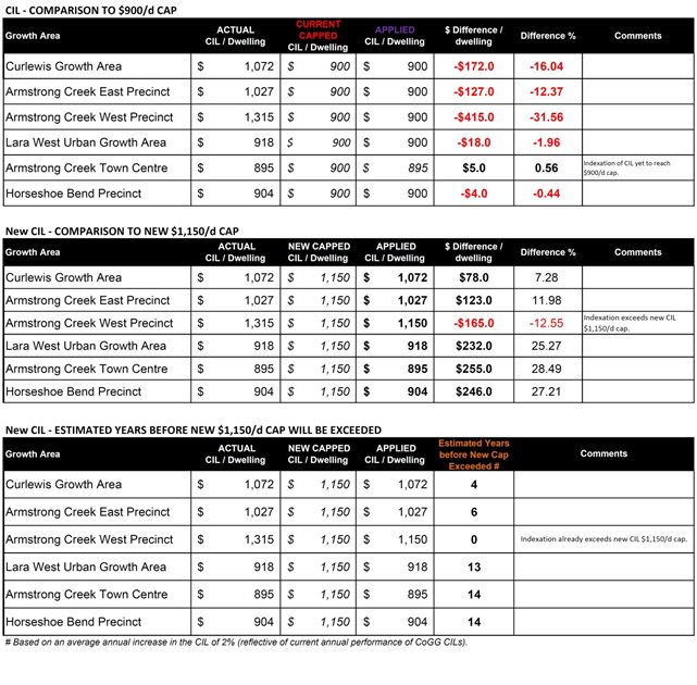
Council has for some time envisaged a future increase in the capped levy with all of Council’s DCPs including a provision that allows for the increase in our CIL levies up to a new cap, if any such increase were to occur. Attachment 1 and 2 provide further details on these changes to the CIL (including comparison of existing and new CILs).
The increase in the CIL is difficult to apply immediately due to the need to allow adequate lead time to communicate the change to the development industry;
It is proposed to increase the levy on 1 January 2017 for communication with the public as well as key areas of the development industry, including building surveyors and local developers;
The increase in the CIL will also reduce originally forecasted DCP funding shortfalls due to the levy now keeping pace with indexation.
L Gardner moved, P Dorling seconded -
That Council endorses an increase of the Community Infrastructure Levy according to the indexation provisions within Development Contributions Plans up to the new cap of $1,150/dwelling effective from January 2017.
Carried.
The announcement by the Minister for Planning to increase the CIL is beneficial to Council in managing its development contribution income.
The current applied CILs average between 0.5 – 31% less than the actual indexed levies that are required to appropriately fund nominated infrastructure (refer Attachment 2 – CIL Comparison Tables). The one exception being the Armstrong Creek Town Centre Precinct which has a CIL below the $900/dwelling cap, however no development has occurred in this precinct and in 2017/18 the CIL will then exceed the $900/dwelling cap.
The new $1,150/dwelling cap will still sit below the CIL for the Armstrong Creek West Precinct, however for the most part the new cap won’t be exceeded for approximately 4 – 14 years (depending on the precinct). The period will ensure appropriate funds are collected before any further government approved increase.
Council has already advised building surveyors and key members of the development industry of the statutory increase in the CIL provisions of the Act. In the context of this report, Council officers will also inform land sales staff (via their developer client) of the CIL increases, including providing an information bulletin for distribution to the public and prospective purchasers.
Council currently has seven active Development Contributions Plans (DCPs) that are incorporated documents in Greater Geelong Planning Scheme. Six of these DCPs nominate collection of a CIL.
DCPs are implemented by the use of a Development Contributions Plan Overlay (DCPO) within the Greater Geelong Planning Scheme (refer Clause 45.06 – Development Contributions Plan Overlay).
The Community Infrastructure Levy (CIL) is collected prior to a building permit being issued for an new dwelling covered by the DCPO. Some developers choose to pay the levy as part of subdivision, however for the most part the levy is paid by the purchaser of the new lot.
Council has always envisaged a future increase in the capped levy with all of Council’s DCPs including the provision below that allows for the increase in our CIL levies if any such increase were to occur (as occurred on 13 October 2016):
If the Community Infrastructure Levy (CIL) cap (currently $900 per dwelling) is ever increased, the Responsible Authority reserves the right to increase the CIL in this DCP to allow for cost escalation in accordance with the indexation methods in this DCP up to the new CIL cap. The higher levy will be collected from the date the new CIL cap is introduced.
The increase in the CIL will assist in mitigating the loss of income currently experienced due to the capped $900/dwelling, noting one of our CILs (Armstrong Creek West Precinct) will still suffer from lost income due to it still exceeding the new $1,150/dwelling levy. However, the impact will obviously be less than that currently experienced.
Source: |
Investment and Attraction - Events, Central Geelong and Waterfront |
General Manager: |
Brett Luxford |
Index Reference: |
SUB-16-187 Waterfront Management |
This report seeks approval to extend the period of Council’s $3m contributory funding offer towards Stage 1A of the Safe Harbour Precinct project to 31 December 2018.
At a Special Council on 7 March 2016, Council agreed to allocate $3m funding towards the $19m Stage 1A of the redevelopment of Fishermen’s Basin, Royal Geelong Yacht Club (RGYC) Clubhouse, Victorian Sailing School and surrounding public areas, known as the Safe Harbour Precinct, contingent on the RGYC securing the remaining funding for the stage from the State and Federal Government by 31 December 2016.
RGYC made an unsuccessful application to the National Stronger Regions Fund (NSRF) in the March 2016 round.
The RGYC have written to Council seeking to extend the funding offer to allow the club to pursue other avenues of project funding (Attachment 2).
Council's funding support must be subject to a number of conditions as outlined in the recommendation.
Council was a partner in the development of the business case of the Geelong Waterfront Safe Harbour Precinct Project with the Victorian Government and the RGYC.
The project provides new infrastructure supporting event growth and attraction and will increase the of the waterfront for public recreation and community events;
In addition, the project will enhance Geelong as a destination for boat users, maritime safety and education.
The RGYC will seek additional funding from a variety of sources including the Victorian Government and Federal Government through the Building Better Regions fund.
The project is identified in the Victorian Government's Central Geelong Revitalisation Action Plan.
P Dorling moved, L Gardner seconded -
That Council:
Extend the offer of $3m funding towards the Geelong Waterfront - Safe Harbour Precinct project until the outcomes of the current round of the Australian Government’s Building Better Regions Fund are known to allow the Royal Geelong Yacht Club to secure the remaining funding as outlined in the Geelong Waterfront Safe Harbour Precinct Business Case (Appendix 1) subject to the following conditions:
the project proceeds in the manner outlined in the business case;
the elements of the wave attenuator and public realm improvements are key aspects that cannot be removed from the project scope;
the total cost of the project shall not be less the $19m;
the Royal Geelong Yacht Club commits at least $3m cash towards the Geelong Waterfront – Safe Harbour Precinct Project Stage 1A;
in addition to the Royal Geelong Yacht Club allocation, that additional funding support totalling at least $13m is secured by the Royal Geelong Yacht Club from a variety of sources including the Victorian State Government and the Australian Federal Government.
Carried.
At a Special Council Meeting of 7 March 2016, Council resolved to:
Acknowledge the work undertaken on the development of the Geelong Waterfront - Safe Harbour Precinct project business case and note the report;
Support the Royal Geelong Yacht Club’s request for $3m (ex GST) funding from Council to undertake Stage 1A of the Geelong Waterfront Safe Harbour Precinct project as outlined in the business case subject to the following conditions:
the project proceeds in the manner outlined in the business case;
the elements of the wave attenuator and public realm improvements are key aspects that cannot be removed from the project scope;
the total cost of Stage 1A of the project shall not be less the $19m;
the Royal Geelong Yacht Club commits at least $3m cash towards the Geelong Waterfront – Safe Harbour Precinct Project;
in addition to the Royal Geelong Yacht Club allocation, that additional funding support totalling at least $13m is secured by the Royal Geelong Yacht Club from a variety of sources including the Victorian State Government and the Australian Federal Government by 31 December 2016.
The commitment was on the back of the completion of the business case (Attachment 3) which highlighted the opportunities that exist through improvements in infrastructure associated with the RGYC and foreshore area.
The RGYC secured funding commitments from the Victorian Government and were seeking $9m from the Federal Government through the NSRF. The application was unsuccessful and the RGYC seeking an extension of time in relation to Council’s funding commitment to allow them to investigate alternative funding opportunities to undertake the project.
The RGYC have outlined their approach which will include an application to the Federal Government's Building Better Regions Fund (BBRF) which have only recently announced the guidelines for this scheme. Applications for the BBRF will open on 18 January 2017. Projects must be completed by 31 December 2019.
The business case outlines stages that could be undertaken in the development of the overall project. The RGYC have indicated that once stage 1A is completed they will immediately commence the next phase (Stage 2) of the project which will include an extension of the marina berths which will provide additional public access to the water.
It is anticipated however that Stage 2 will take some time to complete and will only be realised as berths are leased. The overall total cost of stages 1A and 2 is anticipated to be $31m.
The $3m contribution sought from Council has been identified in Council’s Strategic Resource Plan. Should Council resolve to extend the funding commitment for the project this may alter the timeframe during which the funding is required depending upon when the RGYC are successful in obtaining matching funding.
Council's contributions to the project could be phased over three financial years. Council’s contribution would be contingent on Council funds being allocated to the improvements of the public realm and towards construction of the wave attenuator. These elements all open up additional access for public to the waterfront.
In the course of completing the Business Case and Concept Plan, a wide range of key stakeholders have been consulted including:
Regional Development Victoria |
Sport and Recreation Victoria |
Victorian Regional Channels Authority (VRCA) |
Tourism Victoria |
G21 Geelong Regional Alliance |
Yachting Victoria |
Geelong Chamber of Commerce |
Committee for Geelong |
Boating Industry Association of Victoria (BIA) |
Newcomb Secondary College (operator of the Victorian Sailing School |
Department of Environment, Land, Water and Planning (DELWP) |
|
Issues discussed included expanded community access to the precinct, greater area of public realm, more access to on-water training programs, on-going maintenance, increased employment and economic activity through a redeveloped precinct.
There are currently a small number of business operators using Fishermen’s Basin – helicopter joyflights and commercial vessels - which will need to be relocated to allow this project to proceed.
The three commercial vessels could be relocated to the northern side of Yarra Jetty with upgrades to the moorings. The relocation of the helicopter will prove more challenging but there is a possibility that a floating helipad could be utilised. Changes could be funded from the public realm allocation.
Benefits flowing from the proposed redevelopment directly align with key planning and policy objectives of State Government, City of Greater Geelong, the Royal Geelong Yacht Club and peak organisations.
This includes the Central Geelong Waterfront Master Plan 2011 (CoGG), CoGG City Plan 2013 – 2017, Central Geelong Action Plan (CoGG, 2013), Vision2 (CoGG, Deakin University, Dept. Planning and Community Development, Committee for Geelong, 2013), Victorian Coastal Strategy 2014 (Victorian Coastal Board, SGV 2014), Central Regional Coastal Plan 2015 - 2020 (Central Coastal Board, SGV), Boating Coastal Action Plan (Central Coastal Board, SGV 2007), Corio Bay Coastal Action Plan 2005, Recreational Boating Facilities Framework (Central Coastal Board, SGV 2014), Victoria’s Regional Tourism Strategy (SGV, 2013), Geelong Major Events Strategy (CoGG), Royal Geelong Yacht Club Strategic Plan (2014 - 2018), Yachting Victoria Position Paper to SGV, 2012, Yachting Victoria Strategic Plan (2013).
Current Committee of Management boundaries and leasing arrangements (including the requirement to comply with s190 of the Local Government Act) for the sea bed will need to be addressed as part of the project.
The Geelong Waterfront precinct is a primary focus for the local community. The project aligns with:
City Plan 2013 - 2017 (Update 2015/2016)
Central Geelong Action Plan and Vision2
Geelong Central Waterfront Masterplan Update (2011)
An officer working on the project is a member of the Royal Geelong Yacht Club.
A workshop involving representatives of CoGG, RDV and RGYC was undertaken with a view to identifying and making a preliminary assessment of the key risks in relation to the lifecycle of the project, along with potential mitigating actions.
It has been assumed that commercial risks pertaining to the future operation and demand for marina services continues to rest with RGYC. It has been assumed that RGYC will be able to service any increased rental that CoGG might seek in response to having the use of much improved facilities.
Overall it would appear that the delivery of the project is relatively low risk.
The key configuration issue is whether the attenuator will be effective in creating a safe harbour environment. However, this risk should be mitigated by an effective design and implementation process. In relation to the success of the project in attracting increased boating activity and public participation in the precinct, the commercial risk of the boating activity will rest with RGYC.
An environmental impact study has not been undertaken as part of this business case process. In the event of the project moving forward, it is recommended that a review of planning and environmental requirements be undertaken to inform the development of the Project Implementation Plan.
As further context, the onshore components of the project essentially involve building new RGYC and VSS accommodation and facilities on the existing RGYC site. A Planning Permit has already been issued by CoGG in relation to a major renovation of the existing RGYC clubhouse.
It is not expected that any significant incremental environmental impact would result from demolishing and rebuilding on the existing site, assuming that any incremental water, waste-water and sewage requirements are adequately managed. Rather the redevelopment will provide the opportunity to upgrade and optimise the arrangements.
The on-water (marina) development is within or around the area of the existing marina, with the proposed wave attenuator along an alignment similar to that previously occupied by the Yarra St Pier. Both the wave attenuator and new marina components will be floating, providing the benefits of not inhibiting tidal flow or marine ecology. The reduction of wave action entering and crossing the marina basin from the north-west may also lessen the erosion of Eastern Beach and/or the need for dredging. Thus, the redevelopment should be a viewed as an opportunity to potentially improve the environmental health of the marina and safe harbour environment.
Energy consumption in the new facilities will be less due to appliance efficiency and through the communal use of facilities.
Stage 3 works may involve the relocation of the gross pollutant trap currently in the shallow water adjacent to the sailing school, to further out in the bay limit to limit the amount of silt and rubbish being discharged and trapped along the shore-line. This will be considered in relation to CoGG’s Central Geelong Drainage and Flood Study which will provide a storm water management plan for central Geelong, informing future development, infrastructure upgrades and greening projects.
Source: |
Investment and Attraction - Central Geelong Action Plan |
General Manager: |
Brett Luxford |
Index Reference: |
PRJ-16-143 : Central Geelong CBD 40km Zone |
To reduce the speed limit within Central Geelong in order to create an environment that supports safe movement and city life.
This project has been developed in collaboration with key stakeholders including VicRoads and TAC.
Following the report adopted by Council on the 16th of August 2016, a community engagement period of four weeks was conducted from 25 August 2016 to 22 September 2016. The purpose of the engagement was to obtain public feedback on the proposal and understand the concerns arising from the initiative, to inform decisions about implementation.
It is estimated that it will cost $250,000 to effectively implement the 40km/hr Speed Zone across Central Geelong.
This will be subject to budget considerations for the 2017/18 budget.
This continues the package of traffic modification works to Central Geelong.
Council could seek to bring forward these works into the 2016/17 year and in order to do so would need to fund the actions through savings in other projects or postponing projects.
P Dorling moved. L Gardner seconded -
That Council:
Implement the Central Geelong 40km/hr Speed Zone for the area shown in Appendix 1;
Undertake works to implement the identified actions this financial year and as soon as possible through savings identified in the 2016/17 budget.;
Request the staff to record the impact of the 40km/hr Speed Zone on all adjoining streets including McKillop Street and publish results;
Consider McKillop Street in the Transport Network Operating Plan.
Carried.
Feedback
There were 39 comments received during the consultation period (8 additional comments were received but were not deemed related to the project). Comments were taken in person, via phone, email, written letter, Facebook post comments or comment made on online newspaper article (refer Attachment 2 – Community Feedback).
Of the 39 comments received the following were deemed:
Support for the project (24)
Support the project, with comment (5)
Do not support the project (10)
Outcome
Following consultation no significant feedback was given for a specific change to the proposal or not to proceed with the proposal.
A draft signage scheme has been developed and will be reviewed by VicRoads prior to implementation. In addition, ‘gateway’ linemarking treatments will be applied at the entrances to the 40km/hr Speed Zone. (refer Attachment 3 - draft signage scheme and Attachment 4 - indicative linemarking).
A submission of $250,000 has been made for the 2017/18 budget. In addition, a TAC Pedestrian Blackspot funding grant has been submitted. Both of these submissions would not see the project implemented until the 2017/18 financial year.
Council could support the reallocation of $250,000 from available Central Geelong Action Plan budget items to fulfil the funding, ensuring implementation early 2017. This would either defer a project, reduce the scope of the project or it could be funded through budget savings.
The funds could be reallocated from budget item D81106 – City Loop Bus Feasibility. The City Loop Bus Feasibility scope has been completed.
This project has been developed in collaboration with key stakeholders including VicRoads and the TAC. This approach is consistent with the IAP2 spectrum of public participation, ‘consult’ level of engagement.
The consultation included a website that was open for the duration of the consultation (from 25 August 2016 to 22 September 2016). In addition, four ‘open house’ drop-in sessions were scheduled across the week of Saturday 3rd September to Friday 9th of September.
Owners and residents within the 40km/hr area, and owners bordering the area, were notified of the consultation by letter.
A video was released on social media, demonstrating the impacts of a vehicle travelling down Ryrie Street at 40km/hr vs 50km/hr. The consultation was also launched on the Geelong Australia website.
The proposal closely aligns with ‘Growing the Economy’ and ‘Sustainable and Built Environment’ by supporting the revitalisation of Central Geelong and use of more sustainable transport options to move within the CBD.
Risks to the safety of all road users in Central Geelong will be reduced as a result of the implementation of the initiative outlined in this report.
Source: |
Community Life – Family Services |
General Manager: |
Linda Quinn |
Index Reference: |
Subject: CoGG Kindergarten Cluster Management |
To seek approval to increase kindergarten fees at Council’s three and four year old sessional programs effective from January 2017 in line with the Victorian State Government Kindergarten Funding Rates (including Kindergarten Fee Subsidy) 2017.
Council operates 8 three and four year old sessional kindergarten programs across the municipality. Income is generated through parent fees and state government funding. Fee schedules for these programs are set for the following financial year during the budget formulation period.
In late June 2016, the state government announced an increase to funding rates in recognition of increased salaries for early childhood teachers and educators. Council’s kindergarten fees for fee paying parents are set based on the Victorian State Government Kindergarten Fee Subsidy (KFS) for eligible children to access free kindergarten. Council’s budget process was complete at the time of the state’s funding announcement and therefore a fee increase is necessary from first term in 2017.
Fee schedules for four year old kindergarten programs (15 hours) are set and adopted by Council during the budget formulation period each financial year. The fee setting timeline was prior to the release of the 2017 KFS funding rates.
The KFS rate increased from $1,386 in 2016 to $1,433 per year in 2017, this equates to 3.4%. The KFS covers the cost of free kindergarten programs for eligible children.
It is Council practice to set four year old kindergarten fees based on the rate of the KFS and therefore fee paying parents would incur an increase of $47 per year from first term 2017.
Three year old sessional kindergartens programs are not funded through the state KFS. Eligible three year old children can access a free kindergarten program through the Early Start Program.
The new rate for families accessing an unfunded 3 year old kindergarten program will increase from $1,900 to $1,929; an increase of $29 per year for a 6 hour program. Grovedale Child and Family Centre 3 year old kindergarten fee will have a higher increase to bring the fees into line with Council’s other kindergarten programs.
L Gardner moved, P Dorling seconded -
That Council notes the increase to the Victorian State Government Kindergarten Fee Subsidy 2017 and approves an increase in sessional kindergarten fees in line with the above, effective from term one 2017.
Carried.
Victorian State Government Kindergarten Funding Rates (including KFS) 2017 were announced in late June 2016 post Council’s budget setting process, therefore Council’s kindergartens fee structure does not reflect the increase.
It is proposed that from January 2017, the four year old kindergarten fee will increase from $346.50 per term or $1,386 per year (2016 rate) to $358.25 per term or $1,433 per year (2017 rate). This will be a 3.4% increase in four year old kindergarten fees across all eight programs.
Three year old kindergarten fees will increase from $475 to $482.30 per term or $1,900 per year for six hours.
Council kindergarten fees for full fee paying families are set in line with the State Government fee subsidy rate. The increase in the KFS will see an increase to full fee paying families. Families that are eligible for KFS will continue to receive free kindergarten and will not be impacted.
A budget projection will be required to reflect the increase in Council revenue.
The proposed increase to the kindergarten program fees and additional funding for both three year old and four year old sessional kindergarten programs will increase service income from $611,777 to $636,317, an increase of $24,540 for 2016-2017 financial year.
If the proposed increase is approved, parent handbooks will be updated and a letter will be sent to each family informing them of the 2017 increase to fees.
The Victorian Local Government Act (1989) empowers Council to set user-pays fees and charges to offset the cost of delivering services for the community.
The subject of this report and recommendations are consistent with Council’s strategic City Plan objectives as referred under How We do Business – through responsible and sustainable financial and business management.
No officers involved in this report have any direct or indirect interest in accordance with Section 80(c) of the Local Government Act.
The proposed increase to the 2017 fee structures for the three old sessional kindergarten programs at Grovedale Child and Family Centre may result in parents raising concerns in regards the higher increase to fees.
Source: |
City Services - Engineering Services |
Acting General Manager: |
Vicki Shelton |
Index Reference: |
SUB-16-3161 |
The purpose of this report is to revoke the designation of flood affected land within the stages of the development of Watermark, Stages 1 and 2.
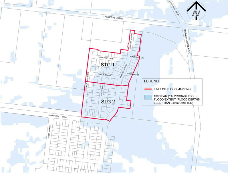
The current designated flood mapping (refer to Appendix 1) was designated by Council at its meeting of 12 December 2006, under the provisions of the Building Regulations 2006.
The subject of this report is the residential land at Charlemont fronting 228 - 262 Reserve Road, Charlemont. Prior to subdivision the parent lot was used primarily as farmland.
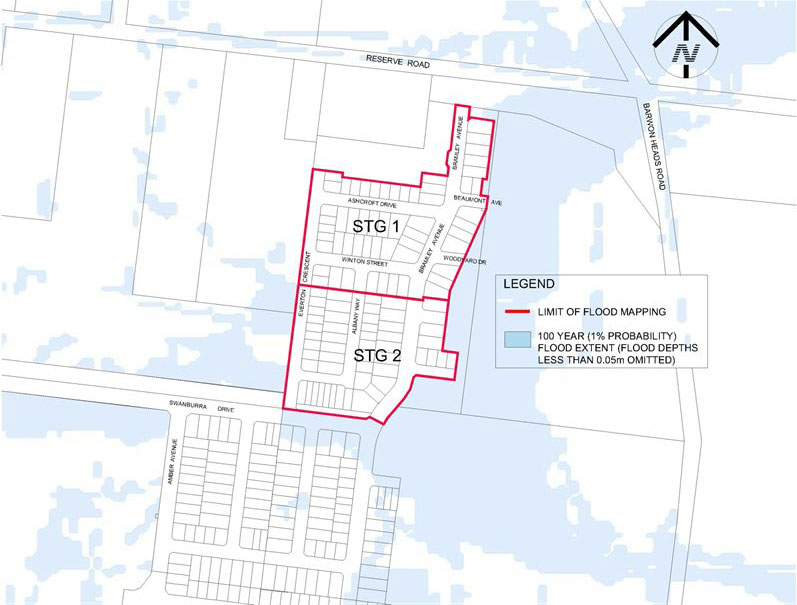
The flood mapping is subject to a revision due to the subdivision and development at 228 - 262 Reserve Road, Charlemont. Prior to subdivision the parent lot was considered to be liable to flooding. This development site, which is also known as Watermark, Stages 1 and 2, achieves flood immunity for newly created lots for flood events up to and including the 100 year Average Recurrence Interval (ARI) event due to approved internal earthworks.
The earthworks undertaken have resulted in the floodwaters from the 100 year ARI event being contained within the boundaries of the road network.
Council has a statutory obligation under the Building Regulations 2006 to designate land as liable to flooding where it reasonably knows it to be prone to flooding. Conversely, there is an obligation to remove the encumbrance of designation from land that is no longer considered to be flood-prone.
It should be noted that designation is separate to the creation of flood overlays within the Planning Scheme, which generally follows designation. In the case of this development, the planning scheme amendment to create post-development flood zones or overlays is proposed after the design of the proposed precincts.
L Gardner moved, P Dorling seconded -
That Council revoke the Council designation of 12 December 2006 of flood affected land Watermark, Stages 1 and 2 as liable to flooding pursuant to Regulation 802(2) of the Building Regulations 2006.
Carried.
Appendix 1 shows the existing flood designation. Appendix 2 shows the change in flood mapping at 228 - 262 Reserve Road, Charlemont after construction of the subdivision.
Designation of land as liable to flooding under Regulation 802 of the Building Regulations 2006 enables the control of floor levels for acceptable building permit applications, or refusal of consent to building applications where there is likely to be a danger to life, health or safety due to flooding. Designation also enables disclosure of flood status within statutory information certificates such as the Land Information Certificate and Building Information Request Form.
Overland flows that may occur within the subdivision during the 100 year ARI flood event are now contained within road and drainage reserves in accordance with accepted best practice for development within flood-prone areas. Best practice requires that any overland flows within residential areas satisfy public safety criteria with respect to velocity and depth of flow.
Council has a statutory obligation under the Building Regulations 2006 to designate land as liable to flooding where it reasonably knows it to be prone to flooding. Conversely, there is an obligation to remove the encumbrance of designation from land that is no longer considered to be flood-prone.
The costs of proceeding to revoke the existing designation and to designate the revised flood mapping at 228 - 262 Reserve Road, Charlemont, in accordance with the requirements of the Building Regulations 2006, are provided for within the annual recurrent budget.
No impact to budget.
A revocation of designation does not warrant public consultation as it constitutes the removal of an encumbrance on land.
Relevant Council databases and flood maps will be revised and updates sent to the Corangamite Catchment Management Authority and Building Control Commission.
The City has various statutory responsibilities for drainage management and flood management (prevention, response and recovery) as set out in the Local Government Act 1989, Local Government Regulations 1990, Planning and Environment Act 1987, Building Regulations 2006, Water Act 1989, Subdivision Act 1988 and Emergency Management Act 1986.
Regulation 802(2) of the Building Regulations 2006 provides Council with the powers to ‘designate’ land liable to flooding. Regulation 802(3) provides that consent must be obtained from Council for an application to build on land liable to flooding.
Section 27 of the Interpretation of Legislation Act 1984 provides the power for Councils to ‘repeal or amend a subordinate instrument made in the exercise of that power’.
Section 807 of the Building Regulations 2006 requires Council to update the municipality’s designated special area maps at the Building Control Commission in the event of alterations to a designated special area. Designated special areas include areas designated as being liable to flooding.
Section 229 of the Local Government Act and Regulation 326 of the Building Regulations provide for the issue of information certificates containing prescribed information, including the flood status of properties.
The revised flood data for 228 - 262 Reserve Road, Charlemont will assist the City in meeting its statutory obligations with regard to flood data.
The revised flood data will also assist in fulfilling the recommendations of the Municipal Emergency Management Committee adopted by Council in November 1998 (i.e. mapping of 1 in 100 year flood levels).
The recommendations of this report are consistent with City Plan, in relation to Growing our Economy and promoting a sustainable built environment, sustainable land use and development.
There are no officer direct or indirect interests with respect to this report.
Council also has some risk exposure with any failure to disclose the flood-prone status of a property in a Land Information Certificate.
The designation of the flood data produced by the flood study is a key step toward minimising Council’s exposure to these risks.
Council has a risk exposure through its statutory obligations under the Building Regulations 2006 to:
designate land as liable to flooding where it reasonably knows it to be prone to flooding;
specify minimum floor levels in consultation with the relevant floodplain management authority (CCMA); and
refuse consent to building applications where there is likely to be a danger to life, health or safety due to flooding.
Council also has some risk exposure with any failure to disclose the flood-prone status of a property in a Land Information Certificate.
Conversely, there is an obligation to remove the encumbrance of designation from land that is no longer considered to be flood-prone. Designation of land as being liable to flooding can result in extra construction costs and concerns regarding saleability, in some cases.
The revocation of flood-prone areas designation and designation of revised flood data does not result in any known adverse environmental impacts.
The removal of a minimum floor level requirement for new dwellings may result in a minor reduction in energy and material usage during construction. In addition, concrete slab-on-ground construction, which is normally used for a non-elevated floor, achieves the minimum energy rating more readily than a timber floor on stumps.
Source: |
City Services - Engineering Services |
Acting General Manager: |
Vicki Shelton |
Index Reference: |
SUB-16-3161 |
The purpose of this report is to revoke the designation of flood affected land within the stages of the development of Charlemont, Stage 1.
The current designated flood mapping (refer to Attachment 1) was designated by Council at its meeting of 12 December 2006, under the provisions of the Building Regulations 2006.
The subject of this report is the residential land at Charlemont fronting 201 - 219 Horseshoe Bend Road, Charlemont. Prior to subdivision the parent lot was used primarily as farmland.
The flood mapping is subject to a revision due to the subdivision and development at 201 - 219 Horseshoe Bend Road, Charlemont. Prior to subdivision the parent lot was considered to be liable to flooding. This development site, which is also known as Charlemont, Stage 1, achieves flood immunity for newly created lots for flood events up to and including the 100 year Average Recurrence Interval (ARI) event due to approved internal earthworks.
The earthworks undertaken have resulted in the floodwaters from the 100 year ARI event being contained within the boundaries of the road network.
Council has a statutory obligation under the Building Regulations 2006 to designate land as liable to flooding where it reasonably knows it to be prone to flooding. Conversely, there is an obligation to remove the encumbrance of designation from land that is no longer considered to be flood-prone.
It should be noted that designation is separate to the creation of flood overlays within the Planning Scheme, which generally follows designation. In the case of this development, the planning scheme amendment to create post-development flood zones or overlays is proposed after the design of the proposed precincts.
L Gardner moved, P Dorling seconded -
That Council revoke the Council designation of 12 December 2006 of flood affected land Charlemont, Stage 1 as liable to flooding pursuant to Regulation 802(2) of the Building Regulations 2006.
Carried.
Appendix 1 shows the existing flood designation. Appendix 2 shows the change in flood mapping at 201 - 219 Horseshoe Bend Road, Charlemont after construction of the subdivision.
Designation of land as liable to flooding under Regulation 802 of the Building Regulations 2006 enables the control of floor levels for acceptable building permit applications, or refusal of consent to building applications where there is likely to be a danger to life, health or safety due to flooding. Designation also enables disclosure of flood status within statutory information certificates such as the Land Information Certificate and Building Information Request Form.
Overland flows that may occur within the subdivision during the 100 year ARI flood event are now contained within road and drainage reserves in accordance with accepted best practice for development within flood-prone areas. Best practice requires that any overland flows within residential areas satisfy public safety criteria with respect to velocity and depth of flow.
Council has a statutory obligation under the Building Regulations 2006 to designate land as liable to flooding where it reasonably knows it to be prone to flooding. Conversely, there is an obligation to remove the encumbrance of designation from land that is no longer considered to be flood-prone.
The costs of proceeding to revoke the existing designation and to designate the revised flood mapping at 201 - 219 Horseshoe Bend Road, Charlemont, in accordance with the requirements of the Building Regulations 2006, are provided for within the annual recurrent budget.
No impact to budget.
A revocation of designation does not warrant public consultation as it constitutes the removal of an encumbrance on land.
Relevant Council databases and flood maps will be revised and updates sent to the Corangamite Catchment Management Authority and Building Control Commission.
The City has various statutory responsibilities for drainage management and flood management (prevention, response and recovery) as set out in the Local Government Act 1989, Local Government Regulations 1990, Planning and Environment Act 1987, Building Regulations 2006, Water Act 1989, Subdivision Act 1988 and Emergency Management Act 1986.
Regulation 802(2) of the Building Regulations 2006 provides Council with the powers to ‘designate’ land liable to flooding. Regulation 802(3) provides that consent must be obtained from Council for an application to build on land liable to flooding.
Section 27 of the Interpretation of Legislation Act 1984 provides the power for Councils to ‘repeal or amend a subordinate instrument made in the exercise of that power’.
Section 807 of the Building Regulations 2006 requires Council to update the municipality’s designated special area maps at the Building Control Commission in the event of alterations to a designated special area. Designated special areas include areas designated as being liable to flooding.
Section 229 of the Local Government Act and Regulation 326 of the Building Regulations provide for the issue of information certificates containing prescribed information, including the flood status of properties.
The revised flood data for 201 - 219 Horseshoe Bend Road, Charlemont will assist the City in meeting its statutory obligations with regard to flood data.
The revised flood data will also assist in fulfilling the recommendations of the Municipal Emergency Management Committee adopted by Council in November 1998 (i.e. mapping of 1 in 100 year flood levels).
The recommendations of this report are consistent with City Plan, in relation to Growing our Economy and promoting a sustainable built environment, sustainable land use and development.
There are no officer direct or indirect interests with respect to this report.
Council also has some risk exposure with any failure to disclose the flood-prone status of a property in a Land Information Certificate.
The designation of the flood data produced by the flood study is a key step toward minimising Council’s exposure to these risks.
Council has a risk exposure through its statutory obligations under the Building Regulations 2006 to:
designate land as liable to flooding where it reasonably knows it to be prone to flooding;
specify minimum floor levels in consultation with the relevant floodplain management authority (CCMA); and
refuse consent to building applications where there is likely to be a danger to life, health or safety due to flooding.
Council also has some risk exposure with any failure to disclose the flood-prone status of a property in a Land Information Certificate.
Conversely, there is an obligation to remove the encumbrance of designation from land that is no longer considered to be flood-prone. Designation of land as being liable to flooding can result in extra construction costs and concerns regarding saleability, in some cases.
The revocation of flood-prone areas designation and designation of revised flood data does not result in any known adverse environmental impacts.
The removal of a minimum floor level requirement for new dwellings may result in a minor reduction in energy and material usage during construction. In addition, concrete slab-on-ground construction, which is normally used for a non-elevated floor, achieves the minimum energy rating more readily than a timber floor on stumps.
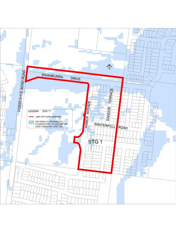
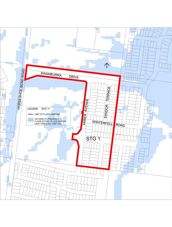
Source: |
Strategy and Performance – Customer Service and Council Business |
Acting General Manager: |
William Tieppo |
Index Reference: |
Council Governance / Council Meeting Procedures |
To adopt the meeting schedule for Council meetings in 2017.
Each year Council adopts its meeting schedule for the coming year. The current Council Meeting cycle consists of four weekly rotational meetings for each month:
Week 1 – Strategic Workshop
Week 2 – Council Briefing
Week 3 – Community Engagement
Week 4 – Ordinary Meeting of Council
The Strategic Workshop and Council Briefing are closed to the public, these meetings are to allow time for briefings and discussions on key issues.
Council’s annual cycle of meetings provides an opportunity for our community to engage with the decision making process of Council.
Adopting the Council Meeting Schedule for 2017 provides our community with advance notice of meeting dates.
The proposed schedule of meetings retains the Ordinary Meeting of Council on the forth Tuesday of the month.
The Community Engagement sessions will provide the ongoing opportunity for meaningful community interaction at the local level.
Any changes to the dates or times of the Ordinary Council Meeting will need to be advertised in accordance with Council Meeting Procedure Local Law.
Dates and times for the Strategic Workshop and Council Briefing are able to be altered without any advertising as these are closed sessions.
P Dorling moved, L Gardner seconded -
That Council
endorse the current Council Meeting cycle;
endorse the proposed schedule of meeting dates for 2017 as per Attachment 2;
advertise any changes to the scheduled Council Meeting dates in City News and on the Geelong Australia website.
Carried.
Council has a key role to play in ensuring that decisions are made in an effective manner and that all known matters are taken into account when making decisions.
To enable the appropriate time for information gathering and ensuring proper community consultation is undertaken it is proposed that the meeting cycle continues as follows for each month:
Week 1 – Strategic Workshop
Week 2 – Council Briefing
Week 3 – Community Engagement
Week 4 – Ordinary Meeting of Council
It should however, be noted that due to the festive period in December the meeting schedule alters.
Dates for Strategic Workshops and Council Briefings can be altered without any further notice as these are closed sessions.
The Council Meeting Schedule for 2017 will be placed on the Geelong Australia website once adopted.
Whilst there are no foreseeable changes to the proposed meeting schedule, it is recommended that any changes will be communicated through City News and on the Geelong Australia website.
If there is an urgent need for Council to meet prior to a scheduled Ordinary Meeting, a Special Meeting of Council may be convened pursuant to sections 83(b) and 89(4) of the Local Government Act 1989.
January – December 2017
STRATEGIC WORKSHOP |
COUNCIL BRIEFING |
COMMUNITY ENGAGEMENT |
COUNCIL MEETING |
|
1st Wednesday of the month closed to public in camera |
2nd Tuesday of the month closed to public in camera |
3rd Wednesday of the month (Night meeting – 6:00pm) open to public to be held at various locations |
4th Tuesday of the month (Night meeting – 6:30pm) open to public |
|
17 January 2017 |
- |
24 January 2017 |
Budget Briefing 7 February and 22 February 2017 |
14 February 2017 |
15 February 2017 |
28 February 2017 |
Budget Briefing 8 March and 22 March 2017 |
14 March 2017 |
15 March 2017 |
28 March 2017 |
Budget Briefing 4 April and 12 April 2017 |
11 April 2017 |
19 April 2017 |
26 April 2017 |
2 May 2017 |
9 May 2017 |
17 May 2017 |
23 May 2017 |
6 June 2017 |
13 June 2017 |
21 June 2017 |
27 June 2017 |
4 July 2017 |
11 July 2017 |
19 July |
25 July 2017 |
1 August 2017 |
8 August 2017 |
16 August 2017 |
22 August 2017 |
5 September 2017 |
12 September 2017 |
20 September 2017 |
26 September 2017 |
3 October 2017 |
10 October 2017 |
18 October 2017 |
24 October 2017 |
8 November 2017 |
14 November 2017 |
15 November 2017 |
28 November 2017 |
|
5 December 2017 |
- |
12 December 2017 |
Source: |
Strategy and Performance – Financial Services |
Acting General Manager: |
William Tieppo |
Index Reference: |
Financial Reporting |
To confirm the 2017-18 Annual Budget timetable, Budget Objectives and process for community engagement for grant application submissions.
A budget timetable is prepared each year as part of a detailed project plan to ensure statutory compliance with the Local Government Act. The timetable provides for completion of the budget development, detailed briefings with Administrators, completion of the community budget submission process, with final adoption by Council prior to 30 June.
Four Council Briefings are scheduled to review specific components of the draft Budget commencing on Wednesday 22 February. Further briefings follow on Wednesday 8 March and Wednesday 22 March and a provision for a final briefing session on 12 April 2017.
The Council meeting, scheduled for 26 April 2017, to adopt the Proposed 2017-18 Budget, City Plan and Fees and Charges. The Council meeting will also give public notice of the Budget.
The timetable provides for a 28 day period in which Budget submissions can be made.
Budget submissions will close on 24 May 2017.
A Council meeting is scheduled on 27 June 2017 to formally adopt the Final 2017-18 Budget.
The financial objectives of the 2017-18 Budget focus on maintaining a low risk organisational profile, delivery of budget within the overall Rate Cap expectations, continued delivery of operating efficiencies and ensure that funding applications are aligned with organisational strategy.
Council is developing a single Grant Scheme to provide for non mandatory funding applications during 2017-18. The scheme replaces the community budget submission process.
L Gardner moved, P Dorling seconded -
That Council endorses the proposed:
timetable for the development of the 2017-18 Annual Budget;
Financial Objectives of the 2017-18 Budget;
development of a new grant process for 2017-18.
Carried.
A budget timetable is prepared each year as part of a detailed project plan to ensure statutory compliance with the Local Government Act. The timetable identifies the main responsibilities, functions and timeframes to complete a review of all matters relating to the 2017-18 Budget. The Annual Budget is an important document that supports the strategic directions of Council for the next twelve months and beyond.
The draft Budget provides a financial framework to assist decision making. Financial objectives of the 2017-18 budget are aligned with the organisation strategy City Plan.
Maintain a low risk Financial Indicator profile (VAGO –refer to Attachment 2)
Deliver a budget within overall Rate Cap expectations
Achieve operating efficiencies in resource utilisation
Undertake a review of base line funding (zero based approach)
Engage with the community for unified Grant Scheme
Minimise net cost of service delivery through Fees and Charges review
Review funding applications to ensure alignment with 8 Strategy drivers
In prior financial periods the mechanism for community engagement regarding funding bids was via an on line submission portal to Council. Following a financial review recommendation, Council is developing a unified Grant Scheme to provide for different types of community based funding applications including:
Community Grants
Community Arts and Festival Grants
Facility Grants
Business Grants
A consultant will be appointed and a working group formed to drive progress towards a single grant scheme with refined evaluation criteria. Further details will be communicated in 2017.
There is a Statutory obligation of Council to adopt the budget each year by 30 June. There are possible financial implications if the annual budget is not adopted by 30 June 2017. These include:
A lack of internal control to monitor and manage the financial position of the Council, i.e. actual versus budget.
The possibility of having to delay the first rate instalment notice if the rate notices cannot be issued by early September due to the late adoption of the Budget which includes the designated property differential rates.
Implementing any Fees and Charges pricing changes and the associated implications of achieving the budgeted income levels
There will be consultation with relevant Council Officers in the development of the new grants process.
Source: |
Strategy and Performance – Property and Procurement |
Acting General Manager: |
William Tieppo |
Index Reference: |
Property Land Sales |
To recommend that Council sell to VicRoads land at 333A Torquay Road, Mount Duneed, being a former drainage basin now occupied by Baanip Boulevard.
In May 2013, VicRoads approached Council to purchase land at 333A Torquay Road, Mount Duneed for the construction of Baanip Boulevard. The land to be sold to VicRoads has an area of 20,824m2 (“the land”), leaving Council with a remodelled drainage basin and drain outlet on land area of area 21,833m2 (refer to Attachment 1).
Rather than having VicRoads compulsory acquire the land, Council consented to purchase by agreement and allowed VicRoads immediate access to the land for construction of Baanip Boulevard which opened for traffic in June 2015.
The land to be sold was defined following completion of construction. Both parties have obtained valuations, and because of the differences between the valuations, a conference of valuers has been scheduled to reconcile any differences.
There remains a small area of Council land south of Baanip Boulevard severed by the proposed purchase by VicRoads (refer to Attachment 1). This land is to be retained by Council for drainage purposes in conjunction with the proposed purchase of a house owned by VicRoads immediately to the east. The effect of the severance has been taken into account by Council’s valuer.
When selling land Council would normally give statutory notice under s189 of the Local Government Act (“the Act”). However under s191 of the Act Council has the ability to sell to a public body without giving public notice. Given that the land is occupied by Baanip Boulevard it is considered reasonable to proceed to sell the land without giving public notice.
It is recommended that Council agree to sell the land to VicRoads providing the agreed price is not less than the valuation provided by Council’s valuer.
L Gardner moved, P Dorling seconded -
That Council sells land of area 20,824m2 at 333A Torquay Road, Mount Duneed to VicRoads;
at a price not less than the Council’s valuation; and
notes that the sale will proceed under s191 of the Local Government Act and that public notice of the intended sale will not be given.
Carried.
Source: |
City Services – Emergency Management and Municipal Resources |
Acting General Manager: |
Vicki Shelton |
Index Reference: |
>Subject: Policies and Procedures |
The purpose of this report is to adopt the amendments to the Emergency Management Policy CPL275.2 (attached).
Council policies are reviewed regularly to ensure that they remain current and relevant. Council has approved and reviewed a number of policies. This policy CPL275 2 Emergency Management Policy has expired.
The Emergency Management Policy is reviewed by the City of Greater Geelong’s Co-ordinator Emergency Management and Municipal Resources Officer every three years.
The Emergency Management Policy most recent review focuses on the two levels of response tables.
One amendment includes the removal of a ‘XACOM Box’ which received copies of all pager messages to the Duty Officers. This has been replaced with emails.
Levels of response tables assist the City Services Duty Officer Group in deciding when to move from one response level to another, which in turn activates additional resources and notification of more Senior Staff.
The policy will have a new review date set to 25 June 2019.
P Dorling moved, L Gardner seconded -
That Council adopt the Emergency Management Policy CPL 275.2.
Carried.
This policy provides Council with direction for the effective management and control of its resources. This management ensures there is effective incident and financial accountability.
Consultation was undertaken as part of the preparation of the CPL275 2 Emergency Management Policy with the City Services Duty Officer Group of the Municipal Emergency Management Planning Committee.
The policy has been developed with reference to relevant legislation in the Emergency Management Manual Victoria which is part of the Municipal Emergency Management Plan.
Responding to Emergency events ties into the City of Greater Geelong City Plan 2013-2017 Community Wellbeing Strategic Direction.
No officers associated with writing this report have any direct/indirect interest in accordance with Section 80(c) of the Local Government Act 1989.
There is a risk to Council’s reputation if there is a less that adequate resource from the City during an emergency.
Most emergencies have an environmental impact, however, a measured, timely response can mitigate these impacts.
Source: |
City Services - Engineering Services |
Acting General Manager: |
Vicki Shelton |
Index Reference: |
Council Reports 2016, Special Rates and Charges, Baker Street, Ocean Grove |
The purpose of this report is to seek a resolution by Council to declare the charges for a Special Charge Scheme to partially fund the construction of roads in the Baker Street group of roads, Ocean Grove (See plan – Appendix 4).
This Special Charge Scheme has been under development in its current form since 2014. The scope of work identified in the scheme is the result of a community engagement process including a response survey. 129 responses received with 85 yes votes and 44 no votes. It has been established via this survey that there is a majority of support for the scheme.
At its meeting of 10 May 2016, Council resolved to make its intention to declare the scheme. On 7 September 2016 a panel hearing was held where four property owners spoke to the panel. One property owner made a presentation in support of the scheme.
The proposed scope of works includes sealing all unsealed portions of roads including Field Street South, Baker Street, Osborne Street, Inskip Street and The Esplanade, Ocean Grove.
There is 1.4 km of roads to be sealed as part of the scheme and there are 106 individual properties benefiting from the scheme.
Council funded works will include intersection safety improvements, a footpath in Field Street South, underground drainage upgrades and The Esplanade road construction.
The total cost of the project is estimated to be $1,899,146. A breakdown of costs is shown in the financial implications section of this report.
Council considered a separate report on 10 May 2016 and resolved to advertise its intention to declare the scheme.
The scheme was advertised on Saturday 21 May 2016 and eight (8) submissions were received including five (5) objections.
After deliberations between the Council panel members and Council officers, it was advised to proceed the scheme to declaration as presented.
P Dorling moved, L Gardner seconded -
That Council:
Resolves to declare the Special Charge Scheme as follows:
The Special Charge is declared for a period of five (5) years commencing upon completion of the works and scheme finalisation.
The special charge be declared for the purposes of defraying expenses incurred by Council in relation to the construction of roads for streets including Field Street South, Baker Street, Osborne Street and Inskip Street, Ocean Grove which:
will provide proper sealed road access, improved street drainage and enhancement to the general amenity for each of the properties included in the scheme;
Council considers is or will be a special benefit to those persons required to pay the special charge (and who are described in succeeding parts of this Resolution); and
arises out of Council’s function of planning for and providing infrastructure for property owners.
it be recorded that, for the purposes of Section 163 (2A) of the Local government Act 1989 (The Act), the special charge proceeds will not exceed the amount calculated in accordance with the prescribed formula (R x C = S), the:
‘benefit ratio’ (R) being calculated at 0.85 represents the special benefits to all persons liable to pay the special charge; and
‘total cost’ (C) of performing the function described in Part b of this Resolution based on estimated cost be recorded as $1,401,626.
‘maximum levy’ (S) total amount of the special charge be levied and recorded as $1,191,382.
the following be specified as the area for which the special rate is so declared:
the area within municipal district of Council highlighted in the plan attached to this Resolution (“the area”).
the following be specified as the land in relation to which the special charge so declared:
All land within the area shown on the plan.
the following be specified as the criteria which form the basis of the special charge so declared:
Ownership of any land described in Part 1(e) of this Resolution.
the following be specified as the manner in which the special charge so declared will be assessed and levied:
The costs to be apportioned based on access and amenity benefits.
The special charge will be levied by sending a notice to the person who is liable to pay, pursuant to section 163(4) of the Act.
having regard to the preceding parts of this Resolution but subject to Section 166 (1) of the Act, it be recorded that:
the owners of the land described in column 1 and 2 of Schedule C to the Resolution are estimated liable for the respective amounts set out in column 6 of Schedule C; and
such owners may, subject to any further resolution of Council pay the special charge in the following manner:
the charge will become due and payable within one month of the issue of the notice requesting payment pursuant to Section 167 (3) of the Act;
interest will not be charged for six months after the issue of the notice provided the person liable makes timely payment in accordance with any repayment arrangements that may be agreed on by Council; and
in accordance with Section 172 of the Act, the rate of interest which is payable on the special charge which has not been paid by the specified date is set at Council’s overdraft rate, reviewed every three months (provided that it shall not exceed the rate fixed by the Governor in Council by Order for the purposes of Section 172 (2A) in which case the rate of interest shall be the maximum rate fixed by the Governor in Council by Order for the purposes of this section).
Authorise the Chief Executive Officer to levy the Special Charge in accordance with Section 163(4) of the Act.
Carried.
The scope of works includes some Council funded elements. These include drainage, a footpath in Field Street South and construction of The Esplanade between Inskip Street and Field Street South.
Drainage has traditionally been funded by Council in a road construction scheme. The Esplanade construction and the footpath in Field Street South will be funded by Council as community facilities for beach users. The Esplanade is not an essential requirement for access for any of the benefiting properties within the scheme.
During the submissions panel hearing of 7 September 2016, some concerns were brought to the table. A summary of concerns including Council officer responses are as follows:
The access off Osborne Street will never be used.
The property in question has dual access points and has been allocated reduced charges. The Osborne Street access is viable and therefore must be considered as a benefit to the property.
Excessive charges due to ownership of four properties.
Charges are allocated per lot title.
Costs are not fairly allocated.
The model used to allocate costs has been explained in detail and all properties were given the same considerations.
Traffic will be worse.
It is considered that the volumes of traffic will remain unchanged when the roads are constructed. This is because the roads are local streets only and the people who use them are owners, beach goers and visitors. This will not change.
Do not want the road.
The primary vote indicates a clear majority of property owners in favour of the road construction.
One property owner addressing the panel was in favour of the roads and explained that they ‘cannot come soon enough’.
The project has a one off capital cost and there will be minimal ongoing maintenance costs. The scheme is funded from the core road construction program C02301 and could proceed in the 2016/17 financial year if approved.
A breakdown of costs is as follows:
Estimated scheme cost to property owners |
$1,191,382 |
Estimated scheme cost to Council is $210,244 |
$707,764 |
Estimated direct cost to Council for improved roadside drainage and footpath is $324,480 |
|
Estimated direct cost to Council for the construction of The Esplanade between Field Street South and Inskip Street is $173,040 |
|
Total Project Cost |
$1,899,146 |
The total estimated net cost to Council for this project is $707,764
Community consultation of the road construction Special Charge Scheme has been carried out as follows:
January 2015 – Update letter to property owners reintroducing the scheme proposal.
March 2015 – Invitation letter to public meeting
21 March 2015 - Public meeting (open forum with 60 attendees) held at the Boorai Centre, Ocean Grove. This meeting disclosed all information in relation to the proposed scheme including scope of work, cost apportionment and Benefit Ratio Calculation.
April 2015 – Update letter, information sheet and property owner survey.
19 July 2015 – Update letter to property owners disclosing results of survey and process from here.
May 2016 – Letter advising of Council’s Intention to Declare the scheme and public notification.
Many phone calls, emails and letters have been received and responded to during the consultation process.
Further correspondence will be sent to all affected property owners should Council resolve to Declare the scheme.
The scheme has been prepared in accordance with the Special Rate and Charge provisions of the Local Government Act 1989 along with Council’s Special Rates and Charges Policy and community engagement guidelines.
This report aligns with the City Plan as follows:
Community Wellbeing:
Healthy Lifestyles – Facilitating and promoting physical activity.
Healthy Environments – Safe, hazard and nuisance free environments.
Sustainably Built and Natural Environment
Enhance and protect natural areas and ecosystem health
Support our Community to live – Encourage increased use of alternatives to car transport.
Advocate for and promote sustainable design and development – Promoting sustainable design and retrofitting and acknowledging the communities desire to have their say.
No Council Officer involved with this process has any direct or indirect interest in the properties.
Provision of sealed roads will provide safer driving conditions for motorists with a defined and more standard road profile. Walking conditions for pedestrians will also be enhanced by minimising the risk of personal injuries through conflict with vehicles. The improved drainage will reduce the hazards associated with water over roads and the affects of nuisance flooding to property.
Some of the roads to be constructed are located within a culturally sensitive area. Ecology and Heritage Partners was commissioned to undertake a Cultural Heritage Letter of Advice (LoA) for the area which advised that a mandatory CHMP is not required. There are no other identified risks for Council in making its intention to declare the scheme.
The road infrastructure proposal provides proper sealed access, improved drainage and improved safety for pedestrian and vehicular traffic. Dust is eliminated.
Storm water runoff will be less contaminated with silt prior to discharge as the bulk of the storm water will be cleaner coming off a sealed road environment.
It is anticipated that minimal vegetation removal will be required to complete the project however a planning permit for vegetation removal will be sought if required.
During the course of construction and the manufacture and procurement of materials, there is expenditure of energy sources and greenhouse gas emissions. This does cease, however, when construction is complete.
The project does not create waste with the exception of some excess spoil. The proposal does not affect any natural habitats.
The works for the construction of roads in Baker Street, Osborne Street Inskip Street and Field Street South which consist of excavation, drainage improvements, intersection improvements, reinstatement of nature strips, legal advice and professional services associated with survey, engineering design, supervision and administration of the project as included in the cost estimate as shown below.
Road construction including Field Street South |
||||||
ITEM |
DESCRIPTION |
QUANTITY |
UNIT |
RATE |
AMOUNT |
|
1.00 |
GENERAL |
|
|
|
|
|
1.01 |
Initial site establishment and set up, decamping and site cleanup and other fixed costs up to time of completion of works. |
|
ITEM |
|
$80,000.00 |
|
1.02 |
Traffic management costs. |
|
ITEM |
|
$15,000.00 |
|
1.03 |
Setting out of works. |
|
ITEM |
|
$4,000.00 |
|
2.00 |
EARTHWORKS and DEMOLITION |
|
|
|
|
|
2.01 |
Excavation and disposal of all materials to limits of work as indicated on plan, including trimming for new road pavement, excavation of soft spots and removal of concrete. |
2800 |
m3 |
$60 |
$168,000.00 |
|
3.00 |
PAVEMENT WORKS |
|
|
|
|
|
3.01 |
150mm compacted depth Class 3 40mm crushed rock, supplied, spread and compacted. |
1123.65 |
m3 |
$100 |
$112,365.00 |
|
3.02 |
150mm compacted depth Class 2 20mm crushed rock, supplied, spread and compacted. |
1123.65 |
m3 |
$110 |
$123,601.50 |
|
3.03 |
30mm compacted depth 10mm nominal size type N Asphalt spread and compacted including emulsion prime and grit using a paver. |
7491 |
m2 |
$35 |
$262,185.00 |
|
4.00 |
CONCRETE WORKS: |
|
|
|
|
|
|
KERBING |
|
|
|
|
|
4.01 |
B1 Barrier kerbing, including fine crushed rock bedding. |
208 |
m |
$120 |
$24,960.00 |
|
4.02 |
SM2 Semi-mountable kerb and channel 600mm wide, including fine crushed rock bedding. |
2635 |
m |
$130 |
$342,550.00 |
|
4.03 |
Concrete open invert 600mm wide including fine crushed rock bedding. |
184 |
m |
$140 |
$25,760.00 |
|
5.00 |
LANDSCAPING |
|
|
|
|
|
5.01 |
Top soiling and seeding nature strips, medians and outer separators. |
1200 |
m2 |
$8 |
$9,600.00 |
|
SUB-TOTAL |
$1,168,022 |
|||||
10% CONTINGENCY |
$116,802 |
|||||
DESIGN |
$58,401 |
|||||
PROJECT ADMINISTRATION |
$58,401 |
|||||
CONSTRUCTION COST ESTIMATE |
$1,401,626 |
|||||
Council Funded Works - Road Drainage and Footpath Construction |
|||||
ITEM |
DESCRIPTION |
QUANTITY |
UNIT |
RATE |
AMOUNT |
1.00 |
GENERAL |
|
|
|
|
1.01 |
Initial site establishment and set up, decamping and site cleanup and other fixed costs up to time of completion of works. |
|
ITEM |
|
$30,000.00 |
1.02 |
Traffic management costs. |
|
ITEM |
|
$5,000.00 |
1.03 |
Setting out of works. |
|
ITEM |
|
$1,000.00 |
4.00 |
DRAINAGE |
|
|
|
|
|
PIPES |
|
|
|
|
4.01 |
300mm dia RC pipe, supplied, laid and jointed including excavation, placement of approved fine crushed rock bedding and back-filling with approved FCR. |
520 |
m |
$160 |
$83,200.00 |
|
PITS : SOAK PIT |
|
|
|
|
4.02 |
Supply, deliver and assemble 158 Atlantis Double Storage units. Place filtergrade Geofabric around Storage units. Encase soak pit in clean river sand. Place 350mm deep layer of clean excavated material backfill. |
1 |
ITEM |
$40,000 |
$40,000.00 |
|
PITS : GRATED |
|
|
|
|
4.03 |
900mm x 600mm grating pit supplied and placed including excavation, placement of approved fine crushed rock bedding and back-filling with approved material. |
3 |
No. |
$1,950 |
$5,850.00 |
|
PITS : September 2017 |
|
|
|
|
4.04 |
900mm x 600mm S.E.Pit, with Gatic type cover, supplied and placed including excavation, placement of approved fine crushed rock bedding and back-filling with approved material. |
26 |
No. |
$1,400 |
$36,400.00 |
|
PITS : JP |
|
|
|
|
4.05 |
900mm x 600mm junction pit, less than 1.5m deep with Gatic type cover, supplied and placed including excavation, placement of approved fine crushed rock bedding and back-filling with approved material. |
6 |
No. |
$1,600 |
$9,600.00 |
5.00 |
CONCRETE WORKS: |
|
|
` |
|
|
PAVING |
|
|
|
|
|
75mm concrete footpath with SL72 mesh including crushed rock bedding and reinstate nature strip. |
400 |
m2 |
$115 |
$46,000.00 |
|
125mm concrete paving with SL72 mesh including crushed rock bedding and reinstate nature strip. |
30 |
m2 |
$125 |
$3,750.00 |
7.00 |
LANDSCAPING |
|
|
|
|
7.01 |
Top soiling and seeding nature strips, medians and outer separators. |
1200 |
m2 |
$8 |
$9,600.00 |
|
SUB-TOTAL |
$270,400 |
||||
10% CONTINGENCY |
$27,040 |
||||
DESIGN |
$13,520 |
||||
PROJECT ADMINISTRATION |
$13,520 |
||||
CONSTRUCTION COST ESTIMATE |
$324,480 |
||||
Council Funded Works - The Esplanade |
|||||
ITEM |
DESCRIPTION |
QUANTITY |
UNIT |
RATE |
AMOUNT |
1.00 |
GENERAL |
|
|
|
|
1.01 |
Initial site establishment and set up, decamping and site cleanup and other fixed costs up to time of completion of works. |
1 |
ITEM |
|
$15,000.00 |
1.02 |
Traffic management costs. |
1 |
ITEM |
|
$5,000.00 |
2.00 |
EARTHWORKS and DEMOLITION |
|
|
|
|
2.01 |
Excavation and disposal of all materials to limits of work as indicated on plan, including trimming for new road pavement, excavation of soft spots and removal of concrete. |
350 |
m3 |
$60 |
$21,000.00 |
3.00 |
PAVEMENT WORKS |
|
|
|
|
3.01 |
150mm compacted depth Class 2 20mm crushed rock footpath, supplied, spread and compacted. |
20 |
m3 |
$120 |
$2,400.00 |
3.02 |
150mm compacted depth Class 3 40mm crushed rock, supplied, spread and compacted. |
175 |
m3 |
$100 |
$17,500.00 |
3.03 |
150mm compacted depth Class 2 20mm crushed rock, supplied, spread and compacted. |
175 |
m3 |
$120 |
$21,000.00 |
3.04 |
30mm compacted depth 10mm nominal size type N Asphalt spread and compacted including emulsion prime and grit using a paver. |
1170 |
m2 |
$35 |
$40,950.00 |
4.00 |
LANDSCAPING |
|
|
|
|
4.01 |
Top soiling and seeding nature strips, medians and outer separators. |
250 |
m2 |
$15 |
$3,750.00 |
4.02 |
Bollards 125mm dia, 1.2m high round top treated pine supplied and placed with concrete backfill. |
104 |
No |
$150 |
$15,600.00 |
5.00 |
SIGNING, LINE-MARKING AND FENCING |
|
|
|
|
5.01 |
Line-marking |
1 |
ITEM |
$2,000.00 |
|
|
SUB-TOTAL |
$144,200 |
||||
10% CONTINGENCY |
$14,420.00 |
||||
DESIGN |
$7,210.00 |
||||
PROJECT ADMINISTRATION |
$7,210.00 |
||||
CONSTRUCTION COST ESTIMATE |
$173,040 |
||||
A |
Purpose |
|
|||||
|
To construct Field Street South, Baker Street, Osbourne Street, Inskip Street and The Esplanade, Ocean Grove. |
|
|||||
|
|||||||
B |
Coherence |
|
|||||
|
The works will provide a physical connection between Presidents Avenue, Orton Street, Surf Beach Road and Barwon Heads Road, Ocean Grove and will provide a special benefit to adjoining and adjacent properties. |
|
|||||
|
|||||||
C |
Total Cost C |
|
|||||
|
Total Estimated cost of works - urban beachside road construction |
$1,401,626.00 |
|||||
|
TOTAL COST |
|
$1,401,626.00 |
||||
D |
Identify Special Beneficiaries |
|
|||||
|
106 properties are considered to receive a combination of access and amenity benefits. |
|
|||||
|
|||||||
E |
Properties to include |
|
|||||
|
Total Special Benefits (in) is apportioned to 106 properties |
|
|||||
|
There are no Council owned properties in the scheme. Therefore: |
|
|||||
|
Total Special Benefits out of the scheme |
|
TSB (out) |
= |
|
0 |
|
|
|||||||
F |
Estimate of Total Special Benefits |
|
|||||
|
For this scheme it is considered that an equal portion of access and amenity benefits apply to an individual property therefore 50% of the benefits relate to access and 50% to amenity. Estimated use of the roads is 30% for the wider community and 70% for the affected property owners. This estimate is based on the average use of the roads over a twelve month period and has been calculated with the use of collated traffic data. There are no amenity benefits apportioned for the wider community. Amenity benefit is based on frontage with 100% of the new roads fronting benefiting properties. TSB (in) is therefore calculated as follows: |
|
|||||
|
TSB (in) = 50% X 70%(access) + 50% X 100% (amenity) |
= |
85.0% |
|
|||
G |
Estimate of Total Community Benefit -TCB |
|
|
|
|
|
|
|
It is considered that people in the community will receive an access benefit from the works as the roadways are used to access other areas considering potential destinations such as the surf beach, Dunes restaurant and access to surrounding roads. TCB is calculated as follows: |
|
|||||
|
TCB = 50% X 30% (access) = |
|
|
|
|
15.0% |
|
|
|||||||
H |
Calculate "Benefit Ratio" - R |
|
|
|
|
|
|
|
Benefits Ratio = |
TSB (in) |
= |
85 |
0.85 |
|
|
|
|
TSB (in) + |
TSB (out) + TCB |
|
85 + 0 + 15 |
|
|
|
|||||||
I |
Maximum Total Levy (S) |
|
|||||
|
Maximum Total Levy S = R X C |
$1,191,382.10 |
|||||
|
Council Contribution to Special Charge Scheme |
$210,243.90 |
|||||
Baker Street Group - Road Construction Cost Apportionment |
|||||
Column 1 |
Column 2 |
Column 3 |
Column 4 |
Column5 |
Column 6 |
Prop Key |
Address |
Access Benefit |
Amenity Benefit |
Total Benefit |
Total Estimated |
244172 |
1-3 Baker Street, OCEAN GROVE |
1.0 |
1.00 |
2.00 |
$9,521.54 |
244191 |
2 Baker Street, OCEAN GROVE |
1.0 |
0.50 |
1.50 |
$7,141.15 |
244192 |
4 Baker Street, OCEAN GROVE |
1.0 |
1.00 |
2.00 |
$9,521.54 |
244173 |
5 Baker Street, OCEAN GROVE |
1.0 |
1.00 |
2.00 |
$9,521.54 |
244193 |
6 Baker Street, OCEAN GROVE |
1.0 |
1.00 |
2.00 |
$9,521.54 |
244174 |
7-9 Baker Street, OCEAN GROVE |
2.0 |
2.00 |
4.00 |
$19,043.07 |
244194 |
8 Baker Street, OCEAN GROVE |
1.0 |
1.00 |
2.00 |
$9,521.54 |
244175 |
11 Baker Street, OCEAN GROVE |
1.0 |
1.00 |
2.00 |
$9,521.54 |
244176 |
13 Baker Street, OCEAN GROVE |
1.0 |
1.00 |
2.00 |
$9,521.54 |
327367 |
1/15 Baker Street, OCEAN GROVE |
1.0 |
0.75 |
1.75 |
$8,331.34 |
327368 |
2/15 Baker Street, OCEAN GROVE |
1.0 |
0.50 |
1.50 |
$7,141.15 |
201419 |
1/25 Baker Street, OCEAN GROVE |
1.0 |
0.75 |
1.75 |
$8,331.34 |
222101 |
2/25 Baker Street, OCEAN GROVE |
1.0 |
0.50 |
1.50 |
$7,141.15 |
221742 |
3/25 Baker Street, OCEAN GROVE |
1.0 |
0.50 |
1.50 |
$7,141.15 |
343241 |
Unit 1/29-33 Baker Street, OCEAN GROVE |
0.0 |
0.25 |
0.25 |
$1,190.19 |
271896 |
Unit 2/29-33 Baker Street, OCEAN GROVE |
0.0 |
0.25 |
0.25 |
$1,190.19 |
271897 |
Unit 3/29-33 Baker Street, OCEAN GROVE |
0.0 |
0.25 |
0.25 |
$1,190.19 |
334931 |
Unit 4/29-33 Baker Street, OCEAN GROVE |
0.0 |
0.25 |
0.25 |
$1,190.19 |
271899 |
Unit 5/29-33 Baker Street, OCEAN GROVE |
0.0 |
0.25 |
0.25 |
$1,190.19 |
343242 |
Unit 6/29-33 Baker Street, OCEAN GROVE |
0.0 |
0.25 |
0.25 |
$1,190.19 |
271901 |
Unit 7/29-33 Baker Street, OCEAN GROVE |
0.0 |
0.25 |
0.25 |
$1,190.19 |
343243 |
Unit 8/29-33 Baker Street, OCEAN GROVE |
0.0 |
0.25 |
0.25 |
$1,190.19 |
244181 |
35 Baker Street, OCEAN GROVE |
0.5 |
0.50 |
1.00 |
$4,760.77 |
356854 |
36 Baker Street, OCEAN GROVE |
1.0 |
1.00 |
2.00 |
$9,521.54 |
269729 |
PARENT - 36 Baker Street, OCEAN GROVE |
|
|
0.00 |
$0.00 |
244182 |
37 Baker Street, OCEAN GROVE |
1.0 |
1.00 |
2.00 |
$9,521.54 |
272284 |
1/38 Baker Street, OCEAN GROVE |
1.0 |
0.75 |
1.75 |
$8,331.34 |
272285 |
2/38 Baker Street, OCEAN GROVE |
1.0 |
0.50 |
1.50 |
$7,141.15 |
244183 |
39 Baker Street, OCEAN GROVE |
1.0 |
1.00 |
2.00 |
$9,521.54 |
244197 |
40 Baker Street, OCEAN GROVE |
1.0 |
1.00 |
2.00 |
$9,521.54 |
244184 |
41 Baker Street, OCEAN GROVE |
1.0 |
1.00 |
2.00 |
$9,521.54 |
244198 |
42 Baker Street, OCEAN GROVE |
1.0 |
1.00 |
2.00 |
$9,521.54 |
341149 |
1/43 Baker Street, OCEAN GROVE |
1.0 |
0.50 |
1.50 |
$7,141.15 |
341150 |
2/43 Baker Street, OCEAN GROVE |
1.0 |
0.50 |
1.50 |
$7,141.15 |
244199 |
44 Baker Street, OCEAN GROVE |
1.0 |
1.00 |
2.00 |
$9,521.54 |
244186 |
45 Baker Street, OCEAN GROVE |
1.0 |
1.00 |
2.00 |
$9,521.54 |
335617 |
1/46 Baker Street, OCEAN GROVE |
1.0 |
0.75 |
1.75 |
$8,331.34 |
335618 |
2/46 Baker Street, OCEAN GROVE |
1.0 |
0.50 |
1.50 |
$7,141.15 |
270348 |
1/47 Baker Street, OCEAN GROVE |
1.0 |
0.75 |
1.75 |
$8,331.34 |
270349 |
2/47 Baker Street, OCEAN GROVE |
1.0 |
0.50 |
1.50 |
$7,141.15 |
244201 |
48 Baker Street, OCEAN GROVE |
1.0 |
1.00 |
2.00 |
$9,521.54 |
244188 |
49 Baker Street, OCEAN GROVE |
1.0 |
1.00 |
2.00 |
$9,521.54 |
244202 |
50 Baker Street, OCEAN GROVE |
1.0 |
1.00 |
2.00 |
$9,521.54 |
244189 |
51 Baker Street, OCEAN GROVE |
1.0 |
1.00 |
2.00 |
$9,521.54 |
244203 |
52 Baker Street, OCEAN GROVE |
1.0 |
1.00 |
2.00 |
$9,521.54 |
244190 |
53 Baker Street, OCEAN GROVE |
1.0 |
1.00 |
2.00 |
$9,521.54 |
244204 |
54 Baker Street, OCEAN GROVE |
1.0 |
1.00 |
2.00 |
$9,521.54 |
356855 |
137 Field Street South, OCEAN GROVE |
1.0 |
1.00 |
2.00 |
$9,521.54 |
253744 |
1/1-3 Inskip Street, OCEAN GROVE |
1.0 |
0.25 |
1.25 |
$5,950.96 |
253745 |
2/1-3 Inskip Street, OCEAN GROVE |
1.0 |
0.25 |
1.25 |
$5,950.96 |
253746 |
3/1-3 Inskip Street, OCEAN GROVE |
1.0 |
0.25 |
1.25 |
$5,950.96 |
253747 |
4/1-3 Inskip Street, OCEAN GROVE |
1.0 |
0.25 |
1.25 |
$5,950.96 |
253748 |
5/1-3 Inskip Street, OCEAN GROVE |
1.0 |
0.25 |
1.25 |
$5,950.96 |
253749 |
6/1-3 Inskip Street, OCEAN GROVE |
1.0 |
0.25 |
1.25 |
$5,950.96 |
253750 |
7/1-3 Inskip Street, OCEAN GROVE |
1.0 |
0.25 |
1.25 |
$5,950.96 |
264136 |
2 Inskip Street, OCEAN GROVE |
1.0 |
1.00 |
2.00 |
$9,521.54 |
336258 |
1/4 Inskip Street, OCEAN GROVE |
1.0 |
0.50 |
1.50 |
$7,141.15 |
336259 |
2/4 Inskip Street, OCEAN GROVE |
1.0 |
0.50 |
1.50 |
$7,141.15 |
253751 |
5 Inskip Street, OCEAN GROVE |
1.0 |
1.00 |
2.00 |
$9,521.54 |
314987 |
1/6 Inskip Street, OCEAN GROVE |
1.0 |
0.75 |
1.75 |
$8,331.34 |
314988 |
2/6 Inskip Street, OCEAN GROVE |
1.0 |
0.50 |
1.50 |
$7,141.15 |
318158 |
1/8 Inskip Street, OCEAN GROVE |
1.0 |
0.75 |
1.75 |
$8,331.34 |
318159 |
2/8 Inskip Street, OCEAN GROVE |
1.0 |
0.50 |
1.50 |
$7,141.15 |
312894 |
16 Inskip Street, OCEAN GROVE |
1.0 |
0.50 |
1.50 |
$7,141.15 |
312893 |
18 Inskip Street, OCEAN GROVE |
1.0 |
0.50 |
1.50 |
$7,141.15 |
312892 |
20 Inskip Street, OCEAN GROVE |
1.0 |
0.50 |
1.50 |
$7,141.15 |
312891 |
22 Inskip Street, OCEAN GROVE |
1.0 |
0.50 |
1.50 |
$7,141.15 |
312890 |
24 Inskip Street, OCEAN GROVE |
1.0 |
0.50 |
1.50 |
$7,141.15 |
264147 |
30-34 Orton Street, OCEAN GROVE |
1.0 |
1.75 |
2.75 |
$13,092.11 |
350443 |
8/32 Orton Street, OCEAN GROVE |
0.0 |
0.25 |
0.25 |
$1,190.19 |
314298 |
1 Osborne Street, OCEAN GROVE |
1.0 |
0.75 |
1.75 |
$8,331.34 |
314299 |
3 Osborne Street, OCEAN GROVE |
1.0 |
0.75 |
1.75 |
$8,331.34 |
257308 |
5 Osborne Street, OCEAN GROVE |
1.0 |
1.00 |
2.00 |
$9,521.54 |
257309 |
7 Osborne Street, OCEAN GROVE |
1.0 |
1.00 |
2.00 |
$9,521.54 |
257310 |
9 Osborne Street, OCEAN GROVE |
2.0 |
2.00 |
4.00 |
$19,043.07 |
257311 |
1/11 Osborne Street, OCEAN GROVE |
2.0 |
2.00 |
4.00 |
$19,043.07 |
257312 |
2/11 Osborne Street, OCEAN GROVE |
|
|
|
$0.00 |
257313 |
3/11 Osborne Street, OCEAN GROVE |
|
|
|
$0.00 |
257314 |
4/11 Osborne Street, OCEAN GROVE |
|
|
|
$0.00 |
257315 |
5/11 Osborne Street, OCEAN GROVE |
|
|
|
$0.00 |
257316 |
6/11 Osborne Street, OCEAN GROVE |
|
|
|
$0.00 |
338009 |
1/18 Osborne Street, OCEAN GROVE |
1.0 |
0.75 |
1.75 |
$8,331.34 |
338010 |
2/18 Osborne Street, OCEAN GROVE |
1.0 |
0.50 |
1.50 |
$7,141.15 |
257327 |
20 Osborne Street, OCEAN GROVE |
1.0 |
1.00 |
2.00 |
$9,521.54 |
257328 |
1/22 Osborne Street, OCEAN GROVE |
1.0 |
1.00 |
2.00 |
$9,521.54 |
257329 |
2/22 Osborne Street, OCEAN GROVE |
|
|
|
$0.00 |
257330 |
24 Osborne Street, OCEAN GROVE |
1.0 |
1.00 |
2.00 |
$9,521.54 |
257331 |
26 Osborne Street, OCEAN GROVE |
1.0 |
1.00 |
2.00 |
$9,521.54 |
257332 |
28 Osborne Street, OCEAN GROVE |
1.0 |
1.00 |
2.00 |
$9,521.54 |
330522 |
34 Osborne Street, OCEAN GROVE |
1.0 |
1.00 |
2.00 |
$9,521.54 |
257317 |
35 Osborne Street, OCEAN GROVE |
1.0 |
1.00 |
2.00 |
$9,521.54 |
250549 |
36 Osborne Street, OCEAN GROVE |
1.0 |
1.00 |
2.00 |
$9,521.54 |
257318 |
37 Osborne Street, OCEAN GROVE |
1.0 |
1.00 |
2.00 |
$9,521.54 |
250550 |
38 Osborne Street, OCEAN GROVE |
1.0 |
1.00 |
2.00 |
$9,521.54 |
257319 |
39 Osborne Street, OCEAN GROVE |
1.0 |
1.00 |
2.00 |
$9,521.54 |
250551 |
40 Osborne Street, OCEAN GROVE |
1.0 |
1.00 |
2.00 |
$9,521.54 |
257320 |
41 Osborne Street, OCEAN GROVE |
1.0 |
1.00 |
2.00 |
$9,521.54 |
250552 |
42-44 Osborne Street, OCEAN GROVE |
1.0 |
1.00 |
2.00 |
$9,521.54 |
257321 |
43 Osborne Street, OCEAN GROVE |
1.0 |
1.00 |
2.00 |
$9,521.54 |
257322 |
45 Osborne Street, OCEAN GROVE |
1.0 |
1.00 |
2.00 |
$9,521.54 |
257323 |
47 Osborne Street, OCEAN GROVE |
1.0 |
1.00 |
2.00 |
$9,521.54 |
257324 |
49 Osborne Street, OCEAN GROVE |
1.0 |
1.00 |
2.00 |
$9,521.54 |
257325 |
51 Osborne Street, OCEAN GROVE |
0.5 |
0.25 |
0.75 |
$3,570.58 |
264146 |
16 Sweetman Parade, OCEAN GROVE |
0.0 |
0.50 |
0.50 |
$2,380.38 |
314297 |
18 Sweetman Parade, OCEAN GROVE |
1.0 |
0.50 |
1.50 |
$7,141.15 |
312883 |
1/5-7 The Esplanade, OCEAN GROVE |
1.0 |
0.25 |
1.25 |
$5,950.96 |
312884 |
2/5-7 The Esplanade, OCEAN GROVE |
1.0 |
0.25 |
1.25 |
$5,950.96 |
312885 |
3/5-7 The Esplanade, OCEAN GROVE |
1.0 |
0.25 |
1.25 |
$5,950.96 |
312886 |
4/5-7 The Esplanade, OCEAN GROVE |
1.0 |
0.25 |
1.25 |
$5,950.96 |
312887 |
5/5-7 The Esplanade, OCEAN GROVE |
1.0 |
0.25 |
1.25 |
$5,950.96 |
312888 |
6/5-7 The Esplanade, OCEAN GROVE |
1.0 |
0.25 |
1.25 |
$5,950.96 |
312889 |
7/5-7 The Esplanade, OCEAN GROVE |
1.0 |
0.25 |
1.25 |
$5,950.96 |
264134 |
9 The Esplanade, OCEAN GROVE |
37.0 |
37.00 |
74.00 |
$352,296.80 |
330521 |
29 The Esplanade, OCEAN GROVE |
1.0 |
1.00 |
2.00 |
$9,521.54 |
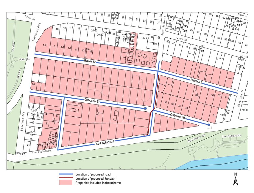
Baker Street Group of Streets
Stage |
Status |
Description |
Approval to prepare scheme |
✓ |
Decision made to prepare scheme following consideration of surveys of property owners and feed back from the community. Council may then place the project in the budget system or proceed immediately to prepare a scheme. Scheme preparation involves survey, design and preparation of an apportionment of costs. April 2015. |
Intention to Declare Scheme |
✓ |
Report to Council providing information on scheme including advice of impending advertising of scheme and declaration of charge. Seeks Council approval by resolution to proceed with process. 10 May 2016 |
Advertisement |
✓ |
The scheme is advertised in the local newspaper and all allotted property owners are notified by mail. This advertisement indicates Council’s intention and notification to ‘declare’ a scheme in a month’s time. 21 May 2016 |
Submissions |
✓ |
From the time of advertising property owners have 28 days (as set down by the Local Government Act) to lodge submissions, either in support or opposition to the scheme. |
Submissions Review Panel Hearing |
✓ |
A Submissions Review Panel is convened (quorum of three Councillors) and meets to consider submissions. Some submissions are written only, and other submitters may wish to be heard before the Panel. The Panel makes a recommendation to Council regarding the scheme. 7 September 2016 |
Declaration Report |
✓ |
Any time 28 days after advertising the scheme and after the Submissions Review Panel has met and considered submissions, Council considers a report and may proceed to “declare” the charges in accordance with its advertised intent. Subsequent to this the Finance Manager issues the levy notices and there is a formal charge placed on the property. This is the final step in the process for Council to make a decision on the scheme. |
Appeal |
|
Property owners may lodge an application for review with the Victorian Civil and Administrative Tribunal (VCAT) within one month of issue of the levy notice. An appeal is listed, heard and determined by the Tribunal and this process generally takes three to four months. Decisions made by VCAT are binding on all parties. |
Construction |
|
Council may then proceed to construct the works. Invoices are issued seeking payment of the estimated cost within one month of commencement. |
Final Cost Report |
|
At the completion of the works the scheme is “finalised” taking into account actual costs incurred and payments are adjusted accordingly. |
Source: |
City Services – Engineering Services |
Acting General Manager: |
Vicki Shelton |
Index Reference: |
Special Rates and Charges, Montpellier Drive, Highton |
This report seeks a resolution by Council to declare the charges for a Special Charge Scheme to partially fund the construction of a footpath in Montpellier Drive and Reigate Road, Highton. (See plan – Appendix 4).
Existing footpaths are in place in Lansbury Crescent to the north, Cheam Walk and Lambhill Crescent to the west and Mount Pleasant Road to the south. The construction of the Montpellier Drive and Reigate Road footpaths will provide a new link with these footpaths and improved the pedestrian network around the Montpellier Primary School.
An attempt at a Special Charge scheme was made in 2005 but this scheme was not presented to Council at the time.
The affected property owners were advised of a new scheme proposal via a mail out in June 2015. The mail out included a survey and out of the 20 properties affected by the scheme, 12 property owners responded.
The results included two (2) yes votes for the proposed footpath and 10 no votes.
On 27 January 2016, Council resolved it intention to declare the scheme and the scheme was advertised on 6 February 2016.
On 7 September 2016, a panel hearing was convened.
It is proposed to construct 440 meters of 1.5 metre wide footpath to provide for improved pedestrian access along Montpellier Drive and Reigate Road, Highton. The access is considered to be an important safety initiative for pedestrian movements around the Montpellier Primary School.
There are 20 residential properties abutting the proposed footpath that will receive special benefit. There are no Council owned properties in the scheme.
The total estimated project cost is $158,729. For a breakdown of costs, refer to the financial implications section of this report.
Council considered a separate report on 27 January 2016 and resolved to advertise its ‘intention to declare’ the scheme.
The scheme was advertised on Saturday 6 February 2016 and four (4) submissions were received. One submission showed support, one was supportive of the footpath but questioned the side of the street it is proposed to be constructed and two submissions were objections.
In the subsequent submissions panel hearing of 7 September 2016 three property owners presented to the panel in support of their submissions. After consideration, the advice from the panel was to proceed to declaration as presented.
P Dorling moved, L Gardner seconded -
That Council:
Resolves to declare the Special Charge Scheme as follows:
The Special Charge is declared for a period of five (5) years commencing upon completion of the works.
The Special Charge be declared for the purpose of defraying any expenses incurred by Council in relation to the construction of the footpath on Montpellier Drive and Reigate Road, Highton which:
Will provide proper pedestrian access, improved pedestrian safety and enhancement to the general amenity for each of the properties included in the scheme;
Council considers is or will be a special benefit to those persons required to pay the special charge (and who are described in succeeding parts of this Resolution); and
Arises out of Council’s function of planning for and providing infrastructure for property owners.
The total cost of project, be recorded as $158,729 (Schedule A).
It be recorded that, for the purposes of Section 163 (2A) of the Local Government Act 1989 (The Act), the special charge proceeds will not exceed the amount calculated in accordance with the prescribed formula (R x C = S), the:
‘benefit ratio’ (R) being calculated at 0.32 represents the special benefits to all persons liable to pay the special charge (Schedule B);
‘total cost’ (C) of performing the function described in part 1 (b) of this resolution based on estimated cost be recorded as $130,824; and
‘maximum levy’ (S) be recorded as $41,863.68
the following be specified as the area for which the special rate is so declared:
the area within municipal district of Council highlighted in the plan attached to this Resolution (Appendix 4).
the following be specified as the land in relation to which the special charge so declared:
land within the area shown on the plan.
the following be specified as the criteria which form the basis of the special charge so declared:
ownership of any land described in Part 1(e) of this Resolution.
the following be specified as the manner in which the special charge so declared will be assessed and levied:
Each lot receives an access and amenity benefit;
The maximum levy is divided equally on an access and frontage share basis;
The special charge will be levied by sending a notice to the person who is liable to pay, pursuant to section 163(4) of the Act.
having regard to the preceding parts of this Resolution but subject to Section 166 (1) of the Act, it be recorded that;
the owners of the land described in column 1 of Schedule C to the resolution are estimated liable for the respective amounts set out in column 8 of Schedule C; and
such owners may, subject to any further resolution of Council pay the special charge in the following manner;
the charge will become due and payable within one month of the issue of the notice requesting payment pursuant to Section 167 (3) of the Act;
interest will not be charged for six months after the issue of the notice provided the person liable makes timely payment in accordance with any repayment arrangements that may be agreed on by Council; and
in accordance with Section 172 of the Act, the interest rate payable on the special charge which has not been paid by the specific date is set at Council’s overdraft rate, reviewed every three months (provided that it shall not exceed the rate fixed by the Governor in Council by Order for the purposes of Section 172 (2A) in which case the rate of interest shall be the maximum rate fixed by the Governor in Council by Order for the purposes of this section).
Authorise Council’s Chief Executive Officer to levy the Special Charge in accordance with Section 163 (4) of the Act.
Carried.
When considering the Benefit Ratio for this footpath scheme, it is reasonable that a majority of cost be apportioned to the community benefit when considering the proximity of the Montpellier Primary School. With a calculated Benefit Ratio of 0.32, a majority of funding for this scheme would be coming from Council. The average cost per property is estimated at $2,093 which compares favourably to other recent footpath schemes.
Of the panel hearing of 7 September 2016, the main concerns raised and corresponding officer considerations include:
Path should be on opposite side
It is acknowledged that a footpath on both sides of Montpellier Drive would be ideal. The western side was chosen due to the existing pedestrian crossing in Montpellier Drive and the link that the footpath provided with Lansbury Crescent.
Why not put the footpath in the centre median strip
A footpath in this location is considered impractical as linkages are made more difficult with increased road crossings required for access.
Concerns regarding the welfare of trees.
There are some large trees within the nature strip that do require consideration. It is proposed to construct the footpath past these trees with a raised porous paving in order to protect the tree roots from damage.
The project is a one off capital cost and there will be minimal ongoing maintenance costs. If approved, the scheme could proceed this financial year as funding is currently set in the C15310 project cost.
Financial details are as follows:
|
Maximum scheme levy to Property Owners (income) |
$41,863.68 |
|
Scheme levy to Council |
$88,960.32 |
|
Direct Funding by Council to reinstate driveways, porous paving and construct a supporting retaining wall. |
$27,905.00 |
|
Total Project Cost |
$158,729.00 |
From the table above, the total net cost to Council for this project is estimated to be $116,865.
Community consultation for the footpath construction Special Charge Scheme has been carried out as follows:
30 June 2015 – Initiation letter including a concept plan, cost estimate, apportionment of charges, Special Rates and Charges brochure and survey to property owners.
29 January 2016 – Letter to owners advising of Council’s Intention to declare the scheme and invitation to make a submission.
17 May 2016 – Update letter to owners advising of the upcoming panel hearing and process.
7 September 2016 – Panel Hearing
5 October 2016 – Letter to owners advising of the results of the panel hearing and decision to proceed to declaration.
Some phone calls have been fielded in response to the correspondence. A further letter will be sent to all affected property owners should Council resolve to declare the Special Charge Scheme.
The scheme has been prepared in accordance with the Special Rate and Charge provisions of the Local Government Act 1989, the 2004 ministerial guidelines, Council’s Special Rates and Charges Policy and community engagement guidelines.
This report aligns with the City Plan as follows:
Sustainably Built and Natural Environment
Support our Community to live sustainably – Encourage increased use of alternatives to car transport and seek efficient traffic movement throughout the municipality.
Advocate for and promote sustainable design and development – Promoting sustainable design and retrofitting.
Acknowledge the community’s desire to have their say and be involved in planning for the future of Greater Geelong.
In preparing this report, no Council officer has any direct or indirect interest in the properties affected by the scheme.
Provision of a sealed footpath will provide safer walking conditions for pedestrians by minimising the risk of personal injuries through conflict with vehicles and the elimination of uneven and slippery surfaces.
There are no identified risks for Council in making its declaration of charge.
The provision of a sealed pathway provides a permanent and safe means of access. During construction and the manufacture and procurement of materials, energy is used resulting in some greenhouse gas emissions. This stops when construction is complete.
The project does not create waste with the exception of some excavated material.
The proposal does not affect any natural habitats.
The proposal may require some nature strip and property trees and shrubs to be trimmed. Two small nature strip trees are earmarked for removal. A specialised porous pavement is to be used around the root zones of some of the more established trees within the nature strip. This will protect and preserve the tree roots.
The works for the construction of a footpath in Montpellier Drive and Reigate Road, Highton which consist of excavation, concrete footpath, reinstatement of nature strip, miscellaneous construction works and professional services associated with survey, engineering design, drafting, supervision and administration of the project all as included in the cost estimate shown below.
SCHEME - FOOTPATH CONSTRUCTION |
|||||
ITEM |
DESCRIPTION |
QUANTITY |
UNIT |
RATE |
AMOUNT |
|
1.00 |
GENERAL |
|
|
|
|
|
1.01 |
Initial site establishment and set up, decamping and site cleanup and other fixed costs up to time of completion of works. |
1 |
item |
$12,000.00 |
$12,000.00 |
|
1.02 |
Traffic management costs. |
1 |
item |
$4,300.00 |
$4,300.00 |
|
1.03 |
Setting out of works. |
1 |
item |
$500.00 |
$500.00 |
|
1.04 |
Service/Cable locations |
1 |
item |
$1,000.00 |
$1,000.00 |
|
1.05 |
Internal supervision fee (COGG construction) |
1 |
item |
$6,500.00 |
$6,500.00 |
|
2.00 |
EARTHWORKS and DEMOLITION |
|
|
|
|
|
2.01 |
Excavation and disposal of all materials to limits of work as indicated on plan, including trimming for new road pavement, excavation of soft spots and removal of concrete. |
20 |
m3 |
$60.00 |
$1,200.00 |
|
2.02 |
Saw-cut of concrete and asphalt paving |
1 |
item |
$250.00 |
$250.00 |
|
2.03 |
Remove/Trim of overhanging branches and replacement of trees and disposal as per plan. |
1 |
item |
$1,000.00 |
$1,000.00 |
|
3.00 |
PAVEMENT WORKS |
|
|
|
|
|
3.01 |
Supply, place and compaction of 20mm Class 2 FCR in pavement area in front of kerb and channel to 300mm deep including, 30mm compacted depth 10mm nominal size type N Asphalt spread and compacted including emulsion prime and grit. |
7 |
m2 |
$155.00 |
$1,085.00 |
|
3.02 |
Porous paving construct sub and top surface layers including edging, supplied, spread and compacted. |
106 |
m2 |
$280.00 |
$29,680.00 |
|
4.00 |
CONCRETE WORKS: |
|
|
` |
|
|
4.01 |
Concrete pram crossing 1.5m wide, including fine crushed rock bedding. |
2 |
No. |
$250.00 |
$500.00 |
|
4.02 |
125mm (25 Mpa) concrete paving with SL72 mesh including crushed rock bedding and reinstate nature strip. |
531 |
m2 |
$125.00 |
$66,375.00 |
|
5.00 |
SERVICES |
|
|
|
|
|
5.01 |
Alteration to Telecommunication Assets |
1 |
item |
$500.00 |
$500.00 |
|
6.00 |
LANDSCAPING |
|
|
|
|
|
6.01 |
Top soiling and seeding nature strips. |
70 |
m2 |
$8.00 |
$560.00 |
|
SUB-TOTAL: |
$125,450 |
||||
|
10% CONTINGENCY: |
$12,545 |
||||
|
Design |
$7,527 |
||||
|
Project Administration |
$5,018 |
||||
|
CONSTRUCTION COST ESTIMATE |
$150,540 |
||||
COUNCIL FUNDED WORKS – Driveway re-establishment, porous paving and retaining wall |
|||||
ITEM |
DESCRIPTION |
QUANTITY |
UNIT |
RATE |
AMOUNT |
1.00 |
GENERAL |
|
|
|
|
1.01 |
Initial site establishment and set up, decamping and site cleanup and other fixed costs up to time of completion of works. |
1 |
item |
$1,000.00 |
$1,000.00 |
1.02 |
Traffic management costs. |
1 |
item |
$500.00 |
$500.00 |
1.03 |
Internal supervision fee (COGG construction) |
1 |
item |
$500.00 |
$500.00 |
2.00 |
PAVEMENT WORKS |
|
|
|
|
2.01 |
Porous paving construct sub and top surface layers including edging, supplied, spread and compacted. |
106 |
m2 |
$155.00 |
$16,430 |
3.00 |
CONCRETE WORKS: |
|
|
` |
|
3.01 |
Reinforced Concrete Retaining Wall and Footing with F62 mesh including 75mm compacted depth Class 3 FCR bedding and reinstate nature strip. |
5 |
m |
$410.00 |
$2,050.00 |
3.02 |
Remove existing concrete paving and construct 125mm (25 Mpa) concrete paving with SL72 mesh including crushed rock bedding and reinstate nature strip. |
19 |
m2 |
$146.00 |
$2,774.00 |
|
SUB-TOTAL: |
$23,254 |
||||
|
10% CONTINGENCY: |
$2,325 |
||||
|
Design |
$1,395 |
||||
|
Project Administration |
$930 |
||||
|
CONSTRUCTION COST ESTIMATE |
$27,905 |
||||
A |
Purpose |
|
|||||
|
To construct a footpath in Montpellier Drive and Reigate Road, Highton to provide all weather pedestrian access for property owners and the wider community. |
|
|||||
|
|||||||
B |
Coherence |
|
|||||
|
The works will provide a physical pathway connection between Mt Pleasant Road and Lansbury Crescent, between Reigate Road and Culzean Crescent and will provide a special benefit to adjoining and remote properties. |
|
|||||
|
|||||||
C |
Total Cost C |
|
|||||
|
Total Estimated cost of works - footpath construction |
$158,729.00 |
|||||
|
Direct funding by Council to rebuild concrete driveways, a new reinforced concrete retaining wall and contribution towards porous paving |
$27,905 |
|||||
|
TOTAL COST |
|
$130,824 |
||||
D |
Identify Special Beneficiaries |
|
|||||
|
20 properties with frontages to the proposed footpath are considered to receive access and amenity benefits. |
|
|||||
|
|||||||
E |
Properties to include |
|
|||||
|
The 20 abutting properties receive both access and amenity benefits. Therefore: |
|
|||||
|
Total Special Benefits (in) is apportioned to 20 properties |
|
|||||
|
There are no Council owned properties in the scheme. Therefore: |
|
|||||
|
Total Special Benefits out of the scheme |
TSB (out) |
= |
|
0 |
|
|
|
|||||||
F |
Estimate of Total Special Benefits |
|
|||||
|
For this scheme it is considered that the greater proportion of benefit is for pedestrian access given the purpose of the scheme. Therefore it is estimated that 80% of the benefits relate to access and 20% to amenity. Estimated pedestrian use of the paths is 85% for the wider community and 15% for abutting property owners. Amenity benefits are based on frontage with 100% of the footpaths fronting benefiting properties. TSB (in) is therefore calculated as follows: |
|
|||||
|
TSB (in) = 80% X 15%(access) + 20% X 100% (amenity) = |
32% |
|
||||
|
|||||||
G |
Estimate of Total Community Benefit -TCB |
|
|||||
|
It is considered that people in the community will receive a benefit from the works as the pathway is used to access other areas. There are no amenity benefits considered for the wider community. TCB is calculated as follows: |
|
|||||
|
TCB = 80% X 85% = |
68% |
|
||||
|
|||||||
H |
Calculate "Benefit Ratio" - R |
|
|
|
|
|
|
|
Benefits Ratio = |
TSB (in) |
= |
32 |
0.32 |
|
|
|
|
TSB (in) + |
TSB (out) + TCB |
|
32 + 0 + 68 |
|
|
|
|||||||
I |
Maximum Total Levy (S) |
|
|||||
|
Maximum Total Levy S = R X C |
$41,863.68 |
|||||
|
Council Contribution to Special Charge Scheme |
$88,960.32 |
|||||
|
COLUMN 1 |
COLUMN 2 |
COLUMN 3 |
COLUMN 4 |
COLUMN 5 |
COLUMN 6 |
COLUMN 7 |
COLUMN 8 |
|
|
PROPERTY ADDRESS |
FRONTAGE (metres) |
ALLOWANCE FOR DRIVEWAY |
APPORTIONABLE FRONTAGE (metres) |
ACCESS BENEFIT UNIT |
ACCESS BENEFIT |
AMENITY BENEFIT |
ESTIMATED COST ($) |
1 |
2 Montpellier Drive, HIGHTON VIC 3216 |
16.48 |
2.30 |
14.18 |
1.00 |
$1,268.60 |
$781.00 |
$2,049.60 |
2 |
4 Montpellier Drive, HIGHTON VIC 3216 |
16.00 |
4.04 |
11.96 |
1.00 |
$1,268.60 |
$658.63 |
$1,927.22 |
3 |
6 Montpellier Drive, HIGHTON VIC 3216 |
16.00 |
2.90 |
13.10 |
1.00 |
$1,268.60 |
$721.40 |
$1,989.99 |
4 |
8 Montpellier Drive, HIGHTON VIC 3216 |
19.20 |
2.52 |
16.68 |
1.00 |
$1,268.60 |
$918.53 |
$2,187.13 |
5 |
10 Montpellier Drive, HIGHTON VIC 3216 |
19.20 |
0.00 |
19.20 |
0.50 |
$ 634.30 |
$1,057.28 |
$1,691.58 |
6 |
12 Montpellier Drive, HIGHTON VIC 3216 |
18.29 |
0.00 |
18.29 |
0.50 |
$ 634.30 |
$1,006.94 |
$1,641.24 |
7 |
14 Montpellier Drive, HIGHTON VIC 3216 |
22.86 |
3.76 |
19.10 |
1.00 |
$1,268.60 |
$1,051.65 |
$2,320.24 |
8 |
16 Montpellier Drive, HIGHTON VIC 3216 |
18.29 |
4.40 |
13.89 |
1.00 |
$1,268.60 |
$764.67 |
$2,033.27 |
9 |
18 Montpellier Drive, HIGHTON VIC 3216 |
24.38 |
4.40 |
19.98 |
1.00 |
$1,268.60 |
$1,100.32 |
$2,368.92 |
10 |
20 Montpellier Drive, HIGHTON VIC 3216 |
16.31 |
0.00 |
16.31 |
0.50 |
$ 634.30 |
$897.85 |
$1,532.15 |
11 |
22 Montpellier Drive, HIGHTON VIC 3216 |
20.47 |
0.00 |
20.47 |
0.50 |
$ 634.30 |
$1,127.21 |
$1,761.51 |
12 |
24 Montpellier Drive, HIGHTON VIC 3216 |
24.38 |
4.80 |
19.58 |
1.00 |
$1,268.60 |
$1,078.30 |
$2,346.89 |
13 |
25 Montpellier Drive, HIGHTON VIC 3216 |
26.57 |
4.10 |
22.47 |
1.00 |
$1,268.60 |
$1,237.11 |
$2,505.71 |
14 |
26 Montpellier Drive, HIGHTON VIC 3216 |
21.34 |
5.38 |
15.96 |
1.00 |
$1,268.60 |
$878.54 |
$2,147.13 |
15 |
27 Montpellier Drive, HIGHTON VIC 3216 |
22.86 |
4.95 |
17.91 |
1.00 |
$1,268.60 |
$986.12 |
$2,254.72 |
16 |
28 Montpellier Drive, HIGHTON VIC 3216 |
21.33 |
0.00 |
21.33 |
0.50 |
$ 634.30 |
$1,174.32 |
$1,808.62 |
17 |
29 Montpellier Drive, HIGHTON VIC 3216 |
19.81 |
4.23 |
15.58 |
0.50 |
$ 634.30 |
$857.95 |
$1,492.24 |
18 |
262 Mt Pleasant Road, HIGHTON VIC 3216 |
38.10 |
2.50 |
35.60 |
0.50 |
$ 634.30 |
$1,960.14 |
$2,594.43 |
19 |
44 Reigate Road, HIGHTON VIC 3216 |
29.04 |
3.70 |
25.34 |
1.00 |
$1,268.60 |
$1,395.49 |
$2,664.09 |
20 |
46 Reigate Road, HIGHTON VIC 3216 |
26.24 |
3.02 |
23.22 |
1.00 |
$1,268.60 |
$1,278.39 |
$2,546.99 |
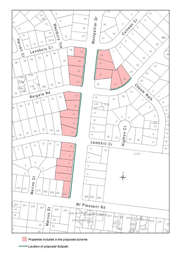
MONTPELLIER DRIVE and REIGATE ROAD, HIGHTON – PROPOSED FOOTPATH
Stage |
Status |
Description |
Approval to prepare scheme |
✓ |
Decision made to prepare scheme following consideration of surveys of residents and feed back from the community. Council may then place the project in the budget system or proceed immediately to prepare a scheme. Scheme preparation involves survey, design and preparation of an apportionment of costs. June 2015 |
Intention to Declare Scheme |
✓ |
Report to Council providing information on scheme including advice of impending advertising of scheme and declaration of charge. Seeks Council approval by resolution to proceed with process. 27 January 2016. |
Advertisement |
✓ |
The scheme is advertised in the local newspaper and all allotted property owners are notified by mail. This advertisement indicates Council’s intention and notification to ‘declare’ a scheme in a month’s time or at a subsequent meeting. 6 February 2016. |
Submissions |
✓ |
From the time of advertising property owners have 28 days (as set down by the Local Government Act) to lodge submissions, either in support or opposition to the scheme. Closed 7 March 2016. |
Submissions Review Panel Hearing |
✓ |
A Submissions Review Panel is convened if required (quorum of three Councillors) and meets to consider submissions. Some submissions are written only, and other submitters may wish to be heard before the Panel. The Panel makes a recommendation to Council regarding the scheme. 7 September 2016. |
Declaration Report |
✓ |
Any time 28 days after advertising the scheme and after the Submissions Review Panel has met and considered submissions, Council considers a report and may proceed to “declare” the charges in accordance with its advertised intent. Subsequent to this the Finance Manager issues the levy notices and there is a formal charge placed on the property. This is the final step in the process for Council to make a decision on the scheme. |
Appeal |
|
Property owners may lodge an application for review with the Victorian Civil and Administrative Tribunal (VCAT) within one month of issue of the levy notice. An appeal is listed, heard and determined by the Tribunal and this process generally takes three to four months. Decisions made by VCAT are binding on all parties. |
Construction |
|
Council may then proceed to construct the works. Invoices are issued seeking payment of the estimated cost within one month of commencement. |
Final Cost Report |
|
At the completion of the works the scheme is “finalised” taking into account actual costs incurred and payments are adjusted accordingly. |
Source: |
Chief Executive Office - Corporate Internal Auditor |
CEO: |
Kelvin Spiller |
Index Reference: |
Audit - CG - Internal |
To rescind the previous Audit Advisory Committee Terms of Reference and Charter and to adopt the proposed Audit and Risk Committee Charter.
A review by the Audit Advisory Committee of the current Charter has been undertaken. The proposed new Audit and Risk Committee Charter (Attachment 1) and the current Audit Advisory Committee Terms of Reference and Charter (Attachment 2) are attached.
The name of the Committee has been changed to the Audit and Risk Committee to more accurately describe its purpose.
The Audit and Risk Committee Charter is based on current good practice whilst recognising relevant sector guidance. In addition, the revisions incorporate what fits best for Council in terms of good governance.
The Charter provides a better structure within the document so that its purpose, role and its administration are more clearly articulated:
to clarify the responsibilities of the Committee and remove details that were at times inconsistent and overlapping;
to change the length of the terms of the independent members to two full three year terms;
to provide a maximum of two, three year terms for independent members;
to exclude reference to independent member remuneration; and
to separate the Committee’s Charter from the Internal Audit Charter.
The revised Charter will enable the Committee to establish a more effective Annual Work Plan to support Council.
The proposed Charter has been endorsed by the Audit Advisory Committee.
A review of the Audit and Risk Committee Charter document will be undertaken every two years or earlier if necessary.
L Gardner moved, P Dorling seconded -
That Council:
rescinds the Audit Advisory Committee Terms of Reference and Charter (Attachment 2); and
adopts the Audit and Risk Committee Charter (Attachment 1).
Carried.
Contents | Previous Page: Section A - Procedural Matters | Next Page: Section C - Assembly of Councillors
