
Council Minutes - Section B: Reports - 12 December 2017
Contents | Previous Page: Section A - Procedural Matters | Next Page: Section C - Assembly of Councillors
Contents | Previous Page: Section A - Procedural Matters | Next Page: Section C - Assembly of Councillors
Reports tabled at the Ordinary Meeting of Council on Tuesday date held at the Council Conference and Reception Centre in City Hall, 57 Little Malop Street, Geelong.
Revocation of Flood Prone Area Designation of New Lots at Armstrong Creek, Stage 3
Revocation of Flood Prone Area Designation of New Lots at Watermark, Stage 4 and 5
Tender T1770859 – Construction of Highton Enhanced Children’s Centre (Confidential)
Tender T1770870 – Provision of Cleaning Services at the City of Greater Geelong Family Services Centre (Confidential)
Source: |
Planning and Development |
Director: |
Kelvin Walsh |
Index Reference: |
Amendment C357 |
To recommend that Council adopts Planning Scheme Amendment C357 (the Amendment) as exhibited and refers it to the Minister for Planning for approval.
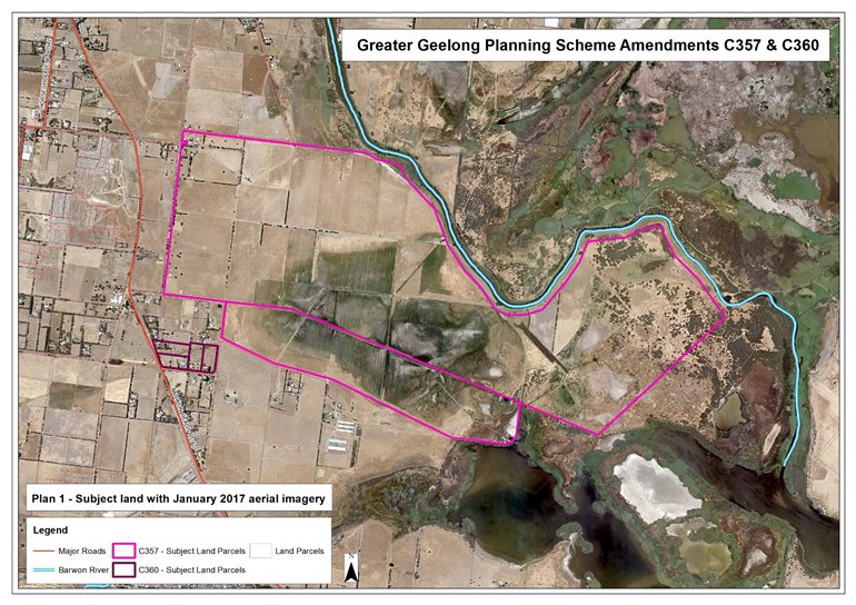
The Amendment proposes a Public Acquisition Overlay (PAO) on approximately 420 hectares of land at 109-215 Sparrovale Road, Charlemont known as “Sparrovale Farm”and the entire land parcel at 1-87 Groves Road, Armstrong Creek known as “Cold Winds”. Both parcels of land are required for end-of-line drainage for the Armstrong Creek Horseshoe Bend Precinct. Attachment 2 shows the location of the subject land parcels.
The Horseshoe Bend Precinct Structure Plan (HBPSP) and the Horseshoe Bend Development Contributions Plan (HBDCP) were incorporated into the Greater Geelong Planning Scheme in November 2014.
Development within the Horseshoe Bend Precinct is limited until the parcels of land at 109-215 Sparrovale Road, Charlemont and 1-87 Groves Road, Armstrong Creek (referred to above) are acquired for the purposes of an end-of-line drainage solution for the management of storm water for the precinct. Drainage onto the land will protect the Ramsar wetlands system to the east and will allow the land to be ultimately developed as public open space (Sparrovale Wetlands).
Both developer and Council attempts to negotiate the purchase of the two land parcels, which are the subject of the Amendment, have been unsuccessful. As a result Council resolved, on 27 September 2016, to seek Ministerial Authorisation to exhibit the Amendment. The Amendment was exhibited between 12 December 2016 and 15 February 2017. Submissions were referred to an Independent Panel (the Panel) appointed by the Minister for Planning. The Panel Hearing was held on 6 and 7 September 2017 and a copy of the Panel report is provided in Attachment 3.
Ten submissions were received in respect of the Amendment, including 3 objections. Two of the objections, being objections by the land owners which are the subject of the Amendment, were withdrawn prior to the Panel hearing.
After considering the remaining objection, the Panel recommended that the Amendment be adopted as exhibited.
The PAO will allow Council to commence compulsory acquisition processes in accordance with the Land Acquisition and Compensation Act 1986 (LACA).
Delivery of the of the drainage solution is vital for the on-going development of the Horseshoe Bend Precinct and the majority of the Armstrong Creek growth area and will require Council funding in addition to funds from developer contributions.
Cr Nelson moved, Cr Murnane seconded -
That Council resolves to:
Adopt Planning Scheme Amendment C357 in the form as exhibited between 12 December 2016 and 15 February 2017; and
Refer the adopted Amendment C357 to the Minister for Planning for approval.
Carried.
The acquisition cost for the Amendment land parcels are part funded as separate projects within the HBDCP.
As a result of the land being acquired under the provisions of the LACA, developer contributions funding is insufficient to give effect to the acquisition.
Latest estimate of projects associated with the Amendment over a five year period are shown in the following table and can be compared to estimates included in the four year Strategic Resource Plan (SRP) adopted as part of the 2017-18 Budget.
Year |
Latest Estimate |
2017-18 SRP |
Variance (Inc.) / Dec |
2017-18 |
$4.7m |
$4.7m |
$0 |
2018-19 |
$9.5m |
$1.8m |
($7.7m) |
2019-20 + |
$2.8m |
$2.6m |
($0.2m) |
Subtotal |
$17.0m |
$9.1m |
($7.9m) |
Council can be expected to recover cash from the HBDCP over the next twenty years. However, in the short term the funding requirements are assumed as loan borrowings and form part of Council’s borrowing commitments in the four year SRP. Council’s loan borrowings will need to be increased for 2018-19 and beyond and this will need to be factored into the 2018-19 SRP calculations.
An audit of the total projected cost of infrastructure, land acquisition, and other developer contributions items within the Armstrong Creek Urban Growth Area is currently being undertaken. This cost, together with projected revenue from other sources, will be included in a report to Council early in 2018 together with a funding strategy to ensure commitments can be met.
The shortfall in funding for the land acquisition will be recovered from an adjustment to forward project commitments for Armstrong Creek. A full analysis of Developer Contribution Plans is underway as well as a review of funding available for Armstrong Creek infrastructure.
The Amendment was exhibited between 12 December 2016 and 15 February 2017. Ten submissions were made to the Amendment including 3 objections. Two of the objections were from the land owners which are the subject of the amendment. Those objections were withdrawn 3 days prior to the Panel hearing commencing. The remaining objection was considered by the Panel.
The preparation and exhibition of the Amendment has been undertaken in accordance with Council’s Social Equity principles.
Communications were designed to address the particular needs and obstacles faced by priority areas and groups and all consultation was conducted with the aim of fully understanding the needs and wants of the affected land holders.
The Amendment is in accordance with the vision and intent of both the HBPSP and HBDCP. Both documents are incorporated into the Greater Geelong Planning Scheme and Council is bound, in accordance with the Planning and Environment Act 1987, to deliver the nominated infrastructure items.
The land acquisition component of the amendment is subject to the provisions of the LACA.
The Armstrong Creek Urban Growth Plan is nominated in the City Plan as integral to the delivery of Council’s Sustainable built and natural environmentstrategic direction.
The delivery of the Sparrovale Wetlands will result in significant enhancement to an existing ecosystem whilst ensuring that the urban development occurring now, and into the future, will have a significantly reduced negative environmental footprint.
In addition, the wetlands will also provide significant areas of passive open space which contributes to the Community Wellbeingstrategic direction in the City Plan.
No Council officers or contractors involved in the preparation of this report have a conflict of interest regarding the matter under consideration.
Development within the Horseshoe Bend Precinct is limited until such time as the land for drainage is secured and made available to receive storm water runoff.
Council has issued planning permits for approximately 3,500 lots since the HBPSP was incorporated into the Greater Geelong Planning Scheme. Dependent on location within the Precinct, and the direction of storm water flow, all the planning permits issued for development with the Horseshoe Bend Precinct have a condition that restricts development to either a total number of hectares or 25% of approved lots. The condition is a direct response to Appendix 9 of the HBPSP which summarises the development limits nominated in the Horseshoe Bend Storm Water Management Strategy.
Strong residential land sales within the Horseshoe Bend Precinct has resulted in development having reached the threshold. As a result, construction on the 3 active residential estates in the precinct may soon be forced to cease until the Sparrovale Wetlands are acquired and commissioned to receive storm water.
The application of a PAO will result in financial risks associated with the compulsory acquisition process and the consequent heads of compensation and other land owner costs that will be paid.
There are a number of positive environmental outcomes that will be achieved through the purchase and establishment of the Sparrovale Wetlands.
The primary purpose of the Sparrovale Wetlands is the establishment of a fully functioning storm water management system, in accordance with the Horseshoe Bend Storm Water Management Strategy, utilising principles of Water Sensitive Urban Design (WSUD).
The treatment of storm water using WSUD principles significantly reduces the negative impact that untreated storm water has on our rivers, bays and beaches.
The Sparrovale Wetlands will, when operational, will have a positive impact on the overall health of our waterways by:
reducing the speed of urban storm water runoff during rain events reducing erosion potential; and
removing rubbish and reducing the nutrient levels in the water.
The Sparrovale Wetlands will also, when fully constructed, receive seasonal flows from the Armstrong Creek. Diversion of seasonal flows to the Sparrovale Wetland removes the risk of any potential harm to the Ramsar listed Connewarre wetland system from an increase in the volume of freshwater entering the system as a result of urban development.
Clause 56.07-4 of the Greater Geelong Planning Scheme nominates a number of requirements that need to be met to maintain pre-development flows and meet best practice in storm water treatment and management for urban development. The HBPSP and Horseshoe Bend Storm Water Management Strategy also set expectations that must be met to manage storm water during and post urban development.
The acquisition of the entire land parcel at 1-87 Groves Road and that part of the land parcel at 109-215 Sparrovale Road that is subject to inundation during 1 in 100 year flood events is key to the management of storm water generated by the development of the Horseshoe Bend Precinct but can also accommodate seasonal flows from the neighbouring Armstrong Creek.
There will be significant passive recreation benefits to the wider community as a result of acquisition.
The Barwon River Parklands Strategy 2011 and the G21 Implementation Plan both nominate significant linear open space areas along the Barwon River which are envisioned to provide a contiguous passive recreation and pathway link between Geelong and Barwon Heads. The river frontage of Sparrovale Farm will contribute a significant area of land for this purpose.
Whilst a vision for the development of the area around the wetlands is yet to be established the significant land area may offer walking trails, bird watching, heritage interpretation opportunities and environmental interpretation, education and protection.
The Amendment was considered by the Panel with Amendment C360 (which is not the subject of this Report, but affects neighbouring land).
A total of 10 submissions were received during exhibition of the Amendment. Of these, 3 were objections to the proposed PAO, two of those being land owner objections. The land owner objections were withdrawn prior to the Panel hearing commencing, with the remaining objection being considered by the Panel during its assessment of submissions and is discussed below.
The Panel was convened on September 6 and 7 2017 during which time Panel heard submissions in support of the Amendment from Council, the Dennis Family Corporation on behalf of their Ashbury Estate development, Spiire on behalf of the developer of the Charlemont Rise Estate, the Department of Environment, Land, Water and Planning and ID Land on behalf of their Watermark Estate development.
The remaining objection related to current flooding being generated by development on the west side of Barwon Heads Road. The Panel sought advice from a water modelling expert who indicated that the current flooding of the area surrounding the objectors property would cease once the infrastructure nominated in the Horseshoe Bend Storm Water Management Strategy is constructed. This includes the proposed retarding basin and overland flow path that is the subject of Amendment C360 and the Sparrovale Wetlands.
The Panel were satisfied that the amendment is technically appropriate and that Council should work with developers to mitigate flooding risks to downstream properties prior to the construction of all the drainage infrastructure nominated in the HBPSP and HBDCP.
The Panel recommended that the Amendment be adopted, as exhibited.
The Panel made the following further recommendation that is specific to the concerns of the objector to the Amendment:
“The Council and the developers of the Horseshoe Bend Precinct should implement appropriate interim measures to minimise flooding risks for the downstream properties while the final storm water infrastructure is being constructed.”
Council officers, particularly Council’s engineering staff, have commenced working with developers to implement measures for storm water management that attempt to mitigate flooding risks for downstream properties. For these measures to be effective developers will need to design solutions that deal with the overall volume of water that is, and will continue to be, generated by urban development of the west side of Barwon Heads Road.
Source: |
Planning & Development |
Director: |
Kelvin Walsh |
Index Reference: |
Amendment C360 |
To recommend that Council abandons Planning Scheme Amendment C360 (the Amendment) and proceeds with an underground bypass drainage pipeline along the Council managed Boundary and Harriott Roads as an alternative solution to the drainage need for the Horseshoe Bend Precinct.
The Horseshoe Bend Precinct Structure Plan (HBPSP) and associated Horseshoe Bend Development Contributions Plan (HBDCP) nominate land acquisition and construction of drainage infrastructure across the four land parcels at 661-669 Barwon Heads Road and 619-639, 641-655 and 657-669 Boundary Road, Charlemont.
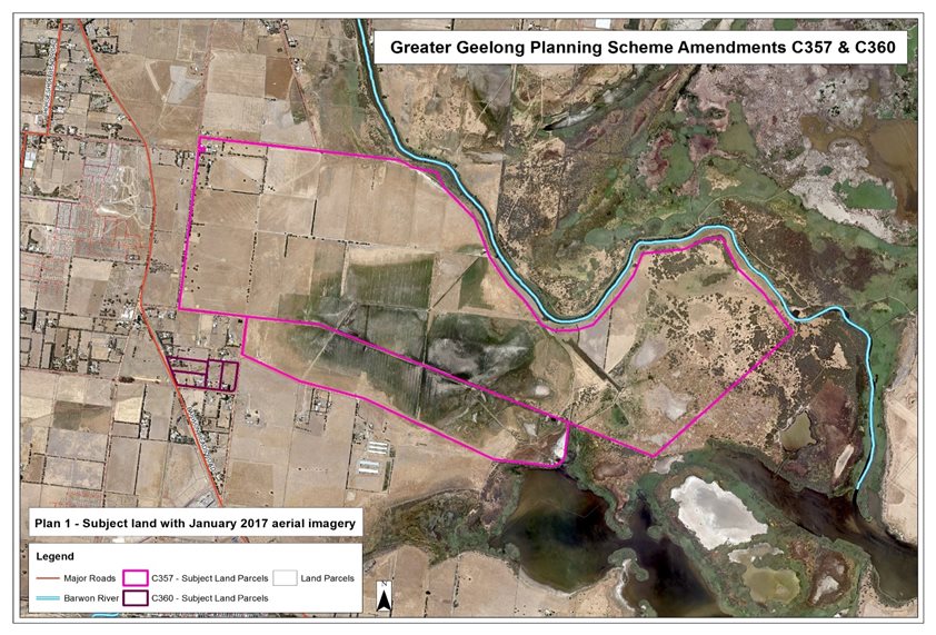
The infrastructure is required to convey storm water from the west side of Barwon Heads Road into Sparrovale Wetlands. Attachment 2 shows the location of the subject land.
The Amendment proposes a Public Acquisition Overlay (PAO) on portions of land at 661-669 Barwon Heads Road and 619-639, 641-655 and 657-669 Boundary Road, Charlemont to enable land to be acquired by compulsory acquisition to accommodate a retarding basin and overland flow path for the retardation, treatment and conveyance of storm water into the Sparrovale Wetlands. This land is already a natural drainage path.
The Amendment was exhibited between 12 December 2016 and 15 February 2017. Ten submissions were received, three of which were objections. The submissions were referred to an Independent Panel (the Panel) appointed by the Minister for Planning. The Panel Hearing was held on 6 and 7 September 2017 and a copy of the Panel report is provided in Attachment 3.
The 3 objections were from land owners directly affected by the proposed PAO raising concern about the loss of their land, alignment of the proposed PAO boundary and requesting the consideration of other storm water conveyance options by Council that do not involve compulsory acquisition.
Council officers have investigated an alternative solution to the compulsory acquisition of land which proposes a bypass drainage pipeline along the Council managed Boundary and Harriott Roads with the capacity to convey excess peak flows attributable to urban development into the Sparrovale Wetlands (the Alternative Solution).
The Alternative Solution will carry the urban run-off, allowing the natural flow and major storm events to continue onto the land owners land.
Under the Alternative Solution, if the land owners wish to develop their land in the future, a master plan will be required for the 15 properties in their sub-precinct and the existing drainage path will have to be transferred to Council as a reserve to manage drainage in the sub-precinct. This may not occur for some years however.
Cr Nelson moved, Cr Murnane seconded -
That Council:
Abandon planning scheme Amendment C360 and the consequent compulsory acquisition of 661-669 Barwon Heads Road and 619-639, 641-655 and 657-669 Boundary Road, Charlemont.
Proceed with the design and construction of an underground bypass drainage pipeline along the Council managed Boundary and Harriott Roads to convey the excess peak flows generated by urban development within the Horseshoe Bend Precinct.
Carried.
Council has the management and control of:
public sewers and drains within its municipal district; and
sewers and drains in and under roads in its municipal district; and
and works and materials relating to those sewers and drains
except those that are vested in a Minister, the Crown or other public body under section 198 of the Local Government Act 1989.
Clause 56.07-4 of the Greater Geelong Planning Scheme nominates a number of requirements that need to be met to maintain pre-development flows and meet best practice in storm water treatment and management for urban development. The HBPSP and Horseshoe Bend Storm Water Management Strategy also set expectations that must be met to manage storm water during and post urban development.
The acquisition of the land referred to in this Report for a retarding basin and overland flow path will allow passage of storm water from the west side of Barwon Heads Road to be retarded, treated and released into the Sparrovale Wetlands along an enhanced environmental waterway. Internal engineering investigations have determined that, whilst the Alternative Solution will also achieve these objectives, the existing floodway (land at 661-669 Barwon Heads Road and 619-639, 641-655 and 657-669 Boundary Road, Charlemont) will still be subject to flooding as pre-development storm water runoff will continue. However, this runoff will not be attributable to development within the Horseshoe Bend Precinct, but rather is a pre-existing condition. The increased storm water volumes and flow rates produced from development in Horseshoe Bend Precinct can be resolved by the conveyance of flow through the Alternative Solution.
The HBDCP nominates and costs of infrastructure required for the Horseshoe Bend Precinct and apportions the total cost of land and construction across the Precinct. The costs are broken down into a per hectare dollar value which is payable as cash, or constructed by developers as ‘works-in-kind’, as urban development occurs.
The HBDCP nominates funding for land acquisition and construction costs for intersection works, community facilities, drainage infrastructure and active sporting facilities. Each capital project cost is revalued annually, using relevant building indexes, and each land area to be acquired is revalued. The annual revaluation of works and land results in an updated per hectare rate.
The acquisition costs for the four land parcels that are the subject of the Amendment are part funded as separate projects within the HBDCP.
Requires amendment to budget.
The total cost to Council to deliver the drainage solution identified in the HBPSP, including both construction costs and compulsory land acquisition, is $4.7m. Council can expect to recover up to $4.2m from the HBDCP over the next 20 years for this purpose. The 2017-18 budget includes $1.7m for this project.
If Council resolves to adopt the Amendment, future year Budget proposals will be presented to Council to fund the balance of acquisition of all land parcels.
Under the Alternative Solution, the total cost to Council of using existing road reserves as the location for the proposed bypass drain is expected to be $1.4m. Existing Budget funds for acquisition will be reallocated to fund the construction. No costs will be recoverable under the HBDCP as the Alternative Solution has not been identified as a HBDCP item.
The Alternative Solution is able to be designed and constructed within the next 12 months.
Environmental outcomes are achieved through the purchase and establishment of the retarding basin and overland flow path that will ultimately deliver storm water into the Sparrovale Wetlands include the establishment of a fully functioning storm water management system, delivered in accordance with the Horseshoe Bend Storm Water Management Strategy and utilising principles of Water Sensitive Urban Design (WSUD).
The treatment of storm water using WSUD principles significantly reduces the negative impact that untreated storm water has on our rivers, bays and beaches.
The retarding basin and overland flow path, when operational, will have a positive impact on the overall health of our waterways by:
reducing the speed of urban storm water runoff flows during rain events reducing erosion potential; and
removing rubbish and reducing the nutrient levels in the water.
The Alternative Solution also maintains the objectives of environmental protection of waterways including the management development-derived runoff.
The Amendment 0 was exhibited between 12 December 2016 and 15 February 2017 with a total of 10 submissions received/ .
The preparation and exhibition of the Amendment was undertaken in accordance with Council’s Social Equity considerations.
Communications were designed to address the particular needs and obstacles faced by priority areas and groups and all consultation was conducted with the aim of fully understanding the needs and wants of the affected land holders.
The Amendment is in accordance with the vision and intent of both the HBPSP and HBDCP. Both documents are incorporated into the Greater Geelong Planning Scheme and Council is required to deliver infrastructure to address development impacts on surrounding properties such as the management of excess runoff.
The land acquisition component of Amendment C360 is subject to the provisions of the. Land Acquisition and Compensation Act 1986 (LACA).
The Armstrong Creek Urban Growth Plan is nominated in City Plan as integral to the delivery of Council’s Sustainable built and natural environmentstrategic direction.
The purchase of land and construction of the retention basin and overland flow path provides an area for a fully landscaped, environmentally sensitive conveyance of storm water into the Sparrovale Wetlands. The delivery of the Sparrovale Wetlands, the end of line drainage asset for the precinct, will result in enhancement to an existing ecosystem whilst ensuring that the urban development occurring now, and into the future, will have a significantly reduced negative environmental footprint.In addition, the overland flow path will also provide a landscaped area of passive open space and off road pathway which contributes to the Community Wellbeingstrategic direction nominated in City Plan. The off road path is designed and located to encourage pedestrians to access the Sparrovale Wetlands.
No Council officers or contractors involved in the preparation of this report have a conflict of interest regarding the matter under consideration.
Development within the Horseshoe Bend Precinct is limited until such time as the land for drainage is secured and made available to receive storm water runoff.
The Amendment will enable the conveyance of flows from the west side of Barwon Heads Road into the Sparrovale Wetlands end of line drainage solution, consistent with the HBPSP and the Horseshoe Bend Storm Water Strategy. The Alternative Solution will deliver the same practical outcome, but is a drainage solution that is not consistent with the HBPSP or the Horseshoe Bend Storm Water Strategy.
A total of 10 submissions were received during the exhibition of the Amendment. Of these, 3 submissions were objections to the proposal.
The Amendment was considered by the Panel in conjunction with Amendment C357 (which is not the subject of this Report, but affects neighbouring land, being the ultimate end of line Sparrovale Wetlands)
Objections to the proposed PAO related to the amount of land proposed to be acquired, alignment of the proposed PAO boundary and alternative options, flooding and safety due to future public access in the area to be acquired.
In summary Panel responded to these concerns as follows:
to the extent that there may be some question about the precise area of land which is ultimately required for a project, there are subsequent stages and milestones available whereby the area of land to be acquired can be reduced. Section 107 of the Planning and Environment Act 1987enables a land owner to claim;
that the land owners will be compensated according to the relevant legislation;
it is beyond the scope of the Panel to comment on obligations and procedures under the LACA ;
the application of the PAO is required, warranted and strategically justified.
The Panel were satisfied that the Amendment is technically appropriate and that Council should work with developers to mitigate flooding risks to downstream properties prior to the construction of all the drainage infrastructure nominated in the HBPSP and HBDCP.
The Panel recommended that Amendment 360 be adopted, as exhibited and made the following further recommendation specific to Amendment C360:
The alignment of the waterway through properties affected by C360 should be designed within the affected properties to generally follow the alignment of the existing property boundaries and the extent of any land ultimately required should be minimised.
Council officers have balanced the relevant cost and benefits of both the Amendment and the Alternative Solution. The acceptance of the Alternative Solution would avoid the need for compulsory acquisition processes across the subject land. However, the Alternative Solution does not address the pre-development floodway status of the land.
Both the Amendment and the Alternative Solution deliver similar outcomes with respect to the management of development-derived runoff and as the Drainage Authority, Council recognises the benefits flowing from the adoption of the Amendment in order to provide control over land and to undertake works in accordance with the adopted Horseshoe Bend Storm Water Management Strategy. However, this view must be balanced against the cost implications of adopting and proceeding with Amendment C360 and the impact of a compulsory acquisition process and the infrastructure construction processes on the affected landowners.
As noted, a workable and cost-effective engineering option is available that will maintain storm water runoff to pre-development levels, such that a PAO as detailed in the Amendment is not required.
Source: |
Planning and Development |
Director: |
Andrew Keen |
Index Reference: |
Application: C365 |
To consider the Independent Panel report and adopt Planning Scheme Amendment C365.
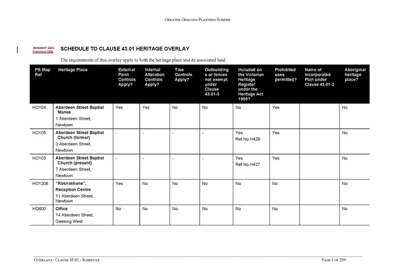
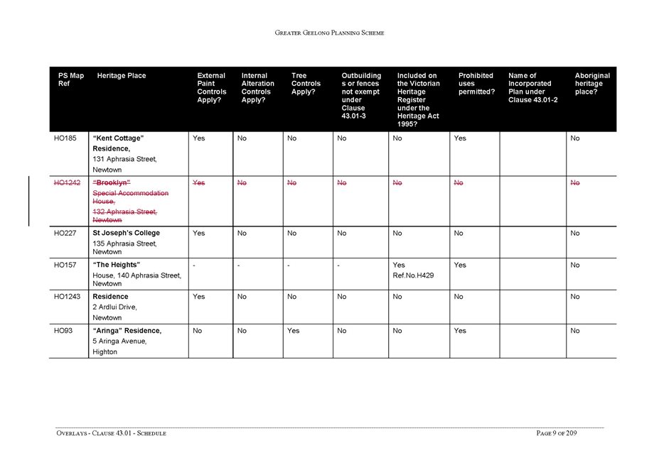
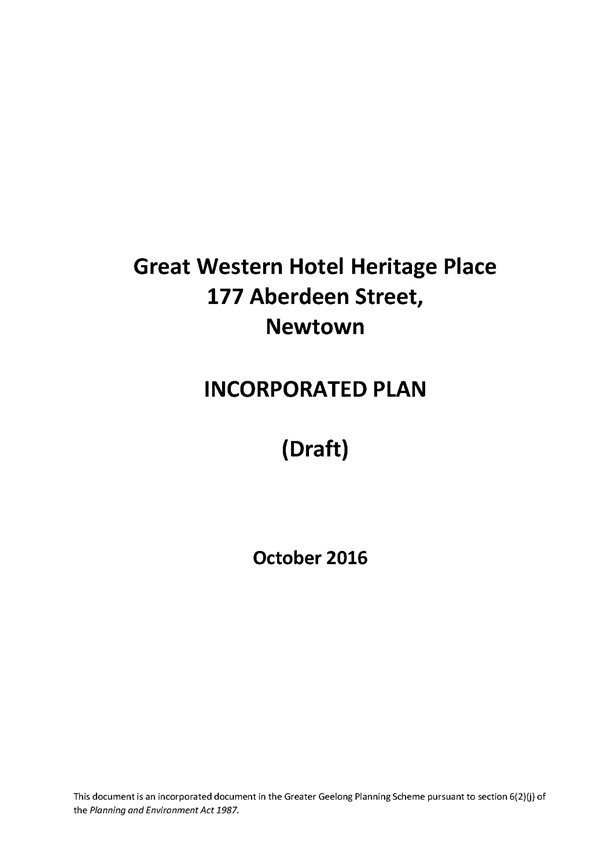
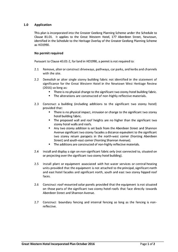
Amendment C365 (the Amendment) applies the Heritage Overlay to three precincts and 5 individual places within the Newtown West area, deletes existing individual heritage overlays from 3 properties, includes 3 new planning policies in the Local Planning Policy Framework for each of the new precincts and incorporates ‘The Great Western Hotel Incorporated Plan 2016’ .
The Amendment is the result of the Newtown West Heritage Review 2016 (Review).
Exhibition of the Amendment from 23 February 2017 to 27 March 2017 resulted in 16 submissions which were referred to an Independent Panel (the Panel), appointed by the Minister for Planning. A Panel Hearing was held on 14 August 2017 and the Panel has supported the Amendment.
Following exhibition of the Amendment, Council received submissions that:
objected to the inclusion of the Great Western Hotel in a heritage overlay;
proposed that that the Upper Skene Street Precinct does not have the integrity of intactness to warrant the Heritage Overlay; and
objected to additional costs and impediments associated with applying the Heritage overlay.
The Panel considers the Amendment to have strong strategic planning support.
The Panel supports the inclusion of the Great Western Hotel in the heritage overlay and the configuration of the proposed Upper Skene Street precinct.
The Panel recommends the Amendment be adopted subject to some minor changes. Consequently, the changes have been incorporated into the Amendment.
Cr Murrihy moved, Cr Kontelj seconded -
That Council:
Adopts Amendment C365 in the form as outlined in Attachment 2 of this report; and
Submits the adopted Amendment C365 together with the prescribed information to the Minister for Planning requesting approval.
Carried.
During implementation of new residential zones via Amendment C300, the Newtown West Action Group became involved in the future of this area and submitted to the C300 Panel that the area’s heritage values had not been addressed in earlier heritage studies in Newtown. Louise Honman of Context Consultants was engaged by the Action Group to appraise the heritage of the area and provide expert evidence. The C300 Panel noted: “Ms Honman’s evidence that this area warrants ‘a full heritage assessment’ and encourages Council to give consideration to commissioning this work to investigate whether the HO should be applied.”(C300 Panel Report at page 32).
Council subsequently resolved to undertake a heritage review (the Review) for the Newtown West area in 2014. The review was completed in 2016 and recommended a Heritage Overlay be applied to the following:
Newtown West heritage area (58 places in draft – 56 post public notification)
Upper Skene Street heritage area (34 places)
West Melbourne Road heritage area (13 places)
177 Aberdeen Street - hotel
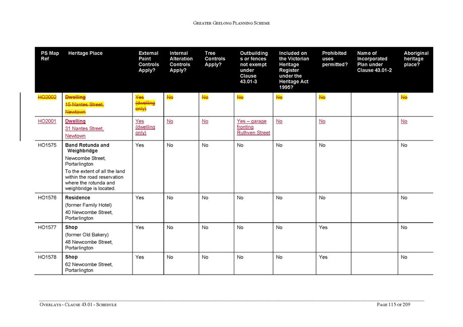
15 Nantes Street – dwelling
31 Nantes Street – dwelling
321-323 Shannon Avenue – semi-detached dwellings
325 Shannon Avenue - dwelling
The Newtown Housing Commission Estate (60 places) was identified as significant but was not recommended for inclusion in a heritage overlay.
The Review underwent an informal notification process with supporting and objecting comments received. Some changes were made to the Review, and at its meeting of 22 November 2016, Council resolved to proceed with a planning scheme amendment. This resolution also sought to request the Minister for Planning to apply an interim heritage overlay whilst the formal planning scheme amendment was prepared and considered.
In December 2016 officers lodged a request with the Minister for Planning seeking the application of interim heritage controls whilst the permanent amendment was going through the amendment process. This request was declined in March 2017 noting insufficient growth pressure in Newtown West to warrant interim provisions. Council was advised that there is an opportunity to apply for an individual site interim control if a request for demolition is lodged on a significant site identified in the Review. No individual request for an interim control has been made in the intervening period.
Public exhibition commenced on 23 February 2017 and closed on 27 March 2017. Sixteen submissions were received, including five objecting submissions.
Council (under delegation) then considered a report on the submissions and resolved on 24 May 2017 to request the Minister for Planning appoint an Independent Panel to consider the submissions.
Panel Hearing and Panel Report Recommendations
A Panel Hearing (the Hearing) was held on 14 August 2017. Submissions at the Hearing were made by:
Council officers calling expert evidence in heritage;
One local resident;
A representative of the local branch of the National Trust; and
A planning consultant acting for a submitter.
The main issues presented to the Panel were:
The appropriateness of including the Great Western Hotel in the heritage overlay
Concerns about the costs associated with the heritage overlay
Concerns about the integrity of the Upper Skene Street Precinct
Support for including areas in heritage precincts
The Panel considered all written submissions made in response to the exhibition of the Amendment; as well as further submissions, evidence and other material presented to it during the Hearing, and its observations from 2 site visits.
In its 18 September 2017 report, the Panel noted that:
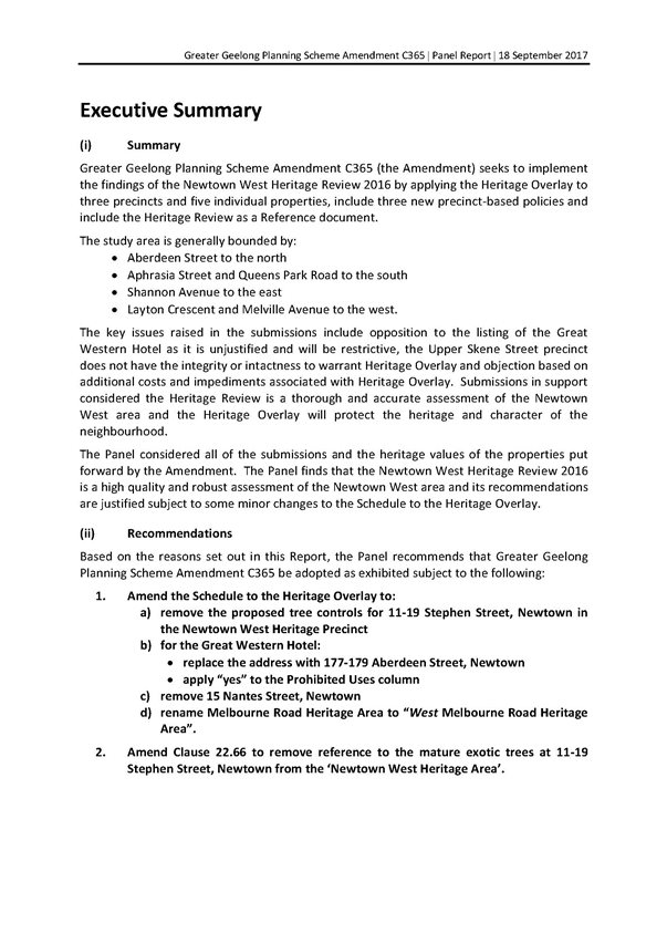
“…the Newtown West Heritage Review 2016 is a high quality and robust assessment of the Newtown West area and its recommendations are justified subject to some minor changes to the Schedule to the Heritage Overlay.”(C365 Panel Report at the executive summary page)
The key Panel findings were:
The Amendment is supported by, and implements, the relevant sections of the State and Local Planning Policy Framework, and is consistent with the relevant Ministerial Directions and Practice Notes.
The Amendment is well founded and strategically justified, and the Amendment should proceed subject to some minor changes
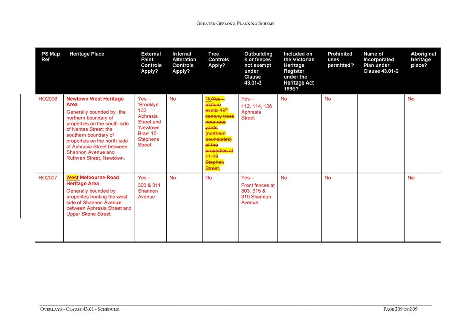
The Newtown West Heritage Precinct is of historical and aesthetic significance at a local level, is intact and has the integrity to warrant Heritage Overlay. The Heritage Overlay should be applied as exhibited subject to removing reference to tree controls in the Schedule to the Heritage Overlay for 11-19 Stephen Street.
The Upper Skene Street Heritage Precinct is of historical and aesthetic significance at a local level, is intact and has the integrity to warrant Heritage Overlay. The Heritage Overlay should be applied as exhibited.
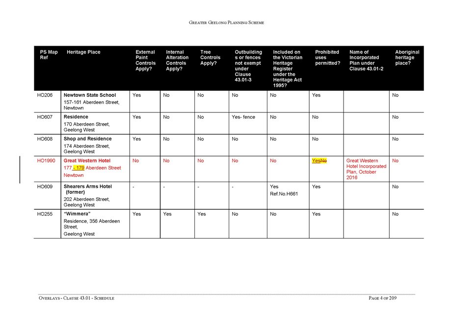
The Great Western Hotel at 177-179 Aberdeen Street, Newtown is of historical and aesthetic significance and warrants inclusion within the Heritage Overlay. The prohibited uses column in the Schedule to the Heritage Overlay should be activated to provide for opportunities of uses for the building given its non-residential use in a residential zone.
The address of the property in the Schedule to the Heritage Overlay should be specified as 177-179 Aberdeen Street, Newtown.
The exhibited Incorporated Plan is appropriate.
15 Nantes Street, Newtown has been demolished and no fabric remains. It should be removed from the Amendment.
The description for HO2007 in the Schedule to the Heritage Overlay should be renamed “West Melbourne Road Heritage Area”.
The Panel recommended that the Amendment be adopted subject to changes recommend by the Panel. The Amendment is shown in Attachment 2.
A copy of the Panel Report Executive Summary is in Attachment 3.
Council officer response
The Panel Report findings and recommendations are all supported and are based upon the changes recommended by Council officers to the Panel and at the Hearing.
There are no financial implications to the budget from this recommendation.
Council officers have advised submitters of the release of the Panel Report. Submitters will be notified of the final decision of Council and the Minister for Planning.
Inclusion of significant sites and precincts within the heritage overlay is consistent with the Planning and Environment Act 1987and with a range of State and local planning policies.
The Amendment is consistent with the strategic direction of community wellbeing and the priority of connected, creative and strong communities.
No Council officers or contractors involved in the preparation of this report have a conflict of interest regarding the matter under consideration.
There are no notable risks associated with implementing the recommendations contained in this report.
The amendment will not have any adverse effects on the environment.
Planning and Environment Act 1987
The planning authority for this amendment is the Minister for Planning.
The Greater Geelong Planning Scheme is amended as follows:
Planning Scheme Maps
The Planning Scheme Maps are amended by a total of 2 attached map sheets.
Overlay Maps
Amend Planning Scheme Map Nos.HO48 and HO49 are in the manner shown on the 2 attached maps marked “Greater Geelong Planning Scheme, Amendment C365”.
Planning Scheme Ordinance
The Planning Scheme Ordinance is amended as follows:
In Local Planning Policy Framework – replace Clause 22.09 with a new Clause 22.09 in the form of the attached document.
In Local Planning Policy Framework – insert Clause 22.65 in the form of the attached document.
In Local Planning Policy Framework – insert Clause 22.66 in the form of the attached document.
In Local Planning Policy Framework – insert Clause 22.67 in the form of the attached document.
In Overlays – Clause 43.01, replace the Schedule with a new Schedule in the form of the attached document.
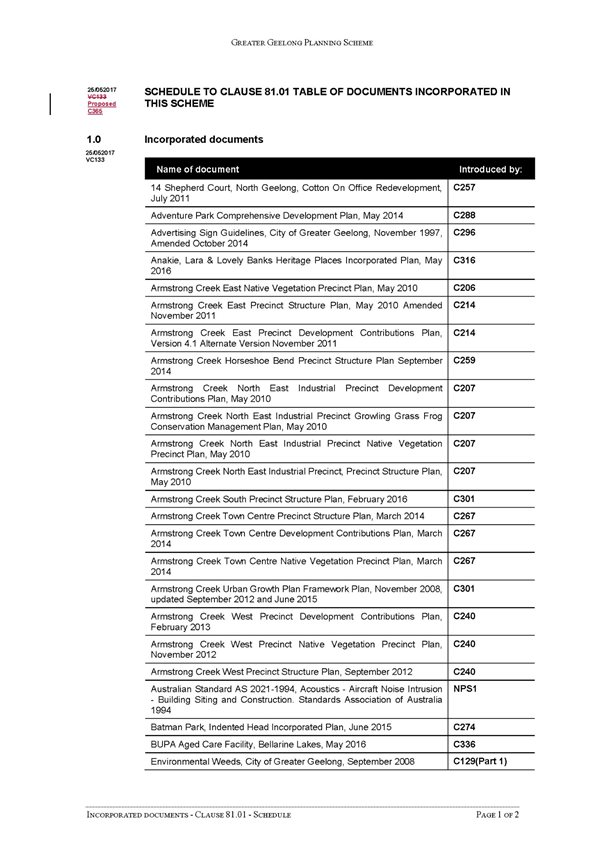
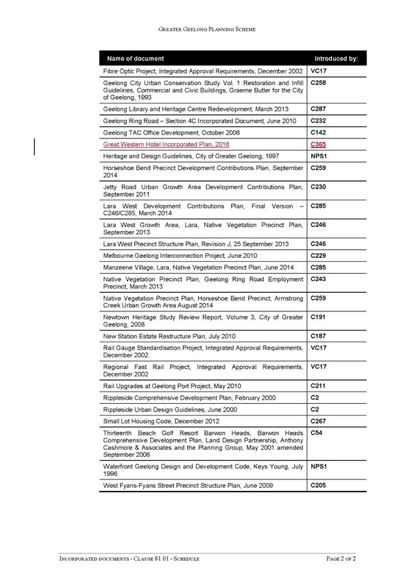
In Incorporated Documents – Clause 81.01, replace the Schedule with a new Schedule in the form of the attached document.
End of document
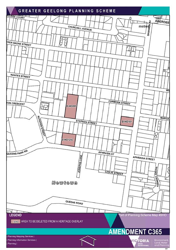
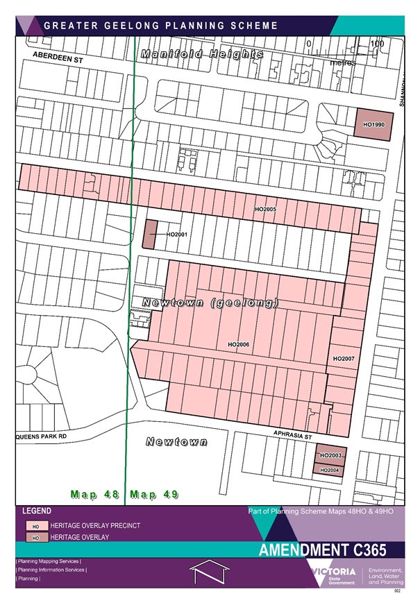
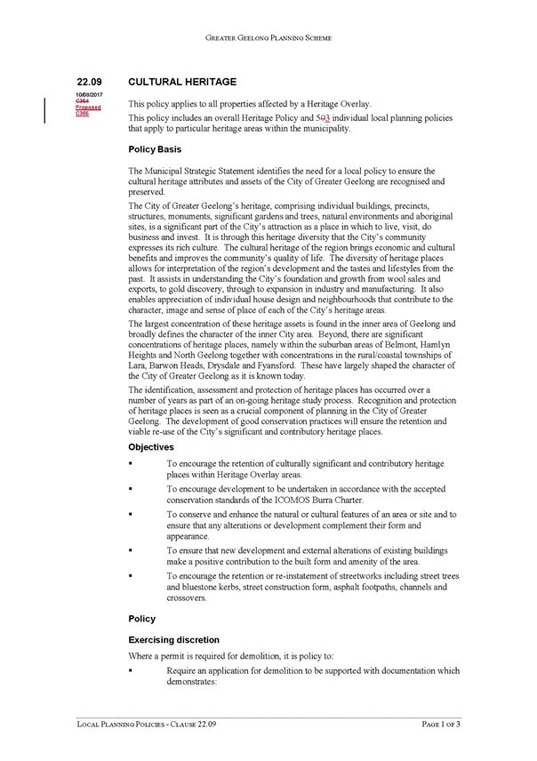
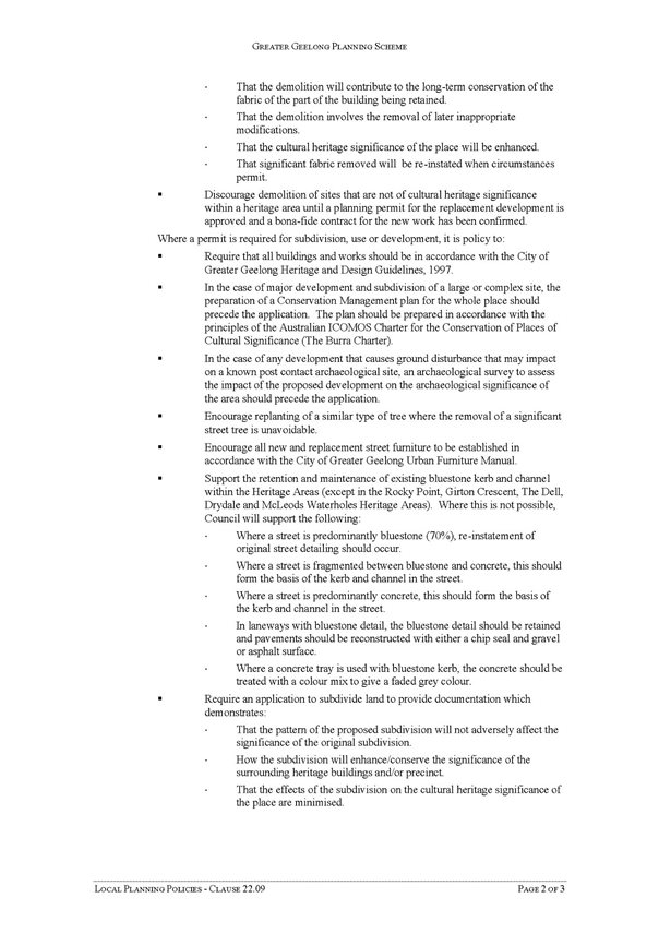
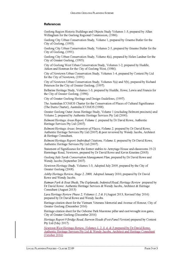
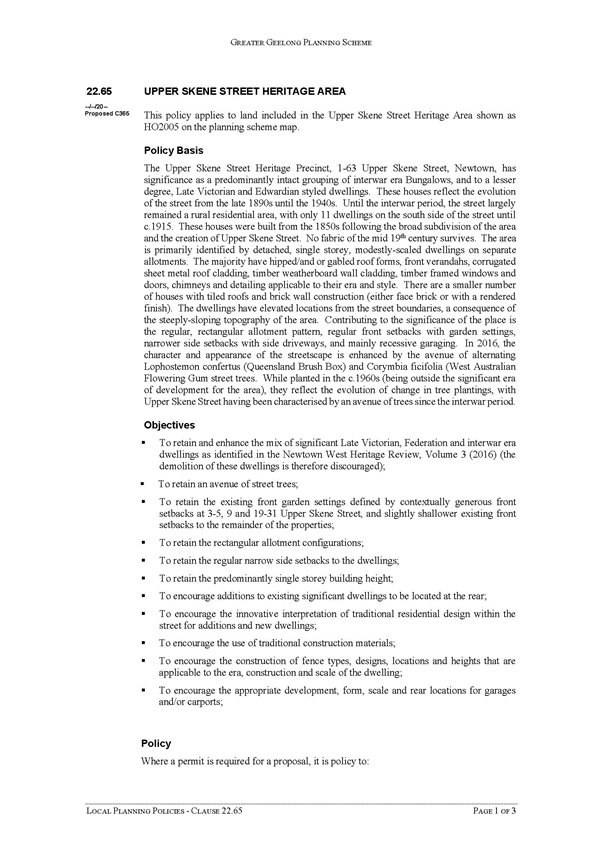
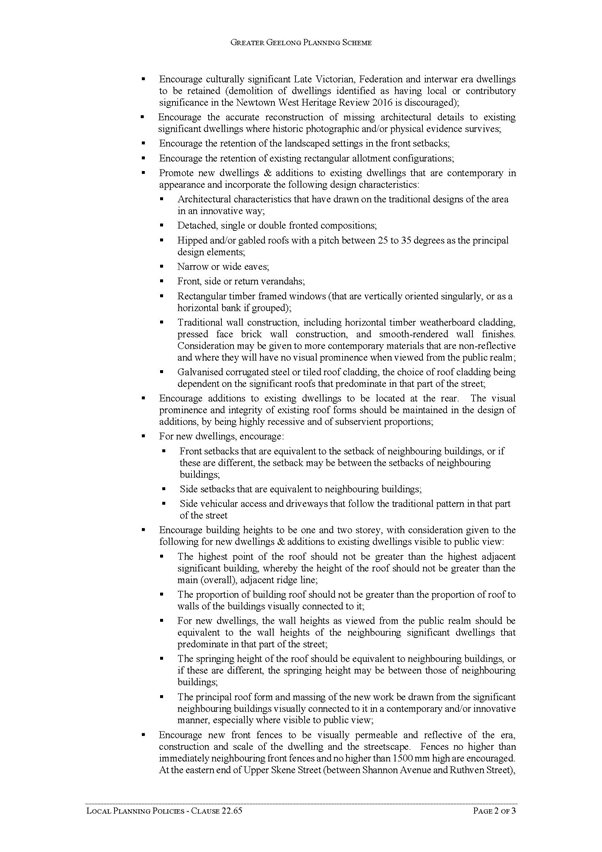
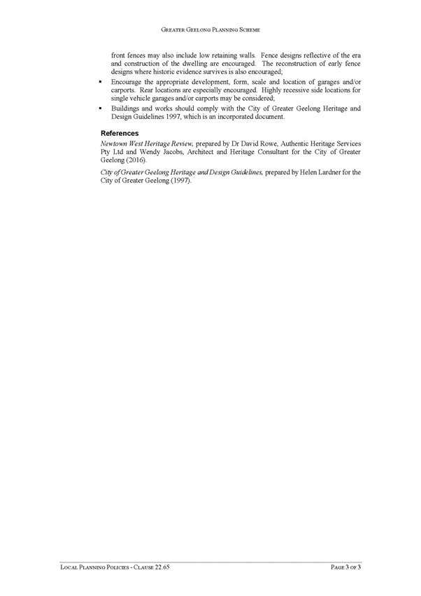
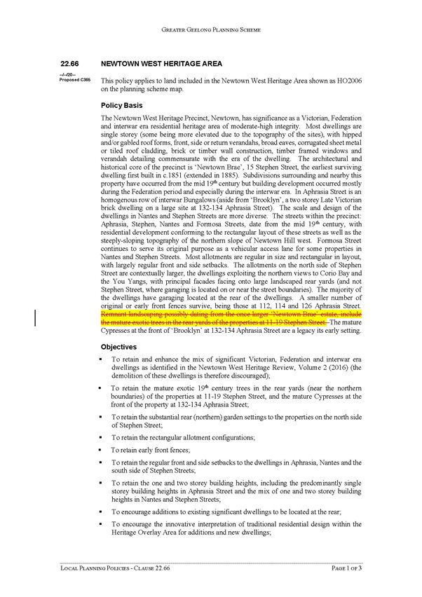
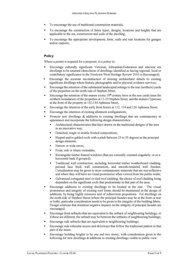
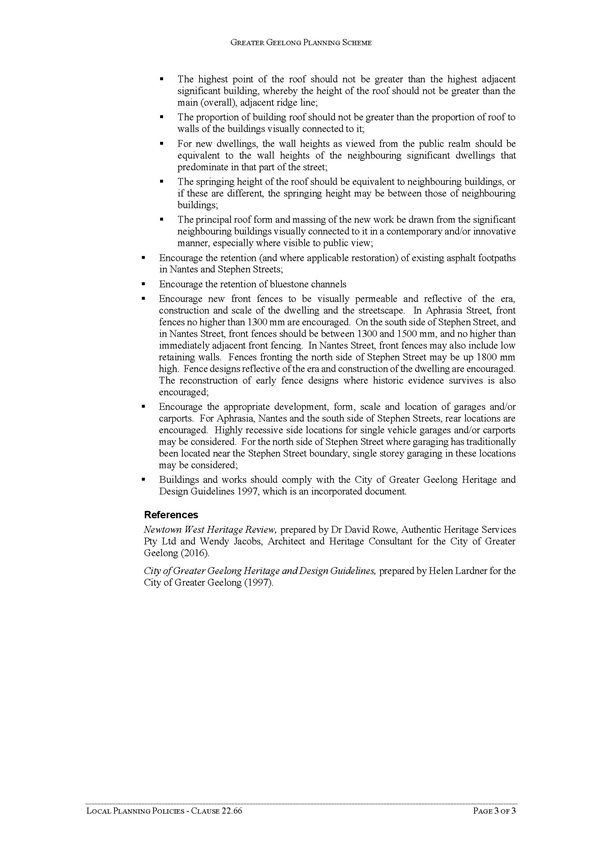
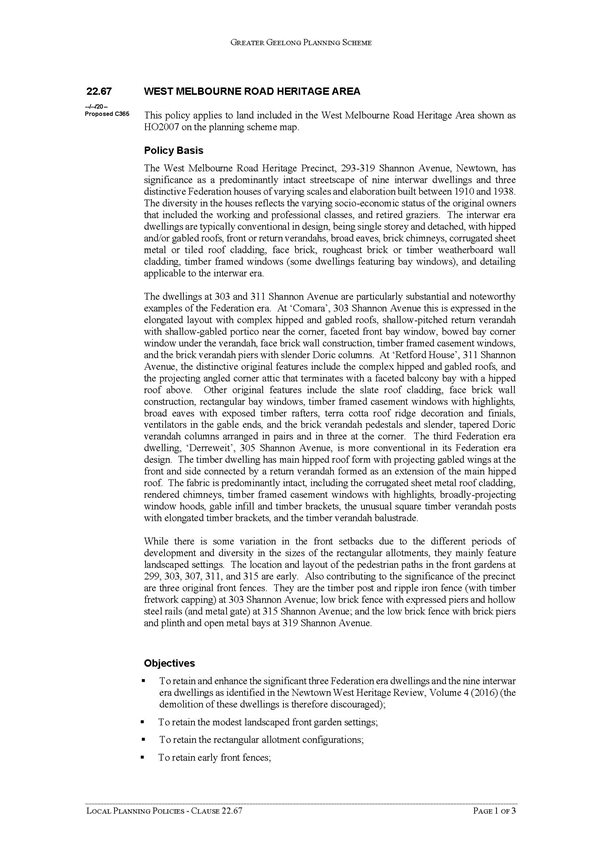
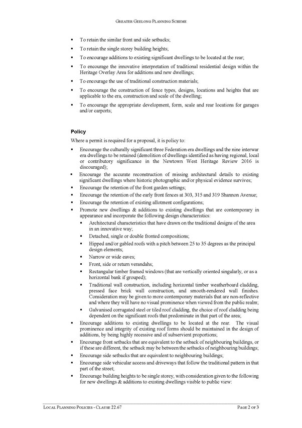
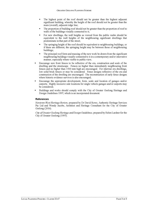
Note that only the affected pages of the Schedule to Clause 43.01 (the Heritage Overlay) are included on the following pages. The changes post – Panel are in yellow highlight.
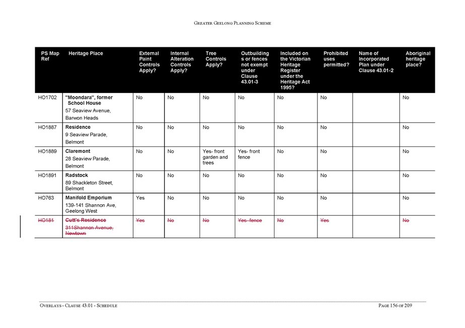
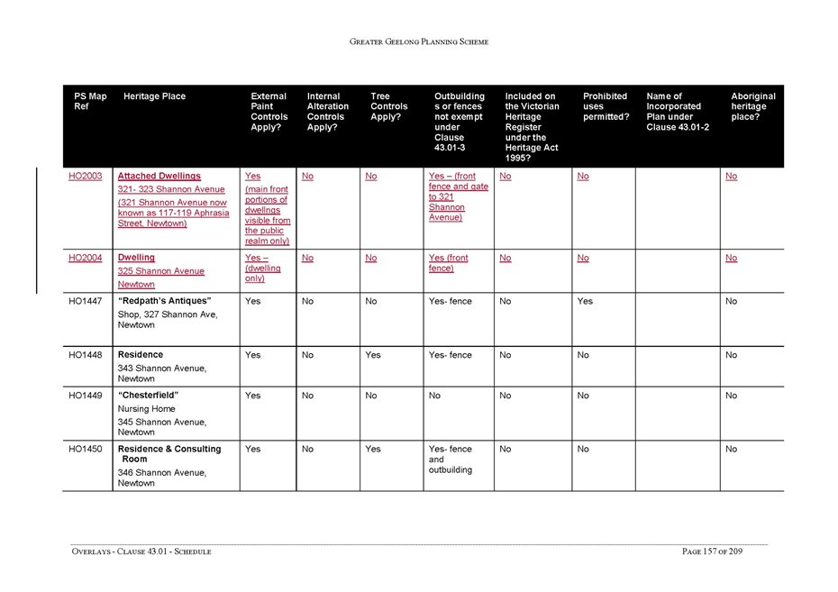
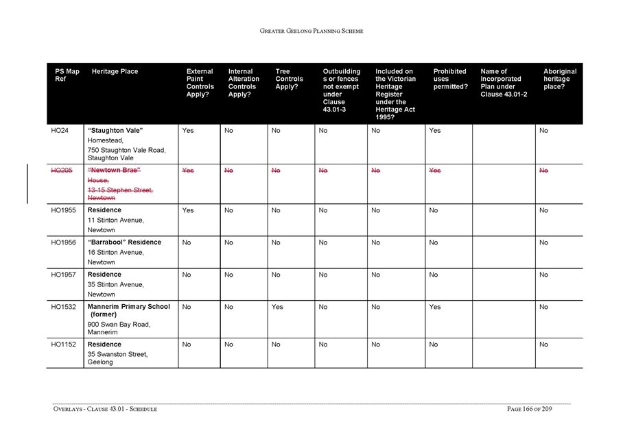
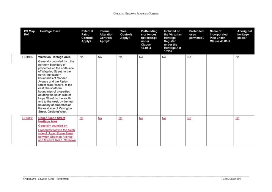
Source: |
Planning and Development |
Director: |
Kelvin Walsh |
Index Reference: |
Application: C373 |
To seek Council support to prepare and exhibit a combined Planning Scheme Amendment C373 and planning permit application 879/2017 for the Lonsdale Golf Course and surrounding land, located off Fellows Road, Point Lonsdale, subject to authorisation being obtained from the Minister for Planning.
Amendment C373 (the Amendment) seeks to rezone vacant farmland along the southern edge of the Lonsdale Golf Course (the Golf Course), off Gill Road, Point Lonsdale, from Farming Zone and Rural Conservation Zone to Special Use Zone 3 to provide for a modest expansion of the existing Golf Course. It also substantially modifies the previously approved proposal to extend the Golf Course around the edges of Lake Victoria which are now proposed to be rezoned from Special Use Zone 3 to Rural Conservation Zone.
The existing Development Plan Overlay Schedule 26 needs to be amended to apply to the changed areas of the Golf Course and relate to the Lonsdale Golf Club’s (the Club’s) modified plans which will produce significantly decreased environmental impacts.
The permit is for a 2 lot subdivision to enable the Club to purchase the newly rezoned Special Use Zone 3 land from the adjoining rural property owner.
The residential component of the previously approved project along the Fellows and Gill Road frontages is not being changed by this amendment.
The previously approved Scheme Amendment C67, gazetted in 2013, was subject to a protracted 10 year planning approval process including an Environment Effects Statement (EES) which generated substantial interest from environmental groups, community groups, nearby landowners, Club members and the general public.
The new proposal, which will have substantially reduced environmental impacts, requires approval of a fresh planning scheme amendment to enable the modified proposals, as described in this report, to be implemented.
In light of the above circumstances and greatly reduced impact, the Club sought approval of a Ministerial amendment without public notification. Despite support from environmental groups and Council officers, the Department of Environment, Land, Water and Planning (DELWP) determined that the Amendment should be processed by Council.
Council officers recommend Amendment C373 and the accompanying Planning Permit 879/2017 be now exhibited in the normal manner, subject to receipt of Ministerial authorisation.
Cr Mason moved, Cr Asher seconded -
That Council:
supports the preparation and exhibition of Amendment C373 to the Greater Geelong Planning Scheme in the form described in the attachments to this report;
considers the application for Planning Permit 879/2017 for a 2 lot subdivision concurrently with the preparation of the Amendment, in accordance with the provisions of Section 96A of the Planning and Environment Act 1987; and
requests the Minister for Planning to authorise the preparation and exhibition of Amendment C373 and Planning Permit 879/2017.
Carried.
Spiire Australia has submitted a combined planning scheme amendment and planning permit application on behalf of the Club to enable an expansion of the 18 hole Golf Course as part of a major redevelopment project.
The rezoning component of the application seeks substantial changes to the previously approved Amendment C67 which was gazetted on 19 September 2013. Amendment C67 was subject to a protracted 10 year planning approval process, including an EES, because of the Club’s then proposal to extend the Golf Course into highly environmentally sensitive areas around the edges of Lake Victoria. This generated substantial interest from nearby residents, Club members, community groups and environmental groups. Council referred all submissions to the Amendment C67 to an Independent Panel (the Panel) appointed pursuant to both the Environment Effects Act 1978(EEA) and the Planning and Environment Act 1987.
The Panel conducted a 7 day hearing and recommended approval of Amendment C67 subject to a range of additional environmental measures to be incorporated into a Development Plan Overlay Schedule. The Minister for Planning’s assessment, pursuant to the EEA, supported Amendment C67 being adopted in accordance with the Panel’s recommendations.
Since approval of Amendment C67, the Club has undertaken a number of stages of the residential component of the project along the Gill and Fellows Road frontages of the site. The new application is not seeking to make changes to the residential component of Amendment C67.
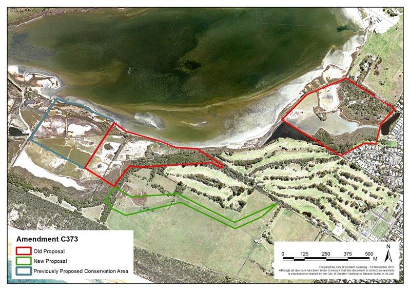
Attachment 2 is an aerial photo of the subject land and surrounding area with the extent of the new proposal outlined in red and the extent of the previous proposal outlined in blue.
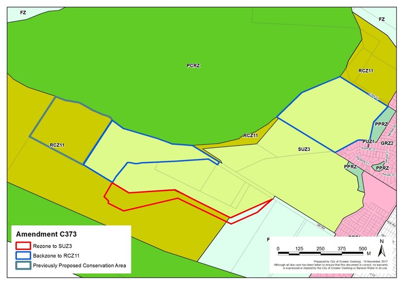
Attachment 3 shows the existing zoning of the Club’s land and surrounding area. The Farming Zone and Rural Conservation Zone land on the south side of Gill Road is now proposed to be rezoned to Special Use Zone to provide for additional Golf Course holes and is outlined in green. The extent of previously approved Special Use Zone land over which it was previously intended to expand the golf course and which are now proposed to be rezoned to Rural Conservation are outlined in red.
The areas to which the accompanying Development Plan Overlay Schedule 26 (DPO 26) will apply are being amended to accord with the areas to which the Special Use Zone will apply.
The wording of DPO 26 is proposed to be substantially modified with respect to the Golf Course component of the project. The existing DPO 26 Schedule makes numerous references to the EES documentation which are largely not relevant to the modified Golf Course layout. Reference to these documents will be removed from the Schedule and replaced with specific environmental requirements relating to the current proposal. Any environmental issues requiring further consideration will therefore be addressed as part of Council’s development plan and permit approval processes. The proposed new DPO 26 Schedule will also contain a Masterplan of the proposed new golf course layout.
The proposed Planning Permit 879/2017 accompanying the Amendment is for a 2 lot subdivision which will enable the Club to purchase land from the adjoining farming property. It will replace a previous permit for a 2 lot subdivision which excises a smaller area of farmland.
It should be noted the previously approved proposal included a permanent conservation reserve on the neighbouring rural property on the edge of Lake Victoria which was an important factor in Amendment C67 being supported. This reserve was to be set aside as a permanent orange bellied parrot habitat to replace such areas potentially lost by the earlier proposal and is outlined in blue in Attachment 2. The Amendment does not include a conservation reserve because the significantly lessened impact on the existing bird habitat negates its need.
In light of the significantly reduced environmental impacts and overall reduction in areas affected by the Golf Course expansion, the Club originally sought the approval of a Ministerial amendment without public notification. At Council’s suggestion, the Club conducted a well-publicised public information session at its clubhouse outlining its new proposals. This session was attended by a wide range of community groups and the general public and received very positive feedback. Despite the demonstrated support from stakeholders and Council officers, DELWP determined that the Amendment should be processed by Council.
The Club’s consultant has requested Council to consider seeking Ministerial exemption from a normal amendment notification. However, as Council officers believe that some form of public notification is warranted (particularly newspaper notices), there is nothing to be gained in terms of saving time in seeking dispensation from direct notification of nearby property owners.
The Club’s application has been referred internally to Council’s Environment & Engineering Services Units and externally to DELWP and the Corangamite Catchment Management Authority (CCMA). No additional engineering requirements to those proposed to be included in DPO 26 Schedule were raised by either Council or CCMA engineers.
Council’s Environment Unit supports the proposed changes to the previously approved project because the new Golf Course holes will be utilising cleared farmland rather than necessitating removal of native vegetation. In addition the new project no longer proposes construction of Golf Course holes next to Lake Victoria significantly reducing the likelihood of bird habitat disturbance. Council’s Environment Unit has sought further information about off-set requirements for vegetation to be removed and details of non-indigenous vegetation to be cleared, both of which will be provided as part of the exhibited Amendment documentation. Suggested modifications to the DPO 26 wording have also been made.
To date, no formal response had been received to Council’s referral request from DELWP. Consideration will be given to including any DELWP requirements as DPO 26 provisions. DELWP will also have an opportunity to make a formal submission should the Amendment be exhibited as recommended.
The changes to the previously approved scheme Amendment C67 mean that the reconfiguration of the Golf Course and its extension will be undertaken without the need to extend into the environmentally sensitive areas around the shores of Lake Victoria. The new, more modest plans will result in a greatly improved environmental outcome and provide a positive closure to this long-running project. All remaining identified environmental issues which need to be addressed in further detail have been included in the amended DPO 26 Schedule which will require Council’s further consideration as part of the development plan approval.
In the processing of the previous EES and Amendment C67 it was recognised that the Club’s redevelopment project would produce a range of community benefits by providing enhanced community and recreation facilities for local residents, strengthening the club as a community focal point and providing additional housing opportunities within the township. Amendment C373, will enable the Club’s redevelopment project to be completed and will have a positive social impact and result in a net community benefit.
Amendment C373 and Planning Permit 879/2017 should be exhibited in the normal manner.
The Club is a private entity and will be responsible for the full funding of this project. There are no financial implications for Council.
Amendment C373 will be exhibited in the normal manner to community groups, landowners and the general public to provide them with an opportunity to make a submission and appear before an Independent Panel appointed by the Minister for Planning if they so wish. Relevant Government agencies were consulted in the preparation of this Amendment.
The Club conducted a well-attended public information session before submitting the application to Council.
The previous project was considered to be consistent with State and Council planning and environmental policies. The new proposal will have significantly reduced impacts and as a result will also comply with these policies.
The Amendment supports the overall thrust of the Sustainable Built and Natural Environment Strategic Directions in that it supports development which respects and enhances the natural environment.
No Council officers or contractors involved in the preparation of this report have a conflict of interest regarding the matter under consideration.
No risks have been identified in respect of this matter.
The approved prior Amendment C67 was subject to a thorough environmental assessment process including an EES to ensure an acceptable environmental outcome was achieved. Amendment C373 will result in significantly reduced environmental impacts in comparison to Amendment C67.
Amendment C373 no longer affects the most environmentally sensitive areas around the edges of Lake Victoria. Council’s Environment Unit, DELWP and environment groups agree with the Club’s consultants that this new proposal provides a positive environmental outcome.
Source: |
Investment and Attraction |
Director: |
Brett Luxford |
Index Reference: |
PRJ-16-1281: Revitalising Central Geelong |
Council received a request from the Geelong Authority to adopt the West End Action Plan 2017) prepared by the Revitalising Central Geelong Partnership (Attachment 3).
The West End Action Plan, formerly the James St Precinct, has been developed to guide projects and streetscapes within the area bounded by Gheringhap, Malop, Moorabool and Ryrie Streets in Central Geelong (the Precinct).
The West End Action Plan has been developed through stakeholder engagement and responds to key issues and opportunities for the precinct including:
Civic Car Park - opportunities for 24-hour access, pay-on-exit technology, modified entry/exit and possible long-term redevelopment;
Creating plaza space and limiting vehicle access to allow for more alfresco activity (timed or essential vehicles only);
Improved connections to the waterfront;
Investigation of opportunities for resolving issues associated with the bus interchange in Moorabool Street;
Reconstruction of laneways within the precinct;
Encouraging infill and shop-top residential development;
Protecting and celebrating heritage buildings and providing incentives for heritage building restoration;
Encouraging and supporting ‘greening’ of the precinct in the public and private domain;
Encouraging more public art which could support a way-finding project throughout the CBD; and
Undertaking a full waste management audit and implementing an integrated waste management system for the precinct.
Cr Kontelj moved, Cr Mansfield seconded -
That Council adopt the West End Action Plan 2017 shown at Attachment 2 of this report as a guiding document for revitalisation projects within the precinct.
Carried.
Projects identified in the West End Action Plan will be funded through the Revitalisation Partnership annual budget.
The West End Action Plan was prepared based on engagement with precinct stakeholders through two workshops. Additional feedback was sought from property owners, traders and residents of the study area. The Geelong Authority has reviewed and endorsed the West End Action Plan.
Public comments on the Draft West End Action Plan 2017 were invited over a two week period from 11 August 2017 to 25 August 2017.
During this period, two written submissions were received. One submission strongly supported the draft plan, particularly the initiatives to increase the vitality of the precinct. The other submission also supported initiatives to increase activity within the precinct such as street festivals suitable for young people and families. In order to support increased activity, this submission suggested that lighting be improved in the precinct and the opening hours of the Civic Car Park be increased.
The street lighting in Little Malop Street is being upgraded as part of the Laneways Project – currently being undertaken. Artistic and pedestrian lighting will be delivered increasing amenity and public safety.
The City of Greater Geelong (CoGG) owns and manages the Civic Car Park. The car park is open from 7am - 11pm (Monday - Wednesday) and from 7am - 1:30am (Thursday - Sunday). There are no plans to increase operating hours as data indicates a lack of demand.
In line with the recently adopted Public Realm Framework, incorporating the Central Geelong Accessibility Audit, all streetscapes and entertainment programs within the CBD will be designed to be fully accessible.
The West End Action Plan is consistent with the Central Geelong Action Plan, the State Action Plan and State and Council planning policies.
New hard and soft landscaping resulting from the plan will reference Council’s urban design guidelines, support sustainable development and respond to community needs.
Future physical works within the precinct will reference plans for the adjacent precincts including Johnstone Park, the Green Spine and the Arts & Cultural Precinct.
This project is directly aligned to the City Plan ‘Growing the Economy’ strategic priority which articulates a continuing focus on improvement of the CBD via the implementation of the Central Geelong Action Plan.
No risks have been identified in adopting the West End Action Plan.
Part of the West End Action Plan proposes the preparation of a resource recovery plan for the precinct to enable a holistic approach to waste and environmental and cost benefit for stakeholders.
A number of streets within the study area form part of the overland flow path for storm water and a number of sites are encumbered by a Special Building Overlay. New streetscape designs will account for storm water management and drainage, and will consider opportunities to incorporate Water Sensitive Urban Design (WSUD) to manage water collection and re-use in and around the precinct.
Source: |
Governance and Legal Services |
Executive Manager: |
Rebecca Leonard |
Index Reference: |
Council Governance - Council Meetings |
This report is presented to Council for consideration of Council Meeting dates for 2018.
Section 89 (4) of the Local Government Act 1989(the Act) requires that reasonable notice be given to the public of meetings of the Council. This is achieved by publishing the date, time and location of the meeting in the Geelong Advertiser and on Council’s website.
Council also establishes the schedule of Ordinary Council meeting dates and venues each year to allow for advance planning of Council business.
Ordinary Council meetings for 2018 are generally planned for the fourth Tuesday of each month. Exceptions to this rule are included in the 2018 Council Meeting Schedule for the January meeting which is planned for 30 January 2018 and the December meeting which is scheduled for 11 December 2018.
Ordinary Council meetings for 2018 are scheduled to commence at 7:00pm.
Ordinary Council meetings for 2018 are planned to be held at the Council Chambers, City Hall, 30 Gheringhap Street, Geelong
Any change to a date, time or venue of an Ordinary Council Meeting will be advertised in accordance with Council Meeting Procedure Local Law and the Act.
Cr Nelson moved, Cr Asher seconded –
That Council endorses the following schedule of Ordinary Council meeting dates for 2018:
Tuesday 30 January 2018
Tuesday 27 February 2018
Tuesday 27 March 2018
Tuesday 24 April 2018
Tuesday 22 May 2018
Tuesday 26 June 2018
Tuesday 24 July 2018
Tuesday 28 August 2018
Tuesday 25 September 2018
Tuesday 23 October 2018
Tuesday 27 November 2018
Tuesday 11 December 2018
Carried.
Source: |
Governance and Legal Services |
Executive Manager: |
Rebecca Leonard |
Index Reference: |
Council Governance - Council Meetings |
This report is presented to Council for consideration of a Community Focus Committee meeting schedule for 2018.
The Community Focus Committee is a special committee of Council comprised solely of Councillors. The purpose of the Committee is to enable Council to consider Council business and to hear from the community in relation to matters which come before it for decision.
The meetings of the Committee must be open to members of the public unless the Committee resolves that a meeting be closed to members of the public under section 89(2) of the Local Government Act 1989(the Act).
Section 89 (4) of the Act requires that reasonable notice be given to the public of meetings of a special committee comprised solely of Councillors. This is achieved by publishing the date, time and location of the meeting in the Geelong Advertiser and on Council’s website.
The schedule of Community Focus Committee Meeting dates and venues for the upcoming year needs to be established to allow for advance planning of Council business.
Community Focus Committee meetings for 2018 are generally planned for the second Tuesday of each month. Exceptions to this rule may be included in the 2018 Council Meeting Schedule with no meeting scheduled for January 2018 and December 2018. This would be a variation to the Committee’s terms of reference to allow for a clash with the December 2018 Ordinary Meeting of Council.
Community Focus Committee meetings for 2018 could be scheduled to commence at 7:00pm. This would be a variation to the Committee’s terms of reference, which provides for a 6:30pm start, to provide sufficient time for all councillors to attend.
Community Focus Committee meetings for 2018 could be planned to be held at various locations within the municipality. This would be a variation to the Committee’s terms of reference, which specifies the City Hall location, to make meetings more accessible for community members.
Confirmation of dates, times and venues of Community Focus Committee meetings will be advertised in accordance with Council Meeting Procedure Local Law and the Act.
Cr Aitken moved, Cr Mason seconded –
That Council endorses the following schedule of Community Focus Committee meeting dates for 2018:
Tuesday 13 February 2018
Tuesday 13 March 2018
Tuesday 10 April 2018
Tuesday 8 May 2018
Tuesday 12 June 2018
Tuesday 10 July 2018
Tuesday 14 August 2018
Tuesday 11 September 2018
Tuesday 9 October 2018
Tuesday 13 November 2018
Carried.
Hall hire and meeting preparation costs could be incurred in implementing distributed meetings. These costs would be met from Council’s 2017/18 budget.
At the Community Focus Committee meeting, Council will consider matters within the Community Focus Committee Terms of Reference. The community can attend and submit information or raise questions about issues on the agenda, or raise general issues or questions related to the Council.
The meeting process is intended to provide the public with an opportunity to ask questions and submit information to Council before a decision is made.
This proposal will provide for improved access for community participation in the decision making processes of Council.
This proposal complies with the provisions of the following policies and local law:
Public question and submission time council policy;
Greater Geelong City Council - Council Meeting Procedures Local Law 2017; and
Community Focus Committee Terms Of Reference as varied by the final arrangements (Attachment 2).
Community Focus Committee meetings will improve how Council does business by providing a process that enhances engagement with the community to better understand their needs and concerns and to provide them with feedback about their input and decisions made.
No Council officers or contractors involved in the preparation of this report have a conflict of interest regarding the matter under consideration.
There are no notable risks associated with this proposal.
There are no environmental issues associated with this proposal.
Source: |
City Services - Engineering Services |
Director: |
Guy Wilson-Browne |
Index Reference: |
SUB-16-3161 |
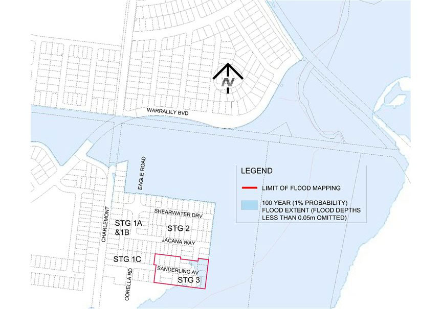
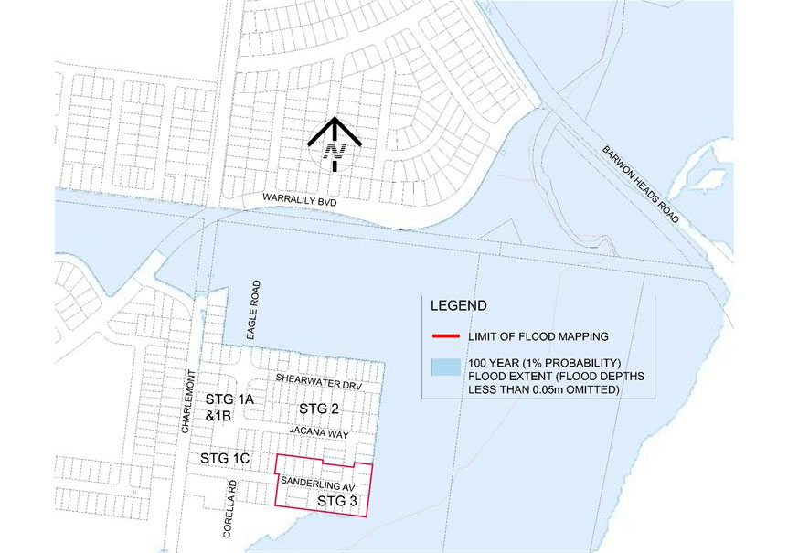
The purpose of this report is for Council to consider revoking the flooding designation within Stage 3 of the development of Armstrong Waters.
Council has a statutory obligation under the Victorian Building Regulations 2006 to designate land as liable to flooding where it reasonably knows it to be prone to flooding. Conversely, there is an obligation to remove the encumbrance of designation from land that is no longer considered to be flood-prone.
The current designated flood mapping (refer to Attachment 2) was designated by Council at its meeting of 12 December 2006, under the provisions of the Building Regulations 2006.
The subject of this report is the residential land at Armstrong Waters fronting 291 – 411 Charlemont Road, Armstrong Creek. Prior to subdivision the parent lot was used primarily as farmland.
The flood mapping is subject to a revision due to the subdivision and development at 291 – 411 Charlemont Road, Armstrong Creek. Prior to subdivision the parent lot was considered to be liable to flooding. This development site, which is also known as Armstrong Waters, Stage 3, achieves flood mitigation for newly created lots for flood events up to and including the 100 year Average Recurrence Interval (ARI) event due to approved internal earthworks.
The earthworks undertaken have resulted in the floodwaters from the 100 year ARI event being contained within the boundaries of the road network (refer
Attachment 3).
It should be noted that designation is separate to the creation of flood overlays within the Planning Scheme, which generally follows designation. In the case of this development, the planning scheme amendment to create post-development flood zones or overlays is proposed after the design of the proposed precincts.
Cr Murnane moved, Cr Nelson seconded -
That Council revoke the Council designation of 12 December 2006 of flood affected land Armstrong Waters, Stage 3 as liable to flooding pursuant to Regulation 802(2) of the Building Regulations 2006.
Carried.
Designation of land as liable to flooding under Regulation 802 of the Victorian Building Regulations 2006 enables the control of floor levels for acceptable building permit applications, or refusal of consent to building applications where there is likely to be a danger to life, health or safety due to flooding. Designation also enables disclosure of flood status within statutory information certificates such as the Land Information Certificate and Building Information Request Form.
Overland flows that may occur within the subdivision during the 100 year ARI flood event are now contained within road and drainage reserves in accordance with accepted best practice for development within flood-prone areas. Best practice requires that any overland flows within residential areas satisfy public safety criteria with respect to velocity and depth of flow.
No impact to budget.
A revocation of designation does not warrant public consultation as it constitutes the removal of an encumbrance on land.
Relevant Council databases and flood maps will be revised and updates sent to the Corangamite Catchment Management Authority and Building Control Commission.
Council have a responsibility to the community to provide the best possible information on areas that are flood prone.
The City has various statutory responsibilities for drainage management and flood management (prevention, response and recovery) as set out in the Local Government Act 1989, Local Government Regulations 1990, Planning and Environment Act 1987, Victorian Building Regulations 2006, Water Act 1989, Subdivision Act 1988 and Emergency Management Act 1986.
The recommendations of this report are consistent with City Plan, in relation to Growing our Economy and promoting a sustainable built environment, sustainable land use and development.
There are no officer direct or indirect interests with respect to this report.
Council also has some risk exposure with any failure to disclose the flood-prone status of a property in a Land Information Certificate.
The revocation of the designation is the final step in minimising Council’s risk.
The revocation of flood-prone areas designation and designation of revised flood data through the design of this stage it is considered unlikely to result in any known adverse environmental impacts.
Source: |
City Services - Engineering Services |
Director: |
Guy Wilson-Browne |
Index Reference: |
SUB-16-3161 |
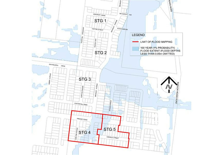
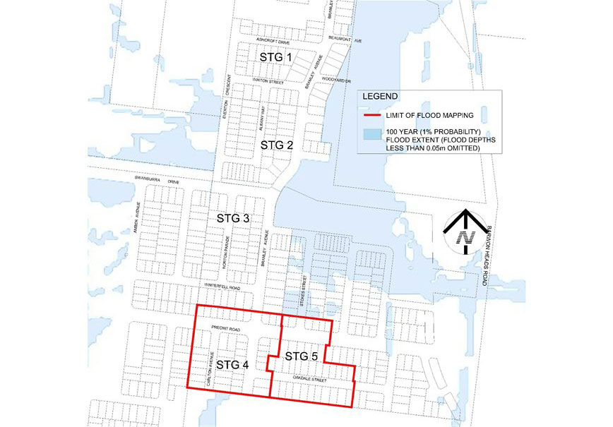
For Council to consider revoking the flooding designation within Stages 4 and 5 of the development at 228 - 262 Reserve Road, Charlemont part of the development also known as Watermark.
Council has a statutory obligation under the Victorian Building Regulations 2006 to designate land as liable to flooding where it reasonably knows it to be prone to flooding. Conversely, there is an obligation to remove the encumbrance of designation from land that is no longer considered to be flood-prone.
The current designated flood mapping (Attachment 2) was designated by Council at its meeting of 12 December 2006, under the provisions of the Building Regulations 2006.
The subject of this report is the residential land fronting 228 - 262 Reserve Road, Charlemont. Prior to subdivision the parent lot was used primarily as farmland.
The flood mapping is subject to a revision due to the subdivision and development at 228 - 262 Reserve Road, Charlemont. Prior to subdivision the parent lot was considered to be liable to flooding. This development site, which is also known as Watermark, Stages 4 and 5, achieves flood mitigation for newly created lots for flood events up to and including the 100 year Average Recurrence Interval (ARI) event due to approved internal earthworks.
The earthworks undertaken have resulted in the floodwaters from the 100 year ARI event being contained within the boundaries of the road network (Attachment 3).
It should be noted that designation is separate to the creation of flood overlays within the Planning Scheme, which generally follows designation. In the case of this development, the planning scheme amendment to create post-development flood zones or overlays is proposed after the design of the proposed precincts.
Cr Murnane moved, Cr Nelson seconded -
That Council revoke the Council designation of 12 December 2006 of flood affected land Watermark, Stages 4 and 5, at 228 - 262 Reserve Road, Charlemont, as liable to flooding pursuant to Regulation 802(2) of the Building Interim Regulations 2017.
Carried.
Designation of land as liable to flooding under Regulation 802 of the Building Interim Regulations 2017enables the control of floor levels for acceptable building permit applications, or refusal of consent to building applications where there is likely to be a danger to life, health or safety due to flooding. Designation also enables disclosure of flood status within statutory information certificates such as the Land Information Certificate and Building Information Request Form.
Overland flows that may occur within the subdivision during the 100 year ARI flood event are now contained within road and drainage reserves in accordance with accepted best practice for development within flood-prone areas. Best practice requires that any overland flows within residential areas satisfy public safety criteria with respect to velocity and depth of flow.
No impact to budget.
A revocation of designation does not warrant public consultation as it constitutes the removal of an encumbrance on land.
Relevant Council databases and flood maps will be revised and updates sent to the Corangamite Catchment Management Authority and Building Control Commission.
Council have a responsibility to the community to provide the best possible information on areas that are flood prone.
Greater Geelong City Council has various statutory responsibilities for drainage management and flood management (prevention, response and recovery) as set out in the Local Government Act 1989, Local Government (General) Regulations 2015, Planning and Environment Act 1987, Building Interim Regulations 2017, Water Act 1989, Subdivision Act 1988and Emergency Management Act 1986.
The recommendations of this report are consistent with City Plan, in relation to Growing our Economy and promoting a sustainable built environment, sustainable land use and development.
No Council officers or contractors involved in the preparation of this report have a conflict of interest regarding the matter under consideration.
Council has some risk exposure with any failure to disclose the flood-prone status of a property in a Land Information Certificate.
The designation of the flood data produced by the flood study is a key step toward minimising Council’s exposure to these risks.
The revocation of flood-prone areas designation and designation of revised flood data through the design of these stages it is considered unlikely to result in any known adverse environmental impacts.
Source: |
Community Life – Family Services |
Director: |
Linda Quinn |
Index Reference: |
Tender T1770870/Community Services and Development – Standards & Guidelines – Community Facilities |
Cr Nelson moved, Cr Murnane seconded -
That in accordance with Section 89 (2) (h) of the Local Government Act 1989, this matter which the Council considers would prejudice the Council or any person be considered at the conclusion of all other business at which time the meeting be closed to members of the public.
Carried.
Source: |
City Services – Capital Projects |
Director: |
Guy Wilson-Browne |
Index Reference: |
Tender T1770859 |
Cr Mason moved, Cr Asher seconded -
That in accordance with Section 89 (2) (d) of the Local Government Act 1989, this contractual matter be considered at the conclusion of all other business at which time the meeting be closed to members of the public.
Carried.
Contents | Previous Page: Section A - Procedural Matters | Next Page: Section C - Assembly of Councillors
