
Reports tabled at the Community Focus Council Meeting of Council on Tuesday 10 July 2018, held at the Belmont Bowls Club, 16-36 Reynolds Road, Belmont.
Amendment C359 Combined Heritage Amendment – Consideration of Panel Report and Adoption
Revocation of Flood-Prone Area Designation of New Lots at Ashbury, Stages 4 and 5
Source: |
Planning & Development - Strategic Implementation |
Acting Director: |
Joanne van Slageren |
Index Reference: |
Amendment C-359 |
Portfolio: |
Sustainable Development |
To consider the Panel Report about Amendment C359 and to adopt the Amendment.
Amendment C359 implements several recent pieces of heritage review work including the City Fringe Heritage Area Review 2016, the Former Dennys Lascelles Woolstore Heritage Assessment 2017, the Ceres Heritage Study Report 2017, the corrections of heritage overlay anomalies and changes to the heritage overlay and environment audit overlay affecting the former rope run at 9 Scarlett Street, Geelong West.
The Amendment was exhibited 31 August to 2 October 2017, with 12 submissions received (10 opposing including one late submission) to the exhibition of the Amendment. Nine submissions were resolved by the City’s delegate by agreeing to make changes to the Amendment. Three unresolved submissions were formally referred to an independent Panel, appointed by the Minister for Planning. The Panel hearing was held on 14th February 2018 and the Panel Report received on 23 April 2018.
The Panel concludes that the Amendment is supported by, and implements, State and Local policy, and is generally well founded and strategically justified.
The Panel recommends that the Amendment be adopted as exhibited but with some changes, including most of those made by Council in considering and resolving several submissions.
The Panel does not support the removal of the heritage overlay from the former rope run at 9 Scarlett Street, Geelong West until the Heritage Victoria registration has been amended. To facilitate this, the amendment is to be split into parts, with the majority of the amendment to progress now in Part 1 and the 9 Scarlett Street site to progress later in Part 2.
The Panel has found that the site at 11 Mercer Street to be of local heritage significance and recommended that it be included in the heritage overlay. Subsequent to the Panel’s report, an Emergency Works Order was issued on 24 May 2018 for the building’s demolition due to its lack of structural integrity and severe safety concerns.
The Panel has recommended the retention of some of the redeveloped edges of the City East precinct.
The Panel has concluded that the recommendation for the partial retention of the saw-tooth roof at 20 Brougham Street should remain in the citation sheet for the property.
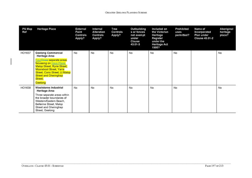
The Panel has recommended additional heritage assessments be undertaken of the Woolstores Industrial Heritage Area and a review of the Geelong Commercial Heritage Area, in particular the contribution of Post war buildings.
The Panel has made recommendations about Submissions not referred to it and for which post-exhibition decisions to change the amendment have been made. In these instances, the recommendations of the Panel are not supported.
Councillor Mason moved, Councillor Murnane seconded -
That Council:
Adopts Amendment C359 Part 1 in the form outlined in Attachment 4 of this report;
Submits the adopted Amendment together with the prescribed information to the Minister for Planning requesting approval;
Updates the City Fringe Heritage Area Review 2016, Ceres Heritage Citations Project Study Report 2017 and the Former Dennys Lascelles Woolstore 20 Brougham Street, Geelong Heritage Assessment 2017 with the post-exhibition and adoption changes; and
Defers consideration of Amendment C359 Part 2 until Heritage Victoria has changed the extent of its registration for the former Ropeworks site at 9 Scarlett Street, Geelong West.
Carried.
Amendment C359 is a comprehensive and complex amendment covering many sites. It is a culmination of a number of pieces of work that the City has undertaken over the last couple of years. These have been combined into a single amendment to support the efficiency objectives of DELWP in reducing the number of planning scheme amendments.
The heritage studies subject to the amendment are:
City Fringe Heritage Area Review 2016
Ceres Heritage Study Report 2017
Dennys Lascelle Wool Store – 20 Brougham Street, Geelong
The amendment also corrects numerous heritage anomalies and deals with the heritage overlay and the environment audit overlay at 9 Scarlett Street, Geelong West.
The Amendment was exhibited from Thursday 31 August to Monday 2 October 2017. Notice of the Amendment was mailed to all owners of land affected by the Amendment.
As a result of exhibition 11 submissions were initially received – Two submissions support the Amendment; one submission both supports and opposes different parts of the Amendment, and the balance either object or request changes to the Amendment. A further submission was accepted by City officers on 16th January 2018, raising the total to 12 submissions. The late submission sought a change to the grading of the house at 14A Western Beach Road Geelong from contributory to non-contributory.
The objecting submissions were largely objections to the inclusion and deletion of properties in the heritage overlay, the level of significance ascribed to properties, the exclusion of items from the amendment and general comments about the loss of Geelong’s heritage and the trend of facadism.
Submissions 3, 4, 5, 6, 7, 8, 9, 11 and 12 were not referred to the Panel as these were resolved to the satisfaction of the submitters. These submissions include:
Submission 3 supported the Amendment.
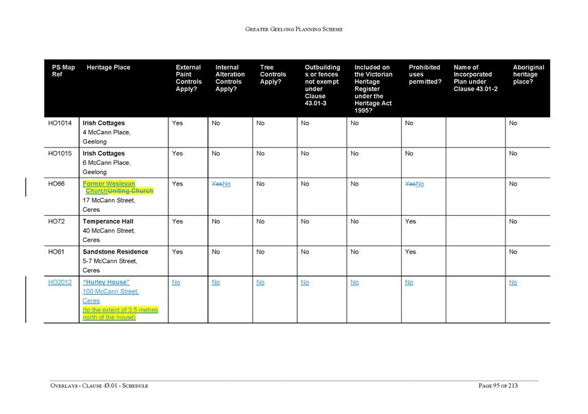
Submission 4 (17 McCann Street, Ceres) opposed the extension of the Heritage Overlay (HO66) to cover the site as a planning permit had been issued for the demolition and development of the site. This was supported and resolved to alter the exhibited mapping of HO66 to reduce the overlay to only cover the former Church Building and a curtilage along its southern side.
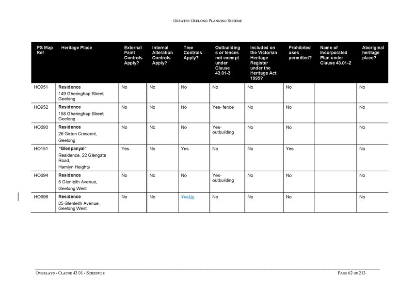
Submission 5 (25 Glenleith Avenue, Geelong West – change to HO696) submitted that the Schedule to the Heritage Overlay be amended to delete tree controls as there are no trees of significance on site and not reference to trees in the citation. This submission was supported.
Submission 6 (25-29 Ryrie Street, Geelong – proposed inclusion in HO1637) supported the deletion of the site from the current HO1639 but opposed the inclusion of the property in HO1637 Geelong Commercial Heritage Areas. The submission opposed the nomination of 25-29 Ryrie Street as a contributory property within the proposed expanded area of HO1637. This submission was and resolved to remove the properties centred on the Ryrie Street/Fenwick Street intersection from inclusion in HO1637 and to make changes to the City Fringe Heritage Area Review.
Submission 7 (20 Brougham, Street Geelong – proposed HO2013) recognised that the woolstore is significant however objected to the recommendation in the citation to retain the saw-tooth roof on the basis that the roof is not original and a planning permit has been issued for redevelopment of the site, which includes removal of the roof. This was supported and resolved to amend the citation to delete reference to retaining some of the form of the roof.
Submission 8 – 100 McCann Street, Ceres (proposed HO2012) sought to change the statement of significance to clarify the gable roof section as the rear of the cottage is not of heritage significance and change the northern boundary of the Heritage Overlay to exclude the modern prefabricated building. The submission was supported and agreed to change the citation and reduce the extent of the Heritage Overlay.
Submission 9 – supported the removal of the Heritage Overlay from 9 Scarlett Street, Geelong West (part of the ropewalk site).
Submission 11 (42-44 Western Beach Road, Geelong – proposed HO2018) sought to change the grading of 42-44 Western Road, Geelong from ‘contributory’ to ‘non-contributory’ as half the site is a 1990 development and the balance is a cheap and modest construction. This submission was supported and resolved to change the grading to non-contributory.
Submission 12 (14A Western Beach Road, Geelong – proposed HO2018) opposed the inclusion of the building as ‘contributory’ as the site has been altered and was not a good example of a Post war residence. The submission was and resolved to change the grading to non-contributory.
Three outstanding submissions (Submissions 1, 2 and 10) could not be resolved and were referred to the Panel:
Objection to proposed inclusion of 285 Gully Road, Ceres within a Heritage Overlay (Submission 1)
Objection to proposed inclusion of 11 Mercer Street, Geelong within a Heritage Overlay (Submission 2)
Submission from the National Trust which both supported aspects of the amendment and objected to the removal of a number of properties within the Heritage Overlay, in particular within the City Fringe Heritage Precinct (Submission 10).
On 21 November 2017 the City’s delegate (Peter Smith – Coordinator Strategic Implementation) considered a report on the submissions and made the following decision:
Request the Minister for Planning to appoint a Panel under Part 8 of the Planning and Environment Act 1987;
Refer submissions 1, 2 and 10 on Amendment C359 to the Panel; and
Submit to the Panel its response to the submissions generally as outlined in this report.
On 6th February 2018 the City’s delegate (Peter Smith) again considered a report on the late submission which was accepted mid-January 2019. This report considered the submission by Mr Peter Andrew Barrett about the house at 14A Western Beach Road and made the following decision:
Support the change to the Amendment as requested by the submission by changing the designation of the property at 14A Western Beach Road Geelong from contributory to non-contributory in the City fringe Heritage Area Review 2016; and
Advise the appointed Independent Panel of Council’s consideration and resolution of the submission.
A one-person Panel, chaired by Ms Lucinda Peterson, conducted the Hearing on 14 February 2018.
An Officer from the Strategic Implementation Unit represented the City and reflected the delegated authority resolutions and argued that the amendment is strategically justified. Further, the Officer indicated that a series of post-exhibition changes to the amendment were made to respond to issues raised in submissions.
The Panel Report, received on 23 April 2018, generally supports the City’s position on the amendment, but has recommended some changes to the amendment for adoption. The Panel Report’s Executive Summary is at Attachment 2.
Attachment 3 is a table listing all of the Panel’s recommendations, a summary Council response and adopted Council position.
The sites/locations considered during the Panel Hearing, the Panel’s conclusions and recommendations and Council officer’s response are outlined below using the headings from the Panel Report.
Section 3.1: City Fringe Heritage Area Review (East)
Summary findings
The Panel concludes:
Generally the reconfiguration of the City East Heritage Precinct and Austin Park and Environs Precincts are appropriate.
The southern precinct edges of City East Heritage Precinct should retain 86 and 88 Sydney Parade and 3 and 2-6B Sydney Avenue within the City East Heritage Area given the significance of the axial street pattern.
Given the context of the precinct, 153 to 165 Corio Street should be retained within the Heritage Overlay and these properties should be incorporated in the Austin Park and Environs.
The Panel recommends:
Amend the Heritage Overlap Map to:
Retain 2-6B and 3 Sydney Avenue and 86-88 Sydney Parade, Geelong within the Heritage Overlay in the City East Heritage Precinct (HO1639)
Include 153-165 Corio Street, Geelong within the Heritage Overlay in the Austin Park and Environs Heritage Precinct (HO2016).
Amend the City Fringe Heritage Area Review:
Heritage Citation for City East Heritage Area to include and list 2-6B and 3 Sydney Avenue and 86-88 Sydney Parade, Geelong as non-contributory.
Heritage Citation for Austin Park and Environs Heritage Area to include and list 153-165 Corio Street, Geelong as non-contributory.
Council Officer Response:
These recommendations of the Panel are supported. The heritage expert author of the City Fringe Heritage Area Review considered in detail the extent of the proposed new precincts and determined that the inclusion of non-contributory sites at the edges of the precincts was unnecessary. Discussions with the author post receipt of the Panel’s Report indicated that this Panel recommendation is satisfactory to the integrity of the City Fringe Heritage Area Review. The retention of these edges within the precincts will ensure that any future development is respectful of the heritage values and characteristics of the City East Heritage Area and the Austin Park and Environs Heritage Area and nearby contributory buildings.
Section 3.2 City Fringe Heritage Area Review (West)
Summary findings
The Panel concludes:
The proposed removal of 12 Ryrie Street, Geelong from the Heritage Overlay is not supported given its location among highly significant buildings on Ryrie Street.
Council’s post-exhibition proposal to remove properties from the Heritage Overlay (including contributory buildings) in the vicinity of Ryrie Street and Fenwick Street until the Geelong Commercial Heritage Area is reviewed is not supported.
The Geelong Commercial Heritage Area should be reviewed as a priority in further strategic work to include assessment of Post war places.
The Panel recommends:
Amend the Heritage Overlap Map to:
Retain the land bounded by Little Ryrie Street, Fenwick Street, Little Malop Street and La Trobe Terrace within the Heritage Overlay (excluding 10 Little Malop Street, 245 and 259 La Trobe Terrace, 13 Ryrie Street and 1 Little Ryrie Street).
Council Officer Response:
The recommendations of the Panel about the City Fringe Heritage Area West are not supported. Submission 6 was resolved post exhibition to the satisfaction of the submitter. With the input of Council’s Heritage Advisor, the resolution of the submission included that the proposed western extension of the Geelong Commercial Heritage Area centred along Ryrie Street be deleted from the amendment and that the Geelong Commercial Heritage Area be fully reviewed to account for other post-war development of potential significance, and to accord with the Planning Practice Note. It was recognised that this approach will see some buildings of proposed contributory significance vulnerable during the intervening period, but that ultimately the analysis should assist in providing a sound basis for the revised heritage values of this existing heritage area.
To retain now retain these properties in the heritage overlay for an indefinite period will continue a policy vacuum for these sites as all the precinct-based heritage overlays in the area are changing, the local planning policies are changing and there is no citation sheet or statement of significance for these sites.
A post-panel report letter from the submitter has urged Council to not support the Panel recommendation given that this issue was resolved by Council prior to the Hearing, and also on the grounds that it would be at odds with the principle of natural justice and Section 24 of the Planning and Environment Act 1987.
To renege on the resolution of submission 6 would be a reversal of the post-exhibition change to the Amendment, and would lose the faith and goodwill between Council and the Submitter. The Planning and Environment Act 1987 is clear that there are 3 options for the planning authority when making decisions on the submissions:
change the amendment in the manner requested; or
refer the submission to a panel; or
abandon the amendment or that part of the amendment
As the submission was resolved by changing the amendment and not referred to a Panel, Council has already acted as per the first of the 3 options listed above.
The amendment proposed for adoption is consistent with Council’s resolution of the submission and does not include the area in the vicinity of the Ryrie Street and Fenwick Street intersection in the heritage overlay.
If these sites were to remain within the heritage overlay, there are complexities relating to the lack of evidence and statement of significance for them. As they are being deleted, it is reasonable to make it a priority to undertake the further work for the Geelong Commercial Heritage Area and then proceed with another planning scheme amendment following this. In the meantime, if a permit is sought that potentially negatively impacts on a potentially significant site, Council has the option to seek an interim amendment from the Minister for Planning.
It is recommended that priority be given to the review of the Geelong Commercial Heritage Area overlays.
Section 3.3: City Fringe Heritage Area Review (North)
Summary findings
The Panel concludes:
Although it is an eclectic area, refining of the City Fringe Heritage Area (North) to the Western Beach Road Heritage Precinct is appropriate.
The properties 14A, 34 and 44 Western Beach Road are non-contributory.
No 42 Western Beach Road clearly displays the characteristics of the Post-War style that contributes to the significance of the precinct and is therefore contributory.
The Panel recommends:
Amend the City Fringe Heritage Area Review:
For the Western Beach Road Heritage Area, list 14a and 44 Western Beach Road as non-contributory.
Council Officer Response:
Submission 12 dealt with the site at 14A Western Beach Road and was resolved by the City post-exhibition with a change to the amendment. The submission therefore wasn’t referred to the Panel. As the recommendation of the Panel about 14a Western Beach Road is consistent with Council’s resolution of the submission, the Panel’s recommendation supports Council’s position on this site.
Submission 11 dealt with 42-44 Western Beach Road and was not referred to the Panel as Council had resolved it post-exhibition. The Panel’s conclusion about 42 Western Beach Road is at odds with the City’s post-exhibition change to the amendment. The heritage expert author of the City Fringe Heritage Area Review, when consulted about the submission, considered the status of the buildings at 42 and 44 Western Beach Road and advised the City that the grading can be altered to non-contributory. Officers support this position and disagree with the Panel recommendation on a submission that was resolved and not referred to it.
Section 4: 11 Mercer Street, Geelong
Summary findings
The Panel concludes:
The primary consideration for whether a place should be formally recognised in the planning scheme under the Heritage Overlay is whether it is of cultural heritage significance. As opposed to ‘intactness’ or ‘integrity’, the condition of a building does not inform whether a building is significant. The issue of condition is more appropriately considered at the planning permit stage when plans are put before the Council.
The Panel considers that 11 Mercer Street is of local significance for historical and representative reasons and that the heritage citation should be amended to remove reference to aesthetic significance and detail those parts of the property that are not significant.
The Panel also concluded that the Heritage Overlay should be refined to apply only to the Victorian building and the remainder of the site need not be included in the Heritage Overlay.
The Panel recommends:
Amend the Heritage Overlay Map to:
Include only the two storey Victorian building at 11 Mercer Street, Geelong and exclude the balance of the land.
Amend the Heritage Overlay Schedule to:
Change 11 Mercer Street (HO2015) to explain that the Heritage Overlay does not include the 1960s and 1980s buildings to the rear and only includes the two storey Victorian building.
Amend the Heritage Citation for 11 Mercer Street, Geelong to identify and document the place in the context of representative significance and remove references to aesthetic significance and specify those parts of the building that are not significant, consistent with Appendix B.
Council Officer response:
The conclusions of the Panel about the heritage significance of the site are supported and reflect the City’s position put to the Panel during the course of the Hearing.
Post the Panel Hearing, the City’s Municipal Building Surveyor has been considering a request for an emergency works order to demolish the building. This was made just days post the Panel Hearing, at which, disappointingly, no mention of this impending request was made.
Council’s Municipal Building Surveyor has exercised powers to inspect the building and ascertain its structural integrity and safety. The inspection determined that the building is unsafe, has lost its structural integrity and does not meet current safety standards. The condition of the building poses a severe risk to life in a strong wind or rain event. A cease of occupation order has been issued and an exclusion zone established in Mercer Street. An Emergency Building Order for a safe and controlled demolition of the building was issued on 24 may 2018 and is to be carried out within 30 days of issue.
Whilst the Panel has independently reviewed and recommended the inclusion of 11 Mercer Street within the heritage overlay, the emergency building order and impending demolition of site effectively render this action redundant. Reluctantly, it is therefore recommended that Council not support the Panel’s recommendation for 11 Mercer Street.
Section 5: Ceres Heritage Study 2017
Summary findings
The Panel concludes:
The content of the citations in the Ceres Heritage Study is of high quality.
The Panel accepts the confined nature of the Ceres Heritage Study 2017 in the context of this Amendment.
Section 5.2: 285 Gully Road, Ceres
The Panel, concludes:
The property at 285 Gully Road, Ceres is of local significance and a Heritage Overlay is justified.
The post exhibition revised Heritage Overlay map is sufficient to retain the significance of the place.
The Panel recommends:
Amend the Heritage Over Map to:
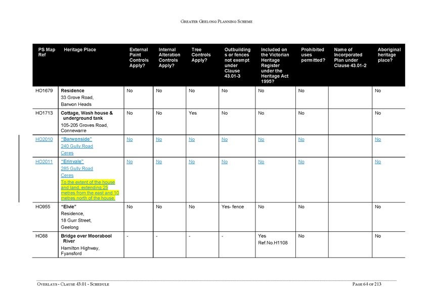
Reduce the extent of the Heritage Overlay at 285 Gully Road, Ceres (HO2011) to 10 metres north of the house.
Amend the Heritage Overlay Schedule to:
Change 285 Gully Road, Ceres (HO2011) to explain that the Heritage Overlay includes the house and land 25 metres from the east and 10 metres north of the house.
Amend the Heritage Citation for 285 Gully Road, Ceres to update the history and physical description of the building, specify those parts of the building that are not significant and policy around changes to the building including the wording “Subject to planning and building permits, opportunities are available to construct rear (southern) and side (eastern) additions to the existing dwelling. For major additions, it is suggested that consideration is given to the retention of the existing original three dimensional integrity of the dwelling, possibly by setting down the roofs and eaves of the new work, or by connecting to the existing by a narrow link. It is also suggested that any addition on the east side is set back from the front to enable the retention in the integrity and character of the principle front three dimensional portion of the dwelling”, consistent with Appendix C.
Council Officer Response:
These recommendations of the Panel are supported and reflect the proposed changes put to the Panel by the Officer.
Section 5.3: 17 and 100 McCann Street, Ceres
Summary findings
The Panel concludes:
The former Sunday school building at 17 McCann Street has been demolished and therefore the existing extent of the Heritage Overlay that includes the church only should be maintained.
It is appropriate that the Heritage Overlay be revised on 100 McCann Street to exclude the prefabricated building and revise the citation to clarify the non-contributory nature of 1940s addition.
The Panel recommends:
Amend the Heritage Overlap Map to:
Retain the current extent of the Heritage Overlay at 17 McCann Street, Ceres to include the church only.
Exclude the pre-fabricated building at 100 McCann Street, Ceres
Amend the Heritage Overlay Schedule to:
Allocate ‘No’ in the outbuildings column for 17 McCann Street, Ceres (HO66) to remove reference to the former Sunday school building.
In the description of the Heritage Place for 100 McCann Street (HO2012) the extent of the Heritage Overlay is 3.5 metres north of the house.
Amend the Heritage Citation:
For 17 McCann Street, Ceres remove reference to the Sunday school in the Statement of Significance although retain reference to the Sunday school in the site’s history.
For 100 McCann Street, Ceres clarify that the 1940s gable extension is not significant.
Council Officer Response:
Submissions 4 (17 McCann Street) and 8 (100 McCann Street) were resolved by the City and not referred to the Panel. Nonetheless, these recommendations of the Panel are generally supported as they reflect the changes made to the amendment post-exhibition by Council to resolve the submissions. The only exception to this is the Panel recommendation to retain the current extent of HO66 boundary affecting 17 McCann Street. As per the post-exhibition change to the amendment to resolve Submission 4, the mapping of HO66 is to be contracted to only cover the former Church building and a curtilage along its southern and western sides. This has been accepted by the landowner and better reflects the extent of significance of the Church.
Section 6: 20 Brougham Street, Geelong (Former Dennys Lascelles Woolstore)
Summary findings
The Panel concludes:
20 Brougham Street, Geelong warrants inclusion in the Heritage Overlay as exhibited.
Reference to the saw-tooth roof at 20 Brougham Street, Geelong should remain within the “Other recommendations” section of the citation as exhibited.
Council should consider for further strategic work reviewing the Woolstores Industrial Heritage Area and design guidelines to discourage facadism treatment.
The Panel did not make any recommendations about this site.
Council Officer Response:
Council resolved Submission 7 with a post-exhibition change to the citation sheet for this property. This change was accepted by the submitter and the submission was not referred to the Panel. The Planning and Environment Act 1987 is clear that there are 3 options for the planning authority when making decisions on the submissions:
change the amendment in the manner requested; or
refer the submission to a panel; or
abandon the amendment or that part of the amendment
Given that under delegation it was resolved to change the amendment and notify the submitter, Council has made its determination as per the first of the 3 options listed above.
The amendment proposed for adoption is consistent with the resolution of the submission post-exhibition and does not include the requirement in the citation sheet to retain the saw-tooth roof.
Section 7: 9 Scarlett Street, Geelong West (Donaghy’s Rope Walk)
Summary findings
The Panel concludes:
9 Scarlett Street, Geelong West should not be removed from the Heritage Overlay as it is still on the Victorian Heritage Register and its removal while it is on the Victorian Heritage Register is contrary to the Planning Practice Note Applying the Heritage Overlay and the Heritage Act 2017. Its inclusion in the Victorian Heritage Register should be considered first.
When the satisfaction of the requirements of the Environmental Audit Overlay have been met, the Environmental Audit Overlay should be removed.
The Panel recommends:
Amend the Schedule to the Heritage Overlay for HO741 ‘Donaghy’s Rope Walk’ to retain 9 Scarlett Street, Geelong West.
Retain the existing extent of the Heritage Overlay on 9 Scarlett Street, Geelong West.
Council Officer Response:
As Submission 9 was a supporting submission for the amendment, there was no resolution to change the amendment or refer it to a Panel. The Panel recommendation to resolve the Victorian Heritage Register listing of 9 Scarlett Street prior to dealing with the Heritage Overlay is supported. At the time of the emergency works order to demolish the structure, the advice from Heritage Victoria (HV) to the landowners’ consultant was that it would just be a matter of HV amending the Registration to delete reference to the structure. Council proceeded with the amendment to remove the heritage overlay on the understanding that HV was undertaking the Registration change. However, this was not acted upon by HV, with the position since changing to an application having to be made to amend the Registration.
The landowner will now make the application, and the City will provide a letter of support for the application.
It is recommended that Amendment C359 be split into 2 parts, with part 1 comprising all parts of the amendment with the exception of the heritage overlay change to 9 Scarlett Street, and that this be placed on hold until the HV registration is sorted. This will save on another amendment being prepared at a later date. Part 1 will be adopted at this time and Part 2, containing just the heritage overlay change to 9 Scarlett Street, will be adopted at a future date when the HV registration has been resolved. This approach has been discussed with DELWP officers and received their support.
A certificate of Environmental Audit was issued by an Environmental Auditor appointed under the Environment Protection Act 1970 on 28th February 2018. This certified that the condition of the land at 9 Scarlett Street Geelong West is neither detrimental nor potentially detrimental to any beneficial use of the site. There is no requirement for Council to provide any further approval. As the Certificate has been issued, the reason for the retention of the EAO has been removed and it is appropriate to delete the EAO as part of the amendment.
Panel’s Further Recommendations
Summary findings
The Panel has made two further recommendations which are beyond the scope of Amendment C359:
Council should consider reviewing the Woolstores Industrial Heritage Area and design policy to ensure that design response to development is best practice and avoids facadism.
Council should consider reviewing the Geelong Commercial Heritage Area, in particular the contribution of Post war buildings and the heritage contribution of Ryrie Street/Fenwick Street intersection.
Council Officer Response:
The Panel’s further recommendations about reviewing the Woolstores and Geelong Commercial Heritage areas are beyond the scope of Amendment C359 but will be taken into account as Council determines future heritage review priorities across the municipality. It is noted that a review of the heritage overlays for central Geelong is included in the Municipal Heritage Strategy 2017 as a short to medium term action. review of the Woolstores Industrial Heritage Area could be included within the scope of this work.
No change to the amendment is required from these Panel recommendations.
There will be no significant financial implications on Council.
The Amendment was exhibited in accordance with the provisions of the Planning and
Environment Act 1987 to provide for full public comment, including notifying all affected
landowners by mail. Submitters have been notified of the release of the Panel Report and will be notified of the Council’s adoption and of the final decision on the Amendment by the Minister for Planning.
The Amendment does not raise any social equity issues.
The amendment will result in a good planning outcome ensuring the preservation of locally significant heritage places.
The amendment will achieve the objectives of the State Planning Policy Framework at Clause 15.03-1 (Heritage conservation) by ensuring the conservation of places of heritage significance.
The Amendment will achieve the objectives of the Local Planning Policy Framework (LPPF) including:
Clause 21.06-5 Heritage and Identity includes an objective “to conserve and enhance individual places and areas of pre and post contact cultural heritage significance” with relevant strategies.
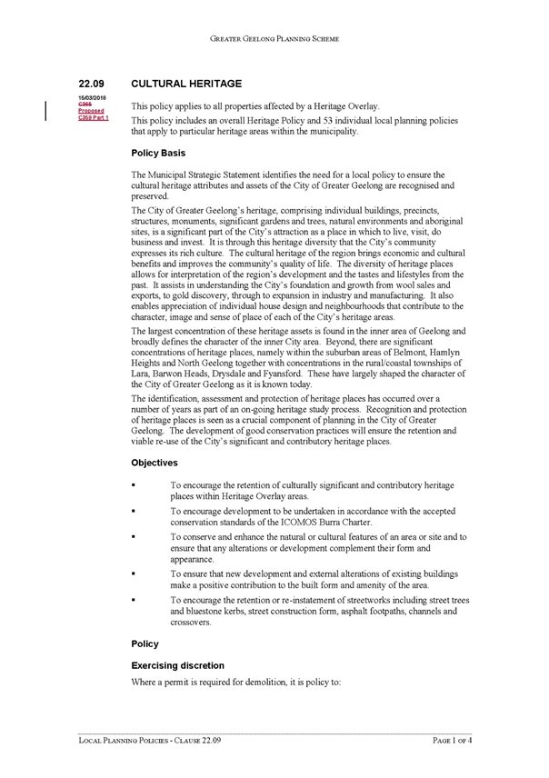
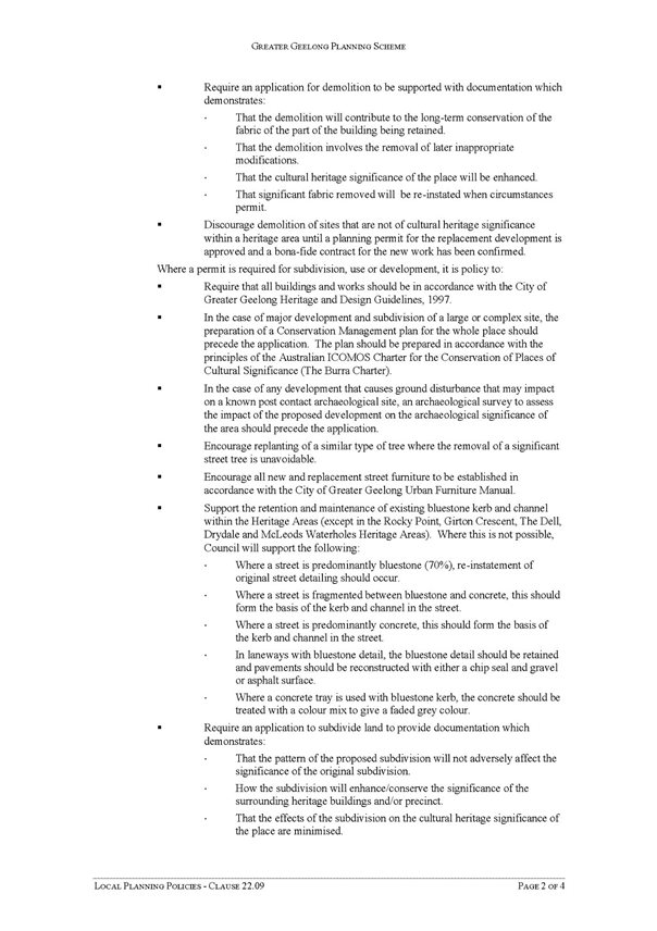
Clause 22.09 Cultural Heritage is a local policy that applies to all properties affected by a Heritage Overlay and hence would guide decision making on the precincts and individual properties to be included in the Heritage Overlay. This amendment will help achieve the Council cultural heritage objectives and implement the strategies identified in Clause 22.09.
The Amendment supports the Sustainable Built and Natural Environment strategic direction of City Plan and is consistent with the strategic direction of community Wellbeing and the priority of connected, creative and strong communities.
No Council Officers involved in the preparation of this report have any direct or indirect interest, in accordance with Section 80C of the Local Government Act.
There are no notable risks associated with implementing the recommendation contained in this report. There is a risk of loss of places of heritage significance without the introduction of the recommended planning provisions.
The proposed amendment will not have any adverse effects on the environment.
Panel Recommendation Greater Geelong Planning Scheme – Amendment C359 |
Summary Council Response |
Adopted Council Position |
City Fringe Heritage Area Review East |
||
Amend the Heritage Overlap Map to:
Amend the City Fringe Heritage Area Review:
|
Supported. |
Heritage Overlay map changed as per Panel recommendations. Citation sheets for the City East Heritage Area and the Austin Park and Environs Heritage Area changed as per the Panel recommendations. |
City Fringe Heritage Area Review West |
||
Amend the Heritage Overlap Map to:
|
Not supported |
Area deleted from proposed heritage overlay HO1637 and existing HO1639. |
City Fringe Heritage Area Review North |
||
Amend the City Fringe Heritage Area Review:
|
Supported in part. Changes to the City Fringe Heritage Area Review for 14A Western Beach Road and 44 Western Beach Road supported. Recommendation for 42 Western Beach Road not supported. |
City Fringe Heritage Area Review changed to list 14a, 42 and 44 Western Beach Road Geelong as non-contributory. |
11 Mercer Street, Geelong |
||
Amend the Heritage Overlay Map to:
Amend the Heritage Overlay Schedule to:
|
Not supported due to issue of emergency building order for demolition on 24 May 2018. |
11 Mercer Street Geelong deleted from proposed HO2015 on the Planning Scheme Maps and in the Schedule to Clause 43.01. Citation sheet for 11 Mercer Street Geelong to be updated to explain that the site was demolished in 2018 following the Emergency Building Order. |
285 Gully Road, Ceres |
||
Amend the Heritage Overlay Map to:
Amend the Heritage Overlay Schedule to:
Amend the Heritage Citation for 285 Gully Road, Ceres to update the history and physical description of the building, specify those parts of the building that are not significant and policy around changes to the building including the wording “Subject to planning and building permits, opportunities are available to construct rear (southern) and side (eastern) additions to the existing dwelling. For major additions, it is suggested that consideration is given to the retention of the existing original three dimensional integrity of the dwelling, possibly by setting down the roofs and eaves of the new work, or by connecting to the existing by a narrow link. It is also suggested that any addition on the east side is set back from the front to enable the retention in the integrity and character of the principle front three dimensional portion of the dwelling”, consistent with Appendix C. |
Supported. |
Heritage Overlay map changed to include a reduced extent for HO2011. The schedule to Clause 43.01 changed to clarify the extent of the overlay as per the Panel recommendation. Citation sheet in Ceres Heritage Study 2017 changed to incorporate the Panel recommendation. |
17 McCann Street and 100 McCann Street, Ceres |
||
Amend the Heritage Overlap Map to:
Amend the Heritage Overlay Schedule to:
Amend the Heritage Citation:
|
Supported in part. The mapped extent of HO66 is to be contracted to only cover the former Church building and a curtilage along its southern and western sides. |
Heritage Overlay map changed to modify the extent of HO66 including a reduced curtilage along the western and southern boundaries of the church building. Heritage Overlay map changed to modify the extent of HO2012 to delete the pre-fabricated building. The schedule to Clause 43.01 changed to remove reference to the Sunday school building for HO66. The schedule to Clause 43.01 changed to include the description of HO2012 as per the Panel recommendation. Citation sheet for 17 McCann Street changed as per the Panel recommendation. Citation sheet for 100 McCann Street changed as per Panel recommendation. |
20 Brougham Street, Geelong (Former Dennys Lascelles Woolstore) |
||
The Panel made conclusions about this site but did not make any recommendations about this site. |
Not Supported. |
Citation sheet for 20 Brougham Street changed to remove the reference to retention of the saw-tooth roof. |
9 Scarlett Street, Geelong West (Donaghy’s Rope Walk) |
||
Amend the Schedule to the Heritage Overlay for HO741 ‘Donaghy’s Rope Walk’ to retain 9 Scarlett Street, Geelong West. Retain the existing extent of the Heritage Overlay on 9 Scarlett Street, Geelong West. |
Supported. |
Amendment split into 2 parts. C359 Part 1 adopted. C359 Part 2 deferred. EAO deleted from 9 Scarlett Street as part of C359 Part 1. HO741 retained in C359 Part 2 until Heritage Victoria resolves their Registration for the site. |
Panel’s Further Recommendations |
||
The Panel has made two further recommendations: Council should consider reviewing the Woolstores Industrial Heritage Area and design policy to ensure that design response to development is best practice and avoids facadism. Council should consider reviewing the Geelong Commercial Heritage Area, in particular the contribution of Post war buildings and the heritage contribution of Ryrie Street/Fenwick Street intersection. |
Supported subject to budget and work program capacity. Beyond the scope of Amendment C359 but will be taken into account as Council determines future heritage review priorities across the municipality. |
No changes to this Amendment. |
The planning authority for this amendment is the City of Greater Geelong.
The Greater Geelong Planning Scheme is amended as follows:
The Planning Scheme Maps are amended by a total of 13 attached map sheets.
Overlay Maps
Amend Planning Scheme Map Nos. 31HO, 38HO, 47HO, 49HO, 50HO and 37EAO in the manner shown on the 13 attached maps marked “Greater Geelong Planning Scheme, Amendment C359 Part 1”.
The Planning Scheme Ordinance is amended as follows:
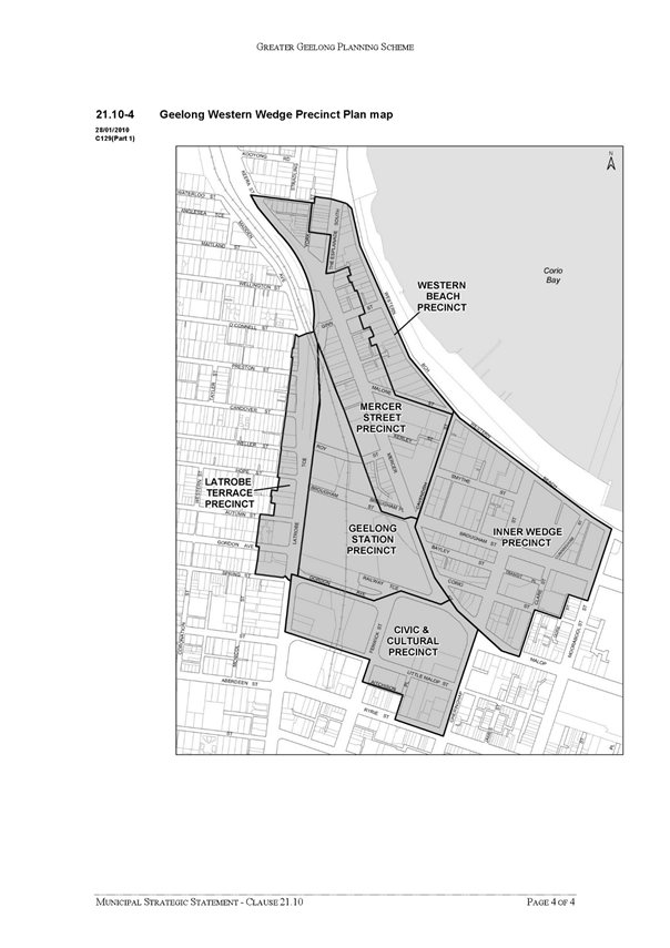
In Local Planning Policy Framework – replace Clause 21.10 with a new Clause 21.10 in the form of the attached document.
In Local Planning Policy Framework – replace Clause 22.09 with a new Clause 22.09 in the form of the attached document.
In Local Planning Policy Framework – replace Clause 22.28 with a new Clause 22.28 in the form of the attached document.
In Local Planning Policy Framework – replace Clause 22.30 with a new Clause 22.30 in the form of the attached document.
In Local Planning Policy Framework – replace Clause 22.32 with a new Clause 22.32 in the form of the attached document.
In Local Planning Policy Framework – insert new Clause 22.68 in the form of the attached document.
In Local Planning Policy Framework – insert new Clause 22.69 in the form of the attached document.
In Local Planning Policy Framework – insert new Clause 22.70 in the form of the attached document.
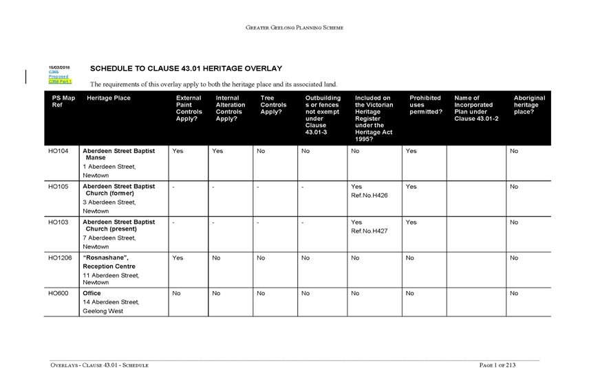
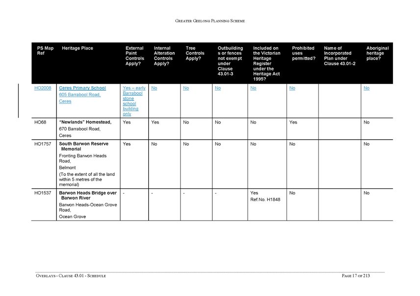
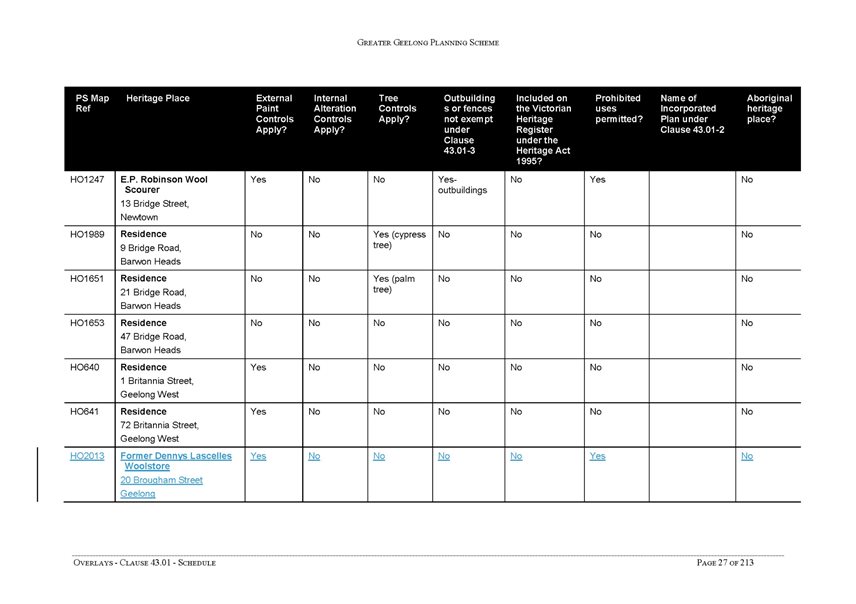
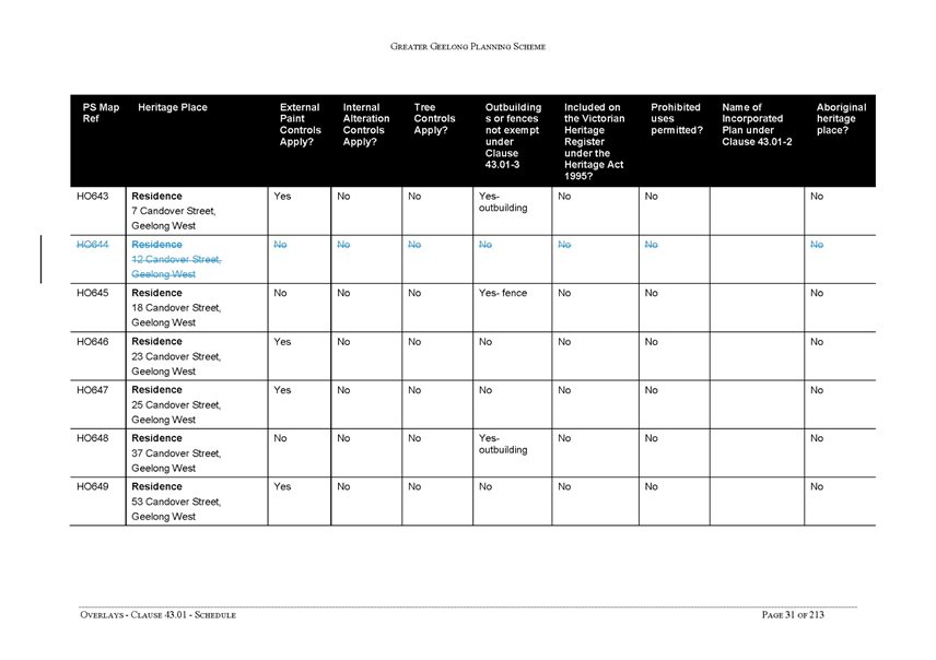
In Overlays – Clause 43.01, replace the Schedule with a new Schedule in the form of the attached document.
End of document
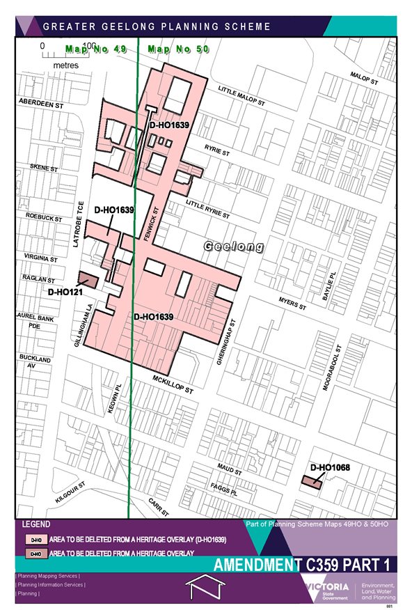
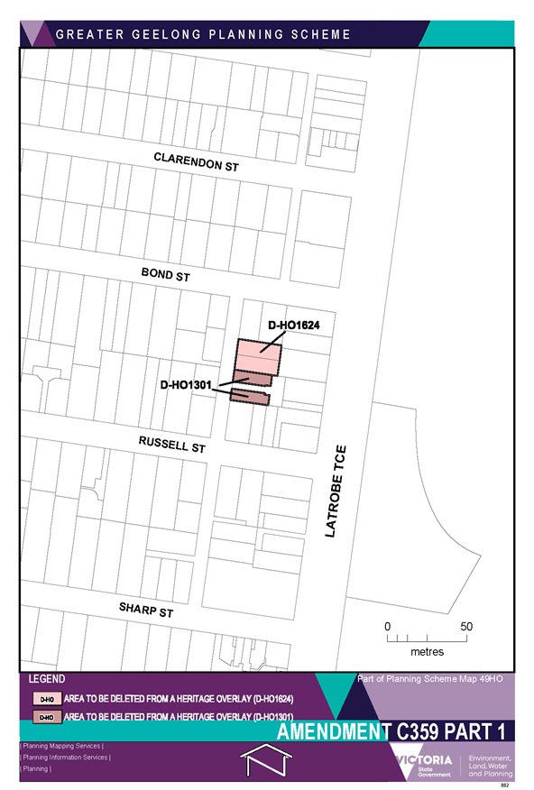
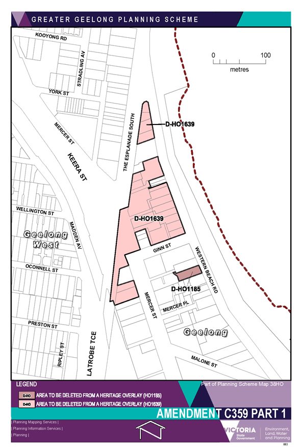
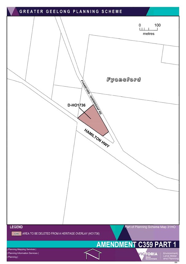
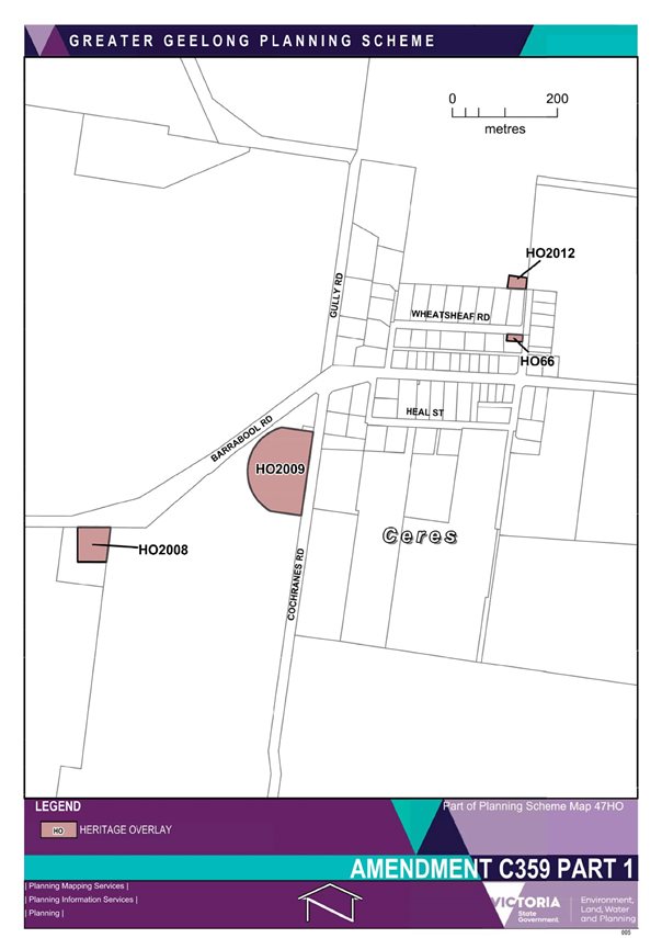
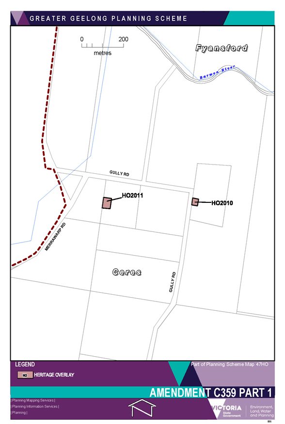
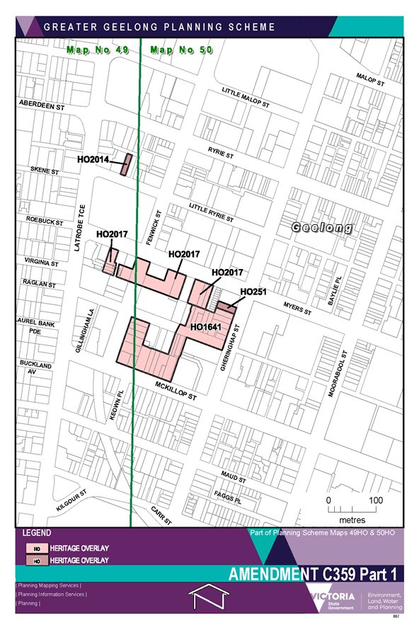
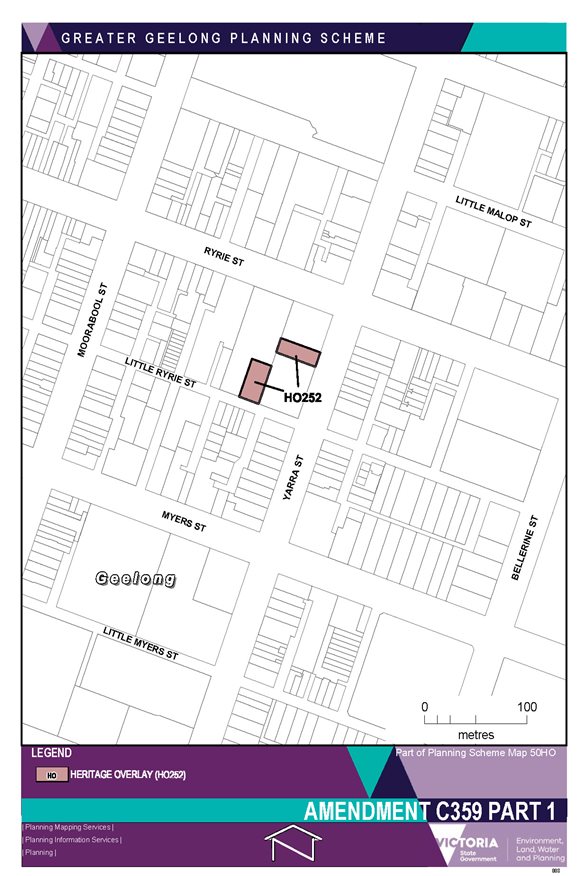
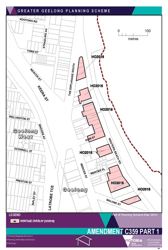
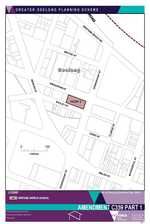
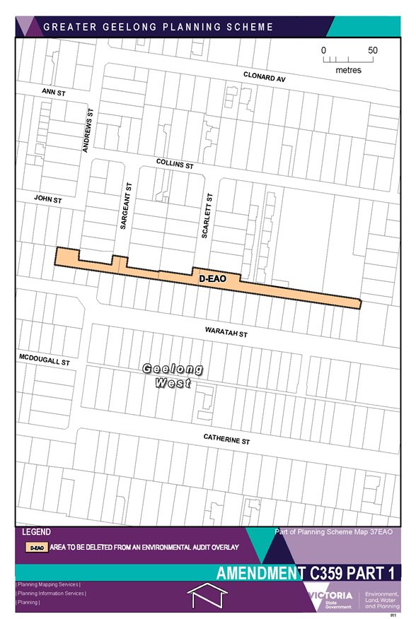
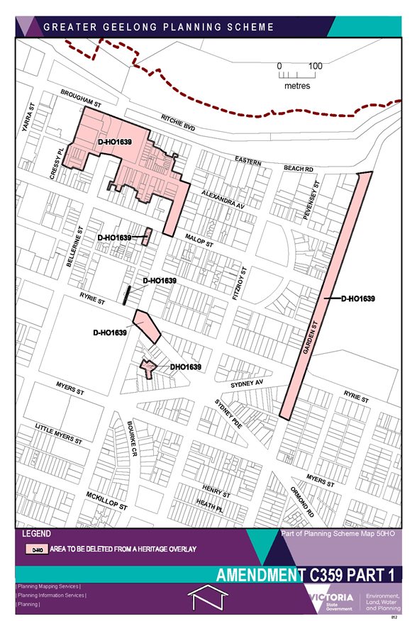
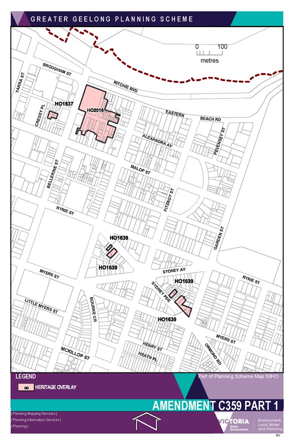
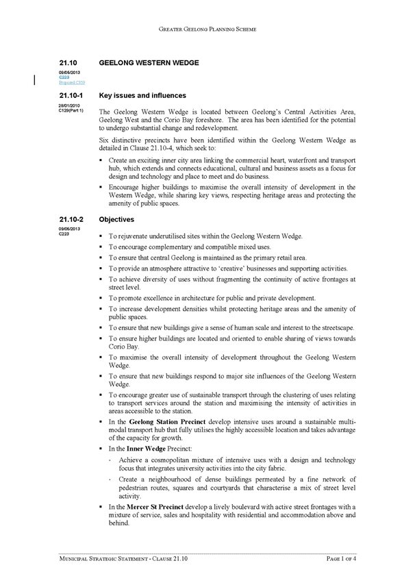
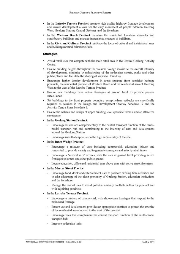
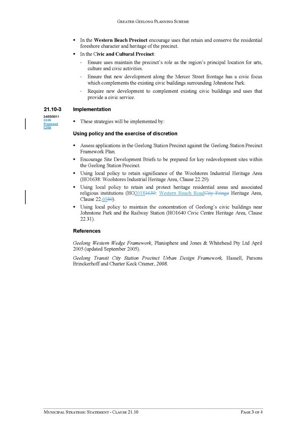
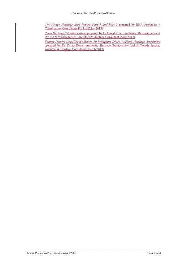
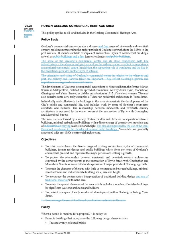
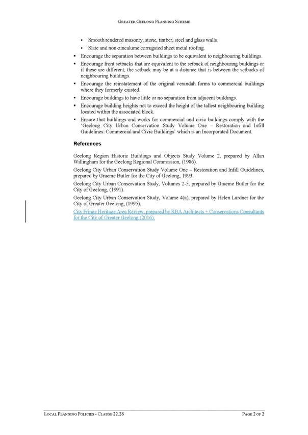
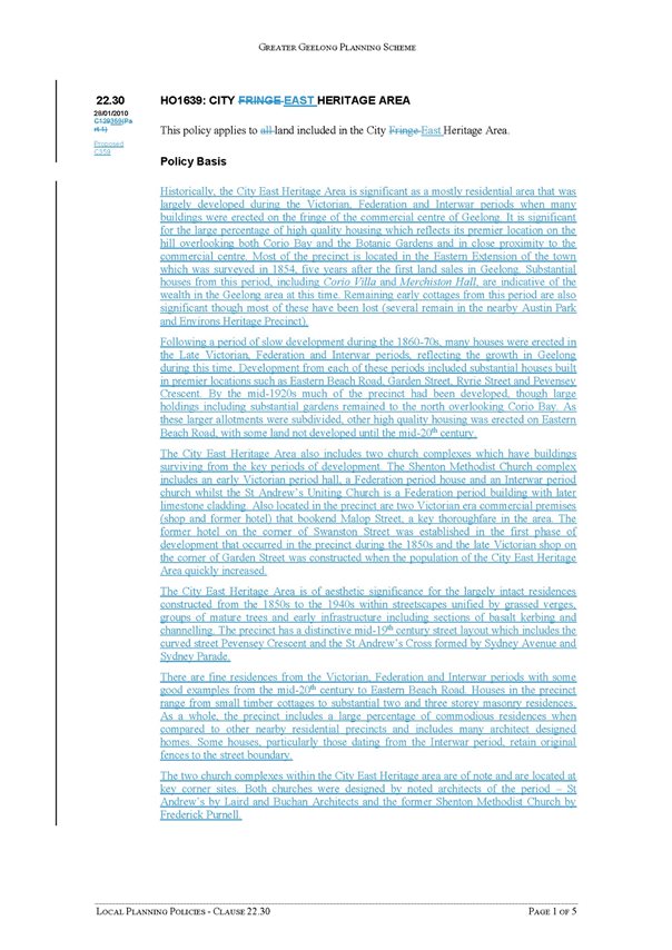
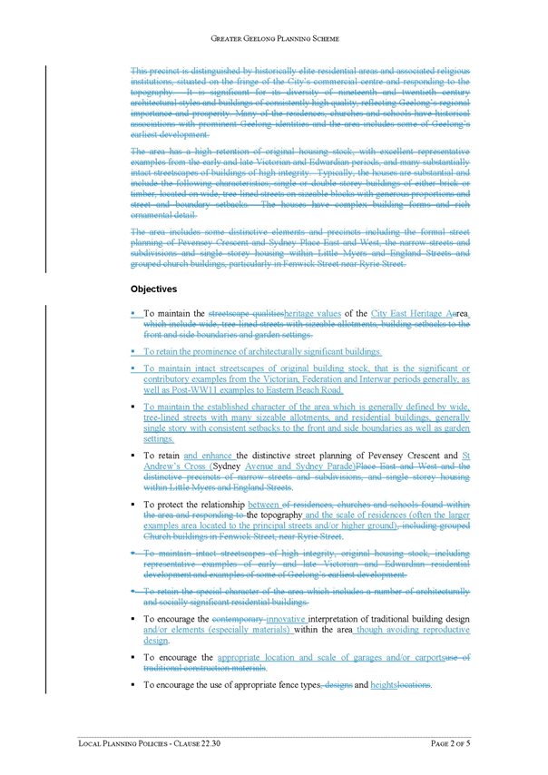
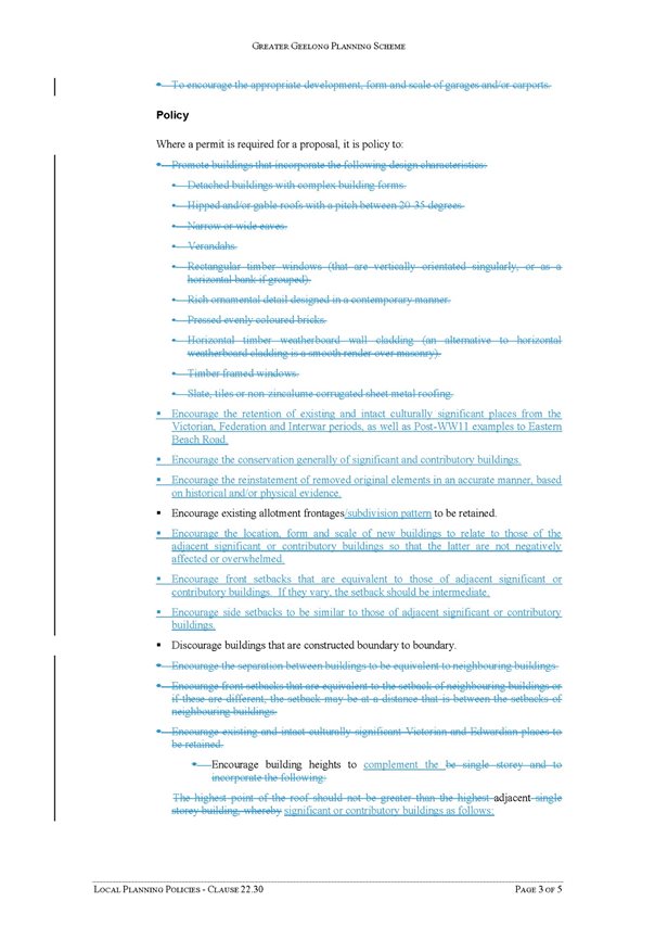
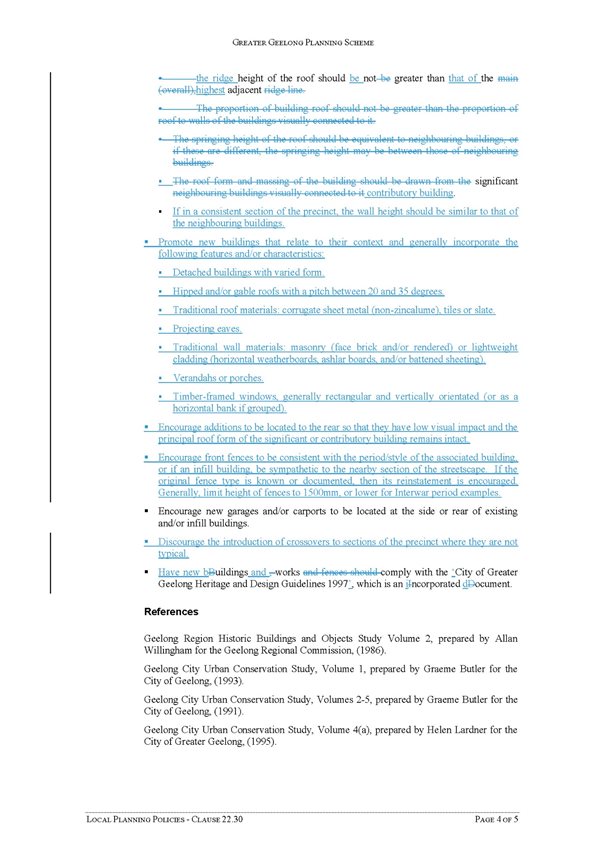
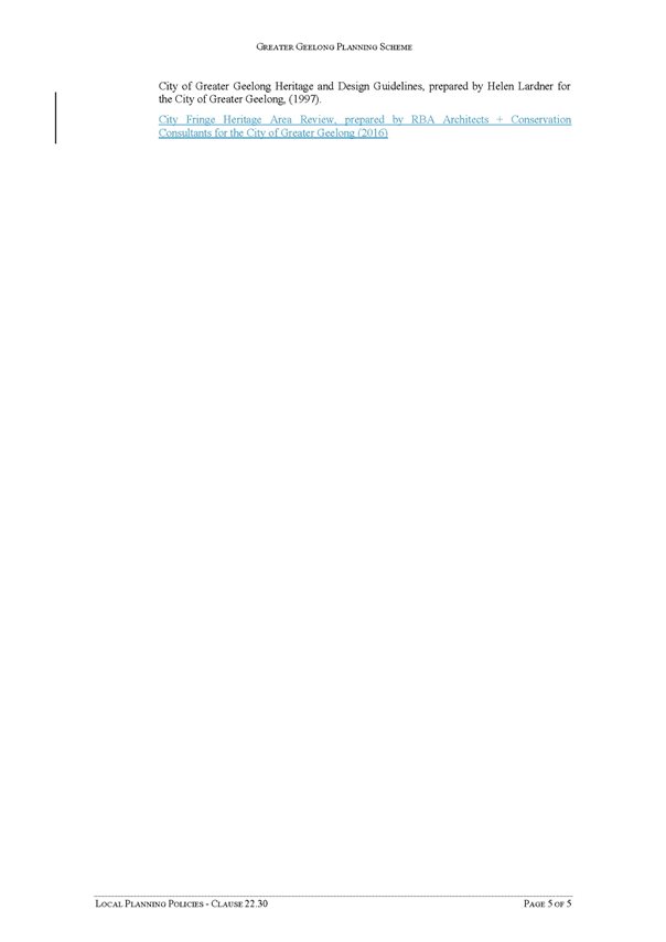
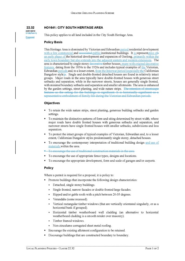
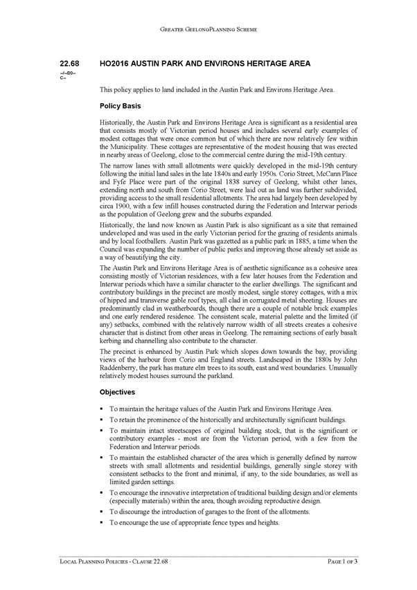
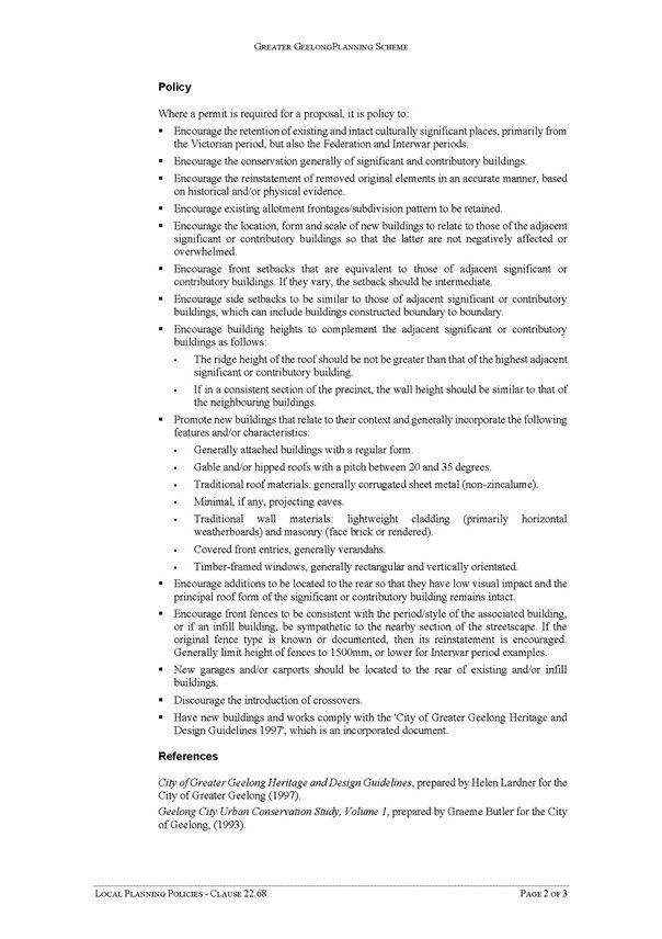
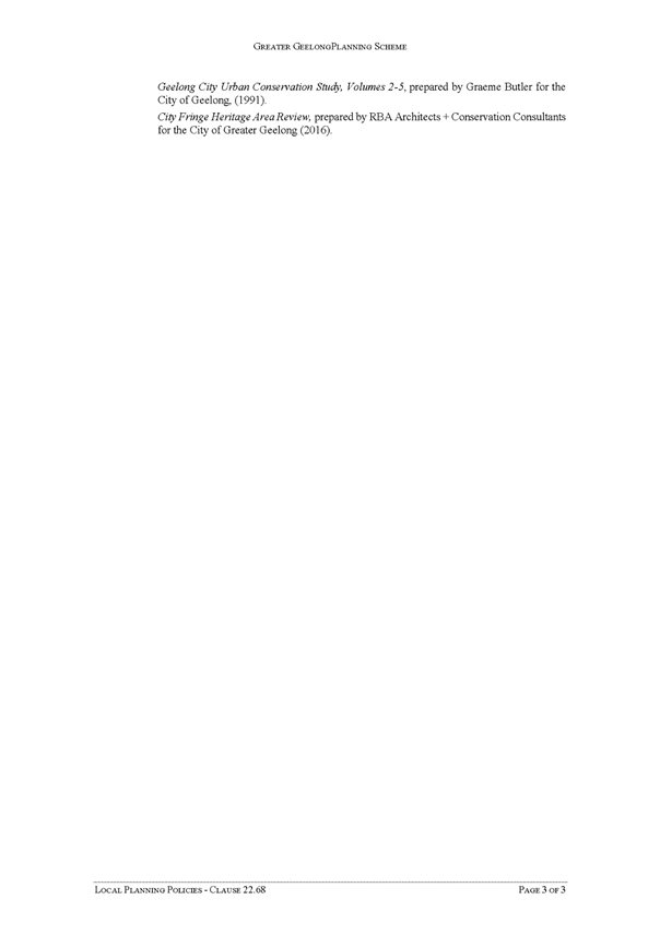
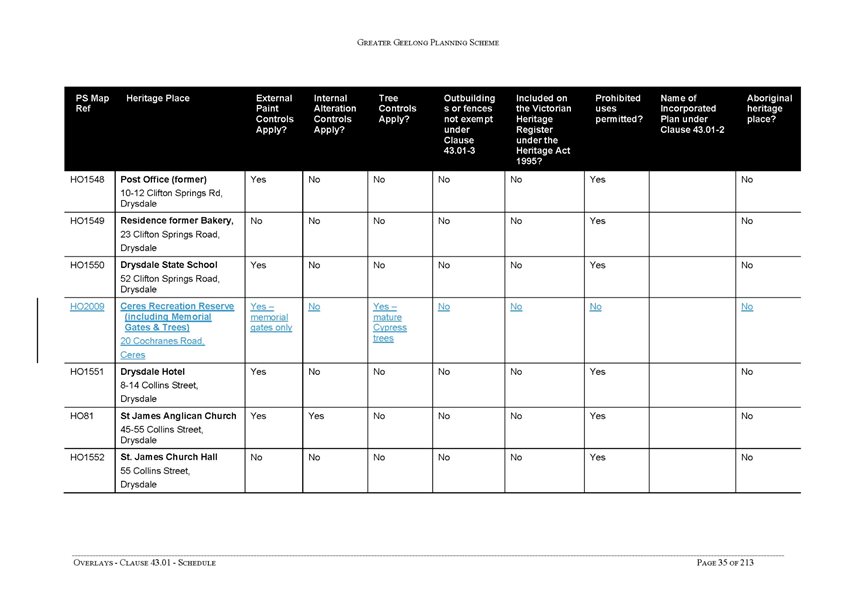
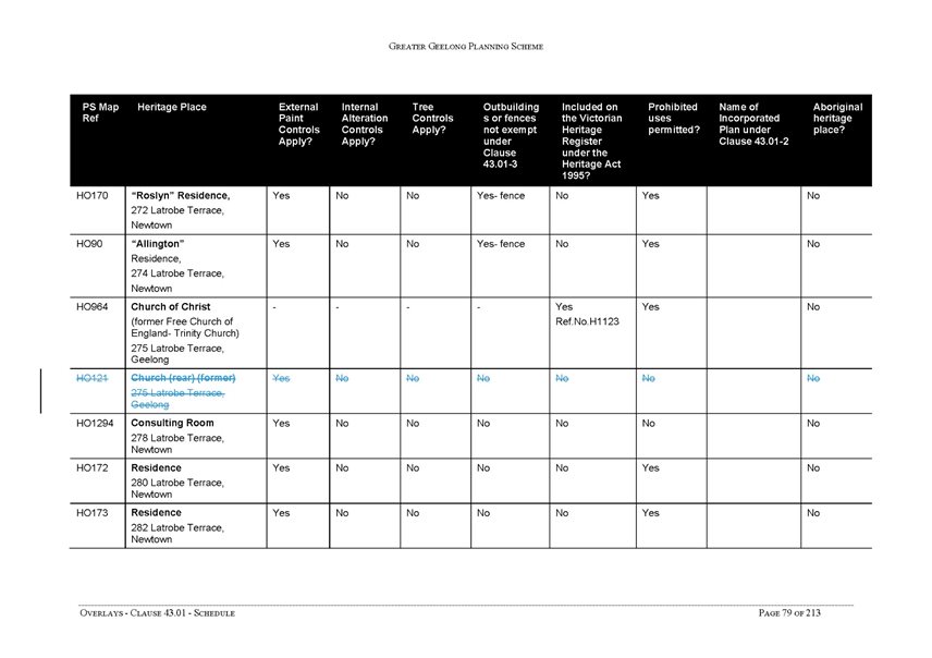
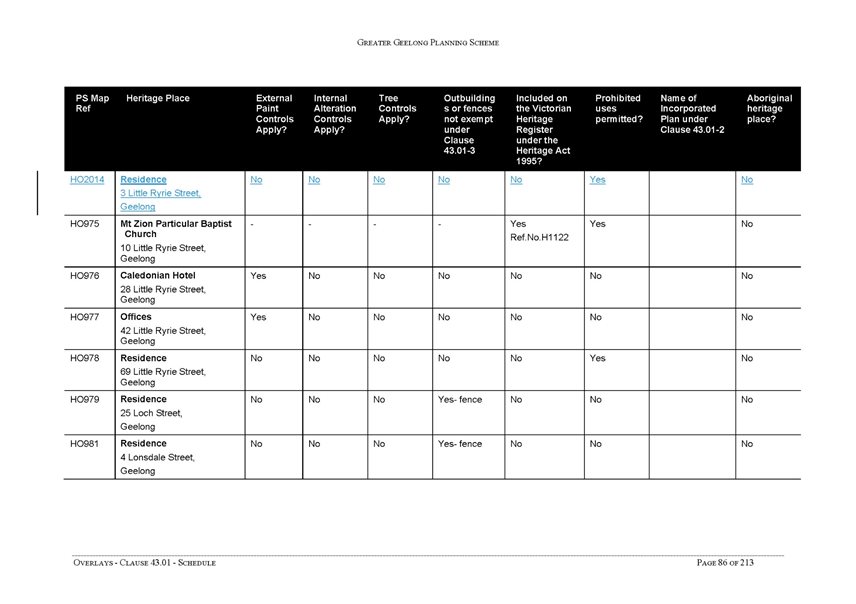
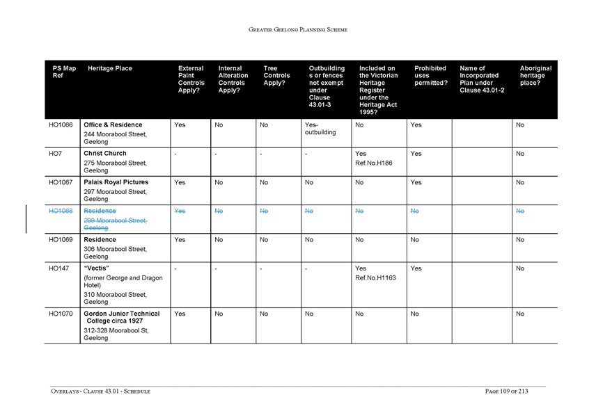
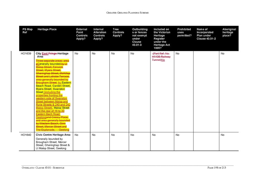
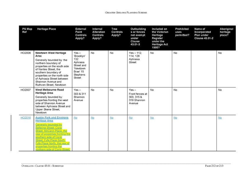
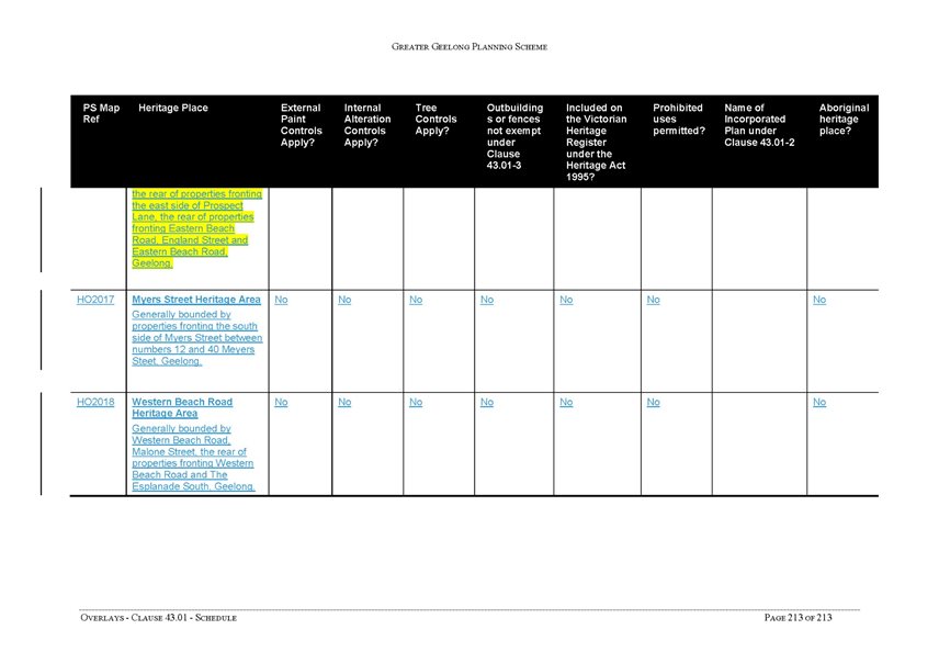
Note that only the affected pages of the Schedule to Clause 43.01 (the Heritage Overlay) are included in this Attachment. Changes made post-panel report highlighted in yellow.
[Back to List]
Source: |
Community Life - Social Planning and Investment |
Director: |
Linda Quinn |
Index Reference: |
Sports Leisure and Recreation - Sports |
Portfolio: |
Social and Infrastructure Planning |
To seek Council endorsement to release the draft Herne Hill Master Plan for the purpose of undertaking further community consultation.
Herne Hill Reserve is an active sports reserve located between Finchaven Street, Norwood Street and Edinburgh Avenue in Herne Hill.
Herne Hill Reserve has a mix of active uses including football, cricket and netball. The reserve serves as the home ground for the St Joseph’s Football and Netball Club (SJFNC) and the St Peters Cricket Club (SPCC), providing for 937 active sport club members (37% female). The reserve is a valued open space area that is utilised by the broader community. In 2017 a survey conducted of people living within 400m of the reserve indicated that 97.7% of respondents (46 people) visit the reserve on a regular basis.
In late 2016 Council Administrators met with representatives of the SJFNC. The club presented Council with a proposal to build a stand-alone female change facility (known as the ‘Wedge’), which was not the preferred approach to improvements at the reserve because of the number of single purpose standalone buildings already on the site. Subsequently, Council instructed officers to prepare a master plan for the Herne Hill Reserve to guide future development and improvement.
The draft Herne Hill Reserve Master Plan identifies the following items:
Oval boundary, drainage solution and parkland paths
Netball courtside support facilities (including public toilet)
New cricket net storage (next to cricket nets)
New playground and formalise the passive recreational area
Major pavilion refurbishment and significant extension to accommodate St Peters Cricket Club and St Joseph’s Football and Netball Club).
The total investment of the draft Herne Hill Master Plan if implemented is $4.08 million. $500,000 is allocated in the 2018/19 draft Council budget for the delivery of Stage 1. It is proposed that the delivery of the remaining stages be achieved via a funding partnership between the state government, local sporting clubs and City of Greater Geelong.
No funds have been allocated in the Strategic Resource Plan to complete the project.
There is a need to further test the propositions of the draft Master Plan with the broader community. There are no financial commitments associated with the release of the draft.
Councillor Kontelj moved, Councillor Aitken seconded -
That Council release the Draft Herne Hill Reserve Master Plan for the purpose of broader community consultation for a period of four (4) weeks.
Carried.
Background and Drivers
In late 2016 Council (Administrators) met with representatives of St Joseph’s Football & Netball Club. The club presented Council with a proposal to build a standalone female change facility (known as the ‘Wedge’). The proposal was to add another substantial built form into a reserve that already hosted a number of buildings. The proposal did not address some of the other needs of the community, including the football / netball and cricket clubs, growth in participation and the future use of the reserve.
Subsequently, Council requested officers to prepare a Master Plan for the Herne Hill Reserve to guide it’s future development and improvement, and that this be undertaken in consultation with the tenant clubs, governing bodies, the local community and key stakeholders.
Master Plan Development
In May 2018, the draft Master Plan was completed. The draft considers the issues and opportunities as they relate to the development and improvement of Herne Hill Reserve. It brings together the key findings captured throughout the development process, provides a proposed design response, indicates priorities for implementation and levels of investment.
The draft Master Plan aligns with Council’s 30-year vision and ensures that the long-term aspirations of the tenant clubs, community groups and local residents are taken into consideration so far. The plan addresses functional issues within the existing landscape (e.g. drainage, safe circulation and fit-for-purpose infrastructure) in addition to a focus on passive recreation areas to encourage community use of the reserve.
Master Plan Principles
A set of principles were developed that underpin the draft Master Plan and subsequent design response, with the view to:
consolidate built form;
improve access and amenity;
make fit-for-purpose;
provide and protect open space; and
ensure financial viability and overall sustainability.
Collective Priorities
In consultation with the St Joseph’s Football & Netball Club and the St Peters Cricket Club a needs analysis was completed. A number of collective priorities were identified:
improved drainage in and around the site;
improved suitability and functionality of existing buildings (including female friendly facilities);
provision of safe parking and pedestrian movement; and
improved quality and availability of open space and other public amenity.
Master Plan Priority Staging and Cost Estimates
The draft Master Plan provides a high level indication of the scale and types of improvements proposed to the Herne Hill Reserve to meet the future community and club needs for this reserve.
Table 1 provides a summary of key elements of the overall Master Plan, cost estimates and associated priority staging. A visual representation of the Draft Herne Hill Reserve Master Plan and Pavilion Concept Design is provided in Attachment 2.
Priority Staging |
Items |
Cost Estimate |
1
|
A. Sports precinct connection (including removal of existing decrepit buildings) |
$150,000 |
B. Netball courtside support facilities (including public toilet) |
$150,000 |
|
C. New cricket net storage (next to cricket nets) |
$30,000 |
|
2 |
D. New playground and formalise passive recreational area |
$200,000 |
|
E. New street parking and parkland improvement |
$200,000 |
|
F. Pavilion refurbishment and significant extension (including removal and integration of St Peters Cricket Club pavilion) |
$3,000,000 |
|
G. New internal parking |
$350,000 |
Total |
|
$4,080,000 |
The most significant deliverable is the new pavilion (refer item G in Table 1). The pavilion is to be shared by both clubs during their respective seasons. This will meet the needs of all clubs. A significant element of the new pavilion is the delivery of 6 gender neutral change facilities which will enable the growth and development of female participation in netball, football and cricket.
Stage One Priority (and interim measures)
In response to the immediate pressures experienced by tenant clubs, stage one measures have been allocated in the draft 2018/19 Council Budget at a cost of $500,000.
The stage one measures include the delivery of items B,C and D:
Sports precinct connection (including removal of existing decrepit buildings) and construct netball courtside support facilities (including public toilet). It is important to note being that this facility will remain a permanent facility for the reserve and clubs (combined cost estimate $300,000);
New cricket storage (next to cricket nets). Also a permanent installation (cost estimate $30,000).
In addition to the completion of Stage 1, the following interim measures will also be undertaken in 2018/19:
A retrofit to meet the immediate needs of the St Joseph’s Football and Netball Club to provide gender neutral change facilities in St Joseph’s FNC existing change room provision (cost estimate $170,000).
The estimated total investment to deliver the draft Herne Hill Reserve Master Plan is $4.08M as at June 2018 (noting that $100,000 of works have already been completed in 2017/18).
Future budget proposal.
An investment of $500K for the delivery of initial priority stages relating to the draft Master Plan is currently being considered in the 2018/19 draft Council budget, including some interim works to provide suitable female friendly change facilities.
There is no funding allocated in the Strategic Resource Plan for this project.
It is proposed that the delivery of remaining stages would be achieved via a funding partnership between the federal government, state government, local sporting clubs and City of Greater Geelong.
To guide the development of the Herne Hill Master Plan and its engagement activity a Project Governance Structure was established that included a Project Control Group and Reference Group with representatives from key stakeholders and local users.
In January and February 2017, a letterbox drop and online survey was distributed to local residents of Herne Hill Reserve to gauge the usage behaviours, needs and aspirations of the local community. A postcard about the survey was delivered to 400 households and 46 responses were received. These insights have been included in the development of the Master Plan.
The draft Master Plan as presented, has been endorsed by the St Joseph’s Football & Netball Club Committee and St Peters Cricket Club Committee.
Subject to Council endorsement of the draft Master Plan, the next phase of community engagement will involve providing an opportunity for the broader community to have their say:
Letter drop to all residents within a 400m radius of the Herne Hill Reserve.
The draft Herne Hill Master Plan will be available via the geelongaustralia.com.au website and hard copies will be available in the local library to provide the opportunity for the broader community to make comment.
Herne Hill Reserve is the home of a strong female participation base and encouraging gender equity is of paramount importance in the provision and use of community facilities.
The St Joseph’s Football and Netball Club currently has 870 members, with 37% of these members being female. The St Joseph’s football program has over 100 female participants and the St Joseph’s netball program has 248 female participants. The female participants in both of these sports do not currently have facilities that are appropriate to support the level of growth in female participation.
The St Peters Cricket Club currently has no female registered participants.
There are no known policy, legal or statutory implications associated with this report or the public exhibition of the draft Master Plan.
The Herne Hill Reserve Master Plan is consistent with three of the eleven strategic priorities of the Council Plan 2018-2022. The development of Herne Hill will provide:
Improved health and safety for our community by improving safety of, and user satisfaction with, community infrastructure and by consulting with the community to create more health and fitness options.
Informed social infrastructure and planning by upgrading community facilities we will make them safe and provide more quality spaces that support active lifestyles, support the growth of localised and regional sporting facilities and deliver accessible and attractive community infrastructure, based on community need.
A more inclusive and diverse community by supporting activities that improve social connections in our community, promoting gender equality and diversity in our sporting and leisure facilities, and programs and improving access to facilities and programs for people of all abilities.
The Master Plan is also consistent with the Greater Geelong: A Clever and Creative Future in developing and inclusive, diverse, healthy and socially connected community through ensuring there is equity in the provision of local infrastructure.
There is no known conflict for any council staff or contractors involved in the preparation of this report and no officer involved in the recommendation of this report has any direct or indirect interest.
Escalations
Cost estimates associated with the draft Master Plan are provided at a point in time (as at June 2018) and may be subject to cost escalations if delivery of elements is delayed.
Process
The project governance framework and process calls for the opportunity for the broader public to have their say on the propositions of the draft Master Plan. There is a stakeholder expectation that this step in the process is realised in line with project governance and engagement plan.
No environmental implications are evident.
Source: |
Community Life - Social Planning & Investment |
Director: |
Linda Quinn |
Index Reference: |
Sport Leisure and Recreation - Reports |
Portfolio: |
Social and Infrastructure Planning |
To seek Council endorsement to release the draft West Oval Master Plan for the purpose of undertaking further community consultation.
West Oval is a sports reserve located on the corner of Church Street and Weddell Road, North Geelong and has a mix of active and passive uses. Tenant clubs include the Geelong West Giants Football Netball Club, Geelong West Cricket Club and Geelong Cycling Club.
West Oval is a highly valued open space with over 1,050 club users, along with being well utilised by the broader community. In 2017 a survey conducted of people living within 400m of the reserve indicated that 96.6% of respondents (302 people) use the reserve regularly.
In 2015, an audit of football and netball facilities conducted by independent consultants found that the facilities at West Oval rated in the bottom three of all AFL facilities in the Geelong Region.
In 2016, a shared facility management arrangement was developed for West Oval. This work was an important precursor to undertaking the preparation of the West Oval Master Plan and resulted in the merger of two former senior football clubs - Geelong West St Peters Football Netball Club (Red West) and Geelong West Sporting Club (Blue West).
The West Oval Master Plan aims to significantly improve and consolidate the poor quality facilities to appropriately accommodate the local clubs and also the significant informal community use of the facility. The plan also considers the objectives outlined in the G21 Barwon AFL Strategy 2015 that identifies West Oval as a potential site capable of hosting the region’s competition finals and events, including the TAC Cup and AFL Barwon football finals.
In 2017/18 Council budgeted $85,000 to develop a plan for West Oval to investigate the feasibility and estimated costs for redevelopment consistent with the AFL Barwon Strategy 2015.
The West Oval Master Plan reveals that the latent conditions and constraints of this site provide some limitations that has cost implications for any re-development of this venue (that is: the pavilion is proposed to be over two-storeys due to limited site area, soil contamination and very poor soil condition).
The significant opportunities identified in the draft master plan include the provision of a new multi-use club and community building; creation of a new entrance from Weddell Rd including the development of a pedestrian plaza; conversion of existing toilet block in to a fit-for-purpose storage facility; retention and protection of the heritage listed grandstand; provision of appropriate supporting infrastructure, and enhanced seating opportunities for spectators.
The preliminary cost estimate associated with the draft West Oval Master Plan is approximately $10M total, including a multi-use community pavilion estimated at $7 million.
The project may be able to be staged. This approach would be explored during detailed design.
The delivery of this project would require a funding partnership between the state government, federal government, AFL, the local sporting clubs and the City of Greater Geelong.
The purpose of further consultation is to formally seek the views of stakeholders and the broader community with regard to the draft West Oval Master Plan. There are no financial or other commitments to Council associated with the release of the draft master plan.
No funds have been allocated in the Strategic Resource Plan to complete the project.
Councillor Kontelj moved, Councillor Aitken seconded -
That Council release the draft West Oval Master Plan for the purpose of broader community consultation for a period of four (4) weeks.
Carried.
Background and Context
West Oval is an active sports reserve located at 66-76 Church Street in North Geelong, located approximately 3km north of Geelong’s CBD. West Oval hosts a range of facilities including that already caters for a wide range of uses, including a high quality oval, with a turf wicket, and one of the only cycling velodromes in the region.
West Oval is bordered by residential areas and the total area of the reserve is approximately 3.9 hectares. West Oval has a mix of active uses including football, cricket, netball and cycling. The reserve serves as the home ground for the Geelong West Giants Football and Netball Club (500 football participants and 250 netball participants), Geelong West Cricket Club (71 participants) and Geelong Cycling Club (230 registered members).
West Oval is on Crown land, with the City of Greater Geelong as land manager.
There are six main buildings located at West Oval:
Flowers Family Stand (Heritage listed);
Geelong West Giants Football and Netball Club social rooms;
Geelong Cycling Clubrooms;
Geelong West Giants Netball Pavilion;
Public Toilets (northern);
Public Toilets (southern).
In addition, the reserve also includes a neighbourhood scale playground and picnic space that are used for passive recreation.
These buildings are supplemented by a range of support structures including kiosks and storage sheds.
At present the facilities and infrastructure at West Oval are ageing and disconnected (spread over 6 buildings) and with the exception of the netball pavilion, are one of the highest priorities for asset renewal based on the poor quality of infrastructure and the high level of participation at the reserve.
In 2015, an audit of football and netball facilities conducted by independent consultants during the development of the G21 AFL Barwon Regional Strategy found that West Oval rated in the bottom three of all AFL facilities with a score of 28 points out of a potential 60, following Bakers Oval (23/60) and Anakie Reserve (27/60). Conversely, West Oval rated 40 out of 40 points for its overall netball provision.
The anticipated major changes in the function of the reserve will be associated with football, with the ground identified in the 2015 AFL Barwon Strategy as being the preferred location in Geelong for hosting regional events and finals, including TAC cup and AFLW games.
Management Model Review
The first step in developing a master plan at West Oval was to address shared management arrangements to ensure fair and equitable access for all users. This work was undertaken in 2016 and resulted in the formation of the Geelong West Giants, resulting from the recent merger of Geelong West St Peters Football Netball Club (Red West) and Geelong West Sporting Club (Blue West), traditionally based at nearby Bakers Oval (a smaller active sports reserve, located in Geelong West).
The merger of the two clubs and their size meant that they now play in two different divisions requiring the facility to be used every weekend as opposed to every other weekend like many other clubs, therefore maximising any potential future investment. Facility development and improvements proposed are in recognition of the facilities existing capacity and increased use, and based on both the CoGG and AFL guidelines for facility development .
Key Master Plan Drivers & Constraints
A number of key drivers for renewal were identified throughout consultation with tenant clubs, members, local residents and other key stakeholders and is summarised below:
Existing building size and condition not fit-for-purpose – Given the considerable number of participants and current level of community sporting activity at West Oval, the size and condition of the existing buildings is not suitable or fit-for-purpose and will require an upgrade.
Parking and traffic management - Most survey respondents are concerned with and want to see parking and traffic management addressed before allowing more regional events. Local residents have requested more information to understand the likely impact increased activities might have on their home.
Safety and cleanliness is high on the agenda for local residents - Local residents want to see improved lighting and amenities to ensure the environment remains safe and clean.
Diversity of use is encouraged - The local community desire some diversity in use at the reserve to incorporate a wider range of activities and spaces.
Velodrome presents an initial but significant constraint – The velodrome presents a significant constraint upon the development and functioning of the site as a regional AFL venue, compromising playability (that is: limiting adequate runoffs suitable for VFL standard competition) and compromising spectator viewing and access to the ground. Nevertheless, it is still in use and it is recognised that the relocation of the velodrome will be required in the longer term but should be retained until this can occur. The draft master plan proposes working within the constraint of the velodrome.
Reserve is subject to two heritage overlays – West Oval is subject to two heritage overlays H0777 and HO 92. Ho777 refers to the Western Grandstand (also known as the Flowers Family Stand) and may have some impact on the adaptive use of the grandstand in the context of a regional facility but presents no obstruction to internal modifications.
Site Constraints – Site investigations have revealed some limitations and considerations associated with development (e.g. the need for a two-storey dwelling due to limited space, soil contamination and ground stabilisation works). Site considerations have been factored into the draft plans. It should be noted that any development on the site will likely attract the same constraints and associated costs.
The following key opportunities were identified for improvement as part of the master plan process:
The provision of a new multi-use club and community building providing facilities and areas aligning with AFL regional facility guidelines;
The relocation of the existing Geelong Cycling Club velodrome, once a viable alternate location is identified and once redundant, repurposing of the existing velodrome to include tiered spectator seating and slight widening of the oval to provide adequate runoffs;
The creation of a new entrance from Weddell Rd including the development of a pedestrian plaza;
The conversion of existing toilet block in to a fit-for-purpose storage facility;
The provision of additional formalised car parking to provide for enlarged spectator crowds in a regional facility context;
The retention and protection of the heritage listed grandstand with provision of some internal modifications to improve the overall function and amenity;
The provision of appropriate supporting infrastructure, such as coaches boxes, interchange areas, as required by AFL regional facility guidelines, as well as enhanced seating opportunities for spectators of all sports, including formalised spectator seating at the netball courts;
The provision of pedestrian access and circulation which is compliant with relevant Disability Discrimination Act (DDA) access standards and Australian Standard requirements.
Final cost estimates will be refined further should the master plan proceed to a more detailed design phase following community consultation.
The preliminary estimate for total investment to deliver the draft West Oval Master Plan is up to $10M. A new club and community building, including pedestrian access, contingencies and fees represents the major component of the anticipated cost, estimated at $7M. The remaining supporting infrastructure and features make up the remaining $3M of expected works.
The West Oval Master Plan is currently at draft stage, therefore there are no financial commitments associated with the draft Plan at the point of releasing it for public exhibition.
An investment of $100K is allocated in Council’s 2018/19 Budget to undertake further detailed design and cost testing of the draft Plan.
There is no allocation of funding in the Strategic Resource Plan.
It is expected that the delivery of the West Oval Master Plan would be achieved via a funding partnership between the federal and state governments, local sporting clubs and City of Greater Geelong.
To guide the development of the West Oval Master Plan and its engagement activity a Project Governance Structure was established that included a Project Control Group and Reference Group with representatives from key stakeholders and local users.
In late 2017 a letterbox drop and online survey was distributed to local residents across almost 500 properties near the West Oval. The postcard included information about the project and a weblink to the survey. The purpose of the survey was to gauge the usage behaviours, needs and aspirations of the local community. The survey was open for four-weeks and 302 responses were received. These insights have been included in the development of the West Oval Master Plan.
The draft West Oval Master Plan as presented, has been endorsed by the tenant clubs as represented in the Project Reference Group.
Subject to Council endorsement of the draft West Oval Master Plan, the next phase of community engagement will involve providing an opportunity for the broader community to have their say:
Letter drop to all residents within a 400m radius of the reserve (West Oval), providing a range of opportunities to provide comment and submission.
The draft West Oval Master Plan will be available via the geelongaustralia.com.au website and hard copies will be available in the local library to provide the opportunity for the broader community to make comment.
West Oval is the home of a strong female participation base and a focus on inclusive participation. Encouraging gender equity and all abilities inclusiveness is of paramount importance in the provision and use of community facilities.
The Geelong West Giants Football and Netball Club currently has 750 members, with approximately 47% of these members being female. The Geelong West Giants football program has almost 100 female participants and the netball program has 250 female participants. The Geelong West Giants netball program also includes one all abilities netball team.
The Geelong West Cricket Club currently has one female registered participant out of a total of 71 players.
The Geelong Cycling Club has 230 registered members and although it is known that female participants make up a portion of this member base, the exact percentage is unknown at the time of writing this report.
There are no known policy, legal or statutory implications associated with this report or the public exhibition of the draft West Oval Master Plan.
The West Oval Master Plan is consistent with three of the eleven strategic priorities of the Council Plan 2018-2022. The development of the West Oval will provide:
Improved health and safety for our community by improving safety of, and user satisfaction with, community infrastructure and by consulting with the community to create more health and fitness options.
Informed social infrastructure and planning by upgrading community facilities we will make them safe and provide more quality spaces that support active lifestyles, support the growth of localised and regional sporting facilities and deliver accessible and attractive community infrastructure, based on community need.
A more inclusive and diverse community by supporting activities that improve social connections in our community, promoting gender equality and diversity in our sporting and leisure facilities, and programs and improving access to facilities and programs for people of all abilities.
The Master Plan is also consistent with the Greater Geelong: A Clever and Creative Future in developing and inclusive, diverse, healthy and socially connected community through ensuring there is equity in the provision of local infrastructure.
There is no known conflict for any council staff or contractors involved in the preparation of this report and no officer involved in the recommendation of this report has any direct or indirect interest.
Final Cost Estimates and Escalations
Preliminary cost estimates associated with the draft West Oval Master Plan are provided at a point in time (as at June 2018) and are to be used as a guide only. Preliminary cost estimates are subject to change based on further detailed design and pending the outcome of further community consultation. Cost estimates may be subject to cost escalations if delivery of elements is delayed.
Process
The project governance framework and process calls for the opportunity for the broader public to have their say on the propositions of the draft West Oval Master Plan. There is a stakeholder expectation that this step in the process is realised in line with project governance and engagement plan.
No environmental implications are evident.
Source: |
Investment & Attraction / Central Geelong & Waterfront |
Director: |
Brett Luxford |
Index Reference: |
Central Geelong Revitalisation |
Portfolio: |
Social and Infrastructure Planning |
To advise Council on a project completed by the Revitalising Central Geelong Partnership team to identify the community infrastructure needed to support the targeted population of 10,000 residents living in Central Geelong.
In 2013, Council endorsed the Central Geelong Action Plan, a 15 year plan to increase the number of people living, working, studying and visiting Central Geelong. The plan sets a target of at least 10,000 people living in Central Geelong by 2028.
In 2016, the State Government released the Revitalising Central Geelong Action Plan. A partnership team, made of officers from Council and the Department of Environment, Land, Water and Planning has been established to implement the State’s Action Plan.
One of the actions from the Revitalising Central Geelong Action Plan is to:
‘Identify community infrastructure requirements (facilities and services) to support projected central city population targets’
Council’s municipal Social Infrastructure Plan 2014-2031 (SIP) identifies the community need for access to a range of services and facilities in the future. In June 2017, Council resolved to review the current SIP including a broad community engagement process.
In planning for a revitalised Central Geelong it is important to ensure the provision of future community facilities from the outset in order to support the development of the projected future population.
Providing a range of quality community infrastructure in Central Geelong will attract and retain a diverse population. The Central Geelong Community Infrastructure Final Report (Attachment 2) identifies the need for; a primary school, early years facility, youth facilities and spaces, community health centre; supported accommodation, large multipurpose community space, community office space, community meeting space and creative spaces.
The State Government is the lead agency for a primary school and community health centre. The Revitalising Central Geelong Partnership team and Geelong Authority will advocate for this infrastructure. Council and non-profit organisations are the lead agency for all of the other community infrastructure identified for Central Geelong.
The Central Geelong Community Infrastructure Final Report will inform the review of the SIP, which once adopted by Council, will set the strategic direction and guide Council decision making, prioritising and investing in future social infrastructure.
Councillor Aitken moved, Councillor Mansfield seconded -
That Council endorses the Central Geelong Community Infrastructure Final Report and:
Notes that any items to be funded by Council will be considered as part of the Social Infrastructure Plan; and
Supports the implementation of the findings of the report and supports the Partnership’s engagement with the relevant lead agencies.
Carried.
There is no impact to budget in noting this report. The responsibility of providing and funding community infrastructure rests with various stakeholders. As a land and building owner, Council has the potential to develop or use its holdings for community infrastructure (solely or as a joint venture).
Central Geelong Community Infrastructure report
An initial survey seeking the community’s views on the existing community infrastructure in Central Geelong and the need for additional infrastructure was undertaken from 27 March to 7 April 2017.
265 survey responses were received, which together with a review of the existing community services and facilities informed the development of a draft Central Geelong Community Infrastructure report.
The draft report was made available for public comment in June 2017. Targeted stakeholder engagement and interviews were also conducted.
A summary of the community consultation is included in Appendix B of the Central Geelong Community Infrastructure Final Report.
Social Infrastructure Plan 2014-2031
A progress report on the SIP review and associated community engagement plan were noted by Council in April 2018.
Community engagement on the SIP is scheduled to occur in August / September 2018. The findings of the Central Geelong Community Infrastructure report will be tested during this engagement to confirm the community infrastructure needs for the CBD and if any new infrastructure gaps have been identified since the consultation undertaken in 2017.
The Central Geelong Community Infrastructure Final Report addresses social inequity by identifying the places and spaces needed to support the Central Geelong community to function effectively.
There are no legal or statutory implications related to the recommendation in this Council report.
This report aligns with the following strategic priorities of Council Plan 2018 – 2022:
Improved Health and Safety of our community;
Informed Social Infrastructure and Planning;
A more inclusive and diverse community.
In the ‘Greater Geelong; A Clever and Creative Future’, a key objective is an inclusive, diverse, healthy and socially connected community. It states that success will be achieved by ensuring that public areas and local services are accessible to all levels of ability and that there is equity in the provision of community infrastructure.
No officer involved in the preparation of this report has any direct or indirect conflict of interest in relation to this report.
There is a risk that the targeted Central Geelong population will not be achieved in the absence of a strategic direction for community infrastructure in the CBD.
There are no environmental impacts in noting this report.
Source: |
Community Life - Social Planning & Investment |
Director: |
Linda Quinn |
Index Reference: |
Gender Equity |
Portfolio: |
An Inclusive and Diverse Community |
To present the draft Ba-gurrk Gender Equity Framework (Attachment 2) to Council prior to public comment.
Gender equity is the process of being fair to men and women and providing fair access to the same opportunities to enable equal outcomes.
Achieving gender equity has emerged as a community priority as awareness of the contribution gender equality makes to achieving a civil, safe and healthy society has increased. International evidence demonstrates that countries with higher levels of gender equity have lower levels of violence against women and children.
Gender equity recognises that men and women have different life experiences, levels of power and access to decision-making, therefore different approaches are needed to provide equitable outcomes for all.
To ensure fairness, strategies and measures must often be available to compensate for women’s historical and social disadvantages that prevent women and men from otherwise operating on a ‘level playing field’.
The development of the Ba-gurrk Gender Equity Framework (the Framework) builds on the work and recommendations of the Women in Community Life Advisory Committee and the City of Greater Geelong's Family Violence Action Group. The Framework will guide the City’s community based activities and responses, as well as the City’s internal policies and procedures.
The Framework is based on consultation with community members, government and non-government organisations and council staff. It provides the context from which an action plan will be developed. The action plan will incorporate the requirement for all policies, plans, services and programs with an organisational-wide and community-wide impact to commit to gender equity principles to achieve a fair and inclusive community.
The Framework identifies principles and four key themes that focus on community; leadership; language and organisational policies and procedures.
The final Framework and action plan will return to Council for consideration and, pending endorsement, will be launched in October 2018 as part of the Month of Action, which raises awareness of violence against women and children.
Councillor Mansfield moved, Councillor Asher seconded -
That Council note the draft Ba-gurrk Gender Equity Framework and release it for public comment, with a view to informing the development of an action plan.
Carried.
$40,000 was expended in the development of the Framework, this included extensive stakeholder engagement. Future expenditure will be within existing budget. Grant applications will be submitted when the opportunity arises.
The framework is underpinned by engaging with the whole community. This will occur both with organisations and groups external to the City as well as internal departments. There is well established and ongoing engagement with existing community organisations and relevant services.
The Framework will contribute to addressing all the adopted Social Equity principles. The focus on addressing inequality, inequity and social exclusion for women is key to achieving social equity in Geelong.
The Framework contribution to addressing family violence is a requirement of the public health and wellbeing plan. Additionally, the Victorian state government Gender Equality Strategy 2016 identifies a strategic outcome of 50:50 by 2025 women to elected positions. Actions directly aimed at achieving gender equity are within the remit of the Human Rights Charter.
The achievement of gender equality within the City will positively contribute and underpin all ten of the Council Plan strategic priorities. In particular improved health and safety of our community; informed social infrastructure and planning; a more inclusive and diverse community; vibrant arts and culture; a thriving and sustainable economy; and organisational leadership, strategy and governance. A City focussed on gender equity positively supports and complements all aspects of the Clever and Creative Future vision in particular the achievement of an inclusive, diverse, healthy and socially connected community; a community where people feel safe; and a prosperous economy that supports jobs and education opportunities.
No conflict of interest was identified in the development of this report.
There is an increased risk to Councils reputation by not actively addressing gender equity.
Not applicable.
Source: |
Finance & Strategy - Property and Procurement |
Director: |
Peter Anderson |
Index Reference: |
SUB-17-3539 |
Portfolio: |
Leadership and Governance |
The purpose of this report is to recommend that Council consider the submissions received to the proposed exchange of land at Indented Head and to recommend that Council proceed with the land exchange.
Mira Ira Pty Ltd (“the developer”) has been developing the Seabreeze residential estate at Indented Head for a number of years. As development moves to the west it is approaching land of high ecological significance which contains a non perennial watercourse. There are no specific zones or overlays on the Planning Scheme offering protection for the land.
The Council is the beneficial owner of a 3.917ha municipal reserve at 690 Batman Road. The land was set aside as a municipal reserve in 1988 however it is vacant land. It is adjacent to the Seabreeze residential estate, and is of lower ecological significance than the remaining land owned by the developer.
The Bellarine Peninsula Recreation and Leisure Needs Study (2005) recommended the Council should actively pursue a land exchange in line with the current proposal. This view was supported by an assessment undertaken in 2014 which identified large areas of high ecological value in the land the Council seeks to acquire and protect.
In May 2016, having completed the statutory procedures for the land of sale under s189 of the Local Government Act 1989, Council approved the exchange of 3.917ha of Council land for 13.63 ha of land owned by the developer for a payment to Council of $95,000 being the difference in valuations for the respective land parcels.
Due to delays in obtaining a planning permit for development of Council’s land, the exchange of land agreement was not executed. Recent valuations identified that the current market value of the 13.63 hectares that Council will acquire is $2,830,000 while the 3.917ha at 690 Batman Road is valued $2,940,000, resulting in $110,000 payable to the Council.
A revised notice of intention to exchange land was re published in March and May 2018 and at the close of the submissions period two submissions were received, being one objecting submission from the Geelong Ratepayers Inc. and another supporting submission from the Wathaurung Aboriginal Corporation.
The developer has obtained a planning permit 447/2016 to develop 70 residential allotments on Council’s land and land currently owned by the developer.
The objecting submission on behalf of the Geelong Ratepayers Inc. raised issues relating to the content of the statutory notice, the cost of maintaining the land Council is to receive, Council not having to own land to preserve it and fire risk.
The supporting submission by the Wathaurung Aboriginal Corporation raises issues relating to future planning and management of the land and future communications.
These submissions are addressed in the Consideration of Submission in Attachment 1.
The exchange of land which has been discussed with the community and the developer for many years has broad community support and will over time become a significant defining feature for the western boundary of the township. Community support is reflected in the 37 supporting submissions received to the May 2016 notice of intention to sell Council’s land.
The land Council is to obtain is one of the two remaining privately owned significant parcels of remnant vegetation on the Bellarine Peninsula which can be managed for a modest cost for significant community benefit.
In parallel with the sale/exchange of land process there are two planning permit actions on foot to vest the land to be sold by Council in Council’s name and delete a redundant s173 agreement relating to drainage from Council’s land.
It is recommended that Council considers the submissions received and proceed with the exchange of land for a payment to Council of $110,000 being the difference in the current valuations of the respective land parcels.
Councillor Mason moved, Councillor Nelson seconded -
That Council in respect to an exchange of Council’s land of 3.917ha at 690 Batman Road Indented Head being Reserve 2 on LP210545A for 13.63ha of the developer’s land being Lot B on PS811067U:
Considers submissions received under s189 and s223 of the Local Government Act 1989;
Proceeds with the exchange of land;
Advises the Wathaurung Aboriginal Corporation that they will have the opportunity to be actively involved in the development of a master plan for the land Council is to acquire;
Notes the consideration for the exchange of land being $110,000 plus GST payable to the Council;
Authorises the CEO to sign all documents relevant to the exchange of land;
Notifies each person making a submission of the decision and reasons for the decision; and
Refer the preparation of a land management plan for consideration in the 2019-2020 budget.
Carried.
The following is a summary of the submission received from Denis O’Bryan Secretary Geelong Ratepayers Inc., along with the officer’s response.
Submission: The notice of intention to sell or exchange land is misleading and illegal.
Response: The notice published in March 2018 set out a description of the land to be exchanged and provided an accurate drawing of the respective parcels. The notice did however incorrectly describe the area of the land to be acquired by Council as 3.6ha rather than 13.6ha. For this reason the notice was republished in May 2018.
Submission: Council should reconsider the land exchange against its current priorities and policies and reconsider the financial implications for the land exchange and maintenance.
Response: New valuations have been obtained on the current market value of both sites and the agreement with the developer reflects these. Updated planning and current annual maintenance costs are provided below.
Submission: While the ecological values of the land Council is to obtain are significant it is not necessary for Council to own the land to protect those values.
Response: At present the land of ecological value that Council is to obtain has no statutory protection under the current planning scheme as it is currently zoned General Residential Zone 2 without any overlays. There may however be controls at state and national level for individual species. It would be possible for the developer to apply for a planning permit to develop the land.
In public ownership a proactive management and enhancement plan can be implemented to ensure the ecological values remain permanently protected and access to sensitive parts of the land controlled as appropriate.
Submission: If Council buys the developer’s land and manages it at a high fuel load it will be responsible for a fire hazard under Australian Standard 3959 and will cause higher costs for adjacent houses. Managing the land at a low fuel load can be done without Council ownership.
Response: Under AS 3959 fire prone areas include all rural areas on the Bellarine Peninsula as well as land generally included within the first row of building lots bordering all towns which are at the interface between rural and urban areas. Heavily timbered urban areas are also included. The first row of lots bordering the land of ecological value that Council is to obtain, including Seascape and Annmaree Drives, are designated fire prone. This designation triggers implementation of a range of building standards under AS3959 aimed at reducing risk from bushfire.
Council is capable of responsibly managing the land it will obtain to protect its ecological values and control fire risk at the urban interface.
The following is a summary of the submission received from the Wathaurung Aboriginal Corporation along with the officer’s response. Overall the Wadawurrung (trading name of Wathaurung Aboriginal Corporation) is supportive of Council’s efforts to preserve and protect the land it intends to acquire as part of the land exchange.
Submission: The land the Council is to acquire must be zoned for Conservation purposes.
Response: The land Council is to acquire has been the subject of an Ecological Assessment prepared for Council by Okologie Consulting in 2014, and the assessment identified areas of high, moderate and low ecological value as well as developable land. This suggests that a range of conservation, recreational and other uses may be appropriate for the land, and the foreshadowed management plan will determine the most appropriate future uses of its various parts which will generate an appropriate zoning structure for the Planning Scheme.
Submission: Council must take all possible steps to protect and preserve the native flora and fauna on the land it is to acquire.
Response: One of the main purposes for Council’s involvement in the land exchange is to ensure the protection and enhancement of the ecological values of the land.
Submission: Council works with Wadawurrung to play a positive and active role in the protection and preservation of conservation and Aboriginal values on the land Council is to acquire.
Submission: Council partners with Wadawurrung in the development of a master plan for the land.
Response: The Wadawurrung will be involved in the preparation of the management plan which will include involvement from all relevant community groups. The master plan will also establish a framework for on-going management of the land and the role of all community groups.
Submission: Council ensures that Wadawurrung is always actively consulted and engaged in advance of any land exchange.
Response: In September 2017 Council adopted the Municipal Heritage Strategy 2017-2021 which recognises cultural heritage and includes a strategy action plan providing for meeting with the Wadawurrung (RAP) to identify cultural heritage actions and engagement where there are impacts on cultural heritage or sites. This action plan will continue to be implemented in relation to property sales and exchanges.
The proceeds from the sale of the land will be non-recurrent income for which provision is made in the 2017/18 budget. As property assets are disposed of the written down value is adjusted on the asset register.
Estimates for capital and recurrent costs for the Council in relation to the future ownership of the land of high ecological significance are:
Preparation of management plan |
$18,000 |
Fencing, gates, paths |
$38,000 |
Other including signage, community event |
$8,000 |
Annual maintenance including mowing |
$16,000 per annum |
Opportunities for community engagement have been available in both the notice of intention to sell land and planning permit processes. The land exchange appears to have broad community support.
There are no social equity considerations associated with the recommendations of this report.
All procedures for the sale of land set out in s189 and s223 of the Local Government Act 1989 have been complied with.
The land exchange complies with the requirement of the Subdivision Act 1988, section 20(2)(a) that the proceeds from the sale of public open space are applied to buy land for the use of public recreation or public resort, as parkland or for similar purposes.
The recommendation supports the action priority relating to proactively managing our assets, including land holdings where the sale of assets no longer required will support the identified progress indicators.
No officers or contractors involved in the preparation of this report have a direct or indirect interest in any matters to which this report relates.
The risks involved in the ownership and management of the land of high ecological value are able to be adequately managed using standard management procedures.
The proposed land exchange presents an opportunity for the Council to own and preserve one of the two most significant parcels of remnant vegetation that remain in private ownership on the Bellarine Peninsula. Parts of the land of lesser ecological value may be able to be used for alternative more active recreation use as appropriate.
Source: |
City Services – Engineering Services |
Director: |
Guy Wilson- Browne |
Index Reference: |
SUB-16-3161 |
Portfolio: |
Sustainable Development |
For Council to consider revoking its designation of 12 December 2006 of flood affected land Ashbury, Stage 4 and 5 as liable to flooding pursuant to Regulation 802 (2) of the Building Regulations 2006.
Council has a statutory obligation under the Building Regulations 2006 to designate land as liable to flooding where it reasonably knows it to be prone to flooding. Conversely, there is an obligation to remove the encumbrance of designation from land that is no longer considered to be flood-prone.
The current designated flood mapping (refer to Attachment 2) was designated by Council at its meeting of 12 December 2006, under the provisions of the Building Regulations 2006.
The subject of this report is the residential land at Ashbury fronting 282 – 400 Horseshoe Bend Road, Armstrong Creek. Prior to subdivision the parent lot was used primarily as farmland.
The flood mapping is subject to a revision due to the subdivision and development at 282 – 400 Horseshoe Bend Road, Armstrong Creek. Prior to subdivision the parent lot was considered to be liable to flooding. This development site, which is also known as Ashbury, Stages 4 and 5, achieves flood immunity for newly created lots for flood events up to and including the 100 year Average Recurrence Interval (ARI) event due to approved internal earthworks.
The earthworks undertaken have resulted in the floodwaters from the 100 year ARI event being contained within the boundaries of the road network (refer
Attachment 3).
It should be noted that designation is separate to the creation of flood overlays within the Planning Scheme, which generally follows designation. In the case of this development, the planning scheme amendment to create post-development flood zones or overlays is proposed after the design of the proposed precincts.
Councillor Murnane moved, Councillor Nelson seconded -
That Council revoke the Council designation of 12 December 2006 of flood affected land Ashbury, Stage 4 and 5 as liable to flooding pursuant to Regulation 802(2) of the Building Regulations 2006.
Carried.
No impact to budget.
A revocation of designation does not warrant public consultation as it constitutes the removal of an encumbrance on land.
Relevant Council databases and flood maps will be revised and updates sent to the Corangamite Catchment Management Authority and Building Control Commission.
Council have a responsibility to the community to provide the best possible information on areas that are flood prone.
The City has various statutory responsibilities for drainage management and flood management (prevention, response and recovery) as set out in the Local Government Act 1989, Local Government Regulations 1990, Planning and Environment Act 1987, Building Regulations 2006, Water Act 1989, Subdivision Act 1988 and Emergency Management Act 1986.
The recommendations of this report are consistent with the Council Plan, in relation to Growing our Economy and promoting a sustainable built environment, sustainable land use and development.
There are no officer direct or indirect interests with respect to this report.
Council also has some risk exposure with any failure to disclose the flood-prone status of a property in a Land Information Certificate.
The revocation of the designation is the final step in minimising Council’s risk.
The revocation of flood-prone areas designation and designation of revised flood data through the design of this stage is considered unlikely to result in any known adverse environmental impacts.
As there was no further business the meeting closed at 9:01pm on Tuesday 10 July 2018.
Signed: _________________________________________
Councillor Peter Murrihy (Acting Mayor)
Date of Confirmation: _____________________________
Contents | Previous Page: Section A - Procedural Matters |
