
Reports tabled at the Community Focus Council Meeting of Council on Tuesday 9 October 2018, held at the Leopold Sportsmans Club, 135 Kensington Road, Leopold.
Settlement Strategy – Consideration of Submissions and Adoption of Final Strategy
Implementation of the Infrastructure Design Manual into the Greater Geelong Planning Scheme
Consolidation of Central Administrative Offices – Advisory Committee – Terms of Reference
Borough of Queenscliffe – Geelong Heritage Centre – Membership Renewal
Revocation of Flood Prone Area Designation of New Lots at Watermark, Stage 7
Source: |
Planning and Development - Planning Strategy |
Acting Director: |
Joanne van Slageren |
Portfolio: |
Sustainable Development |
To provide a summary of the outcomes of the draft Settlement Strategy (the Strategy) community engagement process and seek adoption of the final Strategy.
The Strategy and the introduction of its key recommendations into the planning scheme will guide decision making and investment around settlement planning and housing provision to 2036.
The draft Strategy was presented to Council in May 2018 where the second of three phases of community engagement was endorsed. The draft was exhibited in May-June 2018 with 73 submissions received (see Attachment 2 for submission summary and officer response).
To give effect to the final Strategy (Attachment 4), it needs to be adopted by Council with the relevant recommendations introduced into the Planning Scheme via a planning scheme amendment.
Key themes raised in submissions included: requests to identify additional land for residential development in both urban Geelong and the Bellarine Peninsula, differing views on the approach to housing and lot supply data, views that the Strategy should be based on higher growth rates than the most likely scenario identified, support for both growing and protecting the Bellarine Peninsula, support to expedite multiple development fronts in the Northern and Western Growth Areas, a desire to provide more rural living opportunities, the need to consider more innovative housing solutions and concerns infrastructure is not keeping pace with growth.
The views raised in consultation have been carefully considered and have resulted in a number of changes being made (see Attachment 3 for summary of changes).
The Strategy is consistent with state and local policy requirements and provides a planning framework to deliver housing in the municipality out to 2036. This will provide certainty to the community, development industry and service and infrastructure providers.
The Strategy considers a high population growth scenario (3%) to ensure that we can respond to changing trends in housing demands over time.
Aspirations of the Clever and Creative vision such as supporting population growth and protecting the natural environment are being delivered with directions set out to support 10,000 people living in Central Geelong and 50 per cent of new housing to be constructed in existing urban areas.
This includes support for housing and mixed use development around train stations and activity centres, the identification of further urban renewal and housing intensification areas and support for public realm investments to deliver attractive, high amenity neighbourhoods.
The timely but managed release of the identified future growth areas will ensure land supply is maintained. The Strategy articulates the process and expectations in delivering the framework plan for the Northern and Western Growth Areas and subsequent precinct structure plans. Upon finalisation of the framework plan pre-planning will commence for the short term priority precincts.
Increasing the diversity of housing stock in both established and growth areas will be critical to meeting future housing and population needs. Benefits include providing housing that meets different demographic and lifestyle needs, increasing affordability options and reducing the pressure for continued outward urban expansion which is not sustainable in the long term. The need for infrastructure to keep pace with housing and population growth is also identified, particularly the need to maximise opportunities near existing and future active and public transport opportunities.
The Strategy provides direction around protecting what the community value most about living in Geelong including protecting the natural environment and green spaces. Directions include pursuing a permanent settlement boundary to contain urban development and protect the highly valued non-urban breaks between townships and neighbouring municipalities. A consultative process for introducing a permanent boundary is outlined including working with the State government to establish a logical inclusions process to establish robust defendable boundaries and undertaking further work around landscape values and management.
Directions for the Bellarine Peninsula will see the contribution it makes to the Geelong housing supply decline over time. Once current greenfield estates reach build out the focus for new housing will be on infill development. The introduction of permanent settlement boundaries will assist protecting the environmental, farming, landscape and tourism values on the Bellarine.
A monitoring and review program is set out in the Strategy. A growth scenarios approach allows for adjustments to be made based on evidence and housing and lot supply data collected over time. The Strategy can respond to continued or higher than expected growth or a revision of current growth trends.
A planning scheme amendment is required to give effect to the Strategy directions by introducing it as a reference document in the planning scheme and making changes to Council’s municipal strategic statement. This process will involve a third phase of community engagement and opportunities for submissions. Any unresolved submissions can be referred for consideration by an independent panel prior to final consideration by the Council and the Minister for Planning.
Councillor Asher moved, Councillor Mason seconded -
That Council:
Adopt the Greater Geelong Settlement Strategy, September 2018; and
Request the Minister for Planning authorise the preparation of a planning scheme amendment to implement the recommendations of the Settlement Strategy, September 2018 into the Greater Geelong Planning Scheme.
Carried.
Implementing the Strategy via a planning scheme amendment forms part of the budget of the Strategic Implementation unit. The further work identified within the Strategy will be subject to future budget bids.
Once implemented there will be no ongoing or additional operational costs.
Community engagement has formed an important part of the Strategy development. There are three phases to the engagement approach:
Phase 1 of community engagement occurred in July 2007 with feedback received on the background and issues papers. As a result, 55 submissions were received and considered in preparing the draft strategy.
Phase 2 of community engagement occurred in May-June with the release of the draft Strategy document. As a result 73 submissions were received and considered as part of this report.
Phase 3 of community engagement will occur in 2019 as part of the planning scheme amendment process which includes a statutory public exhibition period and opportunities for submissions.
A component of the draft strategy considers the need to increase the level of affordable and social housing within the municipality.
The Strategy has considered relevant state and local planning policy. To give the recommendations statutory weight, a planning scheme amendment will be initiated to implement the policy elements into the Greater Geelong Planning Scheme.
The Strategy aligns with the Planned Sustainable Development strategic priority of the Council Plan. Delivery of the Settlement Strategy is one of our identified aims for 2018/19. It will deliver the following key priorities identified in the Council Plan: ensuring housing supply, diversity and affordability can meet the needs of our growing community; facilitating opportunities for infill residential development; continuing to develop urban growth areas across the region; and managing the impact of development on the unique character of our townships.
No Council officers involved in the development of the Strategy and preparation of the report have a direct or indirect interest in the issue to which this report relates.
The Strategy will provide a clear framework to deliver housing into the future. Having a robust housing strategy will ensure that we avoid ad-hoc and reactionary planning and miss opportunities to deliver the Clever and Creative vision.
The Strategy has a number of environmental implications including the need to look at environmental risks and values when considering the spatial distribution of housing, looking at how development can be more sustainable into the future, increasing the share of housing provided by urban consolidation and thus reducing pressure for outward expansion, increasing housing diversity and implementing the One Planet Living principles.
(a full summary of all submissions and a response is provided in attachment 3)
General
The strategy is not visionary. (3)
Advice provided as part of early development industry consultation sessions has been ignored. (2)
The base line figures used for the housing data is outdated. (2)
The growth rate used in the strategy is too low and is not aspirational. (3)
The strategy is anti-growth. (5)
The City should undertake long term planning to 2050, a Plan Geelong or similar, with the State government to create an integrated plan for growth and to protect future opportunities. (3)
Managing Future Growth
Geelong does not need an Urban Growth Boundary or Permanent Settlement Boundary. It will be a barrier to growth and prosperity. (5)
7a. Support for permanent settlement boundaries and non-urban breaks (11)
Commence a PSP in both the north and west of the NWGGA. (7)
VPA should plan new growth areas. (1)
The Strategy should recognise different land markets exist in Northern Geelong, Western Geelong, Central Geelong, Southern Geelong and the Bellarine and should plan for a mix of at least 15 years greenfield and urban redevelopment land supply within each sector. (1)
Infrastructure
The need for infrastructure to keep pace with housing and population growth. (6)
Housing Diversity
The Strategy raises the issue of housing choice and diversity in growth areas but does not address it or offer solutions. (2)
12a. Support for increasing housing diversity (5)
Interest for further residential development
Interest within settlement boundaries for conversion to conventional residential diversities from rural living or low density residential. (3)
Interest outside current identified areas for residential development. (30)
More Rural Living Zoned land and lifestyle opportunities needed. (5)
Bellarine Peninsula
The unique character of the Bellarine needs to be preserved. (10)
Bellarine towns should not be excluded from contributing to housing supply, people want to live there. (4)
Other
Little River and You Yangs Region should be a distinctive area. (1)
Do not support the West Fyans (precinct 4) transitioning to Mixed Use from Industrial land uses as part of stage 2 of the Structure Plan as it will compromise business operations (including 50-60 staff). (4)
Support for the protection of farmland and do not support more rural living (4)
1 The strategy is not visionary.
Submitters have criticised the Strategy for not being visionary. This relates to perceived issues around the twenty year planning period, not setting ambitious population targets, not bringing together all land use and infrastructure requirements into the bigger picture with the community vision, only building on existing policy and not looking at innovative and new opportunities for housing.
Response
The purpose of the Settlement Strategy first and foremost is to look at what Geelong’s housing needs will be and how these can be accommodated out to 2036. It is important to note when dealing with projections (population and the resulting housing need), the further ahead you look into the future, the less reliable the data becomes, to a point where the projections essentially become meaningless. For this reason, the Settlement Strategy looks at housing needs to 2036 with a buffer built in up to 2051 to track the fifteen year residential land supply required by the state government.
The Strategy considers the housing needs of a population exceeding 400,000 people, almost double the current population. Five growth scenarios (with growths rates ranging from 1.3 to 3.0 percent) were developed to track population growth and the corresponding housing need. This approach is flexible and with regular monitoring will assist the City plan for and manage, either, an acceleration or slowing of projected growth rates. The scenarios based approach is widely accepted as noted by Infrastructure Victoria (Learning from the past: A history of Infrastructure Planning in Victoria, 2016):
‘History has shown that the best plans have been flexible and have taken a long term approach without being tied to a particular population forecast for a particular year. With this in mind, Infrastructure Victoria will consider a variety of near- term and long-term scenarios, will plan on the basis of population capacity for given scenarios, and will tailor its recommendations accordingly.’
The Strategy brings together all the relevant strategic planning work from a state and local level into one concise document which does provide ‘a big picture’ of both the current situation and our long term vision for housing supply and settlement planning.
The City has a vision strategy, Greater Geelong: A Clever and Creative Future. This is the community and Council’s 30 year vision. The Strategy is consistent with the vision and sets out how the principles around housing and settlement will be delivered spatially including; increasing the contribution urban consolidation makes to housing supply, managing the release of new growth areas, introducing a permanent settlement boundary, preserving non-urban breaks, directing growth to identified locations and increasing the diversity and density of housing in targeted areas. The Strategy also outlines Geelong’s strategic and lifestyle advantages, its strong and diversifying economy and the need to capitalise on these while preserving what makes Geelong unique.
2 Advice provided as part of early development industry consultation sessions has been ignored.
Questions have been raised over the accuracy of the housing data, particularly in relation to the supply and demand figures.
Response
The City’s methodology for determining residential land supply has been tested at Panel and found to be robust. Bi-annual monitoring of housing development and residential land supply enables development trends to be continually tracked. Scenario planning coupled with regular development monitoring means the City can respond to trends as they emerge. A key consideration in developing the Strategy was to ensure it be formed and managed in a way that allows for the possibility of both the continuation or acceleration of the increasing rates of growth now being reported or for any possible significant revision or reversal of the current trend.
The methodology for calculating development activity is undertaken on a lot by lot basis. Lots are counted when they are constructed and available for houses. A submitter proposed that the sale of a lot or an expression of interest from a potential purchaser should be used to determine availability. Officers do not support this assertion as it is subject to change, difficult to quantify and the time between pre-sales and a house being constructed can be years, therefore is does not accurately represent the construction of housing.
There are a variety of factors and numerous methodologies that can be used to evaluate land supply. The specialist consultants engaged by the City to undertake the housing and land analysis for the Strategy did use the information provided by the development industry in relation to understanding the timing of releases, potential yields and land fragmentation issues in their analysis. The methodology used can be further tested as part of the amendment process.
3 The base line figures used for the housing data is outdated and therefore there is insufficient land supply, all current housing projects will be sold out in eight years and the Strategy does not address this. The identified supply is fragmented and not available for development.
The Strategy uses land supply information from 1 January 2017. It is argued by submitters that an additional 12+ months of growth has occurred and there has been a significant change in land supply in this time.
Response
The Strategy does respond to the spike in housing demand being experienced. Updated development activity data was prepared in December 2017. The most recent development data confirms strong activity in the residential sector. A fifth ‘growth surge’ scenario (3.0 percent) was added to the Strategy (four scenarios were presented in the background papers) in direct response to the high growth development trends experienced in 2017 (2.7 percent). The addition of 12 -17 months of strong housing growth can be accounted for under the aspirational and surge scenarios. If we attribute a 3 percent growth rate to both 2017 and 2018 the 5 year average will be 2.6 percent, well within the growth surge scenario range.
It is important to note that even if the most recent higher growth rate continues it will take several years before the medium term (~5 year) average is at 3 percent. If the current short-term growth rates persist the framework plan for the new growth areas will be in place and enable precinct structure plans to be brought forward to cater for the higher level of housing demand.
Under the growth surge scenario, it is estimated that existing stocks of broad-hectare land and major infill sites are sufficient to satisfy housing demand across the municipality for approximately 20 years.
Graph 1: Adequacy of broad-hectare/major infill residential land supply 2017
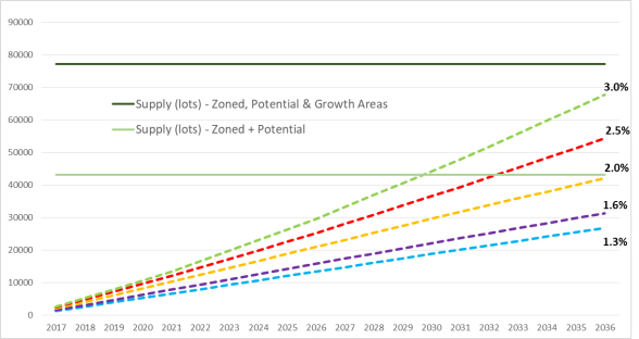
Barwon Water has provided connection data for new lots for 2017/18. There were a total of 3,274 new connections in Greater Geelong comprising 2,665 greenfield and 609 infill connections, this is up 82 percent on 2016/17. The development industry has stated the average lot construction over the next five years is likely to be 4,200 lots per annum, the average lot construction over the past five years, based on Barwon Water connection data was 2,480. The 2017/18 figures account for one year of development activity which when deducted from the figures used in the Strategy provide an up to date account of development activity. Even with strong development in 2017/18 the five year average will not exceed the growth accounted for as part of the growth surge scenario planning.
Our supply of residential land is not highly fragmented. Over fifty percent of our land supply (excluding the Northern and Western growth areas) comprises parcels or single ownership greater than 20 hectares. Sixteen percent of supply is considered to be fragmented (multiple owners and smaller parcels). This type of supply is more difficult to develop, however, these smaller holdings have been periodically developed and prior to Armstrong Creek becoming available provided a significant part of Geelong’s supply. Coordination between developments is important to unlock these areas and ensure connected developments. To this end, the City is leading the preparation of the Marshall Precinct Structure Plan (Armstrong Creek) to facilitate development in a fragmented precinct.
Council has committed to fund an update to the land supply monitor in the 2018/19 budget. This forms part of the bi-annual program and allows the tracking of development trends over time. As part of amendment process and likely independent planning panel process we will be in a position to present the most up to date figures.
4 The growth rate used in the strategy is too low and is not aspirational.
A number of submitters stated the 2.5 percent growth rate cited as a realistic scenario in the Strategy is too low.
Response
The Strategy considers a 2.5 percent growth rate as a realistic growth rate at this point in time. The development industry is promoting a 3.0 percent plus growth rate as a realistic option, however, we are not there yet. While the growth rate for 2017 reached 2.7 percent the current five year average sits at 2.0 percent.
Data from the Australian Bureau of Statistics shows that Victoria’s share of national population growth peaked in 2016 at 40.6 percent before trending down to its current level of 37.3 percent. It also shows Victoria’s share of net overseas migration fell by 1.4 percent from June 2016 to September 2017 and interstate migration fell by 1,635 over the same period. Preliminary ABS figures also show record numbers of residents departing Australia with an increase of 9,000 in the final three months of 2017 compared with 2016.
No one knows the long-term future of population growth rates with any certainty. The scenario based approach in the Strategy, including regular monitoring and review, ensures we understand the implications of sustained high population growth or a slowing growth rate and are therefore in a position to respond accordingly. As noted above a three percent ‘growth surge’ scenario was included in the Strategy and the implications of this on housing needs are clearly understood.
A 20 year growth scenario at the 3 percent level would put growth significantly above the long term average. Capacity remains for short to medium term growth surges that exceed even the current rates of growth for a number of years.
There is no doubt the short term population growth rates in Geelong have spiked. However, Geelong has not yet approached the very high rates of growth experienced by Melbourne’s designated growth areas (which have seen annual rates of 4 per cent up to even 8 per cent some years in the 2006-2016 period). Over the past 10 years long term rates have been between 3.6 per cent per annum in Hume and Casey (which have a somewhat restricted land supply), up to more than five per cent per annum in Whittlesea and Cardinia and over seven per cent per annum in Wyndham.
There remain strong land supplies in Melbourne’s designated growth areas (including Mitchell adjacent to Hume in the north). So while it is possible, it seems unlikely, that the diversion of demand from Melbourne will see these levels of housing demand and population growth come to Geelong in the short to medium term. A reasonable comparison is the City of Cardinia, which for many years tracked at two per cent or less annual growth. Only since 2003, when land supply in Casey (and other outer eastern Melbourne suburbs) began to fill up, did Cardinia’s growth rate jump up to over four per cent.
Geelong gains the strongest sources of growth is from inward migration from neighbouring and nearby regions in the Barwon and the South West regions. The migration flows to and from Melbourne are not yet at levels that are significantly impacting Geelong’s growth.
If we assume population growth remains at current strong (but not record) levels it is unlikely, at least until land supplies in Melbourne’s south-west growth area (Wyndham) become significantly more constrained, that Geelong will see medium to long term growth rates rise above four per cent.
It is likely to take several years before the medium term (~ five year) average is at three percent and there is plenty of buffer built in if sustained growth occurs at three percent in the future. For the reasons outlined above the 2.5 percent growth rate should remain the demand indicator for current and future supply at this time.
5 The strategy is anti-growth.
In relation to the Northern and Western Growth Areas the development industry has been reporting the proposed north and west growth areas will not come online until 2025 at the earliest and that just one precinct structure plan (PSP) in either the northern or western growth area will be released by 2025.
Response
These statements are incorrect and misleading.
The Settlement Strategy has a recommendation that states:
‘Commence development in at least [emphasis added] one new growth area by 2025, by initiating precinct structure planning after the framework plan has been approved’
When this recommendation is read in the context of the Strategy it is clear this is a minimum requirement to maintain competition in the greenfield market as development in Armstrong Creek starts to slow (Armstrong Creek build-out is currently at about 15 percent). There are at least 15 active or planned growth fronts currently being facilitated by Council across the City.
Council is open to commencing pre-planning opportunities for multiple precinct structure plans across one or both of the identified growth areas upon the finalisation (council adoption) of the framework plan in early 2019. The framework plan along with an integrated infrastructure delivery plan will provide guidance around the number of precincts, logical sequencing, infrastructure requirements and high level land-use and development principles. This is the foundation on which further planning can build and at this time Council will be in a position to make an informed decision on the preparation of the precinct structure plans. It is noted that Barwon Water, a major serving authority, supports this approach.
Commencing the precinct structure plans for a community that will ultimately be the size of Ballarat (~100,000 residents) without a completed blueprint clearly articulating what we want and how we are going to get there will not deliver our clever and creative vision for growth. The City wants to ensure new development is well planned and serviced, cost effective, sustainable, logically sequenced and embraces the community’s vision, this should not be seen as anti-growth rather it is proactively managing growth.
6 The City should undertake long term planning to 2050, a Plan Geelong or similar, with the State government, to create an integrated plan for growth and to protect future opportunities.
Response
The Strategy considers housing needs to 2036. The G21 Regional Growth Plan and Implementation Plan sets out a plan to manage growth, land use pressures and infrastructure requirements to 2050. It includes the consideration of transport, the economy, land for housing and employment, infrastructure and protection of natural assets and the character of the region.
The Regional Growth Plan was developed with the State Government and is included in the State Planning Policy Framework.
7 Geelong does not need an Urban Growth Boundary or Permanent Settlement Boundary. It will be a barrier to growth and prosperity.
Submitters queried the need for a permanent settlement boundary and felt the recommendation is anti-growth. It was argued Melbourne had a population around 3.2 million people when the urban growth boundary was introduced in 2002, Geelong’s population currently sits around 250,000. It was also argued the introduction of a permanent boundary is not consistent with state or federal policy to promote growth in the regions and relive pressure on the capital cities.
A number of submitters also criticised the nomination of a permanent settlement boundary on the framework plan when the process to finalise the boundary has not yet been undertaken.
Response
The introduction of the metro Urban Growth Boundary (UGB) did not happen overnight. Melbourne planning policies to protect non-urban or ‘green wedge’ areas have existed and been built upon for over 40 years. In 1971 the document Planning Policies for the Melbourne Metropolitan Region was seen as:
‘the first step towards making the most of efficient and compatible use of land available, channelling urban development into growth corridors within easy reach of open areas, making the best use of our existing systems, conserving our resources, preserving areas for the future and developing in a way that minimises future community costs.’
Melbourne 2030 (2002) saw the introduction of the Urban Growth Boundary as:
‘a tool to facilitate the achievement of a more compact city…direct growth to areas best able to be supplied with appropriate infrastructure and services…(and) protect other valuable land from urban development pressures’.
The foresight and principles around managing growth cited above are relevant considerations to managing growth in the Geelong municipality into the future.
The introduction of an urban growth boundary or permanent boundary does not preclude future change and urban expansion. This is demonstrated by a number of significant changes made to the Melbourne UGB over the past fifteen years. It does however increase the level of scrutiny (including Parliamentary review) of any proposed boundary change. The introduction of the Planning and Environment Amendment (Distinctive Areas and Landscapes) Bill 2017 into Parliament provides another option for enduring settlement boundaries, particularly on the Bellarine, which is already declared an area with distinct area and landscape values with a Localised Planning Statement in State policy. This mechanism also allows changes to boundaries albeit with the approval of the Minister and ratification from the Parliament.
The introduction of a permanent boundary would need the support of the State Government. The Strategy also identifies the need to consider a regional approach to growth and a growth boundary. A number of councils in the G21 region have expressed an interest in such an approach. This would require a consultative process and an assessment of land similar to the approach taken for identifying Melbourne’s green wedges and urban growth boundary. This is clearly articulated in the Settlement Strategy as further work to be undertaken.
The introduction of a more enduring urban growth or settlement boundary should be seen as one of a number of tools to manage growth. Continually expanding our urban areas outward is not a sustainable (environmentally, economically or socially) or long term solution to population growth and housing provision.
The nomination of a ‘permanent settlement boundary’ on the framework plan has been amended to ‘indicative permanent settlement boundary’ to reflect the fact there is further work to be undertaken which could potentially result in some minor changes to the boundary.
7a Support for permanent settlement boundaries and non-urban breaks
A number of submitters supported the introduction of permanent boundaries, particularly on the Bellarine. This was seen as critical to managing urban sprawl into the non-urban breaks. A submission also noted the impact on local communities (and Council) in terms of resourcing and responding to five yearly Structure Plan reviews and continued pressure for outward expansion. It was also noted buyers who purchase land outside identified boundaries should not have an expectation town boundaries will expand so they can see a return on a speculative investment.
8 Commence Precinct Structure Plans in both the Northern and Western Geelong Growth Areas as soon as possible.
Response
The Strategy does not preclude commencing PSPs in both the north and the west once the framework planning is completed. The framework plan will identify short term priority PSPs that could move forward to pre-planning once the Framework Plan is adopted. There are number of options available including preparing one or more PSPs in one or both of the growth areas subject to the considerations expressed in the Strategy. See also response to theme five.
9 The Victorian Planning Authority (VPA) should manage the precinct structure planning for the Northern and Western growth areas
Response
The VPA is supporting the City in delivery of the growth areas in an assisting and advisory role. The VPA is represented on the Project Control Group and is supporting key inputs to the strategic planning necessary through the Streamlining for Growth fund.
The City is best placed to act as planning authority for the Northern and Western Geelong Growth Areas. We intimately understand the needs and expectations of our current and future community. The City is committed to the timely pre-planning of priority PSP areas following the adoption of the Framework Plan. The City is well resourced and has experience in growth area planning. We are the authority on inputs such as community and recreation infrastructure, drainage infrastructure (as drainage authority), local transport and land use planning which a PSP, regardless of who prepares it, would be reliant on. As Planning Authority we can ensure a seamless transition between the delivery of precinct structure plans, permit and subdivision approvals processes and the long term management of assets.
10 The Strategy should recognise different land markets exist in Northern Geelong, Western Geelong, Central Geelong, Southern Geelong and the Bellarine and should plan for a mix of at least 15 years greenfield and urban redevelopment land supply within each sector.
Response
It is noted the State requires 15 years land supply be nominated within the municipality (not individual towns or markets) and that it is up to the City to determine how this is met. The notion put forward by submitters would see Geelong consistently providing 75 years of residential land supply.
The Strategy provides a mix of greenfield and infill development opportunities with residential land already being developed or identified for development across each of the sectors noted above over the life of the Strategy. The City is clearly articulating the focus of growth over the long term will be in northern and western areas of Geelong.
A strategic housing framework should not be based on the notion of a never-ending supply of new residential land in every perceived market across the municipality. There are areas that will be appropriate for further development and areas that are not.
11 The Strategy needs greater emphasis on what infrastructure is needed, the importance of infrastructure keeping pace with growth and how infrastructure will be funded.
Response
The G21 Regional Growth and Implementation Plan sets out the high level infrastructure needs to support growth. The G21 Regional Road Transport Plan 2017-2021 guides upgrades and identifies future issues for regional transport.
The City is responsible for delivering a variety of local government infrastructure and services. We are continually working to understand community needs, for example, updating the Social Infrastructure Plan. Funding options include rates revenue, state and federal grants, private funding agreements such as negotiated developer contributions and formal funding agreements such as Developer Contributions Plans (DCP) or Infrastructure Contributions Plans (ICP). The City is advocating for funding equivalent to the Growth Areas Infrastructure Contributions for state infrastructure for Geelong.
The City will work within the existing framework to deliver the best outcomes for the Geelong community. In planning for new growth areas an integrated infrastructure delivery plan is being prepared to inform the final framework plan which will help secure infrastructure that supports new communities.
In relation to value capture there have been a number of papers (Capturing Value, Infrastructure Australia, 2016, Smart Cities Plan, Department of the Prime Minister and Cabinet, 2016, Value Creation and Capture Framework, Department of Premier and Cabinet, 2017) in recent years which highlight a number of opportunities, issues and complexities around such schemes. Council will continue to take advantage of funding opportunities under the current frameworks and mechanisms and work with the State to deliver for the Geelong community, including advocating for State investment in roads, public transport, health and education.
Some additional wording around the need for improved transport infrastructure and funding infrastructure as part of redevelopment and urban renewal has been added in the ‘Managing Future Growth’ and ‘Urban Consolidation’ sections of the Strategy.
12 The Strategy raises the issue of housing choice and diversity in growth areas but does not address it or offer solutions.
Response
A direction of the Strategy includes increasing housing diversity in growth areas by delivering a broad range of lot sizes, capable of accommodating a variety of affordable housing types, including social housing. This direction will then inform more detailed place-based framework plans, precinct structure plans, urban design frameworks and development plans. In relation to housing diversity in established areas the Strategy includes specific targets and timeframes for urban consolidation and sets out further work for maximising opportunities in housing diversity areas, around train stations and in central Geelong.
A new section on ‘housing diversity’ has been added as a new theme within the Strategy to provide more information and guidance, this also includes additional background information on housing diversity data being included. The material for this section has largely come from the background and issues papers prepared for the phase 1 consultation.
12a Support for increasing housing diversity
A number of submitters supported the principles and objectives around increasing the diversity of housing in Geelong. This diversity will provide for different life stages, increase affordability help reduce the pressure for urban sprawl.
13 Interest within settlement boundaries for conversion to conventional residential diversities from rural living or low density residential (3)
A couple of submitters from Drysdale had interest in converting low density and rural living zoned land within the exiting township boundary to more conventional housing densities.
Response
Land within current settlement boundaries will be guided by the land use directions set out in existing Structure Plans. The Strategy notes the role of Structure Plans going forward needs to be reconsidered in the context of potentially permanent settlement boundaries. This includes managing housing demand and intensifying development within townships while still balancing the township character and providing a diversity of housing options.
14 Interest outside current identified areas for residential development (30)
A number of submissions (38) put forward land (generally farming zoned land) they believe should be developed for housing that is not currently identified in the Strategy. The reasons put forward to support the proposals included: proximity to existing services and established urban areas, no environmental significance, not viable for farming, will provide innovative housing solutions, will increase competition, choice and affordability in the market.
A number of submitters noted it was premature to look at permanent settlement boundaries and ruling areas in or out without further strategic consideration.
The individual areas put forward for consideration are summarised below:
Urban Geelong
35 and 69-93 Hams Road Waurn Ponds (2)
These sites have previously been strategically identified for residential development and rezoning from the Farming Zone (amendments C273 and C372). The submission noted it appeared this site had been erroneously excluded by the permanent settlement boundary indicated on the framework plan.
Response
Agreed. Strategic justification for residential development on these sites was previously set out as part of amendment C273 and includes the Armstrong Creek Urban Growth Plan, G21 Regional Growth Plan and State and Local Planning Policy. The framework plan will be amended to include these sites within the boundary.
Boral site Waurn Ponds (2)
Boral land bounded by Baanip Bld and railway Anglesea and Whites Road should be included as a future investigation area. Land not used for quarry and is well located. Three precincts identified northern (short term), central and southern (longer term). Northern precinct 125ha could provide mix of housing, employment and parklands. This development would assist Boral operations at the port.
Response
A submission from the owner would be considered as part of the process for developing a permanent settlement boundary.
Moolap - Future Urban Growth Boundary to extend to the future Geelong Ring Road extension (8)
Eleven submissions were received from landholders in the Moolap area where the proposed ring road will be constructed. It was argued the ring road could open up development opportunities and this area is well located with good links to central Geelong and the Bellarine.
Response
Given the final planning for the ring road has not been completed it is premature to include this area within the settlement boundary. Once the road is completed the implications will be better understood and further assessments can made. The final outcomes of the Moolap Coastal Strategic Framework Plan will also potentially have implications for this area.
Moolap - Alcoa land (1)
The draft Moolap Coastal Strategic Framework Plan sets out the primary directions for the south-east precinct (land between Moolap and Leopold on the north side of the Portarlington Highway) as residential (long term) and the Point Henry precinct as residential and tourism (short term).
Response
The Moolap investigation area will be marked on the Framework Plan as the final directions have not been released by the state government. Council raised issues in relation to aspects of the draft and it is unclear how these might have been resolved, if at all, in the final Plan. Should the Plan be released post Council adoption refinements can be made as part of the Planning Scheme amendment process.
Mount Duneed (2)
Two submissions looking at conventional residential development and a submission looking at either low density or conventional residential development were put forward for the area south of the existing Armstrong Creek growth area boundary south of Whites Road.
Response
A submission from owners would be considered as part of the process for developing a permanent settlement boundary.
Lara/Avalon (1)
Submitter noted opportunity to build on proximity to Lara and key infrastructure such as roads, rail and airport. Development could occur while still maintaining the non-urban break between Geelong and Melbourne.
Response
The Avalon Corridor Strategy is currently being developed which will look at land-use planning in this area with key considerations being airport operations. This submission has been forwarded to the project manager for consideration.
Bellarine Peninsula
Leopold - North of Portarlington Road and west of Melaluka Road (3)
Submission noted opportunity to provide lifestyle, holiday, townhouse, Bay access and public/open space as part of an innovative overall plan for the northern bay area .
Submission noted opportunity to develop the western side of Melaluka Road, area around 130ha (south side of the Bellarine Highway) up to the highway.
Wallington / Ocean Grove (9)
Submitters (7) outlined the potential of the area north of the current town boundary to the Bellarine Highway, north and west of the current boundary to the area generally around the Ocean Grove Nature Reserve.
The robustness of using existing boundaries without detailed analysis around environment, farming, landscape etc. or completing the further work noted in clause 21.13-3 was questioned. There needs to a review considering these matters as part of determining the ultimate town boundaries. Planned and sustainable growth should be supported.
Sales data shows 74% of buyers are from Geelong and the Bellarine, this kind of information has not been used to inform council decision making. Development of this area will maximise proximity to Grubb Road activity centre.
Barwon Heads (1)
A submission supported land on the western edge of town between the existing township and the golf course to be included in Barwon Heads boundary to allow residential development. This area is outside the settlement boundary under the recently reviewed Barwon Heads Structure Plan which will be going through a Panel process in August 2018.
St Leonards, Portarlington, Curlewis (4)
Submissions noted an interest in further residential development in these townships adjacent to the current boundary.
Response to Bellarine interest
The Strategy clearly articulates new housing development on the Bellarine should decrease over time in order to preserve the character of the area. As part of implementing permanent boundaries refinements to existing boundaries will be considered in accordance with the directions set out in the Strategy. It is noted only the district towns on the Bellarine should be considered as part of this process.
Response (to all of the above)
Given the extent of land currently being developed for housing or identified for future development, in excess of 22 years under the highest 3 percent growth scenario, it was determined there is no requirement to nominate further growth areas beyond what is already identified in the Strategy at this time. Council has not carried out the strategic assessments necessary to identify future residential development opportunities.
The Strategy identifies the need to; work with the state government, neighbouring councils and other stakeholders, carry out a consultative process and use the Melbourne logical inclusions process as a guide to introduce a permanent settlement boundary and protect non-urban breaks.
It would be premature to formalise this process but the precedent set by the logical inclusions process and Macedon Localised Planning Statement provides a methodology. For example the considerations set out in the 2009 Delivering Melbourne’s newest sustainable communities public consultation report on the process includes:
Agricultural activities
Biodiversity
Drainage corridors
Extractive industry
Heritage (including Aboriginal cultural heritage and post contact heritage)
Landscape features
Land use
Salinity
Soil capability
Transport
Trunk services (including water services, sewerage, electricity, gas and telecommunications) and
Wildfire.
The planning principles and processes set out for managing green wedges and as part of developing the Macedon Ranges Localised Planning Statement also provide valuable insights for assessing and considering the non-urban breaks or areas of landscape significance in the municipality. It is worth noting, particularly in the context of the Bellarine that the settlement boundaries for the Macedon Ranges:
‘are based on approved long-term structure plans and approved planning scheme amendments, which have undergone extensive community and stakeholder engagement and form part of the Macedon Ranges Planning Scheme. Considerations for determining the boundaries included land constraints and opportunities, including an assessment of environmental, landscape and cultural features, natural resources, infrastructure and services.’(Macedon Ranges Draft Localised Planning Statement, Frequently asked questions, DELWP, 2018)
We agree with the submissions that state the work has not been done to rule areas out or in for future development. The logical inclusions process is not looking at identifying new residential growth fronts or future investigation areas given the adequacy of current and proposed residential land supply. The process will focus on infrastructure delivery, creating enduring boundaries and creating sustainable communities in the context of formalising permanent boundaries.
A consultation phase will form part of the process for developing a permanent settlement boundary.
15 More Rural Living Zoned land and lifestyle opportunities needed
Five submissions noted the need to consider the merit of rural residential land particularly on the Bellarine around Ocean Grove and Wallington. The Strategy says it is discouraged but as per practice note 37 Council needs to understand does rural residential align with overall strategic plan for municipality, housing diversity and needs, where should new rural res take place, can new rural res have quality outcomes?
Response
Council’s current position on Rural Living land is to limit it to existing nodes.
Greater Geelong has a long standing policy to limit rural living zoned to the current existing nodes. Creating more rural living zone land, while potentially preserving a more ‘rural’ character is considered to be an inefficient use of land and will not make a significant contribution to housing supply or affordability. This issue was explored as part of the development of the Rural Land Use Strategy 2007 which informed the current policy position. The following is an extract from the Strategy:
Rural living in Greater Geelong takes many forms; large scale residential subdivisions, scattered coastal developments and small farmlets, including those actively farming yet relying on economic and employment links to urban areas. In many ways the existing rural landscapes, including the broad range of agricultural activities in numerous areas, already offers scope for rural lifestyles with good connections to coastal towns and the city centre.
The ability to live in an attractive environment is a key part of attracting highly skilled workers. Geelong Council has traditionally taken a conservative approach to planning for specific rural living development. It has held a strong position in relation to this form of development over time, and while it has provided a level of supply, it has not supported extensive areas of rural living lots, as have many rural municipalities. The rural living development formally provided in Geelong is within a number of distinct nodes, and consists of lots of between 1ha and 3ha. This approach seeks to strike a balance between the inefficiencies of land use and infrastructure supply associated with rural living, and the genuine demand expressed. Rural living development can change the amenity of the area through additional development and the associated pressures on landscapes, the environment and infrastructure, as well as placing pressures on the continued viability of agricultural activities. Rural living is more expensive and less efficient to service than conventional residential development.
Current Rural Living and Low Density precincts can be found in Waurn Ponds, Fyansford, Batesford, Lovely Banks, Lara, Leopold, Drysdale, Newcomb, Moolap, Wallington, Curlewis, Portarlington, Ocean Grove and Barwon Heads. There are also ‘lifestyle’ opportunities in the farming zone across the municipality and rural living nodes in the neighbouring municipalities of Surf Coast and Golden Plains.
Geelong is a growth municipality and needs to cater for a growing population. If land is suitable for development it should be developed in the most cost effective and efficient way. The current rural living nodes will continue to turn over and there are additional life style opportunities provided in the Farming Zone particularly on the Bellarine. The Strategy also seeks to preserve ‘green’ landscapes which will preserve the ‘rural feel’ outside townships so people can enjoy the benefit of these green spaces while living in townships.
In relation to Planning Practice Note 37 Rural Residential Development there is no strategy support for additional rural living land which is the first question to be considered as part of a sequence of questions to determine the suitability additional rural residential development.
16 Bellarine Character needs to be preserved
A number of submissions (10) noted the need to preserve the character of the Bellarine and the fact balance is needed between natural areas and residential areas. Submissions (11) also supported the introduction of permanent settlement boundaries and the protection of non-urban breaks.
There was support for permanent boundaries and the need to provide an overall strategic planning framework to accommodate growth. There were concerns that any further expansion will erode landscape, tourism, farming and environmental values. Council must resist pressure from speculative developers purchasing land outside town boundaries which has never been identified for future development.
Response
The Strategy provides a long-term vision and recommendations for the Bellarine. Overtime this will see the extent of urban development contained by permanent boundaries and the protection of landscapes and non-urban breaks strengthened. There are a number of options available to deliver these outcomes and these will be investigated as part of the identified further work in the Strategy.
17 Bellarine towns should not be excluded from contributing to housing supply, people want to live there and it should be affordable to everyone.
Response
At the 2016 census (Australian Bureau of Statistics) Melbourne, Geelong, Ballarat and Bendigo where the top four urban centres in Victoria. Three townships on the Bellarine also made it into the top thirty with Ocean Grove/Barwon Heads at 13 (18,208 people), Drysdale/Clifton Springs at 24 (12,483 people) and Leopold at 27 (11,882 people).
The Bellarine, as a combined area, would come in forth on the list ahead of Melton (54,455 people). These figures show that the Bellarine is making a major contribution to housing not only in the context of Geelong but also Victoria.
The Strategy looks to strike a balance between housing provision and the need to protect what makes the Bellarine unique. This is not a new concept. The Mornington Peninsula was included in Urban Growth Boundary when it was first introduced. Mornington is somewhat comparable to the Bellarine in that it offers unique lifestyle choices with similar commuting times and distances to the Melbourne CBD. The Draft Mornington Peninsula Green Wedge Management Plan 2018 (Mornington Peninsula Shire, 2018) shows seventy percent of its land area set aside as rural.
The Macedon Ranges is also looking to introduce permanent settlement boundaries in order to preserve its unique character. Its lifestyle offer and proximity to Melbourne is seeing strong growth which the State and local Council are looking to proactively manage via the Distinctive Areas and Landscapes Bill 2017.
There was also a concern the wording around the Bellarine essentially ‘locks up’ the area indefinitely. Acknowledging the ‘district towns’ are already fulfilling their role is an acknowledgment they offer higher order services and facilities and accommodate more growth than lower order towns. This should not be interpreted as they are fulfilling the role therefore no further consideration or investigation should occur. This is not the case as the discussion around the further work required to look at permanent boundaries indicates. The change in wording from ‘permanent settlement boundary’ to ‘indicative settlement boundary’ on the framework plan also seeks to clarify a process needs to be undertaken prior to permanent boundaries being established.
18 Little River and You Yangs Region – distinctive area recognition
A submission was received advocating for Little River and the You Yangs Region to be recognised as an area of distinctive and significant heritage and landscape value and non-urban break that should be protected under Clause 11.05 in the State Planning Policy Framework.
Support for provided for the introduction of a permanent settlement boundary and preservation of non-urban breaks. It was noted consultation would need to include a wide range of stakeholders for such a proposal.
Response
The Strategy reinforces the critical role of non-urban breaks and specifically notes the importance of the break between Geelong and Melbourne (Wyndham). The recommendations around pursuing a permanent settlement boundary and the work to assess areas with landscape values and consider options to manage these into the future will include the Little River - You Yangs precinct and will build on previous and current planning work such as the South West Victorian Landscape Assessment Study, Avalon and the You Yangs Tourism Development Plan and the Avalon Corridor Strategy.
The submission notes the challenges associated with rural living and smaller farming zoned lots which the City has addressed to some extent with a number of local planning policies relating to rural and farming areas.
The submission also raises a number of questions beyond the scope of the Settlement Strategy in relation to the detailed planning for the Little River – You Yangs area. The City is currently working with the state government and Wyndham council on the Avalon Corridor Strategy and the submission has been forwarded to the Avalon Corridor Strategy Project Manager which can consider these issues in more detail.
19 Do not support the West Fyans (precinct 4) transitioning to Mixed Use from Industrial land uses as part of stage 2 of the Structure Plan as it will compromise business operations (including 50-60 staff).
Response
This precinct is already listed as a key development area identified for higher density housing in the planning scheme at clauses 11.09-6 (State) and 21.06-3 and 21.17 (local). The Strategy does not make any additional recommendation in relation to this precinct other than to support the existing policies. The West Fyans – Fyans Structure Plan is currently being reviewed and the submissions (3) relating to this issue have been forwarded to the project manager for consideration.
20 Support for the protection of farmland and do not support more rural living
There was support for protecting agricultural land for housing development to aid food security into the future. There was also support for limiting rural living development due to the impact on rural land.
|
Submission No. |
Submission Summary |
Officer Response |
1 |
Requesting rezoning from Rural Living to Residential in Collins Street, Drysdale |
This are falls within the existing township boundary. Further urban consolidation opportunities can be explored as part of future township plans. |
2 |
Issues including cycling safety, footpath upgrades and increased traffic. Agree the Bellarine needs to be preserved. |
Noted. See themes 11 and 16. |
3 |
Strategy has a is bias against Rural Living Zones. Questions why rural residential developments are "discouraged" by Council. No mention of the RLZ in Leopold was another concern. |
See theme 15 |
4 |
Strong support for Bellarine recommendations. Ocean Grove should not be further extended. Council needs to make it clear that they are not intending to review permanent boundaries every few years. Pressure from speculative developers who purchase land outside boundaries which have never been identified for development should be resisted. |
See theme 16 |
5 |
Believes subject land (Hams Road, Waurn Ponds) was excluded from the Settlement Boundary in the Framework Plan. Supports the inclusion of Boral’s land bound by Baanip Blvd/Warrnambool to Melbourne railway line to the north, Anglesea Rd to the west and Whites Rd to the south and Ghazeepore Rd to the east for inclusion in future investigations. |
Agree the Framework Plan should be amended to include this site within settlement boundary. See theme 14. |
6 |
Wallington / Ocean Grove area needs more robustness when determining boundaries of townships. Settlement Strategy implies work completed as part of amendment C346 is irrelevant without any evidence or basis. |
See theme 14. Further work identified as part of the Ocean Grove Structure Plan is specifically referenced as work to be addressed as part of the process for determining a settlement boundary. |
7 |
Strategy does not identify further rural residential land which includes low density developments. Opportunities need to be investigated on the Bellarine. Planning Practice Note 37 states planning scheme should ensure that reasonable opportunities are found for rural residential development. Council should be working to understand this. |
See theme 15. |
8 |
Strategy not informed by municipal strategy, does not give big picture, including the Clever and Creative Future. Disagree with development data. No boundary needed. Strategy is anti-growth. Constraints on supply will impact affordability. Innovative approaches to funding for infrastructure needed. |
See themes 1 to 8. |
9 |
Wallington / Ocean Grove area. Object to the strategy as overrides agreed planning policy of 2015 Ocean Grove Structure Plan. Supports the measured expansion of Ocean Grove but limited to a long term growth boundary. Provision should be made to extend to a future growth boundary. Welcome opportunity to work with Council to facilitate and existing and agreed set of land use actions for Ocean Grove. |
See theme 14. |
10 |
Wallington 5 acre lots should stay and more created. Zoned farming land should stay as is. Planning for continued green areas needed. |
See theme 15. |
11 |
Direction to work with state government and neighbouring Councils to consider a regional approach to housing and settlement boundaries is supported. |
Noted. |
12 |
Would like to see the current urban Geelong boundary extended to the future Geelong Ring Road extension Moolap. |
See theme 14. |
13 |
Proposes growth opportunities are considered north of current Leopold township. Development of this area could make a positive contribution to housing choice and diversity. The Strategy does not look at innovative and new approaches to settlement planning. Silent on how greater housing choice and affordability will be delivered. |
See theme 14. |
14 |
Support preservation of significant landscapes and environments from urban encroachment and containment of urban development within settlement boundaries (yet to be clearly established). The area around the You Yangs region should be considered as a distinctive landscape. Support non-urban break between settlements. Has a number of queries around planning for the Avalon corridor area. |
See theme 18. |
15 |
Concerned the Strategy will compromise future business operations and employment in West Fyans area. Support residential growth, however specific direction to increase housing density in West Fyans Street Precinct is a significant concern and inconsistent with the current policy direction. Do not support high-density housing growth now or in the future for this area. |
See theme 19. |
16 |
Concerned the strategy will compromise future business operations and employment in West Fyans area. Support residential growth, however specific direction to increase housing density in West Fyans Street Precinct is a significant concern and inconsistent with the current policy direction. Do not support high-density housing growth now or in the future for this area. |
See theme 19. |
17 |
Concerned the strategy will compromise future business operations and employment in in West Fyans area. Support residential growth, however specific direction to increase housing density in West Fyans Street Precinct is a significant concern and inconsistent with the current policy direction. Do not support high-density housing growth now or in the future for this area. |
See theme 19. |
18 |
Support no further urban growth towards Point Lonsdale; maintain existing green wedge; protect wetlands; maintain urban breaks between settlements; maintain seaside village character. |
See theme 16. |
19 |
Supportive of principles and directions outlined in the strategy. Supports directions to direct development towards urban Geelong areas and existing key growth areas; appropriate sequencing for NWGGA; ability to cater for planned growth within town boundaries on the Bellarine; supportive of logical inclusion process with respect to permanent settlement boundaries; supports infill of central Geelong. |
Noted. |
20 |
Full submission to be provided 29 June |
Noted. |
21 |
Endorse the need to overlap supply from Armstrong Creek to the NWGGA and increasing housing diversity in growth areas. Recommends commencing PSPs in both the north and the west and concerned considerations for a PSP will duplicate the PSPs themselves. |
Noted. See theme 8. Considerations to commence a PSP will not be as detailed as that in the PSP but assist informed decision making. |
22 |
There are further development opportunities in Leopold. Concern the strategy has adopted a 'no growth' scenario for the Bellarine with the intention of introducing fixed settlement boundary. Request alternative housing framework scenario is considered. Concern no assessment of potential growth options has been undertaken in favour of a no growth scenario for the Bellarine. Support for logical inclusions process. Further work around future growth required with consideration to infrastructure also needed. |
See theme 14. |
23 |
Approaches to managing the direction of future settlement growth are well thought out and sensible, particularly commitment to sustainability and reference to the Clever and Creative vision of high amenity neighbourhoods. Lack of acknowledgment in the draft of transport implications inc. greenhouse gas emissions, car dependent communities, linking with Transport for Victoria, importance of internal public transport routes and buses in Geelong. |
Noted and agreed. Additional wording included in ‘Managing Future Growth’ around the importance of sustainable transport. Sections have been included on the importance of transport planning in delivering sustainable communities in the managing growth and urban consolidation sections. |
24 |
Supports measured expansion of Barwon Heads to accommodate new housing. Additional development pressure will be placed on existing township which is inconsistent with aspirations of a coastal township; non-urban interface along the western edge of town will remain unresolved; current strategy is inconsistent with the previous Panel recommendations as per C159; creation of a defined settlement boundary for Barwon Heads is inconsistent with the stated purpose and scope of strategy; exclusion of land is inconsistent with Coastal Strategy 2014; should be re-drafted to support the creation of a logical, defendable ultimate township boundary for Barwon Heads. |
Noted. The Barwon Heads Structure Plan amendment process will determine the settlement boundary for Barwon Heads. The Strategy does not contemplate additional growth in townships other than ‘district towns’ on the Bellarine. |
25 |
Directions to contain growth within the Bellarine are not supported by strong strategic arguments that substantiate their need. The perceived threat to the values of the Bellarine has no basis. The reliance of current and future urban growth zones to solely satisfy growth needs ignores the important role of the Bellarine in the growth of the Geelong community. Interest in further development in Wallington, Portarlington, St Leonards. |
Township plans have informed the current boundaries as the basis for permanent boundaries subject to the process identified in the Strategy. See theme 14. |
26 |
Recommendation Council considers Boral Waurn Ponds property as the 'Boral Investigation Area' in developing the final strategy including: support appropriate planning pathway to enable short-term rezoning of the northern portion of the site; include property with any proposed settlement boundary reflecting lands potential urban redevelopment; continue to work with Boral to establish appropriate land use and planning outcomes. |
See theme 14. |
27 |
Strongly support initiative to deliver a Strategy to prepare for and manage growth in Geelong. Recommend improve certainty around development timing and to champion housing choice and diversity. Commence preparation of one PSP immediately after Framework Process in each of the Northern and Western Growth Areas. West Fyans Key Development Area not be included in the Growth Scenarios tables. |
Noted. See themes 8, 12 and 19. |
28 |
Support the Strategy however recommend commencement of the preparation of at least one PSP immediately after the Framework Plan process in each of the Northern and Western Growth Area. Should also be options to buy land beyond what is already identified for growth. |
See theme 8. |
29 |
Support the Strategy however recommend commencement of the preparation of at least one PSP immediately after the Framework Plan process in each of the Northern and Western Growth Area. |
As above. |
30 |
Support the Strategy however recommend commencement of the preparation of at least one PSP immediately after the Framework Plan process in each of the Northern and Western Growth Area. |
As above. |
31 |
Support development in Armstrong Creek but seek greater support for a mixed use, rather than exclusively employment uses. Request Council revisit strategic policy for the West Industrial Precinct and Draft Settlement Strategy. Housing affordability is another key consideration - encouraged to plan for a faster growth rate. |
Noted. The Armstrong Creek Framework Plan provides the overarching principles for development in the WIP. There are broader considerations in relation to employment and industrial land which are currently being investigated therefore it would be premature for the Strategy to make a recommendation around this. |
32 |
Propose boundary set at Moolap Station Road or at least to the proposed Bellarine Link for the completion of the Ring Road. This land would be suited for residential development. |
See theme 14. |
33 |
Supports designation of the northern area of Ocean Grove as a growth area. Opportunity to revisit permanent settlement boundaries provided. There is a need to balance future development. Recommends addition of wording ‘this may warrant amendments to current settlement boundaries’ to be included. |
See theme 7 and 14. |
34 |
Seeks to protect opportunity to continue to grow Ocean Grove in a managed and sustainable way. Number of directions in the draft strategy would unreasonably deny this opportunity to the detriment of long-term viability of the township. Concerns strategy undermines key principles and recommendations set out in a number of existing planning documents. |
See theme 7, 14 and 17. The further work in relation to Ocean Grove in specifically reference in the section on ‘permanent settlement boundaries’. This section also states boundaries should be based ‘generally’ in existing urban and identified growth areas. It also states a consultation process to review the boundary and deal with anomalies and logical inclusions will be established. |
35 |
Direction of application of settlement boundaries around specific towns located in the Bellarine does not clarify whether existing land already recognised for future urban growth will be continue to be supported such as in Curlewis. |
The undeveloped land within Jetty Road is nominated for residential development in the Drysdale Structure Plan, the Jetty Road Urban Growth Plan, local planning policy and is included within the ‘existing settlement boundary’ on the ‘housing framework plan 2036’ in the Strategy. This site is supported under the direction ‘implement permanent boundaries based generally on existing urban areas and areas already identified in policy’ |
36 |
Request for area adjacent to Drysdale school precinct bounded by Princess Street, Grubb Road, Belchers Road and Basin Road - currently farming zone be considered for residential development. Location is a significant anomaly it its current configuration, location and zoning - should be considered in connection to the Drysdale Township and not part of broad acre farmland. Support process for consideration. |
Noted. See theme 14. |
37 |
Concerned that the Moolap study area is identified as forming part of the non-urban break between Geelong and Leopold. Final strategy to respond to the land use directions of the approved Moolap Plan. Consideration should be given to the location of key settlement breaks in the G21 Regional Growth Plan. |
DELWP have not released the approved Moolap Plan therefore council does not know what the land use directions are for this area. The framework plan will be revised to show the ‘Moolap framework plan investigation area’. All four key settlement breaks in the G21 growth plan are included in the framework plan including the break between the eastern edge of Geelong and Leopold (Moolap) which is nominated to ‘maintain productive agricultural areas’. The hatch will be removed from the industrial zoned land on Point Henry. |
38 |
Moolap should be developed. This area is more practical rezone than Leopold. Plan doesn't allow for growing population demand from Melbourne. |
See theme 14. |
39 |
More important to develop Moolap than concentrating on Lara and Bannockburn due to proximity to City Centre. Moolap is ideal for subdivision. |
See theme 14. |
40 |
Release of land in Moolap is long overdue and obvious choice for development. |
See theme 14. |
|
Moolap should be part of the future housing plan for Geelong. New freeway and well located to Geelong and Bellarine. Coastal communities should not be excluded from change and growth. |
See theme 14. |
41 |
Barwon Heads, Portarlington and Point Lonsdale - lack of lot supply in recent years - Council has ignored associated problems created by the shortage. People want to live on the Peninsula so housing should be provided. Moolap on the edge of the freeway should be considered. |
Theme 14 and 17. |
42 |
Oppose dilution of Drysdale as a growth town as it will ultimately lessen the importance of rezoning future residential growth land at Drysdale. Oppose use of permanent settlement boundaries as there is no strategic justification to replace the existing settlement boundaries contained in Structure Plans and may not honour the existing Drysdale Settlement Boundary. |
See theme 7. Any boundary would be based on boundaries already established in structure plan. Land within the current boundaries will not be removed. The current Structure Plan already supports consolidation in this areas therefore a rezoning proposal in this precinct is possible subject to the usual considerations. |
43 |
Propose that Lara North/Avalon be identified as land ideal for the future development as employment land accessible by a new station at Lara North/Avalon. Clear urban breaks between urban settlements can still be maintained and preserve the township character of Lara. |
Noted. Identifying further employment land is outside the scope of the Strategy. The Avalon Corridor Strategy will look at planning in this area with a focus on the strategic infrastructure available. The non-urban break notation is indicative and can be adjusted and refined as a result of further work including the landscape assessment. |
44 |
Agree in principle with the recommendations around protection for the Bellarine. Request that any new development within the Bellarine be declined and keep development within existing boundaries. |
Noted. See theme 16. |
45 |
Concern Coppards Road in Moolap will be used as the eastern part of Geelong's future permanent boundary. Strategy does not address VicRoads proposed Ring Road extension to the Bellarine and this should be considered as the permanent boundary to eastern Geelong. |
Noted. See theme 14. |
46 |
Retain existing boundaries on the Bellarine, housing development on the Bellarine cease. Preserve and build on farming and agriculture opportunities. Rural vistas be preserved and maintained. |
Noted. See theme 16. |
47 |
Do no support permanent settlement boundaries for any townships. Concerned this will limit opportunities particularly on the Bellarine. Settlement pattern in Geelong is unevenly balanced. Support future growth of the Bellarine, including expanding Ocean Grove north to highway. |
See themes 7, 14 and 17. |
48 |
The proposed containment and reduction of residential development in the Bellarine is premature as the Bellarine continues to be a popular and attractive residential location. Suggest boundaries not be termed 'permanent' as it denotes that no further changes can occur. Do not support containing growth in St Leonards. |
The current St Leonards Structure Plan does not nominate this site for future residential growth and it is outside the settlement boundary. See theme 14. |
49 |
Concern of possibility of rezoning of land to the east side of Hardings Road, Wallington in proximity to nature and wetland reserves. Needs to maintain rural appeal and green wedges established since at least the 80’s. |
Noted. See theme 16. |
50 |
Refer to earlier submission |
|
51 |
Unable to open attachment – request made to resend |
|
52 |
Infrastructure within the whole of Greater Geelong needs to be improved if the growth areas are developed. Infrastructure already not coping with existing population never mind future growth. Need plan to identify existing congestion traffic and pedestrian hot spots and develop a plan to improve over 10 years. Improve train parking for travelling residents. |
See theme 11. |
53 |
Need to address housing affordability. While big houses on smaller blocks increases density it does not address diversity. Need new approach to housing in relation to access, affordability, sustainability, energy efficiency, building materials and most importantly, how houses should contribute to the needs of their occupants. Looking for support for registered charity group Geelong and Bellarine Tiny Homes Ltd. to conduct a Pilot Program around smaller housing / communal living. Flexibility in regulations is needed to deliver new approaches to housing. |
See theme 12. |
54 |
Car traffic is now a problem in Geelong and not only the grid lock each evening. It is taking 40 minutes rather than the previous 20 minute commute from Drysdale. With new developments, housing and residents, is there any plan to provide an alternative to taking the car to work, to include cycle paths for commuters and secure bike parking when they arrive at work? |
See theme 11. |
55 |
Have emailed as no submission provided |
|
56 |
There must be a public transport plan developed alongside housing or car dependence will continue counter to sustainability objectives. More green space and protected biodiversity areas within developments is needed as is more sustainable water and stormwater management. |
See theme 11. Council is committed to more sustainable urban development and the Strategy has principles around ‘One Planet Living’. Additional content has been added on sustainability principles in the ‘Managing Future Growth’ section of the Strategy. |
57 |
Moolap should be considered a future residential opportunity. None of the land allotments are big enough for profitable farming. The proposed completion of the ring road changes the viewing aspect of the area. The area is referred to as having flooding concerns however not all of the area has this issue and could be addressed at rezoning. Settlement boundary should be extended right up to the proposed ring road. |
See theme 13. |
58 |
Moolap area near Coppards Rd should become part of the future of Geelong. The proposed new Bellarine Link road should be the proposed permanent boundary. The proposed permanent boundary should be defined by the current Geelong Ring Road that surrounds Geelong. |
See theme 13. |
59 |
Support proposal to maintain separation between towns, the Bellarine, Torquay, Wyndham etc as per in England. This maintains the charm and appeal of the Geelong area and offers people something different to Melbourne. Need to protect and conserve significant remnant vegetation and landscapes for visual appeal, tourism and improved quality of life for community. Creation of large conservation reserves within proposed growth area with remnant vegetation Batesford, Mt. Duneed, Armstrong Creek and Thomson Creek is needed. Recommend larger allotment sizes on proposed urban fringes in keeping with the adjacent natural landscape. |
See theme 13. |
60 |
Support area around Lara train station going to Residential Growth Zone Schedule 2. |
The Strategy identifies the need to do further work around railway stations which includes reviewing the Housing Diversity Area in Lara with consideration to increasing the area from 400m to 800m around the station. |
61 |
Lack of reference to Leopold township, would like to see a new Leopold Structure Plan on the agenda. Draft strategy does not address many issues it identifies and offers little response to questions of housing demand, affordability, housing choice and diversity but advocates more for land to be developed in the North/West of Geelong. |
See themes 11 and 13. |
62 |
Do not support content of Strategy due to: lack of vision for Geelong's growth, outdated land availability data, consideration of developable land beyond those specific areas outlined in the Strategy, settlement boundaries will reduce growth and greater involvement required from State Gov. Need a Plan Geelong or similar. |
See themes 1 to 9. |
63 |
Appropriate buffer zones outside town boundaries can contain and expand a rural character with appropriate vegetation, complementing landscape and managing future pressure from infill development. Support hybrid development on rural land that does not support productive agriculture but could provide development in keeping with landscape values by either smaller farming zoned lots for housing or application of the rural living zone. |
See theme 14. |
64 |
Disagree with argument that Geelong has excess 15 years land supply. Do not support legislated urban growth boundaries. Outdated development data used to support strategy. Fifteen years land supply should be provided in each market. Strategy should highlight importance of building industry to the economy. Need transport, infrastructure and service investment to support growth. Support VPA planning the new growth areas and planning for these areas should be fast tracked. Resource the planning units to deal with growth planning. Long term planning to 2050 is needed. |
See themes 1 to 10. |
65 |
Land in Mt Duneed currently outside the Armstrong Creek growth area boundary should be included within the settlement boundary. The land has no impediments to residential development and can be funded by the developer. The land meets the criteria established by the metro logical inclusions process. Defining the boundary should occur as part of the Strategy not as further work. Request land be included within boundary or the current nominated boundary is described as ‘indicative’. |
Somewhat agree. Strategic analysis to rule land in or out of the ultimate boundary has not been undertaken. The wording on the framework plan has been amended to ‘indicative settlement boundary subject to further investigation’ which articulates some changes may occur as a result of the logical inclusions process. |
66 |
Strongly supportive of the strategy and its broad intentions, in particular to limit residential growth on the Bellarine to within existing settlement boundaries. Continued growth could impact on the character, tourism appeal and environment. Boundaries will provide certainty for everyone. Continual review of boundaries is resource intensive for council and communities and does not provide certainty for landholder around future investment. Council also needs to support economic opportunities for communities. |
Noted. See theme 16. |
67 |
Support submission 36. |
Noted. |
68 |
Victorian Farmers Federation Bellarine Branch supports shift of settlement growth from the Bellarine to urban infill and other areas of Geelong. Supports introduction of permanent settlement boundaries for Bellarine. Supports restricting rural living to existing nodes. Requests consultation on any changes to the planning scheme which may impact rural land on the Bellarine. |
Noted. See theme 16. |
69 |
Comments made in relation to the summary paper. Recommends providing more information on demographics, definitions around housing type, policy context documents, refining some of principles and directions, minor corrections, importance of supporting infrastructure alongside growth and having clear boundaries. |
Much of the clarification sought can be found in the main document. A section will be added on housing definitions/diversity with content provided from the phase 1 issues paper. Changes made to ordering of boundary directions so they are a logical sequence. |
70 |
Recommends land within Drysdale town boundary be maximised with no lots larger than 4000sqm where servicing allows, create green buffers outside the town boundaries for farming and recreation, council to consult with landholders of larger lots with the aim of increasing development within towns and stop continual outward expansion. |
This are falls within the existing township boundary. Further urban consolidation opportunities can be explored as part of future township plans. |
71 |
Submission relates to the Bellarine. Recommends a damage avoidance model to prevent inappropriate growth, settlement outside existing township boundaries should be regarded as exceptional rather than routine, township boundaries should be frozen with alterations avoided through rigid policy, support the discontinuance of the term growth areas, no further land should be zoned for residential development outside township boundaries unless exceptional, infill development within town boundaries should be managed carefully, create Coastal Protection Zone, need greater consideration of coastal inundation, maintain non-urban breaks between Geelong and the Bellarine and townships. |
Noted. See theme 16. |
72 |
Interest in area around Russells Road, Whites Road, Williams Road, and Ghazeepore Road being included in the Urban Growth Boundary. Area totals approx. 120 ha of farming zoned land which adjoins the Urban Growth Boundary north of Whites Road. Could be considered a logical and natural addition to the Armstrong Creek Urban Growth Plan/ boundary and be residential land in the future with transition options to adjoining farmland. |
See theme 14. |
73 |
Less ambitious populations figures should be used. Danger Geelong becomes a dormitory suburb of Melbourne, green belts important. High density infill that doesn’t impact suburbs can be achieved. Seas level rise needs to be considered. Support protection for agricultural land. Need adequate parks and open space in new areas. Supports BLPS. Supports getting rid of ‘growth areas’ terminology. Need to protect remaining environmental features. Support ceasing growth on the Bellarine. Restricting greenfield will support infill. |
See theme 16. Restricting greenfield to ‘force’ infill is problematic in terms of impacting supply and affordability. The Strategy is looking at a balanced approach in the shorter term with a move to more infill over time. |
Page Number |
Changes |
5 |
Delete ‘what happens next’ paragraph |
12 |
Introduction headings ‘public consultation’ and ‘housing diversity’ added |
17 |
Heading change to ‘Public consultation’ |
18 |
New section on draft strategy consultation – submissions added |
36-37 |
New section ‘Housing Diversity’ in ‘Trends in Housing Development’ added |
40 |
Two graphs on lot size data added |
49 |
‘Housing Diversity’ theme added |
53 |
Rural living nodes updated to include all areas. |
54-55 |
New section on ‘Housing Diversity’ added |
56 |
Additional next steps to plan growth areas added |
56 |
‘Sustainable transport’ section added |
57 |
Add directions around prioritising PSPs and starting pre-planning for PSPs post framework plan adoption. |
59 |
Definition of ‘district town’ added |
61 |
Minor changes to directions principle 1 a, b, d and principle 2 c |
62 |
Discussion on lot supply under ‘permanent settlement boundaries’ added |
62 |
Example of considerations for the logical inclusions process added |
62 |
Provision around time frames for logical inclusions identified land and process added |
62 |
Discussion on green wedges in non-urban breaks section added |
64 |
Minor changes to directions c, d and add distinctive landscapes investigation direction. |
63 |
Discussion on You Yangs precinct as a potential ‘distinctive area’ added. |
66 |
Date 2028 changed to 2026 as date for 10,000 people living in central Geelong |
66 |
Discussion around public and active transport as part of infill added |
67 |
Consideration of ‘rail corridor precinct’ and opportunities at Breakwater added |
69 |
‘Other opportunities’ heading changed to ‘Other urban renewal and intensification opportunities’ |
70 |
Add direction for ‘rail corridor precinct’, add key development areas and increased housing diversity areas in reference to place making, delete f, add infrastructure and transport directions around increasing densities. |
Source: |
Planning and Development - City Development |
Acting Director: |
Joanne van Slageren |
Portfolio: |
Sustainable Development |
To support a request to the Minister for Planning to intervene and prepare a Planning Scheme Amendment to include the Infrastructure Design Manual (IDM) in the Planning Scheme..
The Local Government Infrastructure Design Association (LGIDA) is coordinating a planning scheme amendment request to the Minister for Planning on behalf of 18 regional Councils as the ‘first batch’ of municipalities to include the IDM in their respective planning schemes. This requires the support of Council to request the Minister for Planning to intervene and prepare the planning scheme amendment.
The IDM is designed to clearly document and standardise Councils’ requirements for the design and development of municipal infrastructure. It also aims to expedite Councils’ engineering approvals and ensure that minimum design criteria are met in regard to the design and construction of municipal infrastructure regardless of whether it is constructed by a Council or a developer.
The IDM has been in operation across regional Victoria for over ten years and is increasingly used and relied upon by local government and VCAT in specifying infrastructure requirements for new development. The IDM has the support of an Independent Planning Panel and a specific Ministerial Advisory Committee.
Council adopted the IDM 22 September 2009.
The LGIDA is coordinating batches of regional Councils to seek a group amendment (GC Amendment) to planning schemes to include references to the IDM.
There are at least 36 municipalities who could form part of the GC amendments. With such a strong level of support, the LGIDA has proposed to submit all documentation to DELWP for the first group amendment, requesting the Minister for Planning to be the Planning Authority and to conduct an amendment under section 20(4). Subsequent GC amendments for additional Councils will follow.
Officers have supported the inclusion of Greater Geelong in the first batch of Council’s to seek an amendment.
Due to the size of the GC Amendment, the number of municipalities affected and the long term operation and acceptance by industry of the IDM, it is anticipated that the Minister will proceed without the notification process.
Councillor Mason moved, Councillor Murrihy seconded -
That Council support the:
request from the LGIDA to coordinate the Planning Scheme Amendment request to the Minister for Planning;
Minister for Planning preparing a GC Amendment to the Greater Geelong Planning Scheme to implement and reference the Infrastructure Design Manual.
Carried.
There are no financial implications arising from this report.
The Minister for Planning will be the Planning Authority for this amendment and it will not be subject to public notification. As the IDM is widely accepted and used by the development industry proceeding with a Ministerial amendment without notification is supported.
The IDM standardises Council requirements for the design and development of municipal infrastructure. It aims to provide a consistent approach to ensure the design of development and subdivisions achieve attractive, liveable, walkable, cyclable, diverse and sustainable neighbourhoods for present and future communities. The social effects of this amendment are considered to be beneficial to Council, the region and the community.
The inclusion of the IDM at Clause 21 of every rural and regional planning scheme as a ‘Reference document’ will ensure that the objectives and principles for the provision and restructure of urban and rural infrastructure can be undertaken in a manner that enhances the performance of the municipality and facilitates growth. Inclusion of the IDM as a reference document in the planning scheme will also ensure that infrastructure requirements are consistent throughout the municipality.
The proposal supports both the Growing our Economy and Sustainable Built Environment strategic directions of Council Plan.
No Council officers involved in the preparation of this report have any direct or indirect interest in the matter this which this report relates, in accordance with Section 80C of the Local Government Act.
There are no notable risks associated with this amendment.
The amendment is expected to have positive environmental effects. The IDM provides design criteria for future development to ensure that development does not impact negatively on the environment and is undertaken in an environmentally sustainable manner.
Clause 56 (Residential Subdivision) was introduced into all planning schemes in 2001.
In 2004, Campaspe Shire Council, Greater Shepparton City Council and Greater Bendigo City Council agreed to work together to develop a common engineering manual to augment Clause 56 documenting common infrastructure standards across the three municipalities. The idea was to minimize disruptions to the development community where standards could be uniform across the borders of the three municipalities. In December 2006, a draft Infrastructure Design Manual was launched across the three municipalities and a seven-week consultation period commenced.
Around the end of 2007, six Gippsland Councils received funding through (then) DPCD to investigate a common guideline for developers. As a result, these Councils also joined the IDM membership group and adopted the IDM in early 2010.
In late 2010, an extensive rollout of presentations to Councils in the west and north of the State was undertaken resulting in a number of other Councils joining the growing list of regional Councils making use of the IDM. In October 2011, the four remaining Councils in the east of the State joined the Group.
Councils mainly joined to provide a consistency of approach to development across the region in order to construct infrastructure to a standard that the council required and that was not reflected within the existing Clause 56 (e.g. road widths, footpaths etc.). It was also used to reduce the number of standard drawings used by councils allowing contractors to be confident with the machinery they needed to perform the works (e.g. kerb and channel profiles).
The IDM is currently utilised by 44 Councils across Victoria, despite not being included in the planning scheme of many of these Councils.
The proposal to include the IDM in the new Planning Policy Framework (PPF) is consistent with all recently introduced Regional Growth Plans and the PPF itself.
Amendment C112 in 2015 to the Greater Shepparton Planning Scheme was the first attempt to amend a Planning Scheme to include references to the IDM. The Panel for that amendment found there was a high level of support for the amendment in submissions, although a number of detailed issues were raised about the proposed Municipal Strategic Statement (MSS) content and some elements of the current IDM. The Panel was satisfied that the IDM was a useful resource that warranted recognition in the Greater Shepparton Planning Scheme and potentially in other rural and regional planning schemes. The Panel recommended that the IDM should be a ‘guideline’ document and that compliance with its standards should be discretionary and not mandatory.
In June 2015 the Minister for Planning also appointed an Advisory Committee to investigate various issues associated with the broader implementation of the IDM across Victoria.
The Committee invited submissions from all non-metropolitan Councils; regional service authorities and referral authorities; and over 530 regional consultants, developers, practitioners and peak industry groups; and all of the submissions made in relation to the Greater Shepparton C112. The Committee noted that all but one submission provided general support for the IDM, including support for its broader implementation. Submissions commented on the IDM’s relationship to Clause 56 and some submissions supported a review of Clause 56.
The Committee concluded that the introduction of the IDM into regional planning schemes should not be delayed (emphasis added) pending a review of Clause 56. The Committee concluded that the IDM was a technically sound and useful document, the scope of the IDM was appropriate and there were appropriate processes in place to manage, review and update the IDM.
The amendment to the Greater Geelong Planning Scheme to implement the IDM is to include:
Modifications to Clause 21.08 to include updated references to the Infrastructure Design Manual and to include the IDM as a Reference Document – see Attachment 2.
Council officers support Greater Geelong being included in the batch 1 GC Amendment. The IDM has been applied in Geelong since 2009 and is an industry-wide accepted and implemented standard for development and subdivision. It is used regularly by officers, consultants, developers and contractors. The IDM is a regional document that is beneficial for the development industry, reduces variations across Councils, improves efficiencies and ensures that all parties are working towards a standard set of design parameters and requirements. It is a ‘living document’ with industry-raised issues always considered and changes reviewed. The City of Greater Geelong is a member of the Local Government Infrastructure Design Association with representation on the Board.
Inclusion of the IDM within the Planning Scheme is seen as the natural progression of its implementation and supports the recommendations of the Ministerial Advisory Committee.
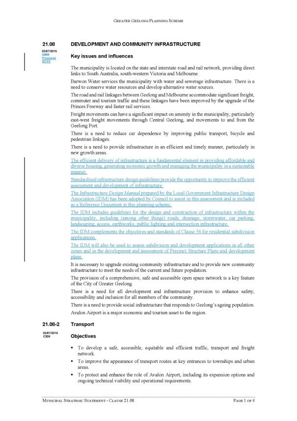
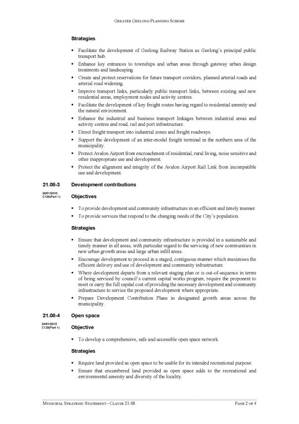
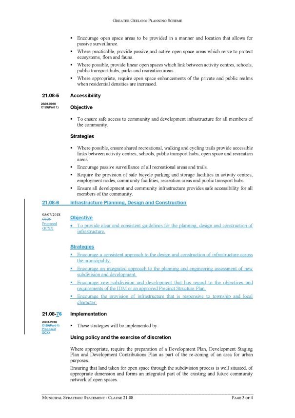
Source: |
City Services - Environment and Waste Services |
Director: |
Guy Wilson-Browne |
Portfolio: |
Environment and Sustainability |
For Council to consider and approve the draft Breamlea Holiday Park Master Plan.
The City of Greater Geelong (CoGG) acts as Committee of Management (CoM) for the Breamlea Holiday Park (Park) and surrounding foreshore (Crown land) on behalf of the Department of Environment, Land, Water and Planning (DELWP).
The Breamlea Holiday Park Master Plan (Master Plan) (Attachment 2) aligns with the requirements of State Government policy and best practice guidelines for foreshore caravan parks.
The City has undertaken a competitive tender processes for management of the Park, with the most recent process finalised in 2011. The existing Park Manager who was re-appointed at this time has been managing the Park since 1996. The current contract is due to end in November 2020 as the final three year option of a 3x3x3 year renewable term.
There are a number of other caravan park operators on the Bellarine Peninsula including Barwon Coast Committee of Management and the Borough of Queenscliffe.
Barwon Coast Committee of Management is responsible for the management of Riverview Family Caravan Park, Riverside Camp Ground and Barwon Heads Caravan Park. These caravan parks provide around 1,000 campsites, and for about six weeks in peak summer the Riverside Camping Ground also operates to provide additional sites.
The Borough of Queenscliffe (BoQ) manage four parks, including all year and seasonal sites, with a total of approximately 370 sites. Three parks are managed by BoQ staff with 5.4 total Full Time Equivalents (FTEs) working on-site and 1.0 FTE working in the BoQ office. The management of one seasonal park (approximately 110 non-powered sites) is contracted out using Caretakers Australia at $350 per day.
The total operating profit for all BoQ parks is approximately $700,000 to $800,000 annually which is used to fund improvements and maintenance of community facilities, foreshore infrastructure and coastal protection activities on Crown land.
In comparison to other caravan parks in the region, the Breamlea Holiday Park has fewer and older recreation facilities, has the lowest star rating, has less cabin accommodation and has the lowest fees.
The Master Plan has been prepared to improve safety, management and facilities within the Park with a key objective to increase revenue and maintain the values of the site and foreshore.
The City has undertaken upgrades to the Park including the construction of three eco-friendly villas, upgrades to the amenity blocks, BBQ areas and general store frontage, improved outdoor lighting, installation of an all abilities toilet, new fencing and improved tree management. Through careful management, the Park is operating at a near financial break-even status.
The Master Plan seeks to maintain a Park that is financially sustainable and attractive to users and deliver a functional mix of accommodation by:
consolidating six and twelve month permit sites and casual sites,
designating an additional 23 sites as 12-month permit sites,
designating an area to be available for use by larger motor-homes, and
designating an area for additional cabin accommodation.
The Draft Master Plan was the subject of a public consultation period for six weeks in September 2017, after being endorsed by Council at its August 2017 meeting. A summary of the comments received during the consultation period is included at Attachment 3. All comments received were considered as part of finalising the Master Plan.
DELWP provided approval for the implementation of the Breamlea Holiday Park Master Plan as consent under the Coastal Management Act 1995, by letter dated 17 January 2018 (Attachment 4).
There is a need to review the management arrangements of the Park to provide greater certainty given that this is the only Park that the City manages.
Councillor Mason moved, Councillor Mansfield seconded -
That Council:
Approve the Breamlea Holiday Park Masterplan 2018 (Attachment 2);
Note that any financial implications will be subject to Council’s annual budget process; and
Receive a future report within 6 months on alternative management options for the Breamlea Holiday Park.
Carried.
Total Project Cost
Implementation of lower cost items in the Breamlea Holiday Park Master Plan will be funded from Park income. Larger cost items such as the installation of new cabins, depending on profit levels in future years, may require additional funds from Council subject to the annual budget process.
The Master Plan focuses on improving the operation and facilities of the Park until 2022. Several items of expenditure listed as part of the Master Plan may occur over a longer time period. The cost to implement the full range of actions within the Master Plan is estimated at between $1.01 million and $1.41 million, with the variation due to ageing infrastructure and variation in the cost of cabins depending on the final choice of design and construction. The Master Plan indicates that cabins will only be installed subject to funding.
Table 1 Summary of planned expenditure as part of the Master Plan
Master Plan Action |
Cost Estimate $ |
Estimated Implementation Period |
Comment |
Develop Cultural Heritage Management Plan (CHMP) |
$30,000 |
0-2 years |
Mandatory |
Undertake site reconfiguration and introduce online booking system |
$70,000 |
0-2 years |
|
Install underground dump point |
$10,000 |
0-2 years |
|
Install / construct 10 new cabins |
$600,000 to $800,000 |
Average of 1-2 cabins installed every 1-2 years |
Variation due to designs and constructions methods available |
Undertake amenity block upgrades |
$100,000 to $150,000 |
Staged completion over 1-5 years |
Variation due to ageing infrastructure |
Undertake upgrades to underground services and enable metering of utilities |
$200,000 to $350,000 |
Staged completion over 1-5 years |
Variation due to ageing infrastructure |
Note annual operational and maintenance costs (excluding contractual Park Manager expenditure) are estimated to remain at between $150,000 and $200,000 per annum.
Breamlea Holiday Park |
||
2017 2018 and 2016 2018 Financial Report |
||
|
||
Income Statement | ||
Financial Years: 2016/2017 and 2017/2018 |
||
|
2016/2017 |
2017/2018 |
Income |
|
|
Casual sites including cabins |
217,488 |
248,959 |
Annual sites |
236,630 |
228,523 |
Total income |
454,119 |
477,483 |
Expenses |
|
|
Depreciation |
37,847 |
38,801 |
Utilities |
36,152 |
35,256 |
General Work and External Services - includes Park Management Fees, CoGG admin, all contractors |
356,876 |
432,021 |
Total expenses |
430,875 |
506,078 |
Surplus/(deficit) for the year |
23,244 |
(28,595) |
Income
The annual income for 2016/2017 was $454,119 and included a net surplus of $23,244.
The annual income for 2017/2018 was $477,483 and included a net deficit of $28,595.
The difference in the recorded net suplus/deficit is due to the different expense allocation to CoGG administration and operational support. $30,500 was allocated in 2016/2017 whilst $112,000 was allocated in 2017/2018. This larger amount is a more accurate representation of this expense and reflects the increased focus on Park management.
A steady increase in total Park income was realised from 2012 ($402,820) to 2018 ($477,483). This increase is due to increased total income from casual site (camping and cabins / villas) bookings, as well as annual CPI increases applied to all site fees in recent years. Total income from 12 month sites remained relatively static over this period.
The Park Manager retains any profits from the shop and post office. The total 2016/2017 takings were $134,300 for the shop and approximately $800 for the post office. The Park Manager has recently decided to stop offering cooked food at the shop stating an inability to compete with new take away food options at Armstrong Creek.
The Park relies on the natural environment as its main attraction for customers, with the weather playing a key role in Park occupancy levels. In 2017/2018, 44% of casual site income was generated during December and January. By increasing the number of 12 month permit sites by 23, the Master Plan provides the opportunity to increase base income across the entire year which will more than offset the minimal negative impact to casual site income.
Current demand for 12 month sites indicates that proposed newly allocated sites are likely to be occupied within 12-24 months of the Master Plan being approved. Twelve month sites can be utilised as casual sites prior to being allocated.
The introduction of additional cabin accommodation and enhancements to accommodate motor homes, complimented with an online booking facility to improve marketing capability, also seeks to increase bookings across the year. The improvements seek to provide the diversity of accommodation options that correspond with industry trends, without compromising the ‘natural environment experience’ that attracts many people to Breamlea Holiday Park in the first place.
The Caravan Industry Association of Australia undertook a State of Industry review which is reported to be a ‘comprehensive review of all caravanning and camping tourism figures, recreational vehicle manufacturing and registration statistics for 2016’. The review highlights the increased demand for cabin accommodation as part of the camping experience.
In accordance with the Crown Land (Reserves) Act 1978, Council is obliged to invest any funds it earns on coastal Crown land back into the maintenance and improvements of coastal infrastructure and natural values.
Expenditure
Total expenditure for 2016/2017 was $430,875 with expenditure of $206,000 provided to Park Management as per contractual arrangements. An amount of $30,500 was allocated to CoGG administration expenditure. Total expenditure for 2017/2018 was $506,078 with expenditure of $209,000 provided to Park Management as per contractual arrangements. An amount of $112,00 was allocated to CoGG administration expenditure which is a more accurate representation of the true cost to CoGG given the level of administration and operational support provided by CoGG (Environment, Finance, Legal, Tree Crew).
The final optional three-year contract term with the current Park Manager ends in November 2020.
Community and stakeholder consultation has been an important component of development of the Master Plan.
Initial consultation in 2014 involved a workshop held at the Park with representatives from Council, Park management, DELWP, Country Fire Authority (CFA), the Wathaurung and Parcor Safety Training and Consulting.
A draft Master Plan, refined over a number of years, received in-principal support from DELWP in July 2017 and Council support was provided in August 2017 to commence a six-week public consultation process.
The public consultation process included providing the Draft Master Plan, with an invitation to comment, to all Breamlea Holiday Park 12 month and seasonal site holders, all Breamlea residents and other relevant government and community stakeholders.
The Draft Master Plan and details for comment were also displayed at the Breamlea General Store and published on the ‘Have Your Say’ section of Council’s website. Twelve submissions were received, the details of which were all considered in the development of the proposed final Master Plan. A summary of submissions and Council’s responses were published on Council’s website as part of the online community consultation process.
The Master Plan requires that nine 12 month site holders be relocated to another available 12 month site. Specific communication has been undertaken with these site holders to confirm the proposed Master Plan will require them to relocate, that relocation can occur over a generous time frame (1-3 years) and that their preferences for site relocation will be considered and resolved prior to offering 12 month sites to other parties. Communication with these affected site holders will continue following any Council approval of the Master Plan.
Notification of Council’s approval of the Master Plan will occur on Council’s website and via letters to site holders and residents and information displayed at Breamlea General Store.
The Breamlea Holiday Park, containing the general store and post office, is central to the fabric of the small Breamlea community.
The proposed final Master Plan was submitted to DELWP, as the land owner, in December 2017. DELWP provided their letter of consent dated 17 January 2018 for use and development of Coastal Crown Land with regard to the Breamlea Holiday Park Master Plan in January 2018.
The changes suggested as part of the Master Plan are consistent with requirements of State Government policy and best practice guidelines for foreshore caravan parks.
Twelve month site holders undertake an annual application process with Council, at which time Council assess and confirm whether their application is approved for an additional 12 months. These details are confirmed in the terms and conditions provided to each registered site holder so that there is no guarantee for a term beyond the yearly agreement.
The Master Plan aligns with the Council Plan 2018-2022 objectives, in particular:
Growing our tourism and events;
Innovative finances and technology;
Effective environmental management.
No officer involved in the preparation of this report has a direct or indirect interest.
Emergency management and occupational health and safety procedures have recently been reviewed and updated as part of preparing the Master Plan. This process included an updated risk assessment for the Park.
The Emergency Management Plan requires an annual inspection by the CFA.
Breamlea is surrounded by significant environmental areas including the open coast, dunes and wetlands which are inhabited by a diverse array of flora and fauna. The operation of the Park in this sensitive setting is focussed on minimising environmental impacts.
There is no remnant indigenous vegetation within the Park. The existing large Eucalypts include Southern Mahogany, Tuart and Sugar Gum are not indigenous to Breamlea but contribute to landscape, character and amenity.
Ongoing monitoring and management of the trees will continue and a staged tree replacement program using indigenous local provenance Moonah and Coast Manna Gum will be implemented.
The Master Plan includes undertaking a waste management plan.
Source: |
Planning and Development - Local Laws |
Acting Director: |
Brett Luxford |
Portfolio: |
Community Health and Safety |
To authorise the making of an Order that sets out the rules applying to dogs in public places on land managed by the Bellarine Bayside Foreshore Committee of Management (BBFCM).
At its 14 August 2018 Community Focus Council Meeting, Council agreed to adopt dog control orders and enter in to a Domestic Animal Control Agreement with the BBFCM in accordance with Section 26 (2A) of the Domestic Animals Act 1994.
Following this endorsement of the subject dog control orders, it is now necessary to formalise these by Council authorising the making of the Order pursuant to Section 26 (2) of the Domestic Animals Act 1994. This authorisation by Council is the final step in ensuring that the orders have legal standing by being brought into effect in accordance with the relevant legislation. The Order is included in this report as Attachment 2.
The authorisation of the making of the order will complete the process of legitimising any dog control order on the BBFCM land.
If the authorisation of the making of the order is not undertaken, the dog control orders will have no legal effect.
Councillor Sullivan moved, Councillor Grzybek seconded -
That Council:
Authorise the making of the Order under Section 26 of the Domestic Animals Act 1994; and
Delegate to the Manager Health and Local Laws the authority to carry out the required statutory advertising in the making of the Order by Council.
Carried.
There are no financial implications with respect to authorisation of the making of this Order by Council.
The authorisation of the making of the Order is the final legal and administrative step to legitimise the dog control orders that were agreed upon by Council following extensive community engagement. As a result there is no need for any further community engagement.
All matters relating to Social Equity were considered in the 14 August 2018 Report that endorsed the feedback from the community engagement process.
In order for the subject dog control orders to have legal effect, Council, after agreeing to adopt the orders and enter in to an Agreement, is now required under Section 26 (2) to formally authorise the ‘making’ of such orders.
Improved Health and Safety of our Community
Providing safer public places
Encouraging responsible pet ownership
Promoting active living
Informed Social Infrastructure and Planning
Provide more quality spaces that support active lifestyles
More Inclusive and Diverse Community
Supporting activities that improve social connections in or community
Further developing programs that support older people and young people in our community
There is no conflict of interest with respect to any officer in the preparation of this report.
By implementing enforceable dog control orders on the subject land, Council has the opportunity to improve risk and safety outcomes for its residents who use that space.
There are no environmental implications associated with this report
Source: |
City Services - Environment and Waste Services |
Director: |
Guy Wilson-Browne |
Portfolio: |
Environment and Sustainability |
To seek Council approval for the draft Hooded Plover Conservation Action Plan 2018 – 2021, developed to protect the iconic and highly threatened, hooded plover (Thinornis cucullatus cucullatus), to be open for six weeks public consultation.
Hooded plovers are an endangered bird species that inhabit our local beaches. Since 2006, the City of Greater Geelong (the City), under the guidance of BirdLife Australia with the support of community volunteers, has implemented a range of actions to help protect the birds.
Hooded plovers breed on two sections of coast managed by the City – one section at Breamlea and the other between Ocean Grove and Point Lonsdale. They also breed on sections of the Bellarine managed by Borough of Queenscliffe, Barwon Coast Committee of Management and Barwon Water.
As hooded plover breeding areas transcend coastal management boundaries multiple agencies including the City are responsible for their protection. There are also non-government agencies and community groups who act to conserve hooded plovers. To bring these groups together and ensure a consistent, well informed management approach, the City formed the Hooded Plover Working Group in 2013. The group consists of representatives from BirdLife Australia, Friends of the Hooded Plover (Bellarine and Breamlea), Barwon Coast Committee of Management, the Borough of Queenscliffe, Parks Victoria, Barwon Water and the City’s – Environment and Local Laws Departments. It’s primary aim is to work toward National Recovery objectives and ensure a strategic and collaborative approach to hooded plover management.
This focus on collaboration and strategy has been the driver for the compilation of this Conservation Action Plan. The inaugural Plan, which defines the key priorities and targets for hooded plover management for the next five years, was developed by the City’s Environment Team in consultation with partner agencies and the community.
The Hooded Plover Conservation Action Plan outlines what the City will do to improve the breeding success of our local hooded plovers. It consolidates current actions and sets a framework for future activities to benefit this vulnerable species, including:
Support the recovery and long-term survival of the hooded plover;
Achieve an annual breeding target of 0.4. to 0.5 fledglings per breeding pair;
Continue to monitor and address hooded plover threats;
Raise awareness about the hooded plover;
Apply a collaborative strategic approach towards hooded plover breeding protection;
Support BirdLife Australia staff and volunteers; and
Manage hooded plover breeding sites to improve fledging numbers;
Community activity and predation from dogs and pest animals are threatening hooded plovers and their young. An increasing coastal population is resulting in more people and dogs on our beaches. This is escalating the risk of harm to hooded plovers and increasing the urgency for education of beach users;
Introduced plant species modifying hooded plover habitat, and
Habitat, including beach and non-breeding wetland habitat, under threat from changes in land use and new developments.
Councillor Mansfield moved, Councillor Mason seconded -
That Council approve the draft Hooded Plover Conservation Action Plan (Attachment 2) to be open for six weeks public consultation.
Carried.
No additional budget or staff resources will be required to deliver the Plan.
The draft Plan was developed under the guidance of the Hooded Plover Working Group consisting of representatives from Friends of the Hooded Plover (Bellarine and Breamlea), BirdLife Australia, Barwon Coast Committee of Management, the Borough of Queenscliffe, Parks Victoria and Barwon Water. Key stakeholders were provided an opportunity to comment on the plan and these comments have been incorporated into this draft.
Once the draft has been endorsed by Council it will be displayed on ‘Community Have Your Say’ for six weeks and promoted on social media and our website inviting public comment.
The City will seek to promote the importance of protecting hooded plovers to a diverse and inclusive range of community groups, clubs and schools. The Plan will be made available in alternate versions, including in other languages and on Read Speaker / HTML.
The Plan aligns with Council policy and strategy and fulfils environmental objectives outlined in the Council Plan 2018-2022 and the Environment Management Strategy.
The Plan will help achieve strategic objectives of the Environmental Management Strategy which relate to Ecosystem Health including:
2A - Protect, preserve and enhance natural areas and ecosystem health;
2B - Increase the extent and resilience of natural habitats, including the amount of area under permanent protection;
2C - Increase reporting of programs;
2D - Improve knowledge of natural areas and threatening processes; and
2F - Enhance stakeholder engagement and partnerships.
This Plan will help achieve two key priorities under the Sustainable Development objective in the Council Plan including;
Delivering biodiversity conservation programs; and
Preserving nature reserves, rural and coastal environments.
No officer involved in the preparation of this report has any direct or indirect conflict of interest in the matters raised in this report.
There are no perceivable risks associated with the adoption of this Plan.
Implementing this Plan will lead to positive environmental implications by reducing negative impacts on an endangered species and our coastal environment.
Source: |
Finance and Strategy |
Director: |
Peter Anderson |
Portfolio: |
Leadership and Governance |
To establish a new Central Administrative Office Project Advisory Committee (the Committee) and endorse the Committee’s terms of reference.
The current Central Administrative Office Project Advisory Committee was established by resolution of Council on 24 April 2018 to provide initial advice regarding the Central Administrative Office building project (the Project). It has concluded its work having achieved all of the objectives listed in its terms of reference and having submitted a final report to Council on 25 September.
Council has committed to consolidating its administrative offices to the 137 Mercer Street Geelong site by resolution adopted at the 25 September 2018 Council meeting.
Council is able to establish advisory committees by resolution to provide advice to Council on a particular matter. Such committees do not have delegated powers and may not allocate Council funds or resources.
Further work is required to refine design and delivery matters relating to the Project;
Council requires consideration and provision of advice about the Project regarding the following matters:
design criteria for the Project;
financial agreement with proponents;
final selection of the successful proponent;
opportunities for the project to be a catalyst for further CBD revitalisation projects;
preferred future arrangements for civic and ceremonial functions associated with any extension of the Geelong Gallery to part of the existing Town Hall;
the business case for expansion of the Geelong Gallery to part of the existing Geelong Town Hall;
opportunities for the sale of surplus Council property as part of the financing plan for the Project;
general progress of the Project as reported from time to time;
other matters relative to the Project that may be referred by Council from time to time or matters referred by management.
An advisory committee will be best placed to advise Council regarding the Project.
Terms of reference for the Committee (Attachment 2) have been prepared and reflect the ongoing needs of Council in relation to delivery of the Project.
Councillor Aitken moved, Councillor Kontelj seconded -
That Council:
Abolish the Central Administrative Office Project Advisory Committee established by resolution of Council on 24 April 2018 and revokes its terms of reference;
Establish a new Central Administrative Office Project Advisory Committee;
Endorse the Central Administrative Office Project Advisory Committee terms of reference at Attachment 2 of this report, and with the following amendment to item 3 g) opportunities for the financial debt reduction opportunities such as sale of surplus Council property as part of the financing plan for the project;
Appoint at least five Councillors to be members of the new Central Administrative Office Project Advisory Committee; and
Appoint the Mayor to be chairperson of the new Central Administrative Office Project Advisory Committee.
Carried.
There are no financial implications arising from the subject of this report. Provision of secretariat services and committee resourcing is provided for in the City’s 2018-19 budget.
The Committee will be tasked with undertaking consultation to inform advice as required.
The Committee will allow consideration of social equity issues that arise from consideration of the project and related matters.
Formation of the Committee is compliant with the Local Government Act (Vic) 1989 as well as Council’s policies and procedures relating to the establishment of advisory committees.
The work of the Committee will support delivery of the 2018-22 Council Plan strategic priority - Organisational Leadership, Strategy and Governance - which has a key priority of consolidating the City of Greater Geelong offices.
No Council officers or contractors who have provided advice in relation to this report have declared a conflict of interest regarding the matter under consideration.
The establishment of an advisory committee will support the Council to identify and manage risks associated with the Project.
There are no environmental implications arising from the subject of this report.
Source: |
Investment and Attraction - Economic Developme nt |
Director: |
Brett Luxford |
Portfolio: |
Environment and Sustainability |
To provide Council with an update on the activities of the Rural and Peri Urban Advisory Committee and to outline the Committee’s recommendations to Council.
On 13 February 2018, Council resolved to establish a Rural and Peri-Urban Advisory Committee to advise Council regarding key strategic and service matters affecting the rural and peri-urban community of the municipality. Councillor Mason was appointed Chair of the Committee.
Public expressions of interest were sought for membership of the Committee. Following an interview process, members of the Committee, listed in Attachment 2, were appointed by the Chief Executive Officer in accordance with the Terms of Reference.
The Committee initially met on 1 June 2018 and has since met monthly.
After reviewing a number of previously commissioned reports relating to the Geelong saleyards and agribusiness in the region, as well as the minutes of the Saleyards Advisory Group and other publicly available reports (all listed in Attachment 3), the Committee has identified four priority areas which will form the basis of Committee agendas and discussion going forward. Those priorities are:
Biosecurity;
Livestock exchange;
Information exchange; and
Truck wash facilities.
The Committee notes that all of these priorities are interdependent.
The Committee has also identified a number of specific issues affecting rural and peri-urban communities in the municipality, including:
Biosecurity:
Department of agriculture tagging and traceability requirements;
Meat and livestock association requirements;
Analysis of threats, risk mitigation and emergency response;
Vulnerability of local agricultural, tourist and other industries; and
Local Government support for State and Commonwealth policies.
Settlement Strategy: including best practice management of rural and peri -urban farms and maintaining the right to farm within urban breaks.
Social needs:
Men’s (and Women’s) Shed, peer education and collaboration;
Further development of rural community values;
Cost of not having Local Government ongoing support for agricultural and rural lifestyle communities;
Educational needs, particularly for new settlers and “lifestylers” that need ongoing guidance and orientation;
Economic benefit locally, including value-add and new industries.
Environmental considerations:
Pest, plants and animals, exotic species, prohibited weeds and feral animals on public and private land;
Best agricultural environmental management practice; and
Implications for One Planet Living and Zero Carbon goals.
Other services/activities which could support each other in a rural environment:
Community Hub;
Coordinated livestock and produce markets within established yearly calendars;
Support for ‘think local’, including support local procurement and markets;
Social and cultural activities; and
Energy production.
In response to the priorities and issues identified by the Committee, the Committee has developed a workplan (Attachment 4).
As a result of its meetings and deliberations to date, the Committee recommends to Council that:
A scoping study for a multi- purpose small-scale livestock and information exchange in the G21 region (Scoping Study) to be commissioned that pulls together existing reports, industry information and analyses existing data relating to the local use of saleyards including demographics of the users, with further consideration to economic, social and environmental benefits and the current behaviours and needs of stakeholders;
The Committee supports, in principle, a shared funding arrangement between stakeholder Councils for the Scoping Study. The Committee recommends that the Council engage with each interested Council to determine each Council’s cost contribution; and
That the outcomes of the Scoping Study be the subject of further recommendations from the Committee to the Council.
Councillor Mason moved, Councillor Sullivan seconded -
That Council:
Note the update of the activities of the Committee;
Note the recommendations of the Committee;
Refer the consideration of an allocation of adequate funding to conduct the Scoping Study to the 2019/20 budget process; and
Request the Chief Executive Officer to engage with the relevant Councils to determine each Council’s cost contribution to the Scoping Study.
Carried.
It is anticipated that the cost of a scoping study for a ‘small scale livestock and information exchange’ would be $100,000. The cost of implementing the recommendations of the Committee will need to be considered in Council’s 2019/2020 budget.
The Committee provides an important link between the rural and peri urban communities and Council.
The Committee is considering the social implications of adequate facilities and education about issues affecting the rural and peri urban communities in the municipality.
The Committee is an advisory committee to Council in accordance with the Local Government Act (Vic) 1989.
The establishment and continuation of the Committee aligns with a number of the Council Plan priorities:
Planned sustainable development
A more inclusive and diverse community
Improved health and safety of our community
Effective environmental management
A thriving and sustainable economy
No officer involved in the preparation of this report has any direct or indirect conflict of interest in the matters raised in this report.
The Committee has identified a number of areas which it believes are of importance to the sustainability of rural and peri urban communities in the municipality.
The Committee has considered and will continue to consider environmental issues arising in rural and peri urban areas in the municipality.
Councillor Jim Mason (Chair)
Fiona Conroy (Community Farmer and VFF Member)
Joan Lindros (Community -Environmental Networks)
Stuart Mclean OAM (Community Farmer, Ex Board North-Central Catchment Management Authority (CMA) and Chair of Australian Livestock Association)
Geoff McFarlane (Community, Retired Department of Agriculture and Advocate of Best Agricultural Management Practices)
Eric Sharkey (Community Farmer, Ex member Port Philip and Western Port CMA, Member of G21 Agribusiness Forum)
Councillor Carol McGregor (Surf Coast Shire)
Councillor David Evans (Golden Plains Shire)
Gareth Smith (Officer, Colac Shire – General Manager Development and Community Services and Environment. Ex Corangamite CMA and Landcare)
Dr Angela Clough (Department of Agriculture, Biosecurity, Emergency Response, - Ballarat and Western Victoria)
Manager, Economic Development and Events
Manager, Planning Strategy and Urban Growth
Manager, Connected Communities
Manager, Engineering Services
Preparing for Change: A New Saleyard user demographic June 2017
Local (Geelong) Livestock Market Analysis March 2017
Kismet Report November 2016 Geelong Saleyards Stakeholder Workshop
Minutes of the Geelong Saleyards Advisory Committee
Structural Engineers Report 2016
Sustainable Agribusiness Strategy for the G21 Region
City of Greater Geelong Saleyards Users Survey 2016
Current Issues for further reading
Stock and Land 24 Aug 2018 “Saleyards need to become community hubs, to grow and thrive”
NSW Government – Greater Sydney Peri Urban Bio- Security Program (link removed - page no longer found)
Victorian Government – Protecting Victoria’s Environment- Biodiversity 2037
Victorian Government – Agriculture Victoria Strategy
Category |
Topics |
Status |
|
|
|
Bio Security |
||
|
Bio Security |
Priority |
|
|
|
Attention to policy for environment |
||
|
Habitat protection |
|
| Land management sustainability |
|
|
Indigenous vegetation |
|
| Wetland management |
|
| Protection of rural land |
|
|
Pest, plants and animals |
|
|
Revegetation |
|
|
Waste management |
|
|
Truck Wash |
Priority |
|
|
|
Road Infrastructure |
||
|
Roads – maintenance |
|
|
Roadside management |
|
|
Truck access |
|
|
|
|
Strategic Planning |
||
|
River corridors |
|
|
Right to farm - land use |
|
|
Rates |
|
|
Access to water |
|
|
|
|
Peri Urban Farmer |
||
|
Livestock Exchange |
Priority |
|
Biosecurity |
Priority |
|
Information Exchange peri urban farmer |
Priority |
Peri urban preparedness for emergency |
|
|
|
Information from council to peri urban farmers |
|
|
|
|
Source: |
Investment and Attraction - Arts and Culture |
Director: |
Brett Luxford |
Portfolio: |
Arts, Culture and Heritage |
To provide Council with an overview of the Potato Shed activities and highlights for the 2017/2018 period.
The Potato Shed was built as a joint venture between the City of Greater Geelong, Bellarine Secondary College (BSC) and St Ignatius College Geelong (SICG) with additional funding from the State Government. A Joint Use Agreement (JUA) was signed and Council established a Committee of Management under Section 86 of the Local Government Act. The venue opened 15 March 2001.
The Potato Shed is a multi-arts venue presenting performing arts; live music, art exhibitions; educational and public programmes to residents and visitors to the Bellarine.
Council, Bellarine Secondary College and St Ignatius College Geelong all contribute financially to the operation of the Potato Shed based on the JUA.
The Potato Shed activities in 2017/2018 included 102 theatre, dance and music performances along with exhibitions and youth events.
108,444 visits were made to the Potato Shed in the 2017/2018 year, including 69,564 general public and 38,880 visits from school students (Attachment 2). This was a 4% increase from 16/17.
The 2017/2018 program showcased a diverse array of performances, dance works and original productions. This included high profile touring productions: La Mama “Birdcage Thursdays”; Melbourne Theatre Company with “Hungry Ghosts”; South Australia Arts with “Rogue Romantic” along with the development of a new work “Dance Hall”, in conjunction with award winning international performers Finucane and Smith which then toured Victoria.
Other highlights included attendance of 8,500 at the 2017 Family Fun Day, and Children’s Week Prep Workshops, which attracted participation from most primary schools on the Bellarine.
The significant ongoing success and popularity of the Potato Shed in 17/18 brought continued challenges. These included managing the needs and expectations of schools, hirers and community groups as well as the increasing demand from the growing population and new groups forming on the Peninsula.
Councillor Mason moved, Councillor Sullivan seconded -
That Council note the overview of the Potato Shed activities and highlights for 2017/2018.
Carried.
Total expenditure for the Potato Shed, both operational and facility renewal, for 17/18 was $626,027 offset by total income of $333,365. Net contribution by Council was therefore $292,622 including depreciation of $57,616. The Family Fun day is also included.
In accordance with the agreed formula in the JUA, the BSC and SICG contributed $63,624 to the operating costs and an additional $20,520 towards facility renewal.
Further income was generated from venue hire, ticketing, grants and some sponsorship.
Regular feedback is sought from those who attend performances and participate in programs at the Potato Shed to ensure the venue continually improves and responds to the changing and diverse needs of the community. Community members regularly expressed their ongoing desire for the venue to be re-developed.
The Potato Shed has a commitment to promote fairness, justice, and equality to all. The lack of any public transport directly to the venue impacts on this commitment.
Through a series of resolutions dating back to 1997, Council agreed to participate as a joint venture partner with Bellarine Secondary College and St Ignatius College in the development and use of the Potato Shed Multi-arts facility. All parties are bound to the conditions of the JUA.
The Potato Shed aligns to the Council Plan and the Clever Creative vision, assisting to create a vibrant arts and culture facility as a highly regarded and inclusive venue.
There is no direct or indirect interest by Council officers involved in the preparation of this report.
The Potato Shed has obligations under OHandS legislation to provide appropriate equipment and training and to ensure that the venue meets WorkSafe requirements.
The Potato Shed continues to encourage all users and hirers to be waste wise. LED lighting used in foyer, hallways and toilets resulting in a substantial reduction in electricity use. Conversion of theatre lighting to LED continues as budget permits.
Source: |
Investment and Attraction / Arts and Culture |
Director: |
Brett Luxford |
Portfolio: |
Arts, Culture and Heritage |
To seek Council endorsement for the Borough of Queenscliffe to re-establish its membership of the Geelong Heritage Centre.
The Geelong Regional Library Corporation (GRLC) was established by Greater Geelong City Council (GGCC), Golden Plains Shire (GPS), Surf Coast Shire (SCS) and the Borough of Queenscliffe (BOQ) in March 1997 by agreement made under section 196 of the Local Government Act (Vic) 1989 (Original Agreement).
The Original Agreement was updated in March 2009 and revised in June 2016 with the GRLC operating under the Agreement to Continue the Geelong Regional Library Corporation.
The Geelong Heritage Centre (GHC) was established in 1979. GGCC, GPS and SCS have all had an ongoing governance and operational relationship including an annual municipal contribution to the GHC by all three Councils since its inception.
The BOQ was part of the original arrangement making an annual municipal contribution until July 2002 when it withdrew from the formal GHC arrangement.
Following the review of the Agreement to Continue the Geelong Regional Library Service in June 2016, the Councils entered into a Supplemental Agreement amending the Current Agreement to integrate the operations of the GHC with operations of the GRLC. This Supplemental Agreement reflected that the BOQ did not have a relationship with the GHC.
The BOQ has since requested to re-establish its membership of the GHC. The GRLC Board at its meeting on 13 August 2018 resolved to accept the BOQ request to re-establish its membership of the GHC.
The BOQ will make an annual municipal contribution to the GRLC Budget and are willing to cover costs associated with the process of determining what formal and legal requirements are required to prepare for this change to be brought into effect.
Formal approval by the four GRLC member Councils is required to confirm the membership of BOQ.
The executed Further Supplemental Agreement (2018) is to be forwarded to the Minister for Local Government (Vic.) for approval and published in the Victorian Government Gazette.
Councillor Nelson moved, Councillor Kontelj seconded -
That Council:
Endorse the Geelong Regional Library Corporation Board resolution of
13 August 2018 to accept the Borough of Queenscliffe’s request to re-establish its membership of the Geelong Heritage Centre;
Authorise the Chief Executive Officer to execute the Deed of Variation to the Further Supplemental Agreement on behalf of the Greater Geelong City Council.
Carried.
The BOQ will reimburse the GRLC for the costs associated with re-establishing its membership and the preparation of the Deed of Variation.
The BOQ will make an annual contribution to the GRLC toward the operations of the GHC.
The Borough of Queenscliffe is already a member of the GRLC and their return to membership of the GHC is considered to be of benefit to the region’s communities.
Heritage and social history provides the opportunities for communities to connect and work together in turn contributing to pride in place.
At the GRLC Board meeting of Monday 13 August 2018 it was moved by Councillor Nathan Hansford and seconded by Councillor Margot Smith:
That the GRLC Board welcomes and approves Borough of Queenscliffe membership of the Geelong Heritage Centre and that the Further Supplemental Agreement 2018 (appended) be approved for forwarding to GRLC member councils and as a direct result re-establish the Borough of Queenscliffe Council access to Geelong Heritage Centre service and collection related provisions.
Councillor Ross Ebbels abstained from the vote.
Carried.
The Further Supplemental Agreement has been prepared for approval and signing by GGCC, GPS, SCS and BOQ to confirm the BOQ’s membership of the GHC. In recognising the additional service that the Heritage Centre will provide the BOQ, a determination of an initial additional municipal contribution to the GRLC budget has been calculated.
The opportunity to expand the heritage collection and to collaborate with neighbouring municipalities aligns with the priorities and strategic directions of the Council Plan 2018-22, in particular the vibrant arts and culture measure of success to increase the number of objects actively cared for within our arts and heritage collections.
No officers involved in the preparation of this report have a direct or indirect interest in matters to which it relates.
There are no significant risks to Council in supporting the membership of the BOQ of the GHC.
There are no known direct environmental implications arising from this report.
Source: |
City Services – Engineering Services |
Director: |
Guy Wilson- Browne |
Portfolio: |
Social and Infrastructure Planning |
To revoke Council’s designation of 12 December 2006 of flood affected land Watermark, Stage 7 as liable to flooding pursuant to Regulation 802 (2) of the Building Regulations 2006.
Council has a statutory obligation under the Building Regulations 2006 to designate land as liable to flooding where it reasonably knows it to be prone to flooding. Conversely, there is an obligation to remove the encumbrance of designation from land that is no longer considered to be flood-prone.
The current designated flood mapping (refer to Attachment 2) was designated by Council at its meeting of 12 December 2006, under the provisions of the Building Regulations 2006.
The subject of this report is the residential land at Watermark fronting 228 – 262 Reserve Road, Charlemont. Prior to subdivision the parent lot was used primarily as farmland.
The flood mapping is subject to a revision due to the subdivision and development at 228 – 262 Reserve Road, Charlemont. Prior to subdivision the parent lot was considered to be liable to flooding. This development site, which is also known as Watermark, Stage 7, achieves flood immunity for newly created lots for flood events up to and including the 100 year Average Recurrence Interval (ARI) event due to approved internal earthworks.
The earthworks undertaken have resulted in the floodwaters from the 100 year ARI event being contained within the boundaries of the road network (refer
Attachment 3).
It should be noted that designation is separate to the creation of flood overlays within the Planning Scheme, which generally follows designation. In the case of this development, the planning scheme amendment to create post-development flood zones or overlays is proposed after the design of the proposed precincts.
Councillor Murnane moved, Councillor Nelson seconded -
That Council revoke the Council designation of 12 December 2006 of flood affected land Watermark, Stage 7 as liable to flooding pursuant to Regulation 802(2) of the Building Regulations 2006.
Carried.
No impact to budget.
A revocation of designation does not warrant public consultation as it constitutes the removal of an encumbrance on land.
Relevant Council databases and flood maps will be revised and updates sent to the Corangamite Catchment Management Authority and Building Control Commission.
Council have a responsibility to the community to provide the best possible information on areas that are flood prone.
The City has various statutory responsibilities for drainage management and flood management (prevention, response and recovery) as set out in the Local Government Act 1989, Local Government Regulations 1990, Planning and Environment Act 1987, Building Regulations 2006, Water Act 1989, Subdivision Act 1988 and Emergency Management Act 1986.
The recommendations of this report are consistent with Council Plan, in relation to Growing our Economy and promoting a sustainable built environment, sustainable land use and development.
There are no officer direct or indirect interests with respect to this report.
Council also has some risk exposure with any failure to disclose the flood-prone status of a property in a Land Information Certificate.
The revocation of the designation is the final step in minimising Council’s risk.
The revocation of flood-prone areas designation and designation of revised flood data through the design of this stage is considered unlikely to result in any known adverse environmental impacts.
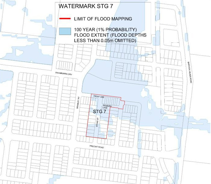
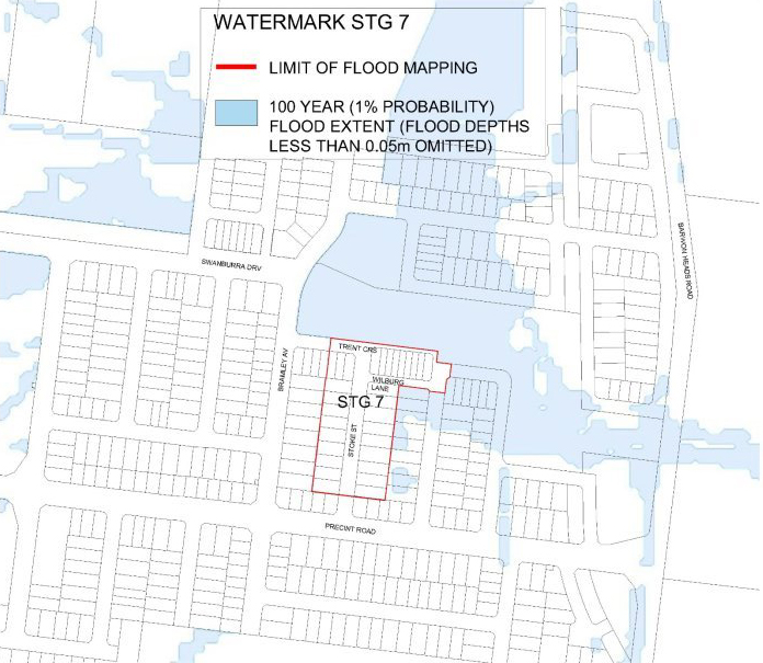
As there was no further business the meeting closed at 9:52pm on Tuesday 9 October 2018.
Signed: _________________________________________
Councillor Bruce Harwood (Mayor)
Date of Confirmation: _____________________________
Contents | Previous Page: Section A - Procedural Matters |
