
Council Minutes - Section B: Reports - 26 March 2019
Contents | Previous Page: Section A - Procedural Matters | Next Page: Section C - Notice of Motion
Contents | Previous Page: Section A - Procedural Matters | Next Page: Section C - Notice of Motion
Reports tabled at the Ordinary Meeting of Council on Tuesday date held at the Council Conference and Reception Centre in City Hall, 57 Little Malop Street, Geelong.
Northern and Western Growth Area – Adoption of Framework Plan
Audit and Risk Committee Summary Report (Confidential)
Contractual Matter (Confidential)
Contractual Matter (Confidential)
Source: |
Planning and Development - Planning Strategy and Urban Growth |
Director: |
Gareth Smith |
Portfolio: |
Sustainable Development |
To consider submissions on the draft future urban structure plans in the Northern and Western Geelong Growth Areas and to adopt the Northern and Western Geelong Growth Areas Framework Plan (Attachment 4).
In 2013, the G21 Regional Growth Plan identified the potential future development of the growth areas. In November 2014, the Minister for Planning approved Amendment C322 to rezone parts of the Northern Geelong Growth Area from Farming Zone to Urban Growth Zone as part of a Ministerial amendment. The Minister informed Council that it was expected that the City would lead the preparation of a framework plan to set the scope for future precinct structure plans (PSPs).
On 8 December 2015 Council resolved to commence preparation of a framework plan and integrated infrastructure delivery plan for two growth areas to the north and west of Geelong. On 8 May 2018 Council resolved to undertake community engagement on the draft future urban structure of the growth areas to inform the preparation of a framework plan.
A draft future urban structure plan for the Northern and Western Geelong Growth Areas was exhibited for public comment in May and June 2018.
Eighty-one submissions (79 unique) were received on the draft future urban structure plan. Most were from or on behalf of landowners within the growth areas, with others from residents or groups outside of the growth areas. Submissions were received from Barwon Water, APA Group (gas pipeline operator), Viva Energy Australia and Golden Plains Shire.
Key issues raised in the submissions made during community engagement included opposition to proposed land use changes and new arterial roads within rural living areas of Lovely Banks; protection of environmental values in the growth areas; provision of active and public transport to support new communities; inclusion of the land between the two growth areas within the framework plan; and general opposition.
Relevant amendments to the future urban structure plan that seek to resolve submissions include identifying rural living properties within the growth areas as ‘subject to future investigation’ of residential development as part of a long-term precinct structure plan, removing previously identified arterial roads from within rural areas of Lovely Banks and retaining the vast majority of rural living properties within the Rural Living Zone; committing to undertake an overarching biodiversity conservation strategy for each growth area and including a native vegetation precinct plan with each PSP; and outlining a comprehensive active and public transport network.
The framework plan outlines principles and actions to achieve the community’s ‘clever and creative’ vision in the development of the growth areas. Creation of a network of sustainable, self-sufficient, liveable, walkable neighbourhoods will centre on the Clever and Creative Corridor, a tree-lined boulevard corridor of community activity and high quality active and public transport options linking neighbourhoods in both growth areas.
A broad range of key stakeholder have been involved in the preparation including the Department of Environment, Land, Water and Planning (DELWP), Regional Development Victoria (RDV), Transport for Victoria (TfV), the Victorian Planning Authority (VPA), VicRoads and Barwon Water. Ongoing collaboration with stakeholders will continue throughout the planning and development of the growth areas.
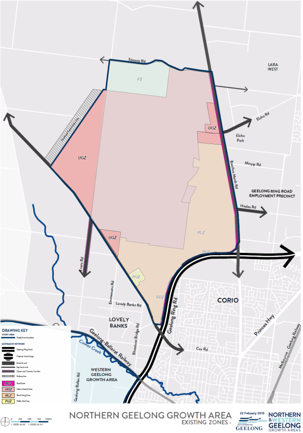
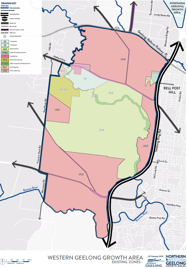
The City will seek authorisation from the Minister for Planning to undertake public exhibition of a planning scheme amendment to make changes to the local planning policy framework and give effect to the framework plan including the rezoning of some land in the growth areas to the Urban Growth Zone (illustrated in Map 2 and Map 4 in Attachment 2).
The growth areas will be planned and developed in an orderly and sustainable sequence of nine short, medium and long term precincts. Commencement of two PSPs in 2018/19 is recommended to maintain a competitive land supply market. The framework plan includes a ‘Delivery’ section that outlines the utilities and infrastructure required and staging of precincts.
The City will contact landowners in the Elcho Road East precinct (Northern Geelong) and Creamery Road precinct (Western Geelong) to commence negotiations and engage in individual third party funding agreements with willing participants that will fund technical studies to inform the preparation of PSPs.
Councillor Aitken moved, Councillor Mason seconded -
That Council:
adopt the Northern and Western Geelong Growth Areas Framework Plan as amended prior to exhibition;
seek authorisation from the Minister for Planning to prepare and exhibit an amendment to the Greater Geelong Planning Scheme to include the necessary elements of the Northern and Western Geelong Growth Areas Framework Plan within the Scheme and to rezone portions of the Northern and Western Geelong Growth Areas to Urban Growth Zone as outlined in Attachment 2;
immediately commence preparation of precinct structure plans (PSPs) for the Elcho Road East precinct in the Northern Geelong Growth Area and the Creamery Road precinct in the Western Geelong Growth Area; and
seek funding from the state government that will facilitate the ongoing planning for major transport infrastructure required to accommodate Geelong’s anticipated future growth, including the Geelong Growth Areas Transport Infrastructure Strategy.
Carried.
Memorandums of Understanding were executed within landowner consortiums in early 2016 to partially fund technical studies that informed the framework plan.
Planning for the Northern and Western Geelong Growth Areas, including preparation of two PSPs, is proposed for inclusion in Council’s 2019/20 budget. This includes preparation of a planning scheme amendment, the transport study and preparation of two PSPs. Total city funding proposed for 2019/20 is $787,000. In addition, considerable staff time will be dedicated to the project.
Individual third party funding agreements will be executed with land owners/developers that seek to progress the preparation of a PSP in the precincts recommended for commencement. Agreements will fund the background and technical reports required to inform the preparation of PSPs. This process is consistent with the metropolitan growth area model followed by the VPA and does not guarantee the adoption and approval of a PSP as a consequence of entering the agreement.
Development contribution plans (DCPs) or infrastructure contribution plans (ICPs) will generate most of the funding for subsequent development of transport and drainage infrastructure and community facilities. Similar to Armstrong Creek, regional scale infrastructure, including sub-regional open space, libraries and aquatic centres, are not generally included within development levies. Proposed staging of the precincts in the framework plan locates these larger community facilities in medium or long term precincts. Provision of these facilities is unlikely to be required until an advanced stage of development. The framework plan does not spatially locate these facilities or ‘lock in’ their future provision.
In order to minimise costs to Council and the community, community facilities will be delivered in a staged manner and be delivered as shared facilities, where practicable. Access to existing facilities in established areas will be maximised, and land will be purchased early where possible. Advocacy to the state government will be critical to the sharing of costs and the timely delivery of this infrastructure.
An extensive schedule of stakeholder engagement has informed the Northern and Western Geelong Growth Areas project, up to and including the preparation of the framework plan. Community engagement has included project bulletins to landowners in May 2016 and April 2017; ‘Open House’ community information sessions in May 2017, October 2017, May 2018 and June 2018 including sessions held in Corio, Batesford and central Geelong; a series of ‘Vision and Principles’ workshops in July 2017; ‘Enquiry by Design’ workshops in November 2017; community consultation on the draft future urban structure plan in May and June 2018 and the release of a community engagement summary report in August 2018. In addition, a wide range of industry and government stakeholders have participated in technical reference groups.
Eighty-one submissions (79 unique) were received on the draft future urban structure plan. Most were from or on behalf of landowners within the growth areas, with others from residents or groups outside of the growth areas. A summary of submissions and responses is provided in Attachment 2 and consideration of each submission in Attachment 3.
The planning scheme amendment to implement the framework plan will be subject to a statutory exhibition period. Where any submissions cannot be resolved, an independent planning panel will be requested. Community engagement will also occur during the subsequent PSP process for each individual precinct.
The project contains significant social equity considerations, responding to Greater Geelong’s significant growth rate by planning for the future provision of affordable housing and employment opportunities to meet the needs of the community. The framework plan will guide development of the growth areas in a manner that addresses the City’s responsibility to deliver vibrant, walkable neighbourhoods with great amenity, environmental sustainability, abundant open space, community facilities and activity centres that provide the daily needs and jobs for local residents.
The City is a GROW compact signatory and is committed to its role as a community leader in demonstrating and encouraging local investments and the use of social procurement. The City will engage with development proponents throughout the preparation of each precinct structure plan to encourage the use of social procurement and local investment in the subsequent urban development of the growth areas as part of a GROW compact.
The Northern and Western Geelong Growth Areas are identified in state policy as potential growth areas as outlined in the G21 Regional Growth Plan. Council adopted the Settlement Strategy in October 2018 that highlights the importance of the growth areas in supporting Geelong’s long term land supply.
The framework plan has considered relevant state and local planning policy. To give the framework plan statutory weight, a planning scheme amendment will implement policy elements into the Greater Geelong Planning Scheme and rezone portions of each growth area to the Urban Growth Zone.
The framework plan recognises the ongoing extractive operations of Batesford Quarry and maintains the quarry within the Special Use Zone. PSPs in the Western Geelong Growth Area are proposed in a manner that will allow urban development in locations with an adequate separation distance from ongoing operations in the quarry pit.
Schedule 4 to the Environmental Significance Overlay applies to parts of the Northern Geelong Growth Area and relates to grasslands within the Werribee Plains Hinterland. The City will work with DELWP to undertake a biodiversity conservation strategy that intends to guide the management of nationally and state significant biodiversity values.
The framework plan aligns with the ‘planned sustainable development’ strategic priority of the Council Plan. It will assist in delivering the following key priorities under that strategic priority: ensuring housing supply, diversity and affordability can meet the needs of our growing community; continuing to develop urban growth areas across the region; improving the environmental performance of new developments; managing the impact of development on the unique character of our townships; and delivering biodiversity conservation programs.
The framework plan also aligns with several other strategic priorities of the Council Plan: improved health and safety of our community; informed social infrastructure and planning; effective environmental management; integrated transport connections and a thriving and sustainable economy.
No Council officers involved in the development of the framework plan and preparation of the report have a direct or indirect interest in the issue to which this report relates.
Technical studies: The framework plan is a high-level land use plan to inform PSPs. As a consequence, the technical studies undertaken are generally high-level and will be further informed by detailed technical studies for each PSP. In some cases, detailed technical studies may identify recommendations that differ from the directions in the framework plan with the possibility of changes being made to land uses outlined in the framework plan including potential biodiversity conservation, sizing of drainage infrastructure and road improvements that will inform public acquisition of land where required.
Funding of technical studies: The process for preparing technical studies has included several reports that are funded by the landowner consortiums and managed in collaboration with the City. This approach will not be continued for future planning including the PSPs.
Midland Highway: VicRoads is currently planning for the improvement of the Midland Highway. The duplication of the existing alignment of Midland Highway through the Western Geelong Growth Area forms part of the improvement project, as well as several bypass options. The City has assumed the existing Midland Highway alignment will be duplicated for the purposes of preparing the framework plan; however, the framework plan does acknowledge that the upgrade of the Midland Highway and any potential realignment is subject to future investigation and has designed a road network that is capable of adapting to realignment. VicRoads is the coordinating road authority for the Midland Highway.
Batesford Quarry: The vision for the reuse of the Batesford Quarry is a recreational lake. Due to the long term timeframe and complex transition of the quarry to a lake this use cannot be resolved in the framework plan. PSPs in the Western Geelong Growth Area do not rely on the transition of the quarry and surrounding land to an urban environment; whilst not intended, a scenario where the quarry is never rehabilitated to an urban standard will still result in the remaining four precincts in the Western Geelong Growth Area delivering high amenity neighbourhoods that are well connected to urban Geelong. A PSP in proximity to the quarry pit will not commence until detailed investigation of the decommission, rehabilitation and impacts of the proposed transition to a lake are undertaken and further considered.
Financial costs of urban development: The planning for infrastructure and sequencing of development is critical to managing the costs of urban development. Each PSP must be carefully considered to ensure that the scale of community infrastructure is commensurate with community needs, scope is minimised and funding for local infrastructure is maximised in the preparation of DCPs.
Consequences of development on adjoining development: the size and scale of the future urban development in the growth areas will have an impact on adjoining development, most notably in relation to anticipated traffic movements as part of its full build out. A comprehensive list of state and local transport infrastructure has been identified in the framework plan to facilitate traffic movements for residents in the growth areas and existing residents in adjoining areas. Local infrastructure will be funded via development levies as part of DCPs or ICPs. State infrastructure will be advocated for via the Geelong Growth Areas Transport Instructure Strategy. Specific actions in the framework plan highlight the importance of providing landscape screening or buffer treatments to adjoining areas including the Batesford township and rural living properties. Future investigation of active and public transport connections between the Western Geelong Growth Area and urban Geelong via Church Street will be subject to future investigation in the very long term, subject to traffic demands generated by the growth area in the advanced stages of its development. The connection has the potential to provide good connections between existing urban Geelong and the future recreation lake at the Batesford Quarry.
Environmental implications have been considered as part of the preparation of the framework plan. Technical studies relating to the capability of land including assessments of native flora and fauna, Aboriginal and post-contact heritage, geotechnical, hydrogeological and environmental constraints, stormwater drainage and land use buffers have been undertaken.
The framework plan identifies actions to protect biodiversity including an overarching biodiversity conservation strategy for each growth area, provision of biodiversity linkages, identified and potential conservation areas, tree canopy coverage and tree planting.
Strategic context
In 2013, the G21 Regional Growth Plan identified the potential future development of the growth areas.
In November 2014, the Minister for Planning approved Amendment C322 to rezone parts of the Northern Geelong Growth Area from Farming Zone to Urban Growth Zone as part of a Ministerial amendment. The Minister informed Council that it was expected that the City would lead the preparation of a framework plan to set the scope for future PSPs.
On 8 December 2015, Council resolved to prepare a framework plan and integrated infrastructure delivery plan for the growth areas.
The City is using the standard “hierarchy of plans” approach for greenfield planning projects that is used in metropolitan Melbourne and is consistent with State Government guidelines. The first stage is the framework plan that sets out the high level land use direction for each growth area. Each growth area will be divided into smaller precincts and a PSP will be prepared for each precinct. The PSP includes fine-grain detail and is underpinned by development levies collected via a DCP or the anticipated ‘flat rate’ ICP being newly implemented in metropolitan growth areas.
The Northern and Western Geelong Growth Areas project is being prepared to address Geelong’s long-term population growth as part of a clever and creative future. The project constitutes the largest greenfield planning project in regional Victoria with the capacity to accommodate approximately 112,000 new Geelong residents.
The Northern Geelong Growth Area, in Lovely Banks, has an area of 2,090 hectares and is anticipated to deliver more than 17,000 new dwellings for a population of approximately 48,000 residents. Four PSPs will be prepared for the Northern Geelong Growth Area.
The Western Geelong Growth Area, in Batesford, has an area of 3,245 hectares and is anticipated to deliver up to 23,000 new dwellings for a population exceeding 64,000 residents. Five PSPs will be prepared for the Western Geelong Growth Area.
On 8 May 2018 Council resolved to undertake community engagement on the draft future urban structure of the growth areas to inform the preparation of a framework plan.
Community engagement and consideration of submissions on draft future urban structure plan
In May and June 2018 community engagement was conducted on a draft future urban structure plan for the Northern and Western Geelong Growth Areas. A background report was prepared to provide the community with a summary of key policy considerations and technical studies. In order to maximise engagement with the wider community, the consultation period extended to 45 days and included 14 print adverts in four local newspapers, a Community Update newsletter sent to every Greater Geelong residence inviting submissions, project brochures sent to landowners within and adjoining the growth areas and four ‘open house’ sessions held in Corio, Batesford and central Geelong with more than 250 attendees.
Eighty-one submissions (79 unique) were received on the draft future urban structure plan.
Key issues raised and a response to each are outlined below. A full summary of submissions received, including responses to issues raised, is at Attachment 3. Consideration of submissions on the draft future urban structure plan has informed the preparation of the framework plan.
Opposition to Northern and Western Geelong Growth Areas
Six submissions indicated outright opposition to the growth areas, with two others opposing one of the growth areas. Four submissions indicated that the urban growth proposed for the growth areas should be redirected to other locations – in or on the eastern edge of urban Geelong, or to other towns in the region.
Response: No changes made to the plan
The project is identified in state policy (G21 Regional Growth Plan). A large portion of the Northern Geelong Growth Area is already in the Urban Growth Zone. The growth areas will provide for Greater Geelong’s long term greenfield housing supply as supported in Council’s adopted Settlement Strategy.
Northern Geelong Growth Area – existing Rural Living area
There are 297 rural living properties in the North Geelong Growth Area; 21 submissions argued that land in Lovely Banks currently in the Rural Living Zone should remain a Rural Living area. Submitters argued that adjacent residential subdivision would impact on landowners’ rural living lifestyle and amenity. Six of the submissions expressed concern at the impact of rates increases resulting from a change in zoning. Eight submissions called for a transitional low density residential area between the existing rural living area and any conventional residential development.
Response: Changes made to the plan
The plan has been amended to retain most existing Rural Living zoned properties in Lovely Banks in the Rural Living Zone until a PSP is undertaken for this area. The framework plan identifies this area for ‘future investigation of residential.’ In the long term, the City will undertake investigation of conventional or low density residential development as part of a future PSP process. The desire for land owners to subdivide within rural living areas may increase over time as urban development occurs in surrounding areas and services and infrastructure are closer. Detailed assessment of its capacity to deliver future residential land use would be required through a PSP process.
Some existing rural living zoned properties in proximity to the Geelong Ring Road Employment Precinct are identified in the framework plan to transition to employment-based land use to provide Geelong's future jobs; however, this a long term proposition and these lots will also remain in the Rural Living Zone until the eventual PSP process rezones the properties to Urban Growth Zone in the long term.
A few small areas of the current Rural Living Zone that are planned for conventional residential density in the short to medium term are proposed to be rezoned to Urban Growth Zone as they form part of short and medium term precincts.
Importantly, a decision to develop and subdivide their land is one for individual landowners upon the completion of a PSP.
Northern Geelong Growth Area – Proposed Arterial Road
Twelve submissions expressed opposition to a proposed arterial road identified in the draft future urban structure plan running north from the Barwon Water Lovely Banks Basin and located in the vicinity of Viewhill Road. Submissions indicated concerns with the impact of the road on landowners, including possible land acquisition. Several submissions suggested an alternative location for the proposed arterial road.
Response: Response: Changes made to the plan
Based on updated transport modelling, this arterial road connection is not required and has been removed from the final framework plan. Access for future residents will be sufficiently catered for by intersection connections on Anakie Road at Emmersons Road and Evans Road. Should future investigation of this area lead to urban development, road requirements would be reassessed as part of the PSP process.
Western Geelong Growth Area – PSP staging
Four submissions argued that the north-eastern portion of the Western Geelong Growth Area (land bounded by Midland Highway, Geelong Ring Road, Geelong-Ballarat railway and Moorabool River) is best placed to be the first stage of development of the growth area.
Response: Supported in part
The framework plan identifies the Creamery Road precinct, in the north-east of the Western Geelong Growth Area, as the first PSP to be prepared in that growth area. Urban development will commence on land adjoining the existing residential neighbourhood of Bell Post Hill with direct access to central Geelong via Ballarat Road. Creamery Road precinct is the closest precinct to existing utilities and has excellent access to urban Geelong from both Creamery Road freeway flyover and the Midland Highway interchange.
Land between the Northern and Western Geelong Growth Areas
Four submissions indicated that land between the Northern and Western Geelong Growth Areas should be identified for urban development, either by inclusion in a growth area or for low density residential.
Response: Do not support
The Northern and Western Geelong Growth Areas were identified in the G21 Regional Growth Plan and are defined in Council’s adopted Settlement Strategy. There is no need to identify further land for growth areas given the Settlement Strategy has identified adequate residential land supply; however, planning for the Northern and Western Geelong Growth Areas will not prejudice any longer term potential for urban growth between the two growth areas.
Environmental considerations
Seven submissions specifically called for protection of environmental values (particularly native vegetation and fauna habitat) in the development of the growth areas. Other submissions opposing the Northern and Western Geelong Growth Areas outright, or opposing elements of the draft future urban structure plan, referred to environmental impacts.
Response: Support
The framework plan identifies actions to protect biodiversity including an overarching biodiversity conservation strategy for each growth area, provision of biodiversity linkages, identified and potential conservation areas, tree canopy coverage and tree planting.
Active transport – pedestrian and cycling network
Nine submissions called for new or improved pedestrian/cycling facilities, both within the growth areas and linking the growth areas to urban Geelong.
Response: Support
The framework plan specifies that a comprehensive active transport network will be established that prioritises walking and cycling within and between neighbourhoods. Active transport will be prioritised in the design of linear open space corridors. Greater Geelong’s Principal Bicycle Network will be expanded with new or upgraded infrastructure to provide connections to the broader city network. Provision of an active transport network will be further detailed in the subsequent PSP process and include off-road shared paths along every arterial road, connector street, waterway open space and the Clever and Creative Corridor.
Public transport
Six submissions made specific recommendations on public transport. New rail connections were proposed between the growth areas and to the existing rail network. Light rail was also proposed. Other submissions noted public transport inadequacies in the vicinity of the growth areas and in the region more generally.
Response: Support in part
Public transport is a key focus of the framework plan and will also be a key focus of subsequent PSPs. Public transport will be central to the design of neighbourhoods to promote mode shift from private vehicles. While no new railways lines are proposed, the framework plan proposes passenger rail services between Geelong and Bannockburn, with a new railway station in the proximity of Geelong-Ballan Road. High frequency public transport services are proposed to both Geelong, Lara and Corio Railway Stations. The Clever and Creative Corridor allocates land for a public transport corridor within and to and from the growth areas.
Land acquisition
Four submissions specifically raised concern at the prospect of compulsory acquisition of land for roads or other aspects of urban development. Other submissions opposing proposed arterial roads also alluded to potential loss of land.
Response: Response: Do not support
Land required for roads or other public purposes will be secured through the subdivision process in most instances. Public Acquisition Overlays will be used sparingly and only where acquisition is essential and cannot be negotiated with landowners. Future consideration of the use of the Public Acquisition Overlay will occur on a needs basis as part of the relevant PSP and may need to be utilised in deliver road widenings or drainage infrastructure in areas that have several or fragmented land configurations.
Framework Plan elements
The framework plan addresses six elements, each of which is outlined under the headings below.
Clever and Creative
The framework plan is guided by and seeks to achieve the community led aspirations of the A Clever and Creative vision, along with the One Planet Living principles.
The Clever and Creative Corridor is a fundamental to achieving the community’s vision and is a concept that has guided the design and preparation of the framework plan. Through the Clever and Creative Corridor, the City seeks to ensure future development is sustainable, self-sufficient, diverse, distinctive and connected through varied transport options. The Corridor will be a tree-lined, boulevard-style transit corridor that prioritises active and public transport between activity centres, schools, community facilities, sports reserves and local parks in each neighbourhood.
The corridor provides a strategic, centralised location to deliver many of the measures of success outlined in the community’s vision including large tree canopy cover, integrated water management, zero carbon, and medium density residential that includes diverse housing types such as social and community housing. The corridor includes reserving land within the cross section of the street for a dedicated, separated public transport route capable of delivering future models of mass-transit such as light rail, bus rapid transit and trackless trams. In the short and medium term of urban development, the corridor will be utilised as a principal active transport corridor that links community facilities and activity centres to deliver ‘20-minute neighbourhoods’ where local residents can conveniently access their daily needs.
Actions to achieve the Clever and Creative vision are embedded throughout the other framework plan elements.
Environment
The framework plan identifies environmental values of the growth areas and specifies a wide range of actions to ensure that these are protected or enhanced through the development of the growth areas.
Significant environmental and landform features – the Lovely Banks Monocline, Barwon and Moorabool River corridors, Cowies Creek, Dog Rocks Sanctuary – will be protected or enhanced. Individual detailed master plans outlining protection and enhancement of river and creek corridors will be prepared for the Barwon and Moorabool Rivers and Cowies Creek.
Flooding and stormwater management will maintain and enhance predevelopment hydrology, respond to the natural landscape and minimise downstream impacts with future planning to be undertaken in collaboration with Barwon Water and the Corangamite Catchment Management Authority.
Assessments will be prepared for each precinct to determine the presence of Aboriginal cultural heritage that may influence the design of the urban landscape and open space network. The visibility of Aboriginal history and culture will be promoted within the urban landscape. Post cultural (European) heritage elements, including dry stone walls, will be investigated, protected and incorporated into the urban landscape including Elcho Homestead.
Land uses within high voltage electricity transmission line easements and within the measurement length of the gas pipeline will be carefully planned to minimise risks to community safety. Areas of potential land contamination have been identified and will be subject to further investigation.
Surrounding areas, including the wider landscape, do not present a significant bushfire risk to the growth areas. The potential impact of grassfires will be identified and managed in the non-urban interfaces.
Land use buffers have been implemented in the Northern Geelong Growth Area to protect future residents from surrounding land uses.
Neighbourhood
New neighbourhoods will be designed on the principle of a 20-minute, 800-metre walkable catchment within which daily needs are provided for, with walking and cycling prioritised. High-quality neighbourhood amenity will be achieved by maximising tree canopy cover.
Neighbourhoods in the growth areas are to be climate resilient, net carbon positive and environmentally sustainable. An environmentally sustainable design action plan will be prepared for each precinct. Neighbourhoods will be designed with the capacity to adapt to new technologies including innovation in buildings, transport, energy and waste.
The City is working in collaboration with Barwon Water and DELWP to deliver an integrated water management strategy for the growth areas.
The growth areas will provide housing diversity in both densities and typologies. Activity centres will include high density housing. The housing mix will also provide opportunities for affordable, aged-care, community and social housing options.
The framework plan includes consideration of the needs of the future communities for schools, community facilities and open space required to create sustainable, self-sufficient new neighbourhoods.
Locations suitable for the potential delivery of sub-regional open space have been identified within or adjoining both growth areas. Both locations in the Western Geelong Growth Area are located within the study boundary and generally co-located along the open space corridor. For the Northern Geelong Growth Area, potential external locations include Elcho Park and Sutcliffe Reserve. These locations have not been investigated to date and have been listed only for their future potential to utilise existing City assets given the long-term timeframe for delivery sub-regional open space and their proximity to existing Northern Geelong community that would also benefit. Alternatively, purchase of land within the growth area may create a significant cost.
The growth areas will deliver active open space within 400 metres of each resident, and dedicated active transport links within easy reach of each resident. Dispersed multi-use open spaces and facilities will provide access to nature and encourage exercise, sporting and social activities. Open space networks will protect biodiversity, waterways and cultural heritage values. Trails will be cultivated along the ridgeline of the Lovely Banks Monocline and along the Moorabool and Barwon River corridors.
Economy
Activity centres in the growth areas need to be considered in the context of urban Geelong’s existing retail hierarchy, which provides for a spatial distribution of shopping opportunities that minimises the cost of travel to consumers and the environment. The framework plan identifies a hierarchy of activity centres in each growth area that will provide self-sufficiency, accessibility, vibrancy and local employment for the growth areas while not adversely impacting the broader network of activity centres in Geelong.
The total network of activity centres for the Northern and Western Geelong includes:
Two sub-regional activity centres that will deliver a comprehensive range of large-scale retail, commercial, entertainment and community uses required in the region and support high density residential development in the surrounding neighbourhoods.
Eight neighbourhood activity centres that will deliver a mix of everyday shopping needs and local services, co-locating with community facilities and services to create the local heart of the surrounding neighbourhoods.
Local convenience centres to be provided in locations beyond a comfortable walk of larger activity centre catchments.
The location of the sub-regional activity centre in the southern half of the Western Geelong Growth Area is position to promote the future services of the Corio Shopping Centre.
Both growth areas cater for light industrial land uses (e.g. service industries, freight and logistics and light manufacturing) in designated employment precincts. Employment land uses are not compatible with residential neighbourhoods and will be located within a precinct where industries can support each other and growth without impediment.
The location of the employment precinct in the Western Geelong Growth Area provides 117 hectares of land on flat terrain that avoids heavy vehicle movements in proximity to river corridors and Batesford Quarry.
The location of the employment precinct in the Northern Geelong Growth Area provides 177 hectares of land on flat terrain that avoids heavy vehicle movements on the monocline escarpment and within residential neighbourhoods and outstanding access to the Geelong Ring Road.
High-level analysis indicates that a total employment land required to support the local residents of the Northern Geelong Growth Area is up to 110 hectares. The proposed increased size of the employment precinct, and its potential to expand further north along Bacchus Marsh Road, is based on its strategic location adjoining the Geelong Ring Road Employment Precinct and direct proximity to the Port of Geelong and Avalon Airport. The employment precinct can grow by an additional 124 hectares, if required, to support Geelong’s long-term economic growth by transitioning rural living properties within the existing GREP buffer.
Movement
The framework plan identifies the importance of achieving a mode shift to active and public transport. As Geelong rapidly grows, the capacity to provide for private vehicles to cater for their current proportion of journeys will be compromised. Strategic transport modelling undertaken for the framework plan indicates that current private vehicle use patterns applied to residents in the growth areas in a full development scenario (modelled to 2051) would create daily volumes of 42,000 to 64,000 vehicles per day on the Hamilton Highway with up to 57,000 and 50,000 vehicles movements per day on the Midland Highway and Bacchus Marsh Road respectively. Geelong’s existing road network, and the network in central Geelong, is not adequate to accommodate these traffic volumes.
Significant State Government investment will be required to deliver large-scale road and rail upgrades to facilitate the growth anticipated of Greater Geelong. The framework plan outlines a comprehensive list of state infrastructure projects to facilitate growth including:
Opening the Geelong-Ballarat railway corridor to commuter services between Geelong and Bannockburn
A new railway station in proximity to Evans Road, Lovely Banks
Rail overpass at Evans Road, subject to rail corridor improvements
Rail overpass at Geelong-Ballan Road, subject to rail corridor improvements
Upgrade and duplication of Bacchus Marsh Road, Hamilton Highway and Midland Highway with external upgrades toward central Geelong
Upgrade of Geelong Ring Road interchanges at Bacchus Marsh Road, Anakie Road, Midland Highway and Hamilton Highway
A new half-diamond interchange on the Geelong Ring Road in proximity to Church Street incorporating a local freeway flyover for dedicated active and public transport movements (subject to detailed future investigation of traffic demand)
Upgrades of the Creamery Road flyover on the Geelong Ring Road
Pedestrian bridge connecting Lovely Banks and Corio
Realignment and localisation of Fyansford-Gheringhap Road
High frequency bus services throughout the growth areas connecting to Lara, Corio, North Geelong and Geelong railway stations.
The City is working in collaboration with TfV, VicRoads and the VPA to deliver the Geelong Growth Area Transport Infrastructure Strategy that establishes and prioritises the ultimate transport infrastructure requirements generated by Armstrong Creek and the Northern and Western Geelong Growth Areas at full development. The project includes planning for Geelong’s major road and public transport network and will be used to strengthen advocacy for timely provision of state infrastructure to support growth in the Geelong region. The project is vital as the Growth Areas Infrastructure Contribution (GAIC) that provides funding to deliver state infrastructure in metropolitan growth areas is not available to Greater Geelong.
The framework plan specifies a minimum of a 14-metres central or side-running median will be reserved within the Clever and Creative Corridor to allow for the future application of a dedicated, separated public transport corridor capable of delivering future models of mass-transit such as light rail, bus rapid transit and trackless trams. Importantly, the Clever and Creative Corridor links directly to the Geelong-Ballarat rail line and the location of the proposed future railway station which will allow residents direct access to the wider rail network.
Delivery
Sequencing of urban development is critical to the success of the growth areas and must be undertaken in a manner that benefits the City’s broader community and economy.
Council’s Settlement Strategy identifies the need for development of at least one new urban growth front by 2025 to maintain residential land supply in the context of sustained growth. The Settlement Strategy identifies a range of issues to be considered in decision making about preparation of PSPs.
The commencement of one PSP in each area is consistent with the directions given by the Minster for Planning to the VPA in its Statement of Expectations for 2018/19.
Urban development in the Northern Geelong Growth Area is proposed to commence in the north-east of the growth area on land adjoining Lara West, prioritising early connections to the Lara Railway Station and Lara Town Centre. In the medium term, neighbourhoods will be established through the western plateau, before urban development is considered in the south-eastern portion of the growth area. The Elcho Road East Precinct will be the first PSP in the Northern Geelong Growth Area.
Urban development in the Western Geelong Growth Area is proposed to commence on land in the north-east of the growth area adjoining Bell Post Hill with direct access to central Geelong via Ballarat Road. In the medium term, new neighbourhoods will be established along the Midland Highway and Hamilton Highway corridors, before urban development is considered in proximity to the Batesford Quarry. The Creamery Road Precinct will be the first PSP in the Western Geelong Growth Area.
Beyond the commencement of initial two PSPs, the commencement of any subsequent PSP will be initiated by the City based on strategic policy and budgeting. Recommendations for the commencement of a PSP will be based on the City’s Settlement Strategy, maintaining an adequate supply of residential land, sequencing proposed in the framework plan, the capacity for urban development in the precinct to meet the community aspirations, One Planet principles and project objectives and executing funding agreements that are sufficient to undertake technical studies.
Simultaneous preparation of PSPs in each growth area is not be supported unless necessitated by the City’s strategic policy and considerations outlined above.
PSPs will be prepared by the City to provide detailed guidance for the design and development of Geelong’s new neighbourhoods.
This strategic policy approach seeks to limit financial and infrastructure exposure felt by the City and the community when too many simultaneous development fronts create the need for infrastructure to be delivered to new communities that may be far removed from each other and from urban Geelong. The process outlined in the framework plan will provide the City with greater control of growth area development than has been enabled in Armstrong Creek.
The ICP is likely to replace the DCP in regional councils and will fund infrastructure identified to support the initial PSPs. The DCP/ICP defines the local infrastructure required to support the new community and allocates the proportion of funding to be borne by the City and by the developer. The City has been active in lobbying the state government for a ‘metropolitan-equivalent’ ICP levy that would provide the same ‘per hectare’ development levies that are applied by the metropolitan growth councils and City officers are represented on the technical reference group that is informing the consideration of a regional rate.
Planning Scheme Amendment
In order to facilitate PSPs and to give effect to actions in the framework plan, a planning scheme amendment is required.
Map changes
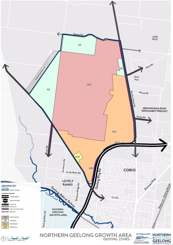
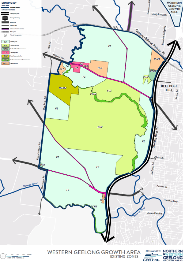
The Planning Scheme Amendment will rezone portions of the Northern and Western Geelong Growth Areas to the Urban Growth Zone. These areas, shown in the figures below, are as follows:
Northern Geelong Growth Area
Land in the Farming Zone bounded by the high voltage transmission line easement on the west and Evans Road in the east that is within a precinct identified for conventional density residential in the medium term.
A small area of land in the Rural Living Zone north of Lovely Banks Road and west of Emmersons Road that is within a precinct identified for conventional density residential in the medium term.
A small area of land in the Rural Living Zone in the vicinity of Elcho and Bacchus Marsh Roads that is within the Elcho Road East Precinct identified for conventional density residential in the short term.
As outlined above, all other land currently in the Rural Living Zone is to remain in that zone.
Western Geelong Growth Area
All land in the Farming Zone or Rural Living Zone identified in the framework plan for conventional density residential, whether in the short, medium or long term.
The current Special Use Zone Schedule 7 (Earth and Energy Resources Industry) over the Batesford Quarry will be retained while the quarry is operational.
Ordnance changes
Appropriate changes will be made to the Local Planning Policy Framework of the Greater Geelong Planning Scheme to give effect to the framework plan. These will include changes to:
Clause 21.03 (Objectives – Strategies – Implementation)
Clause 21.04 (Municipal Framework Plan)
Clause 21.06 (Settlement and Housing)
Clause 21.07 (Economic Development and Employment)
and a new Clause 21.19 (Northern and Western Geelong Growth Areas).
Map 1 - Northern Geelong Growth Area – Existing Zones
Map 2 - Northern Geelong Growth Area – Proposed Zones
Map 3 - Western Geelong Growth Area – Existing Zones
Map 4 - Western Geelong Growth Area – Proposed Zones
Source: |
Community Life - Social Planning and Investment |
Acting Director: |
Robyn Stevens |
Portfolio: |
Social and Infrastructure Planning |
To confirm the governance arrangements for the development of an inclusive play space at Rippleside Park.
In 2018 the City received a proposal from a community member, to consider developing an inclusive play space within the municipality. Discussions have been held regarding the proposal with charity organisations Touched By Olivia and Variety - The Children’s Charity. These organisations have a partnership that delivers inclusive play spaces across Australia.
The municipality currently has limited play opportunities for people with disabilities. In Greater Geelong, over 14,000 people need help in their day-to-day lives, with an increase in help needed amongst younger demographics.
The Rippleside playground was built in 2000 and is identified for renewal. The proposal is to redevelop the Geelong Community Adventure Playground at Rippleside Park into an inclusive play space, employing Universal Design principles.
This proposed redevelopment is consistent with the Access and Inclusion Plan 2018 - 2022 that outlines the City’s commitment to upholding the rights of all people and ensures an accessible environment that offers the opportunity for participation and inclusion for everyone, regardless of ability. The redevelopment is also consistent with the Geelong Play Strategy 2012 - 2021 as it offers an opportunity to renew and maintain significant, but ageing play structures.
The proposed governance arrangement for this project is a partnership with the charity organisations Touched by Olivia and Variety. The key responsibilities of these organisations will be community fundraising and promotion of the project throughout Geelong and nationally. The partnership model is intended to bring additional funding to the project via mechanisms not generally available to government.
The partnership would entitle the charity organisations Touched by Olivia and Variety to naming rights over the play space. Importantly, the naming rights will apply to the play space only, not to Rippleside Park.
Councillor Murrihy moved, Councillor Kontelj seconded -
That Council:
authorise the CEO to enter into a memorandum of understanding with Touched By Olivia and Variety to partner in the delivery of an inclusive play space at Rippleside Park; and
note the partnership entitles the charity organisations to naming rights, with the likely name of the new play space being “Livvi’s Place”.
Councillor Nelson left the meeting room at 7:57pm.
Councillor Nelson re-entered the meeting room at 7:59pm
Carried.
No budget is allocated to this project in the current 2018-19 financial year.
Based on similar projects in other municipalities, the preliminary estimated cost for construction will be approximately $1,000,000 plus an additional amount of $500,000 to upgrade the surrounds and toilet facilities.
Subject to the planning and design phases of this project being complemented in a timely way, we anticipate construction could start in 2020-21 financial year.
Funding from other community partners and the state government will be sought via a fundraising campaign led by the charity organisation partners in this project - Touched By Olivia and Variety. It is anticipated that fundraising could form an estimated 20 per cent of the project costs (including direct financial contributions and in-kind support).
The charity partners have experience in the delivery of over $40 million of co-designed and co-created places across the country over the last decade.
The potential financial benefits from the proposed partnership include access to a network of suppliers who offer discounts on equipment, design and service and leveraging the charity organisations’ ability to secure grants, raise funds and secure pro bono goods and services.The current play space is an ageing asset due for renewal. Annual maintenance costs approximately $50,000 which include inspections, maintenance, repairs and materials. Due to the design, age and timber materials, the maintenance is labour intensive and high cost. A new, site-specific facility will reduce these maintenance costs.
Rippleside Park has existing infrastructure to support the project such as toilets, car parking, picnic and barbeque facilities and is also well connected with walking trails.
Following consultation with the local community organisation - Friends of Rippleside Park & Environs (FoRPE) - a letter of support for the development of an accessible play space has been received. The letter states (in part) “support for the Council Officers’ recommendation that the existing playground be replaced with an all-accessible play space within the existing footprint on condition that it is a local project using local employment. FoRPE acknowledges Council’s offer to continue to consult with FoRPE and other key stake holders on this proposed visionary plan.”
Community engagement will be an extensive part of this project. Local residents, disability agencies and advocacy groups, community groups, prospective park users, community members and Council’s Access and Inclusion Advisory Committee will be engaged throughout the project.
Should Council resolve to proceed with the recommendations of this report, a detailed engagement plan will be developed.
The governance and management of the project will be overseen by the City in accordance with the City’s standard project management framework.
It is proposed that for this project a fundraising committee also be established. The key purpose of the fundraising committee would be to seek financial support for the project from within the community and other levels of Government. A fund-raising strategy will be developed as the project progresses.
It is proposed that the membership of the fundraising committee be developed via an expression of interest (EOI). The EOI would seek applications from interested members of the community in being part of the fundraising committee for the project. Councillors would be briefed on the outcome of the expression of interest and the shortlisting of candidates prior to a final decision being made.
Play is for everyone, young and old, families and carers and people of all abilities. The importance of play is recognised by the United Nations Convention on the Right of the Child. The United Nations recognises play as a right for all children. Play is essential to children’s development.
The City’s Geelong Play Strategy 2012-2021 also recognises the important role play offers to the development of children and their families and in the development of prosperous and cohesive communities. The strategy recognises that play enables children to learn new skills, make friends and build self-confidence. Play is important to the health and wellbeing of people of all ages and cultural backgrounds.
Geelong currently has limited play opportunities for people with disabilities. With over 14,000 people with a disability in the region, an ageing population increasingly involved in the everyday care of their grandchildren and a multicultural society, play spaces should provide an inclusive experience for all.
The development of an inclusive playground addresses the first three goals in the Access and Inclusion Action Plan 2018-2022:
Ensure facilities, buildings, environments and experiences are accessible to everyone;
Provide more accessible public urban space; and
Increase the number of community facilities with accessible toilets and adult change facilities.
Best practice has been defined as structures and environments that comply with Universal Design principles and meet the needs of the widest possible range of people. Universal Design creates spaces that can be used and accessed regardless of a person’s age, level of ability, cultural background or any other factors that contribute to the diversity of our community.
Rippleside Park is a central and highly accessible location within the municipality.
A memorandum of understanding (MOU) will be developed between Variety / Touched By Oliva and the City. The MOU is not a legal relationship; its intent is to demonstrate a harmonious and cooperative approach by City of Greater Geelong and Variety / Touched By Olivia to develop an inclusive playground at Rippleside Park.
The naming of the new play space will be in line with the state government’s Naming Rules for Places in Victoria 2016. These rules are the statutory requirements and therefore mandatory for Council.
The development of an inclusive play space is consistent with the following strategic priorities of the Council Plan:
Improved health and safety for our community – by improving the safety and user satisfaction of community infrastructure, creating more health and fitness options and promoting active living;
Informed social infrastructure and planning – by providing more quality spaces that support active lifestyles, delivering accessible and attractive community infrastructure based on community need and maintaining our public open space;
A more inclusive and diverse community – by supporting activities that improve social connections in our community, improving access to facilities and programs for people of all abilities; and
A destination that attracts local and international visitors.
No Council officers or contractors who have provided advice in relation to this report have declared a conflict of interest regarding the matter under consideration.
Three possible project management arrangements were considered:
Externally managed by charity organisations, with input and approvals from the City;
Solely managed by the City; and
Collaboratively managed by the City and with input from charity organisations for fundraising, design, consultation and promotion.
The preferred option is III. The completed play space will be a public asset, owned and managed by the City. It is important that the City has active involvement in the design and construction of the asset however the collaborative approach will increase the chance of success by spreading responsibilities, increasing the diversity of ideas and increasing the buy-in by the user groups and surrounding community. It also increases funding opportunities and scope to apply for grants available to not for profit groups.
There is strong community ownership of the existing Geelong Community Adventure Playground (the play space currently at Rippleside Park). It was initiated, planned, funded and constructed with very strong input from the community. 1,500 volunteers contributed to the playground’s planning, fundraising and construction. It took three years to plan and six days to construct in November 2000. It was an exceptional example of a collaborative project between the community and the City.
The playground was built with funds from the City, state government and 124 local sponsors. Each piece of playground equipment was sponsored by local organisations and 1,200 fence pickets were individually purchased and are still onsite and display the names of the purchaser.
The Geelong Community Adventure Playground committee no longer exists.
The Friends of Rippleside Park and Environs is an active community group and will be engaged as a key stakeholder as part of the project.
No significant environmental implications are associated with this report.
Source: |
Community Life |
Acting Director: |
Robyn Stevens |
Portfolio: |
Social and Infrastructure Planning |
To seek approval to allocate public land for the development of a community shed to accommodate the Grovedale Men’s Shed program.
For the purpose of this discussion, a differentiation is made between Men’s Shed programs (activities and governance), and the facilities from which the programs operate, community sheds (the buildings).
Men’s Shed programs build social cohesion and connection and are a grassroots example of a dynamic community development movement which can deliver significant health and wellbeing outcomes.
There are 14 Men’s Shed programs currently operating across the City of Greater Geelong with three operating from City facilities.
The Grovedale Men’s Shed program has operated from a facility purpose built by Villawood at Club Armstrong in Unity Drive, for five years. The group has 30 members and meet on a Tuesday between 1.00pm-4.00pm. The group have temporarily relocated to a site known as Foundation 61 in Mt Duneed, pending identification of an alternate site.
Council allocated $50,000 in the 2018-19 budget to “Undertake planning work to identify a suitable site in Grovedale locale that will meet the needs of the Grovedale Men’s Shed [program] and retain open space at Grovedale hub location.”
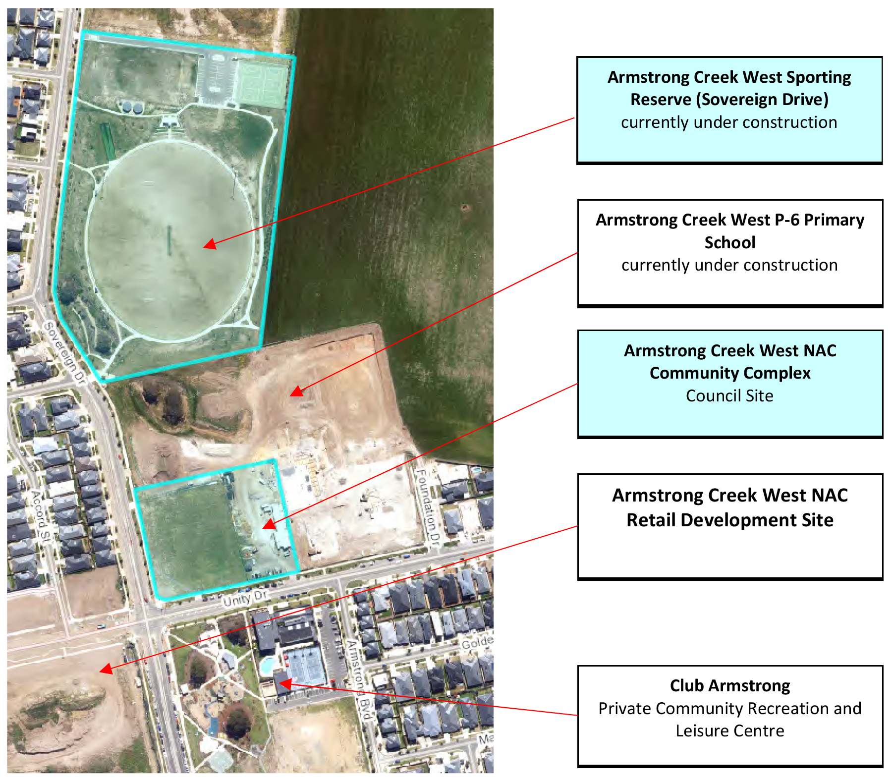
The Grovedale Men’s Shed Inc. have provided in-principle support for further investigating the proposal to co-locate the proposed community shed in the Armstrong Creek West precinct (refer to Attachment, figure 1).
A site capability and options analysis was undertaken across 15 potential sites. Three sites were selected for further investigation being Mt Duneed Recreation Reserve, John Croft Reserve in Grovedale, and Armstrong Creek West precinct. The options analysis identified the Armstrong Creek West precinct site at Unity and Sovereign Drive as the preferred site (refer to Attachment, figure 1).
Armstrong Creek West Precinct, which includes delivery of a new child and family centre at Unity Drive, and a new sporting pavillion at Sovereign Drive, Armstrong Creek.
Councillor Nelson moved, Councillor Murnane seconded:
That Council:
endorse in-principle the development of a community shed within the Armstrong Creek West precinct, as delineated in figure 1 of the Attachment; and
note that a process of design and development will commence, in consultation with the Grovedale Men’s Shed Incorporated, to identify the precise location and design of the proposed community shed facility.
Carried.
The Grovedale Men’s Shed Inc. have indicated a facility of approximately 24m x 18m on a concrete slab is required. Preliminary quantity survey (QS) cost estimates indicate construction of a stand-alone facility would be $595,000 depending on construction approach and scope. The requested specifications are significantly larger than those provided for other existing men’s shed programs currently located within the City of Greater Geelong.
The members of the Grovedale Men’s Shed Inc. indicate that they will pursue further funding from the state government of $60,000 once they have a confirmed site. Should the group be successful in obtaining funding from the state government, the capital construction shortfall would be in the order of $515,000 to realise the project.
At this stage no funding is being sought from Council toward the capital costs of this proposed development.
The proposal is for a community shed to be considered alongside and potentially be co-located with other community facility developments currently underway in the Armstrong Creek West precinct (refer to figure 1), which include the design and development of a new child and family centre and sporting pavillion.
Based on the existence of the program, engagement insights, accessibility requirements and geographical location, a men’s shed program is deemed to be required to meet the needs of the population in Grovedale and the surrounding area (including Armstrong Creek). Given the group no longer reside at Club Armstrong, a community shed facility is required for their ongoing program delivery and activities.
Community engagement has been ongoing in relation to the proposed development. Social Planning & Investment staff have met with representatives of the Grovedale Men’s Shed on a number of occasions to discuss their operations, requirements and preference in relation to a new site.
The Grovedale Men’s Shed Inc. have provided correspondence to indicate their in-principle support for locating the community shed within the Armstrong Creek West precinct as delineated in figure 1. The correspondence from the Grovedale Men’s Shed reads (in part) that “We accept that there are many good reasons why the Unity Drive Community Hub / Sporting ground sites make good common and commercial sense for the Men's shed. We appreciate that the fact this area is already tagged community use and has less planning issues making it an easy process. Whilst we are happy to support this site we cannot give unqualified support until we have seen the final design. We foresee the proximity to the school and other community groups could be a massive plus in developing shared spaces such as gardens. We appreciate that the space needs to be partially a multi-use facility and that can be achieved by clever design”.
An assessment of population benchmarks and also considering the current provision of similar facilities in other locations, indicates sufficient community demand for development of a community shed, with ability to host a men’s shed program.
Council has made a commitment to developing a Gender Equity Framework to improve gender equity outcomes for the community by ensuring all the City’s policies, plans, services and programs include gender equity principles to achieve a fair and inclusive community. Community sheds facilitate social inclusion opportunities for all including Men’s Shed programs whilst allowing access for other community groups and activities.
The current Social Infrastructure Plan (SIP) recognises Men’s Shed programs as a District Level facility with a catchment of 50,000 population. Based on benchmarks the municipality is well catered for in regard to men’s shed provisioning. As the program was catered for at Club Armstrong at the time of the SIP development, a new facility was not specifically recommended in the SIP for the Grovedale or Armstrong Creek Planning areas.
The Social Infrastructure Plan principles encourage:
locating of community facilities/spaces as part of a functional major centre with public transport, bike and walking path access;
integration of community facilities/spaces with recreation and leisure (indoors and outdoors), where complementary;
shared use of community facilities;
developing flexible, multipurpose community facilities/spaces which can incorporate a range of commercial and community services and change over time as the community matures; and
create adaptable community facilities/spaces appropriate to the level of service demanded.
The allocation of a public reserve for a community shed without the acquisition of additional public open space will result in a net loss of open space available to the community. Which is not aligned with Council Plan 2018-22 – Informed Social Infrastructure Planning commitment to no net loss of open space by suburb.
Council has previously refused provision of open space for the development of a Men’s Shed at Ocean Grove (2013). Any development that seeks to encroach onto open space would be subject to an Open Space Approval process.
Site capability assessments were undertaken on 15 potential sites initially and further analysis was completed on three sites based on Social Infrastructure Plan criteria. The following is a summary of the three potential development options:
Assessment Criteria |
Mt Duneed Recreation Reserve |
John Croft Reserve, (Grovedale Community Hub) |
Armstrong Creek West Precinct (Refer to Figure 1) |
Site capability |
Large recreation reserve containing aboriginal cultural heritage and native vegetation value |
Relatively small open space reserve with a substantial community hub, community garden and drainage assets |
Site allocated in existing Neighbourhood Activity Precinct (NAC) adjacent to schools, sporting facilities and retail |
No net loss of open space |
Would result in a net loss of open space |
Would result in a net loss of open space |
No or negligible net loss of open space. Will be integrated with existing proposals for built form in this location. |
Planning Scheme considerations |
Public Park Recreation Zone (PPRZ) Environmental Significance Overlay (ESO1) Vegetation Protection Overlay (VPO1) Aboriginal Cultural Heritage Overlay (See Figure 1) A Cultural Heritage Management Plan and Native Vegetation Assessment will be required Subject to an Open Space Approval Process |
General Residential Zone 1 (GRZ1) & Public Park Recreation Zone (PPRZ) Subject to an Open Space Approval Process |
Urban Growth Zone 3 (UGZ3) Public Park Recreation Zone (PPRZ) |
Location |
Located on the peri-urban boundary of the CoGG Relatively remote reserve in rural setting |
Centrally located to Grovedale Well used reserve in traditional residential setting |
Centrally located to Grovedale and Armstrong Creek Growth area |
Access to public transport |
No |
Yes |
Yes |
Integration with activity centre |
No |
No |
Yes |
Flexible multi use/Shared Use/Flexibility |
Yes |
Yes |
Yes |
Community Impact |
The allocation of public land (PPRZ) may result in a level of community concern about the loss of local public open space for other uses |
The allocation of public land (PPRZ) may result in a level of community concern about the loss of local public open space for other uses |
Minimal impact as the proposal for built form in this precinct and locations is already identified in the precinct structure plan |
Figure 1 Armstrong Creek West Precinct – Unity and Sovereign Drives, Mount Duneed
The development of a Community Shed to service the Grovedale and Armstrong Creek community aligns with a number of Council objectives including:
Improved health and safety of our community;
Informed social infrastructure and planning; and
A more inclusive and diverse community.
The allocation of public open space without the acquisition of additional open space within the suburb will contravene Council Plan 2019-22’s objective of ‘no net loss of open space by the suburb’.
No Council officers or contractors who have provided advice in relation to this report have declared a conflict of interest regarding the matter under consideration.
The proposal to locate a community shed within the Armstrong Creek West precinct aligns with the Social Infrastructure Plan principles, minimises the impact on open space and is consistent with Council’s policy position in relation to no net loss of open space.
The development of a stand-alone singular purpose facility would be inconsistent with the Social Infrastructure Plan principles and at another location (i.e. park or reserve) is likely to result in a more significant loss of dedicated open space.
Site capability assessments were undertaken on a range of sites including Council owned and managed land, school sites and industrial land holdings.
Site capability assessments have been undertaken on 15 potential locations, with further assessment conducted on three potential options. Site assessment criteria included policy alignment, land use and planning scheme implications, locality, access to public transport, development opportunities and site capability.
The potential environmental implications of the options not proposed include:
Locate the development of a community shed at the Mount Duneed Recreation Reserve in 130 Russells Road, Mount Duneed, however would be subject to an Open Space Approval Process.
Land capability and site analysis has identified the Mt Duneed Recreation Reserve is a relatively isolated reserve utilised by the Mt Duneed Pony Club and Highton Cricket Club. The reserve is an area of cultural heritage significance and contains remnant vegetation. A Cultural Heritage Management Plan and Native Vegetation assessments will be a statutory obligation in relation to this option. The site has a single access road and no public or pedestrian transport connections.
Integrate provision of a community shed at John Croft Reserve, Grovedale Community Hub site, Heyers Road, Grovedale. Development on this site would be subject to an Open Space approval. A master planning process may be required to ensure development would not be detrimental to open space functionality.
Relocation of the community garden has been recommended by Recreation & Open Space unit previously in relation to any developments in this open space reserve. Consideration is also required on potential impact on adjacent residential properties surrounding the reserve.
The proposal to locate a community shed in the Armstrong Creek West precinct would allow for the potential integration or colocation of the community shed into the scope of community facilities already planned.
Source: |
Investment and Attraction |
Director: |
Brett Luxford |
Portfolio: |
Economic Development |
To seek Council approval to endorse the Geelong City Deal based on the commitments the City is making to the projects.
A Memorandum of Understanding (MOU) to work together on City Deals was signed by the Commonwealth and State Governments in Geelong on 17 January 2018. As a first priority, the Commonwealth and State Governments agreed to work with local governments to deliver the Geelong City Deal. Negotiations between the signatories and the community have been ongoing to finalise the scope of the Geelong City Deal.
The State Government detailed their funding commitment to the Geelong City Deal via a pre-budget announcement on 1 May 2018 and then through the allocation in the 2018/19 Victorian Budget.
On Monday 29 October 2018, the Commonwealth Government announced their commitment to the City Deal projects.
On Monday 11 March 2019, the Commonwealth and State Governments announced that the Geelong City Deal had been secured with supplementary contributions from both the Commonwealth and State Governments.
The Geelong City Deal has a focus on the visitor economy and the projects that have been included in the Deal largely reflect that focus. The Commonwealth and State Governments’ agreed list of projects is outlined in Attachment 2.
The City of Greater Geelong has been asked to be a signatory to the Geelong City Deal. By signing the Geelong City Deal, the City of Greater Geelong will be engaged as a key partner in the governance of the City Deal and in the implementation of its agreed commitments. The City of Greater Geelong is the only local government signatory.
The City's commitments, as outlined in this report, are either budgeted this financial year or in most instances have been identified through the Strategic Resource Plan that was adopted by Council as part of the 2018/19 budget process.
The City will only contribute funding to projects that fall within the City of Greater Geelong municipality.
The governance arrangements and implementation plan will be developed by the Commonwealth and State Governments’ representatives over the coming months and will be reported back to Council.
Other councils will work with the Commonwealth and State Governments to implement projects within their municipality and will be invited to participate in a stakeholder advisory capacity through the Deal’s governance arrangements.
Councillor Sullivan moved, Councillor Murrihy seconded -
That Council:
Note the focus of the Geelong City Deal and the key projects that are to be included.
Subject to appropriate budget approval, support the inclusion of the following Council-funded elements into the Geelong City Deal:
$7.28 million 19/20 Gheringhap Street Drain Works (Central Geelong Revitalisation - Existing);
$3 million 20/21 Central Geelong Revitalisation Works (New);
$3 million 20/21 Geelong Safe Harbour Project (Existing);
$3 million 20/21 Convention & Exhibition Centre - Public Realm (New);
$900,000 20/21 – 21/24 Smart Parking Activities (New); and
$250,000 18/19 Smart City initiatives (Safety Cameras, Ped Counting, Renew Geelong).
Authorise the Mayor and Chief Executive Officer to finalise the City’s contribution to the Geelong City Deal together with the Victorian Government and the Australian Government.
Authorise the Mayor to endorse the Geelong City Deal >on behalf of the City of Greater Geelong.
Carried.
The City has been invited to be a signatory to the Geelong City Deal and as such is expected to contribute to the City Deal. The City’s commitment is in excess of $17 million and includes already commitment elements as well as new elements that have been factored into the Strategic Resource Plan that Council adopted as part of the 2018/19 budget.
The City’s commitments are around Smart City initiatives, support for the Convention and Exhibition Centre, Central Geelong Revitalisation and the Geelong Waterfront Safe Harbour Precinct Project. These elements are all identified as priorities for Council and aligns with the Council Plan 2018-2022.
A number of key stakeholder groups have been involved in the identification of the projects that have been announced as part of the Geelong City Deal including: G21, the Committee for Geelong, Deakin University, the Greater Geelong Chamber of Commerce, Tourism Greater Geelong and the Bellarine, Great Ocean Road Tourism and neighbouring Councils.
The Geelong City Deal represents a significant opportunity to attract a level of funding to Geelong that will help deliver key projects that will help drive the local and regional economy. The creation of employment through these projects will open up opportunities for local residents to gain employment.
The Geelong City Deal implementation will also identify key targets that will help ensure that social measures are being considered and improved by the significant investment by all tiers of government.
There are no policy or statutory implications associated with this report.
This project aligns with a number of strategic priorities identified in the Council Plan 2018-2022 including;
A thriving and sustainable economy;
Growing our tourism and events and;
Innovative Finances and Technology
There will also be a number of benefits from the investment that will help address some of the social elements identified in the Council Plan 2018-2022.
No officer involved in the development of this report or the negotiation around the Geelong City Deal has any real or perceived conflict of interest.
By being involved in the Geelong City Deal the City has a greater opportunity to influence outcomes and minimise any risk to either the community or the organisation. To be involved in the implementation however the City needs to be a signatory and make a commitment to the Deal.
The Geelong City Deal will seek to address many environmental impacts that significant tourism has had on key assets in the region such as the Great Ocean Road.
Project |
Joint funding |
Geelong Convention & Exhibition Centre |
$171.2 million |
Central Geelong Revitalisation |
$27.85 million |
Geelong Waterfront Safe Harbour project |
$3.5 million |
Shipwreck Coast Masterplan |
$108.15 million |
Queenscliff Ferry Terminal |
$10 million |
Deakin University Future Economy Precinct |
$7.6 million |
Great Ocean Road Infrastructure Projects |
$27.5 million |
TOTAL: |
$355.8 million |
The table above highlights the projects that have been announced as being jointly funded by the Australian and Victorian Governments for the Geelong City Deal.
It should be noted that the value of these projects does not reflect the City’s financial contribution to these projects.
Source: |
Governance & Legal Service |
Executive Manager: |
Rebecca Leonard |
Portfolio: |
Leadership and Governance |
Councillor Grzybek moved, Councillor Murnane seconded -
That in accordance with Section 89 (2) (h) of the Local Government Act 1989, this matter which the Council considers would prejudice the Council or any person, be considered at the conclusion of all other business at which time the meeting be closed to members of the public.
Carried.
Source: |
Finance and Strategy |
Director: |
Michael Dugina |
Portfolio: |
Leadership and Governance |
Councillor Grzybek moved, Councillor Aitken seconded -
That in accordance with Section 89 (2) (d) of the Local Government Act 1989, this contractual matter be considered at the conclusion of all other business at which time the meeting be closed to members of the public.
Carried.
Source: |
Planning and Development |
Director: |
Gareth Smith |
Portfolio |
Finance |
Councillor Nelson moved, Councillor Asher seconded -
That in accordance with Section 89 (2)(d) and (f) of the Local Government Act 1989, this report which relates to contractual matters and legal advice be considered at the conclusion of all other business at which time the meeting be closed to members of the public.
Carried.
Contents | Previous Page: Section A - Procedural Matters | Next Page: Section C - Notice of Motion
