
Council Minutes - Section B: Reports - 30 April 2019
Contents | Previous Page: Section A - Procedural Matters | Next Page: Section C - Assembly of Councillors
Contents | Previous Page: Section A - Procedural Matters | Next Page: Section C - Assembly of Councillors
Reports tabled at the Ordinary Meeting of Council on Tuesday date held at the Council Conference and Reception Centre in City Hall, 57 Little Malop Street, Geelong.
Adoption of Proposed Council Plan 2018-2022 Update 2019-2020 and Proposed Budget
Building Better Bike Connections Southern Link – Stage One (Central Geelong to Barwon River) Design
Building Better Bike Connections Southern Link – Stage Two (Barwon River to Waurn Ponds) Design
Proposed Development (Confidential)
Source: |
Finance and Strategy – Financial Services |
Director: |
Michael Dugina |
Portfolio: |
Finance |
To adopt the proposed Council Plan 2018-2022, Update 2019-2020 and 2019-2020 Budget and release both documents for a 28-day public submission period.
In accordance with section 125 of the Local Government Act (Vic) 1989 (Act), Council approved a Council Plan on 26 June 2018. Council Plan 2018-2022 identifies the objectives and priorities of Council during its four-year term. The Council Plan 2018-2022:
Contains 11 strategic priorities, each with deliverables and measures;
Includes measures based on One Planet Living principles;
Has overarching themes of sustainability, equity and community engagement;
Does not specifically address all of the City’s service delivery functions; and
Is supported by the Municipal Public Health and Wellbeing plan and the region’s long-term Vision Greater Geelong: A Clever and Creative Future.
At least once in each financial year, a Council must consider whether the current Council Plan requires any adjustment in respect of the remaining period of the Council Plan.
In accordance with section 127 of the Act, Council is required to prepare a budget for each financial year and must ensure that it contains all required statements, reports and data as prescribed by the Act. These requirements are outlined in Appendix 1.
There is no adjustment to the strategic priorities, key priorities and measures of success in Council Plan 2018-2022, but the annual actions for 2019-2020 have been updated to reflect proposed 2019-2020 Budget and organisation initiatives.
The elements of the proposed 2019-2020 Budget are contained in Appendix 1. Key outcomes for the proposed 2019-2020 Budget are:
A strategic and community lead approach to the prioritisation and development of community infrastructure;
A focus on asset renewal investment and key heritage assets;
Continued investment in the development and revitalisation of central Geelong including support for the City Deal;
Responding to growth and future planning; and
An investment in business productivity improvement including the Civic Precinct and Digital Strategy.
The Rating Strategy for 2019-2020 , Council Policy, procedure, rate assistance and information on the City’s approach to raising the property rates is updated to reflect the outcome of Council’s budget deliberations. Appendix 2 provides a schedule declaring the differential rates and charges, as required by the Act.
The Minister for Local Government announced on 20 December 2018 that all Victorian Councils would have a rate cap imposed, limiting any increase to a maximum of 2.5%. The City did not apply for a variation to the cap for 2019-2020 .
Councillor Murnane moved, Councillor Asher seconded -
That Council:
Pursuant to sections 125 and 127 of the Local Government Act (Vic) 1989 (Act):
Has considered whether Council Plan 2018-2022 requires any adjustment in respect of the remaining period of the Council Plan;
Note there is no adjustment required to the strategic priorities, key priorities and measures of success in Council Plan 2018-2022, but the annual actions in 2019-2020 have been updated to reflect proposed 2019-2020 Budget and organisational initiatives;
Receive and consider the proposed 2019-2020 Budget (Appendix 1), which includes Financial Statements, Statement of Human Resources and strategic resource plan projections;
Receive and consider the Rates, Municipal Charge, Waste Collection & Recycling Charge and other income (required to meet the appropriate financial requirements as proposed in the 2019-2020 Budget);
Receive and consider the proposed declaration of Rates and Charges (Appendix 2), for the purpose of:
public scrutiny and comment;
inclusion within the Rating Strategy 2019-2020 of rate waivers under section 171 of the Act as detailed therein; and
inclusion within the Rating Strategy 2019-2020 of rate rebates, under section 169 of the Act as detailed therein.
Advertise the proposed Council Plan 2018-2022, Update 2019-2020 and the 2019-2020 Budget in the Geelong Advertiser on Wednesday, 1 May 2019, make copies available for inspection at customer service centres and on Council’s website, and invite written submissions from the public with the submissions closing at 5pm on Tuesday 28 May 2019.
Appoint a Submissions Review Panel (Panel) to:
consider any written submissions and hear any person who wishes to address the Panel in support of a submission on the proposed Council Plan 2018-2022, Update 2019-2020 and 2019-2020 Budget and Differential Rating, at a meeting on Wednesday 5 June 2019; and
provide a report to Council on its proceedings, including a summary of hearings.
Note that, after considering the report of the Council Plan and Budget Submissions Panel, Council will consider adopting the Council Plan 2018-2022, Update 2019-2020 and the 2019-2020 Budget and declare the rates at a Council meeting on Tuesday, 25 June 2019.
Carried.
The budget has been prepared in accordance with the direction provided by Council at the rate cap of 2.5%. Changes in rates, fees and charges have been structured to meet the financial requirements as proposed for the 2019-2020 year.
Expenditure includes the continuation of Council services to the community.
The 2019-2020 budget achieves a comprehensive income result of $64.9 million including underlying result of $1.2 million, recognition of infrastructure $56.5 million and capital income of $8.6.
The Capital program forecasts expenditure of $115.6 million in 2019-2020 . This includes carryover project funding from 2018-2019 for incomplete projects of $26.5 million, $111.4 million of new project funding with $22.3 million forecast to carryover into 2020-2021.
New loans of $35.3m are proposed for 2019-2020 including $6.4 million deferred loans from 2018-19. The projected total amount of loan borrowings as at 30 June 2020 is $91.8 million.
A public notice will be published in the Geelong Advertiser on Wednesday, 1 May 2019 advising the proposed Council Plan 2018-2022, Update 2019-2020 and 2019-2020 Budget will be available for public scrutiny and inviting written submissions to be made.
Following the closing date for the written submissions on Tuesday 28 May 2019 at 5:00pm, it is proposed to convene a Council Plan and Budget Submissions Panel on Wednesday 5 June 2019 to review any submissions that have been received. A report will then be put forward to Council on any recommended amendments to the Proposed Council Plan and Budget.
Public Notice of the adopted Council Plan 2018-2022, Update 2019-2020 and 2019-2020 Budget and declaration of rates and charges will be advertised following the Council meeting.
The proposed budget identifies the sources and allocation of resources to implement the many social initiatives that impact on the community.
The annual budget is prepared to comply with the requirements of the Act and the Local Government (Planning and Reporting) Regulations 2014. The process also recognises the need to align the annual budget to the direction and allocation of resources identified within the Council Plan 2018-2022.
This report identifies the activities council will undertake in 2019-22 which are aligned to achieving the priorities in Council Plan 2018-2022.
No council officers involved in the preparation of this report have a direct or indirect interest in any matter to which this report relates.
Under section 130 of the Act, Council must adopt the Annual Budget by 30 June each year.
The budget has been developed in accordance with a timetable to ensure sufficient time to achieve 30 June adoption and to include community consultation, meetings of the executive and Council to prepare the Council Plan 2018-2022, Update 2019-2020 and 2019-2020 Budget. The timetable provides a framework to manage risk in order for Council to meet its statutory obligations and avoid adverse implications if the process is delayed.
The proposed budget identifies the sources and allocation of the resources to implement the many environmental initiatives that impact on the community as outlined with Council Plan 2018-2022.
The proposed Council Plan 2018-2022, Update 2019-2020 and 2019-2020 Budget for the financial year commencing 1 July 2019 has been completed.
The proposed Council Plan 2018-2022, Update 2019-2020 and 2019-2020 Budget and document (Appendix 1) has been prepared on the basis of the best practice guidelines as developed by a local government industry taskforce and issued to all municipalities across Victoria. The proposed budget document has been developed under the following sections:
Link to Council Plan.
Services and Service Performance indicators.
Financial Statements.
Notes to the Financial Statements.
Financial Performance indicators.
6. Appendices.
In accordance with the Act, the proposed 2019-2020 Budget also includes clear linkages to Council Plan 2018-2022 and its supporting key strategies and actions.
Specific inclusions in the proposed Budget are a summary by Council Plan Strategic Priorities:
the activities and initiatives to be funded in the Budget;
how the activities and initiatives will contribute to achieving the strategic priorities; and
the measure of success in relation to each strategic priority.
In addition, a component of the proposed budget is the setting of rates and charges. The Minister for Local Government announced on 20 December 2018 that the 2019-2020 rate cap would be 2.5% for all Victorian councils. The Declaration of Rates and Charges for 2019-2020 is attached (Appendix 2).
The formal Rating Strategy document will be updated to reflect Council’s statements of policy, procedure, general information and historical trends.
Council has declared a special rate in respect of the central business district of Geelong applicable to non-residential, non-exempt properties. The special rate is the Central Activities Area (CAA) rate and is in addition to other rates and charges. The purpose of the special rate is to promote the CAA as a commercial shopping precinct using events, marketing and media.
Rating Strategy 2019-2020
The Rating Strategy document will be updated to reflect the outcome of Council’s budget deliberations.
Rates and charges are the major source of council revenue accounting for 62.8% of the total council revenue annually. An increase in rate income is required to meet the objectives of council aspirations and community expectations for new infrastructure.
The Minister for Local Government announced on 20 December 2018 that the 2019-2020 rate cap would be 2.5% for all Victorian councils.
Not all council charges are included in the rate cap calculation.
Rates and the Municipal charge are included in the rate cap calculation.
The waste charge and the Fire Services Property Levy are not included in the rate cap calculation.
The 2018-19 base average rate is calculated as $1,556.33 and the 2019-2020 Budget proposes this will increase by 2.5% to $1,595.22.
The rate cap calculation for 2019-2020 is:
|
2018-19 |
2019-20 |
Proposed Average Rate Increase all Rateable Property |
|
2.5 % |
|
|
|
Rates and Municipal Charge (adjusted for Supplementary Rates 2018-19) |
195,987,081 |
200,884,597 |
Number of Rateable Properties |
125,929 |
125,929 |
Base Average Rate (BAR) |
1,556.33 |
1,595.22 |
The rates and charges for individual properties may have increased or decreased by a different percentage amount to the rate cap for the following reasons:
The valuation of a property relative to the valuation of another property in the municipal district.
The application of a differential rate based on land use.
The inclusion of other charges not included in the rate cap.
Current Year Rate Increases
The 2019 revaluation has not had uniform valuation movements amongst the rating differentials. Residential properties have increased by an average of 13.0% compared to an increase of 32.7% for farm properties. Other differentials have moved by 7.3% for commercial properties, 9.8% for industrial properties and 25.3% for vacant land.
After adjusting for the impact of the 2019 revaluation, the Residential and Mixed Use differentials have increased in accordance with the 2.5% rate cap. The Farm differential has decreased and when combined with the farm rebate, the overall increase is 2.5%. Other differential movement is as follows, Commercial has increased by 3.5%, Industrial has had no change 0.00%, Vacant land has increased by 5.9%, Cultural and Recreational has increased by 3.6% and Petroleum has decreased by (8.9%).
The Municipal Charge represents a fee on all rateable assessments as a contribution to the fixed and unavoidable costs of governance. The Municipal Charge is to increase from $102.00 to $105.25 or 3.2%.
The Waste Collection Service charge is calculated based on a fee for service, including direct, indirect and overhead costs. For 2019-2020 , the charge includes a standard hard waste service. The charge is also impacted by the cost of recycling processing and the EPA levy of $35.88 per tenement. The charge for 2019-2020 will increase from $316.90 to $332.00 or 4.8%.
A section 162 Service Charge known as Additional Bins Service was introduced in 2016-17. Households may apply for an additional garbage bin, upsized garbage bin, recycling bin or a green waste bin. The charges for 2019-2020 are $146.85 for a 140L garbage bin, $105.25 to upgrade to a 240L garbage bin, $82.40 for a recycling bin and $95.30 for a 240L green waste bin.
The Farm rebate has been set at 33.3% to maintain an average rate increase consistent with residential rates and represents a cost to Council of $1.233m.
Council has reverted to the definition of Cultural and Recreational Lands Act 1963 from 2017-18. Any properties removed from the differential are eligible for a transitional rebate to the otherwise applicable rate. The transitional rebate is set at 25% for 2019-2020 .
The Housing Support Waiver for eligible Charitable Housing will be maintained for 2019-2020 and is available upon application.
The Rates Assistance Waiver is retained for 2019-2020 with the valuation threshold at 50% where the 2019 revaluation may cause financial hardship.
A rates waiver introduced for the New Corio Estate from 2013-14 recognising this inappropriate subdivision and Planning Scheme Amendment C243 will be maintained.
The pensioner concession will increase from $229.40 in accordance with movement in CPI for Melbourne as advised by the Australian Bureau of Statistics to an estimated $235.10 (to be confirmed in May 2019).
The gap between the Commercial and Industrial differential has been reduced from 26.1% in 2018-19 to 19.0% in 2019-2020 in line with Council policy. The intention is for these two rates being set at the same rate in future years.
The Petroleum differential has been aligned to the Industrial rate in the dollar, as per Council’s adopted Statement of Principle.
Residential Rates and Charges
The average Capital Improved Value of residential properties within the municipality has increased from $483,166 to $546,060.
The total increase in rates and charges for the average residential property with a capital improved value of $546,060 is $47.16 or 3.0%. This increase is made up of $28.81 for General Rates, $3.25 for Municipal Charge and $15.10 for the Waste Collection Service.
Residential Properties |
2018-19 |
2019-20 |
Increase % |
Rates on Average |
Budget Rates on Average |
||
CIV $ |
CIV $ |
||
General Rates CIV x Rate in $ |
1,152.35 |
1,181.16 |
2.5% |
Municipal Charge |
102.00 |
105.25 |
3.2% |
Total Rates including Municipal Charge |
1,254.35 |
1,286.41 |
2.6% |
Waste Collection Service |
316.90 |
332.00 |
4.8% |
Total Rates & Charges |
1,571.25 |
1,618.41 |
3.0% |
Rate Waiver
Council declares a waiver under section 171 of the Act for residential land and farm land properties where the valuation of the assessment has increased between the 2018 valuation and the 2019 valuation by 50% or more and that increase is purely attributable to market factors, not attributable, in whole or in part, to improvements made to the assessment by the owner (or occupier). The amount of the waiver be set at:
between 25% and 49.99% of the general rates payable for the 2019-2020 financial year, increasing pro rata according to the valuation increase, for valuation increases between 50% and 59.99%; and
50% of the general rate payable for the 2019-2020 financial year for valuation increases of 60% or more.
The waiver is designed to mitigate the impact of significant valuation increases for ratepayers who can demonstrate low income status (maximum income of $53,728 and owned the property for both valuation periods).
Council declare a Housing Support waiver under section 171 of the Act of 100% of general rates and municipal charge for the following types of housing; transitional, emergency, crisis housing, housing for legatees or war widows provided by the Geelong Legacy Club or provided by RSL, and supported housing for people with a disability.
This waiver recognises that these properties provide specific needs within the community. Application can be made to Council to have land classified as being eligible for the waiver.
The New Corio Estate is an old and inappropriate subdivision within an established farming zone in Corio. Since the land is zoned as farming land it cannot be developed for residential use with no services available for the area.
There is no prospect of these services becoming available in the future. In addition, environment reports in recent years have shown that the land contains significant native vegetation which Council is obligated to protect for future generations. Council adopted Planning Scheme amendment C243 which formally protects the native vegetation and provides some certainty over the future of the land. This amendment was approved by the Minister of Environment & Climate Control on 30 April 2013.
From 2013-14 Council declared a waiver under section 171 of the Act of 100% of general rates and municipal charge for privately owned properties in the New Corio Estate. This rates assistance waiver recognises the financial burden associated with ownership of the land and the encumbrances that prevents property owners from making any demands on Council services now and into the future.
Rate Structure
Council has 11 rating or tariff groups with the application of differential rates to each of these groups in accordance with section 161 of the Act. The finalised Ministerial Guidelines for Differential Rating were gazetted on 26 April 2013 and came into effect from 1 July 2013. The intention of the guidelines is to provide clarity, consistency and transparency. Council is required to consider the objectives, the suitable uses and the types of classes of land when introducing a differential rate. The guidelines establish three groups of types and classes of land categories for differential rates – those which are considered ‘appropriate’, those which must be ‘carefully considered’ by a council and those which would ‘not be appropriate’.
2019-2020 Proposed Budget forms part of this report. It is provided as a separate document.
In accordance with section 127 of the Local Government Act 1989 (Act), Council is required to prepare a budget for each financial year and must ensure that it contains:
The budgeted statements in the form and containing the matters required by the regulations;
A description of the activities and initiatives to be funded in the budget;
A statement as to how the activities and initiatives described under paragraph (b) will contribute to achieving the strategic objectives specified in the Council Plan;
Separately identified Strategic Objectives to be undertaken during the financial year and service performance outcome indicators in relation to each Strategic Objective;
Any other details required by the regulations.
In addition, Council must ensure the budget considers the following:
The information the Council is required to declare under section 158(1);
If the Council intends to declare a differential rate under section 161, the details listed in section161(2), and
If the Council intends to declare a differential rate under section 161A, the details listed in section 161(2).
Amount intended to be raised by General Rates, Municipal Charge, and Annual Service Charge for the period 1 July 2019 - 30 June 2020.
An amount of $237,516,488 be declared as the amount which Council intends to raise by General Rates, Municipal Charge and the Annual Service Charge, which amount is calculated as follows:
General Rates $186,628,097
Municipal Charge $13,254,531; and
Annual Service Charge $37,633,860.
General Rates
A general rate be declared for the period 1 July 2019 to 30 June 2020.
It be further declared that the general rate be raised by the application of differential rates.
A differential rate be respectively declared for rateable land having the respective characteristics specified below, which characteristics will form the criteria for each differential rate so declared.
Farm Land – means any land which:
is not less than 2 hectares in area; and
is used predominantly for the business of grazing (including agistment), dairying, pig-farming, poultry farming, fish farming, tree farming, bee-keeping, viticulture, horticulture, fruit growing or the growing of crops of any kind or for any combination of those activities; or
satisfies the criteria for municipal purpose benefit for large holdings to the extent that it is, for example, land that is predominantly used and maintained for heritage, cultural or environmental purposes, or land that is held as natural bushland under a trust for nature covenant, or land that is held under some other type of similar formal undertaking.
To avoid doubt, 'business' for the purposes of identifying Farm Land has the same meaning as that given to it by section 2(1) of the Valuation of Land Act 1960 for the same purpose, being a business that:
has a significant and substantial commercial purpose or character; and
seeks to make a profit on a continuous or repetitive basis form its activities on the land; and
is making a profit from its activities on the land, or that has a reasonable prospect of making a profit from its activities on the land if it continues to operate in the way that it is operating.
Residential Land - means any land:
that is used exclusively for residential purposes; or
on which a habitable building is erected, which building is unoccupied, and which is zoned residential under the Greater Geelong Planning Scheme.
Vacant Land - means any land:
that does not have the characteristics of Farm Land; and
on which no building is erected, save for any uninhabitable shed or shelter, the size of which does not exceed 5% of the total area of the land.
Petroleum Production Land – means any land that is:
used primarily for the production or conveyance of petroleum and/or petroleum by-products; and
is described as such in Schedule A.
Industrial Land – means any land that:
does not have the characteristics of
Vacant Land; or
Commercial Land; or
Petroleum Production Land; and
is used predominantly for industrial purposes, which includes manufacturing, repairing, servicing, processing and reprocessing or warehousing.
Commercial Land – means any land that:
does not have the characteristics of:
Farm Land; or
Industrial Land; or
Petroleum Production Land; and
is used predominantly for the sale of goods or services or other commercial purposes; or
on which a habitable building is erected, which building is unoccupied, and which is zoned other than residential under the Greater Geelong Planning Scheme.
Mixed Use Land – means any land that:
has the characteristics of Residential Land combined with the characteristics of Commercial Land or Industrial Land; and
is used partly for residential purposes and partly for commercial and/or industrial purposes.
The Point – Residential Land - means any land that:
is used exclusively for residential purposes; or
on which a habitable building is erected, which building is unoccupied, and which is zoned residential under the Greater Geelong Planning Scheme; and
is described as such in Schedule A.
The Point – Vacant Land - means any land:
that does not have the characteristics of Farm Land; and
on which no building is erected save for any small uninhabitable storage shed or shelter, the size of which does not exceed 5% of the total land area; and
is described as such in Schedule A.
The Point – Commercial Land - means any land that:
does not have the characteristics of:
Farm Land; or
Industrial Land; and
is used predominantly for the sale of goods or services, or other commercial purposes; or
on which a habitable building is erected, which building is unoccupied, and which is zoned other than residential under the Greater Geelong Planning Scheme; and
is described as such in Schedule A.
A rate pursuant to the Cultural and Recreational Lands Act 1963 be declared for rateable land having the respective characteristics specified below.
Cultural and Recreational Land -
Any land which -
has the characteristics of Recreational land as defined by the Cultural and Recreational Lands Act 1963; and
is described as such in Schedule A.
Each differential rate and Cultural and Recreation Lands Rate will be determined by multiplying the Capital Improved Value of each rateable land (categorised by the characteristics described in paragraph 2.3 and 2.4 by the relevant percentages indicated in the following table:
CATEGORY %
Farm Land .00173045 (or .173045 percent of Capital Improved Value).
A rebate of 33.3% of the CIV by rate in dollar in accordance with Council policy for farm rating.
Residential Land .00216306 (or .216306 percent of Capital Improved Value).
Vacant Land .00316116 (or .316116 percent of Capital Improved Value).
The Point Residential Land .00216306 (or .216306 percent of Capital Improved Value).
The Point Vacant Land .00316116 (or .316116 percent of Capital Improved Value).
The Point Commercial Land .00520136 (or .520136 percent of Capital Improved Value).
Petroleum Production Land .00619020 (or .619020 percent of Capital Improved Value).
Industrial Land .00619020 (or .619020 percent of Capital Improved Value).
Commercial Land .00520136 (or .520136 percent of Capital Improved Value).
Mixed Use Land .00324072 (or .324072 percent of Capital Improved Value).
Cultural and Recreational .00162229 (or .162229 percent of Capital Improved Value).
It be recorded that Council considers that each differential rate will contribute to the equitable and efficient carrying out of Council functions; and that
the respective objectives of each differential rate be those specified in Schedule B;
the respective types or classes of land which are subject to each differential rate be those defined in Schedule B;
the respective uses and levels of each differential rate in relation to those respective types or classes of land be those described in Schedule B; and
the relevant
uses of; and
geographical locations of; and
planning scheme zonings of; and
types of buildings on the respective types or classes of land be those identified in Schedule B; and
It be confirmed that no amount is fixed as the minimum amount payable by way of general rate in respect of each rateable land within the municipal district.
Rebates
Farm Rebate
For 2019-2020 Council declare a rebate under section 169 of the Act of 33.3% for all land classified and rated as farm land. Properties defined as farms will be entitled to a rebate recognising that there is a benefit to the community in encouraging the retention of large lot primary producing holdings. An application can be made to Council to have land classified as Farm land.
Cultural and Recreational Rebate
For 2019-2020 Council declare a transitional rebate under section 169 of the Act for 25% of the difference between the Cultural and Recreational differential of the otherwise applicable differential. Properties that were eligible for the Cultural and Recreational differential in 2016-17 that are no longer eligible in 2017-18 will be encouraged to apply for this rebate.
Waivers
Rates Assistance Waivers
Council declares a waiver of general rates under section 171 of the Act for the class of persons comprised of ratepayers in respect of assessments which are categorised as Residential Land or Farm Land where the valuation of the assessment has increased, between the 2018 valuation and the 2019 valuation, by 50% or more and that increase is purely attributable to market factors, not attributable, in whole or in part, to improvements made to the assessment by the owner (or occupier). The amount of the waiver is set at:
between 25% and 49.99% of the general rates payable for the 2019-2020 financial year, increasing pro rata according to the valuation increase, for valuation increases between 50% and 59.99%; and
50% of the general rates for the 2019-2020 financial year for valuation increases of 60% or more.
The waiver is designed to mitigate the rates shock of a valuation increase.
For 2019-2020 Council declares a Housing Support waiver of 100% of general rates and municipal charge under section 171 of the Act for the class of persons comprised of ratepayers in respect of assessments which contain the following types of housing:
transitional, emergency or crisis housing;
housing for Legatees or War Widows, provided by the Geelong Legacy Club or provided by RSL; and
supported housing for disabled people.
This waiver recognises that these properties provide for specific needs within the community. Application can be made to Council to have land classified as being eligible for the waiver.
New Corio Estate (Inappropriate Subdivision)
For 2019-2020 financial year, Council declares a waiver of 100% of general rates and municipal charge under section 171 of the Act for the class of persons comprised of ratepayers in respect of assessments which are in private ownership within the inappropriate subdivision known as New Corio Estate. This rates assistance waiver recognises the financial burden associated with ownership of this land. Land within the New Corio Estate is zoned as farming land and the area has been determined to be an inappropriate subdivision due to the difficulty of providing utilities and drainage and due to its distance from other residential areas. The Minister for Environment & Climate Change has approved a native vegetation plan for this land in support of natural temperate grassland of the Victorian Volcanic Plains. The waiver recognises the ongoing encumbrances on the land that prevent owners from making any demands on Council services now and into the future.
Municipal Charge
An annual municipal charge be declared for the period commencing 1 July 2019 to 30 June 2020.
The purpose of the municipal charge is to recover some of the administrative costs of the Council.
The charge be the sum of $105.25 for each rateable property in the municipality.
Applications for exemption for farm land in accordance with section 159 of the Act, is to be made within two months from the date of issue of annual rate notice.
Annual Service Charge
An Annual Service Charge be declared for the period commencing 1 July 2019 to 30 June 2020.
The Annual Service Charge be declared for the collection and disposal of refuse.
The Annual Service Charge be $332.00 for each rateable land and non-rateable land (or part) in respect of which the Annual Service Charge may be levied.
The criteria specified below, be the criteria, which form the basis of the Annual Service Charge, so declared:
Geographic existence within those areas of the municipal district in which Council provides a domestic refuse collection and disposal service. The charge will be raised irrespective of whether the service is used or not.
Annual Service Charge – Additional Bin Service
An Annual Service Charge – Additional Bin Service, be declared for the period commencing 1 July 2019 to 30 June 2020.
The Annual Service Charge – Additional Bin Service, be declared for the collection and disposal of refuse.
New Service Charge to apply if additional services are requested by the property owners who meet eligibility criteria.
The criteria specified below, be the criteria, which form the basis of the Annual Service Charge – Additional Bin Service, so declared:
The additional bin service charge will be available via application, compliant with the following criteria:
The property owner or their authorised agent signs the additional bin application form, provides appropriate supporting evidence and agrees to the applicable service charge;
In all cases of application for additional bins, Council reserves the right to inspect the applicant’s existing bins to confirm that they are overloaded. If this cannot be confirmed, the additional bins will not be provided;
The green waste additional bin has become available at the Anakie Road Green Organics processing facility from 2019-2020 .
Applications that meet the criteria will be billed via the Rate, Valuation & Charges notice.
If an application is received and approved in the first six months of the financial year, that is, from July to December, the full annual cost of the additional bin will be charged. If an application is received and approved in the second half of the financial year, that is January to June, half the annual cost will be charged.
The following costs will apply for the additional bin service for 2019-2020:
Garbage bin 140L - $146.85
Garbage bin 240L - $105.25
Recycling bin 240L - $82.40
Green waste 240L - $95.30
Central Activities Area Rate
Council has declared a special rate in respect of the central business district of Geelong applicable to non-residential, non-exempt properties and is in addition to other rates and charges. The special rate is the Central Activities Area (CAA) Rate calculated based on the Capital improved valuation and a rate in the dollar. The purpose of the special rate is to promote the CAA as a commercial shopping precinct using events, marketing and media.
A special rate has been declared for the period commencing on 1 July 2016 and concluding on 30 June 2021. The fourth year of the scheme (2019-20) will raise $1,117,259 ($1,090,009 in 2018-19). The rate in the dollar for 2019-2020 is set at $0.00063761 and $0.00019887 for Cultural & Recreation (Cultural and Recreation properties are charged a reduced CAA rate, in accordance with the ratio of the recreation rate to the commercial rate).
Incentives
No incentives be declared as the incentives to be given by Council for the payment of General Rates, Municipal Charge and the Annual Service Charge (described earlier in this document) before the dates fixed for their payment under section 167 of the Act.
Consequential
Notwithstanding anything said in any earlier Resolution of Council, the Geelong Advertiser be chosen, as the newspaper in which the public notice will appear.
The Responsible Officer of Council be authorised to levy and recover the General Rates, Municipal Charge and the Annual Service Charge described earlier in accordance with the Act.
Interest
Interest on unpaid rates and charges will be charged in accordance with section 172 of the Act. Interest will be charged at the penalty interest rate of 10% for 2019-2020 . In proven cases of hardship where Council approves rates to be deferred, interest will be charged at 5.34% for 2019-2020 .
Petroleum Production Land
All that land generally bounded more or less by Princes Highway, Shell Parade, Corio Bay Foreshore, Wharf Road, Station Road and neighboring land.
The Point Residential Land
All the residential land formerly described in Certificate of Title Volume 09901 Folio 324 and also described as Lot B LP 214468, Lot B PS 635643, PS 640648Y, PS 722221H, PS 722220K, PS 743868K, PS 732908M, PS 638301D, PS 635642R, PS722215C, PS 722214E, PS 743877, PS 816893, PS 743876 and PS 743878, PS 822924, PS 822922, PS 822918 and PS 816907.
The Point Vacant Land
All the vacant land formerly described in Certificate of Title Volume 09901 Folio 324 and also described as Lot B LP 214468, Lot B PS 635643, PS 640648Y, PS 722221H, PS 722220K, PS 743868K, PS 732908M, PS 638301D, PS 635642R, PS722215C, PS 722214E, PS 743877, PS 816893, PS 743876 and PS 743878, PS 822924, PS 822922, PS 822918 and PS 816907.
The Point Commercial Land
All the commercial land formerly described in Certificate of Title Volume 09901 Folio 324 and also described as Lot B LP 214468, Lot B PS 635643, PS 640648Y, PS 722221H, PS 722220K, PS 743868K, PS 732908M, PS 638301D, PS 635642R, PS722215C, PS 722214E, PS 743877, PS 816893, PS 743876 and PS 743878, PS 822924, PS 822922, PS 822918 and PS 816907.
Cultural and Recreational Land
Any land reserved under the Cultural and Recreational Lands Act 1963 including the following:
Ratepayer |
Property Address |
Bareena Bowling Club Incorporated |
89 Noble Street, NEWTOWN VIC 3220 |
Bell Park Sports Club |
10 Lynnburn Road, BATESFORD VIC 3213 |
Barwon Rowing Club Inc. |
2 Barwon Terrace, SOUTH GEELONG VIC 3220 |
Geelong College Rowing Club |
4 Barwon Terrace, SOUTH GEELONG VIC 3220 |
Geelong Church of England Grammar School |
6 Barwon Terrace, SOUTH GEELONG VIC 3220 |
Geelong Rowing Association |
8 Barwon Terrace, SOUTH GEELONG VIC 3220 |
Corio Bay Rowing Club |
10 Barwon Terrace, SOUTH GEELONG VIC 3220 |
Geelong Race Course Trustees |
99 Breakwater Road, BREAKWATER VIC 3219 |
Royal Geelong Agricultural & Pastoral Society Inc |
79 Breakwater Road, BREAKWATER VIC 3219 |
Royal Geelong Yacht Club |
25 Eastern Beach Road, GEELONG VIC 3220 |
Geelong Eastern Park Bowling Club Inc |
51-55 Garden Street, EAST GEELONG VIC 3219 |
Geelong Football Club Limited |
360 Moorabool Street, SOUTH GEELONG VIC 3220 |
East Geelong Golf Club |
401 Eastern Park Circuit, EAST GEELONG VIC 3219 |
East Geelong Recreation Reserve Committee |
137-139 McKillop Street, GEELONG VIC 3220 |
Western Beach Boat Club Inc |
74-90 Western Foreshore Road, GEELONG VIC 3220 |
Highton Bowling Club Inc |
204 Roslyn Road, HIGHTON VIC 3216 |
Barwon Heads Golf Club Incorporated |
1A Golf Links Road, BARWON HEADS VIC 3227 |
Belmont Bowling Club Incorporated |
16-36 Reynolds Road, BELMONT VIC 3216 |
Geelong Lawn Tennis Club Incorporated |
12-20 Sommers Street, BELMONT VIC 3216 |
Geelong Bowls Club Incorporated |
4-10 Sommers Street, BELMONT VIC 3216 |
Geelong Pistol Club Inc |
70-80 Williams Road, MOUNT DUNEED VIC 3217 |
Western District Car Club and |
55 Beach Road, AVALON VIC 3212 |
Geelong Motor Sports Complex Inc |
|
Beckley Park Committee of Management Inc |
40 Broderick Road, CORIO VIC 3214 |
Croatian Community Centre of Geelong (Inc) |
172 Cox Road, CORIO VIC 3214 |
Australian Croatian Sporting Centre and |
15 Gibbons Road, LARA VIC 3212 |
North Geelong Warriors Soccer Club Inc |
|
Geelong Trailable Yacht Club Inc |
105 Mackey Street, NORTH GEELONG VIC 3215 |
Clifton Springs Golf Club Inc |
62-88 Clear Water Drive, CLIFTON SPRINGS VIC 3222 |
Clifton Springs Bowling Club |
39 Springs Street, CLIFTON SPRINGS VIC 3222 |
Drysdale Bowling & Croquet Club Inc |
19-29 Collins Street, DRYSDALE VIC 3222 |
Lonsdale Golf Club |
PARENT - 28 Gill Road, POINT LONSDALE VIC 3225 |
Portarlington Sailing Club |
219 Point Richards Road, PORTARLINGTON VIC 3223 |
Portarlington Bowls Club Incorporated |
2A Harding Street, PORTARLINGTON VIC 3223 |
Indented Head Boat Club Inc |
326A The Esplanade, INDENTED HEAD VIC 3223 |
Indented Head Yacht Club |
326B The Esplanade, INDENTED HEAD VIC 3223 |
St Leonards Yacht Club & Motor Squadron |
1001 Lower Bluff Road, ST LEONARDS VIC 3223 |
Portarlington Golf Club |
92-160 Hood Road, PORTARLINGTON VIC 3223 |
Leopold Sportsmans Club Inc |
131-139 Kensington Road, LEOPOLD VIC 3224 |
Ocean Grove Bowling Club Incorporated |
16-24 The Terrace, OCEAN GROVE VIC 3226 |
St Leonards Bowling Club |
1274 Murradoc Road, ST LEONARDS VIC 3223 |
Ocean Grove Golf Club Incorporated |
9 Guthridge Street, OCEAN GROVE VIC 3226 |
Geelong Watersports Club Inc |
493-499 Wilsons Road, ST ALBANS PARK VIC 3219 |
Lagoon Boat Club Inc |
200 Foreshore Road, CORIO VIC 3214 |
Belrec Incorporated |
68 Calvert Street, HAMLYN HEIGHTS VIC 3215 |
North Shore Football & Netball Club Inc |
39 Rose Avenue, NORLANE VIC 3214 |
Lara Sporting Club Incorporated |
4 Mill Road, LARA VIC 3212 |
Corio Bay Sailing Club |
180 Foreshore Road, CORIO VIC 3214 |
Norlane Bowling Club Incorporated |
26-36 St Georges Road, CORIO VIC 3214 |
Lara Bowling Club Inc |
10 Alkara Avenue, LARA VIC 3212 |
Herne Hill Bowls Club Inc |
200 McCurdy Road, FYANSFORD VIC 3218 |
Seabrae Boat Owners Club Inc |
302 Clifton Avenue, LEOPOLD VIC 3224 |
Barwon Heads Bowling Club Inc |
18 Geelong Road East, BARWON HEADS VIC 3227 |
Lonsdale Golf Club |
69 Fellows Road, POINT LONSDALE VIC 3225 |
City of Geelong Bowls Club Inc |
7-9 Ballarat Road, NORTH GEELONG VIC 3215 |
Properties potentially eligible for the Cultural and Recreational rebate are:
Ratepayer |
Property Address |
Geelong & Dist Angling Club & Fish Protect Society |
9 Yuille Street, Geelong West VIC 3218 |
Geelong Table Tennis Association |
84-88 Church Street, North Geelong VIC 3215 |
Geelong Bridge Club |
148-152 Portarlington Road, NEWCOMB VIC 3219 |
Association of Ukrainians - Victoria |
16-21 Monastery Court, LOVELY BANKS VIC 3213 |
Austrian Club Geelong Incorporated |
258 Plantation Road, CORIO VIC 3214 |
Serbian Parish Youth Club |
256 Plantation Road, CORIO VIC 3214 |
St Leonards Golf Club Inc |
79-175 Harvey Road, St Leonards VIC 3223 |
Geelong Speedway Drivers Club Inc |
1/4 Wood Street, South Geelong VIC 3220 |
Wood Street Public Recreation Reserve COM Inc. |
2/4 Wood Street, South Geelong VIC 3220 |
Wood Street Public Recreation Reserve COM Inc. |
3/4 Wood Street, South Geelong VIC 3221 |
Geelong Transport Drivers Social Club Inc |
4/4 Wood Street, South Geelong VIC 3220 |
Farm Land
Rating Objectives:
To ensure that all rateable land makes an equitable and efficient financial contribution to the cost of carrying out the functions of Council generally, including the:
construction and maintenance of public infrastructure;
development and provision of health and community services; and
provision of general support services.
To encourage and support the business of primary production and, where appropriate, expand the business of primary production.
These objectives will be met by setting the Farm Land differential at 80% of the Residential Land differential and by the provision of a farm rebate under section 169 of the Act.
Types and Classes
Rateable land having the relevant characteristics described previously in 2.3.1 of Appendix 2.
Use and Level of Differential Rate
The differential rate will be used to fund some of those items of expenditure described in the Budget adopted by Council. The level of the differential rate less the applicable rebate is the level, which Council considers it necessary to achieve the objectives specified above.
Geographic Location
Wherever located within the municipal district.
Use of Land
Any use permitted under the Greater Geelong Planning Scheme.
Planning Scheme Zoning
The zoning applicable to each rateable land within this category, as determined by consulting maps referred to in the Greater Geelong Planning Scheme.
Types of Buildings
All buildings which are now constructed on the land or which are constructed prior to 30 June 2020.
Residential Land
Rating Objective:
To ensure that all rateable land makes an equitable and efficient financial contribution to the cost of carrying out the functions of Council generally, including the:
construction and maintenance of public infrastructure;
development and provision of health and community services; and
provision of general support services.
Types and Classes
Rateable land having the relevant characteristics described previously in 2.3.2 of Appendix 2.
Use and Level of Differential Rate
The differential rate will be used to fund some of those items of expenditure described in the Budget adopted by Council. The level of the differential rate is the level which Council considers is necessary to achieve the objectives specified above.
Geographic Location
Wherever located within the municipal district.
Use of Land
Any use permitted under the Greater Geelong Planning Scheme.
Planning Scheme Zoning
The zoning applicable to each rateable land within this category, as determined by consulting maps referred to in the Greater Geelong Planning Scheme.
Types of Buildings
All buildings which are now constructed on the land or which are constructed prior to 30 June 2020.
Vacant Land
Rating Objectives:
To ensure that all rateable land makes an equitable and efficient financial contribution to the cost of carrying out the functions of Council generally, including the:
construction and maintenance of public infrastructure;
development and provision of health and community services; and
provision of general support services.
To encourage the prompt development of vacant land to attract new residents and businesses to the City of Greater Geelong.
To discourage untimely and unnecessary divisions of land.
These objectives will be met by setting the Vacant Land differential at 146.1% of the Residential Land differential.
Types and Classes
Rateable land having the relevant characteristics described previously in 2.3.3 of Appendix 3.
Use and Level of Differential Rate
The differential rate will be used to fund some of those items of expenditure described in the Budget adopted by Council.
Geographic Location
Wherever located within the municipal district.
Use of Land
Any use permitted under the Geelong Regional Planning Scheme.
Planning Scheme Zoning
The zoning applicable to each rateable land within this category, as determined by consulting maps referred to in the Geelong Regional Planning Scheme.
Types of Buildings
No building must be located on the land or constructed prior to 30 June 2020 save for any uninhabitable shed or shelter that does not exceed more than 5% of the total area of the land.
Petroleum Production Land
Rating Objective:
To ensure that all rateable land makes an equitable and efficient financial contribution to the cost of carrying out the functions of Council generally, including the:
construction and maintenance of public infrastructure;
development and provision of health and community services; and
provision of general support services.
The Petroleum Production Land differential is set at the Industrial Land rate differential for 2019-2020.
Types and Classes
Rateable land having the relevant characteristics described previously 2.3.4. of Appendix 2.
Use and Level of Differential Rate
The differential rate will be used to fund some of those items of expenditure described in the Budget adopted by Council.
Geographic Location
As described in Schedule A.
Use of Land
Any use permitted under the Greater Geelong Planning Scheme.
Planning Scheme Zoning
The zoning applicable to each rateable land within this category, as determined by consulting maps referred to in the Greater Geelong Planning Scheme.
Types of Buildings
All buildings which are now constructed on the land or which are constructed prior to 30 June 2020.
Industrial Land
Rating Objective:
To ensure that all rateable land makes an equitable and efficient financial contribution to the cost of carrying out the functions of Council generally, including the:
construction and maintenance of public infrastructure;
development and provision of health and community services; and
provision of general support services.
Types and Classes
Rateable land having the relevant characteristics described previously in 2.3.5 of Appendix 2.
Use and Level of Differential Rate
The differential rate will be used to fund some of those items of expenditure described in the Budget adopted by Council.
Geographic Location
Wherever located within the municipal district.
Use of Land
Any use permitted under the Greater Geelong Planning Scheme.
Planning Scheme Zoning
The zoning applicable to each rateable land within this category, as determined by consulting maps referred to in the Greater Geelong Planning Scheme.
Types of Buildings
All buildings which are now constructed on the land or which are constructed prior to 30 June 2020.
Commercial Land
Rating Objective:
To ensure that all rateable land makes an equitable and efficient financial contribution to the cost of carrying out the functions of Council generally, including the:
construction and maintenance of public infrastructure;
development and provision of health and community services; and
provision of general support services.
Types and Classes
Rateable land having the relevant characteristics described previously in 2.3.6 of Appendix 2.
Use and Level of Differential Rate
The differential rate will be used to fund some of those items of expenditure described in the Budget adopted by Council.
Geographic Location
Wherever located within the municipal district.
Use of Land
Any use permitted under the Greater Geelong Planning Scheme.
Planning Scheme Zoning
The zoning applicable to each rateable land within this category, as determined by consulting maps referred to in the Greater Geelong Planning Scheme.
Types of Buildings
All buildings which are now constructed on the land or which are constructed prior to 30 June 2020.
Mixed Use Land
Rating Objective:
To ensure that all rateable land makes an equitable and efficient financial contribution to the cost of carrying out the functions of Council generally, including the:
construction and maintenance of public infrastructure;
development and provision of health and community services; and
provision of general support services.
Types and Classes
Rateable land having the relevant characteristics described previously in 2.3.7 of Appendix 2.
Use and Level of Differential Rate
The differential rate will be used to fund some of those items of expenditure described in the Budget adopted by Council.
Geographic Location
Wherever located within the municipal district.
Use of Land
Any use permitted under the Greater Geelong Planning Scheme.
Planning Scheme Zoning
The zoning applicable to each rateable land within this category, as determined by consulting maps referred to in the Greater Geelong Planning Scheme.
Types of Buildings
All buildings which are now constructed on the land or which are constructed prior to 30 June 2020.
The Point – Residential Land
Rating Objectives:
To ensure that all rateable land makes an equitable and efficient financial contribution to the cost of carrying out the functions of Council generally, including the:
construction and maintenance of public infrastructure;
development and provision of health and community services;
provision of general support services; and
management of environmentally sensitive land.
To ensure that, following the development of the Point Land, and transfer to Council of the management of environmentally sensitive land, including the provision of a range of services around an existing waterway, constructed lake and canal system, an equitable and efficient financial contribution to the cost of Council's management responsibilities will be made by the ratepayers in respect of that land.
Types and Classes
Rateable land having the relevant characteristics described previously in 2.3.8 of Appendix 2.
Use and Level of Differential Rate
The differential rate will be used to fund some of those items of expenditure described in the Budget adopted by Council.
Geographic Location
As described in Schedule A.
Use of Land
Any use permitted under the Greater Geelong Planning Scheme.
Planning Scheme Zoning
The zoning applicable to each rateable land within this category, as determined by consulting maps referred to in the Greater Geelong Planning Scheme.
Types of Buildings
All buildings which are now constructed on the land or which are constructed prior to 30 June 2020.
The Point – Vacant Land
Rating Objectives:
To ensure that all rateable land makes an equitable and efficient financial contribution to the cost of carrying out the functions of Council, generally including the:
construction and maintenance of public infrastructure;
development and provision of health and community services;
provision of general support services; and
management of environmentally sensitive land.
To ensure that, following the development of the Point Land, and transfer to Council of the management of environmentally sensitive land, including the provision of a range of services around an existing waterway, constructed lake and canal system, an equitable and efficient financial contribution to the cost of Council's management responsibilities will be made by the ratepayers in respect of that land.
Types and Classes
Rateable land having the relevant characteristics described previously in 2.3.9 of Appendix 2.
Use and Level of Differential Rate
The differential rate will be used to fund some of those items of expenditure described in the Budget adopted by Council.
Geographic Location
As described in Schedule A.
Use of Land
Any use permitted under the Greater Geelong Planning Scheme.
Planning Scheme Zoning
The zoning applicable to each rateable land within this category, as determined by consulting maps referred to in the Greater Geelong Planning Scheme.
Types of Buildings
All buildings which are now constructed on the land or which are constructed prior to 30 June 2020.
The Point – Commercial Land
Rating Objectives:
To ensure that all rateable land makes an equitable and efficient financial contribution to cost of carrying out the functions of Council, generally including the:
construction and maintenance of public infrastructure;
development and provision of health and community services;
provision of general support services; and
management of environmentally sensitive land.
To ensure that, following the development of the Point Land, and transfer to Council of the management of environmentally sensitive land, including the provision of a range of services around an existing waterway, constructed lake and canal system, to ensure that an equitable and efficient financial contribution to the cost of Council's management responsibilities will be made by the ratepayers in respect of that land.
Types and Classes
Rateable land having the relevant characteristics described previously in 2.3.10 of Appendix 2.
Use and Level of Differential Rate
The differential rate will be used to fund some of those items of expenditure described in the Budget adopted by Council.
Geographic Location
As described in Schedule A.
Use of Land
Any use permitted under the Greater Geelong Planning Scheme.
Planning Scheme Zoning
The zoning applicable to each rateable land within this category, as determined by consulting maps referred to in the Greater Geelong Planning Scheme.
Types of Buildings
All buildings which are now constructed on the land or which are constructed prior to 30 June 2020.
Cultural and Recreational Land
Has the characteristics of Recreational land as defined by the Cultural and Recreational Lands Act 1963.
Types and Classes
Rateable land having the relevant characteristics described previously in 2.4.1 of Appendix 2.
Use and Level of Differential Rate
The differential rate will be used to fund some of those items of expenditure described in the Budget adopted by Council.
Geographic Location
As described in Schedule A.
Use of Land
Any use permitted under the Greater Geelong Planning Scheme.
Planning Scheme Zoning
The zoning applicable to each rateable land within this category, as determined by consulting maps referred to in the Greater Geelong Planning Scheme.
Types of Buildings
All buildings which are now constructed on the land or which are constructed prior to 30 June 2020.
Councillors Aitken and Grzybek declared a Conflict of Interest in Agenda Item 2 – Building Better Bike Connections Southern Link – Stage One (Central Geelong to Barwon River) Design.
Councillor Aitken owns property in High Street Belmont which is part of the proposed Stage 1 and 2.
Councillor Grzybek is an employee of the Transport Accident Commission that is providing the funding for this project.
The Councillors left the meeting at 9:01pm
Source: |
City Services – Engineering Services |
Director: |
Guy Wilson-Browne |
Portfolio: |
Transportation and Connections |
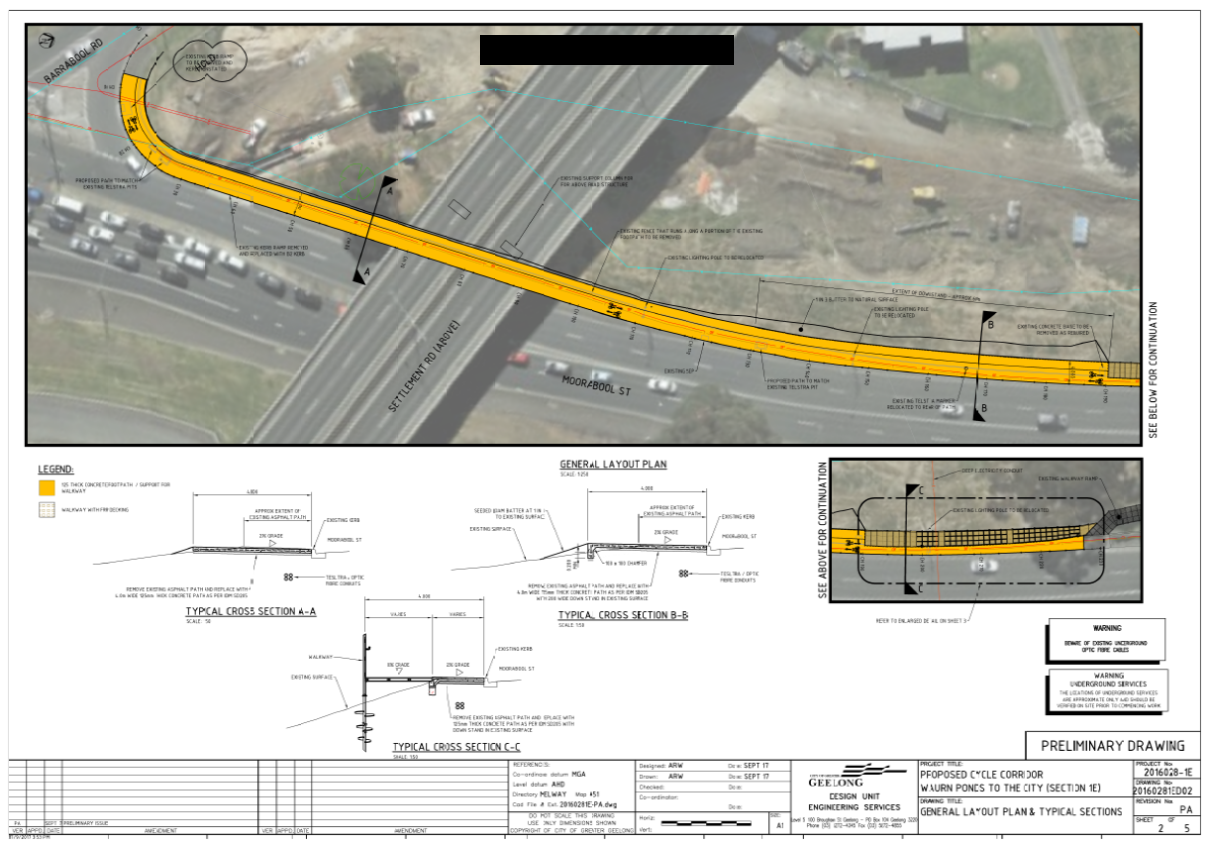
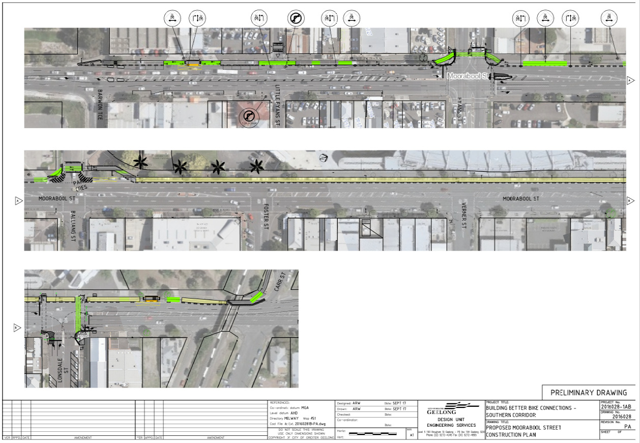
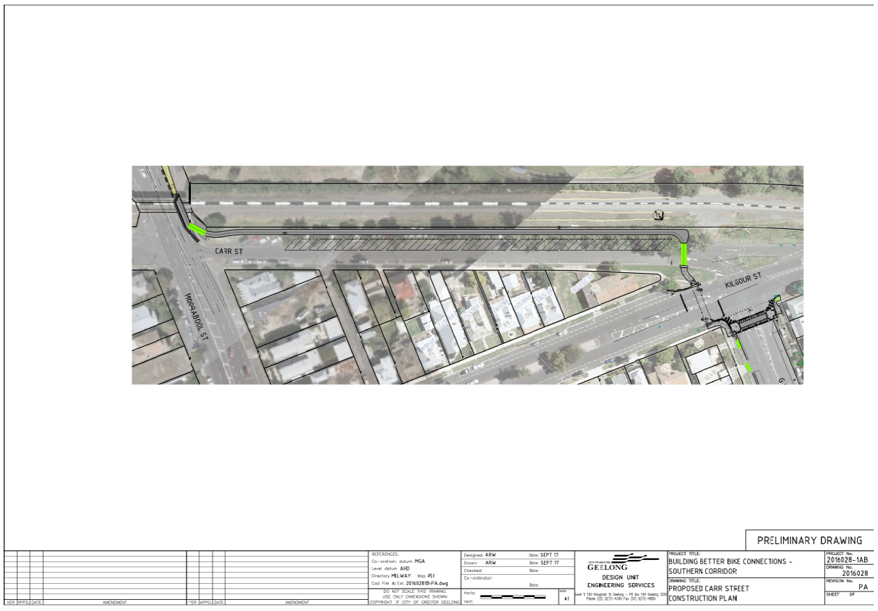
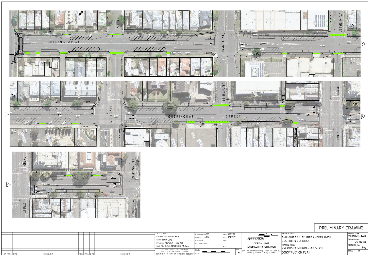
For Council to endorse the Moorabool Street, Carr Street and Gheringhap Street proposed design for Stage One (Central Geelong to Barwon River) of the Building Better Bike Connections - Southern Link Project.
Fast and reliable transport network is part of our 30-year community led vision for a Clever and Creative city. To reach the City’s goal of half of all journeys to work being made by public transport, walking or cycling, we need better bike connections around Geelong. Cycling corridors promote safer riding, less congestion, clean air and healthier residents.
The City received a $4.7 million grant from the TAC's Safer Pedestrian and Cyclist Fund to create two cycling connections:
The southern link to connect Central Geelong with Waurn Ponds via Belmont; and
The western link to connects Central Geelong with Herne Hill via Geelong West.
Stage One is a critical link in Geelong’s cycling network, connecting 25 per cent of Geelong’s population located south of the Barwon River to Geelong’s key employment precinct and transport hubs.
Stage One was endorsed by Council in 2014 as a two way bike lane that is separated from traffic, linking Central Geelong, Deakin University, the Bellarine Rail Trail and Barwon River Trail.
The design of Stage One was determined by best practice standards to meet the TAC funding criteria and to minimise impact on and along the roadway. Cyclists will be separated from other traffic to ensure riders of all abilities and ages feel safe and comfortable using the facility.
Following investigation and assessment of a number of routes against the criteria of safety, directness, connectivity and road use and transport planning, Moorabool Street, Carr Street and Gheringhap Street is the recommended route. Refer to background report (Attachment 3).
Various design options for Moorabool Street were considered, including; the type and style of bike path; impacting turning lanes or traffic lanes rather than parking; and, options to enhance the existing infrastructure. Refer to Moorabool Street Layout Assessment (Attachment 4). The alternate Moorabool Street layouts considered were deemed to have greater negative impact on the roads function and compromise safety.
Stage One links key destinations including South Geelong Station, the Barwon River Trail, the Bellarine Rail Trail and Central Geelong (including Deakin and major employers like Work Safe and National Disability Insurance Agency).
The Moorabool Street section between Fyans Street and Carr Street uses the parking lane on the western side of Moorabool Street resulting in a reduction of 48 parking spaces. To help offset car parking losses, other spaces have been created in nearby side streets and by line-marking spaces within Kardinia Park parking areas.
The bicycle lane design reduces the number of traffic lanes in Gheringhap Street from two to one in each direction to provide the space required for separated bike lanes. All turning lanes at intersections are maintained, which are the critical element in maintaining capacity. Car parking spaces along the length of Gheringhap Street are reduced from 192 to 151.
The southern link has two main stages; Stage One (Central Geelong to Barwon River),and Stage Two (Barwon River to Waurn Ponds). Stage One can be delivered as a standalone project, however Stage Two would benefit from being delivered in conjunction with Stage One. Only Stage One of the southern link can be funded from the TAC grant allocation and the City has submitted a variation to TAC requesting an additional $1,058,000 to deliver Stage Two.
Alternate Recommendation:
Councillor Kontelj moved, Councillor Sullivan seconded –
That Council:
Acknowledge that a fast and reliable transport network is part of our 30 year vision for a Clever and Creative city.
Reaffirm its commitment to Building Better Bike Connections between Central Geelong to Barwon River (Stage One of the Southern Link);
Does not endorse Moorabool Street, Carr Street and Gheringhap Street as the route for Stage One of the Southern Link);
Request the Chief Executive Officer to write to the Transport Accident Commission (TAC) to determine if funding would remain available for an alternative design and/or route(s) for Stage One and, if so, seek the TAC’s confirmation of what alternative design and/or route(s) it would fund;
Subject to the TAC agreeing to fund an alternative design and/or route(s) for Stage One, request the Chief Executive Officer to:
assess whether any of the funded alternative design and/or routes for Stage One meet any of all of the following criteria:
including the use of Kardinia Park as part of the route;
no greater than 10% reduction in on street parking in any one street;
no removal or reduction in vehicle road lanes, including turning lanes;
prepare a community engagement plan for Stage One calling for community feedback in relation to the funded alternative design and/or route(s) for Stage One; and
present alternative design and/or route(s) for Stage One, including community feedback, to Council for consideration by no later than February 2020.
Not carried.
Division Requested:
For: Councillors Kontelj, Nelson, Sullivan.
Against: Councillors Asher, Harwood, Mansfield, Mason, Murnane, Murrihy.
Original Recommendation:
Councillor Murrihy moved, Councillor Mansfield seconded -
That Council endorse the preferred design (Attachment 2) for Moorabool Street, Carr Street and Gheringhap Street as Stage One of the Southern Link - Building Better Bike Connections Project to allow the project to continue to the tender phase.
Carried.
Division Requested:
For: Councillors Asher, Harwood, Mansfield, Mason, Murnane, Murrihy.
Against: Councillors Kontelj, Nelson, Sullivan.
Councillor Mason moved, Councillor Murrihy seconded –
That debate continues beyond 10:00pm as per 3.31.2 of the Council Meetings Procedure Local Law.
Carried.
The TAC has committed funding of $4,923,000 towards the project. The costs for the Western Link is $1,627,000 with an additional $343,000 for design and engagement, with remaining budget of $2,953,000 available for the Southern Link.
The estimated cost for Southern Link - Stage One (Central Geelong to the Barwon River) is $1,955,000; and Stage Two (Barwon River to Waurn Ponds - with preferred Option 2B) is $2,056,000.
The recommendations reflect the funding situation.
Progression of Stage One (Central Geelong to the Barwon River) to the tender phase with existing funding; and
Stage Two (Barwon River to Waurn Ponds) is recommended for design endorsement noting the request to TAC and VicRoads requesting additional funding for Stage Two (Barwon River to Waurn Ponds).
Other route options as well as alternate layouts for Gheringhap St and Moorabool St were investigated, however they did not meet the project criteria of safety, directness, connectivity to destinations and alignment to road use and transport planning. As a result these route options and layouts were considered sub-optimal and are therefore not recommended.
Two rounds of engagement were held in January 2018 and February 2019.
The first round of engagement was delivered in early 2018 and focused on identifying the level of support in the community for the two cycling corridors, the Southern Link and the Western Link. 466 people commented on the Southern Link as a complete corridor during the first round of engagement, with 71 per cent supporting the proposed designs.
Councillors and City officers attended a trader organised meeting in May 2018 regarding the proposed layout for Moorabool Street. Alternatives to the proposed route were presented for consideration. These routes were assessed and deemed unsuitable or less attractive than the proposed route based on the criteria of safety, directness, connectivity and road use and transport planning, refer to Attachment 3. The outcome of the route assessments were distributed to the traders, and broader community during subsequent engagement.
A second round of engagement took place in February 2019 to inform the community of the assessment and data that had been collected in response to community and trader feedback. This engagement provided an opportunity for the community to provide further feedback on the recommended route of Moorabool Street, Carr Street and Gheringhap Street. For designs that were presented to the community refer to Attachment 2. A Project Background Paper was also made available to the community, which is provided in Attachment 3. Comments received and corresponding responses are provided in Attachment 5.
There are a number of key themes that have emerged through all of the community engagement. These issues have been investigated further and where possible adopted in the design. The main themes are listed in the following table:
Feedback theme |
Response |
Reduction of parking on Moorabool Street between Fyans Street and Carr Street |
The bike lanes use the current car parking space on the western side of Moorabool Street along Kardnina Park. There are 48 car parks, 40 have no time restrictions, and are typically used by workers from nearby businesses. It was observed that these car parks have low turnover throughout the day, with 90 per cent of these car parks have the same vehicle parked or are vacant from 10am to 4pm. It is proposed to offset 31 of these car parks in the nearby side streets of Carr Street and Balliang Street. This can be achieved by converting some of the parallel parks to angled parks and line marking car parks in areas that are not marked. Engagement with residents occurred in March 2018 with support for these changes. Following discussions with the Kardinia Park Trust, an area of the existing gravel car park outside Gate 5 would be formalised. This will create more car parks and offset parking losses on Moorabool Street. Street lighting will also be investigated following feedback around safety. |
Reduction in parking on the western side of Moorabool Street between Lt Fyans Street and Fyans Street |
Two parking bays would be removed north of Little Fyans Street, leaving one existing car park. To offset this impact, the nearby bus stop will be moved. Three carparks will be created where the bus stop is removed. This option provides five carparks close to the intersection of Little Fyans Street. A study of the three existing car parks (two of which are those to be removed) during the opening hours of Barwon Takeaway showed occupancy rates between 30 and 38 per cent in the northern most car park, 5 and 11 per cent for the middle car park and 15 per cent and 42 per cent in the southern most car park. The car parks had a number of longer stays which could be improved for traders by implementing appropriate time restrictions, that traders would be able to influence. It is proposed to work with adjacent businesses to optimise the time restrictions for their customer use. |
Restriction of right turns from Moorabool Street into Lt Fyans Street |
Between the Moorabool Street Bridge and Fyans Street, the existing painted median strip will be removed to accommodate the required space to maintain parking and the bike lane. This removes the dedicated turning lanes at Little Fyans Street. For the safety of cyclists, the right turn from Moorabool Street into the Little Fyans Street (heading west) will be banned. The right turn from Moorabool Street into Little Fyans Street (heading east) will be also be banned, but only in the morning peak-hour traffic. This was changed from a full time ban following feedback from traders, and will improve safety by limiting the potential of a rear end crash during busy morning traffic periods. It was observed that only one car per minute turns right at Lt Fyans Street in the morning peak. This can be easily absorbed into other right turns along Moorabool Street at Barwon Tce and Fyans Street. |
The safety of a two-way bike lane at uncontrolled intersections |
Two-way bike lanes work under specific circumstances, such as when there are limited side roads and accesses. Kardinia Park limits the number of side roads and property access points along the western side of Moorabool Street in comparison to the eastern side. A two-way bike lane on the western side of Moorabool Street, between Fyans Street and Carr Street, eliminates four side road crossings and five property access points for south bound cyclists, that otherwise would be required to be crossed. total of nine crossing conflicts would be mitigated by a two-way bike lane on the western side of Moorabool Street, which is safer for cyclists. Green pavement treatments and signage will warn motorists of cyclists crossing side roads and access points. Signs and pavement marking will also be used to alert cyclists to potential conflicts with motorists. A separated bike lane for south bound riders on the eastern side of Moorabool Street would reduce customer parking, with spaces needing to be removed to ensure adequate visibility of cyclists at property accesses. |
Reduction in parking on Gheringhap Street |
Every effort has been made to minimise the impact on parking in Gheringhap Street, while also maintaining existing street trees that are planted in the road. The impact on parking for each block is:
|
Reduction in traffic lanes on Gheringhap St from two in each direction to one in each direction |
Turning lanes at intersections will be maintained. The intersections are the critical point for maintaining capacity and road function. |
Alternate layout options for Moorabool Street were investigated in developing the proposed design. Assessment of these layouts considered the impact on road function, best use of road space and safety. Alternate arrangements that were considered included; one way bike lanes on each side of the road which required the removal of western side parking; one way bike lanes on each side of the road which requires the removal of turning lanes; and two way bike lane on the western side which requires the removal of western parking. One way bike lane configuration would also reduce parking on the eastern side in front of business at each access point for sight distance requirements, to allow enough time for a turning driver to see a cyclist. A one way system would also require south bound cyclists to cross four additional side roads and five more property accesses, compared to the two way path layout on the western side. Assessment of the layout options also considered the cumulative risk, the two way bike lane configuration was deemed a lesser risk due to the limited number of required vehicle crossing points. These layout options can be found in Attachment 4.
The Victorian Cycle Strategy states that women, children and senior Victorians cycle far less than the typical cyclist, who is male and under 45. Making the network safer and lower-stress will increase the participation of underrepresented groups.
When Hornby Street in Vancouver, Canada, was converted from a painted on road lane to a protected bike lane, the percentage of female riders increased from 28 to 39 per cent over a four-year period. Separated bike lanes provide an environment where more people in the community, whether younger or older, male or female, feel safer and are more likely to ride.
There are no policy, legal or statutory implications arising from the subject of this report.
This project has a strong alignment to the council plan in the three areas of transport, community health and safety and environment
Integrated Transport Connections
Delivering better connected walking, cycling and trail paths across our region.
Delivering the Better Bike Connections project.
Improved Health and Safety of Our Community
Promoting healthy eating and supporting active living.
Working toward having the safest roads in Victoria.
Effective Environmental Management
Educating and assisting our community to act on climate change, by reducing waste, emissions and water usage.
No Council officers or contractors who have provided advice in relation to this report have declared a conflict of interest regarding the matter under consideration.
The proposed design maximise attractiveness to all cyclists by delivering a route that is direct and connected. The route has then been design using best practice and adopting Safe System principles to optimise safety for all road users. Further information on the risk assessment on the proposed design refer to Attachment 3.
According to the City’s Environment Management Strategy, vehicle emissions are the dominant contributor to air pollution in the region. Mode shift away from cars to cycling and active transport will have a positive effect on air quality.
The City has adopted the principles of One Planet Living. Sustainable Transport is one of these principles, aimed at encouraging low carbon modes of transport to reduce emissions.
The City Of Greater Geelong |
Building Better Bike Conections - Southern LinkPROJECT BACKGROUND |
Stage 1 - BARWON RIVER to CENTRAL GEELONG |
Contents
Building Better Bike Connections
Road Use and Transport Planning
Central Geelong – Kilgour St to Malop St
Barwon River to Kilgour Street
Latrobe Boulevard and Kardinia Park>
Road Use and Transport Planning
Moorabool Street Bridge, Yarra Street, Lonsdale Street and Carr Street
Road Use and Transport Planning
Moorabool Street and Kardinia Park
Road Use and Transport Planning
Moorabool Street and Carr Street
Road Use and Transport Planning
Appendix A: City of Greater Geelong Strategies
Improved Health and Safety of Our Community
Effective Environmental Management
Integrated Transport Connections
Appendix B: Council Meeting Minutes – Adoption of PBN
Appendix C: Council Meeting Minutes – G21 Priority Bicycle Network - Projects
The purpose of this document is to collate the information that has informed and supported the development of the Building Better Bike Connections Southern Link.
The City of Greater Geelong has identified a need to create and improve facilities to allow more people to ride bikes for transport in and around Geelong. This will create a more sustainable transport system into the future and help our community experience the health, environmental, economic and social benefits that cycling can bring to a city.
The City has been successful in obtaining funding from the TAC for the Building Better Bike Connections –Southern Link project. The project aims to create a cycle link from Geelong’s southern suburbs such as Waurn Ponds and Belmont, to Central Geelong.
Cycling is an important part of a sustainable transport system. Research shows that commuters with an average level of fitness are typically attracted to ride for trips of up to about 10km. This makes cycling a viable commuting option for a large portion of Geelong residents. Cycling is an inexpensive and accessible form of transport for people of all ages and abilities, including those who are too young or unable to drive.
From September 2016 to May 2017, the City listened to over 16,000 people about what they value in our region. They shared ideas about how to address challenges we’re facing now and in the future. From this engagement the clever and creative vision was formed. The community’s aspiration for transport in Greater Geelong was for a fast, reliable and connected transport network. This includes developing a sustainable, connected and networked system for walking, cycling and public transport, allowing people of all abilities into and across Greater Geelong.
Greater Geelong is experiencing increasing pressure on our road network due to a heavy reliance and dependence on cars as a primary source of transport for short and long trips. Greater Geelong’s population growth is currently about 2.6 per cent, which is higher than the state average, and continues to add pressure on our road network.
A Census data survey from 2011 examined 11,822 commuter trips into Central Geelong, finding that 88 per cent of trips were made by car, with an average of 1.09 people in each car.
The remaining commuter trips into Central Geelong were: walking (6 per cent), public transport (4 per cent) and cycling (2 per cent). The majority (70 per cent) of these trips were less than 10km, which is within comfortable cycling distance, yet just 8 per cent of people walked or cycled into Central Geelong.

Cycling for transport, provides many benefits for our community, including:
Accessible transport
Health
Environment and sustainability, and
Urban Design.
Given its many benefits for our community, cycling and active transport is embedded in many of the City’s strategies and plans to help us deliver these outcomes to Greater Geelong residents.
The following plans and strategies contain actions relating to active transport:
Council Plan 2018 –2022
Clever and Creative Future Vision
Integrated Comprehensive Transport Plan 2015
Road Safety Strategy 2012–2017
Geelong Public Health and Wellbeing Plan 2018–2021
Greater Geelong Physical Activity Strategy 2014 –2017
Environmental Management Strategy 2014–2017
Central Geelong Action Plan 2013
Central Geelong Car Parking and Access Strategy 2013
Central Geelong: Looking Forward Structure Plan 2007
Central Geelong Urban Design Guidelines 2008.
See Appendix A for more details of strategies and plans that consider active transport.
Building Better Bike Connections
Traditionally, facilities for cyclists have been painted bike lanes next to traffic. This style of road treatment only caters for a small portion of the population, typically younger males that are more confident and more willing to take risks.
The Victorian Cycling Strategy 2018–28 states:
About 60 per cent of Victorians are curious about cycling and like to ride, but they don’t cycle, or cycle less, because they want a safer, lower-stress, better-connected network and a more inclusive cycling culture. If we had such a network and culture, four in 10 Victorians say they would be encouraged to cycle, or cycle more often, to destinations close to where they live. They would be attracted by the comfort and safety of the cycling experience, the predictability of the journey time and the low cost.
This is where the biggest shift towards cycling can be achieved. To attract this section of the population to cycling, they require facilities that separate and protect them from motor vehicles.
Cities like Sydney, Vancouver and Portland have shown that providing separation from motorists can generate a significant increase in the number of cyclists, and attract a higher percentage of female riders.
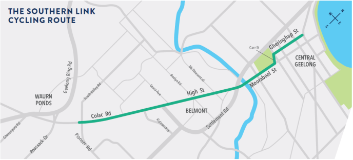
The Principal Bicycle Network (PBN) is a network of on-road and off-road routes that provide cyclists with safe, accessible and connected cycling routes in Geelong. The aim of the PBN is to elevate the importance of selected routes within the overall bicycle network and to prioritise future works to improve conditions for cyclists.
A state-wide process was undertaken to expand the PBN from metropolitan Melbourne to regional Victoria, expanding on existing municipal bicycle networks.
Council endorsed the proposed PBN for Greater Geelong at its meeting on 28 January 2014 (See Appendix B for the Council Meeting Minutes)
Strategic Cycling Corridors (SCC) are the main corridors of the bicycle network and are part of the PBN. These corridors provide links to major destinations and employment precincts.
The four key criteria used by the City to ensure that the corridors are successful in attracting the highest number of riders were:
Safety,
Directness,
Connectivity, and
Road use and transport planning.
The aim of these corridors is to provide facilities that cater for the widest range of cyclists, considering their confidence level, ability and providing access for people of all ages. In considering these criteria, corridors should either separate cyclists from other traffic or be in areas that have low speed limits and low traffic volume environments where cyclists and cars can safely share the road.
The Southern Link is a Strategic Cycling Corridor connecting Central Geelong with Belmont, Highton and Waurn Ponds.
The objective of this corridor is to provide a safe and direct link between residential areas and shopping centres at Waurn Ponds and Belmont, Deakin University’s Waurn Ponds and Waterfront campuses, The Gordon, Geelong and South Geelong train stations and Central Geelong.
It aims to provide, where possible, cycle facilities that separate cyclists from cars and other traffic.
This link has been broken into three segments:
Stage 1 – Barwon River to Central Geelong (also previously called Barwon to Bay)
Stage 2 – High Street – Mt Pleasant Road to Roslyn Road
Stage 3 – Remaining sections of High Street and Colac Road to Waurn Ponds.
The section of the Southern Link from the Barwon River to Central Geelong and Corio Bay is the most important segment in the Southern Link and one of the most critical links in Geelong’s bicycle network.
With approximately 25 per cent of Greater Geelong’s population living south of the Barwon River within the 3216 postcode, it’s important to provide a safe and direct link to major destinations north of the river. This includes shopping and employment areas in Central Geelong, and the South Geelong Train Station – the closest station for many Belmont and Highton residents.
It also links the Barwon River trails and the Bellarine Rail Trail to each other and to Central Geelong.
Vehicles are currently funnelled to just four river crossings between Breakwater and Queens Park. With high population growth in areas south of Geelong, such as Armstrong Creek, pressure on these crossings will only increase.
However, the constraint of limited river crossings also provides a great opportunity. Cyclists from the south of the river are channelled to a small number of north-south routes, meaning that a single, well-designed cycle facility has the potential to be a direct route for a large portion of our population.
Following Council’s endorsement of the PBN in January 2014, four key cycling projects supporting the PBN were put forward to be endorsed. These were presented at the Council meeting on 25 February 2014 (See Appendix C for Council Meeting Minutes).
The projects were:
Moorabool Street Bridge Cycling Connection
Northern Suburbs Cycling Link
Corio Quay Road Shared Path Upgrade
Barwon to Bay Cycleway Design and Construction.
Council carried a motion to:
Write to the Minister for Infrastructure and Regional Development seeking funding support for the Barwon to the Bay cycle way; and
Liaise with VicRoads to seek funding for cycling improvement works on the arterial road network.
In 2016, the Victorian Government announced a $100 million Safer Cyclists and Pedestrian Fund, to be funded and managed by TAC and VicRoads.
Strategic Cycling Corridors across Victoria were assessed and prioritised in both regional and metropolitan areas. The highest priorities were workshopped in early 2017, with successful projects announced in late 2017.
The City of Greater Geelong had two projects that were successful in obtaining funding. They were the Western Link, through Geelong West, and the Southern Link.
The City of Greater Geelong has run engagement activities on both projectsduring2018. These are detailed in the Engagement section of this document.
The Barwon River to Central Geelong segment of the Southern Link is anchored around the use of the shared path on the western side of the Moorabool Street Bridge. The bridge provides a Barwon River crossing in the most direct line with Central Geelong, also providing connections to the Barwon River trail, on both sides of the river.
There are a number of potential routes that could be used to link the bridge to Central Geelong. These were assessed against the following criteria:
Safety
Directness
Connectivity, and
Road use and transport planning.
Cyclists are among the most vulnerable road users and are very susceptible to serious injury in a crash. Speed plays a major factor with the risk of a fatal outcome in a crash increasing significantly at speeds over 40km/h.

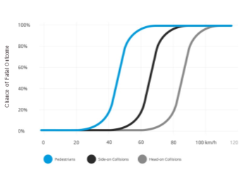
Where traffic volumes and speeds are low, cyclists can more safely mix with cars. However where speeds are higher, over 40km/h, it is best practice to pursue an option that separates cyclists and cars.
Anywhere that cars and cyclists come together at intersections or property accesses, warning devices and changes to the environment are often required to ensure that riders are safe and can be seen.
Safety, or even perceived safety, on the road plays a major role in the decisions people make about whether or not to ride a particular route. Safe cycling facilities are the key to attracting riders of all ages and abilities and ensuring that it caters to the largest number of people in our community,
Riders are generally attracted to routes that provide them with the most direct link from point A to point B.
Diverting cyclists away from the most direct route not only results in increased trip times but also requires them to exert more energy, unlike car drivers.
To provide a facility that is highly used, it must connect effectively to key destinations, like shopping and employment precincts and transport hubs, such as train stations. These destinations attract large numbers of vehicle movements and have the greatest ability to attract more people to use bikes for transport.
A route with poor connections will restrict the number of people who use the facility, and it may also require additional facilities to be built on parallel routes.
Road Use and Transport Planning
Road space is a finite resource. In general, there are limited opportunities to provide more space on a road in an urban environment due to things such as existing buildings and services.
Road use and transport planning is important in managing the competing interests of different transport modes in this limited road space.
Transport planning looks at the wider road network to prioritise different transport modes on different roads. It also considers land use and road characteristics. This type of planning aims to:
Facilitate good pedestrian access into and within activity centres in periods of high demand
Prioritise buses on key public transport routes that link activity centres
Encourage ‘through traffic’ to use alternative routes around activity centres
Encourage bicycles by further developing the bicycle network
Prioritise trucks on important transport routes that link freight hubs and reduce their conflict with other transport modes and activity centres.
Central Geelong – Kilgour St to Malop St
There were three north-south routes through Central Geelong considered for the Southern Link: Yarra Street, Moorabool Street and Gheringhap Street.
Yarra Street is designated as a motor vehicle traffic route in the draft Network Operating Plan for Central Geelong. Trying to prioritise another transport mode (bicycles) in this space would compromise its traffic function. Taking this into account, Yarra Street is not recommended as a cycling route.
Moorabool Street provides direct access into the heart of Central Geelong. It is designated as a bicycle and bus priority route in the draft Network Operating Plan.
To provide a cycling facility in this space requires significant changes to the current street layout. Moorabool Street will be prioritised for a major review as part of the Central Geelong Revitalisation Project.
Gheringhap Street provides direct access to Deakin University, Central Geelong’s cultural precinct, key employers such as Work Safe, NDIA and TAC and is close to the Geelong Train Station and The Gordon.
Gheringhap Street has two lanes in each direction and angled parking on both sides of the road. A cycle lane in each direction could be installed between parking and kerb by reducing the traffic lanes to one in each direction.
Intersections are critical to maintaining manageable traffic volume. Keeping the same number of lanes at intersections, and removing a lane in each direction between intersections will have minimal impact on Gheringhap Street’s traffic volume capacity.
There is a reduction in car parking bays from 192 to 151, spread along the length of Gheringhap Street.
That cycle facilities be installed on Gheringhap Street due to its connectivity to destinations and its ability to accommodate cycle lanes.
In the future, the possibility of installing cycle facilities and streetscape works along Moorabool Street, to complement the cycle network in and around Central Geelong, will be explored as part of the Central Geelong Revitalisation Project.
Barwon River to Kilgour Street
In January 2018, the City of Greater Geelong presented a proposal to the community that identified Moorabool Street, Carr Street and Gheringhap Street as the most suitable route.
A traders group presented plans for alternative routes to the east and west of Moorabool Street. These routes have also been assessed against the same criteria.
Latrobe Boulevard and Kardinia Park

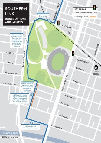
The most western route assessed directs north bound cyclists left from the Moorabool Street Bridge into Barwon Terrace. From there they turn right into Latrobe Boulevard, crossing Fyans Street into Hopkins Street, then continuing through the western side of Kardinia Park. The route then crosses the train line at Kilgour Street to Gheringhap Street.
The on-road section of cycle lanes could be delivered with a kerb separating cyclists and cars. The off-road section through Kardinia Park provides an environment that separates cyclists from traffic.
Fyans Street is an arterial road carrying a high volume of traffic, with a large number of commercial and heavy vehicles. The intersection with Latrobe Boulevard is currently uncontrolled and would require a set of traffic signals to help cyclists cross safely.
This route also crosses the train line at a level crossing on Kilgour Street.
This route is 400m longer than the most direct route along Moorabool Street and Carr Street.
The route connects well to the Kardinia Park swimming pool and sports facilities.
It has no connection to the Bellarine Rail Trail or to South Geelong Train Station – a key destination for this project.
Road Use and Transport Planning
As noted in the safety criteria, a set of signals is required to enable cyclists to cross Fyans Street. Fyans Street is an arterial road, managed by VicRoads. Fyans Street is an important freight and traffic route through South Geelong.
The freight function of Fyans Street will play major role in reducing heavy vehicle movements through Central Geelong. As such, an additional set of traffic signals on Fyans Street is not supported by either VicRoads or Transport for Victoria.
An additional set of traffic signals at Latrobe Boulevard would also have negative impacts on the existing signalised intersection at Latrobe Terrace and would be effected by traffic queuing.
Planning is underway to duplicate the rail line between Geelong and South Geelong. This will require cyclists to cross additional train lines and may increase the frequency of services. This will impact safety and cause delay to cyclists.
Parking would also need to be removed from one side of the road to along Latrobe Boulevard, resulting in the loss of 21 or 34 spaces, depending on the side of the road used. This parking is directly outside businesses and homes, and is difficult to offset in the immediate area.
A set of traffic signals would be required on Fyans Street, at the intersection of Latrobe Boulevard, to ensure the safety of cyclist on this route. As these signals are not supported by VicRoads or Transport for Victoria and cannot be installed, this route cannot be recommended.
The lack of connectivity to the South Geelong Train Station and Bellarine Rail Trail are additional reasons why this route cannot be recommended.
Moorabool Street Bridge, Yarra Street, Lonsdale Street and Carr Street

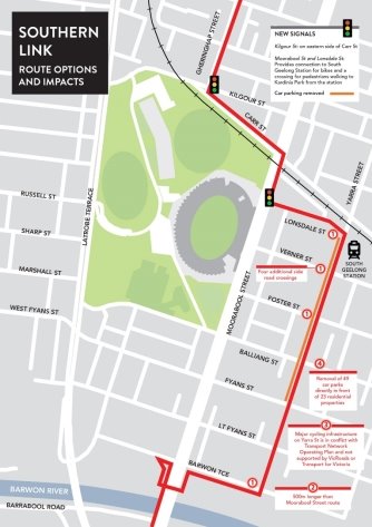
This route has north bound cyclists turning left at the end of the Moorabool Street bridge and using the ramp to get to the Barwon River trail. From there they head east to the end of Yarra Street, crossing over Barwon Terrace.
The cycle facility would be a one-way cycle lane on each side of Yarra Street, separated from traffic or car parking by a kerb. This would continue to Lonsdale Street where cyclists would turn and use the existing separated two-way lane.
New signals would be installed at the intersection of Lonsdale Street and Moorabool Street, where cyclists would cross to travel along Carr Street to Gheringhap Street.
This route is proposed to have a kerb between cyclists and traffic to physically separate them.
Given the number of side roads and access points, the cycle lanes proposed are one-way on both sides of the road. There are four additional side road crossings than the proposal for Moorabool Street.
Side roads and access point crossings would be treated with a green surface to help raise driver awareness of the cycle lane.
This route is 500m longer than the Moorabool Street and Carr Street route.
It requires cyclists heading in to Central Geelong to travel one block east before travelling back two blocks west.
This route connects directly to the South Geelong Train Station and the Bellarine Rail Trail.
The traffic signals at Lonsdale Street also provide a safe pedestrian connection from the train station to the Kardinia Park precinct.
Road Use and Transport Planning
Due to the width of Yarra Street, parking is required to be removed from one side of the street to install protected cycle lanes on both sides of the street. This would require the removal of approximately 49 car parks directly in front of 23 properties.
These car parks could be replaced in side roads by converting parallel parking to angle parking, however they would not allow residents to park outside their properties.
Yarra Street is designated as a motor vehicle traffic route in the draft Network Operating Plan for Central Geelong. Trying to prioritise another transport mode (bicycles) in this space would compromise its traffic function. Transport for Victoria has stated that major cycling infrastructure on Yarra Street conflicts with the draft Network Operating Plan and is not supported.
The removal of parking in this route would have a greater impact on adjacent properties than alternative routes.
The route is very indirect and would struggle to attract cyclists to use it, other than those going to the South Geelong Train Station.
Given that it also does not align with the transport planning objectives for the surrounding area, this route is not recommended for the Southern Link.
Moorabool Street and Kardinia Park

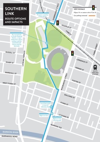
This route uses a two-way cycle lane on the western side of Moorabool Street, between the Moorabool Street Bridge and Park Crescent. At Park Crescent it then becomes an off-road path on the eastern side of the Kardinia Park stadium.
The path joins Kilgour Street west of the rail line. It then crosses the rail line and travels along Kilgour Street to Gheringhap Street.
The Moorabool Street section is designed with a kerb between cyclists and traffic to physically separate the two.
It is proposed to ban the right turn from Moorabool Street for cars travelling west on Little Fyans Street. This is to avoid a conflict with south-bound cyclists. Traffic can access Little Fyans Street by using alternatives routes along Fyans Street and Latrobe Boulevard.
The left turn into the eastern side of Little Fyans Street would be banned during the morning peak, but allowed throughout the rest of the day.
At the Fyans Street and Moorabool Street intersection, the cycle lane is set six metres to the west (on Fyans Street) so drivers turning left into Fyans Street can better see cyclists and pedestrians and not hold up traffic continuing straight (north) on Moorabool Street.
There are uncontrolled property accesses including the Shell service station, Bob Jane T Mart and Smiths Holden. It would be proposed to use signage, coloured pavement and possible flashing lights to warn drivers of the two way bike movements in the area.
The off-road section through Kardinia Park provides an environment that separates cyclists from traffic.
This route also crosses the train line at a level crossing on Kilgour Street.
This route is 100m longer than the Moorabool Street and Carr Street route.
The route connects well to the Kardinia Park Stadium and sports facilities.
It has no connection to the Bellarine Rail Trail or the South Geelong Train Station, a key destination for this project.
Road Use and Transport Planning
As per the Moorabool Street and Carr Street route, the Moorabool Street section will have similar impact parking and turn lanes between the Moorabool Street Bridge and Fyans Street.
The existing painted median strip would be removed and the traffic lanes and car parking shifted over to accommodate a cycle lane between the parking and kerb. This removes the turning lanes at Little Fyans Street.
For the safety of cyclists, the right turn into the western side of Little Fyans Street would be banned. The right turn into the eastern side would also be banned but only in the morning peak hour. This will improve safety and limit the potential of a rear end crash in the busy morning peak hour.
Two parking bays would be removed north of Little Fyans Street, leaving one existing car park. To offset this impact, the nearby bus stop, south of Little Fyans Street, could be moved further south. This will allow three additional car parks to be created in its place.
Relocating the bus stop further south, away from businesses, will require removing two existing car parks.
This option provides five carparks close to the intersection of Little Fyans Street.
There is planning underway to duplicate the rail line between Geelong and South Geelong. This may increase the frequency of services, causing additional delay to cyclists, and will require cyclists to cross additional lines impacting safety. Rail lines are an extreme slip hazard to cyclists.
The lack of connectivity to the South Geelong Train Station and Bellarine Rail Trial is the reason that this route cannot be recommended.
Moorabool Street and Carr Street

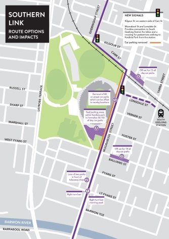
This route uses Moorabool Street and Carr Street to connect to Gheringhap Street. This proposal is designed with a two way cycle lane, separated from traffic, on the western side of Moorabool Street. And a two way off-road path on the southern side of Carr Street.
This route is designed to use a kerb to separate cyclists and traffic.
Twoway bike lanes work under specific circumstances, such as when there are limited side roads and accesses. Kardinia Park limits the number of side roads and property access points along this route. A two-way path on the western side of Moorabool Street, between Fyans Street and Carr Street, eliminates four side road crossings and five property access points for south bound cyclists.
This makes the route safer for cyclists travelling in the two-way lane on the western side of Moorabool Street.
There are two uncontrolled intersections at Park Crescent and Little Fyans Street. At Park Crescent the cycle lane is shifted six metres back from the intersection. This allows vehicles turning right from Moorabool Street to better see oncoming traffic, and cyclists and pedestrians. Vehicles also have better vision to look both ways as they are square to the crossing.
It is proposed to ban the right turn from Moorabool Street into the western side of Little Fyans Street to avoid a conflict with south bound cyclists.
Traffic can easily access Little Fyans Street by using alternative routes along Fyans Street and Latrobe Boulevard.
At the Fyans and Moorabool street intersection, the cycle lane is set back six metres to allow vehicles turning left ( heading west along Fyans Street) to better see cyclists and pedestrians using the path and to avoid holding up traffic heading straight (north) on Moorabool Street.
There uncontrolled property accesses along Moorabool Street, including the Shell service station, Bob Jane T Mart and Smiths Holden.
It is proposed to use signage, coloured pavement and lights to warn drivers of the two-way bike movements in the area.
This route provides the most direct route between the Moorabool Street Bridge and Gheringhap Street.
This is the most central route to Central Geelong and provides a spine that can be used by people accessing either the east, west or middle of Central Geelong. This will encourage more cyclists to use a single and safest route, and will reduce the need for extra facilities on parallel routes.
A set of traffic signals installed at the intersection of Lonsdale Street and Moorabool Street will provide a separated connection through to the South Geelong Train Station. There is an existing two-way separated lane on the northern side of Lonsdale Street.
This route also connects to the Bellarine Rail Trail, linking it with the Barwon River trail. This would help develop an extensive high-quality network linking our region’s cycling trails and also provide great recreation and tourism opportunities.
It also provides a safe pedestrian connection from the Geelong Train Station to the Kardinia Park Precinct.
Road Use and Transport Planning
The cycle lanes use the current car parking space on the western side of the road, between Fyans Street and Carr Street. There are 47 car parks, most have no time restrictions, and are typically used by workers.
It is proposed to offset 31 of these car parks in the nearby side streets, Carr Street and Balliang Street. This can be achieved by converting some of the parallel parks to angled parks and line marking car parks in areas that are not marked.
Following discussions with the Kardinia Park Trust, an area of the existing gravel car park outside Gate 5 would be sealed and line marked. This will create more car parks and would help offset parking losses on Moorabool Street.
These offset car parks will still provide the same opportunities for workers to park all day and conveniently walk to work.
Between the Moorabool Street Bridge and Fyans Street, the existing painted median strip will be removed to accommodate a cycle lane between car parks and the kerb. This removes the turning lanes at Little Fyans Street.
For the safety of cyclists, the right turn into the Little Fyans Street (for traffic heading west) will be banned. The right turn into the eastern side will be also be banned but only in the morning peak-hour traffic. This will also limit the potential of a rear end crash during busy morning traffic periods.
Two parking bays would be removed north of Little Fyans Street, leaving one existing car park. To offset this impact, the nearby bus stop, south of Little Fyans Street, will be moved further south. This will create three car parks close to businesses north of Little Fyans Street.
Relocating the bus stop further south, away from businesses, will require removing two existing car parks. This option provides 5 carparks close to the intersection of Little Fyans Street.
Given its central location, good connectivity and directness to Central Geelong, the South Geelong Train Station and Kardinia Park, this route has the best chance of attracting the highest number of cyclists.
The link to the Bellarine Rail Trail is also important in providing a connected trail network.
The limited number of side road crossings and accesses also make this a safe solution for cyclists.
While there are impacts to parking, these can be offset nearby to maintain the current level of all day parking.
For these reasons, this is the recommended route for the Southern Link.
|
ENGAGEMENT TO DATE |
||
|
DATE |
ACTIVITY |
DESCRIPTION |
|
Jan-Feb 2018 |
Better Bike Connections community survey |
Concept plans released for community feedback, with 565 survey responses in total. 466 people commented on the Southern Link route, of those 70 per cent supported it, 26 per cent opposed it and 4 per cent were neutral. |
|
March |
One-on-one meetings with traders |
One-on-one meetings with Moorabool Street traders who had accepted/requested further discussion. |
|
May |
Officers attended trader meeting |
City officers attended a meeting organised by Moorabool Street traders to express their specific concerns. Traders presented three alternative routes for the City to consider. |
|
May |
Follow-up letter to traders |
Letter delivered to Moorabool Street traders clarifying proposed changes to the street and inviting traders to meet one-on-one with City officers. |
|
May |
Letters sent to Carr, Verner and Balliang Street residents regarding potential car parking changes |
In response to trader concerns regarding 47 all-day car park losses on the western side of Moorabool Street (next to Kardinia Park), we engaged with residents of Carr, Verner and Balliang streets regarding our plans to reconfigure car parks to increase all-day parking supply and help offset losses. As a result of this engagement we decided to proceed with changes to Carr and Balliang streets only. |
|
June |
Follow-up conversations and letter to traders in response to alternative routes proposed by traders |
We hand delivered letters to traders which explained the reasons why the alternative routes suggested were assessed as unsuitable. |
|
Aug |
Engagement with Kardinia Park Trust |
In an effort to offset car parking losses, we met with the Kardinia Park Trust board to discuss our proposal to seal a section of Kardinia Park (next to the Senior Citizens Centre) to formalise all-day car parking spaces. The board gave an in-principal agreement for us to proceed with engagement regarding proposed sealing of this parking area. |
|
Feb 2019 |
Community engagement for Stage 1 including Have Your Say page on website and 3 drop in sessions on Moorabool Street |
Plans, which included minor amendments made following previous community feedback, were presented to the community for final comment before taking the recommended option to council. There were 502 document downloads and 48 online submissions, along with 2 letters. Feedback was a mix of support for the project and concern over specific aspects of the design. |
What We Heard
Throughout the engagement process we heard a number of recurring themes. These were based around:
The removal of parking on Moorabool Street
The safety of a two-way cycle lane, particularly across accesses like the Shell Service Station
The impact of turn bans at Little Fyans Street
Buses stopping in the traffic lane at the stop just north of Lonsdale Street.
As a result of community consultation, we have made changes to the original project plans. These include:
In response to traders’ concerns regarding the loss of 47 all-day parking spaces on the western side of Moorabool Street (next to Kardinia Park), we have confirmed plans to help offset this by creating other all-day car park spaces close to Moorabool Street. By reconfiguring parking spaces on nearby Carr and Balliang streets, we will create 31 other all-day spaces. We also have plans to seal a section of Kardinia Park (near the Senior Citizens Centre) as well as mark out other all-day car parks in the same area.
Retaining the right turn lane from Moorabool Street into Fyans Street (except during morning peak times).
Retaining a car park just north of Little Fyans Street, as well as relocating the bus stop so there will be five car park spaces within 50 metres of businesses. The net loss of car parks in the section of Moorabool Street (between Fyans Street and Barwon Terrace) will now be four spaces (five spaces were originally proposed to be removed).
|
DATE |
ACTIVITY |
DESCRIPTION |
|
March 2019 |
Council Briefing |
Present Gheringhap/Moorabool street engagement outcomes High Street recommendation |
|
Tues 9 April |
Council Meeting |
Recommendation for:
To proceed to tender. |
|
April - July |
Prepare documentation for tender |
Finalise detailed designs, specifications, tender documents and relevant approvals to proceed to tender |
Appendix A: City of Greater Geelong Strategies
Table 1: City of Greater Geelong strategies and plans with active transport objectives or actions
|
Plan/Strategy |
Themes |
Active Transport Actions/Objectives |
|
Council Plan 2018-2022  |
Key document outlining Council’s priorities for the next four years. It was created drawing on a number of sources including Greater Geelong: A Clever and Creative Future, Municipal Public Health and Wellbeing Plan, Social Equity Principles and relevant legislation, government and social policies. |
Improved Health and Safety of Our Community Promoting healthy eating and supporting active living. Working toward having the safest roads in Victoria. Effective Environmental Management Educating and assisting our community to act on climate change, by reducing waste, emissions and water usage. Integrated Transport Connections Delivering better connected walking, cycling and trail paths across our region. Delivering the Better Bike Connections project. |
|
Clever and Creative Future Vision  |
Representing the voices of more than 16,000 residents and stakeholders, this document is a guide for future councils, all levels of government, community organisations, businesses and anyone wanting to make a genuine contribution to our city-region. The community aspiration for Greater Geelong’s transport connections was for a fast, reliable and connected transport network. The community values sustainable, connected and networked walking, cycling and public transport services that allow all abilities access into and across the city-region. |
Success in meeting this aspiration in terms of active transport was deemed to be achieved by:
The measures of this success are:
|
|
Integrated Comprehensive Transport Plan 2015  |
The City of Greater Geelong is experiencing strong population growth and change in its key economic sectors, as more balanced and diversified economic growth is sought from the health, education, tourism, advanced manufacturing, and knowledge sectors. The Integrated Comprehensive Transport Plan (ICTP) guides investment decisions for the transport system within the City of Greater Geelong, and will help meet the region’s need to plan for growth and change. |
|
|
Road Safety Strategy 2012-2017  |
The City recognises the importance of road safety and its significant impact on families and the broader community and has taken on a coordination role to help reduce the incidence and severity of road crashes and associated road trauma. The strategy looks to the “Safe System Approach” to reduce road trauma across the municipality through:
|
Provide connecting cycle networks and safe routes for users Provide safe intersections Provide and maintain safe walking paths and crossing facilities Promotion of active travel modes to families using early childhood services Encourage adults to improve their cycling skills through more frequent riding and promote membership of cycling clubs for enhanced opportunities Promote responsible use of existing infrastructure and the importance of planning routes |
|
Geelong Public Health and Wellbeing Plan 2018-2021  |
The Health and Wellbeing Plan provides goals and strategies to improve health and wellbeing and to ensure that the greatest improvements are realised among those who need it the most. Based on policy, data, partner and community involvement, the plan identifies the following goals:
|
Delivery of cycle projects including the Building Better Bike Connections projects. Developing a master plan of Greater Geelong and Bellarine shared trails that will increase physical activity and connections between clubs, schools and social groups. |
|
Greater Geelong Physical Activity Strategy 2014-2017  |
The Greater Geelong Physical Activity Strategy recognises that the City of Greater Geelong can positively contribute to the health and wellbeing of the community by making physical activity the easy choice. This can be done through careful and considered design of public spaces and the built environment, and by ensuring the needs of people are paramount when making decisions about the spaces in which they live, learn, work and play. The strategy identifies seven of the best investments for physical activity, two of which relate to active transport. Transport policies and systems that prioritise walking, cycling and public transport (e.g. active transport programs such as walking school bus and tools to encourage active transport to work). Urban design regulations and infrastructure that provides equitable and safe access to recreational physical activity; and recreational and transport-related walking and cycling across. |
Ensure the Integrated Transport Plan focuses on addressing high speed priority routes to key destinations; the development of alternative, frequent high speed public transport; the development of safe road crossings for pedestrians; the development of a network of connected cycling / walking paths; and the reduction of speed limits only in areas where there are high pedestrian numbers Continue to fund and prioritise infrastructure that support active travel Ensure the Municipal Strategic Statement contains healthy, built environment components that support active living In partnership with the community, identify safety issues that may impact on participation in physical activity. |
|
Environmental Management Strategy 2014-2017  |
The Environment Management Strategy 2014-2017 is the key document for guiding Council planning, decision-making and activities that impact the Greater Geelong environment. The Strategy provides a framework to build healthy, connected communities, which are able to live in a clean environment that is respected and cared for. The Strategy is underpinned by the concept of sustainability and principles of One Planet Living, which can be applied across all areas of Council. The provision of public transport services, promotion of active transport and the movement of vehicles through and around Geelong have also been identified as critical issues for the region. |
Implement Road Safety Strategy, including infrastructure to encourage sustainable transport via cycling Investigate CBD transport network improvements enabling a cleaner, more user friendly environment where active transport options are encouraged Increase the number of bicycle riders counted on ‘Super Tuesday’ Increase the length of dedicated and shared bicycle paths Prepare a One Planet Living Community Strategy as it applies to reducing Council and community ecological footprint, including sustainable transport (Smart Travel). |
|
Central Geelong Action Plan 2013  |
The Action Plan sets targets for investment, promotion, planning and for measuring success for 2028. Some of these look to significantly increase the number of people living and working in Central Geelong, including:
A common theme from community consultation for the plan was ‘Moving Around’ with regular bus services, better cycling paths and end of trip facilities, better safety and connectivity for pedestrians identified as ideas to address these issues. |
Create an integrated, attractive and well-designed pedestrian and cycling network which supports healthy living and public safety. Make the city more walkable and promote more engaging activity on the streets, and broaden the city experience. Redirect non-essential heavy vehicle traffic away from Central Geelong. |
|
Central Geelong Car Parking and Access Strategy 2013  |
Geelong is currently a very car dominated city, however with the growth scenarios envisaged, the current level of reliance on private cars will become increasingly unsustainable. There will need to be a shift towards public transport, walking and cycling if Central Geelong is to increasingly become a vibrant place to live and visit – not just to work. The strategy identifies that Central Geelong is at a turning point. There will never be an easier time to make the following changes that are necessary to secure a more sustainable future:
|
Short-term initiatives endorsed in the strategy included:
|
|
Central Geelong: Looking Forward Structure plan 2007  |
The Central Geelong Structure Plan has been prepared to provide a planning and design framework for the city for the next 20 years. The structure plan has the following high level objectives related to active transport:
|
|
Central Geelong Urban Design Guidelines 2008  |
These guidelines have been prepared to encourage and facilitate new, high-quality development in Central Geelong by identifying the aspirations for the city centre and clarifying the physical consequences those aspirations will have on new development There are three high order aims which these urban design guidelines aspire to achieve:
Some of the objectives of these aims include:
|
|
Appendix B: Council Meeting Minutes – Adoption of PBN
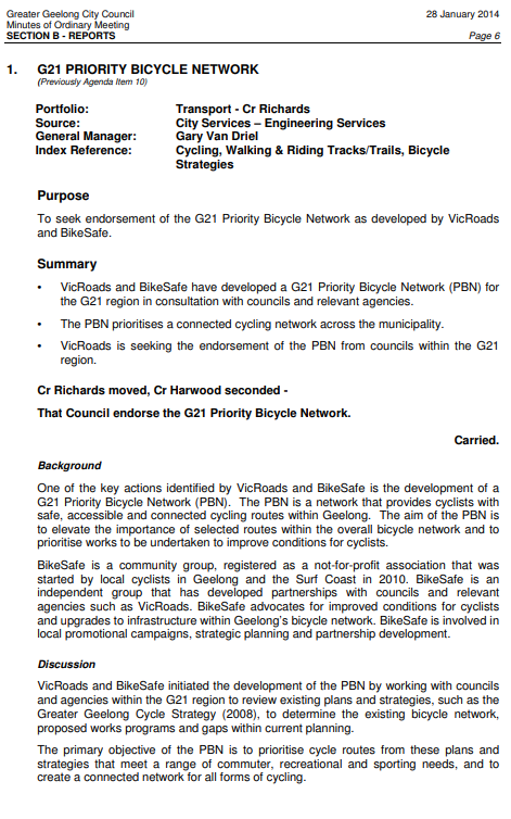
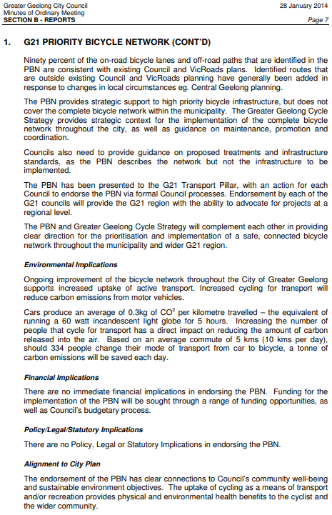
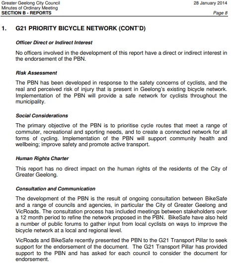
Appendix C: Council Meeting Minutes – G21 Priority Bicycle Network - Projects
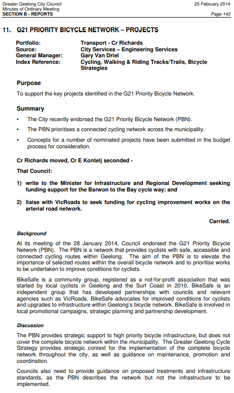
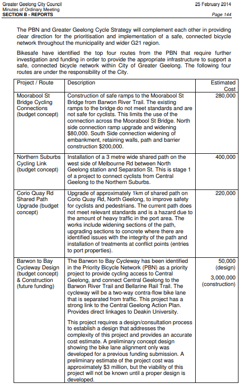
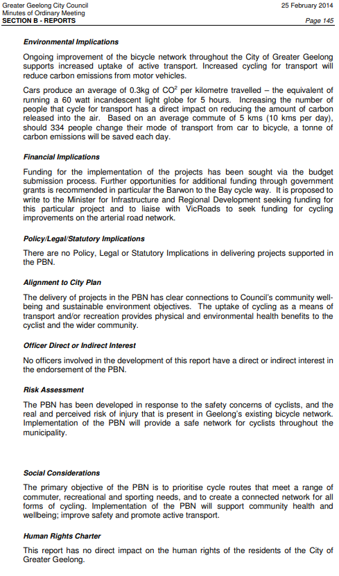
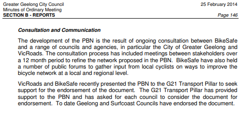
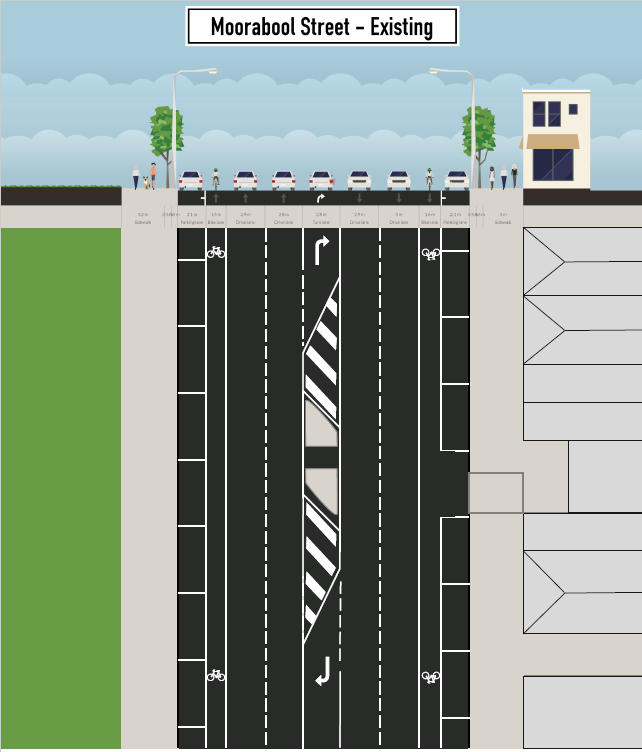
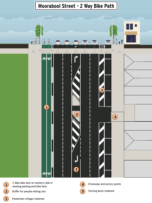
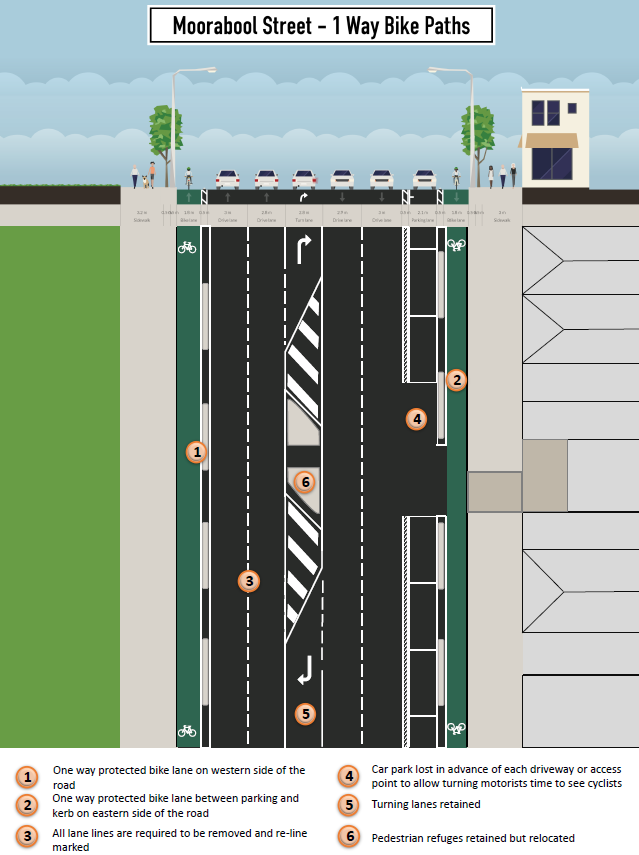
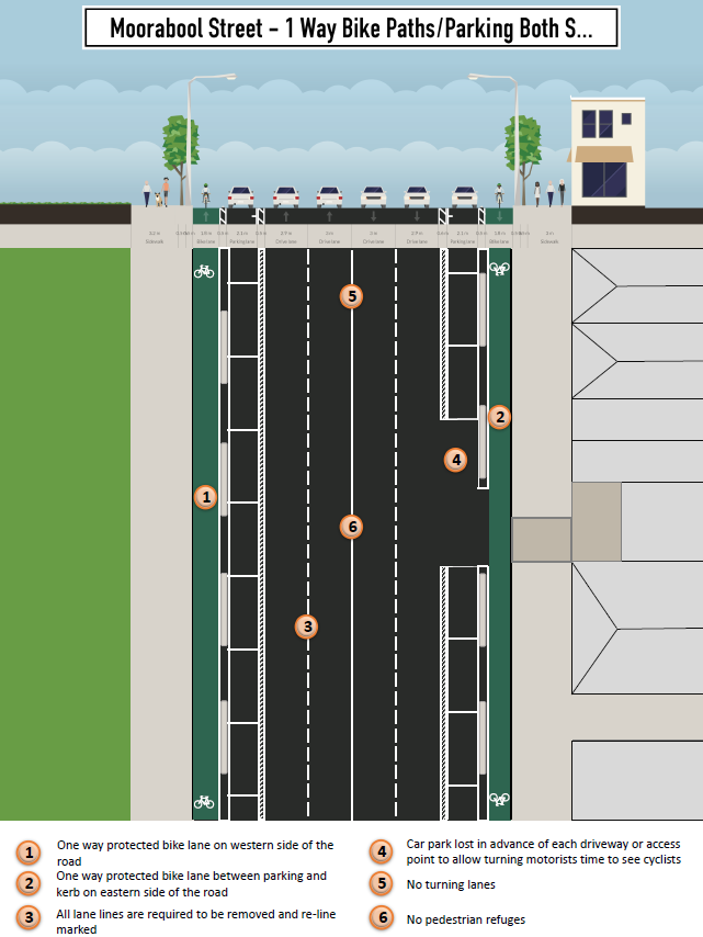

Better bike connections
Stage 1 (Moorabool, Carr, Gheringhap St)
Engagement Feedback
|
Comment |
Response |
|
Even though I’m from Ocean Grove I ride quite a bit in Geelong so would love to have safer cycle paths. I've checked out all three routes and there are good points in them all. The Kardinia park connections would concern me when crossing Fyans St as this is often difficult, even in a car, when there's a lot of traffic. Moorabool St seems to me to be the best option with safer crossing and with Lonsdale St already having a bike path from south Geelong station to Moorabool St, that would be a good way to connect to that route. So my preferred option would be the Moorabool Carr St option. Thank you for the opportunity to respond to this survey. I did drop in to chat at the marquee at Kardinia park. I thank you for anything you can do to make cycling safer as many more will then ride. I know too many who've given up for fear of being hit by an inattentive motorist which seems to be on the increase. At any time we welcome discussion on the bicycle show on the pulse re cycling improvements. I love the Malop St path. Thank god it's slowing motorists who have other options. |
Comment noted |
|
I still have the same concerns I emailed in last year but had no response!
|
A change from angled parking to parallel parking will greatly reduce the number of car parks available.
It is difficult to easily incorporate cyclist into roundabout designs and no ability to coordinate traffic movements with the rail crossing. A fully signalised intersection was considered but dismissed at this time due to the proximity to the rail crossing. |
|
Like most other COGG bike plans it simply won't work - do you remember Swanston St.? How about the path through eastern park that starts and ends nowhere? Another path linking to somethings but not others. So what's wrong? Ask yourself - is this the route you would drive and then you will know the answer. If I want to catch a train will I take this route, or turn right at Lonsdale St and get on the same train at south a Geelong? If I’m going to the Gordon where I work will I take option 1 or ride straight ahead on Moorabool street and then take one dodgy left at Malop St and ride straight ahead? If I want to join the bay trail will I take this option or ride straight ahead all the way through Moorabool street and then turn left to head out towards north Geelong or right towards eastern beach. And of course, no cyclist would ever want to go shopping in town and so wouldn't bother with your path either. The answer is you are proposing another white elephant which makes neither businesses or cyclists happy, because it doesn't understand human behaviour. |
The proposed route has good connectivity to South Geelong Station via Lonsdale Street, will provide a route that provides close access to the Gordon and Deakin University and will ultimately connect through to the waterfront. The aim of this project is to provide one central, high quality cycle facility that allows people of all ages and ability to ride. |
|
It's good to see the development of bicycle paths in Geelong in preparation for the massive increase in population over the next 15 years (about 30%), and with increasing climate concerns happening at the same time during this period, we need to create alternative safe transportation options. I would like to see a consideration also given to end-of-journey, or bicycle parking stations. Cyclists also want to stop, shop and socialise in these areas, and it would be great to see what plans there are to accommodate these additional bicycles which will be frequenting our city. |
End of trip facilities are a key component as part of a cycling network and are being incorporated into more work workplaces. Cycle facilities like bike tools and parking are being included in projects like the Central Geelong Revitalisation project. We will continue to seek opportunities to improve these facilities. |
|
I am looking forward to this being built as proposed. It would give me confidence to cycle into the city from Belmont. Currently I take the bus as I am constantly worried . I cant see the point of some of the alternative designs, the proposed route is the most direct and will be used. If you build a new direct route some people may not use it which will effect the safety benefits. |
Comment noted |
|
I strongly support any infrastructure planning that will assist in decreasing emissions. |
Comment noted |
|
Preferred options - from Gheringhap, down Carr to Moorabool St with offshoot to south Geelong station. This avoids crossing train lines and leads directly to bridge crossing. Shortest route, cyclist are commuters too, we like getting from a to b in the fastest and easiest way just like motorist |
Comment noted |
|
To thank all those who have worked to make Geelong a safer city for bike riders. I have looked at the plans and feel that it will be the best route. Geelong is the perfect size city to embrace cycling so hopefully these plans will come to fruition. |
Comment noted |
|
I vote for the original route proposed, ie Gheringhap St - Carr St - Moorabool St with segregated bike lanes and improved signalised crossings. |
Comment noted |
|
Please build the bike lanes as planned. I would be more confident to cycle from my home in Belmont into Geelong city centre. Currently I don’t have the confidence to cycle on Belmont high street and Moorabool street due to the amount of traffic and my concern of someone opening a car door without looking. So even though there is an existing bike lane on part of the route, a separated one would make so much difference to safety. |
Comment noted |
|
Moorabool St - Carr - Gheringhap route is set up ideally to implement the bike route on. Cars continue on down Moorabool into the CBD. Route provides excellent connection to the south Geelong station with the existing Lonsdale street. |
Comment noted |
|
Very pleased with the design. Much safer for cyclists and will encourage more people to cycle and therefore fewer cars. |
Comment noted |
|
Thanks for the opportunity to provide comment. Based on the information provided I find it difficult to comprehend how the southern link route is the favoured route As a bike rider I would prefer to follow settlement road all the way down to Barrabool Rd. Makes more sense than flying down through a shopping strip down a steep hill heading north and trying to get up a hill on the journey back. Not sure the strategic cycling corridor thinking is a clear strategy. I am interested to know what statistics have been used to support bike lanes through the links detailed in the report. How many bikes have been traffic counted in these sections to support these plans? What are the numbers and /or expected numbers? $4.7 million would go a long way to repair existing infrastructure currently in disrepair. For example I challenge council to audit existing bike lanes throughout the region and take special note of pot holes, fire and water main valves all strategically positioned in bike lanes, the lack of clear lining and bike lane markings. Let’s fix what we have before we jump into creating infrastructure that most likely won’t be maintained. |
Traditional cycle facilities like painted lanes are known to only attracted a limited type of rider, mainly those more confident and more willing to take risks. Settlement Road is a high volume, high speed road that many people would not feel comfortable to rider. In order to attract more people to riding they need to feel safe and confident in the spaces that they want to ride. To do this we need to provide facilities that separate cars and cyclists. It has been shown that people do not ride where they don’t feel safe. In places like Sydney where they have provided separated cycle facilities, the number of people riding has dramatically increased. |
|
Sounds good in general. Place pedestrian operated lights at the bus stop in Moorabool St where passengers alight the 42 bus to walk along Lonsdale St to get to the south Geelong station. (or reroute the 42 bus and others to go via Sth Geelong station.) |
Noted. Signals are being installed at Lonsdale Street to improve connections for pedestrians and cyclists. |
|
Makes sense, I’m for it. Good start, connect in quiet streets to connect to residents too Bellarine street in the CBD would be great too. |
Comment noted |
|
Reasonable plan, makes sense. Think it will work alright. Good connections. |
Comment noted |
|
Property owner of Barwon takeaway and Berkawitz building. Opposing the project - the loss of parking. 2 parks out the front. Tenants will suffer. |
There are currently 3 car parks on the western side of Moorabool Street, north of Lt Fyans St. It is proposed to remove 2 of these parks and rearrange the bus stop and parking just south of Lt Fyans Street. This will provide more closer to the affected area. Studies of these parks show that they have low occupancy throughout the day. We will work with the business owners to ensure that parking time limits are appropriate for the functions of the businesses. |
|
Owners of property - 500 Moorabool St cnr Lt Fyans St. Against the project and the loss of parking. It will have negative impact on business. Would like to see project scrapped and more parking created. |
There are currently 3 car parks on the western side of Moorabool Street, north of Lt Fyans St. It is proposed to remove 2 of these parks and rearrange the bus stop and parking just south of Lt Fyans Street. This will provide more closer to the affected area. Studies of these parks show that they have low occupancy throughout the day. We will work with the business owners to ensure that parking time limits are appropriate for the functions of the businesses. |
|
Think it's a great idea. I don't ride now, but something like this I will use. If you can make it green / planting that would great too |
Comment noted |
|
Good that Verner St stays as is. Bike plans make sense |
Comment noted |
|
Bikes don't pay rego, don't have a right to use the road |
Comment noted |
|
Happy with the plans for this section |
Comment noted |
|
Great idea, separated will feel much safer. Its needed |
Comment noted |
|
I support the proposal to encourage greater bicycle use |
Comment noted |
|
Having recently moved from Herne Hill to Belmont, I know firsthand how dangerous it is to ride from Belmont into town, my place of work. These plans are extremely encouraging and I am sure that once safe infrastructure is in place, that cycling numbers will grow. I've only being commuting from Belmont for two weeks and have already had 3 very close calls. One so frightening that I considered not riding until changes are made. Great idea to have lanes next to path in Gheringhap, one danger area is reversing cars. There is such a small margin for cyclists in this area between parked cars, and those travelling. |
Comment noted |
|
Good work on getting the project to this stage. Should act as a good precedent for other bike connections. Commuter riding in g'town will hopefully increase as people feel safer to use the roads. It would be very cool to see connections being planned from CBD to growth areas (Armstrong creek & NWGA) in the near future. |
Comment noted |
|
Gheringhap like single way bike lanes. Understand why two-way for Moorabool street with less access, and isn't directly out the front of shops - good. Great idea connecting up Carr St to Gheringhap. Good to have facilities for riders separate from cars. Great job assessing routes, Moorabool street looks good |
Comment noted |
|
Car parking ought to be secondary. Primary objective should be for a workable bike route that is continuous that should connect to the station (Lonsdale Street). Should be emphasis on the remaining parking to be short term for business/customers. And future developments should have staff parking onsite, and not rely on street. Parkland/green space should be for that, ideally not parking. |
Comment noted |
|
Just get on with it! Going to happen, needs to happen. I'm not a rider and don't see what's all the fuss is about. |
Comment noted |
|
Geelong seems to be the only city council going out of their way to increase congestion on our roads. With an expected population growth rate of 30%, this plan is ludicrous and does nothing to attract visitors/tourists to the city. There will be no such thing as a "quick trip to the shops" as the reduction in traffic lanes and reduced on-street car parking will increase visitor frustration (let alone the locals' frustration) and they will ultimately choose to go to other, non-restrictive shopping centres such as Waurn ponds. It may be great for the handful of cyclists who may use it on a weekend, but the majority of the city's rate-payers will suffer for it. |
Given Geelong’s high growth rate, a single focus on cars as a primary mode of transport is not sustainable. The City needs to provide people with genuine options for different transport modes to ensure a sustainable transport system into the future. This is not just a focus on bikes but also walking and public transport. Whilst there is a reduction in parking as a result of the proposed project, every effort has been made to avoid and minimise the impact to parking used by customers. Turn lanes have been maintained on Gheringhap Street to provide maximum capacity for vehicle throughput at the intersections. This is the most critical point in terms of catering for traffic volumes. |
|
We are Carr street property owners and believe it is a great idea for our street. The whole bike project should be initiated asap. Thanks COGG |
Comment noted |
|
I have worked in Gheringhap street for 30+ years and the traffic is a lot more heavier and the parking is not sufficient. We have clients that have to park at the post office in 15 minute parking areas and hope they are not booked. The council has to remember Gheringhap St provides vital access to St john of god hospital with all its facilities, nursing staff car parking, visitor parking and patient parking, etc. Their carpark is always busy and full. We also have ford credit, many many businesses that don't have their own parking available to clients. The breast screen clinic, real estate agents, dental offices, etc. both lanes are busy all day with traffic and importantly we have our fair share of fire trucks flying past on their way to various incidents, etc. Gheringhap street is a major road that leads into town and out on to Latrobe terrace. It would be interesting for you to witness Geelong football club game traffic and parking in Gheringhap street. We also have Matthew Flinders around the corner and to stop traffic in Gheringhap street would be simply criminal...I monitored bike traffic last week and there was 1 cyclist that rode on our lovely wide footpath - very clever indeed. Sharing footpaths with foot traffic works all around the world and this should be considered. Not enough parking, busy through traffic getting from a-b. Look at what has happened to Yarra street! My work colleagues and I never attempt to go into Malop street because of the bike path. We now bank in Pakington street and use our vehicles to drive there. Let’s count the number of cars using Gheringhap street and the number of cyclists. I am happy to share a footpath. I also pay my registration and insurances to have a car and live 25 minutes out of Geelong. Various working businesses staff in the street do not live in Geelong so will never need a bike path. Common sense needs to prevail. Fenwick Street might be a better option closer to the various schools - MFGC & the Gordon & library would surely make more sense or why can't the cyclists use Yarra street - you have already changed it... since parking has been placed in the middle of Myers street this has created a traffic problem at 5pm as there is only one lane access across Fenwick Street - barely anyone turns right and we now have cars doing u turns to get out of the gridlock near a very busy school to get back onto Latrobe Tce!!...please re consider as Gheringhap street is a main thoroughfare and is much needed as it is.... Do not change the streetscape there is too much to lose. |
The block containing the post office, McKillop St to Myers St, has a minor reduction of 3 car spaces. Turn lanes have been maintained on Gheringhap Street to provide maximum capacity for vehicle throughput at the intersections. This is the most critical point in terms of catering for traffic volumes. When selecting Gheringhap St as the recommended route, the road network and transport function of each north south road in Central Geelong was considered. Gheringhap St was deemed the most suitable route in terms of its ability to cater for cyclists and deliver them to suitable destinations like Deakin University and major employment areas. |
|
I support your proposed southern link route via Moorabool - Carr - Gheringhap Streets. It will make cycling in Geelong a much safer means of transport and in doing so, it will encourage more people to cycle, which will improve the health of the community, will help the environment and lessen traffic congestion. |
Comment noted |
|
Rather than ride up Moorabool St past the stadium, the cyclists could turn down Park Cres and ride through Kardinia park. There are existing paths there which could be widened to make room for both cyclists and pedestrians, or you could create an additional bike path that brings them out beside the train line at Kilgour St. This would reduce the need to remove car parks and significantly reduce the cost. Place the Kilgour St cyclist crossing alongside the rail crossing to prevent cars being accidentally stopped on the tracks at inopportune times. Road humps are completely impractical for a main road with a 60 speed limit. Would you put them on Fyans St or Latrobe Terrace? A new intersection at Lonsdale St is not necessary. It seems to be purely for cyclists, but there are crossings 2 blocks up at Kilgour St or 3 blocks down at Fyans St, which is not a great distance. It's just causing more unnecessary congestion. Since no work has been done to improve transport between the northern and eastern suburbs, there is already a lot of congestion in the CBD at peak hours. The poorly planned adjustments to Malop St have caused even more issues. At peak times, Gheringhap St is completely backed up between Malop and Ryrie streets, so reducing to 1 lane would simply push this congestion further back along mercer St to create further delays and potential incidents. Gheringhap St between Malop and Ryrie should remain 2 lane, at least on the east side of the road. If room for cyclists is needed, reduce the west (GPAC) side to 1 lane and install a 2 way/lane cycle path between cars parks and footpath (which could be reduced for additional space if necessary). The left lane on the east side of Gheringhap St would be left turn only with the lane ending at Ryrie St, with clear signage indicating this erected along mercer St and railway terrace. The right lane would be for those going straight along Gheringhap St, with right turning lanes kept to prevent traffic stalls (see below point). Gheringhap St from Ryrie St onwards could be reduced to 1 lane each way, but all turning lanes should be kept to reduce the issues faced in Malop St (i.e. The one car that needs to turn cannot due to oncoming traffic, resulting in every car behind them being unable to move and missing an entire set of lights as a result, leading to cars being unable to cross at the previous intersection, continuing backwards). Could keep the 2 way bike path extending up the west side of Gheringhap between car parks and footpath to create a single route for cyclists to follow and prevent their having to cross roads, or split at Ryrie St and then join again at Kilgour St. |
One of the key criteria for the bike lane is its ability to connect to major destinations. South Geelong Station has been identified as a key destination to attract cyclists. Locating the path in Kardinia Park means there is no connection to the station. Placing the crossing of Kilgour St at the level crossing would not be on the desire line for cyclists accessing Gheringhap St. The crossing is located on the eastern side of the intersection to move it further away from the level crossing. Installing traffic signals at Lonsdale Street will not only provide safe crossing for cyclists accessing the station but also for pedestrians travelling between Kardinia Park and the station. It also provides increase reliability for buses turning right from Moorabool Street into Lonsdale Street. Turn lanes have been maintained on Gheringhap Street to provide maximum capacity for vehicle throughput at the intersections. This is the most critical point in terms of catering for traffic volumes. |
|
The proposed Moorabool/Carr St option seems like the right one. I would also support the Moorabool/Kardinia park option as #2. I like that they go down Gheringhap St instead of down Moorabool St hill into town. The additional car spaces is a good way to offset those that are being lost. Doing a great job guys. Keep at it. |
Comment noted |
|
I am appreciative of the council's proposal to for better bike connections within the CBD. As all growing cities become congested with cars and parking issues bikes offer and sustainable healthy solution. |
Comment noted |
|
Looks good however it’s important to remember people with young children at school etc. need all day parking near their place of work to enable them to work 8 hours a day in between dropping them off at care/school getting to and from work and picking them up again. That doesn’t leave a lot of time for walking to and from your car/waiting for a bus or riding your bike. |
Comment noted |
|
TAC grant aside are these proposed works based on evidence of riders currently commuting to and from the CBD or in the hope of attracting more; just because I have money in my pocket doesn’t mean I must spend it. The plans are ambitious for a place such as Geelong, there is a need to reinvigorate the CBD, reducing lanes and parking options will impact traders, whereas bikes sharing footpaths or improving footpaths for a bike lane in either direction that emulates traffic flow could have addressed the matter. There isn’t that much foot traffic in Geelong to impact with a dedicated bike lane. |
There is a large number of people in Geelong that would like to ride but do not feel safe enough to ride on our existing facilities which tend to be on road and between traffic and parked cars. Cycling for transport is identified in a number of council endorsed strategies as a measure to improve health, transport pressures and the environment. |
|
The more bike paths/lanes available, the more they will be used, the less people will drive, the less congestion will occur. This is great, would love to see more projects like this in the future. I'm always hesitant about riding into the city from High St Belmont and down Moorabool St just because of the few sections that don't feel safe (i.e. Between the bridge and Fyans St, or past all the angled parked cars on Moorabool St in the city). I ride around Melbourne frequently and there are bike lanes on most roads in all directions in and out of the city. They are safe (mostly) and well utilised. If all the bike lanes disappeared in Melbourne, many people would either take public transport - adding to the already overcrowded trains and trams, and some will just drive or continue riding on roads - adding to the already congested roads. People complain that this bike path project will mean less car parks are available. When implemented, people need to adjust to the bike lanes, and in time, more commuters will ride and take advantage of the bike lanes. Over time, there will be a need for more bike lanes, in all directions in and out of the city. Would also like to see bike lane connections made available to all train stations (Waurn Ponds through to Lara). |
Comment noted |
|
I think the bike proposal looks good overall, I have some concerns around additional traffic queuing on Gheringhap St when reduced to a single lane. This may cause more traffic to rat run down Maud St to get access to Mackillop etc. I believe this design needs to incorporate traffic calming and discouragement measures to Maud St in particular. The only other thing I would like to be considered is better street lighting. I know turning into Maud from Gheringhap west bound is atrocious completely unable to see pedestrians etc. at night there. |
Turn lanes have been maintained on Gheringhap Street to provide maximum capacity for vehicle throughput at the intersections. This is the most critical point in terms of catering for traffic volumes. |
|
Now you are overlooking the danger of cars queuing over the level crossing at Kilgour St which they already do at peak times. Putting in traffic lights at Kilgour/Gheringhap will only exacerbate this situation further encouraging cars to queue over the rail crossing in both directions. The combination of traffic lights at Latrobe/noble/Kilgour and Kilgour/Gheringhap you are potentially setting up a very dangerous situation with a level crossing in between with over 120 rail movements a weekday. At the very least the traffic lights at Kilgour / Gheringhap need to be co-ordinated with the lx booms at Kilgour St in that on approach of a train (a) a green phase is immediately given to eastbound traffic in Kilgour St (to get any cars off the crossing) and (b) a red phase to westbound traffic in Kilgour St to prevent such cars blocking the crossing. Finally a hatched yellow road surface at the rail crossing and prominent signage do not queue over tracks. If you have not already done so you should consult with both V/line & Victrack before installing traffic lights at Gheringhap & Kilgour streets. Overall proposed bike proposal is excellent. Re: High St Belmont, just get on and do it . The on street parks in High St are often vacant, as there are hundreds of off street parks available in excess of demand on both sides of high St, so ignore the nimbys and get on with it. |
We will be working Victrack and VLine in regards to the Kilgour Street Level crossing and the proposed signals. |
|
Brilliant! More bikes more business, health and safety. From Belmont into the city would be an awesome thing - more of it please. |
Comment noted |
|
I ride with a child in a seat so the less roads to town the better from Hamlyn Heights |
Comment noted |
|
Too much continual emphasis on bike lanes. Need more car parking. Bicycle lanes can be diverted from trading districts. They can peddle a bit further and take a scenic route as bicyclists do not add much to the economy. Mainly ride to work and recreation. More, not less car parking is needed as purchasing consumers use cars to do shopping, not pushies. |
Direct routes to destinations are shown to attract the maximum number of riders when looking at cycling for transport. |
|
I object to a bike paths and reduction in carparks. We and many others operate professional businesses in Gheringhap St. & car parking is essential for clients to access businesses. Clients don’t ride bikes into Gheringhap St to see their lawyer, conveyancer, accountant or real estate agent. City of greater Geelong you are failing businesses in Geelong. I object to this ridiculous no thought planned to the effects of many in Gheringhap street. As a rate owner I object! |
While the number of parking spaces on Gheringhap Street is reduced from 192 to 141 the reduction per block is small. |
|
The plan looks great. Bring it on. It will be wonderful to have a safe bike route along Gheringhap St. I ride it regularly and it is dangerous with the narrow left hand lanes often impeded by parked cars and sharing the lane with cars that frequently come within inches of you. I also think it is important to have a connection to south Geelong station and the Bellarine rail trail. Hopefully in the future you can have safe bike connections through to east Geelong, Thomson and Newcomb too. I live in east Geelong and it is too dangerous for the kids to ride to school at south Geelong primary. Even walking is very difficult, particularly crossing St Albans rd. and Swanston Streets around the Kilgour St intersections. |
Comment noted |
|
I wish to oppose the proposed creation of bicycle lanes on Gheringhap Street roadway. My company has owned a property on Gheringhap Street for 60 years. Especially over the past decade there has been a progressive growth in the volume of car and truck traffic using Gheringhap Street. I surmise this is in part due to the narrowing and roadwork in both Malop Street and Moorabool Street and the delays associated with heavy traffic on Latrobe Terrace. The consequent planned narrowing of Gheringhap Street to accommodate bikes is likely to:
In my submission there is a way of accommodating bikes on Gheringhap Street. The footpaths on either side are wide enough for a separate bike laneway to be created. This measure has already been taken in parts of Melbourne including St Kilda Road. I look forward to your favourable consideration. |
Turn lanes have been maintained on Gheringhap Street to provide maximum capacity for vehicle throughput at the intersections. This is the most critical point in terms of catering for traffic volumes. The treatment proposed for Gheringhap Street separates bikes from cars rather than mixing them in the same space. There are still interactions with between them at intersections. This will be mitigated by controlling movements at signals and using green pavement treatments and signs at signalised intersections. The footpath along Gheringhap Street varies in width due to trees, power and light poles and other street furniture and is not suitable to mix pedestrians and cyclists. The safest way to deal with all transport modes is to provide each separate space. |
|
I have operated an office from Gheringhap Street for the past 32 years. I am 100% against the proposal to install bike lanes and to reduce motor vehicle traffic to one lane. Gheringhap Street is a beautiful tree lined street and is clearly one of the main routes into Geelong CBD. In my view, it does not need changing in any shape or form. At different times of the day, I often wonder if 2 traffic lanes are enough as it is used by motor vehicles, delivery vans and emergency services. To change to one lane would be absolutely absurd. I just cannot agree to uproot a beautiful streetscape that currently works so efficiently for a proposed 30 year vision with better bike connections. The pending inconvenience to my business re proposed construction is extremely worrying to me. For the past 30 years, my clients have been able to easily park out the front of my office when coming to see me. I imagine this is going to be impossible at some stages of construction and the overall loss of car parks will exasperate the issue further. I’m sorry but I cannot see one positive with this planned change of Gheringhap Street. We don’t need change simply for change’s sake. |
Turn lanes have been maintained on Gheringhap Street to provide maximum capacity for vehicle throughput at the intersections. This is the most critical point in terms of catering for traffic volumes. All street trees will remain as part of the project. The majority of the treatments being proposed along Gheringhap Street only involve changes to line marking. Impacts to the operation of Gheringhap Street will be minimal and timed to ensure any disruption is kept to a minimum. The block containing the post office, McKillop St to Myers St, has a minor reduction of 3 car spaces. |
|
Writing to express my concern in regards to the proposal of bike lanes in Moorabool Street. Has there been an independent traffic study done on the proposed route? Has there been as part of this study an assessment of the car parks that will be lost and the impact this will have? What impact is this proposed bike lane going to have around GMHBA stadium during major sport events? |
Assessments have been completed for a number of routes as to their suitability. The criteria they were assessed against were: Safety, Directness, Connectivity, Road Use and Transport Planning. The assessments looked at various roads and their function and potential impacts. VicRoads and Transport for Victoria have provided input into the assessments. Car parks ear marked for removal were study to understand how they are used. This has informed decisions around offsetting parking other changes to mitigate impacts from changes. The City is working closely with Kardinia Park Trust around their operational requirements on Moorabool Street. |
|
The vast majority of businesses in Moorabool Street are heavily reliant on existing Moorabool Street parking to provide customers and employees with adequate parking availability, within a reasonable distance of store/office locations. On average, 32 – 39 cars utilise the western side car parks in Moorabool Street between Fyans Street and Carr Street daily. What studies have been undertaken to evaluate the impact to businesses who rely solely on local parking for customers and employees to conveniently access stores/offices in Moorabool Street? The overflow from South Geelong railway station is also significant and impacts not only local residents, but also local businesses along Moorabool Street. What study has been completed to measure the volume usage of the proposed bike route, particularly throughout winter months? – Has a 12 month (with average monthly volume use) study been completed? Have studies been done to identify any other viable routes as alternatives to Moorabool Street? Has any consideration been given to positioning the cycling route alongside the running track within Kardinia Park? |
An observational study has been undertaken for the use of the car parks on the western side of Moorabool Street. These carparks were shown to have turnover of only 10% of spaces between the hours of 10am and 4pm. This shows that car parks are mainly utilised by staff parking for the day. The removal of these parks will have minimal impact on customers’ ability to park in the area. 31 spaces can be created in side roads to offset the removed parks on Moorabool Street. These are located within an easy walk to businesses. Providing cycle links to South Geelong Station is important in providing alternate modes to access the station other than by car. This is a destination that will be actively promoted to ride to. There is evidence to support that the majority of people that want to ride for transport currently don’t ride as they do not feel safe riding on traditional cycling facilities. Separating cyclist from cars has shown to have a significant impact on rider numbers. Assessments have been completed for a number of routes as to their suitability. The criteria they were assessed against were: Safety, Directness, Connectivity, Road Use and Transport Planning. |
Moorabool street has had dedicated bicycle lanes on each side of the street that comply with worlds best practice for as long as I can remember with no cycling deaths or serious injuries that I am aware of. Council wish to change this position by installing bi directional lanes in front of our service station regardless of the fact that the world’s leading experts strongly oppose bi directional cycling lanes for on road use, they are only suitable for off road use like through parkland or greenways. |
There is evidence to support that the majority of people that want to ride for transport currently don’t ride as they do not feel safe riding on traditional cycling facilities. Separating cyclist from cars has shown to have a significant impact on rider numbers. On the western side of Moorabool Street, Kardinia Park limits the number of access points and side rides that a cyclist would have to cross. In most circumstances we would not advocate for a two way path, however the fewer accesses on the western side provides a safer environment than a one way path on the eastern side. Numerous cycling and road safety experts have been consulted and supported this treatment. |
Councillor Aitken and Grzybek declared a Conflict of Interest in Agenda Item 3 – Building Better Bike Connections Southern Link – Stage Two (Barwon River to Waurn Ponds) Design.
Councillor Aitken owns property in High Street Belmont which is part of the proposed Stage 1 and 2.
Councillor Grzybek is an employee of the Transport Accident Commission that is providing the funding for this project.
The Councillors left the room at 9:01pm
Source: |
City Services - Engineering Services |
Director: |
Guy Wilson-Browne |
Portfolio: |
Transportation and Connections |
For Council to endorse the design for the Southern Link - Stage Two (Barwon River to Waurn Ponds) of the Better Bike Connections – Southern Link project, including the design for High Street between Mount Pleasant Road and Roslyn Road following community consultation.
Fast and reliable transport network is part of our 30-year community led vision for a Clever and Creative city. To reach the City’s goal of half of all journeys to work being made by public transport, walking or cycling, we need better bike connections around Geelong. Cycling corridors promote safer riding, less congestion, clean air and healthier residents.
The City received a $4.7 million grant from the TAC's Safer Pedestrian and Cyclist Fund to create two cycling connections:
The southern link to connect Central Geelong with Waurn Ponds via Belmont.
The western link to connects Central Geelong with Herne Hill via Geelong West.
The routes were developed as part of a state-wide process, led by VicRoads four years ago, to identify principal bicycle networks across regional Victoria. Design and routes for the corridor were assessed against the criteria of safety, directness, connectivity and road use and transport planning to determine best fit and ability to attract cyclists.
Stage Two is more than a cycling project, it is also an opportunity to improve the amenity of High Street and boost its appeal as a destination for shopping, dining and services.
A number of design options were available for the High Street cycling corridor which met best practice standards and the TAC funding criteria. The City engaged with the community on the three design options for High Street, Belmont and more than 2,600 submissions were received in response.
The design of the remainder of Stage Two was determined by best practice standards to meet the TAC funding criteria and to minimise impact on and along the roadway.
Of the three design options offered for public consultation - Option 1, Option 2 and Option 3 (see attachments 3 and 4) - for High Street, 39 per cent of respondents preferred Option 2. Those respondents who preferred Option 2 were asked to consider their preferred configuration of the bike lane, with options for a two-way bike lane on one side (Option 2A), or a one-way bike lane on both sides (Option 2B) both of which had almost identical impacts on parking, streetscape layout and improvements, addition of pedestrian crossings and bus operations. The results of the survey showed that 23 per cent of overall respondents preferred Option 2B, and 16 per cent preferred Option 2A.
Option 2B separates cyclists from other traffic to ensure riders of all abilities and ages feel safe and comfortable using the facility and the community preference is supported by the City. This preferred option delivers not only cycling improvements, it also delivers pedestrian and streetscape improvements.
The community provided feedback that indented bus bays should be considered along High Street. The City investigated this option and consulted with Public Transport Victoria on the ability to indent bus bays, however, doing so was considered to be a poor outcome as it created a congested footpath environment, impacts further on parking and was not preferred by Public Transport Victoria.
The design of Option 2B reduces on street parking from 83 spaces to 53 spaces (see attachment 3). Existing on street parking on High Street makes up just seven per cent of parking in the area.
The southern link has two main stages; Stage One (Central Geelong to Barwon River, and Stage Two (Barwon River to Waurn Ponds). Stage One can be delivered as a standalone project, however Stage Two would benefit from being delivered in conjunction with Stage One. Only Stage One of the southern link can be funded from the TAC grant allocation and the City has submitted a variation to TAC requesting an additional $1,058,000 to deliver Stage Two.
Councillor Kontelj moved, Councillor Sullivan seconded –
That Council:
endorse Option 1 (as per Attachment 4) as the preferred option for High Street (between Mt Pleasant Road and Roslyn road) and to commence further engagement to finalise detailed design;
endorse the design of the remainder of Stage Two (as per Attachment 2) including High Street (between Barwon Heads Road and Mt Pleasant Road); High Street (between Roslyn Road and Settlement road) and High Street Service lane (Between Cambra Road and Reynolds Road)
note that a variation request has been submitted to the Transport Accident Commission (TAC) and VicRoads requesting additional funding for Stage Two (Barwon River to Waurn Ponds); and
endorse the preferred design for Stage Two (Barwon River to Waurn Ponds) of the Southern Link Building Better Bike Connections Project to proceed to tender, subject to receipt of external funding as requested from the TAC and VicRoads.
Not carried.
Division Requested:
For: Councillors Kontelj, Nelson, Sullivan.
Against: Councillors Asher, Harwood, Mason, Mansfield, Murnane, Murrihy.
Original Recommendation
That Council:
endorse Option 2B (as per Attachment 3) as the preferred option for High Street (between Mt Pleasant Road and Roslyn Road) and to commence further engagement to finalise detailed design;
endorse the design of the remainder of Stage Two (as per Attachment 2) including High Street (between Barwon Heads Rd and Mt Pleasant Rd); High Street (between Roslyn Road and Settlement Road) and High Street Service Lane (between Cambra Road and Reynolds Road);
note that a variation request has been submitted to the Transport Accident Commission (TAC) and VicRoads requesting additional funding for Stage Two (Barwon River to Waurn Ponds); and
endorse the preferred design for Stage Two (Barwon River to Waurn Ponds) of the Southern Link Building Better Bike Connections Project to proceed to tender, subject to receipt of external funding as requested from the TAC and VicRoads.
Carried.
Division Requested:
For: Councillors Asher, Harwood, Mason, Mansfield, Murnane, Murrihy.
Against: Councillors Kontelj, Sullivan, Nelson.
The TAC has committed funding of $4,923,000 towards the project. The costs for the Western Link is $1,627,000 with an additional $343,000 for design and engagement, with remaining budget of $2,953,000 available for the Southern Link.
The estimated cost for Southern Link – Stage One (Central Geelong to the Barwon River) is $1,955,000; and Stage Two (Barwon River to Waurn Ponds – with preferred Option 2B) is $2,056,000.
The recommendations reflect the funding situation:
Progression of Stage One (Central Geelong to the Barwon River) to the tender phase with existing funding; and
Stage Two (Barwon River to Waurn Ponds) is recommended for design endorsement noting the request to TAC and VicRoads requesting additional funding for Stage Two (Barwon River to Waurn Ponds).
Two rounds of engagement were held in January 2018 and September 2018 with over 2,600 submissions received in the second round of engagement.
The first round of engagement was delivered in early 2018 and focused on identifying the level of support in the community for the two cycling corridors, the Southern Link and the Western Link. Of 466 people who responded in relation to the Southern Link, during the first round of engagement, 71 per cent supported the proposed designs.
The second round of engagement occurred between 31 July and 7 September 2019. People were invited to complete a survey either online, hard copy (at Belmont Customer Service Centre), or in person at one of the seven pop up sessions held on High Street. The engagement was advertised online, along High Street, in newspapers and via a mass mail out to Belmont residents. Two traders’ sessions were also held at the Belmont Library. 2,611 people completed a survey.
The options presented to the community for High Street, Belmont through the engagement are detailed in the table below. All options are deemed to be acceptable by the TAC for funding as part of the program.
|
OPTION |
DESCRIPTION |
|
Option One – Bikes and cars share the road |
Treatments and line marking aimed at encouraging road sharing. Improved pedestrian safety and access with two new raised pedestrian crossings and improvements to the existing signalised crossing. On street parking remains with the exception of 8 car parks required to implement new crossings. Limited opportunities to improve streetscape. All existing turning lanes remain. Engagement outcomes for Options One demonstrated a level of support from the community, particularly in regards to maintaining similar car parking arrangement and the provision for additional pedestrian crossings. However, it provides no opportunity to enhance the streetscape, improve tree canopy cover or amend the condition of footpaths. |
|
Option Two – Separated bike lanes with changes to parking |
Two way separated bike lanes on the western side of the street in Option 2A. One way separated bike lanes on both sides of the street in Option 2B. Improved pedestrian safety and access with two new raised pedestrian crossings and improvements to the existing signalised crossing. Provides an opportunity to increase the number of street trees and vegetation. On street car parking is reduced from 83 spaces to 53 spaces. On street parking is staggered across both sides of the street between Roslyn Rd and Regent St and on the western side between Regent St and Mt Pleasant Rd Right turn lanes are maintained at intersections but removed at car park access points. Buses load and unload passengers from the traffic lanes. Option Two was the favoured option follow community engagement, particularly with regards to its ability to balance the needs of pedestrians, bike riders, car parking and vehicle movement. When posed between Option 2A (two-way bike lane) and 2B (one-way bike lane), the engagement results showed greater support for Option 2B due to the configuration of bike lanes being consistent with vehicles flow. Community feedback also emphasised the opportunity for streetscape enhancements to High Street and a balance of car parking still being provided. |
|
Option Three – One way protected bike lanes on each side of the street |
One way separated bike lanes on both sides of the street Improved pedestrian safety and access with two new raised pedestrian crossings and improvements to the existing signalised crossing. Provides an opportunity to increase the number of street trees and vegetation. Provides an extra 1.5m of footpath space to support on-street activities such as alfresco dinning. All on street car parking is removed. Right turn lanes are maintained at intersections but removed at car park accesses. Buses load and unload passengers from the traffic lanes. Whilst the design of Option Three maximises the opportunity for streetscapes improvements and vegetation, engagement outcomes suggested that this option had too great of an impact on parking and posed too significant of a change to High Street. |
For the preferred design of High Street refer to Attachment 3.
For alternative designs of High Street considered refer to Attachment 4.
39 per cent of survey respondents preferred Option 2, with 58 per cent of those respondents preferring Option 2B. 63 per cent of respondents told us they preferred an option with separated bike lanes and significant changes to streetscape. More detail of this engagement can be found in the attached Engagement Summary, refer to Attachment 6.
Availability and impact to parking was the major concern of respondents and traders. Two parking studies have been undertaken to identify the capacity and demand for parking in the area. These studies show that there is capacity within the existing off street parking areas to absorb any proposed loss of parking on High Street. The parking studies are attached to this report, refer to Attachment 7.
There was some concern regarding buses stopping in the traffic lanes to load and unload passengers. This arrangement provides more space to move infrastructure away from buildings, provide more space for pedestrians to circulate and a less cluttered footpath environment.
The alternative to buses stopping in traffic lanes is for buses to pull into the parking lane which would impact the design by:
Reducing the footpath width, with a maximum change from 2.9m to 1.7m and a minimum change of 2.5m to 2.0m (depending on which bus stop refer to Attachment 8). Indenting the bus bays also requires creating a length of shared space for pedestrians and cyclists over the length of one of the bus stops; and
Reduces a further 10 car parks.
Public Transport Victoria and bus operators prefer to stop in the traffic lane as it is safer and more efficient than having to merge back into a traffic lane. It is a similar operating arrangement to trams stopping on the street and traffic having to wait until passengers are clear of the road. The average dwell time (the time buses are pulled over for) of north bound buses on High Street is 29.2 seconds. This data has been provided by Public Transport Victoria.
There was good support for the proposed raised pedestrian crossings across all options.
Alternative routes to High Street were suggested and assessed. They were not recommended due to safety concerns, lack of connectivity to shops and services and directness. Assessments of these routes are attached, refer to Attachment 5.
The Victorian Cycle Strategy states that women, children and senior Victorians cycle far less than the typical cyclist, who is male and under 45. Making the network safer and lower-stress will increase the participation of underrepresented groups. When Hornby Street in Vancouver, Canada, was converted form a painted on road lane to a protected bike lane, the percentage of female riders increased from 28 to 39 per cent over a four-year period. Separated bike lanes provide an environment where more people in the community, whether younger or older, male or female, feel safer and are more likely to ride.
There are no policy, legal or statutory implications arising from the subject of this report
This project has a strong alignment to the council plan in the three areas of transport, community health and safety and environment
Integrated Transport Connections:
Delivering better connected walking, cycling and trail paths across our region;
Delivering the Better Bike Connections project.
Improved Health and Safety of Our Community:
Promoting healthy eating and supporting active living;
Working toward having the safest roads in Victoria.
Effective Environmental Management:
Educating and assisting our community to act on climate change, by reducing waste, emissions and water usage.
No Council officers or contractors who have provided advice in relation to this report have declared a conflict of interest regarding the matter under consideration.
The proposed design maximise attractiveness to all cyclists by delivering a route that is direct and connected. The route has then been design using best practice and adopting Safe System principles to optimise safety for all road users.
According to the City’s Environment Management Strategy, vehicle emissions are the dominant contributor to air pollution in the region. Mode shift away from cars to cycling and active transport will have a positive effect on air quality.
The City has adopted the principles of One Planet Living. Sustainable Transport is one of these principles, aimed at encouraging low carbon modes of transport to reduce emissions.
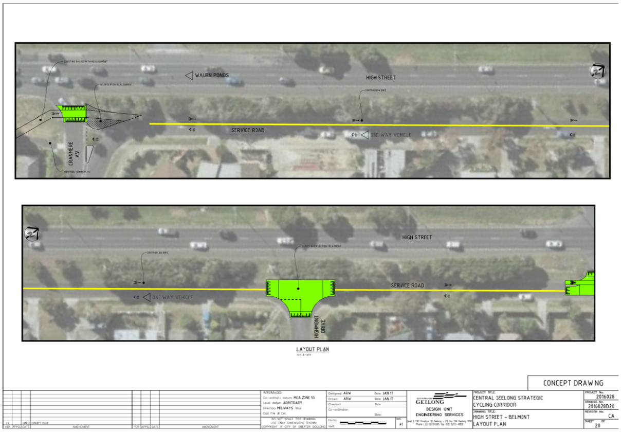
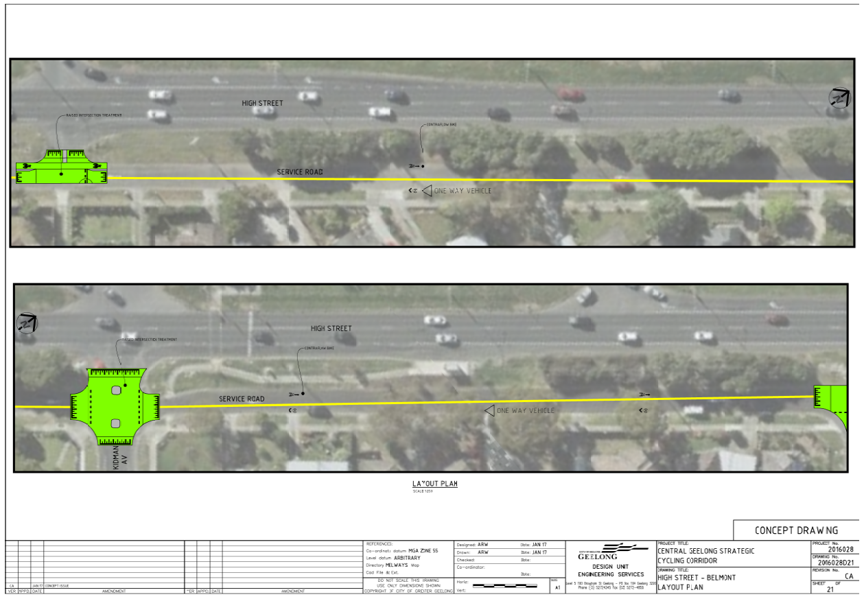
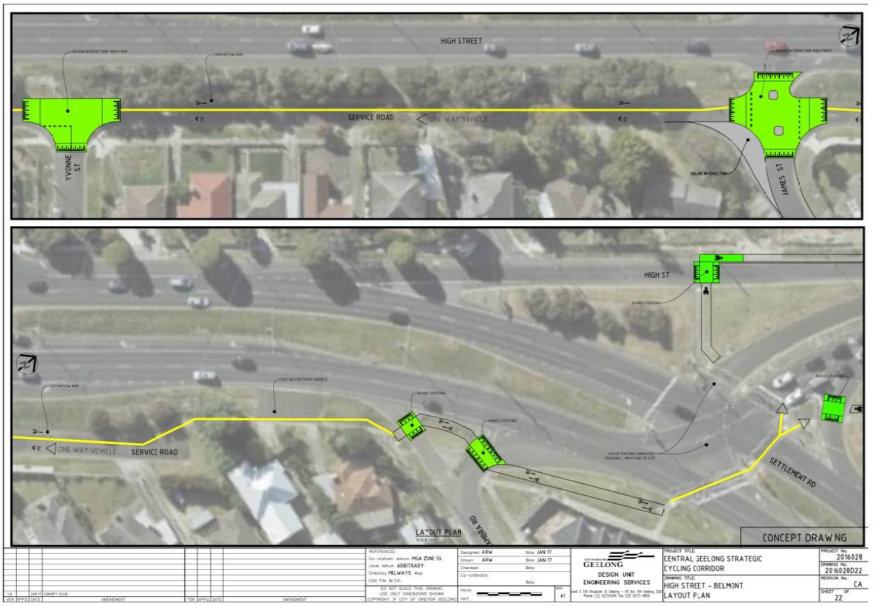
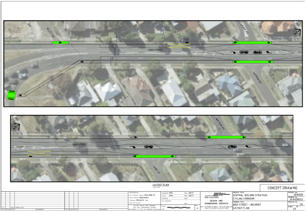
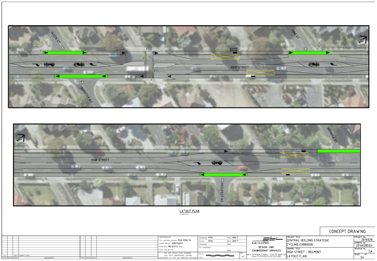
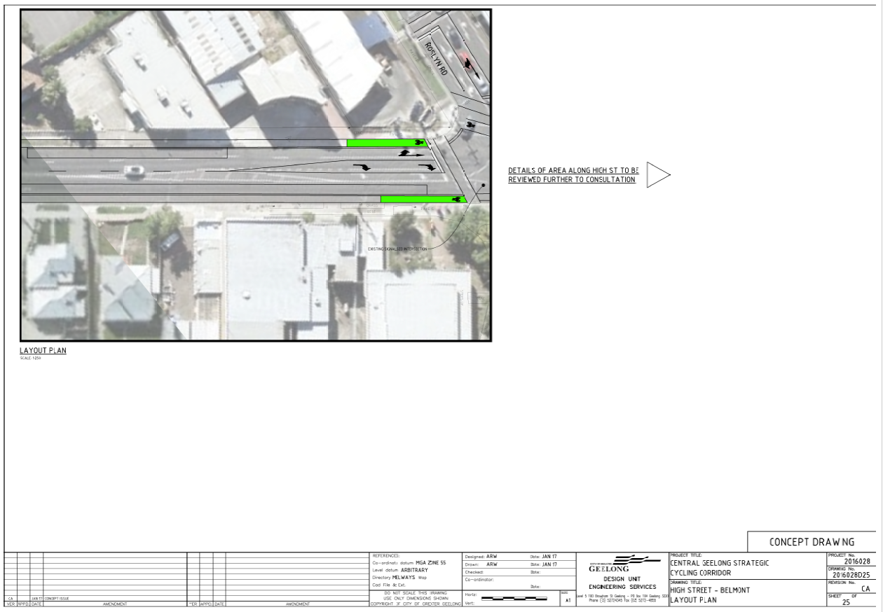
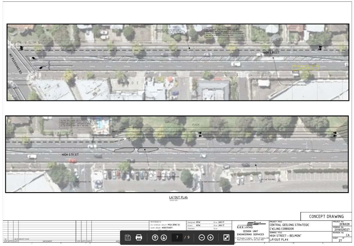
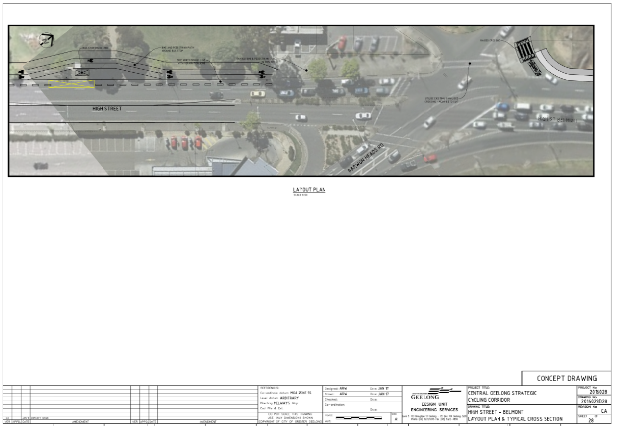
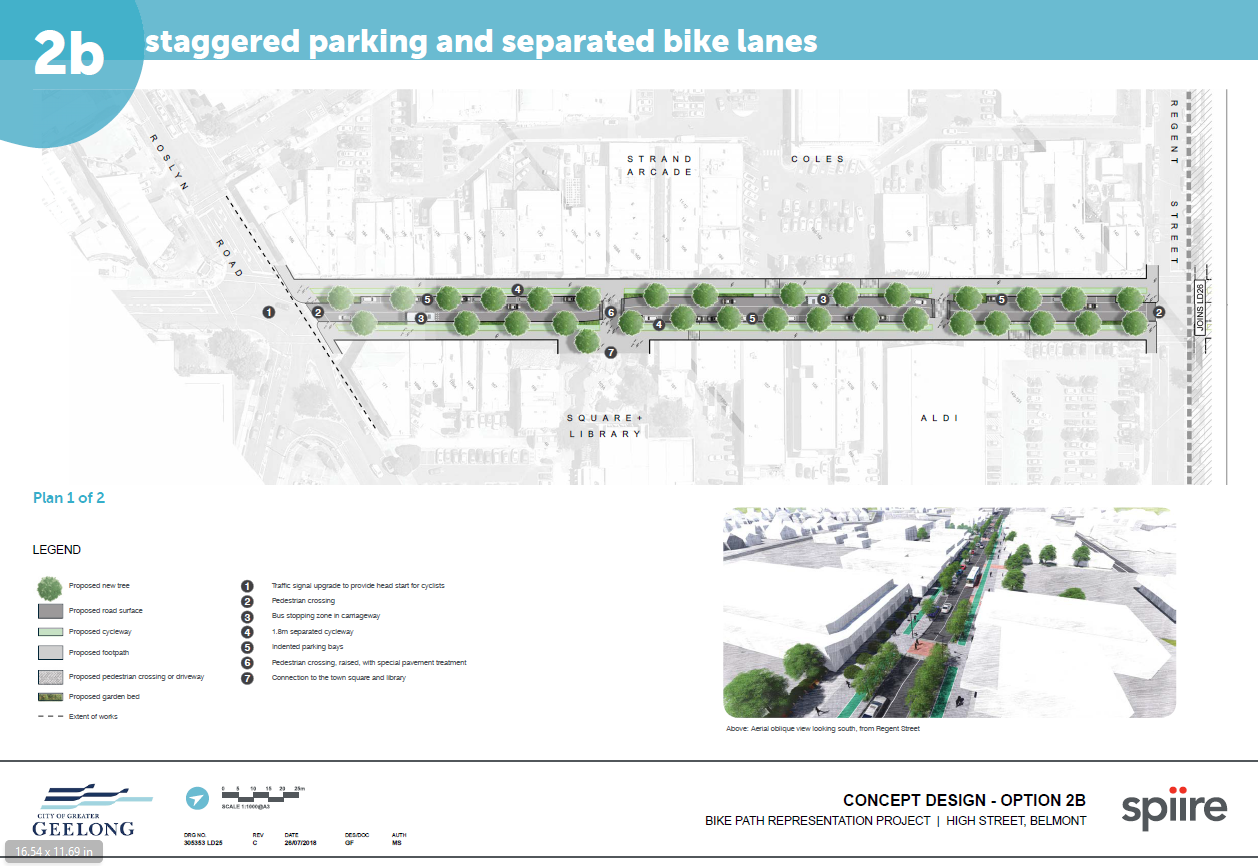
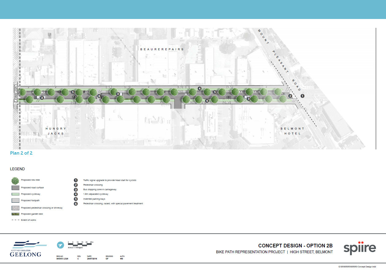
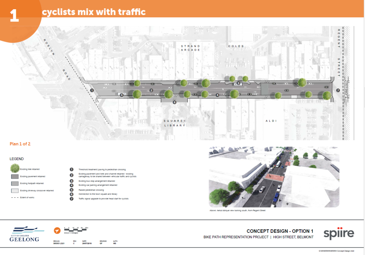
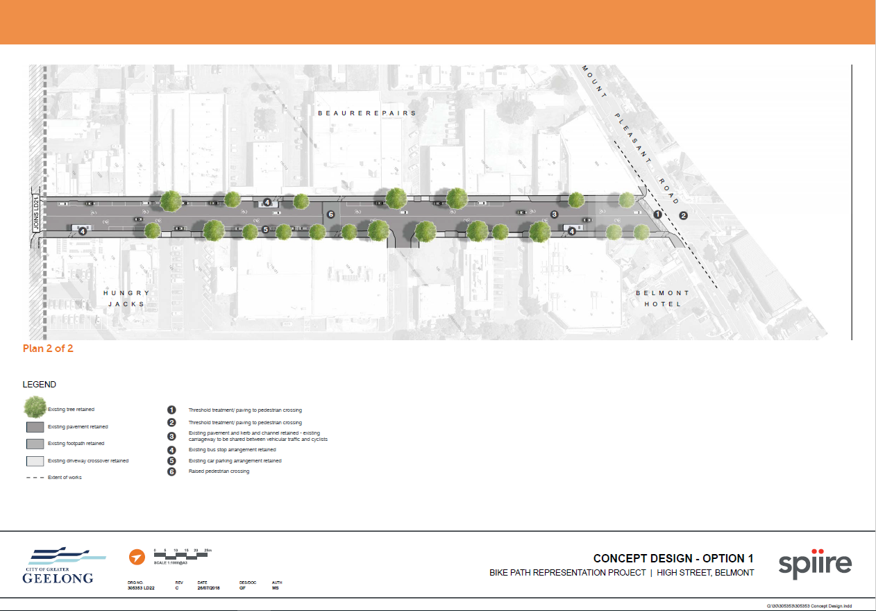
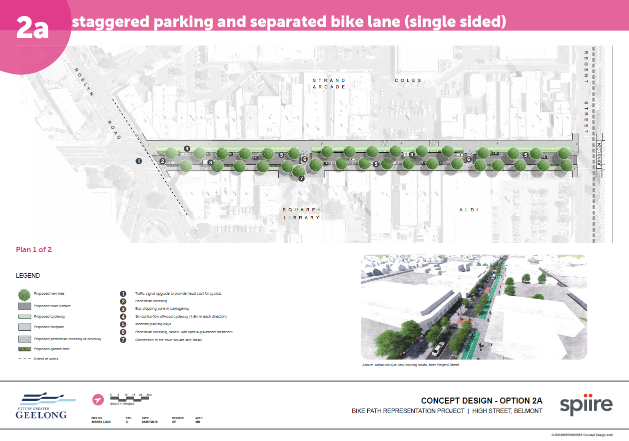
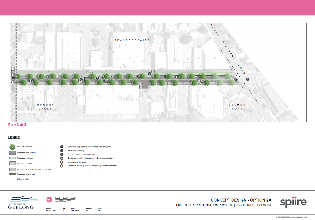
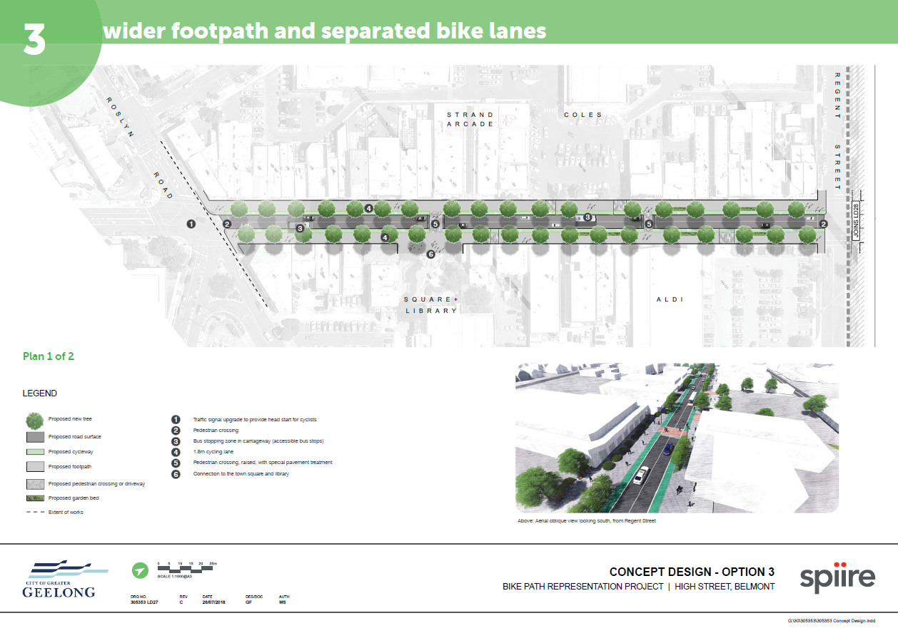
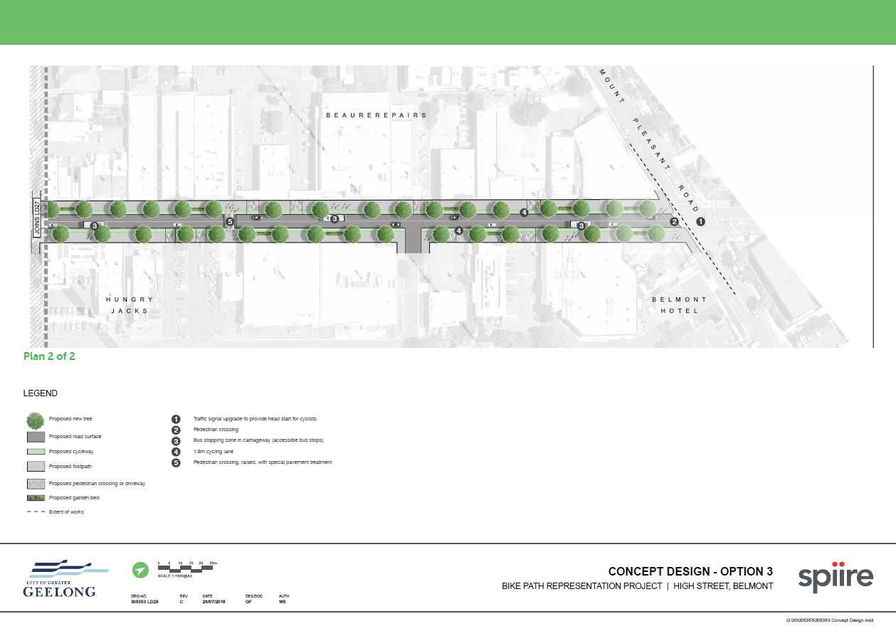
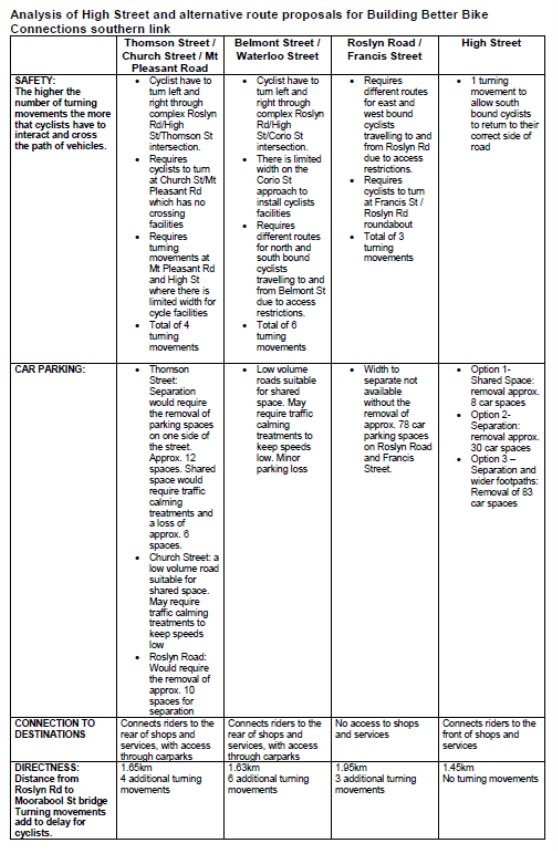
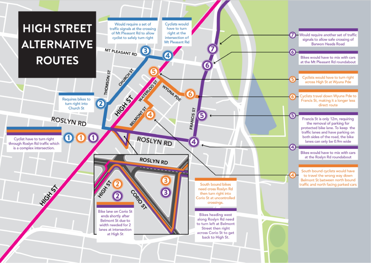
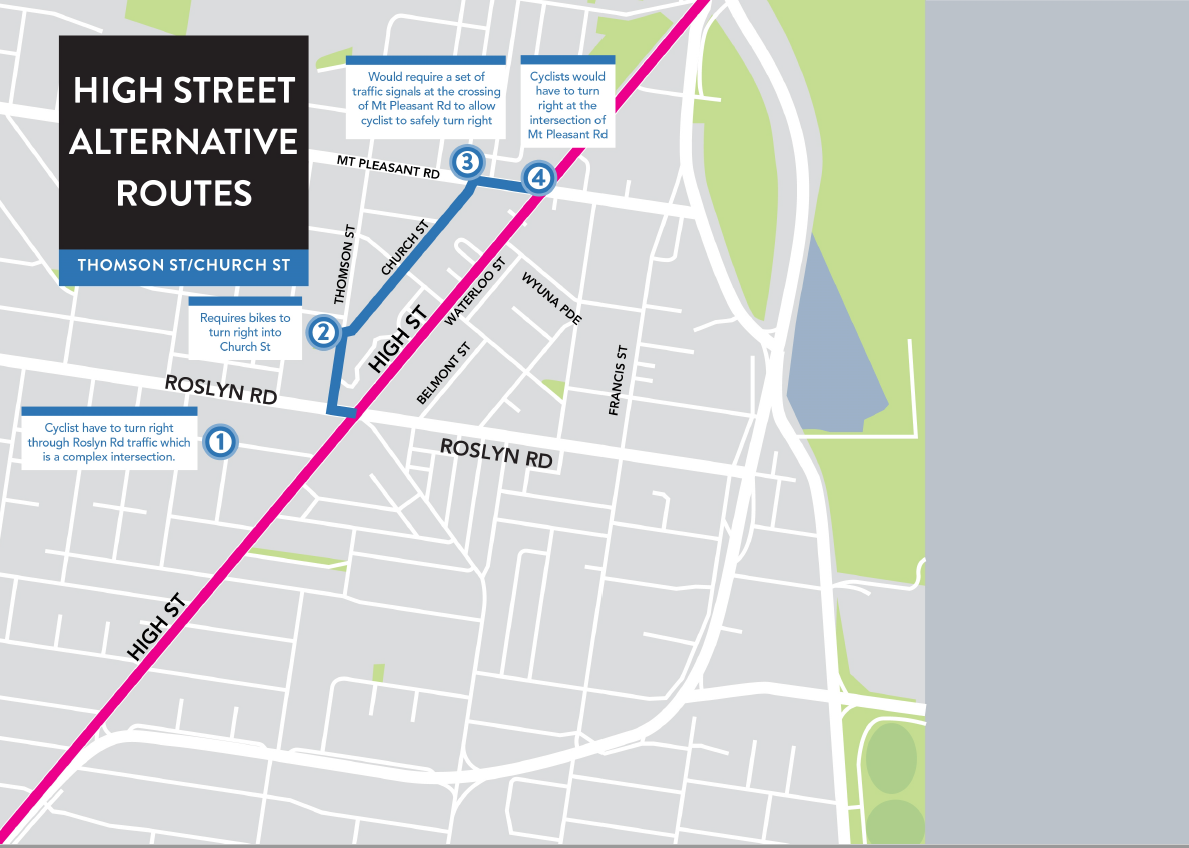
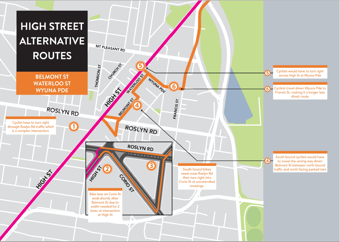
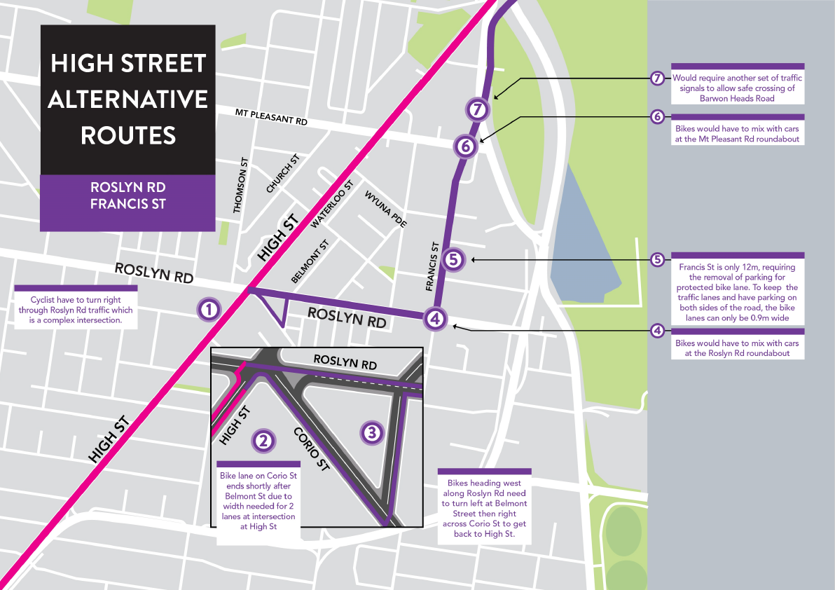
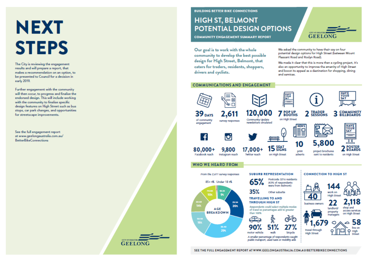
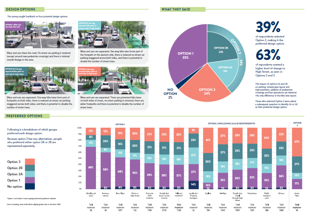
|
The City Of Greater Geelong |
|
Building better Bike connections |
Engagement Report High Street, Belmont Potential Design Options November 2018 |
Contents
Travelling to and through High Street
Summary of topics and sentiments for each ption
What we heard about each design option
OurSay sentiment analysis report
Community engagement summary report
The City of Greater Geelong received a $4.7 million grant from the TAC's Safer Pedestrian and Cyclist Fund to create cycling connections:
The southern link will connect Central Geelong with Waurn Ponds via Belmont.
The western link will connect Central Geelong with Herne Hill via Geelong West.
Adopting best practice from around the world, the cycling routes will include a combination of protected bike lanes (where bikes are separated from cars) and a shared use system (where cars and bikes share the road).
Both routes are designed to be used by cyclists of a wide range of ages and abilities to safely ride to destinations like shopping areas and key employment precincts.
This southern link is more than a cycling project, it is also an opportunity to improve the amenity of High Street and boost its appeal as a destination for shopping, dining and services. This project is about more than bikes and bike lanes. It’s about activating the High Street space and connecting people from destination to destination.
This report summarises the community engagement results for the potential design options for the High Street, Belmont (between Mount Pleasant Road and Roslyn Road) section of the southern link route.
The engagement period was 31 July to 7 September, 2018. A snapshot of the results can be found in Appendix 1 – Community engagement summary report.
This was the second round of engagement for the Building Better Bike Connections project. The first round was delivered in early 2018 and focused on identifying the level of support in the community for the two cycling corridors. 466 people commented on the southern link during the first round of engagement with 70.7 per cent supporting the proposed southern link part of the project.
The engagement was promoted widely, with the aim to work with the whole community to develop the best possible design for High Street (between Mount Pleasant Road and Roslyn Road) that caters for the diverse community now and into the future, including traders, residents, shoppers, drivers and cyclists.
Our communications highlighted that this project was more than a cycling project, it was also an opportunity to improve the amenity of High Street and boost its appeal as a destination for shopping, dining and services. This project is about more than bikes and bike lanes. It’s about activating the High Street space and connecting people from destination to destination.
A survey formed the basis of the engagement. The survey sought feedback on four potential design options (option 2 had two alternatives within it) for High Street. The design options are detailed below:
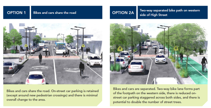
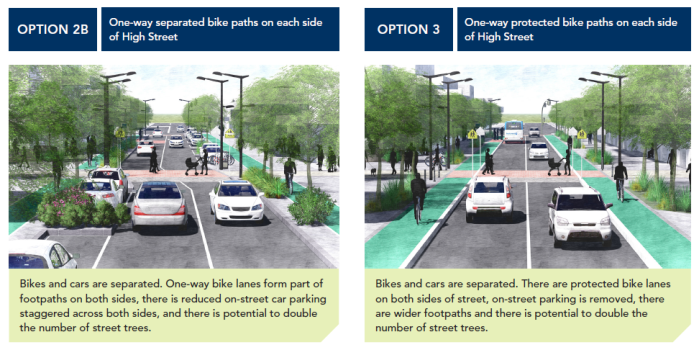
Due to the similarities between options 2A and 2B, respondents were asked to initially elect their preferred design options from options 1, 2 or 3. Those who selected option 2 as their preferred design were then asked a subsequent question to identify 2A or 2B as their preferred design.
Table 1. Communications and engagement activities
|
Approach |
Engagement level |
Activities |
|
General communications Broad communications release via print , social media, the Geelong Australia website and emails/mailouts with the purpose of creating awareness of the project and the potential design options and desire to participate in the engagement. |
Inform |
Have Your Say page on website Social media posts Media releases Project website Posters and signage on High Street Advertising in local newspapers Article in Community Update newsletter (120,000 copies are circulated in the region) Display at Belmont Library Flyers Factsheets Community signs on roadsides Letters to Belmont residents and businesses Video showing the four potential design options Email to local schools, businesses and other groups |
|
Engagement The engagement included an online and hard copy survey, pop up (in person) engagements on High St and trader-specific engagement including information sessions and one-on-one meetings. The survey focused on four potential designs, providing opportunity for the community to voice their preferences, likes and dislikes in a safe and supported way. |
Inform - Consult |
Traders’ sessions Pop up booth on High Street where anyone could ask questions and complete the survey One-on-one meetings with traders Survey Online Hard copy |
Figure 5. Communications and engagement statistics

This engagement was self-selecting with any interested person able to respond. It was not a random stratified sample of respondents (i.e participants were not randomly selected to represent the demographics of the Greater Geelong community).
Through the engagement process, quantitative and qualitative data was collected. The survey asked respondents to:
provide demographic information including suburb, age, connection to High Street and travel mode to and through High Street
identify their preferred design option
the reason why this was their preferred design option
state what they liked or disliked about the other design options.
See Appendix 2 for the Building Better Bike Connections survey.
In preparing this report, both quantitative (numbers) and qualitative (open text responses) data has been analysed. To ensure the essence of the extensive qualitative data was captured, engagement consultants, OurSay were engaged to do an open text analysis and provide an independent report which included:
sentiment analysis
topic analysis
summary analysis
OurSay’s sentiment analysis is important as it provides context to why certain cohorts prefer each option and their feelings towards various elements of each option.
See Appendix 3 for the full OurSay report - Sentiment analysis report of open free text survey responses.
Over 2,600 people engaged with the City about the four potential designs options for High Street.
2,611 surveys completed (hard copy, online, and in person at pop ups on High Street)
37 traders participated in two trader/landlord-only facilitated workshops
40+ conversations at each of the seven High Street pop up booths.
Whilst respondents came from across the municipality and further afield, 43 per cent were from Belmont. A total of 65 per cent of the respondents were from postcode 3216, which includes Belmont, Grovedale, Highton, Marshall, Waurn Ponds and Wandana Heights.
Figure 2. Suburb representation
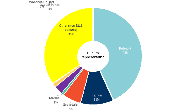
Almost half of the respondents (49 per cent) were aged 25-49 years of age. The age group with the greatest representation was 35-49 years, representing almost 29 per cent of responses.
The voices of the over 60s were also heard, with this group making up 25 per cent of respondents. Only one per cent of respondents were under 18. See Figure 6 for further breakdown.
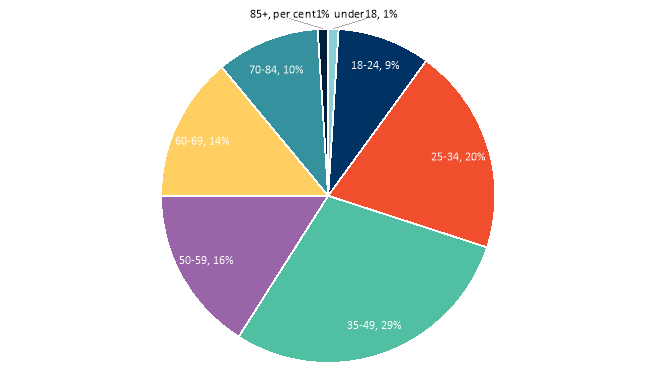
Survey respondents were asked to identify their connection to High Street. They were able to select multiple options therefore the total number of responses is greater than the total number of respondents.
The majority of respondents said they shop and access services on High Street (81 per cent) and travel through High Street (64 per cent ).
Five per cent of respondents said they work on High Street, 1.5 per cent own/run a business and just under one per cent are landlords/property managers.
Two per cent of respondents identified as living on High Street.
Figure 4. Connection to High Street
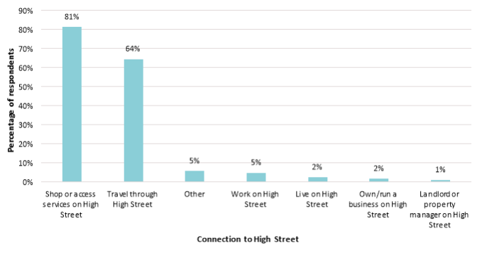
Travelling to and through High Street
Survey respondents were asked how they travelled to and through High Street. They were able to select multiple options, therefore the total number of responses is greater than the total number of respondents.
Ninety per cent of respondents told us they use a motor vehicle to travel to and through High Street. Fifty one per cent travel by foot. The third most common response was by bicycle (27 per cent), followed by 15 per cent catching public transport, three per cent using taxis and one per cent using mobility aids (including wheelchairs and electric scooters).
Figure 5. Travelling to and through High Street
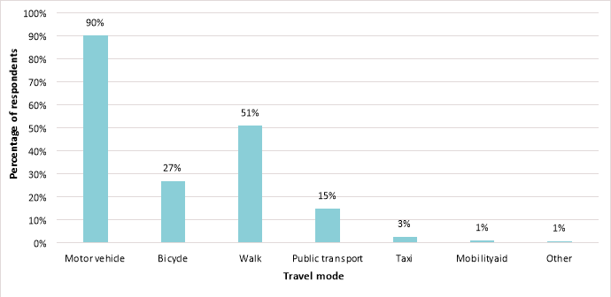
Overall option 2 was chosen by the highest number of respondents (39 per cent) followed by option 1 (35 per cent) and option 3 (24 per cent ).
63 per cent of respondents want some form of separated bike paths on High Street (by selecting options 2 and 3).
Of the respondents that chose option 2, the majority (58 per cent) preferred option 2B, which proposes one-way separated bike paths on each side of the street, compared to option 2A (42 per cent), which proposes a two-way separated bike path on the western side of the street.
Figure 6. Preferred design option breakdown
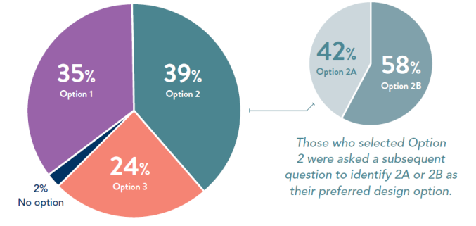
There was a propensity for younger respondents to select options with greater change. The under 50s preferred option 2 (46 per cent) and 47 per cent of under 18s preferred option 3.
The over 50s (48 per cent) were more likely to want minimal or no change, preferring option 1.
Belmont residents had a split preference for option 1 and option 2 (37 per cent respectively).
When the overall preference of postcode 3216 residents (Belmont plus other surrounding 3216 suburbs) was considered, option 1 was the preferred option (39 per cent) followed very closely by option 2 (36 per cent).
The majority of landlords/property managers preferred option 2 (50 per cent) whereas a higher proportion of High Street workers and business owners preferred option 1 (45 per cent and 58 per cent respectively).
Those shopping/accessing services on High Street were fairly evenly split on option 1 and 2 (38 per cent and 37 per cent respectively).
The majority of those who described their connection to High Street as ‘travelling through’ preferred option 2 (43 per cent).
Summary of topics and sentiments FOR EACH Option
In their report, consultants OurSay, filtered and counted responses by topic (excluding bikes/cycling which were too common) for each of the four design options, and measured sentiment to produce the summaries in the four charts below. It should be noted that the count for each topic does not correlate with the number of responses as there may have been a number of topics appearing in a single response. The count for positive comments is green, negative is red and the neutral count orange.
Pos/Neg/Neutral: number of comments which had positive, negative and neutral sentiment on the topic respectively.
Average score: ranges from -5 to 5, where -5 is extremely negative, 0 is neutral and 5 is extremely positive; a score of over 2 can be considered strongly positive.
Figure 7. Cars/parking sentiment count
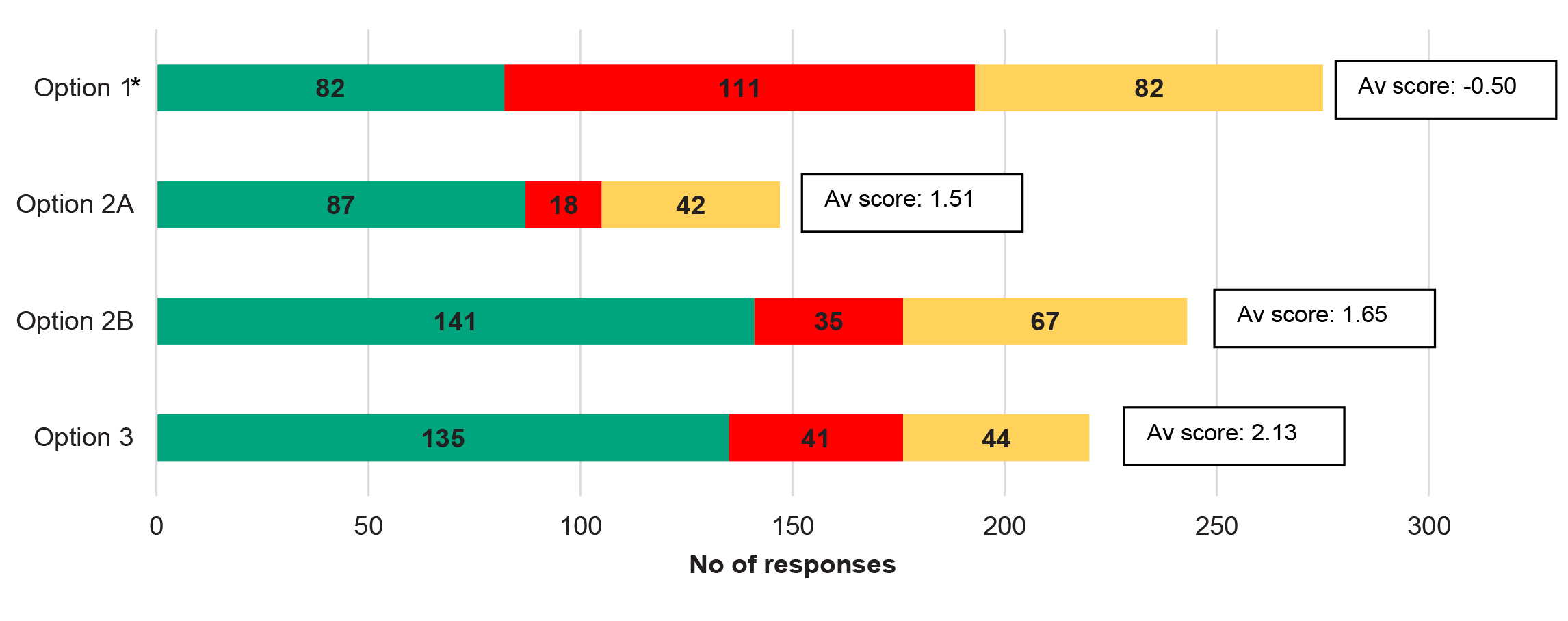
*Note: it should also be acknowledged that further in-depth analysis by OurSay of option 1 sentiment found that negative comments about car parking related to the “difficulty” or “loss” of car parking in all other options rather than a negative sentiment about car parking in the option 1 design.
Figure 8. Business/shops sentiment count
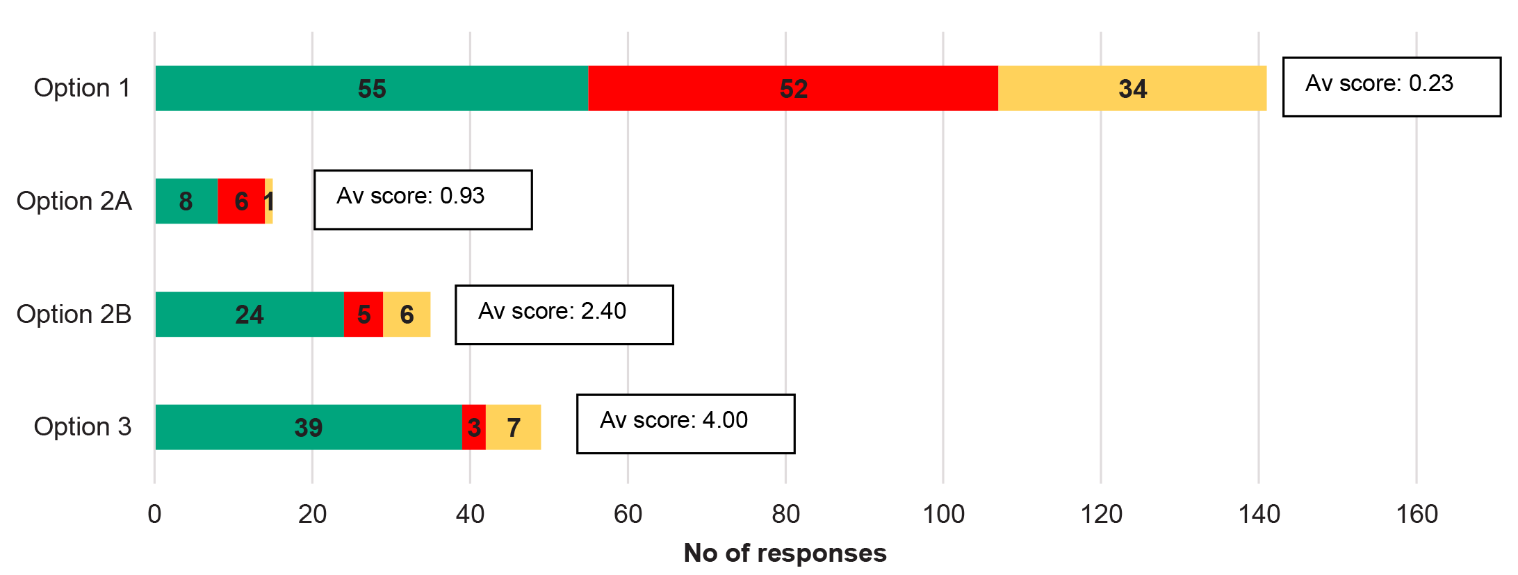
Figure 9. Pedestrians/walking sentiment count
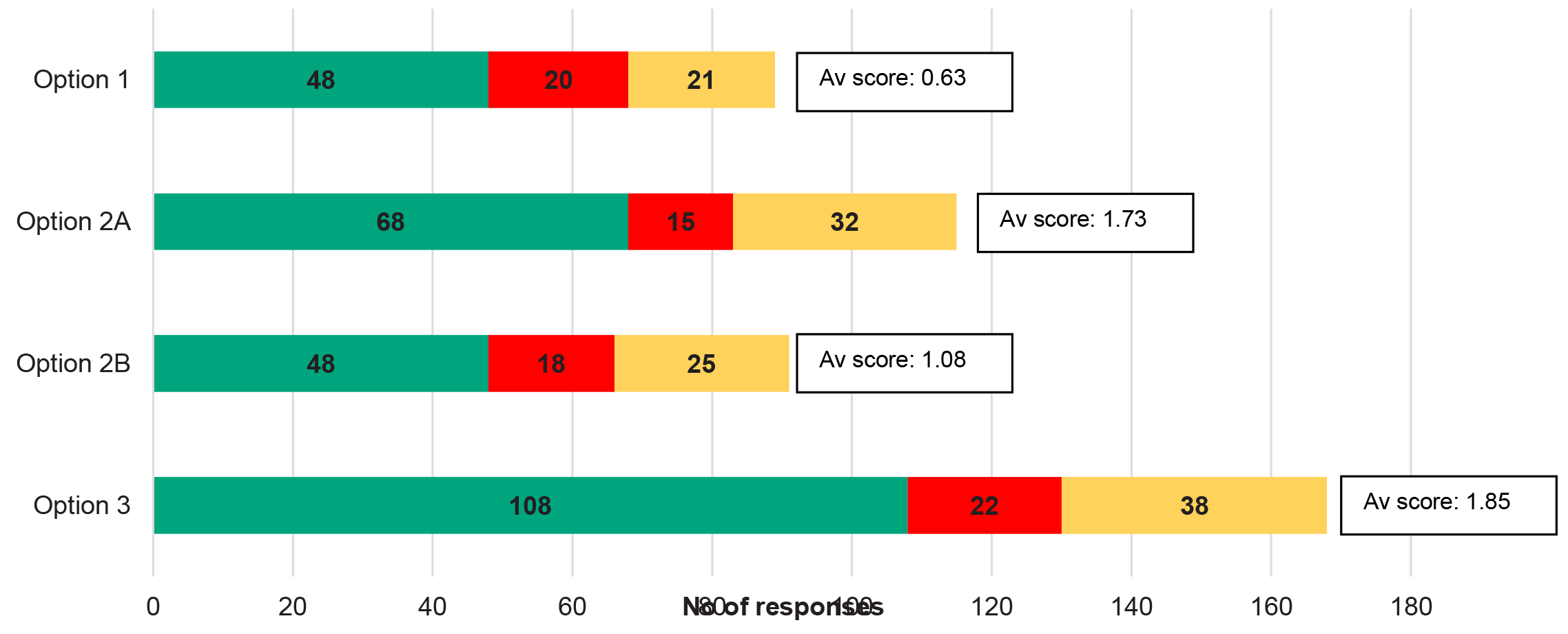
Figure 14. Safety sentiment count
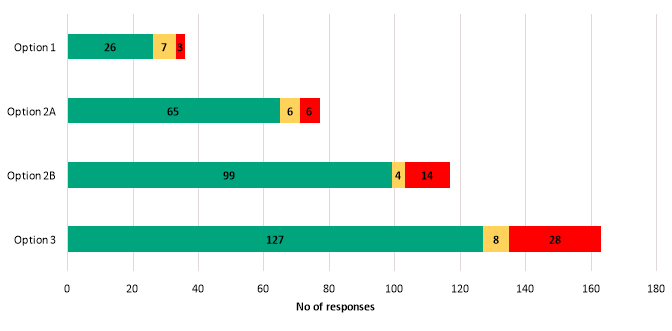
WHAT WE HEARD ABOUT EACH DESIGN OPTION
The following is a snapshot of the groups of people (by age, connection to High Street, mode of transport or suburb) who preferred each option. The key themes for each option is also highlighted.
The design options are listed in the order of most preferred to least preferred.
The commentary around the themes for each design option has come from an independent report produced by consultants OurSay.
Groups who preferred Option 2 (includes 2A and 2B option respondents)
Overall, this was the preferred design option with 39 per cent of respondents (n=1023) choosing this option. Of the 2A and 2B options, 2B was the preferred option at 58 per cent.
This was the preferred design option for the following groups:
*Option 1 and 2 were equally preferred by Belmont residents.
Option 2 was also the preferred option for respondents who travel through High Street (43 per cent) and pedestrians (40 per cent).
Key themes identified for option 2
Option 2B:
The top three themes that emerged for people who chose option 2B were (n=517):
Cars/parking: 243 mentions. When talking about the effect on cars/parking, these responses were overwhelmingly positive.
Safety: 117 mentions. Responses on safety impacts were almost exclusively positive.
Pedestrians/walking: 91 mentions. Responses on the impacts on pedestrians/walking were strongly positive.
Along with option 3, this was the only cohort of respondents to bring up beauty/attractiveness (14 out of 646 responses). Beauty and attractiveness recorded the most positive topic for this option (4.2 out of an average score of -5 to +5, where -5 is extremely negative, 0 is neutral and +5 is extremely positive).
Option 2A:
The top three themes that emerged for people who chose option 2A were (n=366):
Cars/parking: 147 mentions. When talking about cars/parking, these responses tended to be highly positive.
Pedestrians/walking: 115 mentions. Responses on the impacts on pedestrians/walking tended to be strongly positive.
Safety: 77 mentions. These responses also expressed strongly positive sentiment.
Overall, this was the second preferred design option with 35 per cent of respondents (n=904) choosing this option.
This was the preferred design option for:
*Option 1 and 2 were equally preferred by Belmont residents.
Option 1 was also marginally preferred over option 2 by respondents who shop or access services (38 per cent compared to 37 per cent for option 2) and High Street residents (36 per cent compared to 35 per cent for option 2).
Key themes identified for option 1:
The top three themes that emerged for people who chose option 1 were (n=646):
Cars/parking: 275 mentions. When talking about cars/parking, respondents were more likely to express negative sentiments about the loss of parking for all other options.
Businesses/shops: 141 mentions. There was an even split between positive (better for trade) and negative (worse for trade) sentiment.
Pedestrian/walking: 99 mentions. When talking about pedestrian/walking, respondents were likely to be highly positive.
People who chose option 1 were also most likely out of all the options to comment on crossings (52 mentions), with strongly positive sentiments.
Overall, this was the least preferred design option with 24 per cent of respondents (n=625) choosing this option.
This was the preferred design option for:
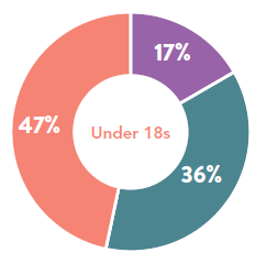
Whilst under 18 year olds were the only age group to identify option 3 as their preferred design option, over a quarter of respondents from the 25-49 year old cohort selected option 3 as their preferred design.
Key themes identified for option 3:
The top three themes that emerged for people who chose option 3 were (n=534):
Cars/parking: 220 mentions. When talking about the effect on cars/parking, these responses were strongly positive.
Pedestrians/walking: 168 mentions. Responses on the impacts on pedestrians/walking expressed strongly positive sentiment.
Safety: 163 mentions. Responses on safety impacts were overwhelmingly positive.
Along with option 2B, this was the only cohort of respondents to bring up beauty/attractiveness (15 out of 646 responses). Beauty/attractiveness recorded the most positive topic for this option (4.8 out of an average score of -5 to +5, where -5 is extremely negative, 0 is neutral and +5 is extremely positive).
OurSay sentiment analysis report
Community engagement summary report
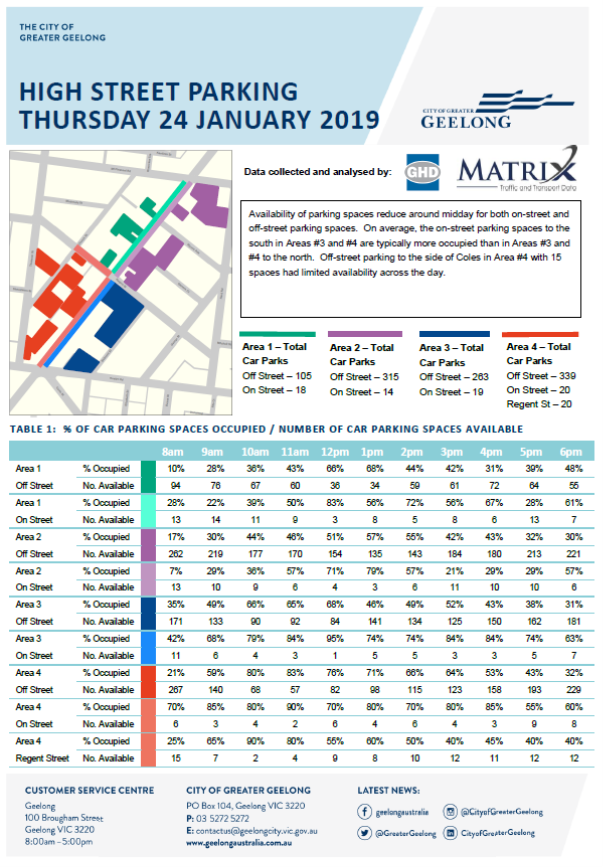
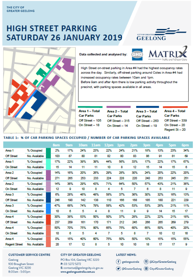
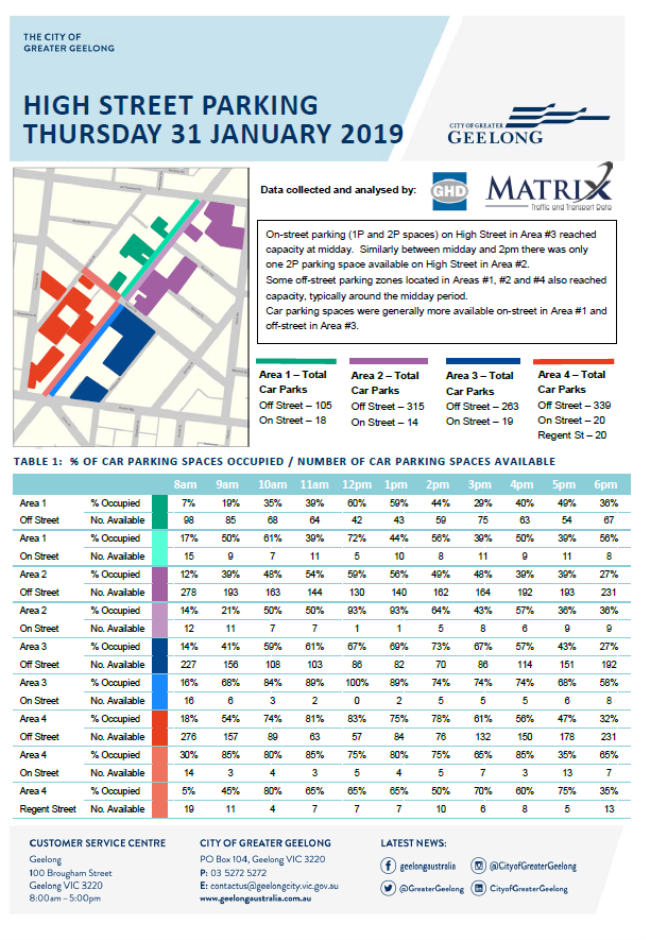
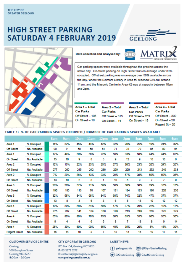
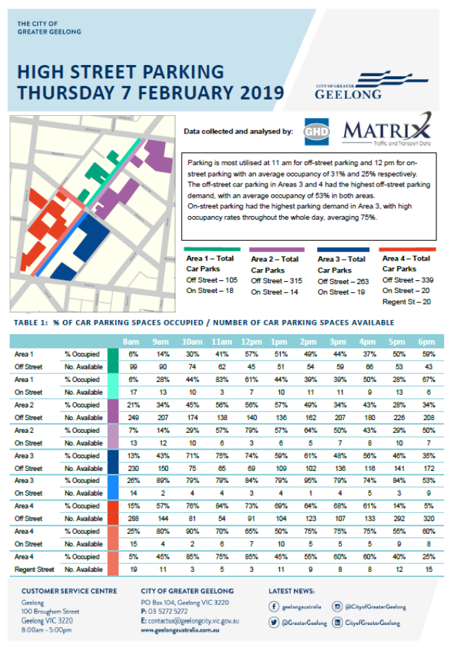
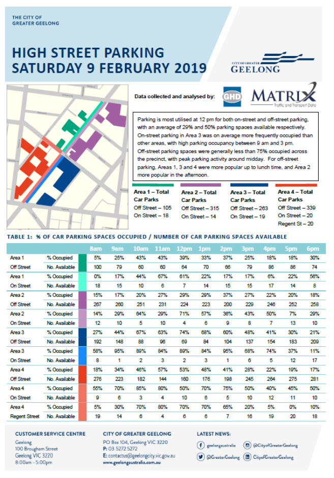
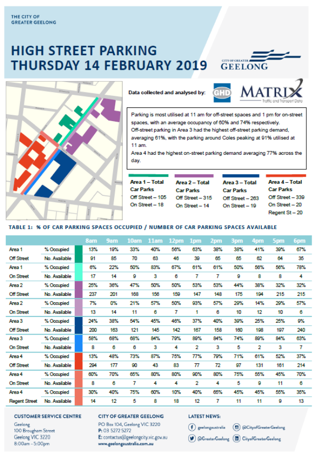
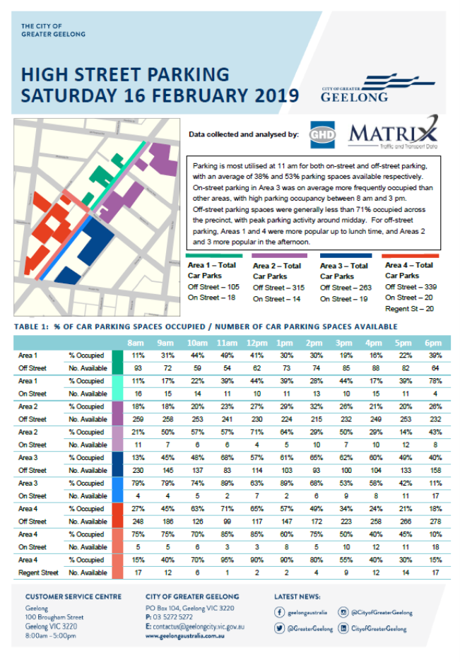
Attachment 8
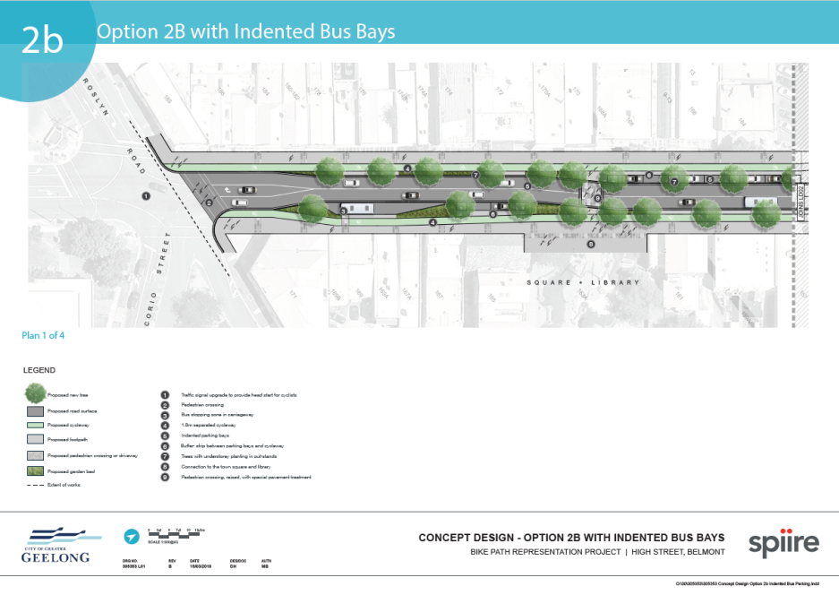
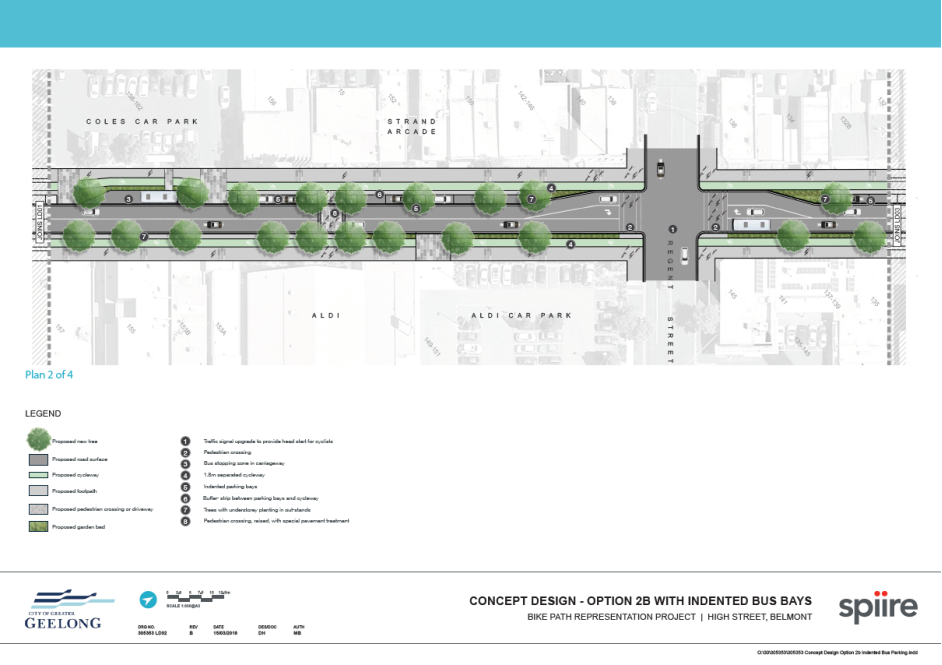
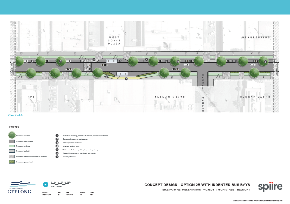
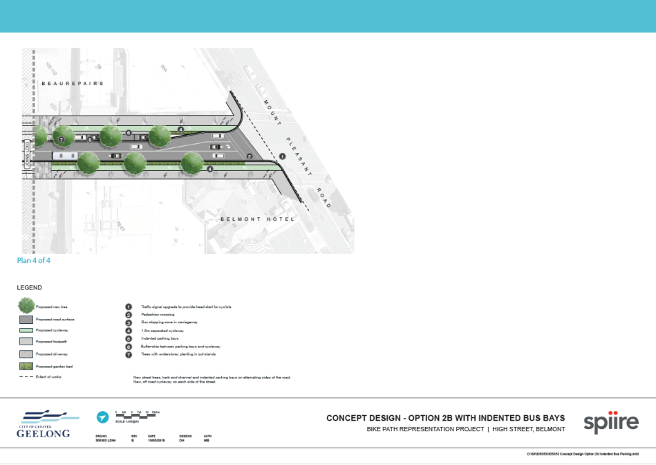
Councillors Aitken and Grzybek re-entered the meeting at 10:33pm
Source: |
Finance & Strategy |
Director: |
Michael Dugina |
Portfolio: |
Finance |
To update the Community Investment and Support Fund (CISF) Policy and Guidelines, and revoke the Private Sporting Infrastructure Capital Co-contribution Policy.
The Community Investment and Support Fund (CISF) policy and Guidelines were endorsed by Council on 26 June 2018. The program has been running for one year and some improvement opportunities have been identified both at a policy and procedural level.
The Private Sporting Infrastructure Capital Co-contribution Policy was endorsed by Council on 12 May 2015 and was due for review in 2018.
The Private Sporting Infrastructure Capital Co-contribution Policy provided that council would fund, subject to approval in the annual budget, up to 1/3 of capital works for sporting infrastructure, not on Council owned or managed land. Community based sporting clubs and organisations would fund the remainder.
The Private Infrastructure Policy offered no clear guidelines or eligibility criteria for clubs or organisations to approach Council for funding commitments.
The CISF Policy has an established application and assessment framework and clear guidelines that enable a transparent and equitable grants process supporting community groups through a single process.
The Community Facility Infrastructure Fund (CFIF) was one grant stream under the existing CISF Policy, however this was restricted to not for profit organisations and clubs on Council owned or managed land, thus making private clubs ineligible. This has been changed in the update to the new Policy and Guidelines.
Council will establish a single process under the new CISF policy, whereby clubs and organisations can apply for grants regardless of whether they occupy private or public (Council managed) land.
Councillor Murnane moved Councillor Kontelj seconded –
That Council:
Revoke the Private Sporting Infrastructure Capital Co-contribution Policy;
Endorse the revised Community Investment and Support Fund Policy (Attachment 2);
Endorse the updated Application & Assessment Framework (Attachment 3) and associated Guidelines (Attachment 4); and
Endorse the updated Terms of Reference (Attachment 5).
Carried.
Provision is being made in the 2019-2020 budget for amendments to the existing grants scheme.
Information sessions will be held for the community about the changes to CISF and additional funding opportunities. All promotional information will be updated and made available on the Geelong Australia website. Staff are available during the application process to provide advice and information to groups submitting a grant application. All applicants to the CISF are notified of the outcome of their grant application following the assessment process and the list of allocations will be reported on the Geelong Australia website.
The CISF Policy ensures equitable access to funding is available to eligible groups within our community. The program encourages applications for projects and initiatives that promote participation and inclusion across the community. The provision of grants through the CISF promotes inclusion and participation.
CISF Policy, framework and related guidelines provide the parameters for managing and delivering the CISF to the community. The framework and guiding documents have been developed to reflect good practice as outlined by the Australian Institute of Grants Management.
The provision of grants through the CISF supports and encourages connection and engagement of a range of community groups and members. This aligns with the Council Plan 2018-2022 and our vision, A Clever and Creative Future.
No officer has any known indirect or direct conflict of interest in the preparation of this report.
The grant program and its independent assessment, based on criteria approved by Council will protect Councillors and Officers from any direct or implied conflicts of interest.
Grants are governed in accordance with Council’s monitoring, reporting and accountability framework. The engagement of independent assessment panel members includes processes to ensure probity and conflict of interest issues are addressed.
The CISF Policy and guidelines allow for consideration of environmental impacts as part of the grants process.
Source: |
Finance & Strategy – Strategy & Program Delivery |
Director: |
Michael Dugina |
Portfolio: |
Strategy and Communications |
To present the Vision Annual report – ‘Our Progress 2018’ for noting by Council.
The Community-led 30-year vision, Greater Geelong: A Clever and Creative Future, was launched in August 2017. A Council resolution at that time committed to reporting annually to the community on the progress and performance, against the milestones and measures contained in the report. ‘Our Progress 2018’ is the first update and honours that commitment.
The ‘Our Progress 2018’ report has been reviewed and endorsed by the Vision Partner Group at their meeting on Tuesday 19 February. The report contains two key features:
Highlight projects and activities completed by Council and community that align with community aspirations. Some key achievements contributing to the delivery of the vision include:
Geelong’s designation as Australia’s first and only UNESCO City of Design;
AirAsia, the first airline to operate international flights at Avalon Airport;
The introduction of the Youth Council, who will provide advice to the Council on specific issues; and
The launch of the new garden organics composting facility, which will process up to 35,000 tonnes of green organics each year.
Progress on measures of success.
The report will be available to the community in hard copy and on the Geelong Australia website.
Councillor Asher moved, Councillor Murrihy seconded -
That Council notes the publication of the Vision Annual Report – ‘Our Progress 2018’.
Carried.
There are no financial implications arising from the subject of this report.
The Our Progress 2018 report has been prepared in consultation with the Vision Partner Group. The report will be made available to the community in hard copy at various Council sites, as well as online through the Council’s website (www.geelongaustralia.com.au) after the Council Meeting on 23 April 2019.
The Our Progress 2018 report documents the work that council in collaboration with the community is undertaking in relation to the implementation of the 30-year vision. This update includes activities relating to the community aspiration for an inclusive, diverse, healthy and socially connected community.
The Our Progress 2018 report has been developed to meet our commitment to update the community on the progress of the vision on an annual basis.
The Council plan has been guided by the 30-year community vision for the municipality. This report highlights the alignment between the Strategic Priorities within Council Plan 2018-2022, and the community aspirations that form the foundation of the 30-year community-led vision.
There have been no direct or indirect interests declared.
Delivering the Greater Geelong: A Clever and Creative future Vision has been identified as a strategic risk for the City with a High risk rating based on a consequence level of Severe and a likelihood level of Possible.
Key causal factors include:
The failure of the organisation to ‘own’ and adopt the vision, and failing to keep the vision ‘alive’, visible and front-of-mind with the community and stakeholders; and
Failure to implement the vision and aspirations outlined in the document may result in a significant reputational consequence to the organisation, given the level of community engagement in developing the vision. Commitment to implementation has been made publicly, and a charter developed and endorsed by the Vision Partner Group.
Treatment plans have been developed by Management to manage this risk to an acceptable level.
The Our Progress 2018 report documents the work that Council in collaboration with the community is undertaking in relation to the implementation of the 30-year vision. This update includes activities relating to the community aspirations for sustainable development that supports population growth and protects the natural environment, and development and implementation of sustainable solutions.
Source: |
Finance and Strategy - Property and Procurement |
Director: |
Michael Dugina |
Portfolio: |
Finance |
To seek Council approval for the City to give public notice of the intention to sell a property located at 257 Roslyn Road, Highton through a competitive marketing process.
The City owned and managed the property at 257 Roslyn Road, Highton (the property) for the provision of a kindergarten
The aging property was identified as having a poor layout and facilities in the City’s Municipal Children’s Services Infrastructure Plan 2013-2030, with a recommendation for ‘development of new facility to replace and augment existing services to meet future needs of local population.’
The kindergarten has been replaced by the Highton Child and Family Centre at 74 Belle Vue Avenue, Highton which is now fully operational.
The property, no longer fit for purpose, has been vacated and is surplus to the City’s needs and should be considered for disposal.
It is zoned for general residential purposes and on a single title, so there will be no requirement for rezoning or subdivision to prepare it for sale. Council should commence the sale process for the property in accordance with section 189 of the Local Government Act 1989 (Act) which involves giving public notice of the intention to sell the property and calling for submissions regarding the sale.
If submissions are received they will be considered by the Council or if requesting to be heard, the Submissions Review Panel will hear the submissions and a further report will be put to Council. If no submissions are received it is proposed that the property will be sold by a public process determined in discussion with the appointed agent.
Councillor Murnane moved, Councillor Nelson seconded -
That Council:
Highton, being certificate of title volume 11582 folio 815 (“the land”) on the following terms and conditions:
The land be sold by public process;
The price being no less than a certified valuation of the land obtained no more than 6 months prior to the date of sale; and
Other appropriate terms and conditions.
Commence the process under section 189 of the Local Government Act 1989 (Act) to sell the land and that public notice of and the right of a person under section 223 of the Act to make a submission in relation to the proposed sale be given in the Geelong Advertiser and Geelong Independent;
Consider any submissions received or appoint the Submissions Hearing Panel to hear and report to the Council on any submissions in relation to the proposed sale;
Notes that if submissions are received a further report will be put to Council. If there are no submissions the property will be sold; and
Authorise the Director Finance & Strategy to sign all documents relating to the sale of the property.
Carried.
The sale of the property will reduce the financial impact of maintaining an aging asset which has been replaced. The proceeds from the sale will provide a positive financial benefit. The costs associated with the sale will relate to public notice, property valuation and sales commission.
Any person will have an opportunity to make a written submission on the proposed sale under the notice of intention to sell land. A submitter is entitled to request in the submission that the person wishes to appear in person, or to be represented by a person specified in the submission, at a meeting to be heard in support of their submission.
There are no social equity issues associated with this matter.
The proposal aligns with the City’s Municipal Children’s Services Infrastructure Plan 2013-2030 which was endorsed by the Council on 24 March 2015.
Section 189 of the Act requires that Council must obtain a valuation of the property from a suitably qualified property valuer which is made not more than 6 months prior to the sale and give public notice of its intention to sell the land and consider any submissions received. If any submissions are received they will be considered by Council and if requested, heard by the Submissions Review Panel followed by a report to Council. If no submissions are received the property will be sold.
Should the sale proceed an agent will be appointed to sell the property by a public process and the method of sale will be determined in consultation with the agent. Sale options include public auction, sale by expressions of interest or listing.
There are no human rights ramifications to the proposal.
The sale of this property which is no longer required by the City and has financial implication in maintaining it and aligns with the strategic priority of organisational leadership, strategy and governance and its key priority of ‘proactively managing our assets, including land holdings’.
No officers or contractors involved in the preparation of this report have a direct or indirect interest in the matters to which this report relates.
No notable risks associated with implementation of the recommendations.
There are no environmental implications to this proposal.
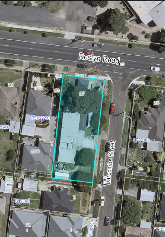
Source: |
Community Life – Leisure and Recreation Services |
Director: |
Robyn Stevens |
Portfolio: |
Social and Infrastructure Planning |
To seek endorsement from Council for the draft Golf Facilities Strategy and seek approval to undertake community consultation during a four-week public exhibition period.
Several reviews of the City’s role in golf course provision have been undertaken over the past fifteen years; the first, in 2005, was the Golf Course Best Value Review. A more recent report was done in 2014; Golf in Geelong – State of Play Report, which only considered three courses the City had an active role in managing and maintaining.
The City has seven golf courses on Council-owned Crown Land: Balyang Par 3, Barwon Valley, Clifton Springs, East Geelong, Lara, Ocean Grove and Queens Park. Each of these facilities is operated under one of three different management models: 100% City managed, leased facilities and City maintained course or a full-site lease.
The Golf Facilities Strategy proposes a transition to club-based management models and to discontinue the City’s role in directly operating golf facilities over three years.
The City has completed a comprehensive strategic assessment of its golf courses which has informed the development of the Golf Facilities Strategy. The strategy sets a clear vision for the future use, management and sustainability of our golf facilities.
The draft 2019 Golf Facilities Strategy has been developed following extensive consultation and engagement with the seven golf clubs and through detailed analysis of the existing performance and market catchment of each course.
The four courses leased to the Barwon Valley, Clifton Springs, East Geelong and Ocean Grove Clubs are being managed sustainably and at no cost to the City. There is a need to address equity with the existing lease rental arrangements at these facilities with consideration of low-rent, long-term tenure across each course.
The draft strategy proposes to transition Lara, Queens Park and Balyang Par 3 to full operating leases over the next three years with significant support from the City during this period to ensure sustainable management arrangements can be implemented.
Councillor Murrihy moved, Councillor Aitken seconded -
That Council:
endorses the draft Golf Facilities Strategy;
approves a four-week public exhibition of the draft strategy to seek feedback from the golf clubs and broader community; and
report to Council following the exhibition period for final endorsement.
Carried.
Four of the seven golf courses are currently leased to clubs that operate them at no cost to the City. The strategy recommends the City reviews and implements low-rent leases to support clubs to be financially sustainable for the long term.
The draft strategy proposes the City not directly operate golf facilities, which would significantly reduce the current level of expenditure across the three existing courses the City has an active role in maintaining or operating: Queens Park, Lara and Balyang Par 3.
The City would reduce its operating expenditure by $1.2 million after three years if a staged transition to club-based management models or commercial lease at these three courses was successful.
The draft strategy recommends capital upgrades of the Queens Park irrigation system at a cost of $1 million for stage one. Advocacy for funding stage two, storm-water harvesting and dam infrastructure would also need to be considered as a longer term project. This will ensure more efficient water management practices and water savings can be achieved.
Comprehensive community engagement was undertaken in the development of the draft strategy. The consultation opportunities included:
Meetings with club committee representatives and service contractors at each of the seven golf clubs. The discussions included facilitating a detailed Strengths, Weaknesses, Opportunities and Threat analysis workshop. These are summarised in the strategy.
Surveys conducted with golf club members across all courses, including casual users.
Community survey via the City’s “Have you Say” website which was promoted via City News. A total of 279 responses were received and key insights are summarised in the strategy.
Surveys distributed to all golf clubs in the broader G21 region. 12 of the 20 golf clubs provided responses.
The strategy is underpinned by strategic principles to ensure that social equity and access are key considerations in the future sustainable provision of clubs and facilities in the municipality. These include:
Delivering community benefit – the City supports golf in the community and eeks to optimise the social, community, environmental and economic benefits generated from golf. The City will offer support and monitor performance of golf clubs and facilities operating on Council land with a focus on ensuring they are addressing the challenges and opportunities of the contemporary golf club and facility.
Supporting golf clubs and facilities – the City will not directly operate golf facilities but will support golf clubs and facilities operating on Council land through low-rent, long-term tenure with requirements for tenant golf clubs to:
meet governance standards and performance benchmarks to develop sustainable business models;
develop long-term capital investment plans; and
be guided and influenced by community interests, needs and aspirations, actual participation trends and demographic characteristics.
Ensuring publicly accessible golf facilities – All golf clubs and facilities operating on Council land under low-rent leases must provide an agreed percentage of their available green-fee times for public play at casual green-fee prices set within ranges agreed with the City annually.
Any long term lease arrangements will be advertised in accordance with statutory requirements of the Local Government Act 1989.
The strategy aligns with a number of Council Plan objectives including:
Improved health and safety of our community;
Informed social infrastructure and planning; and
A more inclusive and diverse community.
A strategic principle of the strategy proposes integration with the City’s recreation and leisure strategies which would include the City’s Social Infrastructure Plan.
No Council officers or contractors who have provided advice in relation to this report have declared a conflict of interest regarding the matter under consideration.
The draft strategy proposes a staged transition to a club-based management model for six of the seven courses. The City will work closely with the clubs during the implementation over three years to ensure any risks to the clubs financial sustainability are mitigated. These club-based management arrangements will require significant volunteer support in the day to day management and maintenance of the courses.
Should clubs be reluctant to explore club-based management models, commercial lease arrangements will be considered as an alternate option for the service delivery.
Water sustainability is an ongoing risk that will require support and advocacy from the City to ensure long term recycled water and irrigation efficiency practices can be achieved. The majority of clubs are well positioned with sustainable water management practices, which includes warm season grass conversions on fairways.
Long term asset renewal funding is a risk for many of the courses in terms of clubhouse infrastructure. The City will continue to support and advocate for renewal projects through the City’s Community Infrastructure and Support Fund programs.
A strategic principle of the strategy is a focus on conserving and protecting the environment. Golf clubs and facilities on Council land must protect and enhance the natural and cultural environments, particularly areas of remnant vegetation, habitat and indigenous cultural value.
The City will support and advocate for water sustainability projects and initiatives led by the golf clubs.
The strategy advocates for the upgrade of the Queens Park irrigation system for greater efficiency in the aging infrastructure. Planning and design has been undertaken for stage one; replacement of the existing irrigation system and associated upgrades, and for stage two; storm-water harvesting and dam infrastructure.
The City will continue to advocate for and explore sustainable recycled water opportunities for Lara golf course on the conclusion of the Barwon Prison recycled water agreement.
Source: |
Community Life – Social Planning and Investment |
Director: |
Robyn Stevens |
Portfolio: |
Social and Infrastructure Planning |
Councillor Kontelj moved, Councillor Mason seconded -
That in accordance with Section 89 (2) (c) of the Local Government Act 1989, this matter be considered at the conclusion of all other business at which time the meeting be closed to members of the public.
Carried.
Councillor Kontelj left the meeting at 10:56pm and returned at 11:00pm.
Contents | Previous Page: Section A - Procedural Matters | Next Page: Section C - Assembly of Councillors
