
Council Minutes - Section B: Reports - 28 May 2019
Contents | Previous Page: Section A - Procedural Matters | Next Page: Section C - Assembly of Councillors
Contents | Previous Page: Section A - Procedural Matters | Next Page: Section C - Assembly of Councillors
Reports tabled at the Ordinary Meeting of Council on Tuesday date held at the Council Conference and Reception Centre in City Hall, 57 Little Malop Street, Geelong.
Amendment C363 Central Road Drysdale - Resolution to Prepare and Exhibit the Amendment
Official Renaming of Stewarts Reserve, Armstrong Creek to ‘Dooliebeal’
Geelong Waterfront Safe Harbour Precinct – Masterplan Final Report
Community Investment Support Fund (CISF) 2018-2019 Round 2 Funding Recommendations
Contractual Matter (Confidential)
Source: |
Planning, Design & Development - Strategic Implementation |
Director: |
Gareth Smith |
Portfolio: |
Sustainable Development |
To seek a Council resolution to prepare and exhibit Planning Scheme Amendment C363.
In July 2017, the consultant acting for McLeods Developments Pty Ltd lodged a planning scheme amendment request to rezone Rural Living Zone land (subject land) on either side of Central Road, Drysdale to facilitate conventional residential development.
The subject land is shown in Attachment 2 and consists of 28 individual properties.
Prior to receiving the request, officers had engaged all of the directly affected landowners regarding the City’s intentions to accept and consider a developer initiated proposal.
The subject land is within the Drysdale Clifton Springs settlement boundary and identified in the Greater Geelong Planning Scheme (planning scheme) for rezoning to the General Residential Zone.
Because the subject land is in fragmented ownership, the rezoning is supported by planning controls to require the form of future use and development to be shown on a plan, and for the levying of contributions to deliver shared infrastructure.
Since lodging the rezoning request, the proponent, in consultation with the City, has prepared planning and technical reports as discussed in Attachment 3. Adjoining underutilised residential zoned land east of the Central Road properties provides an opportunity to improve connectivity and also forms part of the Amendment.
The proposal is now recommended to be exhibited inviting submissions.
Councillor Mansfield moved, Councillor Mason seconded -
That Council:
Support the preparation and exhibition of Amendment C363 to the Greater Geelong Planning Scheme to:
Rezone the land bounded by Jetty Road, Wyndham Street, Thomas Street, and the rear of Central Road properties from Rural Living Zone to General Residential Zone Schedule 1 (the subject land as shown in Attachment 2);
Apply a Development Plan Overlay to the subject land;
Apply a Development Contributions Plan Overlay to the subject land;
Rezone 91-101 Central Road Drysdale from Rural Living Zone to General Residential Zone Schedule 1 to reflect the existing retirement village developed on the property; and
Apply a Design and Development Overlay to 1 Sheileen Court, 2-20 Sheileen Court and 23 Marsh Court, Drysdale, to facilitate future road connectivity to the subject land.
Request the Minister for Planning to authorise the preparation and exhibition of Amendment C363.
Carried.
It is proposed to apply a Development Contributions Plan Overlay Schedule (DCPO) to the subject land. The Central Road Drysdale Draft Development Contributions Plan (DCP) has been prepared in support of the amendment.
The DCP is proposed to become an incorporated document in the planning scheme which would legally tie Council to the provisions of the plan. The DCP identifies $10m in new infrastructure including the upgrade of Jetty Road and pedestrian signals, local parks, open space trails and drainage basins. Contributions towards the Drysdale Regional Community and Learning Hub will also apply.
The DCP will enable the collection of levies to ensure the identified shared infrastructure is funded to enable the City and developers to provide the infrastructure. The City will act as the collecting agency and may deliver infrastructure or enter into agreements with developers to provide land and works in-kind.
In reaching this report’s position to recommend preparation and exhibition of Amendment C363, the City has undertaken landowner engagement as follows:
4.1 November 2014: letter sent to landowners and a public meeting convened to inform of the possible future land-use direction of the subject land;
4.2 December 2014: questionnaire sent to landowners to survey views about rezoning the subject land to enable conventional residential development;
4.3 February 2015: letter sent to landowners advising of a generally favourable survey response in support of rezoning. Advised landowners that the absence of a developer to initiate the process meant rezoning was unlikely;
4.4 May 2016: letter sent to landowners advising that there is active developer interest in pursuing a residential rezoning of the subject land;
4.5 June 2016: letter sent to landowners, including landowners in the wider area, inviting them to a presentation and workshop;
4.6 June 15 2016: landowner workshop held at the Springdale Community House;
4.7 August 2016: letter sent to landowners summarising the outcomes of the workshop and next steps;
4.8 December 2016: further update to landowners advising of the City’s intention to accept and consider a developer initiated rezoning application;
4.9 July 2017: rezoning application received from St Quentin Consulting on behalf of the developer; and
4.10 May 2019: letter sent to landowners advising of the listing of a report to Council at its 28 May Ordinary meeting recommending a planning scheme amendment to rezone the subject land to the General Residential Zone.
It is worth noting that the subject land was considered suitable for conventional residential development in the 1992 Drysdale Clifton Springs Structure Plan and carried over to the 2010 structure plan. Preparation of these plans included community engagement and opportunity for submissions, as did the amendment processes to implement the structure plans into the planning scheme.
The amendment has appropriately considered social equity principles. The City has engaged with the affected landowners about the potential future rezoning to facilitate housing development. Further engagement will occur as part of exhibiting the amendment.
There is strong support for the amendment in the planning scheme’s Municipal Strategic Statement. Most notably, at Clause 21.14 Bellarine Peninsula, the subject land is identified for rezoning to the General Residential Zone. This area is located within the Drysdale Clifton Springs settlement boundary, close to the retail centre, schools and developing housing estates at Jetty Road, Ada Street and the retirement village on Central Road.
The recently adopted 2018 Settlement Strategy recognises Drysdale as a district town on the Bellarine Peninsula capable of accommodating population growth. The settlement strategy directs that district town boundaries will be based generally on existing urban areas and areas already identified in policy.
The amendment aligns with the Sustainable, Built and Natural Environment and Growing our Economy strategic directions in the Council Plan 2018-22.
No City officer involved in the preparation of this report has declared any direct or indirect interest.
Deferral or delay in proceeding to exhibition is likely to cause confusion and uncertainty for directly affected landowners.
The amendment is supported by technical assessments to address stormwater quantity and quality management, native fauna and vegetation, and public open space. This information has informed the proposed development framework plan and discussed further in Attachment 3.
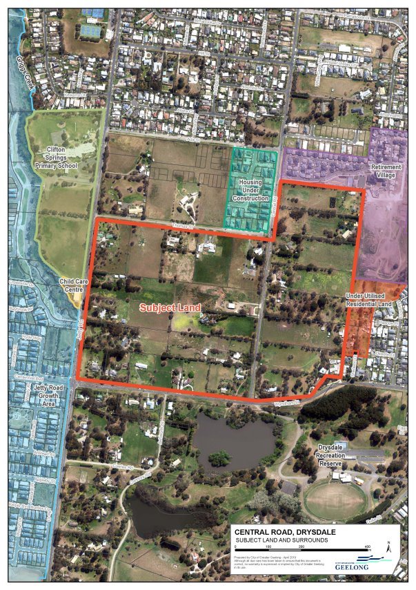
Strategic basis for the Amendment
When the City first informed landowners of the potential to rezone the subject land, it did so on the basis of clear strategic direction in the planning scheme. This area is located close to the Drysdale Town Centre, schools, local parks and community facilities.
Preparation and adoption of the Drysdale Clifton Springs Structure Plan in 2010 considered the subject land suitable for residential development. Pages 8-9 of the 2010 structure plan refers to the subject land as ‘Central Road’ and notes the area was originally identified for rezoning in the 1992 structure plan. The 2010 structure plan also states that land east of the Central Road properties should be integrated with the future development.
Following adoption of the Drysdale Clifton Springs Structure Plan 2010, Amendment C194 implemented the structure plan into the Planning Scheme at Clause 21.14. The clause designates Drysdale as one of three development hubs on the Bellarine for residential growth and service provision.
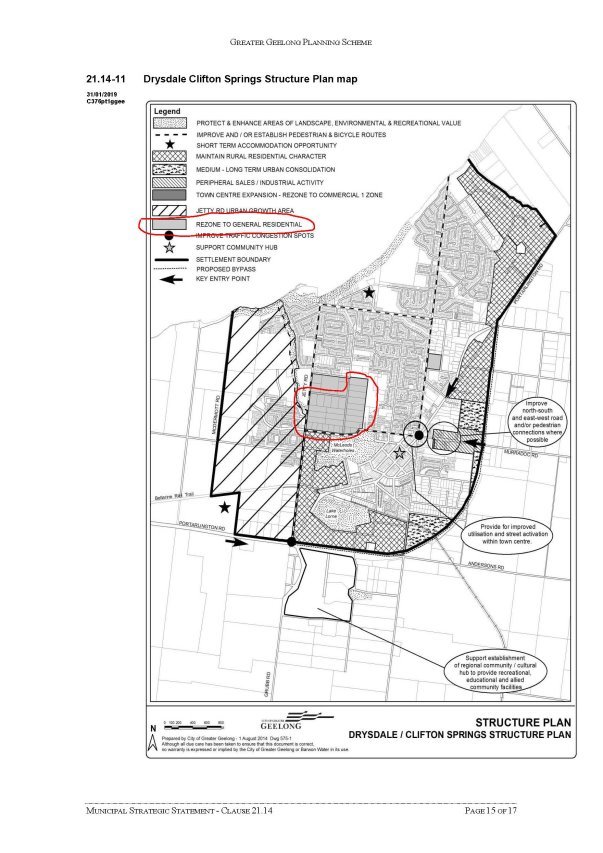
Clause 21.14 includes specific strategies for Drysdale including to contain urban development within the defined settlement boundary on the Drysdale Clifton Springs structure plan map at Clause 21.14-11. The map is copied at Attachment 4 showing the subject land as ‘rezone to general residential’.
The area directly north; bounded by Thomas Street, Jetty Road, Ada Street and Central Road, was rezoned from Rural Living Zone for residential development in 2010. Construction is currently underway. This area, together with the subject land, is designated in the Clause 21.14-11 map as ‘rezone to general residential’.
Drysdale Clifton Springs is also identified at a regional level as a district town where growth is supported (Clause 11.01-1R Settlement - Geelong G21). The role of district towns includes to provide for new housing within existing settlement boundaries. The recently adopted 2018 Settlement Strategy is consistent with this policy position.
Site constraints and opportunities
Prior to lodging the amendment request, the proponent commissioned a number of technical assessments to inform the future development layout. This work was undertaken in consultation with the City and officers provided direction on the type and location of infrastructure required.
Assessments were prepared for service infrastructure, stormwater drainage, public open space, traffic, bushfire hazard, native vegetation and fauna, planted trees and cultural heritage. The urban servicing investigations confirm that the subject land is able to efficiently connect to all necessary infrastructure (i.e. water, sewer, gas, electricity, drainage, roads and telecommunications).
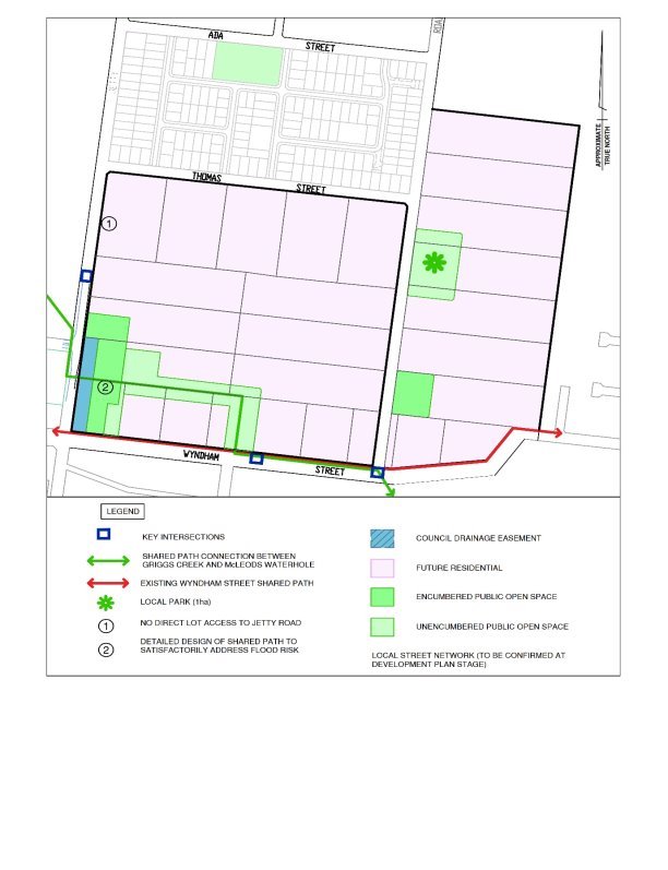
Based on this work the future development layout is intended to include the following features:
9.1 Dwelling yield of approximately 550 lots;
9.2 A one hectare park located on the east side of Central Road;
9.3 A strategic open space shared path link and co-located park through the subject land that will connect the Griggs Creek trail to the Drysdale Recreation Reserve. The crossing at Jetty Road will be signalised and there will be Wyndham Street improvements to allow safe crossing to the recreation reserve;
9.4 Retention of canopy trees with high arboricultural value in the public open space network;
9.5 New roads to intersect with Jetty Road and Wyndham Street, and the upgrade of the Central Road and Wyndham Street intersection; and
9.6 Two new drainage retardation basins.
Properties located at the south-west corner of the subject land are partly encumbered by a Council stormwater drainage easement. This area forms part of the principle waterway connection between McLeods Waterholes and Griggs Creek. Development of Wyndham Street land parcels will be dependent on full (ultimate) construction of the proposed Jetty Road drainage basin reserve.
There is no available road and drainage connection to the residential land east of the Central Road properties. Development of the subject land presents an opportunity to provide a connection and can be facilitated when the adjoining underutilised residential land is also redeveloped.
The cultural heritage due diligence included desktop and field assessments. The assessment finds that Aboriginal burials have been identified within similar landform types within 1km of the subject land and the site will need to be managed in accordance with the Aboriginal Heritage Act 2006.
A Cultural Heritage Management Plan (CHMP) prepared prior to development will be a mandatory requirement for the land close to McLeods Waterholes. The assessment recommends a CHMP covering the entire subject land should be considered by the proponent. While a request to rezone land does not trigger a requirement to prepare a CHMP, subdivision permits cannot be issued until the responsible authority receives an approved CHMP. Permits must also be consistent with any approved CHMP.
Amendment documents
The subject land is currently zoned for rural living. In order to permit conventional residential subdivision, it is proposed to rezone the subject land to the General Residential Zone Schedule 1. This zone is consistent with the surrounding developing estates in the Jetty Road Growth Area and between Ada Street and Thomas Street.
Directly north of the subject land is 91-101 Central Road, also applied with the Rural Living Zone. This property is currently under construction as part of the Bellarine Springs Retirement Village and should be rezoned. The property will not however be subject to other planning controls proposed as part of Amendment C363.
The area south of Wyndham Street will remain in the Rural Living Zone and Public Park and Recreation Zone (Drysdale Recreation Reserve) consistent with the directions of the Drysdale Clifton Springs Structure Plan.
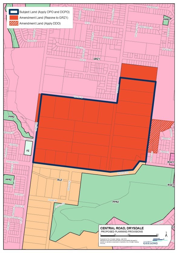
It is proposed to apply a Development Plan Overlay and Development Contributions Plan Overlay to the subject land. The map at Attachment 5 shows the land proposed to be applied with the overlay provisions and the land to be rezoned.
The purpose of a Development Plan Overlay is to identify areas which require the form and conditions of future use and development to be shown on a development plan before a planning permit can be granted. There are 24 individual owners that make up the subject land which means it is essential for development to occur in a planned and coordinated manner.
Once the subject land is rezoned and a development plan has been prepared to the satisfaction of the responsible authority, subsequent planning permit applications are exempt from the notice and review requirements of the Planning & Environment Act 1987. Planning Practice Note 23 (p.3) states: “Appropriate strategic planning and community consultation from the start also ensures that once the overlays are in place the council is able to make decisions on planning applications without the need to further consult”.
It is intended that the land owned by the proponent, and land that the proponent has agreement with other owners to develop, will be the first stage of construction and the planning provisions have been structured to allow for this to occur.
The proposed DCPO will include a framework plan map similar to that shown in Attachment 6.
The purpose of a DCPO is to identify areas which require the preparation of a development contributions plan for the purpose of levying contributions for the provision of works, services and facilities before development can commence.
In the past when rezoning similar, relatively small areas in fragmental land ownership, Council has tended to enter into section 173 agreements with individual owners to provide for shared infrastructure. Entering agreements with multiple owners is a time-consuming and uncertain process. It has therefore been decided that the use of the development contributions plan planning tool is the preferred approach.
The proposed DCPO is informed by the preparation of a draft DCP. The DCP will become an incorporated document in the planning scheme. The draft DCP lists the infrastructure items required to service the future residents, states timing of delivery and calculates a development contribution rate. The draft DCP is supported by a land valuation report and costings for road, drainage and open space infrastructure.
The specific details of the draft DCP are currently being resolved with the proponent. The timing of exhibition of Amendment C363 will be subject to finalising the draft document acceptable to Council officers.
In order to improve connectivity between the subject land and existing residential land to the east, it is proposed to apply a Design and Development Overlay to 1 Sheileen Court, 2-20 Sheileen Court and 23 Marsh Court, Drysdale (shown in Attachment 5). The purpose of a Design and Development Overlay is to identify areas which are affected by specific requirements relating to the design and built form of new development. In this instance, the overlay control will require any subdivision permit application to provide for a road reserve connection.
All amendment and supporting documentation will be exhibited and any affected or interested person may lodge a submission about the amendment.
Impacts on landowners
Attachment 1 includes a summary of the community engagement with directly affected owners. From previous engagement, the majority of landowners support the proposed amendment, though at least four owners were known to be in opposition when surveyed in December 2014.
Eight of the 28 properties are owned by land developers.
Landowners who continue to live on their property while development takes place on neighbouring land are likely to be subject to construction amenity impacts. These impacts would be mitigated by conditions on subdivision permits as would normally be expected in this situation.
It is important to note that should the proposed overlays be applied to the subject land, there is no automatic requirement for landowners to deliver works or pay levies or develop their land for housing. Owners can continue to reside on their property and undertake improvements or additions to their dwelling, outbuildings and gardens as they see fit. The overlays will only place statutory requirements when or if owners decide to seek permits for subdivision and or development for accommodation.
Owners who would seek to subdivide their property (for example, into two lots to retain an existing dwelling and sell a new lot) once the subject land is rezoned, can only apply after a development plan has been approved by the responsible authority.
Further fragmentation of the subject land will make coordinated development more difficult and would generally not be supported. It is likely that developers will acquire properties over time.
With regards to 1 Sheileen Court, 2-20 Sheileen Court and 23 Marsh Court, Drysdale, this part of the amendment has been instigated by the City.
The parcels at 2-20 Sheileen Court and 23 Marsh Court are owned by a land developer. It is noted that a planning permit application was lodged in 2008 seeking multi-lot residential subdivision of 1 Sheileen Court and 2-20 Sheileen Court. The application was ultimately withdrawn by the proponent as the proponent was unable to satisfactorily address drainage and road connection constraints.
Source: |
Community Life – Connected Communities |
Director: |
Robyn Stevens |
Portfolio: |
Leadership and Governance |
To note the first report to Council from the Youth Council Advisory Committee, including the 2019 Youth Council Advisory Committee Annual Plan and Protocols, meeting schedule for 2019 and date of the Geelong Youth Summit.
Twelve local young people have been elected to the new Greater Geelong City Council Youth Council Advisory Committee (Committee), and during their 12 month term will serve as the region's official 'youth voice'.
Aged between 12 and 16, the youth councillors represent a wide spread of local towns and suburbs, with three representatives from each of the four Council wards - Bellarine, Brownbill, Kardinia and Windermere.
Elected by members of youth advisory groups from within their wards, the youth councillors were successful from a total pool of 49 nominees.
The Committee will meet once a month at City Hall. The Junior Mayor will then present the group's findings and recommendations to Council on a quarterly basis.
A 2019 Youth Council Advisory Committee Annual Plan and Protocols (Annual Plan) – Attachment 2 – has been developed and was endorsed by the Committee at their meeting on 29 April 2019.
At the same meeting the Committee adopted their Youth Council Charter.
The Committee will meet each month.
Junior Mayor, Josie Horne, will present to Council four times during 2019 about the Committee’s findings and recommendations as set out in the annual plan. The Junior mayor’s presentation is included in – Attachment 3.
Key priorities, as set by the Committee in their annual plan, include mental health and wellbeing, community safety and homelessness, the environment and the 2019 youth summit.
The 2019 youth summit will be held on Saturday, 26 October 2019.
The 2019 youth survey questions will also be developed by the Committee and delivered through the City’s ‘Have your Say’ engagement platform.
Councillor Sullivan moved, Councillor Mansfield seconded -
That Council:
Note the first report to Council from the Youth Council Advisory Committee including the 2019 Youth Council Advisory Committee Annual Plan and Protocols;
Note the Youth Council Advisory Committee 2019 meeting schedule, including the presentation program to Council; and
Note a Youth Council Summit will be held on 26 October 2019.
Carried.
There are no significant budget implications resulting from the adoption of the Youth Council Advisory Committee’s annual plan.
The report adheres to Committee’s terms of reference. A range of community engagement activities will be delivered as part of the implementation of the action plan.
The Committee provides an opportunity for young people to contribute to and be included in civic life.
The proposal complies with the Committee’s terms of reference.
The key priorities outlined in the annual plan align with council plan priorities of:
5.1 Improved health and safety of our community – consult with the community on safety issues that are impacting them;
5.2 A more inclusive and diverse community – further developing programs that support young people in our community;
5.3 Effective environmental management – educating and assisting our community; and
5.4 Organisational leadership, strategy and governance – communicating and engaging with the community.
No City officers or contractors who have provided advice in relation to this report have declared a conflict of interest regarding the matter under consideration.
The Committee will provide advice to Council on specific issues relating to young people in our community.
There are no environmental implications.
Source: |
Customer & Corporate Services – Financial Services |
Director: |
Michael Dugina |
Portfolio: |
Finance |
To authorise the Chief Executive officer to commence the procurement process for the provision of a $26 million loan, and to accept or reject the lowest conforming tender and to authorise the Chief Executive Officer and Mayor to execute the necessary documentation to secure the loan.
Council adopted its 2018-2019 Budget on 26 June 2018. The budget provides for loan borrowings of $42 million.
Loan borrowings are timed based on working capital requirements and expenditure forecasts for each specific capital project.
A review of project cash flows by project has been completed and loan borrowing requirements for the 2019-2020 financial year identified to be $26 million.
The 2018-2019 budget included provisions for new borrowings of $42 million, including $27.1 million deferred borrowings from 2017-2018.
It is proposed that, based on project cash flow requirements, a loan tender for a $26 million loan be issued. A total of $6.4 million will be carried over in the 2019-2020 budget mainly due to retiming of Developer Contribution projects. A total of $9.6 million planned borrowings including Hendy Street Community Hub and Developer Contribution Plan projects have been deferred from 2018-2019 and may be reassessed in future budgets.
The 2018-2019 loan borrowing is sought for construction of community facilities, Developer Contribution Plan projects and other projects.
Tight timeframes apply to acceptance of loan borrowing tenders with financial institutions only holding quoted interest rates for a short period of time, requiring draw down within one week in some cases. This constraint prevents Council from having an opportunity to formally consider the tender prior to acceptance.
In accordance with the Council Borrowing Policy, authorisation is sought for the Chief Executive officer to commence a procurement process for a $26 million loan for a term of 10 years, with principal and fixed interest repayments. Authorisation is also sought for the Chief Executive Officer to accept the lowest conforming tender, and for the Mayor and Chief Executive Officer to sign and seal the necessary documentation to secure the $26 million loan (such documentation would include: Bank – Letter of Offer; Deed of Charge and Certificate in relation to Deed of Charge).
An updated report will be presented to Council to notify the final rate settlement agreed for the loan.
The revised loan borrowings will result in a loan balance as at 30 June 2019 of $65.6 million.
Councillor Murnane moved, Councillor Murrihy seconded -
That Council:
Authorise the procurement process for a $26 million principal and fixed interest loan for a term of 10 years;
Authorise to the Chief Executive Officer its powers and functions to accept or reject the lowest conforming tender for the provision of a $26 million loan; and
Authorise the Mayor and Chief Executive Officer to execute the necessary documentation to secure the loan.
Carried.
Table 1 summaries the forecast annual principal repayments, and loan balance amounts to 30 June 2019.
Year |
Opening loan Balance |
New Borrowings |
Principal Repayments |
Loan Balance |
2018-2019 |
48,677 |
26,022 |
(9,127) |
65,572 |
Table 2 summarises the planned loan borrowings relative to the original budget provision.
Project |
Budget borrowings 2018-2019 |
Carryover 2019-2020 |
Deferred Borrowings |
Borrowings 2018-2019 |
Highton enhanced early learning centre |
3,500 |
|
|
3,500 |
Leopold community hub stage 2 |
2,200 |
|
|
2,200 |
Rosewell community hub |
2,350 |
20 |
|
2,330 |
Drysdale Integrated children’s centre |
3,080 |
|
|
3,080 |
Cloverdale community centre |
2,000 |
|
|
2,000 |
Purnell Road CFC |
2,480 |
|
|
2,480 |
Armstrong Creek projects |
18,268 |
4,200 |
5,295 |
8,773 |
Other |
8,169 |
2,210 |
4,300 |
1,659 |
Total |
42,047 |
6,430 |
9,595 |
26,022 |
Financial performance indicators for loans & borrowings indicate that Council can be described as having low debt levels with significant capacity to increase debt levels into the future for significant infrastructure projects such as Civic Accommodation.
Indicator |
Greater Geelong |
Similar council comparison 2017-2018 |
Interest bearing loans / rate revenue |
28.85% |
30.01% |
Interest & principal repayments / rate revenue |
5.10% |
4.39% |
Non-current liabilities / own source revenue |
24.0% |
33.47% |
Provision for loan borrowings was communicated through the 2018-2019 budget process.
There are no social equity considerations associated with the acceptance of this tender.
The report is required to comply with Council’s Loan Borrowing Policy.
This report contributes to responsible and sustainable financial management as aligned to the council plan strategic objective ‘Innovative Finances and Technology’.
No officer involved in the preparation of this report has any direct or indirect conflict interest in the matters raised in this report.
There are no risks associated with the acceptance of this tender.
There are no environmental implications arising from the subject of this report.
Source: |
City Services - Environment and Waste |
Director: |
Guy Wilson-Browne |
Portfolio: |
Environment and Sustainability |
To seek Council approval to rename Stewarts Reserve in Armstrong Creek to Dooliebeal, the Wadawurrung Traditional Owner name for the site.
Council is responsible as a naming authority designated under the Local Government Act 1989 and is required to use the Naming Rules for Places in Victoria. The City is the Committee of Management for the reserve which is crown land (see map in Attachment 2: Stewarts Reserve Renaming Proposal - Frequently Asked Questions).
The proposed name, Dooliebeal, is a Wadawurrung word that references the river red gums found in the reserve and the Armstrong Creek valley more broadly. Dooliebeal was also the name the Stewart family, who settled the area in the 1850’s, called their homestead, which according to family history was in reference to Wadawurrung words used to describe the vegetation of the area. The Stewart name is proposed to be retained through the naming of the walkway through the reserve. An information brochure was prepared as part of the public consultation process (Attachment 2).
The proposed renaming will help build a greater understanding of Wadawurrung history and Geelong’s shared history.
Council adoption of the proposal as part of National Reconciliation Week is symbolic of our commitment towards meaningful and practical reconciliation between the broader community and all Aboriginal and Torres Strait Islander peoples.
Public notification of the proposal was carried out in accordance with the Naming Rules for Places in Victoria.
The proposed name change reflects the significance of the site to the traditional owners of the land, the Wadawurrung people. It also reflects the wishes of the Stewart family.
Eleven submissions were received. Ten strongly support the proposal and one proposed the alternate name of Red Gum Reserve.
A summary of submissions and the City’s responses is provided in Attachment 3.
Submissions were considered and Dooliebeal remains the preferred name.
The proposal will be submitted to Geographic Names Victoria for approval. If approved a new place name sign and interpretive sign will be erected and an official renaming ceremony held with the Wadawurrung traditional owners.
Councillor Mansfield moved, Councillor Mason seconded -
That Council approve the renaming of ‘Stewarts Reserve’ to ‘Dooliebeal’.
Carried.
The costs associated with this project include public notices, letters to adjoining property owners, consultation and design, the preparation of an information brochure and construction and installation of new signage. The City has set aside $10,000 to complete the brochure and signage.
Prior to the proposal being advertised, the City gained in principle support from the relevant key stakeholders.
The proposed name change has the support of the Wadawurrung Aboriginal Corporation as the Registered Aboriginal Party and Traditional Owners of this site. The City has signed a Wadawurrung Language Use Agreement for the use of the name Dooliebeal.
John Stewart, who is the great-great-grandson of the original land purchaser (John Stewart), has been consulted regarding the proposed change. As part of the public consultation process, another two descendants provided supporting submissions.
The Mount Duneed History Group and Progress Association were informed and were supportive of the name change subject to the Stewart name being retained in some way.
The City is proposing to retain the Stewart name by including it in the name of the walking path adjoining the reserve.
Consultation has been conducted in accordance with the ‘Naming rules for places in Victoria, statutory requirements for naming roads, features and localities –2016’ prepared by Geographic Names Victoria.
Letters were sent to all adjoining property owners advising them of the proposed renaming and inviting a submission.
The proposal was advertised via City News in the Geelong Indy and Geelong Advertiser on 8 March 2019 and 9 March 2019 and on the Geelong Australia website for 30 days.
Eleven submissions have been received. Ten submissions were in favour of the renaming and one submission proposed the alternate name of Red Gum Reserve for ease of use including by emergency services. A summary of submissions and City responses is provided in Attachment 3. Submitters received written acknowledgement and were advised of the Council meeting to consider the proposal.
Subject to the Registrar of Geographic Names approval, the relevant notifications about the renaming will be made.
Council has a responsibility to the community to ensure that all properties are able to be identified in a clear and logical manner for emergency services and visitors to the area. The proposed name will provide this.
The reserve is a former government road that was discontinued by the City under the provisions of the Local Government Act 1989. The land reverted to unreserved Crown Land and has subsequently been reserved for public purposes under the provisions of the Crown Land (Reserves) Act 1978 with the City appointed as Committee of Management.
The Local Government Act 1989, the Geographic Place Names Act 1998 and the Naming Rules for Places in Victoria have been followed. There is a street named Dooliebeal Avenue in Armstrong Creek, however this is not considered a duplication as a feature is not considered a duplicate with a road (under section 2.2 of the Naming Rules). This was confirmed with Geographic Names Victoria.
The reserve renaming to reflect traditional owner language is consistent with the City’s Municipal Heritage Strategy and Karreenga Aboriginal Action Plan which support initiatives for recognising and respecting Aboriginal culture and history and building positive relationships and respect between Aboriginal and non-Aboriginal people.
This proposal aligns with improved health and safety of our community (providing safer public spaces) and vibrant arts and culture (recognising and celebrating Geelong’s Aboriginal culture and history) council plan objectives.
There is no City officer direct or indirect interest involved in this report.
There are no notable risks arising from this report.
There are no environmental issues arising from this report.
Source: |
Economy, Investment & Attraction |
Director: |
Brett Luxford |
Portfolio: |
Social and Infrastructure Planning |
To seek Council endorsement for the Geelong Waterfront Safe Harbour Precinct Master Plan (Attachment 2) following the conclusion of the community consultation period.
The Royal Geelong Yacht Club (RGYC) have written to Council requesting that the Geelong Waterfront Safe Harbour Precinct Master Plan be endorsed by Council.
At the Community Focus Council Meeting on 12 March 2019, Council agreed to the public exhibition of the draft Master Plan for a period of 21 days to seek further stakeholder feedback.
The community feedback was generally supportive of the master plan. Key themes of the consultation have been addressed by changes to the master plan or will be considered in more detail during the next stage of design.
A comprehensive review of the master plan by the Department of Environment, Land, Water and Planning (DELWP) has provide guidance in the document for elements such as reclaiming of seabed area for the boat yard and public access around the site.
Endorsement of the master plan will enable Council and State Government funding for the project to be released to RGYC and allow the planning approval process to commence.
The $19.1 million stage one of the project will include the wave attenuator, new RGYC marina berths, Sailing School building and public realm improvements.
The implementation of the master plan will require a change to the existing lease of the RGYC.
Councillor Murrihy moved, Councillor Aitken seconded -
That Council:
Endorse the Geelong Waterfront Safe Harbour Project;
Delegate authority to the CEO to sign the $3 million funding agreement for Council’s contribution to the wave attenuator and public realm elements of the project including path upgrade to Eastern Beach Road;
Delegate authority to the CEO to enter into a new lease agreement with the Royal Geelong Yacht Club that includes a new seabed area for the Wave Attenuator and amendments to the existing land and seabed lease in general accordance with the Master Plan; and
Support the intervention by the Minister for Planning to amend the Greater Geelong Planning Scheme subject to Council being the responsible authority for secondary development approvals under the Incorporated Document.
Carried.
The RGYC have requested that Council release funding that has been budgeted for this project. The $ 3 million contribution sought from Council is accounted for in the 2019-2020 Strategic Resource Plan as a non-recurrent disbursement in December 2019 in accordance with previous resolutions of Council.
All financial risk and future operational costs with the project rests with RGYC. Changes to the public realm through the implementation of the master plan will be fully assessed before development occurs to ensure ongoing costs implications are known.
A review of RGYC lease rental will be undertaken to determine if any new income opportunities are realised to the City in response to the use of much improved facilities. Any rental increase is likely to be offset by ongoing maintenance of new public realm areas.
This project has received wide media attention which has been based on the master plan vision and design concepts. The RGYC has undertaken two rounds of community consultation including targeted stakeholder workshops for local residents, traders and club members. Results have revealed support for the project.
Following Council endorsement to release the draft master plan for a final period of community consultation, the master plan was available via the City’s ‘Have Your Say’ engagement platform with hard copies available via Council Customer Service Centre and mailed to 800 nearby land owners and occupiers.
The final period of consultation resulted in 30 responses. Overall the community responses were supportive of the master plan. A summary of the community feedback and responses is provided (Attachment 3 – Geelong Waterfront Safe Harbour Precinct Master Plan - Engagement Findings Report)
The key themes from the community consultation were:
7.1 Design elements to ensure that the development provides enhancement of the pedestrian experience; universal access; positive contribution to views and sightlines; and protection of surrounding waterfront heritage and character;
7.2 Traffic movement to ensure safe, convenient and efficient access for both vehicles and bicycles. Retention of commercial vehicle access to piers at Fisherman’s Basin;
7.3 Retention and expansion of commercial berthing facilities in Fisherman’s Basin for businesses should public piers like Stoney Pier be removed. Retaining the helicopter joy flight business at the waterfront; and
7.4 Maximising public access to the wave attenuator for recreational fishing and associated fishing facilities.
These key themes have been addressed by changes to the master plan or will be considered in more detail during the next stage of design. The establishment of a Design Advisory Committee will be used to consider the detailed design and make recommendations to the Project Control Group (PCG).
The changes to the master plan as a result of the public engagement feedback have been made in corroboration with RGYC, DELWP and Council staff.
Renegotiation of the RGYC lease is needed to amend the lease to include the seabed area for the wave attenuator and any realignment of land boundaries. Under the Local Government Act 1989 Council is required to provide public notice of its intention to enter into a new lease with RGYC.
The project provides new infrastructure supporting event growth and attraction. It will increase the use of the waterfront for public recreation and new community event opportunities.
The new Victorian Sailing School building will open new learn to sail programs for the public and enhance the existing RGYC Sailability program.
A new Changing Places Facility will form part of the new Victorian Sailing School building and will have managed access for the general public. Support for a Changing Places Facility in this location has strong backing from a wide range of community and reference groups and has been funded by the Department of Human Services.
The new wave attenuator will be effective in creating a safe harbour environment and suitable for public accessibility in accordance with Disability Discrimination Act 1992 (Cth) requirements.
A number of approvals are required to facilitate the proposal. These include a planning permit under the Planning and Environment Act 1987, Marine and Coastal Act 2018 consent, Heritage Victoria consent, and various secondary consents for works.
Following an assessment of the possible planning controls by Council and DELWP staff, an incorporated document under Clause 51.01 “Specific Sites and Exclusions” emerged as the most appropriate tool for the development, particularly as the development straddles two zones and is subject to planning scheme overlays. This would exempt the project from the usual planning scheme requirements and a planning permit would not be required.
Council will be required to endorse this approach to enable the RGYC to write to the Minister for Planning, seeking the Minister’s intervention under 20(4) of the Planning and Environment Act 1987.
The approach of a Ministerial amendment and use of the Incorporated Document will provide more certainty to the RGYC with regard to the timing of planning approvals. This type of approach is often taken with large, complex public and private sector developments. Under the normal planning permit process there is a chance of objections and lengthy delays at VCAT.
In lieu of a planning permit the incorporated document will include specific conditions and a requirement for further detailed plans to be submitted for approval by Council officers in consultation with other agencies.
The master plan has been refined in corroboration with DELWP to reflect the incorporated document approach. Principles and strategies within the master plan will inform the decision making process for future secondary approvals. A design advisory committee will be used to encourage excellence in siting and design to ensure the development provides a positive contribution to the area.
The footprint of the RGYC land and seabed lease boundaries will change with the development. The aim will be to minimise the footprint of new structures to prevent loss of open public space. Council in its role as land manager will negotiate the terms and conditions of the new lease. Responsibilities of RGYC and the City for the ongoing maintenance of new public realm areas will be detailed in the lease.
The project aligns with Council Plan 2018 – 2022: Growing Our Tourism and Events. The project is listed as a 2018-2019 aim to support the Geelong Waterfront Safe Harbour Precinct.
The project is also listed within the Central Geelong Action Plan and Revitalising Central Geelong State Action Plan
There are no conflicts of interest in relation to this report.
All financial risks rest with RGYC including the future operation and demand for marina services. The PCG will take responsibility to manage project risk to ensure that public realm improvements are achieved.
The tender and development steps of the project will be used to look at options to stage the work and provide the City with the opportunity to safeguard public assets and community use of the precinct.
A PCG, which includes all funding stakeholders, has been established to guide the development of the project. The PCG will continue to oversee the implementation of the project to ensure that the community benefit outcomes are achieved.
Environmental impact studies have commenced. The planning approval process will inform what final environmental reports are required.
The onshore components of the project essentially involve building new RGYC and Victorian Sailing School accommodation and facilities on the existing RGYC site. It is not expected that any significant incremental environmental impact would result from demolishing and rebuilding on the existing site, assuming that any incremental water, waste-water and sewage requirements are adequately managed. Rather, the redevelopment will provide the opportunity to upgrade and optimise the arrangements.
The on-water (marina) development is within or around the area of the existing marina, with the proposed wave attenuator along an alignment to the west of the site previously occupied by the Yarra Street Pier.
Energy consumption in the new facilities will be less due to appliance efficiency and through the communal use of facilities.
Later stages of the works may involve reclamation of seabed and the relocation of storm water outlets and the gross pollutant trap currently in the shallow water adjacent to the sailing school. Any future works must limit the amount of silt and rubbish being discharged and trapped along the shore-line. The Central Geelong Drainage and Flood Study does not provide direct advice in this matter and further investigations will be conducted to ensure improved environmental outcomes.
Any future reclamation of seabed areas will be subject to environmental effects studies and needs to be tested against net positive benefit to the community. Endorsement of the master plan does not commit Council to a particular view on this matter.
Councillor Murnance moved, Councillor Sullivan seconded -
That item 6. Community Investment Support Fund (CISF) 2018-2019 Round 2 Funding Recommendations be discussed in open Council.
Carried.
Source: |
Customer & Corporate Services - Program Integration & Development |
Director: |
Michael Dugina |
Portfolio: |
Finance |
To seek Council endorsement of the Community Investment Support Fund (CISF) Independent Assessment Panel Round 2 funding recommendations for the period 1 December 2018 to 18 February 2019.
The CISF grant programs are assessed by an independent assessment panel. The independent assessment panel present a summary of funding recommendations based on the Council endorsed framework, guidelines and terms of reference and specialist advice from relevant City officers to the Council for endorsement.
Initial funding recommendations for the 2018-2019 CISF grant programs were endorsed by Council on 27 November 2018. Three grant programs did not exhaust the available funds so a second round was conducted from 1 December 2018 to 18 February 2019 for:
3.1 Community Facilities Infrastructure Fund (CFIF) – Round 2 funding recommendations of $155,148;
3.2 Healthy & Connected Communities – Round 2 funding recommendations of $93,123; and
3.3 Major Heritage – Round 2 funding recommendations of $104,360.
Round 2 Independent Assessment Panel funding recommendations resulted in unallocated funds for all the programs – see Attachment 2 for summary and Attachment 3 report for details of funding recommendations (successful applicants).
Four applications to the CFIF were not assessed due to ineligibility because they were not on Council or Crown land. The recent endorsement by Council of the updated CISF Policy and Guidelines has the effect that these clubs will be eligible to apply for grant funding under the renamed Community Infrastructure Grants for 2019-2020, application period due to open in May. The organisations will be contacted by the City after final funding recommendations have been endorsed by Council to explain how to progress new applications for 2019-2020 Grant round.
Councillor Murnane moved, Councillor Murrihy seconded -
That Council:
Endorse the Community Investment and Support Fund Independent Assessment Panel Round 2 funding recommendations for 2018-2019 listed in Attachment 3 for period 1 December 2018 to 18 February 2019;
Commend and congratulate the community groups and organisations who have received funding under the Community Investment and Support Fund for their efforts and contribution to the Geelong community;
Endorse the carry-over of the Community Facilities Infrastructure Fund unallocated grant funds of $162,852 from FY 2018-2019 to FY 2019-2020; and
Recognise the efforts of the Independent Assessment Panel members.
Authorise the Chief Executive Officer to publicly communicate the Council’s decision.
Carried.
If the total budget allocation for the competitive grants programs listed in this report is still not fully expended after Round 2 the remaining funds may be carried over to 2019-2020.
Grant application open and closing dates were advertised.
Applications were made via the Smarty Grants website and City staff are available to help organisations experiencing difficulties with the website.
Independent assessment panel members are community members who followed an expression of interest process and were appointed based on experience and suitability.
All groups will be notified of the outcome of their grant application. The list of grant applications to be funded will be published on the Geelong Australia website.
Feedback will be provided to unsuccessful applicants with the aim to aid future grant applications.
Social equity issues were considered for all grant applications.
The provision of grants to the community supports local community organisations and endorses the aims of the Greater Geelong: A Clever and Creative Future vision.
The program was run in accordance with the Council’s Community Investment and Support Fund Policy.
The CISF aims to fund projects that assist in achieving goals and outcomes consistent with the strategic priorities of the Council Plan 2018-2022.
The grant guidelines provide details about the priority areas of each program. This is to ensure applicants are made aware of the aims of the program and to assist them in developing their proposals.
Grants are offered to assist community organisations to provide opportunities that benefit the wider Geelong community. This aligns with the council plan strategic priority of “A More Inclusive and Diverse Community” where one of the aims of 2018-2019 is to “provide a grants scheme to fund community groups, and initiatives that promote inclusion and accessibility”.
The provision of grants is carried out in accordance with the Local Government Act 1989 consideration of officer direct or indirect interest.
The CISF assessment process records any conflict of interest relating to each grant application that is assessed.
The CISF is governed in accordance with the City’s monitoring, reporting and accountability framework.
Successful applicants are provided with an acquittal and evaluation form for their completion and return to the City as a record of the outcome of the grant funding they received. Audits are carried out on a periodic basis.
Some of the projects supported via the CISF undertake environmental activities.
Grant Fund Stream |
Fund Pool 18/19 |
Fund Pool |
Value of Funding Requests |
Total Value of Funding Recommendations |
Balance available in Grant Fund |
Number of Applications |
Number of Applications Funded in Full |
Number of Applications Partially Funded |
Number of Applications Unsuccessful |
Number of Applications Ineligible under Guidelines |
|
|
ROUND 2 |
ROUND 2 |
ROUND 2 |
ROUND 2 |
ROUND 2 |
ROUND 2 |
ROUND 2 |
ROUND 2 |
ROUND 2 |
CISF Major Heritage |
$200,000 |
$171,250 |
$227,949 |
$104,360 |
$66,890 |
7 |
0 |
4 |
0 |
3 |
CISF Healthy & Connected Communities |
$243,000 |
$100,463 |
$214,443 |
$93,123 |
$7,340 |
64 |
26 |
7 |
20 |
11 |
TOTAL |
$713,000 |
$271,713 |
$442,392 |
$197,483 |
$74,230 |
71 |
26 |
11 |
20 |
14 |
Guideline requirement that Applicant fund one third of the project or apply for Financial Hardship exemption and the City fund full project.
|
Fund Pool 18/19 |
Fund Pool |
Value of Funding Requests |
Total Value of Funding Recommendations |
Balance available in Grant Fund |
Number of Applications |
Number of Applications Funded in Full |
Number of Applications Partially Funded |
Number of Applications Unsuccessful |
Number of Applications Ineligible under Guidelines |
|
|
ROUND 2 |
ROUND 2 |
ROUND 2 |
ROUND 2 |
ROUND 2 |
ROUND 2 |
ROUND 2 |
ROUND 2 |
ROUND 2 |
CISF Community Facilities Infrastructure Fund (CFIF) |
$1,000,000 |
$318,011 |
$2,467,624 |
$155,148 |
$162,863 |
22 |
6 |
1 |
4 |
11 |
TOTAL |
$1,000,000 |
$318,011 |
$2,467,624 |
$155,148 |
$162,863 |
22 |
6 |
1 |
4 |
11 |
Source: |
City Services |
Director: |
Guy Wilson-Browne |
Portfolio: |
Environment and Sustainability |
Councillor Murnane moved, Councillor Asher seconded -
That in accordance with Section 89 (2)(d) and (f) of the Local Government Act 1989, this report which relates to contractual matters and legal advice be considered at the conclusion of all other business at which time the meeting be closed to members of the public.
Carried.
Contents | Previous Page: Section A - Procedural Matters | Next Page: Section C - Assembly of Councillors
