
Reports tabled at the Community Focus Council Meeting of Council on Tuesday 10 September 2019, held at the Armstrong Creek Community Centre, 46-70 Central Boulevard, Armstrong Creek.
Amendment C401 – Community Care Accommodation, 120 Russell’s Road Mt Duneed – Resolution to Exhibit
Revocation of Flood-Prone Area Designation of New Lots at Anchoridge Estate, Stages 1, 2 And 3
Revocation of Flood-Prone Area Designation of New Lots at Ashbury Estate, Stage 13
Source: |
Customer & Corporate Services – Financial Services |
Director: |
Michael Dugina |
Portfolio: |
Finance |
To approve “in principle” the audited Financial Statements and Performance Statement and authorise two Councillors to certify the statements.
Under Section 131 of the Local Government Act 1989 (Act), in each financial year Council must prepare an annual report that includes audited financial statements and a performance statement for the financial year. These statements must be prepared in the prescribed manner and form and be certified by the City’s external auditor. The City’s current external auditor is the Victorian Auditor General’s Office (VAGO).
The City’s Audit and Risk Committee have responsibility to:
Review the annual financial report and performance statement and consider whether they are complete, consistent with information known to committee members and reflects appropriate accounting treatments; and
Recommend the adoption of the annual financial report and performance statement to Council.
Under section 132 of the LGA, Council is required to approve “in principle” the statements prior to receiving final certification from the Auditor General. Council’s approval requires nominating two Councillors to certify those statements, together with Chief Executive Officer and Principal Accounting officer, and to lodge these statements with the Auditor General.
The 2018-2019 Financial Statement of Accounts (Attachment 3) and Performance Statement (Attachment 4) have been prepared by the City and reviewed by the VAGO. These statements have been prepared in accordance with Australian equivalents to International Financial Reporting Standards.
A final closing audit report and final management letter has been received from VAGO. An issue in respect to the timing of receipt of developer contributed assets was identified during the preparation of the financial statements, and following work done by the City, a material adjustment has been made to the financial statements. VAGO has concluded that the statements are presented fairly and has, in principle, given its clearance of the statements.
The Audit and Risk Committee met on 21 August 2019 to consider the Annual Financial Report and the External Audit results. The Committee endorsed the 2018-2019 draft Financial Statements and Performance Statement subject to resolution of any outstanding audit issues with any material changes to be notified to the Audit and Risk committee chairman.
The 2018-2019 financial statement of accounts highlight:
A satisfactory period of operation with a $125.3 million surplus, high closing cash balances of $106 million and significant asset growth to $2.5 billion;
An overall spend of $485.9 million , including operating expenditure $361.4 million and capital expenditure $124.5 million. The Comprehensive Income Statement highlights a surplus for the year of $125.3 million plus $31 million roads and footpaths revaluation increment for a total comprehensive result of $156.3 million;
$10.7 million for early receipt of 50% Victorian Financial Assistance Grants funding for 2019-2020; and
Debt levels increased during the year from $48.7 million to $65.8 million with $26 million of new loans and $8.8 million repayment of borrowings.
The completion of the annual financial statements has indicated that the Council is in a sound financial position to meeting its obligations going forward.
Councillor Murnane moved, Councillor Murrihy seconded -
That Council:
Give approval in principle to the “2018-2019 Financial Statements” (Attachment 3) and the “Performance Statement” (Attachment 4); and
Authorise two Councillors, being the Mayor, Councillor B Harwood and Councillor P Murnane, to certify the Statements subject to any changes recommended and agreed with the Auditor General.
Carried.
As detailed within accompanying Financial Statements – refer Attachment 4.
The Financial Statement of Accounts and the Performance Statement will be available to the public as part of the published Annual report and accessible via www.geelongaustralia.com.au.
The prescribed indicators and measures of service performance outcome, financial performance and sustainable capacity as per section 131(3) and 131(4) of the Act will also be available on the State Government ‘Know Your Council’ website from November 2019.
Incomes and expenditures on the City’s social equity programs are included in the Financial Statements.
Under Section 131 of the Act a Council must in respect of each year prepare an Annual Report, which includes audited financial statements for the financial year.
Under Section 131 a Council must not submit the financial statements to its auditors or the Minister unless it has passed a resolution giving approval “in Principle” to the statements.
Under Section 131 a Council must authorise two Councillors to certify the statements in their final form after any changes recommended, or agreed to with the auditor.
The actions outlined in this report are aimed at complying with the requirements of the Act.
The financial statements and the performance statement highlight that 2018-2019 City operations have been managed in a responsible manner. The results contribute to responsible and sustainable financial management as aligned in the Council Plan strategic objective ‘Innovative Finances and Technology.
The City’s officers preparing this report have no direct or indirect interest.
The statements are released as a draft and are still subject to being signed off by the Auditor General.
Incomes and expenditures on the City’s environmental preservation and enhancement programs are included in the financial statements.
The Financial Statement of Accounts 2018-2019 (refer Attachment 3) record a satisfactory period of operation with a favourable operating surplus, high closing cash balances and significant asset growth.
The $125.3 million surplus result was ($55.4 million) favourable to adopted Budget and included the following favourable and unfavourable income and expenditure items (refer Note 1.1 – Attachment 3).
Main variances are as follows:
|
Budget 2019 |
Actual 2019 |
Variance |
INCOME |
|
|
|
Rates and charges |
238,297 |
230,942 |
(7,355) |
Statutory fees and fines |
13,434 |
14,457 |
(1,023) |
User fees |
55,005 |
63,934 |
8,929 |
Grants - operating |
43,135 |
58,139 |
15,004 |
Grants - capital |
21,157 |
20,244 |
(913) |
Contributions - monetary |
4,813 |
6,702 |
1,889 |
Contributions - non monetary |
45,000 |
85,905 |
40,905 |
Share of net profits/(losses) of associates and joint ventures |
0 |
(337) |
(337) |
Other income |
6,610 |
8,476 |
1,866 |
Total Income |
427,450 |
488,462 |
61,012 |
EXPENSES |
|
|
|
Employee Costs |
154,817 |
154,592 |
225 |
Materials & Services |
105,170 |
107,527 |
(2,357) |
Bad & Doubtful Debts |
900 |
2,432 |
(1,532) |
Depreciation & Amortisation |
62,893 |
65,951 |
(3,058) |
Borrowing Costs |
2,893 |
1897 |
996 |
Net (gain)/loss on disposal of property, infrastructure, plant and equipment |
3,052 |
2,005 |
1,047 |
Other expenses |
27,873 |
28,774 |
(901) |
Total Expenses |
357,598 |
363,178 |
(5,580) |
Surplus/(Deficit) for the year |
69,852 |
125,284 |
55,432 |
Grants Commission 2019-2020 50% received in June 2019 ($10.7 million favourable). Budget had been adjusted for payment of 50% of 2018-2019 being received in 2017-2018.
Additional fees were received for Commercial waste disposal $1.6 million and subdivision design fees $1.4 million.
Early receipt of Community Infrastructure levies for St Leonards growth area, Armstrong Creek and Ocean Grove $2.1 million.
Increased Subdivision assets $33.1 million and recognition of open space $7.1 million.
Other income $1.9 million favourable with additional Interest received $0.1m, and unbudgeted program funds received for, Greenhouse reduction program, Central Geelong Activity Area Pedestrian Network and Road Trauma Public Art Memorial.
Bad & Doubtful debts ($1.5 million) unfavourable due to increase in provision for Infringement debtors – mainly parking infringements and provision for rectification works on the Belcher building.
Borrowing costs $1.0 million favourable with deferral and cancellation of loan borrowings.
Increased proceeds received for assets disposed of during the year.
Depreciation and Amortisation ($3.1m) unfavourable due to the unbudgeted increase in non-monetary assets received from developers.
The Balance Sheet shows that Council has a very strong asset position with over $2.5 billion worth of assets that are used to provide services to the community.
Current Assets are $127m which has increased during the year due to the favourable cash balance.
Current liabilities are $81.6m which is predominately leave provisions and trade payables and non-current liabilities are $75.9 which has increased due to the drawing down of a loan in 2018-2019.
Total loan balance has increased from $48.7m to $65.8 million.
Council’s cash position at the end of the year is $105.5m, which is a slight increase from the opening balance.
The cash balance will provide funds to complete Capital and Non Capital projects carried over from 2018-2019 and working capital to ensure service provision continues at the same levels in 2019-2020.
Council has an extensive capital works program to renew, upgrade and provide new assets to ensure the continuation and improvement of services provided to the community. Council spent $124.5m on capital works in 2018-2019 and included the following highlights:
|
Actual $ million |
Road Replacement and construction |
20.1 |
DCP - ACEP - NAC Community Complex |
10.1 |
Drainage Replacement and Construction |
8.7 |
Plant and Vehicles |
8.7 |
DCP - HBP - Sparrovale Wetlands DI_LA_23 |
7.8 |
Purnell Rd CFC |
7.7 |
Footpaths & Bikepaths |
5.2 |
Drysdale Integrated Children and Family Centre |
4.1 |
Highton Family Hub |
3.8 |
Leopold Community Hub Stage 2 |
3.4 |
Rosewall Neighbourhood Centre - Detailed Design |
3.1 |
DCP - Armstrong Creek Town Centre - Community Facilities Site |
3.0 |
Computers & Telecommunications |
2.2 |
DCP - ACEP - NAC Community Pavilion |
2.2 |
Cloverdale Community Centre |
2.0 |
Drysdale Landfill - Leachate Management |
1.6 |
Drysdale Landfill Cell 5 |
1.5 |
Goldsworthy Reserve Track Renewal |
1.3 |
Northern ARC Detailed Design |
1.2 |
Building Renewal Works |
1.2 |
DCP - HBP - Sparrovale Wetlands DI_LA_22 |
1.1 |
Civic Accommodation Project |
1.0 |
Stead Park Softball Pavilion Upgrade |
1.0 |
Winter Reserve Changeroom Upgrade |
0.9 |
Lara United Soccer Club Female Change Facility |
0.9 |
Toilet Block Renewal / Replacement Program |
0.8 |
Anakie Reserve Facility Upgrade |
0.8 |
Drysdale Integrated Children’s & Family Centre |
0.7 |
DCP – ACWP – Acquisition Drainage Reserve |
0.7 |
Purnell Rd CFC |
0.6 |
Council is required to prepare and include a performance statement (refer Attachment 4) within its annual report. The performance statement includes the results of the prescribed sustainable capacity, service performance and financial performance indicators and measures together with a description of the municipal district and an explanation of material variations in the results. This statement has been prepared to meet the requirements of the Act and Local Government (Planning and Reporting) Regulations 2014.
A Governance and Management checklist has been completed for 2018-2019. The results in the prescribed form represent Councils assessment against the prescribed Governance and Management checklist as at 30 June 2019.
Where applicable the results in the performance statement have been prepared on accounting bases consistent with those reported in the Financial Statements. The other results are based on information drawn from Council information systems or from third parties (e.g. Australian Bureau of Statistics).
The performance statement presents the actual results for the current year and for the prescribed financial performance indicators and measures, the results forecast by the Council’s Strategic Resource Plan. The forecast figures included in the performance statement are those adopted by Council in its Strategic Resource Plan on 25 June 2019 and which forms part of the Council plan. The results for 2018-2019 are consistent with the results from the previous year.
The Performance Statement results and the Service Performance Indicators prescribed under the Local Government Performance Reporting Framework will be reported on the ‘Know Your Council’ website (www.knowyourcouncil.vic.gov.au).
In accordance with the requirements of Section 132 of the Act the nominated Principal Accounting Officer of Council, two Councillors and the Chief Executive Officer are required to sign the Performance Statement. The Governance & Management checklist is required to be signed by Chief Executive Officer and The Mayor to represent the status of Council’s Governance and Management arrangements.
The external audit, conducted by the Victorian Auditor General’s Office (VAGO), was completed on Friday, 16 August 2019 as per the audit plan. A closing report summarising the Audit findings and a Final management letter has been reviewed by the Audit & Risk Committee.
Councillor Sullivan declared a Conflict of Interest by a close association in Agenda Item 2 Amendment GC104 – Proposed Train Stabling and Maintenance Facility at 255 Reservoir Road, Waurn Ponds, in that his partner’s family owns an adjoining property and left the meeting room prior to discussion at 7:45pm.
Source: |
Planning, Design & Development – Strategic Implementation |
Director: |
Gareth Smith |
Portfolio: |
Planning |
To seek Council support for a submission to be made to the State Government’s Amendment GC104 for a Train Stabling and Maintenance Facility at Waurn Ponds.
Rail Projects Victoria (RPV) has lodged a request with the Minister for Planning to change the Greater Geelong Planning Scheme to facilitate the Waurn Ponds Train Maintenance and Stabling Facility (the project).
The Minister has decided to become the Planning Authority for the amendment (GC104) which requires changes to both the Greater Geelong and Surf Coast planning schemes.
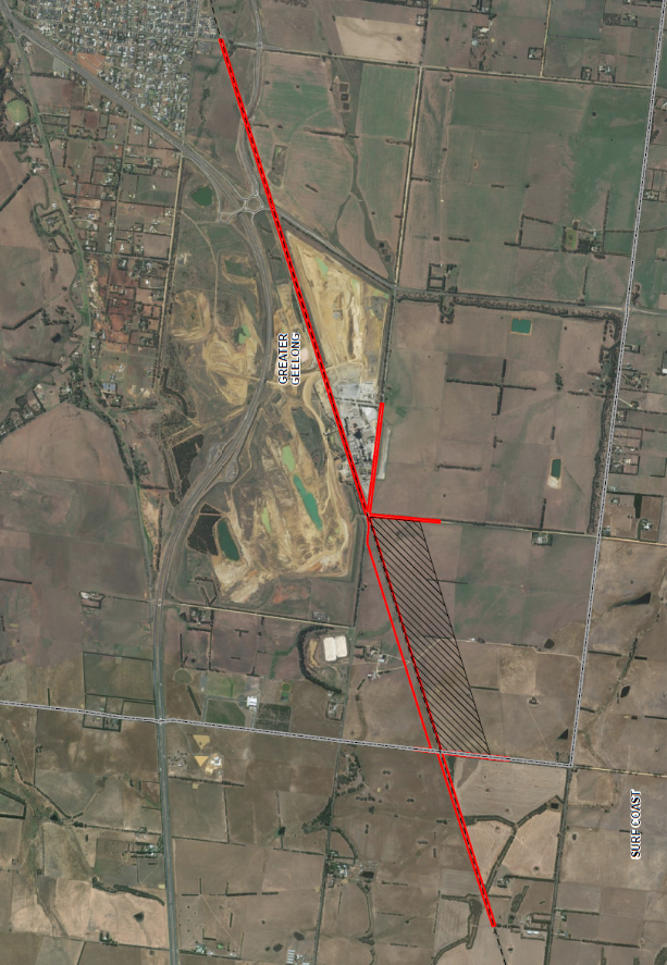
The site is located at the edge of the Greater Geelong municipality and just west of the Boral quarry land on Reservoir Road (see map in Attachment 2).
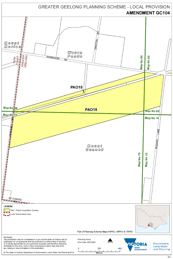
The main aspect of GC104 is a Public Acquisition Overlay (PAO) to be applied to privately owned farming land at 255 Reservoir Road, Waurn Ponds. This would allow compulsory acquisition of the land so it can be developed for the facility (see PAO map in Attachment 3).
The land proposed for acquisition is in the order of 60 hectares and divides the farm in two with the house, sheds and other facilities being split from the main sheep farm paddocks.
The Minister for Planning has referred the proposal to the Government Land Standing Advisory Committee for consideration and to provide recommendations on the suitability of the proposed planning scheme changes.
GC104 is on public exhibition until 16 September 2019 and an Advisory Committee hearing is scheduled in October 2019.
A submission has been drafted (Attachment 4), with key comments including:
Recognition and support of the need for a train stabling and maintenance facility west of the Waurn Ponds Railway Station. This will provide the ability for the State Government to improve train services on the Geelong line to meet the growing population needs.
A request for an assessment of all potential site options to be made publicly available as part of the amendment process.
The impact on the private farm and the family that own and operate the farm at 255 Reservoir Road, Waurn Ponds is significant.
The proposed acquisition, development and use of the facility (24 hours, 7 days a week) will affect the amenity and ongoing operation of the affected farm.
Request for RPV to take all efforts to minimise the impact on the local community including potential off-site acoustic, light spill and visual amenity impacts.
The visual impact of Stage 2 has been underestimated, with the southern edge of the Stage 2 land ‘platform’ sitting up to a height of eight metres above existing ground level. This will change the topography of the area and potentially have a significant visual impact.
Comments are also provided on planning matters and specialist transport impact, ecological, noise and stormwater management reports.
Subject to Council endorsement, the submission will be lodged and the City will present the issues to the Advisory Committee hearing in October.
Councillor Nelson moved, Councillor Mason seconded -
That Council endorse a submission to Amendment GC104 - Waurn Ponds Train Maintenance and Stabling Facility being made by the City generally as outlined in Attachment 4, and request the following:
Expansion of the Advisory Committee Terms of Reference to review all available site options for the facility;
Further public notification and exhibition of a report on alternative site options and extend the period for public submissions; and
Deferral of the Advisory Committee Hearing scheduled for October 2019 to allow the above to occur.
Carried.
There are no financial implications to Council as a result of this report.
This is a State Government project and is currently going through a public exhibition process.
The proposal will have social impacts but is not considered to relate to any particular social equity considerations.
Planning policy has been outlined in the planning report prepared by government appointed consultants. In general, the proposal is considered to be policy neutral.
This is a State Government project and aligns to Council Plan Priority 7- Integrated Transport Connections including “advocating to improve rail, road and sea connections for our region”.
No City officers involved in the preparation of this report have any direct or indirect interest in the matter to which this report relates.
The draft submission in Attachment 4 highlights the potential risks associated with the amendment and the consequences of acquiring the land and constructing the facility.
Environmental impacts have been assessed in a specialist report. Comments on environmental matters are provided in the draft submission in Attachment 4.
City of Greater Geelong Submission to Amendment GC104
Waurn Ponds Train Stabling and Maintenance Facility
To: Government Land Standing Advisory Committee
Dear Sir/Madam
The City of Greater Geelong provides the following submission to Amendment GC104. This submission was endorsed by Council at its meeting of 10 September 2019.
Overall comments
The City recognises and supports the need for a train stabling and maintenance facility west of the Waurn Ponds Railway Station. As outlined in the documentation supporting the amendment this will provide the ability for the State Government to improve train services on the Geelong line. Such improvements are needed to meet the growing population of the Geelong region.
The City requests that an assessment of all potential site options is made publicly available as part of the amendment process. This would provide transparency and stakeholders would be able to see the pros and cons of various sites and how they perform against the selection criteria.
The impact on the private farm and the family that own and operate the farm at 255 Reservoir Road is significant. While the impacts of Stage 1 (11 hectares and stabling of 6 trains) may be acceptable and manageable the large area and operation of Stage 2 (an additional 50 hectares and more than 20 trains stabled) needs to be carefully considered.
The proposed Public Acquisition Overlay (PAO15) will allow the compulsory acquisition of a very large area of land which would split the private farm in two. The total PAO area is approximately 61 hectares. This includes a strip of land 50 metres north of the rail corridor for the full width of the property, and the area to the south of the rail corridor, which is 350 metres south and at a length of approximately 1,720 metres.
The City considers the proposed acquisition, development and use of the facility (24 hours, 7 days a week) will affect the amenity and ongoing operation of the farm given that it separates the farm house, sheds and other buildings from the main sheep paddocks.
The City encourages Rail Projects Victoria to take all efforts to minimise the impact on the local community including potential off-site acoustic, light spill and visual amenity impacts.
The City believes the visual impact of Stage 2 has been underestimated. Stage 2 requires a large amount of cut and fill and terracing over a 350 metres wide by 1720 metres long area. The documentation in support of the proposal refers to the southern edge of the Stage 2 land ‘platform’ sitting up to a height of eight metres above existing ground level. This will change the topography of the area and potentially have a significant visual impact.
From a planning perspective it is noted that the proposal is not specifically mentioned in State or Local policy in the Greater Geelong Planning Scheme.
Indirectly if the project is to improve train services this will assist servicing the growth of Geelong which has support in various state, regional and local policies. The City’s current position on growth across Greater Geelong is outlined in the Settlement Strategy (October 2018) which currently being implemented into the scheme via Amendment C395ggee.
The City’s strategic planning approach is to manage growth within defined areas and minimise impacts on rural land where possible. Local policies such as Clause 22.64 (Discretionary Uses in Rural Areas) discourage non rural uses in rural areas particularly where they impact on agriculture. Hence, a negative aspect of this proposed site for the train stabling facility is that it’s an operating farm and outside the urbanised part of the municipality. The proposal will impact on the rural setting and amenity and all effort needs to be taken to carefully analyse and minimise the impact.
The City has had limited time to properly review the planning report and specialist investigations. Some initial comments are provided below and may be expanded upon at the Advisory Committee Hearing in October.
Comments on specialist investigations
The following specialist investigations have been undertaken over several years to inform the Project:
Agricultural Impact Assessment
Bushfire Assessment and Development Report
Cultural and Historic Heritage
Ecological Assessment - Biodiversity Assessment and Ecological Assessment - Growling Grass Frog Study
Geotechnical Investigations
Landscape and Visual Impact Assessment
Lighting Design Requirements and Recommendations
Noise Assessment
Social Impact Assessment
Stormwater Management Plan
Transport Impact Assessment
In 2016 at the request of Public Transport Victoria (PTV), the City provided input into the potential scope of the technical/specialist reports. However, it is not until now, 3 years later that the City has had the opportunity to review any technical information.
Unfortunately there is a very tight timeframe for officers to prepare a report on this proposal and get it to a Council meeting before the closing date for submissions. As a result only a brief review of the reports has been undertaken. Further assessment is proposed between now and the Advisory Committee meeting in October.
The following technical comments are provided on a limited number of specialist investigations that were exhibited with Amendment GC104.
Traffic Impact Assessment (Onemilegrid 12 June 2019)
The Transport Impact Assessment (TIA) has a chapter on ‘recommended road upgrades’ (Chapter 9). It states that it is considered appropriate to upgrade (seal) Bogans Lane from Reservoir Rd to at least 50 m to the south of the proposed access road to the rail stabling site.
This construction of Bogans Lane must be a requirement, and must be upgraded to include full depth asphalt and a width of 6.0 m prior to all construction works occurring on-site.
No mention is made of upgrade works to Reservoir Rd. Reservoir Rd consists of a basic spray seal west of the asphalt seal at Gate 4 (Boral). There is an approximate length of 240 m and the road is 5.5 m wide.
It must be a requirement that Reservoir Rd between Gate 4 and Bogans Lane is upgraded to include full depth asphalt and a width of 6.0 m. This work could be completed immediately after on-site construction works are completed and before the use begins.
There are numerous other sections of Reservoir Rd up to Anglesea Rd that are in poor condition. These are a council responsibility, however we would believe the proponent should contribute to the repair/upgrade of the road.
The section of Anglesea Rd from Reservoir Rd (including the Reservoir Rd intersection) to approximately 420 m north is in poor condition. This is a VicRoads responsibility, however the question is whether the proponent could contribute to the repair/upgrade of the road (i.e. if repair work is not completed by the time Stage 1 is in operation).
A streetlight with a minimum 150 W High Pressure Sodium (or LED equivalent) is required at the Reservoir Rd/Bogans Lane intersections and at the Bogans Lane/access road intersection.
The Reservoir Rd/Bogans Lane and Bogans Lane/access road intersections will have to be designed to accommodate a B double trucks.
The operator of the stabling yard will have to apply to the National Heavy Vehicle Regulator (NHVR) to use Bogans Lane for B double use up to the access road.
No construction access will be permitted from Pettavel Rd for Stage 1. For Stage 2, this will need to be reviewed at the time.
No construction traffic will be permitted to use Bogans Lane between the site access and Mt Duneed Rd.
If, at some point in the future Reservoir Rd is truncated by Boral to begin extraction works on the southern side, Bogans Lane will have to be constructed to Mt Duneed Rd.
An appropriate haul road will have to be constructed on-site with the Bogans Lane access road as the sole access point.
If an access to Pettavel Rd is permitted, then the proposed ‘alternative route’ must be amended to use Pettavel Rd to Mt Duneed Rd, and Mt Duneed Rd to Anglesea Rd. The route to the Princes Hwy will not be permitted.
Traffic Impacts
The road construction works at the Reservoir Rd/Bogans Lane intersection will need to consider where westbound traffic must stop when the boom gates are down. At present, one to two stopped vehicles block the intersection. ‘Keep Clear’ linemarking will have to be considered.
The low traffic volumes on Reservoir Rd and the additional frequency of the boom gates in operation is not seen as having much impact on the road at all, however the 60 second operation time of the boom gates for a departing trains seems quite long.
The TIA does not provide an assessment of the impact to the at grade rail crossing in Ghazeepore Rd. Traffic volumes at the level crossing in Ghazeepore Rd are running up to 7000 veh/day. At present this crossing is in operation eight times per day Monday to Friday, and six times per day Saturday and Sunday. An assessment must be completed to show the impacts to Ghazeepore Rd during Stage 1 of the stabling yard operation, and for Stage 2, and to allow for traffic growth.
The traffic impacts at the Anglesea Rd/Reservoir Rd intersection may be impacted by the ever increasing volumes on Anglesea Rd. The traffic generated by the stabling yards will be small; Boral is generating less traffic than it used to so the added volumes will only approach the volumes seen in the past.
VicRoads had some intentions of duplicating Anglesea Rd between the ring road works and Mt Duneed Rd. These plans appear to have been put on the backburner and may not occur for many years.
Environment related comments on traffic report
The only item of concern in this traffic assessment is the proposal to potentially use Pettavel Road as alternate access/egress during the construction period. To prevent any potential impacts to vegetation on this road, construction access along this road should be avoided. Construction access would require significant pruning/lopping of the existing tree canopy.
Ecological Assessment (AECOM June 2019)
The City considers the assessment is a good overall review of ecological values within the project area, but acknowledges limitations within the report (the subject land within 255 Reservoir Road was not accessible, and the report relies on desktop assessment and modelling) and recommends additional work is done prior to the project moving forward. In the absence of detailed designs for the stabling facility, AECOM have assumed that all native vegetation will be impacted in the footprint of the proposal, this means that impacts are likely to be less than what is highlighted. The report recommends the following:
Consideration should be given to the ‘avoid and minimise’ principles as detailed in the Guidelines (DELWP, 2017a).
A Native Vegetation Removal report should be prepared by DELWP following the finalisation of the extent of necessary removals.
Preparation of the following documents and management plans to minimise impacts to the environment:
A CEMP: ecological and environmental impacts during the construction of the project can be controlled and minimised through the preparation of a CEMP. The CEMP should include provision for a qualified zoologist to be available during vegetation clearance to salvage and translocate fauna species impacted by clearance activities (in line with the requirements of the Wildlife Act), measures to protect water quality, management measures in relation to listed weeds and pests (in line with the requirements of the CaLP act), and measures to protect native vegetation and fauna habitat to be retained (such as the installation of fencing around the designated No Go areas).
Offset strategy: An offset strategy to be developed to address applicable offset requirements under the P and E Act.
There is the potential for the works to encroach into the tree protection zones of trees located on neighbouring properties. Potential impacts to these trees should be assessed by a suitably qualified arboricultural consultant following detailed design. If required, a tree management plan will be prepared for the project land.
Areas of private land not previously assessed by AECOM or EHP should be subject to a detailed vegetation assessment during the ideal Summer/Spring survey period to validate the modelled vegetation quality and extent.
Council officer agrees with these recommendations, but recommends that the following should also be included:
A weed management plan for the project land which provides for ongoing weed management in addition to what is prescribed in the CEMP. The AECOM report identified a number of listed and high threat weeds which need to be controlled.
A targeted survey for the Western Burrowing Crayfish (Engageus merosetosus), an endangered species with a moderate likelihood of being found onsite. This work could be done at the same time as the detailed vegetation assessment of the private land not previously assessed.
The stage 2/emergency access point nominated on Pettavel Road should be informed by the presence of Native Vegetation, and should be located in an area that does not contain native vegetation. This may result in avoiding a trigger under VPO1.
Noise Assessment (AJM June 2019)
The Noise Assessment considers noise impacts for four operational scenarios. The Noise Assessment predicts exceedances to the Recommended Maximum Noise Levels for Scenarios 2, 3 and 4 due to start-up operations during the early hours of the morning when it is expected that nearby residents would be inside their dwellings.
The noise assessment includes a range of mitigation options. The mitigation measure it considered most appropriate is offsite architectural treatment to nearby residences.
The City recommends that advice be sought from the EPA on noise impacts. It is also recommended that all effort be undertaken to minimise noise from the site rather than only relying on offsite treatments at nearby dwellings.
An independent peer review of the noise assessment should be undertaken.
Stormwater Management Plan (AECOM June 2019)
The Stormwater Management Plan is limited to demonstrating 1% AEP flows can be appropriately conveyed through the footprint of the stabling facility. It is proposed to achieve this by capturing flows at the railway formation and piping through the facility footprint. This is generally an acceptable outcome and should provide comfort to the landowners that existing inflows to farm dams can be maintained at near existing conditions.
The City believes the following further information is required:
Sensitivity testing to confirm pipe sizing by modelling using methodologies outlined in Australian Rainfall and Runoff 2019
Details of how water quality impacts are to be managed. Runoff from the facility must be treated to achieve current best practice pollutant reduction targets. Fuel and chemical storage areas shall be bunded or otherwise appropriately managed to prevent spills to adjoining property.
Councillor Sullivan re-entered the meeting room at 7:56pm.
Source: |
Planning, Design & Development - Strategic Implementation |
Director: |
Gareth Smith |
Portfolio: |
Sustainable Development |
To seek a Council resolution to prepare and exhibit Amendment C401 subject to authorisation by the Minister for Planning.
On 13 May 2019, St Quentin Consulting on behalf of Foundation 61 Inc. lodged a planning scheme amendment that seeks to allow a Community Care Accommodation facility at 120 Russells Road, Mount Duneed.
The amendment proposes to use an Incorporated Document and Planning Scheme Clause 51.01 Specific Sites and Exclusion. The incorporated document will allow the facility to be constructed and used on site as well as the removal of native vegetation and would be in lieu of a planning permit.
The proposal is for a single storey building which could accommodate up to 8 residents and associated support staff.
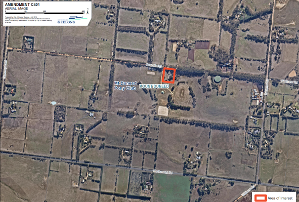
The site at 120 Russells Road, Mount Duneed is an 8,094 square metre parcel of land situated within the Farming Zone with the surrounding land to the east, west and south being the Mount Duneed Recreational Reserve.
The amendment is required as the proposed use of the land for a Community Care Accommodation Facility is currently prohibited within the Farming Zone. The most appropriate Land Use Term to describe the proposal within the Victorian Planning Provision is Community Care Accommodation.
The City had been reviewing a planning permit application for the proposal for several months. However, the State Government’s Amendment VC152 (26 October 2018) introduced a new Planning Scheme Land Use Term for “Community Care Accommodation”.
This means Community Care Accommodation is now prohibited in the Farming Zone and a planning scheme amendment is required.
Foundation 61 is a not for profit organisation that runs a men’s rehabilitation centre at Williams Rd, Mount Duneed in Surf Coast Shire.
Some residents and user groups of the Mt Duneed Recreation Reserve have expressed concern at the proposal. The City held a meeting with the residents and Foundation 61 to share information on the proposal and the concerns.
The City believes the proposal warrants support to proceed to public exhibition due to the net social and health benefits that the facility can offer vulnerable members of the community.
Councillor Murnane moved, Councillor Nelson seconded -
That Council support the preparation and exhibition of Amendment C401 to the Greater Geelong Planning Scheme to:
Include 120 Russells Road Mount Duneed into Column 1 of the Schedule to Clause 51.01 Specific Sites and Exclusions;
Include the name of the incorporated document being ‘Community Care Accommodation at 120 Russells Road Mount Duneed, August 2019’ into Column 2 of the Schedule to Clause 51.01 Specific Sites and Exclusions;
Include the name of the Incorporated Document being the ‘Community Care Accommodation at 120 Russells Road Mount Duneed, August 2019’ into Column 1 of the Schedule to Clause 72.04 Documents Incorporated in this Planning Scheme;
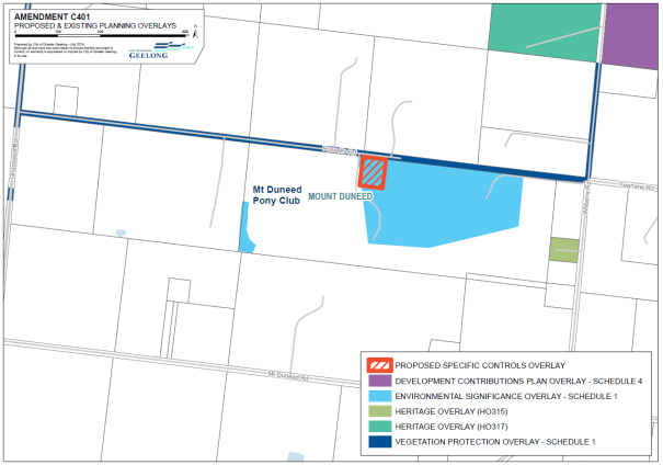
Implement a Specific Controls Overlay – Schedule 1; and
Request the Minister for Planning to authorise the preparation and exhibition of Amendment C401.
Carried.
There are no significant financial implications to Council.
If Council resolves to support the exhibition, nearby landowners and occupiers, prescribed Ministers and other relevant agencies will be directly notified during the statutory exhibition period. The broader community will be notified through notices in local newspapers and the City’s website.
The amendment addresses social equity by providing opportunities for vulnerable members of the community to seek treatment for drug and alcohol related issues.
The amendment is consistent with the following clauses of the Greater Geelong Planning Scheme
12.01-2S - Native Vegetation Management - Whilst the objective seeks to ensure there is no net loss to biodiversity because of the removal, destruction or lopping of native vegetation, given the constraints of the site the removal of vegetation proposed is appropriate. The proposal seeks to remove 0.223 hectares of native vegetation in addition to an area of planted vegetation which has been granted approval by Council to be removed as the planted vegetation has occurred due to the lack of definitive fencing along the eastern title boundary of the site.
12.05-2S – Landscapes - The existing vegetation within the reserve as well as the amount of vegetation within the road reserve contributes to the landscape character and identity of the area and the proposed development of the site can meet this objective. As previously mentioned, some vegetation will be required to be removed to facilitate the proposal however vegetation that is removed is proposed to be offset. The proposed built form of the building, its materials and siting together with the proposed landscaping on the site is not considered to have an impact upon the significant landscape.
Clause 13.02-1 Bushfire Planning - Whilst the subject site is not situated within a Bushfire Management Overlay, the site is within a bushfire prone area and therefore the Incorporated Document nominates a BAL12.5 to the construction of the Community Care Accommodation building to address the Bushfire Planning Provision at Clause 13.02-1 of the Greater Geelong Planning Scheme to satisfy the Country Fire Authority.
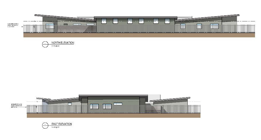
Clause 15.01-2S Building Design - The proposed built form will positively contribute to the local context and enhance the public realm through a single storey design which has suitable articulation, appropriate setbacks from the boundaries of the site and contemporary materials.
Clause 15.01-6S Design for Rural Areas - The siting and design of the proposed building is considered to respect the existing characteristics of the rural properties to the north of the site. The proposal is not considered to impact the existing recreational reserve land to the east, west and south of the site.
Clause 15.03-1S Heritage Conservation - The proposal is considered to appropriately conserve a place of heritage significance as Heritage Victoria have included the Mount Duneed Wesleyan Methodist Church as an inventory item H7721-0534 on the Heritage Victoria Database. Because of the requirement to conserve this historical area of the site, the construction of the building, driveway and carpark area is outside the site extent of the previous church, no approvals are needed from Heritage Victoria.
Clause 15.03-2S Aboriginal Cultural Heritage - A voluntary Cultural Heritage Management Plan has been prepared and approved by the registered Aboriginal Party for the proposed development on the site.
Clause 16.01-6S Community Care Accommodation - This clause includes an objective which seeks the location of community care accommodation being kept confidential. This location of the subject site towards the end of a road within a semi-rural setting will assist in meeting this objective.
Clause 22.05 Agriculture, Rural Dwellings and Subdivision - Whilst the subject site is situated within the Farming Zone it is constrained and not conducive to farming activities due to the former church building, its size and proximity to the adjoining recreational reserve. The proposed use on the subject site is unlikely to impact the existing farming activities to the north given the setback of the proposed building and its intended use.
Clause 22.64 Discretionary Uses in Rural Areas – The proposed use of the land for a Community Care Accommodation Facility is appropriate for this subject site despite the policy discouraging discretionary non-agricultural uses in rural areas that could be reasonably located in an urban zone. The proposed use of the site is appropriate in a semi-rural environment and the rural landscape character of the area is compromised by three boundaries of the site bordering the Mount Duneed Recreational Reserve.
The Amendment supports strategic priority of improved health and safety of our community in the Council Plan 2018-2022.
No City officers involved in the preparation of this report have any direct or indirect interest in this matter.
There are no notable risks associated with implementing the recommendations contained in this report.
The Arborist Report for the site states that vegetation on the site is dominated by large, Monterey Pines (Pinus radiata) which have little or no retention value and don’t require a permit for removal.
Dense thickets of Kangaroo Thorn (Acacia paradoxa) are present and appear to be a haven for rabbits, of which the removal of the thickets would facilitate control or eradication of rabbits.
Despite the recommendation for the retention and protection of two trees the useful life expectancy of the Drooping She-oaks (Allocasuarina verticillata) is 5-10 years and 10-20 years, therefore the removal of these trees is acceptable where an appropriate landscape plan is provided.
The Amendment applies to a vacant parcel of land at 120 Russells Road Mount Duneed (Attachment 3).
The former land use of the subject site was the Mount Duneed Wesleyan Methodist Church which is believed to have been destroyed by fire and the remains of this building are situated in the north-west part of the site.
A voluntary Cultural Heritage Management Plan (CHMP) was prepared, and no Aboriginal cultural heritage was identified in the activity area during the preparation of the CHMP.
The subject site is within a Bushfire Prone Area and not a Bushfire Management Overlay. The Bushfire Hazard Assessment identified that the closest classifiable vegetation type is grassland with the remainder of the assessment area (less than 150 metres) being modified vegetation and low-threat vegetation. A BAL12.5 defendable space and construction is to be followed which should be considered suitable by the Country Fire Authority.
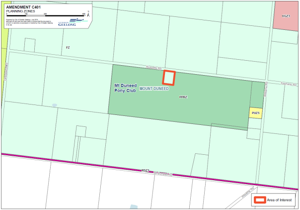
The subject site is situated within the Farming Zone (Refer to Attachment 4) and covered by an Environmental Significant Overlay – Schedule 1, with the surrounding land to the east, west and south being the Mount Duneed Recreational Reserve zoned Public Park and Recreation Zone. Russells Road also contains a Vegetation Protection Overlay – Schedule 1(Refer to Attachment 5).
The Amendment is required to allow the proposed Community Care Accommodation to be constructed and used on this Farming Zone lot as the current Farming Zone prohibits Community Care Accommodation.
The Land Use Term for Community Care Accommodation pursuant to Clause 73.03 is ‘Land used to provide accommodation and care services. It includes permanent, temporary and emergency accommodation. It may include supervisory staff and support services for residents and visitors.’
Apart from the use of the land being prohibited in the Farming Zone, this amendment has been brought before Council because of changes to the Greater Geelong Planning Scheme under VC152 (26 October 2018).
The incorporated document provides for the use and development of a Community Care Accommodation without requiring the rezoning of the land to facilitate the outcome.
The proposed facility is to be run by Foundation 61 (a not for profit organisation) as a women’s alcohol and drug rehabilitation facility separate from the current men’s facility run by the organisation in Williams Road Mt Duneed further south of the subject site within the Surf Coast Shire.
There is an unmet demand and need for a women’s only residential alcohol and drug rehabilitation facility in the Greater Geelong region as outlined in the Demand and Service Model prepared by Thomson Goodall Associates Pty Ltd contained within the supporting documentation.
The semi-rural setting of subject site may provide for increased success rates for residents of the Community Care Accommodation Facility as opposed to an urban environment. The semi-rural setting of the site provides an advantage of being remote from distractions and psychological separation from their area they have been using alcohol and drugs but also having relatively convenient access to urban facilities.
In addition to the use of the land for a Community Care Accommodation the proposal will include buildings and works and the removal of native vegetation.
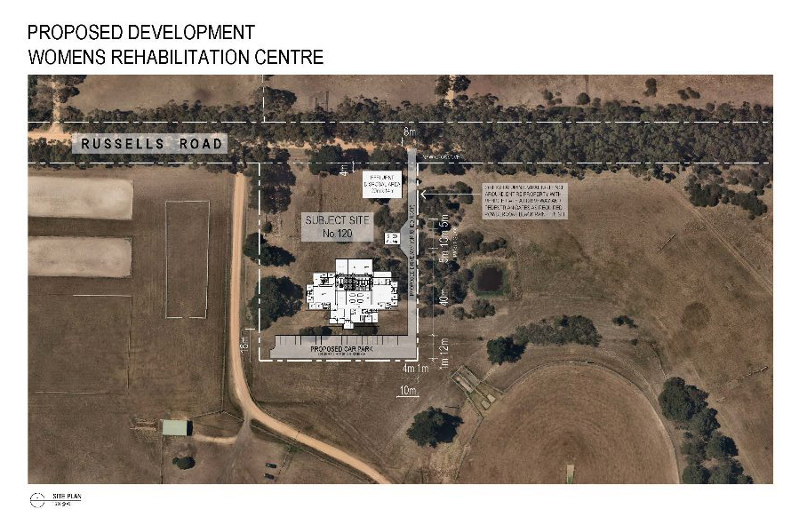
The proposed works to occur on the site will consist of the construction of a new vehicle crossover along the eastern front boundary of the subject which leads to a 4-metre-wide driveway. There is a small vehicle passing area and a 6 x 8 metre shed associated with a proposed produce garden. The driveway leads to 12-metre-wide car parking and vehicle turning area at the rear of the site.
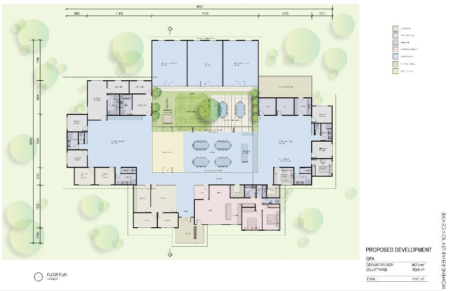
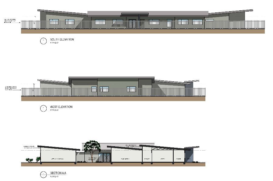
The main building consists of a single storey skillion roofed building which contains several bedrooms, offices, main lounge areas a courtyard and a gym, arts and craft room and a meeting / classroom. The building will be setback a suitable distance from each of the boundaries of the site particularly from the front boundary abutting Russells Road.
The proposed building is considered to provide a suitable buffer from the recreational reserve and the design and landscaping of the site is separate from the activities occurring within the reserve. A copy of the proposed plans for the building are in Attachment 6.
As per the information from the applicant, residents are not permitted to leave the site unless under supervision.
The application was referred to internal City departments and external government agencies for comment. Comments received have been considered in this report and will inform conditions to be placed on the proposed Incorporated Document. This document will act in a similar fashion to a planning permit.
Key Issues
Some of the potential key issues as part of the proposal include:
The suitability of the proposed use adjacent to a recreational reserve.
The proposed use of the land will be separate from the recreational reserve and the activities associated on the subject site will be contained within the subject site itself.
The location of the proposed facility within a semi-rural setting is considered to provide for positive social outcomes and empowering people who need assistance. The residents attend the facility voluntarily and there is no court ordered mandate forcing residents to the facility.
The proposed number of residents at the site is no more than 8 with approximately 3 support staff. This is not considered to be an excessive number that would impact upon the amenity of the area.
The suitability of the proposed use in the Farming Zone.
The mechanism for using a Site-Specific Exclusion for the proposal is the most appropriate given the land has not been used for agricultural activities for its existence and the size and location of the land are not considered to be suitable for agricultural activities to occur. This technique will mean the land stays in the Farming Zone but the proposal is permitted subject to an Incorporated Document.
Whilst the subject site is situated within the Farming Zone and the land to the north of the site is also situated within the Farming Zone the proposed use of the land is not considered to have an impact upon any existing farming operations occurring on land to the north.
The semi-rural nature of the land is considered to benefit the residents of the Community Care Accommodation Facility as opposed to the location of a Drug and Alcohol Rehabilitation Facility that is located within an urban area. This formed part of a VCAT decision to refuse to grant a planning permit for a similar type facility as outlined within Better Living and Education v Yarra Ranges SC [2015] VCAT 86 (5 February 2015).
In Association for Better Living and Education v Yarra Ranges SC [2015] VCAT 86 (5 February 2015) the tribunal affirmed the decision of the Responsible Authority to refuse a rehabilitation centre to cater for 80 patients.
A 2.72-hectare parcel of land zoned Low-Density Residential Zone situated approximately 750 metres from the Warburton CBD with much of the Tribunal’s decision focused on the site’s location within an established residential.
Support for the proposed use of land for drug and alcohol rehabilitation facilities within semi-rural areas has been identified within two VCAT decisions being Australian Community Support Organisation Ltd v Moira SC (No.2) [2017] VCAT 1133 (28 July 2017) and Odyssey House Victoria v Benalla Rural CC & Ors [2003] VCAT 15 (9 January 2003).
In Australian Community Support Organisation Ltd v Moira SC (No.2) [2017] VCAT 1133 (28 July 2017) the Tribunal set aside the Responsible Authority’s decision and issued a permit for residential rehabilitation. The proposal sought buildings and works as well as the use of land for a residential alcohol and drug rehabilitation centre in the Farming Zone.
In Odyssey House Victoria v Benalla Rural CC & Ors [2003] VCAT 15 (9 January 2003) the Tribunal set aside the Responsible Authority’s decision and issued a permit for a Drug and Alcohol Residential Rehabilitation centre.
Part of the reason for the Tribunal supporting the proposed use was that (para 58) a facility such as this needs to exude a degree of detachment and would not be suited to a downtown location in either Melbourne or Benalla. It seems to us therefore that a location 12 minutes’ drive from town and in a not entirely isolated but yet pleasant rural setting such as Moylullah is entirely appropriate.
The removal of vegetation from the site.
The applicant has applied for the removal of some vegetation on the site to facilitate the proposed development. The removal of vegetation required to be removed from the site is acceptable in this instance subject to appropriate conditions for the offset of this removal.
Fencing around the site.
A revised landscape plan will detail the fencing and landscaping of the boundaries of the subject site. Fencing is required to be in consideration of the referral from Council’s Recreation and Open Space Department that any fencing be rural in nature.
Traffic Movements / Conflict between vehicles and horses.
The amount of traffic proposed as part of the development is acceptable given the low vehicle numbers associated with the site. Russells Road is a public road and whilst most of the traffic along this section of the road is associated with the use of the recreational reserve, the increase in traffic because of the proposed facility is acceptable.
Source: |
Planning, Design & Development – Health & Local Laws |
Director: |
Gareth Smith |
Portfolio: |
Community Health and Safety |
To approve the commencement of a community engagement process regarding a proposal presented to Council by the Barwon Coast Committee of Management Inc. (BCCM) to revise the existing dog control orders applicable to the land under their responsibility.
Council adopted dog control orders applicable to BCCM land for the first time in 2008 as part of the development of its first Domestic Animal Management Plan. The land in question extends from marker 42W in Breamlea to marker 7W in Collendina. The current dog control orders shown in (Attachment 3).
The BCCM foreshore is a place of regional importance and conducting such a review enables consideration of numerous issues including the flora and fauna values, community expectations, public safety, environmental protection and creating safe shared spaces for all users of the foreshore.
Between January 2018 to July 2019, the BCCM commissioned Federation University to undertake an independent social research project (“Share Our Shores: Beach Usage Research Project”) to identify the challenges faced by all beach users between Breamlea and Collendina.
A report of findings from the BCCM preliminary community engagement has informed the BCCM proposed changes to the existing dog control orders for Council to consider.
A total of 1,715 people completed surveys disseminated by BCCM regarding beach usage, 72.9% of whom were dog owners.
BCCM’s general rationale behind these proposed changes includes:
Access and Equity for all – especially those with limited mobility or fear of dogs;
Simplified Compliance;
Clear Simplified Signage;
Personal Safety;
Environmental Impacts.
BCCM have recommended 4 key changes to the dog control orders currently in place along the Barwon Coast (Attachments 4 & 5).
Establishing a number of longer “seasonal” zones (16W-20W, 21W-24W, 24W-27W and 34W-36W) allowing dogs on leash at certain times of the day during certain periods of the year rather than the existing prohibitions;
The Ocean Grove main beach between 13W – 16W is to change from a “conditional off-leash” area to a “dogs prohibited” area, with an off beach ‘walk-through’ pathway;
The beach between 36W – 40W is proposed to be a “Horse Zone” where dogs are required “on leash at all times”;
The number of dog control orders would be reduced from 5 to 3, making it easier for the community to understand and comply.
Unwanted attention by dogs off-leash was the most commonly cited answer regarding compromised beach enjoyment by both permanent residents and visitors.
The City needs to engage the community to establish if these proposed changes are in line with community expectations prior to being adopted, gazetted and enforced.
Councillor Grzybek moved, Councillor Mason seconded -
That Council:
Acknowledge the Barwon Coast Committee of Management community engagement process and proposal to amend existing dog control orders; and
Authorise the implementation of City-lead community engagement processes for a 6-week period.
Carried.
The City’s existing resources will be used to facilitate the community engagement process.
A dog control signage audit of the municipality was completed between March and May 2019, covering 371 reserves and trails throughout Greater Geelong municipality, including the BCCM land. The upgrading of signage would be complimented by educational and awareness messages.
The community engagement process is proposed for a period of 6 weeks, from 14 October 2019 – 22 November 2019, and will be advertised in local newspapers, through social media, and also through posters displayed on some key beach access points along the Barwon Coast.
The community engagement will consist of an online survey, with hard copy versions also available at customer service centres. Four drop in sessions are also proposed for venues in both Barwon Heads and Ocean Grove
The proposed community engagement activities aim to maximise equity and accessibility for all by offering multiple options (on line, written, face to face) and times to participate in providing feedback. Community forum venues will consider disability access.
In adopting dog control orders, the City will implement controls that aim to provide safe and accessible public spaces for all to enjoy. The City predicts that through clear signage and simplified dog zones, there is a likelihood of improved compliance outcomes with respect to the safe and shared use of a public space.
Under Section 26 of the Domestic Animals Act 1994, Council may by resolution make an order which sets out conditions with respect to dogs in public places. This order must be published in the Government Gazette and in a newspaper circulating in the municipal district of the Council making the order.
Improved health and safety of our community:
Providing safer public places;
Encouraging responsible pet ownership;
Promoting active living.
Informed social infrastructure and planning:
Provide more quality spaces that support active lifestyles.
More inclusive and diverse community:
Supporting activities that improve social connections in our community;
Further developing programs that support older people and young people in our community.
No City officers or contractors who have provided advice in relation to this report have declared a conflict of interest regarding the matter under consideration.
Risks can be minimised by applying practical, fair and reasonable dog control orders in public places to ensure the safety of all users. The orders provide a platform for community education, against which compliance activities and preventative measures can be undertaken.
There is recognition of the existence of several environmentally sensitive areas within this coastline that are protected by the current Dog Control Orders and are proposed to remain in effect.
Any dog rules that may be applied to open spaces within the municipality on land managed by other land managers may be done so through a separate process in which Council can choose to enter into a formal agreement pursuant to Section 26 (2) of the Domestic Animals Act 1994.
The BCCM and the City have previously undertaken this process in 2008 and reached an agreement regarding dog control orders on BCCM land (Attachment 3). Ten years on, the BCCM have recognised the need for a review to occur, which considers the contemporary issues relevant to the effective management of their land.
The City will work with the BCCM to ensure that these proposed changes are aligned to community expectations through a formal community engagement process.
Over a six month period, between 1 January 2019 and 1 July 2019, the BCCM have reported 164 incidences of non-compliance, with 134 of those being dogs off leash in an on leash zone. Twenty seven of these resulted in dog attacks. These figures are only those that were reported to BCCM.
During the 2017-18 financial year, the following dog-related incidents (150) were reported to BCCM:
57 offences in prohibited zone;
48 general non-compliance across the reserve;
19 harassing causing nuisance;
8 wildlife harassment; and
18 wildlife attacks.
During this same period (2017-18), the City received 63 complaints about dog related incidents (10 dog attacks, 23 menacing dogs and 30 dogs at large/off leash in on leash areas) on BCCM land.
BCCM Consultation
In conjunction with Federation University, the BCCM produced a report titled “Barwon Coast Coastal Management and Beach Usage Report”, and a large portion of this report focuses on “Dogs on Beaches”.
A 28 question online survey was completed by 1,715 people between December 2017 and April 2018 regarding current dog control orders and beach usage, and this information has formed the basis of the proposed dog control order amendments submitted by BCCM.
The Federation University study identified the following trends:
Dog management and dog access to beach areas was the major management challenge identified - 72.6% from dog owners – 20.9% non-dog owners;
Dogs off-leash was the predominant issue for those reporting a compromised capacity to enjoy the beach; from both locals and visitors and dog owners and non-dog owners;
44.5% indicated they had been negatively impacted on their enjoyment.
Major themes arising from the Federation University study and associated community feedback were:
Provide more timed access to beaches currently off limits to dogs over the peak period – allowing dogs on leash before 8am and after 8pm;
Make the current regulations easier to understand – reduced number of control zones from 5 to 3;
Provide an area as a safe swimming beach where dogs are prohibited all year round.
The Federation University study also identified the following recommendations from respondents:
Separate areas for different beach users;
Ability to walk dogs on beaches before 8am and after 6pm during summer;
No dogs on beaches during summer months;
Less complicated regulations supported by 39.2% dog owners and 49.1% non-dog owners;
Increase level of compliance;
57.8% wanting clearer distinction between the start and end of different dog regulation.
Some additional notable statistics from the survey include:
79% of respondents were full time residents in the region;
The beach was used for dog-walking by 76% of respondents;
Dogs off-leash was the greatest issue compromising beach enjoyment in both local and visiting populations;
Regardless of dog ownership status, ~30% of all survey respondents reported that they are negatively impacted by the presence of dogs, mostly due to lack of compliance and control by the dog owner (22.8%), negative dog – dog, or human-dog interactions including bites, nuisance and menacing (27.0%), dog fouling (22.3%) and safety concerns (18.1%);
The presence of dog friendly beaches was a major motivator for many individuals to move to the region;
Positive aspects of dogs on beaches were reported to be mental and physical health benefits, dog socialisation and community building amongst dog owners;
The attitudes of dog-owners towards dog management issues was more favourable to dogs being on beaches and facing less restrictions versus non-dog owners.
City Consultation
It is proposed to deliver a comprehensive community consultation process, which will involve the release of a 12-question online survey. It is proposed that the survey will be open for 6 weeks, running from 14 October to 22 November 2019.
Additionally, there will be 4 drop in community consultation sessions where members of the community can come and speak freely with staff from both BCCM and the City. These consultations will occur in both Barwon Heads and Ocean Grove. The times for each session will be varied so as to enable a broad cross section of our community to attend.
During this 6 week period, the City will promote the engagement sessions by:
Placing a story in the Community Update;
Sending media releases to local newspapers;
Posting information about the survey and face-to-face sessions on the City’s social media channels.
Utilising lead newsletters and forums.
Persons responding to the survey or providing feedback at an engagement session will be responded to on submission of their information.
There would appear to be wide acknowledgment of the importance of dog ownership with respect to improving health wellbeing outcomes. Adopting easy to understand and fair dog control orders that do not compromise this outcome as well as providing safe and shared public spaces for all users is the desired outcome for the City. Safety and environmental protection are the key considerations, with no specific group having greater entitlement to these spaces over any other group in the interest of preserving these considerations.
Source: |
Governance, Strategy & Performance - Governance |
Director: |
Rebecca Leonard |
Portfolio: |
Leadership and Governance |
To review and amend the Election Period Policy in preparation for the 2020 General Council Election.
Amendments to the Local Government Act 1989 (Act) in November 2015, included the establishment of section 93B which required all Councils to adopt an election period policy. Council adopted its current policy in August 2017 in preparation for the 2017 Council election.
The policy regulates decision-making, use of resources, public consultation, council events and access to council information during the election period for a general council election.
The Act requires that Council review and, if required, amend the policy not later than 12 months before the commencement of the election period of each subsequent general council election.
The next general council election is in October 2020. Its election period commences on 22 September 2020. Therefore, the current policy must be reviewed and amended by 22 September 2019.
The City benchmarked the current policy against legislative obligations and better practice guidance material recommended for consideration by sector agencies. It was also compared with the election period policies of a number of like-sized metropolitan and larger regional councils.
The amended policy (Attachment 2) incorporates improvement opportunities from the benchmarking exercise and includes stakeholder contributions, including input from Councillors, such as equitable candidate access to hiring City facilities and clarification of City staff protocols.
These changes clarify the expression of current provisions. They also expand on the minimum requirements in ways that assist meeting the objective of avoiding actions and decisions which could be perceived as influencing voters or limiting the policy choices of the incoming council. In addition, they improve equitable treatment of candidates and allow City staff to be involved in public life provided they avoid any actual, potential or perceived conflict of interest with their City employment.
Councillor Murnane moved, Councillor Nelson seconded -
That Council adopt the amended Election Period Policy (Attachment 2).
Carried.
There are no financial implications arising from the subject of this report.
The policy has been subject to stakeholder review and benchmarking with legislation, better practice guidance material recommended for consideration by sector agencies and election period policies of a number of like-sized metropolitan and larger regional councils.
The policy provides for the equitable treatment of council election candidates.
Council is obliged by section 93B of the Act to maintain the Election Period Policy through reviewing, and if necessary amending, the policy before each general council election.
Amendments to the policy include:
Alignment of terms and definitions with related legislation and policies to ensure consistent and clear use.
Addition of new provisions from:
Councillor requests related to hiring City facilities and clarifying City staff rules;
Improvement opportunities based on better practice guidance and benchmarking findings;
Council’s electoral sign provisions under the Amenity protection Local Law that apply at all times; and
The introduction of Community Focus Council meetings through an April 2018 Council resolution.
The Charter of Human Rights and Responsibilities Act 2006 gives City employees the right to participate in public life, which includes the right to vote and to be able to participate in local government elections. The policy provision covering City staff has been expanded to provide for the involvement of City staff in democratic and political activities provided they avoid any actual, potential or perceived conflict of interest with their City employment.
The amended policy will help deliver the organisational leadership, strategy and governance strategic priority by strengthening governance and integrity arrangements. It enhances transparency, equity and human rights policy settings for the general council election.
No City officers or contractors who have provided advice in relation to this report have declared a conflict of interest regarding the matter under consideration.
The policy reduces the likelihood of candidate and election complaints by helping achieve the objective of avoiding actions and decisions which could be perceived as influencing voters or limiting the policy choices of the incoming council.
There are no environmental implications arising from the subject of this report.
Source: |
City Services – Engineering Services |
Director: |
Guy Wilson-Browne |
Portfolio: |
Social and Infrastructure Planning |
To revoke Council’s designation of 12 December 2006 of flood affected land at Anchoridge Estate, Stages 1, 2 and 3 inclusive as liable to flooding pursuant to regulation 153 of the Building Regulations 2018.
Council has a statutory obligation under the Building Regulations 2018 to designate land as liable to flooding where it reasonably knows it to be prone to flooding. Conversely, there is an obligation to remove the encumbrance of designation from land that is no longer considered to be flood-prone.
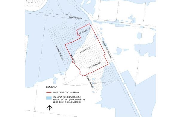
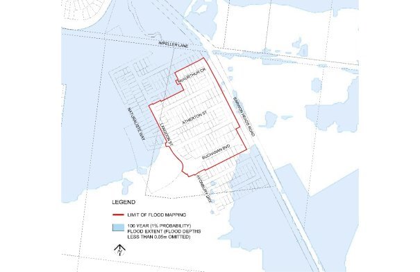
The current designated flood mapping (Attachment 2) was designated by Council at its meeting of 12 December 2006.
This revocation will result in another stage of new lots in Anchoridge Estate fronting 892 – 958 Barwon Heads Road, Armstrong Creek being free of their flood prone status, paving the way for owners to build homes on their land.
The flood mapping is subject to a revision due to the subdivision and development at 892 – 958 Barwon Heads Road, Anchoridge Estate. Prior to subdivision the parent lot was considered to be liable to flooding. This development site, which is also known as Anchoridge Estate, Stages 1, 2 and 3 inclusive, achieves flood immunity for newly created lots for flood events up to and including the 100 year Average Recurrence Interval (ARI) event due to approved internal earthworks.
The decision by Council engineers that the flood prone status can be removed includes assessment of internal drainage, road construction and earthworks to contain potential floodwaters from the 100 year ARI event within road and drainage reserves (Attachment 3).
It should be noted that designation is separate to the creation of flood overlays within the Planning Scheme, which generally follows designation. In the case of this development, the planning scheme amendment to create post-development flood zones or overlays is proposed after the design of the proposed precincts.
Councillor Murnane moved, Councillor Nelson seconded -
That Council revoke the Council designation of 12 December 2006 of flood affected land at Anchoridge Estate, Stages 1,2 and 3 inclusive as liable to flooding pursuant to regulation 153 of the Building Regulations 2018.
Carried.
There are no financial implications arising from the subject of this report.
A revocation of designation does not warrant public consultation as it constitutes the removal of an encumbrance on land.
Relevant City databases and flood maps will be revised and updates sent to the Corangamite Catchment Management Authority and Building Control Commission.
Council have a responsibility to the community to provide the best possible information on areas that are flood prone. The removal of flood prone designation allows owners to build on their land without a special permit from the City, and without raising the floor level of their home. It also reduces the cost of property insurance.
The City has various statutory responsibilities for drainage management and flood management (prevention, response and recovery) as set out in the Local Government Act 1989, Local Government Regulations 1990, Planning and Environment Act 1987, Building Regulations 2018, Water Act 1989, Subdivision Act 1988 and Emergency Management Act 1986.
The works have resulted in the lots being protected from flooding during a major storm event that has a one per cent probability of occurring in any one year, and occurs on average once in 100 years. This is the required standard for new subdivisions.
The recommendations of this report are consistent with the Council Plan, in relation to planned sustainable development.
No City officers or contractors who have provided advice in relation to this report have declared a conflict of interest regarding the matter under consideration.
Council also has some risk exposure with any failure to disclose the flood-prone status of a property in a Land Information Certificate.
The revocation of the designation is the final step in minimising Council’s risk.
The revocation of flood-prone areas designation and designation of revised flood data through the design of this stage is considered unlikely to result in any known adverse environmental impacts.
Source: |
City Services – Engineering Services |
Director: |
Guy Wilson-Browne |
Portfolio: |
Social and Infrastructure Planning |
To revoke Council’s designation of 12 December 2006 of flood affected land at Ashbury Estate, Stage 13 inclusive as liable to flooding pursuant to regulation 153 of the Building Regulations 2018.
Council has a statutory obligation under the Building Regulations 2018 to designate land as liable to flooding where it reasonably knows it to be prone to flooding. Conversely, there is an obligation to remove the encumbrance of designation from land that is no longer considered to be flood-prone.
The current designated flood mapping (Attachment 2) was designated by Council at its meeting of 12 December 2006.
This revocation will result in another stage of new lots in Ashbury Estate fronting 282 – 400 Horseshoe Bend Road, Armstrong Creek being free of their flood prone status, paving the way for owners to build homes on their land.
The flood mapping is subject to a revision due to the subdivision and development at 282 – 400 Horseshoe Bend Road, Ashbury Estate. Prior to subdivision the parent lot was considered to be liable to flooding. This development site, which is also known as Ashbury Estate, Stage 13 inclusive, achieves flood immunity for newly created lots for flood events up to and including the 100 year Average Recurrence Interval (ARI) event due to approved internal earthworks.
The decision by the City that the flood prone status can be removed includes assessment of internal drainage, road construction and earthworks to contain potential floodwaters from the 100 year ARI event within road and drainage reserves (Attachment 3).
It should be noted that designation is separate to the creation of flood overlays within the Planning Scheme, which generally follows designation. In the case of this development, the planning scheme amendment to create post-development flood zones or overlays is proposed after the design of the proposed precincts.
Councillor Murnane moved, Councillor Nelson seconded -
That Council revoke the Council designation of 12 December 2006 of flood affected land at Ashbury Estate, Stage 13 inclusive as liable to flooding pursuant to regulation 153 of the Building Regulations 2018.
Carried.
There are no financial implications arising from the subject of this report.
A revocation of designation does not warrant public consultation as it constitutes the removal of an encumbrance on land.
Relevant City databases and flood maps will be revised and updates sent to the Corangamite Catchment Management Authority and Building Control Commission.
Council have a responsibility to the community to provide the best possible information on areas that are flood prone. The removal of flood prone designation allows owners to build on their land without a special permit from the City, and without raising the floor level of their home. It also reduces the cost of property insurance.
The City has various statutory responsibilities for drainage management and flood management (prevention, response and recovery) as set out in the Local Government Act 1989, Local Government Regulations 1990, Planning and Environment Act 1987, Building Regulations 2018, Water Act 1989, Subdivision Act 1988 and Emergency Management Act 1986.
The works have resulted in the lots being protected from flooding during a major storm event that has a one per cent probability of occurring in any one year, and occurs on average once in 100 years. This is the required standard for new subdivisions.
The recommendations of this report are consistent with the Council Plan, in relation to planned sustainable development.
No City officers or contractors who have provided advice in relation to this report have declared a conflict of interest regarding the matter under consideration.
Council also has some risk exposure with any failure to disclose the flood-prone status of a property in a Land Information Certificate.
The revocation of the designation is the final step in minimising Council’s risk.
The revocation of flood-prone areas designation and designation of revised flood data through the design of this stage is considered unlikely to result in any known adverse environmental impacts.
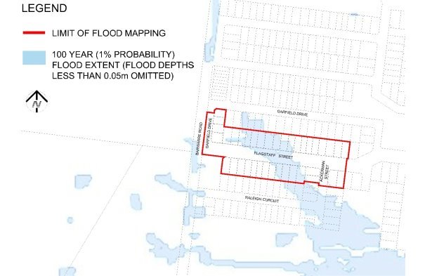
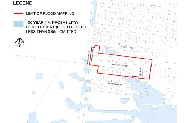
As there was no further business the meeting closed at 10:18pm on Tuesday 10 September 2019.
Signed: _________________________________________
Councillor Bruce Harwood (Mayor)
Date of Confirmation: _____________________________
Contents | Previous Page: Section A - Procedural Matters |
