
Reports tabled at the Community Focus Council Meeting of Council on Tuesday 10 March 2020, held at the Baptcare Coasthaven Community, 45 Robin Avenue, Norlane.
Restricting Vehicles in Little Malop – Proposed Changes for Central Geelong Laneways
Draft Pakington Street (Geelong West) and Gordon Avenue Urban Design Framework
Rural and Peri-Urban Advisory Committee Annual Report 2018/2019
Tender T1900049 Elcho Channel and Basin – Stage 2 Drainage Works
Revocation of Flood Prone Area Designation of New Lots at Charlemont Rise Estate, Stage 10
Councillor Grzybek declared a direct interest in Agenda Item 1, Lara Traffic Management Plan 2019-2029 in that she is Secretary of the Lara United Football Club and left the meeting room prior to discussion at 7:25pm.
Source: |
City Services – Engineering Services |
Director: |
Guy Wilson-Browne |
Portfolio: |
Transportation and Connections |
To seek Council adoption of the Lara Traffic Management Plan 2019-2029.
The Lara Traffic Management Plan (the Plan) commenced following feedback from the communities of Lara and Little River about traffic safety and access issues, particularly associated with truck movements and increased volumes of traffic on local roads.
Data collected to support the Plan included traffic volumes, vehicle speeds, road hierarchies, road condition, quarry access, quarry haulage routes and road accident statistics.
Three phases (stages) of community engagement were undertaken between October 2018 and October 2019.
Following thirteen community forums and on-line ‘Have Your Say’, over 350 comments were raised, across a range of transport and infrastructure topics. These issues are consolidated into 179 related items for respective agencies in an Action Plan. The 179 actions are grouped into 17 priority categories. Refer Attachment 3.
Following community input, the revised Plan has now been finalised for consideration by Council.
Some priority actions are complete or in progress in the 2019-2020 traffic management program.
Some priority actions will be referred to the 2020-2021 annual traffic management works program. Major projects identified in the Plan that fall outside of the annual works program will be referred to the budget for funding.
The Plan recognises the need for revisions to truck routes through Lara. This is a priority action in the Plan and will require cooperation from the Department of Transport to proceed with the implementation of preferred truck routes, on local and State roads, within the Lara township and surrounding areas.
Engagement from the community to-date has enabled preliminary work to commence on the revision of truck routes to, within and around Lara. Further confirmation and community engagement on the truck route revision implementation will commence as a priority action.
The Plan also recognises broader traffic management issues associated with growth in Lara and the surrounding areas. The Geelong Growth Areas Transport Infrastructure Strategy will further clarify and aim to resolve transport infrastructure challenges arising for communities within existing and future precincts.
Councillor Grzybek moved, Councillor Aitken seconded -
That Council:
Adopt the Lara Traffic Management Plan 2019-2029 (Attachment 3);
Note the actions that have been implemented this financial year (refer to Attachment 2);
Refer priority actions to the 2020-2021 budget;
Support the commencement of revisions to truck routes in Lara and the associated implementation; and
Request the Chief Executive Officer to write to the Minister for Transport seeking their commitment to support the revisions to truck routes in Lara.
Carried.
The priority actions will be referred to current and future programs and budgets. Depending on scale, some of these works have already been completed or in progress within existing 2019-20 programs, others will require specific budget bids or external funding.
The need for the Lara Traffic Management Plan has been identified by the community for many years, as early as 2017.
The City formally commenced engagement and opened an online ‘Have Your Say’ page from 26 September 2018 through to 22 October 2018. Hard copies were made available on request and written submissions could be mailed in.
The first stage of community engagement sessions was held on Wednesday 10 October 2018 (10am-12pm and 4pm-7pm) and on Saturday 13 October 2018 (9am-12pm). During these three sessions 66 people visited the forum and 111 people provided comments via on-line ‘Have Your Say’ survey.
The first stage of community consultations assisted forming the draft action plan which was presented to Council at the 12 March 2019 Community Focus Council Meeting. The resolution noted further consultation on the draft plan and for the final revised plan to be presented back to Council for adoption.
The second stage of community engagement sessions consultations commenced 25 March 2019. Community sessions were held on 28 March (4.30pm-7.30pm), 4 April (9am-12pm), 10 April (10am-1pm and 4pm-7pm) and 1 May (10am-12pm and 5pm-7.30pm). During these five sessions 65 people visited the forum and 69 people provided further comments via on-line ‘Have Your Say’ survey.
The third stage of community engagement sessions was a forum held on the 30 May (7pm-9.30pm). Representatives from Regional Roads Victoria and City of Greater Geelong presented updates on current action plans. More than 100 people attended this forum.
Following the Council resolution on 13 August 2019, the draft Plan was released for community comment from 28 August to 30 October 2019. The engagement also included two drop-in sessions on 28 August and 18 September.
Comments received on the draft plan related to the format of the plan, more information on timing of actions, clearer definition of themes and reference to the growth and development of Lara and the impact that has on traffic volumes. These comments have been incorporated into the revised plan (Attachment 3).
There are no social equity implications arising from the subject of this report.
There is no policy, legal or statutory implications arising from the subject of this report.
Integrated Transport Connections: Aim – Establish a traffic management plan for the northern growth corridor (including Lara).
There is no officer direct or indirect interest in the preparation of this report.
With expansive growth in and around Lara, the safe and efficient movement could be compromised if actions are not Implemented. This Lara Traffic Management Plan identifies the short-term risks facing Lara and prioritises those actions required in the short term.
Further work on long-term issues associated actions is required to identify mitigation measures.
There are no environmental implications associated with the outcomes of this report.
Following community consultation, 179 actions have been developed for implementation of further investigation (refer to Plan - Attachment 3). From the 179 actions, there are number of priority actions which are identified in this report.
Grouped into 17 categories, the actions can be classified as:
Localised infrastructure works – which can be delivered within current and existing programs, or may require further Council budget bids to contribute funds for delivery; and
Larger scale planning or capital works – which typically need further investigation and planning to determine how and what solution will resolve the current, and future, transport challenges.
The 17 action categories are:
Truck movements through, within and around Lara township;
‘Six ways’ intersection;
Grade separation of the Geelong rail line and McClelland Avenue;
Review of speed limits on local roads;
Lara Station car parking;
Intersection upgrades (various);
Pedestrian and cyclist safety crossing upgrades;
Footpath works;
Lighting works;
Traffic management works;
Drainage works;
Road maintenance works;
Road upgrade works;
Bridge condition works;
Environmental works;
Landscape works; and
Public transport.
The following actions have been either completed, or in process of approval and implementation:
Speed Limit changes to: McClelland Avenue, Hicks Street, Mill Road, Heales Road, Lara Six Ways;
McClelland Road right turn lands;
Broderick Road / Heales Road traffic signal installation;
Little River Ripley Road / Kirks Bridge Road traffic island installation;
Installation of warning signs to improve safety at Alfred and Fisher Street; and
Relocate flood gates and associated signage to improve safety on Windermere Road.
Immediate priority actions have been identified from community engagement and officer investigations:
Complete review and implementation of speed limit changes;
Commence working with the Department of Transport on implementing revision to truck routes to, within and around Lara township;
Advocate to the Department of Transport on an update for the ‘Six-Ways’ intersection upgrades, including timing and commitment to construction;
Commence construction of McClelland Road right turn lanes and speed limit reduction;
The Director of City Services to write to the Department of Transport for the design and cost estimate of the McClelland Avenue rail grade separation and commitment to delivery timeframes;
In partnership with school principals, develop Safe Travel to School routes for Lara primary schools;
Review all local area traffic management requests, and implement where required; and
Immediately review the traffic management plan associated with the goal development on Bacchus Marsh Road to ensure travel routes do not use Lara township as a thoroughfare.
Understanding the significant growth that has occurred and is projected to occur in Lara and other growth areas in Geelong, the City has already commenced the Geelong Growth Area Transport Infrastructure Strategy, in partnership with the Department of Transport and the Victorian Planning Authority.
This strategy will inform how the growth occurring now, and in the future, will impact the transport network across the entire Geelong municipality. This will give the City and Department of Transport a clear understanding of congestion in the network and required future upgrades.
The project seeks to achieve four key objectives:
To identify the major transport (road and rail) infrastructure requirements to support the ultimate development scenario in Geelong’s growth areas;
To identify the requirements and staging of infrastructure based on modelled growth scenarios at intervals of: 2018 (base case), 2031, 2041 and 2051;
To deliver reporting material, communication material and advocacy documentation to facilitate local and state infrastructure funding and delivery; and
To form the basis for the identification of mechanisms that may secure a growth area infrastructure contribution for Geelong.
Source: |
Economy, Investment & Attraction - Central Geelong and Waterfront |
Director: |
Brett Luxford |
Portfolio: |
Economic Development |
To seek Council’s endorsement of the Restricting Vehicles in Little Malop Amended Proposal & Analysis report January 2020 (Attachment 2) to restrict vehicles in Little Malop Street (between Dennys Place and Moorabool Street).
At the Community Focus Meeting on 9 April 2019, Council endorsed the commencement of community consultation regarding the provision of vehicle access restrictions in Little Malop Street (between James Street and Moorabool Street).
Consultation with the community occurred between 10 April and 1 May 2019. A Restricting Vehicles in Little Malop - Engagement Findings report (Attachment 3) has been prepared which summarises the results and community views on the proposed changes.
Council requested that a final recommendation be presented to for a decision. A report and final recommendation has been prepared, which analyses the key issues that have been raised by the community.
The amended proposal has sought to balance competing interests and views in the Laneways Precinct and seeks to provide an outcome which would deliver a net community benefit.
Following approval of the proposal, the capital costs associated with implementing the restrictions will be further investigated and costed, and a capital budget submission prepared for consideration in the 2020-21 Council Budget.
Councillor Kontelj moved, Councillor Murrihy seconded -
That Council:
Endorse the amended proposal to provide vehicle access restrictions in Little Malop Street (between Dennys Place and Moorabool Street); and
Refer the project to the 2020-21 budget for consideration.
Request the Chief Executive Officer to provide a report that details options to allow service and tenant access to Lt Malop Street and Shorts Place from Moorabool Street. This should also include the consideration to permanently close off Lt Malop Street to vehicles between Shorts Place and Dennys Place. The report should be presented by 30 June 2020.
Carried.
Costs associated with implementing the amended proposal include the installation of bollards, civil and electrical works and new signage, and are estimated to be approximately $90,000.00 (Source: Bollard Manufacturer).
A budget submission will be prepared and presented for consideration in the 2020-21 Council Budget.
Engagement with the community associated with this proposal was pivotal to help with understanding how the people who use, live or trade in the Central Geelong Laneways Precinct may be impacted by the proposed vehicle access restrictions.
The preparation of the amended proposal has sought to balance the competing interests and views associated with vehicle access in the laneways and produce an outcome which can deliver a net community benefit.
Disabled car parking is currently available in James Street, Ryrie Street and Moorabool Street. There are no disabled parking spaces provided within the proposed area for the vehicle access restrictions.
Approval from VicRoads will be required prior to the implementation of the vehicle access restrictions, given their role in approving major traffic control devices. VicRoads have previously provided in-principle support for this proposal.
The Local Government Act 1989 provides Council with the power to place obstructions or barriers on a road, either permanently or temporarily.
Implementation of the vehicle access restrictions will impact some owners and occupiers of land located within the affected area. The amended proposal has sought to minimise these impacts, as much as practicable, and without compromising the benefits to the community (as a whole).
With regards to the private car park located at the northern end of McLarty Place, access to this car park could be via Malop Street as there is a pre-existing driveway crossover.
This report aligns with the strategic priorities outlined in the Council Plan 2018-22 with regards to ‘A Thriving and Sustainable Economy’. Vehicle access restrictions in the Laneways Precinct will support the continued economic growth and revitalisation of Central Geelong by providing more street space for commercial activities.
No officers involved in the preparation of this report have a direct or indirect interest in matters to which it relates.
Current vehicle movements in the Laneways Precinct are considered to present an elevated public safety risk to pedestrians. Given the area’s higher use for alfresco dining and entertainment, and the posted speed of 10 kph Shared Zone, the amended proposal being suggested here attempts to minimise vehicle risk to pedestrians in the area.
Vehicle restrictions to private properties may present risks with regards to possible litigation against the City. The amended proposal has sought to minimise property access impacts and preserve a point of entry/exit for all pre-existing private property access and off-street parking areas.
Restrictions to delivery vehicle access within the affected area has the potential to present reputational risks associated with impacts to business operations. The amended proposal has sought to provide an acceptable balance between permitting limited deliveries between 4:00am and 10:00am daily.
Restrictions to emergency access into the area presents a potential risk regarding public safety. This risk has been mitigated through consultation with emergency services providers, and measures to allow efficient access have been developed.
The successful implementation of vehicle access restrictions in the area will help to show leadership in developing appropriate ways to remodel urban spaces, providing priority to people and street based activities, including alfresco dining and events, rather than facilitating limited vehicle access at the detriment to those activities.
While only providing some incremental changes, the proposed restrictions will also provide some environmental benefits to the area associated with less car congestion and pollution, and lower noise levels associated with a reduction in vehicles.
Source: |
Planning, Design and Development |
Director: |
Gareth Smith |
Portfolio: |
Planning |
To release the draft Pakington Street (Geelong West) and Gordon Avenue Urban Design Framework (UDF) for community consultation (Attachment 2).
In 2018, the City of Greater Geelong (City) began preparation of the UDF. The UDF establishes the short and medium-term objectives, strategies and actions that will deliver a shared vision for the future of the area and guide future investment by the public and private sectors.
Extensive community consultation has taken place to develop the vision for the UDF. The vision is to create a vibrant and thriving urban village that is a place of inclusion, a place of opportunities and a place for people.
Consultation consisted of a series of community workshops, community surveys, and a ‘place score’ survey in 2018. A trader’s workshop and a second “place score” survey in 2019. Over three hundred community members have provided comments and suggestions during the consultation period.
The UDF is separated into three precincts that reflect the existing zoning, land use and character of the built environment: Retail Core, Northern and Gordon Avenue. Key recommendations are:
upgrade the streetscape of Pakington Street incrementally to improve the materials, create more spaces to sit, increase vegetation, public art and upgrade the pocket parks opposite the post office and outside the town hall;
make the existing bike lanes more visible and introduce more bike infrastructure and introduce more pedestrian crossings in Pakington Street and the side streets; and
retain the one and two storey heritage character of the retail core and make recommendations regarding future planning controls to deliver medium and high density residential development in the Northern and Gordon Avenue precincts.
Consultation will occur for at least 6 weeks. Following consultation the UDF will be further refined and refined to Council for adoption and inclusion in the Greater Geelong Planning Scheme and the capital works will be referred to future budgets.
Councillor Murrihy moved, Councillor Kontelj seconded -
That Council endorse the draft Pakington Street (Geelong West) and Gordon Avenue Urban Design Framework for community consultation for a period of no less than six weeks.
Carried.
The preparation of the (UDF) was funded in the 2018/19 and 2019/20 budgets. This included technical studies and community consultation activities.
Future streetscape upgrades, short term activations, transport and drainage upgrades will be subject to future budgets.
An extensive schedule of stakeholder engagement has informed the preparation of the draft UDF. Community consultation workshops and on-line surveys first occurred in March 2018, which helped the City understand how the community uses and interacts with the area, what they value and what they would like to see improved. A workshop was also undertaken with local traders in April 2019 to understand their priorities and insights on the area. Place Experience and Care Factor surveys were undertaken in December 2018 and April 2019 to further understand the key issues and the best and worst performing attributes of each precinct.
Key issues raised through community engagement include:
the general character, facilities and events are highly valued and need to be promoted;
poor pedestrian connectivity and train station access;
some safety improvements are needed including better street lighting;
a lack of trees and vegetation in some areas;
a village “vibe” with more local residents is desired;
making pedestrians a priority and allowing for safe and convenient walking and cycling;
a focus on businesses remaining local and connected to the character of the area;
more open spaces and community spaces including places to sit and relax;
extended trading hours;
improving signage and way finding;
better maintenance and improvement of the footpath;
reactivating the street to allow safe and convenient movement;
designating areas and design for outdoor dining;
providing more bicycle parking and improving bike safety;
improvements to car parking supply and usage;
improved access to public buildings and facilities; and
celebration of history of the place and the heritage buildings.
A wide range of government stakeholders have participated in stakeholder engagement. Stakeholders include Vic Track and Transport for Victoria (TfV), and various internal departments at the City.
The draft UDF will be released for further consultation for at least 6 weeks.
The planning scheme amendment to implement the UDF into the Greater Geelong Planning Scheme will include further community input, subject to Council endorsement for a final UDF.
The project contains significant social equity considerations by contributing to Greater Geelong’s significant growth rate by planning for the future provision of diverse and affordable housing in a location well served by infrastructure and services.
The UDF also recognises the City’s draft Social Housing Plan and recommends social housing via an inclusionary zoning process and potential voluntary housing agreements with interested parties. Further work will be undertaken to determine the nature and style of social housing needs in this area.
The UDF highlights the importance of universal design and aims to improve the walkability and cyclability of Geelong West.
The final UDF will inform a planning scheme amendment to give statutory effect to the land use and built form planning controls recommended.
The strategies and actions in the UDF also aim to contribute to and support Geelong’s UNESCO City of Design designation and our commitment to the UNESCO Creative Cities Network (UCCN) Sustainable Development Goal #11 – Sustainable Cities and Communities.
The draft UDF aligns with the ‘planned sustainable development’ strategic priority of the Council Plan. It will assist in delivering the following key priorities:
ensuring housing supply, diversity and affordability can meet the needs of our growing community;
promoting infill housing and renewal of industrial areas;
improving the environmental performance of new developments; and
improving transport connection and accessibility and managing the impact of development on the unique character of the precinct.
The UDF also aligns with several other strategic priorities of the Council Plan:
improved health and safety of our community;
informed social infrastructure and planning;
effective environmental management; and
integrated transport connections and a thriving and sustainable economy.
No Council officers involved in the development of the UDF and preparation of the report have declared a direct or indirect interest in the issue to which this report relates.
Comprehensive community consultation was undertaken to understand expectations of the community and to reflect their desires in the draft UDF. Subject to Council’s endorsement, the draft UDF will be presented to the community for comment and suggested changes. This robust process of community consultation and technical reporting minimises the risk that the community’s desires and expectations have not been considered.
The UDF has been carefully considered to ensure that the scale of infrastructure is commensurate with community needs, while the cost and burden on the City does not present any significant financial risks.
The UDF features “urban greening and sustainable outcomes” as one of its core guiding principles. Outcomes proposed by the draft UDF include:
significant tree planting and landscaping on the street;
the provision of more public open space;
improving the public realm to promote health and wellbeing benefits; and
environmentally sustainable design.
Source: |
Customer & Corporate Services - Financial Services |
Director: |
Michael Dugina |
Portfolio: |
Finance |
To seek approval to rename a road that has been truncated (definition: shortened by; or as if having a part cut off) by the Drysdale Bypass Project.
The Drysdale Bypass is 6km of road being constructed between Jetty Road and Whitcombes Road to improve safety and ease congestion on the Bellarine Peninsula. The project is expected to be completed mid-2020.
This has caused 9 roads to be truncated and they must be renamed.
The Naming Rules for Places in Victoria 2016 requires all roadways which become non navigable from point A to point B in a direct manner to be separately named.
Stage 1 renamed four roads and was adopted by Council on 10 December 2019, Stage 2 renamed three roads and was adopted by Council on 28 January 2020.
At the Ordinary Meeting of Council held on 28 January 2020, Council resolved to rename a further 3 roads in addition to an amended motion which stated, “That Council not support the renaming of the section of Clarendon Road from Andersons Road to Buccleugh Street, to “Waterson Place, Drysdale” and request the CEO to further consider the change to Clarendon Road and report back to Council”. At its meeting on 25 February, the Council further deferred its consideration of this matter.
The name Clarendon is one universally used for place names, and no doubt refers to George W. F. Villiers, fourth earl of Clarendon (1800-1870), who succeeded to the earldom in 1838. At the time of the naming of the first Drysdale streets, he was lord privy seal in Lord Melbourne's ministry and was a supporter of the repeal of the corn laws; he was also foreign minister in several ministries, more particularly that during the Crimean War.
An advertisement was placed in the Geelong Advertiser newspaper on 1 November 2019. The proposed renaming was also placed on the City’s website for 30 days as per statutory requirement.
Affected property owners and residents have been consulted with regards to the renaming.
Submissions have been reviewed as per the Naming Rules for Places in Victoria 2016.
The Office of Geographic Names supports the approach taken by the City in regards to public consultation.
The original suggestion was to rename the road to Jiggins Road, the first survey results showed 1 in favour, 3 against and 1 no response to Jiggins.
A submission was received requesting the roadway to be renamed Waterson.
Further community consultation was undertaken with the residents on the south end of Clarendon Road (affected by the renaming), the second survey results showed 3 in favour of Waterson and 2 no response within the statutory consultation period.
Council received a request outside the statutory consultation period from a resident to further consider the renaming of Clarendon Road.
Further consideration was given to:
Minimising the impact to residents. 24 residents would be affected if the north end of Clarendon Rd (currently unaffected) was renamed, in comparison to 5 owners (excluding Vic Roads owned land) at the current south end of Clarendon Road;
The length of ownership for a number of residents at the both ends of Clarendon Road was considered; and
Further consideration was given to the relevance of the ANZAC name Waterson to the locality.
Councillor Sullivan moved, Councillor Mason seconded -
That Council approve the renaming of Clarendon Road, Drysdale (from Andersons Road to Buccleugh Street) to “Waterson Place, Drysdale”.
Carried.
The approximate cost to the City is $500 per renaming. This includes advertising, notification to adjoining property owners and residents, notification to authorities and street signage.
Initial consultation:
A letter and survey were mailed to all affected property owners in Clarendon Road advising of the proposal and seeking feedback on the road renaming.
The proposal was advertised in the Geelong Advertiser and Geelong Australia website in September 2019.
Responses received 1 in favour, 3 against and 1 no response.
A suggestion was made that Waterson should be the name.
Second consultation:
Due to the feedback received a second survey was sent to property owners offering a choice between the name Jiggins and Waterson.
This proposed was advertised in the Geelong Advertiser and the Geelong Australia website in November 2019.
Responses received were 3 in favour of Waterson and 2 no response.
Submissions closed on 2 December 2019
Submissions were reviewed as per Naming Rules for Places in Victoria 2016.
The City has a responsibility to the community to ensure that all properties are able to be identified in a clear and logical manner for emergency services and visitors to the area.
The Local Government Act 1989, the Geographic Place Names Act 1998 and The Naming Rules for Places in Victoria 2016 have been followed.
The proposed road renaming’s are consistent with Council Plan strategic priorities of:
Improved Health and Safety of our Community by enabling emergency services to locate properties on these roadways in a timely manner with minimal confusion.
A more inclusive and diverse Community by respecting the language barrier with different cultures and the way in which words are pronounced.
No Council officers or contractors who have provided advice in relation to this report have declared a conflict of interest regarding the matter under consideration.
If an emergency situation occurred, the City’s proposal to rename these sections of roadway could minimise the risk or failure to be able to access a situation in a timely manner.
Failure to rename this roadway may cause a risk to public safety.
There are no environmental implications arising from the subject of this report.
It is proposed to rename Clarendon Road to Waterson Place, Drysdale. Section to be renamed is highlighted below by the broken line.
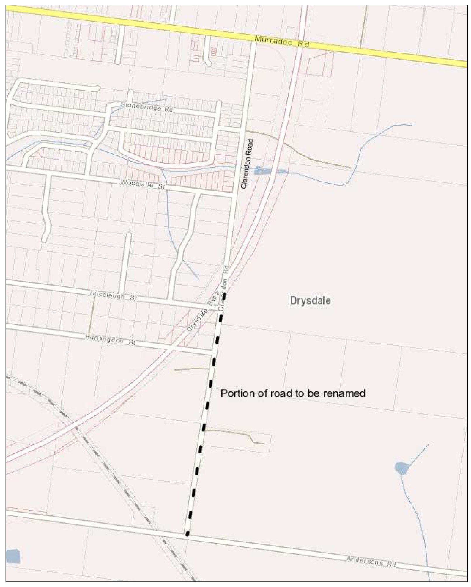
In honor of Corporal Horace Stanley Waterson – As a young child he moved to Drysdale and attended Drysdale State School and the Drysdale Methodist Church. Horace served for the Commonwealth Army on the western front and was killed in action in Belgium on 15 June 1917.
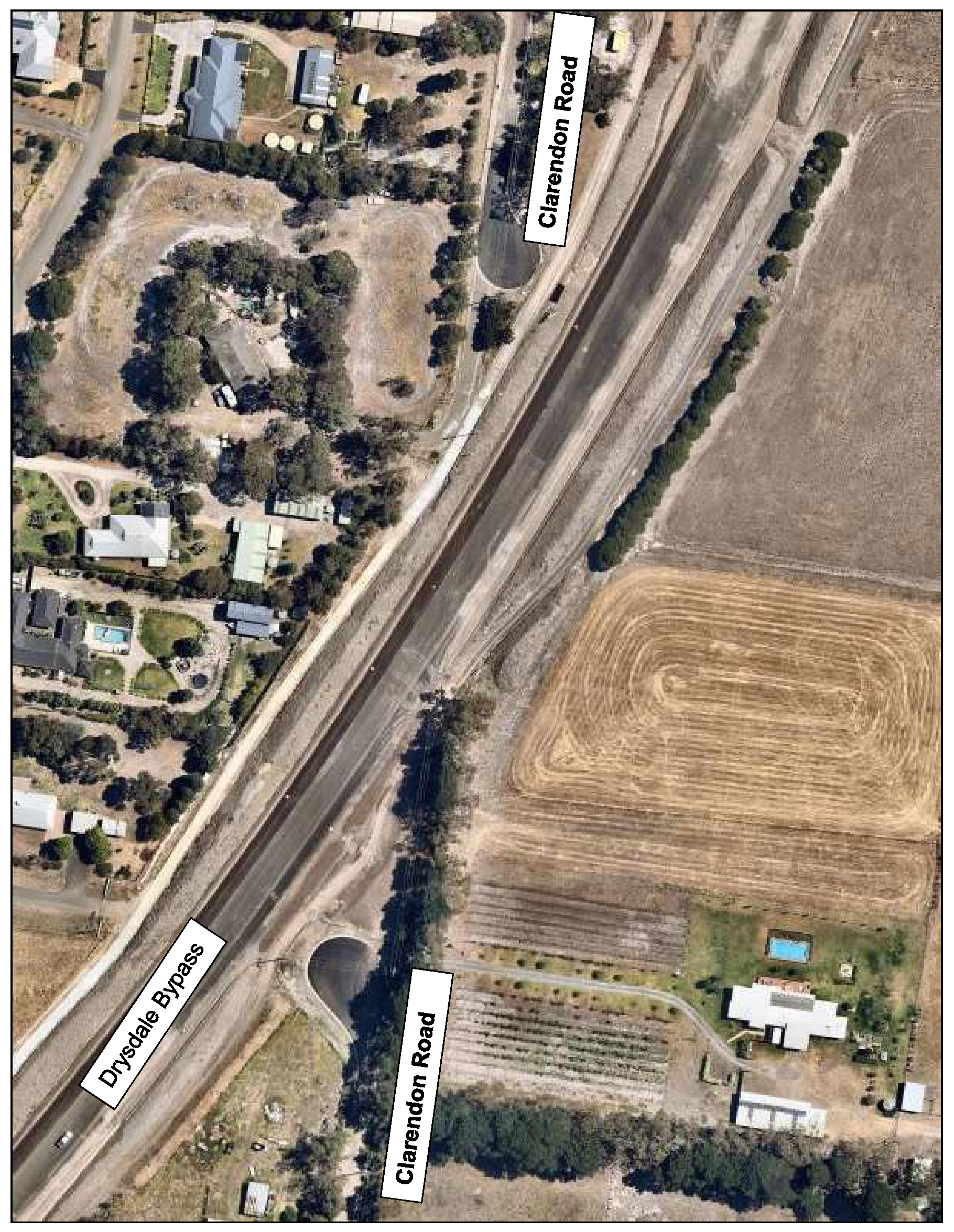
Aerial image showing how the road is truncated.
Source: |
Economy, Investment & Attraction – Economic Development and Events |
Director: |
Brett Luxford |
Portfolio: |
Rural and Coastal |
To update Council on the activities of the Rural and Peri-Urban Advisory Committee (Committee) via the 2018/19 Annual Report.
Council endorsed the formation and the Terms of Reference for the Rural and Peri-Urban Advisory Committee on 20 February 2017. Councillor Mason was appointed to the position of Chair.
The Committee has a diverse membership with nine (9) members, including representatives from Surf Coast Shire, Golden Plains Shire, Agriculture Victoria and various independent representatives. The City of Greater Geelong is represented by Councillor Mason and five (5) City of Greater Geelong Managers from Economic Development & Events, Strategic Planning, Engineering Services, Waste & Environment, and Healthy Communities. The Committee meets monthly.
Key activities and achievements include; forming active sub-committees, receiving presentations from various organisations on matters related to the rural and peri urban constituents, preparing budget submissions and participating in rural and peri urban related projects being undertaken by the City of Greater Geelong and other organisations.
Three sub-committees have been formed focusing on a livestock and information exchange, pest plants and animals, and roadside vegetation.
Key activities identified for the next 12 months include completing the feasibility study for a livestock and information exchange, developing and making information available to the rural and peri urban farmers, and providing input into various strategies including the Environmental Management Strategy, Distinctive Area Landscapes, and Restoring Rural Landscapes.
A Rural and Peri-Urban Advisory Committee Annual Report 2018-19 (Attachment 2) has been prepared and endorsed by the Rural and Peri Urban Committee to provide an overview of the Committee and its activities over the past 12 months.
Councillor Mason moved, Councillor Sullivan seconded -
That Council note the Rural and Peri-Urban Advisory Committee Annual Report 2018-2019.
Carried.
The Rural and Peri-Urban Advisory Committee is resourced by existing staff within the Economic Development & Events Department.
A draft Rural and Peri-Urban Advisory Committee Annual Report was circulated to Committee members, who accepted the report. A wide range of community consultation through various channels is currently being undertaken to support the feasibility study into a livestock and information exchange.
The Rural and Peri-Urban Advisory Committee members represent a diverse range of backgrounds and interests. This makes the Committee a valuable resource to Council on matters related to the Rural and Peri-Urban community.
There are no legal or statutory implications as a result of this report.
This report aligns to the following priorities in the Council Plan 2018-2022 - Effective Environmental Management, Planned and Sustainable Development and Informed Social Infrastructure and Planning.
No officer involved in the preparation of this report has a conflict of interest.
There are no risks associated with noting the Rural and Peri-Urban Advisory Committee Annual Report 2018-2019.
There are no environmental implications as a result of this report.
Note: Introduction of Urgent Business requires two-thirds majority of Councillors present.
Councillor Murnane proposes to raise the following item as Urgent Business:
Councillor Murnane moved, Councillor Mansfield seconded -
That Council considers as Urgent Business a motion concerning the authorising of the Chief Executive Officer to enter into an option agreement for the lease of 37 Morgan Street, North Geelong.
Carried.
The Council is concerned with the number of residents within Greater Geelong who require emergency food relief for both themselves and their families. Currently, national figures indicate that throughout the Greater Geelong region, local agencies are providing approximately 2.5 million meals per year. This figure is estimated to grow to 3.2 million meals per year by 2031, an increase of 31 percent.
The City commissioned a Food Assistance report to explore the food assistance system in Geelong and investigate the opportunities for improvement. The report is due to be presented to Council in May 2020.
The preliminary findings of the report indicates a need for additional storage and distribution space for the municipality.
An opportunity has arisen to lease a food distribution centre at 37 Morgan Street North Geelong. To ensure that the opportunity to lease this property is not lost whilst the Council await the report, the Council will be required to enter into an option agreement.
Councillor Murnane moved, Councillor Asher seconded -
That Council:
Authorise the Chief Executive Officer to enter into an option to lease 37 Morgan Street North Geelong from 1 July 2020;
Allocate $10,000 from the 2019-20 budget for the non-refundable cost of securing the option;
Conditional on the outcomes of the Food Assistance report, due for consideration by Council in May 2020:
Allocates the $1M from the 2019-20 budget to renovation works of the aforementioned leased premises; and
Considers allocating a grant amount of up to $150,000 per annum for five years to a third party provider for the running costs of a food distribution centre at the aforementioned lease premises.
Note the intention is for the lease of the aforementioned property be undertaken by a third party and not by Council to ensure the lease obligations are not borne by Council.
Carried
As there was no further business the meeting closed at 9:10pm on Tuesday 10 March 2020.
Signed: _________________________________________
Councillor Stephanie Asher (Mayor)
Date of Confirmation: _____________________________
Contents | Previous Page: Section A - Procedural Matters |
