
Council Minutes - Section B: Reports - 24 March 2020
Contents | Previous Page: Section A - Procedural Matters | Next Page: Section C - Notice of Motion
Contents | Previous Page: Section A - Procedural Matters | Next Page: Section C - Notice of Motion
Reports tabled at the Ordinary Meeting of Council on Tuesday date held at the Council Conference and Reception Centre in City Hall, 57 Little Malop Street, Geelong.
Amendment C372 Hams Road, Waurn Ponds – Consideration of Panel Report and Adoption
Audit and Risk Committee Summary Report (Confidential)
Source: |
Planning, Design & Development – City Development |
Director: |
Gareth Smith |
Portfolio: |
Planning |
To consider the Panel Report about Amendment C372 and Planning Permits 662/2017 and 663/2017 and adopt Amendment C372.
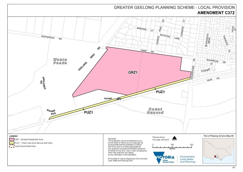
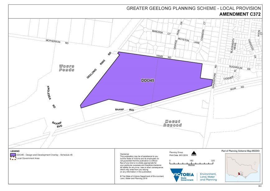
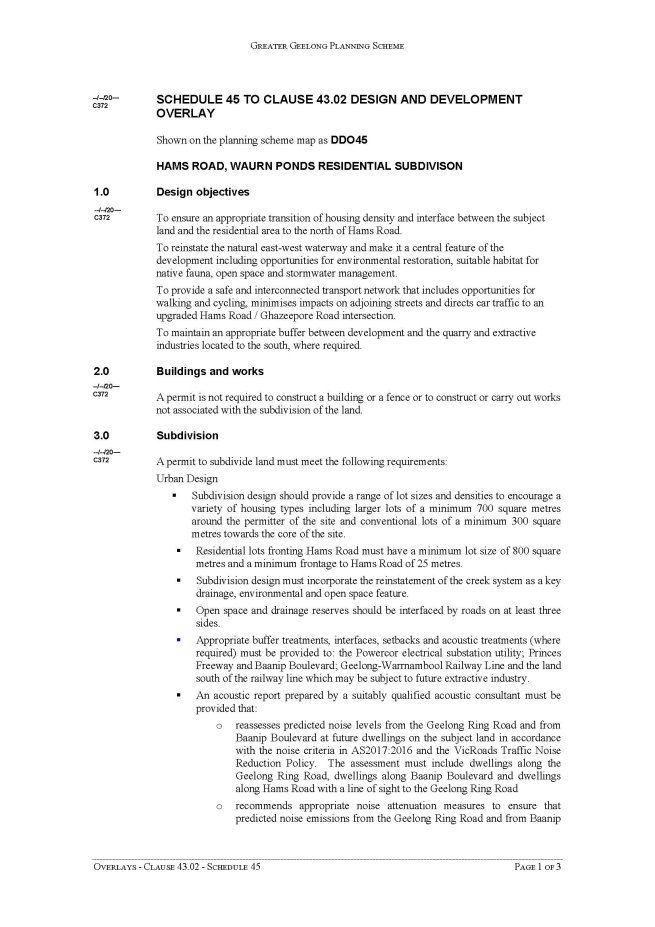
The Amendment primarily rezones land at 35 and 69-93 Hams Road, Waurn Ponds from Farming Zone to General Residential Zone Schedule 1 and applies Design and Development Overlay Schedule 45 to guide residential development of the land. Planning Permit applications 662/2017 and 663/2017 seek to allow subdivision of the land, removal of native vegetation, and removal of a gas easement from the land at 69-93 Hams Road that is no longer required.
This Amendment and planning permits implement the recommendations of the Panel to facilitate the rezoning and multi-lot residential subdivision development of the land. Attachment 2 provides a background summary of the Amendment process, including consideration of the Panel Report.
Exhibition of the Amendment and draft planning permits in March/April 2019 resulted in 159 objections primarily addressing issues including traffic and housing density. Other concerns raised in submissions included potential for student housing, socio-economic issues, crime and safety, servicing, environmental impacts, flooding, drainage, noise and air quality, the buffer from the Boral quarry land and the consultation process.
The submissions were considered by Council on 25 June 2019 when it was resolved to refer all submissions to an Independent Panel appointed by the Minister for Planning.
Following a hearing in August 2019, the Panel’s report was received on 28 October 2019. Under Section 27 of the Planning and Environment Act 1987, the Planning Authority must consider the Panel’s report before deciding whether or not to adopt the Amendment.
The Panel found the Amendment to be well founded and strategically justified by policy and recommends that both the Amendment and planning permits be adopted with changes.
On balance the Panel was satisfied that the development is likely to add a relatively small amount of additional traffic to Ghazeepore Road and the surrounding network, and there are no traffic reasons to not support the proposed development. The Panel supports the proposed roundabout at the intersection with Hams Road, Ghazeepore Road and Sugargum Drive.
On the issue of housing density and neighbourhood character, the Panel supports the proposed density reflected in the revised Masterplan and does not consider that it will result in an unacceptable impact on the neighbourhood character.
Whilst the Panel’s recommendation are generally supported, this report at Attachment 2 provides the City’s response.
It is recommended that Amendment C372 and PP662/2017 & PP663/2017 be adopted with changes and sent to the Minister for Planning requesting approval. Since the 28 January 2020 Council meeting, the two planning permits for adoption included in Attachment 6 have been updated to include the Panel recommended conditions that were accidently omitted by error.
Councillor Murnane moved, Councillor Harwood seconded -
That Council:
Adopt Amendment C372 in the form outlined in Attachment 3 of this report with the following changes to the Design and Development Overlay:
‘Urban Design’ - first dot point “conventional lots of a minimum 300 square metres towards the core of the site” replace 300 with 400 square metres; and
‘Urban Design’ - second dot point “lots fronting Hams Road must have a minimum lot size of 800 square metres.” replace 800 with 850 square metres.
Submit the adopted Amendment C372 and prescribed information to the Minister for Planning requesting approval;
Recommend to the Minister for Planning that Planning Permits 662/2017 & 663/2017 be approved in the form outlined in Attachment 6 of this report with the following changes:
To Condition 1 of both permits include:
All plans to be amended to show no residential lots less than 400 square metres in area;
The Overall Subdivision Masterplan to be amended to show no more than 214 lots in total across both sites.
To Condition 1 of Permit 662/2017 for the western site include:
Deletion of 3 lots in the north east corner of the site adjoining the north-south entry street off Hams Road and replacement with open space to provide a visual connection to the creek reserve parkland;
To Condition 1 of Permit 663/2017 for the eastern site include:
Deletion of 3 lots in the north west corner of the site and replacement with open space to provide a visual connection to the creek reserve parkland.
Authorise the signing and sealing of the Section 173 Agreements accompanying this Amendment C372 to formalise developer contributions (the draft Agreement is in Attachment 5 to this report).
Acknowledge the existing traffic issues on Ghazeepore Road, the $500,000 contribution by the proponent to contribute to rectification of the issues and Council seeks the community be engaged with identifying design options to address current concerns of the community.
Acknowledge that both planning permits require further environmental assessments to be submitted which must include an assessment of the land by a suitably qualified environmental professional detailing the level and location of any contamination.
Carried.
Division Requested:
For: Councillors Murnane, Harwood, Sullivan, Mason, Grzybek, Asher, Mansfield, Murrihy
Against: Councillors Kontelj, Aitken
The Amendment and permits are accompanied by an Agreement under Section 173 of the Planning and Environment Act 1987. A Section 173 Agreement is a voluntary agreement between Council and a landowner. They can include requirements relating to the use and development of land and they run with the title of the land. In this case, the Agreements require landowners/developers to undertake intersection and road upgrades, undertake external drainage works, provide public open space, and pay the community infrastructure contribution of $2670 per lot for the proposed 245 residential lots.
Amendment C372 and draft Planning permits 662/2017 and 663/2017 were exhibited in accordance with the requirements of the Planning and Environment Act 1987.
All submitters had an opportunity to be heard before an Independent Panel appointed by the Minister for Planning. The Panel considered all submissions referred to it, not just the submissions presented at the hearing.
The Independent Panel report has been publicly released and all submitters notified of its availability.
The Amendment will provide social benefits through the provision of further housing choices to the Geelong community by the range of lot sizes proposed. The future and existing residents in the area will also benefit from improved public open space, shared pathways and road intersection improvements.
An accompanying Section 173 Agreement will require a financial contribution towards community facilities in the Waurn Ponds, Armstrong Creek/Grovedale area.
The Amendment is consistent with the Greater Geelong Planning Scheme Planning Policy Framework, in particular Clauses 21.02, 21.04, 21.06, 21.08 and 21.11, which supports the residential growth of this area.
The Amendment aligns with the Sustainable, Built and Natural Environment and Growing our Economy strategic priorities as it facilitates development in accordance with an adopted strategic plan.
No City officer involved in the preparation of this report has any direct or indirect interest.
Delay in adopting Amendment C372 will impact the timeline for the subdivision development and bringing this new growth area onto the market and fulfilling Council’s planning policies for the area.
Ecological assessments have been undertaken and show some native vegetation and habitat on the land. Planning permit conditions address the impacts on native vegetation including offsets for vegetation to be lost.
The subject land has a degraded and unmanaged section of waterway running through it which is part of Armstrong Creek. The masterplan, through permit conditions and the DDO schedule, will protect and improve the waterway.
Amendment C372 and permit applications 662/2017 and 663/2017 seek to facilitate the multi-lot residential subdivision and development of the land at 35 and 69-93 Hams Road, Waurn Ponds.
The land is around 24 hectares in size and is located on the south-west edge of urban Geelong, approximately 10 km by road from Central Geelong. It is the last Farming Zone site inside the Ring Road / Anglesea Road in this part of the municipality. It is close to the Waurn Ponds Station, Deakin University’s Waurn Ponds campus, the Waurn Ponds Shopping Centre and to the Armstrong Creek West Growth Area. North of the land is the Grange Park Estate and the Powercor Waurn Ponds Zone Substation abuts the north east of the subject land. The land is bounded by:
Hams Road to the north;
The Geelong Ring Road (Princes Freeway) to the west;
Baanip Boulevard and the Melbourne to Warrnambool railway line to the south; and
Ghazeepore Road to the east.
The Amendment as exhibited sought to:
Rezone the land from Farming Zone to General Residential Zone 1;
Rezones the Barwon Reserve to Public Use Zone 1; and
Apply a new Design and Development Overlay Schedule 45 to guide future residential development of the land.
The planning permit applications propose to allow, subject to conditions:
Subdivision of the land;
Remove native vegetation; and
Remove a gas easement from the land at 69-93 Hams Road that is no longer required.
A draft Section 173 Agreement for developer contributions and offsite works was exhibited with the Amendment. This Agreement obligates the owner to provide the following as part of the subdivision of the land:
Intersection works at the Hams Road and Ghazeepore Road junction;
Upgrades to Hams Road;
Upgrades to Ghazeepore Road;
External drainage works – including within the VicRoads reserve, the Ghazeepore Road culvert and the Geelong-Warrnambool railway culvert;
Community Infrastructure Contribution (voluntary) – of $2670 per lot;
Public Open Space Contribution - 10% of all developable residential land in the subdivision (unencumbered), or 10% of site value or a combination of both; and
Public Open Space Improvements – including landscaping, fencing, seating, signage, playgrounds and the waterway shared pathways.
Council’s obligation is to collect and apply the Community Infrastructure Contribution to community infrastructure projects in Waurn Ponds/Grovedale areas.
Owners of the two properties subject to the Agreement have also agreed to make a $500,000 contribution towards a traffic improvement study in Ghazeepore Road (a final draft Agreement, with individual landowner details removed, is at Attachment 5).
Amendment C372 was exhibited between 13 March and 26 April 2019. As a result, 165 submissions were received of which 159 (including 77 pro forma submission) opposed/sought changes to the Amendment. Six (6) submissions either supported, did not object or provided comments.
The major issues raised in the submissions were:
traffic;
proposed density of the subdivision;
noise from the substation and surrounding roads and rail;
drainage and flooding issues, including impacts on a VicTrack culvert under the railway corridor;
ecological issues, including loss of native vegetation and loss of habitat;
issues relating to the interface with the neighbouring substation and the quarry;
cultural heritage impacts;
potential contamination;
bushfire risk and emergency vehicle access; and
social issues.
Council minutes of 25 June 2019 summarised all submissions and provided a detailed City response to all of the issues raised.
All submissions were considered pursuant to Sections 22(1) & (2) of the Planning and Environment Act 1987 and referred to an Independent Panel appointed by the Minister for Planning.
The appointed two person panel held a directions hearing on 22 July 2019 and a four (4) day Panel Hearing in Geelong on 22, 23, 26, and 27 August 2019. Council was represented at the hearing by City officers.
The Panel has now presented its report to Council and recommended that Amendment C372 be adopted with some changes, and that planning permits 662/2017 and 663/2017 be issued with some changes. Attachment 4 is the Executive Summary of the Panel Report and contains the consolidated panel recommendations.
A complete copy of the Panel’s report is available on the Geelong Australia website.
The Panel Report provided discussion and a series of findings and recommendations about all the issues associated with the Amendment, planning permit and S173 Agreement. A summary and response to the key matters is provided below.
Issue – Strategic justification for the proposal
The Panel was not persuaded by any party that there is any reason to question the overall policy support for the proposal. The Panel noted that the strategic framework identifies the land for future residential development and rezoning is consistent with a number of high level State policy directions. At a more regional and local level, the Panel noted that the rezoning meets policy directions in the G21 Regional Growth Plan aimed at minimising the continued expansion of the urban footprint and providing a mix of infill development in suitable locations. The Panel recommends some minor amendments to the exhibited Design and Development Overlay Schedule 45, which are shown in Appendix C of this report.
The Panel considered that the development represented on the revised Masterplan will produce an acceptable outcome that will deliver net community benefit and sustainable development. The Panel also found that the permits should be granted, subject to the conditions outlined in their report.
Panel Conclusion: The Panel concluded that the Amendment is well founded and strategically justified and should proceed.
City response: The City concurs with this view of the Panel on the suitability and policy support for the rezoning and the recommended changes to the DDO45 and two planning permits.
Issue – Traffic impacts
The issue considered whether there is capacity within the current road network to accommodate the development traffic, with expert evidence presenting that there is, whilst residents identifying that they are already experiencing significant traffic congestion under current conditions, and that adding the extra traffic will make things worse.
The Panel also considered the submitters concerns about the internal road layout, including adequate access for emergency vehicles.
Panel Conclusion: The Panel concluded that the development is likely to add a relatively small amount of additional traffic to Ghazeepore Road and the surrounding network, and there are no traffic reasons to not support the proposed development. The Panel has also noted Council’s acknowledgement that traffic in Ghazeepore Road is currently causing difficulties for the local residents and would likely be designed differently if it was being designed today. The Panel regards the proponent’s voluntary contribution of $500,000 toward a traffic improvement study in Ghazeepore Road, and any resulting improvement works is an appropriate response.
The Panel supports the proposed roundabout at the intersection with Hams Road, Ghazeepore Road and Sugargum Drive, going some way to resolving existing traffic concerns in Ghazeepore Road. The Panel has not found that the proposed development is likely to result in significant traffic increased in Grange Park Drive and does not support turn bans at the intersection of Grange Park Drive and Hams Road.
The Panel generally supports the proposed upgrades to Hams Road. However the Panel has not supported the 3.0 metre wide shared path on the south side of Hams Road requested by Transport for Victoria (TfV), concluding that the shared path through the creek reserve is sufficient. However, as TfV is a determining referral authority, the Panel recommended further consultation with them on this matter.
Based on submissions and evidence and CFA advice, the Panel is satisfied that the internal road layout can accommodate emergency vehicle access.
City response: The City accepts the Panel’s findings on traffic in the vicinity of the proposed development. The S173 Agreement includes the obligations for the various road and intersection upgrades, and a financial contribution to Council for a broader traffic management study of Ghazeepore Road. The City has consulted with Transport for Victoria as recommended by the Panel. TfV has advised of the strategic importance of the shared path and its connection between existing and planned paths and key origins and destinations, and requires the retention of this path, with specific conditions to be included on the permit. As a determining referral authority, the City must include these conditions and retain the shared path in the subdivision.
The City concurs with the Panel’s conclusions that the internal road layout can accommodate emergency vehicle access and is in line with accepted subdivision standards.
Issue - Housing density and neighbourhood character
A key matter contested in the Hearing was the impact of the density of the proposal on the character of the established residential areas in the vicinity of the site. Many submissions did not oppose the rezoning to residential but were concerned about the relatively small lot sizes compared with those in the Grange Park Estate, the inclusion of medium density super lots and the inconsistency with the semi-rural feel of the area. Concerns about the proposed density were also held about the other amenity impacts such as on traffic in the area.
Panel Conclusion: The Panel supports the proposed density reflected in the revised Masterplan and does not consider that it will result in an unacceptable impact on the neighbourhood character. Larger lots are proposed along Hams Road and around the perimeter of the site, providing an appropriate interface with the Grange Park Estate. The current policy framework does not support the larger lot sizes and lower densities sought by many submitters. In fact, it supports higher densities than those proposed, given the proximity of the land to Waurn Ponds Station and other local and regional services and employment opportunities.
City response: The City concurs with the Panel’s conclusions on this point of submissions.
Issue – Noise
The subject land is in a noise constrained environment. Nearby noise sources include the Geelong Ring Road and Baanip Boulevard, the Geelong to Warrnambool railway line, the Powercor substation, the Boral quarry and the proposed pump station on the site. The Panel has considered the noise issues from each of these sources and the impacts on the residential proposal.
The Panel noted that noise assessments conducted to date indicate that noise from the substation exceeds the applicable criteria and that noise mitigation measures will be required to ensure the noise criteria can be met. Noise attenuation measures must not increase noise levels at existing dwellings to the north and east of the substation and that further assessment will be required. The panel also noted that noise assessments conducted to date indicate that noise levels from the railway line exceed investigation thresholds specified in the Victorian Passenger Rail Noise Policy. Noise mitigation measures will also be required to address impacts on dwellings near the railway line.
Panel Conclusion - While noise assessments conducted to date concluded that predicted traffic noise levels would be appropriate, the Panel has some concerns with the Traffic Noise Assessment and considers that traffic noise needs to be reassessed, and the need for noise mitigation further considered. Suitable permit conditions have been included to ensure that this occurs.
City Response – Conditions have been included in the planning permits as recommended by the Panel to address noise attenuation.
Issue - Flooding and Drainage
Submissions raised various issues about drainage and flooding of the subject land and surrounding areas. In particular, the Panel considered the adequacy of the proposed drainage scheme, flooding of Hams Road and Grange Park Estate, potential flooding impacts on the substation and the VicTrack and Ghazeepore Road culverts.
Panel Conclusion - Subject to some minor refinements, the Panel concluded that the proposed drainage scheme will improve the currently degraded waterway traversing the site, and will improve existing local flooding conditions including the periodic flooding of the retarding basin and surrounding properties in the Grange Park Estate, and the flooding that occurs across Hams Road. The Panel also noted that external drainage works will be required, including upgrades to the culverts in Hams Road and Ghazeepore Road.
On the issue of the use of, and impacts on, VicTrack’s aging brick culvert under the Geelong to Warrnambool railway corridor, the Panel noted that the culvert is currently not performing as it should, largely due to sediment build up, and there can be significant ponding of water on both sides of the railway line. The Panel concluded that VicTrack’s initial objection to the development draining through the VicTrack culvert was unreasonable and that it needs to be upgraded or replaced to allow for safe and effective drainage management. The Panel commented that further negotiations will be required between the Proponent, VicTrack and others, including Council. The Panel considers it unreasonable to expect the Proponent to bear all responsibility and cost of the upgrade or replacement.
City Response – The City supports these conclusions of the Panel, and has incorporated the recommended changes into the planning permit conditions and very minor reference to VicTrack in the S173 Agreement.
Issue - Ecological impact
The panel considered the issue of the loss of native vegetation and the impacts on fauna from the proposal. The site contains patches of remnant native vegetation as well as an off-site patch of Grassy Woodland on Hams Road. The waterway and wetlands are sensitive areas and require careful consideration. Officers noted that more detail was required on this issue and that offsets for the loss of vegetation in Hams Road would be required.
Panel Conclusion – The Panel concluded that the exhibited permit conditions were not sufficiently rigorous to deliver acceptable biodiversity outcomes. However the Panel supports the revised permit conditions provided by Council at the Hearing. Subject to minor refinements, the Panel concluded that they will ensure that native vegetation to be retained will be properly identified and protected, and that vegetation to be lost will be appropriately replaced or offset. The Panel identified that some changes were required to permit conditions to better protect frog species on the land (including determining whether the Growling Grass Frog is present), but the Panel is satisfied that the revised permit conditions will, if implemented, deliver a better biodiversity outcome on the land and for the surrounding area than currently exists.
City Response – The City supports this Panel conclusion including the refinements of the DDO45 and the inclusion of revised conditions in the two planning permits.
Issue - The Quarry
To the west of the subject land is the Boral quarry with stone extraction allowed up to the edge of the Boral land. While the Panel has some reservations about the impact of possible blasting activity, it found there was insufficient evidence to justify imposing a larger 500 metre buffer, which would result in most of the subject land being potentially undevelopable.
Panel Conclusion - It is appropriate to apply a 250 metre extractive industry buffer to both permits, and to reference this buffer in the Design and Development Overlay Schedule 45. The Panel also concluded that subdivision and development of land within the buffer should not be permitted without the consent of the Earth Resources Regulation Branch of the Department of Jobs, Precincts and Regions.
City Response – The City concurs with these Panel conclusions and these measures are incorporated in the DDO45 recommended for adoption.
Issue – The substation
The Waurn Ponds Zone Substation is located at 25 Hams Road and directly abuts the site. It has been operating in this located since 1972 and contains equipment that emits noise. Submissions were concerned that the noise emissions from the substation had not been addressed, and could negatively impact on the residential development. The Panel considered expert evidence on the issue and the varied positions of the parties to address the issue via the DDO, planning permit conditions, modifications to the subdivision design and built form and noise barriers around the substation. In particular, consideration of a 5 metre high acoustic barrier around the substation were discussed, including the potential resulting visual amenity impacts on the area.
Panel Conclusion – The Panel is satisfied that the impacts of the substation on the proposed development (and the reverse amenity impacts of the development on the substation) can be appropriately managed through adding permit conditions to ensure that the drainage system does not allow flooding of the substation site, and to ensure that future dwellings on the land incorporate appropriate measures to attenuate the noise generated by the substation
City Response – The City supports this and has incorporated appropriate conditions into the planning permits to avoid flooding of the substation and to require noise attenuation in future dwellings.
Planning and Environment Act 1987
The planning authority for this amendment is Greater Geelong City Council.
The Greater Geelong Planning Scheme is amended as follows:
Planning Scheme Maps
The Planning Scheme Maps are amended by a total of 2 attached map sheets.
Zoning Maps
Amend Planning Scheme Map No.65 in the manner shown on the attached map marked “Greater Geelong Planning Scheme, Amendment C372”.
Overlay Maps
Amend Planning Scheme Map No.65DDO in the manner shown on the attached map marked “Greater Geelong Planning Scheme, Amendment C372”.
Planning Scheme Ordinance
The Planning Scheme Ordinance is amended as follows:
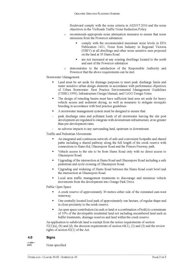
In Overlays – Clause 43.02, insert a new Schedule 45 in the form of the attached document.
End of document
Source: |
Planning, Design & Development - City Development |
Director: |
Gareth Smith |
Portfolio: |
Planning |
To consider submissions received on Planning Scheme Amendment C401 and recommend all the submissions be referred to an Independent Planning Panel.
In March 2019, a Planning Permit application was lodged for a residential alcohol and drug rehabilitation facility and vegetation removal at 120 Russells Road, Mount Duneed. The application was subsequently withdrawn as the proposal falls within the land use term Community Care Accommodation, introduced into planning schemes by the State Government’s Amendment VC 152 in October 2018 and prohibited in the Farming Zone.
In May 2019, St Quentin Consulting on behalf of Foundation 61 Inc. lodged a planning scheme amendment to allow a Community Care Accommodation facility and associated vegetation removal at 120 Russells Road. The amendment proposes a Specific Controls Overlay and an Incorporated Document.
At its meeting of 10 September 2019, Council resolved to support preparation and exhibition of Amendment C401.
Amendment C401 was exhibited from 17 October to 25 November 2019. 38 submissions were received. 31 submissions object to, and four submissions support the amendment. Separately, a petition with 130 signatures regarding the proposal was presented to Council at its meeting of 10 December 2019.
Key issues raised in submissions include the appropriateness of the location for the facility, safety of users of Mount Duneed Recreation Reserve and local residents, impact on and relationship with the Reserve, facility management and future changes, vegetation removal, traffic, visual impact and impact on historic values.
Council officers have considered the submissions and recommend various changes to the Amendment to address issues raised in submissions and other minor matters identified.
It is recommended that all submissions be referred to an Independent Panel appointed by the Minister for Planning.
Councillor Harwood moved, Councillor Murnane seconded -
That Council having considered all submissions summarised in Attachment 9 to this report to Amendment C401 to the Greater Geelong Planning Scheme resolves to:
Request the Minister for Planning to appoint an Independent Panel under Part 8 of the Planning and Environment Act, 1987;
Refer all submissions summarised in Attachment 9 of this report to the Panel; and
Submit to the Panel its response to the submissions generally as outlined in this report.
Carried.
There are no significant financial implications to Council.
Exhibition and notice of the Amendment was conducted in accordance with the Planning and Environment Act 1987.
Panel hearing dates have been pre-set for this Amendment: Directions Hearing on Tuesday 21 April 2020 and Panel Hearing commencing Wednesday 20 May 2020. Planning Panels Victoria will notify all submitters of the Panel dates and provide the opportunity for submitters to be heard at the Panel Hearing.
The amendment addresses social equity by providing opportunities for vulnerable members of the community to seek treatment for drug and alcohol related issues.
The Amendment supports the following State Policies from the Planning Policy Framework:
Clause 12.01-2S Native vegetation management;
Clause 12.05-2S Landscapes;
Clause 13.02-1S Bushfire planning;
Clause 15.01-2S Building design;
Clause 15.01-6S Design for rural areas;
Clause 15.02-1S Energy and resource efficiency;
Clause 15.03-1S Heritage conservation;
Clause 15.03-2S Aboriginal cultural heritage; and
Clause 16.01-6S Community care accommodation.
The Amendment supports the following policies from the Local Planning Policy Framework:
Clause 22.05 Agriculture, Rural Dwellings and Subdivision; and
Clause 22.64 Discretionary Uses in Rural Areas.
Alignment to Council Plan
The Amendment supports strategic priority of improved health and safety of our community in the Council Plan 2018-2022.
No Council officers involved in the preparation of this report have a direct or indirect interest in the issue to which this report relates.
There are no notable risks associated with implementing the recommendations contained in this report. Issues raised in submissions regarding potential risks to nearby residents and to users of the adjacent Recreation Reserve are addressed in Attachment 2 of this report.
The proposal requires some native vegetation removal. It is recommended that the Incorporated Document include a requirement to provide appropriate offsets prior to vegetation removal. A revised site plan showing reduced car parking will allow retention of two Sheoaks previously identified for removal.
In March 2019, a Planning Permit application was lodged for a residential alcohol and drug rehabilitation facility and vegetation removal at 120 Russells Road, Mount Duneed.
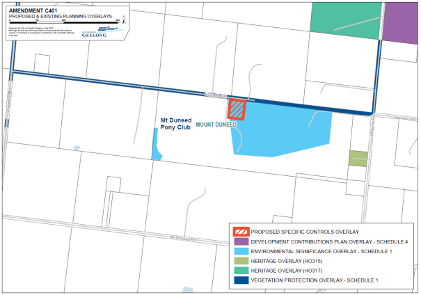
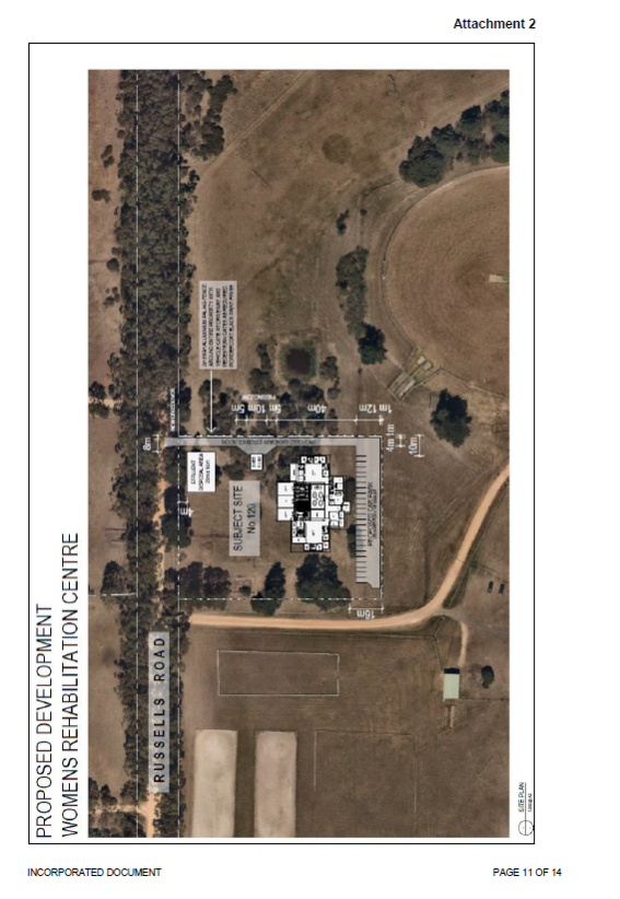
The subject site is a vacant 8094 m2 parcel of land within the Farming Zone, abutted by the Mount Duneed Recreational Reserve to the east, west and south. An Environmental Significant Overlay – Schedule 1 applies to most of the site, along with land to the south and east within the Recreational Reserve. A Vegetation Protection Overlay – Schedule 1 applies to Russells Road.
The subject site is owned by the Uniting Church in Australia Property Trust (Victoria). The site was formerly occupied by the Mount Duneed Wesleyan Methodist Church, constructed in 1857 destroyed by fire in 1944. Limited remains of this building are situated in the north-west part of the site.
The planning permit application was subsequently withdrawn as the proposal falls within the land use term Community Care Accommodation, introduced into planning schemes by the State Government’s Amendment VC 152 in October 2018. Community Care Accommodation is prohibited in the Farming Zone.
In May 2019, St Quentin Consulting on behalf of Foundation 61 Inc. lodged a planning scheme amendment to allow a Community Care Accommodation facility and associated vegetation removal at 120 Russells Road.
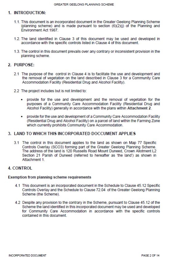
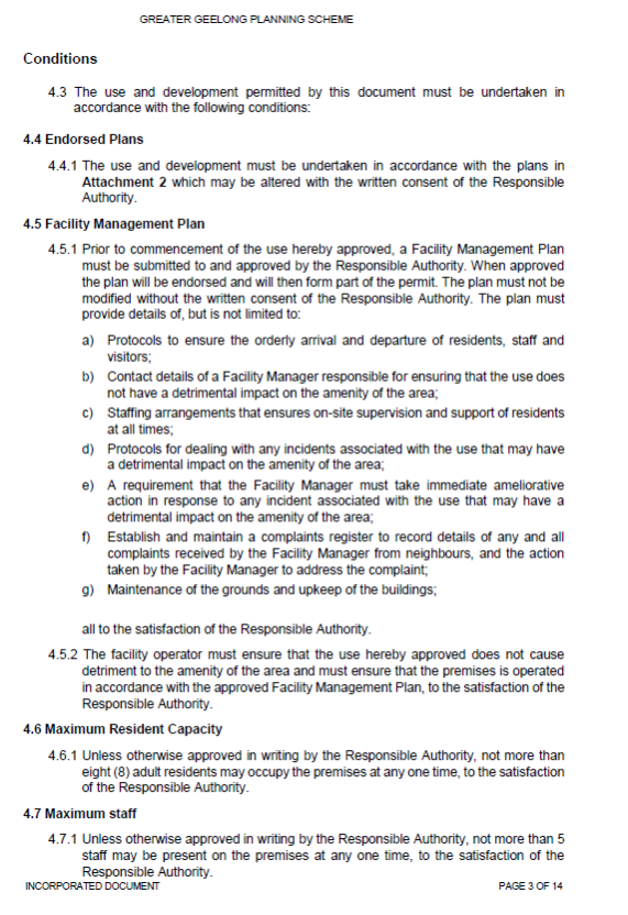
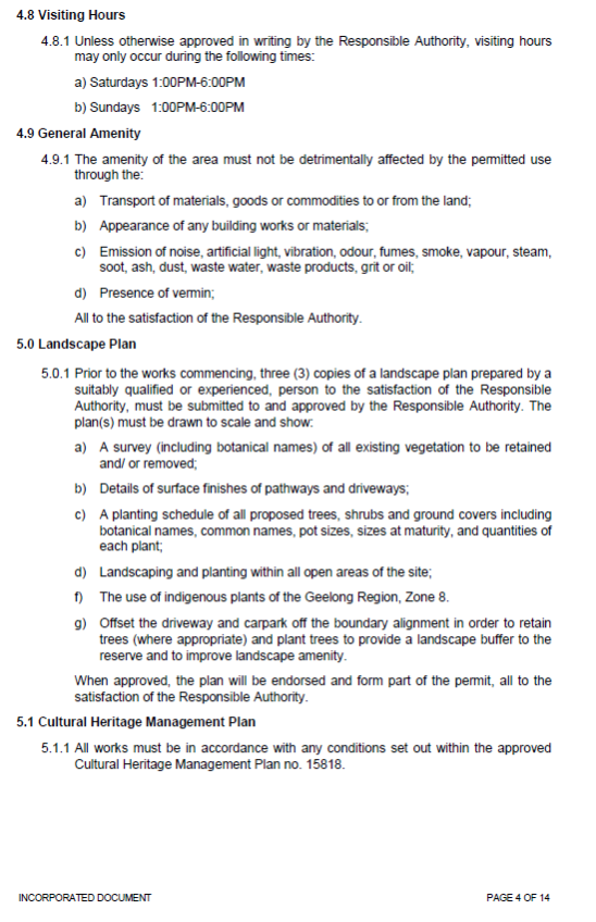
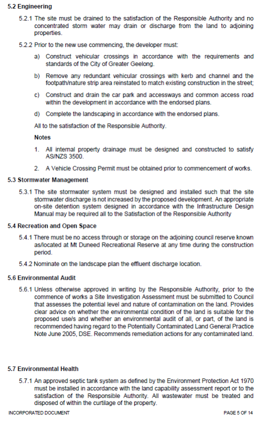
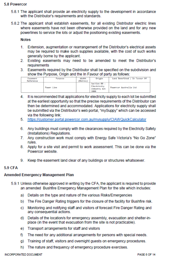
The amendment proposes a Specific Controls Overlay and an Incorporated Document. The Incorporated Document allows use and development of Community Care Accommodation in accordance with plans in the document, which may be altered with the written consent of the Responsible Authority (Council), and controls set out in the document. The Incorporated Document acts similarly to a planning permit.
The facility is proposed to be run by Foundation 61 (a not for profit organisation) as a women’s alcohol and drug rehabilitation facility. The same organisation separately operates a men’s rehabilitation facility in Williams Road, Mount Duneed, further south within the Surf Coast Shire.
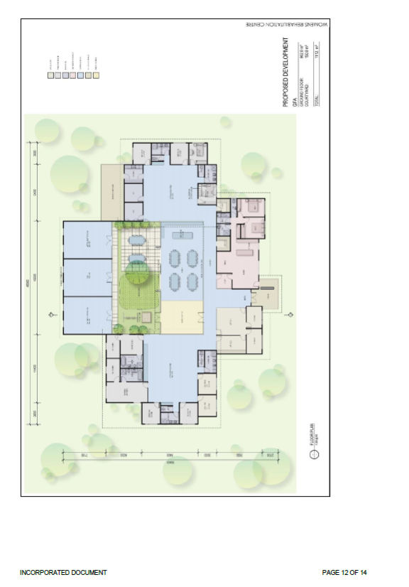
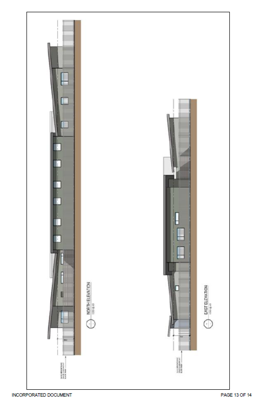
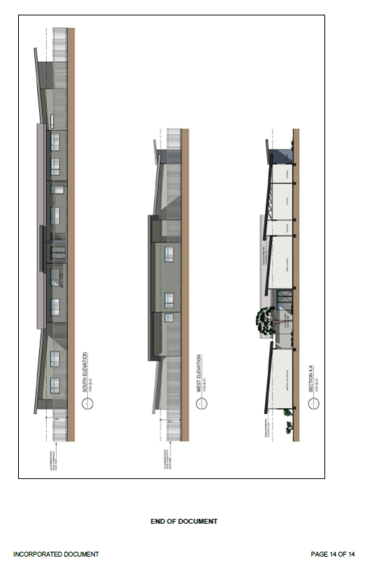
The plans in the Incorporated Document are a for a single storey main building located towards the southern boundary of the site, containing several bedrooms, offices, main lounge areas, a courtyard and a gym, arts and craft room and a meeting/classroom. A 6 x 8 m shed is also proposed. The plans delineate an on-site effluent disposal area. The proposed development avoids the site extent of the former church in the north-west of the site. A driveway is proposed from Russells Road; no access to the site is proposed from the Recreation Reserve. (Exhibited site plan and elevations are in the exhibited Incorporated Document at Attachment 6).
Controls in the Incorporated Document include:
a maximum of eight adult residents and five staff on the site at any one time;
the requirement for a facility management plan, addressing matters such as protocols for arrival and departure of residents, staff and visitors, ensuring on-site supervision and support of residents at all times, incident management, maintenance and upkeep; and
visiting hours limited to 1:00 to 6:00 p.m. on weekends.
The Incorporated Document does not limit residents to women only.
At its meeting of 10 September 2019, Council resolved to support preparation and exhibition of Amendment C401.
Amendment C401 was exhibited from 17 October to 25 November 2019. 38 submissions were received. Of these submissions:
31 object to the amendment;
one requests changes to the amendment;
four support the amendment; and
two express no objection.
The Department of Environment, Land, Water and Planning (DELWP) submission, among other matters, requests that the Incorporated Document be modified to specify the location and extent of native vegetation to be removed and include a requirement that appropriately specified offsets are provided prior to vegetation being removed. This submission is discussed under the heading Vegetation removal below.
A summary of all submissions in table format can be found at Attachment 9.
The following section of this Attachment provides a theme-based summary of issues raised in submissions and an officer response.
A response to issues not fitting within the themes below can be found in Attachment 9.
A petition with 130 signatures regarding the proposed facility was presented to Council at its meeting of 10 December 2019. 16 of those signing the petition also lodged objecting submissions. The petition read as follows:
This type of facility is prohibited under the Planning Scheme. This is not a suitable location as any future development for community use and the open and scenic values of Mount Duneed Reserve will be affected and important indigenous vegetation will be destroyed. It could attract an undesirable element inhibiting the enjoyment of the Reserve by the general public.
We request that the City of Greater Geelong abandon Planning Scheme Amendment C401 and investigate incorporating 120 Russells Road into the Reserve, protecting the natural and scenic values so that the open space will be retained and can continue to be enjoyed by the public in future years.
Appropriateness of location
Nearly all objecting submissions contend that the subject site is an inappropriate location for the proposed facility.
Reasons cited for the location being inappropriate include:
the facility is too close to the adjacent Mount Duneed Recreation Reserve and its various uses including pony club, adult horse riding and cricket;
the facility should not be located in the Farming Zone;
the site is too remote from public transport, medical facilities, emergency services and schools;
the site is too close to the Mount Duneed Primary School;
the facility does not need to be in a rural area;
the facility should be located in an urban area;
the facility is too close to a residential area;
the facility should be in a less dense, less family-oriented area;
proximity to a gun club may cause problems;
inconsistency with the character and semi-rural nature of the area.
Officer response
State planning policy recognises the need for and seeks to facilitate community care accommodation. An objective of Clause 16.01-6S is:
To facilitate the establishment of community care accommodation and support their location being kept confidential.
Victoria Planning Provisions applying throughout the state generally encourage community care accommodation. The use of Community care accommodation and the development of buildings and works for this use is, subject to certain conditions, exempt from requiring a planning permit in a wide range of residential and rural residential zones. These include the Residential Growth, General Residential, Neighbourhood Residential, Low Density Residential, Township and Rural Living Zones.
The wide range of zones in which the use is conditionally exempt from requiring a planning permit reflects a confidence that the use is compatible with adjacent and nearby residential, educational, recreational and other community uses that occur in or adjacent to those zones.
Notwithstanding this, Amendment VC 152, which introduced the land use term Community care accommodation into planning schemes in October 2018, did not provide for the use in the Farming Zone. Community Care Accommodation is prohibited in the Farming Zone as it falls within the broader land use term Accommodation under Clause 73.04-1. The appropriateness of the use on the subject site thus still needs to be demonstrated to warrant applying the Specific Controls Overlay to land within the Farming Zone.
Although largely decided under earlier planning controls, several VCAT decisions on similar facilities have established support for drug and alcohol rehabilitation facilities in semi-rural areas:
Myers Planning Group Pty Ltd v Warrnambool CC [2019] VCAT 1153 – land in the Farming Zone;
Australian Community Support Organisation Ltd v Moira SC (No.2) [2017] VCAT 1133 – land in the Farming Zone; and
Odyssey House Victoria v Benalla Rural CC & Ors [2003] VCAT 15 – land in the (then) Rural Zone.
It has been recognised that a semi-rural location may be of benefit to residents of a community care accommodation facility as compared to a location within an urban area. In Odyssey House Victoria v Benalla Rural CC & Ors [2003] VCAT 15, for example, in its decision on a proposed drug and alcohol residential rehabilitation facility located near Benalla, VCAT noted that:
A facility such as this needs to exude a degree of detachment and would not be suited to a downtown location in either Melbourne or Benalla.
It seems to us therefore that a location 12 minutes’ drive from town and in a not entirely isolated but yet pleasant rural setting such as Moylullah is entirely appropriate.
The proposal does not result in the loss or fragmentation of agricultural land. The subject site is an historic 8094 m2 parcel of land. Other than grazing, it has not been used for agricultural purposes and it is not located directly adjacent any other land in the Farming Zone with which it could be jointly used for agriculture. It is not considered that the use is likely to adversely impact on farming operations on land in the Farming Zone to the north of Russells Road.
Issues raised regarding visual impact, safety and the relationship with and impacts on the adjacent Recreation Reserve are considered separately below. However, the site’s location, in the Farming Zone but in relatively close proximity to urban Geelong, is considered appropriate for the use of community care accommodation.
Safety of Reserve users and local residents
27 of the 31 objecting submissions expressed concern for the safety of local residents and/or users of the Mount Duneed Recreation Reserve due to the nature of the proposed use, the residents and their visitors. It is clear from submissions that these fears are sincerely and strongly held.
Submission express concern for the safety of Reserve users, emphasising the numbers of children and women who use the Reserve and contending that their safety cannot be guaranteed. Some submitters indicate that should the proposed facility be developed on the site, they will no longer feel safe for them or their children to use the Reserve.
Submissions express concern that residents of the facility will access the adjacent Reserve and that children may be exposed to drug affected behaviour. Concern is also expressed regarding visitors to the site, including hostile partners who may try to gain access to the facility. Several submissions contend that the facility will attract unsavoury people to the area and the Reserve and that this will result in antisocial behaviour. Submitters raise the potential for abusive or violent interactions between visitors and Reserve users. One submitter contends that the facility will generate visitors and onlookers to pony club events who have not completed a Working with Children check. Another submitter notes that drug dealing activities already take place at the Reserve.
Concern is also expressed regarding property crime and vandalism. Reserve users note previous vandalism problems at the Reserve and that valuable equipment is stored at the Reserve. Risks to the safety of horses, cars and valuables are cited.
The relative seclusion of the area is cited as a security concern. It is contended that police or ambulance services will not be able to respond quickly to any incident at or near the facility.
To the contrary, one supporting submission notes that the men’s facility run by the same organisation proposing the facility on the subject site is well run and secluded, and contends that there is minimal risk to the community from the proposed facility.
Officer response
The wide range of residential and rural residential zones throughout Victoria in which use and development of Community care accommodation conditionally requires no planning permit should give some comfort and reassurance that the use is considered compatible with adjacent and nearby residential, educational, recreational and other community uses.
Surf Coast Shire’s Statutory Planning and Investigations teams advise that they are not aware of any complaints regarding the operation of the men’s facility in Williams Road, Mount Duneed, operated by the same organisation proposing the facility on the subject site.
The proposed use of the land will be separate from the Recreational Reserve and the activities associated on the subject site will be contained within the subject site itself. The applicant advises that the facility will have permanent 24-hour supervision and staff presence.
With respect to the resident patients that the facility will cater for, the applicant has advised as follows:
Foundation 61 patients are voluntary only, meaning people are not directed by Courts to do mandatory time at a Foundation 61 facility. They are referred to Foundation 61 by a number of ways, including General Practitioners, churches and other community volunteer groups.
Patients must be physically capable to look after themselves relatively independently and the facility will not cater for physical, psychiatric or intellectual disabilities; and
Although some women may have had previous traumatic relationships with men, the facility will not cater for women who are currently in a violent or abusive relationship. The women who attend the facility, as with Foundation 61’s men’s facility, will have the support of their family to attend Foundation 61.
Controls proposed in the exhibited Incorporated Document also go some way to address security concerns:
a maximum of eight adult residents and five staff on the site at any one time;
the requirement for a facility management plan, addressing matters such as protocols for arrival and departure of residents, staff and visitors, ensuring on-site supervision and support of residents at all times, incident management, maintenance and upkeep; and
visiting hours limited to 1:00 to 6:00 p.m. on weekends.
It is in the interests of all parties, the facility’s operator, residents and visitors, nearby residents and Reserve users that management of the facility minimises the risk of any adverse outcomes. Including some further requirements for the Facility Management Plan in the Incorporated Document will further ensure that matters of potential concern are adequately addressed. The following additional requirements are based partly on planning permit conditions applied by VCAT in its decision on Myers Planning Group Pty Ltd v Warrnambool CC [2019] VCAT 1153 to address similar concerns:
an Emergency Management Plan detailing how the proponent will prepare for and respond to emergency situations including, among other matters, a protocol with the CFA, Victoria Police and Ambulance Victoria;
a risk management plan which:
identifies the safety and security risks involved in operation of the facility;
assesses the severity and degree of likelihood of any relevant incident or event occurring; and
sets out the measures that the facility operator will take to address and, in so far as possible, minimise each identified risk;
provision for dealing with clients who indicate a wish to leave the facility before the end of their scheduled program, including measures to ensure their departure from the facility is planned;
resident rules that prohibit access to any private properties adjoining Russells Road; and
keep a written logbook of all attendees (including residential clients and visitors) to the facility, with the logbook to include details consisting of the names of people, dates and times of attendance and departure to and from the centre; the logbook must be made available for inspection by the Responsible Authority at any time upon request.
Impact on/relationship to Reserve
Some submissions express concerns with the potential impact of the proposal on the current use of the Mount Duneed Recreation Reserve. Four submissions raise the potential for conflict between residential use of the subject land and equestrian use of the Reserve, in particular noise from equestrian competitions which can involve early starts and overnight camping. The risk of horses to facility residents who access the Reserve is also cited.
Several submissions contend that the site is effectively, and has been perceived to be, part of the adjacent Mount Duneed Recreation Reserve. One states that the subject site is an intrinsic part of the Reserve in all but Title. Other submissions refer to the proposal as being located within the Reserve or intruding into the Reserve.
Some submissions raise the history of the subject site in support of the site being considered part of the Reserve. It is argued that the public have not been excluded from the site and that it has long been maintained by Council. One submission argued that “squatters’ rights” should apply. Submissions call for the land to be acquired by Council, absorbed into the Recreation Reserve or set aside as a Conservation Reserve. Separately, the petition presented to Council in December 2019 calls for Council to investigate incorporating the site into the Reserve.
Several submissions refer to revegetation works, carried out by local residents/volunteers, that include the subject site. The submissions also object to removal of trees in this revegetation area.
Officer response
Recreational uses of the Reserve will continue to be subject to noise controls currently applying in the area. The proponent intends that resident patients will not access the Reserve.
Notwithstanding any maintenance by Council or public access over time, the subject site is owned by the Uniting Church in Australia Property Trust (Victoria). The applicant has advised that Foundation 61 is negotiating its purchase.
A revegetation area planted for conservation purposes in 2003 is located partly within the subject site and partly within the Reserve. The loss of some of this vegetation is unfortunate, particularly given volunteer involvement in its planting. However, Council’s Recreation & Open Space unit has advised that if the development is approved it will permit the removal of this vegetation, to the minimum extent required to facilitate the proposed development. The City has undertaken to conduct revegetation works in the Reserve adjoining the development site to offset this loss of vegetation.
Land swap suggestion
One submission requests that Council examine feasibility of a land swap within the general area to allow development to proceed while protecting the native grassland patch on the subject site.
Council’s Environmental Planning unit suggested investigation of a land swap for an equivalent parcel in the north-western corner of the Mount Duneed Recreation Reserve. This suggestion was put to the applicant.
Officer response
The applicant has advised that in its view the land swap is not a realistic option and that, on balance, Foundation 61 wishes to proceed with the amendment to facilitate its proposal on the subject site (120 Russells Road).
In support of this view the applicant advises:
The position of the subject site, which is not contiguous with any other Farming Zone land, has made the use possible;
Foundation 61’s grants are time sensitive and it would appear that the current site and process will be the most effective option;
Foundation 61 has been negotiating purchase of this land for several years and government grants that have been approved have all referenced this site. To change sites at this stage would almost certainly result in loss of government funding;
Although there is some vegetation removal proposed, we intend to modify this slightly so that additional vegetation can be retained; and
The suggested revised site would not be a panacea to all objections as it would still be adjacent to the Recreation Reserve and the pony club and also closer to a residential property than currently proposed.
On the basis of the applicant’s response, there is no need to further investigate the possibility of a land swap.
Facility management and future changes
Some submissions questioned the proponent’s management capability. Submissions contend that:
the proponent does not have the capacity to strictly enforce rules;
drug and alcohol rehabilitation facilities need to be run, managed or backed by large organisations with a history of continuity, whereas the proponent is not backed by a large organisation that can continue to provide the services contemplated;
the men’s facility in Surf Coast Shire operated by the proponent is not strictly controlled;
a submitter who is a neighbour of the men’s facility has interacted with the facility’s residents; and
residents of the men’s facility are often outside unsupervised and at times there is no staff member present to speak.
The future of the facility is raised in several submissions. Succession plans for the facility are questioned. Submissions express concern at the potential for expansion and/or significant changes under a different operator in the future. Another submission expresses concern that the facility could close within a year.
Officer response
Assertions made regarding the proponent’s management capability or the operation of the men’s facility run by the proponent in Mount Duneed in Surf Coast Shire have not been assessed. Surf Coast Shire’s Statutory Planning and Investigations teams advise that they are not aware of any complaints regarding the operation of the men’s facility in Williams Road, Mount Duneed, operated by the same organisation proposing the facility on the subject site.
The amendment has been requested on behalf of a specific proponent. The Incorporated Document allows development in accordance with specific site plans and subject to a range of specific controls. However, the Incorporated Document is not specific to the proponent and would remain applicable under the Scheme (in Schedule to Clause 45.12) regardless of the ownership or management of the site and facility.
If and when the current amendment is gazetted, any subsequent alteration to the Incorporated Document would require a separate planning scheme amendment. The vegetation and heritage constraints on the site, among other matters, would mitigate against significant physical expansion of the facility.
With respect to the future of the site should Foundation 61 cease operation, the applicant has advised:
Whilst, Foundation 61 considers it has a long-term future as an organisation providing services to those in need, questions have been asked about the future of the site and the facility if Foundation 61 should cease operating the facility for any reason.
Ultimately there is an acknowledged need for facilities of this type within our communities; whilst the services and spaces they provide to those in need are limited, there will always be demand for facilities of this nature.
Foundation 61 is a Registered Charity with Public Benevolent Institution status. As such if the organisation was for any reason wound up then the assets of the organisation would be required by law to be transferred to another charity with a similar mission for the continuation of the objectives of the organisation.
Vegetation removal
14 of 31 objecting submitters, including the Geelong Environment Council and the Geelong Field Naturalists Club, expressed concern about the removal of vegetation proposed by the Amendment. DELWP requested changes to the Incorporated Document and indicated that as the Amendment has the effect of removing the permit requirement to remove native vegetation, this component should be assessed as part of the Amendment process.
Concerns raised in objecting submissions include:
the loss of trees, including two Sheoaks, a Bursaria and introduced Pinus Radiata;
the loss of grassy woodland vegetation patches;
regional significance of grassy woodland patches on the site;
removal of grasslands from the site would diminish the integrity of the larger grassland patch on adjacent land to the east;
values of particular flora species on the site, including Chocolate Lilies, Milkmaids, Prickfoot, Slender Speedwell, Milky Beauty-heads, Yellow Rush Lilies and Sundews;
five wildflower species have been identified on the site that were not recorded in an ecological assessment prepared for the amendment;
the “avoid, minimise or offset” principle in Clause 52.17 of the Scheme should be applied to protect the vegetation on the site;
loss of Pinus Radiata that are a food source for Yellow-tailed Black Cockatoos;
loss of fauna habitat for a wide range of other birds and other species;
removal of roadside vegetation; and
removal of vegetation previously planted on the site by volunteers.
The DELWP submission includes the following points:
The Incorporated Document speaks only generally about vegetation that may be removed and fails to include an offset requirement;
The Incorporated Document should be modified to be specific about the location and extent of native vegetation to be removed and include a requirement that appropriately specified offsets are provided prior to vegetation being removed;
As the Amendment has the effect of removing the permit requirement to remove native vegetation associated with the development, this component should be assessed as part of the Amendment process;
The ecological assessment and native vegetation removal application reports by Okologie Consulting appear to have been prepared without understanding structure of the amendment and refer to need for planning permits;
The proposal must consider whether the proposal has been sited or designed to avoid and minimise impacts on native vegetation, and whether feasible opportunities exist to further avoid and minimise such impacts. Revised locations for the access, shed and effluent disposal area should be considered before the Incorporated Document is approved;
Feasible alternative designs or siting are likely to be possible with reduced or no impacts to the patches of native vegetation; and
The Okologie Consulting reports do not address decision guidelines for Environmental Significance Overlay Schedule 1.
Officer response
The subject site is constrained by the remains and heritage values of the former church. The site is listed in the Victorian Heritage Inventory H7721-0534 (Mount Duneed Wesleyan Methodist Church Site). Historic features covered in the Heritage Inventory include not only the remains of the church but also historic cattle yard and ramp and modified basalt outcropping.
Siting and design of the proposal has avoided the extent of these heritage values. Given these constraints it is considered that the proposed layout has adequately addressed the principle of avoiding and minimising impact on native vegetation.
The applicant has submitted revised site plans (Attachment 7) that show a reduced car parking area that will allow retention of two Sheoaks that had been identified for removal on the exhibited site plans. This revision is appropriate and the revised site plans should be included in the Incorporated Document.
The DELWP request to modify the Incorporated Document to specify the location and extent of native vegetation to be removed and include a requirement to provide appropriate offsets prior to vegetation removal is supported.
The applicant has commissioned a revision of the native vegetation removal report and will provide this to Council and to DELWP when completed. This will be considered by Council officers and by DELWP prior to a Panel hearing on the amendment. It is understood that the revised report will address the points in the DELWP submission outlined above.
Removal of trees and shrubs in the revegetation area is addressed under the heading Impact on/relationship to Reserve above. Classified as planted vegetation, these would not currently require a permit to remove.
Traffic
Several objecting submissions express concerns with traffic generated by the proposed facility. Submitters contend increased traffic will endanger pedestrians, horses and riders using Russells Road. Concern is expressed regarding maintenance implications of additional traffic on an unsealed road, and at the facility’s location near the main entrance to the Mount Duneed Recreation Reserve from Russells Road.
Officer response
Russells Road is a 1.3 km long unsealed no-through road, providing access to five rural properties and to the Mount Duneed Recreation Reserve. The amount of additional traffic anticipated to be generated by the development is acceptable on an unsealed road. There should be no traffic conflict with vehicles using the Reserve as the facility will have a separate access from Russells Road to the east of the access into the Reserve and no vehicular access will be allowed from the Reserve.
Visual impact
Eleven submissions raise concerns with adverse visual impact of the facility or contend it will detrimentally affect the amenity of the area and Reserve. Submissions contend the facility will represent an urban site in a rural landscape and that it will be inconsistent with the landscape values of the area and Reserve. One submission cited the visual impact on the entrance to the Reserve.
Officer response
The visual impact of the proposed building as shown on exhibited site plans and elevations is considered acceptable. The single storey building’s size and height will not adversely intrude on the rural landscape. The setback of the building and roadside vegetation along Russells Road will minimise its visual impact from the road.
A revised landscape plan has been submitted by the applicant (Attachment 8) that provides for perimeter landscape planting (shrubs) that will soften the view of the building from the Reserve along the southern and western boundaries of the site. The revised plan also shows visually permeable fencing. The revised landscape plan should be included in the Incorporated Document.
Impact on historic values
Two submissions suggest that the history of the site, including church ruins, will be destroyed. Three submissions raise the possibility of burials on the site.
Officer response
The siting of proposed development avoids the extent of identified heritage values – the church remains and other historic features. The Incorporated Document specifies that any works located within the Heritage Inventory area of the site will need a permit from Heritage Victoria.
Council is unaware of any evidence of burials on the site. The Cultural Heritage Management Plan prepared for the site outlines procedures to be followed in the event that any human remains were found.
Supporting submissions
Four submissions support the Amendment. Supporting submitters contend that:
the facility will meet a local need and benefit the community;
the facility would complement the effective men’s facility operated by the proponent; and
the site is well located for the facility, being in a relatively remote rural area yet accessible for staff, clients and families.
Officer response
An analysis of demand prepared for the proponent notes that there is significant unmet demand for residential rehabilitation services generally in Victoria and specifically in the Barwon region. It concludes that there is a particular demand for specialised beds for women only in a semi-rural setting, which maximises the opportunity for recovery and rehabilitation.
The proposal will provide social and health benefits to vulnerable members of the community.
Authorisation requirement
DELWP, under delegation from the Minister for Planning, authorised the preparation of the amendment subject to this condition:
As the land may have been used for agricultural activities in the past, the council should satisfy itself that the land is not contaminated and is suitable for the proposed use.
The land use history of the subject site is addressed in the Cultural Heritage Management Plan prepared for the amendment as well as in a report on the Victorian Heritage Database. These conclude that, after the destruction of the church by bushfire in 1944, the site appears to have been used for stock grazing, with a cattle yard and ramp present in the western part of the site. The proposed facility will be located on a part of the site outside the area of these historic features. Council is unaware of any evidence of any other agricultural activities on the site.
Given this land use history and the siting of proposed development, it is considered likely that the land is not contaminated and is suitable for the proposed use.
Notwithstanding the above, Clause 5.6.1 (Environmental Audit) of the Incorporated Document specifies a requirement for a Site Investigation Assessment to be submitted to Council prior to the commencement of works, unless otherwise approved in writing by the Responsible Authority. This Assessment is to provide clear advice on whether the environmental condition of the land is suitable for the proposed use and whether an environmental audit is recommended.
Identified changes to Amendment
Changes to the Amendment arising from the above themes are as follows:
additional requirements in the Incorporated Document for the facility management plan as outlined above in the officer response under the heading Safety of Reserve users and local residents (paragraph 38);
replace the site plan in the exhibited Incorporated Document with the revised site plan (Attachment 7);
include a revised landscape plan (Attachment 8) in the Incorporated Document and remove the requirement for a landscape plan accordingly; and
modify the Incorporated Document to specify the location and extent of native vegetation to be removed and include a requirement to provide appropriate offsets prior to vegetation removal.
Other changes to the Amendment have been identified:
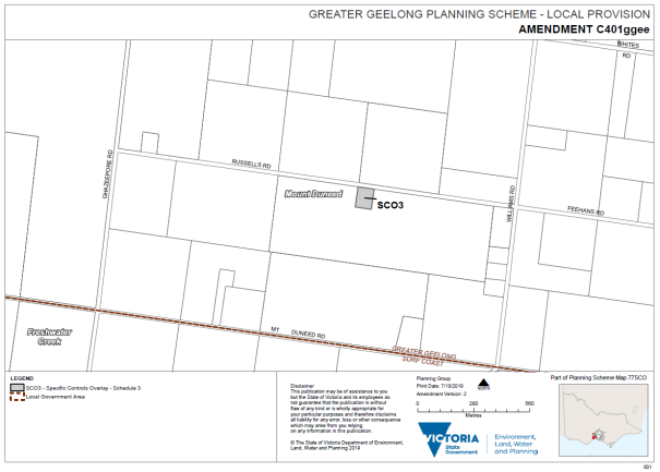
update the Special Controls Overlay number from SCO3 to SCO8 as other SCOs have recently been included in the Scheme;
rewrite points in the Incorporated Document that refer to a permit – the Incorporated Document acts similarly to, and removes the need for a planning permit;
rewrite Clause 5.6.1 of the Incorporated Document to list requirements in dot point format;
use the Special Controls Overlay map (Attachment 5) rather than the zone map at Attachment 1 of the Incorporated Document; and
modify the Explanatory Report’s section on Clause 13.02-1 to refer to BAL 19 rather than BAL 12.5.
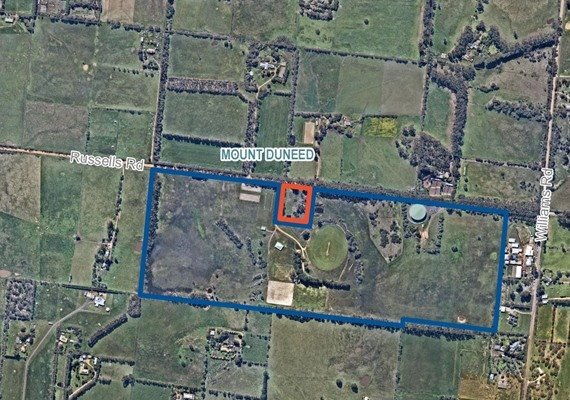
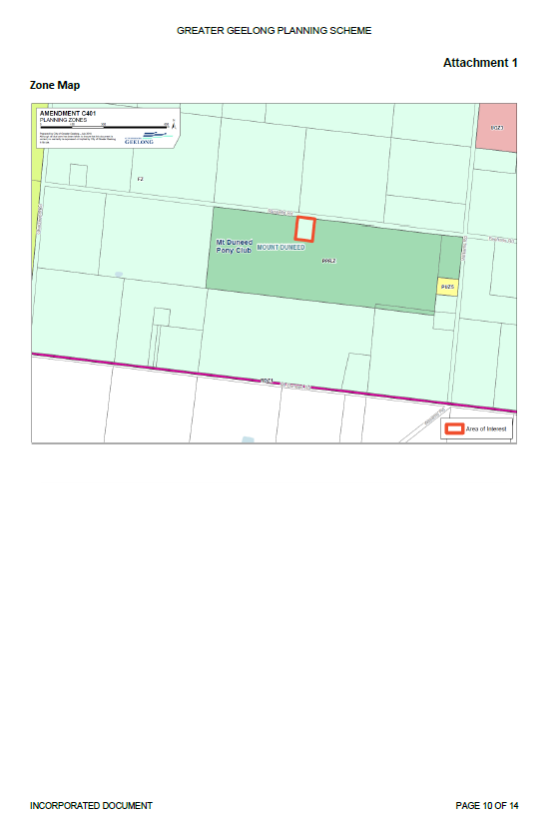
120 Russells Road, Mount Duneed outlined in red; and
Mount Duneed Recreation Reserve outlined in blue.
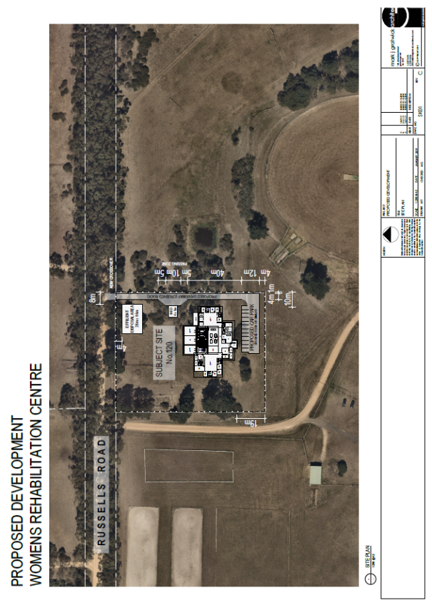
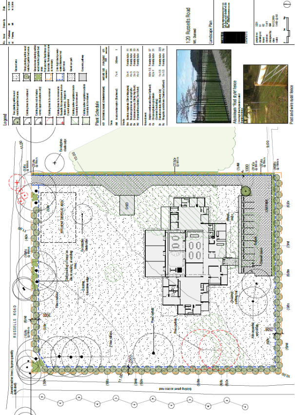
Source: |
Planning, Design & Development - Planning Strategy |
Director: |
Gareth Smith |
Portfolio: |
Planning |
To establish a Council position to resolve local height schedules that are inconsistent with the zone provisions because of state government changes to the residential zones.
In March 2017 the State Government introduced the current suite of residential zones. This included changes to height controls and the introduction of a minimum garden area to the neighbourhood (NRZ) and general (GRZ) residential zones.
Local councils were advised that zones with inconsistent local building height variations would have three years to comply with the new zone requirements. The state government recently released guidance for applying the zones.
Two zones in the city are impacted:
General Residential Zone Schedule 2 (GRZ2) - Incremental Change Area:
Increases maximum building height by 2 metres from 9 metres to 11 metres.
Residential Growth Zone 2 (RGZ2) – Urban Increased Housing Diversity Areas:
Increases maximum building height by 3 metres from 10.5 metres to 13.5 metres..
The Bellarine Peninsula towns are not affected by these changes. Building heights will be considered by the Bellarine Peninsula Distinctive Area and Landscapes project managed by DELWP.
A report has been prepared (Attachment 2) that considers three options to resolve the local schedule issue based on the practice notes and how they apply to the City’s existing housing framework.
To maintain the housing framework established in the Housing Diversity Strategy and subsequent housing policy and maintain the building heights as close as possible to the existing height limits the preferred option is:
Back zone the General Residential Zone 2 areas in urban Geelong to Neighbourhood Residential Zone:
maintain the 9m maximum height limit;
maintain the existing additional open space and landscape requirements will be maintained to differentiate from the other GRZ areas; and
if this back zoning does not occur the building height limit will increase from 9 metres to 11 metres.
Back zone the Residential Growth Zone 2 areas to a new General Residential Zone:
unavoidable small increase in building height limit from 10.5 metres to 11 metres;
all other variations in existing zone schedules (open space, site coverage, front setbacks) will be transferred from the RGZ to deliver housing change and diversity in these areas and to differentiate from the other GRZ areas;
exempt the garden area requirement;
if this back zoning does not occur the building height limit will increase from 10.5 metres to 13.5 metres;
refer to Attachment 2 for maps of impacted areas and draft clauses; and
given the level of existing strategic work underpinning these recommendations, including significant community consultation and independent review, no further strategic work is necessary.
Councillor Sullivan moved, Councillor Mason seconded -
That Council:
Note the State Government requirement to change the Greater Geelong Planning Scheme to align with the Victorian Planning Provisions.
Support the following zone and policy changes as described in Attachment 2 – Report to Implementing the new Residential Zones:
Back zoning of the General Residential Zone 2 areas in urban Geelong to Neighbourhood Residential Zone and include:
a 9m maximum height limit; and
maintain the existing additional open space and landscape requirements
Back zoning the Residential Growth Zone 2 areas to a new General Residential Zone and include:
all other variations in existing zone schedules (open space, site coverage, front setbacks) will be transferred from the RGZ to deliver housing change and diversity in these areas and to differentiate from the other GRZ areas; and
exempt the garden area requirement.
Write to the Minister for Planning with Council’s preferred option and to request that the changes are implemented via GC Ministerial amendment with other impacted Councils.
Note the Bellarine Peninsula towns are not included in these zone changes. Building heights will be considered by the Bellarine Peninsula Distinctive Area and Landscapes project managed by DELWP.
Carried.
There are no costs associated with a GC Ministerial amendment. Resourcing is provided by the Department of Environment, Land, Water and Planning.
The recommendations in this report are supported by extensive previous community consultations as part of planning scheme amendments C129 – Housing Diversity Strategy, C300 - Implementation of the New Residential Zones and C334 - Incremental Change Review which were all subject to informal and formal public consultation, independent panel review, Council adoption and Ministerial approval.
Due to the extensive consultation already undertaken and the consistency of the proposed zoning regime with existing policy the preferred method of implementing the changes is via a GC Ministerial amendment along with other Councils. The GC amendment is consistent with the practice note on ‘Ministerial powers of intervention in planning and heritage matters’. This is the most cost and resource efficient option to implement the changes.
The State Government also released housing policy changes under amendment VC110 – Reformed Residential Zones and subsequent planning practice notes: PPN84: Applying the minimum garden area requirement, PPN90: Planning for housing, PPN91: Using the residential zones.
The recommendations in this report support the delivery of housing diversity and the protection of residential areas with identified garden character attributes. This supports the established housing framework of providing a variety of housing types in targeted locations.
The recommendations set out in this report and Attachment 2 are consistent with the Victorian Planning Provisions, City’s Housing Diversity Strategy, Planning Policy Framework; target of achieving fifty percent of new housing through urban consolidation and the protection of residential areas with identified unique character attributes.
The detailed report in Attachment 2 includes assessment of three options:
Option 1 – Local height schedules to revert back to the parent zone (Council does nothing):
Building height limit will increase from 9 metres to 11 metres in GRZ2; and
Building height limit will increase from 10.5m to 13.5 in RGZ2.
Option 2 – Request a 20 (4) Ministerial amendment to ‘back zone’ General Residential Zone 2 to Neighbourhood Residential Zone and update the local policy 22.63 to increase the heights for urban Increased Housing Diversity Areas in the Residential Growth Zone 2:
Building height limit will be maintained at 9m in GRZ2; and
Building height limit will increase from 10.5 metres to 13.5 metres in RGZ2.
Option 3 – Request a 20 (4) Ministerial amendment to ‘back zone’ General Residential Zone 2 to Neighbourhood Residential Zone (new schedule) and Residential Growth Zone 2 to General Residential Zone (new schedule) for the urban Increased Housing Diversity Areas:
Building height limit will be maintained at 9m in GRZ2; and
Unavoidable small increase in building height limit from 10.5 metres to 11 metres in RGZ2.
Option 3 is the preferred option and recommended to Council. This option balances delivering housing policy and character objectives while achieving, as close as possible, existing building height limits.
While option 2 delivers a strong alignment to the zone purpose and our housing framework it would see building heights increase by 3m or one storey which is a significant jump from the current limits. The existing 10.5m height limit was an outcome of community interest during amendment C300 around building heights. As a result, an increase to 13.5m cannot be justified without further consultation and strategic work.
Apart from height all other aspects (front setback, site coverage, open space) of the RGZ2 areas can be transferred to the new GRZ schedule to allow more intensive development and deliver housing diversity. This will ensure the Increased Housing Diversity Areas are clearly differentiated from conventional residential areas and that the housing hierarchy is maintained.
The City has and will continue to undertake strategic planning and policy work in the area of housing. Several ‘place-based’ projects are currently underway including the former Saleyards precinct, Pakington Street and Gordon Avenue and South Geelong Station which all consider housing opportunities. These projects have identified specific sites where four or more stories may be appropriate due to their size, current and surrounding uses etc. In these cases the RGZ or other zones such as Mixed Use zone could be strategically applied to achieve more intensive housing outcomes.
No other zones are affected by these changes.
The Bellarine Peninsula towns are not affected by these changes. Building heights will be considered by the Bellarine Peninsula Distinctive Area and Landscapes project managed by DELWP.
The proposal aligns with the Planned Sustainable Development strategic priority of the Council Plan including ensuring housing diversity and affordability, facilitating opportunities for infill development and managing the impact of development on neighbourhood character.
No Council officers involved in the development of the framework plan and preparation of the report have a direct or indirect interest in the issue to which this report relates.
The recommended approach offers the lowest risk to Council and the community as the building heights proposed are as close to existing controls as possible whilst maintaining the overall intent of the housing diversity strategy and subsequent housing policy in the planning scheme.
If Council does not form a position on this matter and the heights revert to the state standard zones the building heights will increase 2m in GRZ2 areas and 3m in RGZ2 areas. The resulting increases in height could have a negative impact on neighbourhood character and community expectations and would not be consistent with previous community consultation.
The proposal aims to increase housing diversity and the share of housing provided by urban consolidation thus reducing pressure for outward expansion. It also aims to preserve the garden character of identified areas, maintaining and enhancing canopy cover.
Source: |
City Services - Engineering Services |
Director: |
Guy Wilson-Browne |
Portfolio: |
Rural and Coastal |
For Council to consider and adopt the Shared Trails Masterplan.
The Shared Trails Masterplan (the Masterplan) aims to identify and prioritise a connected shared trails network throughout the municipality.
The Masterplan is guided by existing Council strategies and plans, including; The City’s Municipal Public Health and Wellbeing Plan 2018-21; Shared Path Management Plan 2018; Greater Geelong: A Clever and Creative Future; G21 Region Road Transport Plan 2017-27; and, the Greater Geelong and Bellarine Tourism Development Plan 2019-22.
Two phases of community consultation were undertaken during July and August 2019.
Eight community pop-up sessions were held throughout the municipality in addition to an interactive online engagement platform. The online engagement platform received over 5400 site visits and collected 1445 comments on a range of shared path related topics.
Following further stakeholder input, the Masterplan has now been finalised for consideration by Council.
A shared trail can be defined as a path that provides for multiple users (including pedestrians, cyclists, horse riders, dog walkers etc).
The Masterplan undertakes a gap analysis of the shared path network under these three classifications:
Network Gaps: Gaps between corridors and key attractions that do not currently exist, which require the planning and development for new shared trails;
Trail Gaps: Relatively minor gaps between existing trails; and
Trail Deficiencies: Deficiencies in the existing network which may include issues with corridor safety, surface condition or geometry and supporting amenities.
To inform investment in the shared trails network, a multi-criteria assessment (MCA) was applied, resulting in prioritisation of actions for each of the three classifications. The MCA was informed from community feedback and the following criteria:
Catchment: The residential catchment density surrounding the route (current and forecasted);
Function: The function the route will serve (recreation, commuter, education, local-access) between origins and destinations;
Connectivity: Between major, minor and local paths;
Cost: High level measure of cost of implementation, considering flooding risk, environmental risk, cultural and heritage issues and land acquisition;
Tourism benefit: A measure of the benefit to passive and active tourism;
Crash history safety benefit: Consideration of improvements on a route with an existing crash history, or a parallel route which would attract users; and
Health benefits: Considered levels of physical activity for areas taken from the Municipal Public Health and Wellbeing Plan 2018-21 and their relative activity levels;
Priority actions have been identified under each of the three classifications (network gaps, trial gaps and trail deficiencies). Refer Attachment 2
The Masterplan identified planning and environmental challenges that will need to be addressed when considering route options.
Councillor Mason moved, Councillor Sullivan seconded -
That Council:
Adopt the Shared Trails Masterplan (Attachment 3);
Note the actions that are committed and ongoing this financial year (Attachment 1); and
Refer further priority projects to the 2020-2021 budget; and
Note that the community will be able to provide feedback on the priority projects as part of the 2020-2021 budget submission process.
Carried.
The priority actions will be referred to existing and future programs and budgets. Depending on scale, some of these works are in progress within the existing 2019-2020 program, others will require specific budget bids or external funding.
From the Shared Trails Masterplan 2019-2020 capital budget, we have committed $200,000 as part of a co-contribution project with Barwon Coast Committee of Management for delivery of a path from the 13th Beach Surf Lifesaving Club to nearby carpark.
From the Shared Trains Masterplan 2019-2020 discretionary budget, we have commissioned this Masterplan, and have remaining funds to commence further detailed investigations of priority projects.
A stakeholder workshop was conducted 18 June with representatives from City of Greater Geelong, Regional Roads Victoria, Department of Transport and Bicycle Network to identify key issues surrounding development of the shared trails network throughout the municipality.
The City opened an online ‘Have Your Say’ page, via Social pinpoint, on 1 July 2019 through to 31 August 2019. Hard copies were made available on request and at customer service locations and written submissions could be mailed in.
Community feedback provided 1445 comments under the following categories:
Gaps & Opportunities;
Issues & Comments;
Supporting Amenities; and
I like this.
8 pop-up sessions were held throughout the region to accommodate community members wanting to speak directly to City officers. A total of 98 people attended the following locations:
Ocean Grove, Saturday 13 July, 9am – 1pm;
Leopold, Thursday 18 July 9am – 1pm;
Armstrong Creek, Thursday 25 July, 9am – 1pm;
Geelong, Thursday 1 August, 9am – 1pm;
Portarlington, Thursday 8 August, 9am – 1pm;
Highton, Saturday 10 August, 9am – 1pm;
Lara, Thursday 15 August, 9am – 1pm; and
Corio, Thursday 22 August, 9am – 1pm.
The Masterplan supports connections between and within communities providing opportunities to bring people together.
There is no policy, legal or statutory implications arising from the subject of this report.
Greater Geelong: A Clever and Creative Future: meeting multiple community aspirations including a connected transport network, a destination that attracts local and international visitors, and a healthy and socially connected community.
Municipal Public Health and Wellbeing Plan: supporting the community to enjoy the highest standards of health, wellbeing and participation at every age, aiming for the greatest improvements among those who need it most.
Social Equity Principals: seeking to make services and facilities more equitable across Greater Geelong.
There is no officer direct or indirect interest in the preparation of this report.
Safer access for trail users will be achieved by completing the network.
Through the development of the Shared Trails Masterplan, the Bellarine Rail Trail has been identified as trail that is heavily relied upon providing connections in the east and Bellarine. There is a vulnerability to the broader shared trails network should this trail be removed or reinstated with other transport modes (ie reinstated with rail). Whilst it is not identified in the Shared Trails Masterplan document, should this occur in the future it shall be a requirement that an adjacent or suitably alternate trail be provided.
Through the investigations and engagement for this Shared Trails Master Plan, it has highlighted that the formal arrangements of the management of the Bellarine Rail Trail is fragmented. With various arrangements in place with the City, VicTrack and the Geelong Preservation Society a review and consolidation of these arrangements has been identified as a priority. These arrangements need to be formalised and consider the conditions associated with the management and maintenance of the trail surface, supporting infrastructure and vegetation – particularly in relation to appropriate maintenance practices.
Environmental implications associated with the outcomes of this report include:
Engage with the Sparrovale Master Planning process to identify preferred routes between Geelong-Barwon Heads;
A path through the Buckley Park wildlife reserve between Ocean Grove and Pt Lonsdale is not a route option to be considered for further development, other route options will be investigated; and
A path between Lake Victoria and Buckley Park wildlife reserve between Ocean Grove and Pt Lonsdale is not an option to be considered for further development, other route options will be investigated.
There is no room to build a shared trail along the Swan Bay Foreshore. This is a significant environmental area subject to sea level rise impacts. This is not an option to be considered for further development, other route options will be investigated.
Shared paths along Hovells Creek are to be located well away from the riparian zone and not impact environment values.
Following community consultation, 1445 comments were classified as relating to:
Network Gaps: Gaps between corridors and key attractions that do not currently exist, which require the planning and development for new shared trails;
Trail Gaps: Relatively minor gaps between existing trails; and
Trail Deficiencies: Deficiencies in the existing network which may include issues with corridor safety, surface condition or geometry and supporting amenities.
Following community consultation and technical assessments were complete, projects were subjected to multi-criteria assessment to produce a prioritised list of actions for each classification as follows:
Network Gaps
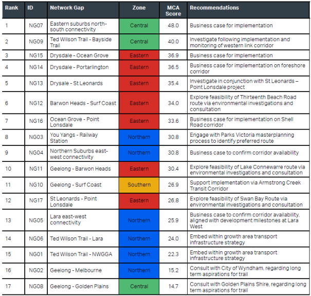
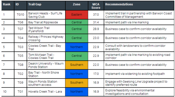
Trail Deficiencies
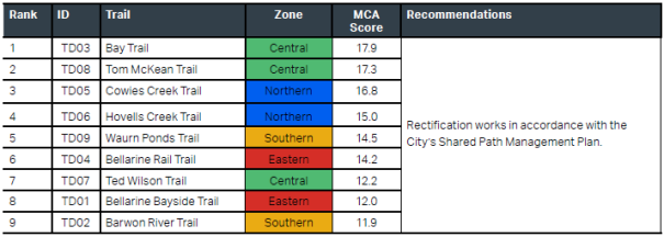
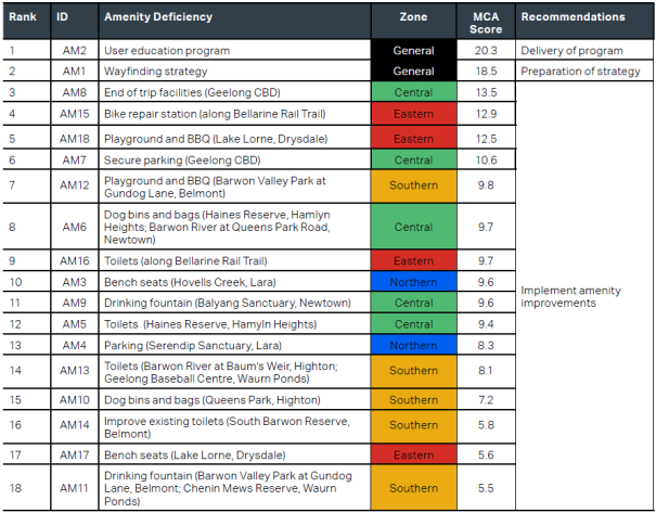
The following projects are underway:
Contribution to Barwon Coast Committee of Management for the delivery of path along Thirteenth Beach Road from the existing path at the western car park to Surf Lifesaving Club (Project - TG10).
Source: |
Customer & Corporate Services - Program Integration and Development |
Director: |
Michael Dugina |
Portfolio: |
Finance |
To seek Council’s approval for changes to the 2020-2021 Grant Guidelines in Attachment 2, and to advise Council of the key dates for the 2020 grants program.
On 26 November 2019 Council resolved to “request the Chief Executive Officer to engage with Councillors to conduct a review of the existing Terms of Reference to further enhance the development of the Grants Program and report to Council by 31 March 2020”.
Council’s Election Period Policy prohibits consideration of any decision to allocate community grants from Tuesday 22 September 2020 until Saturday 24 October 2020.
The review of the guidelines considers the effect of the 2019-2020 changes to allow applications from organisations who operate in facilities not located on Council owned or managed land (referred to as ‘private’).
The guidelines must be available to the community by the last week of March 2020 in order to finalise the assessment and approval processes by Council prior to the Election Period commencing.
Community engagement will commence in March 2020. Grants are scheduled to open no later than 27 April 2020 and close on 24 May 2020. Recommendations for funding will be presented to the Council meeting on 25 August 2020 followed by grant ceremonies up until 18 September 2020.
Councillor Aitken moved, Councillor Kontelj seconded -
That Council:
Approve the changes to the guidelines as shown in the table at Attachment 2 subject to the following changes to the Community Infrastructure Grant program guidelines;
The removal of ‘Social Housing an ineligible project type’;
The removal of ‘Health care providers ineligible to apply’;
The removal of ‘Primary and secondary schools and tertiary institutions ineligible to apply’;
The removal of ‘limit the number of applications valued at $250,000 or more to no more than 60% of the total budget’; and
Amending ‘make capital projects with total costs in excess of $1.5 million an ineligible project type’ to $3.5 million.
Establish a First Nations Heritage Grants fund in collaboration with Traditional Owners and:
Develop relevant guidelines for the approval of Council; and
Allocate grants during the 2020-2021 Financial Year.
Allocate 50% of the 2020-2021 Central Geelong Heritage Grants budget to the First Nations Heritage Grants budget;
Authorise the Director of Customer and Corporate Services to make administrative changes to the guidelines;
Note that the grants will open no later than 27 April 2020 and close on 24 May 2020; and
Note that funding recommendations for all grant categories will be presented to Council for endorsement at its meeting on 25 August 2020.
Carried.
There are no financial implications for the City in changing the grant guidelines.
The review of grant guidelines has considered feedback from Councillors, previous applicants, assessors and officers.
At the debrief workshop following the 2019-2020 grant funding round, officers reviewed feedback from applicants received via the SmartyGrants application forms. Applicants are invited to comment on how easy or hard the on-line process is, time taken to complete an application, and to provide a general comment.
The debrief workshop also considered feedback gathered from direct contact with community organisations, individuals, business and property owners from phone conversations and meetings.
The grant guidelines prioritise community impact, access and participation.
The provision of grants to the community supports local community organisations and endorses the aims of the Greater Geelong: A Clever and Creative Future vision.
The grants aim to fund projects that assist in achieving goals and outcomes consistent with the strategic priorities of the Council Plan 2018-2022.
Updating the guidelines addresses the 2019-2020 priority action ‘Implement a new approach for the Community Investment and Support Fund’.
No Council Officer involved in the writing of this report has any conflict of interest to declare.
Changes to the guidelines are in response to feedback from Councillors, community members and Council Officers.
Guidelines for all programs are explained at community information sessions and officers are available to answer questions about individual applications. Guidelines are published on the Geelong Australia website.
The key messages of the grants engagement and marketing plan are to raise awareness of the earlier application dates, important changes to guidelines and that Council officers are available for support.
Approval of the guidelines in March 2020 is a key requirement of the timeline. The impact of delaying guidelines is either shortened application and assessment times in order to endorse funding decisions prior to the election period or delaying Council’s endorsement of funding recommendations until after the election period.
The guidelines reflect the principles of Council’s Sustainability Framework.
Grant Program |
Guideline Change |
Community Infrastructure |
Make
|
Make capital projects with total costs in excess of $1.5million an ineligible project type. |
|
Limit the number of applications valued at $250,000 or more to no more than 60% of the total budget. |
|
Make the priority criteria for 2020-2021:
|
|
Remove “Contribution by organisation will attract a weighting score proportionate to total project cost i.e. 90% contribution attracts score of 9, 20% contribution attracts a score of 2” as a key indicator in the well-planned project assessment criteria |
|
Central Geelong Heritage |
|
Introduce a new category – Category 3 Project Feasibility and Investigation. Maximum of $10,000 to assist with costs of engaging consultants and practitioners to provide technical investigations, planning, project scoping and feasibility for future eligible heritage restoration projects. |
|
Change eligibility of applicants from:
to
|
|
Change the assessment criteria from:
to
|
|
Remove the location constraint of the priority streetscape areas. |
|
Improve information for applicants to assist them through the steps and requirements of each category. |
|
Creative Communities |
Increase the maximum grant amount from $6,000 to $10,0000 in line with the other community project/festival/event funds. |
Healthy and Connected Communities |
Increase the maximum grant amount from $6,000 to $10,000 in line with the other community project / festival / event funds. |
Favourably assess applications that provide evidence of intent to increase the social and economic participation of our most vulnerable people and/or enhance a sense of community belonging. |
|
Environment and Sustainability |
Increase the maximum grant amount from $6,000 to $10,000 in line with the other community project / festival / event funds. |
Update the guidelines to reflect the principles and actions of Council’s Sustainability Framework. |
|
Community Events |
Decrease the maximum grant amount from $20,000 to $10,000 in line with the other community project / festival / event funds. |
Include a definition of Community Event and strengthen the explanation of the types of projects supported by the fund and to better direct applicants to the correct project / festival / event fund. |
Community Infrastructure
Feedback:
A lack of clarity on the types of applicants and projects that best suit the purpose of Community Infrastructure grants.
The eligibility guidelines were changed for the 2019-2020 funding round, to allow applications from organisation on private land. This change unintentionally resulted in a lack of clarity on the eligibility of some applicants and the most appropriate type of projects for Community Infrastructure grants. This caused confusion for applicants, officers providing advice and assessment panels. Therefore, some of the applications received and assessed were from large, professional bodies with State and/or Federal Government policy responsibilities.
To address this feedback, it is proposed to change the eligibility criteria to exclude applications from health care providers, primary and secondary schools and tertiary institutions and housing projects.
Contributions to large projects
A small number of applications were received for projects with budgets in excess of $2 million. Feedback indicates a preference for grants to support organisations with limited options to secure funding from other sources and to limit awarding grants to large-scale and complex capital projects.
To address this feedback, it is proposed to make projects with total costs in excess of $1.5 million ineligible to apply.
A two-step process for projects with multiple funding sources not secured, to allow approval contingent on receiving other funds.
The current guidelines require applicants to demonstrate they have secured all sources of funding for their project. This ensures the City is funding projects ready to proceed.
Some larger projects require funding from multiple government and philanthropic sources. Confirmation from one party e.g. Council, can provide leverage and support to assist securing other funding which is a positive outcome for the group.
The risk to Council of providing contingent approval is that funding must be held in reserve until the group has secured all financial support. This could take several months or years or the project may not proceed. In the meantime, other applications could be funded and deliver more immediate impact for the community. This change is not recommended.
Viability of limiting the number of larger grants in favour of smaller grants e.g. a maximum of 2-3 grants awarded in the $200,000 - $300,000 bracket.
In the three years from 2017-2019, the City received 142 applications for Community Infrastructure Grants requesting a total of $15.6 million and funded 70 projects with a total value of $4.9 million.
Of the 142 applications, 78 (55%) requested $50,000 or less and 31 (22%) requested $250,000 or more.
The Community Infrastructure Grants supports a mix of lower and higher value projects and all projects are assessed together regardless of the total grant request.
Limiting the number of larger ($250,000 and above) applications could improve the success rate of the smaller ($100,000 and less) applications, assuming the smaller projects still rate favourably against the assessment criteria.
To address this feedback, it is proposed to limit the number of applications valued at $250,000 or more to no more than 60% of the total budget.
Electronic Gaming Machines (EGMs)
The community infrastructure guidelines currently state that facilities designated for electronic gaming machine operations are not eligible under the community infrastructure guidelines and that proposals for funding where the recipient organisations receive revenue from electronic gaming machines are given a lower priority during the assessment phase
To improve the assessment process all applicants will be asked to provide information on their access to EGM revenue to inform priorities for funding recommendations. This change will be introduced to other grant programs in the Community Investment and Support Fund.
Priority criteria
Council may on an annual basis nominate priority funding themes which will attract an additional score as part of the application assessment. In 2019-2020 the priority themes were:
Gender Equity additional 10%; and
Social Equity additional 10%
Based on feedback it is proposed the priority criteria for 2020-2021 are:
All abilities access additional 10%; and
Social inequity additional 10%
Volunteering was considered, however given that the fund supports not for profit community groups, mostly run by volunteers an additional priority for volunteering is not required.
Well planned Project - key indicators
It is proposed to remove ‘Contribution by organisation will attract a weighting score proportionate to total project cost i.e. 90% contribution attracts score of 9, 20% contribution attracts a score of 2’ as a key indicator in the well-planned project assessment criteria
The intention of this indicator was to encourage applicants to contribute funds to the project even if they could not meet the required 1/3 contribution ratio, but as it is written it could be misconstrued to favour financially well-resourced clubs. If an applicant cannot meet the 1/3 ratio, they must apply for Financial Hardship.
How do we ensure that funded Private facilities remain accessible to the public?
The City’s legal team will consider if it’s possible to include a clause in contracts with private clubs to ensure that the facility funded by the City is protected from future change of use or sale, and that it will remain accessible to the public. These contracts are currently under development and are based on the Victorian Government’s Common Funding Agreement.
Central Geelong Heritage Fund
Expand eligibility to all of municipality not just Central Geelong.
The Central Geelong Heritage Fund was created through the Central Geelong Action Plan (2013) and supports the restoration of heritage building facades in Central Geelong.
The Fund is underpinned by guiding principles in the Action Plan, which seek to attract more people working, living, learning and playing in Central Geelong, along with helping to stimulate private investment and support activity and development in the city centre.
The fund is an important initiative by Council with a dual purpose to assist with improvements to the city’s streetscapes and liveability of Central Geelong; and stimulate private investment in Central Geelong.
Allowing applications from across the municipality does not align with the strategic intent and purpose of the Heritage fund and is not recommended. The State Government and the City provides other support for heritage restorations.
State Government provides funding for supporting the restoration of heritage buildings across Victoria. The Living Heritage Program has a $60 million fund which targets significant heritage places that are included on the Victorian Heritage Register, several of which are buildings and outdoor heritage items, such as monuments throughout the City of Greater Geelong.
The City of Greater Geelong also offers a Minor Low Interest Heritage Loan Program to assist owners of recognised heritage buildings to undertake works to retain and enhance their heritage. This program applies across the municipality.
Expand to include indigenous heritage not just European heritage.
The region’s cultural heritage continues to further recognise indigenous heritage as an important theme in the development of the City’s Arts and Cultural Strategy. The strategic work being undertaken during 2020 will better inform both the City’s and the Arts and Culture Department’s role in this area.
Changing the guidelines to include indigenous heritage projects in not recommended until the City is clearer on its role and responsibility in this important area.
Improve guidelines to ensure greater success of applications
Feedback included how to attract projects that best suit the purpose of this grant fund and ensure a greater success of applications.
To address this feedback a new category will be created to assist with the costs of planning for future eligible heritage restoration projects and guidelines will include improved information to assist applicants through the steps and requirements of each category. Additionally, the constraint of the priority streetscape areas will be removed allowing all projects in the Central Geelong boundary to be assessed equally.
Creative Communities
Feedback included confusion about the different amount of funding available between grant programs and the timing of rounds.
To address this feedback, all grants will open on the same date and it is proposed to increase the maximum grant amount from $6,000 to $10,000 in line with the other community project, festival and event grants.
Healthy and Connected Communities
Feedback included a lack of clarity around some guidelines, confusion about the different amount of funding available between grant programs, the timing of rounds and how to attract community projects that best suit the purpose of this grant fund.
To address this feedback, all grants will open on the same date and it is proposed to increase the maximum grant amount from $6,000 to $10,000 in line with other community project, festival and event grants.
Applications that aim to increase the social and economic participation of our most vulnerable people or enhance a sense of community belonging will be more favourably assessed.
Environment and Sustainability
Feedback included confusion about the different amount of funding available between grant programs, the timing of rounds and the need to update the guidelines in response to the principles of Council’s recently adopted Sustainability Framework.
To address this feedback, all grants will open on the same date and it is proposed to increase the maximum grant amount from $6,000 to $10,000 in line with other community project, festival and event grants. The updated guidelines will reflect the principles of Council’s Sustainability Framework.
Community Events
Feedback included confusion about the different amount of funding available between grant programs, the timing of rounds, a lack of clarity on the eligibility of applicants and the types of events that best suit the purpose of program.
To address this feedback all grants will open on the same date and it is proposed to decrease the maximum grant amount from $20,000 to $10,000 in line with other community project, festival and event grants. The definition of events and explanation of the types of projects supported by the fund will be improved to better direct applicants to the correct project, festival or event grant.
Source: |
Community Life - Leisure & Recreation Services |
Director: |
Robyn Stevens |
Portfolio: |
Sport and Recreation |
To present the Bellarine Peninsula 50m Outdoor Pool Scoping Study (February 2020).
Participation in sport, recreation and leisure activities is an important contributor to community health and wellbeing.
In April 2019 the federal government announced an election commitment of $10 million funding for a 50m outdoor pool in the north Bellarine.
The City commissioned a scoping study (Attachment 2) to explore the costs and benefits of investing in a 50m outdoor pool in the Drysdale catchment area, including consideration of potential locations, capital costs and financial performance.
The scoping study identifies the north Bellarine as a catchment where there is currently not equitable access to aquatic services when compared to almost all other areas within the municipality.
The scoping study identifies that while investment in a 50m outdoor pool will provide community benefits and go some way to providing more equitable access to aquatic services on the north Bellarine, noting the future development of additional aquatic facilities such as warm water pools and water play should also be considered, particularly with projections that the Bellarine Peninsula will grow by 40 per cent to approximately 70,000 residents by 2041.
The scoping study estimates the capital (construction) cost for a 50m outdoor pool will be between $13.7 million and $15.8 million in excess of the $10 million to be provided by the federal government, with the operating costs ranging between $1 million and $100,000 per annum, depending on the operating model applied to a 50m outdoor pool.
The scoping study included a desktop analysis of several sites for location of a 50m outdoor pool. The final study identifies two locations as the most viable being the Drysdale council depot site and the (proposed) Drysdale Regional Sports Precinct.
A preliminary and high level site review has been undertaken and this is included in Appendix 2 of the scoping study. This site review considers each location regarding the sustainability for future expansion of aquatic services and facilities as the population grows; accessibility from a range of locations across the north Bellarine along with the opportunity for integration with other local facilities and services.
Councillor Sullivan moved, Councillor Mason seconded -
That Council:
Note the Bellarine Peninsula 50m Outdoor Pool Scoping Study (February 2020); and
Refer the estimated capital and operating costs (Attachment 2) for consideration as part of the 2020-2021 budget deliberations and long-term financial plan.
Councillor Murnane left the meeting room at 8:22pm.
Councillor Murnane re-entered the meeting room at 8:24pm.
Carried.
In 2019 an election commitment of $10 million was announced for funding the construction of a 50m outdoor pool in the north Bellarine.
At this stage no funding agreement has been entered into with the federal government.
Initial cost estimates from an independent quantity surveyor for a generically designed 50m outdoor pool at each of the two preferred sites is:
Drysdale Sporting Precinct - $13,788 million; and
Drysdale Maintenance Depot - $15,281 million.
Significant assessment of site conditions and a detailed, customised design response for the preferred site(s) will be required to refine the cost plan and provide a more accurate final cost, that could vary from the estimates provided in this report.
The operational projections for the pool were based on a review of the performance of 20 outdoor pools. The review projected the following for three different operational models:
Item |
Option 1 |
Option 2 |
Option Option 3 |
|---|---|---|---|
Total Visits |
34,298 |
30,487 |
11,433 |
Average Visits per Day |
97 |
127 |
114 |
Net Performance |
($1,019,211) |
($581,077) |
($101,904) |
Average Income per Day |
$582.97 |
$762.18 |
$685.96 |
Subsidy per Visit |
($29.72) |
($19.06) |
($8.91) |
Subsidy per Day |
($2,887) |
($2,421) |
($1,019) |
Community consultation for the City’s draft Social Infrastructure Plan in 2018 provided some insight into community demand for improved aquatic provision on the Bellarine Peninsula.
In a community survey 12 per cent (117) of total survey respondents (individuals n=971) indicated a need for improved access to aquatic spaces. However, for residents of the Bellarine 27 per cent (104) of total survey respondents (individuals n=384) indicated a need for improved access to aquatic spaces.
47.7 per cent (51) of residents in Clifton Springs / Curlewis / Drysdale / Bellarine (individuals n=107), indicated a need for improved access to aquatic spaces, and 30.8 per cent (16) of total survey respondents in Portarlington / St Leonards / Indented Head (individuals n=52), indicated a need for improved access to aquatic spaces.
The directional data obtained through community engagement for the draft Social Infrastructure Plan indicates there is a high level of community demand for improved access to aquatics in Clifton Springs, Curlewis, Drysdale, Portarlington, St Leonards and Indented Head when compared with other suburbs in the City of Greater Geelong.
The principles from the draft Social Infrastructure Policy (2019) have been applied to assessing social equity.
When applying the principles of ‘accessibility’ and ‘equity’ the north Bellarine, including the suburbs or towns of Drysdale, Curlewis, Clifton Springs, Portarlington and St Leonards have poorer equity of access to aquatic services compared to other areas within the municipality.
The scoping study indicates that a 50m outdoor pool will improve access to aquatic facilities and provide a level of community benefit for residents in the north Bellarine area. However, consideration should also be given to aquatic services and facilities able to meet the range of needs within the community that would benefit from additional aquatic services that a 50m pool by itself may not be able to provide for the future (i.e. warm water, learn to swim etc).
All legal and statutory requirements would be identified and met in the design and delivery of an aquatic facility.
The Council Plan 2018-2022 identifies ‘informed social infrastructure and planning’ as one of the City’s strategic priorities, with key priorities being ‘providing more quality spaces that support active lifestyles’ and ‘delivering accessible and attractive community infrastructure, based on community need’.
No Council officers or contractors who have provided advice in relation to this report are known to have a conflict of interest in regard to this matter.
The City may be at risk of not providing adequate aquatic facilities and services for residents and visitors if future growth projections, such as in the Drysdale catchment area, are not planned and accounted for.
There is a financial risk should Council commit to the signing of a funding agreement with the federal government at this time, until the detailed design and investigation is undertaken and the costs of constructing a 50m outdoor pool are better understood.
All environmental requirements would be identified and met in the design and delivery of an aquatic facility.
Source: |
Governance, Strategy & Performance |
Director: |
Rebecca Leonard |
Portfolio |
Leadership and Governance |
Councillor Mason moved, Councillor Grzybek seconded -
That in accordance with Section 89 (2) (h) of the Local Government Act 1989, this matter which the Council considers would prejudice the Council or any person, be considered at the conclusion of all other business at which time the meeting be closed to members of the public.
Carried.
Contents | Previous Page: Section A - Procedural Matters | Next Page: Section C - Notice of Motion
