
Council Minutes - Section B: Reports - 26 May 2020
Contents | Previous Page: Section A - Procedural Matters | Next Page: Section C - Assembly of Councillors
Contents | Previous Page: Section A - Procedural Matters | Next Page: Section C - Assembly of Councillors
Reports tabled at the Ordinary Meeting of Council on Tuesday date held at the Council Conference and Reception Centre in City Hall, 57 Little Malop Street, Geelong.
Revocation of Flood Prone Area Designation of New Lots at Ashbury Estate, Stage 14
Contractual Matter (Confidential)
Contractual Matter (Confidential)
Source: |
Planning, Design & Development |
Director: |
Gareth Smith |
Portfolio: |
Community Health, Wellbeing and Safety |
To present community feedback regarding the draft dog control orders applicable to land managed by Barwon Coast Committee of Management Inc. (BCCM) and seek Council endorsement to present revised Orders to BCCM for their endorsement prior to Council’s further consideration.
In 2008 as part of the Domestic Animal Management Plan, Council adopted dog control orders (the Orders) on behalf of BCCM that remain in place (Attachment 2).
In 2019, BCCM requested Council consider adopting proposed changes to the existing Orders. Council endorsed public exhibition of draft dog control orders at its 10 September 2019 Council meeting. The draft Orders aimed to simplify existing Orders and provide a balanced access arrangement for dog owners and non-dog owners.
A six-week community engagement process was conducted by the City throughout October and November 2019 regarding the proposed Orders. There were 592 participants in providing feedback through survey, correspondence and face to face community meetings.
Dog Control Orders inherently may see contrasting views between dog owners and non-dog owners. The BCCM and City seek to find an appropriate balance that provides areas for both to safely enjoy the coast whilst protecting the significant environmental values.
Consultation findings indicated both dog and non-dog owners desire for improved sharing of this coastal space, however also expressed the need for some modifications to be made to the draft Orders, including adjusting summer season length and changing timed access for dogs at certain locations.
There was a minority number of dog and non-dog owners who had firm and contrasting views to either support full dog access or complete dog prohibition.
A summary of feedback themes is included in Attachment 4. A comprehensive report on consultation findings can be found on the City’s website.
BCCM and City representatives have considered the feedback and identified several amendments to the exhibited draft Orders including increased time ranges for dog owners and greater flexibility in some on lead areas. The BCCM seek to maintain the proposed prohibition of dogs on the Ocean Grove main beach as it remains an important objective for BCCM on safety, amenity and environmental grounds.
Suggested amendments to the exhibited Orders will permit access with a dog to 72.7% of the coastline with significant reductions of prohibited areas/periods, offset by additional conditional dogs on lead areas. Revised Orders are included as Attachment 3.
Councillor Sullivan moved, Councillor Mason seconded -
That Council:
Note the findings of the community consultation process summarised in Attachment 4.
Seek endorsement from Barwon Coast Committee of Management Inc. of the amended draft Dog Control Orders as found in Attachment 3, noting changes from the exhibited Dog Control Orders, including:
dog access times in the Seasonal Zones (Areas B and C) amended from 8.00pm – 8.00am to 7.00pm – 9.00am, consistent with other coastal dog orders adopted by the Great Ocean Road Coast Committee;
dogs needing to be on lead in Area A when horses are present rather than all year round or at specified times and permitted off lead when horses are not present;
dogs being on lead at all times in Area E, 75m either side of the 7W marker rather than the whole area between 7W and 8W, acknowledging the community sentiment to keep the intent of the current orders in place; and
dogs being prohibited from the Ocean Grove main beach (Area D) from 1 December to 30 April and on lead from 1 May to 30 November.
Carried.
There are no financial implications to the City with respect to adopting revised Orders as BCCM will be responsible for updating signs and communicating the Orders to the community. The City’s animal patrols will continue as has been done in the past.
An extensive community engagement process was conducted for 6 weeks, enabling people to complete the online survey or to attend face to face drop-in consultation sessions, where they could gain further information regarding the intent of the proposed changes prior to submitting their feedback.
There were 592 contributions to the engagement process including:
477 surveys (3:1 dog owners: non-dog owners);
104 attended a face-to-face consultation (9:1 dog owners: non-dog owners); and
11 individuals submitted opinions via letter or email.
There was significantly more dog owners provided feedback than those without dogs.
Results of the community engagement are summarised in Attachment 4, and the comprehensive consultation findings report can be found on the City’s website.
Seeking BCCM endorsement of amendments to the draft Orders based on community feedback is a required process as the land manager, prior to the Council formally considering to the endorse the Orders.
Subject to BCCM endorsement of revised Dog Control Orders (Attachment 3) the Council will then be presented final Orders to endorse.
The revised Orders aim to provide appropriate access to the coast for the entire community including a balance between those with dogs and those seeking access without dogs. The revised Orders provide dog owners with access to 72.7% of the BCCM coastal lands.
Upon reviewing community feedback and deciding upon the modifications to the subject dog control orders, Council and the BCCM need to agree on the Orders prior to the Council formally authorising the ‘making’ of such orders as required under Section 26 (2) of the Domestic Animals Act 2008.
The development and applying of Dog Control Orders aligns to:
Improved Health and Safety of our Community:
Providing safer public places;
Encouraging responsible pet ownership; and
Promoting active living.
Informed Social Infrastructure and Planning:
Provide more quality spaces that support active lifestyles.
More Inclusive and Diverse Community:
Supporting activities that improve social connections in the community.
There is no conflict of interest with respect to any officer in the preparation of this report, nor the community consultation process.
By implementing enforceable dog control orders on the subject BCCM land, Council has the opportunity to improve risk, safety and amenity outcomes for all users of the subject areas.
The proposed Orders consider environmental values of the BCCM coastal lands and where appropriate includes access restrictions to protect areas of environmental significance. This is one of the key objectives of the proposed orders.
Councillor Aitken declared a Conflict of Interest in Agenda Item 2 – Draft Saleyards Precinct Plan Consultation. in that his employer is a major tenant of the precinct being considered and left the room at 7.13 prior to discussion of the item.
Source: |
Planning, Design & Development - Planning Strategy |
Director: |
Gareth Smith |
Portfolio: |
Planning |
To seek Council endorsement to release the draft Saleyards Precinct Plan for public consultation.
In August 2018 Council resolved to support a residential and mixed use development on the former Geelong Saleyards site and support community consultation to inform the Plan’s directions.
The draft Plan has been prepared (see Attachment 2) and outlines the background, policy context, site analysis, consultation, design principles, framework plan, concept plan and implementation plan which will inform the future use and development of the precinct.
A mixed use development which includes predominantly medium to high density residential development with supporting retail and commercial uses and high quality parkland and streetscapes have been identified as the preferred uses within the precinct.
Council is a major landholder providing an exciting opportunity for the City to lead the creation of a unique urban infill residential and mixed use development based on the Plan. Innovation in urban design, architecture, affordable and social housing, environmental sustainability and technology are all preferred outcomes for the site.
The historic saleyards use and heritage assets of the site will be celebrated and preserved including the cattle yards and ramp, bluestone drain, central thoroughfare and latrines shed through interpretation and adaptive reuse.
The COVID-19 crisis will have a major impact on the economy. This project will boost the City’s readiness to have proposals that are shovel ready and can enable economic recovery.
The Plan is proposed to go out for consultation for a period of 8 weeks. Consultation on the proposal will be designed with the current situation with COVID-19 in mind.
A report will be prepared later in the year for Council to consider submissions and adopt the final Plan including options to implement the vision.
Murrihy moved, Councillor Kontelj seconded -
That Council:
Support the draft directions and design principles for the precinct; and
Endorse the release of the draft Saleyards Precinct Plan for public consultation for a period not less than 8 weeks.
Carried.
There are no significant financial implications in noting the draft Plan and releasing it for consultation.
Officers are investigating the options available to the City to achieve the best economic, social and environmental outcomes from the sale of the Council owned part of the precinct. Council is a major land-holder and this presents some unique opportunities. These sale options will be presented upon the finalisation of the precinct plan.
On 3 September 2019 the City held a workshop to give landowners, the community and key stakeholders an opportunity to inform the Plan. These workshops looked at preferred outcomes, opportunities and challenges, movement, look and feel and activities. A summary of the workshop can be found in Attachment 2.
Consultation on the draft precinct plan will allow further engagement and feedback before the Plan is finalised and the vision for the site can start to be realised.
The consultation for this project will be designed to respond to current circumstances around COVID-19. The consultation period will be 8 weeks to give the community an adequate amount of time to engage in the process. In lieu of face to face consultation, the community will have an opportunity to engage through a variety of online platforms. The documents will be accessible online. Those who may have specific questions may be accommodated through phone calls or online meetings.
Previous submitters, key landholders and stakeholders will be directly notified and notices will be placed in local newspapers and on the City’s website.
Officers have been in discussion with the owners of the former Target site. The most recent option utilises the existing building for the medium term for an office and ancillary uses. This will not impact on achieving the long-term vision for the precinct.
A key opportunity identified for this site is to deliver affordable housing options. This includes social housing consistent with the City’s Social Housing Plan 2020-2041. Given Council is a significant landholder in the precinct the City can play a major leadership, investment and partnership role in the delivery if this outcome.
The Plan provides high level use, design and development and layout guidance to deliver the long-term vision. The Plan allows flexibility and can be delivered in stages as the various sites are ready to be re-developed. Landholders do not have to act on the Plan once it is finalised however the Plan provides long term land use and development directions to provide certainty around future investment and other decision making.
The Plan is consistent with State and Local planning policies relating to the delivery of urban consolidation, a range of housing types in well serviced locations, environmentally sustainable design, the preservation of heritage and neighbourhood character and design.
If Council ultimately resolves to sell the Saleyards site, then it could do so at any time pursuant to the requirements of the Local Government Act.
The Plan is consistent with the Social Housing Plan 2020-2041, Housing Diversity Strategy, Settlement Strategy, One Planet Living principles and the Clever and Creative vision.
The outcomes of the Rippleside Catchment Drainage and Flood Study will inform the final design and development of the site.
The Plan aligns with the following strategic priorities: improved health and safety of our community, informed social infrastructure and planning, a more inclusive and diverse community, planned sustainable development, effective environmental management and organisational leadership, strategy and governance.
No officers involved in the preparation of the report have any direct or indirect interest in the matter to which the report relates in accordance with the Local Government Act.
The site has a history of industrial uses. An Environmental Site Assessment has been undertaken and indicated remediation options are available to deliver the Plan. Any future development will need to meet EPA requirements.
The Plan has a design principle to ‘Create a framework that supports best practice environmentally sustainable design’. It considers waste management, water sensitive urban design, building design, storm water management, One Planet Living, ESD requirements and future opportunities such as car sharing.
Councillor Aitken re-entered the meeting room at 7:22pm.
Source: |
Planning, Design & Development - Strategic Implementation |
Director: |
Gareth Smith |
Portfolio: |
Planning |
To consider the Panel report on Amendment C394ggee and adopt the Amendment.
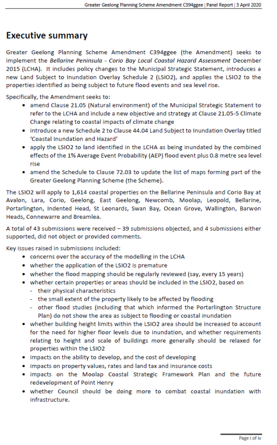
Amendment C394ggee (the Amendment) implements the Bellarine Peninsula - Corio Bay Local Coastal Hazard Assessment which maps areas that will be impacted by sea level rise and storm surge inundation.
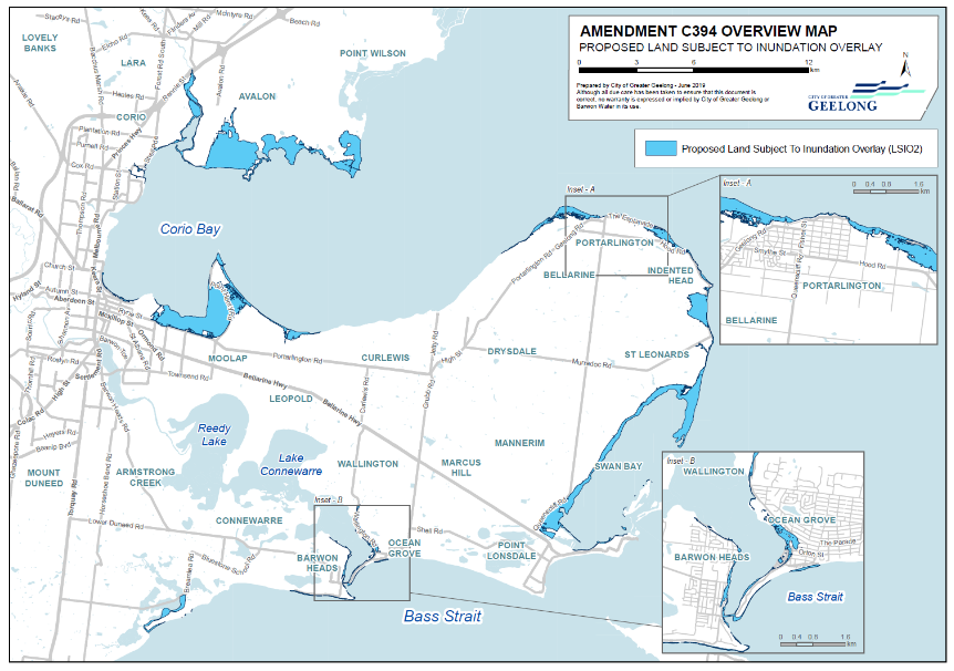
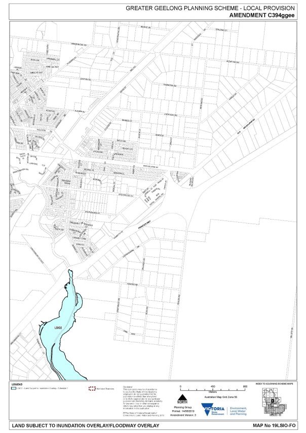
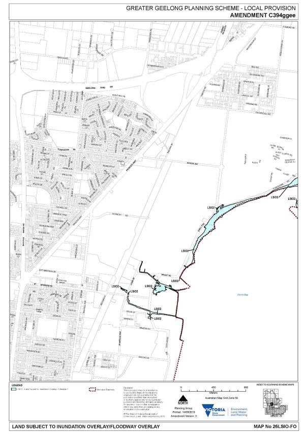
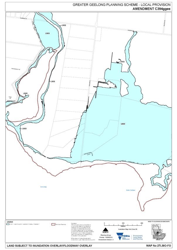
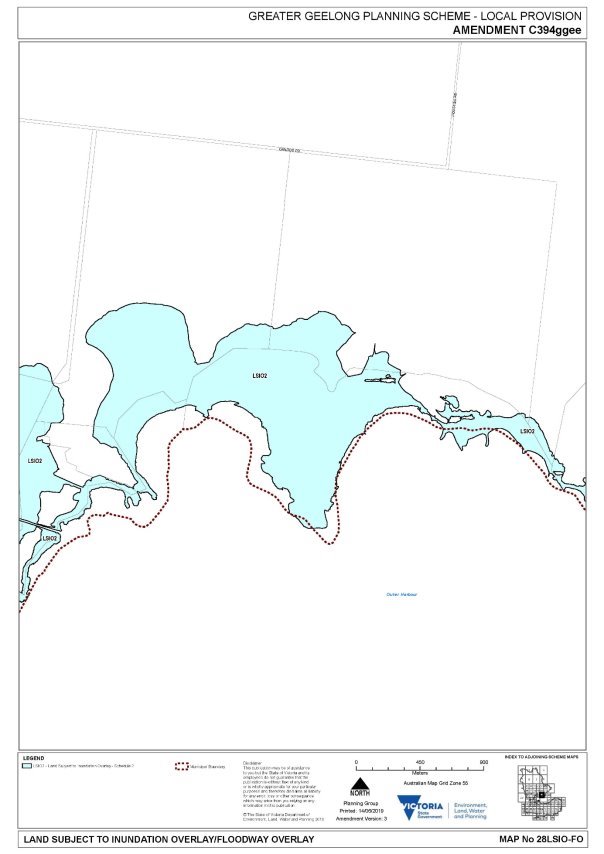
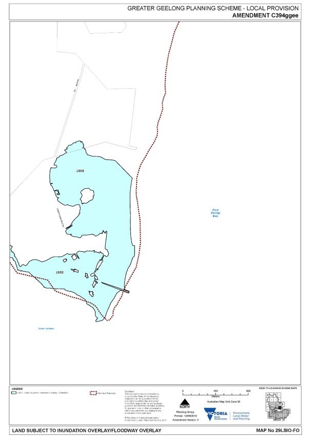
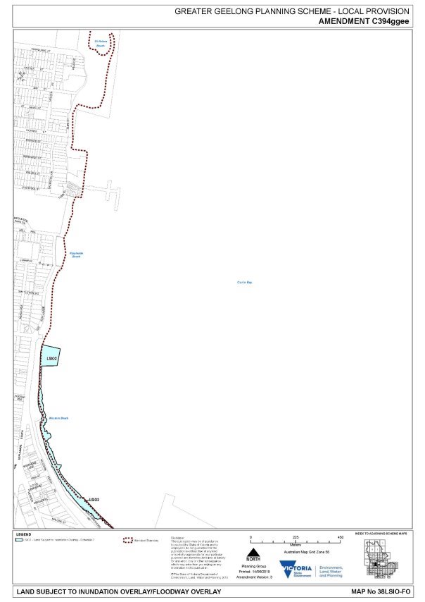
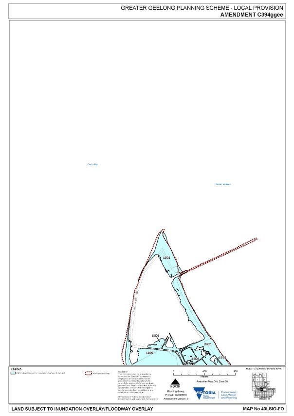
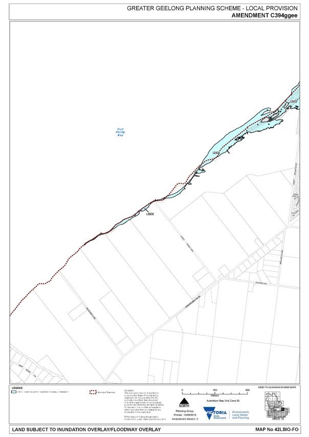
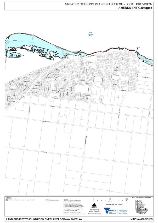
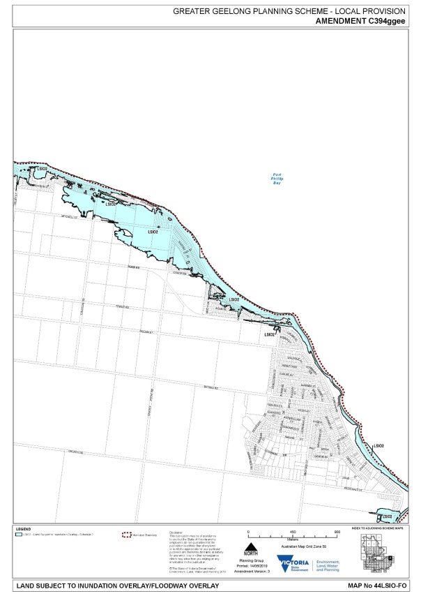
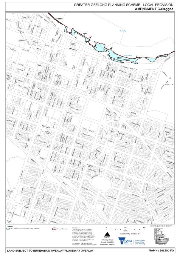
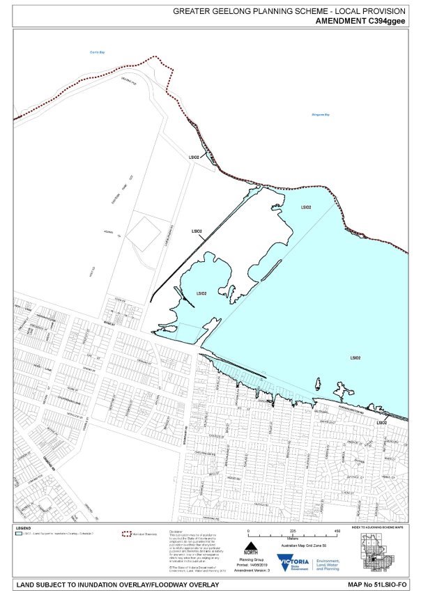
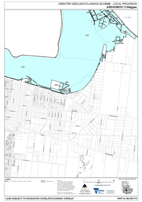
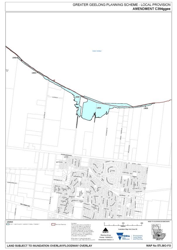
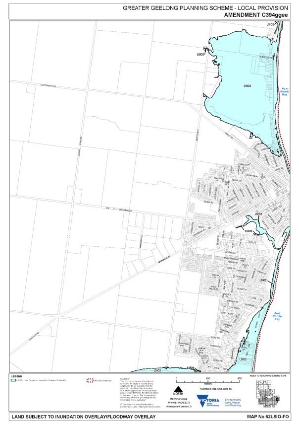
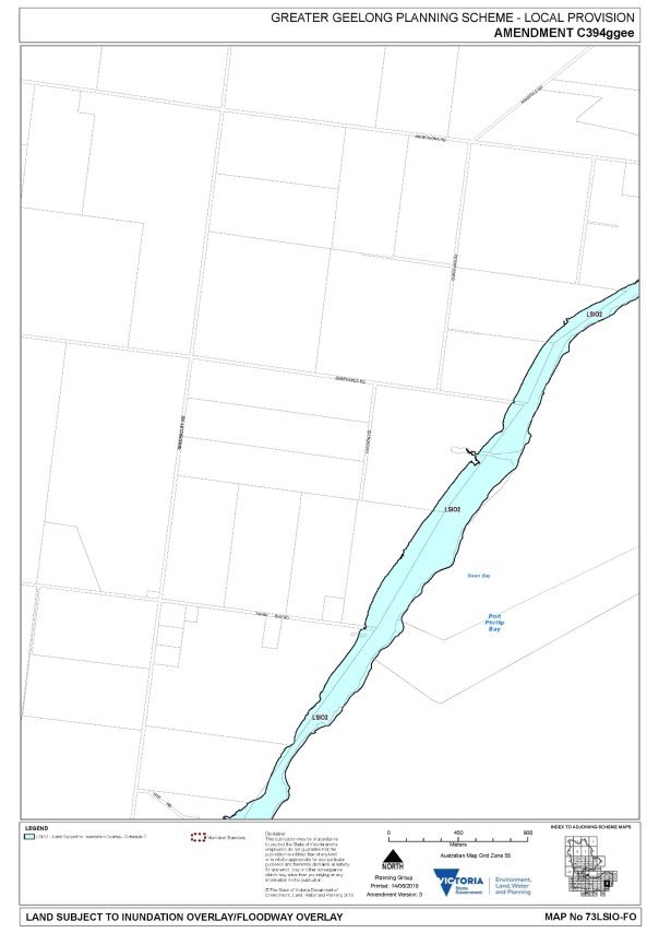
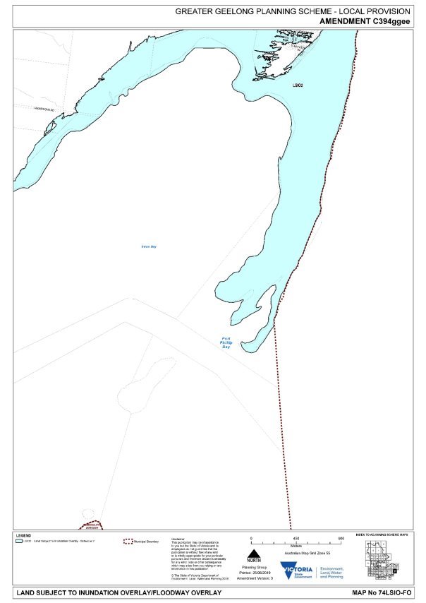
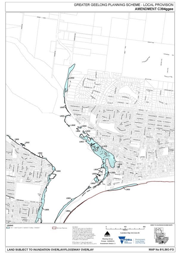
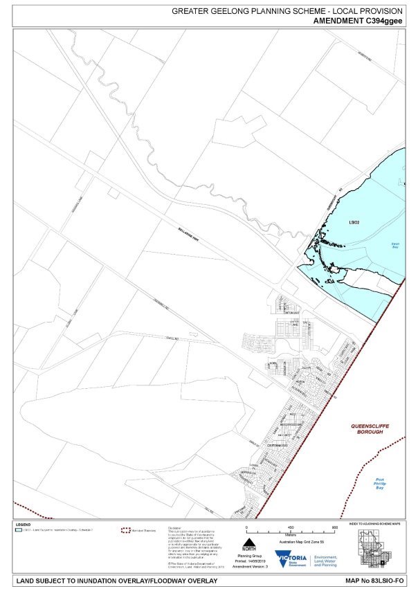
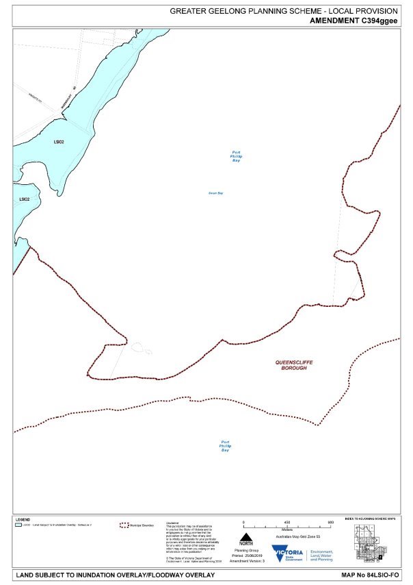
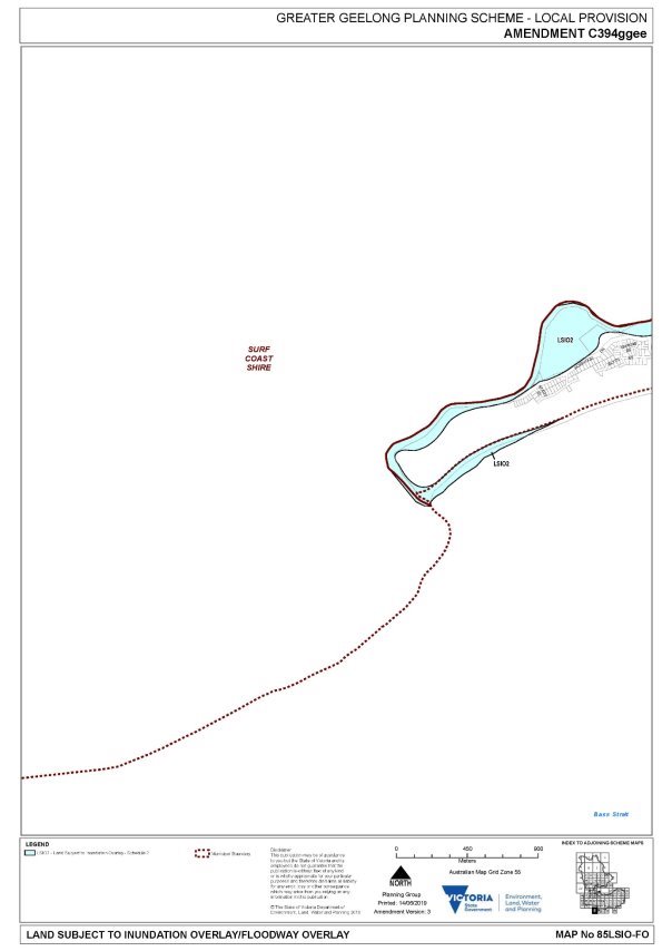
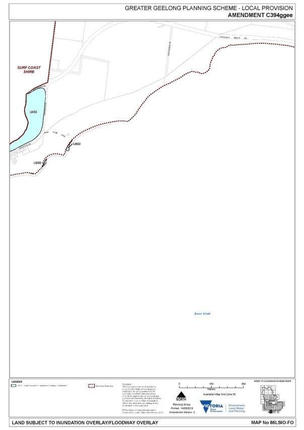
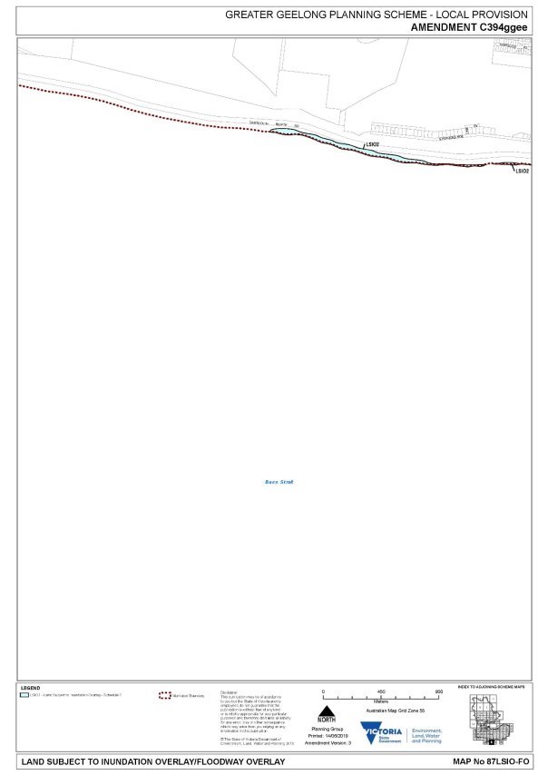
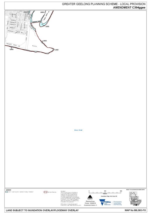
The Amendment includes planning scheme policy changes and applies a new Land Subject to Inundation Overlay (LSIO2) to 1600 properties based on 0.8m sea level rise and a 1% AEP storm surge event as required by State Government policy. The map in Attachment 3 shows the coastal areas subject to the proposed overlay.
On 14 May 2019 Council resolved to support public exhibition of the Amendment which occurred in July/August 2019 with notice sent to around 2000 owners and occupiers.
A total of 43 submissions were received including 39 objections.
On 26 November 2019 Council resolved to refer the submissions to an independent Panel as required under the Planning and Environment Act. The Panel held a hearing on 28 February 2020 and provided its report to Council in early April 2020.
The Panel supports the amendment and commends Council on its “forward looking and proactive approach in preparing the Amendment” (see Executive Summary in Attachment 4).
The Panel concludes that the Amendment is supported by, and implements, the Planning Policy Framework, and is consistent with Ministerial Directions and Practice Notes. It found the LSIO is the most appropriate planning tool available to address the risk of sea level rise and storm-tide surge. It states the Amendment is well founded and strategically justified and provides net community benefit.
The Amendment is now ready for adoption and forwarding to the Minister for approval.
Sullivan moved, Councillor Mason seconded -
That Council
Adopt Amendment C394ggee in the form outlined in Attachment 5 of this report; and
Submit the adopted Amendment C394ggee together with the prescribed information to the Minister for Planning requesting approval.
Carried.
Adoption of the Amendment and application of the overlay will not have any significant financial implications to Council. The project has incurred the usual costs associated with a planning scheme amendment including Panel hearing fees and the cost of engaging an expert witness. A grant is being sought from DELWP’s Coastal Planning Grants Program to cover the cost of the Panel hearing (approximately $27K).
The Amendment was exhibited in accordance with the requirements of the Planning and Environment Act 1987.
All submitters had an opportunity to be heard before an Independent Panel appointed by the Minister for Planning. The only submitters that appeared were the Department of Environment, Land, Water and Planning (DELWP) and the Corangamite Catchment Management Authority (CCMA). However, the Panel considered all submissions referred to it, not just the submissions presented at the hearing.
The Independent Panel report has been publicly released and all submitters notified of its availability.
The Amendment has positive economic and social benefits by identifying areas where planning permit assessment can reduce the risk of the harm from coastal erosion, flooding, sea level rise and storm surge.
The Amendment is supported by the following State and local planning policies:
Clause 13.01-2S Coastal inundation and erosion;
Clause 13.03-1S Floodplain management;
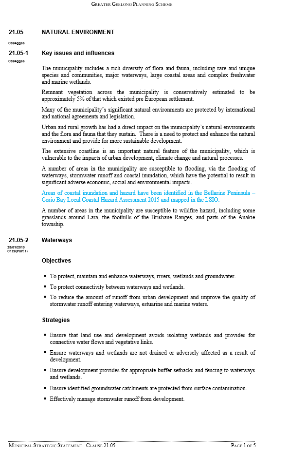
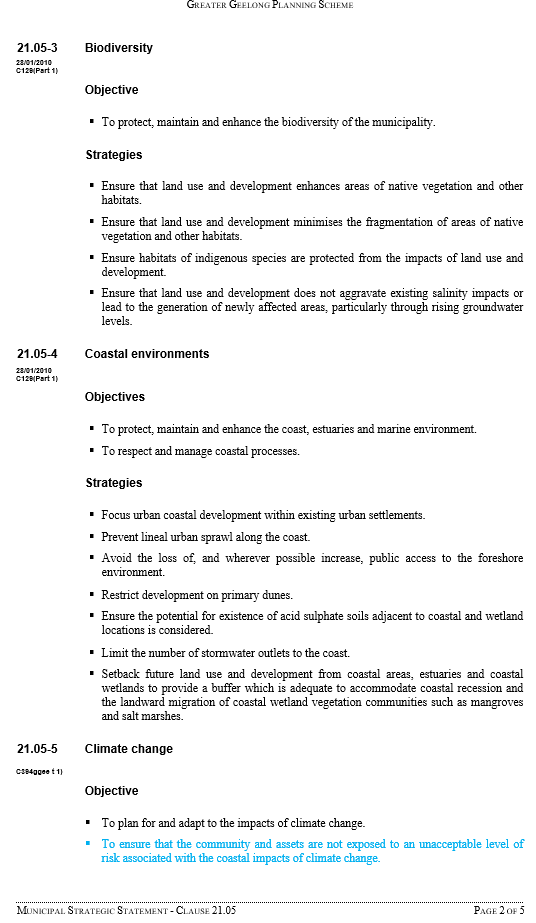
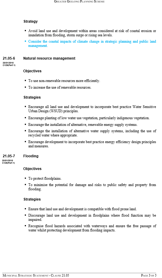
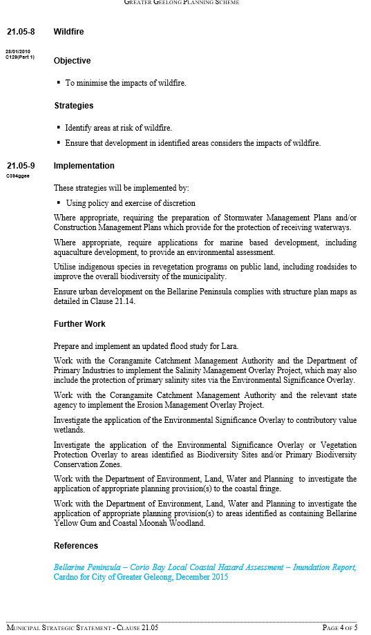
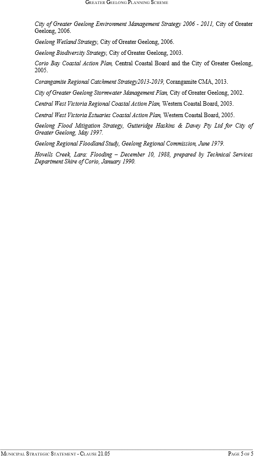
Clause 21.05-4 Coastal environments;
Clause 21.05-5 Climate change; and
Clause 21.05-7 Flooding.
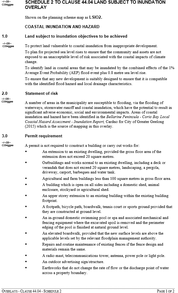
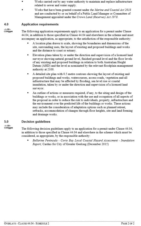
If the Amendment is adopted and approved the Land Subject to Inundation Overlay (Schedule 2) will trigger a planning permit for buildings and works (see LSIO2 Schedule for adoption in Attachment 4). However, it includes several exemptions such as:
Extensions to dwellings of less than 20 square metres;
Outbuildings, decks, verandahs (less than 20 square metres), landscaping, pergolas, driveways, carports, barbeques and water tanks;
Agricultural and farm buildings less than 100 square metres in gross floor area; and
Upper storey extensions to an existing building within the existing building footprint.
Under the LSIO2 planning permit applications will be referred to the CCMA. In most cases in existing townships the CCMA is likely to allow single dwellings but will set floor levels that consider sea level rise, storm surge level and freeboard.
The Amendment aligns with the Council Plan strategic priorities of:
Planned sustainable development – including the priority of improving the environmental performance of new developments, using planning controls; and
Effective environmental management – including the Climate Change Adaptation Strategy and protection of coastal areas.
No Council officers involved in the preparation of this report have any direct or indirect interest.
There is a risk if Council, as the Planning Authority, does not act on the coastal inundation mapping it has available, that it may be liable if flooding occurs in the future and damages property. Council can reduce this risk by acting on the scientific based data it has available and applying the appropriate overlay.
The Amendment will help manage the environmental hazard posed by future sea level rise.
Bellarine Peninsula - Corio Bay Local Coastal Hazard Assessment “Our Coast”
Victorian Government policy requires all councils to plan for a 0.8 metre sea level rise by the year 2100. The Bellarine Peninsula – Corio Bay Local Coastal Hazard Assessment – Inundation Report(LCHA) was prepared and released in December 2015 in response.
The report was prepared as part of the Our Coast project. This project identified properties that will be subject to future flood events and sea level rise and is the basis for the Amendment. Our Coast is a multi-agency Victorian Government funded initiative and covers the area from Breamlea to Point Wilson. It expands on two previous climate change coastal research projects undertaken by the CSIRO and the Victorian Government (Future Coasts) and is known as a “3rd pass” assessment.
Amendment C394ggee
The Amendment includes a new Land Subject to Inundation Overlay (LSIO2) and local policy changes. The overlay will require a planning permit for new buildings and works on 1600 coastal properties (including 1244 residential zoned properties) on the Bellarine Peninsula and Corio Bay - as shown in the Overview Map in Attachment 3.
The Point Lonsdale area was mapped as part of the Our Coast project but is not included in the Amendment. The maps need to be revised to take into account new waterways under construction in The Point residential development. This area will be subject to a later planning scheme amendment.
On 14 May 2019 Council resolved to support the public exhibition of the Amendment.
The Amendment was exhibited from 11 July 2019 to 12 August 2019.
As a result of exhibition, a total of 43 submissions were received. Of these 39 submissions objected and 4 submissions either supported, did not object or provided comments.
On 26 November Council resolved to refer the submissions to an independent Panel as required under the Planning and Environment Act. The Panel held a hearing on 28 February 2020 and provided its report to Council in early April 2020.
Panel Recommendations and Findings
A copy of the Executive Summary of the Panel report is in Attachment 4.
The Panel recommends adoption of the Amendment and its comments include:
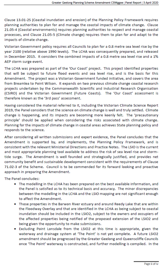
“Having considered the material referred to it, including the Victorian Climate Science Report 2019, the Panel considers that the science on climate change is well and truly settled. Climate change is happening, and its impacts are becoming more keenly felt. The ‘precautionary principle’ should be applied when considering the risks associated with climate change. Planning for the impacts of climate change in coastal areas achieves State planning policy and responds to the science; and
After considering all written submissions and expert evidence, the Panel concludes that the Amendment is supported by, and implements, the Planning Policy Framework, and is consistent with the relevant Ministerial Directions and Practice Notes. The LSIO is the current and most appropriate planning tool available to address the risk of sea level rise and storm-tide surge.
The Amendment is well founded and strategically justified, and provides net community benefit and sustainable development consistent with the requirements of Clause 71.02-3 of the Scheme. Council is to be commended for its forward looking and proactive approach in preparing the Amendment.”
The Panel provides detailed discussion, conclusions and recommendations on a wide range of issues.
The following is a summary of the Panel discussions and conclusions on issues where it goes on to make a formal recommendation. A City response is provided to each recommendation. The Planning and Environment Act requires the Planning Authority (Council) to consider panel recommendations hence the focus of this report on these issues. A summary of other conclusions the Panel reaches (without recommendations) is provided later in this Council report. A full copy of the Panel report is available online.
Issue - Strategic Justification
The Panel described the strategic issues as:
whether there is a sufficient evidence base for sea level rise;
whether the Amendment is premature;
whether (and how often) the mapping should be reviewed; and
whether the LSIO is the appropriate tool.
Several submissions took issue with the timeframe of predicted inundation (to the year 2100), and considered that this was too far distant in the future to warrant applying an LSIO now and that the Amendment is premature. Some submitters considered that the evidence on which the 2100 levels are based was inaccurate. Some considered that Council should wait until there is actual evidence of sea level rise, rather than predictions.
Council called Dr David Provis (the author of the LCHA) to provide expert evidence in relation to the preparation of the LCHA, including the modelling.
The Panel explains that the “Victorian Coastal Strategy refers to studies undertaken at Lorne and Stony Point that have recorded rises of 2.8 millimetres each year and 2.4 millimetres each year respectively since 1991. Dr Provis cited these studies and provided extracts from them in his evidence to the Panel. The Panel is satisfied on the basis of these studies that sea level rise is already occurring. The Panel does not consider that the ‘wait and see’ approach advocated for by some submitters would be a responsible approach.”
The Panel “acknowledges that planning for an 80 year horizon (to 2100) is a conservative approach. It accepts Dr Provis’ evidence that in effect, much of the land to which the LSIO2 will be applied may not be inundated for many years to come – perhaps even until after the life cycle of buildings that may be erected on the land in the next couple of years. However, the policy framework is clear that planning authorities should be taking the long view, and should be planning for a sea level rise of 0.8 metres by 2100.”
The Panel “accepts the position of Council, Dr Provis and the CCMA that a LSIO is the current and most appropriate planning tool available to address the risk of sea level rise and storm-tide surge. It has been consistently applied by other Councils who have introduced planning tools to deal with climate related coastal inundation and hazard”.
The Panel concludes the Amendment is strategically justified and should proceed.
Panel recommendation:
“Adopt the Amendment as exhibited, subject to the Panel’s specific recommendations.”
City Response: The Panel’s recommendation is supported and the Amendment is recommended for adoption.
Issue - The accuracy of the modelling
The issue is whether the technical basis of the modelling relied upon in the LCHA is correct.
The Panel describes the issue further saying “Dr Provis acknowledged that the input data had some gaps but that Council had taken the best possible practical measures to address them. He concluded that there were no obvious errors in the mapping. The 2007 LiDAR data is currently the only available data being relied upon for all coastal LSIO mapping in Victoria. Dr Provis acknowledged that the input data had some gaps but that Council had taken the best possible practical measures to address them”
The Panel concludes the modelling in the LCHA has been prepared on the best available information, and the Panel is satisfied as to its technical basis and accuracy.
Panel recommendation:
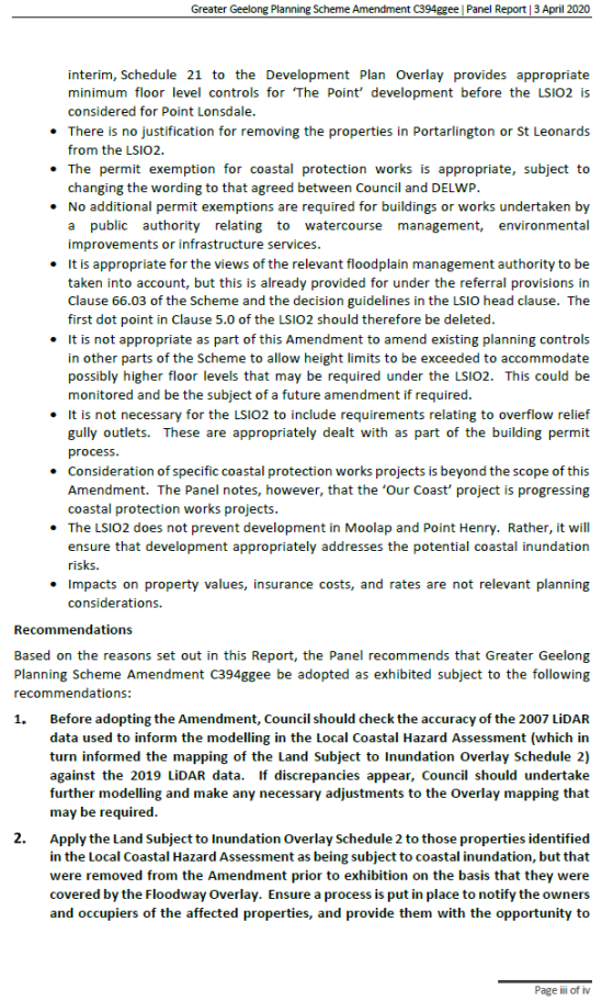
"Before adopting the Amendment, Council should check the accuracy of the 2007 LiDAR data used to inform the modelling in the Local Coastal Hazard Assessment (which in turn informed the mapping of the Land Subject to Inundation Overlay Schedule 2) against the 2019 LiDAR data. If discrepancies appear, Council should undertake further modelling and make any necessary adjustments to the Overlay mapping that may be required.”
City Response: In response to this recommendation City engineers compared ground surface levels from elevation data captured by LiDAR survey in 2007 and 2019, at locations in Ocean Grove, Portarlington and St Leonards.
Both datasets have a specified vertical accuracy of ±0.1m. Both datasets have been through a rigorous QA process in accordance with industry standard. When compared, the vast majority of LiDAR points have between -0.25 metres to 0 metres difference. For example, in the Ocean Grove sample over 80% of points tested are within ±0.25 metres.
When mapped, the differences are distributed in small patches, with the locations suggesting they can generally be attributed to:
cut and fill associated with dwelling construction;
other earthworks;
tide levels at the time of capture;
natural accretion and recession within the coastal zone (i.e. movement of sand); and
artefacts caused by changes in vegetation coverage.
The analysis has shown there’s nothing to suggest that either dataset is ‘wrong’ or that there have been any major changes to the landscape that would invalidate the original modelling. Any variation is what is normally expected with LiDAR and what would be expected over a 12-year period.
On this basis, further modelling is not required in relation to the more recent LiDAR data.
Appropriateness of the LSIO mapping - Properties in the Floodway Overlay (FO)
The Panel discusses several issues about the LSIO mapping with the one issue that includes a recommendation being whether it is appropriate to exclude properties covered by the FO from the LSIO2.
DELWP’s authorisation for Council to prepare the Amendment was subject to the following condition:
“Reconcile the extent of overlap of the proposed LSIO mapping with existing flood provisions, in particular the Floodway Overlay mapping at Barwon Heads, Lake Connewarre and Reedy Lake.”
Council officers explained to the Panel that, in response to the condition, they had removed several properties in the Barwon River estuary area and around Reedy Lake that are within the FO.
In response to questions from the Panel, Council indicated that it did not consider it necessary to remove these properties from the LSIO2 simply because they are subject to another flood control. Council preferred to apply both, where more than one flood risk applies. The CCMA indicated that while it has no difficulty in principle with two flood tools applying, the main concern is to ensure that at least one control applies so that permit applications are referred to the CCMA.
The Panel says “Given Dr Provis’ evidence about the particular and distinct characteristics of flooding from coastal inundation, the Panel considers that it is prudent to apply the LSIO2 to all properties that are subject to coastal inundation, irrespective of whether another flood tool also applies.”
Panel recommendation:
“Apply the Land Subject to Inundation Overlay Schedule 2 to those properties identified in the Local Coastal Hazard Assessment as being subject to coastal inundation, but that were removed from the Amendment prior to exhibition on the basis that they were covered by the Floodway Overlay.
Ensure a process is put in place to notify the owners and occupiers of the affected properties, and provide them with the opportunity to make submissions and (if necessary) have their submissions considered by an independent panel.”
City Response: The Panel’s findings that it is prudent to apply the LSIO2 to all properties including those already covered by a Floodway Overlay in the Barwon River estuary/Lake Connewarre/Reedy Lake vindicates the City’s position it put forward to DELWP when seeking authorisation.
With regard to applying the LSIO2 to the properties excluded by DELWP Council officers prefer to do this separately to the current C394 Amendment so it can be kept moving through to adoption and approval. It is recommended that the LSIO2 be applied to these properties under a future amendment. A relevant amendment would be the amendment to implement the CCMA’s Lower Barwon and Moorabool River Flood Study. This amendment will be put to Council some time in 2020 and then move to exhibition. It updates the flood related overlays along the Barwon River and the LSIO2 could added for efficiency.
Application issues – Permit exemptions
This issue relates to permit exemptions. The Panel describes the situation saying that DELWP sought changes at Clause 3.0 of the proposed LSIO2. DELWP suggested that Council replace the words:
Works carried out under the Marine and Coastal Act 2018 or the Crown Land (Reserves) Act 1978 that have had regard to the Bellarine Peninsula – Corio Bay Local Coastal Hazard Assessment and are conducted by a public land manager or a coastal committee under the Marine and Coastal Act 2018
Works that have been granted consent under the Marine and Coastal Act 2018 and are conducted by a Public Land Manager or Committee of Management appointed under the Crown Land (Reserves) Act 1978.
DELWP stated that this general consent is typically relied upon to enable minor and like for like repair of existing structures in the coastal zone. This includes rapid repair of sea walls or other structures whose purpose is to manage or mitigate coastal erosion or related risk, and visitor facilities (such as stairways) that are designed to enable safe access to the coastal zone. DELWP supported modifications to the exhibited schedule that enabled such work to proceed without a planning permit.
Council accepted DELWP’s advice and the changes to the wording of Clause 3.0.
The Panel supports the exemption in the LSIO2 relating to coastal protection works and visitor facilities that are consented to under coastal protection legislation
Panel Recommendation:
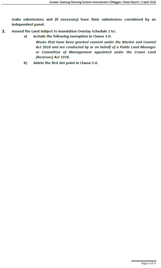
“Amend Clause 3.0 of the Land Subject to Inundation Overlay Schedule 2 to include the following exemption
Works that have been granted consent under the Marine and Coastal Act 2018 and are conducted by or on behalf of a Public Land Manager or Committee of Management appointed under the Crown Land (Reserves) Act 1978.”
City response: The Panel recommendation is accepted and the LSIO2 schedule for adoption (see Attachment 4) includes the new wording.
Application issues – views of the floodplain management authority
The issue is whether the decision guidelines in the LSIO2 should refer to the views of the relevant catchment management authority, or the floodplain management authority.
The Panel states “it considers it appropriate that the views of the relevant floodplain management authority be sought and considered in relation to permit applications under the LSIO2. However the Scheme already provides for this. Under Clause 66.03, permit applications under the LSIO within the waterway management district of Melbourne Water must be referred to Melbourne Water, and permit applications outside the waterway management district of Melbourne Water must be referred to the relevant floodplain management authority (which in this case is the CCMA). The decision guidelines in the LSIO head clause (Clause 44.04-8) also require any comments of the relevant floodplain management authority to be taken into account. The first dot point in Clause 5.0 of the LSIO2 is therefore not necessary, and should be deleted.”
Panel Recommendation:
“Delete the first dot point in Clause 5.0 of the Land Subject to Inundation Overlay Schedule 2.”
City response: The Panel recommendation is accepted and the wording has been deleted from the LSIO2 schedule for adoption (see Attachment 4).
Other conclusions
Throughout its report the Panel provides a series of conclusions on a range of issues. They are consistent with the City’s position on the Amendment. However, they do not include formal recommendations and as such don’t require a formal City response, the conclusions include:
Excluding Point Lonsdale from the LSIO2 at this time is appropriate, given the waterway and drainage system at ‘The Point’ is not yet complete. A future LSIO2 amendment should be progressed by the Greater Geelong and Queenscliffe Councils once ‘The Point’ waterway is constructed, and further modelling is compiled. In the interim, Schedule 21 to the Development Plan Overlay provides appropriate minimum floor level controls for ‘The Point’ development before the LSIO2 is considered for Point Lonsdale;
There is no justification for removing the properties in Portarlington or St Leonards from the LSIO2;
No additional permit exemptions are required for buildings or works undertaken by a public authority relating to watercourse management, environmental improvements or infrastructure services;
It is not appropriate as part of this Amendment to amend existing planning controls in other parts of the Scheme to allow height limits to be exceeded to accommodate possibly higher floor levels that may be required under the LSIO2. This could be monitored and be the subject of a future amendment if required;
It is not necessary for the LSIO2 to include requirements relating to overflow relief gully outlets. These are appropriately dealt with as part of the building permit process;
Consideration of specific coastal protection works projects is beyond the scope of this Amendment. The Panel notes, however, that the ‘Our Coast’ project is progressing coastal protection works projects;
The LSIO2 does not prevent development in Moolap and Point Henry. Rather, it will ensure that development appropriately addresses the potential coastal inundation risks; and
Impacts on property values, insurance costs, and rates are not relevant planning considerations.
Planning and Environment Act 1987
The planning authority for this amendment is Greater Geelong City Council.
The Greater GeelongPlanning Scheme is amended as follows:
Planning Scheme Maps
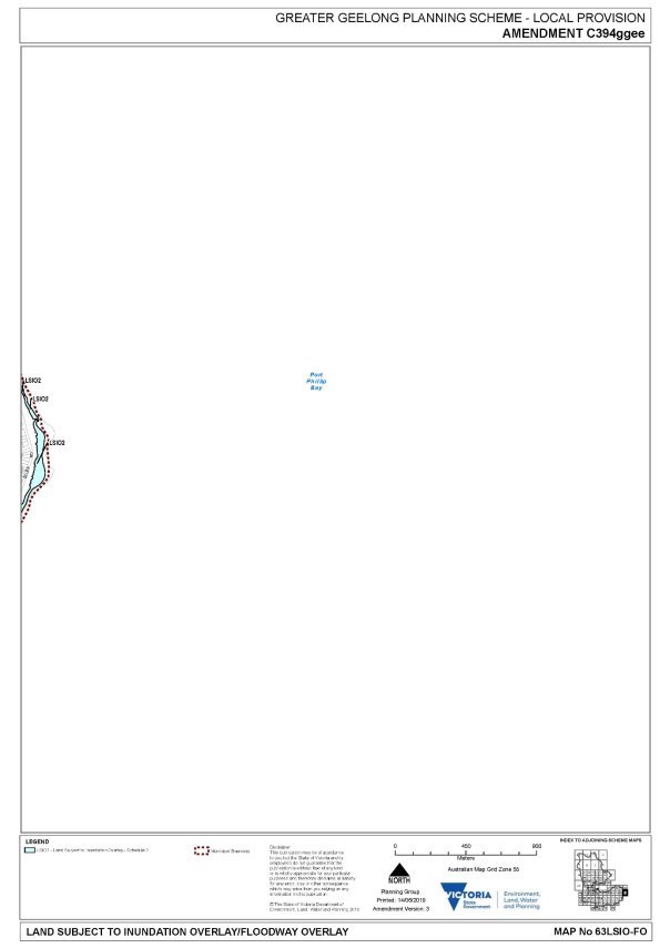
The Planning Scheme Maps are amended by a total of 26attached mapsheets.
Overlay Maps
Amend Planning Scheme Map Nos. 19, 27, 29, 50, 56, 81, 83, 86 and 88 LSIO-FO in the manner shown on the 9 attached maps marked “Greater Geelong Planning Scheme, Amendment C394”.
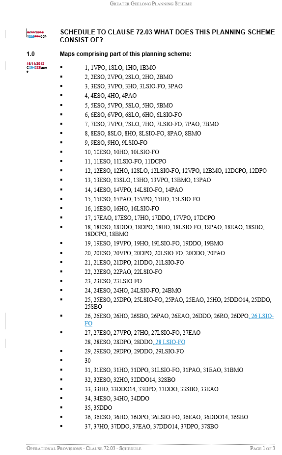
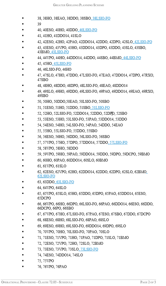
Insert new Planning Scheme Map Nos. 26, 28, 38, 40, 42, 43, 44, 45, 51, 57, 62, 63, 73, 74, 84, 85 and 87 LSIO-FO in the manner shown on the 17 attached maps marked “Greater Geelong Planning Scheme, Amendment C394”.
Planning Scheme Ordinance
The Planning Scheme Ordinance is amended as follows:
In Local Planning Policy Framework – replace Clause 21.05 with a new Clause 21.05 in the form of the attached document.
In Overlays – Clause 44.04, insert a new Schedule 2 in the form of the attached document.
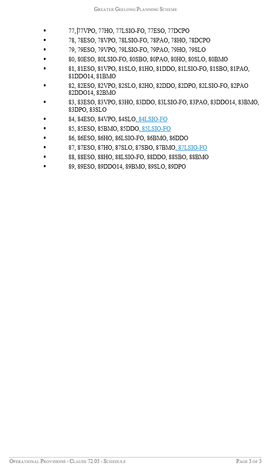
In Operational Provisions – Clause 72.03, replace the Schedule with a new Schedule in the form of the attached document.
End of document
Source: |
Community Life - Social Planning and Investment |
Director: |
Robyn Stevens |
Portfolio: |
Community Health, Wellbeing and Safety |
To consider the Food Assistance Business Case and potential investment into establishing a new food distribution centre at 37 Morgan Street, North Geelong.
An independent consultancy (Social Ventures Australia) were engaged in November 2019 to prepare the Food Assistance Business Case provided as Attachment 2.
At the Council Community Focus Meeting on 10 March 2020, Council resolved the following, conditional on the outcomes of this report:
To allocate $1 million from the 2019/2020 budget towards renovation works at
37 Morgan Street, North Geelong; and
Consider allocating a grant amount of up to $150,000 per annum for five years to a third-party provider for the running costs of a food distribution centre at the aforementioned lease premises.
The key findings of the Food Assistance Business Case are:
There is insufficient food storage and distribution capacity, and the current site in North Geelong is constrained, operating at full capacity and facing several immediate compliance issues;
The existing governance structures and processes, including the Geelong Food Assistance Network (GFAN), support collaboration between key stakeholders. However, the collaborative relationship between GFAN and Geelong Food Relief Centre (GFRC) requires strengthening to improve communication and collaboration, and to ensure all key stakeholders have a more significant role in decision making; and
There is currently limited information and ability to influence the quality and quantity of food inputs and outputs across the Geelong region, with potential to impact nutritional outcomes for customers.
The key recommendations of the Food Assistance Business Case are:
To implement a revised governance structure that would oversee the food relief system in the Geelong region and aim to build capacity in the system that will improve communication, collaboration and collective decision making amongst all key stakeholders; and
That a priority for capital investment should be for a larger and more fit for purpose distribution and storage facility, as a matter of some urgency.
The GFRC currently receives and stores approximately 70 per cent of the food supplied into the system. GFRC have provided an operating financial plan and preliminary capital cost analysis for redevelopment of the site at 37 Morgan Street, North Geelong (Attachment 3) to indicate the viability of any decision to relocate GFRC.
Murnane moved, Councillor Mansfield seconded -
That Council
Note the findings and recommendations of the Food Assistance Business Case (Attachment 2) and specifically thank all organisations and volunteers involved in the provision of food assistance to our community;
Note the financial analysis and submission of the Geelong Food Relief Centre (Attachment 3) indicating the forecast operating and capital costs related to establishment of a new food distribution and storage facility at 37 Morgan Street, North Geelong; and
Authorise the Chief Executive Officer to enter into the appropriate forms of agreement with the Geelong Food Relief Centre (GFRC) that will commence on or about 1 July 2020, and that any agreements be generally consistent with the following terms:
Be a maximum term of 5 years to enable GFRC to enter into a 10 year lease (with additional 5 year option) over the property at 37 Morgan St, North Geelong for the sole purpose of operating a not for profit food relief distribution and storage centre;
Provide funding of $100,000 in the first year of the agreement and $150,000 per annum for the following four years. Specifically, the funding agreement should ensure that:
During the first year of the agreement, $60,000 (plus GST) be provided for the rental, maintenance and electricity cost for 37 Morgan Street, North Geelong and $40,000 (plus GST) toward strengthening the volunteer, philanthropic and stakeholder engagement capacity; and
An amount of $120,000 per annum (plus GST) be provided for rental maintenance and electricity cost for 37 Morgan Street, North Geelong and $30,000 per annum (plus GST) toward strengthening the volunteer, philanthropic and stakeholder engagement.
Provide funding of up to $1 million for the renewal and redevelopment of the 37 Morgan Street, North Geelong site for the sole purpose of operating a not for profit food relief distribution and storage centre, subject to a quantity surveyors report being prepared and agreed between the City of Greater Geelong and GFRC;
Requires the implementation of revised governance arrangements to strengthen the collaboration and decision-making role of other key stakeholders (including representatives from major food suppliers and the Geelong Food Assistance Network) via a GFRC review of its governance and operating model; and
A report be provided by GFRC to Council annually on the governance, operating and financial performance of GFRC.
Carried.
In the 2018/19 budget, Council allocated $75,000 to undertake a feasibility study. A further budget of $1 million was approved in the 2019/2020 for a food relief centre to strategically address food shortages in the municipality (subject to the business case).
Should Council adopt the recommendations in this report the capital contribution of Council will be $1 million into the renewal of 37 Morgan Street, North Geelong. This would be a one-off payment and the expenditure tied to a capital disbursement / grant. The lease for the property will be taken by GFRC for a period of 10 years. Council’s contribution is a maximum of $750,000 at (up to) $150,000 per annum for five years.
The submission of GFRC (Attachment 3) indicates that the contribution of council will support the organisation to be financially sustainable in the new premises at 37 Morgan Street, North Geelong.
Significantly, the cashflow projections of GFRC indicate a strategic intention to increase the operating surplus year on year, to strengthen GFRC’s medium to longer term financial position, which is deemed prudent in an environment where uncertainty of funding and potential crisis can severely impact the organisations capacity and ability to distribute food into the system.
Stakeholder Engagement has been undertaken throughout the various stages of the project and has included a series of four workshops with the key stakeholder group that has included the following organisations and people:
Chairperson, Stakeholder Group - Keith Fagg;
Geelong Councillor (Chair Community Health, Wellbeing and Safety) - Pat Murnane;
Barwon Child Youth and Family - Sandy Morrison;
Chair, Geelong Food Assistance Network / Senior Manager, Uniting - Des Younghusband;
Regional Manager, Salvation Army - Aubrey Anderson;
Deputy Chair, Geelong Food Relief Centre / St Vincent De Paul Society - John McCarthy;
CEO, Geelong Community Foundation - Gail Rodgers;
CEO, Give Where You Live - Bill Mithen;
CEO, Give Where You Live - Cynthia Scherer;
Volunteering Geelong - Helen Hunter;
Ambassador, Second Bite - Andrew Balaam;
Chair, Geelong Food Relief Centre - Maurice Anglin;
Program Manager, Food Bank Victoria - Zac Lewis;
Logistics Manager, Fare Share - Pat Lanyon; and
CEO, genU - Mike McKinstry.
The consultants have also engaged one-on-one with 20 service organisations, including members of the Geelong Food Assistance Network (GFAN) to gather community insights and data related to the current food assistance system. Four workshops have also been delivered to identify the collective issues impacting the current approach to food assistance across the municipality.
The Food Assistance Stakeholder Group have collectively considered the strategic recommendations outlined in the business case (Attachment 2).
The right to food is a basic human right recognised by international human rights law, noting that food should be available, accessible and adequate.
The Social Equity principles from the draft Social Infrastructure Policy (2019) have been applied in assessing social equity. Council’s Social Equity Principles identify that:
‘service and infrastructure design, location, communication and support arrangements will address the particular needs and obstacles faced by priority areas and groups’; and
‘all activities of the City will be informed by up to date demographic and geographic information on social equity in the region which identifies priority areas and groups for attention.
It is estimated that the current food assistance system provides approximately 2.16 million meals per annum, however using Foodbank’s estimates of people experiencing food insecurity by population, it is anticipated it should be providing approximately 2.48 million meals per annum to around 53,000 residents. This indicates a current gap in demand for food of approximately 350,000 meals per annum.
Geelong’s increasing population of 17% since 2011, to 252,000 in 2018 has placed increased pressure on the food assistance system and with the population predicted to reach 330,000 residents by 2031, the need to develop a sustainable food assistance system is crucial. Forecasts suggest that if the current system remains unchanged there could be an estimated 1 million meals gap by 2031.
The implementation of the recommendations in the Food Assistance Business Case is likely to improve availability, access and adequacy of food for some of the most vulnerable in our community.
The recommendations of this report (if adopted by Council) will be implemented through legal instruments and agreements with third parties, including Geelong Food Relief Centre Inc. The legal instruments are designed to ensure any financial contribution is appropriately accounted for and expended in accordance with the council resolution and legislation, while also minimising financial or legal exposure and risk to Council.
Endorsing the recommendations in the Food Assistance Business Plan aligns with several council objectives including
Improved health and safety of our community;
Informed social infrastructure and planning; and
A more inclusive and diverse community.
No Council officers, consultants or contractors who have provided advice in relation to this report are known to have a conflict of interest in regard to this matter.
Considering the growing extent of food insecurity and general growth for food assistance across the Greater Geelong, a lack of strategic forward planning in food assistance is a risk to the sustainability of the food assistance system and the people who rely on it.
There is a financial risk to Council associated with the third-party agreements however these will be managed through implementation of risk mitigation strategies and formalised agreements.
Further detailed business modelling and a review of the proposed design and construction costs have also been completed and tested to minimise any potential risk to GFRC, council and the broader community. The submission of GFRC indicates their financial capacity to operate the Morgan Street site.
There are no known environment implications associated with this report.
Source: |
Customer & Corporate Services - Financial Services |
Director: |
Michael Dugina |
Portfolio: |
Finance |
To seek Council approval to adopt the updated Non-Current Asset Accounting Policy.
The previous Asset Accounting Policy was adopted by Council in February 2010. As part of the asset accounting stream of the Asset Transformation program the policy has been reviewed and updated.
The updated Non-Current Asset Accounting Policy is set out at Attachment 2.
Key changes to the policy include:
Clear and concise objectives;
Revaluation threshold is included. Previously only the capitalisation threshold was included; and
Alignment of non-current asset classes with annual financial statements.
The policy ensures compliance with relevant Australian Accounting Standards and provides clear definitions and guidance on Asset Accounting requirements.
The policy provides a Key Policy Statement Summary.
Aitken moved, Councillor Grzybek seconded -
That Council adopt the Non-Current Asset Accounting Policy.
Carried.
The policy supports financially sustainable asset accounting practices and principles, ensuring assets are funded for current and future generations.
Community consultation drives service delivery and asset management decisions. A report will be provided to the community on the state of our assets.
Social equity considerations form part of the asset accounting process.
All legislative requirements and statutory implications were considered in the development of this policy. Whilst the previous policy was developed in accordance with industry best practice at the time, the policy has considered new standards and guidelines in the review.
Alignment to our Council Plan 2018-2022 is a key element of the policy, supporting and underpinning all strategic priorities.
No Council officers have a direct or indirect interest in any matter to which this report relates.
The policy articulates how asset management will consider and apply elements of our Enterprise Risk Management Framework.
Compliance with the policy will assist with effective environmental management.
Source: |
Customer & Corporate Services - Property, Procurement and Assets |
Director: |
Michael Dugina |
Portfolio: |
Leadership and Governance |
To seek Council approval to adopt the updated Asset Management Policy.
Local Government asset management practices and responsibilities have been subject to review on many occasions over the last decade. Recently the 2019 VAGO Audit: tilted, Local Government Assets: Asset Management and Compliance, set out several recommendations relating to the Asset Management Practices of Councils. The Local Government Act 2020 also outlined clear expectations for development of 10 Year Asset Management Plans driven by service levels and community engagement.
The Asset Management Transformation Program was established in 2016 to drive transformation of Council’s asset management practices. In 2019 a project plan was established, identifying key work streams. Updating the Asset Management Policy was a key task. The previous Asset Management Policy was adopted by Council in August 2012.
The Asset Management Policy (Attachment 2) incorporates the following improvements:
Streamlining the policy to focus on strategic themes and principles. Procedural information has been removed and will be included in the Asset Management Procedure and Framework.
Aligning the policy with requirements under the Local Government Act (2020) such as:
Preparation of 10-year Long Term Financial Plans informed by Council’s Strategic Asset Management Planning;
Emphasising the centrality of Service Planning and community engagement to the City’s asset management practice; and
Alignment with key recommendations in the VAGO Performance Audit (2019) into Asset Management, primarily ensuring reliability of systems and asset information.
The Policy will drive the vision and direction for the Asset Management Strategy.
Aiken moved, Councillor Grzybek seconded -
That Council adopt the Asset Management Policy.
Carried.
The policy supports financially sustainable asset management practices and principles, ensuring assets are funded for current and future generations.
Community consultation drives service delivery and asset management decisions. A report will be provided to the community on the state of our assets.
Social equity considerations form part or the asset planning, delivery and maintenance process.
All legislative requirements and statutory implications were considered in the development of this policy. Whilst the previous policy was developed in accordance with industry best practice at the time, the policy has considered new standards and guidelines in the review.
Alignment to our Council Plan 2018-2022 is a key element of the policy, supporting and underpinning all strategic priorities.
No officer in the preparation of this report has a conflict of interest.
The policy articulates how asset management will consider and apply element of our Enterprise Risk Management Framework.
Compliance with the policy will assist with effective environmental management.
Source: |
City Services - Engineering Services |
Director: |
Guy Wilson-Browne |
Portfolio: |
Parks, Gardens and City Services |
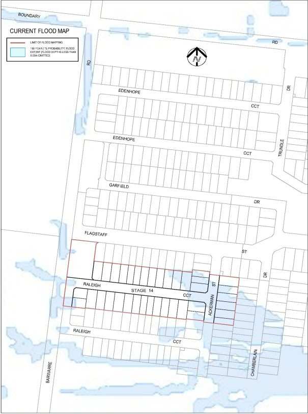
To revoke Council’s designation of 12 December 2006 of flood affected land Ashbury Estate, Stage 14 inclusive as liable to flooding pursuant to regulation 153 of the Building Regulations 2018.
Council has a statutory obligation under the Building Regulations 2018 to designate land as liable to flooding where it reasonably knows it to be prone to flooding. Conversely, there is an obligation to remove the encumbrance of designation from land that is no longer considered to be flood-prone.
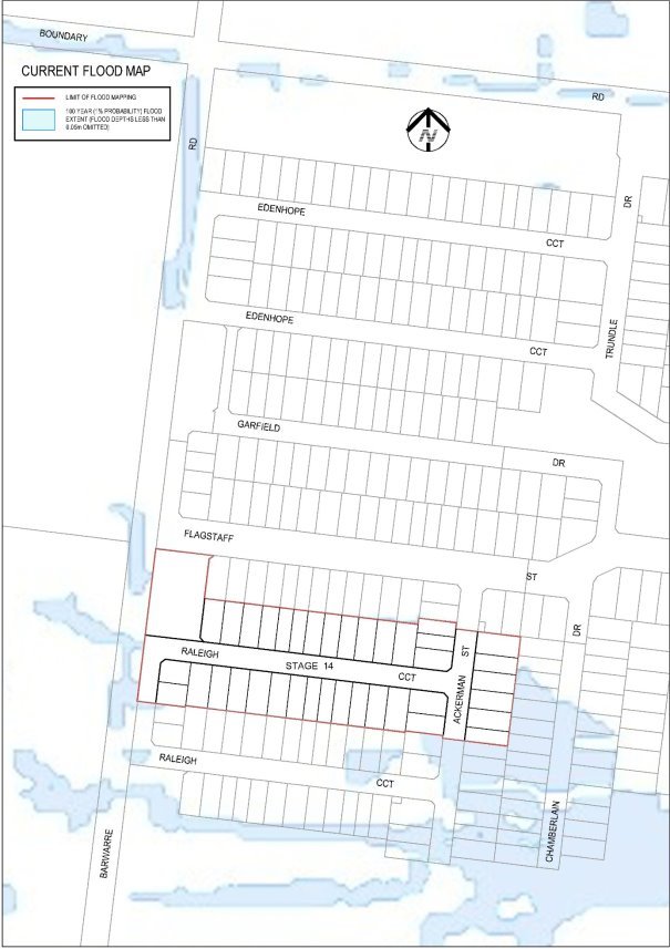
The current designated flood mapping (Attachment 2) was designated by Council at its meeting of 12 December 2006.
This revocation will result in another stage of new lots in Ashbury Estate fronting 282 – 400 Horseshoe Bend Road, Armstrong Creek being free of their flood prone status, paving the way for owners to build homes on their land.
The flood mapping is subject to a revision due to the subdivision and development at 282 – 400 Horseshoe Bend Road, Armstrong Creek. Prior to subdivision the parent lot was considered to be liable to flooding. This development site, which is also known as Ashbury Estate, Stage 14 inclusive, achieves flood immunity for newly created lots for flood events up to and including the 100 year Average Recurrence Interval (ARI) event due to approved internal earthworks.
The decision by the City that the flood prone status can be removed includes assessment of internal drainage, road construction and earthworks to contain potential floodwaters from the 100 year ARI event within road and drainage reserves (Attachment 3).
It should be noted that designation is separate to the creation of flood overlays within the Planning Scheme, which generally follows designation. In the case of this development, the planning scheme amendment to create post-development flood zones or overlays is proposed after the design of the proposed precincts.
Aitken moved, Councillor Kontelj seconded -
That Council revoke the Council designation of 12 December 2006 of flood affected land at Ashbury Estate, Stage 14 inclusive as liable to flooding pursuant to regulation 153 of the Building Regulations 2018.
Carried.
No impact to budget.
A revocation of designation does not warrant public consultation as it constitutes the removal of an encumbrance on land.
Relevant Council databases and flood maps will be revised and updates sent to the Corangamite Catchment Management Authority and Building Control Commission.
Council have a responsibility to the community to provide the best possible information on areas that are flood prone. The removal of flood prone designation allows owners to build on their land without a special permit from the City, and without raising the floor level of their home. It also reduces the cost of property insurance.
The City has various statutory responsibilities for drainage management and flood management (prevention, response and recovery) as set out in the Local Government Act 1989, Local Government Regulations 1990, Planning and Environment Act 1987, Building Regulations 2018, Water Act 1989, Subdivision Act 1988 and Emergency Management Act 1986.
The works have resulted in the lots being protected from flooding during a major storm event that has a one per cent probability of occurring in any one year, and occurs on average once in 100 years. This is the required standard for new subdivisions.
The recommendations of this report are consistent with City Plan, in relation to planned sustainable development.
There are no officer direct or indirect interests with respect to this report.
Council also has some risk exposure with any failure to disclose the flood-prone status of a property in a Land Information Certificate.
The revocation of the designation is the final step in minimising Council’s risk.
The revocation of flood-prone areas designation and designation of revised flood data through the design of this stage is considered unlikely to result in any known adverse environmental impacts.
Councillor Kontelj declared a Conflict of Interest in Agenda Item 8 – Tender T2000038 Supply of Asphalt Works, Products and Services in that a number of contractors and suppliers noted in the report are customers of the business of which he is a Director and left the room at 8:05pm prior to discussion of the item.
Source: |
Customer & Corporate Services - Property, Procurement and Assets |
Director: |
Michael Dugina |
Portfolio: |
Finance |
To establish a contract panel based on an agreed schedule of rates for the ‘Supply of Asphalt Works, Products & Services’ used in road construction and maintenance activities undertaken by the City.
The current panel of contractors for the supply of the City’s asphalting program will expire on 30 June 2020.
To facilitate the ongoing supply of asphalt and associated works, the Procurement Unit undertook a public tender (Tender No. T2000038) on behalf of the Engineering Services Department.
The annual budget allocated for this contract is $8,000,000 (ex-GST).
At tender close the City received five submissions from:
Boral Resources (VIC) Pty Ltd;
Econopave Asphalt Services Pty Ltd;
Fulton Hogan Industries Pty Ltd;
Hetekaro Pty Ltd t/a Asphalt Paving Services; and
Greenhall Asphalt Pty Ltd
The submissions were evaluated in accordance with the processes detailed in the City’s ‘Procurement and Contracts Manual’.
Based on the volume of works required to deliver the annual asphalting program and the quality and competitive pricing of the submissions, the Tender Evaluation Panel (TEP) recommend that all five tenderers are included on the Contract Panel.
Subject to Council awarding the Contract, the service will commence 1 July 2020.
Aitken moved, Councillor Grzybek seconded -
That Council
Award Panel Contract C2000038 for the Supply of Asphalt Works, Products and Services for 3 years (with a further 2 x 12 month extension options) based on the tendered schedule of rates to the following preferred tenderers; and
Tenderer |
ABN |
Boral Resources (VIC) Pty Ltd |
87 004 620 731 |
Econopave Asphalt Services Pty Ltd |
11 069 746 587 |
Fulton Hogan Industries Pty Ltd |
54 000 538 689 |
Hetekaro Pty Ltd t/a Asphalt Paving Services |
72 107 136 774 |
Greenhall Asphalt Pty Ltd at Trustee for the Asphalt Settlement Trust |
61 903 904 814 |
Authorise the Chief Executive Officer to execute Contract No. C2000038 and any other documents required by or to give effect to the terms of the Contract on behalf of Council.
Carried.
The current budget allocation for the supply of asphalting and associated works is $8,000,000 p/a (ex-GST) and is contingent on funding allocations in future recurrent, renewal and capital budgets. The estimated total cost for the term of the 5 year agreement (inclusive of option periods) is $40,000,000 (ex-GST) subject to annual adjustments. This contract will operate on a “rise and fall” basis referencing section 199 of the VicRoads Standard – Provision for Adjustment of Contract Sum for the term of the contracted period with minor amendments.
As stipulated in the specification and in the contract, the contractor must provide residents, impacted by proposed works, a minimum 48 hours notice, in writing, unless otherwise approved by the City’s Superintendent.
All five tenderers operate businesses within the Geelong Region providing significant local employment and economic benefits to the Geelong community.
This tender was publicly tendered in accordance with the requirements of section 186 of the Local Government Act 1989 and the tender process has been conducted in accordance with Council’s Procurement Policy.
Confidential information contained in this Council Report will be managed in accordance with Section 89(2) of the Local Government Act 1989, as the information relates to contractual matters and premature disclosure of the information could be prejudicial to the interests of Council or other persons.
This project will aid in the delivery of integrated transport connections by supporting improvements to existing roads, streets and footpaths.
All voting members on the Evaluation Panel confirmed that they did not have a conflict of interest with any of the tenderers.
ASIC Director checks have been provided for all tenderers.
The tender evaluation process involved the assessment of Work, Health and Safety policies, procedures and risk assessment documents. Any other risks associated with the acceptance of this tender will be managed through the contract conditions.
Any environmental implications associated with this contract provision are the responsibility of the Contractor and will be managed through the contract documentation. The inclusion of recycled content and innovative solutions is included in the provision of services under this contract.
Contract Details
Contract C2000038 – Supply of Asphalt Works, Products & Services
Invitation to Tender
The City issued Tender T2000038, closing 2:00pm Wednesday 11 March 2020, seeking to appoint a panel of contractors to deliver the City’s annual asphalting program based on an agreed schedule of rate.
Table 1 Invitations to Tender
Medium |
Date Advertised |
Geelong Advertiser |
15 February 2020 |
City of Greater Geelong website |
15 February 2020 |
Tender Evaluation Panel
The Tender Evaluation Panel (TEP) comprised the following staff.
Table 2 Tender Evaluation Panel
Position Title |
Panel role |
Procurement Specialist |
Chair |
Manager Engineering Services |
Member |
Co-ordinator Construction |
Member |
Senior Program Officer – Engineering Services. |
Member |
OHS Advisor |
Non-Voting Member |
Tender Submissions
At tender close the City received five tender submissions.
Table 3 Tender Submissions Received
Tender |
Conforming Tender |
|
A |
Boral Resources (VIC) Pty Ltd |
Yes |
B |
Econopave Asphalt Services Pty Ltd |
Yes |
C |
Fulton Hogan Industries Pty Ltd |
Yes |
D |
Hetekaro Pty Ltd t/a Asphalt Paving Services |
Yes |
E |
Greenhall Asphalt Pty Ltd at Trustee for the Asphalt Settlement Trust |
Yes |
Tender Evaluation
The TEP used the following qualitative criteria (in order of weighting) to assess the submissions:
Table 4 Comparative Criteria Weighting
Comparative Criteria |
Weighting % |
Capability and experience, past performance over last 3 years |
30% |
Proposed Contract Resourcing |
10% |
Risk Management Policy & Procedures, Risk Identification and Mitigation |
10% |
Quality Management Policy |
10% |
Economic & Local Economic Benefit |
10% |
Customer Service Processes (service delivery, enquiries, complaints) |
10% |
Methodology/Plan for Performing Contract |
5% |
Clever and Creative/Degree of Innovation |
5% |
Recycled/Re-used Content and Environmental Consideration |
5% |
Continuous Improvement Policy & Processes |
5% |
Tender Evaluation Scores
At the conclusion of the evaluation, all five Tenderers achieved a weighted score of >60 percent.
The TEP have determined based on the volume of work to deliver the City’s asphalting program, the quality of the submissions and a value for money assessment of the tendered rates, that all five Tenderers warrant inclusion on the contract panel.
Table 5 Tender Evaluation Scores
Tender |
Rank |
Boral Resources (VIC) Pty Ltd |
Recommended |
Econopave Asphalt Services Pty Ltd |
Recommended |
Fulton Hogan Industries Pty Ltd |
Recommended |
Hetekaro Pty Ltd t/a Asphalt Paving Services |
Recommended |
Greenhall Asphalt Pty Ltd at Trustee for the Asphalt Settlement Trust |
Recommended |
Post-Tender Contact
The TEP sought clarification from:
Econopave Asphalt Services Pty Ltd regarding methodology for carrying out works under contract and examples of past and schedule works akin to this contract; and
Greenhall Asphalt Pty Ltd regarding proposed Project Manager for works under contract.
The detailed responses received addressed the TEP’s concerns and confirmed the tenderers ability to successfully deliver the service.
Probity
No probity issues identified.
Councillor Kontelj re-entered the meeting room at 8:10pm.
Source: |
Governance, Strategy & Performance - Strategy, Engagement & Performance |
Director: |
Rebecca Leonard |
Portfolio: |
Leadership and Governance |
To present the Vision Annual report – ‘Our Progress 2019’ for noting by Council.
The Community-led 30-year vision, Greater Geelong: A Clever and Creative Future, was launched in August 2017.
A Council resolution at that time committed to reporting annually to the community on the progress and performance, against the milestones and measures contained in the report. ‘Our Progress 2019’ is the second update and honours that commitment.
The ‘Our Progress 2019’ report has been reviewed and endorsed by the Vision Partner Group. The report contains two key features:
Highlight projects and activities completed by bot the Vision Partner Group and community that align with community aspirations. Some key achievements contributing to the delivery of the vision include:
The opening of a co-working creative industries space the ‘Creative Engine’ as part of the overall redevelopment of the Geelong Arts Centre;
The Greater Geelong Youth Council hosted the 2019 Geelong Youth Summit at GMHBA Stadium in October;
Port Phillip Ferries launched a new ferry service between Central Geelong and Docklands in December; and
Barwon Water partnered with the community and regional leadership design a new water future for our region, as part of the Water for our Future program.
Progress on measures of success.
Murrihy moved, Councillor Kontelj seconded -
That Council note the publication of the Vision Annual Report – ‘Our Progress 2019’.
Carried.
There are no financial implications arising from the subject of this report.
The Our Progress 2019 report has been prepared in consultation with the Vision Partner Group. The report will be made available to the community in hard copy at various Council sites, as well as online through the Council’s website after the Council Meeting on 28 April 2020.
The Our Progress 2019 report documents the work that council in collaboration with the community is undertaking in relation to the implementation of the 30-year vision. This update includes activities relating to the community aspiration for an inclusive, diverse, healthy and socially connected community.
The Our Progress 2019 report has been developed to meet our commitment to update the community on the progress of the vision on an annual basis.
The Council Plan has been guided by the 30-year community vision for the municipality. This report highlights the alignment between the Strategic Priorities within Council Plan 2018-22, and the community aspirations that form the foundation of the 30-year community-led vision.
There have been no direct or indirect interests declared.
Delivering the Greater Geelong: A Clever and Creative future Vision has been identified as a strategic risk for the City with a High-risk rating based on a consequence level of Severe and a likelihood level of Possible.
Key causal factors include:
The failure of the organisation to ‘own’ and adopt the vision, and failing to keep the vision ‘alive’, visible and front-of-mind with the community and stakeholders; and
Failure to implement the vision and aspirations outlined in the document may result in a significant reputational consequence to the organisation, given the level of community engagement in developing the vision. Commitment to implementation has been made publicly, and a charter developed and endorsed by the Vision Partner Group.
Treatment plans have been developed by Management to manage this risk to an acceptable level.
The Our Progress 2018 report documents the work that Council in collaboration with the community is undertaking in relation to the implementation of the 30-year vision. This update includes activities relating to the community aspirations for sustainable development that supports population growth and protects the natural environment, and development and implementation of sustainable solutions.
Source: |
Customer & Corporate Services - Program Integration and Development |
Director: |
Michael Dugina |
Portfolio: |
Environment and Sustainability |
Councillor Harwood moved, Councillor Grzybek seconded -
That in accordance with Section 89 (2) (d) of the Local Government Act 1989, this contractual matter be considered at the conclusion of all other business at which time the meeting be closed to members of the public.
Carried.
Source: |
City Services – Environment and Waste Services |
Director: |
Guy Wilson-Browne |
Portfolio: |
Waste Management |
Councillor Nelson moved, Councillor Grzybek seconded -
That in accordance with Section 89 (2) (d) of the Local Government Act 1989, this contractual matter be considered at the conclusion of all other business at which time the meeting be closed to members of the public.
Carried.
Contents | Previous Page: Section A - Procedural Matters | Next Page: Section C - Assembly of Councillors
