
Council Minutes - Section B: Reports - 28 July 2020
Contents | Previous Page: Section A - Procedural Matters | Next Page: Section C - Notice of Motion
Contents | Previous Page: Section A - Procedural Matters | Next Page: Section C - Notice of Motion
Reports tabled at the Ordinary Meeting of Council on Tuesday date Held virtually by Zoom and broadcast on the City's website.
Ghazeepore Road, Waurn Ponds – Footpath Construction SRC353 – Finalisation of Scheme
Tender T2000053 LED Lighting and Smart Control Delivery – Supply of Street Lighting Hardware
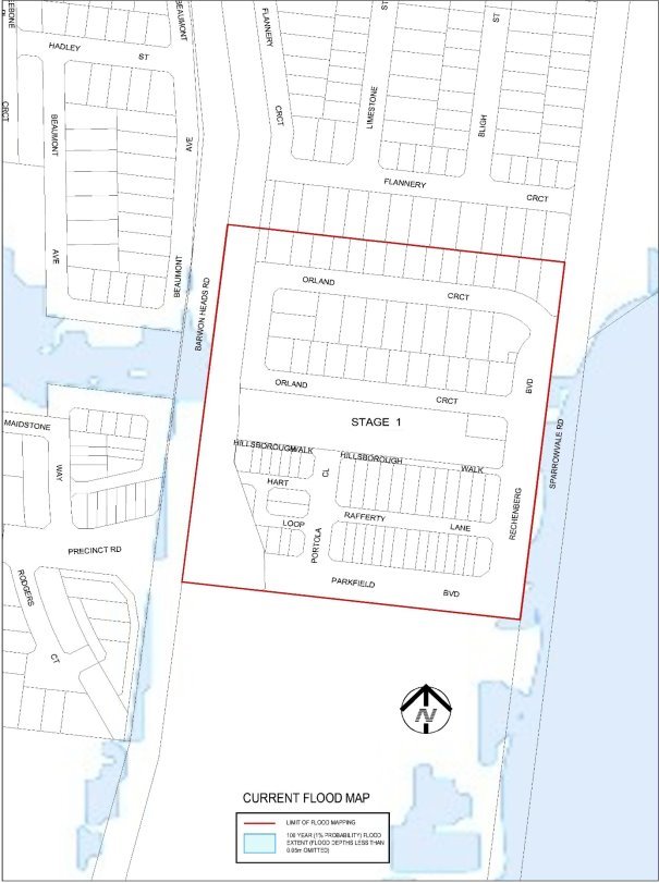
Revocation of Flood-Prone Area Designation of New Lots at Glenlee Estate, Stage 1
2019-2020 Borrowing Provision Confidential
Source: |
Community Life – Social Planning and Investment |
Director: |
Robyn Stevens |
Portfolio: |
Sport and Recreation |
To seek Council endorsement of the Social Infrastructure Plan: Generation One 2020-2023 and the Social Infrastructure Planning and Investment Policy 2020.
The City regularly invests approximately one-third of its annual expenditure toward social infrastructure, in both facilities and services.
The Council Transformation Program 2016 identified the development of a social infrastructure plan as a priority to guide Council’s future investment in social infrastructure. The Council Plan 2018-2022 identified Council’s vision, ‘Putting the Community First’, and a strategic priority of ‘Informed Social Infrastructure and Planning’.
In August 2019, the Social Infrastructure Plan: Generation One 2020-2023 was developed and released for preliminary community engagement. The aim of the policy is to ensure a fair and equitable approach to how investment is made in community places, spaces and services. It provides guidance in prioritising investment decisions and gives the community a clear understanding of Council’s role and how decisions are made.
The Social Infrastructure Plan: Generation One 2020-2023 developed to identify the short and medium term priorities for delivery of social infrastructure. The plan articulates Council’s intention to continue its investment in social infrastructure to support the health, wellbeing and connectedness of our community into the future.
In May 2020, the Draft Social Infrastructure Plan: Generation One 2020-2023 (including the Policy) was released for community consultation.
The recent community consultation reached 44,573 people with 3,612 engagements, resulting in 79 formal submissions being received. Of the responses received 94.7 per cent indicated support of the new policy and plan, with 30.7 per cent also providing further feedback and suggestions for improvement (refer to Community Engagement, Summary Findings Report – Attachment 4).
The community feedback has been taken into consideration and the final Social Infrastructure Plan: Generation One 2020-2023 has been updated to reflect any changes, as outlined in the Community Engagement, Summary Findings Report (Attachment 4).
Councillor Murnane moved, Councillor Mansfield seconded -
That Council endorse the Social Infrastructure Plan: Generation One 2020-2023 (Attachment 2) and accompanying Social Infrastructure Planning and Investment Policy (Attachment 3).
Carried.
There are no financial requirements associated specifically with the endorsement of the Social Infrastructure Plan: Generation One 2020-2023.
The plan is designed to guide and indicate the priorities for further investment in subsequent years, while allowing for changes in circumstances and priorities over time.
The financial planning for implementation of the Social Infrastructure Plan: Generation One 2020-2023 will be through Council’s existing strategic resource plan, and any decisions for investment in specific projects will be made in each budget cycle.
In April 2018, Council resolved to review and revise the draft Social Infrastructure Plan (2015), following preliminary engagement with the community.
During August and December 2018, the City undertook extensive community and stakeholder engagement to inform the drafting of a new social infrastructure plan. The engagement provided insight from the community about their social infrastructure needs, as well as insight into the matters the community believed Council should consider when making decisions about social infrastructure investment.
In August 2019, the Draft Social Infrastructure Policy was released for community consultation and received strong community support with 89 per cent of respondents in overall support of the new policy. This policy was then embedded into the draft Social Infrastructure Plan for further consultation.
In April 2020, Council endorsed the release the Draft Social Infrastructure Plan: Generation One 2020-2023 for community consultation for a period of six (6) weeks. Due to the implications of COVID-19 social distancing restrictions and community facility closures at the time, the engagement campaign was limited to a comprehensive online, direct email and social media engagement approach.
The community engagement campaign opened on 1 May 2020 and closed on 12 June 2020. Reaching 44,573 people with 3,612 engagements and receiving 79 formal submissions.
Formal submissions were also received from the following community organisations and service providers, all in full support of the plan:
Geelong Regional Library Corporation;
U3A (Geelong University of the Third Age);
Toy Libraries of Geelong; and
A combined submission from Encompass Community Services, Whittington Primary School and Bellarine Living and Learning Centre.
Overall, the draft plan received strong community support with 94.7 per cent of respondents believing the new plan was heading in the right direction. Of the total respondents 30.7 per cent believed there was some room for improvement in a specific area of the plan, and this feedback is captured in the Community Engagement, Summary Findings Report (Attachment 4) with some revisions proposed to the final plan.
Some key themes emerged from the 79 submissions received (on behalf of both individuals and community groups). A summary of feedback themes and considerations is provided below, along with a copy of the Community Engagement, Summary Findings Report (Attachment 4) for more detail:
Respondents felt that the plan is representative and holistic (that is: for all facility types, people, ages and areas);
Respondents felt it has a clear strategic direction, is comprehensive, well-articulated and evidence based. While one respondent felt that the data and insights needed improvement (this is in alignment with the plan’s recommendations);
Respondents congratulated Council on this complex and necessary undertaking, and for its strategic yet ambitious approach. While one respondent expressed a desire for a longer-term plan that demonstrates how all the shortfalls in social infrastructure will be addressed;
Respondents felt that the plan is fair and improved transparency with a clear rationale and justification for investment;
Respondents recognised the plan for its excellent community engagement and responsiveness to community needs, also capturing both big and small projects;
The new plan format and online mapping tool designed to help navigate the complexity and diverse range of infrastructure was well received. Respondents considered it to be easy to understand and use, and it allowed them to see what is collectively planned in their area. While a couple felt that the functionality of the document could improve with the format considered too long by some and not easy to use;
Respondents welcomed the strong focus on addressing disadvantage and age-friendly places and spaces throughout the plan and emphasised the importance of this going forward;
Respondents gave appreciation for the inclusion of certain infrastructure types such as libraries, arts and culture, golf and public toilets. While others felt there needs to be more of an emphasis on improved transport and parking options as part of social infrastructure planning and investment;
Respondents showed strong support and provided great suggestions for public open space, playgrounds, skate parks, fenced dog parks and off-leash areas, and the City’s shared trails. While others felt the plan was lacking in the areas of public open space projects, consideration of world class sporting facilities (not just ‘micro-solutions’), including a major indoor sports centre for the region;
A focus on Whittington and the Northern areas of Geelong was welcomed while a couple of respondents felt areas such as Highton, Lara and the Bellarine were lacking in the plan, despite a number of projects identified in the plan for these areas; and
The need for greater sustainability was emphasised along with some great suggestions put forward regarding the use of sustainable energy sources and value managing infrastructure development for a range of projects.
The community feedback has been taken into consideration and the final Social Infrastructure Plan: Generation One 2020-2023 has been updated to reflect any changes required, as outlined in the Community Engagement, Summary Findings Report (Attachment 4). The action plan will also be updated annually, informed by new information resulting from planning projects and improved data and insights in the first year.
The Social Infrastructure Plan: Generation One 2020-2023 explicitly incorporates the principles of social equity, consistent with Council’s endorsed Social Equity Principles (September 2017) where it was acknowledged that it would be difficult to achieve any of the aspirations contained in the Geelong Clever and Creative City Strategy unless inequity is addressed.
At that time Council adopted the following principles that are reflected in the Social Infrastructure Plan’s definition of ‘Equity’:
all activities of the City will be informed by up-to-date demographic and geographic information on social equity in the region which identifies priority areas and groups for attention;
planning of all activities will be informed by effective, focused partnerships and engagement with priority groups and areas, aimed at fully understanding the particular needs and obstacles they experience in accessing services and facilities; and
service and infrastructure design, location, communication, and support arrangements will address the particular needs and obstacles faced by priority areas and groups.
The aim of adopting these principles is to drive greater consideration of equity when making decisions. The way we plan and deliver our social infrastructure can play an important role in improving equity, accessibility and connectivity while reducing disadvantage across our City.
The policy framework outlined in the plan, is proposed to both guide the decisions of Council and to provide guidance to the City on the matters that Council would like the organisation to consider when providing them advice for decisions.
The Social Infrastructure Plan: Generation One 2020-2023 delivers on the strategic priority of the Council Plan 2018-2022 that calls for ‘informed social infrastructure and planning’ and sets the foundation for Council’s commitment to ‘strive for social equity in the infrastructure and services we deliver for our community’.
The Social Infrastructure Plan: Generation One 2020-2023 will also guide future decision making on a number of key priorities related to ‘informed social infrastructure and planning’ as outlined in the Council Plan 2018-2022, these priorities are:
providing more quality spaces that support active lifestyles;
supporting the growth of localised and regional sporting facilities;
delivering accessible and attractive community infrastructure, based on community need;
advocating and planning for a range of social and affordable housing options; and
maintaining our public open space.
No City officers or contractors who have provided advice in relation to this report have declared a conflict of interest regarding the matter under consideration.
The lack of an existing policy position or plan related to the planning and investment of social infrastructure can result in a risk of unsustainable or inequitable decision making. If not addressed there is a risk that the community will become increasingly frustrated with the lack of clarity about what is planned in their communities, and any current inequity across the various networks will remain, and fair access to services may be impacted.
Through Council’s Asset Management Transformation program and the new Social Infrastructure Plan: Generation One 2020-2023. Council aims to focus on establishing a process of asset management stewardship, a robust approach to assessing asset criticality to inform clear and transparent decision making, and to ensure accountability for our asset management approach.
Sustainability, including environmental sustainability, is a key principle that underpins the plan and will form part of Council’s decision-making process in relation to social infrastructure planning and investment.
Source: |
Governance, Strategy & Performance - Strategy & Performance |
Director: |
Rebecca Leonard |
Portfolio: |
Leadership and Governance |
To note the Sustainability Action Plan Engagement Report and present an updated Sustainability Framework 2020 and Sustainability Action Plan for adoption by Council following community consultation; and to seek Council approval for the release of the Draft Sustainability Policy for community consultation.
The initial Sustainability Framework was developed in response to Council’s resolution of September 2019 and was adopted by Council on 25 February 2020.
A draft Sustainability Action Plan was also presented to Council on 25 February 2020 and since then was for community consultation until 31 May 2020. Consultation on the draft Sustainability Action Plan was facilitated by an online survey.
In total, 96 responses were received via the survey during the consultation from individuals and community groups and 8 letters were also received regarding the Sustainability Action Plan and the Sustainability Framework. Attached is the engagement report from the community consultation (Attachment 2) and the updated Sustainability Action Plan (Attachment 3).
Whilst feedback was sought from the community on the draft Sustainability Action Plan, the community also provided feedback in relation to the Sustainability Framework itself. In response to the feedback received in relation to the Sustainability Framework, and consistent with the City’s commitment to listening to the community, some amendments are suggested for the Sustainability Framework (Attachment 4).
The amendments to the Sustainability Framework include:
Focus on ensuring the language is clear and is easy to understand;
Ensure that the holistic nature of sustainability is represented;
Recognise the important role of community education and involvement;
Reiterate the acknowledgement of a climate emergency by the City and Council;
Reclarify the areas of focus and objectives; and
Provide a strong foundation for the role of the City and Council, and their strategies and plans.
To implement the Sustainability Framework 2020, the draft Sustainability Policy (Attachment 5) is proposed. The draft Sustainability Policy details how the Sustainability Framework will be operationalised across the City’s activities.
The updated Sustainability Framework 2020, draft Sustainability Policy and Sustainability Action Plan will shape decision making for both Council and the City’s operations. And now, in the time of the COVID-19 pandemic, the importance of sustainability has been highlighted, particularly as it relates to the City’s ability to provide the support needed by the community now and into the future.
Councillor Kontelj moved, Councillor Grzybek seconded -
That Council:
Note the Sustainability Action Plan Engagement Report (Attachment 2);
Adopt the amended Sustainability Framework 2020 (Attachment 4);
Adopt the revised Sustainability Action Plan (Attachment 3); and
Endorse the draft Sustainability Policy (Attachment 5) for community consultation for a period of no less than 6 weeks;
Councillor Asher moved, Councillor Mansfield seconded –
That Council:
Note the Sustainability Action Plan Engagement Report (Attachment 2);
Adopt the amended Sustainability Framework 2020 (Attachment 4);
Adopt the revised Sustainability Action Plan (Attachment 3); and
Endorse the draft Sustainability Policy (Attachment 5) for community consultation for a period of no less than 6 weeks;
Request the Chief Executive Officer to provide a report to Council by 31 December that includes the following:
The public targets to be included in the annual reporting program and the Sustainability Action Plan. The public targets, including a carbon reduction target are to be benchmarked against best practice government and private sector organisations; and
The development of a public Climate Change Statement as part of the Climate Change Response Program.
Request the Chief Executive Officer provide a report to Council by 21 September with proposed terms of reference for a Sustainability Consultative Committee, comprising representatives with a range of environmental management, social/community planning and financial/risk analysis expertise, to advise and support the development and implementation of the Sustainability Action Plan.
Carried Unanimously.
Division Requested:
For: Councillors Asher, Aitken, Grzybek, Murrihy, Kontelj, Mansfield, Mason. Murnane, Harwood, Nelson, Sullivan
Against: Nil.
Implementation of the Sustainability Framework requires funding, including completing the Action Plan and the supporting communications and engagement activities, and measuring and reporting. The approved cost to implement the Framework is $250,000, with $50,000 allocated to the 2019/2020 year and $200,000 has been allocated in the 2020-2021 budget.
The Sustainability Framework also recognises the importance of a lens of sustainability across all financial processes and considerations, to contribute to the long-term sustainability of our community.
The Sustainability Framework, Action Plan and draft Policy will be supported by an implementation plan including ongoing communication and engagement activities. It is essential, following the amount of feedback received in the April/May 2020 consultation, to continue to work with key stakeholders in the ongoing delivery of the Sustainability Action Plan.
The draft Sustainability Policy must be informed by community consultation.
A communications and engagement plan will be developed to support the integration and implementation of the Sustainability Framework, Action Plan and Policy. This will include internal and external activities to ensure that all stakeholders are aware of the sustainability outcomes that the Council is wanting to achieve and the leadership it is displaying.
The Sustainability Framework recognises the importance of equity, access and inclusion as a key priority area contributing to the long-term sustainability of our community.
A key component of the Sustainability Framework is the draft Sustainability Policy. The implementation of the Framework will also influence the amendment of relevant existing policies and the development of new policies.
The Sustainability framework also aligns with the overarching governance principles of the Local Government Act 2020 which require Council to consider the economic, social and environmental sustainability of the municipal district, including mitigation and planning for climate change risks and promote this.
Sustainability is a key consideration/theme of Council Plan 2018-2022 and features strongly throughout the community’s 30-year Clever and Creative vision.
There is no identified conflict of interest for any officer involved in this report.
Failure to consolidate the City’s approach to sustainability could result in significant risk as the Sustainability Framework 2020 aims to deliver a culture of sustainable practice across the organisation, therefore better preparing the organisation and community to meet the demands of the future.
As the organisation and region face considerable environmental challenges, the Sustainability Framework provides the opportunity to consolidate our current and future approach to addressing climate change and other critical issues.
Source: |
Planning, Design & Development – Planning Strategy |
Director: |
Gareth Smith |
Portfolio: |
Planning |
To seek endorsement to release the draft South Geelong Urban Design Framework (UDF) for public consultation.
The City’s Settlement Strategy 2018 identifies the need for strategic planning work to increase the capacity for development around our train station precincts. Higher density development within the rail corridor is key to deliver on the City’s infill development target of 50% of total housing supply within existing areas by 2047.
The draft UDF outlines the background policy context, site analysis, consultation, design principles, concept plans and implementation plans which will inform the future use and development of the precinct. See Attachment 2.
The draft UDF nominates both the South Geelong Station and Moorabool Street precincts as key development areas and an expansion of the increased housing diversity area around South Geelong Station from 400 m to 800 m.
Barwon Water is a key landholder within the precinct. The former Barwon Water depot presents a unique opportunity for high density mixed-use development.
The duplication of the railway line from South Geelong to Waurn Ponds includes a second platform and is an opportunity to enhance both pedestrian and bicycle access to the railway station via a pedestrian crossing connecting to Bellerine Street.
Development of the South Geelong station carpark and construction of a multi deck car park is a long-term vision for the precinct.
A mixed-use development is envisaged for the South Geelong station precinct which includes medium to high density residential development, retail and commercial uses.
Medium to high density residential redevelopment is envisaged along Moorabool Street, with commercial uses supported on the ground floor.
Public consultation on the UDF is proposed for a period of 8 weeks. Consultation on the proposal will be designed with the current situation with COVID-19 in mind.
Councillor Sullivan moved, Councillor Murrihy seconded -
That Council:
Support the draft directions and design principles for the Urban Design Framework; and
Endorse the release of the draft South Geelong Station Urban Design Framework for a period of 8 weeks.
Carried.
There are no significant financial implications in noting the draft plan and releasing it for consultation.
Upgrading of roads for bicycle lanes and car parking and other public realm improvements will form part of the long term capital budgeting program. The City is seeking funding through State Government road safety programs as part of the Safer Travel in Local Streets (STILS) program.
On July 2019, the City held a community consultation workshop with residents and stakeholders to discuss the future vision for the precinct.
Consultation on the draft UDF will allow further engagement and feedback before the plan is finalised.
The consultation for this project will be designed to respond to current circumstances around COVID-19. The consultation period will be 8 weeks to give the community an adequate amount of time to engage in the process. An 8-week period will end just before Council enters its caretaker period. If extended beyond 8 weeks, the consultation period would be paused during caretaker period.
In lieu of face to face consultation, the community will have an opportunity to engage through a variety of online platforms. The documents will be accessible online. Those who may have specific questions may be accommodated through phone calls or online meetings.
There is opportunity to deliver affordable housing options in the station precinct. This includes social housing consistent with the City’s Social Housing Plan 2020-2041.
The UDF provides high level use, design and development to deliver the long term vision. The UDF includes proposed staging of the development to enable the precincts to be developed in stages.
In July 2019 the City engaged Galbraith Scott to undertake a universal access audit of the streets within the study area. This audit identified a series of recommended improvements, relating to elements such as street crossings, footpaths, street lighting, railway crossing, disabled parking and way finding signage. The UDF was informed by the universal access audit and recommends that the findings of the audit be incorporated into the final design of street upgrades.
The Plan is consistent with State and Local planning policies relating to the delivery of urban consolidation, a range of housing types in well serviced locations, environmentally sustainable design, the preservation of heritage and neighbourhood character and design.
The Plan is consistent with the Social Housing Plan 2020-2041, Housing Diversity Strategy, Settlement Strategy, One Planet Living principles and the Clever and Creative vision.
The draft UDF nominates both the South Geelong Station and Moorabool Street precincts as key development areas.
An expansion of the increased housing diversity area (IHDA) from 400 m to approximately 800m from the station is recommended. The general residential zone will be applied to the IHDA. A preferred building height of 11m will apply to most residential areas. Heritage overlays in the precinct will be retained.
The Plan aligns with the following strategic priorities: improved health and safety of our community, informed social infrastructure and planning, a more inclusive and diverse community, planned sustainable development, effective environmental management and organisational leadership, strategy and governance.
No officers involved in the preparation of the report have any direct or indirect interest in the matter in which the report relates in accordance with the Local Government Act.
There are no notable risks associated with implementing the recommendations contained in this report.
A portion of the South Geelong UDF study area falls within a 500 metre buffer from a former landfill site. Development within that buffer may require an environmental audit and mitigation measures.
Privately owned land adjacent to the car parking area south-east of Geelong Station was used as the South Geelong Briquette depot. An Environmental Audit Overlay was applied to the site when it was rezoned from Industrial 1 to Residential 1 in 2007. A permit has been issued for residential subdivision and development of the site.
The UDF encourages best practice environmentally sensitive design and proposes substantial tree planting. Public realm improvements will create a more pedestrian and cycling friendly environment. Transit-oriented development near South Geelong Station will reduce private vehicle use and dependency.
Source: |
Planning, Design & Development – Strategic Implementation |
Director: |
Gareth Smith |
Portfolio: |
Planning |
To seek Council support to prepare and exhibit Amendment C339 which revises the Floodway Overlay, Special Building Overlay and Land Subject to Inundation controls across the municipality.
The amendment proposes to implement the recommendations of the Lower Barwon and Lower Moorabool Flood Investigation, December 2018 and the Lara Flood Study, March 2020, together with the application of remaining proposed areas of the Bellarine Peninsula - Corio Bay Local Coastal Hazard Assessment December 2015 (LCHA), to properties in Barwon Heads, Ocean Grove, Wallington and Connewarre.
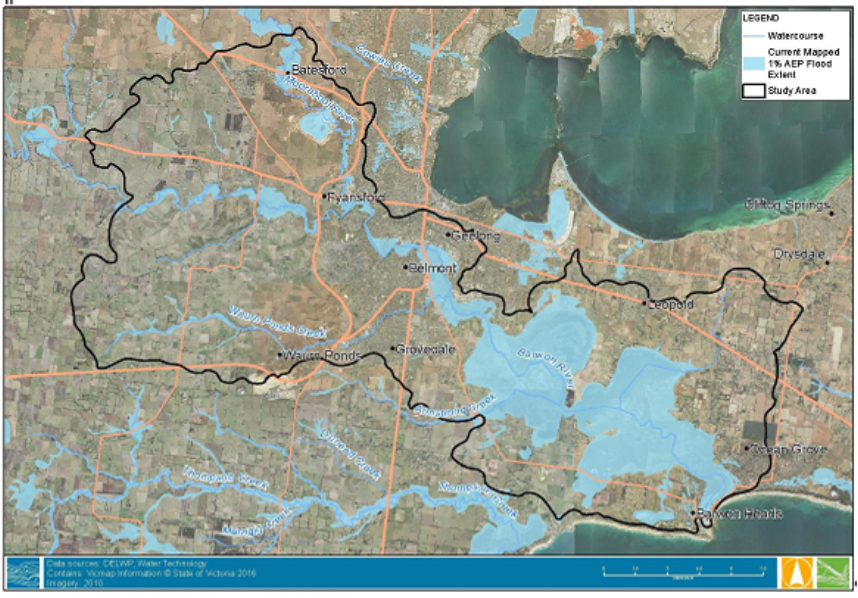
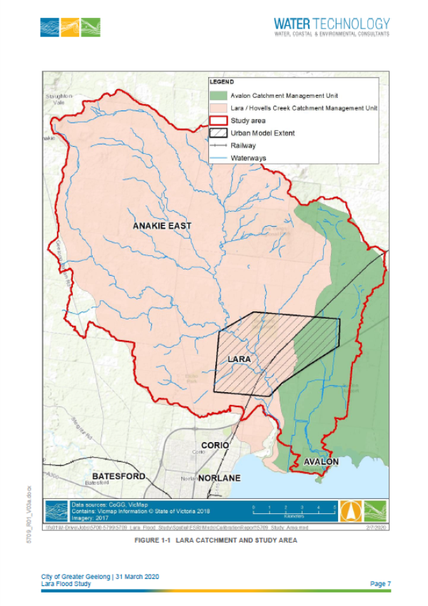
The Lower Barwon and Lower Moorabool Flood Investigation and the Lara Flood Study, were prepared by Water Technology, Water, Coastal & Environmental Consultants, with the Lower Barwon and Lower Moorabool Investigation being a joint project of the Corangamite Catchment Management Authority and the City of Greater Geelong.
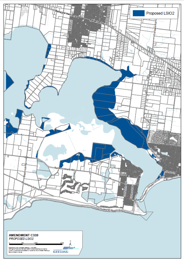
The majority of the LCHA was implemented by Amendment C394 which applied a new Land Subject to Inundation Overlay Schedule 2 (LSIO2) to areas affected by future sea level rise and storm surge. The Department of Environment Land Water and Planning refused authorisation to exhibit the proposed LSIO2 to land already covered by flood overlays in the Barwon River estuary and Lake Connewarre. The Planning Panel which subsequently considered Amendment C394 recommended that LSIO2 should be applied and this is now being sought as part of Amendment C339.
The majority of the affected properties are already subject to Greater Geelong Planning Scheme flood overlays.
The mapping changes introduced by the Lower Barwon and Lower Moorabool Investigation and the Lara Study reflect more accurate flood risk assessments than are currently in place, including a reduction in the assessed risk for a number of properties, as well as the removal of controls from large areas currently identified as subject to inundation.
The proposed changes to the Schedules to the Land Subject to Inundation Overlay (LSIO1), Floodway Overlay (FO1) and Special Building Overlay (SBO1) introduce exemptions from the need for a planning permits for a range of matters.
Councillor Sullivan moved, Councillor Mason seconded -
That Council:
Support the preparation and exhibition of Amendment C339 to the Greater Geelong Planning Scheme to:
Revise the extent of application of the Urban Flood Zone, (UFZ) Public Conservation and Resource Zone (PCRZ), Public Park and Recreation Zone (PPRZ), Floodway Overlay (FO), Land Subject to Inundation Overlays (LSIO), Schedules 1 and 2, (LSIO1 & LSIO2) and Special Building Overlay (SBO) in the areas of the respective studies identified in attachments 3, 4 & 5; and
Amend the Schedules to the Floodway Overlay (FO), Land Subject to Inundation Overlay Schedule (LSIO) and the Special Building Overlay (SBO) consistent with the recommendations of the Lower Barwon and Lower Moorabool Flood Investigation and the Lara Flood Study.
Request the Minister for Planning to authorise the preparation and exhibition of Amendment C339.
Carried.
Application of the overlays will not have any significant financial implications to Council with the exception of the usual costs associated with the planning scheme amendment process.
As the proponent and Planning Authority, the City will be responsible for all amendment related costs including landowner notification, panel hearing fees and engagement of expert witnesses at a panel hearing.
If Council resolves to support this amendment the public exhibition process will involve a mail out to all affected landowners and notices in local newspapers and the Victoria Government Gazette as required by the Planning and Environment Act 1987.
Interested parties will be able to make submissions which would be considered by Council and most likely referred to an independent panel where submitters could further present their case at a panel hearing.
Community engagement was also undertaken during the preparation of the three studies that are being implemented – the Lower Barwon and Lower Moorabool Flood Investigation, the Lara Flood Study and the Bellarine Corio Bay Local Coastal Hazard Assessment.
The amendment is expected to have positive social impacts. Flooding, coastal erosion, sea level rise and storm surge can result in significant costs for the community and the State. They can severely disrupt communities and in extreme cases, cause extensive damage to public and private property, agricultural losses, personal hardship and potential loss of life. The amendment has positive economic and social benefits by identifying areas where planning permit assessment can reduce the risk of these harms.
The amendment is supported by the following policies from the State section of the planning scheme:
Clause 13.01-2S Coastal inundation and erosion – the amendment achieves the policy objective “to plan for the potential coastal impacts of climate change” and implements the following strategies:
Plan for sea level rise of not less than 0.8 metres by 2100 and allow for the combined effects of tides, storm surges, coastal processes and local conditions such as topography and geology when assessing risks and coastal impacts associated with climate change;
Ensure that land subject to coastal hazards is identified and appropriately managed to ensure that future development is not at risk;
Avoid development in identified coastal hazard areas susceptible to inundation.
Clause 13.03-1S Floodplain management – the amendment meets the objective to assist in the protection of:
Life, property and community infrastructure from flood hazard;
The natural flood carrying capacity of rivers, streams and floodways;
The flood storage function of floodplains and waterways;
Floodplain areas of environmental significance to river health; and
The amendment also implements the strategies to “Identify land affected by flooding, including land inundated by the 1 in 100-year flood event or as determined by the floodplain management authority in planning schemes” and “Avoid intensifying the impact of flooding through inappropriately located use and development.”
The amendment supports and implements the following policies from the local section of the Planning Scheme:
Clause 21.05-4 Coastal environments:
The objectives: To protect, maintain and enhance the coast, estuaries and marine environment and to respect and manage coastal processes; and
The strategy: Setback future land use and development from coastal areas, estuaries and coastal wetlands to provide a buffer which is adequate to accommodate coastal recession and the landward migration of coastal wetland vegetation communities such as mangroves and salt marshes.
Clause 21.05-5 Climate change:
The objective: To plan for and adapt to the impacts of climate change; and
The strategy: Avoid land use and development within areas considered at risk of coastal erosion or inundation from flooding, storm surge or rising sea levels.
Clause 21.05-7 Flooding – has relevant objectives:
To protect floodplains; and
To minimise the potential for damage and risks to public safety and property from flooding.
The proposed amendment aligns with the Council Plan strategic priorities of:
Planned sustainable development – including the priority of improving the environmental performance of new developments, using planning controls; and
Effective environmental management – including the Climate Change Adaptation Strategy and protection of coastal areas.
No Council officers involved in the preparation of the report have a direct or indirect interest in the issue to which this report relates.
There is a risk that landowners may object to the Overlay being applied to their properties. However, there is a greater risk that if Council, as the Planning Authority, does not act on the flood plain and coastal inundation mapping it has available it may be liable if flooding occurs in the future and damages property. Council can reduce this risk by acting on the scientific based data it has available and applying the appropriate zones and overlays.
The amendment will help manage the environmental hazard posed by 1% Annual Exceedance Probability (AEP) flood events and future sea level rise. The respective flooding overlays will trigger a planning permit requirement for relevant buildings and works. This includes new dwellings, subdivision and earthworks that alter natural ground levels. The Responsible Authority and Floodplain Management Authority will be able to assess planning applications in areas identified as potentially vulnerable from riverine flooding, future sea level rise and associated environmental hazards such as coastal erosion, flooding and storm surge.
Lower Barwon and Lower Moorabool Flood Investigation
The floodplains of the Barwon and Moorabool Rivers have faced significant riverine floods in 1852, 1880, 1909, 1951, 1978, 1995, 2001 and 2011. Fortunately, given the long and frequent history of flooding along the Barwon and Moorabool Rivers, much of the residential development through Geelong and the wider catchment is located outside of the areas known to be subject to flooding. Consequently, much of the floodplain is now occupied for recreational uses with some land still occupied by commercial and industrial businesses.
Completion of the Lower Barwon and Lower Moorabool Rivers Flood Risk Management Study (the study) project increases community resilience and provides the mechanism to manage and reduce future flood damages through the development of a full suite of fit-for-purpose floodplain mapping products to guide land use and development planning, flood response planning and determination of appropriate flood warning arrangements.
Corangamite CMA in partnership with the Greater Geelong City Council and Golden Plains Shire Council engaged Water Technology to undertake the study. The overall objective of this project was to review and revise existing flooding information and produce detailed flood mapping for a range of flood scenarios within the study area. The project has involved a definitive flood investigation for the floodplain reaches within the study area, including collation of available relevant data, a comprehensive hydrological assessment, and determination of robust flood levels, velocities, depths and extents for a range of design floods. The project developed an improved understanding of flood behaviour to enable improved land use planning and emergency response.
The investigation area and major watercourses are identified in Attachment 3.
Lara Flood Study
Council resolved at the Community Focus Council Meeting of 14 July 2020 to endorse the preparation of a planning scheme amendment to implement the findings of the Lara Flood Study. Consistent with that decision, implementation of the findings of that study is proposed to be included as part of Amendment C339.
The area of the Lara Flood Study is identified in Attachment 4.
Exemptions under the Schedule to the LSIO1 and FO1
The proposed changes to the Schedules to the FO1 and LSIO1 include the following, which will significantly reduce the need to obtain planning permits for development on land within the respective overlays:
An extension to an existing dwelling, provided the gross floor area of the extension does not exceed 20 square metres;
An upper storey extension to an existing building within the existing building footprint;
A footpath, bicycle path, boardwalk, tennis court or sports ground provided that they are constructed at ground level;
An in-ground domestic swimming pool or spa and associated mechanical and fencing equipment where the excavated spoil is removed from the 1% AEP floodplain and the perimeter edging of the pool is finished at natural ground level; and
Repairs and routine maintenance of existing fences if the fence design and materials remain the same.
These exemptions will apply to all land to which the FO1 and LSIO1, including any land outside of the Lower Barwon and Lower Moorabool Investigation Area and the Lara Flood Study already covered by the overlays.
Bellarine Peninsula - Corio Bay Local Coastal Hazard Assessment (Our Coast Project)
When authorisation to exhibit Amendment C394 was sought, DELWP did not support the LSIO2 being applied to land already subject to the LSIO1, and it was therefore excluded from the exhibition process.
The C394 Panel recommendation was to:
“Apply the Land Subject to Inundation Overlay Schedule 2 to those properties identified in the Local Coastal Hazard Assessment as being subject to coastal inundation, but that were removed from the Amendment prior to exhibition on the basis that they were covered by the Floodway Overlay; and
Ensure a process is put in place to notify the owners and occupiers of the affected properties, and provide them with the opportunity to make submissions and (if necessary) have their submissions considered by an independent panel.”
The 26 May 2020 Council Report on the adoption of Amendment C394 provided the following response to the Panel Recommendation:
“City Response: The Panel’s findings that it is prudent to apply the LSIO2 to all properties including those already covered by a Floodway Overlay in the Barwon River estuary/Lake Connewarre/Reedy Lake vindicates the City’s position it put forward to DELWP when seeking authorisation; and
With regard to applying the LSIO2 to the properties excluded by DELWP Council officers prefer to do this separately to the current C394 Amendment so it can be kept moving through to adoption and approval. It is recommended that the LSIO2 be applied to these properties under a future amendment. A relevant amendment would be the amendment to implement the CCMA’s Lower Barwon and Moorabool River Flood Study. This amendment will be put to Council some time in 2020 and then move to exhibition. It updates the flood related overlays along the Barwon River and the LSIO2 could added for efficiency.”
The subject land has therefore been included as part of Amendment C339, consistent with the above recommendation, and are identified in Attachment 5.
Source: |
City Services – Engineering Services |
Director: |
Guy Wilson-Browne |
Portfolio: |
Parks, Gardens and City Services |
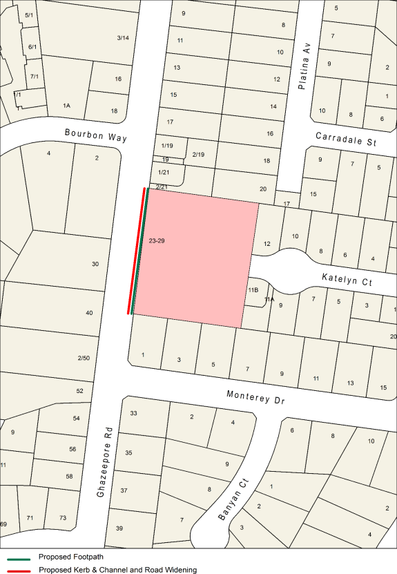
This report is to finalise the Special Charge Scheme for footpath construction, kerb and channel and road widening abutting 23-29 Ghazeepore Road, Waurn Ponds.
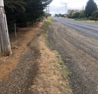
A missing 83 lineal metre section of kerb and channel and footpath abutting 23-29 Ghazeepore Road, Waurn Ponds (refer to Attachment 3) was identified for construction to provide improvements for pedestrians and road users.
The works were facilitated via a Special Charge Scheme which was declared by Council at its meeting on 12 June 2018:
There is one property abutting the proposed works that receives special benefit;
There are no Council owned properties in the scheme; and
The total estimate cost of the works was $154,752.00 made up of scheme cost $92,580 and bus bay works $62,172.
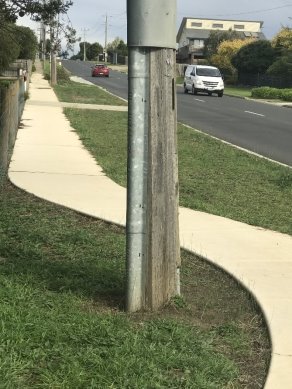
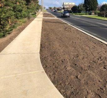
The works have now been completed (refer to Attachment 5) at a total cost of $149,034.46.
Additional works to construct an indented bus bay for an adjacent bus stop immediately south of the proposed scheme cost $63,005.52 and were fully funded by the City and not included as part of the scheme.
The scheme can be finalised and property owner charged based on the total actual cost of the scheme of $86,028.94. This is $6,551.06 less than the declared charge representing a 7.08% reduction in property owner contribution as shown in Schedule A – Attachment 2.
Councillor Nelson moved, Councillor Mason seconded -
That Council endorse the scheme final costs and amendments to the Special Charge on properties as shown in Schedule A – Attachment 2.
Carried.
The project has been funded under the core footpath construction program (C02303).
The final design and construction costs are summarised below:
Work Items |
Estimate |
Actual Costs |
% Change |
|---|---|---|---|
Special Charge Scheme – Project 1, footpath |
$30,840.00 |
$28,432.65 |
7.81% decrease |
Special Charge Scheme – Project 2, kerb and channel and road widening |
$61,740.00 |
$57,596.29 |
6.71% decrease |
Special Charge Scheme Total |
$92,580.00 |
$86,028.94 |
7.08% decrease |
Bus Bay and drainage construction |
$62,172.00 |
$63,005.52 |
1.34% increase |
Works Total |
$154,752.00 |
$149,034.46 |
3.69% decrease |
The decrease in costs are due to competitive tender rates applied to the works.
Based on the declared benefit ratios of 0.095 for Project 1 and 0.288 for Project 2, revised final scheme charges have been prepared.
Property owner contribution |
Estimated Cost |
Actual Cost |
|---|---|---|
Project 1 Footpath |
$2,937.00 |
$2,707.87 |
Project 2 Kerb and Channel and road widening |
$17,767.00 |
$16,574.47 |
Total Property owner contribution |
$20,704.00 |
$19,282.34 |
Council Contribution |
|
|
Project 1 Footpath |
$27,903.00 |
$25,724.78 |
Project 2 Kerb and Channel and road widening |
$43,973.00 |
$41,021.82 |
Bus Bay and drainage construction |
$62,172.00 |
$63,005.52 |
Total Council contribution |
$134,048.00 |
$129,752.12 |
TOTAL PROJECT COST |
$154,752.00 |
$149,034.46 |
Property owners have the ability to nominate a payment plan and may access our hardship policy if applicable.
Communication with property owners was undertaken during the project and Special Charge Scheme process as shown in Attachment 4. A levy notice was issued to the Property Owner on 13 June 2018. No objection was received, and the project proceeded to construction.
The provision of properly sealed and drained roads and footpaths is aligned to the Council Plan and provides improved amenity, connectivity and safety for pedestrians.
The scheme has been prepared in accordance with the Special Rate and Charge provisions of the Local Government Act 1989 along with the 2004 ministerial guidelines and Council’s Special Rates and Charges Policy. The process chart for Special Rate Schemes is shown in Attachment 4.
This report aligns with the Council Plan as follows:
These works primarily align Integrated Transport Connections and key priority to improve our road management and engagement program;
These works also directly respond to the action to implement a Council program of infrastructure upgrades including streets, roads and drains;
Other connections to the Council Plan include:
An investment into sustainable infrastructure for the Waurn Ponds community, reducing operation and maintenance liability; and
Encourages use of active transport, such as walking due to the footpath construction creating a safer public space.
No Council Officer involved with this process has any direct or indirect interest in the project or properties included in the scheme.
Provision of a sealed pathway provides safer walking conditions for pedestrians by minimising the risk of personal injuries through conflict with vehicles and the elimination of uneven and slippery surfaces. Provision of a footpath constructed to standards and suitably drained will provide safer passage for pedestrians.
Whilst investigating this project, it was decided to include the construction of a bus bay indent to the south of the subject site. The existing bus stop located on the east side of Ghazeepore Road adjacent to the property at No 1 Monterey Drive had no bus stop indent for buses to pullover from the thru traffic lane. The width of the road does not allow for two-way traffic whilst a bus is pulled up at the stop. For this reason, an indented bus stop allows for safer passing of two-way traffic and improved safety for motorists.
The new footpath and kerb and channel and sealed parking lane provides proper sealed access and improved amenity as dust and mud concerns are mitigated.
No significant vegetation removal was required to complete the project.
|
ADDRESS |
ESTIMATED COST |
ACTUAL COST |
|---|---|---|---|
346772 |
23-29 Ghazeepore Road, Waurn Ponds, 3216 |
$20,704.00 |
$19,282.34 |
Stage |
Status |
Description |
|---|---|---|
Approval to prepare scheme |
|
Decision made to prepare scheme following consideration of surveys of residents and feedback from the community via informal survey. Council may then place the project in the budget system or proceed immediately to prepare a scheme. Scheme preparation involves survey, design and preparation of an apportionment of costs. 2017 |
Intention to Declare Scheme |
|
Report to Council providing information on scheme including advice of impending advertising of scheme and declaration of charge. Seeks Council approval by resolution to proceed with process. |
Advertisement |
|
The scheme is advertised in the local newspaper and all allotted property owners are notified by mail. This advertisement indicates Council’s intention and notification to ‘declare’ a scheme in a month’s time. |
Submissions |
|
From the time of advertising property owners have 28 days (as set down by the Local Government Act) to lodge submissions, either in support or opposition to the scheme. |
Submissions Review Panel Hearing |
N/A |
A Submissions Review Panel is convened (quorum of three Councillors) and meets to consider submissions. Some submissions are written only, and other submitters may wish to be heard before the Panel. The Panel makes a recommendation to Council regarding the scheme. |
Declaration Report |
|
Any time 28 days after advertising the scheme and after the Submissions Review Panel has met and considered submissions, Council considers a report and may proceed to “declare” the charges in accordance with its advertised intent. Subsequent to this the Finance Manager issues the levy notices and there is a formal charge placed on the property. This is the final step in the process for Council to make a decision on the scheme. |
Appeal |
N/A |
Property owners may lodge an application for review with the Victorian Civil and Administrative Tribunal (VCAT) within one month of issue of the levy notice. An appeal is listed, heard and determined by the Tribunal and this process generally takes three to four months. Decisions made by VCAT are binding on all parties. |
Construction |
|
Council may then proceed to construct the works. Invoices are issued seeking payment of the estimated cost within one month of commencement. |
Final Cost Report |
|
At the completion of the works the scheme is “finalised” taking into account actual costs incurred and payments are adjusted accordingly. |
Photos of works before and after completion
Source: |
Customer & Corporate Services – Property, Procurement & Assets |
Director: |
Michael Dugina |
Portfolio: |
Finance |
To award Contract C2000053 for the LED Lighting and Smart Control Delivery – Supply of Street Lighting Hardware project to Schreder Australia Pty Ltd (ABN 17 604 331 937) under the terms and conditions of the MAV Contract SL3911: Panel of Providers for Approved Energy-Efficient Street Lighting Hardware (luminaires and associated components) and Installation Services.
The City owns or pays for the operation and maintenance of over 25,000 street lights at a cost of $3.2m per year (2018). Conversion of existing light fittings to more efficient light-emitting diodes (LEDs) with smart control technology would deliver a vast range of benefits including operational cost savings, a reduction in energy consumption and greenhouse gas emissions and improvements to road safety, public security, public amenity, lighting service and asset management.
Works for the entire project shall comprise of an accelerated bulk replacement of approximately 25,000 existing street lights that the City either owns or pays for with modern LED luminaries. The new luminaries will also include a smart control device which will be connected to a new wireless network and will enable remote control and adjustment of the lighting output, also creating a platform for additional smart city infrastructure to be added.
Works under this engagement (Phase 1) will include the replacement of approximately 15,000 existing street lights which includes most of the regions ‘P category’ lights.
Procurement Services managed a select tender process, using a Municipal Association of Victoria (MAV) panel contract outlined below, seeking to appoint a suitably qualified and experienced lighting supplier to undertake the supply of the associated LED light fittings and smart control devices for Phase 1.
The City is utilising the existing Municipal Association of Victoria (MAV) Contract SL3911: Panel of Providers for Approved Energy-Efficient Street Lighting Hardware (luminaires and associated components) and Installation Services and aligns with the terms and conditions of this panel.
The submissions were evaluated in accordance with the processes detailed in the City’s ‘Procurement and Contracts Manual’
Based on the tenderers project experience, expertise and value for money the Tender Evaluation Panel (TEP) recommend that Schreder Australia Pty Ltd be awarded the contract for the supply of lighting hardware.
Subject to Council awarding the contract, the project will commence 10 August 2020.
The lump sum price for the delivery of the project is $4,948,939.20 (excl. GST).
Councillor Aiken moved, Councillor Grzybek seconded -
That Council:
Award Contract C2000053 for the LED Lighting and Smart Control Delivery – Supply of Street Lighting Hardware project to Schreder Australia Pty Ltd (ABN 17 604 331 937) for the tendered lump sum price of $4,948,939.20 (excl. GST); and
Authorise the CEO to execute Contract C2000053 and any other documents required by or to give effect to the terms of the contract on behalf of Council.
Carried.
The lighting hardware being purchased is a 13.7W light fitting instead of the 17W light fitting. The 13.7W light fitting is a slightly more expensive capital outlay initially, however the 13.7W light fitting is 20% more efficient to operate. This is anticipated to save the City $41,773.00 per year and $417,731.00 over 10 years to operate, which is the expected lifespan of the fitting.
The tendered price came within the estimated budget for this phase of the project.
Conversion of street lighting to LED technology has progressed rapidly throughout the world and indeed in Australia.
The engagement process will clearly communicate the progress and success of accelerated lighting replacements across the globe, the proven financial, social and environmental benefits available to the City, and inform the community on the lighting and smart controls technology being implemented.
Media and social media campaigns will be completed during the design phase to gather feedback and comments to be considered in the design and will also continue through implementation of the project to keep the community updated on progress and timing of the works in specific areas.
Research recognises that quality street lighting improves road safety and particularly white light provided by LEDs, makes people feel safer in the public domain at night and can be more of a deterrent to antisocial behaviour. Implementing LED and smart controlled lighting will help community members of all genders and age groups feel safer on our roads and where they live.
Installation of Smart Controlled LED lighting aligns closely with the City’s policies and strategic documentation including ‘A Clever and Creative Future’, the ‘Community Zero Carbon Action Plan’ and the Council Plan 2018-2022 as further detailed below.
The planned and systematic conversion of street lighting to LED’s will also ensure improved compliance with the Public Lighting Code which is regulated by the Essential Services Commission.
This project aligns closely with several the strategic priorities within the Council Plan 2018-2022, including:
Improved Health and Safety of Our Community - LED conversion will improve public lighting coverage and reliability resulting in safer public spaces and roadways (key priority);
Effective Environmental Management - the changeover of standard street lights to LEDs is listed as a key priority. One of the measures of success is to reduce emissions from street lights, building and vehicle fleet by 50% by 2020. Although this project will achieve this magnitude, through reducing emissions from street lights by 63%, the size and duration of the project requires it to commence as a matter of urgency;
Removing mercury vapour light fittings from our inventory will also increase our use of sustainable materials; and
Innovative Finances and Technology - this project is integral for a number of the Council Plan key priorities in delivering smart technology solutions. Smart lighting will improve maintenance and asset management, provide opportunities for simple and targeted lighting modifications and provide a platform for additional smart technology devices to be deployed throughout the region.
No City officers have declared a direct or indirect interest in this matter.
Large scale implementation of LED public lighting is now well tested throughout Victoria and the rest of the world, therefore risks associated with proceeding with this technology are insignificant. Whilst the efficiency of the LEDs may improve further, they have already reached a point where any further energy reductions would be outweighed by the opportunity lost from not acting immediately. Smart controlled lighting has progressed rapidly in the last 5 years and is likely to evolve further in the next 5-10 years, however coordinating with the LED rollout presents a huge financial advantage and an opportunity for the City to be a leader in technology advancement.
As with all large projects there are a number of financial risks associated with the financial model and business case:
Higher installation costs than estimated;
Higher third party (DNSP) costs involved with capital project costs and also maintenance rates (future costs cannot be locked in, however are regulated by the Australian Energy Regulator). It should also be noted that the equivalent risks associated with doing nothing are even greater with the risk of operational and maintenance costs for legacy lighting increasing;
The business case financial model includes for a portion of the capital costs to be offset from funding available through the Victorian Energy Efficiency Target Scheme (State funded rebates available through proven energy use reductions). Rebate values are based on a market price depending on supply and demand. The model assumes a conservative price, therefore presenting both a risk and an opportunity to the project; and
The business case is based on a 2-year program with a 6-12 months period of design and procurement required before hand. Delaying the start or extending the duration will increase the total cost.
The bulk change out of existing public lighting to LED technology would reduce energy consumption by 63.5% from 12.52GWh (gigawatt hours) per year to 4.57GWh per year. This presents a reduction in greenhouse gas emissions of 8,664t of CO2 per year.
Furthermore, the Minamata Convention is a global treaty to ban most mercury vapour lights by 2020 to protect human health and the environment from the adverse effects of mercury. Australia signed up to the treaty in 2013, and if, as expected, ratifies the convention it would see a ban on the importation of mercury vapour street lighting lamps. Regardless of Australia’s position, global suppliers of mercury vapour lamps are already winding down production and the City will be forced to replace luminaires when availability of replacement mercury vapour lamps ceases. Accelerated replacement will fast track the elimination of these hazardous mercury vapour light fittings from our region. The project will also ensure that redundant mercury vapour lamps are disposed of in methodical and environmentally responsible manner.
Contract Details
Contract C2000053 – LED Lighting and Smart Control Delivery Project – Supply of Street Lighting Hardware
Invitation to Tender
The City issued a select tender T2000053, closing 2pm Monday 1 June 2020, seeking to appoint a qualified lighting supplier to undertake the supply of the associated LED light fittings and smart control devices for the initial phase (Phase 1) of the project which includes most of the regions ‘P category’ lights.
Table 1 Invitations to Tender
Medium |
Date Advertised |
|---|---|
eProcure |
22 May 2020 |
Tender Evaluation Panel
The Tender Evaluation Panel comprised the following staff
Table 2 Tender Evaluation Panel
Position Title |
Panel role |
|---|---|
Procurement Specialist |
Chair (non-voting) |
Manager Capital Projects |
Member (voting) |
Project Manager, Capital Projects |
Member (voting) |
Senior Lead Smart City, Smart City |
Member (voting) |
Technical Services Officer, Engineering Services |
Member (voting) |
Tender Submissions
Tenderers had to comply with the following mandatory criteria:
OH&S system – if the tenderers OH&S processes and procedures do not meet a minimum standard determined by the City, the tenderer will not be considered for the Contract.
Tenderer must have a heat and UV radiation exposure management procedure, and if not, must be willing to abide by the City’s Heat and UV Radiation Exposure and Outdoor Clothing Procedures (Long/Long).
All tenderers complied with the mandatory criteria and all submissions were received before tender close.
Table 3 Tender Submissions Received
Tender |
|
Conforming tender |
|---|---|---|
A |
Schreder Australia Pty Ltd |
Yes |
B |
Tender B |
Yes |
C |
Tender C |
Yes |
Tender Evaluation
The Evaluation Panel used the following qualitative criteria (in order of weighting) to assess the submissions:
Table 4 Comparative Criteria Weighting
Comparative Criteria |
Weighting % |
|---|---|
Methodology & Plan for Performing Contract (incl. Capability) |
50 |
Clever and Creative (Innovation) (mandatory) |
40 |
Economic & Local Content contribution |
10 |
The tender was evaluated by the evaluation panel in a two staged process:
Qualitative assessment of a weighted score totalling 100%; and
Evaluation of price against weighted score: VFM = Tendered Price ÷ Weighted Score (lowest VFM Score = preferred supplier).
Schreder Australia Pty Ltd were deemed the best value for money tenderer, demonstrating best value for money for the City, and placing them as the preferred tenderer to progress to interview stage.
Tender Evaluation Scores
At the conclusion of the evaluation the tenders were ranked in the following order.
Table 5 Tender Evaluation Scores
Tender |
|
Rank |
|---|---|---|
A |
Schreder Australia Pty Ltd |
1 |
B |
Tenderer B |
2 |
C |
Tenderer C |
3 |
Post-Tender Contact
The Evaluation Panel sought clarifications in writing from the shortlisted tenderer (Schreder Australia Pty Ltd) regarding project breakdown, project management approach, resource utilisation, capacity to deliver orders on time and discuss the proposed products. The shortlisted tenderer was invited to interview (held Monday 29 June 2020). At interview, Schreder Australia Pty Ltd demonstrated their ability to deliver the project and illustrated that they have undertaken the appropriate due diligence and have allocated the required resources.
Schreder Australia Pty Ltd demonstrated a thorough understanding of the requirements of the specification with a proven record of delivering comparable contracts. The Tender Evaluation Panel noted that Schreder Australia Pty Ltd are an experienced provider of comparable projects and leaders in innovative technology.
Schreder Australia Pty Ltd project methodology demonstrated that they have the available resources and expertise to successfully deliver the works as tendered and provided evidence of their capability to deliver the project within the City’s timeframes.
Schreder Australia Pty Ltd OHS documentation addressed the high risk tasks associated with the works providing examples of SWMS used on a project with a comparable risk profile and all relevant qualifications required.
Probity
No probity issues identified.
Source: |
City Services – Engineering Services |
Director: |
Guy Wilson-Browne |
Portfolio: |
Parks, Gardens and City Services |
To revoke Council’s designation of 12 December 2006 of flood affected land at Glenlee Estate, Stage 1 as liable to flooding pursuant to regulation 153 of the Building Regulations 2018.
Council has a statutory obligation under the Building Regulations 2018 to designate land as liable to flooding where it reasonably knows it to be prone to flooding. Conversely, there is an obligation to remove the encumbrance of designation from land that is no longer considered to be flood-prone.
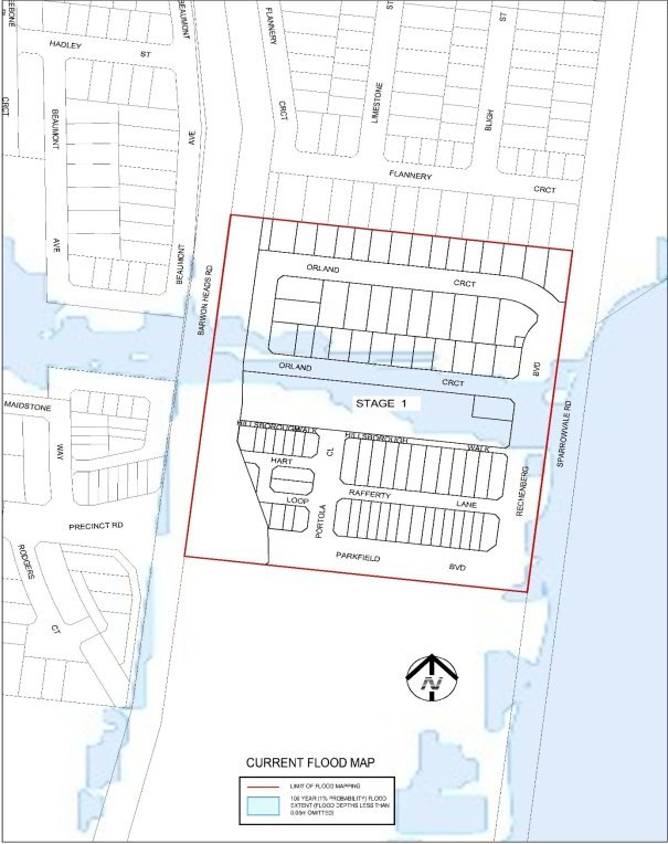
The current designated flood mapping (Attachment 2) was designated by Council at its meeting of 12 December 2006.
This revocation will result in another stage of new lots in Glenlee Estate fronting 274 – 280 Reserve Road, Charlemont being free of their flood prone status, paving the way for owners to build homes on their land.
The flood mapping is subject to a revision due to the subdivision and development at 274 – 280 Reserve Road, Charlemont. Prior to subdivision the parent lot was considered to be liable to flooding. This development site, which is also known as Glenlee Estate, Stage 1 achieves flood immunity for newly created lots for flood events up to and including the 100-year Average Recurrence Interval (ARI) event due to approved internal earthworks.
The recommendation by Council engineers that the flood prone status can be removed includes assessment of internal drainage, road construction and earthworks to contain potential floodwaters from the 100-year ARI event within road and drainage reserves (Attachment 3).
It should be noted that designation is separate to the creation of flood overlays within the Planning Scheme, which generally follows designation. In the case of this development, the planning scheme amendment to create post-development flood zones or overlays is proposed after the design of the proposed precincts.
Councillor Kontelj moved, Councillor Nelson seconded -
That Council revoke the Council designation of 12 December 2006 of flood affected land at Glenlee Estate, Stage 1 as liable to flooding pursuant to regulation 153 of the Building Regulations 2018.
Carried.
There are no financial implications arising from the subject of this report.
A revocation of designation does not warrant public consultation as it constitutes the removal of an encumbrance on land.
Relevant City databases and flood maps will be revised and updates sent to the Corangamite Catchment Management Authority and Building Control Commission.
Council have a responsibility to the community to provide the best possible information on areas that are flood prone. The removal of flood prone designation allows owners to build on their land without a special permit from the City, and without raising the floor level of their home. It also reduces the cost of property insurance.
The City has various statutory responsibilities for drainage management and flood management (prevention, response and recovery) as set out in the Local Government Act 1989, Local Government Regulations 1990, Planning and Environment Act 1987, Building Regulations 2018, Water Act 1989, Subdivision Act 1988 and Emergency Management Act 1986.
The works have resulted in the lots being protected from flooding during a major storm event that has a one per cent probability of occurring in any one year, and occurs on average once in 100 years. This is the required standard for new subdivisions.
The recommendations of this report are consistent with the Council Plan, in relation to planned sustainable development.
No City officers or contractors who have provided advice in relation to this report have declared a conflict of interest regarding the matter under consideration.
Council also has some risk exposure with any failure to disclose the flood-prone status of a property in a Land Information Certificate.
The revocation of the designation is the final step in minimising Council’s risk.
The revocation of flood-prone areas designation and designation of revised flood data through the design of this stage is considered unlikely to result in any known adverse environmental impacts.
Source: |
Customer & Corporate Services – Financial Services |
Director: |
Michael Dugina |
Portfolio: |
Finance |
Councillor Aitken moved, Councillor Grzybek seconded -
That in accordance with Section 89 (2) (d) of the Local Government Act 1989, this contractual matter be considered at the conclusion of all other business at which time the meeting be closed to members of the public.
Contents | Previous Page: Section A - Procedural Matters | Next Page: Section C - Notice of Motion
