Council Minutes - Section B: Reports - 8 September 2020
Contents | Previous Page: Section A - Procedural Matters | Next Page: Section C – Confidential
Contents | Previous Page: Section A - Procedural Matters | Next Page: Section C – Confidential
Reports tabled at the Community Focus Council Meeting of Council on Tuesday 8 September 2020, held at the Indented Head Community Hall, opposite 326 The Esplanade, Indented Head.
Proposed Amemdment C391GGEE and Planning Permit PP39/2019 - Ash Road (East), Leopold
Municipal Public Health and Wellbeing Plan Annual Report 2019-2020
Roslyn Road, Highton - Footpath Construction - SRC 346 - Finalisation of Scheme
Revocation of Flood-Prone Area - Designation of New Lots at Lara Central Estate Stage 8
Revocation of Flood-Prone Area Designation of New Lots at Manzeene Village, Lara Stage 8A, 8B and 12
Proposed Sale of Part of 137 Mercer Street, Geelong (Civic Accommodation Precinct)
Proposed Development Confidential
Contractual Matter Confidential
Proposed Development Confidential
Audit and Risk Committee - Summary and Committee Membership Confidential
Source: |
Planning, Design & Development – City Development |
Director: |
Gareth Smith |
Portfolio: |
Planning |
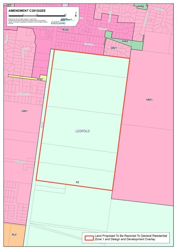
To support the preparation and exhibition of a combined planning scheme amendment C391ggee and planning permit 39/2019 to rezone land at 73-85 to 143-155 Ash Road Leopold to General Residential Zone 1 (GRZ1) and Design and Development Overlay (DDO) and to subdivide the land for conventional residential development.
The amendment and permit application have been made by Tract Consulting Pty Ltd on behalf of Eastern Ash Pty Ltd, a subsidiary of Ample Investment Group Pty Ltd.
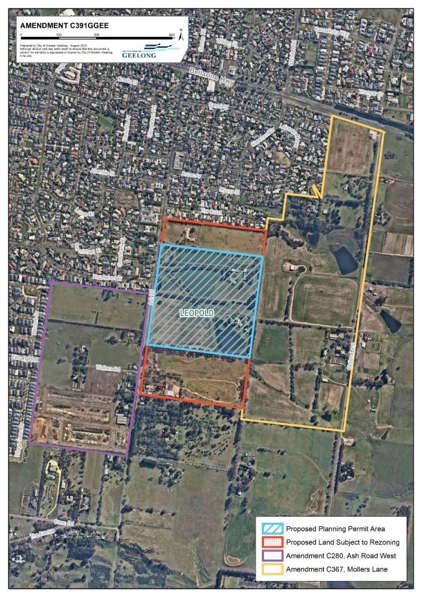
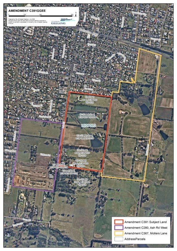
The subject land of the permit and rezoning (shown in Attachment 3) consists of five separately owned Farming Zone properties.
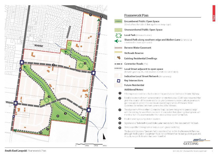
The South East Leopold Framework Plan (shown in Attachment 5) was prepared in 2016 to guide the rezoning and development of approximately 80 hectares south of the Bellarine Highway between Ash Road and Mollers Lane. This application covers about half of the area, known as the Ash Road east.
Amendment C367 and permit 1463/2018 affecting the Mollers Lane side was approved earlier this year.
Amendment C391ggee is supported by the Leopold Structure Plan adopted by Council in 2013, which identified this land as suitable for conventional residential development in one of the City’s growth areas.
The general layout of the proposed subdivision accords with the South East Leopold Framework Plan 2016 and allows for a cohesive development across the south east growth area of the town.
The rezoning affects 5 properties whilst the permit application only applies to two of the larger centrally located properties.
The lot yield from the planning permit will be approximately 195 lots.
Stormwater drainage from the site will flow through the Mollers Lane development and onto Lake Connewarre. Development impact of freshwater flows into the Lake require careful management and may require a separate application to the Commonwealth Government for approval under the EPBC Act.
The subdivision layout has been influenced by the approved Mollers Land development to the east and by the road structure of land to the west in the Ash Road west area that was rezoned by Amendment C280.
Development contributions will be required for community infrastructure and allocated towards the pavilion at the Estuary Reserve. These are to be attained through a section 173 Agreement.
Councillor Sullivan moved, Councillor Mason seconded -
That Council:
Endorse the preparation and exhibition of Amendment C391ggee to the Greater Geelong Planning Scheme to rezone land at 73-85, 97-101, 103-127, 129-141 and 143-155 Ash Road, Leopold from Farming Zone to General Residential Zone 1 with an accompanying Design and Development Overlay;
Considers the application for a planning permit for the subdivision of land and removal of native vegetation for 87-101 and 103-127 Ash Road, Leopold concurrently with the preparation of the Amendment in accordance with the provisions of Section 96A of the Planning and Environment Act 1987;
Prepares a section 173 Agreement for development contributions; and
Requests the Minister for planning to authorise the preparation and exhibition of Amendment C391ggee and Planning Permit 39/2019.
Carried.
Road and drainage infrastructure and open space will be provided by the developer. Community infrastructure contributions will be gained through a section 173 Agreement under the Planning and Environment Act 1987.
Current landowners and other parties were consulted in the preparation of the South East Leopold Framework Plan in 2016.
All landowners affected by the rezoning proposal have given their support to the applicant to make the rezoning application.
If Council resolves to support the exhibition, the amendment and permit will be exhibited in accordance with the requirements of the Planning and Environment Act 1987. This is anticipated to occur later in 2020 or early in 2021. Nearby landowners and occupiers, prescribed Ministers and other relevant agencies will be directly notified during the statutory exhibition period. The broader community will be notified through notices in the local newspapers and the City’s website. There will be an opportunity to make submissions.
Changes to the Planning and Environment Act 1987 in May 2020 allow for exhibition of planning scheme amendments without the need to have paper copies available for view at Council offices during the covid-19 period. This amendment will be available for viewing online.
The Amendment will provide social benefits through the establishment of a new residential development conveniently located to sporting, community and educational facilities. Development contributions will be allocated to community infrastructure projects within Leopold, most likely being the Estuary Reserve Leopold Modular Pavilion.
The proposal accords with the objectives of Planning in Victoria as set out in the Planning and Environment Act 1987 as it provides for the rezoning and subdivision of land to achieve an orderly well-planned outcome consistent with the strategic direction of Leopold.
The proposal is consistent with the Planning Policy Framework, in particular with the Leopold Structure Plan which identified this land as suitable for conventional residential development as the key remaining growth area within the Leopold settlement boundary.
This site represents a logical rezoning as it will complete the urban growth on the south eastern edge of Leopold with the General Residential Zone 1.
The proposal aligns with the directions of the Sustainable Built and Natural Environment and the Growing our Economy strategic priorities as it facilitates development in accordance with an adopted township structure plan.
No City officer involved in the preparation of this report has any direct or indirect interest.
There are no risks with proceeding with the recommendations of this report.
The permit application seeks approval to remove native vegetation and appropriate offsets will be required.
The planning permit will include conditions for the management of stormwater leaving the site to protect Lake Connewarre downstream.
In 2011 the Leopold Structure Plan identified the suitability of the south eastern area of Leopold for future urban development.
The first of the rezoning in this part of Leopold was Amendment C280 and it rezoned the Ash Road west area (western side of Ash Road) to residential in March 2016. Development commenced in the area in 2019.
In 2016 the City of Greater Geelong engaged Tract Consultants to prepare a Framework Plan for the South East Leopold Growth Area to guide the subsequent rezoning and development processes. It was essentially developed as a tool to guide future development and ensure a coordinated approach given the current development pressures in Leopold. The Framework Plan was developed in consultation with landowners, City Officers and relevant referral agencies who all provided input into the overall design direction for the area.
The Framework Plan recommended key features to be incorporated into the overall future residential development of the area including linear open space reserves along the creek network, connector roads to provide east/west integration, a shared pathway network, and retention of some stands of mature trees to provide character and interest to the area.
Attachment 5 shows the South East Leopold Framework Plan Map. The Plan has helped inform coordinated development across the broader area but is not included in the Planning Scheme as a reference document.
There were two logical development fronts within the area of the Plan – Mollers Lane and Ash Road east (subject of this application). Mollers Lane was rezoned to residential and a planning permit issued for subdivision in January 2020.
The application being considered is a combined Planning Scheme Amendment and Planning Permit pursuant to section 96A of the Planning and Environment Act 1987. It relates to the land at 73-85, 87-101, 103-127, 129-141 and 143-155 Ash Road. Leopold, a combined area of approximately 29 hectares.
The rezoning proposal affects all the land. The planning permit for subdivision and removal of native vegetation only affects the land at 87-101 and 103-127 Ash Road only. Refer to Attachment 3 for the outline of these areas. Attachment 6 shows the proposed extent of rezoning and DDO.
The application is accompanied by several reports addressing traffic, infrastructure, environment, landscape, stormwater management and cultural heritage.
The site is located approximately 2.2 kilometres southeast of the Gateway Plaza and 12 kilometres east of the Central Geelong. It is located to the south and east of Leopold’s existing residential area. Immediately west of the site is the Ash Road west area where development has commenced. Land to the east is part of the 40-hectare Mollers Lane area which was rezoned to residential earlier this year Attachment 4 shows the locality.
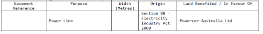
All the land is located within the Farming Zone and is used for rural lifestyle purposes. There is a single dwelling and associated outbuildings on each site. Two easements are located throughout the site, one managed by Barwon Water, running parallel to the northern boundary of 87-101 Ash Road, for the purposes of water supply.
A second easement is located with both 87-101 and 103-127 Ash Road, running in a northwest to southeast direction, contains a Barwon Water outfall pipe.
The site is rolling topography with a large dam located within the eastern half of 87-101 Ash Road. The site is mostly grassed and punctuated with planted vegetation to mark out many of the property boundaries. Some patches of native vegetation remain within the site.
The rezoning and planning permit will allow the land to be developed in a form that will achieve integration with the Mollers Lane development to the east and connection to the Ash Road west area centred on Walkers Road. This is consistent with the objectives of the Leopold Structure Plan and the Framework Plan.
The land is not subject to cultural heritage sensitivity nor to any overlays.
All necessary infrastructure required to facilitate future residential subdivision can be provided to the site.
The combined rezoning and planning permit proposal is supported by planning policy to extend the existing residential area. It is consistent with the Leopold Structure Plan which identified this land as suitable for conventional residential development as the key remaining growth area within the Leopold settlement boundary.
The proposal accords with the objectives of Planning in Victoria as set out in the Planning and Environment Act 1987 as it will provide for the rezoning and subdivision of land to achieve an orderly, well planned outcome consistent with the strategic direction of Leopold.
The land will provide an integrated open space network via the provision of linear open space area and local park and co-located storm water detention basin. These features will connect to the east into the Mollers Lane development area and provide easy walking and cycling access throughout the new residential area estate.
The urban design and open space approach to the layout incorporates street edged open space areas for public safety and ready access. The proposed subdivision will contribute a range of lot sizes consistent with the offerings in the other recently subdivided areas of Leopold and will go close to meeting Council’s policy of 15 lots per hectare. The subject land will be drained using current best practice water sensitive urban design principles and meet Council and CCMA requirements ensuring integration with neighbouring properties and no impacts on Lake Connewarre downstream.
Both the Structure and Framework Plans include additional land to the south at 157, 159 and 161-183 Ash Road within the area for urban growth. This consists of 3 properties, comprising 2 smaller 4,000m2 lifestyle blocks and a much larger 8ha site. This land can be serviced and drained separately from area subject of this application and is not reliant on the proposed road and drainage infrastructure. These three properties have not been included in this rezoning proposal and will be subject to a future application for any rezoning.
The developer applicant has agreements with the two largest properties and has advanced this combined rezoning and permit application. They have the support of the balance of the landowners for the rezoning application to include their land.
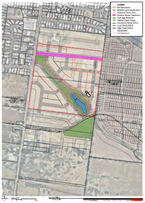
Attachment 7 shows the indicative subdivision layout proposal for the subject land.
Integration with existing residential area
All existing residential development to the north of the subject land consists of a lengthy cul-de-sac which was reflective of the favoured development type of the era it was subdivided and the earlier settlement boundaries of Leopold. It is a pattern that is not conducive to integrating the proposed subdivision with this established area.
The proposed subdivision layout across the site will reflect a contemporary subdivision design with connectivity and open space featured.
As the Ash Road east area has been designed to seamlessly connect with the Mollers Lane area to the east through the linear open space, northern and southern connector roads and the layout of the proposed subdivision.
Storm water management
The key feature of the subdivision is the linear open space that will bisect the land from north west to south east. This area will follow the natural stormwater flows rather than a formally constructed watercourse. This has support from the CCMA and the City’s engineers.
The subdivision design also features a significant drainage reserve and basin to manage stormwater generated by the future subdivision of the land. The reserve will have the capacity to treat stormwater consistent with the principles of water sensitive urban design and detain stormwater to predevelopment flows to ensure that there are no downstream impacts.
With its urban development, water volume discharge from the subject land will increase into the existing defined waterways. The proposed onsite detention basin will ‘flatten out’ the peaks of discharge.
Stormwater discharge from the site will be largely downstream through the Mollers Lane development. There are ongoing discussions between City officers and the Mollers Lane developers about future transmission of stormwater from their site to Lake Connewarre. The Ash Road east development will feed into the final arrangement.
Road network
Primary access to this area will be from Ash Road. It will be widened and will be constructed with kerb, channel and bitumen seal for its length along the rezoning area.
To accommodate increased traffic using Ash Road Lane, the Bellarine Highway/ Ash Road intersection will need to be upgraded to lengthen the right-hand queuing lane from the Highway into Ash Road. The development will be required to fund the costs of this work.
There are two proposed east-west connector roads within the site – one in the north and one in the south. The northern road is based around the existing Barwon Water easement that runs east-west through the site and contains the Bellarine Water Transfer Main pipelines. This proposal will integrate with the alignment approved as part of the Mollers Lane development to the east. The southern road is located to provide a westerly link with the Estuary Boulevard/Walkers Road on the west side of Ash Road and is a key design parameter in the Framework Plan. Again, the alignment of this southern connector seamlessly integrates with the alignment set in the Mollers Lane area.
Design of the subdivision and the provision of two connector roads will allow for the future provision of bus routes through the new subdivision.
Proposed Overlay
This Amendment will introduce and apply a new Design and Development Overlay (DDO) to the site. This will facilitate development that is generally in accordance with the Structure Plan and the Framework Plan.
The proposed DDO will be similar to the terms of the DDO43 which was applied to the Mollers Lane development front. It will feature an overall development plan and include requirements to be met including urban design, stormwater management, traffic and pedestrian movements, public open space and environmental management.
A DDO requires a planning permit to construct a building or construct or carry out works, and to subdivide land. This will provide a backup in the unlikely event that the concurrent permit with this rezoning is not acted upon. It will also provide the guidance for subdivision pattern for the properties being rezoned but which are not subject to the concurrent planning permit.
Application of a DDO means that permit applications for the future subdivision of the balance of the properties will go through a third-party notification process. As detailed subdivision plans for these sites are not yet known and subject to future permits, it is a fair expectation that the community be able to have a review process.
A Development Plan Overlay (DPO) could be applied to the site but is not recommended as it would duplicate the concurrent planning permit proposal for about half of the rezoning area. For the three smaller, separated properties outside of the permit area, requiring 2 or 3 requiring development plans for subsequent development is deemed to be unnecessary administrative burden when planning permits will suffice.
Open space
Most of the open space is to be provided through a linear spine oriented in a northwest to southeast direction across the site complemented by a triangular shaped reserve of approximately 1.0 ha. The drainage reserve is to be co-located with the linear open space. All open space is proposed to be bounded by public roads to provide casual passive surveillance and ease of access.
The linear open space will include shared pathways and other usual infrastructure such as seating and landscaping.
The Planning Scheme requires a 10% contribution for open space for residential subdivision. The City can attain this through land or cash equivalent or a combination of both. Final calculations and configurations are being negotiated and will be completed for exhibition.
Environment Issues
A Growling Grass Frog assessment will need to be undertaken in October to determine if the area provides any habitat and how it should be protected. This may have a minor impact on subdivision layout.
An Environmental Assessment prepared by Coffey for 73-155 Ash Road, Leopold did not identify any soil contamination that would impact on the rezoning and future residential subdivision.
Some native vegetation will be removed as part of the subdivision works. These patches are unfortunately located close to the existing dam which needs to be completed rebuilt to meet the required engineering standards for a drainage basin. Offsets will be required for this lost vegetation within the same catchment or municipal area.
Development contributions
The development needs to provide localised infrastructure such as stormwater drainage, public open space and roads to meet the needs of the future residential population.
For these smaller growth areas which are fewer than 40 hectares with a handful of landowners, the City’s approach is that the developer delivers the local infrastructure as part of the development. The City does not take on the role of directly facilitating local infrastructure delivery through collecting contributions and passing these onto other developers/landowners delivering works in kind through mechanisms such as developer contributions plans (DCP) and overlays, i.e. the City does not act as a collection agency for this smaller growth area and become involved in funding arrangements between developers and private property owners. A DCP would also usually only be required where there is regional infrastructure to be delivered – in this application there is none.
Development contributions for this proposal will be obtained via section 173 Agreement with a draft Agreement to be exhibited with the amendment. The s173 will also clarify the infrastructure being delivered by the developers.
It is more complicated to deal with a section 173 Agreement where there are multiple landowners who are not all working together to advance the rezoning. It was able to be achieved with the Mollers Lane landowners and developers who worked together and voluntarily entered into s173 Agreements to deliver the local infrastructure and the community infrastructure contribution. Time will be required to continue negotiations with the proponent on this matter before proceeding to exhibition.
If agreement can’t be reached with all landowners an available option is to proceed with rezoning only the land subject to the permit application, 87-101 and 103-127 Ash Road.
Development contributions for community infrastructure will also be required. These contributions are collected on a per lot basis and will most likely be allocated to the Estuary Reserve Modular Pavilion planned for the sporting reserves in the Estuary Estate adjacent to Melaluka Road.
Source: |
Planning, Design & Development – Strategic Implementation |
Director: |
Gareth Smith |
Portfolio: |
Planning |
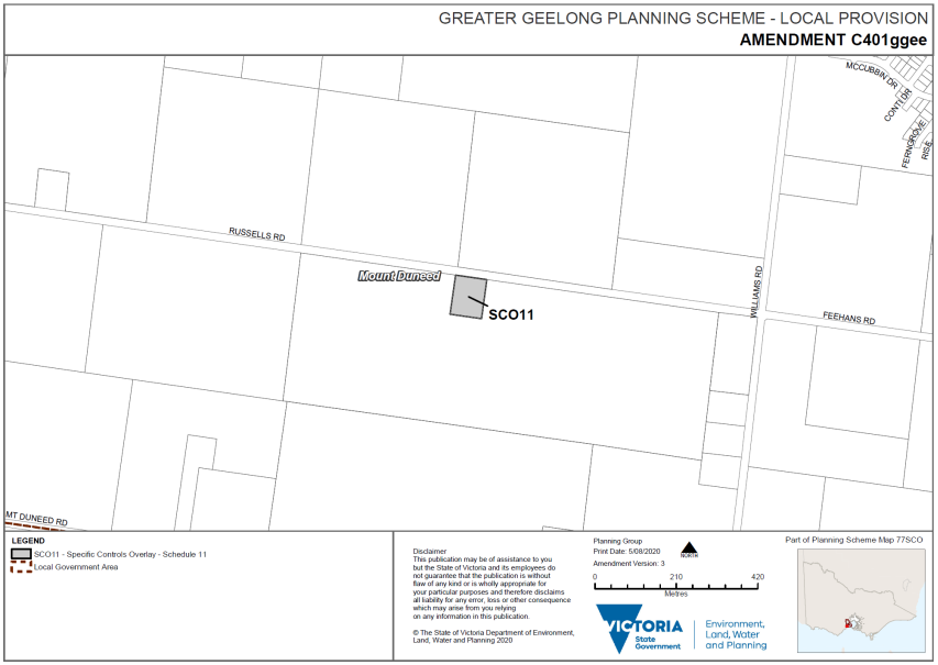
To consider the Panel Report about Amendment C401ggee and adopt the Amendment.
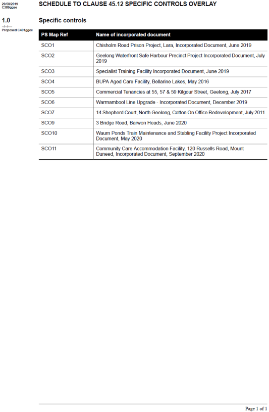
The Amendment applies a Specific Controls Overlay and incorporates a document titled Community Care Accommodation Facility, 120 Russells Road, Mount Duneed, Incorporated Document, August 2019 into the Planning Scheme. The Incorporated Document contains a number of conditions that apply to the proposed use and development. It also authorises the removal of native vegetation from the site.
This Amendment implements the recommendations of the Panel to facilitate a women’s residential drug and alcohol rehabilitation facility on the land as proposed by Foundation 61. Attachment 2 provides a background summary of the Amendment process, including consideration of the Panel Report.
Exhibition of the Amendment in October/November 2019 resulted in 31 objections primarily addressing issues including the appropriateness of the location for the facility, safety of users of Mount Duneed Recreation Reserve and local residents, impact on and relationship with the Reserve, facility management and future changes, vegetation removal, traffic, visual impact and impact on historic values. Separately, a petition with 130 signatures regarding the proposal was presented to Council at its meeting of 10 December 2019.
The submissions were considered by Council on 24 March 2020 when it was resolved to refer all submissions to an Independent Panel appointed by the Minister for Planning.
Following a hearing in May 2020, the Panel’s report was received on 25 June 2020. Under Section 27 of the Planning and Environment Act 1987, the Planning Authority must consider the Panel’s report before deciding whether or not to adopt the Amendment.
The Panel found the Amendment to be well founded and strategically justified by policy and recommends that the Amendment be adopted with changes.
On balance the Panel was satisfied there is a significant need for the facility and that it would not result in a land use conflict with nearby farming activities. The Panel also found the proposed location was appropriate for the use and would not impact the use of the adjoining Mount Duneed Recreation Reserve.
Whilst the Panel’s recommendations are generally supported, this report at Attachment 2 provides the City’s response.
It is recommended that Amendment C401ggee be adopted with changes and sent to the Minister for Planning requesting approval. Since the 24 March 2020 Council meeting, the proposal was amended to include removal of native vegetation and the incorporated document for adoption included in Attachment 3 has been updated to include the Panel recommended condition for offsets.
Councillor Harwood moved, Councillor Nelson seconded -
That Council:
Adopt Amendment C401ggee in the form outlined in Attachment 3 of this report; and
Submit the adopted Amendment C401ggee and prescribed information to the Minister for Planning requesting approval.
Carried.
There are no significant financial implications to Council.
Amendment C401ggee was exhibited in accordance with the requirements of the Planning and Environment Act 1987.
All submitters had an opportunity to be heard before an Independent Panel appointed by the Minister for Planning. The Panel considered all submissions referred to it, not just the submissions presented at the hearing.
The Independent Panel report has been publicly released and all submitters notified of its availability.
The amendment addresses social equity by providing opportunities for vulnerable members of the community to seek treatment for drug and alcohol related issues.
The Amendment supports the following State Policies from the Planning Policy Framework:
Clause 12.01-2S Native vegetation management
Clause 12.05-2S Landscapes
Clause 13.02-1S Bushfire planning
Clause 15.01-2S Building design
Clause 15.01-6S Design for rural areas
Clause 15.02-1S Energy and resource efficiency
Clause 15.03-1S Heritage conservation
Clause 15.03-2S Aboriginal cultural heritage
Clause 16.01-6S Community care accommodation
The Amendment supports the following policies from the Local Planning Policy Framework:
Clause 22.05 Agriculture, Rural Dwellings and Subdivision
Clause 22.64 Discretionary Uses in Rural Areas
The Amendment supports strategic priority of improved health and safety of our community in the Council Plan 2018-2022.
No City officer involved in the preparation of this report has any direct or indirect interest.
Delay in adopting the Amendment will impact the timeline for the facility development and delivery of its affordable rehabilitation services for women, for which there is a critical shortage in the Barwon region and in Victoria more broadly.
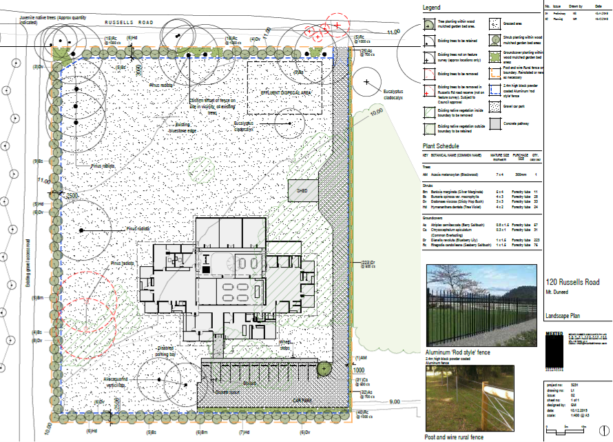
The proposal requires some native vegetation removal. The Incorporated Document includes a requirement to provide appropriate offsets prior to vegetation removal. A revised site plan showing reduced car parking will allow retention of two Sheoaks previously identified for removal.
In March 2019, a Planning Permit application was lodged for a residential alcohol and drug rehabilitation facility and vegetation removal at 120 Russells Road, Mount Duneed.
The subject site is a vacant 8094 m2 parcel of land within the Farming Zone, abutted by the Mount Duneed Recreational Reserve to the east, west and south. An Environmental Significant Overlay – Schedule 1 applies to most of the site, along with land to the south and east within the Recreational Reserve. A Vegetation Protection Overlay – Schedule 1 applies to Russells Road.
The subject site is owned by the Uniting Church in Australia Property Trust (Victoria). The site was formerly occupied by the Mount Duneed Wesleyan Methodist Church, constructed in 1857 destroyed by fire in 1944. Limited remains of this building are situated in the north-west part of the site.
The planning permit application was subsequently withdrawn as the proposal falls within the land use term Community Care Accommodation, introduced into planning schemes by the State Government’s Amendment VC152 in October 2018. Community Care Accommodation is prohibited in the Farming Zone.
In May 2019, St Quentin Consulting on behalf of Foundation 61 Inc. lodged a planning scheme amendment to allow a Community Care Accommodation facility and associated vegetation removal at 120 Russells Road.
The amendment proposes a Specific Controls Overlay and an Incorporated Document. The Incorporated Document allows use and development of Community Care Accommodation in accordance with plans in the document, which may be altered with the written consent of the Responsible Authority (Council), and controls set out in the document. The Incorporated Document acts similarly to a planning permit.
The facility is proposed to be run by Foundation 61 (a not for profit organisation) as a women’s alcohol and drug rehabilitation facility. The same organisation separately operates a men’s rehabilitation facility in Williams Road, Mount Duneed, further south within the Surf Coast Shire.
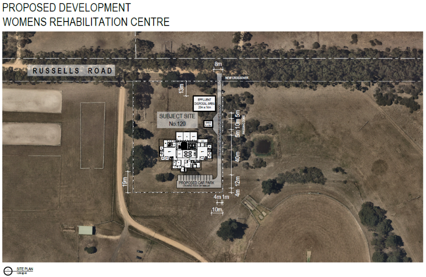
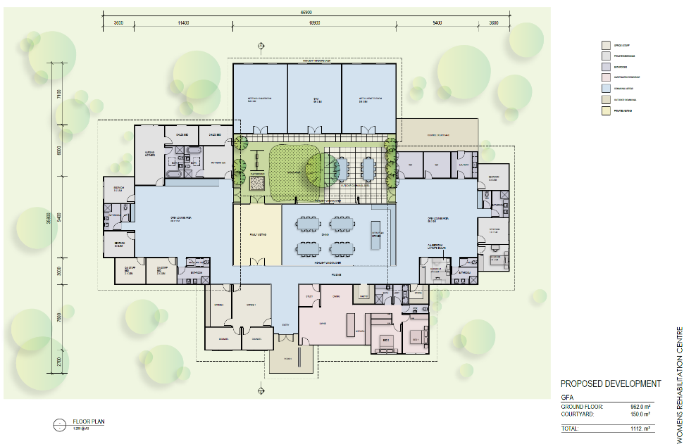
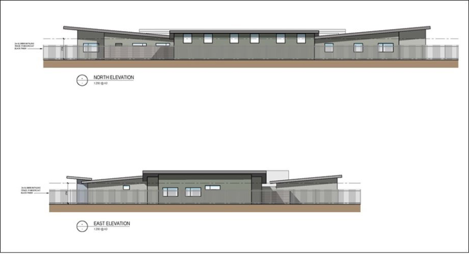
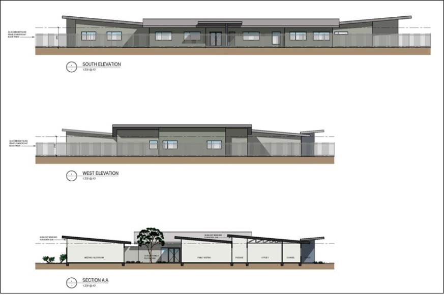
The plans in the Incorporated Document are a for a single storey main building located towards the southern boundary of the site, containing several bedrooms, offices, main lounge areas, a courtyard and a gym, arts and craft room and a meeting/classroom. A 6 x 8 m shed is also proposed. The plans delineate an on-site effluent disposal area. The proposed development avoids the site extent of the former church in the north-west of the site. A driveway is proposed from Russells Road; no access to the site is proposed from the Recreation Reserve (site plan and elevations are in the proposed Incorporated Document at Attachment 3).
Controls in the Incorporated Document include:
a maximum of eight adult residents and five staff on the site at any one time;
the requirement for a facility management plan, addressing matters such as protocols for arrival and departure of residents, staff and visitors, ensuring on-site supervision and support of residents at all times, incident management, maintenance and upkeep; and
visiting hours limited to 1:00 to 6:00 p.m. on weekends.
The Incorporated Document does not limit residents to women only.
Exhibition and submissions
Amendment C401 was exhibited from 17 October to 25 November 2019. 38 submissions were received. Of these submissions:
31 object to the amendment;
one requests changes to the amendment;
four support the amendment; and
two express no objection.
Department of Environment, Land, Water and Planning (DELWP) also lodged a submission which, among other matters, requested the Incorporated Document be modified to specify the location and extent of native vegetation to be removed and include a requirement that appropriately specified offsets are provided prior to vegetation being removed. Conditions have been included in the proposed Incorporated Document at Attachment 3 addressing these requirements.
A petition with 130 signatures regarding the proposed facility was presented to Council at its meeting of 10 December 2019. 16 of those signing the petition also lodged objecting submissions. The major issues raised in the submissions were:
appropriateness of location;
safety of reserve users and local residents;
impact on/relationship to reserve;
land swap suggestion;
facility management and future changes;
vegetation removal;
traffic;
visual impact; and
impact on historic values.
Council minutes of 24 March 2020 summarised all of the submissions and provided a detailed City response to all of the issues raised.
All submissions were considered pursuant to Sections 22(1) & (2) of the Planning and Environment Act 1987 and referred to an Independent Panel appointed by the Minister for Planning.
The appointed two person panel held a directions hearing on 21 April 2020 and a three (3) day Panel Hearing on video conference on 18, 19 and 20 May 2020. Council was represented at the hearing by City officers.
The Panel has now presented its report to Council and recommended that the Amendment be adopted with some changes. Attachment 4 is the Executive Summary of the Panel Report and contains the consolidated panel recommendations.
A complete copy of the Panel’s report is available on the Geelong Australia website.
Key Panel findings and City responses
The Panel Report provided discussion and a series of findings and recommendations about all the issues associated with the Amendment. A summary and response to the key matters is provided below.
Issue – Strategic justification for the proposal
The Panel described the strategic issues as:
whether there is a need for the facility
whether the location in a semi-rural setting is appropriate
impacts on agricultural land and the right to farm.
The Panel accepted that there is an urgent and significant need for residential treatment facilities that are affordable, accessible, offer longer term programs and are dedicated to women. It further noted there is a critical shortage of these residential services and that, more broadly, drug and alcohol rehabilitation services are in short supply in the Barwon Region and Victoria.
It was also accepted the semi-rural location is appropriate as it is a critical element of the therapeutic model of the proposed facility. The location provides a setting that is ‘somewhat separate’ from the usual environment of the residents, while still being close enough for their access to services, families and community.
The Panel was satisfied that the proposal is not inconsistent with policies that protect agricultural land, noting the proposal is a ‘low intensity’ residential use and that the Mount Duneed Recreation Reserve provides a substantial buffer from the farming land to the east, west and south. The siting of the building, existing roadside vegetation and proposed landscaping, as well as the Russells Road reserve, will also provide a buffer from farming uses to the north.
The Panel considered the proposal meets policy objectives that seek to ensure that communities are provided with integrated health facilities and social infrastructure, without compromising other policy objectives relating to protection of agricultural land and landscapes.
Panel Conclusion: The Panel concluded that the Amendment is well founded and strategically justified and should proceed.
City response: The City concurs with this view of the Panel on the suitability and policy support for the application of the Specific Controls Overlay to the site and incorporated document to facilitate the development of the proposed facility.
Issue – Safety of reserve users and local residents
The Panel acknowledged the surrounding community clearly has genuinely held concerns about the social impacts of the proposed development – fears of antisocial or violent behaviour from residents or their visitors, fears that children at the nearby Mount Duneed Primary School or using the Reserve will be exposed to drug or alcohol affected behaviour, fears of vandalism, property damage and threats to personal safety.
Panel Conclusion: The Panel did not consider these fears would be realised and noted all evidence and submissions were that the programs and services run by Foundation 61 (at their existing men’s facility in Williams Road) are well run and pose no risk to the community. The Panel also viewed some of the exhibited Incorporated Document conditions relating to details of ‘day to day’ operations of the Facility Management Plan as unnecessary for planning purposes.
It was recommended the conditions be replaced with broader requirements and a new condition requiring a sign to be installed with contact details, for residents to raise any issues or concerns.
City Response: The City concurs with the Panel’s view on this matter and accepts the Panel’s recommendations for amended conditions.
Issue – Impact on/relationship to reserve
The Panel acknowledged the site has been regarded as part of the Reserve for some time by the community. It also accepted the community feels they are losing part of the Reserve to facilitate the proposed development.
The Panel also noted the site has always remained in separate private ownership and is very small compared to the rest of the Reserve. It considered the risk of inappropriate interactions with users of the Reserve would be minimal (or nil), as the facility will be self-contained. Residents would not be permitted outside without being accompanied by a staff member.
Panel Conclusion – The Panel was confident that the facility and the Reserve can successfully coexist.
City Response – The City concurs with this conclusion.
Issue – Land swap suggestion
A suggestion was made in the submissions and by Council’s Environmental Planning unit to investigate the feasibility of a land swap within the Reserve, to allow development to proceed while protecting the native grassland patch on the subject site. The suggestion had been put to the proponent, who advised they did not view the land swap as a realistic option. The proponent wishes to proceed with the amendment in its current form, to facilitate its proposal on the subject site (120 Russells Road).
Panel Conclusion – The Panel concluded it was not the role of the Panel to consider whether other sites are preferable. Instead its role is to consider whether the proposal is acceptable.
City Response – The City concurs with the Panel on the basis of the proponent’s response.
Issue – Facility management and future changes
Some submissions questioned the proponent’s management capability and the future of the facility, including concerns about its viability as well as the potential for expansion and/or significant changes under a different operator in the future.
Panel Conclusion – The Panel considered the proponent to be ‘a highly respected, well run organisation’ and as discussed earlier, did not regard there to be potential for adverse effects to the adjoining reserve or residences in the area.
City Response – The City supports this Panel conclusion and it is further noted that in the event the facility changed operator, the use and development would be required to be in accordance with the incorporated document and endorsed plans. Any subsequent alteration to the Incorporated Document would require a separate planning scheme amendment. Further, the vegetation and heritage constraints on the site, among other matters, would limit the potential for significant physical expansion of the facility.
With respect to the future of the site should Foundation 61 cease operation, the proponent has advised:
Whilst, Foundation 61 considers it has a long-term future as an organisation providing services to those in need, questions have been asked about the future of the site and the facility if Foundation 61 should cease operating the facility for any reason.
Ultimately there is an acknowledged need for facilities of this type within our communities; whilst the services and spaces they provide to those in need are limited, there will always be demand for facilities of this nature.
Foundation 61 is a Registered Charity with Public Benevolent Institution status. As such if the organisation was for any reason wound up then the assets of the organisation would be required by law to be transferred to another charity with a similar mission for the continuation of the objectives of the organisation.
Issue – Vegetation removal
The panel considered the issue of the loss of native vegetation from the proposal. The vegetation proposed for removal includes four areas of remnant native Grassy Woodland and two pine trees within the site. Three trees are also proposed to be removed in the road reserve for site access, although this would not require a permit under the Vegetation Protection Overlay applying to this area.
A revegetation area planted in 2003, that is located partly within the site, is also proposed for removal. As the vegetation was planted it does not require a formal offset under the Planning Scheme. The City, however, has undertaken to conduct revegetation works in the Reserve adjoining the development site, to offset this loss of vegetation.
Panel Conclusion – The development of the facility will require the removal of some vegetation from the site, including some remnant native vegetation. However, subject to some additional landscaping conditions, the Panel is satisfied that the Proponent has applied the avoid, minimise and offset principles embodied in State policy and the Native Vegetation Guidelines. The Panel also strongly encouraged Council to undertake the further replanting in the Reserve to offset the loss of the revegetation works within the site. The Panel also canvassed alternative access arrangements but acknowledged none of these would be straightforward.
City Response – The City concurs with the Panel’s view on this matter and accepts the Panel’s recommendations for amended conditions. The City further acknowledges it would be impractical to require alternative access points, due to their complexity and the time constraints of the proponent to commence the development.
Issue – Traffic
Some submissions expressed concerns with traffic generated by the proposed facility. Submitters contended increased traffic will endanger pedestrians, horses and riders using Russells Road. Concerns were expressed regarding maintenance implications of additional traffic on an unsealed road, and at the facility’s location near the main entrance to the Mount Duneed Recreation Reserve from Russells Road.
Panel Conclusion – The Panel considered the traffic impacts of the proposed development to be acceptable.
City Response – The City concurs with the Panel’s view on this matter, noting the vehicle access to the proposed facility will be separate to the Reserve.
Issue – Visual impact
The Panel considered whether the proposal would have an adverse visual impact or detrimentally affect the amenity of the area and Reserve. It considered whether the facility would represent an urban site in a rural landscape or be inconsistent with the landscape values of the area and Reserve.
Panel Conclusion – The Panel concluded the proposal would not have unacceptable visual impacts or unacceptably impact the landscape values or rural character of the area. This was, however, subject to further exploration of alternative options to the proposed 2.4m ‘inner’ fence that could be lower or less visually intrusive.
City Response – The City concurs with the conclusion of the Panel in this matter. Council officers have discussed alternatives to the inner fence with the proponent and has resolved the fence should be reduced to 1.8m in height. It is considered this responds to the recommendation of the Panel, including that the fence still provide for the ‘sense of safety and security for the facility’s residents’. It is further noted a similar type of fence has been constructed at Mount Duneed Primary School near its road frontage. Therefore the fencing type, while uncommon in the area, is not without precedent.
Issue – Impact on historic values
The Panel considered whether the proposal would result in the history of the site, including church ruins, will be destroyed.
Panel Conclusion – The Panel gave some weight to the historical value of the site, although noting there was no formal protection. It considered the proposal would not unacceptably impact the heritage values of the site and acknowledged the proponent had designed and sited the proposed building to avoid the area of heritage interest on the site.
City Response – The City concurs with the Panel conclusion on this matter.
The planning authority for this amendment is Greater Geelong City Council.
The Greater Geelong Planning Scheme is amended as follows:
Planning Scheme Maps
The Planning Scheme Maps are amended by a total of 1 attached map sheet.
Overlay Maps
Insert Planning Scheme Map No. 77SCO in the manner shown on the 1 attached map marked “Greater Geelong Planning Scheme, Amendment C401ggee”.
Planning Scheme Ordinance
The Planning Scheme Ordinance is amended as follows:
In Overlays – Clause 45.12, replace the Schedule 2 with a new Schedule in the form of the attached document.
In Operational Provisions – Clause 72.03, replace the Schedule with a new Schedule in the form of the attached document.
In Operational Provisions – Clause 72.04, replace the Schedule with a new Schedule in the form of the attached document.
End of document
GREATER GEELONG PLANNING SCHEME
INTRODUCTION
1.1 |
This document is an incorporated document in the Greater Geelong Planning Scheme (planning scheme) and is made pursuant to section (6)(2)(j) of the Planning and Environment Act 1987. |
1.2 |
The land identified in Clause 3 of this document (the Land) may be used and developed in accordance with the specific controls listed in Clause 4 of this document. |
1.3 |
The control in this document prevails over any contrary or inconsistent provision in the planning scheme. |
PURPOSE
2.1 |
The purpose of the control in Clause 4 is to facilitate the use and development of the Land for a Community Care Accommodation Facility (Residential Drug and Alcohol Facility). |
2.2 |
The project includes but is not limited to:
generally in accordance with the plans within Attachment 1 |
LAND TO WHICH THIS INCORPORATED DOCUMENT APPLIES
3.1 |
The control in this document applies to the land as shown on Map 77 Specific Controls Overlay (SCO3) forming part of the Greater Geelong Planning Scheme. The address of the land is 120 Russells Road Mount Duneed, Crown Allotment L2 Section 21 Parish of Duneed (referred to hereafter as ‘the Land’). |
CONTROL
Exemption from planning scheme requirements
4.1 |
This document is an incorporated document in the Schedule to Clause 45.12 Specific Controls Overlay and the Schedule to Clause 72.04 of the Greater Geelong Planning Scheme (the Scheme). |
4.2 |
Despite any provision to the contrary in the Scheme, pursuant to Clause 45.12 of the Scheme the Land may be used and developed for Community Care Accommodation in accordance with the specific controls contained in this document. |
Conditions
4.3 |
The use and development permitted by this document must be undertaken in accordance with the following conditions: |
|
4.4 |
Endorsed Plans |
|
|
4.4.1 |
The use and development must be undertaken in accordance with the plans in Attachment 1, with the Landscape Plan amended as outlined in Clause 4.4.2. The plans may be altered with the written consent of the Responsible Authority. |
|
4.4.2 |
Prior to the commencement of works the Landscape Plan must be amended as follows to the satisfaction of the Responsible Authority:
|
4.5 |
Landscaping |
|
|
4.5.1 |
The landscaping works must be carried out and completed in accordance with the endorsed Landscape Plan to the satisfaction of the Responsible Authority. The perimeter landscaping works must be completed prior to works on the site commencing, unless the Responsible Authority consents otherwise. |
|
4.5.2 |
Prior to the commencement of any works:
|
|
4.5.3 |
Except with the written consent of the Responsible Authority, there must be no vehicular or pedestrian access, trenching or soil excavation, or storage of waste within the vegetation and tree protection zones. |
|
4.5.4 |
The vegetation and tree protection zones must be maintained to the satisfaction of the Responsible Authority throughout the construction phase. |
|
4.5.5 |
The landscaping works must be maintained, and any landscaping that dies must be promptly replaced, all to the satisfaction of the Responsible Authority. |
4.6 |
Facility Management Plan |
|
|
4.6.1 |
Prior to commencement of the use hereby approved, a Facility Management Plan must be submitted to the Responsible Authority. The plan must provide details of, but is not limited to:
all to the satisfaction of the Responsible Authority. |
|
4.6.2 |
The facility operator must ensure that the use hereby approved does not cause detriment to the amenity of the area and must ensure that the premises is operated in accordance with the Facility Management Plan, to the satisfaction of the Responsible Authority. |
|
4.6.3 |
The facility operator must ensure that a sign is placed at or near the entrance to the Land. The sign must include the name and phone number of the Facility Manager, and must be maintained to the satisfaction of the Responsible Authority.; |
4.7 |
Maximum Resident Capacity |
|
|
4.7.1 |
Unless otherwise approved in writing by the Responsible Authority, not more than eight (8) adult residents and their dependent children (if required) may occupy the premises at any one time, to the satisfaction of the Responsible Authority. |
4.8 |
Maximum staff |
|
|
4.8.1 |
Unless otherwise approved in writing by the Responsible Authority, </a>not more than 5 staff may be present on the premises at any one time, to the satisfaction of the Responsible Authority. |
4.9 |
Visiting Hours |
|
|
4.9.1 |
Unless otherwise approved in writing by the Responsible Authority, visiting hours may only occur during the following times:
|
4.10 |
General Amenity |
|
|
4.10.1 |
The amenity of the area must not be detrimentally affected through the:
All to the satisfaction of the Responsible Authority. |
5.1 |
Cultural Heritage Management Plan |
|
|
5.1.1 |
All works must be in accordance with any conditions set out within the approved Cultural Heritage Management Plan no. 15818. |
5.2 |
Engineering |
|
|
5.2.1 |
The site must be drained to the satisfaction of the Responsible Authority and no concentrated storm water may drain or discharge from the land to adjoining properties. |
|
5.2.2 |
Prior to the new use commencing, the developer must:
All to the satisfaction of the Responsible Authority. Notes
|
5.3 |
Stormwater Management |
|
|
5.3.1 |
The site stormwater system must be designed and installed such that the site stormwater discharge is not increased by the proposed development. An appropriate on-site detention system designed in accordance with the Infrastructure Design Manual may be required all to the satisfaction of the Responsible Authority. |
|
5.3.2 |
Except with the written consent of the Responsible Authority, water tanks and onsite detention systems must be located so as to avoid the removal of any vegetation marked for retention on the endorsed Landscape Plan. |
5.4 |
Recreation and Open Space |
|
|
5.4.1 |
There must be no access through or storage on the adjoining council reserve known as/located at Mt Duneed Recreational Reserve at any time during the construction period. |
5.5 |
Environmental Audit |
|
|
5.5.1 |
Unless otherwise approved in writing by the Responsible Authority, prior to the commence of works a Site Investigation Assessment must be submitted to Council that:
|
5.6 |
Environmental Health |
|
|
5.6.1 |
An approved septic tank system as defined by the Environment Protection Act 1970 must be installed in accordance with the land capability assessment report prepared by St Quentin dated October 2018 to the satisfaction of the Responsible Authority. All wastewater must be treated and disposed of within the curtilage of the property. |
5.7 |
Powercor |
|
|
5.7.1 |
The applicant shall provide an electricity supply to the development in accordance with the Distributor’s requirements and standards. |
|
5.7.2 |
The applicant shall establish easements, for all existing Distributor electric lines where easements have not been otherwise provided on the land and for any new powerlines to service the lots or adjust the positioning existing easements. Notes
|
5.8 |
CFA |
|
|
5.8.1 |
Unless otherwise approved in writing by the CFA, the applicant is required to provide a Bushfire Emergency Management Plan for the site generally in accordance with the plan attached to the Bushfire Hazard Assessment prepared by Okologie Consulting dated 22 February 2019 but amended to include:
Notes: Additional changes to the Bushfire Emergency Management Plan could include:
|
5.9 |
Bushfire/Structural Fire Mitigation Measures |
|
|
5.9.1 |
Unless otherwise approved in writing by the CFA or the Responsible Authority in consultation with the CFA, the building is required to constructed to a Bushfire Attack Level of BAL 19. |
|
5.9.2 |
The whole of the subject site should be maintained as “defendable space” to the following prescription:
|
|
5.9.3 |
Unless otherwise approved in writing by the CFA or the Responsible Authority in consultation with the CFA, landscaping and planting out of vegetation on the site should be in accordance with CFA publication Landscaping for Bushfire – Garden Design and Plant Selection. |
|
5.9.4 |
Unless otherwise approved in writing by the CFA or the Responsible Authority in consultation with the CFA, a below ground operable hydrant must be provided at or near the proposed driveway on Russells Rd. The maximum distance between the hydrant and the rear of the building envelope must be no more than 120 metres. The street hydrant shall be identified as per the Fire Services Guideline – Identification of Street Hydrants for Fire Fighting Purposes. |
|
5.9.5 |
Unless otherwise approved in writing by the CFA or the Responsible Authority in consultation with the CFA, the proposed driveway and accessway must meet the following requirements:
|
|
5.9.6 |
Unless otherwise approved in writing by the CFA or the Responsible Authority in consultation with the CFA, domestic sprinklers should be installed within the proposed building. Sprinkler installation to be installed to the relevant Australian Standards and Building Regulations. Bushfire Notes
|
5.10 |
Barwon Water |
|
|
5.10.1 |
The developer will be required to apply to Barwon Water for connection during the permit phase. Specific servicing comments below:
Note: Water is available at the site however there is limited capacity. The applicant should approach Barwon Water to discuss specific servicing requirements as part of the connection process. |
5.11 |
Heritage Victoria |
|
|
5.11.1 |
Any works located within the Heritage Inventory area of the site will need a permit from Heritage Victoria. |
5.12 |
Native vegetation removal |
|
|
5.12.1 |
Unless otherwise approved by the Responsible Authority, prior to the removal of any native vegetation:
|
5.13 |
Expiry |
|
|
5.13.1 |
The control in this incorporated document expires if any of the following circumstances apply:
|
GREATER GEELONG PLANNING SCHEME
END OF DOCUMENT
Source: |
Community Life – Social Planning and Investment |
Director: |
Robyn Stevens |
Portfolio: |
Parks, Gardens and City Services |
To provide information on the outcome of the Submissions Review Panel meeting which was held on 14 August 2020 and make recommendations on the proposed construction of a fenced dog park beneath the Settlement Road bridge at 162 Barrabool Road, Belmont.
At the Community Focus Meeting of 9 April 2019, Council adopted the Fenced Dog Parks Siting, Design and Management Guidelines.
Following an analysis of potential fenced dog park sites, officers recommended that a new dog park be constructed under the Settlement Road bridge in Belmont.
Community feedback was sought on draft concept plans for a period of 18 days from 21 May 2020.
One formal submission was received objecting to the proposed site. In accordance with the ‘Approval Procedure for Open Space Development Projects’ Policy, a mediation meeting was convened on 14 July 2020 for the applicant to share their concerns and seek to resolve the issues raised.
On 13 August 2020 a Submissions Review Panel comprised of six Councillors was convened and conducted online via Zoom to hear the objector’s concerns. The minutes of the Submissions Review Panel meeting are provided at Attachment 2.
The objector’s concerns primarily relate to the potential for the site to displace overflow carparking occasionally utilised by Geelong Football Club AFL patrons and site drainage concerns.
The Submissions Review Panel acknowledged the submitters objections but concluded that the site was well located and suited for the proposed development of a fenced dog park and supported proceeding with its construction in this location.
Councillor Nelson moved, Councillor Murnane seconded -
That Council endorses proceeding with the construction of a fenced dog park beneath the Settlement Road Bridge as recommended by the Belmont Fenced Dog Park Submissions Review Panel.
Carried.
In 2019-20 the City allocated $600,000 toward the delivery of three dog parks across the municipality.
The Minister for Energy, Environment and Climate Change has recently announced the allocation of $225,000 toward a new dog park at Belmont.
Community feedback was sought on draft concept plans for a period of 18 days from 21 May 2020. Engagement was undertaken via Council’s ‘Have Your Say’ platform, direct email to the Belmont Park Pavilion Committee of Management and signage placed on site. Social media and press articles were also published raising community awareness of the engagement.
The social media campaign had a reach of 36,337 people which included 6,171 interactions such as likes, tags and comments. The overwhelming majority of the online engagements were supportive of the project.
87 submissions were received for the Belmont dog park. 10 formal and 77 informal.
Nine formal submissions were supportive of the site and/or provided design suggestions.
Only one formal submission was received objecting to the proposed location.
There is currently only one fenced dog park in the municipality, located approximately 12 kilometres distance from proposed Belmont site. The Kardinia Ward is home to over 8,000 registered dogs and the construction of a fenced dog park in the proposed location will deliver a much closer and more accessible facility for the use of the diverse community of dog owners who live south of the Barwon River.
The proposed site and concept plans comply with the Council adopted Fenced Dog Parks Siting, Design and Management Guidelines. There are no known legislative or human rights issues associated with the proposal.
The construction of a fenced dog park beneath the Settlement Road bridge, as recommended in this report aligns with the following strategic priorities of Council Plan 2018-22:
Informed social infrastructure planning: This site selected is central to a high number of registered dog owners and the proposal has been strongly supported through the community engagement undertaken; and
A more inclusive and diverse community: There are currently over 8,000 dogs registered within the Kardinia Ward. The construction of a purpose-built fenced dog park in this central and easily accessible location, will cater to a high number of dog owners and provide an opportunity for this community to exercise their pets off leash in a controlled manner.
No Council officers or contractors who have provided advice in relation to this report have declared a conflict of interest regarding the matter under consideration.
The strong positive response from the community engagement undertaken indicates there is a high level of interest in, and support for this facility. A decision not to proceed with a fenced dog park in this location could result in reputational risk to Council.
The impact of flooding given the infrequency of such events and nature of this asset is deemed of low consequence, however opportunities to mitigate the potential impacts of a flood event will be considered in the detailed design process.
The impact on parking for match day events at Kardinia Park has also been reviewed. It is the officer’s view that substantial parking will still be available on the undeveloped portion of the site. This allocation is deemed reasonable given the infrequency of its use for the parking of cars, relative to the community use and benefit to be derived from the use of the land as a dog park.
The proposed site minimises the material inputs required to build a compliant facility as it takes advantage of the site’s existing infrastructure including shade, shelter, parking, public toilets and utility connections. It also activates a currently underutilised space, repurposing it for a greater level of use by the community.
Source: |
Community Life – Social Planning and Investment |
Director: |
Robyn Stevens |
Portfolio: |
Arts, Culture and Heritage |
To consider the sustainable development options for the future of Osborne House and proposed next stage of the process.
In February 2020, Council (in part) resolved to prepare a Sustainable Development Plan for Osborne House that would identify options for its future use and development, consistent with a series of agreed processes and principles.
In May 2020 Birru Consulting and Trethowan (Heritage) Architects were appointed to look at some options for the sustainable development of Osborne House.
A process of extensive stakeholder engagement has been undertaken to consider five options for the sustainable development of Osborne House. This process has involved representatives from the National Trust of Victoria, Regional Development Victoria, Heritage Victoria and ongoing consultation with the executive of the Osborne Park Association.
An independent heritage and financial assessment of potential sustainable development scenarios for Osborne House was undertaken.
Options for the sustainable development of Osborne House have been tested, that indicate the redevelopment of Osborne House as a cultural heritage asset may be feasible in partnership between the City and the State Government and/or private partners.
A process of testing the interest of potential partners is required to better understand whether interest exists in Government and/or the private sector partnering with Council in the redevelopment of Osborne House.
To achieve this, an expression of interest process is proposed to be undertaken in early 2021, subject to the process being designed and presented to Council for endorsement by December 2020.
It is proposed that any potential expression of interest process should be designed in accordance with the social equity considerations outlined in this report, that include the principles adopted by Council on 25 February 2020 (Attachment 1).
Councillor Kontelj moved, Councillor Aitken seconded -
That Council:
Note the additional principles and guidance outlined in this report (Attachment 1, 'Social Equity Considerations') that will guide any future expression of interest process;
Receive a further report in January 2021 that outlines the terms of an expression of interest process for the purpose of seeking interest from potential investors and government in the future redevelopment of Osborne House as an enduring, creative, productive and protected heritage and community asset;
Modify Item 6 in the report to include that the OPA and the Geelong and Region Branch National Trust as members of the Project Reference Group;
Request the existing Project Reference Group be maintained and consulted to assist the development of the January report and terms of an expression of interest process;
Receive a further report in January 2021 to outline options for the Maritime and Naval Collection housed in the Osborne House Stables;
Acknowledge that both the Geelong Gaol and Geelong Post Office have been sold and wishes to re-engage with the State Government to confirm the conditions around the availability of the heritage loan funds associated with these assets for the restoration works of Osborne House and Stable remain;
Reaffirm it 2018 resolution that the funds from Council's lease agreement on the former Russell Polo Field would also be directed to the restoration and maintenance of Osborne House; and
Confirm that the Osborne Park sports grounds mentioned in the consultant report do not form part of the Osborne House - Sustainable Development Plan and there are no plans to change the sporting ovals usage or planning zoning.
Carried.
Division Requested:
For: Councillors Asher, Aitken, Kontelj, Nelson, Mason, Murnane, Mansfield, Grzybek, Harwood, Murrihy, Sullivan
The high-level financial analysis of the sustainable development options considered by this report, indicate potential total costs for redevelopment of Osborne House ranging from approximately $21 million to $48 million depending on the type of future uses and development proposed, with all options potentially attracting various levels of government and private partnership investment.
The type of development and level of government and private investment will have a significant impact on the Council’s financial capacity to renew and redevelop Osborne House.
A budget of $2 million has been made available in the 2020-21 financial year for restoration and maintenance works. These priority works are underway, consistent with the findings of the Lovell Chen Conservation Management Plan 2009.
A Project Control Group (PCG) was established to oversee the preparation of the Osborne House Sustainable Development Plan that has informed this report. The PCG included representatives from Heritage Victoria (HV), Regional Development Victoria (RDV) and National Trust Victoria (NTAV).
The NTAV support the activation of Osborne Park to drive visitation, precinct and foreshore connection and to create a new and exciting destination for local and travelling visitors. The NTAV view Osborne Park and its many buildings as an opportunity to create a precinct orientated around a cultural hub, that will activate the site and that ultimately will attract other organisations to engage in the precinct for the future growth of Geelong through access and inclusion and diversity, in the hope that the development and any additional improvements will demonstrate all heritage and stories of the site and importantly its Traditional Owners. NTAV understand that any future uses or works at Osborne Park will respect the site's heritage values and support conservation works as part of the upgrade and ongoing engagement of the site, in line with the Lovell Chen 2009 Conservation Management Plan and Heritage Victoria requirements under the Heritage Act 2017.
A Project Reference Group (PRG) was established to ensure the involvement of community representatives who have a direct social connection or heritage interest in Osborne House, which included the Geelong and Region Branch National Trust Geelong, Museum Association, Geelong Maritime Museum, Corio Bay Camera Club, Geelong Memorial Brass Band, North Geelong Cricket Club, National Council of Women, Vietnam Veterans Association and Geelong Society of Model and Experimental Engineers. The PRG met on two occasions being 11 May and 11 August 2020 to identify both the interest of each user group and discuss the options.
A meeting was also held with the Wadawurrung Traditional Owners representative on 31 July 2020. The key interest of the Wadawurrung Traditional Owners is that prior to any potential future development a Cultural Heritage Management Plan (CHMP) is completed, in partnership with Wadawurrung. The findings of the CHMP should be implemented in conjunction with any future development. Wadawurrung have also requested that some community space or presence in Osborne House be considered as part of any redevelopment of the site, noting that the existing residential building (immediately adjacent to the west of Osborne House) is not proposed to be retained. Wadawurrung Traditional Owners will continue to be engaged in any future consultation processes.
It is proposed that a similar project management structure be retained to oversee the proposed expression of interest process, with the PCG to provide project oversight and guidance to the process. The main change to the constituency of the PCG would be the inclusion of a representative from the Osborne Park Association (OPA) executive committee.
The testing of sustainable development options noted in this report have all been guided by the principles adopted in Council’s previous report on this matter in February 2020.
It is proposed to retain those principles that have guided the project to date, while adding some additional guidance for the next stage of the process. These principles will be used to seek interest from partners who will be requested to consider and respond to the principles.
The principles to be retained and additional guidance is as follows:
Culturally
Interpret, protect and celebrate the values of the land known as Osborne Park.
Any future development of Osborne House should involve the interpretation, protection and celebration of the First Nations’ heritage along with the significant post-settlement heritage buildings and landscape.
Any future development should consider the total restoration of the significant heritage buildings of Osborne House, as identified in the Lovell Chen Conservation Management Plan 2009, including giving consideration to its naval heritage.
That a heritage interpretation plan shall accompany any proposal for the future development and use of Osborne House.
The Muirhead and Russell buildings to be made available for general public use and ensure contemporary heritage interpretation of the spaces / buildings.
Socially
The future management and development of Osborne House should consider a mix of community, public and commercial uses, while also providing for public access and community use.
Future management and development of Osborne House should ensure the ongoing public recreational use of the adjoining Osborne Park sports fields.
Uses that are complimentary to and consistent with the concept of a community and cultural heritage precinct, with a proportion (percentage) of appropriately designed space made available for community use (e.g. accommodation of groups, meeting rooms, function area etc).
Opportunities to co-locate people and small scale organisations who can benefit from the sharing of facilities and ideas in the areas of innovation and cultural activities/business.
A community governance structure in place to oversee the future use of Osborne House.
Financially
Any future proposal will consider ideas from private partners for developments to occur in zone 1 and/or zone 3 of the Osborne House site under a long-term lease arrangement, noting that any future development must comply with principles of the Conservation Management Plan (2009) by Lovell Chen.
Osborne House shall be retained in public ownership.
Tenancy arrangements can be considered over all or part of Osborne House, to generate income to cover ongoing maintenance and ensure the viability and financial sustainability of Osborne House, however these arrangements must ensure an appropriate level of public access and use.
All and any areas identified for sole use by community groups and general public, to be under direct control of the City, in perpetuity.
To make safe and secure, restore the heritage asset, reopen for public uses and leverage other potential funding Council will contribute up to $10 million over three to four years (including the $2 million contribution made during 2019/20 and 2020/21).
Future funding will be accumulated and held in an Osborne House (Heritage Restoration) Provision.
That any future development of Osborne House should also give regard to broader government objectives (i.e. employment creation and increased local civic and economic development).
Environmentally
Osborne House be developed and maintained consistent with Council’s Sustainability and Asset Management Policy(s) for public buildings.
That the surrounding landscape of Osborne House be developed and maintained consistent with Council’s policies and incorporating the heritage principles identified in the Lovell Chen Conservation Management Plan 2009.
Osborne House is entered on the Victorian Heritage Register (H1101) and future options for development will need to consider the permit approval requirements of Heritage Victoria under the Heritage Act 2017. These requirements will take precedence over any heritage requirements arising from the City of Greater Geelong planning scheme.
The Council Depot (former Russell Polo Field) and parts of the foreshore along with Osborne House are separately entered in the Victorian Heritage Inventory for its archaeological potential, and future options for development will also need to consider the permit approval requirements of Heritage Victoria.
Osborne House, adjoining parts of the Foreshore Reserve and Swinburne Street Road Reserve contain Aboriginal artefact sites and are within an area of Aboriginal cultural sensitivity. Future options for development will need to consider First Nation values while a Cultural Heritage Management Plan will be required prior to any development works.
The land Osborne House is on is currently zoned PUZ6 for Local Government Use under the planning scheme. Future management and development options should not be limited by this consideration, but a future amendment to the scheme will be submitted to Council once the future use requirements have been determined.
The potential redevelopment of Osborne House as an enduring, creative, productive and protected heritage and community asset is consistent with:
Council’s Vision for a Clever and Creative City, which states specifically that success (in part) “will be achieved by attracting creatively oriented and artistic industries to the region through the creative re-use of heritage assets”;
The UNESCO City of Design key objective being to “work towards placing creativity and cultural industries at the heart of their development plans”; and
The Council Plan 2018-22 and several council key priorities including:
A Vibrant Arts and Culture, incorporating arts and cultural initiatives into infrastructure development, to enhance our sense of place, and specifically commencing the remediation of Osborne House; and
Informed Social Infrastructure and Planning, specifically Council’s priority to deliver accessible and attractive community infrastructure, based on community need.
No Council officers or contractors who have provided advice in relation to this report have declared a conflict of interest regarding the matter under consideration.
There is a financial, reputational and asset risk related to Osborne House. If an agreed plan for the use and development of the building is not developed, the building will continue to fall into disrepair and the heritage values of the building could be lost. To offset this risk Osborne House requires investment and activation to ensure an enduring, creative and productive future, which celebrates and protects the significant heritage status of the building.
The current pandemic presents both a financial and delivery risk. The current environment may have a negative impact on the number of private partners indicating an interest in the development of Osborne House. The proposal to time release of the expression of interest for early 2021 is designed to mitigate the impact the current pandemic may have on investor interest.
It is the view of the independent consultant that the land needing to remain in public ownership may present a risk to potential investment by private partners. Council may need to consider other mechanisms that will provide certainty of tenure and development rights over the land and buildings to attract any potential private partnership.
The current land is zoned public use. This zoning may not be compatible with future interest that arise through the next stages of the process. Dependant on the nature of any interest that does emerge, council may need to consider facilitating a future rezoning of the current land use and any rezoning will be contingent on adoption by the Minister for Planning.
The future development of Osborne House will include a key criteria consideration of Council’s Sustainability Framework.
Any redevelopment of Osborne House will require a Cultural Heritage Management Plan to ensure the indigenous cultural heritage of the landscape is understood and protected.
Source: |
Planning, Design and Development - Urban Design and Heritage |
Director: |
Gareth Smith |
Portfolio: |
Arts, Culture and Heritage |
To present and note the community feedback regarding the consultation process for the draft Geelong Town Hall Conservation Management Plan 2020 (CMP) and for the Council to endorse the final CMP.
City Hall is entered in the Victorian Heritage Register under the title ‘Geelong Town Hall’ and permits are required from Heritage Victoria for all future works to the building.
The purpose of a conservation management plan is to identify what is significant about a place and specifically what aspects of a building need to be retained and conserved, along with what constraints apply to new development. Therefore, this CMP does not showcase future development plans or options but will be useful to persons designing alterations and additions to accommodate future use, and compliance with the recommendations of the CMP should expedite the necessary permit approvals.
GJM Heritage consultants were commissioned by the City in October 2018 to prepare this CMP and in April 2020, Council endorsed release of the draft CMP for public comment.
Thirty-four community submissions were received in response to the consultation on the draft Geelong Town Hall CMP. Responses are included in full at Attachment 3 (Have Your Say online submissions) and Attachments 4 & 5 (emailed submissions).
All were private submissions except one from the Board and Management of Geelong Gallery and one from the Geelong and Region Branch of the National Trust of Australia (Victoria).
Six responses commended on the overall document or recommendations.
No responses challenged the heritage significance of City Hall or need for a CMP.
Five concerns over content were raised – as described and responded to in Attachment 2. These are all valid however, for the reasons outlined, are not considered to warrant change to the CMP document.
Thirty-one responses included comments as to a preferred future use: sixteen supporting expansion of the art gallery into City Hall; eleven supporting a continuation of Council meeting and civic ceremonial use; two supporting a shared art gallery and council/civic use; and two supporting use as a venue for musical performances (chamber music and contemporary). All this feedback is valuable for future decisions of Council, but not applicable to current consideration before Council of endorsing the CMP.
There were also comments on ownership-related matters and other general matters which were also not applicable to the current CMP decision before Council.
Councillor Sullivan moved, Councillor Mason seconded -
That Council:
Note the submissions made in response to the public exhibition of the Draft Geelong Town Hall Conservation Management Plan February 2020; and
Endorse the Geelong Town Hall Conservation Management Plan February 2020 for application to ensure the heritage significance of City Hall is conserved in future management and development actions.
Carried.
The Conservation Management Plan (CMP) process to date has been funded within the designated budget set aside for Civic Accommodation planning.
The final CMP will help guide future investment by the Council in City Hall.
An early draft was referred to the Council’s Heritage Advisory Committee and Heritage Advisor for comment, key issues raised have been addressed in the latest draft.
This report describes the finding of public consultation on the exhibited draft.
City Hall is of high social importance to the Geelong community through its longstanding civic use, and a place of high heritage interest through its history, architecture and prominent siting overlooking the City’s major park.
The City Hall is entered on the Victorian Heritage Register and any works to it require an approved permit from Heritage Victoria. The CMP can guide design work to minimise heritage impact and inform any permit assessment by Heritage Victoria.
Relevant Council Plan priorities include; A More Inclusive & Diverse Community – Improving our engagement with our culturally diverse population, supporting activities that improve social connections in our community, and Planned Sustainable Development - Managing the impact of development on the unique character of our townships.
No City officers or contractors who have provided advice in relation to this report have declared a conflict of interest regarding the matter under consideration.
The CMP should reduce the likelihood of inappropriate works being designed and/or the rejection by Heritage Victoria of any future works proposed by the City to City Hall.
The CMP provides increased community certainty as to what physical changes are possible at City Hall in the future considering its heritage significance.
The CMP will help ensure the City achieve the highest environmental standards possible for the future use and development of City Hall. Any future permits obtained for works will reflect the high standards.
Points (i) to (iii) were raised in several responses including that of the National Trust and several private responders who also identified themselves as National Trust members. Points (iv) to (v) were raised in a private submission.
Concern that insufficient emphasis has been given to the historical and social importance of ongoing municipal use.
Response: Negotiations with the consultant led to a review and recognition of the local importance of Criteria G & H relating to the municipal use and the architect Joseph Reed, between the first and second drafts. Criteria G & H do not meet the Heritage Victoria thresholds for satisfaction of heritage significance at a state level. The recommendations also ‘strongly encourage’ retention of municipal functions and public access.
Concern that the CMP does not include a comparative analysis of similar buildings.
Response: Such analyses are primarily used to determine whether a place should be heritage-listed at a local, state or national level. Given City Hall is already state listed, a comparative analysis was not deemed necessary, a factor that caused this component of work to be removed in the original fee negotiations for the CMP.
Concern the stated architectural style of ‘Renaissance Revival’ is inaccurate.
Response: There is a divergence of professional opinion as to what the style is within a wider grouping of Classical Revival Styles. Discussions with Heritage Victoria and other heritage advisors revealed at least four different style descriptions were found to exist for City Hall. Taking this into account, the consultants for the CMP have proposed the Renaissance Revival style. Given the absence of professional consensus, and ultimately because the style is just a label and will not directly affect any future management outcomes nor cause heritage impacts, no change to the CMP is considered necessary.
Concern that the scope of the consultancy was cut back to exclude a detailed condition assessment and maintenance schedule, that not all roof and basement spaces within the building were accessed.
Response: These components are very important in CMPs for buildings that are not being used and maintained with any regularity. However, City Hall is subject to a high degree of ongoing condition monitoring and maintenance. Furthermore, considerations are also proceeding in respect of potential redevelopment options, whereby redevelopment would render any condition assessment and maintenance schedule obsolete.
Concern that the scope of the consultancy did not allow a community values survey to be undertaken as part of the CMP process.
Response: A social values survey and workshop is a process followed for some places with high levels of community attachment and interaction to identify the nature and level of social value relevant to significance assessment Criterion G. The process is quite lengthy, expensive, and used mainly where values are unclear. In the case of City Hall, the social value is well understood based on the use of the building and comparable places, so a separate survey process was not deemed cost-beneficial for this project. Social values are recognised within the CMP at Criterion G, as per 9i) above.
Respondent |
Comments |
|---|---|
325 |
The Geelong town is one of the original Geelong remaining buildings still kept and in use. |
362 |
Clearly control of the Town Hall Building must remain under the control of COGG. |
459 |
I would love to see the City Hall adapted to be an extension of the Geelong Gallery. There are so many works of art that are in storage that could be placed on display for the Geelong residents and tourists to enjoy. The building would lend itself well to a Gallery Interior and it makes sense to extend the existing gallery to the heritage building. |
1201 |
I broadly agree with the direction of this report: retention of exterior physical fabric to 1917. The 1968 and 1990s additions are of low value and can be removed. returning the TH to a free-standing building would allow flow and links from the Park through to the emerging arts precinct along Little Malop St. |
1243 Board & Management of Geelong Gallery |
The Board and Management of Geelong Gallery is pleased to have the opportunity to respond to the Significance Assessments and Conservation recommendations in the Conservation Management Plan (CMP) for the Geelong Town Hall. |
1308 |
I believe that City Hall should become part of the Art Gallery. Policy 11 contains items, stained glass window and Ingpen Mural, which are relevant to art and could be an added attraction to the Gallery. The Art Gallery needs more exhibition space and a Heritage building next door which could be easily connected would seem to be a viable alternative to other expansion plans. |
1309 |
|
1310 |
I fully support the Conservation Management Plan and strongly believe that Geelong Gallery will be the best organisation to fulfil these aims of conservation, heritage and public access to a range of art and cultural activities. I have been a volunteer at Geelong Gallery since August 2017 and have been impressed by the range of cultural experiences and the outreach to many groups in the community to enable their participation and enjoyment of art and cultural activities. |
1314 |
This presents a fantastic opportunity to expand the gallery to create more spaces and allow for bigger international exhibitions. The gallery is a vital part of Geelong’s cultural identity. An expansion would continue to grow the gallery as an important economic driver for the region. |
1315 |
It would be really great for the gallery to expand so the town can display and develop big international exhibitions as an economic driver. |
1316 |
As a resident of Geelong, I thoroughly endorse this draft city hall conservation management plan and fully support that the space is used by and for the Geelong Gallery, for amongst other things the recognition of local Indigenous history, art and culture, the celebration of creative art and culture, and the appreciation of the multiculturalism that makes Geelong great! Art brings all people together, and brings many people to regions and it is exciting to see our cultural and creative hubs celebrated and supported by Geelong Council. |
1317 |
Highest significance is the external facade being unchanged on Gheringhap/Lt Malop st. |
1318 |
An expanded Geelong Gallery is vital for the community & the city. |
1320 |
The town hall is a great public resource, if somewhat tired. Linking the gallery back into the town hall would reflect the original link between the gallery building and the town hall building. |
1324 |
The City Hall is a treasure of the city. |
1408 |
I whole heartily agree with the Gallery taking over the space. Though I would also like to see that, under the management of the Gallery, that the space includes a substantial "art education and training aspect". I would suggest that this would make a truly unique cultural centre for the City of Geelong. |
1455 |
The community (and the Council acts on behalf of the community) needs to preserve the eastern and northern aspects of the existing City Hall and, by merging/incorporating with the Art Gallery create a venue where the collected arts and crafts can be displayed and rotated as well as bringing in travelling exhibitions. Although Geelong is a bigger city than Ballarat and Bendigo the gallery does not compare well with the area and space available - perhaps a result of the funds that flowed to the other two cities following the gold rushes. |
1468 |
I commend the City on the quality and professionalism of various documents concerning the future use of the current City Hall. I believe, because of the historically significance and the appearance of the existing building, that the City should use the current City Hall for official meetings, visits and receptions. |
1504 |
Let the art gallery use the whole space but keep the outside as a reminder of it being a town hall. The interior has changed so much that making it a full art gallery would be more useful and cost effective for COGG. No point in maintaining it when the new civic place should be the focus going forward. |
1505 |
I want this town hall to be preserved and the use to be for councillors and public use.
|
1506 |
Please keep the Geelong Town Hall as a working and viable space used by the councillors for town business. It is an important historical space and beautiful building which should be preserved for our future. Appropriate usage is the only thing that will keep the town hall going as a vibrant centre of Geelong. |
1508 |
I strongly support the elements of the draft policy relating to ongoing use of the City Hall for municipal governance purposes. |
1509 |
I think that after 160 or so years of being the face and focal point of local government in Geelong, that the Gheringhap St entrance must continue to be used for its original purpose. As Victoria's oldest continuously occupied Town Hall, too much heritage and history will be lost if it just becomes an unused facade-and too much heritage and history of Geelong has been already lost. Obviously the day to day running of the council will be housed in the new building, but the Gheringhap St entrance must continue to represent the connection between the council and the ratepayers. It is a matter of civic pride for the citizens of Geelong. |
1510 |
Dear Sir/Madam, |
1511 |
LEAVE THE GEELONG TOWN HALL AS IS |
1512 |
I write as a resident and ratepayer in the CoGG. I strongly urge overlays be put into place to conserve both the visual presence of the Geelong Town Hall and its surroundings in Johnstone Park and it cultural heritage and civic use as detailed in the City Hall Conservation Management Plan. It is an impressive building and its location within the park setting provides a welcome respite from the ad hoc commercial collection of buildings opposite its front entrance. |
1517 |
It’s important that the 1855 Joseph Reed design heritage Town Hall building continues to be used for elected Councillor’s purposes and interaction with the public when the new Civic Accommodation administration building in Mercer Street on the other side of Johnstone Park is finished. |
1533 |
I am very much in favour of the Town Hall retaining its civic function. It matters that it's unbroken 165 year history is not terminated. It is good for all of us. A prominent civic building used for its original democratic purpose is good for a city's status and good for its citizens. It is an intrinsic part of the City's culture There is the recognition that the building is bigger than us all, that it has withstood changes of all kinds and the perception that what happens inside aims to be for the good of all. I beg you not to separate place from purpose - for the benefit of the City and for all. |
1535 |
I commend the authors of the excellent Draft Plan and support the recommendations. However I think the name Town Hall should be retained even though Geelong is a city. |
1536 |
I have read the CMP and endorse the sentiments and suggestions contained in it. I believe that any development in the surrounding area should be in sympathy with the appearance of the original buildings. I also firmly believe it should be publicly owned ( by the city i.e. all its constituents) and preserved through Council stewardship. Its future use should also complement its historic role as a centre of civic governance. |
1537 |
Overall the CMP is a good document to record the history and significance of the Geelong Town Hall.
|
1539 |
It is important that the 1855 Joseph Reed design heritage Town Hall building continues to be used for elected Councillor’s purposes and for accommodating interaction with the public when the new Civic Accommodation administration building in Mercer Street is finished. |
Email respondent #1 |
Summary extracts from a 20-page submission lodged via email Part 1 - I consider the overall significance of the building together with its social significance are so important to the State’s understanding of its heritage and the development of municipal governance that our present Council should re-consider its own ambitious plans for a new municipal building at a cost of over $91,000,000. In addition, I understand that due to the pandemic causing changes to work habits, and with most people working from home, acres of new office space in Geelong are now vacant. It remains to be seen whether the current changes occurring in work places are indeed structural and will become permanent. The present Geelong City Hall has over 3000 sq m of space (excluding the car park – CMP Appendix A). Surely much of the space could be appropriately re-configured to become more efficient. This should reduce the extent of the $91m new building and its cost, with the advantage of retaining more civic functions at the Town Hall and maintaining important traditions. Perhaps the Gallery’s expansion plans also need to be reviewed in the light of changes to social habits brought about by the pandemic, and of changes in the economy. Part 2 - I consider that the current Council must take into account that the Town Hall is Victoria’s earliest surviving seat of municipal government in continuous use, and support its traditions. Council is responsible to the community in maintaining these traditions as well as the heritage fabric of the Town Hall. To some degree, it has assumed the traditions of all of the Councils absorbed into the City of Greater Geelong. Some of the objects and art works now in the Council’s heritage collections derive from those former municipalities; they need to have an appropriate home into the future. Part 3 - Sec. 1.7 Project Limitations, CMP p. 12 - These limitations of the Town Hall CMP project have greatly undermined its value to the future maintenance and conservation of the Town Hall and are not in accord with Article 6 of the Burra Charter (Appendix 1). I consider that the lack of a detailed overview of the condition of the building today, together with a schedule of recommended remediation and maintenance, has undermined the present and future value of the CMP in caring for the Town Hall, and has negated much of its expense. It is an opportunity lost and could be costly into the future. ‘Community consultation and public surveys were not part of the project scope’ - I consider that this project limitation is completely insupportable for a building with the social significance of the Geelong Town Hall. The consultants’ appointed task of assessing the full heritage value of the Town Hall has thus been hobbled by the lack of community consultation and public surveys. I strongly support the consultants’ demonstrating the cultural and social significance of the Town Hall (in accordance with the Burra Charter Article 6, Appendix 1) by including VHR Criteria G and H in the CMP, expressed as Local Heritage Value. In my view, this recognition of the importance of cultural and social value in the Town Hall heritage assessment should encourage Council to request that Heritage Victoria fully reviews the Town Hall listing and includes both Criteria G and H in the VHR listing along the lines suggested by the consultants. I support the retention of the Geelong City Hall for civic and ceremonial functions (Council meetings, celebrations), similar to Melbourne Town Hall’s role for its community. Necessary accommodation for the Mayor and Councillors to have their own offices would be an advantage to them in carrying out their formal roles. A part of the building should also be set up to display the Council’s significant heritage collections relating to the Geelong City and amalgamated municipalities over the last 150 years. While retaining civic and ceremonial functions, I consider that the Geelong Town Hall would provide the ideal space in which to display them (Appendix 1, Article 10). |
Email respondent #2 National Trust |
Summary extract from 7-page submission lodged via email In some respects the Draft Town Hall Conservation Management Plan February 2020 by GJM Heritage is generally an acceptable record of the history of the building. A CMP for a building is the foundation basis for long term decisions and therefore must be wholly complete and accurate. The Draft Town Hall Conservation Management Plan February 2020 by GJM Heritage does not include the following. 1. A comparative heritage significance assessment to consider other comparable places, which is commonly part of a CMP or heritage study, and required as a valuable component of a CMP in order to assess the level of significance 2. A correct accurate description of the architectural style of the place. The architectural term ‘Renaissance Revival style’ is used throughout the Draft CMP to describe the Geelong Town Hall. The description should be changed to ‘Greek Revival’. 3. Sufficient emphasis of the significance of the continuous unbroken use of the original building for local government purposes under the Significance Assessment and Conservation Policies chapters |
Note two emailed submissions are included in following attachments. |
|
Source: |
Community Life – Healthy Communities Department |
Director: |
Robyn Stevens |
Portfolio: |
Community Health, Wellbeing and Safety |
To recommend that Council not oppose the application by the Waurn Ponds Hotel Management Pty. Ltd. (the Applicant) to the Victorian Commission for Gambling and Liquor Regulation (VCGLR) to increase their electronic gaming machines (EGMs) based on the assessment of the application against Council’s Electronic Gaming Machine (EGM) policy.
In 2018/19, residents in Geelong lost $6.6 million at the Waurn Ponds Hotel. Across the City of Greater Geelong, poker machines took over $119 million from residents in 2018/19 (the fourth highest in the state).
All gaming venue operators who want to increase their allocation of EGMs must apply for approval from the VCGLR. In responding to applications, the options available to Council are to make no comment or to submit a response within 60 calendar days of notification from the VCGLR, either supporting or objecting to the application. The deadline to lodge a response to this application is 19 September 2020. Additionally, the City can be represented at the VCGLR tribunal that will hear the application.
Under the state government’s regional EGM caps system, the City is located within capped region number 8. The cap recognises the high number of EGMs per person in the municipality. A maximum of 1,421 gaming machines are permitted to operate within the combined areas of Greater Geelong and the Borough of Queenscliffe. There are currently 1,357 EGMs in Geelong and Queenscliffe.
A 2009 application by the Waurn Ponds Hotel to relocate 21 EGMs from the Norlane Hotel to Waurn Ponds was not contested by Council due to the shift of machines from a severely disadvantaged area.
The Waurn Ponds Hotel Management Pty. Ltd. At 1154 Princes Highway, Waurn Ponds has applied for a licence for 11 additional poker machines to add to their existing 70. The Waurn Ponds Hotel is operated by a family business that also operate the Norlane Hotel (84 poker machines) and the Racecourse Hotel in Werribee (52 poker machines).
The assessment report (Attachment 2) is undertaken against Council’s Electronic Gaming Policy 2017. The result of this assessment is that while maintaining concern about any increase of EGMs, this application complies with the criteria outlined in the policy and as such, is not opposed.
Councillor Manfield moved, Councillor Murnane seconded -
That Council:
Oppose the Waurn Ponds Hotel Management Pty. Ltd. application to increase the number of electronic gaming machines from 70-81;
Does not support an increase in EGM’s anywhere in the municipality due to increasing community concern about the harm caused to individuals and the wider community through problem gambling;
Note that COGG’s gambling policy is currently under review with a report due back to Council before the end of 2020; and
Write to the State Government requesting a review of the EGM cap in Geelong.
Carried.
Division Requested:
For: Councillors Asher, Murrihy, Harwood, Mansfield, Aitken, Mason, Murnane
Against: Councillors Kontelj, Grzybek, Sullivan, Nelson
There is a financial cost to the City to prepare and argue the proposed response at the VCGLR. This requires engaging legal counsel and an expert consultant to present on behalf of Council at the VCGLR.
The application for increased machine numbers was advertised by the VCGLR in July 2020. However, resulting from the current COVID-19 pandemic crisis, it is extremely difficult to engage the community more broadly on this application.
The application has been considered against the City’s social equity principles including: effective partnerships and engagement with priority population groups and places; the emerging information on social and health equity outcomes; and, when planning services, infrastructure and communications, considering the needs and obstacles faced by priority population groups and places.
Council’s Electronic Gaming Policy argues against the introduction of EGMs in areas where density is above that of the broader municipality. Additionally, Council will discourage an increase in the number of machines in areas of disadvantage (SEIFA levels).
Council has objected to the three most recent EGM applications and was represented at the hearing for all three. The Belmont RSL application was subsequently approved by the VCGLR subject to conditions, the Geelong Polish Association application was not approved by the VCGLR and the Clifton Springs Golf Club application was approved by the VCGLR.
Council has an Electronic Gaming Policy (Attachment 3) adopted in 2017, which provides guidance in responding to applications seeking to increase allocation of EGMs. Developed within the legislative frameworks and policy contexts for Victoria, the policy requires the City to facilitate the implementation of ongoing licensing and management of gaming as a legal activity, in addition to promoting health and wellbeing within the municipality. The policy also sets out criteria against which the City assesses applications to determine whether they can be contested or not.
This report aligns with the Council Plan 2018-2022 strategic priority area 1 – Improved Health and Safety of our Community. Additionally, the Municipal Public Health and Wellbeing Plan 2018 – 2021 goal 1 supports social connection to improve health and wellbeing and achievement of health protection by responding to EGM applications.
No Council officers or contractors who have provided advice in relation to this report have declared a conflict of interest regarding the matter under consideration.
Council has a stated role in reducing harm in the community by applying its adopted policies. The guiding policy in this case is the Electronic Gaming Policy (2017).
There are no environmental implications resulting from this report and /or decision.
Source: |
Customer & Corporate Services – Financial Services |
Director: |
Michael Dugina |
Portfolio: |
Finance |
To approve “in principle” the audited Financial Statements and Performance Statement and authorise two Councillors to certify the statements.
Under Section 131 of the Local Government Act 1989 (Act), in each financial year Council must prepare an annual report that includes audited financial statements and a performance statement for the financial year. These statements must be prepared in the prescribed manner and form and be certified by the City’s external auditor. The City’s current external auditor is the Victorian Auditor General’s Office (VAGO).
The City’s Audit and Risk Committee have the responsibility according to Section 4.1 of its Charter “Financial Reporting Responsibilities” to:
Review the annual financial report and performance statement and consider whether they are complete, consistent with information known to committee members and reflects appropriate accounting treatments; and
Recommend the adoption of the annual financial report and performance statement to Council.
Under section 132 of the LGA, Council is required to approve “in principle” the statements prior to receiving final certification from the Auditor General. Council’s approval requires nominating two Councillors to certify those statements, together with Chief Executive Officer and Principal Accounting officer, and to lodge these statements with the Auditor General.
The Annual Financial Report for the Year Ended 30 June 2020 (Attachment 3) and Performance Statement (Attachment 4) have been prepared by the City and reviewed by VAGO. These statements have been prepared in accordance with Australian equivalents to International Financial Reporting Standards.
A final closing audit report and final management letter has been received from VAGO. VAGO has concluded that the statements are presented fairly and has, in principle, given its clearance of the statements.
The Audit and Risk Committee met on 2 September 2020 to consider the Annual Financial Report and the External Audit results. The Committee endorsed the Annual Financial Report for the Year Ended 30 June 2020 (Attachment 3) and Performance Statement (Attachment 4) and recommend that Council gives approval in principle and authorises the certification of the Financial Statements.
The 2019-20 financial statement of accounts highlight:
A satisfactory period of operation with a $84.9m surplus, high closing cash balances of $103m and significant asset growth to $2.8 billion;
An overall spend of $487.4m, including operating expenditure $364.5m and capital expenditure $122.9m. The Comprehensive Income Statement highlights a surplus for the year of $84.9m plus $166.0m land and buildings revaluation increment for a total comprehensive result of $251.0m;
$10.0m for early receipt of 50% Victorian Financial Assistance Grants funding for 2020-21; and
Debt levels increased during the year from $65.8m to $82.6m with $25m of new loans and $8.2m repayment of borrowings.
The completion of the annual financial statements has indicated that the Council is in a sound financial position to meeting its obligations going forward.
Councillor Aitken moved, Councillor Grzybek seconded -
That Council:
Give approval in principle to the Annual Financial Report for the Year Ended 30 June 2020 (Attachment 3) and the Performance Statement (Attachment 4) and;
Authorise two Councillors, being the Mayor, Councillor S Asher and Councillor A Aitken, to certify the statements subject to any changes recommended and agreed with the Auditor General.
Carried.
As detailed within the accompanying Annual Financial Report – refer Attachment 3.
The Financial Statement of Accounts and the Performance Statement will be available to the public as part of the published Annual report.
The prescribed indicators and measures of service performance outcome, financial performance and sustainable capacity as per section 131(3) and 131(4) of the Act will also be available on the State Government ‘Know Your Council’ website from November 2020.
Incomes and expenditures on the City’s social equity programs are included in the Financial Statements.
Under Section 131 of the Act a Council must in respect of each year prepare an Annual Report, which includes audited financial statements for the financial year.
Under Section 131 a Council must not submit the financial statements to its auditors or the Minister unless it has passed a resolution giving approval “in Principle” to the statements.
Under Section 131 a Council must authorise two Councillors to certify the statements in their final form after any changes recommended or agreed to with the auditor.
The actions outlined in this report are aimed at complying with the requirements of the Act.
The financial statements and the performance statement highlight that 2019-20 City operations have been managed in a responsible manner. The results contribute to responsible and sustainable financial management as aligned in the Council Plan strategic objective ‘Innovative Finances and Technology.
No Council officers or contractors who have provided advice in relation to this report have declared a conflict of interest regarding the matter under consideration.
The statements are released as a draft and are still subject to being signed off by the Auditor General.
Incomes and expenditures on the City’s environmental preservation and enhancement programs are included in the financial statements.
The $84.m surplus result was ($55.4m) favourable to adopted Budget and included the following favourable and unfavourable income and expenditure items (refer Note 1.1 – Attachment 3).
Main variances are as follows:
|
Budget 2020 |
Actual 2020 |
Variance |
|---|---|---|---|
INCOME |
|
|
|
Rates and charges |
249,026 |
241,910 |
(7,116) |
Statutory fees and fines |
15,297 |
11,546 |
(3,750) |
User fees |
58,421 |
53,685 |
(4,736) |
Grants - operating |
58,852 |
57,451 |
(1,401) |
Grants - capital |
12,048 |
10,250 |
(1,798) |
Contributions - monetary |
7,529 |
18,710 |
10,642 |
Contributions - non monetary |
56,500 |
89,952 |
33,452 |
Other income |
8,014 |
4,420 |
(3,594) |
Total Income |
465,684 |
487,384 |
21,699 |
EXPENSES |
|
|
|
Employee Costs |
167,711 |
163,273 |
4,438 |
Materials & Services |
123,729 |
133,732 |
(10,002) |
Bad & Doubtful Debts |
920 |
6,327 |
(5,407) |
Depreciation & Amortisation |
67,080 |
68,999 |
(1,918) |
Amortisation – Intangible assets |
0 |
663 |
(663) |
Amortisation – Right of use assets |
0 |
2,981 |
(2,981) |
Borrowing Costs |
3,465 |
2,246 |
1,219 |
Share of net (profits) / losses of associates |
0 |
725 |
(725) |
Net (gain)/loss on disposal of property, infrastructure, plant and equipment |
6,043 |
5,918 |
125 |
Other expenses |
18,598 |
17,200 |
1,398 |
Total Expenses |
387,547 |
402,440 |
(14,893) |
Surplus/(Deficit) for the year |
78,137 |
84,945 |
6,806 |
2.1 Grants Commission 2020-21 50% received in June 2020 ($10.0m favourable).
2.2 Parking infringement income reduced due to introduction of free parking $1.7m and refunds for health/food permits due to COVID19 stimulus package $1.1m.
2.3 Levies from developers were received early due to growth being greater than budget.
2.4 Increased subdivision assets $19.7m and recognition of open space $13.8.
2.5 Maintenance on buildings was brought forward on facilities closed due to COVID19 $1.5m and increased waste costs due to diversion to other landfill sites $5.0m.
2.6 Bad & Doubtful debts ($5.4m) unfavourable due to providing for SKM being placed in receivership $1.9m and Lifestyle Investments due to a legal dispute on contract content $2.7m.
3.1 The Balance Sheet shows that Council has a very strong asset position with over
$2.8 billion worth of assets that are used to provide services to the community.
3.2 Current liabilities are $107.6m which is predominately leave provisions, trade payables trust funds and deposits and non-current liabilities are $93.8 which has increased due to the drawing down of a loan in 2019-20.
3.3 Total loan balance has increased from $65.8m to $82.6m.
3.4 Adoption of changes to accounting standards has resulted in lease liabilities and right of use assets being reported in the balance sheet in 2019-20.
4.1 Council’s cash position at the end of the year is $103.4m, which is a slight decrease from the opening balance.
4.2 The cash balance will provide funds to complete Capital and Non-Capital projects carried over from 2019-20 and working capital to ensure service provision continues at the same levels in 2020-21.
5.1 Council has an extensive capital works program to renew, upgrade and provide new assets to ensure the continuation and improvement of services provided to the community. Council spent $122.9 on capital works in 2019-20 and included the following highlights:
|
Actual |
|---|---|
Road Replacement and construction |
21.0 |
Civic Accommodation |
17.6 |
Drainage Replacement and Construction |
10.9 |
Drysdale Integrated Children’s Centre |
6.4 |
Fleet |
6.3 |
Footpaths and Bikepaths |
5.4 |
CAA Flood Mitigation |
5.1 |
Computers and Telecommunications |
4.3 |
Building Renewal Works |
3.7 |
Tivoli Drive |
3.6 |
Purnell Rd CFC |
3.4 |
Bell Park – Bell Post Hill Enhanced Early Learning Centre Land Acquisition |
3.1 |
St Mary’s Social Room Extension |
2.2 |
West Oval Redevelopment |
1.4 |
Visitor Centre Geelong Botanic Garden |
1.3 |
Ocean Grove Tennis Club |
1.0 |
St Albans Football Club Changeroom Upgrade |
1.0 |
DCP – SCDC- Land |
0.7 |
Northern Skate Park |
0.6 |
North Geelong Football, Netball and Cricket Clubs |
0.5 |
6.1 Council is required to prepare and include a performance statement (refer Attachment 4) within its annual report. The performance statement includes the results of the prescribed sustainable capacity, service performance and financial performance indicators and measures together with a description of the municipal district and an explanation of material variations in the results. This statement has been prepared to meet the requirements of the Act and Local Government (Planning and Reporting) Regulations 2014.
6.2 A Governance and Management checklist has been completed for 2019-20. The results in the prescribed form represent Councils assessment against the prescribed Governance and Management checklist as at 30 June 2020.
6.3 Where applicable the results in the performance statement have been prepared on accounting bases consistent with those reported in the Financial Statements. The other results are based on information drawn from Council information systems or from third parties (e.g. Australian Bureau of Statistics).
6.4 The performance statement presents the actual results for the current year and for the prescribed financial performance indicators and measures, the results forecast by the Council’s Strategic Resource Plan. The forecast figures included in the performance statement are those adopted by Council in its Strategic Resource Plan on 30 June 2020 and which forms part of the Council plan. The results for 2019-20 are consistent with the results from the previous year.
6.5 The Performance Statement results and the Service Performance Indicators prescribed under the Local Government Performance Reporting Framework will be reported on the ‘Know Your Council’ website.
6.6 In accordance with the requirements of Section 132 of the Act the nominated Principal Accounting Officer of Council, two Councillors and the Chief Executive Officer are required to sign the Performance Statement. The Governance and Management checklist is required to be signed by Chief Executive Officer and the Mayor to represent the status of Council’s Governance and Management arrangements.
7.1 The external audit, conducted by the Victorian Auditor General’s Office (VAGO), was completed on Friday, 21 August 2020 as per the audit plan. A draft closing report summarising the Audit findings and a draft Final Management Letter is to be reviewed by the Audit & Risk Committee.
Source: |
City Services – Environment and Waste Services |
Director: |
Guy Wilson-Browne |
Portfolio: |
Environment |
For Council to consider and adopt the Prevention of Single-Use Plastics Policy (Attachment 2).
In August 2018, a notice of motion was initiated by Councillor Mansfield for Council to develop a Plastic Wise Program to reduce single use plastics at City events and offices.
On April 28, 2020 Council adopted the Waste and Resource Recovery Strategy which includes the following vision:
‘The City contributes to a circular economy by leading and supporting the community to actively avoid waste and increase resource recovery.’
The Strategy also includes a key action to:
‘Phase out single use plastics across City buildings.’
To further support the Waste and Resource Recovery Strategy a Plastic Wise Program Action Plan was also adopted by Council on 28 April 2020. The Plastic Wise Program included an action to develop a Single-Use Plastics Policy.
Council has a leadership opportunity to reduce single use plastics by adopting the Prevention of Single-Use Plastics Policy.
The purpose of the policy is to set out the City’s commitment to progressively eliminate the use of single-use plastic products from all council operations and council managed events.
The policy will also apply to organised activities held at all sites owned and managed by the City.
The City is committed to eliminating single-use plastics because:
Plastics do not biodegrade and therefore cause long-term pollution to our natural environment; and
Greenhouse gas emissions associated with the production of single-use plastics contribute to global climate change.
Councillor Mansfield moved, Councillor Kontelj seconded -
That Council:
Note the environmental harm caused by single-use plastics; and
Adopt the Prevention of Single-Use Plastics Policy.
Carried.
Funding required to implement the Prevention of Single-Use Plastics Policy will be considered in annual planning and budget cycles.
Extensive community consultation has been conducted as part of the development of the Waste and Resource Recovery Strategy. There was strong community feedback that Council should take a leadership role in reducing and preventing the use of single-use plastic.
The introduction of the Prevention of Single-Use Plastics Policy will support waste minimisation, increase amenity and reduce environmental impacts, all of which will increase social equity.
The Prevention of Single-Use Plastics Policy will commit Council to the Implementation Priorities listed in the document including monitoring and reporting on achieving the objectives of the Policy.
The Prevention of Single-Use Plastics Policy supports the Council Plan 2018-22 strategic priority, Effective Environmental Management and shows leadership to address waste and environmental challenges. By adopting this new Policy, we move closer to our goal of zero waste to landfill and support a circular economy.
No officers involved in the preparation of this report have a direct or indirect interest in the maters to which this report relates.
The implementation of the Prevention of Single-Use Plastics Policy will help reduce environmental risks associated with excess waste. The minimisation of occupational health and safety risks have been considered and incorporated within the Policy.
Millions of tonnes of plastic enter the world’s rivers and oceans each year. Single-use plastics have a negative impact on our environment, harm wildlife including aquatic species and marine bird life. The Prevention of Single-Use Plastics Policy aims to reduce waste produced by the City and by events on Council owned and/or managed land. This will minimise impacts on the environment.
Source: |
City Services – Environment and Waste |
Director: |
Guy Wilson-Browne |
Portfolio: |
Environment |
For Council to consider and adopt the Environment Strategy 2020-2030.
The Environment Strategy 2020-2030, and the associated Environment Strategy Action Plan 2020-2022, have been developed to replace the Environmental Management Strategy 2014-2017. The Strategy and Action Plan guide our response to significant environmental issues and associated impacts on our region.
The draft Strategy was informed by extensive community engagement between June and December 2019.
The draft Strategy was released for public consultation between 4 May and 26 June 2020. Forty submissions were received from our community and stakeholders.
The development of the Environment Strategy was a key action contained within the recently adopted Sustainability Framework. The Environment Strategy provides strategic priorities, principles, directions and targets and is supported by a two-year Action Plan.
The goals contained within the Environment Strategy will help guide the City’s decision making, operations and programs to reduce environmental impacts, build resilience to climate risks and enhance our urban and natural environments. The strategy also guides our role in collaborating with the community, all levels of government and other stakeholders on environment and sustainability issues.
The consultation responses from the community show overwhelming support for the goals, principles and actions contained with the Environment Strategy.
The Environment Strategy will be supported by subordinate plans and strategies including the Climate Change Response Plan (currently being developed), an updated Biodiversity Strategy, Urban Forest Strategy, Stormwater Services Strategy and Waste and Resource Recovery Strategy.
Councillor Kontelj moved, Councillor Mansfield seconded -
That Council adopt the Environment Strategy 2020-30 (Attachment 3).
Carried.
Funding required to implement the actions of the Environment Strategy will be considered in the annual planning and budget cycles. The City will also seek external funding opportunities to deliver the actions within the Draft Strategy.
The development of the Environment Strategy was informed by extensive community engagement including:
Community stakeholder workshop to inform the draft Strategy;
Community Open House;
Eight-week online community engagement survey which yielded forty written responses and 194 comments; and
Workshops with key stakeholder groups.
The following themes were identified from the engagement feedback:
Action on climate change was seen by the community as the highest priority goal;
Protection of our landscapes, biodiversity and water resources is critical to our future prosperity;
Our community is passionate about and want to be involved in protecting our region’s environment;
Protection of our environment needs to be considered as equally important with economic and social considerations in our decision-making processes;
The City needs to set ambitious environmental management targets and be transparent in reporting our progress;
The City needs to lead a region wide response to climate change and protection of our environment; and
The City to engage with the Wadawurrung Traditional Owners to protect our regions lands, biodiversity and cultural heritage.
The changes made to the Environment Strategy based upon community feedback include:
Commitment to Global Reporting Initiative Standards (GRI);
Strengthened climate change commitments – including partnerships to reduce community emissions;
Increased the number and breadth of biodiversity commitments and strengthened targets;
Increased commitments to collaborate with the Wadawurrung to connect culture and biodiversity;
Increased commitment to review planning controls to help improve biodiversity protection and sustainable development; and
Aligned the Strategy to commitments to reduce the use of single-use plastic.
The Environment Strategy 2020 - 2030 recognises the importance of equity, access and inclusion as a key priority area contributing to the long-term sustainability of our community.
Many of the actions contained within the Strategy will increase social equity, including supporting access to information, open space reserves and community participation.
The implementation of the Environment Strategy will influence the amendment of relevant existing policies and the development of new policies.
The Environment Strategy 2020 – 2030 supports the strategic priority of effective environmental management and shows leadership to address waste, climate change, water, biodiversity and other environmental challenges.
No City officers or contractors involved in the preparation of this report have a direct or indirect interest in the matters to which this report relates.
The delivery of the actions within the Environment Strategy will minimise risks to the environment, human health and infrastructure assets.
The Environment Strategy sets a vision, goals and actions that provide leadership for the City and our community to manage our natural and built environment and minimise our environmental impacts.
Extensive community consultation and feedback has confirmed that the community want improvements to biodiversity, sustainable urban development, decreased water usage, lower greenhouse gas emissions and better waste management.
The community support a broad range of actions across all the five Goals contained within the Environment Strategy to improve the region’s sustainability.
Key targets contained within the Environment Strategy to address the community feedback include:
All City-managed operations to be carbon neutral by 2025;
All City-owned light fleet vehicles to be powered by zero-emission power sources by 2030;
100% renewable electricity supply used for all City owned and operated buildings and streetlights by 2025;
Strengthened climate change commitments by adopting a new Climate Change Response Plan by 2021;
Achieve a net gain of biodiversity;
Plant one million new trees in Greater Geelong by 2030;
Complete urban heatwave vulnerability modelling and identify priority urban greening sites by 2023;
Develop an Urban Ecology Plan by 2025;
Halve the volume of organic materials going to landfill from residential waste bins between 2020 and 2030, with an interim target of 20 percent reduction by 2025;
Establish an additional 1,000 hectares of protected natural habitat by 2030;
Engage 100,000 people in nature education and conservation activities by 2025;
Review and update our Biodiversity Strategy by 2021;
Review planning policies and processes to support UN Sustainable Development Goals and the IPCC 1.5-degree pathway by 2025; and
Develop masterplans for priority waterways to improve the social, environmental and economic values of urban waterways.
The targets contained within the Environment Strategy are supported by the Environment Strategy Action Plan 2020-2022 which provide further commitments by the City. The Action Plan will be reviewed and updated every two years.
Working in partnership with the community and stakeholders is essential for the delivery of the Environment Strategy. The Strategy provides examples of how the City, local businesses, utilities and community can strengthen our partnerships to improve environmental outcomes. This includes conservation restoration programs and actions to reduce greenhouse gas emissions.
Source: |
City Services - Tree Management Unit |
Director: |
Guy Wilson-Browne |
Portfolio: |
Parks, Gardens and City Services |
To seek Council endorsement to adopt the draft Tree Management Policy.
The draft Tree Management Policy (Attachment 2) has been developed to provide a framework for the management of trees within the City of Greater Geelong and was endorsed by Council for release to the community for engagement for a period of four weeks.
Due to the implications of COVID-19 social distancing restrictions and community facility closures, the engagement campaign was limited to an online engagement approach.
The community engagement campaign opened on 15 July 2020 and closed on 12 August 2020. In total, 28 responses were received via the survey during the consultation from individuals and community groups.
The feedback received indicates broad support for the development of the Tree Management Policy and a summary of feedback is included in Attachment 3.
In response to the feedback a number of amendments are suggested for the Policy Attachment 4.
The amendments to the Policy:
Tree Planting – one additional policy statement:
Planting will prioritise shading pathways and street and park infrastructure.
Tree protection – two additional policy statements:
The City will work with developers to protect as many mature trees as is feasibly possible; and
The City will engage with the public through consultation, publications, and community planting and education programs to raise awareness of the benefits and management of trees.
Tree Removal – four additional policy statements:
Where a tree has been removed, and the site is suitable for replanting, a replacement tree will be established in future planting seasons;
If an existing tree is removed to facilitate private or public works, or damaged due to works or vandalism and cannot be retained, an offset value will be applied to the tree;
The offset value is calculated using the following methodology:
(volume of tree canopy removed/volume of an average 5-year-old tree) x Tree Planting and Establishment charge = Offset Value; and
All money collected through the application of offset values will be used to improve tree canopy cover.
Native Vegetation Framework – now titled Native Tree Management with the following changes:
The goals in policy statement 7.1 have been reworked to provide relevance to trees and moved to the Purpose section of the document;
Section 7.2 and 7.3 have been reworked to provide relevance to trees and moved to the initial Policy Statement on page 5;
Policy statements 1.5 and 1.6 have been moved to Section 7; and
Three new policy statements have been developed addressing biodiversity corridors and catchment areas, rural roadsides and coastal communities:
Native trees will be planted in recognised indigenous biodiversity corridors and catchment areas;
When planting on Rural Roadsides species selection will consider the local Ecological Vegetation Class for appropriate species selection; and
Coastal communities are home to significant stands of indigenous tree species. These populations will be reinforced through ongoing planting programs.
The revised Tree Management Policy will shape decision making for both Council and the City’s operations.
Councillor Mason moved, Councillor Aitken seconded –
That Council:
Adopt the draft Tree Management Policy (Attachment 2); and
Request the policy be reviewed no later than 30 September 2022.
Carried.
Division Requested:
For: Councillors Aitken, Grzybek, Harwood, Mason, Kontelj, Murrihy, Murnane, Mansfield, Sullivan
Against: Councillors Asher, Nelson
There are no additional financial implications arising from the adoption of this policy. The City provides tree management and planting through the Tree Management Unit.
Internal engagement has involved two workshops with six teams and consultation on the draft policy with 17 teams and the Parks, Gardens and City Services Portfolio and Environment Portfolio Councillors. Teams included Environment and Sustainability, Local Laws, Urban Design and Heritage, Open Space Planning, Planning Strategy, Parks, Engineering Services, Central Geelong and Capital Works.
Engagement with the community on the Urban Forest Strategy and the Sustainability Framework has also informed the development of this policy.
A community engagement campaign opened on 15 July 2020 and closed on 12 August 2020. The campaign resulted in responses from 28 community members from 23 suburbs across the City.
This policy will ensure fair, transparent and consistent management decisions by the Tree Management Unit.
The planning and management of trees in accordance with this policy will give due consideration to protecting Aboriginal culture and heritage. This will include raising awareness and compliance with the Aboriginal Heritage Act 2006 and Aboriginal Heritage Regulations 2018. Council acknowledges that certain native trees can be important to cultural heritage places and are a significant part of the heritage of all Australians.
This policy is consistent with the Policies and Procedures Management Policy. The City has benchmarked the provisions of this policy with policies of other Victorian Councils.
The planning scheme includes regulatory protection overlays for trees on private property. These include 42.01 Environmental Significance Overlays, 42.02 Vegetation Protection Overlays, 42.03 Significant Landscape overlays, 43.01 Heritage Overlays and 52.17 Native Vegetation Provision.
A Key Priority of the Council Plan 2018-22 is to plant more trees to green and cool our city and to maintain quality public open space. This priority is reflected in the community’s 30-year Clever and Creative vision, the Urban Forest Strategy and the Sustainability Framework.
Officers involved in the preparation or providing advice to this report do not have direct or indirect interest.
Failure to adopt the policy can result in inconsistent management decisions across Council, causing community dissatisfaction and exposing the City to potential reputational risk and undermining the stated objectives of the Council Plan to deliver infrastructure, services and programs to the community in a sustainable way.
As the organisation and region face considerable environmental challenges, the Tree Management Policy provides a framework for best practice in managing our tree population and addressing climate change issues through greening the city.
As per the Governance Rules (3.37.2) a meeting may not continue after 10pm unless a majority of members present vote in favour of its continuance.
Councillor Grzybek moved, Councillor Sullivan seconded –
That the meeting continue to proceed as per the Governance Rules (3.37.2).
Carried.
Source: |
Community Life – Healthy Communities |
Director: |
Robyn Stevens |
Portfolio: |
Community Health, Wellbeing and Safety |
To note the Municipal Public Health and Wellbeing Plan 2018-2021 (the Plan) second annual report.
The Plan was endorsed by Council on 23 October 2018. In accordance with the Public Health and Wellbeing Act 2008, section 26 (4) “A Council must review its municipal public health and wellbeing plan annually (Attachment 2) and, if appropriate, amend the municipal public health and wellbeing plan.”
This is a comprehensive report for the second year of the Municipal Public Health and Wellbeing Plan 2018-2021. It takes a ‘health in all policies’ approach, highlighting projects, programs and services which specifically relate to the four goal areas of the Plan, and the priorities the community confirmed were important for their health and wellbeing.
This year, key achievements include:
The vital communities project inception work to meet our goal to supporting social connection to improve mental health;
The increased opportunities to provide connect infrastructure that encourages active travel such as the Shared Trails Master Plan, which contributes to increasing participation in physical activity;
The adoption of our first Social Housing Plan 2020-2041 is a highlight in meeting our third goal to improve access to safe and healthy local environment, services and food; and
As part of our goal to increase community safety and prevention of violence and injury, the City implemented a range of initiatives to assist with preventing graffiti in the community.
The Public Health and Wellbeing Act 2008 also asks councils to work with partners in implementing the Plan, and several examples of projects in partnership with others have been included in this report.
Development of the new Municipal Public Health and Wellbeing Plan 2021-25 has commenced, and will continue throughout 2020-21, with adoption due in October 2021.
No changes are required to the Plan for its final year.
Councillor Mansfield moved, Councillor Murnane seconded -
That Council note the Municipal Public Health and Wellbeing Plan 2018-2021 second annual report.
Carried.
No direct financial implication. However, it is important to note that its implementation is embedded in the City’s core business plans and budgets.
The implementation of the Plan requires the City to continuously engage with our community to ensure we are meeting their needs using the Plan’s three-tiered approach: place based, people centred and environmentally sustainable.
The principle underpinning this Plan, of striving for health equity, is consistent with the City’s social equity principles and with the Victorian Public Health Plan 2019-2023 responding to diverse community needs and tackling the disadvantage, stigma and discrimination that affect health and wellbeing.
The newly endorsed Victorian Public Health Plan aims to foster an inclusive system that affords all Victorians the opportunity for optimal health and wellbeing, tackling the attitudes, systems and structures that reinforce health inequalities. Good health and wellbeing are important to everyone and enables people to more fully participate in communities, education and employment opportunities.
The Public Health and Wellbeing Act 2008, section 26 (4) requires Council to annually review the Plan and ensure to resubmit to the Secretary of the Department of Health and Human Services if any changes are made.
The Municipal Public Health and Wellbeing Plan 2018-2021 is directly related to the 11 priorities of the Council Plan within its approach of ‘health in all policies’ and health and wellbeing being at the core of its business as a Local Government.
No City officers or contractors who have provided advice in relation to this report have declared a conflict of interest regarding the matter under consideration.
There are no risks associated to this report or to the Plan.
The Plan has been developed in accordance to the Climate Changes Act 2017 where the Act requires Councils to consider climate change within the Municipal Public Health and Wellbeing Plan.
Source: |
City Services - Engineering Services |
Director: |
Guy Wilson-Browne |
Portfolio: |
Parks, Gardens and City Services |
This report is to finalise the Special Charge Scheme for footpath construction at Roslyn Road between Scenic Road and Remony Avenue, Highton.
This project involved the construction of a footpath along the south side of Roslyn Road, Highton between Scenic Road and Remony Avenue (refer to attached plan – Attachment 3) to provide safe access for pedestrians.
The works were facilitated via a Special Charge Scheme, declared by Council at its meeting of 28 February 2017:
There are 24 residential properties abutting the proposed works that receive special benefit;
There are no City owned properties in the scheme; and
The total estimate of cost for the works was $268,714, consisting of funding from the Special Charge Scheme totalling $217,096 (from both property owners and the City) plus retaining walls and a pedestrian refuge works totalling $51,618 (fully funded by the City).
The works have now been completed (refer to Attachment 5) at a total actual cost of $326,979, consisting of Special Charge Scheme works totalling $230,359 plus City funded works totalling $96,620.
Additional costs were incurred from the works to construct retaining walls along property frontages and a new pedestrian refuge island at the intersection with Thornhill Road.
The Special Charge Scheme can be finalised based on the total actual cost as shown in Schedule A – Attachment 2.
Councillor Harwood moved, Councillor Nelson seconded -
That Council:
Endorse the Special Charge Schemes final costs and amendments to the special charges on properties as shown in Schedule A – Attachment 2; and
Instruct the Chief Executive Officer to adjust the special charge and notify the property owners as required by Section 166 of the Local Government Act 1989 as shown in Schedule A – Attachment 2.
Carried.
The project has been funded under the core footpath construction program (C02303).
The final design and construction costs are summarised below:
|
Estimate |
Actual |
Change |
|---|---|---|---|
Scheme cost to property owners |
$69,471 |
$4,244 |
|
Scheme cost to Council |
$147,625 |
$156,644 |
$9,019 |
Scheme Total |
$217,096 |
$230,359 |
$13,263 |
Construct support retaining walls and a new pedestrian refuge island at the intersection with Thornhill Road – full cost to Council |
$51,618 |
$96,620 |
$45,002 |
Works Total |
$268,714 |
$326,979 |
$58,266 |
Utility works associated with the project (i.e. telephone and sewerage assets) cost was more than originally estimated, and accounts for the increase in Special Charge Scheme amounts.
The scope of retaining walls and a pedestrian refuge increased during the works related to latent site conditions not identified prior to construction. This includes the removal of vegetation and water seepage within the naturestrip.
Based on the declared benefit ratio of 0.32 for the Special Charge Scheme, the revised final special charges have been prepared as shown in Schedule A – Attachment 2.
Property owners have the ability to nominate a payment plan and may access our hardship policy if applicable.
Communication with property owners was undertaken during the project and Special Charge Scheme processes as shown in Attachment 4. A levy notice was issued to the Property Owner on 2 March 2017.
This report aligns with the Council Plan as follows:
Integrated Transport Connections and key priority to improve our road management and engagement program; and
Implement a Council program of infrastructure upgrades including streets, roads and drains.
Other connections to the Council Plan include:
An investment into sustainable infrastructure, reducing operation and maintenance liability; and
Encourages use of active transport, such as walking due to the footpath construction creating a safer public space.
The provision of properly sealed and drained roads and footpaths provides improved amenity, connectivity and safety for pedestrians.
The scheme has been prepared in accordance with the Special Rate and Charge provisions of the Local Government Act 1989 along with the 2004 ministerial guidelines and Council’s Special Rates and Charges Policy. The process chart for Special Rate Schemes is shown in Attachment 4.
From the initial property owner survey results and intention to declare submissions, there was a majority of objection to the scheme. The concerns raised were considered as part of the declaration report and determined to proceed with the scheme as the recovery of cost was less than one third of the total cost. The process for considering objections under Section 163B of the Local Government Act only applies if the scheme is recovering an amount that exceeds two thirds of the total cost of the scheme:
Administrators were appointed to act as the Greater Geelong City Council when the scheme Submissions Review Panel Hearing was conducted, and the scheme was declared.
No Council Officer involved with this process has any direct or indirect interest in the project or properties included in the Special Charge Scheme.
Provision of a sealed pathway provides safer walking conditions for pedestrians by minimising the risk of personal injuries through conflict with vehicles and the elimination of uneven and slippery surfaces. Provision of a footpath constructed to standards and suitably drained will provide safer passage for pedestrians.
Inclusion of retaining walls and a new pedestrian refuge island at the intersection with Thornhill Road provides enhance pedestrian safety:
While most of the works were completed by May 2018, the additional retaining wall works delayed the completion of the project until 2019 which involved further investigations on service authority assets and drainage options related to water seepage within the nature strip.
The new footpath provides proper sealed access and improved amenity as dust and mud concerns are mitigated.
No significant vegetation removal was required to complete the project.
ADDRESS |
ESTIMATED COST |
ACTUAL COST |
|---|---|---|
293 Roslyn Road, HIGHTON VIC 3216 |
$2,464.09 |
2,614.60 |
295 Roslyn Road, HIGHTON VIC 3216 |
$3,133.16 |
$3,324.53 |
297-307 Roslyn Road, HIGHTON VIC 3216 |
8,028.18 |
8,518.55 |
16 Carramar Court, HIGHTON VIC 3216 |
$2,088.33 |
$2,215.89 |
313 Roslyn Road, HIGHTON VIC 3216 |
3,834.78 |
4,069.01 |
1 Thornhill Road, HIGHTON VIC 3216 |
$3,497.42 |
$3,711.05 |
321 Roslyn Road, HIGHTON VIC 3216 |
2,206.22 |
2,340.97 |
323 Roslyn Road, HIGHTON VIC 3216 |
$2,878.37 |
$3,054.18 |
325 Roslyn Road, HIGHTON VIC 3216 |
2,812.88 |
2,984.69 |
327-329 Roslyn Road, HIGHTON VIC 3216 |
$5,397.14 |
$5,726.80 |
331 Roslyn Road, HIGHTON VIC 3216 |
3,111.06 |
3,301.09 |
1/333 Roslyn Road, HIGHTON VIC 3216 |
$2,336.32 |
$2,479.03 |
2/333 Roslyn Road, HIGHTON VIC 3216 |
2,336.32 |
2,479.03 |
3/333 Roslyn Road, HIGHTON VIC 3216 |
$2,336.32 |
$2,479.03 |
4/333 Roslyn Road, HIGHTON VIC 3216 |
2,336.32 |
2,479.03 |
337 Roslyn Road, HIGHTON VIC 3216 |
$2,881.45 |
$3,057.45 |
339 Roslyn Road, HIGHTON VIC 3216 |
2,185.42 |
2,318.90 |
341 Roslyn Road, HIGHTON VIC 3216 |
$2,562.19 |
$2,718.69 |
343 Roslyn Road, HIGHTON VIC 3216 |
2,933.08 |
3,112.23 |
345 Roslyn Road, HIGHTON VIC 3216 |
$2,944.63 |
$3,125.47 |
347 Roslyn Road, HIGHTON VIC 3216 |
3,023.99 |
3,208.70 |
1/349 Roslyn Road, HIGHTON VIC 3216 |
$1,381.01 |
$1,465.36 |
2/349 Roslyn Road, HIGHTON VIC 3216 |
1,381.01 |
1,465.36 |
3/349 Roslyn Road, HIGHTON VIC 3216 |
$1,381.01 |
$1,465.36 |
TOTAL |
$69,470.70 |
$73,715.00 |
Legend: ![]() properties in the scheme area
properties in the scheme area
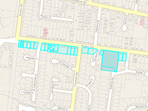
Stage |
Status |
Description |
Date |
|---|---|---|---|
Approval to prepare scheme |
✓ |
Decision made to prepare scheme following consideration of surveys of residents and feedback from the community via informal survey. Council may then place the project in the budget system or proceed immediately to prepare a scheme. Scheme preparation involves survey, design and preparation of an apportionment of costs. |
24/06/2014 |
Intention to Declare Scheme |
✓ |
Report to Council providing information on scheme including advice of impending advertising of scheme and declaration of charge. Seeks Council approval by resolution to proceed with process. |
15/03/2016 |
Advertisement |
✓ |
The scheme is advertised in the local newspaper and all allotted property owners are notified by mail. This advertisement indicates Council’s intention and notification to ‘declare’ a scheme in a month’s time. |
26/03/2016 |
Submissions |
✓ |
From the time of advertising property owners have 28 days (as set down by the Local Government Act) to lodge submissions, either in support or opposition to the scheme. |
22/04/2016 |
Submissions Review Panel Hearing |
✓ |
A Submissions Review Panel is convened and meets to consider submissions. Some submissions are written only, and other submitters may wish to be heard before the Panel. The Panel makes a recommendation to Council regarding the scheme. |
07/09/2016 |
Declaration Report |
✓ |
Any time 28 days after advertising the scheme and after the Submissions Review Panel has met and considered submissions, Council considers a report and may proceed to “declare” the charges in accordance with its advertised intent. Subsequent to this the Finance Manager issues the levy notices and there is a formal charge placed on the property. This is the final step in the process for Council to make a decision on the scheme. |
28/02/2017 |
Appeal |
N/A |
Property owners may lodge an application for review with the Victorian Civil and Administrative Tribunal (VCAT) within one month of issue of the levy notice. An appeal is listed, heard and determined by the Tribunal and this process generally takes three to four months. Decisions made by VCAT are binding on all parties. |
N/A |
Construction |
✓ |
Council may then proceed to construct the works. Invoices are issued seeking payment of the estimated cost within one month of commencement. |
2018-2019 |
Final Cost Report |
✓ |
At the completion of the works the scheme is “finalised” taking into account actual costs incurred and payments are adjusted accordingly. |
September 2020 |
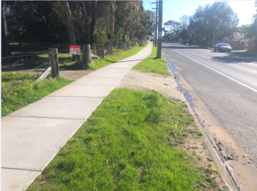
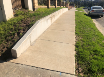
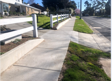
Source: |
City Services – Engineering Services |
Director: |
Guy Wilson-Browne |
Portfolio: |
Transport and Connections |
This report seeks a resolution by Council to declare a Special Charge Scheme to partially fund the construction of road sealing and kerb and channel at No. 122 to No. 155 Tower Road and No. 110 to No. 128 Sproat Street, Portarlington.
The proposed road construction works have been developed in response to several residents requesting the sealing of the unsealed section of Tower Road recognising the demand for improved transport infrastructure, to complement recent land development, address road safety and limit impacts from dust to the adjacent properties.
Council resolved its intention to declare a Special Charge Scheme at its meeting of 12 May 2020. A public notice, letters to all affected property owners and an online information portal were completed containing all pertinent scheme information.
The scheme has been separated into three project components at a total cost of $382,842.00.
Project 1 – construction of sealed road in Tower Road $199,650.00;
Project 2 – construction of kerb and channel in Tower Road $87,966.00; and
Project 3 – construction of kerb and channel in Sproat Street $95,226.00.
Estimated proposed contributions from property owners is $86,659.15 (22.64%) based on an apportionment of cost, with Council’s contribution estimated at $296,182.84 (77.36%). The estimated cost and apportionment are shown in Attachment 4 -
Schedule C.
No formal submissions were received in relation to the proposed charge. Should Council declare the scheme, there is an opportunity for submissions to be sent to the Victorian Civil and Administrative Tribunal (VCAT) for further consideration and determination.
Councillor Mason moved, Councillor Aitken seconded -
That Council:
Resolves to declare the Special Charge Scheme as follows:
The special charge is declared for a period of five years commencing at the start of construction; and
The special charge be declared for the purpose of defraying expenses incurred by Council in relation to road construction, being pavement works, sealing of the road, construction of kerb and channel and ancillary works at No. 122 to No. 155 Tower Road and No. 110 to No. 128 Sproat Street, Portarlington.
The total cost of scheme be recorded as $382,842.00 made up of:
Project 1 - $199,650.00 for No. 122 to No. 155 Tower Road (road seal);
Project 2 - $87,966.00 for No. 122 to No. 155 Tower Road (kerb & channel); and
Project 3 - $95,226.00 for No. 110 to No. 128 Sproat Street (kerb & channel).
(Refer to Attachment 2 – Schedule A).
For the purposes of Section 163 (2A) of Local Government Act 1989 (the Act), the special charge proceeds will not exceed the amount calculated in accordance with the prescribed formula (R x C = S), where the:
‘Benefit ratio’ (R) being calculated at:
1. R1 = 0.221 for Project 1;
2. R2 = 0.220 for Project 2; and
3. R3 = 0.244 for Project 3.
for the special benefits to all persons liable to pay the special charge (Refer to Attachment 2 – Schedule B).
‘Total cost’ (C) of performing the function described in this resolution based on estimated cost be recorded as $382,842.00 made up of:
1. C1 = $199,650.00 for Project 1;
2. C2 = $87,966.00 for Project 2; and
3. C3 = $95,226.00 for Project 3.
'Maximum levy’ (S) be recorded as $86,659.15 (Refer to Attachment 3 – Schedule B) with:
1. S1 of $44,041.24 for Project 1;
2. S2 of $19,382.77 for Project 2; and
3. S3 of $23,235.14 for Project 3.
The following be specified as the area for which the special charge is so declared:
The area within municipal district of Council highlighted in the plan attached to this resolution (Refer to Attachment 5).
The following be specified as the land in relation to which the special charge so declared:
Land within the area shown on the plan (Refer to Attachment 5).
The following be specified as the criteria which form the basis of the special charge so declared:
Ownership of any land described in this Resolution.
The following be specified as the way the special charge so declared will be assessed and levied:
The property receives an access and amenity benefit;
The maximum levy includes an access and amenity benefit; and
The special charge will be levied by sending a notice to the person who is liable to pay, pursuant to section 163(4) of the Act.
Having regard to the preceding parts of this resolution but subject to Section 166 (1) of the Act, that;
the owner of the land described in column 1 and column 2 of Attachment 4 – Schedule C into the resolution is liable for the estimated amount set out in column 6 of Attachment 4 – Schedule C; and
the owner may, subject to any further resolution of Council pay the special charge in the following manner:
1. the charge will become due and payable within one month of the issue of the notice requesting payment pursuant to Section 167 (3) of the Act;
2. interest will not be charged for six (6) months after the issue of the notice provided the person liable makes timely payment in accordance with any repayment arrangements that may be agreed on by Council; and
3. in accordance with Section 172 of the Act, the interest rate payable on the special charge which has not been paid by the specific date is set at Council’s overdraft rate, reviewed every three months (provided that it shall not exceed the rate fixed by the Governor in Council by Order for the purposes of Section 172 (2A) in which case the rate of interest shall be the maximum rate fixed by the Governor in Council by Order for the purposes of this section).
Authorise Council’s Chief Executive Officer or delegated authority to levy the special charge in accordance with Section 163(4) of the Act.
Carried.
Proposed contributions from property owners and Council are set out in the table below:
|
Project 1 |
Project 2 |
Project 3 |
Total |
Property Owner Contributions |
$44,041.24 |
$19,382.77 |
$23,235.14 |
$86,659.15 |
Council Contribution |
$155,608.76 |
$68,583.23 |
$71,990.86 |
$296,182.85 |
Total |
$199,650.00 |
$87,966.00 |
$95,226.00 |
$382,842.00 |
Proposed contributions from property owners and Council are based on benefit ratios of 0.221, 0.220 and 0.244 for Project 1, Project 2 and Project 3 of the scheme respectively and are calculated as shown in Attachment 3 – Schedule B.
The Council contribution reflects the wider community benefit and the costs associated with non-rateable properties.
Funding for construction has been included in the 2020-21 Street Construction Sub-program.
Special charges are the primary source of revenue for Council’s road and footpath construction programs to ensure the ongoing delivery of a range of important transport services to the local community. In times of emergency, such as with the COVID-19 pandemic, it is recognised that significant hardship that can be experienced by the members of the community:
The City will consider an application for financial hardship relief confidentially and objectively based on the information provided by the person in the application and will and advise of its decision in writing after receiving the application and all supporting information.
In 2009 residents of Tower Road were surveyed to gauge support for a road sealing scheme. The results of this survey did not conclusively support a scheme proceeding at that time, with one property owner in favour, four (4) against and five (5) who did not respond.
Since this time and noting the changes with land development and other urbanisation regular feedback has been provided to officers that there is support from the community to reconsider a scheme.
In June 2015 residents living on Tower Road between Alison Road and Sproat Street formed an action group and raised several road safety concerns with the City regarding the road crest, concealed
Requests to improve the road infrastructure is summarised with the following records of communication:
76 requests for service relating to grading and pothole repairs along the unsealed section of Tower Road;
13 requests for dust suppression along the unsealed section of Tower Road;
Seven requests for service for the section of Tower Road to be sealed;
13 letters to residents advising them that the road will be considered for construction under a Special Charge Scheme as part of the City’s forward road construction program;
Several letters received through the local MP’s office on behalf of residents seeking construction, and the City’s response acknowledging the community requests and that a Special Charge Scheme is being considered in future works programs.
In December 2018, three residents campaigned for sealing on this section of Tower Road with one resident noting “there are 13 residences in this part of Tower Road and almost all owners want to see this road sealed as soon as is possible.”
Subsequent to Council’s intention to declare a Special Charge Scheme resolution at its meeting of 12 May 2020:
A Public Notice was placed in the Geelong Advertiser on 13 June 2020 with a copy sent to all affected property owners;
Letters to all affected property owners were sent 9 June 2020 advising of the Intention to Declare and ways of providing feedback under the COVID-19 arrangements; and
An online information portal was established of Council’s website containing all pertinent scheme information.
No submissions were received during the 28-day submission period following the advertisement of the Public Notice which closed on 10 July 2020:
During the 28-day period, officers received informal enquiries regarding the apportionment of scheme cost, response were provided.
Further correspondence will be sent to all affected property owners following Council’s decision on the declaration:
Should Council resolve to declare the charges, all property owners have a right of appeal to VCAT. This information is included in the Levy Notice which is sent. Should VCAT confirm the scheme, Council is cleared to proceed to construction.
The Special Charge Scheme process is described in Attachment 6.
The provision of properly sealed and drained roadways is aligned to the Council Plan and provides improved amenity, connectivity and safety for motorists and pedestrians.
Council is not required to levy a special rate or charge on any or every property that will receive a special benefit. A property with a special benefit may be excluded from the scheme for any of the following reasons:
Council is unable to levy a special charge on the property;
The owner of the property has already contributed to the costs of the works through a development levy;
Council considers that there are advantages for the municipality in excluding the property from the scheme;
Council considers that the special benefits for the property are marginal and would not warrant including the property in the scheme; or
Any other reason that Council considers appropriate.
The scheme has been prepared in accordance with the Special Rate and Charge provisions of the Local Government Act 1989 including the 2004 Ministerial Guideline and Council’s Special Rates and Charges Policy and Community Engagement Guidelines.
These works primarily align with the Council Plan principle of Integrated Transport Connections and key priority to improve our road management and engagement program:
These works also directly respond to the Council Plan action to implement a Council program of infrastructure upgrades including streets, roads and drains.
Other connections to the Council Plan include:
An investment into sustainable infrastructure for the Portarlington community, reducing operation and maintenance liability; and
Encourages use of active transport, such as cycling and walking due to the road construction creating a safer public space.
No Council Officer involved with this process has declared any direct or indirect interest in the properties included in the scheme.
Construction of the unsealed section of Tower Road will provide safer driving conditions for motorists with a defined and more standard road profile. The improved drainage with kerb and channel on both Tower Road and Sproat Street will reduce the hazards associated with water over roads and the effects of nuisance flooding.
No significant vegetation removal will be required to complete the project.
Council will encourage the use of recycled materials for the project construction.
ITEM |
DESCRIPTION |
QUANTITY |
UNIT |
RATE |
AMOUNT |
Scheme Split |
Seal |
K&C |
|---|---|---|---|---|---|---|---|---|
1.00 |
GENERAL |
|
|
|
|
|
|
|
1.01 |
Initial site establishment and set up, decamping and site clean-up and other fixed costs up to time of completion of works. |
|
Item |
|
$24,000.00 |
Both |
$12,000.00 |
$12,000.00 |
1.02 |
Traffic management costs. |
|
Item |
|
$16,000.00 |
Seal |
$16,000.00 |
$0.00 |
1.03 |
Setting out of works. |
|
Item |
|
$1,000.00 |
Both |
$500.00 |
$500.00 |
1.04 |
Service / Cable locations |
|
Item |
|
$700.00 |
Both |
$350.00 |
$350.00 |
1.05 |
Internal supervision fee (COGG construction) |
|
Item |
|
$5,000.00 |
Both |
$2,500.00 |
$2,500.00 |
2.00 |
EARTHWORKS & DEMOLITION |
|
|
|
|
|
|
|
2.01 |
Excavation and disposal of all materials to limits of work as indicated on plan, including trimming for new road pavement, excavation of soft spots and removal of concrete. |
110 |
cubic metres |
$60.00 |
$6,600.00 |
Seal |
$6,600.00 |
$0.00 |
2.02 |
Placement and consolidation of engineered fill with approved materials in preparation for new works. |
270 |
cubic metres |
$60.00 |
$16,200.00 |
Seal |
$16,200.00 |
$0.00 |
2.03 |
Trimming / Removal and disposal of trees. |
|
Item |
|
|
Seal |
$0.00 |
$0.00 |
3.00 |
PAVEMENT WORKS |
|
|
|
|
|
|
|
3.01 |
150 millimetres compacted depth Class 3 40 millimetres crushed rock, supplied, spread and compacted. |
250 |
cubic metre |
$100.00 |
$25,000.00 |
Seal |
$25,000.00 |
$0.00 |
3.02 |
150 millimetres compacted depth Class 2 20 millimetres crushed rock, supplied, spread and compacted. |
250 |
cubic metre |
$120.00 |
$30,000.00 |
Seal |
$30,000.00 |
$0.00 |
3.05 |
30 millimetres compacted depth 10 millimetres nominal size type N Asphalt spread and compacted including emulsion prime & grit using a paver. |
1635 |
square metre |
$35.00 |
$57,225.00 |
Seal |
$57,225.00 |
$0.00 |
6.00 |
DRAINAGE |
|
|
|
|
|
|
|
|
PIPES |
|
|
|
|
|
|
|
6.01 |
Connect existing household storm water to kerb and channel. Including excavation, supply and placement of kerb adapters. |
6 |
No. |
$250.00 |
$1,500.00 |
K&C |
$0.00 |
$1,500.00 |
6.02 |
100 millimetres dia Sub-Soil drains including excavation, supply, placement and provision of approved backfill. |
230 |
metre |
$48.00 |
$11,040.00 |
K&C |
$0.00 |
$11,040.00 |
|
PITS: SEP |
|
|
|
|
|
|
|
6.03 |
Modify existing pit to match finished surface level and supply and fit Gatic type cover. |
1 |
No. |
$775.00 |
$775.00 |
K&C |
$0.00 |
$775.00 |
7.00 |
CONCRETE WORKS: |
|
|
|
|
|
|
|
|
KERBING |
|
|
|
|
|
|
|
7.01 |
B2 Barrier kerb and channel 450 millimetres wide, including fine crushed rock bedding. |
231 |
metre |
$140.00 |
$32,340.00 |
K&C |
$0.00 |
$32,340.00 |
7.02 |
Concrete layback for vehicle crossing 3m wide, including bedding & formwork. |
16 |
No. |
$300.00 |
$4,800.00 |
K&C |
$0.00 |
$4,800.00 |
8.00 |
LANDSCAPING |
|
|
|
|
|
|
|
8.01 |
Top soiling and seeding nature strips, medians and outer separators. |
500 |
square metre |
$15.00 |
$7,500.00 |
K&C |
$0.00 |
$7,500.00 |
SUB-TOTAL: A |
$239,680.00 |
|
$166,375.00 |
$73,305.00 |
||||
10.00 |
PROVISIONAL ITEMS |
|
|
|
|
|
|
|
10.01 |
Alteration to private Water supply. |
|
No |
|
$0.00 |
|
$0.00 |
$0.00 |
10.02 |
Alteration to private Gas supply. |
|
No |
|
$0.00 |
|
$0.00 |
$0.00 |
SUB-TOTAL: B |
$$0 |
$ |
$$0 |
$$0 |
||||
SUB-TOTAL: C (=A+B) |
$239,680.00 |
$ |
$166,375.00 |
$73,305.00 |
||||
20% DESIGN, ADMINSITRATION AND CONTINGENCY: D |
$47,936.00 |
|
$33,275.00 |
$14,661.00 |
||||
CONSTRUCTION COST ESTIMATE: E (=C+D) |
$287,616.00 |
|
$199,650.00 |
$87,966.00 |
||||
ITEM |
DESCRIPTION |
QUANTITY |
UNIT |
RATE |
AMOUNT |
|---|---|---|---|---|---|
1.00 |
GENERAL |
|
|
|
|
1.01 |
Initial site establishment and set up, decamping and site clean-up and other fixed costs up to time of completion of works. |
|
Item |
|
$6,500.00 |
1.02 |
Traffic management costs. |
|
Item |
|
$5,000.00 |
1.03 |
Setting out of works. |
|
Item |
|
$1,000.00 |
1.04 |
Service / Cable locations |
|
Item |
|
$700.00 |
1.05 |
Internal supervision fee (COGG construction) |
|
Item |
|
$2,000.00 |
2.00 |
EARTHWORKS & DEMOLITION |
|
|
|
|
2.01 |
Excavation and disposal of all materials to limits of work as indicated on plan, including trimming for new road pavement, excavation of soft spots and removal of concrete. |
50 |
cubic metre |
$60.00 |
$3,000.00 |
2.02 |
Placement and consolidation of engineered fill with approved materials in preparation for new works. |
50 |
cubic metre |
$60.00 |
|
3.00 |
PAVEMENT WORKS |
|
|
|
|
3.01 |
150 millimetres compacted depth Class 3 40 millimetres crushed rock, supplied, spread and compacted. |
20 |
cubic metre |
$100.00 |
$2,000.00 |
3.02 |
150 millimetres compacted depth Class 2 20 millimetres crushed rock, supplied, spread and compacted. |
20 |
cubic metre |
$120.00 |
$2,400.00 |
3.05 |
30 millimetres compacted depth 10 millimetres nominal size type N Asphalt spread and compacted including emulsion prime & grit using a paver. |
132 |
square metre |
$35.00 |
$4,620.00 |
6.00 |
DRAINAGE |
|
|
|
|
|
PIPES |
|
|
|
|
6.01 |
Connect existing household storm water to kerb and channel. Including excavation, supply and placement of kerb adapters. |
10 |
No. |
$250.00 |
$2,500.00 |
6.02 |
100 millimetres dia Sub-Soil drains including excavation, supply, placement and provision of approved backfill. |
220 |
metre |
$48.00 |
$10,560.00 |
|
PITS: SEP |
|
|
|
|
6.03 |
Modify existing pit to match finished surface level and supply and fit Gatic type cover. |
1 |
No. |
$775.00 |
$775.00 |
7.00 |
CONCRETE WORKS: |
|
|
|
|
|
KERBING |
|
|
|
|
7.01 |
B2 Barrier kerb and channel 450 millimetres wide, including fine crushed rock bedding. |
220 |
metre |
$140.00 |
$30,800.00 |
7.02 |
Concrete layback for vehicle crossing 3m wide, including bedding & formwork. |
10 |
No. |
$300.00 |
$3,000.00 |
8.00 |
LANDSCAPING |
|
|
|
|
8.01 |
Top soiling and seeding nature strips, medians and outer separators. |
100 |
square metre |
$15.00 |
$1,500.00 |
SUB-TOTAL: A |
$79,355.00 |
||||
10.00 |
PROVISIONAL ITEMS |
|
|
|
|
10.01 |
Alteration to private Water supply. |
|
No |
|
$0.00 |
10.02 |
Alteration to private Gas supply. |
|
No |
|
$0.00 |
SUB-TOTAL: B |
$0 |
||||
SUB-TOTAL: C (=A+B) |
$79,355.00 |
||||
20% DESIGN, ADMINSITRATION AND CONTINGENCY: D |
$15,871.00 |
||||
CONSTRUCTION COST ESTIMATE: E (=C+D) |
$95,226.00 |
||||
A |
Purpose |
|||||||
|
To seal Tower Road Portarlington abutting properties from #129 to Sproat St. |
|
||||||
B |
Coherence |
|||||||
|
The works will provide a physical connection between #129 Tower Road and Sproat St, Portarlington and will provide a special benefit to adjoining and adjacent properties. |
|
||||||
C |
Total Cost C |
|||||||
|
Total Estimated cost of works |
|
||||||
|
|
|
|
|
TOTAL COST |
C1 |
$199,650.00 |
|
D |
Identify Special Beneficiaries |
|||||||
|
16 properties with frontage to the road are considered to receive a combination of access and amenity benefits. |
|||||||
E |
Estimate of Total Special Benefits out of the scheme -TSB (out) |
|||||||
|
There are two land parcels which are fully non-rateable that are considered to receive special benefit but are not included in the scheme. |
|
||||||
|
Properties Excluded |
TSB (out) = |
2 |
BU |
|
|
||
F |
Estimate of Total Special Benefits in the scheme - TSB (in) |
|||||||
|
The total benefits to each property are represented in terms of Benefit Units (BU). The construction of Tower Road is considered to provide special benefit to the abutting properties in terms of access (1.0BU) and amenity(1.0BU). Not all properties receive a full benefit. There are 16 allotments receiving benefit 14 calculated as Access BU and 15 as Amenity BU for a total of 29 BU. |
|
||||||
|
Properties Included |
TSB (in) = |
29.00 |
BU |
|
|
||
G |
Estimate of Total Community Benefit -TCB |
|||||||
|
The community will receive a benefit from the works as the roads are used to access other areas. From current traffic counts the estimated use of the road is 77.6% for the wider community and 22.4% for the affected property owners.
|
|
||||||
|
TCB = (Total Benefits (29) / 0.224) X 0.776 = |
|
|
|
||||
|
|
|
|
TCB = |
100.46 |
BU |
|
|
H |
Calculate "Benefit Ratio" - R |
|||||||
|
Benefits Ratio = |
TSB (in) = |
29 |
R1 |
0.221 |
|||
|
|
|
TSB (in) + |
TSB (out) + TCB |
29 + 2 + 100.46 |
|
||
I |
Maximum Total Levy (S) |
|||||||
|
Maximum Total Levy (S = R X C) |
|
|
|
S1 |
$44,041.24 |
||
|
Council Contribution to Special Charge Scheme |
|
|
$155,608.76 |
||||
A |
Purpose |
|||||||||||||
|
To construct kerb and drainage in Tower Road Portarlington abutting properties from #131 to Sproat St. |
|
||||||||||||
B |
Coherence |
|||||||||||||
|
The works will provide a physical connection of kerb and road/property drainage between #131 Tower Road and Sproat St, Portarlington and will provide a special benefit to adjoining and adjacent properties. |
|
||||||||||||
C |
Total Cost C |
|
|
|
|
|
|
|||||||
|
Total Estimated cost of works |
|
|
|
|
|
||||||||
|
|
|
|
|
TOTAL COST |
C2 |
$87,966.00 |
|||||||
D |
Identify Special Beneficiaries |
|||||||||||||
|
14 properties with frontage to the road are considered to receive amenity benefits. |
|
||||||||||||
E |
Estimate of Total Special Benefits out of the scheme -TSB (out) |
|
|
|||||||||||
|
There is one (1) land parcels which are fully non-rateable that are considered to receive special benefit but are out of the scheme. |
|
||||||||||||
|
Properties Excluded |
TSB (out) = |
1 |
BU |
|
|
||||||||
F |
Estimate of Total Special Benefits in the scheme - TSB (in) |
|
|
|
||||||||||
|
The total benefits to each property are represented in terms of Benefit Units (BU). The construction of kerb and channel and ancillary works (i.e. drainage) in Tower Road is considered to provide special benefit to the abutting properties in terms of amenity (1.0BU). There are 14 allotments receiving amenity benefits from the scheme at a total of 13.5 BU. |
|
||||||||||||
|
Properties Included |
TSB (in) = |
13.5 |
BU |
|
|
||||||||
G |
Estimate of Total Community Benefit -TCB |
|
|
|
|
|||||||||
|
The community will receive a benefit from the works as the roads are used to access other areas. From current traffic counts the estimated use of the road is 77.6% for the wider community and 22.4% for the affected property owners.
|
|
||||||||||||
|
TCB = (Total Amenity Benefits (13.5) / 0.224) X 0.776 = |
|
|
|
|
|||||||||
|
|
|
|
TCB = |
46.77 |
BU |
|
|
||||||
H |
Calculate "Benefit Ratio" - R |
|
|
|
|
|
||||||||
|
Benefits Ratio = |
TSB (in) = |
13.5 |
R2 |
0.220 |
|||||||||
|
|
|
TSB (in) + |
TSB (out) + TCB |
13.5 + 1 + 46.77 |
|
||||||||
I |
Maximum Total Levy (S) |
|||||||||||||
|
Maximum Total Levy (S = R X C) |
S2 |
$19,382.77 |
|||||||||||
|
Council Contribution to Special Charge Scheme |
|
$68,583.23 |
|||||||||||
A |
Purpose |
|||||||
|
To construct kerb and drainage in Sproat Street Portarlington abutting properties from #110 to #128. |
|
||||||
B |
Coherence |
|
||||||
|
The works will provide a physical connection of kerb and road/property drainage between #110 to #128 Sproat St, Portarlington and will provide a special benefit to adjoining and adjacent properties. |
|
||||||
C |
Total Cost C |
|
||||||
|
Total Estimated cost of works |
|
||||||
|
|
|
|
TOTAL COST |
C3 |
$95,226.00 |
||
D |
Identify Special Beneficiaries |
|
||||||
|
10 properties with frontage to the road are considered to receive amenity benefits. |
|
||||||
E |
Estimate of Total Special Benefits out of the scheme -TSB (out) |
|
||||||
|
There are no parcels of land deemed to receive benefit which are out of the scheme. |
|
||||||
|
Properties Excluded |
TSB (out) = |
0 |
BU |
|
|
||
F |
Estimate of Total Special Benefits in the scheme - TSB (in) |
|
||||||
|
The total benefits to each property are represented in terms of Benefit Units (BU). The construction of kerb and channel and ancillary works (i.e. drainage) in Tower Road is considered to provide special benefit to the abutting properties in terms of amenity(1.0BU). There are 10 allotments receiving benefit from the scheme at a total of 9.0 BU. |
|
||||||
|
Properties Included |
TSB (in) = |
9.0 |
BU |
|
|
||
G |
Estimate of Total Community Benefit -TCB |
|
||||||
|
The community will receive a benefit from the works as the roads are used to access other areas. From current traffic counts the estimated use of the road is 75.6% for the wider community and 24.4% for the affected property owners.
|
|
||||||
|
TCB = (Total Access Benefits (9.0) / 0.244) X 0.756 = |
|
||||||
|
|
|
|
TCB = |
27.89 |
BU |
|
|
H |
Calculate "Benefit Ratio" - R |
|
||||||
|
Benefits Ratio = |
TSB (in) = |
9 |
R3 |
0.244 |
|||
|
|
|
TSB (in) + |
TSB (out) + TCB |
9 + 0 + 27.89 |
|
|
|
I |
Maximum Total Levy (S) |
|
||||||
|
Maximum Total Levy (S = R X C) |
|
|
|
S3 |
$23,235.14 |
||
|
Council Contribution to Special Charge Scheme |
$71,990.86 |
||||||
Prop Key |
Address |
Access |
Amenity |
Total |
Total |
Comments |
|---|---|---|---|---|---|---|
261691 |
155 Tower Road, PORTARLINGTON VIC 3223 |
1.00 |
1.00 |
2.00 |
$3,037.33 |
|
261690 |
153 Tower Road, PORTARLINGTON VIC 3223 |
1.00 |
1.00 |
2.00 |
$3,037.33 |
|
261689 |
151 Tower Road, PORTARLINGTON VIC 3223 |
1.00 |
1.00 |
2.00 |
$3,037.33 |
|
261688 |
149 Tower Road, PORTARLINGTON VIC 3223 |
1.00 |
1.00 |
2.00 |
$3,037.33 |
|
261687 |
147 Tower Road, PORTARLINGTON VIC 3223 |
1.00 |
1.00 |
2.00 |
$3,037.33 |
|
261686 |
145 Tower Road, PORTARLINGTON VIC 3223 |
1.00 |
1.00 |
2.00 |
$3,037.33 |
|
261701 |
122-138 Tower Road, PORTARLINGTON VIC 3223 |
0.00 |
0.50 |
0.50 |
$759.33 |
rural - no formed access from unsealed |
261685 |
143 Tower Road, PORTARLINGTON VIC 3223 |
1.00 |
1.00 |
2.00 |
$3,037.33 |
|
261684 |
141 Tower Road, PORTARLINGTON VIC 3223 |
1.00 |
1.00 |
2.00 |
$3,037.33 |
|
261683 |
139 Tower Road, PORTARLINGTON VIC 3223 |
1.00 |
1.00 |
2.00 |
$3,037.33 |
|
261682 |
137 Tower Road, PORTARLINGTON VIC 3223 |
1.00 |
1.00 |
2.00 |
$3,037.33 |
|
261681 |
135 Tower Road, PORTARLINGTON VIC 3223 |
1.00 |
1.00 |
2.00 |
$3,037.33 |
|
227559 |
140A Tower Road, PORTARLINGTON VIC 3223 |
0.00 |
0.00 |
0.00 |
$0.00 |
Vodafone 1/4 - rateable |
261702 |
140 Tower Road, PORTARLINGTON VIC 3223 |
0.00 |
0.00 |
0.00 |
$0.00 |
Barwon Water - Non-Rateable |
310009 |
140B Tower Road, PORTARLINGTON VIC 3223 |
0.00 |
0.00 |
0.00 |
$0.00 |
Optus 1/4 - rateable |
310010 |
140C Tower Road, PORTARLINGTON VIC 3223 |
0.00 |
0.00 |
0.00 |
$0.00 |
Telstra 1/4 - rateable |
261680 |
133 Tower Road, PORTARLINGTON VIC 3223 |
1.00 |
1.00 |
2.00 |
$3,037.33 |
|
261679 |
131 Tower Road, PORTARLINGTON VIC 3223 |
1.00 |
1.00 |
2.00 |
$3,037.33 |
|
361589 |
129C Tower Road, PORTARLINGTON VIC 3223 |
0.00 |
0.00 |
0.00 |
$0.00 |
Barwon Water - Non-Rateable |
261703 |
142-160 Tower Road, PORTARLINGTON VIC 3223 |
1.00 |
1.00 |
2.00 |
$3,037.33 |
rural - access |
260476 |
128 Sproat Street, PORTARLINGTON VIC 3223 |
0.00 |
0.50 |
0.50 |
$759.33 |
Corner property access from Sproat St |
|
|
14.0 |
15.00 |
29.00 |
$44,041.24 |
|
Prop Key |
Address |
Access |
Amenity |
Total |
Total |
Comments |
|---|---|---|---|---|---|---|
261691 |
155 Tower Road, PORTARLINGTON VIC 3223 |
0.0 |
1.00 |
1.00 |
$1,435.76 |
|
261690 |
153 Tower Road, PORTARLINGTON VIC 3223 |
0.0 |
1.00 |
1.00 |
$1,435.76 |
|
261689 |
151 Tower Road, PORTARLINGTON VIC 3223 |
0.0 |
1.00 |
1.00 |
$1,435.76 |
|
261688 |
149 Tower Road, PORTARLINGTON VIC 3223 |
0.0 |
1.00 |
1.00 |
$1,435.76 |
|
261687 |
147 Tower Road, PORTARLINGTON VIC 3223 |
0.0 |
1.00 |
1.00 |
$1,435.76 |
|
261686 |
145 Tower Road, PORTARLINGTON VIC 3223 |
0.0 |
1.00 |
1.00 |
$1,435.76 |
|
261685 |
143 Tower Road, PORTARLINGTON VIC 3223 |
0.0 |
1.00 |
1.00 |
$1,435.76 |
|
261684 |
141 Tower Road, PORTARLINGTON VIC 3223 |
0.0 |
1.00 |
1.00 |
$1,435.76 |
|
261683 |
139 Tower Road, PORTARLINGTON VIC 3223 |
0.0 |
1.00 |
1.00 |
$1,435.76 |
|
261682 |
137 Tower Road, PORTARLINGTON VIC 3223 |
0.0 |
1.00 |
1.00 |
$1,435.76 |
|
261681 |
135 Tower Road, PORTARLINGTON VIC 3223 |
0.0 |
1.00 |
1.00 |
$1,435.76 |
|
261680 |
133 Tower Road, PORTARLINGTON VIC 3223 |
0.0 |
1.00 |
1.00 |
$1,435.76 |
|
261679 |
131 Tower Road, PORTARLINGTON VIC 3223 |
0.0 |
1.00 |
1.00 |
$1,435.76 |
|
361589 |
129C Tower Road, PORTARLINGTON VIC 3223 |
0.0 |
0.00 |
0.00 |
$0.00 |
Barwon Water Non-Rateable |
260476 |
128 Sproat Street, PORTARLINGTON VIC 3223 |
0.0 |
0.50 |
0.50 |
$717.88 |
Corner property |
|
|
0.00 |
13.50 |
13.50 |
$19,382.77 |
|
Prop Key |
Address |
Access |
Amenity |
Total |
Total |
Comments |
|---|---|---|---|---|---|---|
260467 |
110 Sproat Street, PORTARLINGTON VIC 3223 |
0.0 |
0.50 |
0.50 |
$1,290.84 |
Corner property |
260468 |
112 Sproat Street, PORTARLINGTON VIC 3223 |
0.0 |
1.00 |
1.00 |
$2,581.68 |
|
260469 |
114 Sproat Street, PORTARLINGTON VIC 3223 |
0.0 |
1.00 |
1.00 |
$2,581.68 |
|
260470 |
116 Sproat Street, PORTARLINGTON VIC 3223 |
0.0 |
1.00 |
1.00 |
$2,581.68 |
|
260476 |
128 Sproat Street, PORTARLINGTON VIC 3223 |
0.0 |
0.50 |
0.50 |
$1,290.84 |
Corner property |
260475 |
126 Sproat Street, PORTARLINGTON VIC 3223 |
0.0 |
1.00 |
1.00 |
$2,581.68 |
|
260474 |
124 Sproat Street, PORTARLINGTON VIC 3223 |
0.0 |
1.00 |
1.00 |
$2,581.68 |
|
260473 |
122 Sproat Street, PORTARLINGTON VIC 3223 |
0.0 |
1.00 |
1.00 |
$2,581.68 |
|
260472 |
120 Sproat Street, PORTARLINGTON VIC 3223 |
0.0 |
1.00 |
1.00 |
$2,581.68 |
|
260471 |
118 Sproat Street, PORTARLINGTON VIC 3223 |
0.0 |
1.00 |
1.00 |
$2,581.68 |
|
|
|
0.00 |
9.00 |
9.00 |
$23,235.14 |
|
COLUMN 1 |
COLUMN 2 |
COLUMN 3 |
COLUMN 4 |
COLUMN 5 |
COLUMN 6 |
|---|---|---|---|---|---|
Prop Key |
Address |
Tower Road |
Tower Road |
Sproat Street |
TOTAL |
260467 |
110 Sproat Street, PORTARLINGTON VIC 3223 |
$- |
$- |
$1,290.84 |
$1,290.84 |
260468 |
112 Sproat Street, PORTARLINGTON VIC 3223 |
$- |
$- |
$2,581.68 |
$2,581.68 |
260469 |
114 Sproat Street, PORTARLINGTON VIC 3223 |
$- |
$- |
$2,581.68 |
$2,581.68 |
260470 |
116 Sproat Street, PORTARLINGTON VIC 3223 |
$- |
$- |
$2,581.68 |
$2,581.68 |
260471 |
118 Sproat Street, PORTARLINGTON VIC 3223 |
$- |
$- |
$2,581.68 |
$2,581.68 |
260472 |
120 Sproat Street, PORTARLINGTON VIC 3223 |
$- |
$- |
$2,581.68 |
$2,581.68 |
260473 |
122 Sproat Street, PORTARLINGTON VIC 3223 |
$- |
$- |
$2,581.68 |
$2,581.68 |
261701 |
122-138 Tower Road, PORTARLINGTON VIC 3223 |
$759.33 |
$- |
$- |
$759.33 |
260474 |
124 Sproat Street, PORTARLINGTON VIC 3223 |
$- |
$- |
$2,581.68 |
$2,581.68 |
260475 |
126 Sproat Street, PORTARLINGTON VIC 3223 |
$- |
$- |
$2,581.68 |
$2,581.68 |
260476 |
128 Sproat Street, PORTARLINGTON VIC 3223 |
$759.33 |
$717.88 |
$1,290.84 |
$2,768.05 |
361589 |
129C Tower Road, PORTARLINGTON VIC 3223 |
$- |
$- |
$- |
$- |
261679 |
131 Tower Road, PORTARLINGTON VIC 3223 |
$3,037.33 |
$1,435.76 |
$- |
$4,473.09 |
261680 |
133 Tower Road, PORTARLINGTON VIC 3223 |
$3,037.33 |
$1,435.76 |
$- |
$4,473.09 |
261681 |
135 Tower Road, PORTARLINGTON VIC 3223 |
$3,037.33 |
$1,435.76 |
$- |
$4,473.09 |
261682 |
137 Tower Road, PORTARLINGTON VIC 3223 |
$3,037.33 |
$1,435.76 |
$- |
$4,473.09 |
261683 |
139 Tower Road, PORTARLINGTON VIC 3223 |
$3,037.33 |
$1,435.76 |
$- |
$4,473.09 |
261702 |
140 Tower Road, PORTARLINGTON VIC 3223 |
$- |
$- |
$- |
$- |
227559 |
140A Tower Road, PORTARLINGTON VIC 3223 |
$- |
$- |
$- |
$- |
310009 |
140B Tower Road, PORTARLINGTON VIC 3223 |
$- |
$- |
$- |
$- |
310010 |
140C Tower Road, PORTARLINGTON VIC 3223 |
$- |
$- |
$- |
$- |
261684 |
141 Tower Road, PORTARLINGTON VIC 3223 |
$3,037.33 |
$1,435.76 |
$- |
$4,473.09 |
261703 |
142-160 Tower Road, PORTARLINGTON VIC 3223 |
$3,037.33 |
$- |
$- |
$3,037.33 |
261685 |
143 Tower Road, PORTARLINGTON VIC 3223 |
$3,037.33 |
$1,435.76 |
$- |
$4,473.09 |
261686 |
145 Tower Road, PORTARLINGTON VIC 3223 |
$3,037.33 |
$1,435.76 |
$- |
$4,473.09 |
261687 |
147 Tower Road, PORTARLINGTON VIC 3223 |
$3,037.33 |
$1,435.76 |
$- |
$4,473.09 |
261688 |
149 Tower Road, PORTARLINGTON VIC 3223 |
$3,037.33 |
$1,435.76 |
$- |
$4,473.09 |
261689 |
151 Tower Road, PORTARLINGTON VIC 3223 |
$3,037.33 |
$1,435.76 |
$- |
$4,473.09 |
261690 |
153 Tower Road, PORTARLINGTON VIC 3223 |
$3,037.33 |
$1,435.76 |
$- |
$4,473.09 |
261691 |
155 Tower Road, PORTARLINGTON VIC 3223 |
$3,037.33 |
$1,435.76 |
$- |
$4,473.09 |
Totals |
$44,041.24 |
$19,382.77 |
$23,235.14 |
$86,659.15 |
|
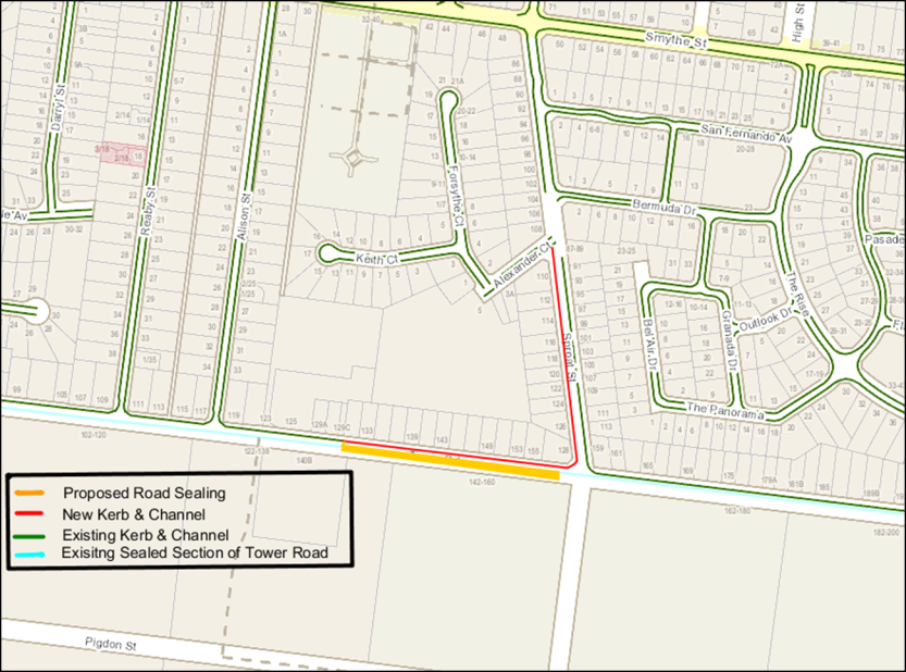
Stage |
Status |
Description |
|---|---|---|
Approval to prepare scheme |
✓ |
Decision made to prepare scheme following consideration of surveys of residents and feedback from the community via informal survey. Council may then place the project in the budget system or proceed immediately to prepare a scheme. Scheme preparation involves survey, design and preparation of an apportionment of costs. 2017 |
Intention to Declare Scheme |
✓ |
Report to Council providing information on scheme including advice of impending advertising of scheme and declaration of charge. Seeks Council approval by resolution to proceed with process. Carried 12 May 2020. |
Advertisement |
✓ |
The scheme is advertised in the local newspaper and all allotted property owners are notified by mail. This advertisement indicates Council’s intention and notification to ‘declare’ a scheme in a month’s time. Advertised 13 June 2020. |
Submissions |
✓ |
From the time of advertising property owners have 28 days (as set down by the Local Government Act) to lodge submissions, either in support or opposition to the scheme. Submissions closed 10 July 2020. |
Submissions Review Panel Hearing |
n/a |
A Submissions Review Panel is convened (quorum of three Councillors) and meets to consider submissions. Some submissions are written only, and other submitters may wish to be heard before the Panel. The Panel makes a recommendation to Council regarding the scheme. No submissions received. |
Declaration Report |
✓ |
Any time 28 days after advertising the scheme and after the Submissions Review Panel has met and considered submissions, Council considers a report and may proceed to “declare” the charges in accordance with its advertised intent. Subsequent to this the Finance Manager issues the levy notices and there is a formal charge placed on the property. This is the final step in the process for Council to decide on the scheme. |
Appeal |
|
Property owners may lodge an application for review with the Victorian Civil and Administrative Tribunal (VCAT) within one month of issue of the levy notice. An appeal is listed, heard and determined by the Tribunal and this process generally takes three to four months. Decisions made by VCAT are binding on all parties. |
Construction |
|
Council may then proceed to construct the works. Invoices are issued seeking payment of the estimated cost within one month of commencement. |
Source: |
City Services – Engineering Services |
Director: |
Guy Wilson-Browne |
Portfolio: |
Parks, Gardens and City Services |
To revoke Council’s designation of 26 October 2004 of flood affected land at Lara Central Estate, Stage 8 as liable to flooding pursuant to regulation 153 of the Building Regulations 2018.
Council has a statutory obligation under the Building Regulations 2018 to designate land as liable to flooding where it reasonably knows it to be prone to flooding. Conversely, there is an obligation to remove the encumbrance of designation from land that is no longer considered to be flood-prone.
The current designated flood mapping (Attachment 2) was designated by Council at its meeting of 26 October 2004.
The flood mapping is subject to a revision due to the subdivision and development at Flinders Avenue, Lara. Prior to subdivision the parent lot was liable to flooding. This development site, which is also known as Lara Central Estate, Stage 8 achieves flood immunity for newly created lots for flood events up to and including the 100 year Average Recurrence Interval (ARI) event due to approved internal earthworks.
The recommendation by Council engineers that the flood prone status can be removed includes assessment of internal drainage, road construction and earthworks to contain potential floodwaters from the 100-year ARI event within road and drainage reserves (Attachment 3).
It should be noted that designation is separate to the creation of flood overlays within the Planning Scheme, which generally follows designation. In the case of this development, the planning scheme amendment to create post-development flood zones or overlays is proposed after the design of the proposed precincts.
Councillor Grzybek moved, Councillor Aitken seconded -
That Council revoke the Council designation of 26 October 2004 of flood affected land at Lara Central Estate Stage 8 as liable to flooding pursuant to regulation 153 of the Building Regulations 2018.
Carried.
There are no financial implications arising from the subject of this report.
A revocation of designation does not warrant public consultation as it constitutes the removal of an encumbrance on land.
Relevant City databases and flood maps will be revised and updates sent to the Corangamite Catchment Management Authority and Building Control Commission.
Council have a responsibility to the community to provide the best possible information on areas that are flood prone. The removal of flood prone designation allows owners to build on their land without a special permit from the City, and without raising the floor level of their home. It also reduces the cost of property insurance.
The City has various statutory responsibilities for drainage management and flood management (prevention, response and recovery) as set out in the Local Government Act 1989, Local Government Regulations 1990, Planning and Environment Act 1987, Building Regulations 2018, Water Act 1989, Subdivision Act 1988 and Emergency Management Act 1986.
The works have resulted in the lots being protected from flooding during a major storm event that has a one per cent probability of occurring in any one year and occurs on average once in 100 years. This is the required standard for new subdivisions.
The recommendations of this report are consistent with the Council Plan, in relation to planned sustainable development.
No City officers or contractors who have provided advice in relation to this report have declared a conflict of interest regarding the matter under consideration.
Council also has some risk exposure with any failure to disclose the flood-prone status of a property in a Land Information Certificate.
The revocation of the designation is the final step in minimising Council’s risk.
The revocation of flood-prone areas designation and designation of revised flood data through the design of this stage is considered unlikely to result in any known adverse environmental impacts.
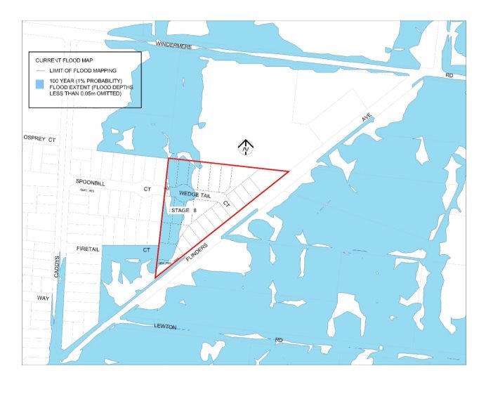
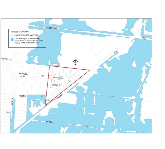
Source: |
City Services – Engineering Services |
Director: |
Guy Wilson-Browne |
Portfolio: |
Parks, Gardens and City Services |
To revoke Council’s designation of 12 December 2006 of flood affected land at Armstrong Estate, Stages 45 and 54 as liable to flooding pursuant to regulation 153 of the Building Regulations 2018.
Council has a statutory obligation under the Building Regulations 2018 to designate land as liable to flooding where it reasonably knows it to be prone to flooding. Conversely, there is an obligation to remove the encumbrance of designation from land that is no longer considered to be flood-prone.
The current designated flood mappings (Attachment 2 and Attachment 3) were designated by Council at its meeting of 12 December 2006.
This revocation will result in another stage of new lots in Armstrong Estate fronting Airport and Whites Road being free of their flood prone status, paving the way for owners to build homes on their land.
The flood mapping is subject to a revision due to the subdivision and development at 60 Airport Road and 52-86 Whites Road, Mount Duneed. Prior to subdivision the parent lot was considered to be liable to flooding. This development site, which is also known as Armstrong Estate, Stages 45 and 54 and achieves flood immunity for newly created lots for flood events up to and including the 100 year Average Recurrence Interval (ARI) event due to approved internal earthworks.
The recommendation by Council engineers that the flood prone status can be removed includes assessment of internal drainage, road construction and earthworks to contain potential floodwaters from the 100 year ARI event within road and drainage reserves (Attachment 4 and Attachment 5).
It should be noted that designation is separate to the creation of flood overlays within the Planning Scheme, which generally follows designation. In the case of this development, the planning scheme amendment to create post-development flood zones or overlays is proposed after the design of the proposed precincts.
Councillor Murnane moved, Councillor Nelson seconded -
That Council revoke the Council designation of 12 December 2006 of flood affected land at Armstrong Estate, Stages 45 and 54 as liable to flooding pursuant to regulation 153 of the Building Regulations 2018.
Carried.
There are no financial implications arising from the subject of this report.
A revocation of designation does not warrant public consultation as it constitutes the removal of an encumbrance on land.
Relevant City databases and flood maps will be revised and updates sent to the Corangamite Catchment Management Authority and Building Control Commission.
Council have a responsibility to the community to provide the best possible information on areas that are flood prone. The removal of flood prone designation allows owners to build on their land without a special permit from the City, and without raising the floor level of their home. It also reduces the cost of property insurance.
The City has various statutory responsibilities for drainage management and flood management (prevention, response and recovery) as set out in the Local Government Act 1989, Local Government Regulations 1990, Planning and Environment Act 1987, Building Regulations 2018, Water Act 1989, Subdivision Act 1988 and Emergency Management Act 1986.
The works have resulted in the lots being protected from flooding during a major storm event that has a one per cent probability of occurring in any one year, and occurs on average once in 100 years. This is the required standard for new subdivisions.
The recommendations of this report are consistent with the Council Plan, in relation to planned sustainable development.
No City officers or contractors who have provided advice in relation to this report have declared a conflict of interest regarding the matter under consideration.
Council also has some risk exposure with any failure to disclose the flood-prone status of a property in a Land Information Certificate.
The revocation of the designation is the final step in minimising Council’s risk.
The revocation of flood-prone areas designation and designation of revised flood data through the design of this stage is considered unlikely to result in any known adverse environmental impacts.
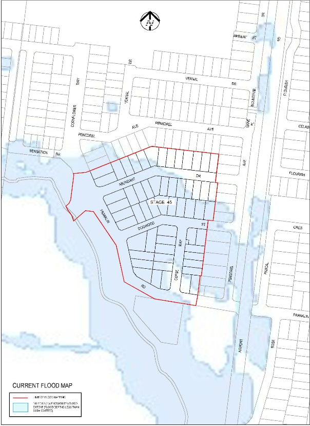
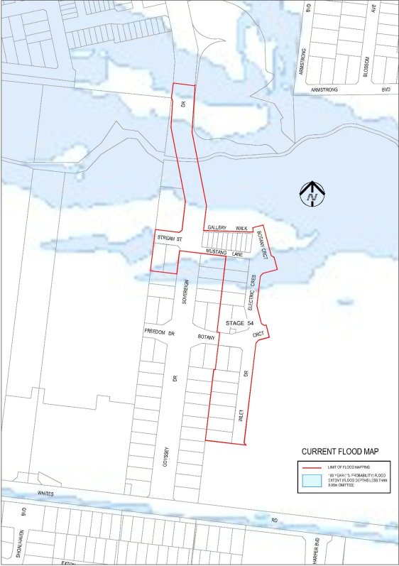
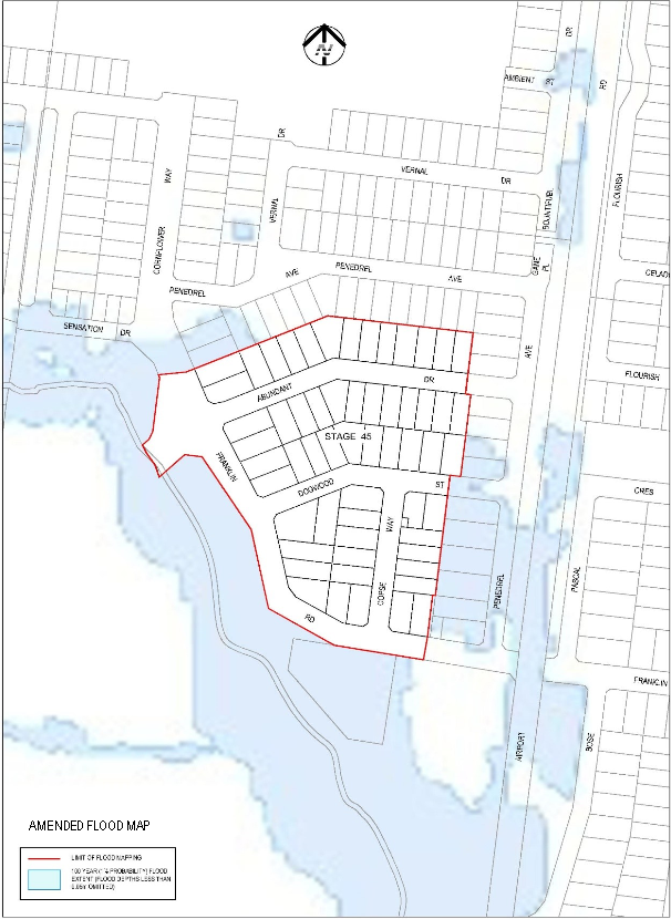
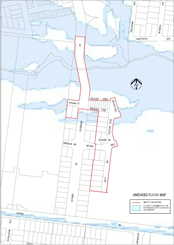
Source: |
City Services – Engineering Services |
Director: |
Guy Wilson-Browne |
Portfolio: |
Parks, Gardens and City Services |
To revoke Council’s designation of 25 March 2003 of flood affected land at Manzeene Village, Stages 8A, 8B and 12 as liable to flooding pursuant to regulation 153 of the Building Regulations 2018.
Council has a statutory obligation under the Building Regulations 2018 to designate land as liable to flooding where it reasonably knows it to be prone to flooding. Conversely, there is an obligation to remove the encumbrance of designation from land that is no longer considered to be flood-prone.
The current designated flood mapping (Attachment 2) was designated by Council at its meeting of 25 March 2003.
This revocation will result in further stage of new lots in Manzeene Village being free of their flood prone status, paving the way for owners to build homes on their land.
The flood mapping is subject to a revision due to the subdivision and development at Manzeene Village, Lara. Prior to subdivision the parent lot was considered to be liable to flooding. This development site, which is also known as Manzeene Village, Stage 8A, 8B and 12 achieves flood immunity for newly created lots for flood events up to and including the 100 year Average Recurrence Interval (ARI) event due to approved internal earthworks.
The recommendation by Council engineers that the flood prone status can be removed includes assessment of internal drainage, road construction and earthworks to contain potential floodwaters from the 100 year ARI event within road and drainage reserves (Attachment 3).
It should be noted that designation is separate to the creation of flood overlays within the Planning Scheme, which generally follows designation. In the case of this development, the planning scheme amendment to create post-development flood zones or overlays is proposed after the design of the proposed precincts.
Councillor Grzybek moved, Councillor Aitken seconded -
That Council revoke the Council designation of 25 March 2003 of flood affected land at Manzeene Village, Stage 8A, 8B and 12 as liable to flooding pursuant to regulation 153 of the Building Regulations 2018.
Carried.
There are no financial implications arising from the subject of this report.
A revocation of designation does not warrant public consultation as it constitutes the removal of an encumbrance on land.
Relevant City databases and flood maps will be revised and updates sent to the Corangamite Catchment Management Authority and Building Control Commission.
Council have a responsibility to the community to provide the best possible information on areas that are flood prone. The removal of flood prone designation allows owners to build on their land without a special permit from the City, and without raising the floor level of their home. It also reduces the cost of property insurance.
The City has various statutory responsibilities for drainage management and flood management (prevention, response and recovery) as set out in the Local Government Act 1989, Local Government Regulations 1990, Planning and Environment Act 1987, Building Regulations 2018, Water Act 1989, Subdivision Act 1988 and Emergency Management Act 1986.
The works have resulted in the lots being protected from flooding during a major storm event that has a one per cent probability of occurring in any one year and occurs on average once in 100 years. This is the required standard for new subdivisions.
The recommendations of this report are consistent with the Council Plan, in relation to planned sustainable development.
No City officers or contractors who have provided advice in relation to this report have declared a conflict of interest regarding the matter under consideration.
Council also has some risk exposure with any failure to disclose the flood-prone status of a property in a Land Information Certificate.
The revocation of the designation is the final step in minimising Council’s risk.
The revocation of flood-prone areas designation and designation of revised flood data through the design of this stage is considered unlikely to result in any known adverse environmental impacts.
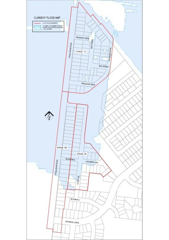
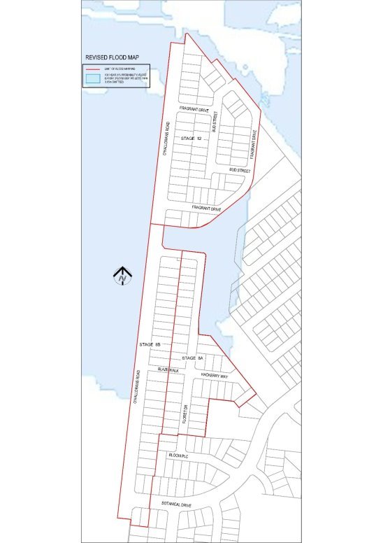
Source: |
Customer & Corporate Services – Property, Procurement and Assets |
Director: |
Michael Dugina |
Portfolio: |
Finance |
To recommend that Council initiate the statutory process for the proposed deviation of approximately 147m2 of Corio Street, Geelong to a new road off Bayley Street, Geelong (as shown in Attachment 3), to enable construction of a carpark entrance off Corio Street to the future Civic Precinct.
The accommodation strategy and the construction of the Civic Precinct at 137 Mercer Street proposes the deviation of part of Corio Street, between Mercer and Gheringhap Streets at the rear of 151 Mercer Street, and the creation of a road from Bayley Street into the Civic Precinct. Attachment 2 shows a detailed location plan of the relevant parcels of land.
Council previously discontinued and purchased another part of Corio Street which was identified as land required for the Civic Precinct development. This occurred in September 2008.
Corio Street is a road on Crown land.
Council has the power under Clause 2 of Schedule 10 of the Local Government Act 1989 (LGA89) to deviate a road, including a road on Crown land. Ministerial consent is required where a road on Crown land is proposed to be deviated onto land which is not Crown land. Ministerial consent will be sought if, after public submissions have been invited and considered, Council resolves to deviate the road.
The proposed deviation is commenced by giving public notice under s223 of LGA89, which invites submissions on the proposed road deviation.
If the deviation process is completed, the deviated portion of Corio Street will vest in Council under section 207B(2A) of LGA89. The newly created road which extends from Bayley Street into the Civic Precinct (located on land owned by Council at 4 Bayley Street), will become a road.
The section of Corio Street which is proposed to be deviated is needed to provide an entrance to a planned underground carpark in the Civic Precinct development. This section, having an area of approximately 147m2 (as shown in Attachment 3), is situated behind 151 Mercer Street, which is owned by Council.
To facilitate the construction of the Civic Precinct development, DELWP has issued a construction licence over that part of Corio Street that is proposed to be deviated. The City has sublicensed the land under the construction licence to Quintessential Equity 047 Pty Ltd (the appointed developer of the Civic Precinct) in order for the necessary development works to be carried out.
The recommendation has been received and noted by the Central Administrative Accommodation Project Advisory Committee (Project Advisory Committee) on 2 September 2020.
Councillor Aitken moved, Councillor Grzybek seconded -
That Council:
Give notice under section 223 of the Local Government Act 1989 of its intention to deviate approximately 147m2 of Corio Street, Geelong to a road off Bayley Street, Geelong as shown in Attachment 3;
Appoint the Submissions Review Panel to hear any submissions if any person wishes to appear in person or be represented by a person specified in support of a submission; and
Note that a further report will be presented to Council to consider the outcomes of the Submissions Review Panel and/or the proposed deviation.
Carried.
There will be nominal costs associated with publishing a public notice in the newspapers and the gazette notice.
There are no additional financial implications in the deviation and submissions process.
The new road construction forms part of the Civic Precinct development and no additional costs will be incurred as a result of this proposal.
A public submissions process under s223 of LGA89 will be required for the proposed deviation outlined in this report. This provides an opportunity for the community to provide its feedback to the Council on the proposed deviation.
There are no adverse social equity impacts created as a result of this road deviation.
Council has the power to deviate a road under Clause 2 of Schedule 10 of LGA89, by notice published in the Government Gazette, subject to obtaining the consent of the Minister for the deviation of a road on Crown land to land that is not Crown land.
A person may make a submission under section 223 of LGA89 on the proposed exercise of the power to deviate a road under Clause 2 of Schedule 10.
Improved Health and Safety – Providing safer public places. As part of the Civic Precinct development, the deviated road will provide greenspace to be incorporated which will be an inclusive and inviting environment for the public and the new road will provide safe service access to the area.
Informed Social Infrastructure and Planning – Maintaining our public open space by providing more accessible public urban space.
Planned Sustainable Development – Managing the impact of development – the development of the Civic Precinct will achieve the highest environmental standards in design, energy, waste and water usage. The development has a six star – green star design. The entrance to the underground carpark is an example of ensuring sensitive design with minimal impact in accordance with the City’s ambition to position Geelong as a leader in innovative and sustainable design.
Leadership, Strategy and Governance - the Civic Precinct will achieve the objectives set out in Council Plan to consolidate the City of Greater Geelong offices into a civic centre accessible to the public in a central location. The underground carpark will assist with the provision of car parking and the entry to such is required to be designed to ensure the purpose is achieved in a sustainable and aesthetic way.
There is no officer conflict of interest, direct or indirect, in the preparation of this report.
The Civic Precinct development has been subject to detailed risk management and it is considered the proposed deviation of the road is a more suitable and required design outcome.
The City’s new office in the Civic Precinct will achieve the highest environmental standards in design, energy, waste and water usage.
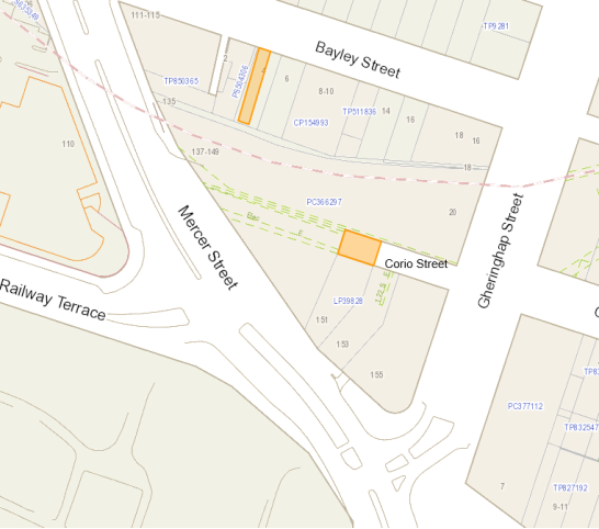
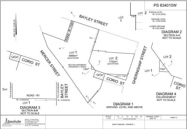
Source: |
Customer & Corporate Services – Civic Accommodation |
Director: |
Michael Dugina |
Portfolio: |
Finance |
To seek Council approval for the City to give public notice of its intention to sell land located at 137 Mercer Street, Geelong marked as Lot 2 on proposed Plan of Subdivision PS834010W (Proposed Lot 2).
In October 2019 Council undertook the statutory process required under section 189 of the Local Government Act 1989 for the proposed sale of land at 137 Mercer Street, Geelong, which was to be sold as part of the development of the Civic Accommodation Precinct. Council resolved to sell that land at its meeting on 26 November 2019. The configuration of the land that was resolved to be sold is shown in the plan in Attachment 2 (Original Configuration).
After final design of the adjacent Council accommodation building and basement area, and the acquisition of adjoining Crown land, it has become necessary to alter the boundaries of the Original Configuration, necessitating a new statutory process for sale of the revised lot. See Attachment 4 for a plan which overlays the previous allotment over the proposed.
A plan showing the configuration of Proposed Lot 2 is contained in Attachment 3. The plan shows Proposed Lot 2 as having an area of 1752m2 at ground level and 10m2 of air space extending upwards commencing from the podium of the building that will be constructed on Proposed Lot 2. The airspace cross section can be seen in diagrams 2 and 4 on the plan in Attachment 3. The airspace cross section hangs over the ground level component of Lot 1 (to be owned by Council). The airspace was also included in the original configuration and plans referred in the development agreement.
Council will be consolidating properties acquired on Bayley Street, Geelong and some of the Crown land recently purchased on the site to create the proposed Lot 1. Proposed Lot 2 also incorporates a small portion of the Crown land (19m2) and land on the western boundary to better accommodate design of Council’s building and basement. Adjustment has been made to the southern boundary to minimise the land size to the actual development parcel, leaving an area of 119m2 that will be retained by Council as part of proposed Lot 1. Prior to the sale of Proposed Lot 2, Council will obtain an independent certified valuation for Proposed Lot 2. The land will not be sold for less than the amount of the independent certified valuation for the land. The sale of lot 2 will fund the acquisition of other parcels in the precinct.
After reconfiguration of the site and assuming the eventual sale of Proposed Lot 2 Council will own 4,788m2 of land in the precinct. This area will increase to 4,935m2 once part of Corio street is closed and acquired. A separate report is to be presented on this matter. Prior to redevelopment and reconfiguration of titles Council owned 4,565m2 so there has been an increase in land holdings of 370m2.
If submissions are received as part of the statutory process, they will be considered by the Council or if requesting to be heard, the Submissions Review Panel will hear the submissions and a further report will be put to Council.
The recommendation has been received and noted by the Central Administrative Accommodation Project Advisory Committee (Project Advisory Committee) on 2 September 2020.
Councillor Harwood moved, Councillor Grzybek seconded -
That Council:
Give notice under section 189 of the Local Government Act 1989 of its intention to sell the land marked Lot 2 on proposed Plan of Subdivision PS834010W, being part of the land at 137 Mercer Street, Geelong;
Appoint the Submissions Review Panel to hear any submission if any person wishes to appear in person or be represented by a person specified in support of a submission; and
Note that a further report will be presented to Council to consider the outcomes of the Submissions Review Panel and/or the sale of the land.
Carried.
The offer to purchase this property was part of the successful negotiated development agreement relative to the establishment of Council’s Civic Accommodation Precinct. The land will only be sold in order to reconfigure the development parcel to realise the best value and approved design outcome for Council. The sale of the land will fund other land acquisitions in the new precinct.
Any person will have an opportunity to make a written submission on the proposed sale under the notice of intention to sell land. A submitter is entitled to request in the submission that the person wishes to appear in person, or to be represented by a person specified in the submission, at a meeting to be heard in support of their submission.
There are no social equity issues associated with this matter.
Section 189 of the Local Government Act 1989 requires that Council must obtain a valuation of the property from a suitably qualified property valuer which is made not more than 6 months prior to the sale and give public notice of its intention to sell the land and consider any submissions received.
Section 223 of the Local Government Act 1989 requires that if any submissions are received, they will be considered by Council and if requested, heard by the Submissions Review Panel followed by a report to Council.
The sale of this property will assist the City in achieving the optimum outcome for its new civic precinct and is required to ensure a proactive approach to management of assets, including land holdings.
No officers or contractors involved in the preparation of this report have a direct or indirect interest in the matters to which this report relates.
No notable risks associated with implementation of the recommendations.
There are no environmental implications to this proposal.
Councillor Harwood moved, Councillor Grzybek seconded -
That in accordance with Section 89 (2) (e) of the Local Government Act 1989, this proposed development matter be considered at the conclusion of all other business at which time the meeting be closed to members of the public.
Carried.
Councillor Harwood moved, Councillor Mason seconded -
That in accordance with Section 89 (2) (d) of the Local Government Act 1989, this contractual matter be considered at the conclusion of all other business at which time the meeting be closed to members of the public.
Carried.
Councillor Murrihy moved, Councillor Harwood seconded -
That in accordance with Section 89 (2) (e) of the Local Government Act 1989, this proposed development matter be considered at the conclusion of all other business at which time the meeting be closed to members of the public.
Carried.
Source: |
Governance, Strategy & Performance – Integrity and Risk |
Director: |
Rebecca Leonard |
Portfolio: |
Leadership and Governance |
Councillor Mason moved, Councillor Grzybek seconded -
That in accordance with Section 89 (2) (h) of the Local Government Act 1989, this matter which the Council considers would prejudice the Council or any person, be considered at the conclusion of all other business at which time the meeting be closed to members of the public.
Carried.
Contents | Previous Page: Section A - Procedural Matters | Next Page: Section C – Confidential