
Council Minutes - Section B: Reports - 10 July 213
Contents | Previous Page: Section A - Procedural Matters | Next Page: Section C - Common Seal Register
Contents | Previous Page: Section A - Procedural Matters | Next Page: Section C - Common Seal Register
Reports tabled at the Ordinary Meeting of Council on Tuesday date held at City Hall, Little Malop Street in Geelong.
Planning Permit Application 1587/2011 for 41-79 Curlewis Road, Curlewis
Belmont Street, Belmont – Proposed Carpark Construction SRC304 – Declaration of Charge
O’Briens Road, Lara – Road Construction SRC317 – Finalisation of Scheme
Cr S Kontelj declared a Conflict of Interest by Close Association in Agenda Item 1, Rippleside – Amendment to Planning Permit, in that his sister has purchased a property in Balmoral Crescent, North Geelong, and left the meeting room at 7:22pm, prior to discussion.
Cr E Kontelj declared a Conflict of Interest by Close Association in Agenda Item 1, Rippleside – Amendment to Planning Permit, in that his sister has purchased a property in Balmoral Crescent, North Geelong, and left the meeting room at 7:22pm, prior to discussion.
Portfolio: |
Planning- Cr Macdonald |
Source: |
Statutory Planning – City Development |
General Manager: |
Peter Bettess |
Index Reference: |
Application 647/2004/B |
Planning Permit 647/04 was issued by the Victorian Civil and Administrative Tribunal (VCAT) on 28 February 2005. This permit has been extended by VCAT and is still valid. The development must now commence by 28 February 2013 and must now be completed within six years of the date of commencement.
The permit allowed the redevelopment of the site with a convenience shop, restricted recreation facility, marina and more than 98 dwellings (178 dwellings).
An application has been made to amend the Planning Permit. As the original Planning Permit was issued by VCAT, it is required to decide upon an amendment to the permit.
VCAT previously directed that the application should be advertised. A number of nearby residents have since become a party to the proceeding.
A hearing to consider the merits of the amendment is scheduled for three days beginning 23 July 2012. The amendment seeks to create a number of super lots which do not strictly accord with the positioning of buildings that were approved in the original permit, but are generally in the positions of these buildings. The amendment would also allow the further subdivision of the super lots into smaller residential sized allotments.
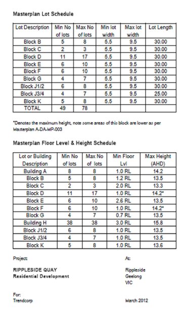
A Masterplan Lot Schedule is proposed to be a restriction on the further subdivision of the land, with the Schedule setting out the minimum/maximum number of lots which can be achieved from each super lot and the minimum/ maximum frontage for each lot
It is also proposed to restrict the height of development which is undertaken on the lots. The height restrictions appear to be designed to reflect the approved development under the original planning permit.
The total number of lots which can be developed on the site will be restricted to 124 lots, with only a single dwelling allowed on each lot.
The site is zoned Comprehensive Development Zone– Schedule 2 (CDZ2) and is subject to an Environmental Audit Overlay (EAO). The purpose of the zone is to encourage the development of the site in a manner which complements and enhances the area. There are two Incorporated Documents referred to in the schedule which inform the development and subdivision of the site.
The purpose of this report is to form Council’s position on the amendment so as to inform Council’s submission to VCAT at the forthcoming hearing.
It is recommended that Council should generally support the application at the forthcoming VCAT hearing subject to the satisfactory resolution of the matters outlined in the Recommendation.
Cr Macdonald moved, Cr Abley seconded -
That the Responsible Authority considers the proposed amendment of Planning Permit 647/2004 is inappropriate based on the following ground:
The subdivision of the super lots into smaller allotments is inappropriate and will result in lots being created which are less than 300 square metres in area and a poor urban design outcome.
The subdivision will unreasonably reduce views beyond what has been approved by Planning Permit 647/04 and the Rippleside Comprehensive Development Plan, 2000.
To ensure a good urban design outcome for the site, an integrated development should be submitted for the site which would allow Council to properly assess views, energy efficiency, urban design and visual appearance and to ensure that the site is developed in a co- manner that complements and enhances the area. The approval of an integrated development for the site will ensure that lots are not created which may be difficult to develop in the future.
It is not appropriate to stage the provision of the Waterside Pedestrian Link.
The proposal is a significant change from that approved and should be a new application rather than an amendment.
Carried.
The site and surrounding area
The Rippleside Shipyard site occupies a 2.8 hectare parcel of reclaimed land that extends out from the escarpment or cliff below Balmoral Crescent. It is located between the beaches of St Helen’s Park to the north and Rippleside Park to the south. Access to the site is provided via Liverpool Street.
The site is currently developed with a number of industrial buildings and sealed areas, with a jetty located to the east of the site extending over the water. An escarpment is located to the west of the site, apart from the escarpment the site falls towards the bay, with a fall of around 3.5 metres from west to east.
A number of large dwellings have been developed along the cliff top in Balmoral Crescent and these dwellings are designed to capture the views available of the coast and the ocean.
A Locality Map is provided at Appendix 1-1.
A summary of the applicable planning controls is provided at Appendix 1-2.
History of the site
In the 1990’s the Port of Geelong determined that the shipyard, other than as a berth for its tug boats, was surplus to its needs and sold the site to the permit applicant. The permit applicant has also obtained a lease over the Crown land of the seabed under the jetty. The resultant site also includes the foreshore area in front of the site.
Following gazettal of Amendment R245, the land, other than the jetty, was rezoned to Comprehensive Development Zone– Schedule 2 (CDZ2) and an Environmental Audit Overlay was applied to the land. The Comprehensive Development Zone was put into place to ensure the integrated redevelopment of the site which is sympathetic to the surrounding residential and recreational environment.
A Planning Permit (PP647/04) which sought the redevelopment of the site was lodged with Council in May 2004. A total of 100 objections were lodged in relation to the development, along with 65 submissions in support of the proposal. Council failed to make a decision on the application within the time prescribed by the Planning and Environment Act 1987, and an application was made to VCAT. Ultimately VCAT supported the application which allowed for the redevelopment of the site with a convenience shop, restricted recreation facility, marina and more than 98 dwellings (178 dwellings).
The Planning Permit has since been extended by VCAT and is still valid. The development must now commence by 28 February 2013 and must now be completed within six years of the date of commencement.
Proposal
An application has been made to amend the Planning Permit. As the original Planning Permit was issued by VCAT, they are required to decide upon an amendment to the permit.
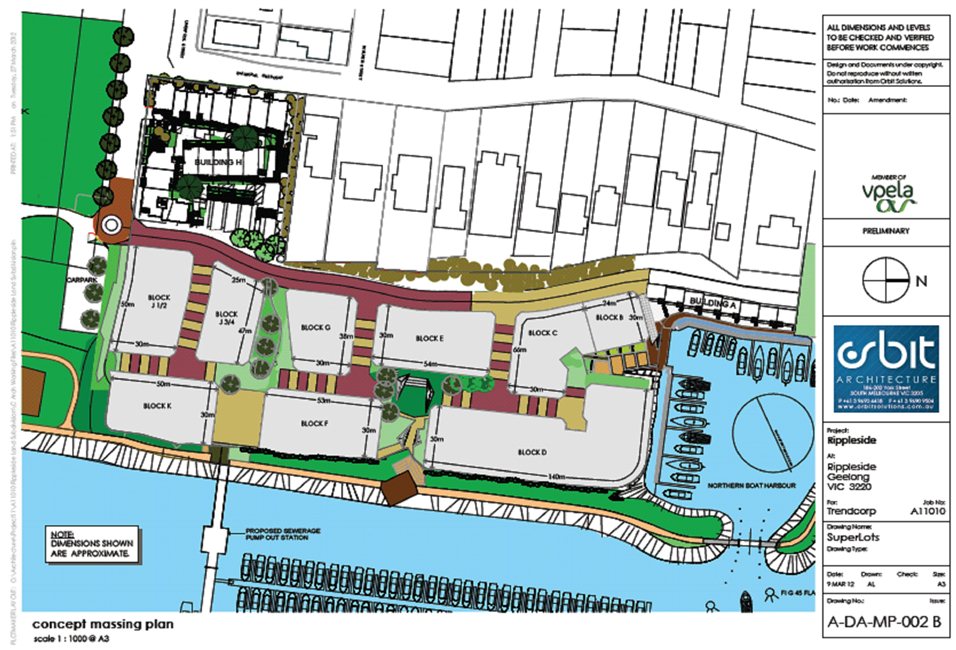
The amendment seeks to create nine super lots which do not strictly accord with the positioning of buildings that were approved in the original permit, but are generally in the positions of these buildings. The amendment would also allow the further subdivision of the super lots into smaller residential sized allotments.
A Masterplan Lot Schedule is proposed to be a restriction on the further subdivision of the land, with the Schedule setting out the minimum/maximum number of lots which can be achieved from each super lot and the minimum/ maximum frontage for each lot.
It is also proposed to restrict the height of development which is undertaken on the lots. The height restrictions appear to be designed to reflect the approved development under the original planning permit.
The total number of lots which can be developed on the site will be restricted to 124 lots, with only a single dwelling allowed on each lot.
The plan of the proposed superlots is included at Appendix 1-3.
The specifics of the Masterplan Lot Schedule and Masterplan Floor Level and Height Schedule are included in Appendix 4.
It is also proposed to retain the ability to construct Buildings A and H in the manner contemplated by the original permit. Building H is located in the south western corner of the site adjacent to Balmoral Crescent, while Building A is located to the north of the site. In addition, the marina component of the application would be retained, as would the construction of the waterside pedestrian link.
The permit applicant has submitted draft permit conditions to VCAT; however it is considered that these would require further modification. The draft conditions can be seen at Appendix 1-5.
Assessment
Key Planning Considerations
It is considered that the amendment could be supported, provided that the matters listed below are adequately addressed:
The timing of the further subdivision of the proposed super lots in circumstances that lots less than 300m² would result having regard to Clause 56.04-2 (Lot Area and building envelopes objective), and the potential difficulties associated achieving an appropriate design solution that responds to the Rippleside Urban Design Guidelines given the disparate ownership of these lots.
Further clarification of lot sizes given apparent anomalies in the scaling of the plans and, in particular, the depth of Block B.
Further and proper analysis of views to ensure views will not be unreasonably reduced having regard to Planning Permit 647/04 and the Rippleside Comprehensive Development Plan, 2000.
Clarification of what the permissions are intended in the amended permit in relation to the future construction of buildings on the land (other Building A and H).
Ensuring appropriate permit conditions that adequately address these matters, as well staging, the timing of infrastructure provision, supplementary reports and the waterside pedestrian link as part of Stage 1 of the subdivision of the land.
Timing of subdivision and size of lots
The application seeks approval to create superlots and also to allow the further subdivision of these lots in accordance with a Masterplan Lot Schedule. The Schedule sets out frontages which can be achieved in the further subdivision of the superlots, allowing lots to have frontages of between 5.5 metres and 9.5 metres and depths of 25-30 metres. In every case this would result in the creation of lots which are less than 300 square metres in area.
The objectives and standards of Clause 56 (Subdivision) apply to the assessment of this application. It is noted that Clause 56.04-2 (Lot area and building envelope objective) sets out to ensure that lots are provided with areas and dimensions that enable the appropriate siting and construction of a dwelling, solar access, private open space, vehicle access and parking, water management, easements and retention of significant vegetation and site features. It specifically states that an application to subdivide land that creates lots of less than 300 square metres should be accompanied by information that shows:
That the lots are consistent or contain building envelopes that is consistent with a development approved under this scheme, or
That a dwelling may be constructed on each lot in accordance with the requirements of this scheme.
No such information has been submitted. In creating new lots, it would be typical to require that the lots can accommodate a building envelope of 9 metres by 15 metres and this cannot be achieved on lots which are proposed to be created.
Concern is raised in relation to the ability of these small lots to be developed with high quality dwellings that achieve a reasonable amenity outcome, especially in circumstances where piecemeal development might result that would include a multiple level, terraced form. The east-west orientation of many of the superlots lots is noted.
It is not considered appropriate to allow the further subdivision of the superlots without the prior approval of the development proposed for the lots or, at the least, a significant proportion of a superlot. That is, via a separate planning permit. It is suggested that the further subdivision of the lots should then reflect the approved development.
It is also noted that the plans showing the superlots are not to scale and discrepancies in the lot sizes appear to exist. For example, Block B is shown in the Masterplan Lot Schedule as having a depth of 30 metres. However, its depth appears less than other Blocks. This may impact upon lot size, the road network and views.
Clarification of what permissions are sought through the permit
On close reading of the permit preamble and the conditions which have been proposed by the permit applicant, it appears that the application also seeks permission for the development of dwellings on the further subdivided lots. As stated, such an approach is not supported. However, it is not known whether this was intended by the applicant.
Urban Design Outcomes
As stated, it is recommended that Council’s position to VCAT should be that the future development of the lots should be subject to a ‘fresh’ application. The provisions of the CDZ2 are such that all buildings and works must be generally in accordance with the Rippleside Urban Design Guidelines, 2000 (RUDG). The RUDG is an Incorporated Document of the Planning Scheme.
The Urban Design Guidelines document is divided into three parts; Context Analysis, Urban Design Framework and Detailed Guidelines. The Detailed Guidelines seek to address issues of detailed design within the parameters established by the urban design framework and are directed towards ensuring that any development does not have unreasonable detrimental impacts on the surrounding community, will be functional and safe, is of a high urban and architectural quality and addresses existing site conditions.
The RUDG is a detailed document which addresses the issue of urban design in relation to the parameters established by the Urban Design Framework. It promotes:
An urban village concept;
Buildings developed in an attached, terraced form and to break up the building mass so as to create attractive and interesting facades;
Innovative, contemporary architecture;
A fine grain of subdivision to establish a diverse built form;
Variation of building height;
Provision of balconies;
Provision of garaging which is incorporated into the dwellings and accessed from the rear;
Roof forms which are simple mono pitch, duo pitched (preferably asymmetrical) or curved forms, incorporating eaves;
Engaging a qualified architect to design all buildings and incorporate innovative, contemporary design;
Incorporation of architectural features which unify the development and express a maritime theme;
External walls which are predominantly rendered masonry, with the remainder clad in a single material;
Finish external walls in muted colours, predominantly off white, pastel or earth tones using one colour for all or the majority of the rendered surface.
Roofing which is clad in tiles, slate or metal to avoid high reflectivity;
Use off white, pastel or earth tones for roof colours.
The lots which can be created under the Masterplan Lot Schedule are in all cases less than 10 metres in width, which limits the scope of design solutions for these lots. The number of individual lots and stand-alone developments limits the ability for an integrated design solution for the entire site that adequately respond to the RUDG.
Zone
The CDZ2 seeks to facilitate the development of the site with a development which is sympathetic to the surrounding residential and recreational environment and provides linkages with surrounding open space networks.
At issue is whether the subdivision of the site first into super lots and then into smaller lots would achieve the purposes of the zone. At this stage, the future development of the lots is unknown, however the approval of the subdivision of the land will set parameters into which development can be undertaken. As set out above, the Masterplan Lot Schedule allows for the creation of long narrow lots which can have frontages of between 5.5 metres and 9.5 metres, restricting the type of development which can be undertaken on each lot.
Views
Views and view corridors have consistently been a contentious issue with this site. An analysis of views did not form part of the amendment material.
Presumably, this is because the applicant considers that the super lots are designed to reflect the location of the buildings which were approved under Planning Permit 647/2004, and because the Masterplan Floor Level and Height Schedule is designed to ensure that the maximum height of future development is restricted in line with the development which was approved under Planning Permit 647/2004.
In determining Planning Permit 647/2004, VCAT made the following comment at Paragraph 31 of its decision:
We do however accept the argument put by Mr Finanzio that considerable weight should be given to the Comprehensive Development Plan envelopes as a primary measure or benchmark for determining the extent of built form that the respondent objectors should reasonably expect to have constructed within the view shed of their dwellings.
In approving Planning Permit 647/2004, VCAT accepted that the development was in accordance with the CDP.
However, when the siting of Blocks is checked against the approved development on the site, there are some instances where parts of the blocks, in particular Block G, Block C and K extend beyond the footprint of the development approved under Planning Permit 647/2004. In addition, the ‘squaring off’ of blocks associated with Block J ¾ and Block E could impact on the views available from the properties along Balmoral Crescent. In the case of these two blocks, areas which were undeveloped and which could provide a view corridor function could be developed with buildings and the view corridor opportunity lost.
There is some confusion about the heights which on the Masterplan are shown to Australian Height Datum (AHD), while on the endorsed plans in some cases are shown as Reduced Levels (RL). This is an issue which will need to be raised at VCAT. Assuming that the RLs relate to a height above sea level, the heights of the development have been checked against the Masterplan. There appears to be one discrepancy relating to Block D where the lower section of the building closest to the foreshore is shown on the plans at 9.7 RL, while the Masterplan shows the height as 13.5 AHD. This could impact on views and needs to be drawn to the attention of the Tribunal.
Appropriate permit conditions
Appropriate permit conditions will need to address the servicing of the site with the required infrastructure, provision of the waterside pedestrian waterside link, provision of appropriate supplementary reports and staging of the subdivision.
It is noted that the application continues to provide the waterside pedestrian link, which is a positive outcome as this link will ultimately become an important piece of community infrastructure.
The provisions of the CDZ2 are such that such that the provision of the waterside pedestrian link must be completed to the satisfaction of the Responsible Authority prior to the issue of a Statement of Compliance for any stage of the subdivision. The permit applicant is seeking to stage the construction of the waterside pedestrian link, however this is not considered acceptable and is contrary to the CDZ2.
The draft amended permit that accompanied the application (Appendix 5) is written in a manner that facilitates the outcome sought be the permit applicant. Concern has been raised in relation to aspects of the amended proposal. Various amendments to conditions would be required to address these concerns.
It is considered there are no environmental implications for Council associated with this application.
It is considered that there will be no financial implications for Council associated with this application.
The proposal has been assessed against the provisions of the Greater Geelong Planning Scheme as detailed in Appendix 2.
No Council officers have any direct or indirect interest in the matter to which this report relates, in accordance with Section 80 (C) of the Local Government Act.
It is considered that there will be no risk to Council associated with this application.
It is considered that there will be no social implications for Council, however it is important to ensure that the waterside pedestrian link is provided as part of Stage 1 of the subdivision. This will ensure that the link is available for public use at an early stage.
The application was referred to various internal departments of Council for comment. None have raised concern with the application.
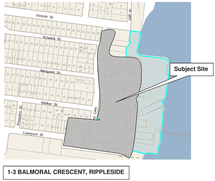
Zone
Comprehensive Development Zone – Schedule 2
The subject site and is located in the Comprehensive Development Zone – Schedule 2. The purpose of the zone is:
To facilitate the use, development and design of an urban environment that complements and enhances the area and provides linkages with the surrounding residential, community and open space networks.
To provide for residential, recreational and boating facilities and activities in conjunction with small-scale commercial and tourism development.
To provide for the integrated subdivision and redevelopment of the Rippleside Shipyards generally in accordance with the Rippleside Comprehensive Development Plan.
To provide for development that is sympathetic to the surrounding residential and recreational environment, utilising the waterfront location and harbour infrastructure.
An application to subdivide land for residential development, other than an application to
subdivide land into lots each containing an existing dwelling or car parking space, must meet the requirements of Clause 56
Overlay
Environmental Audit Overlay
The Environmental Audit Overlay applies to the site, the purpose of the overlay is:
To implement the State Planning Policy Framework and the Local Planning Policy Framework, including the Municipal Strategic Statement and local planning policies.
To ensure that potentially contaminated land is suitable for a use which could be significantly adversely affected by any contamination.
Permit triggers
The planning permit triggers relevant to the amendment are:
Clause 37.02-3– Subdivision of land.
11– Settlement
Planning is to anticipate and respond to the needs of existing and future communities through provision of zoned and serviced land for housing, employment, recreation and open space, commercial and community facilities and infrastructure.
Planning is to recognise the need for, and as far as practicable contribute towards:
Health and safety.
Diversity of choice.
Adaptation in response to changing technology.
Economic viability.
A high standard of urban design and amenity.
Energy efficiency.
Prevention of pollution to land, water and air.
Protection of environmentally sensitive areas and natural resources.
Accessibility.
Land use and transport integration.
Planning is to prevent environmental problems created by siting incompatible land uses close together.
Planning is to facilitate sustainable development that takes full advantage of existing settlement patterns, and investment in transport and communication, water and sewerage and social facilities.
13.01-1–Coastal inundation and erosion
Objective
To plan for and manage the potential coastal impacts of climate change.
13.03-2 Erosion and landslip
Objective
To protect areas prone to erosion, landslip or other land degradation processes.
15.01-1 Urban design
Objective
To create urban environments that are safe, functional and provide good quality environments with a sense of place and cultural identity.
15.01-2 Urban design principles
Objective
To achieve architectural and urban design outcomes that contribute positively to local urban character and enhance the public realm while minimising detrimental impact on neighbouring properties.
15.01-3 Neighbourhood and subdivision design
Objective
To ensure the design of subdivisions achieves attractive, liveable, walkable, cyclable, diverse and sustainable neighbourhoods.
15.01-5 Cultural identity and neighbourhood character
Objective
To recognise and protect cultural identity, neighbourhood character and sense of place.
15.02-1 Energy and resource efficiency
Objective
To encourage land use and development that is consistent with the efficient use of energy and the minimisation of greenhouse gas emissions.
16.01-1 Integrated housing
Objective
To promote a housing market that meets community needs.
16.01-4 Housing diversity
Objective
To provide for a range of housing types to meet increasingly diverse needs.
21.06-2 Urban growth
Objectives
To limit urban sprawl by directing urban growth to designated urban growth areas.
To improve housing affordability through the maintenance of appropriate urban land supplies, the promotion of competition in the housing market and the development of a diverse range of well located housing stock.
21.06-3 Urban consolidation
Objectives
To provide for the consolidation of existing urban areas in a managed way.
To encourage an appropriate range of development densities.
To improve accessibility to urban services.
21.06-4 Neighbourhood character
Objectives
To manage the impact of urban change on existing neighbourhoods.
To ensure that new development responds to the existing neighbourhood character.
To protect areas with a significant garden character.
Crs S and E Kontelj re- entered the meeting room at 7:36pm
Cr Farrell declared a Conflict of Interest by Close Association in Agenda Item 2, Planning Permit Application 1587/2011 for 41-79 Curlewis Road, Curlewis in that the applicant is known to her. Mr Murray employed her son during his carpentry apprenticeship and she worked with him some years ago, and left the meeting room at 7:36pm, prior to discussion.
[Back to List]
Portfolio: |
Planning - Cr Macdonald |
Source: |
Economic Development, Planning & Tourism |
General Manager: |
Peter Bettess |
Index Reference: |
Application 1587/2011 |
This is an application to use a building located on the site at 41-79 Curlewis Road as a Winery and Function Centre and to undertake buildings and works associated with a driveway and car parking areas.
The function centre is proposed to operate a maximum of ten times per calendar year, on a Friday and Saturday night from 7pm until 11:30pm.
Permission is also sought to allow wine tasting and cellar door sales to be undertaken from the site from Sunday to Thursday 11am – 5pm and Friday and Saturday 11am– 11:30pm.
Seating within the building is informal and a bar is located within the building. A small outdoor area is proposed to the east of the building which has an outlook over the adjacent vineyard.
The application was advertised and one objection was lodged. Following discussions between the applicant and the objector the objection was withdrawn unconditionally.
It is considered that the use of the land is complementary to the purpose of the zone. The use allows, predominantly, for a cellar door sales operation which complements the agricultural use of the land, where grapes are grown. The agricultural use will continue to operate from the site.
It is considered that the hours proposed are excessive having regard to the purpose of the zone. It is considered that the hours should be reduced in order to respond to the purpose of the zone. It is not considered reasonable to allow a cellar door sales operation, which could accommodate 200 people, to operate for the hours proposed. There are potential noise impacts from people using the venue and also from vehicle movements. These noise impacts could extend into traditional sleeping hours and cause an unreasonable amenity impact.
The cellar door sales component would operate beyond the hours approved for other cellar door sales businesses on the Bellarine Peninsula, which generally operate until 6:30 in the evening. This is a point of difference which could mean that the proposed cellar door sale is quite popular and bus tours would end at this site. It is not considered appropriate to allow the use to operate late into the night, particularly when the building in which it is to operate is set up in the manner of a bar/ tavern.
It is noted that Council’s Tourism Unit and Community Development Unit have expressed concern with the hours proposed for the winery.
It is recommended that the application is supported, but with a reduction in hours of operation for the winery.
Cr Macdonald moved, Cr Harwood seconded -
That the Responsible Authority having considered all matters which the Planning and Environment Act, 1987, requires it to consider, decides to Grant a Planning Permit for Change of Use to Winery and Place of Assembly (Function Centre) and Buildings and Works Associated with Driveway and Car Park at 41-79 Curlewis Road, Curlewis in accordance with the plans submitted with the application and subject to the following conditions:
Amended plans
Prior to the commencement of the use and/or development, three (3) copies of amended plans to the satisfaction of the Responsible Authority must be submitted to and approved by the Responsible Authority. When approved, the plans will be endorsed and will then form part of the permit. The plans must be drawn to scale with dimensions and must be generally in accordance with the plans submitted with the application but modified to show:
The location of the outdoor area which is to be used;
The use of self-closing doors in the building.
Endorsed plans
The use and development as shown on the endorsed plans must not be altered without the written consent of the Responsible Authority.
Winery hours
Unless otherwise approved in writing by the Responsible Authority, the winery may only operate between the following hours:
Sunday to Thursday– 11:00am - 5:00pm;
Friday and Saturday– 11:00am – 10:00pm.
Function centre
Unless otherwise approved in writing by the Responsible Authority, the function centre must only operate between the following hours:
Friday and Saturday– 6:00pm – 11:30pm.
The function centre hereby approved must not operate more than ten times per calendar year. A diary must me kept of functions held and must be made available for inspection on request by the Responsible Authority.
Unless otherwise approved in writing by the Responsible Authority, when the function centre is in operation the winery must not be open to the public.
Unless otherwise approved in writing, not more than 200 persons may be present on the premises at any one time, to the satisfaction of the Responsible Authority.
While the function centre is in operation, every effort must be made to ensure that the doors to the premises are kept closed and the doors must not be kept propped open to the satisfaction of the Responsible Authority.
Amenity
All security alarms or similar devices installed on the land must be of a silent type in accordance with any current standard published by Standards Australia International Limited and be connected to a security service to the satisfaction of the Responsible Authority.
External amplified equipment, loud speakers or public address system must not be used in conjunction with the use hereby permitted.
The amenity of the area must not be detrimentally affected by the use or development through the:
Transport of materials, goods or commodities to or from the land;
Appearance of any building, works or materials;
Emission of noise, artificial light, vibration, odour, fumes, smoke, vapour, steam, soot, ash, dust, waste water, waste products, grit or oil;
Presence of vermin;
to the satisfaction of the Responsible Authority.
No bottles or other waste materials may be removed from the site or emptied into external bins between the hours of 6:00pm and 9:00am.
Outdoor lighting must be designed, baffled and located to the satisfaction of the Responsible Authority to prevent any adverse effect on adjoining land or road reserve.
Noise levels emanating from the premises must not exceed those required to be met under State Environment Protection Policy (Control of Music from Public Premises), No. N-2.
Construction of driveway and car parking areas
Before the use starts areas set aside for parked vehicles and access lanes as shown on the endorsed plans must be:-
Constructed to the satisfaction of the Responsible Authority;
Properly formed to such levels that they can be used in accordance with the plans;
Surfaced with an approved material for all weather use to the satisfaction of the Responsible Authority.
Drained and maintained to the satisfaction of the Responsible Authority.
Parking areas and access lanes must be kept available for these purposes at all times and maintained to the satisfaction of the Responsible Authority.
Construction of vehicle access
Prior to the use commencing, a rural vehicle crossing at least 4 metres wide, and constructed generally in accordance with Council's standard detail drawing (CGG603, with modifications to include a minimum 4 metre radial on both edges of the crossing that abuts Curlewis Rd and a diversion in the table drain to allow provision of a culvert close to the property boundary to the satisfaction of the Responsible Authority.
Expiry
This permit will expire if one of the following circumstances applies:
The use and/or development is not commenced within two (2) years of the date of this permit.
The development is not completed within four (4) years of the date of this permit.
The Responsible Authority may extend the periods referred to if a request is made in writing within three (3) months of the date of expiry.
Carried.
The site and surrounding area
The site is located on the eastern side of Curlewis Road, Curlewis. The site is a regular rectangular shaped allotment which is developed with a vineyard and a number of dams. A farm building if located in a central position on the site. A dwelling has been developed close to the northern boundary of the site.
The site and surrounding properties are located in the Farming Zone, as a result the area is used for a range of agricultural pursuits including wineries, animal grazing and cropping, along with race horse training.
Curlewis is a local road with a single lane in each direction. There are no verges provided on the side of the road. Curlewis Road is quite a busy road as it is used as a shortcut between the Bellarine Highway and the Portarlington Road.
There are dwellings constructed on the two sites to the north of the subject site and also on the site to the south. The site on the opposite side of Curlewis Road is also developed with a dwelling. There are a number of dwellings developed in the vicinity of the site.
Proposal
This is an application to change the use of the site to a winery.
The application also seeks to operate a place of assembly (function centre) within an existing farm shed located on the site, a cellar door sales operation will also operate from the site. Alcohol to be sold through the cellar door sales will be wine produced on the site. Currently vines are planted on the site and these include 6.5 acres of Pinot Noir, 4 acres of Shiraz and 4 acres of Riesling. The manufacture of wine is undertaken off site.
A new vehicle accessway and internal access will be constructed to serve the new uses, along with a large car parking area. The new driveway is six metres in width and will be constructed with a gravel surface while 1200 square metres of car parking area will be provided. Overflow parking can also be accommodated in nearby paddocks.
It is proposed to operate the winery between the following hours:
Sunday to Thursday 11am and 5pm;
Friday to Saturday 11am and 11:30pm.
The longer hours are sought to allow visitors to do wine tastings in the evening.
It is proposed to operate the place of assembly between the following hours:
Friday and Saturday 7pm and 11:30pm.
The cellar door sales will not be in operation when a function is being held and the function centre will not operate more than ten times in a calendar year. Seating within the building is informal, with tables and chairs being set out in a similar way as to a restaurant. A small outdoor area will be available for smokers, located to the east of the building.
A licence is required to sell liquor from the site; the applicant has advised that a beer and wine producer’s licence will be sought. There is no need for a planning permit for this type of licence.
Assessment
Key Planning Considerations
The key considerations in this case are considered to be:
the appropriateness of the proposal in terms of the zoning controls which apply to the site;
the acceptability of a function centre and winery which operates into the late hours of the night;
the need to support appropriate tourism opportunities on the Bellarine Peninsula;
appropriate consideration of potential amenity impacts associated with the use.
These matters are considered below.
State and Local Planning Policies
There is policy support within the planning policy framework for tourism uses in rural areas. The use of the site for a winery and limited function centre complies with these policies, assisting to maximise the tourism potential of the Bellarine Peninsula, which is increasingly becoming known as a wine destination. Although it is recommended to restrict the hours of operation of the winery beyond what was applied for, it is still considered that the use can contribute to the region’s potential as a tourist destination. It is considered that there needs to be a balancing of the needs of the business and the purpose of the zone, along with the reasonable expectations for the zone.
Planning policy also seeks to ensure that noise emissions are controlled. To this end, planning permit conditions restrict the hours of operation of the uses, such that the use is not likely to unreasonably impact on the amenity of the area through noise emissions and other forms of disturbance.
Zone
The site is located in the Farming Zone; the purpose of the zone is to:
Implement the planning policy framework;
Provide for the use of the land for agriculture;
Encourage the retention of productive agricultural land;
Ensure that non agricultural uses, particularly dwellings, do not adversely affect the use of land for agriculture;
Encourage the use and development of land based on comprehensive and sustainable land management;
Protect and enhance natural resources and the biodiversity of the area.
It is considered that the use of the land is complementary to the purpose of the zone. The use allows, predominantly, for a cellar door sales operation which complements the agricultural use of the land, where grapes are grown. The agricultural use will continue to operate from the site.
It is considered that the hours proposed are excessive having regard to the purpose of the zone. It is not considered reasonable to allow a cellar door sales operation, which could accommodate 200 people, to operate for the hours proposed. There are potential noise impacts from people using the venue and also from vehicle movements. These noise impacts could extend into traditional sleeping hours and cause an unreasonable amenity impact. It is noted that there are a number of dwellings in the general vicinity of the site and as the area is located in the Farming Zone, there is a low level of background noise. As a result, noise generated by the use which is proposed is likely to be more evident than it may be in a different location where there is higher levels of background noise and a reasonable expectation that a late night use would operate.
The cellar door sales component would operate beyond the hours approved for other cellar door sales businesses on the Bellarine Peninsula, which generally operate until 6:30 in the evening. This is a point of difference which could mean that the proposed cellar door sale is quite popular and bus tours would end at this site. It is not considered appropriate to allow the use to operate late into the night, particularly when the building in which it is to operate is set up in the manner of a bar/ tavern. It is considered that a 7pm closing time better aligns with the zoning of the site and the reasonable expectations of activity which could occur in this zone.
The function centre will be allowed to operate until 11:30pm, given that this occurs only ten times per calendar year, these hours have been accepted.
In relation to the decision guidelines of the Farming Zone, it is considered:
The land is capable of accommodating the proposed use;
The agricultural production undertaken on the site will continue;
The use will operate within an existing building and therefore there are no design and siting issues to consider.
It is considered that there will be no environmental implications for Council in the granting of this permit.
It is considered that there will be no financial implications for Council in the granting of the permit.
The proposal has been assessed against the provisions of the Greater Geelong Planning Scheme as detailed in Appendix 2-2.
No Council officers have any direct or indirect interest in the matter to which this report relates, in accordance with Section 80 (C) of the Local Government Act.
It is considered that there will be no risk to Council in the granting of this permit.
It is considered that the hours proposed are excessive having regard to the purpose of the zone. It is not considered reasonable to allow a cellar door sales operation, which could accommodate 200 people, to operate for the hours proposed. There are potential noise impacts from people using the venue and also from vehicle movements. These noise impacts could extend into traditional sleeping hours and cause an unreasonable amenity impact.
The application was referred to various internal departments of Council for comment, as can be seen in the report.
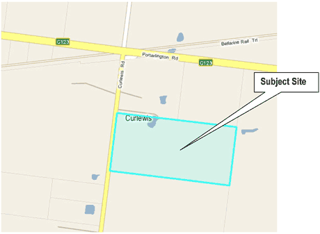
41-79 Curlewis Road, Curlewis
Definition and Nesting
Place of Assembly is defined as follows:
Land where people congregate for religious or cultural activities, entertainment, or meetings.
Function Centre is defined as follows:
Land used, by arrangement, to cater for private functions, and in which food and drink may be served. It may include entertainment and dancing.
Winery is defined as follows:
Land used to display, and sell by retail, vineyard products, in association with the growing of grape vines and the manufacture of the vineyard products. It may include the preparation and sale of food and drink for consumption on the premises.
Zone
Farming Zone
The subject site and surrounding properties are located in the Farming Zone. The purpose of the Farming Zone is:
To implement the State Planning Policy Framework and the Local Planning Policy Framework, including the Municipal Strategic Statement and local planning policies.
To provide for the use of land for agriculture.
To encourage the retention of productive agricultural land.
To ensure that non-agricultural uses, particularly dwellings, do not adversely affect the use of land for agriculture.
To encourage use and development of land based on comprehensive and sustainable land management practices and infrastructure provision.
To protect and enhance natural resources and the biodiversity of the area.
Overlay
No overlays apply to the site.
Permit required clause and condition
A planning permit is triggered for this application pursuant to the following clauses of the Greater Geelong Planning Scheme:
Clause 35.07-1– Use. Note: Condition applies to Place of Assembly– must not be used for more than ten days in a calendar year; and
Clause 37.05-4– Buildings and works.
Restrictive Covenant
There are no restrictive covenants registered on Title. A right of carriageway over the laneway to the rear (east) benefits Lots 3 and 4 (the Palais).
Cultural Heritage Management Plan (CHMP)
The Aboriginal Heritage Regulations 2007 specify the circumstances in which a Cultural Heritage Management Plan is required for an activity or class of activity.
Areas of cultural heritage sensitivity are defined within Part 2 - Division 3 of the Aboriginal Heritage Regulations 2007. Part 2 - Division 3 does not identify the site or part of the site as within an area of cultural heritage sensitivity.
In accordance with the above, a Cultural Heritage Management Plan is not required.
Coastal Hazard Vulnerability Assessment
Clause 13.01 of the State Planning Policy Framework requires Councils to plan for and manage the potential coastal impacts of climate change. To meet the objective of Clause 13.01, Councils must, inter alia:
Plan for sea level rise of not less than 0.8 metres by 2100, and allow for the combined effects of tides, storm surges, coastal processes and local conditions such as topography and geology when assessing risks and coastal impacts associated with climate change.
Apply the precautionary principle to planning and management decision-making when considering the risks associated with climate change.
The criterion that Council has adopted to trigger the requirement for a Coastal Hazard Vulnerability Assessment (CHVA) to be prepared for a proposal is: the site must have an AHD (Australian Height Datum) level of less than 5m and must be within 1km of the coastline or Barwon River.
The subject site is over one kilometre from the coast and the Barwon River. Therefore a CHVA was not required for this proposal.
Clause 52.06– Car parking
There is a requirement for car parking for a place of assembly at a rate of 0.3 spaces to each seat or each square metre of floor area, this equates to a requirement for 70 car spaces. A total of approximately 30 car spaces are provided on site in an informal gravel area. This is considered acceptable based on the fact that a number of people will travel to functions or wineries on buses. There is also the ability for overflow car parking to be accommodated on the site in a nearby paddock. Consequently, all car parking associated with the use can be accommodated on the site without impacting on the road network or adjoining properties. It is considered that an adequate level of car parking is provided on the site and the application accords with the decision guidelines of Clause 52.06-1.
THE STATE PLANNING POLICY FRAMEWORK (SPPF):
SPPF
17.03-1– Facilitating tourism
To encourage tourism development to maximise the employment and long-term economic, social and cultural benefits of developing the State as a competitive domestic and international tourist destination.
14.01-2– Sustainable agricultural land use
Objective
To encourage sustainable agricultural land use.
13.04-1– Noise abatement
Objective
To assist the control of noise effects on sensitive land uses.
THE LOCAL PLANING POLICY FRAMEWORK (LPPF) AND MUNICIPAL STRATEGIC STATEMENT (MSS):
MSS
The following policies of the Municipal Strategic Statement are applicable to this application:
21.07-5– Rural areas
Objectives
To support the use of the northern, western and southern rural areas for productive agriculture.
To ensure that rural areas provide an attractive setting through the preservation of a farmed rural landscape.
To protect and enhance the Bellarine Peninsula as a productive rural area with highly significant landscapes based on farming and environmental features.
21.07-6– Tourism in rural areas
Objectives
To support tourism development in rural areas that respects the open farmed landscape of the area, and contributes to the economy.
LPPF
There are no Local Planning Policies relevant to this application.
Prior to the commencement of the use and/or development, three (3) copies of amended plans to the satisfaction of the Responsible Authority must be submitted to and approved by the Responsible Authority. When approved, the plans will be endorsed and will then form part of the permit. The plans must be drawn to scale with dimensions and must be generally in accordance with the plans submitted with the application but modified to show:
The location of the outdoor area which is to be used;
The use of self-closing doors in the building.
The use and development as shown on the endorsed plans must not be altered without the written consent of the Responsible Authority.
Unless otherwise approved in writing by the Responsible Authority, the winery may only operate between the following hours:
Sunday to Thursday– 11:00am - 5:00pm;
Friday and Saturday– 11:00am – 7:00pm.
Unless otherwise approved in writing by the Responsible Authority, the function centre must only operate between the following hours:
Friday and Saturday– 6:00pm – 11:30pm.
The function centre hereby approved must not operate more than ten times per calendar year. A diary must me kept of functions held and must be made available for inspection on request by the Responsible Authority.
Unless otherwise approved in writing by the Responsible Authority, when the function centre is in operation the winery must not be open to the public.
Unless otherwise approved in writing, not more than 200 persons may be present on the premises at any one time, to the satisfaction of the Responsible Authority.
While the function centre is in operation, every effort must be made to ensure that the doors to the premises are kept closed and the doors must not be kept propped open to the satisfaction of the Responsible Authority.
All security alarms or similar devices installed on the land must be of a silent type in accordance with any current standard published by Standards Australia International Limited and be connected to a security service to the satisfaction of the Responsible Authority.
External amplified equipment, loud speakers or public address system must not be used in conjunction with the use hereby permitted.
The amenity of the area must not be detrimentally affected by the use or development through the:
Transport of materials, goods or commodities to or from the land;
Appearance of any building, works or materials;
Emission of noise, artificial light, vibration, odour, fumes, smoke, vapour, steam, soot, ash, dust, waste water, waste products, grit or oil;
Presence of vermin;
to the satisfaction of the Responsible Authority.
No bottles or other waste materials may be removed from the site or emptied into external bins between the hours of 6:00pm and 9:00am.
Outdoor lighting must be designed, baffled and located to the satisfaction of the Responsible Authority to prevent any adverse effect on adjoining land or road reserve.
Noise levels emanating from the premises must not exceed those required to be met under State Environment Protection Policy (Control of Music from Public Premises), No. N-2.
Before the use starts areas set aside for parked vehicles and access lanes as shown on the endorsed plans must be:-
Constructed to the satisfaction of the Responsible Authority;
Properly formed to such levels that they can be used in accordance with the plans;
Surfaced with an approved material for all weather use to the satisfaction of the Responsible Authority.
Drained and maintained to the satisfaction of the Responsible Authority.
Parking areas and access lanes must be kept available for these purposes at all times and maintained to the satisfaction of the Responsible Authority.
Prior to the use commencing, a rural vehicle crossing at least 4 metres wide, and constructed generally in accordance with Council's standard detail drawing (CGG603, with modifications to include a minimum 4 metre radial on both edges of the crossing that abuts Curlewis Rd and a diversion in the table drain to allow provision of a culvert close to the property boundary to the satisfaction of the Responsible Authority.
This permit will expire if one of the following circumstances applies:
The use and/or development is not commenced within two (2) years of the date of this permit.
The development is not completed within four (4) years of the date of this permit.
The Responsible Authority may extend the periods referred to if a request is made in writing within three (3) months of the date of expiry.
Cr Farrell re-entered the meeting room at 7:42pm
Cr Fisher declared an Indirect Interest in Agenda Item 3, Windsor Park Master Plan 2012, in that her residence backs onto Windsor Park, and left the meeting at 7:42pm prior to discussion.
Portfolio: |
Sport & Recreation - Cr Mitchell |
Source: |
Projects, Recreation & Central Geelong |
A/General Manager: |
Scott Cavanagh |
Index Reference: |
Property: #291789, 39A Rose Avenue, Norlane |
The purpose of this report is for Council to formally endorse the Windsor Park Master Plan (2012).
The Windsor Park Master Plan (2012) was commissioned by Council to examine the existing Windsor Park Master Plan (1997) and develop a new plan to guide the development of the reserve in recognition of changing community expectations.
Key development opportunities identified during the Windsor Park Master Plan included supporting the existing uses of the reserve, improving traffic and pedestrian circulation, increasing opportunities for informal public use and enhancing the appearance and appeal of the reserve.
Cr Granger moved, Cr Harwood seconded -
That Council endorses the Windsor Park Master Plan (2012).
Cr Richards entered the meeting room at 7:42pm
Carried.
Cr Granger left the meeting room at 7:48pm
Windsor Park, Rose Ave Norlane, provides a range of sport, recreation and community facilities, including two ovals and associated pavilions, two netball courts, skate park, cricket nets, playground and open space areas. Windsor Park is also home to the Norlane Community Centre and Norlane RSL and shares a boundary with the Northern Bay P-12 College - Tallis St P-6 Campus.
The sport and recreation activities based at Windsor Park are primarily provided by the North Shore Recreation Club – incorporating football, netball, cricket and little league.
The aim of the Windsor Park Master Plan (2012) (copy available in Councillors Lounge) is to examine the existing Windsor Park Master Plan (1997) and develop a guide for the future development of the reserve having regard to user and community aspirations, whilst enhancing the natural ambience and character of the reserve.
The purpose of this report is for Council to endorse the Windsor Park Master Plan (2012).
The aim of the Windsor Master Plan is to examine the existing Windsor Park Master Plan (1997) and develop a guide for the future development of the reserve. The planning process involved a review of background information, including a detailed review of the existing Windsor Park Master Plan (1997).
A summary of the level of completion of recommendations from the existing Master Plan is included in the Master Plan (2012).
Key outcomes of the Windsor Park Master Plan include the upgrade of pedestrian links, improved traffic circulation and parking, upgrades to sports facilities and improved appearance of the reserve through landscaping.
Formal reference groups were established to provide input into the planning process:
Project Control Group (PCG) consisting of the Ward Councillor and key Council officers to provide high level strategic direction on key issues and opportunities.
Project Working Group (PWG) consisting of Council officers from across CoGG departments and relevant agencies to provide technical advice on the project.
Project Reference Group (PRG) consisting of representatives of the Windsor Park Advisory Committee. The PRG provided input, direction and feedback into the project at key stages.
The consultation and research undertaken during the Windsor Park Master Plan confirmed a number of opportunities for implementation within the reserve:
Continue to provide for a wide range of interests and support development and improvements that reinforce the site as a community recreation hub and encourage increased family participation;
Ensure future site or building improvements which support increased park sharing, access and circulation functionality and visual amenity as a focus;
No net increase in the number of individual building footprints within the park through future development of physical assets;
Ensure future buildings and their development considers co-location within the park and provide a strong focus on an integrated approach to building and facility development;
Prioritise activities within the park that are capable of maximising the use of existing spaces, activity areas and infrastructure;
Ensure future enhancement provides strong connection with Corio / Norlane Structure Planning and creates a sense of ownership of the park from the local community;
Develop spaces and additional uses that complement the multipurpose functionality of Stead Park;
Encourage future use and management opportunities that increase partnerships between all stakeholders;
Adoption of Safer Design Guidelines to minimise anti-social activities.
Ensure accessibility standards and requirements are met across all park spaces, elements and buildings; and
Encourage development initiatives that support the transformational change and liveability of the Corio Norlane area.
Initial consultation with key stakeholders through the PCG, PWG and PRG has indicated support for the vision, objectives and resultant report.
Key recommendations of the Windsor Park Master Plan (2012) include:
Upgrading pedestrian entrances, pathways and crossings;
Improving parking and traffic circulation;
Tree planting within reserve to improve visual amenity;
Upgrade of playground equipment, aligned to Council’s Play Strategy;
Improvement of the secondary oval;
Landscape improvements; and
Redevelopment of North Shore Multi-purpose Clubrooms at the secondary oval.
Implementation of recommendations will improve the overall amenity and functionality of the reserve, including improved access to the wider community for informal use of open space, enhanced traffic management, safety and pedestrian circulation. The current and future needs of all stakeholders and the wider community have been considered in allowing for improved facilities and amenities.
The Windsor Park Master Plan (2012) seeks to support initiatives that facilitate long-term environmental sustainability within the park, including water use, vegetation management and ongoing maintenance.
The Windsor Park Master Plan (2012) recognises that the community values the reserves ability to cater for a wide range of uses. The Windsor Park Master Plan (2012) respects the initiatives of previous Councillors and Council Officers in setting aside this space for public recreation. Future development will seek to enhance the landscape quality of the reserve, promote improvement of facilities, infrastructure and functioning for broad community use, whilst retaining the natural ambience of the precinct.
Community feedback gained during consultation has indicated a strong desire for the improvement of the landscape quality of the reserve, including the planting of trees and other vegetation within the reserve.
The Windsor Park Master Plan (2012) provides a number of recommendations and indicative costings for recommended projects.
Where implementation of specific recommendations requires a new capital allocation from Council, these will be presented and considered as part of the overall annual budget process. Opportunities for contributions from Government, Clubs and other funding sources are listed against specific projects within the Master Plan.
The implementation plan provides a broad estimate of cost specific to each of the recommended actions. These actions are assessed as Mandatory, Critical, High, Medium and Low to guide Council decision making in terms of development.
The Windsor Park Master Plan (2012) outlines the recommended implementation schedule and indicative capital costs for the works identified in the Master Plan. The total cost of all works is estimated at $2,537,850 and is represented by the following prioritised breakdown:
Mandatory: |
Nil |
Critical: |
Nil |
High: |
$957,840 |
Medium: |
$870,950 |
Low: |
$709,060 |
Whilst the adoption of this report does not have any direct financial implications, the listed actions within the plan will cost in the order of $2,537,850. It is expected that the Master Plan will be implemented over an approximate timeframe of 10-15 years.
The Equal Opportunity Act (1995) protects Victorians against discrimination based on a wide range of personal characteristics or associations. These include (but are not limited to) age, gender, ethnicity, disability, pregnancy, religion and employment status. The Windsor Park Master Plan (2012) recognises that all community members have equal rights to participate in and enjoy the benefits of sport and physical activity. The development of the reserve will consider design solutions to help facilitate access for all.
No Council staff or persons engaged under contract have a direct or indirect interest in the development of the Windsor Park Master Plan (2012).
The Windsor Park Master Plan (2012) provides guidance for the development of this important piece of open space over the next 10-15 years.
There are no immediate risks associated with this report. Appropriate risk management measures will be put in place when implementing the recommendations of the report.
The Windsor Park Master Plan (2012) will enhance recreational and social experiences within the park. Improvements in the design, layout and functionality of the reserve, together with improved landscape and path networks will increase safety for visitors to the park.
The Windsor Park Master Plan (2012) recognises that participation in sport and physical activity brings about a range of personal, social, health and economic benefits for individuals and communities.
Windsor Park has an established history of active recreational use, including formal sports such at football, cricket and netball. Future development of the reserve will support ongoing use of the area for a range of formal and informal sport and recreation activities.
The Windsor Park Master Plan (2012) recognises that formal sporting clubs support more that just participation in physical activity. Sporting clubs are recognised as providing a range of broader benefits to the community, including contributions to social capital, community cohesiveness, community connection and building local leaders.
The Windsor Park Master Plan (2012) has been overseen by a three tiered management structure. These include:
Project Control Group (PCG) consisting of the Ward Councillor and key Council officers to provide high level strategic direction on key issues and opportunities.
Project Working Group (PWG) consisting of Council officers from across CoGG departments and relevant agencies to provide technical advice on the project.
Project Reference Group (PRG) consisting of representatives of the Windsor Park Advisory Committee. The PRG provided input, direction and feedback into the project at key stages.
The planning process involved a comprehensive review of background material and the establishment of formal reference groups to guide the planning process. The project has involved extensive consultation with stakeholders, Council staff and the community.
The main consultation tasks have included:
On-site meetings to discuss aspects of the reserve in detail;
Follow-up site visits, telephone interviews and meetings;
Establishment of the PCG, PWG and PRG. These groups have met on a minimum of two occasions each in the lead up to this report;
Consultation with the Windsor Park Advisory Committee;
Community on-line survey;
Resident survey; and
Public submissions.
In total, 83 individual surveys were completed. A summary of consultation results and key findings are included in Appendix 4: Community Consultation Findings of the Windsor Park Master Plan (2012) (previously supplied). The consultation results have been used to inform the identification of critical issues and major themes within the Windsor Park Master Plan (2012).
The draft Windsor Park Master Plan was released by Council for public comment between 4 November 2011 and 2 December 2011. The following steps were taken to provide opportunities for the community to provide feedback on the report:
Copies of the report were available on Council’s website, and at City Hall and Corio Customer Service Centre.
Copies of the report were provided to all tenants of the reserve in paper and electronic form.
The public comment period of four weeks was advertised on 5 November 2011.
The public comment period was discussed at the Windsor Park Advisory Committee on 4 November 2011.
A summary of the comments received by Council regarding the draft Windsor Park Master Plan is provided below:
|
Respondent |
Summary of comments |
Response |
|
Mr David Milsome – North Shore Recreation Club |
|
|
|
Dr Anita Pearson – Deakin University |
|
|
|
Mrs Liz Winning – Resident and Norlane Community Centre |
|
|
3. WINDSOR PARK MASTER PLAN (2012) CONT’D
The final report for the Windsor Park Master Plan (2012) was delayed due to discussions between Council and the Department of Education & Early Childhood Development (DEECD) regarding the exchange of land in Peacock Ave and Gerbera Ave, Norlane as part of the Norlane Family Services Hub project. A report to Council on 28 February, 2012 confirmed Council’s intention to support the exchange of land with DEECD.
A summary of the level of completion of recommendations from the existing Master Plan is included in the Master Plan (2012).
Key outcomes of the Windsor Park Master Plan include the upgrade of pedestrian links, improved traffic circulation and parking, upgrades to sports facilities and improved appearance of the reserve through landscaping.
Formal reference groups were established to provide input into the planning process:
Project Control Group (PCG) consisting of the Ward Councillor and key Council officers to provide high level strategic direction on key issues and opportunities.
Project Working Group (PWG) consisting of Council officers from across CoGG departments and relevant agencies to provide technical advice on the project.
Project Reference Group (PRG) consisting of representatives of the Windsor Park Advisory Committee. The PRG provided input, direction and feedback into the project at key stages.
The consultation and research undertaken during the Windsor Park Master Plan confirmed a number of opportunities for implementation within the reserve:
Continue to provide for a wide range of interests and support development and improvements that reinforce the site as a community recreation hub and encourage increased family participation;
Ensure future site or building improvements which support increased park sharing, access and circulation functionality and visual amenity as a focus;
No net increase in the number of individual building footprints within the park through future development of physical assets;
Ensure future buildings and their development considers co-location within the park and provide a strong focus on an integrated approach to building and facility development;
Prioritise activities within the park that are capable of maximising the use of existing spaces, activity areas and infrastructure;
Ensure future enhancement provides strong connection with Corio / Norlane Structure Planning and creates a sense of ownership of the park from the local community;
Develop spaces and additional uses that complement the multipurpose functionality of Stead Park;
Encourage future use and management opportunities that increase partnerships between all stakeholders;
Adoption of Safer Design Guidelines to minimise anti-social activities.
Ensure accessibility standards and requirements are met across all park spaces, elements and buildings; and
Encourage development initiatives that support the transformational change and liveability of the Corio Norlane area.
3. WINDSOR PARK MASTER PLAN (2012) CONT’D
Initial consultation with key stakeholders through the PCG, PWG and PRG has indicated support for the vision, objectives and resultant report.
Key recommendations of the Windsor Park Master Plan (2012) include:
Upgrading pedestrian entrances, pathways and crossings;
Improving parking and traffic circulation;
Tree planting within reserve to improve visual amenity;
Upgrade of playground equipment, aligned to Council’s Play Strategy;
Improvement of the secondary oval;
Landscape improvements; and
Redevelopment of North Shore Multi-purpose Clubrooms at the secondary oval.
Implementation of recommendations will improve the overall amenity and functionality of the reserve, including improved access to the wider community for informal use of open space, enhanced traffic management, safety and pedestrian circulation. The current and future needs of all stakeholders and the wider community have been considered in allowing for improved facilities and amenities.
The Windsor Park Master Plan (2012) seeks to support initiatives that facilitate long-term environmental sustainability within the park, including water use, vegetation management and ongoing maintenance.
The Windsor Park Master Plan (2012) recognises that the community values the reserves ability to cater for a wide range of uses. The Windsor Park Master Plan (2012) respects the initiatives of previous Councillors and Council Officers in setting aside this space for public recreation. Future development will seek to enhance the landscape quality of the reserve, promote improvement of facilities, infrastructure and functioning for broad community use, whilst retaining the natural ambience of the precinct.
Community feedback gained during consultation has indicated a strong desire for the improvement of the landscape quality of the reserve, including the planting of trees and other vegetation within the reserve.
Financial Implications
The Windsor Park Master Plan (2012) provides a number of recommendations and indicative costings for recommended projects.
Where implementation of specific recommendations requires a new capital allocation from Council, these will be presented and considered as part of the overall annual budget process. Opportunities for contributions from Government, Clubs and other funding sources are listed against specific projects within the Master Plan.
3. WINDSOR PARK MASTER PLAN (2012) CONT’D
The implementation plan provides a broad estimate of cost specific to each of the recommended actions. These actions are assessed as Mandatory, Critical, High, Medium and Low to guide Council decision making in terms of development.
The Windsor Park Master Plan (2012) outlines the recommended implementation schedule and indicative capital costs for the works identified in the Master Plan. The total cost of all works is estimated at $2,537,850 and is represented by the following prioritised breakdown:
Mandatory: Nil
Critical: Nil
High: $957,840
Medium: $870,950
Low: $709,060
Whilst the adoption of this report does not have any direct financial implications, the listed actions within the plan will cost in the order of $2,537,850. It is expected that the Master Plan will be implemented over an approximate timeframe of 10-15 years.
Policy/Legal/Statutory Implications
The Equal Opportunity Act (1995) protects Victorians against discrimination based on a wide range of personal characteristics or associations. These include (but are not limited to) age, gender, ethnicity, disability, pregnancy, religion and employment status. The Windsor Park Master Plan (2012) recognises that all community members have equal rights to participate in and enjoy the benefits of sport and physical activity. The development of the reserve will consider design solutions to help facilitate access for all.
Officer Direct or Indirect Interest
No Council staff or persons engaged under contract have a direct or indirect interest in the development of the Windsor Park Master Plan (2012).
Risk Assessment
The Windsor Park Master Plan (2012) provides guidance for the development of this important piece of open space over the next 10-15 years.
There are no immediate risks associated with this report. Appropriate risk management measures will be put in place when implementing the recommendations of the report.
Social Considerations
The Windsor Park Master Plan (2012) will enhance recreational and social experiences within the park. Improvements in the design, layout and functionality of the reserve, together with improved landscape and path networks will increase safety for visitors to the park.
The Windsor Park Master Plan (2012) recognises that participation in sport and physical activity brings about a range of personal, social, health and economic benefits for individuals and communities.
Windsor Park has an established history of active recreational use, including formal sports such at football, cricket and netball. Future development of the reserve will support ongoing use of the area for a range of formal and informal sport and recreation activities.
The Windsor Park Master Plan (2012) recognises that formal sporting clubs support more that just participation in physical activity. Sporting clubs are recognised as providing a range of broader benefits to the community, including contributions to social capital, community cohesiveness, community connection and building local leaders.
Communication
The Windsor Park Master Plan (2012) has been overseen by a three tiered management structure. These include:
Project Control Group (PCG) consisting of the Ward Councillor and key Council officers to provide high level strategic direction on key issues and opportunities.
Project Working Group (PWG) consisting of Council officers from across CoGG departments and relevant agencies to provide technical advice on the project.
Project Reference Group (PRG) consisting of representatives of the Windsor Park Advisory Committee. The PRG provided input, direction and feedback into the project at key stages.
The planning process involved a comprehensive review of background material and the establishment of formal reference groups to guide the planning process. The project has involved extensive consultation with stakeholders, Council staff and the community.
The main consultation tasks have included:
On-site meetings to discuss aspects of the reserve in detail;
Follow-up site visits, telephone interviews and meetings;
Establishment of the PCG, PWG and PRG. These groups have met on a minimum of two occasions each in the lead up to this report;
Consultation with the Windsor Park Advisory Committee;
Community on-line survey;
Resident survey; and
Public submissions.
In total, 83 individual surveys were completed. A summary of consultation results and key findings are included in Appendix 4: Community Consultation Findings of the Windsor Park Master Plan (2012) (previously supplied). The consultation results have been used to inform the identification of critical issues and major themes within the Windsor Park Master Plan (2012).
The draft Windsor Park Master Plan was released by Council for public comment between 4 November 2011 and 2 December 2011. The following steps were taken to provide opportunities for the community to provide feedback on the report:
Copies of the report were available on Council’s website, and at City Hall and Corio Customer Service Centre.
Copies of the report were provided to all tenants of the reserve in paper and electronic form.
The public comment period of four weeks was advertised on 5 November 2011.
The public comment period was discussed at the Windsor Park Advisory Committee on 4 November 2011.
A summary of the comments received by Council regarding the draft Windsor Park Master Plan is provided below:
|
Respondent |
Summary of comments |
Response |
|
Mr David Milsome – North Shore Recreation Club |
|
|
|
Dr Anita Pearson – Deakin University |
|
|
|
Mrs Liz Winning – Resident and Norlane Community Centre |
|
|
3. WINDSOR PARK MASTER PLAN (2012) CONT’D
The final report for the Windsor Park Master Plan (2012) was delayed due to discussions between Council and the Department of Education & Early Childhood Development (DEECD) regarding the exchange of land in Peacock Ave and Gerbera Ave, Norlane as part of the Norlane Family Services Hub project. A report to Council on 28 February, 2012 confirmed Council’s intention to support the exchange of land with DEECD.
A summary of the level of completion of recommendations from the existing Master Plan is included in the Master Plan (2012).
Key outcomes of the Windsor Park Master Plan include the upgrade of pedestrian links, improved traffic circulation and parking, upgrades to sports facilities and improved appearance of the reserve through landscaping.
Formal reference groups were established to provide input into the planning process:
Project Control Group (PCG) consisting of the Ward Councillor and key Council officers to provide high level strategic direction on key issues and opportunities.
Project Working Group (PWG) consisting of Council officers from across CoGG departments and relevant agencies to provide technical advice on the project.
Project Reference Group (PRG) consisting of representatives of the Windsor Park Advisory Committee. The PRG provided input, direction and feedback into the project at key stages.
The consultation and research undertaken during the Windsor Park Master Plan confirmed a number of opportunities for implementation within the reserve:
Continue to provide for a wide range of interests and support development and improvements that reinforce the site as a community recreation hub and encourage increased family participation;
Ensure future site or building improvements which support increased park sharing, access and circulation functionality and visual amenity as a focus;
No net increase in the number of individual building footprints within the park through future development of physical assets;
Ensure future buildings and their development considers co-location within the park and provide a strong focus on an integrated approach to building and facility development;
Prioritise activities within the park that are capable of maximising the use of existing spaces, activity areas and infrastructure;
Ensure future enhancement provides strong connection with Corio / Norlane Structure Planning and creates a sense of ownership of the park from the local community;
Develop spaces and additional uses that complement the multipurpose functionality of Stead Park;
Encourage future use and management opportunities that increase partnerships between all stakeholders;
Adoption of Safer Design Guidelines to minimise anti-social activities.
Ensure accessibility standards and requirements are met across all park spaces, elements and buildings; and
Encourage development initiatives that support the transformational change and liveability of the Corio Norlane area.
3. WINDSOR PARK MASTER PLAN (2012) CONT’D
Initial consultation with key stakeholders through the PCG, PWG and PRG has indicated support for the vision, objectives and resultant report.
Key recommendations of the Windsor Park Master Plan (2012) include:
Upgrading pedestrian entrances, pathways and crossings;
Improving parking and traffic circulation;
Tree planting within reserve to improve visual amenity;
Upgrade of playground equipment, aligned to Council’s Play Strategy;
Improvement of the secondary oval;
Landscape improvements; and
Redevelopment of North Shore Multi-purpose Clubrooms at the secondary oval.
Implementation of recommendations will improve the overall amenity and functionality of the reserve, including improved access to the wider community for informal use of open space, enhanced traffic management, safety and pedestrian circulation. The current and future needs of all stakeholders and the wider community have been considered in allowing for improved facilities and amenities.
Environmental Implications
The Windsor Park Master Plan (2012) seeks to support initiatives that facilitate long-term environmental sustainability within the park, including water use, vegetation management and ongoing maintenance.
The Windsor Park Master Plan (2012) recognises that the community values the reserves ability to cater for a wide range of uses. The Windsor Park Master Plan (2012) respects the initiatives of previous Councillors and Council Officers in setting aside this space for public recreation. Future development will seek to enhance the landscape quality of the reserve, promote improvement of facilities, infrastructure and functioning for broad community use, whilst retaining the natural ambience of the precinct.
Community feedback gained during consultation has indicated a strong desire for the improvement of the landscape quality of the reserve, including the planting of trees and other vegetation within the reserve.
Financial Implications
The Windsor Park Master Plan (2012) provides a number of recommendations and indicative costings for recommended projects.
Where implementation of specific recommendations requires a new capital allocation from Council, these will be presented and considered as part of the overall annual budget process. Opportunities for contributions from Government, Clubs and other funding sources are listed against specific projects within the Master Plan.
The implementation plan provides a broad estimate of cost specific to each of the recommended actions. These actions are assessed as Mandatory, Critical, High, Medium and Low to guide Council decision making in terms of development.
The Windsor Park Master Plan (2012) outlines the recommended implementation schedule and indicative capital costs for the works identified in the Master Plan. The total cost of all works is estimated at $2,537,850 and is represented by the following prioritised breakdown:
Mandatory: Nil
Critical: Nil
High: $957,840
Medium: $870,950
Low: $709,060
Whilst the adoption of this report does not have any direct financial implications, the listed actions within the plan will cost in the order of $2,537,850. It is expected that the Master Plan will be implemented over an approximate timeframe of 10-15 years.
Policy/Legal/Statutory Implications
The Equal Opportunity Act (1995) protects Victorians against discrimination based on a wide range of personal characteristics or associations. These include (but are not limited to) age, gender, ethnicity, disability, pregnancy, religion and employment status. The Windsor Park Master Plan (2012) recognises that all community members have equal rights to participate in and enjoy the benefits of sport and physical activity. The development of the reserve will consider design solutions to help facilitate access for all.
Officer Direct or Indirect Interest
No Council staff or persons engaged under contract have a direct or indirect interest in the development of the Windsor Park Master Plan (2012).
Risk Assessment
The Windsor Park Master Plan (2012) provides guidance for the development of this important piece of open space over the next 10-15 years.
There are no immediate risks associated with this report. Appropriate risk management measures will be put in place when implementing the recommendations of the report.
Social Considerations
The Windsor Park Master Plan (2012) will enhance recreational and social experiences within the park. Improvements in the design, layout and functionality of the reserve, together with improved landscape and path networks will increase safety for visitors to the park.
The Windsor Park Master Plan (2012) recognises that participation in sport and physical activity brings about a range of personal, social, health and economic benefits for individuals and communities. Windsor Park has an established history of active recreational use, including formal sports such at football, cricket and netball. Future development of the reserve will support ongoing use of the area for a range of formal and informal sport and recreation activities.
3. WINDSOR PARK MASTER PLAN (2012) CONT’D
The Windsor Park Master Plan (2012) recognises that formal sporting clubs support more that just participation in physical activity. Sporting clubs are recognised as providing a range of broader benefits to the community, including contributions to social capital, community cohesiveness, community connection and building local leaders.
Communication
The Windsor Park Master Plan (2012) has been overseen by a three tiered management structure. These include:
Project Control Group (PCG) consisting of the Ward Councillor and key Council officers to provide high level strategic direction on key issues and opportunities.
Project Working Group (PWG) consisting of Council officers from across CoGG departments and relevant agencies to provide technical advice on the project.
Project Reference Group (PRG) consisting of representatives of the Windsor Park Advisory Committee. The PRG provided input, direction and feedback into the project at key stages.
The planning process involved a comprehensive review of background material and the establishment of formal reference groups to guide the planning process. The project has involved extensive consultation with stakeholders, Council staff and the community.
The main consultation tasks have included:
On-site meetings to discuss aspects of the reserve in detail;
Follow-up site visits, telephone interviews and meetings;
Establishment of the PCG, PWG and PRG. These groups have met on a minimum of two occasions each in the lead up to this report;
Consultation with the Windsor Park Advisory Committee;
Community on-line survey;
Resident survey; and
Public submissions.
In total, 83 individual surveys were completed. A summary of consultation results and key findings are included in Appendix 4: Community Consultation Findings of the Windsor Park Master Plan (2012). The consultation results have been used to inform the identification of critical issues and major themes within the Windsor Park Master Plan (2012).
The draft Windsor Park Master Plan was released by Council for public comment between 4 November 2011 and 2 December 2011. The following steps were taken to provide opportunities for the community to provide feedback on the report:
Copies of the report were available on Council’s website, and at City Hall and Corio Customer Service Centre.
Copies of the report were provided to all tenants of the reserve in paper and electronic form.
The public comment period of four weeks was advertised on 5 November 2011.
The public comment period was discussed at the Windsor Park Advisory Committee on 4 November 2011.
A summary of the comments received by Council regarding the draft Windsor Park Master Plan is provided below:
|
Respondent |
Summary of comments |
Response |
|
Mr David Milsome – North Shore Recreation Club |
|
|
|
Dr Anita Pearson – Deakin University |
|
|
|
Mrs Liz Winning – Resident and Norlane Community Centre |
|
|
The final report for the Windsor Park Master Plan (2012) was delayed due to discussions between Council and the Department of Education & Early Childhood Development (DEECD) regarding the exchange of land in Peacock Ave and Gerbera Ave, Norlane as part of the Norlane Family Services Hub project. A report to Council on 28 February, 2012 confirmed Council’s intention to support the exchange of land with DEECD.
Cr Fisher re-entered the meeting room at 7:48pm
[Back to List]
Portfolio: |
Community Development – Cr Fisher |
Source: |
Community Services – Health & Local Laws |
General Manager: |
Jenny McMahon |
Index Reference: |
Subject: Policies & Procedures / document development |
Council policies are developed to provide guidance for the various services and functions of the City of Greater Geelong.
The following policy has been reviewed and updated with minor changes:
Electoral Advertising Signs
Approved policies are made available to the public through Council’s Internet site.
Cr Macdonald moved, Cr Nelson seconded -
That Council endorses the Electoral Advertising Signage policy (Appendix 4-1).
Carried.
Council policies are developed to clearly articulate Council’s intent and preferred method of operation.
Policies are reviewed regularly to ensure that they are current and remain relevant.
The following policies have been reviewed and minor changes have been made and are summarised below:
|
Policy |
Electoral Advertising Signs on Road Reserves CPL45.8 |
|
Responsible Manager |
Manager Health and Local Laws |
|
Purpose |
Establishes Council’s position in relation to the placement of electoral signs |
|
Comment |
Minor change – updated reference to correct Division and retention period for correspondence. |
There are no environmental considerations in the review of this policy.
The policies provide Council with direction for the effective management and control of its resources, however there is no impact on budget.
The policies have been developed with reference to relevant legislation and will enable Council to more effectively meet compliance requirements.
No officer had a direct or indirect interest in the development of this report.
Clearly articulated policies provide Council with a consistent and publicly declared attitude to specific topics. This will assist in reducing the risk and negative consequences to Council that may occur through inconsistent decision making, actions or practices.
Social considerations have been taken into account in the development of Council Policies.
The adopted policy will be available on Council’s internet site.
Electoral Advertising Signs On Road Reserves and Council Land |
|
|
Responsible Officer: |
Expiry Date: |
N/A |
|
General Manager Community Services |
Version No |
01 |
Authorising Officer: |
Chief Executive Officer |
The purpose of this policy is to provide direction on the placement of electoral advertising signs on any Council land, municipal building or road, and to avoid excessive sign clutter.
This policy applies to all electoral candidates and prohibits any electoral advertising signs on Council land, municipal buildings or roads.
Candidates in all levels of Government elections –
Federal;
State; and
Local Government
are subject to this policy.
General Local Law 2005
“Council land” means all land vested in or under the control of Council, including a reserve, watercourse, jetty, reservation and the like, but excludes a road, except that part of the road which is a nature strip or footpath.
“Municipal Building” means any building that is owned, occupied or under the management or control of Council, and includes any recreation centre which is owned, occupied or under the management or control of Council.
“Reserve” means any land which is owned, occupied or managed or controlled by Council and dedicated or used for outdoor cultural, environmental, sporting or recreational purposes.
“Road” has the meaning ascribed to it by Section 3 of the Local Government Act.
The Council has the responsibility for approving an application for the placement of temporary signs on Council land, roads and in or on Municipal Buildings.
Council must remain totally impartial in relation to the promotion of a candidate/s at any democratic election at either Federal, State or Local Government level. It is therefore the policy of Council to refuse any application for the location of an election sign on any Council land, roads or Municipal Buildings within the City of Greater Geelong.
Compliance with this Policy will be monitored and enforced in accordance with Council’s operating guidelines.
Quality Records shall be retained for at least the period shown below.
|
Record |
Retention/Disposal Responsibility |
Retention Period |
Location |
|
Correspondence in relation to election signage |
class 8.2.7 of the Retention and Disposal Authority for Records of Local Government Functions (PROS 09/05), |
4 years after the election |
Document Management Services |
Portfolio: |
Infrastructure - Cr Richards |
Source: |
City Services - Engineering Services |
General Manager: |
Gary Van Driel |
Index Reference: |
Street: Belmont Street, Belmont |
This report relates to a proposed special charge scheme for the construction of a carpark in Belmont Street, Belmont to service the High Street business and retail precinct, refer to plan – Appendix 5-4.
Council purchased the land for the carpark in 2007 which was the subject of a report to Council on 26 April 2006. At this time Council agreed to the purchase of land and subsequent construction on the basis of the initiation of a special charge scheme to recover 50% of the cost of the land and carpark construction.
The cost of the land was $665,205 and the cost of the carpark construction is estimated at $243,965. The amount to be recovered from owners is $204,585.
The State Government agreed to contribute $200,000 to the works and a further Council allocation of $100,000 has been committed.
There are 177 properties in the scheme and charges vary from $67 to $18,107. The capital improved value of the properties has been used as a basis for calculating the charge.
All properties are zoned either business 1 or business 2, however, there are 13 properties in these zones used for residential purposes. The recommendation is in two parts, firstly proposing to declare the charges and secondly, providing a concession to the owners using properties for residential purposes. This is in the way of a deferred charge which becomes payable when the property reverts to commercial use.
The area to be included in the scheme has been determined on the basis of proximity to the proposed carpark with some weighting reductions provided for the more remote properties on the north-west side of High Street.
Council considered a report on 23 March 2010 and the scheme was advertised and submissions invited. The Submission Panel considered all submissions and agreed to proceed with the scheme.
The scheme has been prepared in accordance with the Special Rate and Charge provisions of the Local Government Act, along with Special Rates and Charges Policy.
This report seeks a resolution by Council to “Declare the Charges” for carpark construction in Belmont Street, Belmont in accordance with the Special Charge Scheme Process
Cr Harwood moved, Cr Abley seconded -
That consideration of the report be deferred.
Carried.
Portfolio: |
Infrastructure - Cr Richards |
Source: |
City Services - Engineering Services |
General Manager: |
Gary Van Driel |
Index Reference: |
Subject: Special Rates and Charges |
This report relates to the finalisation of a Special Charge Scheme for road and drainage construction for O’Briens Road, Lara between the Geelong-Bacchus Marsh Road and McManus Road as shown on the plan – Appendix 6-3.
This project is a sub-project of the Geelong Ring Road Employment Precinct (GREP) Project and is seen as an important starting point for the development of the GREP.
The scheme has been administered in accordance with the special rate and charge provisions of the Local Government Act along with Council’s special rates and charges policy.
The report seeks a resolution by Council to ‘vary’ the special charge for the works to finalise the O’Briens Road, Lara, Special Charge Scheme.
The project involved the construction of O’Briens Road as well as main drainage.
Works relating to the special charge scheme component have now been completed and it is appropriate for Council to finalise the scheme.
Based on actual and some estimated costs the total project cost is $7,402,822 compared with the original estimate of $8,406,948. Property owner charges were estimated at $1,046,957. The actual charge to property owners is $696,235.
The project has been subsidised to the value of $2 million by the State Government.
Cr Granger moved, Cr Abley seconded –
That consideration of the report be deferred.
Carried.
Portfolio: |
Infrastructure - Cr Richards |
Source: |
City Services - Engineering Services |
General Manager: |
Gary Van Driel |
Index Reference: |
Special Rates and Charges; Princess Street, Drysdale |
This report relates to the finalisation of a Special Charge Scheme for construction of footpath and kerb and channel in Princess Street, Drysdale between Eversley Street and Newcombe Street.
Council declared the charge for this scheme on 10 August 2010.
The scheme involves 8 property owners and the works were a combination of both footpath and kerb and channel. Council undertook pavement works and drainage.
The cost to be distributed to owners which matches the estimated cost was $38,461 and owners costs vary between $2,977 and $10,464. Council constructed additional pavement and drainage works as part of the project at a cost of $90,808.
The scheme has been prepared in accordance with the Special Rates and Charges provisions of the Local Government Act along with Council’s Special Rates and Charges Policy.
The report seeks a resolution by Council to confirm the special charge for the works to finalise the Princess Street, Drysdale Special Charge Scheme. The process is shown in Attachment 7-1 – Process Chart.
Cr Richards moved, Cr Macdonald seconded -
That Council having declared a special charge on 10 August 2010 for the purposes of defraying the expenses in relation to the construction of footpath, kerb and channel and road widening in Princess Street Drysdale, west side between Eversley Street and Newcombe Street, Drysdale (Appendix 7-2 – Plan) in accordance with Section 163 of the Local Government Act 1989 (the Act) resolves that:
the special charge as declared be confirmed in accordance with actual costs incurred on the project as required by Section 166 of the Act as shown in Schedule A – Appendix 7-1;
the General Manager of Corporate Services is authorised to levy and recover the special charges by sending notices to the persons who are liable to pay in accordance with Section 166 of the Act and the Regulations; and;
in accordance with Section 172, the rate of interest which is payable on the special charges which have not been paid by the specified date is set at Council’s overdraft rate, reviewed every three months (provided that it shall not exceed the rate fixed by the Governor in Council by Order for the purposes of Section 172 2A in which case the rate of interest shall be the maximum fate fixed by the Governor in Council by Order for the purposes of the Section). The interest is to be calculated from the date the special charge is due, with a six months interest free period, providing those persons who choose to pay by instalments adhere to their repayment plan.
Carried.
This report relates to the finalisation of a special charge scheme for footpath, kerb and channel and road pavement in Princess Street, Drysdale, west side between Newcombe Street and Eversley Street.
This block was one with “missing” infrastructure, no footpath, kerb and channel or road widening.
Council had received enquiries and complaints particularly in relation to footpath as there is a residential area to the west and close proximity to the High Street Shopping Centre.
A combined footpath and kerb and channel scheme was undertaken. The actual costs for the special charge scheme components were only marginally above the estimate and in this case it is considered appropriate to charge the estimated cost.
The works have now been completed and it is appropriate for Council to finalise the scheme.
The financial details are as follows:
|
|
Estimated Cost |
Actual Cost |
|
Footpath component |
$36,732 |
$36,766 |
|
Kerb and channel component |
$20,095 |
$20,660 |
As there is very little difference between the estimated cost and the actual cost, the estimated costs have been adopted as the finalised figures. Therefore the cost to be distributed to property owners is $38,461 which is made up of half the footpath component and the kerb and channel component (both based on estimated cost).
Council undertook a considerable amount of additional pavement and drainage works as part of the project at a cost of $90,808.
There are no environmental implications including sustainability, energy use, water use or alternative material use, in Council’s decision to finalise this scheme. The process is an administrative matter only.
There are no financial implications associated with Council proceeding to finalise the scheme. Property owners will be advised of the cost adjustment.
The scheme has been administered in accordance with the special rate and charge provisions of the Local Government Act as well as Council’s Special Rates and Charges Policy. There are no issues regarding the Human Rights Charter.
No Council Officer involved with this process has any direct or indirect interest in the properties.
Provision of a footpath has provided safer walking conditions for pedestrians by minimising the risk of personal injuries through falls and conflict between pedestrians and vehicles. There are no risk assessment issues in Council proceeding to finalise the scheme.
There are no social considerations associated with Council proceeding to finalise the scheme.
Communication with property owners has taken place during the course of the project. Owners will be advised of Council’s decision and the final cost.
|
Prop Key |
Property Details |
Property Address |
Actual |
|
258654 |
Lot 4 LP 98033 |
34-36 Princess Street, Drysdale VIC 3222 |
$10,464 |
|
258660 |
Lot 3 LP 93189 |
42 Princess Street, Drysdale VIC 3222 |
$4,806 |
|
258661 |
Lot 2 LP 93189 |
53 Newcombe Street, Drysdale VIC 3222 |
$ 8,304 |
|
258655 |
Lot 1 SP 20532 |
1/38-40 Princess Street, Drysdale VIC 3222 |
$ 2,977 |
|
258656 |
Lot 2 SP 20532 |
2/38-40 Princess Street, Drysdale VIC 3222 |
$ 2,977 |
|
258657 |
Lot 3 SP 20532 |
3/38-40 Princess Street, Drysdale VIC 3222 |
$ 2,977 |
|
258658 |
Lot 4 SP 20532 |
4/38-40 Princess Street, Drysdale VIC 3222 |
$ 2,977 |
|
258659 |
Lot 5 SP 20532 |
5/38-40 Princess Street, Drysdale VIC 3222 |
$ 2,977 |
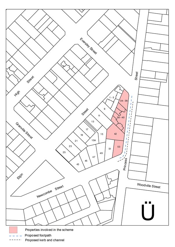
PROCESS CHART
SPECIAL CHARGE PROJECTS – (Section 163 – Local Government Act 1989)
PRINCESS STREET, DRYSDALE
|
Stage |
Status |
Description |
|
Approval to prepare scheme |
|
Decision made to prepare scheme following consideration of surveys of property owners and feed back from the community. Council may then place the project in the budget system or proceed immediately to prepare a scheme. Scheme preparation involves survey, design and preparation of an apportionment of costs. |
|
Intention to Declare Scheme |
|
Report to Council providing information on scheme including advice of impending advertising of scheme and declaration of charge. Seeks Council approval by resolution to proceed with process. 10 September 2009 |
|
Advertisement |
|
The scheme is advertised in the local newspaper and all allotted property owners are notified by mail. This advertisement indicates Council’s intention and notification to ‘declare’ a scheme in a month’s time. 19 December 2009 |
|
Submissions |
|
From the time of advertising property owners have 28 days (as set down by the Local Government Act) to lodge submissions, either in support or opposition to the scheme. |
|
Submissions Review Panel Hearing |
|
A Submissions Review Panel is convened (quorum of three Councillors) and meets to consider submissions. Some submissions are written only, and other submitters may wish to be heard before the Panel. The Panel makes a recommendation to Council regarding the scheme. 22 March 2010 |
|
Declaration Report |
|
Any time 28 days after advertising the scheme and after the Submissions Review Panel has met and considered submissions, Council considers a report and may proceed to “declare” the charges in accordance with its advertised intent. Subsequent to this the Finance Manager issues the levy notices and there is a formal charge placed on the property. This is the final step in the process for Council to make a decision on the scheme. 10 August 2010 |
|
Appeal |
N/A |
Property owners may lodge an application for review with the Victorian Civil and Administrative Tribunal (VCAT) within one month of issue of the levy notice. An appeal is listed, heard and determined by the Tribunal and this process generally takes three to four months. Decisions made by VCAT are binding on all parties. |
|
Construction |
|
Council may then proceed to construct the works. Invoices are issued seeking payment of the estimated cost within one month of commencement. |
|
Final Cost Report |
|
At the completion of the works the scheme is “finalised” taking into account actual costs incurred and payments are adjusted accordingly. |
Contents | Previous Page: Section A - Procedural Matters | Next Page: Section C - Common Seal Register

