
Council Minutes - Section B: Reports (1-10) - 11 September 2012
Contents | Previous Page: Section A - Procedural Matters | Next Page: Section B – Reports (11-20)
Contents | Previous Page: Section A - Procedural Matters | Next Page: Section B – Reports (11-20)
Reports 1-10, tabled at the Ordinary Meeting of Council on Tuesday 11 September 2012 held at City Hall, Little Malop Street in Geelong.
Amendment C269: Rezoning of Additional Land for the Epworth Geelong Teaching Hospital, Waurn Ponds
2012/2013 Sport and Recreation Victoria Funding Program Submissions
Advisory Group – Street Access for the Aged and People with Disabilities – Annual Report 2011-2012
Revocation of Flood-Prone Area Designation of New Lots at Armstrong Creek
Portfolio: |
Economic Development/Planning - Cr Macdonald |
Source: |
Economic Development, Planning and Tourism - City Development |
General Manager: |
Peter Bettess |
Index Reference: |
Application C269 |
The purpose of this report is to seek Council’s in-principle support for an amendment to the Planning Scheme to rezone a 1.065ha parcel to the immediate north of the Epworth Geelong Teaching Hospital site that was rezoned to Special Use Zone 14 (SUZ14) in January this year.
The rezoning is sought to facilitate better access into the Hospital from Pigdons Road.
A Planning Permit was issued on 21 February 2012 for the development of the Hospital. At the time officers expressed concerns about the proposed access to the hospital off Pigdons Road and its relationship with University Drive. Access was constrained due to Epworth HealthCare not owning additional land to provide for a better intersection treatment outcome.
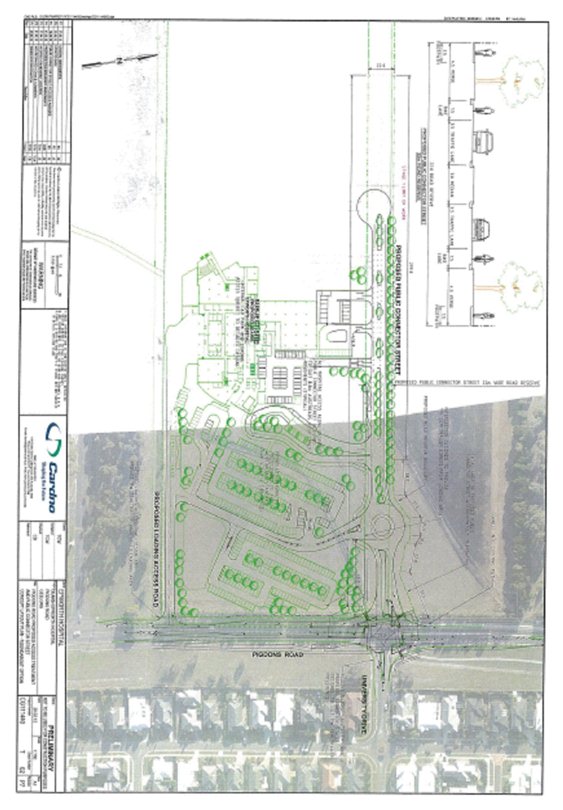
Epworth HealthCare has entered into an agreement with Marcus Oldham College to enable Council’s preferred cross intersection with University Drive and Pigdons Road to be developed.
Securing the additional land and its rezoning will enable an improved road layout at this intersection; improve the intersection operation for local residents and the Hospital and future-proof site access.
Epworth HealthCare is proposing to seek a fast-track planning scheme amendment process under Section 20(4) of the Planning and Environment Act, where the Minister for Planning will again become the Planning Authority and manage the process of the amendment.
It is recommended that the proposed rezoning be supported.
Cr Macdonald moved, Cr Nelson seconded -
That Council supports the:
preparation of a planning scheme amendment to rezone a 1.065ha parcel of land on the Marcus Oldham College site immediately to the north of the Epworth Geelong Teaching Hospital site, to facilitate improved site access and intersection treatment with University Drive;
amendment being processed as a Section 20(4) Ministerial amendment under the Planning and Environment Act 1987.
Carried.
Epworth HealthCare has secured a site in Pigdons Road Waurn Ponds on which to develop a new Teaching Hospital, in partnership with Deakin University. The land was rezoned from Farming Zone to Special Use Zone 14 in January 2012 as part of Amendment C252, prepared by the Minister for Planning. Planning permit 1171/2011 was granted by Council on 21 February 2012 which allowed for the development of the Hospital. During the planning process, Council officers, the community and Councillors identified their preference for a cross intersection along the northern site boundary, opposite University Drive. However, because Epworth HealthCare did not own the required area of land opposite University Drive, it was not possible to achieve Council’s preferred access arrangement. Rather, a staggered intersection was endorsed.
Epworth HealthCare advises that it has now entered into an agreement with Marcus Oldham to enable Council’s preferred cross intersection to be developed. A proposed intersection layout is attached in Appendix 1-1.
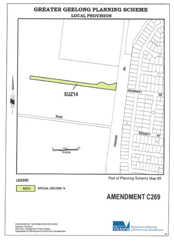
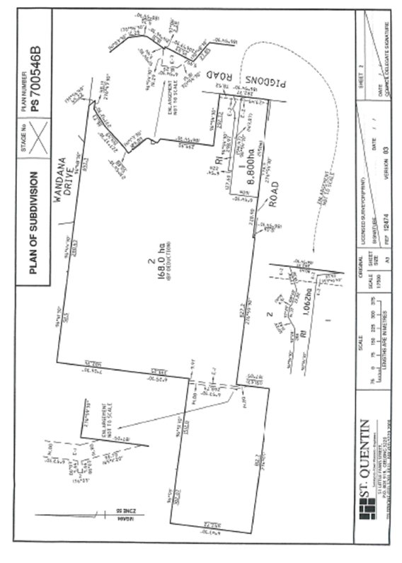
Epworth HealthCare is seeking Council’s in-principle support for the proposed rezoning of the additional land – refer to Appendix 1-2 for proposed zoning map and Plan of Subdivision.
The purpose of the rezoning is to enable the development of an improved access arrangement from Pigdons Road. The rezoning will enable the provision of an improved intersection function and design and will assist in future-proofing access to the adjoining parcels of land.
As with the original Hospital site rezoning, it is proposed to rezone the land from Farming Zone to SUZ14.
Following the rezoning of this additional parcel of land, Epworth HealthCare will be in a position to apply to Council to amend Planning Permit 1171/2011 and the subdivision plan, and to include reference to the proposed new intersection under Section 72 of the Act.
As the land is currently vacant and used for cropping, it is not expected that there are any environmental impediments to the rezoning.
The proponent bears the costs associated with the amendment.
The proposed rezoning will extend the Special Use Zone 14 northward by a small margin and will result in an improved access to the hospital and functioning of the Pigdons Road and University Drive intersection.
No Council officers involved in the preparation of this report have any direct or indirect interest, in accordance with Section 8(C) of the Local Government Act to which this amendment relates.
There are no risks with either implementing or not implementing the recommendations of this report.
The community will benefit from the construction and operation of the Epworth Geelong Teaching Hospital. The small extension of the zoning to the north will facilitate an improved intersection function and design for the Pigdons Road – University Drive intersection for both the Hospital and residents.
Epworth HealthCare will be seeking exemption by the Minister from the usual notification requirements of the Act for this amendment.
Portfolio: |
Planning - Cr Macdonald |
Source: |
Economic Development, Planning & Tourism - Planning Strategy |
General Manager: |
Peter Bettess |
Index Reference: |
Cust: Department of Planning and Community Development |
The Minister for Planning is seeking submissions from Councils on wide ranging reforms to the residential, business, industrial and rural zones in Victoria.
The zone reforms propose the following key changes:
Three new residential zones, being the, general residential, residential growth and neighbourhood residential zone to replace the existing residential 1, residential 2 and residential 3 zones;
Two commercial zones that allow more ‘as of right’ uses and rationalise the five existing business zones; and
Amended industrial zones to allow larger office developments and small supermarkets; and
Amended rural zones to allow more flexibility for agriculture, tourism, accommodation, industry and retail uses.
The reforms to the residential zones are generally supported subject to some refinements to the detail of the zones. The encroachment of commercial uses into residential areas is not supported.
Further advice from DPCD is required on how the new residential zones will be implemented in the City of Greater Geelong and strategic justification required to implement the new zones;
Support review of the current business zones but not support the proposed commercial zones until there is further consultation with the State Government to clarify the role and purpose of the reforms and the impacts on the City’s retail areas; and
The changes to the rural zones are supported, in part provided that new local policy can be implemented before the new zones are implemented to provide certainty for permit applicants and the community on where non-agricultural uses should locate.
It is further considered that DPCD need to support councils through funding to do the strategic planning work required before the new zones are implemented.
Cr Macdonald moved, Cr Granger seconded -
That Council authorise officers to provide a submission to the Department of Planning and Community Development on the Reformed Zones for Victoria in relation to the following key issues and the content of this report:
Express Council’s concern at the limited consultation on the content of the reforms and the timing of this consultation process;
Generally support the format of the proposed new residential zones however seek refinement to the details of some of the provisions and further information on the timing, resources and process for implementation of the new zones;
Some support for the amended rural zones and request DPCD to delay the timing of the introduction of the amended zones until a new local planning policy is included in the Greater Geelong Planning Scheme;
Do not support the immediate translation of the new commercial zones into the Greater Geelong Planning Scheme and request DPCD provide further strategic justification for the changes, evidence of the economic impacts on existing centres and undertake further consultation with local government;
Support the amendment to the industrial zones to remove the floor space restriction on offices; and
DPCD give further consideration to providing funding/resources to councils to assist in the roll out of the new zones.
Carried.
There is consensus amongst local government, the development industry and the community that reforms to the operation of the Victorian Planning System are required. In May 2012 the Victorian Planning System Ministerial Advisory Committee concluded:
The planning system is now very complex;
There is a lack of ownership of the system;
A lack of responsiveness to issues as they arise,
A lack of alternate processes that recognise different types of applications or amendments; and
Timelines are rarely adhered to and in other areas there are no timelines at all.
As a consequence, the delays in the system cause frustration and disappointment and higher costs for development.
The Minister for Planning has initiated wide ranging reforms to the Victorian Planning Provisions (VPPS). The basis for these reforms is the Baillieu government’s Victorian Liberal Nationals Coalition Plan for Planning 2010 that outlined their election promises in relation to planning. These commitments were:
A full review of Victoria’s planning zones to ensure they are functioning correctly to provide an adequate reflection of the planning aspirations of all Victorians.
Clear development ‘green areas’ and no-development ‘red areas’ are established.
Giving regional councils the flexibility to alter land use within farming zones to protect prime farmland for agriculture while respecting the rights of landholders.
The following inquires undertaken by the State and Federal governments that investigated the role of regulatory burden on the efficiency and performance of business have informed the preparation of the zone reforms:
The Victorian Planning System Ministerial Advisory Committee;
The VCEC Inquiry into Victoria’s regulatory framework 2011;
The VCEC Inquiry into Victoria’s tourism industry 2011; and
The Productivity Commission report on Economic Structure and Performance of the Australian Retail Industry 2011.
Key findings of these inquires are:
Greater economic investment can occur by improving regulatory systems.
The planning system can create unnecessary uncertainty, time delays, costs to business and constrain productivity growth.
Reforms are needed to free up the planning processes around commercial investment.
There should be an early review of the farming zones.
There has been consultation with local government for many years on the operation of the existing residential zones. In 2009 the previous Labor government released new residential zones that were never implemented into the VPPs. Council made submissions in 2008 and 2009 and the recommendations of this report build on Council’s previous submissions.
There has however, been no explicit consultation with local government on the reforms to the commercial zones and rural zones. The proposed reforms will have sweeping effects on development in the City’s activity centres and rural areas and the key issues are considered in detail in the discussion section of this report.
Summary of changes:
The key changes to each zone are outlined in the table below:
|
Residential zones |
General Residential Zone – for most residential areas where incremental change is expected:
Residential Growth Zone – for areas identified for substantial housing change and where new built form is expected:
Neighbourhood Residential Zone – for areas with unique character and where minimal housing change is expected:
|
|
Low density residential zone:
|
|
Business zones |
Commercial 1 Zone – replaces the business 1 (retail), business 2 (office) and business 5 (office and high density housing):
Commercial 2 Zone – replaces the business 3 (office and industry) and business 4 (bulky goods and industry) and provides more opportunity for offices, retail and commercial activity:
|
|
Industrial zones |
|
|
Rural zones |
|
Timing for implementation
Based on the limited information provided by DPCD on how the new zones will be implemented it is understood that the following program is proposed:
Submissions close 21st September 2012;
New commercial zones will be finalised and immediately translated into all planning schemes on the basis of the existing business zones. New zones will come into effect in October 2012;
Amendments to rural zones, low density residential zone, township zone, mixed use zone and industrial zones will also come into effect in October 2012; and
New residential zones will be introduced into the VPPs in October with Council and DPCD to apply the zones within 12 months.
There is no advice from DPCD on what process will be used to apply the new residential zones, the level of strategic justification required to apply each zone and if any resources/funding will be available to Council to assist in the rollout.
Key themes and issues identified by officers are outlined below and will form the basis of a detailed submission to DPCD:
Residential zones:
Support for a hierarchical approach to designating the level of housing change for different urban areas
It is recommended that Council generally support the three tiered approach to residential zones. The new zones have the ability to provide greater certainty to the community, permit applicants and Council on the level of housing change expected for different urban areas.
The ability to include neighbourhood character and design objectives into the schedules of each zone is supported. The current zone provisions do not allow for locally responsive content and the proposed schedules to zones will provide a more effective means to implement Council’s housing policy.
Critical to the effectiveness of the new zones will be implementation that is underpinned by thorough strategic planning. DPCD has advised that after the submission period closes and the zones are finalised Council will have 12 months to consider how the zones will be applied. There are no criteria or guidance provided on how the existing zones will be converted and what level of strategic justification will be required to apply each of the zones and support local variations and objectives.
Council’s housing policy is better advanced than other councils through the implementation of the Housing Diversity Strategy (2008) (HDS). However, to fully realise the benefits of these new zones further investigations on the application of each zone and the identification of appropriate local variations will be required over the next 12 months.
It may be possible to apply two schedules to the general residential zone with one schedule applied to the Increased Housing Diversity Areas (within walking distance of neighbourhood centres) and a second schedule for the suburban Incremental Change Areas identified in the HDS.
The application of the residential growth zone to Key Development Areas would be considered on a case by case basis as other planning controls have been used to achieve this change to date. It is not anticipated that the neighbourhood residential zone would be directly translated to any areas in the municipality without further strategic justification due to the very restrictive nature of the controls.
Seek improvements to how single dwelling and multi-unit applications are considered to improve urban design and amenity outcomes
The new zones reduce the permit thresholds for single dwellings on an individual lot and facilitate infill subdivision. Whilst removing the need for a planning permit for dwellings on small lots may seem a simple approach to reducing delays in the planning system there may be adverse outcomes. This approach will encourage the ad hoc infill subdivision, of small lots rather than providing incentives to encourage integrated medium density developments in targeted growth locations.
Once a new lot is created the design and approval of individual dwellings will be considered under the building regulations without a full consideration of the overall design response of the development and how it integrates with the existing neighbourhood. It is recommended that 300sqm should remain the minimum lot size in the general residential zone with the ability for Council to vary the minimum lot size (up or down) in consultation with the local community and DPCD if justified.
In the residential growth zone, the zone intended to be applied around activity centres to accommodate higher density housing outcomes, it is imperative that these sites are developed to their full capability with quality urban design outcomes. Contrary to how the provisions are currently drafted, it is recommended that a permit be required for a single dwelling on al lot to prevent underdevelopment of sites. Multi dwelling applications that meet agreed standards (such as variations to ResCode) should be exempt from notice and review to facilitate integrated medium density housing and promote housing diversity.
If the State Government maintains the reduction in lot sizes then a comprehensive review of Clause 54 and Clause 55 (ResCode) and Clause 56 (subdivision) is required to remove inconsistencies between the new permit triggers and existing standards and objectives. It is recommended that this review should identify which clauses of ResCode should apply to particular scales of development and result in a different version of ResCode (beyond the variations allowed for in the schedules to the new zones) specific to the development of dwellings on lots less than 200sqm and potentially lots as small as 80sqm.
Support retention of notice and review rights in all zones but Council should be able to vary these
It is recommended that Council have the ability to vary the notice and review requirements where development principles are agreed and supported by policy. The existing residential 2 zone that is applied to areas identified for housing change exempts development from notice and review requirements and this should be extended into the new zones.
Areas that are likely to be appropriate to reduce third party appeal rights are key development areas. These areas have been subject to detailed strategic planning and there is clear policy support for substantial housing change. Another example might be a two unit development in the general residential zone or neighbourhood residential zone that meet the standards of ResCode.
Do not support increased flexibility for non-residential uses to establish in residential areas, low density residential and township zones.
Council should not support the relaxing of the non-residential uses that can establish in residential areas. The proposed changes do not strike the right balance between providing local services for residents close to homes and protecting residential amenity. The current residential zones allow for a food and drink premises or a medical centre to establish with a planning permit ensuring that issues relating to building design and amenity impacts are fully considered and managed through permit conditions. A shop or office is currently prohibited regardless of size or location.
If the proposed provisions were introduced a medical centre of up to 250sqm or a shop or office of 100sqm could be built in an established residential area without a planning permit and without neighbouring properties being notified. The first neighbours would know about the development was when construction commenced.
Allowing additional discretionary uses in the residential zones will result in uncertainty for permit applicants and the community and place additional burdens on Council’s planning resources in direct conflict with the State Government’s election commitment to provide more certainty in the planning system.
These changes allow shops and offices, without a floor space cap, to encroach into residential areas resulting in the quasi expansion of the neighbourhood activity areas or small strip shopping areas without proper consideration of the design or amenity impacts of the use on the existing neighbourhoods and the viability of existing stores in the retail centre.
A review of the Home Occupation provisions at Clause 52.11 of the VPPs by DPCD in conjunction with local government is a preferable way to encourage entrepreneurial activity that is more in keeping with the role and amenity expectations of residential areas.
At a minimum a planning permit and third party advertising should be required for both use and development of all non-residential uses. Any non-residential built form adjoining residential development should be required to meet the requirements of ResCode.
Support reduction in the minimum lot size in the Low Density Residential Zone subject to strategic justification
This zone is generally applied to areas on the fringes of existing townships that are constrained for conventional residential development by environmental or infrastructure limitations, particularly drainage. A broad brush approach to reducing the lot size immediately will result in the ad hoc subdivision of existing lots is not supported.
It is recommended that Council request a schedule be included in the Greater Geelong Planning Scheme to maintain the current minimum lot size at 4,000sqm. Council and/or groups of landowners could then undertake a proper investigation to fully test and assess the merits of reducing the lot size in particular locations. If there is a strategic basis for this change a subsequent planning scheme amendment can be sought.
Urge DPCD to provide resources to Councils to fund the strategic planning required for implementation.
As outlined earlier, there has been no guidance on how the new zones will be translated and additional strategic planning will be required to apply these zones effectively. It is recommended that Council request DPCD prepare detailed practice notes on how the residential zones will be implemented and work with individual councils to determine the timing of implementation and additional resources/funding required to achieve this.
Commercial and industrial zones
Support the review of the current business zones however consultation and a clear purpose of the review and subsequent reforms is required
The retail sector is going through major transitions as consumer behaviour changes and planning policy needs to assist traditional shopping strips to continue to thrive. It is recommended that Council supports the State Government initiative to reduce the regulatory burden on businesses and stimulate the commercial sector however there is a distinct lack of consultation and clear direction on the purpose of these reforms and this has translated into the draft zoning provisions.
No strategic justification for the wide ranging changes or evidence of the implications on existing and future centres have been provided by DPCD and it is extremely difficult to assess the full impact of the changes in the time provided by DPCD to comment on the zones. Without this evidence, it is recommended that Council object to the immediate state wide translation of the new commercial zones.
Following further consultation with councils on the drafting of the controls, economic advice and justification on the impacts of the changes from the Minister for Planning Council’s position should be reconsidered.
Do not support removal of floor space caps for shop uses
The new commercial zones will remove the floor space caps for retail and office land uses that apply to key commercial centres in the municipality and form the basis for Council’s hierarchy of retail centres. Councils need the ability to continue to apply local schedules to retail and office uses to provide certainty and achieve strategic planning objectives in relation to retail planning. This is particularly evident for newly establishing growth area centres that are not constrained by existing urban development. It is vital that the role of the new major activity centres and neighbourhood activity centres be cemented in early development and this will be undermined by the new commercial zones.
The new zones will result in traditional bulky goods strips, some industrial areas and office precincts being available for shops and supermarkets without a planning permit where these uses were previously prohibited or permit required uses. These changes may have adverse impacts on the vibrancy of traditional retail strips as key tenants seek cheaper sites with main road frontages that were not previously available for shops. Council should not support ‘as of right’ supermarkets and shops in industrial areas and bulky goods areas. At a minimum these uses should require a planning permit to enable economic justification to be considered as part of the planning permit.
Clarify the purpose of the commercial 1 and commercial 2 zones
There is a disconnect between the purpose of the commercial 1 zone and the controls. The purpose of this zone is ‘to create vibrant mixed use commercial centres for retail, office, business, entertainment and high density residential uses’ however similar to the residential growth zone the permit triggers do not facilitate high density housing.
The purpose of the commercial 2 zone is ‘to develop commercial areas for offices and appropriate manufacturing and industrial uses that do not affect the safety and amenity of adjacent sensitive uses’. Again there is a disconnect between the purpose of the zone and the controls. Shops and restricted retail (bulky goods) are ‘as of right’ uses however the purpose of the zone does not refer to retailing of any kind. Conversely, the purpose refers to protecting the safety and amenity of nearby sensitive uses however industry is an ‘as of right’ use with less restrictions than in industrial zoned areas and accommodation is a permitted use that will inevitably result in land use conflicts into the future.
Whilst these conflicts exist in the purpose and controls of the commercial zones they should not be implemented. Additional delays and uncertainty for business and the community will undermine the purpose of the reforms.
Support additional office developments in industrial areas
Support the proposal to remove the floor space cap of 500sqm for all office uses in the industrial zones is recommended. Industrial areas are no longer exclusively for manufacturing uses. It is important to facilitate modern industrial developments that provide for co-located office, warehousing and manufacturing uses. The flexibility to include an area specific cap is supported to allow Council to implement local policy where required.
Rural zones
Further review of additional non-agricultural uses as discretionary uses in rural areas is required.
The changes to the rural zones seek to introduce broader and more varied uses to all rural zones with more discretion required from councils. The changes are not consistent with the policy foundation of the existing rural zones to protect productive agricultural land. Whilst some remote areas are facing declining populations and require additional flexibility to facilitate development a one-size-fits-all approach to changing the farming zone across the state will undermine existing policy and may lead to:
Incremental encroachment of non-agricultural land uses into farming areas;
Conflicts between high amenity uses and farm businesses;
Fragmented farming patterns and rural landscapes;
Blurred boundaries between urban settlements affecting the role and character of townships and rural and urban areas;
Increasing demand for comparatively cheaper rural land and increasing rural land prices making land too expensive to farm; and
Additional uncertainty in the planning system due to additional discretionary uses and demands on council planning resources.
To address these concerns and still facilitate some additional flexibility in rural areas it is recommended that prior to the new rural zones coming into affect DPCD assist and support Councils to introduce a new local planning policy to provide clear direction on where non-agricultural uses should locate. This policy must come into effect before the amended zone provisions are implemented to prevent an immediate flood of applications. This local policy should be accompanied by a review of the State Planning Policy Framework to provide further policy direction.
Key issues and recommendations are discussed below:
Accommodation uses:
Accommodation uses such as hotels and retirement villages have higher amenity expectations when compared to farms. Land use conflicts between sensitive uses and farming practices will result in existing farm practices being constrained, elevated land values and the fragmentation of productive farm land that is not consistent with purposes of the farming zone.
To facilitate tourism developments in appropriate locations some accommodation uses (i.e. caravan park and residential hotel) are supported however retirement villages and residential villages should be prohibited in the rural zones. These uses should be directed to urban settlements close to services and facilities and should not be able to take advantage of cheap land in farming areas.
The proposed increase for a bed and breakfast from 6 visitors to 10 visitors without a planning permit in all rural zones is supported as this will reduce the regulatory burden on small scale tourism ventures.
Industrial uses:
Industrial uses are not supported in rural areas and should be a prohibited use in the farming zone. Council’s planning framework sets aside land for industrial purposes that is strategically located to provide good access to transport infrastructure and meets the servicing requirements for industrial land uses. It is contrary to orderly and proper planning to allow industrial uses to take advantage of comparatively cheaper farm land to establish.
In the event that a site specific industrial use is suitable for a farming area and it can be demonstrated that an industrial area is not appropriate for the use a site specific rezoning would be appropriate. To better facilitate development and protect farming land DPCD should considerably reduce the time (currently between 12 and 24 months) and cost of planning scheme amendments to reduce the burden on Councils and proponents.
Whilst industrial uses are not supported in the Farming Zone, some industrial uses may only be capable of being accommodated in the Farming Zone. A recent EPA publication mandates a buffer distance of 2 kilometres for green waste processing which is only achievable in the Farming Zone. DPCD should therefore consider preparing a new land use definition for green waste recycling to allow this to be considered as a discretionary use in the Farming Zone.
Education uses:
The introduction of primary schools and secondary schools as a permit required use in all rural zones is supported provided that DPCD allow Council to introduce a local policy on where these uses are appropriate. Under the proposed zone, tertiary education uses are prohibited without justification provided by DPCD, which is considered consistent, and it is recommended that all educations uses should be permitted in appropriate locations in rural areas, again subject to appropriate policy direction.
Retail uses:
The rural zones currently allow for the sale of produce from farms and this practice is further facilitated by the changes to the rural zones. Under the proposed reform a small produce stalls could operate subject to conditions on size and location, without a planning permit and should be supported by Council.
Traditional retail uses such as shops, supermarkets and hardware stores are not supported in the rural zones. It is Council’s policy to focus retail activity into its hierarchy of retail centres and it is not appropriate to allow retail uses in rural areas.
The significant changes proposed to the zones and discretion for a range of uses in all zones beyond that which is provided for today will potentially have broader environmental considerations. These matters will need to be taken into consideration as the implementation of this revised planning regime is progressed.
The introduction of the new zones will impact on both Council’s strategic and statutory planning resources. There will be an immediate need to revisit its recent strategic planning work undertaken as part of the MSS review, including the:
Housing Diversity Strategy;
Retail Strategy; and
Rural Land Use Strategy.
The implementation of the new zones will require changes to the Local Planning Policy Framework the following clauses will be affected:
Municipal strategic statement
|
|
|
|
|
|
Local Planning Policies
|
|
|
|
|
|
|
|
|
|
There is currently no budget in place to undertake the strategic planning and policy development necessitated by the zone reforms. Council’s submission will seek funding from DPCD to assist in undertaking this work.
In addition to the considerable strategic work required, the additional discretionary uses in the rural and commercial zones will increase the workloads for the statutory planning department to consider additional complex applications.
The introduction of new zones would result in legislative changes affecting statutory planning permit applications and future planning scheme amendment(s) to implement the new zones.
No Council officers involved in the development of the review and preparation of this report have a direct or indirect interest in the issue, in accordance with Section 80(c) of the Local Government Act, to which this report relates.
There are no risks associated with Councils submission to the zone reform consultation process.
There are no social considerations resulting from this recommendation on making a submission to the DPCD on the reformed zones.
A copy of Council’s submission will be published in full on the DPCD website.
Portfolio: |
Heritage - Cr Granger |
Source: |
Economic Development, Planning & Tourism - Planning Strategy |
General Manager: |
Peter Bettess |
Index Reference: |
Project: Lara Outer Areas Heritage Review |
Council undertook the Outer Areas Heritage Study between 1998-2000. Volume 12 of the Study identifies 73 heritage places in Lara and surrounding areas including 56 of local significance, 8 of regional significance and 3 of state significance.
To date the places identified in Lara and surrounding areas have not been included in a heritage overlay by a planning scheme amendment.
In March 2012 Council passed a motion to review the Outer Areas Heritage Study in relation to Lara in order to determine which places still have a level of heritage significance that may be appropriate for heritage protection through a planning scheme amendment.
Phase 1 of the project commenced in June 2012 when Council engaged RBA Architects and Conservation Consultants to review the 1998-2000 Study to provide advice on the condition of the heritage places (i.e. if they had been altered, demolished or redeveloped) and if the sites meet the current threshold for local heritage protection in the planning scheme.
The consultants review recommended that 26 places should be included in the heritage overlay, 14 places are likely for recommendation for a heritage overlay subject to further investigation and 15 places are not significant to warrant inclusion in the heritage overlay.
Phase 2 of the project involves preparation of individual citations for each of the properties recommended for inclusion in the heritage overlay and further investigations on individual properties where additional information is required.
Following this work a further report to Council will be prepared to consider whether an amendment to the planning scheme should be pursued.
Cr Granger moved, Cr Macdonald seconded -
That Council:
note the findings of the Lara Heritage Review – Phase 1; and
resolves to support the preparation of updated citations for 26 properties and further research and citations for up to 14 properties in Lara, Anakie and Lovely Banks to determine whether they warrant inclusion in the heritage overlay.
Carried.
Council undertook the Outer Areas Heritage Study between 1998-2000. The Study comprises of 16 volumes and was prepared by Dr David Rowe and Ms Lorraine Huddle of Authentic Heritage Services Pty Ltd.
Volume 12 of the Study details sites in the township of Lara and its surrounds. The Study identified 73 places in Lara - 56 of local significance, 8 of regional significance and 3 of state significance.
Parts of the study have been implemented over the years however the places identified in Lara have not been subject to specific heritage protection through a planning scheme amendment.
In March 2012 Council passed a motion to review the Outer Areas Heritage Study in relation to Lara. Due to the time that had elapsed since the study was completed a review was required to assess the current status of identified places and to determine whether to pursue heritage overlays via a planning scheme amendment for the places identified in the Study.
In June 2012 Council engaged RBA consultants to undertake the review. The consultants have now completed the review and handed down their recommendations and these are discussed below.
Prior to engaging consultants Council officers completed a desk top review of the 73 places in the Study which revealed:
5 are already listed and have a heritage overlay
11 have been demolished
2 are covered by the dry stone wall provisions set out in clause 52.37 of the planning scheme.
The remaining 55 places were reviewed by RBA Architects and Conservation Consultants (based on current best practice and accepted criteria). A full copy of the consultant’s report is available to Councillors and the key points are summarised below.
Of the 55 places reviewed RBA determined that:
26 were determined as having at least local heritage significance and being worthy of planning scheme protection;
14 were determined as having some heritage significance however further historical research and/or site inspection is required to determine if individual heritage protection is warranted; and
15 were determined as not having heritage significance worthy of planning scheme protection.
For sites to reach the threshold for local significance they are intact buildings for their period of construction and retain a high degree of heritage integrity. Some early sites (such as those from the 1860s or 1870s) or an unusual building type may be more altered but nonetheless remain significant as a rare example of a building type or style.
The following sites are recommended for inclusion in the heritage overlay and individual property citations need to be prepared by a consultant for each property to be included in the planning scheme:
|
Site # |
Address |
Site description |
|
2 |
5 & 25 Branch Rd Little River |
Former Duck Ponds School (2nd) |
|
3 |
60 Branch Rd Lara |
Ruins |
|
5 |
85 Curletts Rd Lara |
Cottage & Outbuilding |
|
9 |
1B Flinders Ave Lara |
Former Wesleyan Chapel & underground tank |
|
12 |
400-450 Flinders Ave Lara |
The Pines |
|
14 |
45 Forest Road North Lara |
Lara Lime Company |
|
18 |
31-45 Forest Road South Lara |
House |
|
20 |
110-120 Forest Road South Lara |
House (fmr Lake Bank Hotel) |
|
21 |
155 Forest Road South Lara |
Clover Hill Strawberry Farm |
|
24 |
30 Hicks St Lara |
House & dairy outbuilding |
|
27 |
5 Rennie St Lara |
House |
|
28 |
8 Rennie St Lara |
House |
|
31 |
Walkers Rd Lara |
Avenue of Honour (Cypress trees) |
|
32 |
4 Walkers Rd Lara |
Lara & District War Memorial Gates |
|
33 |
14 Walkers Rd Lara |
Waverley |
|
35 |
10 Windermere Rd Lara |
Glenoe |
|
36 |
785 Bacchus Marsh Rd Anakie |
House |
|
39 |
25 Blairs Rd Lara |
Ruins, possibly combine with site no. 40 |
|
40 |
370 Windermere Rd (near corner of Blairs Rd) Lara |
Building Ruins, possibly combine with site no. 39 |
|
42 |
125 Buckingham St Lara |
Stables - Laurence Park |
|
43 |
125 Buckingham St Lara |
Cottage |
|
44 |
50 Duggans Lane Lara |
House & outbuilding ruins |
|
47 |
80 Gebbies Rd Lara |
Cottage Complex |
|
50 |
32 Patullos Rd Lara |
House |
|
52 |
295 Patullos Rd Lara |
Lochnoben |
|
54 |
450 Staceys Rd Anakie |
Roselea |
The following sites have been recommended for consideration in Phase 2 of the assessment as further historical research or detailed site inspections are required to determine if the properties are of local heritage significance:
|
Site # |
Address |
Site description |
|
4 |
29-35 Curletts Rd Lara |
Holy Trinity Church of England Tower & Lintel stone |
|
7 |
1B Flinders Ave Lara |
John Spalding Hall (Uniting Church), possibly to be grouped with site no. 9 (the Wesleyan Church & tank) |
|
8 |
1B Flinders Ave Lara |
Memorial |
|
13 |
575 Flinders Ave Lara |
Cottage Ruins |
|
19 |
51 Forest Road South Lara |
House |
|
22 |
14 Hicks St Lara |
Lara General Store |
|
25 |
270 Peak School Rd Lara |
Dairy Ruin |
|
26 |
170 Peak School Rd Lara |
Tallaranie Homestead |
|
34 |
11-15 Waverley Rd Lara |
Lara Comm. Centre (fmr Presb. Church) |
|
38 |
220-260 Hams Lane Anakie |
Lara Hill House & outbuilding ruins |
|
41 |
105 Blairs Rd Lara |
Limeburning site |
|
46 |
35 Gebbies Rd Lara |
Cottage |
|
49 |
24 Patullos Rd Lara |
Cottage |
|
53 |
75 Staceys Rd Lovely Banks |
Kia Ora |
Those sites that have not been recommended for inclusion have been altered since the initial study and do not meet the threshold for local significance from a historical, social or architectural perspective. The following sites have not been recommended for inclusion in the heritage overlay:
|
Site # |
Address |
Site description |
|
1 |
1220 Bacchus Marsh Road Lara |
Underground tank |
|
6 |
165 Duggans Lane Lara |
Melrose Homestead |
|
10 |
76 -84 Flinders Ave Lara |
Lara Baptist Church (fmr Catholic) |
|
11 |
350 Flinders Ave Lara |
Cottage |
|
15 |
175 Forest Road North Lara |
Fmr Primitive Methodist Cemetery |
|
16 |
570 Forest Road North Lara |
House |
|
17 |
Princes Freeway –Forest Ramp -In |
Lara Stable foundations & floor |
|
23 |
25 Hicks St Lara |
Lara Railway Station |
|
29 |
43 Station Lake Rd Lara |
House |
|
30 |
87 Station Lake Rd Lara |
Austin Park |
|
37 |
965 Bacchus Marsh Rd Anakie |
House |
|
45 |
165 Duggans Lane Lara |
Ruins |
|
48 |
65-95 Hams Lane Anakie |
House |
|
51 |
40 Patullos Rd Lara |
House |
|
55 |
305 Windermere Rd Lara |
Cottage and Dairy ruins |
Phase 2 of the project will involve the preparation of individual citations for each of the 26 properties recommended for inclusion in the heritage overlay and further research and individual citations if required for the 14 properties identified further assessment. No further assessment will be undertaken of the sites not recommended for inclusion.
The preparation of the citations and further research will be undertaken during October and November 2012 and a planning scheme amendment to implement the heritage overlay will be reported to Council for consideration in early 2013.
The consideration of the review into heritage places in Lara has no environmental implications.
The preparation of the further research on some properties, preparation of individual citations and subsequent planning scheme amendment to introduce a heritage overlay over the identified places can be accommodated within the existing budget for planning policy and Council initiated amendments.
The introduction of a heritage overlay over identified places in Lara in the Greater Geelong Planning Scheme is consistent with State and Local Planning Policy Frameworks. The planning scheme amendment will be carried out in accordance with the Planning and Environment Act 1987.
No Council officers involved in the development of the review and preparation of this report have a direct or indirect interest in the issue, in accordance with Section 80(c) of the Local Government Act, to which this report relates.
There is considered to be a limited risk in implementing the review recommendations. The recommendations will result in a planning control (heritage overlay) being applied to places that have been identified as having heritage significance. Given the relatively small number of places being added there are considered to be no ongoing resourcing issues to consider future planning scheme amendments.
The introduction of a heritage overlay over identified places in Lara in the Greater Geelong Planning Scheme will ensure the cultural and social history of Lara is adequately protected; this will be beneficial for the identity of the township and the community.
The progress of this review will be communicated to stakeholders via the planning scheme amendment process which includes a public exhibition period. Those properties that are directly affected by the amendment will be contacted individually as part of the planning scheme amendment. Where additional escorted site inspections are required individual property owners will be contacted during Phase 2.
Portfolio: |
Community Development - Cr Fisher |
Source: |
Community Services / Aged & Disability Services |
General Manager: |
Jenny McMahon |
Index Reference: |
Subject: Aged & Disability Care / Disability |
In 2009, an access audit was undertaken at Council’s expense on the central Geelong Railway Station.
This extensive and detailed audit included an analysis of pedestrian access, from adjoining streets to platforms, toilets, and facilities.
A series of recommendations, including the construction of a tunnel and elevator for access between platforms, were made to improve the access for people of all abilities.
In 2010 Council allocated funds for access audits for the remaining railway stations within the municipality.
V/Line management approval was received in April 2012 for these six remaining station audits.
The audits on the final six railway stations have now been undertaken.
Copies of the access audit reports have also been forwarded to V/Line for their consideration and use.
The audits have provided a basis for V/Line staff to prioritise works.
They also provide Council with an opportunity to advocate for improvement funds to ensure the City is accessible for all.
Cr Fisher moved, Cr Abley seconded -
That Council:
note the Railway Station Access Audit report and refer them to Council’s Street Access Committee and Disability Advisory Committee for consideration and prioritisation of Council responsible actions.
seek a meeting with Minister Terry Mulder to present the access audit reports and request funding to address the issue.
write to the Department of Transport and VicTrack to seek support for the implementation of the recommendations of the Railway Station Access Audit reports.
Carried.
A community awareness campaign during 2009 identified the Geelong Railway Station as having poor access for people with limited mobility. The particular focus of the campaign was the poor access to platform two and three, accessible only via an historic stair case and bridge over the tracks. The alternate access to platforms two and three is by appointment with station staff who are expected to assist people in chairs and scooters directly across the tracks.
During 2009, the Geelong Advertiser ran a campaign noting the cumulative days of no action by V/Line on this identified access obstacle.
In 2009, also, the Geelong Railway Station was the subject of official speeches at the Geelong Access Awards. Subsequently funding was allocated by Council to undertake an audit of the Railway Station Accessibility as a first step in addressing the shortcomings.
In 2009 additional funding was provided to enable audits to be undertaken on the remaining six local railway stations. Following V/Line management approval, the audits were conducted in May 2012 and the reports were made available in June 2012.
The 2010 audit of the Geelong Railway Station provided Council and V/Line with valuable information. As a result of the recommendations a number of the items have since been addressed which has improved general access and safety for people of all abilities.
The 2012 audits have provided another list of recommended access improvements to the remaining six stations. The audits have utilised the Disability Standards for Accessible Public Transport 2002 and the Disability (Access to Premises – Buildings) Standards 2010 as a guide for access standards. Recommendations have subsequently been made in relation to car parking, ramps, steps, tactile indicators, hand rails, signage, contrast luminance of glass doors, seat heights and accessible toilets etc.
Where recommendations have been made the relevant guidelines and specifications have been itemised and photographs have been included for further explanation.
Copies of the Access Audits have been provided to V/Line in accordance with the conditions of the permit to undertake the work.
V/Line will be able to use the information to develop an infrastructure renewal and upgrading plan, to schedule maintenance and to progressively upgrade their infrastructure for better access. The reports will also be used by V/Line to lobby for capital funding to undertake significant works.
The audit reports will also provide information for Council and other land management authorities on any access issues that might be on land for which they are responsible.
A joint meeting of officers from Council and V/Line has been held to discuss the recommendations and required works. V/Line officers have requested input from Council’s Disability Advisory Committee and Street Access Committee, and other local stakeholders to assist in prioritising works and lobbying for funding to complete the essential upgrades. The audit reports have been provided to Council’s Street Access Committee for consideration and prioritisation of works that are the responsibility of Council.
By making access improvements to the Geelong Railway Stations, people of all abilities will be better able to use the public train system. As a result, car use and the associated pollution and road congestion should be reduced.
The audit reports will assist Council officers to develop future budget bids for any improvement works that are in Council’s domain, adjacent to the stations. For example any pedestrian pram crossings, tactile indicators etc.
By improving access for people of all abilities, Council and V/Line will comply with the Disability Discrimination Act.
No officer involved in the writing of this report has any interest in the matter other than as an officer of Council and community member.
As indicated above, by actioning the recommendations in the audit reports, V/Line and Council will avoid actions taken by individuals under the Disability Discrimination Act and the works will further improve public safety at the stations.
Improvements to access on public transport are critical to the participation and inclusion of people of all abilities in community life. People with disabilities and older frail adults are disproportionately reliant on public transport to obtain the essentials in life such as commuting to work, shopping, accessing services and social life. The recommended improvements will enhance the commuting experience and enable more people to move around the City and travel further afield.
Further information will be provided by the relevant authorities when funding is allocated and specific works are to be undertaken.
Portfolio: |
Sport & Recreation - Cr Mitchell (Mayor) |
Source: |
Projects, Recreation & Central Geelong |
General Manager: |
Dean Frost |
Index Reference: |
Subject: Grants & Funding / Sport & Recreation Victoria Grants - incoming |
Sport and Recreation Victoria’s (SRV) funding programs provide an important opportunity for Council to secure much needed funding for sport and recreation projects in the municipality.
This report outlines a number of projects considered by the Projects, Recreation & Central Geelong division for possible funding under the Community Facility Funding Program (Minor Facilities, Soccer Facilities and Planning categories) and Country Football & Netball Program.
The details of a number of projects that have been presented to the City of Greater Geelong via a project registration process and those that are applicable to the respective funding programs are presented in this report.
Cr Richards moved, Cr Fisher seconded -
That Council endorse the development of submissions for Sport and Recreation Victoria’s funding programs for expenditure in the 2013/14 financial year as follows:
Community Facilities Funding Program – Minor Facilities Category
Grinter Reserve BMX Track Improvements
Queens Park Playground Upgrade
Hurst Reserve Change Facility Upgrade
Community Facility Funding Program – Soccer Facilities
Evans Reserve Soccer Facility Upgrade
Community Facilities Funding Program – Planning Category
Greater Geelong Open Space Strategy
Country Football & Netball Program
Myers Reserve Netball Change Facilities Development
Carried.
Each year the State Government Department for Planning and Community Development - Sport and Recreation Victoria (SRV) make funds available through a number of grant programs.
Generally, these funding programs encourage:
better planning of sport and recreation facilities;
innovative sport and recreation facilities;
accessible, inclusive, high-quality & sustainable sport and recreation facilities;
increasing communities’ access to leisure opportunities; and
strengthening communities through sport and recreation participation.
There are two funding programs that are of particular relevance to this report. Within the Community Facility Funding Program there are three categories that are of relevance to this report (as outlined below).
|
Grant Program/ Category |
Who can apply |
No. of Applications |
Maximum Amount per Grant |
Maximum Total Project Cost |
Funding Ratio (minimum) |
|
Community Facility Funding Program - Minor Facilities Category
|
Sporting clubs, community groups & Councils |
Up to three (3) – seeking a maximum total of $200,000 |
$100,000* |
$500,000 |
1.5 State : 1 Local |
|
Community Facility Funding Program – Soccer Facilities
|
Sporting clubs, community groups & Councils |
Up to two (2) – seeking a maximum total of $100,000 |
$100,000 |
No limit |
1.5 State : 1 Local |
|
Community Facility Funding Program – Planning Category
|
Councils |
One (1) |
$30,000 |
No limit |
1.5 State : 1 Local |
|
Country Football Netball Program |
Sporting clubs, community groups & Councils |
Up to three (3), seeking a maximum total of $100,000 |
$100,000 |
No limit |
1.5 State : 1 Local |
*Applications under the Minor Facilities category for the maximum grant amount need to involve an exceptional project or circumstance.
This report relates specifically to the recommended applications for possible funding by SRV under the Community Facility Funding Program (Minor Facilities, Soccer Facilities and Planning categories) and Country Football & Netball Program. In determining the recommended projects for submission under these programs, the SRV funding guidelines and criteria, and the likelihood of success have been considered.
Community Facility Funding Program (Minor Facilities and Soccer Facilities categories) Assessment Criteria:
|
Why? |
Demonstrate the extent to which the project: |
|||||
|
20% |
|
|||||
How? |
Demonstrate the extent to which the project: |
|||||
|
20% |
|
|||||
Who? |
Demonstrate the extent to which the project: |
|||||
|
10% |
Consults and collaborates with a variety of stakeholders. |
|||||
What will the project achieve? |
Demonstrate the extent to which the project: |
|||||
|
50% |
|
Community Facility Funding Program (Planning category) Assessment Criteria:
Why? |
Demonstrate how the planning process: |
|||
|
20% |
Responds to identified community needs and issues and is supported by local organisations and/or Sporting Associations/peak bodies planning. |
|||
How? |
Demonstrate the extent to which the project: |
|||
|
20% |
|
|||
Who? |
Demonstrate the extent to which the project: |
|||
|
10% |
|
|||
What will the project achieve? |
Demonstrate the extent to which the project: |
|||
|
50% |
|
Country Football & Netball Program Assessment Criteria:
|
Why? |
Demonstrate the extent to which the project: |
|||
|
20% |
|
|||
|
How? |
Demonstrate the extent to which the project: |
|||
|
20% |
|
Country Football & Netball Program Assessment Criteria (cont’d):
|
Who? |
Demonstrate the extent to which the project: |
|||
|
10% |
– Consults and collaborates with a variety of stakeholders including relevant peak bodies. |
|||
|
What will it achieve? |
Demonstrate the extent to which the project: |
|||
|
50% |
|
Minor Facilities Category
A number of project registrations were submitted by sporting clubs and community groups to Council that are eligible for the Minor Facilities category. The City of Greater Geelong can submit up to three (3) applications for consideration by SRV under this category. In evaluating project registrations, consideration was given to projects that provide the greatest benefit to the community and meet the assessment criteria for the funding program. Availability of funding contributions from local sources was also taken into consideration.
Particularly, the Minor Facilities Category focuses on participation outcomes and community access. Council staff have had discussions with the SRV regional office to gain feedback on the proposed projects. The projects that are proposed to be submitted to SRV for funding consideration are outlined below:
Project 1: Grinter Reserve BMX Track Improvements
Project Description: Upgrade to the BMX track at Grinter Reserve to meet UCI standards. This project specifically aims to raise the height of the starting hill and install concrete berms. This project will provide increases in formal competition participation, informal casual use and an increase in events (eligible for state and national events).
Total project cost: $140,000
Funding sources: Grant $80,000, Club $5,000
Council contribution required: $55,000
Project 2: Queens Park Playground Upgrade
Project Description: Upgrade of existing low-level playground to provide a sub-regional play facility. This project is a recommendation from the Greater Geelong Play Strategy and will provide additional opportunities for informal participation for children and families.
Total project cost: $250,000
Funding sources: Grant $70,000
Council contribution required: $180,000
Project 3: Hurst Reserve Change Facility Upgrade
Project Description: Extension to the change rooms at Hurst Reserve to support participation in cricket and little league. The current change rooms are undersized and provide a barrier to increasing participation at the reserve.
Total project cost: $140,000
Funding sources: Grant $50,000
Council contribution required: $90,000
Soccer Facilities Category
A number of project registrations were received by Council that are eligible for the Soccer Facilities category. The City of Greater Geelong can submit up to two applications for a total of $100,000 for consideration by SRV under this category. In evaluating project registrations, consideration was given to applications that provide the greatest benefit to the community and addressed the assessment criteria.
Particularly, the Soccer Facilities category focuses on participation outcomes and community access to soccer. Council staff have had discussions with the SRV regional office to gain feedback on the proposed project. The project that is proposed to be submitted to SRV for funding consideration is outlined below:
Project 1: Evans Reserve Soccer Facility Upgrade
Project Description: The Evans Reserve Master Plan (under development) highlights the need for an upgrade of soccer facilities at Evans Reserve. The planned works include the installation of two additional light poles, reconfiguration of the field boundary to allow for two soccer fields and installation of irrigation. This project will support increases in participation at the reserve.
Total project cost: $220,000
Funding sources: Grant $100,000
Council contribution required: $120,000
Planning Category
Council has an opportunity to apply for funding through the Planning Category of the Community Facility Funding Program to undertake a recreation planning or facility feasibility project. The following project is considered the highest priority amongst potential planning projects.
Project Description: Greater Geelong Open Space Strategy – Review of Council’s Opens Space Strategy in collaboration with other land management authorities within the municipality. This project with provide a broad strategic guide for the development of recreation and open space land and assets throughout the municipality.
Total project cost: $100,000
Grant: $30,000
Funding contributions:
$50,000 Council
$20,000 Partner Land Management Authorities
Country Football & Netball Program
A number of project registrations were received by Council that are eligible for the Country Football & Netball Program. The City of Greater Geelong can submit up to three (3) applications for a total of $100,000 for consideration by SRV under this category. In evaluating project registrations, consideration was given to applications that provide the greatest benefit to the community and addressed the assessment criteria.
Particularly, the Country Football & Netball Program focuses on participation outcomes and community access to football and netball. Council staff have had discussions with the SRV regional office to gain feedback on the proposed project. The project that is proposed to be submitted to SRV for funding consideration is outlined below:
Project 1: Myers Reserve Netball Change Facilities Development
Project Description: Construction of netball changerooms at Myers Reserve to cater for netball use. The change rooms will also play a multipurpose role for football and cricket umpires, and first aid requirements. The development of netball change facilities will support netball participation at Myers Reserve.
Total project cost: $300,000
Funding sources: Grant $100,000
Council contribution required: $200,000
Preferred Applications
Applications to SRV need to be supported by well documented feasibility assessments and/or detailed concept plans. It is considered that extensive investigation and pre-planning has been undertaken for the following projects to be best placed for funding under these grant programs. Final grant submissions will be refined to ensure a higher chance at funding success.
|
COMMUNITY FACILITIES FUNDING PROGRAM: MINOR FACILITIES CATEGORY |
|
PROJECT / GRANT NAME |
PROJECT COST |
GRANT AMOUNT REQUESTED |
PROJECTED COUNCIL CONTRIBUTION |
PROJECTED COMMUNITY CONTRIBUTION |
|
GRINTER RESERVE BMX TRACK IMPROVEMENTS |
140,000 |
80,000 |
55,000 |
5,000 (CLUB) |
|
QUEENS PARK PLAYGROUND UPGRADE |
250,000 |
70,000 |
180,000 |
N/A |
|
HURST RESERVE CHANGE FACILITY UPGRADE |
140,000 |
50,000 |
90,000 |
NIL |
|
COMMUNITY FACILITIES FUNDING PROGRAM: SOCCER FACILITIES CATEGORY |
|
PROJECT / GRANT NAME |
PROJECT COST |
GRANT AMOUNT REQUESTED |
PROJECTED COUNCIL CONTRIBUTION |
PROJECTED COMMUNITY CONTRIBUTION |
|
EVANS RESERVE SOCCER FACILITY UPGRADE |
220,000 |
100,000 |
120,000 |
NIL |
|
COMMUNITY FACILITIES FUNDING PROGRAM: PLANNING CATEGORY |
|
PROJECT / GRANT NAME |
PROJECT COST |
GRANT AMOUNT REQUESTED |
PROJECTED COUNCIL CONTRIBUTION |
PROJECTED COMMUNITY CONTRIBUTION |
|
GREATER GEELONG OPEN SPACE STRATEGY |
$100,000 |
$30,000 |
$50,000 |
$20,000 (PARTNER LAND MANAGEMENT AUTHORITIES) |
|
COUNTRY FOOTBALL & NETBALL PROGRAM |
|
PROJECT / GRANT NAME |
PROJECT COST |
GRANT AMOUNT REQUESTED |
PROJECTED COUNCIL CONTRIBUTION |
PROJECTED COMMUNITY CONTRIBUTION |
|
MYERS RESERVE NETBALL CHANGE FACILITIES DEVELOPMENT |
$300,000 |
$100,000 |
$200,000 |
NIL |
There are no foreseeable environmental implications associated with this report, however during the assessment process; projects that included environmentally sustainable design initiatives were highly regarded.
There are no immediate financial implications associated with adopting the recommendations of this report.
If the funding submissions to SRV are successful, Council shall have to make a commitment to relevant projects for the 2013/14 financial year which would be determined via the budgetary process.
There are no legislative or legal ramifications associated with adoption of this report.
No Council staff or persons engaged in the evaluation of project registrations or in the development of this report have a direct or indirect interest in the matters considered within the report.
There are no immediate risks associated with this report. A component of application for some of the projects may entail relevant risk management matters pertaining to the projects.
The recommended projects will encourage the development of innovative community sport and leisure facilities. The expected population growth within the municipality necessitates the increased and improved provision of community sport facilities that provide a social outlet for the local community.
Participation in sport and recreational activities has long been recognised as an important contributor to community health and well being. Benefits of physical exercise and recreation are well documented and include improved health and fitness, development of social skills, increased community connectedness and enhanced self-esteem. Thus an application for SRV funding for community recreation projects has significant social benefits.
Council’s project registration process for the funding opportunities discussed in this report was open to sporting clubs and community groups between 30 June 2012 and 27 July 2012. Council has used a range of communication methods to inform clubs and community groups of the process for projects to be registered and the timeframe to register projects (as outlined below).
Council facilitated a Sports Forum on 9 May 2012 to provide advice regarding application writing and project development. Club representatives were informed of the opening and closing dates for applications and encouraged to begin developing their projects. Approximately 110 club representatives were present.
Council advertised the project registration process in the Geelong Advertiser “City News” on 30 June 2012, 7 July 2012, 14 July 2012 and 21 July 2012.
Email correspondence was sent to all club contacts and sports forum attendees on 2 July 2012 and 19 July 2012. The project registration form and a fact sheet explaining the project registration process were included as attachments.
Separate emails were sent on 2 July 2012 to all clubs that submitted projects in 2011 inviting them to resubmit their previous project.
In addition to the project registration process, staff from the Sport and Recreation department of Council have investigated, and are aware of potential projects that fit within the funding programs discussed in this report through liaison with sporting clubs and community groups.
Council staff also discussed projects with a range of sporting clubs and community groups during the project registration period to provide advice on developing projects.
Portfolio: |
Sport & Recreation - Cr Mitchell (Mayor) |
Source: |
Projects, Recreation & Central Geelong |
General Manager: |
Dean Frost |
Index Reference: |
Subject: Sport, Leisure & Recreation / Planning & Strategy / Regional Soccer Strategy |
The G21 Regional Football (Soccer) Strategy is a collaborative planning project between City of Greater Geelong (CoGG), Surfcoast Shire, Colac Otway Shire, Golden Plain Shire, Sport and Recreation Victoria and Football Federation Victoria.
The strategy focuses on five key area’s for improvement which include -
Alignment of football planning
Participation pathways
Facility management
Club management and support and
Resourcing and partnering.
The strategy recommends a standard of facility provision equating to Football Federation Victoria (C Class) for all new or redeveloped facilities across the Geelong region.
The strategy also identifies the need for a range of sports development opportunities including the employment of a regional administrator.
Cr Richards moved -
That Council:
accept the G21 Regional Football (Soccer) Strategy;
release the G21 Regional Football (Soccer) Strategy document in line with G21 partner Councils.
Deferral Motion:
Cr E Kontelj moved, Cr Nelson seconded –
That consideration of the report be deferred.
Cr Granger moved, Cr Macdonald seconded –
That Council suspend standing orders.
Carried.
Discussion continued.
Cr Granger moved, Cr Richards seconded –
That standing orders be resumed.
Carried.
The deferral motion
was put and carried.
Portfolio: |
Tourism and Major Events - Cr Harwood |
Source: |
Projects, Recreation and Central Geelong |
General Manager: |
Dean Frost |
Index Reference: |
Subject: Events / Geelong Major Events General |
Council established the Geelong Major Events (GME) committee in August 1998 pursuant to Section 86 of the Local Government Act;
GME strives to stimulate and encourage major events that offer the best opportunity to provide measurable economic benefits, potential to market Geelong outside the municipality and enhance local community life through participation of resident;
GME support the development and improvement of hallmark, major and developing events whilst focusing its activities on a clearly defined strategic program;
GME has established and maintains strong links with the private sector, government and our communities to achieve high levels of stakeholder investment and activity required to realise the events potential of Geelong;
Geelong was awarded the 2013 Australian Masters Games. The event to be staged in October 2013 will bring an estimated $13m of economic expenditure into the Geelong region via its anticipated10,000+ participants.
Council supported the appointment of two new external committee members; Julie Stefanoff and Caroline Moore;
Geelong Major Events supported four national championship events in 2012 including the Australian Chess Championships, Australian Deaf Games, Australian Youth Baseball Championships and the Australian Country Cricket Championships.
This report provides an overview of GMEs activities for the period 1 July 2011 to 30 June 2012 including:
25 supported major events were staged during the year including new events such as the Southern University Games, the Australian Deaf Games, Davis Cup Tennis and a Super Rugby showcase match at Simonds Stadium.
Those events stimulated economic activity and provided social benefits to our community. Approximately $40.6m of event expenditure was generated in our region from local and non local sources which is the equivalent of 325 full time jobs in the region.
Cr Abley moved, Cr Fisher seconded -
That Council notes the report detailing the activities of Geelong Major Events for the 2011/2012 period.
Carried.
Council, in August 1998, established a Section 86 Committee under the provisions of the Local Government Act known as Geelong Major Events (GME) as a means of stimulating and encouraging events within the municipality.
In line with the Geelong Major Events Terms of Reference, an annual report will be presented to Council at the conclusion of the financial year and quarterly reports will be provided throughout the year. This report provides a summary of the activities supported by GME for the period 1 July 2011 to 30 June 2012.
Meetings
GME convened ten ordinary meetings in the period between 1 July 2011 and 30 June 2012.
Meetings are currently scheduled for the third Monday of each month commencing at 4.00pm and are held at City Hall. The meetings are open to the public and meeting dates are advertised in the Geelong Advertiser.
Strategic Outcomes
Key outcomes achieved for the year include:
Two external committee member positions became vacant when Robert Spurling and Nicholas Heath resigned their positions, just prior to the scheduled end of their four year terms in April 2012. The positions were advertised and a small sub-committee was appointed to interview and recommend two new candidates to Council. Council accepted the sub-committees recommendations and on Tuesday 10 April 2012, Julie Stefanoff and Caroline Moore were appointed to the Geelong Major Events committee for a four year term.
On 11 February 2012, Premier Ted Baillieu together with Mayor John Mitchell announced that Geelong has been awarded Host City of the 2013 Australian Masters Games. The event to be staged in October 2013 is estimated to bring around $13m of economic expenditure into the Geelong region via its anticipated10,000+ participants.
Coordination and ongoing support for the Event Multi Agency Working Group (EMAWG) representing key approval bodies and agencies for events in the Geelong Region. EMAWG meetings are held on the second Tuesday of each month.
Geelong Major Events announced its support for the inaugural Geelong Revival Festival (motosport) which will be seen as an event similar to the Geelong Speed Trials return to the Waterfront in December 2012.
Development of a revised funding model for Geelong Major Events which created a special event funding category which provides support for events not defined as mega, hallmark or major events according to the Geelong Major Events revised category definitions.
Geelong Major Events announced the procurement of the Victorian Golf Open tournament to 13th Beach Golf Links on the Bellarine Peninsula in Geelong from February 2013.
Geelong hosted the International 2012 Davis Cup tie of Australia vs China at the Geelong Lawn Tennis Club in February 2012.
Geelong Major Events supported four national championship events in 2012 including the Australian Chess Championships, Australian Deaf Games, Australian Youth Baseball Championships and the Australian Country Cricket Championships.
Details of major events staged during the period:
During the 12 month period, GME supported the following major events which were staged in our region:
|
Event Title |
Date
|
Funding amount |
Estimated Economic Benefit |
|
2011 Southern University Games |
July 2011 |
$25,000 |
$830k |
|
2011 EOS Tour of Geelong (Inc Vic Open Road Champs) |
August 2011 |
$75,000 |
$800k |
|
2011 Special Olympics Winter Games |
September 2011 |
$5,000 |
$225k |
|
2011 Geelong -Streets Are Alive |
October 2011 |
$50,000 |
$528k |
|
2011 Jayco Herald Sun Tour |
October 2011 |
$50,000 |
$500k |
|
2011 Toast to the Coast |
October 2011 |
$30,000 |
$1.2m |
|
2011 Geelong Offshore Superboat Classic |
November 2011 |
$10,000 |
$646k |
|
2011 Denis Walter Carols |
December 2011 |
$30,000 |
$603k |
|
2011 Australian Chess Championships |
December 2011 |
$10,000 |
$592k |
|
2011 Pier Festival (including New Year’s Eve fireworks) |
December 2011 |
$45,000 |
$808k |
|
2012 Australian Country Cricket Championships |
January 2012 |
$10,000 |
$1.6m |
|
2012 Jayco Bay Cycling Classic |
January 2012 |
$30,000 |
$3.1m |
|
2012 Australian Youth Baseball Championships |
January 2012 |
$10,000 |
$1.2m |
|
2012 Australian Deaf Games |
January 2012 |
$40,000 |
$2.1m |
|
2012 Festival of Sails |
January 2012 |
$166,627 |
$10.5m |
|
2012 WH Pincott Barwon Regatta |
January 2012 |
$5,000 |
$337k |
|
Super Rugby Pre-Season Melbourne Rebels match @ Skilled Stadium |
February 2012 |
$13,127 |
$468k |
|
2012 Geelong Multi Sport Festival |
February 2012 |
$150,000 |
$3m |
|
2012 Davis Cup |
February 2012 |
$50,000 |
$975k |
|
2012 Pako Festa Financial ImplicationsGeelong Major Events provided $970,108 of sponsorship, underwriting and seed funding to 25 major events during the financial period, which was within the allocated budget. The event expenditure estimated to be generated by the 25 events staged during the period July 1 2011 to June 30 2012 is estimated to be $40.6m. This event expenditure is estimated to support the equivalent of 325* full-time jobs in Greater Geelong.
*EFT calculation is based on GOT accepted methodology and sourced from the Tourism Research & Impact Assessment for the Geelong Otway Region, Feb 2007. |
February 2012 |
$50,000 |
$5.6m |
|
2012 Sanitarium Weetbix Kids Tryathlon |
March 2012 |
$7,000 |
$430k |
|
2012 Head of Schoolgirls Rowing Regatta |
March 2012 |
$20,000 |
$2m |
|
2012 Geelong Highland Gathering |
March 2012 |
$27,143 |
$500k |
|
2012 Geelong Dance Classic |
May 2012 |
$5,000 |
$250k |
|
2012 National Celtic Festival |
June 2012 |
$40,000 |
$2.1m |
Details of GME funding decisions for the period
During the period, GME provided a commitment of funding support to the following new events to be staged in years 2012 to 2014:
|
Event Title |
Date
|
Funding amount |
|
2013 World IBF Middleweight Eliminator boxing at Geelong Arena |
August 2012 |
$15,000 |
|
2012 Death of a Salesman with Colin Friels at GPAC |
August 2012 |
$20,000 |
|
2012 Geelong Revival Festival (motorsport) |
December 2012 |
$120,000 |
|
2013 Victorian Open Golf Tournament |
February 2013 |
$90,000 |
|
2014 World Vintage Cricket Carnival |
January 2014 |
$27,500 |
Geelong Major Events has developed a methodology which provides a means of approach for the conduct of event funding applications and event evaluations. This methodology has been developed to assess the triple bottom line effect; economic impact, social impact and environmental Impact.
Each Geelong Major Events funding application is assessed according to the methodology and a value is attributed to the perceived environmental benefit relative to the environmental negative impacts associated with the event.
Considerations of positive and negative impact include energy usage, and use of renewable sources, water usage, waste and or recycling generated, traffic congestion, use of non-powered transport options, pollution, destruction or damage to natural environments, event legacies of new or reinvigorated nature and resources.
The environmental impact for each event is assessed and where appropriate actions are identified to protect the environment.
Given the nature of events and the variety of events staged within the Geelong region via Geelong Major Events support, some are environmentally friendly while others manage the environmental impacts as well as possible.
Council play a leading role, through the Events Services Unit, Health and Local Laws and asset managers, working with external agencies to ensure that environmental implications are appropriately managed.
Wherever possible, a waste-wise program is adopted at events to minimise the impact of waste generated at events.
In supporting major events, contractual relationships are entered into generally based on a standard contracted prepared by Council’s solicitors.
Officers involved in the preparation of this report do not have a direct or indirect interest.
The management of risks associated with events is an important aspect to protect the community and Council’s assets. Particular attention is undertaken to identify potential risks with each event and ensure that the appropriate risk management treatments are in place.
All major events are required to present event plans to the Events Multi Agency Working Group, coordinated via Council’s Events Services Unit. Feedback and advice is given to event organisers from the represented agencies and stakeholders on the working group.
The expertise within Council’s Risk Management Business Unit is drawn upon to support events as and when required.
Geelong Major Events make a significant contribution to the social, environmental and economic well being of the community. The major events often provide a legacy for future events and community use such as redeveloped or newly constructed infrastructure.
The achievements of Council and GME in supporting events and the associated benefits provided are communicated via a range of mediums.
Portfolio: |
Arts & Culture - Cr Abley |
Source: |
Community Services / Arts & Culture |
General Manager: |
Jenny McMahon |
Index Reference: |
Subject/ Arts & Culture/Public Art |
The purpose of this report is for Council to endorse the City of Greater Geelong’s first Public Art Strategy titled: ‘Connecting people, place and environment – A public art strategy for the City of Greater Geelong’ (Appendix 1).
Overwhelmingly positive comments were received during the public consultation period. Some minor amendments have also been made to the Strategy as a result of these comments.
Public art refers to the many forms of cultural expression presented in the public realm to engage, inspire, stimulate, celebrate and remember. It includes memorials and monuments.
Public art is now well recognised as a source of civic pride, a representation of cultural richness, expression, diversity, wellbeing, cohesion and sophistication – central to animating place in a unique way and a key draw card for visitors.
Council has a Public Art Collection of over 320 individual items currently valued at approximately $13.5 million. A strategy which guides the proper preservation will enhance the condition and potentially increase the lifespan of certain works, adding 20, 40 or even 100 years of life.
Guidelines for the care, commissioning and planning of public artworks are vital to, and befitting, a municipality of the City of Greater Geelong’s size and profile.
The Strategy establishes a Vision for the City – Public Art in the City of Greater Geelong will: express local cultures and histories; foster creativity and innovation; and enhance and activate public spaces across the municipality.
The Strategy comprises:
Part A – Vision which includes: Activation, Creativity, Expression - establishing the goals and actions for the creative realisation of the Vision; and Delivering, Providing and Preserving, establishing the practical goals and actions to deliver the Vision.
Part B – Process which includes implementation processes.
Cr Abley moved, Cr Granger seconded -
That Council endorse the Public Art Strategy 2012-2022.
Cr Macdonald left the meeting room at 8:13pm
Cr Macdonald re-entered the meeting room at 8:15pm
Carried.
The development of a Public Art Strategy is one of the final major actions of Creativity+, Council’s Cultural Strategy.
There is rapidly growing interest and awareness in public art including from economic and tourism perspectives. Public art is now well recognised as a source of civic pride, a representation of cultural richness, expression, diversity, wellbeing, cohesion and sophistication – central to animating place in a unique way and a key draw card for visitors. In recent years, awareness of temporary or ephemeral art work has also developed through projects such as Mouth to Mountain and the cultural programme of the UCI (e.g. lighting projections on City Hall facade).
Structuring of guidelines for the care, commissioning and planning of various forms of cultural expression within the municipality is therefore vital to and befitting, a municipality of the City of Greater Geelong’s size and profile.
The City’s Public Place Art Collection of 320 individual items is currently valued at approximately $13.5 million. This has been established by an ongoing and exhaustive process of locating and identifying 180 individual items (including public art, memorials and monuments, excluding the Bollards and Waterfront artworks) over recent years. The process also included valuation, assessment, and recommended restoration and maintenance treatment.
The strategy and policy development is critical at this time with new major initiatives such as Vision II, the Cultural Precinct, Armstrong Creek, Jetty Road and other developments as well as projects such as the Laneways Project, all requiring a framework for public art which enables Council to provide a well constructed and managed approach.
The Strategy, entitled ‘Connecting people, place and environment - A public art strategy for the City of Greater Geelong’ includes: Part A – Vision; and Part B – Process (Appendix1).
Part A – Vision has two frameworks: Activation, Creativity, Expression - the goals and actions for the creative realisation of the Vision; and, Delivering, Resourcing and Preserving - the goals and actions to deliver the Vision.
Part B – Process includes the practical implementation processes including commissioning, acquisition, ownership and maintenance. It contains a series of matrices which align project types with levels of responsibility, approval requirements and processes. It also addresses the vital areas of moral rights, alteration, relocation and removal of artworks, and asset management. Potential community benefits and evaluation of projects are also noted in this section.
The Strategy supports diverse forms of public art (programme and collection) as well as current and future maintenance standards. It recommends establishment of an appropriate budgetary mechanism/s for commissioning of new artwork (page 22, Goal 1, Strategy 5.1.2).
Extensive consultation occurred as part of the development of the draft Strategy. Following presentation of the draft Strategy to Council on Tuesday 24th July the document was released for a four week consultation period.
Responses overwhelmingly demonstrated strong support for the Strategy and public art. Attachment 2 (distributed with agenda papers) provides a summary of the key points made during the public consultation period. The Strategy has also been reviewed and edited in response to some comments.
A Public Art Priority Plan is currently being developed. Depending on the significance of projects, different levels of referral and approval will be required. Major proposals (i.e. large stand alone works) will require Council sign off. Opportunities for inclusion in projects such as the new Geelong Library Heritage Centre, and Laneways development will form a critical component of the Priority Plan.
The Strategy also suggests options for developer engagement to foster the integration of public art production into private sector developments. Models for potential developer obligations to Council’s public place art collection are being explored and discussions between local developers and related Council departments have commenced and provide a solid foundation for ongoing discussion.
The Public Art Strategy is now ready for adoption by Council.
The Strategy aims to promote the practice of sustainable arts and cultural production. Structuring of guidelines and regulations around development requirements, temporary public art exhibition will allow for better planning and audit of the environmental impacts of art and cultural activities occurring in the public arena. This approach will provide a foundation for the City of Greater Geelong to position itself at the forefront of sustainable practices within Australia.
Art is involved with enriching and challenging perspectives which are often taken for granted. The Strategy will help to establish public art initiatives which inspire deeper consideration of environmental issues. For example, presentation of creative solutions to everyday environmental challenges such as storm water harvesting or land rehabilitation will inform audiences and help to change attitudes and behaviours in relation to sustainability in and beyond our region.
Council’s existing Public Place Art Collection, including memorials and statues, is currently valued for insurance purposes at approximately $13.5 million. The Baywalk Bollards and Waterfront artworks receive annual maintenance funding of approximately $60,000. There has been no other recurrent budget item for maintenance for the balance of the Collection. Urgent restoration and maintenance works have been undertaken on a case by case basis. As partial implementation of the Strategy in 12/13 there is a new recurrent budget item for assessment, cleaning and maintenance of the existing Collection.
The Strategy, which guides the proper preservation of Council’s public art, will enhance the existing condition and greatly extend the lifespan of the current Collection. This can translate to doubling or tripling the life span of works, adding 20, 40 or even 100 years to different items. The Strategy and appropriate maintenance plan also establish guidelines for timely maintenance of current and future works alleviating the cost of major restoration.
A one year contract role for a Public Art Officer within the Arts & Culture Department has also been incorporated into the 2012/2013 budget. The role makes provision for:
development of the City’s ten-year Public Art Priority Plan (for Council’s further consideration); representation of Council’s interests and responding to requests for support and guidance in relation to the large number of projects currently being initiated by the private sector, artists, internal departments and community organisations;
development of standards and oversee hand over of new assets to Council as well as maintenance of Council’s existing collection;
development of detailed guidelines and processes for implementation of both the Strategy and the Priority Plan;
management of public art projects;
engagement of developers to ensure public art commissioned (including contracts) and handed over to Council is of the best quality and able to be maintained.
There is rapidly growing interest and awareness of art in public environments from economic and tourism perspectives. It is an important draw card for visitors and provides significant direct and indirect economic benefits.
A commitment to public art through the adoption of this strategy will aid the consolidation and development of funding partnerships with Federal and State Government and establish new relationships for further funding opportunities.
The Strategy makes recommendations for the engagement of private property developers in the commissioning of pubic art in new developments. Options currently being explored are unlikely to have financial implications for Council.
The Public Art Strategy supports Creativity+, Council’s Culture Strategy which aims to “build cultural strengths and raise the profile of the Geelong municipality as a creative region through encouragement and support of the cultural sector, recognising and enhancing its contribution to the municipality’s prosperity.”
The Strategy specifies formation of the following: a Public Art Advisory Group to review opportunities and assist with artist selection on projects of significance; a Technical Review Group to assess the logistical requirements involved with significant installations; appointment of a Public Art Officer within the Arts & Culture Department to be the primary interface between Council, other departments and the community and to identify, scope and manage projects.
Public art commissioning processes will be based on established Council selection and procurement guidelines and would include formation of an Artist Selection Panel for each programme/project providing significant artwork opportunities.
Creativity+ recommendations also include: “Ensure cultural development and creative activity are taken into account and integrated into the Planning Scheme and future planning efforts”; and “Work with developers to achieve best practice urban design”.
In support of recommendations included in Creativity+, the Public Art Strategy provides a framework for development and maintenance of the City’s Public Art Program for up to the next ten years. It is anticipated it would be reviewed and amended during that time as required.
No Council officer has direct or indirect interest in the preparation of this report.
The City’s existing Collection requires a commitment to ongoing maintenance. Council regularly receives enquiries and comment about the condition of artworks and memorials with many well-loved by the community. As artworks and monuments provide a very visible record of our history and identity they can be the focus of great civic pride and a resource for cultural tourism in the region.
The presentation of valuable cultural assets in a state of disrepair can symbolise civic disinterest and a lack of pride in heritage. Artists’ reputations also depend on their works being appropriately presented.
The Strategy which establishes guidelines for the proper preservation of Council’s current and future public art will enhance the existing condition and greatly extend the lifespan of the current Collection. This can translate to doubling or tripling the life span of works, adding 20, 40 or even 100 years to different items. Work currently taking place funded through the 2012-13 Budget will help to protect a number of works from premature deterioration but a more expansive and comprehensive programme is vital for the preservation of the entire collection.
The Strategy will provide direction for the development of a high quality collection across the municipality ensuring probity and fair opportunity for all art practitioners, in support of Creativity+ objectives. A further tier of risk management would be established at the commissioning level (building on the current practice) through refinement of new and existing methodologies, project/opportunity scoping, project specific briefs and contracts.
Standardised requirements for procurement of public art, funding, formalised artist selection and commissioning processes established in the Public Art Strategy will help to minimise risk across a range of areas including: the Public Art Collection quality; consistency of commissioning methodology; managing community expectations and interface; marketing and media; occupational health and safety (during and after implementation); and Collection maintenance.
The artwork collection forms part of Council’s Industrial Special Risk (“ISR”) declaration and is covered by a specific Fine Arts Insurance Policy. Council’s Fine Arts Insurance Policy allows for the cost of restoration, the sum insured (if it is beyond economic repair) or fair market value. However, the policy carries an excess of $10,000 for each loss and will not respond where claims fall below this excess.
The Strategy addresses the communities’ needs and aspirations with a blend of vision and pragmatism. It harnesses the opportunity provided by rapid growth and investment to help fund and integrate cultural infrastructure in both new urban and renewal developments while promoting a layered structure to ensure opportunities for audiences and artists. This would underpin a dynamic and innovative public art programme promoting deeper appreciation of a range of issues: the significance of place; local and cultural identity; story telling; sustainability and climate change; environmental connectedness; and contemporary art practice.
The programme will enhance current community perceptions fostering new ways of seeing, interpreting and thinking in relation to both our heritage and significant change in the region.
Directions established in the Strategy aim to foster connections across the City of Greater Geelong’s diverse community. Public art is a widely recognised vehicle for the improvement of social cohesion, helping to establish or reinvigorate a sense of connectedness and civic pride through public engagement.
More socially cohesive communities are more resilient and supportive communities for all. The Strategy promotes alignment of the City’s cultural objectives with moves toward sustainable urban design outcomes through opportunities for integration with Council’s ‘Sustainable Communities – Infrastructure Development Guidelines’.
The role of public art in urban design, place making and spatial activation is also widely recognised for the demonstrated benefit of increased public safety through: an improved sense of community connection, ownership and care for the civic environment; community confidence and sense of safety; and increased levels of use resulting in greater passive surveillance of public facilities. These benefits will contribute to Council’s objectives established in the Community Safety Plan.
Artwork and events focused on art production and exhibition in the public arena also bring recognisable benefits in health and wellbeing through the promotion of active lifestyles, recreation and environmental awareness, all of which encourage the development of social cohesion. The Public Art Strategy aligns with other Council strategies and initiatives in support of these benefits and facilitates exploration and development of creative opportunities for their realisation.
Extensive consultation has been conducted both internally and externally during the development of the Strategy. The diverse range of staff attending workshops has helped raise general awareness of broader implications, issues and benefits of a Public Art Strategy across Council.
Stakeholder Focus Group sessions have provided information on current trends in public art in order to facilitate discussion about community attitudes and values relating to art and culture in Geelong. This stage of consultation also included sessions specifically targeted to young people and the Indigenous communities.
Broad brush community consultation was undertaken at the Queen Victoria Night Markets held in Johnston Park in January and February and met with an overwhelmingly positive response. Nearly 300 survey responses were made.
Property developer consultation has commenced giving developers the opportunity to discuss the options for developer contribution models. These have been well received and provide a solid foundation for further discussion.
The draft Strategy release also coincided with the promotion of the Central Geelong’s first developer initiated public art project, ‘The Vue Apartments’ public platform art billboard. The Arts & Culture Department worked with the developer to assist the structuring and promotion of an open design competition for public participation. Response to the project has been overwhelming.
The draft Public Art Strategy was released on Wednesday, 25 July for public comment following consideration at Council’s meeting on Tuesday, 24 July.
The Arts & Culture Department with the Media Unit, will be responsible for communicating this report.
Portfolio: |
Transport & Infrastructure - Cr Richards |
Source: |
City Services - Engineering Services |
General Manager: |
Gary Van Driel |
Index Reference: |
Subject: Disability Street Access Advisory Group |
The Street Access Advisory Group for the Aged and People with Disabilities was formally established by Council at its meeting on 8 November 2000.
The intention was for the group, involving representatives from various key disability groups, to examine specific street access issues to make sure that the community is being provided with facilities that meet current user demands for effective access for people with disabilities and the aged so they are able to cross roads in and around important areas of the city such as the Central Geelong.
Issues covered include pedestrian and wheelchair ramps, median strips, footpath and road pavement surfaces, parking, crossings, pavement markings, hazardous furniture - both shape and placement, etc.
The group advises Council on the suitability of existing street crossing facilities recommends improvements to street access standards and provides a priority list of improvement works to be considered with annual Council budgets.
Improvement works are required to meet the guidelines set by VicRoads in accordance with the Disability Discrimination Act 1992.
The Annual Report for 2011-2012 outlines activities of the Advisory Group.
Cr Richards moved, Cr Abley seconded -
That Council acknowledge the 2011-2012 report of the Street Access Advisory Group for the Aged & People with Disabilities and commend the members on their efforts to enhance access for the community group that they represent.
Cr Granger left the meeting room at 8:21pm
Cr Granger re-entered the meeting room at 8:22pm
Carried.
The Street Access Advisory Group for the Aged & People with Disabilities was formally established by Council at its meeting on 8 November 2000.
Its terms of reference are to:
advise Council (and VicRoads where appropriate) on the suitability of existing street crossing accesses and access through traffic facilities such as median strips and traffic islands;
recommend improvements to existing street crossing accesses in accordance with current standards and guidelines;
provide Council with a priority list of improvement works to be considered within annual Council budgets or to be considered for inclusion in Council’s annual funding bids to VicRoads; and
monitor the effectiveness of improvements implemented.
The Street Access Advisory Group has met on a regular basis over the last twelve months with eight meetings being held to discuss issues in relation to difficulties experienced in accessing street infrastructure by the aged and people with disabilities.
Over this period a diverse range of street issues were reviewed by the Advisory Group and have resulted in many problem areas being rectified. Five individual projects were completed, most of which involved modification to existing infrastructure.
Several inspections have been carried out by Council staff and members of the Advisory Group representing specific groups to review access issues resulting from development works such as the Geelong Railway Station Precinct Redevelopment. The Advisory Group plays a role in recommending treatments to minimise adverse street access issues.
There are no environmental implications contained in this report.
Allowance is made each year in the road maintenance budget of Engineering Services to undertake the recommended improvement works.
Council has a moral as well as a statutory responsibility to address access issues that disadvantage the aged and people with disabilities. The street access issues are part of the City’s Disability Action Strategy.
No officers involved in the preparation of this report have a direct or indirect interest in matters to which this report relates.
The activities of the group in the addressing of outstanding and potential future access issues are a positive response to risk management.
A key concern of the Group is the need for safety audits to be carried out prior to the commencement of projects, so that Council funds for new work are not depleted by remedial work costs.
The range of issues covered and works implemented by the Street Access Advisory Group impacts on the community/community groups and Council officers in terms of improved access to street infrastructure, safety and education. The Committee provides the opportunity for input to development and infrastructure improvement projects by affected user groups with the express aim of minimising adverse access impacts on those groups.
The Committee communicates through its membership with various disability groups, other committees of Council and with statutory bodies involved in the placement and maintenance of assets within road reserves. Cross divisional communication is an important aspect of the Committee’s advisory responsibilities.
Portfolio: |
Infrastructure - Cr Richards |
Source: |
City Services - Engineering Services |
General Manager: |
Gary Van Driel |
Index Reference: |
Subject: Drainage – Floods |
The purpose of this report is to present a revision to the flood mapping for existing conditions produced within the early stages of the development of the Armstrong Creek Urban Growth Plan (UGP).
The flood mapping is subject to a revision due to the subdivision and development at 300-370 Charlemont Road, Armstrong Creek and 82-120 Lake Road, Armstrong Creek. Prior to subdivision the parent lots was considered to be liable to flooding. This development site, which is also known as Warralilly Estate – Section B1, achieves flood immunity for newly created lots for flood events up to and including the 100 year Average Recurrence Interval (ARI) event due to approved internal earthworks including the reshaping of Armstrong Creek.
The earthworks undertaken have resulted in the floodwaters from the 100 year ARI event being contained within the boundaries of the Armstrong Creek reserve.
Council has a statutory obligation under the Building Regulations 2006 to designate land as liable to flooding where it reasonably knows it to be prone to flooding. Conversely, there is an obligation to remove the encumbrance of designation from land that is no longer considered to be flood-prone.
It should be noted that designation is separate to the creation of flood overlays within the Planning Scheme, which generally follows designation. In the case of the Armstrong Creek UGP area, the planning scheme amendment to create post-development flood zones or overlays is proposed after the design of the proposed precincts.
The current designated flood mapping (refer to Appendix 10-1) was designated by Council at its meeting of 12 December 2006, under the provisions of the Building Regulations 2006. Designation of land as liable to flooding enables the control of floor levels for acceptable building permit applications, or refusal of consent to building applications where there is likely to be a danger to life, health or safety due to flooding. Designation also enables disclosure of flood status within statutory information certificates.
Cr Richards moved, Cr Macdonald seconded -
That Council revoke the Council designation of 12 December 2006 of flood affected land as highlighted as Section B1 on Armstrong Creek Urban Growth Plan Flood Map dated 29 November 2006 as liable to flooding pursuant to Regulation 802(2) of the Building Regulations 2006.
Cr Fisher left the meeting room at 8:27pm.
Carried.
Cr Fisher re-entered the meeting room at 8:31pm
As part of the development of the Armstrong Creek Urban Growth Plan (UGP) a flood study was undertaken by specialist consulting engineers to identify the extents of the 100 year Average Recurrence Interval flood event for existing conditions. Following a public exhibition phase, the resultant flood mapping (refer to Appendix 10-1) was designated by Council at its meeting of 12 December 2006, under the provisions of the Building Regulations 2006.
On 25 October 2011, section 1 of this project was adopted at Council. This is section 2 of the area designation and further sections will be presented to Council in the coming years.
Designation of land as liable to flooding under Regulation 802 of the Building Regulations 2006 enables the control of floor levels for acceptable building permit applications, or refusal of consent to building applications where there is likely to be a danger to life, health or safety due to flooding. Designation also enables disclosure of flood status within statutory information certificates such as the Land Information Certificate and Building Information Request Form.
The subject of this report is the residential land at Armstrong Creek bounded by Charlemont Road and Lake Road. At the time of the flood study the subject land comprised of two larger lots. Prior to subdivision the parent lot was used primarily as farmland.
The subdivision at 300-370 Charlemont Road, Armstrong Creek and 82-120 Lake Road, Armstrong Creek was named Warralilly Estate Section B1 by the developer. The current designated flood extent affects multiple residential lots within the Warralilly Estate Section B1.
Overland flows that may occur within the subdivision during the 100 year ARI flood event are now contained within road and drainage reserves in accordance with accepted best practice for development within flood-prone areas. Best practice requires that any overland flows within residential areas satisfy public safety criteria with respect to velocity and depth of flow.
Council has a statutory obligation under the Building Regulations 2006 to designate land as liable to flooding where it reasonably knows it to be prone to flooding. Conversely, there is an obligation to remove the encumbrance of designation from land that is no longer considered to be flood-prone.
Appendix 10-1 shows the existing flood designation. Appendix 10-2 shows the change in flood mapping at 300-370 Charlemont Road, Armstrong Creek and 82-120 Lake Road, Armstrong Creek after construction of the subdivision.
The revocation of flood-prone areas designation and designation of revised flood data does not result in any known adverse environmental impacts.
The removal of a minimum floor level requirement for new dwellings may result in a minor reduction in energy and material usage during construction. In addition, concrete slab-on-ground construction, which is normally used for a non-elevated floor, achieves the minimum energy rating more readily than a timber floor on stumps.
The costs of proceeding to revoke the existing designation and to designate the revised flood mapping at 300-370 Charlemont Road, Armstrong Creek and 82-120 Lake Road, Armstrong Creek, in accordance with the requirements of the Building Regulations 2006, are provided for within the annual recurrent budget.
The City has various statutory responsibilities for drainage management and flood management (prevention, response and recovery) as set out in the Local Government Act 1989, Local Government Regulations 1990, Planning and Environment Act 1987, Building Regulations 2006, Water Act 1989, Subdivision Act 1988 and Emergency Management Act 1986.
Regulation 802(2) of the Building Regulations 2006 provides Council with the powers to ‘designate’ land liable to flooding. Regulation 802(3) provides that consent must be obtained from Council for an application to build on land liable to flooding.
Section 27 of the Interpretation of Legislation Act 1984 provides the power for Councils to ‘repeal or amend a subordinate instrument made in the exercise of that power’.
Section 807 of the Building Regulations 2006 requires Council to update the municipality’s designated special area maps at the Building Control Commission in the event of alterations to a designated special area. Designated special areas include areas designated as being liable to flooding.
Section 229 of the Local Government Act and Regulation 326 of the Building Regulations provide for the issue of information certificates containing prescribed information, including the flood status of properties.
The revised flood data for 300-370 Charlemont Road, Armstrong Creek and 82-120 Lake Road, Armstrong Creek will assist the City in meeting its statutory obligations with regard to flood data.
The revised flood data will also assist in fulfilling the recommendations of the Municipal Emergency Management Committee adopted by Council in November 1998 (i.e. mapping of 1 in 100 year flood levels).
There are no officer direct or indirect interests with respect to this report.
Council has a risk exposure through its statutory obligations under the Building Regulations 2006 to:
designate land as liable to flooding where it reasonably knows it to be prone to flooding;
specify minimum floor levels in consultation with the relevant floodplain management authority (CCMA); and
refuse consent to building applications where there is likely to be a danger to life, health or safety due to flooding.
Council also has some risk exposure with any failure to disclose the flood-prone status of a property in a Land Information Certificate.
The designation of the flood data produced by the flood study Armstrong Creek UGP project is a key step toward minimising Council’s exposure to these risks.
Conversely, there is an obligation to remove the encumbrance of designation from land that is no longer considered to be flood-prone. Designation of land as being liable to flooding can result in extra construction costs and concerns regarding saleability, in some cases.
Council has a responsibility to the community to provide the best possible information on areas that are flood-prone.
The current designation was undertaken following a public exhibition in October 2006 with notification of affected property owners. These owners were sent letters and fact sheets with an invitation for submissions.
A revocation of designation does not warrant public consultation as it constitutes the removal of an encumbrance on land.
The owners of properties affected by the revocation will be notified so they are aware that disclosure of flood status on a Section 32 Vendors Statement is no longer required.
Relevant Council databases and flood maps will be revised and updates sent to the Corangamite Catchment Management Authority and Building Control Commission.
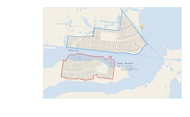
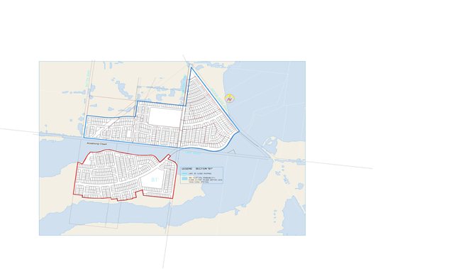
Contents | Previous Page: Section A - Procedural Matters | Next Page: Section B – Reports (11-20)

Copyright CoGG 2012
Last Update: 9 August 2013