Council Minutes - Section B: Reports - 9 July 2013
Contents | Previous Page: Section A - Procedural Matters | Next Page: Section C - Notice of Motion
Contents | Previous Page: Section A - Procedural Matters | Next Page: Section C - Notice of Motion
Reports tabled at the Ordinary Meeting of Council on Tuesday date held at City Hall, Little Malop Street in Geelong.
Amendment C285 – Consideration and Exhibition of Manzeene Avenue, Lara Rezoning
Amendment C203 Trethowan Avenue / Ocean Grand Drive, Ocean Grove
Rezoning Request 892 – 990 Barwon Heads Road, Armstrong Creek
Central Geelong Marketing Committee – Report to Council 2011-2012
Portfolio: |
Planning – Cr Macdonald |
Source: |
Economic Development, Planning and Tourism – Strategic Implementation |
General Manager: |
Peter Bettess |
Index Reference: |
Application: Amendment C285 |
This report seeks Council approval for the preparation and exhibition of a Planning Scheme Amendment (C285) to facilitate the development of land for residential use in the Manzeene Avenue area, Lara. The area is referred to as ‘Manzeene Village’.
The Amendment application was made by Spiire Australia on behalf of Dacland Pty Ltd. Dacland have formed an agreement with 23 of the 26 landowners in the area. This combined landowner entity is known as the ‘Manzeene Avenue Development Trust Pty Ltd’.
The Amendment proposes to rezone the land to the Residential 1 Zone, accompanied by a Development Plan Overlay, Development Contributions Plan and Native Vegetation Precinct Plan.
Advice is being sought from DPCD regarding the new suite of Residential Zones which come into effect on 1 July 2013. If Council is required to use one of the new zones, the General Residential Zone is recommended for this amendment.
The Amendment application, as lodged by the proponent, requests that the south-west corner (i.e. 4 hectares on the corner of Patullos & O’Hallorans Roads) be rezoned to the Business 1 Zone for a Neighbourhood Activity Centre (NAC). This request is not supported and was vigorously opposed at the recent panel hearing for Amendment C246 Lara West Growth Area.
The land affected is bounded by Patullos Road, O’Hallorans Road, Kees Road and the rear of existing residences to the east, in Lara. The land is subdivided into 26 two hectare lots and each lot is developed with a dwelling. Manzeene Avenue cuts through the subdivision connecting Patullos Road to Kees Road.
The Amendment application, as lodged by the proponent, did not seek to include the property on the south east corner (145 Patullos Road) as part of the Amendment. This property has been included by Council officers.
At full development, Manzeene Village will provide for approximately 550 residential lots of varying size, set within a subdivision design that incorporates local parks, stormwater drainage basins, native grassland reserves and established canopy trees.
The application is supported by a planning and urban design report and technical reports addressing drainage, vegetation, transport and movement, cultural heritage and service infrastructure. An economic impact assessment was also submitted to support of the proposed NAC.
Council officers sought initial advice from Energy Safe Victoria and APA GasNet Australia regarding appropriate land uses within proximity to the high-pressure natural gas pipeline located to the west of Manzeene Avenue. The initial advice appeared to rule out a NAC due to the proximity to the gas pipeline.
A Safety Management Study workshop on the gas pipeline and the Manzeene Village proposal occurred on 18 June 2013. The workshop was attended by representatives of: Dacland, Energy Safe Victoria, CoGG and APA Group.
The workshop found that there is no significant difference in the number of persons who might be exposed to the effects of a rupture event on the pipeline, whether the NAC site is utilised for either commercial / retail or residential purposes.
The workshop results will be confirmed when APA gives its formal endorsement. However, it would appear that the gas pipeline is no longer a major influence on decisions regarding the best location for a NAC.
The Development Contributions Plan (DCP) to be placed on exhibition is the Lara West Development Contributions Plan prepared as part of Amendment C246. Manzeene Village is identified as a charge area in the Lara West DCP as its future residents will benefit from the community infrastructure to be provided.
It is considered the proposal (minus the NAC) is supported by the State and Local Planning Policy Framework, including Clause 21.13 of the Greater Geelong Planning Scheme, and there is sufficient merit to warrant its exhibition.
Rejection of the proposed Business 1 Zone (NAC) is entirely consistent with Council’s submissions to the C246 Lara West Growth Area panel hearing and the 12 March 2013 Council resolution, which considered submissions to Amendment C246.
Cr Ansett moved, Cr Macdonald seconded –
Resolves to support the preparation and exhibition of Amendment C285 to the Greater Geelong Planning Scheme for land bounded by Patullos Road, O’Hallorans Road, Kees Road and the rear of existing residences to the east, Lara to:
Rezone the land from the Rural Living Zone to the Residential 1 Zone (or the General Residential Zone - whichever is applicable at the time);
Apply a new Schedule to Clause 43.04 (Development Plan Overlay);
Apply a new Schedule to Clause 45.06 (Development Contributions Plan Overlay);
Incorporate the Lara West Development Contributions Plan to the schedule to Clause 81.01;
Incorporate the Manzeene Avenue Development, Lara, Native Vegetation Precinct Plan, November 2012 to the schedule to Clause 52.16; and
Incorporate the Manzeene Avenue Development, Lara, Native Vegetation Precinct Plan, November 2012 to the schedule to Clause 81.01.
Exhibit the new Schedule to the Development Plan Overlay with a provision identifying the south-west corner as a possible site for non-residential uses including hotel, food and drink premises and service station.
Request the Minister for Planning to authorise the preparation and exhibition of Amendment C285 to the Greater Geelong Planning Scheme.
Carried.
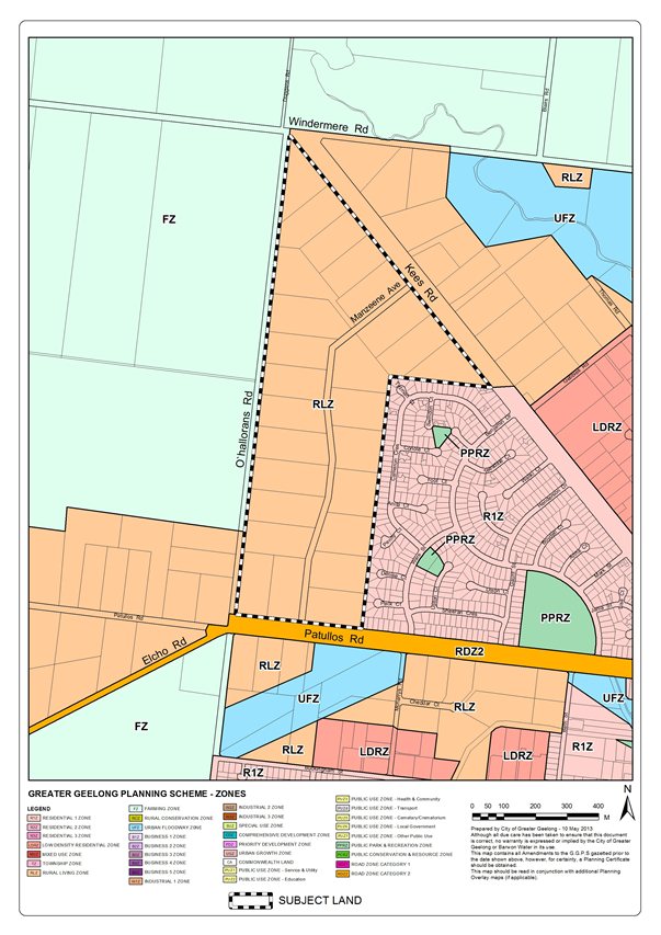
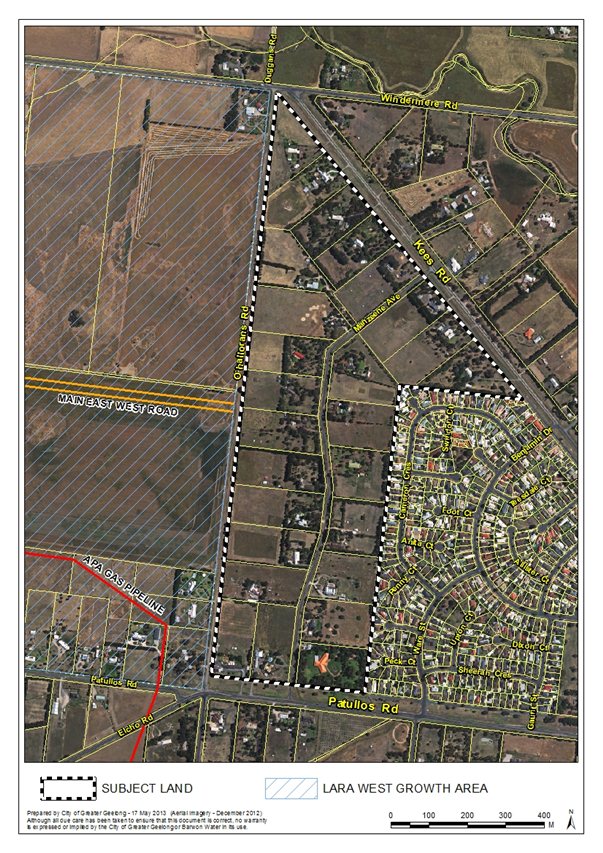
The C285 Amendment land has an area of 60 hectares and consists of 26 rural living properties developed with dwellings on the western edge of existing urban Lara. A current zoning map of the area is shown at Appendix 1 and an aerial map is at Appendix 2. Land to the immediate west of C285 is known as the Lara West Growth Area.
Some landowners in this area have long sought to redevelop and with the coordinated expertise of Dacland Pty Ltd, have moved this project forward. The fragmented landownership would otherwise make it near impossible for individuals to rezone their property. Council is mindful of this and would prefer to see Manzeene Village and the Lara West Growth Area develop concurrently.
Dacland have formed an agreement with 23 of the 26 landowners. This combined landowner entity is known as the ‘Manzeene Avenue Development Trust Pty Ltd’. During the consideration of Amendment C198 Lara Structure Plan in 2010, Spiire Australia (then CPG), acting for the Trust submitted that there was significant strategic merit to rezone the area to the Residential 1 Zone. This position was ultimately supported by the C198 planning panel, Council and the Minister for Planning.
On 6 December 2012, Spiire Australia on behalf of Dacland Pty Ltd lodged a request to amend the Greater Geelong Planning Scheme (known as Amendment C285). The executive summary of the planning report describes the proposal as follows:
“This amendment, proposed by Dacland Pty Ltd, seeks to rezone a 60 hectare site, located adjacent to Manzeene Avenue, within the urban consolidation boundary of Lara. The rezoning will facilitate the development of an infill residential community with a Neighbourhood Activity Centre which will serve greater western Lara. This development is referred to as Manzeene Village.
Over 95% of land owners have come together for form a combined entity with the proponent Dacland Pty Ltd to allow this proposal to proceed. This amalgamation provides certainty of a coordinated and cohesive redevelopment outcome.
The proposal will realize the direction of the Lara Structure Plan to develop the Manzeene Village Precinct in the short term and to make use of underutilised land within the town’s consolidation boundary. The development will complete and enhance the established urban community by creating an “infill” residential development with complementary activities that meets the present and future community needs.
A diversity of housing will be developed, from single family dwellings to medium density and retiree housing.
A new Neighbourhood Activity Centre will be located at the confluence of five roads, providing ideal access for the existing community in the west of Lara, the new Manzeene Village community and the future communities at the western and south western growth fronts identified in the Lara Structure Plan.”
The amendment request was the culmination of a number of meetings between the proponent and Council planning and engineering officers. Initial discussions were held in December 2011 and further took place over the course of 2012, including a meeting about developer contributions with the developers of the Lara West Growth Area and Urban Enterprise P/L.
Both Council officers and the proponent have worked in a collaborative arrangement to realise the development potential of the land for conventional residential use, as directed by policy. Subject to detailed planning for constraints including vegetation and stormwater drainage in particular, there is overwhelming support for the rezoning of this area to the Residential 1 Zone.
However, on 30 October 2012 Council officers were formaly advised by the proponent of the intention to seek a rezoning of part of the land (i.e. 4 hectares on the corner of Patullos & O’Hallorans Roads) to the Business 1 Zone to allow for the development of a Neighbourhood Activity Centre (NAC).
The timing of this announcement coincided with the soon to be exhibited C246 Lara West Growth Area amendment. C246 includes a centrally located NAC conveniently co-located with schools, a Council community centre, district open space and medium density housing. The planning policy for Lara identifies a new NAC to serve growth area residents – not two.
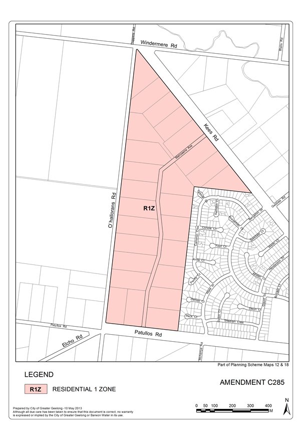
For reasons outlined in this report, Council officers do not support the proposed Business 1 component of the Amendment request. Exhibition of Amendment C285 therefore will propose to rezone the area from the Rural Living Zone to the Residential 1 Zone as shown in Appendix 3.
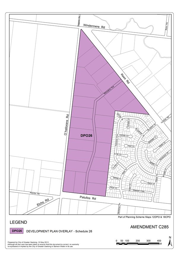
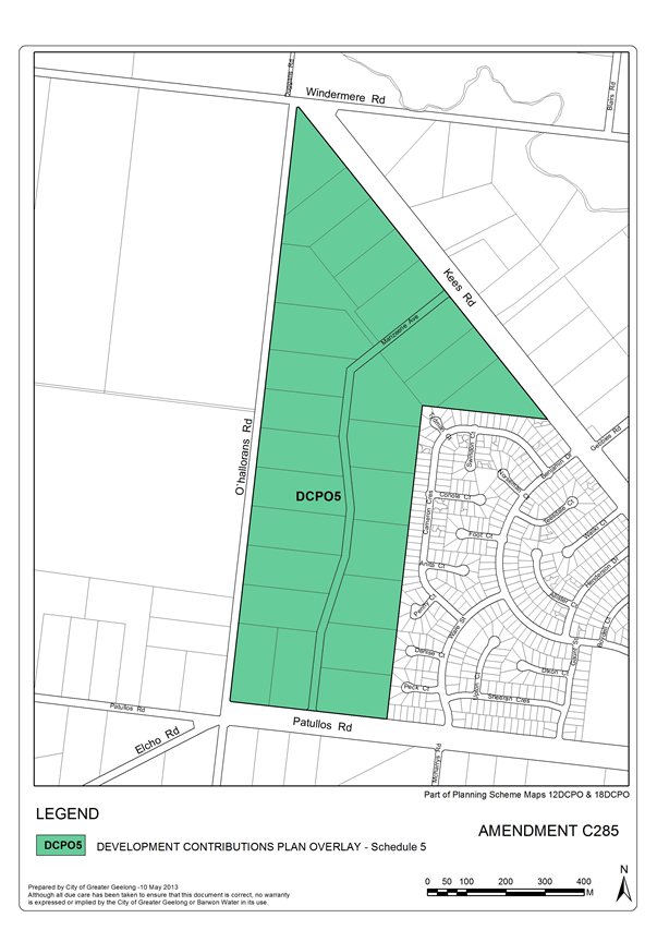
The proposed rezoning will be accompanied by a new Schedule to the Development Plan Overlay (Appendix 4) and Schedule to the Development Contributions Plan Overlay (Appendix 5).
Sitting behind the NAC issue is recent advice received from Energy Safe Victoria and APA GasNet Australia regarding appropriate land uses within proximity to the high-pressure natural gas pipeline located to the west of the Amendment land. Planning for the gas pipeline was extensively considered as part of the C246 Lara West Growth Area panel hearing and is discussed below.
There is clear policy support for the rezoning of Manzeene Village to the Residential 1 Zone, subject to resolution of site-specific constraints. This is not in dispute. What is in dispute is the most appropriate location for a new Neighbourhood Activity Centre.
The location of the NAC will be influenced by its proximity to the APA high-pressure gas pipeline. This significant infrastructure asset is not located on the Amendment land but is a relevant consideration where land uses change within its immediate area.
These two issues were addressed at the C246 Lara West Growth Area panel hearing conducted from 29 April to 8 May 2013. The panel’s recommendations are not expected until the end of July. In considering this Amendment, it would seem prudent
to wait for the panel’s recommendations, however due to contractual arrangements between Dacland P/L and Manzeene Avenue Development Trust P/L, the proponent has requested that the Amendment be progressed to exhibition as soon as possible.
Other site-specific issues involving stormwater drainage, native vegetation, transport and movement and land ownership will also need to be resolved prior to placing the Amendment on exhibition.
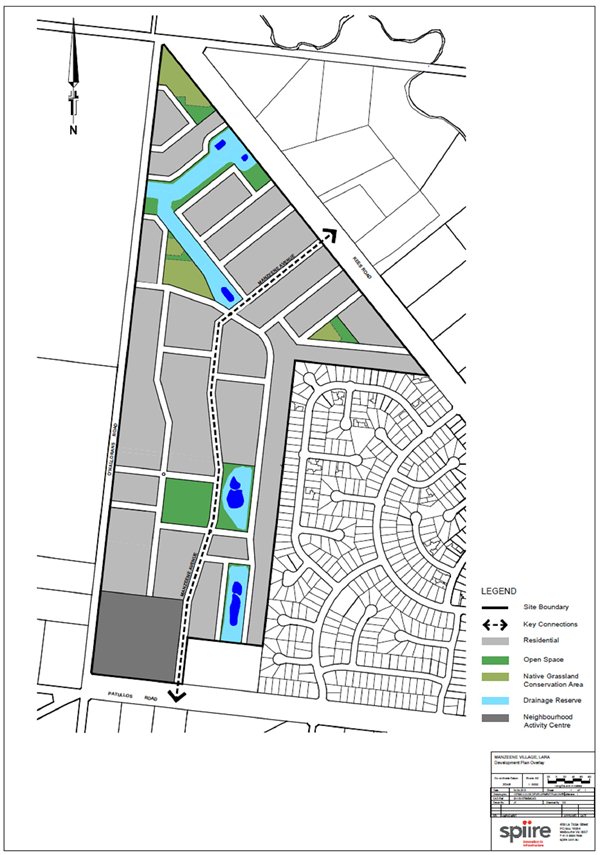
The proposed draft Manzeene Village Development Plan is shown at Appendix 6.1.
The above issues are now addressed in turn:-
Neighbourhood Activity Centre (NAC)
The Amendment request lodged on 6 December 2012 proposes the Business 1 Zone for a NAC at the corner of Patullos Road and O’Hallorans Road of 4 hectares. The request included an Economic Impact Assessment (EIA) prepared by Deep End Services Pty Ltd. The assessment highlights the high levels of ‘escape’ spending from the Lara catchment.
The NAC would consist of 5,275 sq m of retail floor space for specialty shops anchored by a full-line Woolworth’s supermarket, and could be operational by 2017. The EIA considered only ‘retail’ impacts but assumes other uses at the centre including office, medical centre, childcare centre and fuel station as suitable.
The NAC issue was afforded considerable discussion and cross-examination at the C246 Lara West Growth Area panel hearing. The Deep End evidence as summarised at the hearing was that:
“The Manzeene Village NAC site presents the best opportunity to develop a vibrant and viable activity centre at the earliest opportunity for the growing areas of Lara West. The site meets the criteria for neighbourhood centres set out in the GAA’s PSP Guidelines and the Geelong Retail Strategy. Its location is consistent with the current thinking and practice of NAC locations identified in recent PSPs.
The Manzeene Village EIA concluded that the proposed NAC should not result in adverse impact or the closure of a significant number of existing retailers in the Lara Town Centre.
The identified Lara West PSP NAC site is limited in its catchment and its road connections to the broader Lara West area. The PSP site has some prospects to support a more limited level of retail floor space and in time, may well be suited to a smaller NAC or local centre based around an independent supermarket and local shops. A community hub could still be developed in proximity to the schools and district open space.”
Council, in its closing submission to the C246 panel hearing reaffirmed its opposition to the Manzeene Village NAC and its support for a Lara West NAC. Council’s position on this matter has been clear and consistent.
The full extract of Council’s submission (presented by Terry Montebello of Maddocks Lawyers) relating to the location of a new NAC in the west of Lara is in Appendix 7, with some of the key statements repeated below:
“There seems to be broad agreement that there is a need for another activity centre in the west of Lara having regard to, for example, the extent of escape spending and the growth in population. The various panels and the Lara Strategy Plan however, have only ever really contemplated one new NAC. Whatever might be said about the lack of clarity in terms of the guidance that those documents give, none of them seem to contemplate two new NACs in the west of Lara.
It seems now from the submission of Dacland that there could be or should be two NACs in the west of Lara:
the Manzeene village NAC as a larger NAC; and
another (smaller) NAC as proposed in the exhibited PSP.
From Council’s perspective, it has never understood its own strategic planning and various panel reports and any of the strategies done as ever contemplating two NAC’s in the Lara West Area……”
“…Council submits that apart from the constraints it faces with the APA gas pipeline, the Lara West PSP location (on a like for like basis – i.e. not affected by the APA buffer) the PSP site is better located because not only is it more central to its catchment, but it is also co-located with other community and recreational facilities. It is also on a main road which intersects with an arterial road.”
…It is therefore submitted that the panel should not recommend that there be such a substantial change to the PSP such that the NAC is removed from its general location especially in such manner as would leave all the community facilities located distant from the retail component of the activities area….
…It must also be said again that there is no amendment for Manzeene which includes an activity centre. There is no proposal by Council to exhibit an amendment with an activity centre. The proposal as it were is a late proposal by Dacland which has had the effect of slowing its amendment request down significantly. The Dacland amendment will be an amendment that rezones the Dacland land to residential consistent with the implementation provisions in the planning scheme.”
The proponent, in the event that a NAC does not proceed, has suggested that the site be rezoned to the Mixed Use Zone. This zone would allow a range of non-residential uses such as a fuel station, offices and a medical centre to be considered. The Mixed Use Zone is not supported. It is considered that non-residential uses can be accommodated in the Residential 1 Zone and supported by the Development Plan Overlay.
APA Gas Pipeline
APA GasNet Australia (Operations) Pty Ltd (APA) owns and operates over 2,000 kilometres of pipelines throughout Victoria, including the natural gas pipeline located within the Lara West Growth Area which then heads south to a transfer station south of the Princes Freeway. Known as the South West Pipeline, this asset is of strategic importance to the State of Victoria, supplying one-third of Melbourne’s gas and all of Geelong.
The asset does not traverse the Amendment C285 land, but as established through the Lara West Growth Area amendment process, changes to land use within close proximity to the pipeline need to be considered.
Following comments by APA to Amendment C246 dated 13 December 2012 a Safety Management Study in accordance with Australian Standard 2885 was conducted by APA and attended by Council officers and the Lara West developers on 7 March 2013. The SMS Revision No. 8 (Final) concluded: ‘To reduce the residual risk to the public to acceptable levels, compliance with AS2885 requires the location of Sensitive and High Density areas to be not within 324m of this pipeline”.
While APA is the pipeline owner and operator, the regulator and licensor is the Minister Administering the Pipelines Act through the Department of Environment and Primary Industries (DEPI) and its subsidiary Energy Safe Victoria. Council made it very clear at the C246 panel hearing that it is reliant on bodies such as Energy Safe Victoria and DEPI and does not have the necessary expertise where it comes to the pipeline issue.
Regarding Amendment C246 ESV submitted to the panel that it: “does not consider it appropriate that any ‘Sensitive’ or ‘T2’ land use should be planned within 324m of the pipeline”. ‘Sensitive’ or ‘T2’ uses include uses such as NAC’s, schools and residential development greater than 30 lots per hectare. The proposed Manzeene Village NAC is located within 324m of the pipeline.
Amendment C285 was referred to APA, Energy Safe Victoria and DEPI. Initial responses were received from both APA and Energy Safe Victoria. The APA comments are consistent with Energy Safe Victoria’s earlier position on amendment C246, though noting that their comments are based on the Safety Management Study prepared for the Lara West Growth Area. Energy Safe Victoria stated in a letter of 17 May 2013 that in the interests of public safety, some types of land uses may not be appropriate within a certain distance of the South West Gas Transmission Pipeline. This initial advice appeared to rule out a NAC due to the proximity to the gas pipeline
Safety Management Study (SMS)
A Safety Management Study (SMS) workshop on the gas pipeline and the Manzeene Village proposal occurred on 18 June 2013. The workshop was attended by representatives of: Spiire, Dacland, Energy Safe Victoria, City of Greater Geelong, APA Group and GPA Engineering.
The SMS workshop was more detailed than the Lara West SMS. The breakdown of land uses and likely densities of people using the NAC were fully documented. The workshop considered the following advice from Dacland / Spiire:
Based on studies commissioned by Dacland / Spiire, the peak population of the NAC site (over the course of a normal week) is of the order of 200 people. This excludes the activities associated with the proposed childcare centre.
The retail floor space on the site is 6000m2. Additional services proposed for the site include a restaurant, hotel, and gym.
If the NAC was replaced by residential dwellings at 15 dwellings / hectare, the population of the site would be around 160 persons
If the NAC was replaced by residential dwellings at 30 dwellings / hectare, the population of the site would be around 250 persons
The workshop found that there is no significant difference in the number of persons who might be exposed to the effects of a full bore rupture event on the pipeline, whether the NAC site is utilised for either commercial / retail or residential purposes.
On this basis, the workshop found that there is no clear imperative for relocating the NAC due to the gas pipeline.
Based on the information available to the workshop, the primary location classification for the section of pipeline within a distance of approximately 550m (i.e. “the measurement length”) upstream and downstream of the proposed Manzeene Village Development is Residential (T1).
The workshops results will be confirmed when APA gives formal endorsement of the outcomes of the SMS. However, it would appear that the gas pipeline is no longer a major influence on decisions regarding the best location for a NAC.
Stormwater Drainage
The management and treatment of flooding and stormwater impacts across the site is a significant factor in determining the design and function of the development. Strategic cut and fill earthworks will be required to achieve the post development 1% AEP flood event. Council agrees with the proponent where it notes that the current proposal enables the provision of drainage infrastructure that would be unlikely to be feasible without the consolidation of individual parcels of land.
It is well known that the land (and all land in the lower reaches of Hovells Creek where it joins Serendip Creek) has a propensity to flood or be inundated. It is also recognised that there is general a lack of overland flood conveyance and grade for underground drainage systems.
From an early stage Spiire and Council drainage engineers, together with the Corangamite Catchment Management Authority (CCMA), have held discussions. Engineers have also had the benefit of recent assessments and management strategies prepared as part of the Lara West Growth Area planning.
Following review of the preliminary stormwater management report submitted as part of the C285 Amendment application, Council engineers have provided Spiire with comments. This has resulted in the submission of the Manzeene Village, Lara, Site Stormwater Management Plan Report (Rev B) on 16 April 2013.
Council engineers and the CCMA are currently reviewing the report and when satisfied with the proposed management strategy, appropriate wording will be included in the draft Development Plan Overlay for exhibition.
Vegetation
Native vegetation
Brett Lane & Assoc Pty Ltd has prepared a Flora, Fauna and Habitat Hectare Assessment and a Targeted Golden Sun Moth Survey (Feb 2013). This work identified that the site contains 25 fragmented patches of disturbed and degraded grassland indigenous vegetation. The site does not contain any listed flora species including the Golden Sun Moth.
The grassland patches have the floristic composition to be classified as Low-rainfall Plains Grassland (EVC 132) and cover an area of 17.7 hectares with a median patch size of 0.59 ha. The quality of this vegetation is relatively low with an average habitat score of 28 out of 100. The development will require the removal of approximately 16 hectares of native grassland. As a result, the project has been referred to the Minister for Planning under the Environmental Effects Act. The Minister has determined that an Environmental Effects Statement is not required.
Twelve of the 25 patches also have the floristic composition to be considered Natural Temperate Grasslands of the Victorian Volcanic Plain, a listed community under the Commonwealth Environment Protection and Biodiversity Conservation Act 1999 (EPBC Act). The project has been referred to the Commonwealth Government to consider the removal of this vegetation under the EPBC Act.
The proponent must consider management of native vegetation in the context of the ‘avoid’, ‘minimise’ and ‘offset’ direction from Victoria’s Native Vegetation Management – A Framework for Action. The proponent submits that because of the drainage infrastructure and surface level change requirements, the avoidance of large scale vegetation removal is unlikely to be viable under any development scenario.
The proponent also submits that a ‘no development’ scenario is unlikely to result in a favourable environmental outcome due to the various land management practices associated with multiple ownerships that currently exist on the site. The proposed Development Plan will retain some areas of grassland where it can be co-located adjacent to open space areas and drainage reserves. A draft Native Vegetation Precinct Plan has been prepared which will be incorporated into the planning scheme.
Council environment officers had initially queried the amount of native vegetation proposed to be removed and sought further information from the proponent. Likewise, Department of Environment and Primary Industries officers suggest that the developer continues to explore opportunities to incorporate areas of retained vegetation in the layout. Officers are working with the proponent to finalise a Development Plan Overlay and Native Vegetation Precinct Plan that accords with the Native Vegetation Framework.
Non-native vegetation
Tree Logic Pty Ltd have completed an arboricultural assessment, dated November 2012. The assessment identified over 5,000 trees on the site, with the majority being established for ornamental or functional purposes and not for revegetation. While the tree population did contain specimens of River Red Gums, a species indigenous to the area, all specimens were planted. The assessment finds that trees of high arboricultural value (around 1%) included Eucalypts and Corymbias in the later stages of semi-maturity or early maturity and have potential for long term landscape components. All of the trees assessed are exempt from Clause 52.17 Permit requirement.
The Department of Environment and Primary Industries notes that the trees along Manzeene Avenue provide a significant biodiversity corridor for bats and avifauna. The Department considers the trees to be a valuable feature for amenity as well as for their biodiversity values. The Spiire planning report states that a key design objective is to retain as many trees as possible. Council’s Environment Unit has questioned how this objective will be applied to the development site and shape the overall subdivision design.
Ongoing discussions and resolution of this matter will form part of the draft Development Plan Overlay for exhibition.
Transport and Movement
The Amendment land is well connected to the existing road network with Manzeene Avenue forming an attractive central access route from north to south. According to the proponent, it is desired to retain Manzeene Avenue as the ‘spine’ for the development to preserve the existing amenity values and community association with the area.
Both this development and the adjacent Lara West Growth Area will also contribute to the upgrade of O’Hallorans Road and immediate intersections, including the Patullos / Elcho / O’Hallorans Road intersection.
The Cardno Traffic Impact Assessment prepared to support the application finds that there are no traffic engineering grounds that should prohibit the rezoning.
Referral comments from Council’s Traffic Unit state that the function of Manzeene Avenue should be that of a lower order collector road to serve local traffic. This is consistent with the proponent’s vision. However the Traffic Unit strongly recommend that there be an extension of the Lara West main east-west road through to Manzeene Avenue. This will enable a fully controlled intersection that will have long term benefits for vehicles, cyclists and importantly, pedestrians given the proximity of a Local Activity Centre, primary school and community facilities.
Similarly, the Department of Transport / Public Transport Victoria (PTV) comments that the road network should be amended to include a new east-west section of connector road that links the main Lara West east-west road to Manzeene Avenue. PTV states that they are planning a bus route to run through the central spine of the Lara West Growth Area servicing the proposed activity centres and from a bus operations perspective it is optimal to continue this planned route through Manzeene Village.
The proponent does not support the road extension suggested by Council’s Traffic Unit and PTV. Reasons include unknown PTV timing and funding, preference to utilise O’Hallorans Road for buses, encouraging higher levels of traffic and ‘rat running’ and impacts of traffic signals.
It is considered that the inherent benefits of a road extension outweigh any perceived adverse impacts. Safer pedestrian connections and a public bus route that dissects Manzeene Village from O’Hallorans Road through to Manzeene Avenue and exiting at Kees Road are good planning outcomes. This approach is consistent with the Development Plan Overlay (drafted by Spiire) for a movement network that: ‘promotes a high degree of internal permeability for a variety of transport modes’ and ‘enables integration with the existing road network and future growth area to the west’.
Landownership
The Amendment request, as lodged, did not include the 2 hectare property on the north east corner of the Patullos Road / Manzeene Avenue intersection (145 Patullos Road). This property is zoned Rural Living Zone. Council officers see no reason why this property would be excluded from the Amendment. The property is designated for rezoning to the Residential 1 Zone in Clause 21.13 of the Greater Geelong Planning Scheme and will provide a logical part of the overall development.
Therefore 145 Patullos Road will form part of Amendment C285 and be included in the exhibition documents.
Two other properties within the Manzeene Village area do not have contracts with Dacland Pty Ltd. Council officers understand that these two landowners are supportive of the proposed development.
The proposed Manzeene Village development is conveniently located close to the Lara Town Centre, train station and existing bus routes. Future residents will also have the benefit of accessing community infrastructure in the Lara West Growth Area. This will encourage walking and cycling and reduce reliance on the private motor vehicle to access services.
The important environmental issues of managing and treating stormwater drainage – especially the outfall to Hovells Creek, the proposed removal of native grasslands, and the management of non-native canopy trees, have been discussed above.
The Amendment is not expected to result in any adverse financial implications.
As detailed above, a Development Contributions Plan Overlay (DCPO) forms part of the Amendment. The purpose of the DCPO is to levy developer contributions for the provision of works, services and facilities before development can commence.
Clause 11.02 ‘Urban Growth’ of the State Planning Policy Framework requires planning authorities to ensure that sufficient land is available to meet forecast demand. Lara is a designated primary growth node in the Greater Geelong planning Scheme.
The ‘Manzeene Avenue/Kees Road’ area is identified as ‘Conventional residential’ in the Lara Structure Plan and Clause 21.13 of the Planning Scheme. Clause 21.13 supports the rezoning of this area to the Residential 1 Zone with appropriate Development Plan Overlay and Development Contributions Plan Overlay controls.
Advice is being sought from DPCD regarding the new suite of Residential Zones which come into effect on 1 July 2013. If Council is required to use one of the new zones, the General Residential Zone is recommended for this amendment.
In accordance with Sec 80(C) of the Local Government Act Peter Bettess, General Manager, Economic Development, Planning & Tourism declares an indirect financial interest in that he owns Woolworths and Wesfarmers shares.
No other Council Officers involved in this report have any direct or indirect interest, in accordance with Section 80(C) of the Local Government Act.
There are not expected to be any notable risks associated with implementing the recommendation contained in this report.
The proposed Amendment will provide additional residential zoned land in close proximity to the Lara Town Centre and the newly developing Lara West Growth Area.
Formal public exhibition of Planning Scheme Amendment C246 will occur following this resolution, subject to authorisation from the Minister for Planning.
There seems to be broad agreement that there is a need for another activity centre in the west of Lara having regard to, for example, the extent of escape spending and the growth in population. The various panels and the Lara Strategy Plan however, have only ever really contemplated one new NAC. Whatever might be said about the lack of clarity in terms of the guidance that those documents give, none of them seem to contemplate two new NACs in the west of Lara.
It seems now from the submission of Dacland that there could be or should be two NACs in the west of Lara:
the Manzeene village NAC as a larger NAC; and
another (smaller) NAC as proposed in the exhibited PSP.
From Council’s perspective, it has never understood its own strategic planning and various panel reports and any of the strategies done as ever contemplating two NAC’s in the Lara West Area. It is submitted that this aspect of the submission by Dacland is surprising even to its own witnesses (e.g. Mr Hunt) but putting that aside, it is not underpinned by any strategic analysis (apart from evidence from some though not all of its witnesses).
Therefore, not only do the new provisions (i.e. the revised provisions being documents #28 and #29 as produced by Dacland) amount to a transformation of the amendment; they are without any strategic justification.
We submit that the changes amount to a transformation not because they are produced late in the day but because the current amendment changes from a single NAC amendment to a dual NAC amendment. That is a very significant change. There has been no notice given of such a proposal and the authorisation of Amendment C246 did not contemplate any decisions being made in relation to the as yet unauthorised Amendment C285.
The changes that would arise are significant. Dacland has underplayed the significance of those changes. The PSP NAC would be smaller; there would be numerous consequential changes to the PSP and we would simply be left to wonder what happens to the local activity centre now only a matter of a few hundred metres from the Manzeene NAC. Council considers that the Manzeene submissions are piecemeal.
Assuming that only one new NAC is on the cards for the west of Lara the question that arises is whether the PSP NAC site appropriate? Council submits that it is appropriate. It is centrally located to a large proposed population base, it is central in terms of walking distance from that population, it will be co-located with community and recreational facilities and medium density housing; it will be more than a shopping centre; it will be a proper activity centre.
Putting aside the pipeline’s heat flux zone which would seem at least at first blush without some significant shift in the position of Energy Safe Victoria and DPI, to spell the end of the Manzeene NAC proposal, Council submits that the strategic planning and the scheme has always contemplated that the Manzeene Land would be zoned residential not residential and business. (The panel has been referred to page 42 of the Lara Structure Plan & Clause 21.13 -3 regarding what was proposed for implementation).
The growth area to the west of O’Hallorans Road on the other hand was always destined to be zoned a zone that at its very heart contemplates a variety of land uses including business uses; thus the use of the Urban Growth Zone. These recommendations come out of the Lara Structure Plan which is a key document that the Panel must consider. Far from the submission of Dacland, a panel is able (and it would be surprising if it did not) to have regard to documents such as structure plans especially structure plans that have been through a panel process. So far as decision-making at VCAT is concerned, the rules about reference documents are different. But at a planning panel, the issue is whether there is strategic support for a proposal. In this regard, the submissions from Dacland about the status of the structure plan are simply wrong. They do not sit well with clause 11.02-3 of the scheme which calls on Council to undertake and apply structure plans (and precinct structure plans).
However, even if Council is wrong on this, notwithstanding that it was before the growth area proposal in time, the C198 panel addresses the issues that this panel might regard as relevant at page 62 where it states: (with emphasis added)
The Panel does not support an approach which would establish a new freestanding retail centre outside the threshold of the Lara Town Centre, including any potential mall sites (as suggested) to the south or west. While these may be matters as part of future Growth Area planning, there should be full utilisation of Town Centre land before any out–of‐centre growth proceeds. Any north‐west growth precinct will support a population that may require its own retail services, but the Panel thinks that these are best located ‘inboard’, on the eastern end of the proposed development area, so that they can serve the broader Lara community rather than be located on the western periphery as indicated in the Lara Lakes indicative concept.
The various elements of the extract underlined above highlight the key findings of the C198 panel and the points to note are as follows:
These retail matters are properly dealt with as part of future Growth Area planning - which is the current process.
From a timing perspective, a new retail centre should go ahead when there is full utilisation of Town Centre land before any out-of‐centre growth proceeds - not before. Thus the early establishment of a Manzeene NAC or a PSP based NAC for that matter is not desirable until there is full utilization of the town centre.
A new facility should be located in-board rather than on the fringe. Both the PSP and Manzeene would satisfy this.
The north‐west growth precinct (i.e. the Lara West area which we think should be interpreted as including the Manzeene land) will support a population that may require its own retail services. We acknowledge in this regard that the Lara West PSP NAC would occur after a time that Manzeene would establish but not anywhere near as late as Mr Avery suggests. There is both population and escape expenditure and a strategy in place that makes the next (and last for the time being) NAC (wherever it goes) a very attractive proposition for a supermarket operator.
In addition to what was set out earlier regarding the suitability of the PSP NAC, Council also submits that the location as proposed in the PSP is appropriate because it is in an area that will service the growth area and some areas beyond including the Manzeene Land. In this regard, the Panel should also note the catchment plans set out in the Essential Economics June 2012 report at page 8 per Figure 2.1 and page 15 per Figure 3.1. These show a broader catchment than what has been suggested by Manzeene.
Conversely, Council submits that a supermarket and shopping centre on the Manzeene site does not sit well with these criteria.
First, although it might be central to a trafficable catchment as Mr Hunt coined the phrase, it will not be central to the population of the growth area especially from a walkability perspective. The Panel is reminded that the trigger for bringing forward the Lara West amendment was a further assessment of residential land demand and supply that demonstrated significantly less than 15 years lot supply in Lara. The Spade Consulting report found that there is between 7 and 12 years short term available supply of land and the situation is approaching a severely constrained situation.
Page 14 of the Lara Structure Plan identifies that Elcho Road is a very long term proposition. It should be noted that upon the approval of Lara West and Manzeene, there will be a land supply of approximately 30 years in Lara.
The draft development plan for Manzeene Ave shows no real opportunity for community facilities on the Manzeene Land. The placement of the shopping facilities (as distinct from a true activities area) on the Manzeene site as suggested by Dacland would result in a poor planning outcome separating retail facilities from community and recreational and educational facilities and Council submits that this is not consistent with the advice provided in the PSP Guidelines especially those at Element 4.
Second, the Manzeene NAC would (and wants to) establish earlier than the time of full utilisation of town centre. We also observe that at about 4 hectares in area in a Business 1 zone with no floor space limits, the Manzeene NAC would represent a dangerous proposition in the context of a Town Centre that even after Coles would be only slightly larger at 4.2 hectares in area. (i.e. existing is 2.3 hectares plus proposed Business zone of 1.9 hectares = 4.9 hectares)
Council submits that apart from the constraints it faces with the APA gas pipeline, the Lara West PSP location (on a like for like basis – i.e. not affected by the APA buffer) the PSP site is better located because not only is it more central to its catchment, but it is also co-located with other community and recreational facilities. It is also on a main road which intersects with an arterial road. In this regard it is noted that Mr Sheppard’s evidence assumes that other community facilities which according to the PSP Guidelines are desirably located within site of the activity centre can locate on the west side of O’Hallorans Road. With the APA pipeline, that is not possible leaving the Manzeene centre as a shopping centre and not a true activities area.
The notion that all activity centres should strictly be directly adjacent to an arterial road is not accepted.
Standard C3 of clause 56.04-2 is inconsistent with the PSP Guidelines only if you interpret the PSP Guidelines in the way advocated by Dacland. Otherwise, as one would expect, the provisions are consistent. Clause 56.04-2 is as follows: (with emphasis added)
Standard C3
A subdivision should implement any relevant activity centre strategy, plan or policy for the
area set out in this scheme.
Subdivision should be supported by activity centres that are:
Accessible by neighbourhood and regional walking and cycling networks.
Served by public transport that is connected to the regional public transport network.
Located at public transport interchange points for the convenience of passengers and easy connections between public transport services.
Located on arterial roads or connector streets.
Of appropriate size to accommodate a mix of uses that meet local community needs.
There are many NAC type centres based on connector roads without direct access (as in abutting) an arterial road (for instance Armstrong Creek West NAC, Jetty Road NAC). Indeed, Mr Govenlock to his credit noted that it was horses for courses rather than one rule fits all. Mr Sheppard also came around to this view.
It is therefore submitted that the panel should not recommend that there be such a substantial change to the PSP such that the NAC is removed from its general location especially in such manner as would leave all the community facilities located distant from the retail component of the activities area.
It must also be said again that there is no amendment for Manzeene which includes an activity centre. There is no proposal by Council to exhibit an amendment with an activity centre. The proposal as it were is a late proposal by Dacland which has had the effect of slowing its amendment request down significantly. The Dacland amendment will be an amendment that rezones the Dacland land to residential consistent with the implementation provisions in the planning scheme.
Cr Eddy Kontelj re-entered the meeting room at 7:35pm.
Cr Farrell declared an Indirect Interest in Agenda Item 2 and left the meeting prior to discussion of the item at 7:35pm.
Portfolio: |
Planning - Cr Macdonald |
Source: |
City Development - Strategic Implementation |
General Manager: |
Peter Bettess |
Index Reference: |
Subject: Council Reports 2013, Application: 203 |
An application has been made by St Quentin Consulting on behalf of the North East Ocean Grove Subdivision Group to rezone 22 properties totalling 45 ha from Rural Living to Residential 1 together with an accompanying Development Plan Overlay. The subject land is west of Banks Road, north of Shell Road immediately east of The Parks Estate in Ocean Grove.
Advice is being sought from DPCD regarding the new suite of Residential Zones which come into effect on 1 July 2013. If Council is required to use one of the new zones, the General Residential Zone is recommended for this amendment.
A satisfactory ODP has been prepared for the whole area. A model template Section 173 Agreement, which will form the basis for Agreements to be entered into with all land owners to formalise developer contribution arrangements, is also being prepared.
As part of the rezoning, the accompanying Development Plan Overlay will ensure that the development proceeds in a logical manner in accordance with the agreed ODP.
This area falls into two catchments, one draining to the north east (8 properties, 19 ha), the other to the west (14 properties 26 ha). At this stage it is only in the western catchment that active developer interest exists which will assist in the delivery of local infrastructure requirements. Development of the north eastern catchment will be dependent upon Barwon Water constructing a new sewerage pump station, scheduled for 2016/2017.
The rezoning of this area is consistent with adopted Council planning policies and provides an opportunity to contribute to urban consolidation given its close proximity to a range of community and commercial services and facilities nearby in Shell Road.
Cr Macdonald moved, Cr Heagney seconded -
That Council:
resolves to support the preparation and exhibition of Amendment C203 to the Greater Geelong Planning Scheme to:
Rezone land in Shell and Banks Road and Trethowan Avenue / Ocean Grand Drive Ocean Grove as identified in this report from Rural Living zone to Residential 1 zone (or the General Residential Zone – whichever is applicable at the time); and
Apply a Development Plan Overlay to the land being rezoned subject to the finalisation of amendment documentation, model template Section 173 Agreement and accompanying Infrastructure Plan to Council’s satisfaction.
requests the Minister for Planning to Authorise the preparation of Amendment C203; and
resolves to exhibit the draft model template Section 173 Agreement accompanying the amendment documentation as outlined in this report.
Carried.
An application has been made by St Quentin Consulting on behalf of the North East Ocean Grove Subdivision Group to rezone 22 properties totalling 45 ha from Rural Living to Residential 1 together with an accompanying Development Plan Overlay. The subject land is west of Banks Road, north of Shell Road, immediately east of The Parks estate in Ocean Grove.
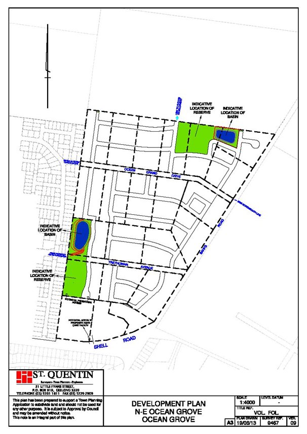
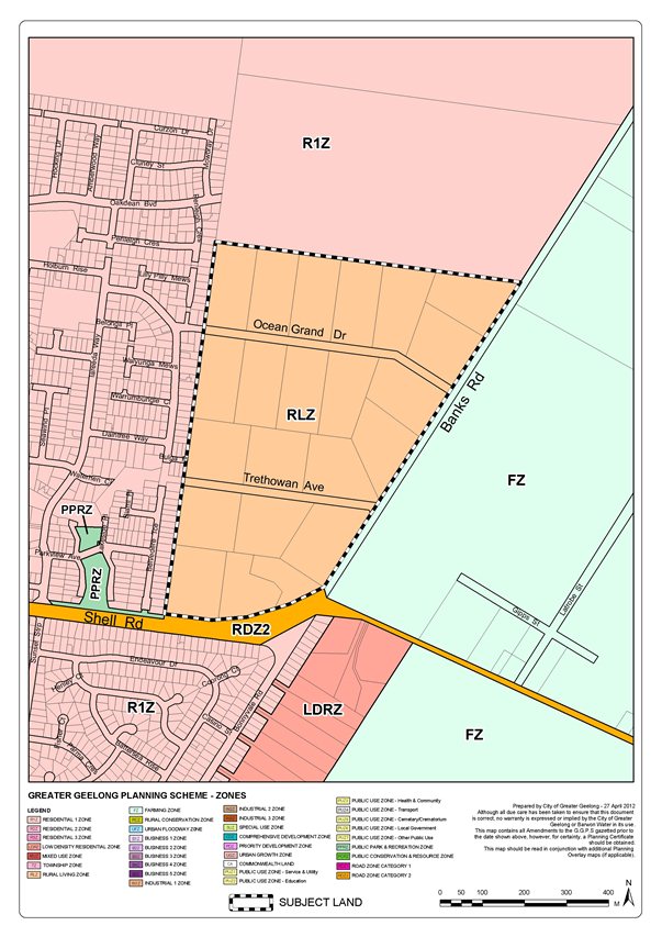
Appendix 1 shows the land subject of the rezoning application and existing zonings. The vast majority of the lots (each approx. 2 ha) are individually owned and used for rural residential purposes. They have been substantially cleared of native vegetation apart from scattered remnant trees and some intact indigenous vegetation within the Banks Road roadside reserve. Appendix 2 is an aerial photo of the subject land and surrounding area.
The application has been accompanied by specialist planning, vegetation, aboriginal cultural heritage, traffic and engineering reports together with a draft outline development plan for the area.
Since this application was originally submitted to Council there have been extensive discussions and negotiations with the applicant and their consultants about the outline development plan and delivery by the developer(s) of the necessary community infrastructure in a timely manner. In this area these arrangements have been complicated by the relatively large number of individual property owners and the need to fairly and equally apportion developer contribution costs among the individual landowners.
Identified infrastructure requirements include:
Provision of 2 stormwater retarding basins
Provision of 2 local parks (10% of the overall area)
Upgrade of Banks Road intersections with Trethowan Avenue and Ocean Grand Drive.
$900 per dwelling community infrastructure levy.
The proponents understand that Section 173 Agreements are required to be signed by all landowners which encapsulate these arrangements.
At the request of Council, the applicants consultants have prepared a draft Infrastructure Plan which sets out in detail the costs of delivering the above infrastructure items and apportioning these costs equitably amongst the 22 landowners.
This Rural Living zoned area has been identified in both the 1993 and 2007 adopted Ocean Grove Structure Plans as a future conventional residential area. The 2007 Structure Plan describes this area as follows:
“The Rural Living zoned area incorporating Ocean Grand Drive and Trethowan Avenue provides an opportunity to make a moderate contribution to urban consolidation given proximity to existing and proposed residential areas to the north and west and availability of services.
The fragmented nature of land ownership will however require the development of an Outline Development Plan (ODP) prior to rezoning to residential (with a Development Plan Overlay based on the ODP) to coordinate broad development principles including street networks, protection of scattered vegetation, open space and linkages, a north south road link between Shell Road and the northern growth area, and a low density treatment to Banks Road. This area is not considered a high priority for Council and support for rezoning will be dependent on local residential capacity to coordinate the development of an Outline Development Plan and prepare a rezoning proposal supported by environmental, traffic, cultural and urban design assessments.”
From a strategic planning viewpoint there is strong State and Council policy justification to support this proposed rezoning.
The subject land falls into two catchments as follows:
The north eastern catchment (8 properties approx 19 ha) which drains into the adjoining undeveloped Kingston Downs estate. This area will require provision of a stormwater retarding basin and a local Park comprising 10% of the catchment area.
The western catchment (14 properties approx 26 ha) which drains into the adjoining developed Parks estate. This area also requires provision of a stormwater retarding basin and local park.
An outline development plan has been prepared by the applicant’s consultants including both catchments which generally meets Council’s requirements for the future development of this area. This has formed the basis of a detailed Development Plan Overlay which sets out all planning, engineering and environmental issues to be addressed as part of the development of this land. Appendix 3 is the draft Development Plan Overlay Schedule which includes the Outline Development Plan.
Negotiations with the applicant and their consultants had been aimed at ensuring the retarding basins and local parklands are provided by the developer as part of the development process and not left to Council to provide and construct at a later time. In the western catchment the retarding basin will be provided by the developer in the first stage of development; however the multiplicity of owners has made delivery of other infrastructure items less certain. In these circumstances, the draft S173 Agreement which has been prepared to apply to all property owners provides the option of Council accepting monetary contributions and delivering the infrastructure. It is proposed that this draft model template be exhibited with the Amendment documentation and that owners be required to sign their individual Agreements before the Amendment is eventually approved.
All landowners in the area have been advised about these proposed arrangements and the amendment process.
Development in the north eastern catchment will be dependent upon Barwon Water constructing a new sewer pump station, scheduled for 2016/2017. As a result at this stage there appears to have been limited immediate interest in development within this catchment.
The proposed rezoning and subsequent residential development is not expected to result in any adverse environmental impacts.
The Development Plan Overlay schedule includes requirements relating to protection of remnant vegetation and management of stormwater to prevent downstream pollution.
All necessary new infrastructure or improvements to existing infrastructure will be funded by developers/land owners as described in this report.
The Amendment is consistent with the State Planning Policy Framework and the Local Planning Policy Framework, as follows:
State Planning Policy Framework. The Amendment implements the objectives and strategies of Clause 11 Settlement, (in particular Urban Growth Clause 11.02, Open Space Clause 11.03 and Regional Development Clause 11.05), Clause 15 Built Environment & Heritage, Clause 16 Housing and Clause 19 Infrastructure.
Local Planning Policy Framework. Clause 21.06 Settlement & Housing identifies Ocean Grove as one of the city’s designated primary urban growth areas. Clause 21.14 The Bellarine Peninsula sets out objectives and strategies for development of the Peninsula and each of the towns as contained in the adopted Structure Plans.
As this report indicates, the proposed rezoning is consistent with the adopted 2007 Ocean Grove Structure Plan and as such is consistent with Clause 21.14 of the LPPF.
The Amendment is also consistent with a range of other environmental, infrastructure, developer contributions and open space policies contained in the M.S.S.
Advice is being sought from DPCD regarding the new suite of Residential Zones which come into effect on 1 July 2013. If Council is required to use on of the new zones, the General Residential Zone is recommended for this amendment.
No Council Officers have any direct or indirect interest, in accordance with Section 80 (C) of the Local Government Act to which this Amendment relates.
The proposed Amendment is not expected to expose Council to any risk of liability beyond that usually associated with facilitating greenfield development.
The Ocean Grove Structure Plan, upon which this Amendment is based, has thoroughly addressed the social implications of identifying areas for future growth.
The subject land is centrally located close to some of the town’s major community, retail and educational facilities.
It is proposed that the Amendment be exhibited in accordance with the provisions of the Planning and Environment Act to provide for full public comment (and potentially referred to an Independent Panel appointed by the Minister for Planning).
It is intended that direct written notification will be provided to all properties within the existing Rural Living zone and all affected adjoining and opposite property owners.
![[image]](130709---minutes-9.jpg "130709---minutes-9.jpg")
SCHEDULE 26 TO THE DEVELOPMENT PLAN OVERLAYShown on the planning scheme map as DPO26 TRETHOWAN AVENUE/OCEAN GRAND DRIVE OCEAN GROVEThis Schedule applies to the area generally north of Shell Road, west of Banks Road incorporating properties in Trethowan Avenue and Ocean Grand Drive, Ocean Grove. The aim of this Schedule is to ensure that development occurs in accordance with broad development principles as shown in the Trethowan Avenue/Ocean Grand Drive Outline Development Plan 2012 and to ensure delivery of essential community infrastructure as set out in the North East Ocean Grove Infrastructure Plan. |
|
1.0 |
Requirement before a permit is grantedA permit may be granted before a development plan has been prepared for the following:
|
2.0 |
Conditions and requirements for permitsA permit must contain conditions or requirements which give effect to the provisions and requirements of the approved North East Ocean Grove Infrastructure Plan and the approved Development Plan. A permit for subdivision must contain a condition which requires the owner to enter into an agreement with the Responsible Authority pursuant to Section 173 of the Planning and Environment Act 1987 to provide development contributions for:
as outlined in the approved Development Plan and North East Ocean Grove Infrastructure Plan. |
3.0 |
Requirements for development planA separate Development Plan may be prepared and approved which addresses the relevant requirements for the western catchment only. The Development Plan must be generally in accordance with Trethowan Avenue/Ocean Grand Drive Outline Development Plan, and include the following: An Urban Design Masterplan that includes:-
A Road Network and Traffic Management Plan complying with any VicRoads requirements that includes:-
A Stormwater Drainage Masterplan that takes an integrated approach to stormwater system management, is designed with reference to the whole of the catchment and includes:
An Open Space and Landscape Masterplan that includes:
|
4.0 |
Decision GuidelinesIn considering whether or not to approve or amend a development plan, the responsible authority must consider:
|
5.0 |
Trethowan Avenue/Ocean Grand Drive Outline Development Plan
|
Cr Farrell returned to the meeting room at 7:37pm
Cr Heagney declared an Indirect Interest in Agenda Item 3 and left the meeting prior to discussion of the item at 7:37pm.
Portfolio: |
Planning – Cr Macdonald |
Source: |
Economic Development, Planning & Tourism – Strategic Implementation |
General Manager: |
Peter Bettess |
Index Reference: |
Subject: Council Reports 2013 |
Amendment C265 proposes to extend coverage of the Special Building Overlay (SBO) to reflect the findings of flood studies recently undertaken and adopted by Council.
These studies identify the nature and extent of flooding in the Portarlington, Newcomb-Whittington and Corio areas.
The exhibition of Amendment C265 resulted in the receipt of twenty five (25) submissions; including 2 concerning properties outside of the areas affected by the amendment, and 3 from government departments / statutory authorities, not objecting.
The exhibited Amendment, together with all submissions was referred to an Independent Panel appointed by the Minister for Planning for consideration, as required by the Planning and Environment Act 1987.
The Independent Panel has recommended that the Amendment be adopted as exhibited.
It is recommended that the Amendment be adopted as described in this report.
Cr E Kontelj moved, Cr Farrell seconded -
That the report be deferred.
Carried.
Portfolio: |
Planning - Cr Macdonald |
Source: |
Economic Development, Planning and Tourism – City Development |
General Manager: |
Peter Bettess |
Index Reference: |
Application C286 & PP 1304/2012 |
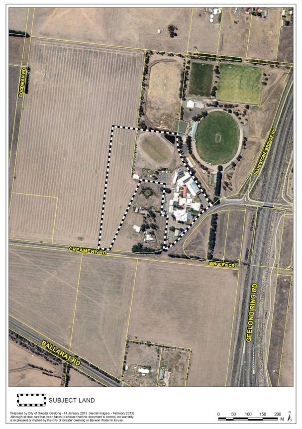
Amendment C286 proposes to rezone land at 65 and 105 Creamery Road Bell Post Hill from the Farming Zone to the Special Use Zone (15) for Private Education Centre.
The Amendment has been initiated by Fadgyas Planning Associates Pty Ltd on behalf of Covenant College, specifically The Geelong Association for Parent Controlled Christian Education (Covenant College).
The Amendment has been undertaken to facilitate an expansion of the Covenant College site to accommodate the growth in student numbers at the school.
Authorisation (A02501) for this Amendment was issued on 27 March 2013 under section 35B of the Planning and Environment Act 1987.
Exhibition of the Amendment between 2 May and 3 June 2012 resulted in no submissions.
The Amendment is consistent with Council planning policy and is considered to be an appropriate response to the education needs of the region.
The Amendment can be adopted with no need to refer to an independent panel.
Cr Macdonald moved, Cr E Kontelj seconded -
That Council:
adopt Amendment C286 as contained in Appendix 1 of this report;
submit the adopted Amendment together with the prescribed information to the Minister for Planning requesting approval; and
recommend to the Minister that a Permit be granted pursuant to Section 96G of the Planning and Environment Act 1987 (Planning Permit No. 1304/2012 is contained in Appendix 3).
Carried.
Amendment C286 and Planning Permit 1304/2012 has been requested by Covenant College. Appendix 1 shows the subject land.
The amendment proposes to:
Introduce a new Schedule 15 to the Special Use Zone to provide for private education centres.
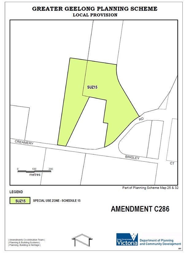
Include the land at 105 Creamery Road (current site of Covenant College) and a 3.24 Ha parcel of adjoining land at 65 Creamery Road within the Special Use Zone – Schedule 15.
The proposed Schedule 15 to the Special Use Zone provides a range of subdivision and development options that are appropriate for a Private Education Centre.
The amendment is combined with a planning permit application PP1304/2012 for subdivision of the land. This will provide for the concurrent excision of the adjoining 3.24 Ha parcel of land and its consolidation into the Covenant College title. There are no buildings and works associated with this application.
The current College site at 105 Creamery Road is within the Farming Zone (Clause 35.07) under the Greater Geelong Scheme. Whilst it has not been used for farming purposes since the mid 1960’s and is adjoined by the Myer Reserve to its north and residential development to its east, it was zoned to Farming Zone under Amendment C130 in 2007 (an amendment that introduced the then new suite of farming zones).
The Farming Zone is limited in the discretionary uses available and education facilities (both use and development) are prohibited. The College however, enjoys existing use rights under Clause 63 of the Scheme.
The land proposed to be acquired to the west is also within the Farming Zone, and whilst there is no prohibition on subdivision, the “test” for the Responsible Authority in considering a subdivision for a prohibited use would be difficult to pass under the current zone. Hence it is seen as appropriate to apply its own Special Use Zone to the College site and also the area proposed to be added to the site. Further, even if the application for subdivision succeeded under the current zone, the additional land could not be used for education purposes as the existing use right could not be applied to the new land.
The amendment will:
Ensure that the on-going use and development of the College is appropriately recognised and safeguarded by inclusion in a specific schedule for private education uses.
Ensure that the provisions/controls in the Schedule reflect the use of the site for educational and ancillary/compatible activities.
Facilitate the subdivision of a small portion of the adjoining property to be consolidated into the existing Covenant College site.
Ministerial Authorisation (No: A02501) for this Amendment was received from the Minister for Planning on 27 March 2013. Exhibition of Amendment C286 took place between 2 May and 3 June 2013 with notices placed in local newspapers and in the Government Gazette. Notice of Amendment was sent to the relevant Ministers under the Planning and Environment Act 1987, and to adjoining properties.
No submissions have been received about this amendment or draft planning permit.
Council is now able to adopt the amendment and forward it to the Minister for Planning seeking approval. The amendment to be adopted is in Appendix 2.
The permit recommended to be issued is in Appendix 3.
There are no adverse environmental consequences from this proposal. Advice from the Environment and Natural Resources Unit is that there are no environmental planning issues associated with either the rezoning or the 2-lot subdivision.
It is not expected that the proposal will result in any financial implications for Council, other than those associated with the usual processing of a planning application.
As outlined above the proposal supports the planning policy framework and will allow for the expansion of a growing and in demand educational service in Geelong.
No Council Officers have any direct or indirect interest, in accordance with Section 80 (c) of the Local Government Act to which this amendment relates.
There are no notable risks associated with implementing the recommendation contained in this report.
The amendment is seen as being positive in terms of social effects. The College already exists on the site, however the amendment will provide the framework that acknowledges the use on the site, and provides for the subdivision that will ensure the longer-term growth potential of the College.
The amendment was exhibited in accordance with the Planning and Environment Act, 1987.
The planning authority for this amendment is Greater Geelong Planning Scheme
Greater Geelong Planning Scheme is amended as follows:
Planning Scheme Maps
The Planning Scheme Maps are amended by a total of 1 attached map.
Planning Scheme Map Nos.25 and 32 are amended in the manner shown on the attached map marked “Greater Geelong Planning Scheme, Amendment C286”.
The Planning Scheme Ordinance is amended as follows:
In Zones – following Clause 37.01, insert a new Schedule 15 in the form of the attached document.
End of document
SCHEDULE 15 TO THE SPECIAL USE ZONEShown on the planning scheme map as SUZ15/ PRIVATE EDUCATION CENTREPurposeTo provide for areas to be used by private educational and religious institutions. To ensure that use and development of these facilities takes place in an orderly and proper manner and does not cause loss of amenity in the surrounding area or neighbourhood. |
||
1.0 |
Table of uses |
|
Section 1 – Permit not required |
||
USE |
CONDITION |
|
Caretaker’s House |
||
Child Care Centre |
Must form part of, or be ancillary to the education centre or religious institution. |
|
Education Centre |
||
Hall |
Must form part of, or be ancillary to the education centre or religious institution. |
|
Informal Outdoor Recreation |
||
Library |
Must form part of, or be ancillary to the education centre or religious institution. |
|
Minor sports and recreation facility (other than outdoor recreation facility) |
||
Minor utility installation |
||
Place of Worship |
Must form part of, or be ancillary to the education centre or religious institution. |
|
Section 2 - Permit required |
||
USE |
CONDITION |
|
Accommodation (other than caretaker’s house) |
Must form part of, or be ancillary to the education centre or religious institution. |
|
Convenience Shop |
Must form part of, or be ancillary to the education centre or religious institution. |
|
Outdoor recreation facility |
||
Office |
||
Place of assembly |
||
Restricted place of assembly |
||
Any use listed in Clause 62.01 |
Must meet the requirements of Clause 62.01 |
|
Any use in Section 1 if the relevant Condition(s) is not met |
||
Section 3 - Prohibited |
||
USE |
||
Any use not in Section 1 or 2 |
||
2.0 |
SubdivisionA permit is required to subdivide land. Application requirements Any application must state the intended outcome of the proposed subdivision and its strategic impact on the overall operation of a private education centre. Exemption from notice and review An application for subdivision within the total boundary of the property is exempt from the notice requirements of Section 52(1)(a), (b) and (d), the decision requirements of Section 64(1), (2), and (3) and the review rights of Section 82(1) of the Act. |
|
3.0 |
Buildings and worksA permit is required to construct a building or to construct or carry out works. Application requirements An application to construct a building or construct or carry out works must be accompanied by the following information, as appropriate:
Decision guidelines Before deciding on an application to construct a building or construct or carry out works the responsible authority must consider, as appropriate:
|
|
4.0 |
Advertising signsThis zone is in Category 3 of Clause 52.05. |
|
|
PLANNING |
Permit No. |
1304/2012 |
|
PERMIT |
Planning Scheme |
Greater Geelong Planning Scheme |
|
|
|
|
|
|
Responsible Authority |
Greater Geelong City Council |
|
|
|
|
|
ADDRESS OF THE LAND |
65 CREAMERY ROAD, BELL POST HILL 105 CREAMERY ROAD, BELL POST HILL |
|
|
|
|
THE PERMIT ALLOWS |
TWO LOT SUBDIVISION (BOUNDARY REALIGNMENT) |
|
|
GENERALLY IN ACCORDANCE WITH THE ENDORSED PLANS |
Endorsed Plans
The layout and site dimensions of the proposed subdivision as shown on the endorsed plan(s) shall not be altered or modified without the written consent of the Responsible Authority. There are no requirements to alter or modify the endorsed plan if a plan is certified under the provisions of the Subdivision Act 1988 that is generally in accordance with the endorsed plans.
Drainage
The site must be drained to the satisfaction of the Responsible Authority.
Utilities
The owner of the land must enter into agreements with the relevant authorities for the provision of water supply, drainage, sewerage facilities, electricity, gas and telecommunication services to each lot shown on the endorsed plan in accordance with the authority’s requirements and relevant legislation at the time.
All existing and proposed easements and sites for existing or required utility services and roads on the land must be set aside in the plan of subdivision submitted for certification in favour of the relevant authority for which the easement or site is to be created.
The plan of subdivision submitted for certification under the Subdivision Act 1988 must be referred to the relevant authority in accordance with Section 8 of that Act.
The permit will expire if the plan of subdivision is not certified within 2 years from the date of this permit and if a statement of compliance is not issued within 5 years of the date of certification of that plan.
The Responsible Authority may extend the periods referred to if a request is made in writing before the permit expires or within 3 months afterwards.
Portfolio: |
Planning – Cr Macdonald |
Source: |
City Development – Strategic Implementation |
General Manager: |
Peter Bettess |
Index Reference: |
Subject: Council Reports 2013 |
An application has been made by TGM on behalf of Mr and Mrs B Keirl seeking “in principle” agreement of Council to rezone approximately 50 ha of land at 892 – 958 and 960 – 990 Barwon Heads Road, Armstrong Creek from Farming to Urban Growth zone and inclusion of the land within the Armstrong Creek Urban Growth Boundary. It is also proposed that the land be included in the approved Armstrong Creek East Precinct Structure Plan by way of an addendum document.
These properties fall immediately outside the Armstrong Creek Urban Growth Boundary as designated in Clause 21.11 of the Municipal Strategic Statement (MSS) in the Planning Scheme.
TGM believes previous submissions to the Council and Independent Panels on behalf of Mr and Mrs Keirl have not been successful on the basis that inadequate technical stormwater management reports had not been provided to support their case.
In 2011 Council requested an independent consultant Bosco Johnson to review these properties and their recommendation is that they should be rezoned for residential development purposes as part of the Growth Area.
The TGM submission mounts the case for the rezoning of this land having regard to planning and policy considerations together with detailed flooding and stormwater management reports.
This proposal has been the subject of referrals to all relevant internal Council units and a range of external Government agencies. Comments received have been summarised in this report.
This report outlines the pros and cons of Council supporting “in principle” the future development of this site having regard to planning policy, land use planning and engineering considerations.
On balance the rezoning of the Keirl property is not supported particularly on a number of strategic and planning policy grounds as set out in this report. From a lot supply perspective the proposal is difficult to justify. The Armstrong Creek Growth Area has been comprehensively planned and designed from the outset in a fully integrated manner and the proposal to “tack on” additional land at this stage is inconsistent with this approach.
Cr Richards moved, Cr Macdonald seconded -
That Council considers the proposal has sufficient merit to warrant exhibition and that the issues raised in the officer’s report can be further addressed as part of the amending planning scheme process.
That Council resolves to proceed with the amendment process regarding the rezoning of land at 892 – 990 Barwon Heads Road Armstrong Creek subject to providing the additional information as outlined in the officer’s report being:
Preparation of a formal planning scheme amendment application including payment of application fees and preparation of all amendment documentation etc.
Preparation of a revised Indicative Subdivision Design to address issues including stormwater management, landscaping and vegetation protection, traffic management, and community infrastructure and interface treatment of rural land to the south.
Completion of the necessary Precinct Structure Plan documentation (which will need to be incorporated into the Scheme).
Preparation of a full traffic assessment including conceptual intersection designs incorporating a major entrance to Barwon Heads Road, to the satisfaction of Vic Roads.
Negotiation of developer contributions to similar levels as the adjoining Growth Area developers including their means of implementation (Section 173 Agreements or Developer Contribution Plan Overlay).
Carried.
An application has been made in February 2013 by TGM (Engineering and Planning Consultants) on behalf of Mr and Mrs B Keirl seeking the “in principle” agreement of Council to rezone approx 50 ha of land at 892 – 958 and 960 – 990 Barwon Heads Road, Armstrong Creek from Farming to Urban Growth zone. The application also seeks to:
have the subject land included within the Armstrong Creek Urban Growth boundary as designated on the Framework Plan map forming part of the Clause 21.11 Armstrong Creek Urban Growth Area of the Planning Scheme; and
have the land included in the Armstrong Creek East Precinct Structure Plan by way of an addendum document.
Appendix 1 shows the location of the subject land superimposed on an existing zoning map.
Appendix 2 shows the subject land falling just outside the south-eastern extremity of the Armstrong Creek Urban Growth Boundary as currently designated on the Framework Map in the Planning Scheme.
Each of the properties comprising the subject land are occupied by one detached house. A cattery (Geelong Cattery) and cattle breeding are conducted on the Keirl property and horse agistment and horse riding school (Rainbow Riders) occur on the other site. Land immediately opposite the subject land in Lake Road is currently being actively developed as part of the Warralily estate, whilst the Laurel Grove land along its western boundary within the growth area remains undeveloped. Appendix 3 is an aerial photo showing the subject land and generally rural type uses to the south and east.
The Armstrong Creek Urban Growth Boundary was first established as part of the Armstrong Creek Urban Growth Plan 2006 which excluded the properties subject of this rezoning application. Amendment C170 approved on 4 December 2008 introduced the Urban Growth zone into the planning scheme and applied it to the Armstrong Creek land inside the identified growth boundary. The growth boundary was included in the planning scheme as a result of the approval of Amendment C138 on 4 December 2008. This amendment introduced the Armstrong Creek Urban Growth Boundary Plan Framework Plan, November 2008, as an incorporated document.
A subsequent Amendment C206 approved on 3 June 2010 provided for the future development of the Armstrong Creek East Precinct by introducing a new Schedule to the Urban Growth zone and a Precinct Structure Plan and Native Vegetation Precinct Plan (and also updated the Armstrong Creek Urban Growth Plan – Framework Plan as related to the Armstrong Creek Urban Growth Plan – Framework Plan as it related to the Armstrong Creek East Precinct). A copy of the East Precinct Structure Plan is Appendix 4.
Previous submissions on behalf of Mr and Mrs Keirl to both the Council and Independent Panels in relation to the above amendments were not successful in demonstrating that these properties should be included in the Growth Area. However it is acknowledged that neither the Council nor the Panels had the opportunity to review the further detailed drainage studies which have now been submitted with this application.
Following further representations by Mr and Mrs Keirl, in 2011 Council engaged an independent consultant Bosco Johnson to assess the potential and likelihood of rezoning the subject land and including it in the Armstrong Creek Growth area. The assessment reviewed the history of the development of this area, previous Panel reports and included consultation with key stakeholders as part of the project.
Bosco Johnson’s recommendation was that the subject land should be rezoned for residential development purposes and included within the overall strategic planning and engineering of the Armstrong Creek Growth Area.
Having reviewed the Bosco Johnson report, Mr and Mrs Kierl have again sought the rezoning of their land. In indicating a preparedness to reconsider the proposal, Council officers advised it would need to include updated flooding and stormwater management designs, strategic planning justification and assessment on the potential impacts on the Armstrong Creek Growth Area.
The submission prepared by TGM includes an Indicative Subdivision Design with a lot yield of 666 lots. This plan is Appendix 5.
The assessment of this application raises a range of strategic and planning policy issues together with the consideration of drainage, traffic, community infrastructure and servicing provision. The following section of this report addresses these issues and includes comments received as a result of referral to internal Council units and external agencies.
Planning Policy Issues
Assessment of this application raises the major planning policy issue of whether development outside a designated urban boundary should be supported.
The TGM submission has undertaken an assessment of the proposal against State and Council Planning policies and argues that the rezoning of the subject land is consistent with these policies. It considers that the site has an “intrinsic nexus” with the adjoining Armstrong Creek East Precinct and that Barwon Heads Road provides a more logical physical boundary to urban development in the area.
The TGM submission also uses the assessment criteria recently applied by the Logical Inclusions Advisory Committee in Melbourne for assessing extensions to the metropolitan growth boundary. It argues that the subject land can comply with these criteria and on that basis the subject land should be added to the Growth Area.
Many of the State and Council planning policies upon which TGM is relying to support this application are general in nature and provide little real strategic support for the rezoning of any specific site. The fact remains that the subject land falls outside the designated Growth Area Boundary and, as such, does not comply with Council’s adopted planning policy as contained in the M.S.S. Any proposal to rezone the subject land would need to include an amendment to the Urban Growth Boundary in Clause 21.11-4, the Armstrong Creek East Precinct Structure Plan forming part of the Schedule 2 to the Urban Growth zone and various Incorporated Documents contained in Schedule 81.01 of the Planning Scheme.
It is considered that an extremely compelling case would need to be made to justify changing these adopted planning policy documents. In this case, support of this application is likely to result in the following poor planning outcomes:
Impact on overall urban design. The Armstrong Creek Growth Area is one which has been planned from the outset based on best-practice sustainable neighbourhood design. It has been the subject of detailed planning design work including integrated infrastructure delivery and developer contribution commitments. The land subject of this rezoning application has not been part of the design work or infrastructure delivery calculations. It is poorly located to neighbourhood community infrastructure as shown on the Precinct Structure Plan and falls outside the 800 metres “walkable catchment” from social infrastructure nodes.
The proposal to “tack on” additional land at the edge of the Growth Area is inconsistent with the integrated planning process. It is likely to produce a subdivision (and community) with poor connectivity to the whole range of community services and facilities whilst also adding a potential (unplanned) additional burden on those services.
Impact on gateway treatments. Current urban design planning for the Growth Area provides for an attractive landscaped entrance built around Armstrong Creek on the southern approach from Barwon Heads. The recently constructed entrance feature on the Warralily estate comprising a significant ornamental lake and major bird sculptures has created an impressive entrance to the new suburb. The imposition of a conventional subdivision on the land subject of this application would significantly lessen this attractive urban design feature which has been created as part of the overall planning of the Growth Area and reduce the attractiveness of the Growth Area as viewed from vehicles using Barwon Heads Road.
Reduction of non urban break. The proposed development would result in a reduction in the non-urban break between Armstrong Creek and Barwon Heads by over one kilometre on one of the more significant tourist routes into Geelong.
Out of Sequence developments. Any early development of the subject land would likely to be at the expense of, rather than in addition to, development within the Growth Area already designated. It is considered logical to encourage compact development at preferred locations within the Growth Area rather than away from the community services and facilities on the periphery.
Drainage and Stormwater Management
TGM believes the previous submissions to the Council and Independent Panels on behalf of Mr and Mrs Keirl have not been successful on the basis that adequate stormwater management reports have not been provided to support their case. This submission is accompanied by a newly commissioned Flooding Investigation report prepared by Water Technology. It has undertaken hydraulic modelling of the site to ascertain the impacts of residential development of the land on water conveyance through the area. It has determined that development works with accompanying proposed mitigation works would:
Reduce the 100 year ARI water surface elevations on neighbouring properties;
Reduce 100 year ARI flood depths;
Result in a lower flow exiting the site than existing conditions;
Result is acceptable flood criteria throughout the site; and
Generally improve stormwater conveyance through the site into Armstrong Creek.
A peer review prepared by Neil Craigie P/L confirmed the conclusions that the land could be developed for urban purposes.
In addition a site Stormwater Management Plan has been prepared which provides further details about how stormwater management and flooding will be managed based on the accompanying detailed subdivision layout plan.
Council maintained throughout the Armstrong Creek planning process up to the panel hearing that it’s preference was to exclude the built form of residential development from the two sub catchments crossing the subject land and the land adjoining to the west (Laurel Grove land). This was reflected in the original proposed Armstrong Creek Urban Growth Area boundary. After deliberation by an Independent Panel, the boundary was extended to include the entire Laurel Grove land, and the northern sub-catchment invert is shown as generally contained in open space. The intent was to contain this north-catchment invert virtually in its natural location although enhanced aesthetically to residential standard.
It is acknowledged it may be technically feasible to make provision for flood mitigation and stormwater drainage on the subject land generally as outlined in the consultant reports accompanying this application. CCMA no longer imposes a limitation on the volume of stormwater directed into the Armstrong Creek catchment. Not withstanding the above, the proposed drainage solutions rely on the Barwon Heads Road north-flowing western table drain. In its modified state, it cuts through the high ground between the sub-catchments in order to discharge to Armstrong Creek. This does not recognise the natural catchment invert across Barwon Heads Road which was disrupted at the time of the road construction. This cross catchment management of surface flows parallel to Barwon Heads Road results in extremely flat grades.
It is not Council’s preferred position to re-direct stormwater from the adjoining catchment using the north flowing western table drain as being proposed by the applicant.
Lot Supply Considerations
The designated Armstrong Creek Growth Area can accommodate some 22,000 dwellings to be constructed over the next 20 years.
The TGM submission argues that development of the subject land is unlikely to have any impact on the Armstrong Creek growth area because the proposed 666 lots on the subject land comprises only 3% of the entire growth area’s future residential dwellings.
The additional dwellings proposed on the subject land would add approximately 9% to the planned dwellings within the Armstrong Creek East Precinct.
In light of the vast areas of land already zoned for future residential development at Armstrong Creek there is no justification for any additional land to be rezoned having regard to lot supply considerations.
Precedent Created
Approval of this proposal may well create an undesirable precedent, not only within Armstrong Creek, but any area where a Structure Plan designates a growth area or township boundary.
In this regard, the following comments from Barwon Water are relevant:
“Barwon Water’s main reservation with this proposal is the potential for it to create a precedent for the incremental extension of the growth boundary for all land surrounding the Urban Growth Area, some of which could be significantly more difficult to service.
Barwon Water seeks certainty in planning decisions and had an expectation that the growth area boundary would remain fixed for a number of decades given:
The significant planning and consultation undertaken in establishing the current growth area boundary;
The current growth area is sufficiently sized to accommodate 30 plus years of growth, and
The large magnitude of the investment required to bring services to the current growth area.
The constant changing of growth boundaries makes planning difficult and can result in inefficient infrastructure outcomes in some cases.”
The physical ability of any land to be developed for urban purposes is in itself insufficient justification to support a proposal. Quite commonly, land outside designated boundaries in Structure Plans is capable of being developed but is excluded because of strategic planning considerations.
Traffic and Transport
The subject land will require a major new entry road with signalised intersection and a substantial redesign of the street layout if this application is supported. TGM acknowledges that a full traffic report addressing access and intersection design issues on Barwon Heads Road and other internal design issues would be prepared if this project proceeds.
Public Transport Victoria advises it has no concerns regarding rezoning this land.
Water Supply and Sewerage
Barwon Water advises reticulated water, recycled water and sewerage services could be provided with any necessary upgrades provided at the developer’s expense.
Community Facilities
This proposal would create new demand for community infrastructure and place additional burden on previously planned infrastructure. The additional population has not been taken into account in planning for community infrastructure in the adjoining Growth Area.
TGM believes the location of the subject land on the southern edge of the Growth Area may attract residents to utilise facilities in Barwon Heads and Torquay and be attractive to holiday makers, thus lessening the impact on Growth Area facilities.
Concluding Comments
The independent consultant assessment prepared for the Council by Bosco Johnson, referred to earlier in this report, did not appear to comprehensively consider the above issues in making its recommendation that the rezoning of this land should now be supported. It acknowledges it did not have regard to the background detailed strategic work undertaken by Council because “this information is already known to the Council”.
If at any time in the future it is determined there is a need to expand the Armstrong Creek Growth Area, the logical approach would be to examine the entire planning interface with the Farming zone and in the context of physical attributes commence with a land capability assessment.
It should be noted that if Council decides to not accept the officer’s recommendation and support this application in principle, it will be necessary for the applicant to:
Prepare a formal planning scheme amendment application including payment of application fees and preparation of all amendment documentation etc .
Prepare a revised Indicative Subdivision Design to address issues including stormwater management, landscaping and vegetation protection, traffic management, and community infrastructure and interface treatment of rural land to the south.
Complete the necessary Precinct Structure Plan documentation (which will need to be incorporated into the Scheme).
Prepare a full traffic assessment including conceptual intersection designs incorporating a major entrance to Barwon Heads Road, to the satisfaction of VicRoads.
Explore opportunities for better stormwater management outcomes that could possibly resolve reinstating the original outflows across Barwon Heads Road (not investigated by the applicants’ consultants).
Negotiate developer contributions to similar levels as the adjoining Growth Area developers including their means of implementation (Section 173 Agreements or Developer Contribution Plan Overlay).
Both properties subject of this application are substantially cleared grazing land subject to intermittent flooding. No environmental constraints to urban development have been identified.
All necessary upgrading to the infrastructure to serve any future residential development on this land would need to be funded by the developer. Developer contributions, to a similar level as the adjoining Growth Area developers, would also need to apply in the event this proposal proceeds.
This proposal is not consistent with Council’s adopted planning policies for the Armstrong Creek Growth Area as set out in this report.
The Armstrong Creek Growth Area has been comprehensively planned and designed from the outset and the proposal to “tack-on” additional land is inconsistent with this approach as reflected in these policies.
If Council supports this application it will be necessary for the Armstrong Creek Growth Plan – Framework map in Clause 21.11 of the M.S.S. to be amended to include the subject land within the designated Urban Growth boundary.
No Council officers have any direct or indirect interest, in accordance with Section 80 (c) of the Local Government Act to which this Amendment relates.
If this application is supported it is considered likely to create a precedent for further similar rezoning requests from landowners abutting the Armstrong Creek Growth Area. It would also be essential to ensure that developer contributions are applied at similar levels to adjoining Growth Area developers or they would be likely to raise objections to inequitable treatment.
Any additional population resulting from this proposal has not been taken into account in infrastructure planning for the Growth Area and would place a further burden on previously planned infrastructure as set out in this report.
In the event Council decides to support the Amendment, it would be necessary that it be exhibited in the normal manner with notification to all nearby owners and occupiers and Armstrong Creek developers.
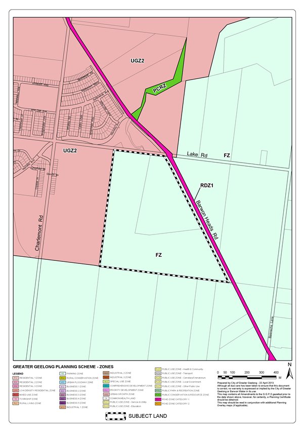
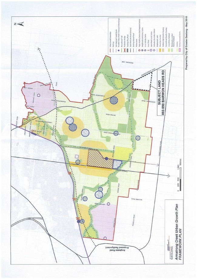
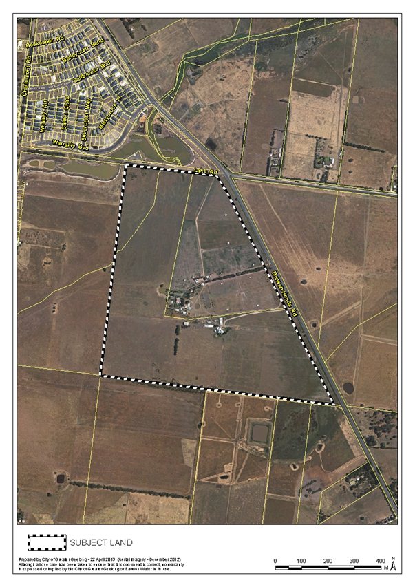
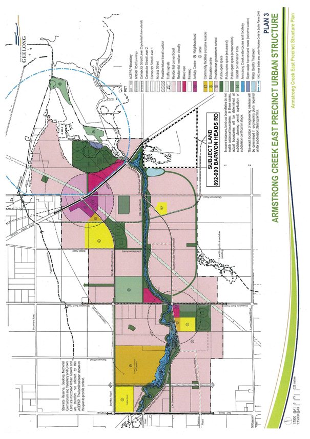
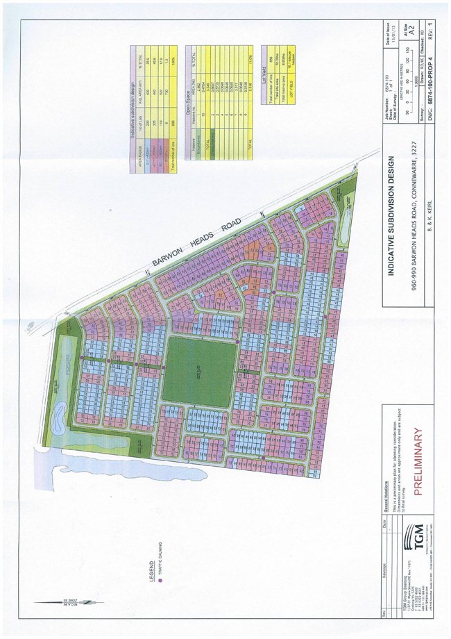
Portfolio: |
Governance – Cr Fagg, Mayor |
Source: |
Corporate Services Administration & Governance |
General Manager: |
Jeff Wall |
Index Reference: |
Local Laws |
Council’s existing Local Law 2009 was adopted on 23 June 2009 and provides for control of the Notice of Motion, election of the Mayor and also the conduct of meetings of Council.
A review of the Local Law is timely, given the election of a new Council and the election of the Directly Elected Mayor pursuant to the City of Greater Geelong Act 1993, which affects parts of the existing Local Law. Other minor changes provide for streamlining the use of the Notice of Motion, providing further clarity around the Chair’s discretion in allowing or disallowing questions and rescission or alteration of previous resolutions. The timeframe for submission of notices of motion has been amended to 10am on the Friday prior to the Council meeting.
Although maintaining a similar format and adopting many of the same clauses as the Local Law 2009, a new draft Meeting Procedures Local Law 2013 is now presented for consideration by Council.
Cr Fagg moved, Cr Harwood seconded -
That:
Council Meeting Procedures Local Law 2013 (Appendix 6-1) be adopted;
Notice of Council’s intention to introduce Council Meeting Procedures Local Law 2013 be advertised in accordance with the Local Government Act 1989 and any submissions received be dealt with by the Submissions Review Panel.
Carried.
While Councils have the option to introduce Local Laws on a variety of issues, the Local Government Act 1989 (“the Act”) requires all Councils to have a Local Law to control the conduct of meetings and also the use of Council’s Notice of Motion.
Previous Local Laws have adequately catered for the conduct of Council Meetings in a manner which has enabled issues to be freely debated. Successive Councils have found the process to be workable. This review has taken the opportunity to amend the meeting procedures as a consequence of the recent amendments to the City of Greater Geelong Act 1993, and any feedback received from councillors, staff and the public.
The review also involved the benchmarking of Local Laws prepared by other Victorian and Interstate Councils, including:
Manningham, Glen Eira, Maribyrnong, Sydney, Gold Coast, Melbourne, Port Phillip, Frankston, Whitehorse, Whittlesea, Brimbank, Hume, Casey, Wyndham, Stonnington, Knox, Brisbane, Boroondara.
Local Laws are a form of regulatory instrument. The authority for Council to make Local Laws comes primarily from the Act, the relevant provisions being Part 5 and Schedule 8.
This review has taken into consideration the City of Greater Geelong Act 1993, particularly in respect to removing reference to the election of the Mayor and replacing it with the process required for the election of the Deputy Mayor.
While the existing Meeting Procedures Local Law remains operative, a number of proposed changes have been made as outlined below.
PART 1 - PRELIMINARY
Clause 1.2 (c) now refers to Deputy Mayor, rather than Mayor.
Clause 1.7 Definitions
Definition of “Mayor” is amended to refer to the Directly Elected Mayor as defined by the City of Greater Geelong Act 1993.
Penalty Units has been amended to refer to Section 110 of the Sentencing Act 1991.
OLD PART 2 - USE OF Notice of Motion
Notice of Motion is now Part 4. The amendments to this section allow for the use of the Notice of Motion under delegation. This will allow Council to streamline the process of signing and sealing routine documents. Documents executed under delegated authority are subject to any conditions and limitations imposed by Council. Certain documents will still require a Council resolution to sign and affix the seal, these will include important legal documents and those required by legislation.
OLD PART 3 - ELECTION OF MAYOR NOW PART 2 - ELECTION OF DEPUTY MAYOR
The Purpose now refers to the City of Greater Geelong Act 1993 for the election of the Deputy Mayor, and provides that the Mayor will preside over the election of the Deputy Mayor.
OLD PART 4 NOW PART 3 - PROCEDURE AT COUNCIL MEETINGS
There has been some minor amendment to the Purpose and also inclusion of scope and notice clauses. The order and content of business has been amended to include acknowledgement of the Traditional Owners and Assembly of Councillors. The order has been slightly amended to list Confidential Matters as the last item.
Other changes to procedures of Council meetings include:
Clause 3.10(4) has been added, which allows Council until 5.00 pm on the Friday following each Council Meeting, to provide the Minutes on the Geelong Australia website.
Clause 3.12 Public Question Time has been amended as follows:
The time allocated for Question Time will be determined by the Chair.
Clarification that questions must be in writing to be included in the minutes.
Clause 3.12(6) has been included to enable the Chair discretion to disallow questions that meet certain criteria:
it relates to a matter outside the duties, functions and powers of Council;
is defamatory, indecent, abusive, offensive, vexatious, frivolous, irrelevant, trivial or objectionable in language;
is aimed to embarrass a Councillor or a member of Council staff;
relates to personnel matters;
relates to industrial matters; or
relates to any other matter which Council considers would prejudice Council or any person.
Clause 3.12(6) permits the Chair to determine who will personally respond to questions i.e. General Managers, Councillor(s) or Council may reserve the right to take the question on notice and provide a written response within 14 days.
Clause 3.23 Rescission or Alteration of Previous Resolutions has been expanded to provide clarity regarding how a rescission or alteration to previous resolutions can occur.
Clause 3.25 Notices of Motion has been amended requiring Notices of Motion be provided by 10 am on the Friday prior to the Ordinary Meeting of Council. This enables staff to undertake reasonable due diligence on the proposed motion prior to distribution.
Clause 3.26 Urgent Business has been amended to reflect the votes required, based on the new composition of Council i.e. two-thirds of 13 Councillors and a Quorum of 7.
There are no environmental implications arising from this report.
There are no financial implications relevant to the adoption of this Local Law.
The Act sets out basic requirements for Council Meetings and requires Councils to have a Local Law to control its meeting procedures. This Local Law has been drafted along similar lines to the current Local Law, having regard to the Act.
The focus of this Local Law is on governance issues surrounding the election of the Deputy Mayor, the use of the Notice of Motion, and also the rules which ensure orderly meeting procedures in a public forum. All Local Laws are required to be reviewed to assess any impact on the National Competition Policy and also the principles of the Human Rights Charter. Appendices 6-2 and 6-3 indicate that the draft Local Law is consistent with the principles of both.
In order to implement a new Local Law, Council must determine the form and content of the Local Law, and must advertise its intention and hear any submissions in accordance with Section 223 of the Act. Any submissions lodged will be considered by a Submissions Review Panel. Once this process is complete, Council may resolve to adopt and confirm the Local Law which comes into operation on the date it is advertised in the Government Gazette.
No officers involved in the preparation of this report or the draft Local Law have any direct or indirect interest in the matter.
Pursuant to Ministerial Direction No. 15, gazetted on 25 October 2012, timeframes have been imposed on all planning authorities amending planning schemes across Victoria. Under section 12(2) of thePlanning and Environment Act, a planning authority must have regard to the Minister’s directions.
Deferral of this report may result in Council failing to meet its statutory timeThere are no risks to Council in commencing the process for implementing this new Local Law.frames for the amendment.
There are no other notable risks associated with implementing the recommendation contained in this report.
There are no specific social considerations, however there is provision for community participation at Council Meetings.
The statutory process provides the opportunity for public comment. Copies of the proposed Local Law will be available at Customer Service Centres, on Council’s website, and will also be advertised in City News.
Portfolio: |
Finance – Cr S Kontelj |
Source: |
Corporate Service - Financial Services |
General Manager: |
Jeff Wall |
Index Reference: |
Financial Management \ Reporting |
On 16 October 2012 the Fire Services Property Levy Act 2012 was proclaimed. The Act is in response to one of the recommendations made by the Victorian Bushfires Royal Commission to replace existing insurance-based fire services levy.
From 1 July 2013 Local Government will be required to bill, receipt and collect the Fire Services Property Levy (FSPL) via the Council Rate Notice and remit collections to the State Revenue Office (SRO) on a quarterly basis.
The Levy will consist of a fixed component plus a variable component based on the property’s capital improved value multiplied by a land use classification rate. The rate for each land use classification (residential, commercial, industrial, primary production, public benefit, vacant) will be determined by the Minister on or before 31 May each year.
It is estimated that 107,071 Non-Council owned properties will be leviable and that the levy amount will be approximately $23,418,594.
The estimated leviable amount payable on Council owned and or controlled land where there is a lease or a licence is $400,000. Properties which are leased from Council may be subject to payment of the levy amount which will reduce the levy payable by Council.
A communication strategy, which includes direct mail to individual property owners, will inform all rateable and non-rateable property owners of the introduction of the Fire Services Property Levy and the associated amount of the levy prior to them receiving their rate notice.
Council will continue to record project costs and pursue full cost recovery from the Valuer General – Victoria, SRO and Department of Treasury and Finance in relation to 2012-2013 costs.
Cr Harwood moved, Cr Macdonald seconded -
That Council notes the progress to implementing the Fire Services Property Levy and seeks full cost recovery from the Valuer General – Victoria, SRO and Department of Treasury and Finance where applicable.
Carried.
On 16 October 2012 the Fire Services Property Levy Act 2012 was proclaimed. The levy is effective from 1 July 2013 and will require Local Government to bill, receipt and collect a Fire Services Property Levy on rateable and non-rateable properties. The collected monies are to be remitted to the State Revenue Office (SRO) on a quarterly basis.
The Levy will consist of a fixed component plus a variable component based on the property’s capital improved value. The fixed component will be $100 for residential properties and $200 for non-residential properties. The variable component will be a rate based on the land use classification for different property types (residential, commercial, industrial, primary production, public benefit, vacant) and will be determined by the Minister on or before 31 May each year. A concession of $50 per property will apply to pensioner concession and Veterans Affairs Gold Card holders.
Council will also be required to apply the Fire Services Property Levy on all Council owned land and buildings. Section 20 of the Act deems that land which is vested in, occupied or under the care, control or management of Council will only incur the fixed charge in respect of some land use classifications.
Property that is currently assessed as non-rateable by Council will also be subject to the levy.
Previous reports to Council in September 2011, February 2012 and March 2013 highlighted:
Council response to the release of the options paper and subsequent submission that opposed the imposition on Local Government for levying and collecting the Fire Services Property Levy.
Additional obligations on Council resulting from the 2012 FSPL legislation.
Submission to Treasurer, through the Municipal Association of Victoria for reimbursement of Council costs associated with the implementation and compliance with the FSPL legislation.
The impact the FSPL will have on rateable and non-rateable properties.
The FSPL levy for all Council owned, controlled or leased properties.
A Communication strategy which included advising property owners by direct mail, print and electronic media of the levy impact prior to receiving the rate notice.
A Council project team has been working on implementing the legislative requirements of the Act to assist with the move from an insurance based levy to a property based levy. As part of the implementation, the following major areas of impact have been identified:
The impact on property owners.
The actual cost to Council of a property based levy on Council owned land compared with the cost of insurance premiums for fire services.
Communicating with property owners to distinguish between the impact of this levy and Council rate movements.
System changes.
The cost to Council of implementation compared to the reimbursement advice received from the State Revenue Office.
The implementation of the FSPL is a major project which has impacted on departments across the organisation including Financial Services, Customer Service, Information Services, Council’s Contract Valuers and Communication and Marketing.
The impact on property owners
As at 6 June there were 113,647 properties on the corporate database. The major task, since the introduction of the FSPL was to review these properties to ensure the land use classification was correct. Council uses its own property classification for rating and/or non-rating purposes and the land use classification was not used.
The Valuer-General Victoria has included the requirement for land use classification to be included as part of the 2014 Valuation Best Practice Guidelines. However, as part of the FSPL implementation, Council has had to undertake its own review.
This review was required to ensure State/Commonwealth owned land is exempt from FSPL, certain land use codes are exempt from FSPL, and where possible, to reduce anomalies between how a property is classified for rating and how it is classified for FSPL. The number of Non-Council owned properties leviable as at 6 June is 107,071.
In May 2013 the Minister advised of the levy rates applicable to each land use classification for 2013-2014.
|
Land use classification |
Fixed Charge |
CFA Levy Rate (Cents per $1,000 of capital improved value) |
|
Residential land (including vacant residential) |
$100 |
11.5 |
|
Commercial |
$200 |
109.2 |
|
Industrial |
$200 |
170.9 |
|
Primary Production |
$200 |
31.2 |
|
Public Benefit |
$200 |
11.5 |
|
Vacant (excluding vacant residential) |
$200 |
11.5 |
Based on the above rates, the table below is an estimate of the levy amount Council will be collecting and remitting to the State Revenue Office from Non-Council owned properties.
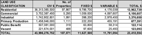
(Based on the levy estimate letter being sent in June 2013; does not include reduction for $50 pensioner concession, where applicable, on residential properties)
Levy applicable to Council owned and/or controlled land
The following table is a summary of all Council owned/controlled land, excluding land where Council acts as Committee of Management and where there is no lease or licence in place as these properties are exempt for 2013-2014.
In 2012-2013 Council remitted $109,486 on insurance premiums for fire services and has budgeted $400,000 for 2013-2014, based on estimates prior to the Ministerial advice. As shown in the table above the cost to Council for Council owned land is approximately $400,494. It is anticipated that some leased properties (FSPL levy $94,410) will be recovered from the tenant. Council may also be liable to pay the levy on properties it does not own and where it is the tenant. Communication with property owners
Council has, over the past couple of months, implemented a number of strategies in order to advise property owners of the impact of the FSPL. These strategies include:
Use of print media and Council website to advise property owners to check insurance premiums in moving from an insurance based to a property based levy.
Direct mail to non-rateable property owners who have not previously received a Council rate notice.
Direct mail to other property owners where Council rate type will be different from Fire Services Property Levy classification, example Council rate type ‘mixed use’ will be treated as ‘commercial’ for FSPL.
Council’s major communication with property owners has been undertaken in June. Individual letters were sent to 107,071 property owners advising them of the estimated FSPL amount included as part of their 2013-2014 rate notice that will be issued in August.
Council’s Customer Service call centre has managed responses to customer enquiries resulting from the mail out with the aim of ensuring a smooth transition to this new levy. This should reduce the number of enquiries when the rate notice is issued.
System changes
The introduction of the FSPL required a number of changes to Council’s operating systems including:
Upgrade to the Pathway Property system, co-ordinated by the Municipal Association of Victoria, where Council operated as the ‘test’ site for Infor Pathway.
Review and recording of Australian Valuation Property Classification Codes.
Redesign of a larger rate notice in compliance with FSPL legislation.
Design, testing and implementation of receipting to ensure correct apportionment of Council rates and FSPL.
Design and testing of Penalty Interest apportionment.
The cost to Council of implementation of FSPL Act 2012
FSPL legislation states that the State Government will consider the cost Council may reasonably incur in performing functions under the Act and will pay an annual fee based on a funding formula developed in consultation with the Municipal Association of Victoria (MAV) and the Revenue Management Association (RMA). In the first year there will also be a start up payment to cover implementation costs.
The State Revenue Office offered Council $10 for the identification of non-rateable leviable properties and $40 for the valuation of these properties. This work has been completed and the cost of these works is as follows:
Additionally, the State has advised that an amount of $51,600 will be paid for 2012-2013 and $160,952 2013-2014. Details have not been provided as to how the amounts have been calculated and a request has been made to the SRO for a breakdown of the fees.
Council has incurred the following additional project implementation costs to June 2013:
Once a break down in funding support is received, Council will be making a submission showing actual expenditure incurred in implementing the legislation in order to recover the deficit.
Not applicable.
Costs associated with Council’s compliance with FSPL legislation will be offset by the $160,952 which will be received from the SRO in 2013-2014.
Council has obligations for compliance under the Fire Services Property Act 2012, as well as changes to the Local Government Act 1989 and the Valuation of Land Act 1960 resulting from the FSPL legislation.
No Council officers have any direct or indirect interest in this matter, in accordance with Section 80(c) of the Local Government Act.
Council will be responsible for all aspects of the FSPL, including managing all associated risks. Once implemented, the risks associated with the FSPL will be the same as risks associated with the collection of Council rates.
The FSPL will impact on properties not previously rated as well as properties where no insurance was paid, such as vacant land. The impact of a property/rating based FSPL relative to the insurance based fire services levy is not yet fully understood.
A communication strategy has been developed and is being implemented as part of the introduction of the FSPL in order to inform the community of the changes and also to manage ratepayer queries in moving from an insurance-based to a property-based levy.
The communications plan has been implemented as part of the annual budget process in order to distinguish impact of this levy from Council rate decision and movements.
This report will assist Councillors in understanding Council’s compliance with the FSPL legislation and implementation in order to:
assist with any ratepayer queries/questions; and
be assured that the methodology used to implement the legislation has been in the best interest of ratepayers.
Cr Richards declared an Indirect Interest in Agenda Item 8 and left the meeting prior to discussion of the item at 7:55pm.
Portfolio: |
Sport & Recreation - Cr Irvine |
Source: |
Projects, Recreation & Central Geelong / Sport & Recreation |
General Manager: |
Dean Frost |
Index Reference: |
Subject: Design / Construction / Maintenance – Parks, Gardens, Reserves & Foreshore / Playing Fields Subject: Policy & Procedures – Official / Policies & Procedures – Document Development |
The purpose of this report is to advise of the proposed amendments to the Recreation Reserve Advertising Signage policy and seek Council endorsement.
Proposed updates to the Recreation Reserve Advertising Signage policy include the following key amendments:
A Kardinia Park Stadium exclusion, recognising the national importance of this venue
Allowing externally facing signage that fronts social facilities
A clean venue requirement, requiring clubs to remove signage at the request of Council for special events
Club identification on signage so ownership and responsibility can be clearly established
Allowance of local community event signage at the site of the event
Business identification allowance
Addition of recommendations and conditions for tennis, fencing, cricket nets and chain wire mesh facilities
Cr Harwood moved and Cr Heagney seconded -
That Council endorse changes to the Recreation Reserve Advertising Signage policy.
Carried.
The Recreation Reserve Advertising Signage policy was established to allow sporting clubs and organisations the opportunity to display sponsor signage without damaging the visual amenity of the reserve. The policy allows clubs to display sponsor signage in a manner that acknowledges sponsor support to the community groups tenanting the reserve. The policy aims to ensure that Council’s investment in reserve amenity is not damaged by excessive and inappropriate signage.
The policy does not address signage that is principally located to be seen externally to the reserve as this is prohibited under the planning scheme noting that Public Park and Recreation Zones (PPRZ) is considered a sensitive area and the placement of advertising signage is not allowed.
The proposed changes in the Recreation Reserve Advertising Signage policy represent an evolution in the policy and address many of the misinterpretations and grey areas of the previous policy. Key changes to the policy are outlined below:
Exclusion of Kardinia Park Stadium: The Kardinia Park Stadium lease arrangements cover off signage requirements for this facility. Its national status also demands an alternative methodology be applied to signage.
Externally facing signage in front of pavilions: This allows clubs to acknowledge sponsors to pavilion users whilst not displaying signage beyond the reserve due to the pavilion structure blocking this view.
Clean venue: A requirement of many major events or alternative users of sporting reserves is that venues are delivered ‘clean’ without any other sponsorship signage. As the primary purpose of the policy is to allow clubs to reasonably display and acknowledge sponsor support, the delivery of a clean venue on request for alternative use is considered reasonable to enable a like opportunity.
Club Acknowledgment: The addition of club acknowledgment to reserve signage ensures that where multiple tenant clubs use a reserve, the audience can determine who is supporting the respective club. This also allows Council to identify signage ownership.
Event Signage: In accordance with the Planning Scheme, event signage will be allowed, however this signage shall be to events at the reserve only and shall not carry the logo of sponsors.
Business Identification Signage: Business identification signage shall be allowed in accordance with the Planning Scheme.
Tennis and Cricket fencing and other chain wire mesh facilities: High net facilities have been added to the policy that were not previously covered. Signage on this type of infrastructure may require special design due to wind loading considerations.
The policy shall be rolled out over a number of years. Clubs will be required to ensure that all new signage is consistent with the existing policy, pre-existing signs will be identified and clubs will be provided with a reasonable time frame to seek alternative arrangements.
Reserve Naming: Sporting clubs are not entitled to enter into commercial agreements to alter venue names or install signage pertaining to the naming of a reserve on a permanent basis.
Safely erected, maintained and managed signage does not detract from the visual and environmental amenity of the reserve.
Sponsorship is a large source of income for many community sporting organisations. This policy seeks to allow clubs to procure sponsors and recognise their contributions at sporting reserves.
Signage installed in public reserves must be consistent with the Planning Scheme, Building Code of Australia and the Occupational Health & Safety Act.
Nil.
The policy indicates the installation conditions for signage on reserves and requires that all signs be inspected and maintained by the club at a level consistent with the reserves’ sporting and public use.
Sporting clubs are recognised as providing a range of broader benefits to the community, including contributions to social capital, community cohesiveness, community connection and building local leaders. Supporting their financial sustainability via the provision of sponsorship through signage is important to ensure that these benefits can be achieved.
Once approved, the policy shall be communicated to all sporting reserve tenant organisations and discussions will commence to resolve any inconsistencies of the policy and/or to phase in new requirements.
Cr Richards re-entered the meeting room at 8pm.
Portfolio: |
Sport & Recreation – Cr Irvine |
Source: |
Projects, Recreation & Central Geelong / Sport & Recreation |
General Manager: |
Dean Frost |
Index Reference: |
Subject: Unauthorised Land Use |
Unauthorised occupation of Council Land use occurs when a property owner places improvements on or fences off Council land, gains access over or places services over or under Council land, where the occupation or use is not authorised by way of easement, lease, licence permit or other appropriate means.
Council land includes all land owned or managed by Council or land Council is entitled to own or manage on behalf of the public.
A desktop survey of Council land has been carried out indicating that there are approximately 253 instances of unauthorised occupation and use. Once rural areas and the Geelong Central Area are surveyed the number is likely to increase significantly. Most examples involve the fencing of private roads, usually rear lanes.
The main risks related to unauthorised occupation and use of Council land relate to denial of use by the public, loss of asset value, loss of revenue from adverse possession of private roads, and restrictions on use of Council land through easements by prescription.
In 2004 changes to the law provided Council with valuable protection from the loss of land through adverse possession. However Council remains exposed where land is designated as a reserve and is not in Council’s name. This includes private roads and some parks.
Council also remains at risk from prescriptive easements, sometimes referred to as “right of long user” which arise when someone has been using Council land for a period.
Cr Harwood moved, Cr Macdonald seconded -
That Council adopt the Unauthorised Land Occupation Policy.
Carried.
Unauthorised occupation and use occurs when someone places improvements on or fences off Council land or gains access over or places services over or under Council
land, where the occupation or use is not authorised by way of easement, lease, licence permit or other appropriate means.
Council land falls into the following land categories:
Crown land being land owned by the State for which the Council may act as Committee of Management.
Council owned land being land owned freehold by Council which is a lot on a plan of subdivision or old law land.
Council reserves being land Council owns but is described as a “reserve” on the title and includes roads, parks and drainage reserves etc.
A desk top survey of instances of unauthorised occupation and use of Council land has been undertaken using the 2009 aerial photos, together with reported instances from the public and other internal Departments over the past five years. The desktop survey involved visual examination of Council land within urban Geelong area and towns excluding the Geelong Central area and rural areas. A total of 253 existing and potential examples of unauthorised possession of Council land have been identified with 63% of which were the fencing off of roads, usually unmade rear lanes. Land “reserved” on title for a public purpose such as a road or a park but is not owned by Council.
Broadly unauthorised possession of either Crown land or Council owned land (freehold or reserves) will not lead to a loss of title through adverse possession claims due to legislative protection. However land that is a reserve or road but not owned by Council may be claimed by adverse possession therefore denying the public any right and consequently, access to the land. However any type of Council land may be encumbered by easements through right of land use.
Adverse possession of land is common throughout the world and is based on the “use it or lose it” principle. A key test for adverse possession is when someone has illegally occupied land to the exclusion of all others for a period of at least 15 years. This often means land owned by an adjoining owner that has been fenced into the claimant’s land for the required period. However fencing in of land is not a necessary condition for successful adverse possession claims.
All instances of Unauthorised Occupation of Council Land, in particular Council owned or managed reserves, broadly limit the availability of public open space available to the general public. This will place a greater strain on the existing public open space owned or managed by Council.
he instances of property owners extending their property boundary onto environmentally sensitive areas such as water fronts will also have an impact on the local environment.
Additionally uncontrolled access across Council land which leads to exposure to the accumulation of the “right of long user” can have the effect of reducing the use of Council land that may be required for future development.
Prior to changes to the Limitations Act in 2004 there is an example of Council losing a part of a reserve through adverse possession, 2,400m² of parkland at Clifton Springs.
Another example was the loss of approximately 105m² of reserve overlooking the Barwon River in Newtown in 2005, a claim that was made during a grace allowed by the change of legislation.
Failing to take action on occupation of private roads forgoes revenue from the sale of those roads once discontinued. In addition unauthorised occupation of private roads as rear lanes can deny access to other ratepayers who often appeal to the Council to take action to maintain their access. There is increasing emphasis on the importance of rear lanes particularly in inner areas where they can contribute to the process of urban consolidation by allowing flexibility in design for development projects.
In 1988 the Subdivision Act was introduced which provided that where land on a plan of subdivision is reserved for use by a public authority, when the plan is registered at the Land Titles Office, that the title to the reserved land is issued in the name of the relevant authority. For local government, such reserves are typically roads, parks and drainage reserves.
Council land being part of roads and reserves created post 1988 now enjoys the protection afforded to Council owned land by changes to the Limitation Act in 2004. Unfortunately, despite requests by Councils at the time, the changes to the Limitations Act did not extend to reserves created on a plan of subdivision prior to 1988. Such land which usually remains in the name of the original sub-divider remains exposed to adverse possession, leaving Local Government in Victoria with an on going problem.
No Council staff member has a direct or indirect interest in the development of the Unauthorised Occupation Policy.
There are two key reserve types where Council is exposed to loss through adverse possession and the significance of the distinction lies in the statutory processes available to Council to address the exposure to loss.
Reserves such as parks and drainage reserves created prior to 1988 which remain in the name of the original sub-divider. These reserves may be transferred to Council upon application under s24A of the Subdivision Act. Since 2004 when a reserve of this type has been identified application is made to have the land transferred to Council, and 28 such reserves have been transferred to date.
The Limitations of Actions Act only protects land for which Council is a registered proprietor under the Transfer of Land Act, excluding general law land. Land Victoria now offers a project updating Council names on title and converting general law land to Torrens title. That project will also provide a comprehensive audit of all Council land, Torrens title and old law. Land Victoria’s project should be pursued as a priority as it will assist in providing protection from claims for parks and reserves remaining in the name of the original sub-divider. It may also turn up land Council owns but is not aware of its ownership as has occurred at least once in recent years.
Roads created prior to 1988 remaining in the name of the original sub-divider which cannot be transferred by application under s24A of the Subdivision Act. These are usually referred to as either private made or unmade roads.
The majority of adverse possession claims over Council land occur on private roads, usually being rear lanes originally intended for night cart access prior to reticulated sewerage being installed but many now provide valuable rear vehicular access.
The majority of all streets and rear lanes in Geelong created prior to 1988 remain in private ownership.
The Unauthorised Occupation of Council Land if left unattended will continue to reduce the availability of public open space to the community therefore placing a greater strain on the existing public open space.
A Working Group of interested service managers has been formed to examine the extent of and make recommendations to address unauthorised occupation and use of Council land. The working group will report through the Land Management Group and where necessary the Executive Management Team.
Contents | Previous Page: Section A - Procedural Matters | Next Page: Section C - Notice of Motion