Council Minutes - Section B: Reports - 26 November 2013
Contents | Previous Page: Section A - Procedural Matters | Next Page: Section B - Reports 2-7
Contents | Previous Page: Section A - Procedural Matters | Next Page: Section B - Reports 2-7
Reports tabled at the Ordinary Meeting of Council on Tuesday date held at City Hall, Little Malop Street in Geelong.
Submission to Plan Melbourne - Metrolopolitan Planning Strategy
Purchace of Land for Drainage Purposes - McClelland Avenue, Lara
Portfolio: |
Planning - Cr Macdonald |
Source: |
Economic Development, Planning and Tourism - City Dveleopment |
General Manager: |
Peter Bettess |
Index Reference: |
Application: C294 |
The purpose of this report is to adopt Planning Scheme Amendment C294.
Amendment C294 proposes to correct mapping and ordinance anomalies, make changes to the Scheme as a consequence of VCAT ruling on the lawfulness of the Rural Living Zone schedule provision, inserts the head clauses of the Residential Growth Zone, General Residential Zone and Neighbourhood Residential Zone into the Scheme and corrects the zoning of two declared roads as requested by VicRoads.
The Amendment is a housekeeping Amendment and has been undertaken to ensure that the Planning Scheme is accurate.
The Amendment applies to a number of different locations across the municipality.
Correction of these anomalies does not change the intent of any part of the Planning Scheme and is consistent with Council and State policy as it is procedural in nature.
Authorisation (A02599) for this Amendment was issued on 28 August 2013 under Section 35B of the Planning and Environment Act 1987.
The Minister for Planning has given the Amendment exemption from the notification requirements of section 19 of the Planning and Environment Act 1987, with the exception of the requirement to notify prescribed Ministers.
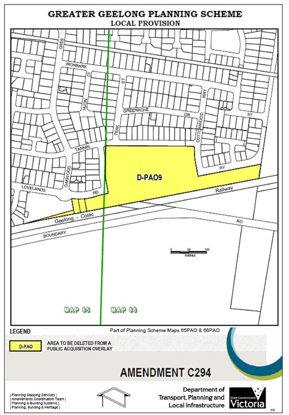
Subsequent to the original authorisation, the Minister for Planning on 14 October 2013 agreed to include in this amendment the removal of all of the Public Acquisition Overlay (PAO9) from the north side of the railway line at the proposed Grovedale station site and to rezone the land acquired by Public Transport Victoria from Residential 1 Zone to Public Use Zone 4.
The three prescribed Ministers from whom exemption of notice cannot be granted have been notified. The Department of Environment and Primary Industries (DEPI) supports the zoning changes to the Barwon Heads Bridge and approach. DEPI recommends a number of changes to Schedule 2 to the Vegetation Protection Overlay, Schedule 2 to the Environmental Significance Overlay and the Schedules to clauses 66.04 and 66.06. To address these as one package as part of a future amendment, the proposed change to recognise the new DEPI name in Schedule 2 to the VPO has been deleted from this amendment.
It is recommended the Amendment be adopted and forwarded to the Minister for approval.
Cr Macdonald moved, Cr S Kontelj seconded -
That Council:
Adopts Amendment C294 as contained in Appendix 1 of this report; and
Submits the adopted Amendment together with the prescribed information to the Minister for Planning requesting approval.
Carried.
The Amendment is required to correct a number of anomalies in the Greater Geelong Planning Scheme (both Maps and Ordinance) that have become apparent during the past 12 months of operation of the Scheme. The Amendment is considered to be housekeeping in nature and has been prepared to ‘tidy up’ the Scheme.
It is incumbent on Council to resolve these matters so that its Planning Scheme is relevant, up-to-date, of a high quality and standard, and meets DTPLI requirements. This anomalies Amendment will address these matters. This is the seventh anomalies amendment since the new format Scheme came into operation in July 2000.
As a result of a VCAT ruling in 2011, an amendment is also required to the Schedule to the Rural Living Zone to delete the ‘triangle’ dimension requirements to lots created in that Zone. VCAT ruled that this provision was unlawful in the Schedule.
The Amendment includes numerous changes to the zoning of public open space now vested in Council, as a result of substantial subdivision construction over the past few years. Most of this land is proposed to be included in the Public Park and Recreation Zone, with a small number of reserves to be included in the Public Conservation and Resource Zone.
Public Transport Victoria has acquired the land on the north side of the Geelong-Colac Railway Line required for the Grovedale Railway Station project It is appropriate that the PAO9 now be removed and the land included in the PUZ4.
VicRoads has recently declared 2 sections of road within the municipality under the Roads Management Act 2004. To ensure consistency with the declaration and the Planning Scheme, it is necessary to rezone these roads to Road Zone Category 1.
Amendment C294 as notified applies to a number of different locations across the municipality including:
1-7 Brompton Avenue, Curlewis
18-26 Anstead Avenue, Curlewis
24-30, 2-22, 24A &32-36 Creekside Drive, Curlewis
14-16 Faggs Place, Geelong
2-14 Stanbury Avenue, Highton
2A Province Boulevard, Highton
41 Morena Street, Highton
27-28 Sand Close, Indented Head
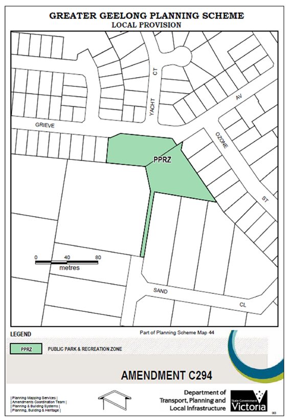
18-24 Grieve Avenue, Indented Head
76-78 Westlakes Boulevard, Lara
4-30 Estuary Boulevard, Leopold
Part of Treefern Street, Leopold
15-17 Fairvista Avenue, Leopold
56-62 Estuary Boulevard, Leopold
51-59 Estuary Boulevard, Leopold
5-15 Village Green Drive, Leopold
54A Burgundy Drive, Waurn Ponds
263-265 Colac Road, Waurn Ponds
1-3 Ashwood Close, Ocean Grove
2-24 Oakdean Boulevard, Ocean Grove
23-33 Empress Boulevard, Ocean Grove
20-28 San Fernando Avenue, Portarlington
33-43 The Rise, Portarlington
26-30 Delungra Avenue, Drysdale
1 Golightly Street, Barwon Heads
1662-1710 Bellarine Highway, Marcus Hill
20-21 Chandon Court, Waurn Ponds
30 Hams Road, Waurn Ponds
26 Burgundy Drive, Waurn Ponds
32A Burgundy Drive, Waurn Ponds
23-29 The Vineyard, Waurn Ponds
50-54 Willesden Drive, Waurn Ponds
5 Voigner Place, Waurn Ponds
Lot J Tannin Way, Waurn Ponds
Mt Duneed Road, Mt Duneed
Barwon Heads Road and Barwon Heads-Ocean Grove Road, Barwon Heads
Serene Terrace, Drysdale
70 and 72 West Fyans Street Newtown
46-54 O’Connell Street, Geelong
27 O’Connell Street, Geelong West
Peace Memorial in Johnstone Park, Geelong
13 Wimmera Street, Belmont
1030 Portarlington Road, Curlewis
Land affected by VPO2
125 Weddell Road, North Geelong
Land in the Rural Living Zone
Land in the Design and Development Overlay Schedule 13 (DDO13)
Land in the Activity Centre Zone
Land affected by Design and Development Overlay 26
68A Clarence Street, Geelong West
Land affected by Clause 22.01 of the LPPF
13-39 Rossack Drive, Waurn Ponds
Land affected by Clause 21.06-6 of the LPPF
On 14 August 2013 Council wrote to the Minister for Planning seeking authorisation of the amendment and exemption from notification as per its resolution under delegation on 13 August 2013.
The Minister subsequently authorised preparation of this amendment on 28 August 2013. On 27 September 2013, the Minister for Planning also granted Council exemption from the need under Ministerial Direction 15 to pre-set Directions and Panel Hearing dates for this amendment.
Post authorisation of the amendment, Public Transport Victoria (PTV) advised Council that it had acquired the land for the future site of the Grovedale Railway Station and endorsing Council amending the Scheme to delete the Public Acquisition Overlay Schedule 9 (PAO9) applicable to the land and to include the acquired land in the Public Use Zone Schedule 4 (for transport). An exchange of letters between Council, PTV and the Department of Transport, Planning and Local Infrastructure supported and endorsed these changes being made as part of Amendment C294. The Minister for Planning confirmed this by letter dated
The three Ministers (Minsters for Environment and Climate Change, Agriculture and Food Security and Energy & Resources) from which exemption of notice cannot be granted under the planning and Environment Act, have been notified for a two week period between 17 October and 1 November 2013. The Department of Environment and Primary Industries (DEPI) supports the zoning changes to the Barwon Heads Bridge and approach. DEPI recommends a number of changes to Schedule 2 to the Vegetation Protection Overlay, Schedule 2 to the Environmental Significance Overlay and the Schedules to clauses 66.04 and 66.06. To address these as one package as part of a future amendment, the proposed change to recognise the new DEPI name in Schedule 2 to the VPO has been deleted from this amendment.
Amendment C294 proposed for adoption makes the following changes to the Scheme:
The amendment makes the following detailed changes to the Greater Geelong Planning Scheme:
Planning Scheme Map Changes
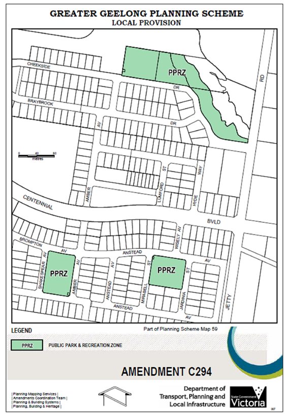
Rezone recently created public open space at 1-7 Brompton Avenue, Curlewis from R1Z to PPRZ.
Rezone recently created public open space at 18-26 Anstead Avenue, Curlewis from R1Z to PPRZ.
Rezone recently created public open space at 24-30, 2-22, 24A &32-36 Creekside Drive, Curlewis from R1Z to PPRZ.
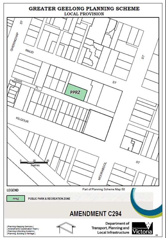
Rezone recently created public open space at 14-16 Faggs Place, Geelong from R1Z to PPRZ.
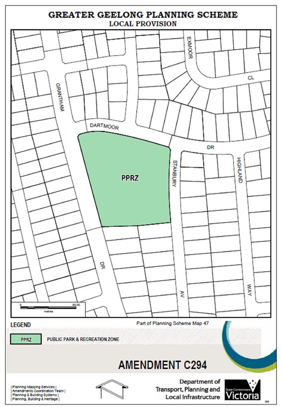
Rezone recently created public open space at 2-14 Stanbury Avenue, Highton from R1Z to PPRZ.
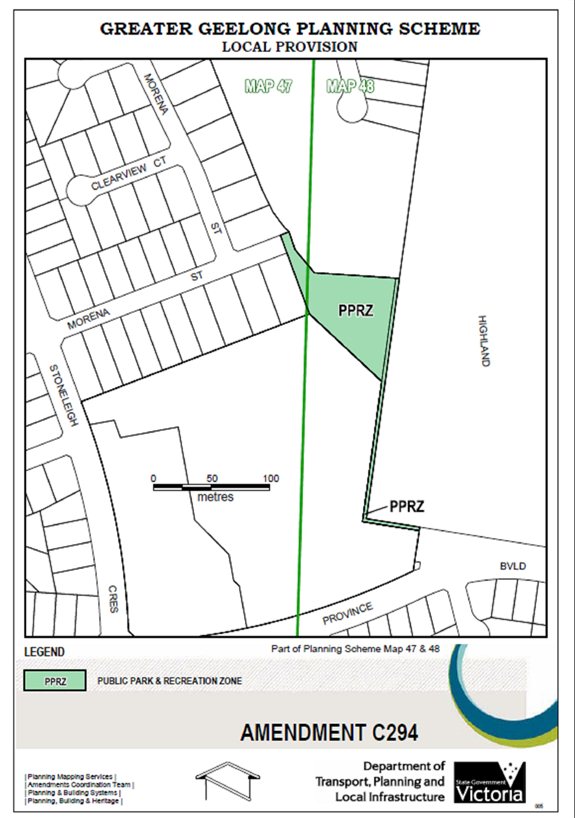
Rezone recently created public open space at 2A Province Boulevard, Highton from R1Z to PPRZ.
Rezone recently created open space at 41 Morena Street, Highton from R1Z to PPRZ.
Rezone recently created public open space at 27-28 Sand Close, Indented Head from R3Z to PPRZ.
Rezone recently created public open space at 18-24 Grieve Avenue, Indented Head from R3Z to PPRZ.
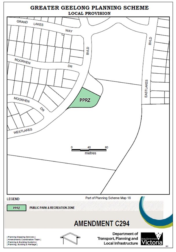
Rezone recently created public open space at 76-78 Westlakes Boulevard, Lara from R1Z to PPRZ.
Rezone recently created public open space at 4-30 Estuary Boulevard, Leopold from R1Z to PPRZ.
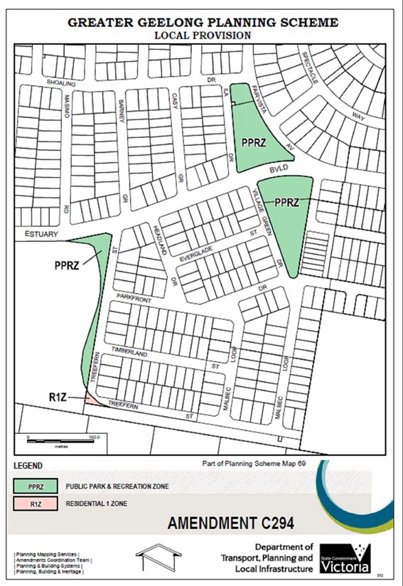
Rezone land in Treefern Street, Leopold from PPRZ to R1Z as it is not part of the open space reserve.
Rezone recently created public open space at 15-17 Fairvista Avenue, Leopold from R1Z to PPRZ.
Rezone recently created public open space at 56-62 Estuary Boulevard, Leopold from R1Z to PPRZ.
Rezone recently created public open space at 51-59 Estuary Boulevard, Leopold from R1Z to PPRZ.
Rezone recently created public open space at 5-15 Village Green Drive, Leopold from R1Z to PPRZ.
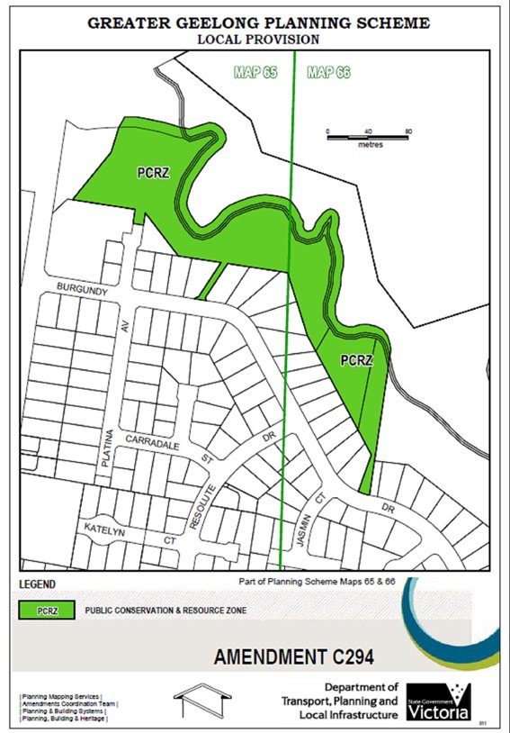
Rezone recently created public open space at 54A Burgundy Drive, Waurn Ponds from R1Z to PCRZ.
Rezone recently created public open space at 263-265 Colac Road, Waurn Ponds from R1Z to PCRZ.
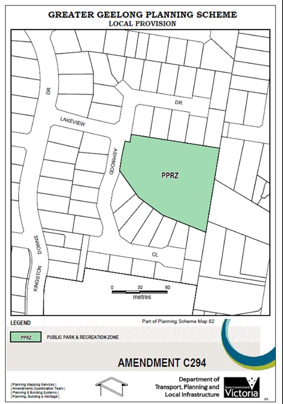
Rezone recently created public open space at 1-3 Ashwood Close, Ocean Grove from R1Z to PPRZ.
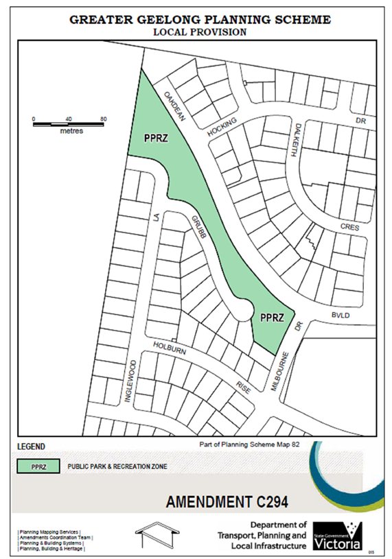
Rezone recently created public open space at 2-24 Oakdean Boulevard, Ocean Grove from R1Z to PPRZ.
Rezone recently created public open space at 23-33 Empress Boulevard, Ocean Grove from R1Z to PPRZ.
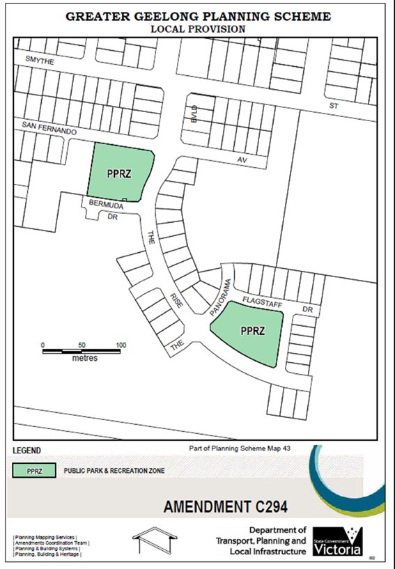
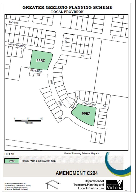
Rezone recently created public open space at 20-28 San Fernando Avenue, Portarlington from R1Z to PPRZ.
Rezone recently created public open space at 33-43 The Rise, Portarlington from R1Z to PPRZ.
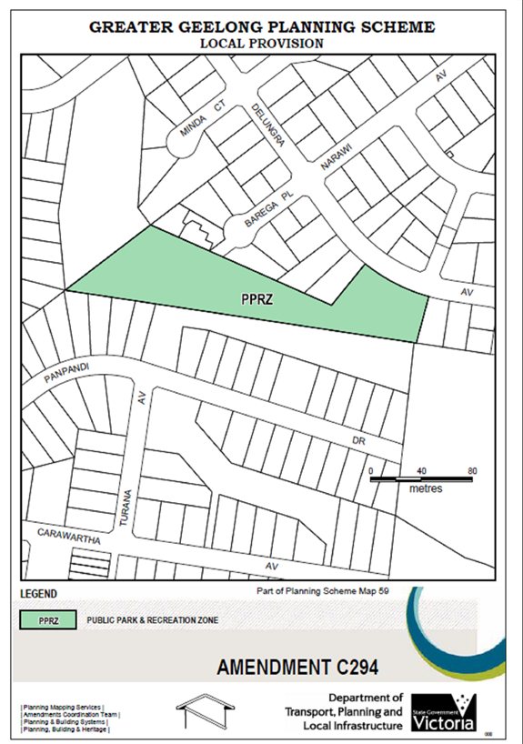
Rezone recently created public open space at 26-30 Delungra Avenue, Drysdale from R1Z to PPRZ.
Rezone land at the rear of 1 Golightly Street, Barwon Heads from B1Z to R1Z. This land is on a separate title and is residentially developed.
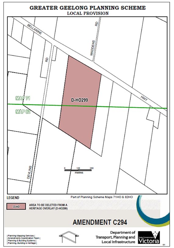
Delete the Heritage Overlay (HO299) from the property at 1662-1710 Bellarine Highway, Marcus Hill. Planning permit 864/07 was issued for the demolition of the slab hut on this site and its continued listing is no longer warranted.
Rezone recently created public open space at 20-21 Chandon Court, Waurn Ponds from R1Z to PPRZ.
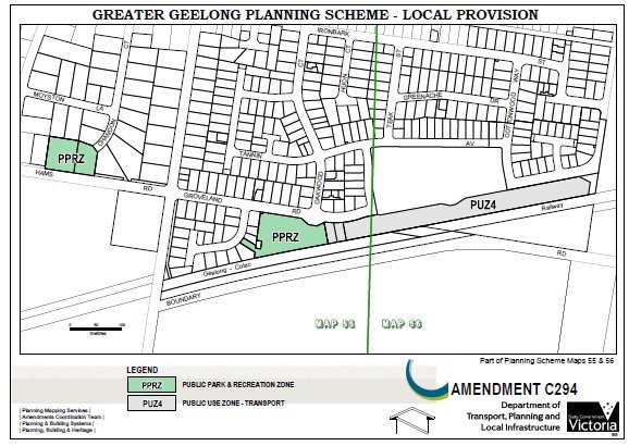
Rezone recently created public open space at 30 Hams Road, Waurn Ponds from R1Z to PPRZ.
Rezone recently created public open space at 26 Burgundy Drive, Waurn Ponds from R1Z to PCRZ.
Rezone recently created public open space at 32A Burgundy Drive, Waurn Ponds from R1Z to PCRZ.
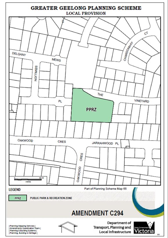
Rezone recently created public open space at 23-29 The Vineyard, Waurn Ponds from R1Z to PPRZ.
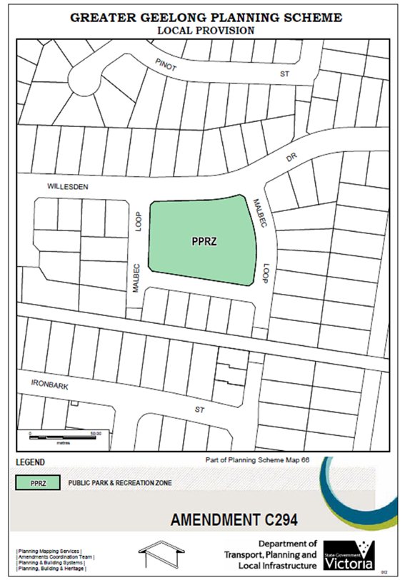
Rezone recently created public open space at 50-54 Willesden Drive, Waurn Ponds from R1Z to PPRZ.
Rezone recently created public open space at 5 Voigner Place, Waurn Ponds from R1Z to PPRZ.
Delete the Public Acquisition Overlay 9 from Lot J Tannin Way, Waurn Ponds. The land required by PTV for the proposed Grovedale Railway Station has been acquired.
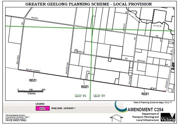
Rezone recently declared land under the Road Management Act 2004 along Mt Duneed Road, Mt Duneed from FZ to RDZ1.
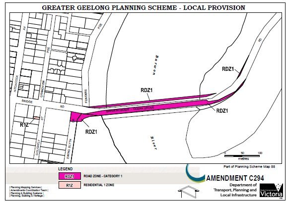
Rezone recently declared land under the Road Management Act 2004 along the Barwon Heads Road and Barwon Heads-Ocean Grove Road, Barwon Heads from PPRZ and PCRZ to RDZ1.
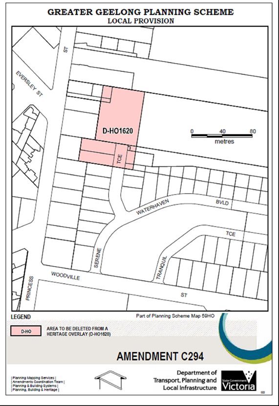
Delete the Heritage Overlay HO1620 from the newly created titles in Serene Terrace, Drysdale. This Heritage Overlay applies to the properties fronting Princess Street (as outlined in clause 22 of the LPPF). The rear or eastern portion of these properties have been subdivided into new vacant house blocks as part of the developing Central Walk estate and have no connection to the heritage precinct.
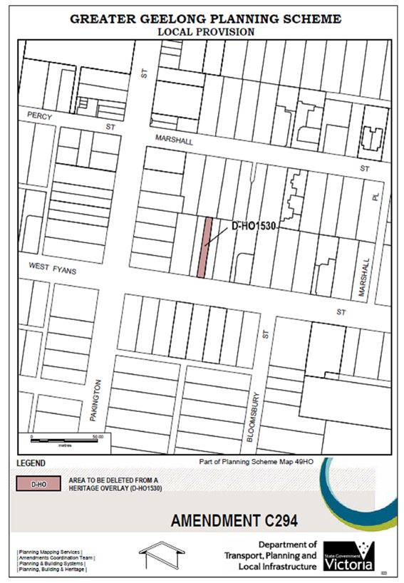
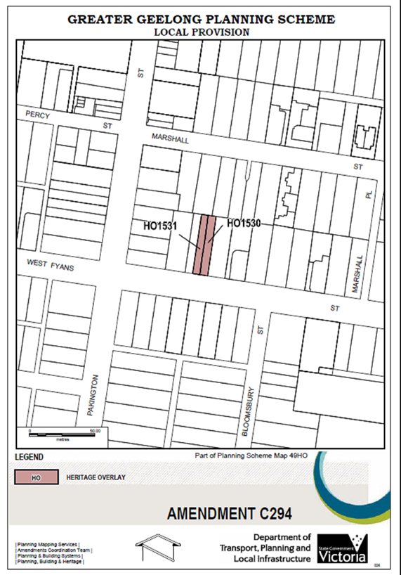
Amend the mapping of Heritage Overlays HO1530 and HO1531 affecting two residences at 70 and 72 West Fyans Street Newtown. The mapping on the planning scheme maps has inadvertently applied both heritage overlays to the site at 72 West Fyans Street. This needs to be changed to correctly map the HO1530 to the property at 70 West Fyans Street and HO1531 to the property at 72 West Fyans Street.
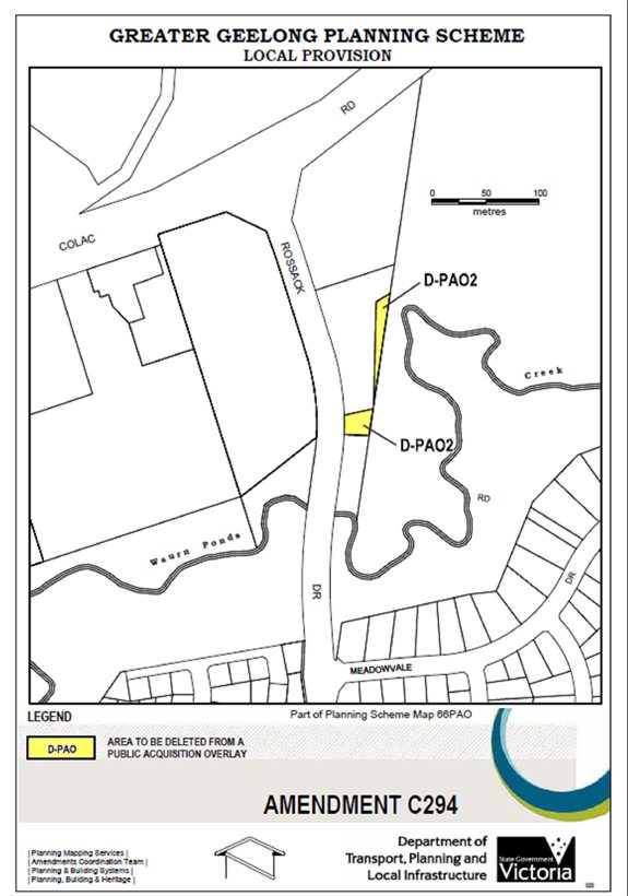
Delete the Public Acquisition Overlay 2 from 13-39 Rossack Drive Waurn Ponds. It is no longer required as a result of the issue of planning permit 1551/2012 for the development of a new police and SES station. A condition on the planning permit requires Victoria Police to make a financial contribution to Council to assist in funding the development of a Waurn Ponds Creek crossing bridge crossing. A shared path along the eastern and southern boundaries of the site could not be achieved as part of the Police/SES Station development so the PAO2 is no longer required to this property.
Rezone the acquired land at Lot J Tannin Way, Waurn Ponds from R1Z to PUZ4. This is the site of the impending Grovedale Railway Station.
Planning Scheme Ordinance Changes
Delete the Heritage Overlay HO737 from the Schedule to the Heritage Overlay. This applies to the Geelong West Free Kindergarten at 46-54 O’Connell Street, Geelong West. This site is to be retained in the HO1962 Waterloo Heritage Area only. This was inadvertently missed as part of Amendment C196.
Delete the Heritage Overlay HO736 from the Schedule to the Heritage Overlay. This applies to 27 O’Connell Street, Geelong West. The site is to be retained in HO1962 Waterloo Heritage Area only. This was inadvertently missed as part of Amendment C196.
Amend the schedule to the Heritage Overlay to complete the heritage listing for entry HO1621, affecting the Peace Memorial in Johnstone Park, Geelong. The internal alterations controls apply column is to be amended to describe that the extent of the internal alteration controls apply to the peace memorial interior only.
Amend the schedule to the Heritage Overlay to remove the cacti listed in the ‘tree controls apply’ column from the entry for HO1901, affecting “Cartret” at 13 Wimmera Street, Belmont. The cactus was removed before the finalisation of Amendment C89 which introduced the heritage entry.
Amend the schedule to the Heritage Overlay to correct the suburb and internal controls apply column for entry HO1587, the St. Francis Xavier Catholic Church at 1030 Portarlington Road, Curlewis. The correct suburb address for this property is to be changed from Curlewis to Leopold. The ‘internal alterations controls apply’ column insufficiently describes the extent of the control and is to be amended to clarify that the internal alteration controls apply only to the “former Church Building Interior Only”.
Amend the Schedule to the Heritage overlay to re-instate the entry of HO1915. This entry was inadvertently deleted from the Schedule to the Heritage Overlay as part of Amendment C169. This affects the Geelong Sale Yards at 125 Weddell Road, North Geelong and was listed in the schedule to the Heritage Overlay by Amendment C183 which preceded C169.
Amend Clause 21.06-6 to delete the reference to undertaking the Ashby Heritage review and Newtown Heritage Study in the Further Work section of the clause. This should have been deleted from the Scheme as part of the amendments to implement these heritage studies.
Amend the schedule to clause 35.03 (Rural Living Zone) to delete the requirement that a lot created in the Rural Living Zone be capable of containing a triangle of 0.8 hectares with minimum dimensions of 70 metres. This was identified by VCAT in case BMF v Greater Geelong CC [2011] VCAT 1666 (29 August 2011) with the ruling that the Schedule to the Rural Living Zone can not regulate the ‘shape’ of a subdivision and that such a provision is unlawful.
Amend Schedule 13 to the Design and Development Overlay (DDO13) by deleting redundant provisions that require planning permits for cut and fill, noise attenuation adjacent to the Ring Road and reflective materials. The first two of these matters are capable of being addressed through a Building Permit and VicRoads permit conditions respectively. The third is not considered to value add to the permit process with development of the Barrabool Hills area being achieved in modern styles using a wide range of building materials.
Amend Schedule 1 to clause 37.08 (Activity Centre Zone) to correct the street description in the table at 5.5-3 precinct requirements. In the table at 5.5-3 Precinct requirements, Precinct 5E has a Preferred maximum street edge wall height and preferred setback of building above street edge wall height listed as 15 metres along Mercer Street and 4 metres along Mercer Street respectively. However, no part of precinct 5E directly abuts Mercer Street. This is to be changed to Malop Street as the correct street.
Amend Schedule 1 to clause 37.08 (Activity Centre Zone) to correct the street description in the table at 5.5-3 precinct requirements. In the table at 5.5-3 Precinct requirements, Precinct 5A has a Preferred maximum street edge wall height and preferred setback of building above street edge wall height listed as 15 metres along Mercer Street and 4 metres along Mercer Street respectively. However, part of precinct 5A also directly abuts Malop Street. This is to be changed to add Malop Street to the description.
Amend schedule 26 to the Design and Development Overlay (Clause 43.02) to correct the inadvertent reference to an incorrect local planning policy. The subdivision requirements of the Design and Development Overlay schedule 26 currently refer to clause 22.20 Cultural Heritage, when it is to be corrected to refer to Clause 22.09 Cultural Heritage.
Delete the Heritage Overlay HO653 from the Schedule to the Heritage Overlay (clause 43.01 schedule). This applies to the residence at 68A Clarence Street, Geelong West. This site is to be retained in the HO1960 Milton Heritage Area only. This was inadvertently missed as part of Amendment C196.
Amend Schedule 1 to the Activity Centre Zone (Clause 37.08) to remove the restriction on Restricted Recreation Facility in precinct 5. The use Restricted Recreation Facility was permitted in the previous Special Use Zone Schedule 10 but is now prohibited in Precinct 5 of the ACZ. Amendment C223 was intended to be a ‘neutral’ transition of the former suite of business and special use zones to the current Activity Centre Zone and it appears this deletion was an oversight. This has impacted on the ability of new operators to enter the market and for existing operators to extend their operations. An amendment to the ACZ Schedule 1 Land Use Table is proposed.
Amend Schedule 1 to the Activity Centre Zone (clause 37.08) to include permit exemption for buildings and works provisions for the construction or carrying out of works for the purposes of Railway, Railway station and Bus Terminal. These were inadvertently removed in the transition from the previous Priority Development Zone to the current Activity Centre Zone. Amendment C223 was intended to be a ‘neutral’ transition of the previous land use controls and it appears this deletion was an oversight.
Insert the General Residential Zone, Residential Growth Zone and the Neighbourhood Residential Zone into the Greater Geelong Planning Scheme Ordinance. DTPLI has instructed Council’s to use these zones for new amendments proposing rezoning to residential. These zones will be available to use for any upcoming amendments. A separate review process is being undertaken to determine the application of the new residential zones to existing residentially zoned areas.
Amend Clause 22.01 to include the new suite of residential zones as zones where the policy applies.
Delete Clause 22.56 Interim Telecommunications Conduit Policy as the mandatory conditions of Clause 66.01-1 render the interim local planning policy redundant.
As there are no objecting submissions to this Amendment, Council can adopt it and send it to the Minister for Planning requesting approval.
No adverse environmental implications are expected as a result of this amendment.
There are no ongoing financial implications for Council arising from this amendment.
The proposal is consistent with the format for planning schemes and with the Ministerial Direction on the Form and Content of Planning Schemes. The Amendment is consistent with the State and Local Policy Framework (SPPF and LPPF). As the changes proposed are minor and essentially administrative in nature, there are no implications for the LPPF. Some minor corrections to the LPPF are proposed by this amendment and will improve its interpretation and relevance.
The amendment supports the Sustainable Built and Natural Environment and Growing our Economy strategic directions of City Plan. In particular, this is achieved through the priorities of a successful and vibrant city centre, ongoing growing our economy, services and activities for the community, and ongoing sustainable built and natural environment services and activities for the community.
No Council officers have any direct or indirect interest, in accordance with Section 80(C) of the Local Government Act, to which this amendment relates.
There are no notable risks associated with either implementing or not implementing the recommendations contained in this report. Given its minor, procedural nature, this amendment has been assessed as having a low level of risk.
No adverse social impacts are expected to result from this amendment.
The amendment will not impact on any basic rights, freedoms and responsibilities as set out in the Charter. Planning legislation provides for the exemptions to the usual consultation process for amendments, which the Minister for Planning duly granted.
The amendment was exempt from the giving of notice with the exception of notification to prescribed Ministers under Section 19(1)( c) of the Planning and Environment Act 1987.
Planning and Environment Act 1987
The planning authority for this amendment is the City of Greater Geelong
The Greater Geelong Planning Scheme is amended as follows:
Planning Scheme Maps
The Planning Scheme Maps are amended by a total of 23 attached map sheets.
Zoning Maps
Amend Planning Scheme Map No.18 in the manner shown on the 1 attached map marked “Greater Geelong Planning Scheme, Amendment C294”.
Amend Planning Scheme Map No 43 in the manner shown on the 1 attached map marked “Greater Geelong Planning Scheme, Amendment C294”.
Amend Planning Scheme Map No 44 in the manner shown on the 1 attached map marked “Greater Geelong Planning Scheme, Amendment C294”.
Amend Planning Scheme Map No 47 in the manner shown on the 1 attached map marked “Greater Geelong Planning Scheme, Amendment C294”.
Amend Planning Scheme Map Nos 47 & 48 in the manner shown on the 1 attached map marked “Greater Geelong Planning Scheme, Amendment C294”.
Amend Planning Scheme Map No 50 in the manner shown on the 1 attached map marked “Greater Geelong Planning Scheme, Amendment C294”.
Amend Planning Scheme Map Nos 55 & 56 in the manner shown on the 1 attached map marked “Greater Geelong Planning Scheme, Amendment C294”.
Amend Planning Scheme Map No 59 in the manner shown on the 2 attached maps marked “Greater Geelong Planning Scheme, Amendment C294”.
Amend Planning Scheme Map No 65 in the manner shown on the 1 attached map marked “Greater Geelong Planning Scheme, Amendment C294”.
Amend Planning Scheme Map Nos 65 & 66 in the manner shown on the 1 attached map marked “Greater Geelong Planning Scheme, Amendment C294”.
Amend Planning Scheme Map No 66 in the manner shown on the 1 attached map marked “Greater Geelong Planning Scheme, Amendment C294”.
Amend Planning Scheme Map No 69 in the manner shown on the 1 attached map marked “Greater Geelong Planning Scheme, Amendment C294”.
Amend Planning Scheme Map Nos 76 & 77 in the manner shown on the 1 attached map marked “Greater Geelong Planning Scheme, Amendment C294”.
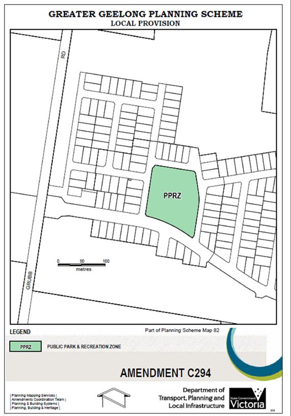
Amend Planning Scheme Map No 82 in the manner shown on the 2 attached maps marked “Greater Geelong Planning Scheme, Amendment C294”.
Amend Planning Scheme Map No 88 in the manner shown on the 1 attached map marked “Greater Geelong Planning Scheme, Amendment C294”.
Overlay Maps
Amend Planning Scheme Map Nos 49HO in the manner shown on the 2 attached maps marked “Greater Geelong Planning Scheme, Amendment C294”.
Amend Planning Scheme Map No 59HO in the manner shown on the 1 attached map marked “Greater Geelong Planning Scheme, Amendment C294”.
Amend Planning Scheme Map Nos 65PAO & 66PAO in the manner shown on the 1 attached map marked “Greater Geelong Planning Scheme, Amendment C294”.
Amend Planning Scheme Map No 66PAO in the manner shown on the 1 attached map marked “Greater Geelong Planning Scheme, Amendment C294”.
Amend Planning Scheme Map Nos 71HO & 82HO in the manner shown on the 1 attached map marked “Greater Geelong Planning Scheme, Amendment C294”.
Planning Scheme Ordinance
The Planning Scheme Ordinance is amended as follows:
In Local Planning Policy Framework – replace Clause 21.06-6 with a new Clause 21.06-6 in the form of the attached document.
In Local Planning Policy Framework – replace Clause 22.01 with a new Clause 22.01 in the form of the attached document.
In Local Planning Policy Framework – delete Clause 22.56.
In Zones – Clause 35.03, replace the Schedule with a new Schedule in the form of the attached document.
In Zones - insert Clause 32.07 in the form of the attached document.
In Zones - insert Clause 32.08 in the form of the attached document.
In Zones - insert Clause 32.09 in the form of the attached document.
In Zones – Clause 37.08 replace Schedule 1 with a new Schedule 1 in the form of the attached document.
In Overlays – Clause 43.01, replace Schedule 1 with a new Schedule 1 in the form of the attached document.
In Overlays – Clause 43.02, replace Schedule 13 with a new Schedule 13 in the form of the attached document.
In Overlays – Clause 43.02, replace Schedule 26 with a new Schedule 26 in the form of the attached document.
End of document
21.06 |
SETTLEMENT AND HOUSING |
19/07/2012 |
21.06-1 Key issues and influences |
28/01/2010 |
DemographicsBetween 2006 and 2031, it is estimated that the municipality will need to accommodate an additional 63,000 persons. This level of population growth will generate demand for approximately 41,000 new dwellings. The region’s population is ageing rapidly through the in-migration of retiring persons and the ageing-in-place of existing residents. The municipality is a popular retirement destination, particularly the coastal towns on the Bellarine Peninsula. Although the population is ageing, it is vitally important that the City continues to provide an environment that attracts and supports children, young people and families. HousingThe majority of new housing development in the municipality will continue to be in the form of detached dwellings on conventionally sized blocks; however the demand for smaller dwelling types is expected to escalate. This trend will be driven by significant growth in smaller households (primarily singles, childless couples and sole parents), as well as emerging preferences for lower maintenance dwellings that are close to urban services. The ageing of the population will contribute substantially to the increase in demand for low maintenance dwellings and retirement accommodation. This accommodation will need to be close to urban services. There is a need to maintain competition and diversity in the housing market. SettlementThere is an environmental, economic and social imperative to reduce urban sprawl and improve accessibility to urban services, principally by consolidating urban development around places of activity and public transport infrastructure. Urban consolidation and changing housing needs are having a significant impact on the character of the City’s existing urban areas, particularly those established suburban areas which are characterised by detached housing in a garden setting. Outward urban growth needs to be carefully managed and directed to designated locations that offer the greatest net benefit to the Geelong community, can be appropriately serviced and which have the capacity to accommodate sustainable development. All development should contribute positively to the quality of the urban environment so that it may be enjoyed and respected by the existing and future community. Whilst rural living areas provide for greater consumer choice in the housing market, they can be inefficient to service and generally contrary to the objective of maintaining a farmed rural landscape in the City’s rural areas. There is consequently a need to restrict rural living to specific locations and to ensure that consumers meet their equitable share of the cost of servicing such locations. The municipality’s rural living nodes will continue to rely on established townships and urban Geelong for commercial and community facilities. IdentityThe City of Greater Geelong is within the traditional territory of the Wathaurong Aboriginal clan groups. Recognition, respect and protection of Greater Geelong’s Indigenous and European cultural heritage is of critical importance to the City’s identity moving forward. |
21.06-2 |
Urban growth |
28/01/2010 C129(Part 1) |
Objectives
Strategies
|
21.06-3 |
Urban consolidation |
28/01/2010 C129(Part 1) |
Objectives
Strategies
|
21.06-4 |
Neighbourhood character |
19/07/2012 C245 |
Objectives
Strategies
|
21.06-5 |
Heritage and identity |
28/01/2010 C129(Part 1) |
Objectives
Strategies
|
21.06-6 |
Implementation |
19/07/2012 C245 |
Using policy and the exercise of discretionEnsure all advertising signage complies with the City of Greater Geelong Advertising Sign Guidelines. Use the Heritage Policies at Clause 22. Use the Discretionary Uses in Rural Living and Low Density Residential Areas at Clause 22.04. Use the Discretionary Uses in Residential Areas at Clause 22.01. Prevent residential development from occurring outside of the settlement boundaries set out in any Framework Plan, Structure Plan or Urban Growth Plan for an area. Assess applications against the Residential Character Study: Character Precinct Brochures. Ensure new development in heritage areas is in accordance with the Incorporated Document City of Greater Geelong Heritage Design Guidelines. Where appropriate, require the preparation of Conservation Management Plans for heritage places. Applying zones and overlaysApply an appropriate zone to identified Key Development Areas. Further workConduct a Heritage Review in the Ashby precinct in Geelong West. Implement the Newtown Heritage Study Review 2008. Review the application of appropriate zones/overlays, consistent with the principles of the Housing Diversity Strategy, surrounding the neighbourhood centres of Pakington Street Newtown, Pakington Street Geelong West, Aberdeen Street Newtown and Shannon Avenue Manifold Heights. Prepare structure plans for Increased Housing Diversity Areas to inform preparation of a more comprehensive set of provisions to realise the policy objectives for these areas. Review the residential areas around Central Geelong to determine Residential 2 opportunities. Review Residential Character Study: Character Precinct Brochures, Planisphere for City of Greater Geelong, September 2001. As a priority commence an investigation into the future residential and industrial land use needs for Geelong, as a basis for future growth area planning, that would include:
Work with the Director of Housing to progress and implement the Norlane Housing Regeneration Development Areas within the Norlane-Corio Urban Renewal Feasibility Study. ReferencesCity of Greater Geelong Housing Strategy Background and Issues Report, Swinburne University, 2005. City of Greater Geelong Housing Diversity Strategy, alphaPlan, David Lock Associates and the City of Greater Geelong, 2007.
Aboriginal Cultural Heritage Management and Protection Development Planning Protocol – 2000. Geelong Verandah Study, Authentic Heritage Services P/L and Wendy Jacobs, 2006. Residential Character Study: Character Precinct Brochures, Planisphere for City of Greater Geelong, September 2001. The Australian ICOMOS Charter for the Conservation of Places of Cultural Significance (The Burra Charter), Australia ICOMOS, 1988. City of Greater Geelong Urban Furniture Style Manual, Taylor and Cullity Pty Ltd for City of Greater Geelong, 1996. |
22.01 |
DISCRETIONARY USES IN RESIDENTIAL AREAS |
28/01/2010 C120 (Part 1) Proposed C294 |
This policy applies to the consideration of use and development applications within the Residential 1, Residential 2, and Residential 3 General Residential, Residential Growth and Neighbourhood Residential Zones. Policy BasisProtecting of the amenity of the City’s residential areas requires a balance between the need for goods and services that serve local residents and workers and the potential for negative impacts on residential amenity. Non-residential uses can reduce the amenity of residential areas through the generation of additional traffic, increased demand for car parking, the hours of operation of the use, appearance, noise and other emissions. In order to maintain the residential character and amenity of an area it is important that non-residential uses are located and function having regard to these issues. To protect residential areas it is important to restrict the encroachment of incompatible non-residential uses. Purpose built non-residential buildings are important features of the City’s residential areas, particularly in the inner suburbs. Council encourages appropriate re-use of these buildings for either residential or non-residential uses where it results in an economically viable use of the building and provides a service to the local community. Objectives
PolicyIt is policy that: Preferred Location
Amenity
Design and Siting
Landscaping
Carparking & Traffic
Advertising Signage
Application Requirements
Performance MeasuresProposals will be measured against the following performance measures: Amenity
Design
Landscaping
Car parking
ReferencesAdvertising Sign Guidelines, City of Greater Geelong November 1997. |
Header clauses of the Residential Growth Zone (clause 32.07)
Header clause of the General Residential Zone (clause 32.08)
Header clause of the Neighbourhood Residential Zone (clause 32.09)
Amendment C294 inserts the header clauses of the three new residential zones into the Greater Geelong Planning Scheme. These Victoria Planning Provisions clauses can be viewed at the Department of Transport, Planning and Local Infrastructure planning schemes online website.
SCHEDULE TO THE RURAL LIVING ZONE |
||||||||
18/01/2010 |
Shown on the planning scheme map as RLZ |
|||||||
|
Land |
Area/Dimensions/Distance |
||||||
Minimum subdivision area (hectares). |
All land |
1 hectare with the average area of lots in a subdivision being at least 1.5 hectares. For the purpose of calculating average area, all lots exceeding 3.0 hectares must be considered as 3.0 hectares (and the balance of a staged subdivision should be excluded).Each lot must also be capable of containing a rectangle of 0.8 hectares with minimum dimensions of 70 metres. |
||||||
Minimum area for which no permit is required to use land for a dwelling (hectares). |
All land |
1 hectare |
||||||
Maximum floor area for which no permit is required to alter or extend an existing dwelling (square metres). |
None specified |
|||||||
Maximum floor area for which no permit is required to construct an out-building associated with an existing dwelling (square metres) |
None specified |
|||||||
Maximum floor area for which no permit is required to alter or extend an existing building used for agriculture (square metres) |
None specified |
|||||||
Minimum setback from a road (metres). |
None specified |
|||||||
Minimum setback from a boundary (metres). |
None specified |
|||||||
Minimum setback from a dwelling not in the same ownership (metres).
|
None specified |
|||||||
Permit requirement for earthworks |
Land |
|||||||
Earthworks which change the rate of flow or the discharge point of water across a property boundary. |
All land, except land contained within the Public Acquisition Overlay (PAO3) for or impacted by the construction of the Geelong Ring Road – Sections 3, 4A, 4B and associated works. |
|||||||
Earthworks which increase the discharge of saline groundwater. |
All land, except land contained within the Public Acquisition Overlay (PAO3) for or impacted by the construction of the Geelong Ring Road – Sections 3, 4A, 4B and associated works. |
|||||||
SCHEDULE 1 TO THE ACTIVITY CENTRE ZONE |
||||||||
09/05/2013 |
Shown on the planning scheme map as ACZ1. | |||||||
CENTRAL GEELONG ACTIVITY CENTRE |
||||||||
1.0 |
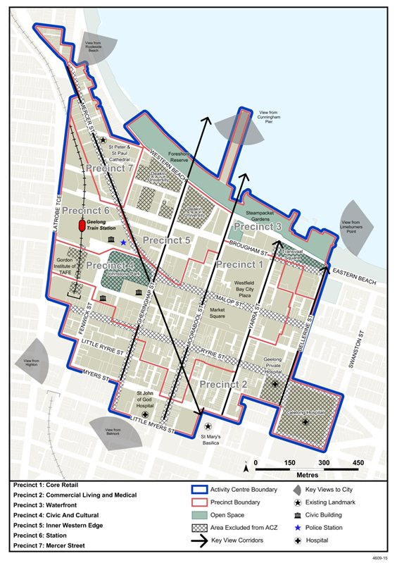
Central Geelong Framework Plan |
|||||||
09/05/2013 |
 |
|||||||
2.009/05/2013 |
Land use and development objectives
Land use
Built form
Views
Public realm
Accessibility and Movement
Land configuration and ownership
|
|||||||
3.0 |
Use of land |
|||||||
09/05/2013 |
Section 1 - Permit not required |
|||||||
USE |
CONDITION |
|||||||
| Accommodation (other than Camping and caravan park, Corrective institution, Dwelling, Host farm and Residential building) | Must be in Precinct 2, 5, 6 or 7 or Sub-precinct 1A or 1B. Any frontage at ground floor level must not exceed 2 metres, unless the floor space adjoining the frontage is a customer service area accessible to the public. |
|||||||
| Bed and breakfast | Must be in Precinct 2, 3, 5, 6 or 7 or Sub-precinct 1A or 1B. In Precinct 5 or 7 any frontage at ground floor level must not exceed 2 metres, unless the floor space adjoining the frontage is a customer service area accessible to the public. |
|||||||
| Betting agency | Must be in Sub-precinct 1A or 1B. |
|||||||
| Bus terminal | Must be in Precinct 6. |
|||||||
| Caretaker’s house | Must be in Precinct 2, 3, 4, 5, 6 or 7 or Sub-precinct 1A or 1B. In Precinct 5 or 7 any frontage at ground floor level must not exceed 2 metres, unless the floor space adjoining the frontage is a customer service area accessible to the public. |
|||||||
| Car park | Must be in Precinct 6. Must be in conjunction with another use in Section 1 or 2. |
|||||||
| Child care centre | Must be in Sub-precinct 1A or 1B. Any frontage at ground floor level must not exceed 2 metres and access must not be shared with a dwelling (other than a caretaker’s house). |
|||||||
| Cinema | Must be in Sub-precinct 1A or 1B. |
|||||||
| Cinema based entertainment facility | Must be located in Sub-precinct 1A or 1B. |
|||||||
| Convenience restaurant | Must be in Sub-precinct 1A or 1B. |
|||||||
| Convenience shop | Must be in Sub-precinct 1A or 1B. |
|||||||
| Department store | Must be in Sub-precinct 1A or 1B. |
|||||||
| Dwelling (other than Bed and breakfast and Caretaker’s house) | Must be in Precinct 2, 3, 5, 6 or 7 or Sub-precinct 1A or 1B. In Sub-precinct 1A or 1B any frontage at ground floor level must not exceed 2 metres. In Precinct 5 or 7 any frontage at ground floor level must not exceed 2 metres, unless the floor space adjoining the frontage is a customer service area accessible to the public. |
|||||||
| Education centre | Must be in Precinct 5 or 7 or Sub-precinct 1A or 1B, and any frontage at ground floor level must not exceed 10 metres. In Sub-precinct 1A or 1B access must not be shared with a dwelling (other than a caretaker’s house). Must not be a primary or secondary school. |
|||||||
| Electoral office | Must be in Precinct 1, 2, 4, 5, 6 or 7. May be used for only 4 months before an election and 2 weeks after an election. |
|||||||
| Food and drink premises (other than Convenience restaurant, Hotel, and Tavern) | Must be in Precinct 3, 5, 6 or 7 or Sub-precinct 1A or 1B. |
|||||||
| Home occupation | ||||||||
| Hotel | Must be in Precinct 5, 6 or 7. |
|||||||
| Informal outdoor recreation | ||||||||
| Laundromat | Must be in Precinct 1, 2 or 4. |
|||||||
| Medical centre | Must be in Precinct 4, 5, 6 or 7 or Sub-precinct 1A, 1B, 2A, 2B, 2C, 2D or 2E. In Precinct 5 or 7 or Sub-precinct 1A or 1B any frontage at ground floor level must not exceed 2 metres and access must not be shared with a dwelling (other than a caretaker’s house) unless the medical centre floor space adjoining the frontage is a customer service area accessible to the public. |
|||||||
| Minor utility installation | ||||||||
| Office (other than Electoral office and Medical centre) | Must be in Precinct 4, 5, 6 or 7 or Sub-precinct 1A, 1B, 2A, 2B, 2C, 2D or 2E. In Precinct 5 or 7 or Sub-precinct 1A or 1B any frontage at ground floor level must not exceed 2 metres and access must not be shared with a dwelling (other than a caretaker’s house) unless the office is a bank, real estate agency, travel agency, or any other office where the floor space adjoining the frontage is a customer service area accessible to the public. |
|||||||
| Postal agency | Must be in Precinct 1, 2 or 4. |
|||||||
| Railway | Must be in Precinct 6. |
|||||||
| Railway station | Must be in Precinct 2, 3, 5, 6 or 7 or Sub-precinct 1A or 1B where the floor space adjoining the frontage is a customer service area accessible to the public. In Precinct 5 or 7 any frontage at ground floor level must not exceed 2 metres. |
|||||||
| Residential building | ||||||||
| Restricted retail premises | Must be in Sub-precinct 1A or 1B. |
|||||||
| Road | ||||||||
| Shop (other than Adult sex bookshop, Convenience shop, Department store, Restricted retail premises and Supermarket) | Must be in Sub-precinct 1A or 1B. |
|||||||
| Supermarket | Must be in Sub-precinct 1A or 1B. |
|||||||
| Take away food premises | Must be in Precinct 3, 5, 6 or 7 or Sub-precinct 1A or 1B. |
|||||||
| Tavern | Must be in Precinct 5, 6 or 7. |
|||||||
| Timber production | Must be in Sub-precinct 1A or 1B. |
|||||||
| Trade supplies (other than Timber production) | Must be in Sub-precinct 1A or 1B. |
|||||||
| Tramway | ||||||||
| Any use listed in Clause 62.01 | Must meet the requirements of Clause 62.01. |
|||||||
Section 2 - Permit required |
||||||||
USE |
CONDITION |
|||||||
| Adult sex bookshop | Must be in Precinct 1, or 4 or Sub-precinct 2A, 2B, 2C, 2D or 2E. Must be at least 200 metres (measured by the shortest route reasonably accessible on foot) from a residential zone or Business 5 Zone, land used for a hospital, primary school or secondary school or land in a Public Acquisition Overlay to be acquired for a hospital, primary school or secondary school. |
|||||||
| Amusement parlour | Must not be in Sub-precinct 2F or 3C. |
|||||||
| Animal keeping | ||||||||
| Brothel | Must be in Precinct 1, 2 or 4. Must be at least 200 metres (measured by the shortest route reasonably accessible on foot) from a residential zone or Business 5 Zone, land used for a hospital, primary school or secondary school or land in a Public Acquisition Overlay to be acquired for a hospital, primary school or secondary school. |
|||||||
| Community market | Must not be in Sub-precinct 3B. |
|||||||
| Convenience shop | In Sub-precinct 2F or 3C the leasable floor area must be no more than 80 square metres. |
|||||||
| Department store – if the Section 1 Condition is not met. | Must not be in Precinct 3, 6 or 7 or Sub-precinct 2F, 5A, 5B, 5C or 5D. |
|||||||
| Funeral parlour | Must be in Precinct 1, 2, 3 or 4. |
|||||||
| Gambling premises | Must not be in Sub-precinct 2F, 3B or 3C. |
|||||||
| Hospital |
|
|||||||
| Industry (other than Research and development centre and Service industry) | Must be in Precinct 1 or 4 or Sub-precinct 2A, 2B, 2C, 2D or 2E. Must not be a purpose listed in the table to Clause 52.10. |
|||||||
| Leisure and recreation (other than Informal outdoor recreation, Major sports and recreation facility, and Motor racing track) | Must be Precinct 1,2,3,4 or 6. |
|||||||
| Market (other than Community market) | Must not be in Sub-precinct 2F, 3B or 3C. |
|||||||
| Medical centre – if the Section 1 Condition is not met |
|
|||||||
| Nightclub | Must not be in Sub-precinct 2F or 3C. |
|||||||
| Office (other than Electoral office and Medical centre) | Must not be in Sub-precinct 2F or 3C. |
|||||||
| Place of assembly (other than Amusement parlour or Nightclub) |
|
|||||||
| Plant nursery |
|
|||||||
| Pleasure boat facility | Must not be in Precinct 6 or Sub-precinct 5A, 5B, 5C or 5D. |
|||||||
| Research and development centre | Must be in Precinct 1, 2, 4, 5, 6 or 7. |
|||||||
| Restricted retail premises – if the Section 1 Condition is not met. | Must be in Precinct 1, 4, 6 or 7 or Sub-precinct 2A, 2B, 2C, 2D or 2E. |
|||||||
| Retail premises (other than Adult sex bookshop, Community market, Convenience shop, Department store, Gambling premises, Market, Plant nursery, Restricted retail premises, Shop, Supermarket and Trade supplies) | Must not be in Sub-precinct 2F or 3C. |
|||||||
| Service industry | Must not be in Precinct 3. |
|||||||
| Service Station | Must be in Precinct 1, 2, 3 or 4. In Sub-precinct 2F or 3C the site must either:
In Sub-precinct 2F or 3C the site must not exceed either:
|
|||||||
| Shop (other than Adult sex bookshop, Department store, Plant nursery, Restricted retail premises and Supermarket) – if the Section 1 Condition is not met | Must not be located in Sub-precinct 2F or 3C. |
|||||||
| Supermarket | Must not be in Precinct 5, 6 or 7 or Sub-precinct 2F or 3C. |
|||||||
| Timber yard | Must not be in Precinct 2 or Sub-precinct 1C, 1D or 3C. |
|||||||
| Trade supplies | Must not be in Sub-precinct 1C, 1D, 2F or 3C. |
|||||||
| Transport terminal (other than Bus terminal, Heliport, Road freight and Wharf) | Must be in Precinct 1, 2, 3, 4 or 6. |
|||||||
| Utility installation (other than Minor utility installation and Telecommunications facility) | Must be in Precinct 1, 2 or 4. |
|||||||
| Warehouse (other than Mail centre) | Must be in Precinct 1, 2 or 4. Must not be a purpose listed in the table to Clause 52.10. |
|||||||
| Any other use not in Section 1 or 3 |
|
|||||||
Section 3 - Prohibited |
||||||||
USE |
||||||||
Agriculture (other than Animal keeping or Apiculture) |
|
|||||||
| Airport |
|
|||||||
Camping and caravan park |
|
|||||||
Cemetery |
|
|||||||
Corrective institution |
|
|||||||
Crematorium |
|
|||||||
Drive-in theatre |
|
|||||||
Freeway service centre |
|
|||||||
Host Farm |
|
|||||||
Intensive animal husbandry |
|
|||||||
Landscape gardening supplies (other than Plant nursery) |
|
|||||||
Major sports and recreation facility |
|
|||||||
Motor racing track |
|
|||||||
Primary produce sales |
|
|||||||
Road freight terminal |
|
|||||||
Saleyard |
|
|||||||
Winery |
|
|||||||
4.0 |
Centre-wide provisions |
|||||||
09/05/2013 |
||||||||
4.1 |
Use of land |
|||||||
09/05/2013 |
A permit is not required to use for land for public purposes providing the use is carried out by, or on behalf of, the public land manager. | |||||||
4.2 |
Subdivision |
|||||||
09/05/2013 |
Applications for the subdivision of land that are not associated with a development proposal that supports the objectives promoted by this schedule are discouraged. | |||||||
4.3 |
Buildings and works |
|||||||
09/05/2013 |
A permit is not required to construct a building or construct or carry out works associated with:
|
|||||||
4.4 |
Design and development |
|||||||
09/05/2013 |
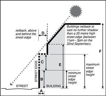
Building heights and setbacksDevelopment should meet any requirements specified at Clause 5 and as shown in Figure 1. Figure 1
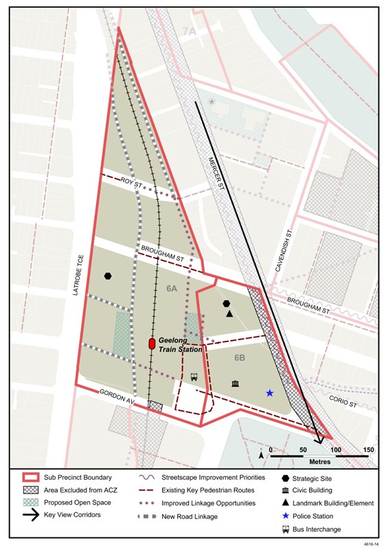
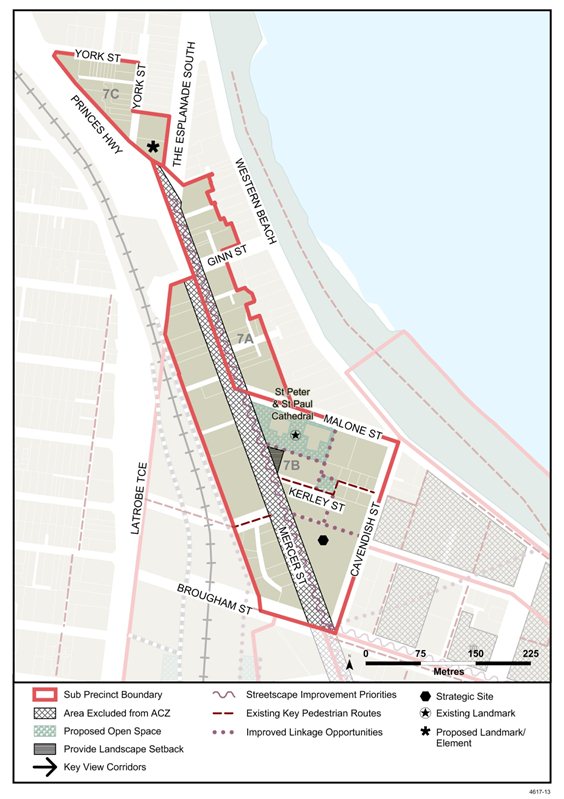
Preferred maximum building heights do not include non occupiable architectural features or landmarks, architectural features (such as domes, towers, masts) and building services, (including enclosed stairwells) that do not exceed the preferred maximum height by more than 4 metres. The combined floor area of these features should not exceed 10 percent of the gross floor area of the top building level. Buildings and works that propose to exceed preferred maximum street edge wall height specified at Clause 5 of this schedule should be setback to ensure they do not add any additional shadow on the identified key pedestrian routes beyond that which would be cast by a 20 metre high street edge wall between 11am and 3pm on 22 September. Building designBuildings should maintain a human scale and protect the street environs by:
Development should avoid blank walls, specifically when readily viewed from Western Beach Road, Eastern Beach Road, Mercer Street, Latrobe Terrace (Princes Hwy), Gheringhap Street, Brougham Street and Ryrie Street. Protection should be provided for pedestrians with continuous and generous verandahs and canopies over footpaths along identified key pedestrian routes, unless they would result in conflict with significant heritage places. Plant, equipment, rubbish and storage areas should be screened from the public domain and existing and potential adjacent developments. New Landmark Buildings or Elements should:
Adequate daylight should be provided to adjacent buildings, particularly to windows of habitable rooms and balconies of adjacent dwellings. Taller buildings and works should not dominate the streetscape. Built form should retain and share views from within Central Geelong and from the identified key view corridors to the city and maintain the general stepping down of built form to Corio Bay. Development which exceeds the preferred maximum building heights specified at Clause 5 should be of slender design, demonstrate design excellence, provide increased pedestrian permeability and spaces, retain generous visual permeability between taller buildings and retain key view corridors. Development over water should maintain and enhance public access. Excluding verandah and awning signs, signs should be contained within the site, and integrated into the design of the building façade, preferably within the first 9 metres, without projecting over footpaths. The design of buildings and works should seek to minimise the impact of traffic, parking, odour, light spill, signage and noise on the amenity of surrounding neighbourhood. All new accommodation uses should provide appropriate acoustic attenuation measures. New development should:
Car parking design should:
Private open spacePrivate open space provided in the form of a balcony should:
Views and landmarksDevelopment should consider its impact on identified key views to the city shown on the Central Geelong Framework Plan being:
Development which obscures or eliminates the identified key view corridors of Corio Bay and the You Yangs when viewed from Gheringhap Street, Moorabool Street, Yarra Street, Bellerine Street, and Swanston Street should be avoided. Views of St Mary’s Basilica Spire when viewed from the northern end of Mercer Street should not be obscured or encroached. Strategic sitesCentral Geelong contains a number of significant strategic sites that have a high level of development opportunity as shown on the precinct plans. Larger scale development, consistent with the Precinct provisions at Clause 5, should be encouraged in these locations, particularly those close to the Waterfront and in Precincts 4, 5 or 6. Access and mobilityDevelopment should allow for the provision of safe and publicly accessible pedestrian routes, linkages and spaces in accordance with the Precinct maps. Adequate light should be provided to public places and to key pedestrian routes. Environmentally Sustainable Development
|
|||||||
5.0 |
Precinct provisions |
|||||||
09/05/2013 |
||||||||
5.1 |
Precinct 1: Core retail |
|||||||
09/05/2013 |
||||||||
5.1-1 |
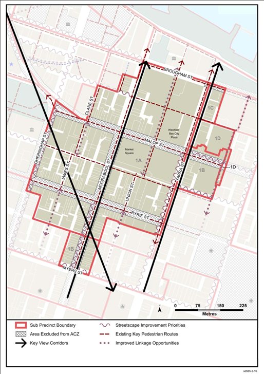
Precinct map |
|||||||
09/05/2013 |
 |
|||||||
5.1-2 |
Precinct Objectives |
|||||||
09/05/2013 |
|
|||||||
5.1-3 |
Precinct requirements |
|||||||
09/05/2013 |
Sub-precinct |
A Preferred setback of building from street frontage (boundary) |
B Minimum street edge wall height +* |
C Preferred maximum street edge wall height +* |
D Preferred setback of building above street edge wall height+ |
E Preferred minimum building height* |
F Preferred maximum building height* |
|
|
1A |
0 metres^ |
10 |
20 metres |
5 metres |
None Specified |
32 metres |
||
|
1B |
0 metres ^ |
10 |
20 metres |
5 metres |
None Specified |
40 metres |
||
|
1C |
0 metres ^ |
None specified |
20 metres |
None specified |
None Specified |
24 metres |
||
|
1D |
0 metres ^ |
10 |
20 metres |
5 metres |
None Specified |
40 metres |
||
* As measured from natural ground level. ^ Setbacks at ground level along the frontage may need to be provided for outdoor seating or the display of goods where not suitable for the adjacent footpath. + Street edge wall height (using the mid point where building is on sloping land) is the height of the wall on the front title boundary where there is no front setback. |
||||||||
5.1-4 |
Precinct guidelines |
|||||||
09/05/2013 |
|
|||||||
5.2 |
Precinct 2: Commercial living and medical |
|||||||
09/05/2013 |
||||||||
5.2-1 |
Precinct map |
|||||||
09/05/2013 |
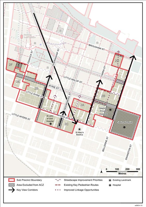 |
|||||||
5.2-2 |
Precinct objectives |
|||||||
09/05/2013 |
|
|||||||
5.2-3 |
Precinct requirements |
|||||||
09/05/2013 |
Sub-precinct |
A Preferred setback of building from street frontage (boundary) |
B Minimum street edge wall height +* |
C Preferred maximum street edge wall height +* |
D Preferred setback of building above street edge wall height+ |
E Preferred minimum building height* |
F Preferred maximum building height* |
|
|
2A |
0 metres ^ |
10 metres |
20 metres |
5 metres |
None Specified |
32 metres |
||
|
2B |
0 metres ^ |
10 metres |
20 metres |
5 metres |
None Specified |
40 metres |
||
|
2C |
0 metres ^ |
10 metres |
20 metres |
5 metres |
None Specified |
24 metres |
||
|
2D |
0 metres ^ |
None specified |
20 metres |
None specified |
None Specified |
24 metres |
||
|
2E |
None Specified^ |
None specified |
None Specified |
None Specified |
None Specified |
None Specified |
||
|
2F |
None Specified^ |
None specified |
None Specified |
None Specified |
None Specified |
None Specified |
||
* As measured from natural ground level. ^ Setbacks at ground floor level along the frontage may need to be provided for outdoor seating or the display of goods where not suitable for the adjacent footpath. + Street edge wall height (using the mid point where building is on sloping land) is the height of the wall on the front title boundary where there is no front setback. |
||||||||
5.2-4 |
Precinct guidelines |
|||||||
09/05/2013 |
|
|||||||
5.3 |
Precinct 3: Waterfront |
|||||||
09/05/2013 |
||||||||
5.3-1 |
Precinct map |
|||||||
09/05/2013 |
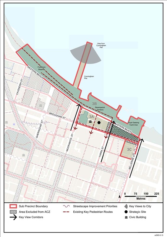 |
|||||||
5.3-2 |
Precinct objectives |
|||||||
09/05/2013 |
|
|||||||
5.3-3 |
Precinct requirements |
|||||||
09/05/2013 |
Sub-precinct |
A Preferred setback of building from street frontage (boundary) |
B Minimum street edge wall height +* |
C Preferred maximum street edge wall height +* |
D Preferred setback of building above street edge wall height+ |
E Preferred minimum building height* |
F Preferred maximum building height* |
|
|
3A |
0 metres ^ |
None specified |
20 metres |
None specified |
None Specified |
24 metres |
||
|
3B |
None Specified ^ |
None specified |
None Specified |
None Specified |
None Specified |
None Specified |
||
|
3C |
0 metres ^ |
None specified |
20 metres |
None specified |
None Specified |
24 metres |
||
* As measured from natural ground level. ^ Setbacks at ground floor level along the frontage may need to be provided for outdoor seating or the display of goods where not suitable for the adjacent footpath. + Street edge wall height (using the mid point where building is on sloping land) is the height of the wall on the front title boundary where there is no front setback. |
||||||||
5.3-4 |
Precinct guidelines |
|||||||
09/05/2013 |
|
|||||||
5.4 |
Precinct 4: Civic and cultural |
|||||||
09/05/2013 |
||||||||
5.4-1 |
Precinct map |
|||||||
09/05/2013 |
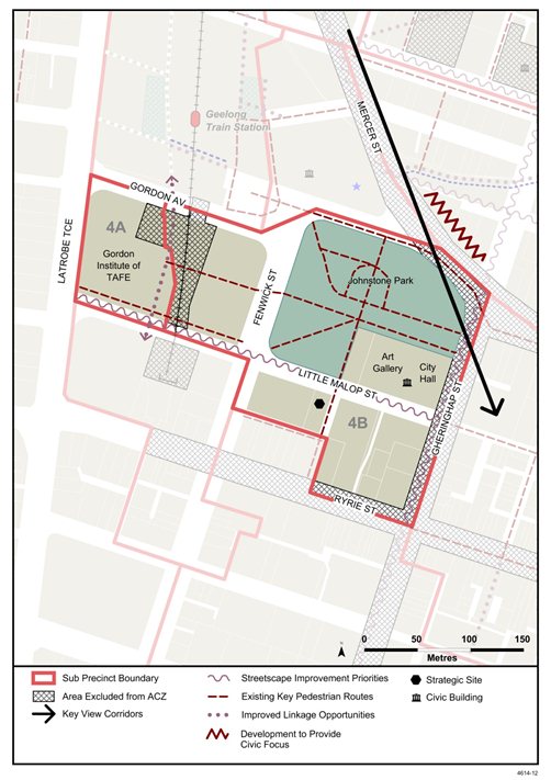 |
|||||||
5.4 |
Precinct objectives |
|||||||
09/05/2013 |
|
|||||||
5.4-3 |
Precinct requirements |
|||||||
09/05/2013 |
Sub-precinct |
A Preferred setback of building from street frontage (boundary) |
B Minimum street edge wall height +* |
C Preferred maximum street edge wall height +* |
D Preferred setback of building above street edge wall height+ |
E Preferred minimum building height* |
F Preferred maximum building height* |
|
|
4A |
Must be a minimum of 6 metres and a maximum of 10 metres |
None specified |
None Specified |
None Specified |
12 metres |
None Specified |
||
|
4B |
0 metres^ |
None specified |
None Specified |
None Specified |
12 metres |
None Specified |
||
* As measured from natural ground level. ^ Setbacks at ground level along the frontage may need to be provided to meet the objectives for this precinct and to provide for outdoor seating or the display of goods where not suitable for the adjacent footpath. + Street edge wall height (using the mid point where building is on sloping land) is the height of the wall on the front title boundary where there is no front setback. |
||||||||
5.4-4 |
Precinct guidelines |
|||||||
09/05/2013 |
|
|||||||
5.5 |
Precinct 5: Inner western wedge |
|||||||
09/05/2013 |
||||||||
5.5-1 |
Precinct map |
|||||||
09/05/2013 |
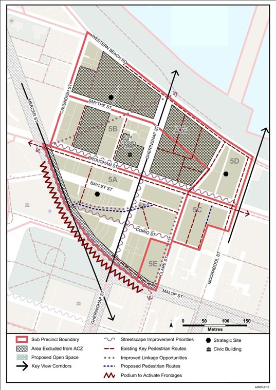 |
|||||||
5.5-2 |
Precinct objectives |
|||||||
09/05/2013 |
|
|||||||
5.5-3 |
Precinct requirements |
|||||||
09/05/2013 |
Sub-precinct |
A Preferred setback of building from street frontage (boundary) |
B Minimum street edge wall height +* |
C Preferred maximum street edge wall height +* |
D Preferred setback of building above street edge wall height+ |
E Preferred minimum building height* |
F Preferred maximum building height* |
|
|
5A |
0 metres^ |
None specified |
15 metres along Mercer and Malop Streets |
4 metres along Mercer and Malop Streets |
12 metres |
None specified |
||
|
5B |
0 metres ^ |
None specified |
None Specified |
None Specified |
12 metres |
28 metres |
||
|
5C |
0 metres ^ |
None specified |
None Specified |
None Specified |
12 metres |
28 metres |
||
|
5D |
0 metres ^ |
None specified |
None specified |
None specified |
12 metres |
20 metres |
||
|
5E |
0 metres^ |
None specified |
15 metres along MalopMercerStreet |
4 metres along MalopMercerStreet |
12 metres |
None specified |
||
* As measured from natural ground level. ^ Setbacks at ground level along the frontage may need to be provided to meet the objectives for this precinct and to provide for outdoor seating or the display of goods where not suitable for the adjacent footpath. + Street edge wall height (using the mid point where building is on sloping land) is the height of the wall on the front title boundary where there is no front setback. |
||||||||
5.5-4 |
Precinct guidelines |
|||||||
09/05/2013 |
|
|||||||
5.6 |
Precinct 6: Station |
|||||||
09/05/2013 |
||||||||
5.6-1 |
Precinct map |
|||||||
09/05/2013 |
 |
|||||||
5.6-2 |
Precinct objectives |
|||||||
09/05/2013 |
|
|||||||
5.6-3 |
Precinct requirements |
|||||||
09/05/2013 |
Sub-precinct |
A Preferred setback of building from street frontage (boundary) |
B Minimum street edge wall height +* |
C Preferred maximum street edge wall height +* |
D Preferred setback of building above street edge wall height+ |
E Preferred minimum building height* |
F Preferred maximum building height* |
|
|
6A |
Should be between 6-10 metres fronting Latrobe Terrace, 0 metres elsewhere |
None specified |
None Specified |
None Specified |
12 metres |
None Specified |
||
|
6B |
0 metre front and side setback to Mercer Street. |
None specified |
15 metres |
4 metres |
12 metres |
None Specified |
||
* As measured from natural ground level. ^ Setbacks at ground level along the frontage may need to be provided to meet the objectives for this precinct and to provide for outdoor seating or the display of goods where not suitable for the adjacent footpath. + Street edge wall height (using the mid point where building is on sloping land) is the height of the wall on the front title boundary where there is no front setback. |
||||||||
5.6-4 |
Precinct guidelines |
|||||||
09/05/2013 |
|
|||||||
5.7 |
Precinct 7: Mercer Street |
|||||||
09/05/2013 |
||||||||
5.7-1 |
Precinct map |
|||||||
09/05/2013 |
 |
|||||||
5.7-2 |
Precinct objectives |
|||||||
09/05/2013 |
|
|||||||
5.7-3 |
Precinct requirements |
|||||||
09/05/2013 |
Sub-precinct |
A Preferred setback of building from street frontage (boundary) |
B Minimum street edge wall height +* |
C Preferred maximum street edge wall height +* |
D Preferred setback of building above street edge wall height+ |
E Preferred minimum building height* |
F Preferred maximum building height* |
|
|
7A |
0 metres^ |
None specified |
15 metres |
4 metres |
12 metres |
15 metres |
||
|
7B |
0 metres^ |
None specified |
15 metres |
4 metres |
12 metres |
None Specified |
||
|
7C |
0 metres^ |
None specified |
15 metres |
None Specified |
12 metres |
15 metres |
||
| * As measured from natural ground level. ^ Setbacks at ground level along the frontage may need to be provided to meet the objectives for this precinct and to provide for outdoor seating or the display of goods where not suitable for the adjacent footpath. + Street edge wall height (using the mid point where building is on sloping land) is the height of the wall on the front title boundary where there is no front setback. |
||||||||
5.7-4 |
Precinct guidelines |
|||||||
09/05/2013 |
|
|||||||
6.0 |
Application requirements |
|||||||
09/05/2013 |
In addition to the application requirements set out at Clause 37.08-7, any application must be accompanied by the following information, as appropriate, to the satisfaction of the responsible authority. Use of landAn application to use land must be accompanied by the following information:
Buildings and worksAn application to construct a building or construct or carry out works must be accompanied by the following information:
|
|||||||
7.0 |
Notice and review |
|||||||
09/05/2013 |
Use of landAn application for the use of land is not exempt from the notice requirements of Section 52(1) (a), (b) and (d), the decision requirements of Section 64(1), (2) and (3) and the review rights of Section 82(1) of the Act. SubdivisionIn Precinct 3 an application to subdivide land is not exempt from the notice requirements of Section 52(1) (a), (b) and (d), the decision requirements of Section 64(1), (2) and (3) and the review rights of Section 82(1) of the Act. Except in Precinct 5 or 7 an application to subdivide land within 30 metres of land (not a road) which is in a residential zone or Business 5 Zone, land used for a hospital or an education centre or land in a Public Acquisition Overlay to be acquired for a hospital or an education centre is not exempt from the notice requirements of Section 52(1) (a), (b) and (d), the decision requirements of Section 64(1), (2) and (3) and the review rights of Section 82(1) of the Act. Buildings and worksIn Precinct 3 an application to construct a building or construct or carry out works is not exempt from the notice requirements of Section 52(1) (a), (b) and (d), the decision requirements of Section 64(1), (2) and (3) and the review rights of Section 82(1) of the Act. In all other Precincts, an application to construct a building or construct or carry out works is not exempt if the buildings and works are within 30 metres of land (not a road) which is in a residential zone or Business 5 Zone, land used for a hospital or an education centre or land in a Public Acquisition Overlay to be acquired for a hospital or an education centre. An application which exceeds a preferred maximum building height as specified in Clause 5 of this Schedule is not exempt from the notice requirements of Section 52(1) (a), (b) and (d), the decision requirements of Section 64(1), (2) and (3) and the review rights of Section 82(1) of the Act. |
|||||||
8.0 |
Decision guidelines |
|||||||
09/05/2013 |
Before deciding on an application, in addition to the decision guidelines at Clause 65 and Clause 37.08-10, the responsible authority must consider, as appropriate:
Buildings and worksBefore deciding on an application, in addition to the decision guidelines at Clause 65 and Clause 37.08-10 the responsible authority must consider, as appropriate:
|
|||||||
9.0 |
Advertising signs |
|||||||
09/05/2013 |
The advertising sign requirements are at Clause 52.05. Land located within Precinct 3 is in Category 3. All other land is in Category 1. |
|||||||
10.0 |
Reference documents |
|||||||
09/05/2013 |
Central Geelong: Looking Forward Structure Plan, City of Greater Geelong (July 2007 Central Geelong Urban Design Guidelines, City of Greater Geelong and Department of Planning and Community Development, Victorian State Government (October 2008) Geelong Western Wedge Framework, Planisphere and Jones & Whitehead Pty Ltd (April 2005, updated September 2005) |
|||||||
Note – only the changes to the Schedule to the Heritage Overlay are included (not the full clause)
14/03/2013 |
SCHEDULE TO THE HERITAGE OVERLAYThe requirements of this overlay apply to both the heritage place and its associated land. |
||||||||
|
PS Map Ref |
Heritage Place |
External Paint Controls Apply? |
Internal Alteration Controls Apply? |
Tree Controls Apply? |
Outbuildings or fences which are not exempt under Clause 43.01-3 |
Included on the Victorian Heritage Register under the Heritage Act 1995? |
Prohibited uses may be permitted? |
Name of Incorporated Plan under Clause 43.01-2 |
Aboriginal heritage place? |
|
HO290 |
"Applegarth" Slab hut excluding residence 1662-1710 Bellarine Highway, Marcus Hill |
Yes |
No |
No |
No |
No |
Yes |
|
No |
|
HO653 |
Residence 68A Clarence Street, Geelong West |
No |
No |
No |
No |
No |
No |
|
No |
|
HO1621 |
Peace Memorial Johnstone Park, 24-28 Gheringhap Street and 49 Little Malop Street, Geelong |
Yes |
Yes - to peace memorial interior only |
No |
No |
No |
Yes |
|
No |
|
HO736 |
Residence 27 O'Connell Street, Geelong West |
No |
No |
No |
No |
No |
No |
|
No |
|
HO737 |
Geelong West Free Kindergarten 46-54 O'Connell Street, Geelong West |
No |
No |
No |
No |
No |
No |
|
No |
|
HO1587 |
St. Francis Xavier Catholic Church 1030 Portarlington Road, CurlewisLeopold |
Yes |
Yes - Former Church Building Interior Only |
Yes |
No |
No |
Yes |
|
No |
HO1915 |
Geelong Sale Yards 125 Weddell Road, North Geelong |
No |
Yes - Stock and Station Agents offices only |
No |
No |
No |
Yes |
|
No |
|
HO1901 |
Cartret 13 Wimmera Street, Belmont |
Yes |
No |
Yes - cactiNo |
No |
No |
No |
|
No |
SCHEDULE 13 TO THE DESIGN AND DEVELOPMENT OVERLAY |
|
19/01/2006 |
Shown on the planning scheme map as DDO13. |
WANDANA STRUCTURE PLAN AREA |
|
1.0 |
Design Objectives |
|
19/01/2006 |
To provide for the conservation and maintenance of the Barwon River and environs by ensuring that any development does not have an adverse impact on the local environment. To ensure that development does not adversely impact on the amenity of existing or proposed public open space. To provide for well designed development of the land. |
2.0 |
Buildings and Works |
19/01/2006 |
A permit is not required to construct a building or construct or carry out works except if any of the following apply:
A permit is required to construct a fence located within 10 metres of an area designated as public open space on a Development Plan approved by the responsible authority, other than a rural-style fence that is no greater than 1.2 metres in height. |
3.0 |
Decision Guidelines |
19/01/2006 |
Before deciding on an application the responsible authority should have regard to the following: The Wandana Structure Plan 1998 and Wandana Development Plan. The impact of the buildings or works on the amenity of the Barwon River and environs or any area of existing or proposed public open space. For lots which abut the Western ByPass reservation, the attenuation of potential noice from teh freeway. |
Contents | Previous Page: Section A - Procedural Matters | Next Page: Section B - Reports 2-7