
Council Minutes - Section B: Reports (3-5) - 27 May 2014
Contents | Previous Page: Section B - Reports (1-2) | Next Page: Section B - Reports (6-10)
Contents | Previous Page: Section B - Reports (1-2) | Next Page: Section B - Reports (6-10)
Reports tabled at the Ordinary Meeting of Council on Tuesday date held at the Geelong Greyhound Racing Club, Princes Freeway, Corio.
Portfolio: |
Planning – Cr Heagney |
Source: |
Planning and Tourism – Strategic Implementation |
A/General Manager: |
Peter Bettess |
Index Reference: |
Council Reports 2014 |
This report considers the Panel Report to Amendment C290 and recommends adoption of the Amendment.
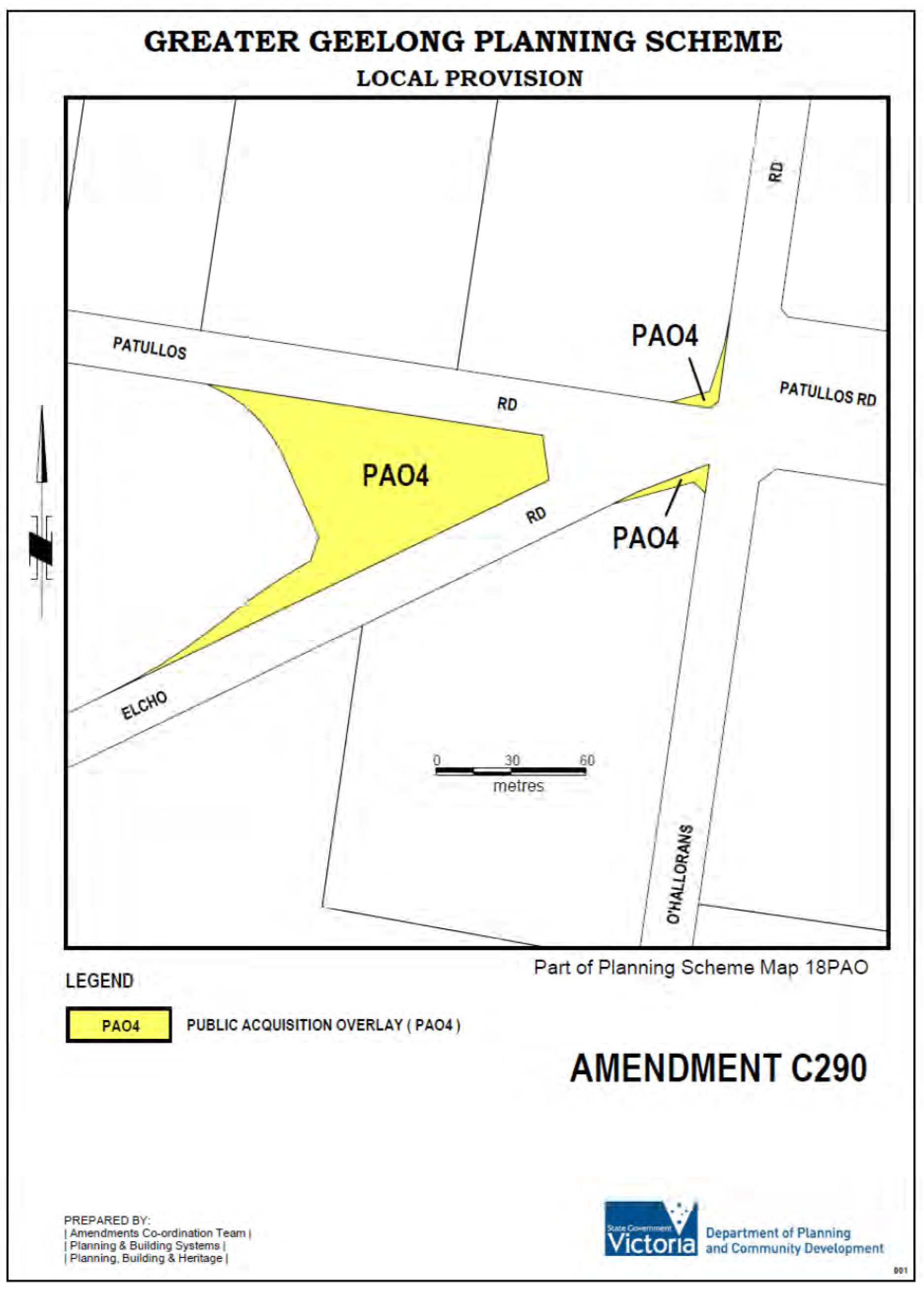
Amendment C290 is Council-initiated and seeks to apply the Public Acquisition Overlay 4 (Proposed Road) to part of three private landholdings that front the Patullos/ O’Hallorans/ Elcho Road intersection, Lara.
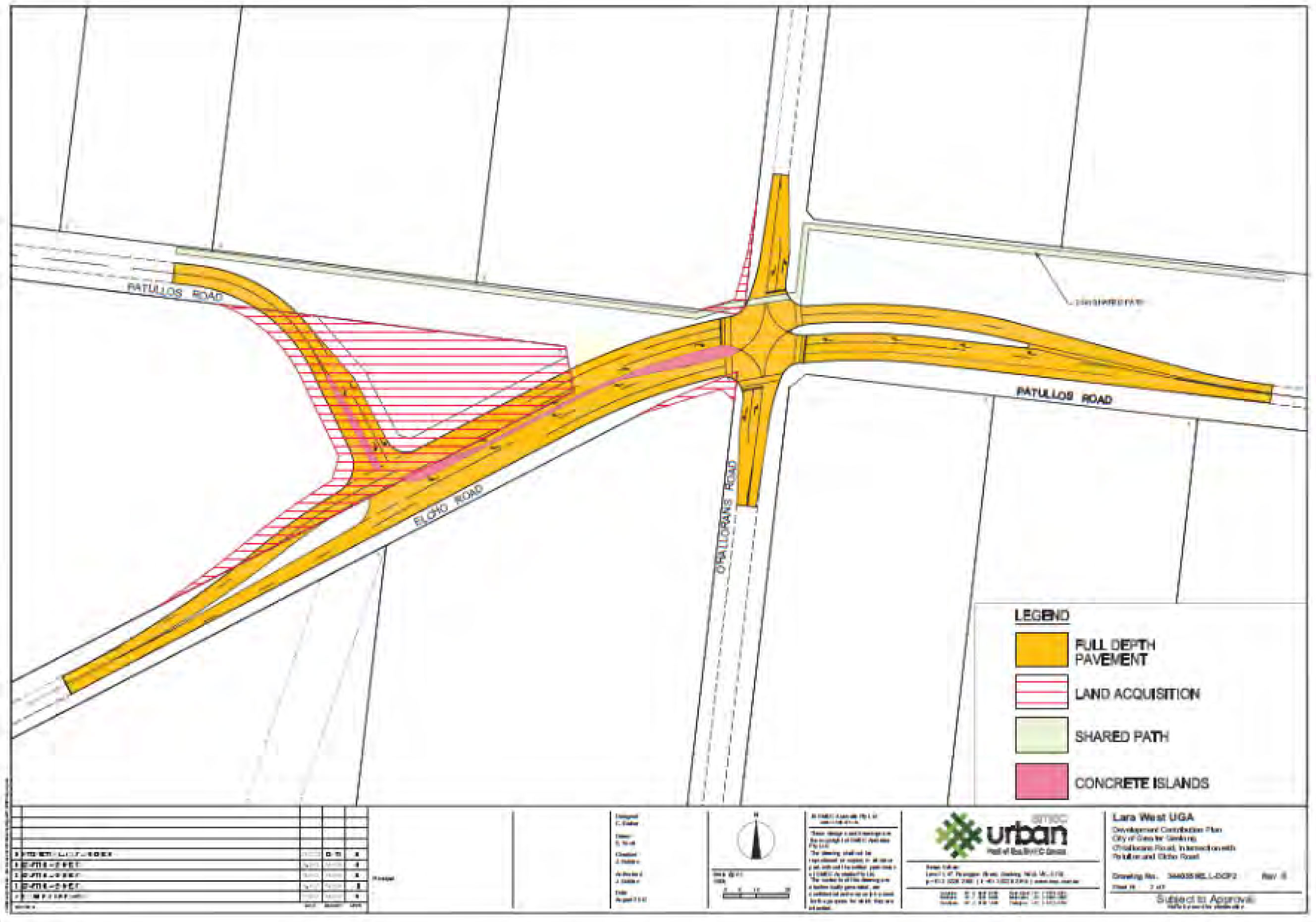
The Amendment will reserve land necessary for the future upgrade of the intersection. The intersection upgrade is part of the wider strategic planning of the Lara West Growth Area.
Public exhibition of Amendment C290 commenced on 2 May 2013 and closed on 3 June 2013.
There were two submissions. APA GasNet Australia advised of the presence of a high-pressure gas pipeline but did not object. The other submission came from a directly affected landowner at 180 Patullos Road, who submitted an alternative road intersection design that sought to spread the land acquisition equitably across all affected landowners.
Council resolved on 11 February 2014 to refer the submissions to an Independent Planning Panel appointed by the Minister for Planning. The panel hearing was held on 26 March 2014.
In summary, the Panel found that the Public Acquisition Overlay, as exhibited, is justified and appropriate in its current form.
The Panel agreed with Council’s submission that the exhibited intersection design is considered to be the best engineering outcome to cater for predicted long term traffic volumes, the role of this intersection in the planned Lara road network, and to provide safe pedestrian and cycle crossing.
It is therefore recommended that the Amendment be adopted.
Cr Ansett moved, Cr Heagney seconded -
That Council resolves to:
Adopt Amendment C290 in the form as outlined in Appendix 1 of this report; and
Submit the adopted Amendment with the prescribed information to the Minister for Planning requesting approval.
Carried.
This Amendment is the result of future planning for the Lara West Growth Area, where the intersections of Patullos Road with O’Hallorans Road and Patullos Road with Elcho Road (referred to as the Patullos/ Elcho/ O’Hallorans Road intersection) require upgrading.
The upgrade of the intersection is an infrastructure project in the incorporated Lara West Development Contributions Plan, September 2013. The design of the intersection in the Lara West Development Contributions Plan is shown at Appendix 2.
The new intersection will require the acquisition of private land. The most appropriate planning tool to identify and acquire the land is the Public Acquisition Overlay 4 (Proposed Road).
The land to be acquired is as follows:
| Part of 165 Patullos Road: | 0.01 hectares |
| Part of 180 Patullos Road: | 0.56 hectares |
| Part of 5 Elcho Road: | 0.01 hectares |
Public exhibition of Amendment C290 occurred over a 4 week period closing on 2 May 2013. The exhibition resulted in a total of two submissions. APA GasNet Australia (Operations) made no objection but requested that Council liaises with them prior to works being undertaken to upgrade the road intersection
The other submission came from a directly affected landowner at 180 Patullos Road (the Trigg Family). The Trigg’s submitted an alternative road intersection design that sought to spread the land acquisition equitably across all affected landowners.
Council resolved on 11 February 2014 to refer the submissions to an Independent Planning Panel appointed by the Minister for Planning. A Panel Hearing occurred on 26 March 2014.
A one person Panel, chaired by Mr Con Tsotsoros, conducted the hearing. In attendance at the hearing were members of the Trigg Family and Council officers from strategic planning and traffic engineering. The Panel provided its report to Council on 3 April 2014.
The Panel concluded that the exhibited Public Acquisition Overlay (PAO) is justified and appropriate in its current form. The Panel has recommended that the Amendment should be adopted as exhibited.
The issues raised during the Panel Hearing, the Panel’s findings and Council officers’ response are outlined below using the headings from the Panel Report.
Chapter 2: Strategic Planning Context
The Panel noted that Lara’s population is expected to double when growth opportunities, including the Lara West Precinct and Manzeene Village, are realised. The Panel said that the subject intersection works and land acquisition were recognised and tested through Amendments C246 and C285 and found to be appropriate.
The Panel concluded that the Amendment is supported by, and implements, the relevant sections of the State and Local Planning Policy Framework.
Council Officer Response
The findings of the Panel are supported.
Chapter 3: Public Acquisition
Council officers submitted that the reservation of the PAO land is necessary for the future upgrade of the Patullos/ Elcho/ O’Hallorans Road intersection. Officers said that the exhibited intersection design is considered to be the best engineering outcome to cater for predicted long term traffic volumes, the role of this intersection in the planned Lara road network, and to provide safe pedestrian and cycle crossing.
The Trigg Family submitted to the Panel that the advantages of their proposed alternative intersection design (i.e. a five-leg intersection) were that it would have a smaller overall footprint and a much fairer distribution of land acquisition. The Trigg’s also questioned whether the decision as to which land is to be acquired was driven by assumed cost savings.
Council informed the Panel that it sought informal advice from VicRoads about the alternative intersection design. The Panel noted that the VicRoads assessment through SIDRA identified long delays, cost and safety implications, cyclist and pedestrian barriers and was, overall, operationally worse.
At the Hearing, the Trigg Family reiterated the question asked during question time at the 11 February 2014 Council Meeting: “If the acquisition must go ahead why can we not retain ownership of the bulk of the land (the space within the triangle)?”
Officers informed the Panel that an internal meeting was convened between Council’s Strategic Planner, Traffic Engineer and Forward Planning Engineer to consider this question. Officers decided not to support the proposal for the following reasons:
The land could potentially be used as part of the proposed drainage detention basin for the Patullos Road Area (within the Lara West Precinct) or for other drainage requirements.
The existing high-pressure gas transmission pipeline easement restricts development capability.
The land could potentially form part of the shared path network and landscaping along the redundant Patullos Road alignment.
The actual detailed design of the intersection is not yet completed.
The new Patullos Road alignment may still have to consider vehicle access to no. 175 Patullos Road.
Council needs to be satisfied that the intersection design is above minimum standards to factor-in future traffic growth.
Any surplus land on the western edge of the PAO can be returned to the landowner.
There are concerns about on-going maintenance and maintenance access should the land be retained. The landowner may be reluctant to maintain this land due to its isolation from the rest of the property (this is no reflection on the Trigg’s but reflects the fact that the property can be sold to new owners).
The Panel identified and addressed two key issues:
Is there an equal or more superior alternative intersection design option available?
The Panel was receptive to considering the Trigg’s alternative design and noted that Council had also. The Panel emphasised that both Council and VicRoads considered the alternative design to be unsafe, inefficient and more expensive, and that this was an important factor weighing against the design.
The Panel believes the alternative design will merely transfer the majority of road alignment to other property owners and is unnecessarily complex. According to the Panel, it is clear that the principle objective of the redesign is to shift the road alignment from a specific property instead of seeking the safest and most efficient intersection layout. The Panel also dismissed land value comparisons.
The Panel concluded that the alternative intersection design proposed by the Trigg Family is not equal to or superior to the design exhibited.
Is the exhibited Public Acquisition Overlay justified and appropriate in its current form?
The Panel believes that Council has undertaken considerable strategic work to justify the application of the PAO and there is no evidence to demonstrate that Council has sought to acquire more land than is required.
The Panel acknowledged that most of the land required for the future intersection upgrade was burdened by the Trigg Family, but did not accept that this was unfair. The Panel said that based on considerable strategic and traffic management considerations, the most appropriate ultimate design for the intersection needs to be primarily located on the eastern most portion of the Trigg’s land.
The Panel found that the City of Greater Geelong acted responsibly by including the Patullos/ Elcho/ O’Hallorans Road intersection in the Lara West Development Contributions Plan and by subsequently seeking to apply the exhibited PAO.
In summary, the Panel found that the PAO, as exhibited, is justified and appropriate because:
It will provide certainty that the City of Greater Geelong will be the acquiring authority;
It will provide certainty that the affected land owners will be compensated by land owners who will benefit from the intersection upgrade;
The extent of the Public Acquisition Overlay reflects the same design justified through Amendment C246, and
There is a need to acquire the land when the relevant threshold in the Lara West Development Contributions Plan is achieved. There currently isn’t anything to activate this process.
Council Officer Response
The findings of the Panel are supported. In its closing submission to the Panel, Officers acknowledged the sentimental attachment of the Trigg’s to their land.
Officers stressed that the acquisition of part of the Trigg’s land, as well as the critical design of the intersection, had been undertaken in an open and transparent manner and was the result of a comprehensive strategic planning process for the Lara West Growth Area.
There are no environmental implications as a result of the Amendment.
There are no financial implications as a result of this Amendment. Funds required to acquire the land will be sourced from developer levies attributed in the Lara West Development Contributions Plan. Council however would be responsible for any associated legal and conveyances costs.
No impact to budget.
The Amendment is consistent with relevant policies and legislative requirements.
Clause 19 of the State Planning Policy Framework states that growth and redevelopment of settlements should be planned in a manner that allows for the logical and efficient provision of infrastructure, including the setting aside of land for the construction of future transport routes. The clause also identifies the use of Development Contributions Plans to manage contributions towards infrastructure.
Clause 45.01 Public Acquisition Overlay forms part of the Victoria Planning Provisions. The purpose of this clause is to identify land which is proposed to be acquired by a Minister, public authority or municipal council and to reserve land for a public purpose. Council, in its role as the planning authority, is bound by the provisions of the Land Acquisition and Compensation Act 1986 in its pursuit of land for the above purpose.
There are no local policies that directly apply to the Patullos/ Elcho/ O’Hallorans Road intersection. However the Municipal Strategic Statement contains a number of policies that require the Planning Authority to strategically plan for the improvement of infrastructure in conjunction with population growth.
Transport objectives in Clause 21.08-2 include the development of a safe, accessible, equitable and efficient traffic, transport and freight network. Objectives of Clause 21.08-3 Development Contributions are to provide infrastructure in an efficient and timely manner and to provide services that respond to the changing needs of the City’s population. The relevant strategy here is to:
Ensure that development and community infrastructure is provided in a sustainable and timely manner in all areas, with particular regard to the servicing of new communities in new urban growth areas and large urban infill areas.
The Amendment supports the ‘Growing our Economy’ and ‘Sustainable Built and Natural Environment’ strategic directions of City Plan. The land to be acquired will facilitate an improved road intersection to support the long term residential growth of Lara.
No Council officer involved in the report has any direct or indirect interest, in accordance with Section 80(c) of the Local Government Act.
There are no notable risks associated with implementing the recommendation contained in this report.
The Amendment will appropriately reserve land required for the planned upgrade of the Patullos/ Elcho/ O’Hallorans Road intersection to cater for the population growth of Lara.
The PAO will provide certainty to the landowners of the future use of the land and compensation in accordance with the Land Acquisition and Compensation Act.
The Amendment will not impact on any basic rights, freedoms and responsibilities as set out in the Charter. Planning legislation ensures an open community consultation process occurs, enabling people to freely express their views and if necessary obtain a fair hearing before an Independent Panel.
Consultation and Communication
Council officers have written to the Amendment submitters and landowners to advise them of the release of the Panel Report. Submitters and landowners will be notified of the final decision of Council and the Minister for Planning.
Planning and Environment Act 1987
The planning authority for this amendment is the Greater Geelong City Council.
The Greater Geelong Planning Scheme is amended as follows:
Planning Scheme Maps
The Planning Scheme Maps are amended by a total of 1 attached map.
Overlay Maps
Planning Scheme Map No 18PAO is amended in the manner shown on the attached map marked “Greater Geelong Planning Scheme, Amendment C290”.
End of document
Portfolio: |
Sport & Recreation - Cr Irvine |
Source: |
Projects, Recreation & Central Geelong - Sport & Recreation |
A/General Manager: |
Paul Jane |
Index Reference: |
Subject: Grants & Subsidies / Sport & Recreation Grants & Funding – incoming |
Sport & Recreation Victoria’s Country Football & Netball Program provides funding opportunities for the development of football and netball facilities. The project that was previously recommended for submission to the program has now been withdrawn by the applicant club. A new project has been recommended and presented for the consideration of Council. This report also recommends that an agreement be entered into with the owner of a shopping centre that seeks to make a voluntary contribution to the project.
The Country Football & Netball Program provides funding opportunities for the development and upgrade of football and netball facilities.
The redevelopment of netball courts at Herne Hill Reserve was recommended for submission to Sport & Recreation Victoria in a report to Council on 28 May 2013.
Discussions with the St Joseph’s Football Netball Club (Herne Hill Reserve tenant club) deemed that the timeframe for confirmation of the outcome of the funding submission did not align with the club’s expectations for completion of this project.
St Joseph’s Football Netball Club withdrew their expression of interest in order to allow the commencement of their netball court construction project immediately.
Following the evaluation of eligible projects, the extension of the pavilion at Leopold Memorial Recreation Reserve to provide for netball participants is recommended as the preferred project to be submitted to Sport & Recreation Victoria’s Country Football & Netball Program.
A contribution to the pavilion extension project has been offered by Lascorp Development Group (Australia) Pty Ltd (“Lascorp”). Lascorp controls two companies – Gateway Plaza Leopold Pty Ltd and Melaluka Commercial Pty Ltd - that own the Gateway Shopping Centre and its future expansion site located opposite the recreation reserve. Lascorp has offered a contribution of $500,000 towards upgrades to the reserve.
The Gateway Plaza Shopping Centre is proposed for major expansion under Planning Scheme Amendment C277 which is subject to a separate report to Council. The contribution from Lascorp is a voluntary contribution to the community and is not a requirement of the planning approval for the shopping centre expansion.
The contribution does have a planning related purpose as it will help implement the recreation reserve master plan.
It is recommended that Council enter into an Agreement under Section 173 of the Planning and Environment Act 1987 to secure the Lascorp contribution to the project.
Cr Irvine moved, Cr Macdonald seconded -
That Council:
Endorse the development of a submission to the Sport & Recreation Victoria Country Football & Netball Program for:
Netball Change Facilities - Leopold Memorial Recreation Reserve.
Enter into an Agreement under Section 173 of the Planning and Environment Act 1987 with the owner of the Gateway Plaza Shopping Centre and its future expansion site to accept a voluntary contribution towards recreation reserve upgrades
Carried.
Each year, the City of Greater Geelong submits projects to the State Government for consideration under a number of funding programs. The Country Football & Netball Program provides funding opportunities for the development of football and netball facilities. Projects are required to demonstrate a clear link to increasing participation in football and/or netball.
A report to Council on 28 May 2013 recommended a submission to the Country Football & Netball Program for the redevelopment of netball facilities at Herne Hill Reserve. At the time of the report, there was one netball court at the reserve, with the proposed redevelopment to reconfigure the location and provide an additional court to cater for growth in netball participation rates. The application was to be submitted by the due date of 31 January 2014, with a funding announcement due by mid 2014.
Following discussions with Council staff in July 2013, the St Joseph’s Football Netball Club decided to:
Withdraw the Herne Hill Reserve netball court construction project from being submitted to the Country Football Netball Program to allow the project to be completed by the commencement of the 2014 season; and
Meet the funding gap using club funds.
As St Joseph’s Football Netball Club has withdrawn their project, a new project is required to be recommended for submission to Sport & Recreation Victoria for funding consideration.
At the time of this report, the Herne Hill Reserve netball court construction project is nearing completion.
The parameters of the Country Football & Netball Program are:
Who can apply |
No. of Applications |
Maximum Amount per Grant |
Maximum Total Project Cost |
Funding Ratio** (minimum) |
Football Netball Clubs & Councils (applications via Council only) |
Up to three (3), seeking a maximum combined total of $100,000 |
$100,000 |
No limit |
1.5 State : 1 Local |
Council’s Sport & Recreation Department has undertaken a review of expressions of interest that were submitted by clubs during the formal submission period (3 – 24 April 2013), as well as a review of strategic and regional projects.
Based on this review and discussions with the State Government regarding eligible projects, the following project is recommended for submission for funding consideration:
Project name: Netball Change Facilities - Leopold Memorial Recreation Reserve
Project description: Extension of the pavilion at Leopold Memorial Recreation Reserve to incorporate netball change facilities, umpires change facilities, first aid, an office, storage space and amenities (project scope subject to detailed QS and available funds). The proposed netball change facilities will support increased netball participation at the reserve.
In evaluating eligible projects, this project was deemed to provide the best outcome for the community, as well as being the most likely to attract funding due to it’s alignment with the evaluation criteria of the funding program.
Given the scope of the project, it is recommended that Council apply for the maximum amount of $100,000 from the Country Football & Netball Program.
The project was not submitted to the January round of the Country Football Netball Program, as the voluntary contribution from Lascorp had not been negotiated by the due date of 31 January 2014.
The next round of the Country Football Netball Program is due on 30 May 2014. Please note that each Council can submit a project to either the January or May funding round per calendar year, therefore no potential funding opportunities have been lost.
Environmental Implications
There are no foreseeable environmental implications associated with this report, however during the assessment process, projects that included environmentally sustainable design initiatives were highly regarded.
There are no immediate financial implications associated with adopting the recommendations of this report.
This project is dependent on funding being provided to the Leopold Memorial Recreation Reserve upgrade by Lascorp as outlined in the discussion section of this report. Should the Lascorp funding not be provided, the project scope cannot be delivered.
Total project funds available: $1.055 million
External funding sources: $600,000
Grant - $100,000
Voluntary contribution from Lascorp - $500,000
Council contribution: $455,000
2013/14 (existing budget) - $455,000
There are legislative and legal ramifications associated with the proposed arrangements with Lascorp.
The proposed funding arrangement with Lascorp is independent of the planning process for the rezoning and planning permits for the expansion of the Gateway Plaza shopping centre (Amendment C277) which is the subject of a separate report to Council.
The arrangement reflects a voluntary contribution to the community by Lascorp. It has not been requested by Council and Council has not previously required the contribution as part of the rezoning process.
Lascorp believes that improvements to the recreation reserve facilities will increase use of the precinct and in turn increase patronage of its shopping centre.
The C277 amendment process has included the requirement for a S173 agreement for developer contributions to other infrastructure matters such as road and intersection upgrades and an off site stormwater system. However, the proposed contribution to the recreation reserve was not formally raised until the C277 amendment process was well underway and Council had already resolved to support exhibition of the amendment.
While the voluntary contribution and agreement are separate to the planning processes for C277, Section 174 (2)(c)(i) of the Planning and Environment Act 1987, provides for a S173 Agreement to include a matter to achieve and advance ‘the objectives of planning in Victoria”. This is considered to be an appropriate basis for the Agreement. There is also a planning policy basis at Clause 21.14-3 of the Greater Geelong Planning Scheme which includes the following further work clause for Leopold: “Implement the Memorial Park Masterplan 2011”. The netball facilities are part of the Masterplan for the Park.
For administrative purposes it is proposed that the financial contribution to the recreation reserve upgrades is part of the same S173 agreement that is being prepared for Amendment C277. The agreement is structured so that the planning considerations are clearly distinguished from the voluntary contribution.
The development of sport and recreation facilities that respond to community needs aligns to the Community Wellbeing objectives of the City Plan. This project will promote healthy participation in active sport and will provide increased opportunities for participation in the broader community.
No Council staff or persons engaged in the evaluation of expressions of interest, development of recommendations or development of this report have a direct or indirect interest in the matters considered within the report.
There are no immediate risks associated with this report. Components of the project may entail relevant risk management matters pertaining during the construction phase.
The recommended project will encourage the development of innovative community sport and leisure facilities. The expected population growth within the municipality necessitates the increased and improved provision of community sport facilities that provide a social outlet for the local community.
Participation in sport and recreational activities has long been recognised as an important contributor to community health and well being.
Benefits of physical exercise and recreation are well documented and include improved health and fitness, development of social skills, increased community connectedness and enhanced self-esteem. Thus an application for Sport & Recreation Victoria funding for community recreation projects has significant social benefits.
This report has no impact on human rights or the Human Rights Charter.
Consultation and Communication
Council’s expression of interest process for a range of Sport & Recreation Victoria funding opportunities was open to sporting clubs and community groups between 3 April 2013 and 24 April 2013. A report was presented to Council on 28 May 2013 seeking endorsement of recommended projects. This report will amend the project to be submitted by Council to the Country Football & Netball Program.
Council used a range of communication methods to inform clubs and community groups of the expression of interest process for projects and the associated timeframe (as outlined below).
Email correspondence was sent to all club contacts on 3 April 2013 and 19 April 2013. A link to the online registration form was included in the email.
A webpage was established on Council’s webpage, with information on relevant grant programs and a link to the online application process.
Council advertised the project registration process in the Geelong Advertiser “City News” on 13 April 2013 and 20 April 2013.
An email was sent on 4 April 2013 to all clubs that submitted projects in 2012 inviting them to resubmit their previous project.
Reminder emails were sent to club representatives that had begun (but not completed) online applications on 22 April 2013 and 24 April 2013.
In addition to the project registration process, staff from the Sport and Recreation Department of Council has investigated, and are aware of, projects that fit within the Country Football Netball Program through liaison with sporting clubs and community groups.
The expression of interest process for clubs was not reopened when the original recommended project was withdrawn. The revised recommended project was selected based on the assessment of submitted expressions of interest and strategic projects. Clubs have the opportunity to submit expressions of interest for future funding rounds through Council’s revised expression of interest process that is open at all times.
A separate report to Council regarding future funding submissions to Sport & Recreation Victoria was endorsed by Council on 8 April 2014. This report outlined projects to be submitted to a range of State Government funding programs, including the January 2015 round of the Country Football Netball Program. The project to be submitted to the January 2015 round is change facilities at Estuary Reserve, Leopold.
Portfolio: |
Planning and Central Geelong - Cr Heagney |
Source |
Planning and Tourism |
General Manager: |
Peter Bettess |
Index Reference |
1273/2013 |
The purpose of this report is for Council to decide upon the planning permit application for electronic signs at 165 Moorabool Street Geelong. The proposed signage is considered to represent a departure from policies within in the Greater Geelong Planning Scheme but which may be considered by Council as an appropriate outcome in Central Geelong.
Planning Permit Application 1273/2013 proposes the construction and display of three electronic signs compromising two large major promotion signs and one promotion sign at 165 Moorabool Street Geelong. Electronic signs are defined in the Planning Scheme as “A sign that can be updated electronically. It includes screens broadcasting still or moving images.”
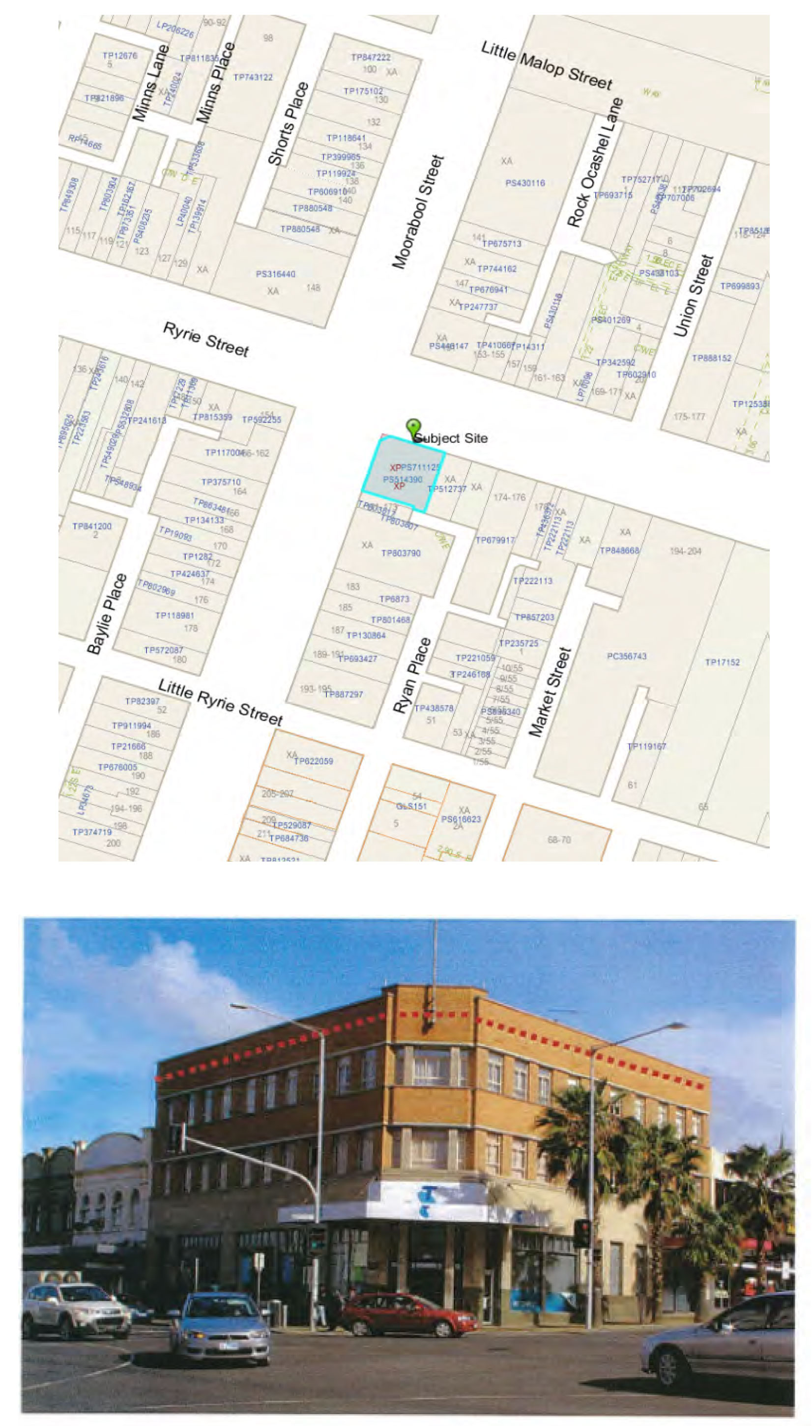
The subject site is located on the south east corner of the Moorabool Street and Ryrie Street intersection. The site currently contains an existing building which has local historic significance (C Listed) known as the former Bank of New South Wales Building.
The subject site is located within the Activity Centre Zone and is affected by Heritage Overlay 1056 and the Geelong Commercial Heritage Area (HO1637).
The application was placed on public notification by way of two (2) signs on site and notices to adjoining landowners and occupiers. Three (3) objections were received which relate to devaluation of property, amenity impacts and adverse impacts on the heritage significance of the building and the area.
The application was required to be referred to VicRoads for comment given the location of the signage along Ryrie Street (a Category 1 road) and within 30m of an intersection. VicRoads initially objected to the signage based on road safety. Subsequently after discussions with the applicant VicRoads withdrew their objection subject to conditions being placed on any permit issued.
The application has been assessed against the relevant State and Local Planning Policy Frameworks, the Activity Centre Zone provisions and against Clauses 52.05 (Advertising Sign) and 65 (Decision Guidelines) of the Greater Geelong Planning Scheme. The application was found to comply with the purpose of the Activity Centre Zone and the State and Local Planning Policies relating to Central Geelong and Activity Centres. The application was considered to comply with aspects of the Heritage Overlay and Local Planning Policy relating to Heritage and the Geelong Commercial Heritage Area.
The application is also considered to accord with elements of the City of Greater Geelong Advertising Sign Guidelines 1997 which is an incorporated document of the Greater Geelong Planning Scheme.
On balance, it is recommended that the application be supported and a Notice of Decision to Grant a Planning Permit be issued.
Cr Heagney moved, Cr Harwood seconded -
That:
the Responsible Authority having considered all matters which the Planning and Environment Act, 1987, requires it to consider, decides to issue a Notice of Decision to Grant a Planning Permit to Construct and Display Internally Illuminated Major Promotional Signage and Internally Illuminated Promotion Signage subject to the conditions contained in Appendix 1, with Condition 11 deleted and the subsequent conditions re-numbered accordingly;
Council reviews and updates the City of Greater Geelong Advertising Sign Guidelines particularly in relation to signage within the Core Retail Precinct within Central Geelong.
Carried.
Division Requested:
For: Crs Ansett, Ellis, Fisher, Harwood, Heagney, Irvine, Lyons, E Kontelj, S Kontelj, Macdonald, Nelson, Richards
Against: Cr Farrell
The Site and Locality
The subject site is located on the south east corner of the Moorabool Street and Ryrie Street intersection. The site contains the former Bank of New South Wales Building. A locality plan is in Appendix 2.
The site is located within the Activity Centre Zone Schedule 1 (Central Geelong Activity Centre) Precinct 1 (Core Retail). The building is covered by Heritage Overlay 1056 which deems the building to be of local historic significance and is within the Geelong Commercial Heritage Area (HO1637).
The statement of significance for the subject building states:
The former Bank of New South Wales building, 165 Moorabool Street, Geelong, has significance as a reasonably intact example of an eclectic interwar Stripped Classical and Modern style. Built in 1937-38 to a design by Godfrey and Spowers in association with Buchan, Laird and Buchan, the exterior of the building has been altered about the ground floor facades. Situated on a prominent corner location, the building has visual connection with neighbouring interwar and Victorian commercial buildings.
The former bank also has a notable townscape relationship with three other commercial buildings forming the intersection of the two principal Geelong thoroughfares of Moorabool and Ryrie Streets. The building complements the architecture of the structures visually connected to it, notably the former T & G Building (1934), former Mercantile Bank (1888) and Belcher's Corner building (1926).
The building compromises three stories and currently contains a shop at ground level and is used for residential purposes on the upper levels.
The site is located on a prominent intersection with the T & G Building located directly opposite on the north east corner. The two other buildings making up the north west and south west corners of the intersection also contain significant heritage buildings.
Proposal
The application proposes three electronic signs. Each sign will have a digital face.
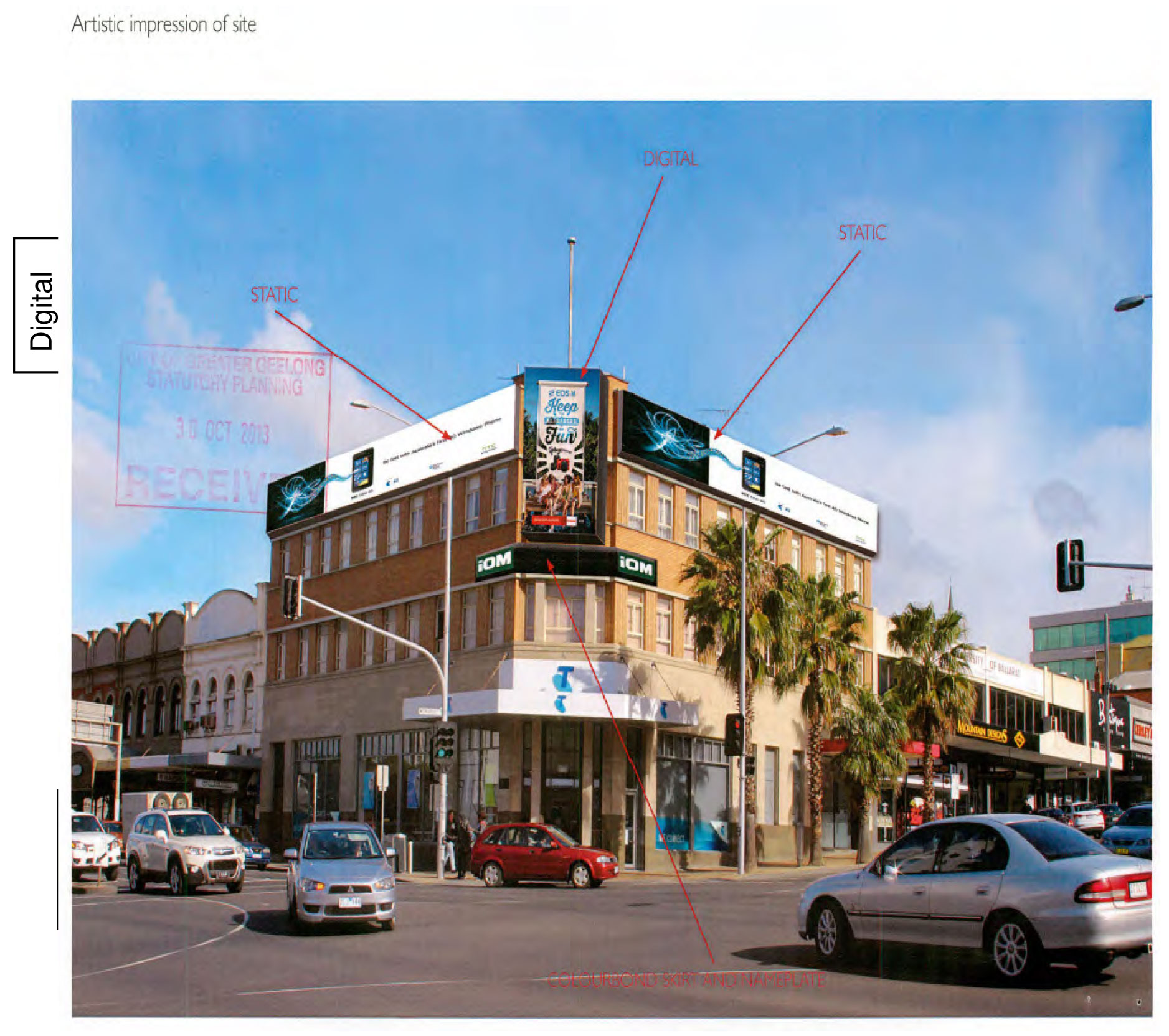
Two digital panels with dimensions of 18.9m by 2m with an overall area of 37.8m² are proposed on the Moorabool Street and Ryrie Street frontages. The signs will be approximately 12m above pavement level and will cover the top floor of the building. These signs are considered to be major promotion signs due to the total area of each sign exceeding 18m².
A third digital panel with dimensions of 4.5m by 3m with an overall area of 13.5m will be located on the north west splay of the building. It will be approximately 9.4m above pavement level. This is considered to be a promotion sign due to the advertisement are not exceeding 18m². An image of the proposed signs can be seen in Appendix 3.
It is proposed that the digital signage will be on at least a 30 second rotation. As the signage will be changing there are no details as to what type of advertisement will be contained within the signage at any time.
The application is required to be assessed against the relevant State and Local Planning Policy Framework, The Activity Centre Zone, The Heritage Overlay, Clause 52.05 (Advertising Signage) and Clause 65 (Decision Guidelines) of the Greater Geelong Planning Scheme.
The proposed signage by virtue of it size, content and illumination will provide vitality, visual interest and colour to Central Geelong’s Core Retail Precinct and therefore can be considered to be consistent with the purpose of Category 1 signage which is applicable in the Activity Centre Zone.
However, the proposal must also be considered against the decision guidelines for signage contained in Clause 52.05 and more specifically the policy relating to signage in heritage overlay areas that is contained in Clause 43.01 and the Greater Geelong’s Advertising Sign Guidelines (November 1997).
The application has been assessed against the requirements of the Heritage Overlay and it is considered that the application satisfies several of the relevant decision guidelines and heritage policy.
When deciding on an application in a heritage area the Responsible Authority must consider the significance of the heritage place and whether the proposal will adversely affect the significance, character or appearance of the heritage place.
The subject site is of local historic significance and as contained within the statement of significance it demonstrates original design qualities of an eclectic interwar Stripped Classical and Modern style. The intact qualities include the prominent and yet highly austere brick parapets with concrete cappings, timber flag pole, large and austere brick band separating the second and third floors, regularly spaced first and second floor window bays with vertically oriented brick piers between, steel framed first and second floor windows and large steel framed first and second floor corner windows with stone piers and sidelights.
The proposal includes three large signs that generally align to the uppermost austere brick band. It is therefore considered that the proposal will have limited adverse affect on the significance, character and appearance of the heritage place.
The City of Greater Geelong Advertising Sign Guidelines 1997 is an incorporated document of the Greater Geelong Planning Scheme and also provides guidance on assessing applications for signage within heritage overlay areas.
The guidelines state that new signs on heritage buildings should be discreet and should allow the architectural details of the building to dominate. Signs should be placed on heritage buildings in locations that were traditionally used as advertising areas. Lettering styles and colours that are appropriate to the design of the building should be used.
Historical evidence of the building shows the simple lettering was used for signage for the Bank of New South Wales. The signage is proposed to be located in the same location as the original lettering and it is on that basis that the proposed signage is deemed to comply with aspects of the Advertising Sign Guidelines.
New signs on heritage buildings must be capable of being removed or replaced without damaging the fabric of the building. Given the overall coverage of the signage it is not clear how the construction will impact on the exterior of the building and whether it could result in significant damage to the building fabric. A condition has been recommended that before works commence, amended plans be submitted which clearly outline how the signs will be affixed to the building with limited impact on the fabric of the historic building.
The Advertising Sign Guidelines also state that neon signs and other internally illuminated signs, flashing signs and fluorescent and iridescent paints should not be used; appropriately placed and baffled external floodlights that illuminate the whole or part of the building facade (including signs) are encouraged. The proposal is for internally illuminated digital LED signage. It is acknowledged that this aspect is not consistent with the guidelines which discourage the use of internally illuminated signage and promote floodlit signage only.
Clause 21.09-25 of the Municipal Strategic Statement contains objectives relating to policy regarding Central Geelong. Whilst the objectives contained within 21.09-2 do encourage the refurbishment of commercial building frontages on key street within Geelong to help revitalize the city the objectives also seek to ensure that new development appropriately responds to identified heritage values.
The objectives of Clause 22.09 – Cultural Heritage, of the Local Planning Policy Framework are to conserve and enhance the natural or cultural features of an area or site and to ensure that any alterations or development complement their form and appearance and to ensure that new development and external alterations of existing buildings make a positive contribution to the built form and amenity of the area.
The objectives of Clause 22.28 which relate to the Geelong Commercial Heritage Area expand on the objectives of Clause 22.09. The objectives are to protect the relationship between nineteenth and twentieth century architecture expressed by the corner towers at the intersection of Ryrie Street with Gheringhap and Moorabool Streets as an architectural expression of major periods of Geelong’s growth and to retain and enhance the diverse range of existing architectural styles of commercial buildings, former residences and public buildings which form the heart of Geelong’s commercial precinct and represent the major periods of Geelong’s growth.
It is considered that the proposal is generally consistent with the objectives of these policies. The proposed signage will emphasise the existing building and its architectural expression which contributes to Geelong’s heritage and represents a period of Geelong’s growth. It is considered that the proposal is in part responsive to the identified heritage values of the site.
The subject site is located within the Central Geelong Action Plan area. An objective of the Central Geelong Action Plan is to create a vibrant, thriving, liveable and successful city centre with a strong sense of identity and community. It is considered that Geelong’s heritage buildings play an important role in providing the city centre with a strong sense of identity. The proposed signage may add some vibrancy to the city centre and may have limited adverse impact on the identity and significance of the heritage place.
Clause 52.05-6 of the Particular Provisions relates to Major promotion signs. The purpose of this clause is to achieve high quality visual standards for the siting of major promotion signs and to ensure that the signs are not detrimental to the appearance of their surroundings or the safe and efficient operation of the route through the application of consistent planning controls.
As outlined above, in this circumstance it is considered that the proposed major promotion signs are not significantly detrimental to the appearance of the heritage building. It is also considered that the proposed signage is not significantly detrimental to the character of the area. It is therefore considered that the application is not inconsistent with the purpose of Clause 52.05-6.
When deciding on an application for major promotion signage the Responsible Authority must also consider the effect of the signage on significant streetscapes, buildings and skylines, residential areas and heritage places. It is considered that the proposed signage will have a minimal impact on the significant heritage building and both the Moorabool Street and Ryrie Street streetscapes.
When determining the effect of a proposed major promotion sign, the following locational principle (amongst others) must be taken into account:
Major promotion signs are discouraged where they will form a dominant visual element from residential areas, within a heritage place or where they will obstruct significant viewlines.
As stated the subject site is covered by an individual heritage overlay but also forms part of a heritage precinct. Given the corner location of the site and the location of the signs on the building, in this circumstance even though it is within a heritage area where major promotion signs are discouraged, the signage is considered to have a minimal impact on the area. Historically, the most visually significant signs could be found on corner buildings. The proposal is a modern extension of this.
The signage may result in vitality and colour in Central Geelong which Council is seeking to promote. Support of this application would potentially result in similar proposals throughout Central Geelong each of which would need to be considered on its merits.
It is considered that there will be no environmental implications for Council in the granting of this permit.
It is considered that there will be no financial implications to Council in granting this permit.
The Planning and Environment Act 1987 and the Greater Geelong Planning Scheme are the relevant documents under which Council must consider the application.
Permit Triggers:
Clause 43.01 of the Heritage Overlay, a permit is required to construct or display a sign.
Clause 52.05-6 of the Particular Provisions (Advertising signs), a permit is required to construct and display a major promotion.
Clause 52.05-7 of the Particular Provisions (Advertising signs) a permit is required to construct and display an electronic sign and a promotion sign that exceeds 8m².
Planning Scheme Definitions
an Electronic Sign is defined as a sign that can be updated electronically. It includes screens broadcasting still or moving images.
a Major Promotion Sign is defined as a sign which is 18 square metres or greater that promotes goods, services, an event or any other matter, whether or not provided, undertaken or sold or for hire on the land or in the building on which the sign is sited.
a Promotion Sign is defined as a sign of less than 18 square metres that promotes goods, services, an event or any other matter, whether or not provided, undertaken or sold or for hire on the land or in the building on which the sign is sited.
The provisions of the Greater Geelong Planning Scheme relevant to this application are contained in Appendix 4.
The construction and display of internally illuminated major promotion and promotion signage aligns with the City Plans Strategic directions for Growing our Economy.
No Council officers have any direct or indirect interest in the matter to which this report relates, in accordance with Section 80 (C) of the Local Government Act.
VicRoads initially objected to the application based on road safety concerns. However they have now formally withdrawn their objection and have required that conditions be placed on the permit requiring amongst others that the signage not contain moving elements, must not be capable of being mistaken for traffic signals, devices or instructions, must not contain flashing text or images and that the transition from one advertisement to another must be instantaneous .
Supporting this application prior to the review of the Advertising Sign Guidelines may pre-empt the review of the Guidelines and encourage other applications for similar advertising signs that challenges Council’s policies within the Planning Scheme.
It is considered that there will be no social implication to Council if the application was supported.
Human Rights Charter
The Planning Scheme regulates land use and decision outcomes and therefore the rights and freedoms set out in the Human Rights Charter have been considered.
Consultation and Communication
The application is not exempt from the notice requirements of Section 52(1)(a), (b) and (d), the decision requirements of Section 64(1), (2) and (3) and the review rights of Section 82(1) of the Act and pursuant to Section 52 of the Planning and Environment Act 1987 the following forms of advertising were undertaken:
Notices were sent to owners and occupiers of adjoining land (including opposite)
A3 sign(s) were placed on the land
As a result of public notification 3 objections to the proposal were received and the summary of objections is provided at Appendix 5.
The application was referred to Council’s Heritage Advisor and VicRoads for comment. The summary of the referral responses is provided at Appendix 6.
Prior to the display of the signage hereby approved, amended plans to the satisfaction of the Responsible Authority must be submitted to and approved by the Responsible Authority. When approved, the plans will be endorsed and will then form part of the permit. The plans must be drawn to scale with dimensions and two copies must be provided. The plans must show the following:
the details as to how the signs will be affixed to the building so as to ensure that the external fabric of the building is not damaged.
The location and size of the signage, including the supporting structure, as shown on the endorsed plans, must not be altered without the written consent of the Responsible Authority.
Generally, 30 seconds is a ‘standard’ amount of time that is designed to capture most circumstances so that a road user is exposed to the sign only once during a traffic signal cycle.
The transition from one advertisement to another must be instantaneous.
In relation to the images displayed on the sign:
Sequences of images giving the illusion of continuous movement must not be displayed;
Images on signs must be related;
Images capable of being mistaken for traffic signals or traffic control devices because they, for example, contain red, amber or green circles, octagons, crosses or triangles must not be displayed;
Images or text capable of being mistaken as an instruction to a road user must not be displayed;
Flashing background, flashing text or flashing images must not be displayed.
The sign must not dazzle or distract road users due to its colouring.
The luminance of the advertising sign must be such that it does not give a veiling luminance to the driver, or greater than 0.25 cd/m2, throughout the driver’s approach to the advertising sign.
Prior to commencement of the construction of the advertising sign a lighting report from a suitably qualified lighting engineer demonstrating how the lighting output prescribed in the above condition will be achieved must be provided to VicRoads for approval. When approved, the report will form part of the planning permit and the sign must at all times operate in accordance with the report.
The owner of the sign must enter into a licence agreement with VicRoads for the proposed use of a stratum of the arterial road reserve (land) prior to the commencement of any works within the arterial road reserve.
The signage must be fixed to the building so as to ensure that the external fabric of the building is not damaged.
This permit as it relates to the development of buildings will expire if one of the following circumstances applies:
The construction of the signage hereby approved has not commenced within two (2) years of the date of this permit.
The construction of the signage hereby approved is not completed within four (4) years of the date of this permit.
The Responsible Authority may extend the periods referred to if a request is made in writing before the permit expires; or
Within six (6) months after the permit expires where the use or development has not yet started; or
Within twelve (12) months after the permit expires, where the development allowed by the permit has lawfully commenced before the permit expiry.
Unless otherwise extended in writing by the Responsible Authority, this permit, as it relates to signage expires fifteen (15) years from the date of issue, at which time the signage and all supporting structures must be removed and the site made good to the satisfaction of the Responsible Authority.
Clause 37.08 Activity Centre Zone
The purpose of the Activity Centre Zone is to:
To implement the State Planning Policy Framework and the Local Planning Policy Framework, including the Municipal Strategic Statement and local planning policies.
To encourage a mixture of uses and the intensive development of the activity centre:
As a focus for business, shopping, working, housing, leisure, transport and community facilities.
To support sustainable urban outcomes that maximise the use of infrastructure and public transport.
To deliver a diversity of housing at higher densities to make optimum use of the facilities and services.
To create through good urban design an attractive, pleasant, walkable, safe and stimulating environment.
To facilitate use and development of land in accordance with the Development Framework for the activity centre.
Clause 43.01 – Heritage Overlay
The purpose of Clause 43.01 of the Heritage Overlay is to:
implement the State Planning Policy Framework and the Local Planning Policy Framework, including the Municipal Strategic Statement and local planning policies.
conserve and enhance heritage places of natural or cultural significance.
conserve and enhance those elements which contribute to the significance of heritage places.
ensure that development does not adversely affect the significance of heritage places.
conserve specifically identified heritage places by allowing a use that would otherwise be prohibited if this will demonstrably assist with the conservation of the significance of the heritage place.
The following State Planning Policies are applicable to this application:
15.01- 1 Urban Design
Objective
To create urban environments that are safe, functional and provide good quality environments with a sense of place and cultural identity.
Strategies
Promote good urban design to make the environment more liveable and attractive.
Ensure new development or redevelopment contributes to community and cultural life by improving safety, diversity and choice, the quality of living and working environments, accessibility and inclusiveness and environmental sustainability.
Require development to respond to its context in terms of urban character, cultural heritage, natural features, surrounding landscape and climate.
Require development to include a site analysis and descriptive statement explaining how the proposed development responds to the site and its context.
Ensure sensitive landscape areas such as the bays and coastlines are protected and that new development does not detract from their natural quality.
Ensure transport corridors integrate land use planning, urban design and transport planning and are developed and managed with particular attention to urban design aspects.
Encourage retention of existing vegetation or revegetation as part of subdivision and development proposals.
15.01-2 - Urban Design Principles
Objective
To achieve architectural and urban design outcomes that contribute positively to local urban character and enhance the public realm while minimising detrimental impact on neighbouring properties.
Strategies
Apply the following design principles to development proposals for non-residential development or residential development not covered by Clause 54, Clause 55 or Clause 56:
Context
Development must take into account the natural, cultural and strategic context of its location.
Planning authorities should emphasise urban design policies and frameworks for key locations or precincts.
A comprehensive site analysis should be the starting point of the design process and form the basis for consideration of height, scale and massing of new development.
The public realm
The public realm, which includes main pedestrian spaces, streets, squares, parks and walkways, should be protected and enhanced.
Safety
New development should create urban environments that enhance personal safety and property security and where people feel safe to live, work and move in at any time.
Landmarks, views and vistas
Landmarks, views and vistas should be protected and enhanced or, where appropriate, created by new additions to the built environment.
Pedestrian spaces
Design of interfaces between buildings and public spaces, including the arrangement of adjoining activities, entrances, windows, and architectural detailing, should enhance the visual and social experience of the user.
Heritage
New development should respect, but not simply copy, historic precedents and create a worthy legacy for future generations.
Consolidation of sites and empty sites
New development should contribute to the complexity and diversity of the built environment.
Site consolidation should not result in street frontages that are out of keeping with the complexity and rhythm of existing streetscapes.
The development process should be managed so that sites are not in an unattractive, neglected state for excessive periods and the impacts from vacant sites are minimised.
Light and shade
Enjoyment of the public realm should be enhanced by a desirable balance of sunlight and shade.
This balance should not be compromised by undesirable overshadowing or exposure to the sun.
Energy and resource efficiency
All building, subdivision and engineering works should include efficient use of resources and energy efficiency.
Architectural quality
New development should achieve high standards in architecture and urban design.
Any rooftop plant, lift over-runs, service entries, communication devices, and other technical attachment should be treated as part of the overall design.
Landscape architecture
Recognition should be given to the setting in which buildings are designed and the integrating role of landscape architecture.
15.01-5 - Cultural Identity and Neighbourhood Character
Objective
To recognise and protect cultural identity, neighbourhood character and sense of place.
Strategies
Ensure development responds and contributes to existing sense of place and cultural identity.
Ensure development recognises distinctive urban forms and layout and their relationship to landscape and vegetation.
Ensure development responds to its context and reinforces special characteristics of local environment and place by emphasising:
The underlying natural landscape character.
The heritage values and built form that reflect community identity.
The values, needs and aspirations of the community.
Objective
To ensure the conservation of places of heritage significance.
Strategies
Identify, assess and document places of natural and cultural heritage significance as a basis for their inclusion in the planning scheme.
Provide for the protection of natural heritage sites and man-made resources and the maintenance of ecological processes and biological diversity.
Provide for the conservation and enhancement of those places which are of, aesthetic, archaeological, architectural, cultural, scientific, or social significance, or otherwise of special cultural value.
Encourage appropriate development that respects places with identified heritage values and creates a worthy legacy for future generations.
Retain those elements that contribute to the importance of the heritage place.
Encourage the conservation and restoration of contributory elements.
Ensure an appropriate setting and context for heritage places is maintained or enhanced.
Support adaptive reuse of heritage buildings whose use has become redundant.
Planning is to provide for a strong and innovative economy, where all sectors of the economy are critical to economic prosperity.
Planning is to contribute to the economic well-being of communities and the State as a whole by supporting and fostering economic growth and development by providing land, facilitating decisions, and resolving land use conflicts, so that each district may build on its strengths and achieve its economic potential.
Objective
To encourage development which meet the communities’ needs for retail, entertainment, office and other commercial services and provides net community benefit in relation to accessibility, efficient infrastructure use and the aggregation and sustainability of commercial facilities.
Strategies
Locate commercial facilities in existing or planned activity centres.
Provide new convenience shopping facilities to provide for the needs of the local population in new residential areas and within, or immediately adjacent to, existing commercial centres.
Provide outlets of trade-related goods or services directly serving or ancillary to industry and which have adequate on-site car parking.
Locate cinema based entertainment facilities within or on the periphery of existing or planned activity centres. Such facilities should not require a permit for use within activity centres and are not encouraged on freestanding sites.
A five year time limit for commencement should be attached to the planning approval for all shopping centres or expansions of over 1,000 square metres in floorspace.
MUNICIPAL STRATEGIC STATEMENT
The following policies of the Municipal Strategic Statement are applicable to this application:
21.06-5 - Heritage and identity
The objective of Clause 21.06-4 of the Municipal Strategic Statement is to:
ensure that urban development enhances Geelong’s sense of place and identity.
conserve and enhance individual places and areas of pre and post contact cultural heritage significance.
Strategies
Protect places of Aboriginal cultural heritage significance.
Retain culturally significant heritage places and areas recognised as being of State, regional, local and contributory significance.
Ensure that the use and development of a heritage place contributes to its heritage significance and longevity.
Encourage the design of new development in heritage areas to provide for a contemporary interpretation that relates to the location, bulk, form and materials of existing and/or neighbouring significant buildings.
21.09-2 – Central Geelong
The objective of Clause 21.09-2 of the Municipal Strategic Statement is to:
support development of Central Geelong as an international waterfront city with world class facilities that is a highly desirable place to live.
ensure the land use precincts are strengthened in accordance with their identified roles in the Structure Plan map at Clause 21.09-4.
ensure the activity clusters are strengthened and support their expansion in accordance with their identified roles in the Structure Plan map at Clause 21.09-4.
encourage appropriate high density housing development within Central Geelong.
encourage innovative and sustainable design outcomes whilst maintaining overall intensity of development and discouraging the under development of sites.
ensure new development appropriately responds to identified heritage values.
retain shared key views to Corio Bay from within Central Geelong and external vantage points.
encourage activation of streets and building frontages on key pedestrian routes and linkage opportunities as detailed in Central Geelong.
maintain and enhance public access to the waterfront.
support the development of a safe and efficient pedestrian environment, public transport system and cycling network.
provide an efficient supply of car parking in Central Geelong that is conveniently located and well designed.
encourage the refurbishment of retail/commercial building frontages on key streets
Strategies
Within each of the land use areas of the Central Geelong Structure Plan map at Clause 21.09-4, strengthen key activities and appropriate ancillary activities, such that the land use areas support and complement each other and reinforce and strengthen the primacy of Central Geelong as the business and cultural centre for the Geelong region.
Encourage the reinstatement of verandas in Central Geelong in accordance with the Geelong Veranda Study 2006.
Maintain the Geelong Railway Station as the region’s primary travel interchange and encourage its enhancement.
Extend existing laneways and identified linkages through buildings where appropriate to enhance the permeability of Central Geelong.
Ensure car parking access is designed and located so as to not impact on the functionality of key pedestrian routes.
Support the provision of appropriate car parking for new use and development.
Support the enhancement of public access and recreation and leisure activities on the Waterfront, including through the redevelopment of the Yarra Street Pier.
Ensure built form steps down towards Corio Bay.
Encourage development of the Central Geelong Key Development Area as defined in the Incorporated Document ‘Key Development and Increased Housing Development Areas July 2009’, as an area for medium and higher density housing consistent with the activity centre focus of Central Geelong.
The following Local Planning Policies are applicable to this application:
22.09 – Cultural Heritage
The objective of Clause 22.09 of the Local Planning Policy Framework is to:
encourage the retention of culturally significant and contributory heritage places within Heritage Overlay areas.
encourage development to be undertaken in accordance with the accepted conservation standards of the ICOMOS Burra Charter.
conserve and enhance the natural or cultural features of an area or site and to ensure that any alterations or development complement their form and appearance.
ensure that new development and external alterations of existing buildings make a positive contribution to the built form and amenity of the area.
encourage the retention or re-instatement of streetworks including street trees and bluestone kerbs, street construction form, asphalt footpaths, channels and crossovers.
22.28 - Geelong Commercial Heritage Area
The objective of Clause 22.28 of the Local Planning Policy Framework is to:
retain and enhance the diverse range of existing architectural styles of commercial buildings, former residences and public buildings which form the heart of Geelong’s commercial precinct and represent the major periods of Geelong’s growth.
protect the relationship between nineteenth and twentieth century architecture expressed by the corner towers at the intersection of Ryrie Street with Gheringhap and Moorabool Streets as an architectural expression of major periods of Geelong’s growth.
retain the character of the area with little or no separation between buildings, minimal street setbacks and indiscriminate building scale, size and height.
encourage the contemporary interpretation of traditional building design within the area.
retain the special character of the area which includes a number of notable buildings by significant Geelong architects and builders.
protect examples of early residential development within Geelong including Yarra Street.
encourage the use of traditional construction materials in the area.
Clause 52.05 – Advertising Signs
The purpose of Clause 52.05 (Advertising Signs) of the Particular Provisions is to:
regulate the display of signs and associated structures.
provide for signs that are compatible with the amenity and visual appearance of an area, including the existing or desired future character.
ensure signs do not contribute to excessive visual clutter or visual disorder.
ensure that signs do not cause loss of amenity or adversely affect the natural or built environment or the safety, appearance or efficiency of a road.
52.05-6 Major promotion sign
Purpose
To achieve high quality visual standards for the siting of major promotion signs.
To ensure that the signs are not detrimental to the appearance of their surroundings or the safe and efficient operation of the route through the application of consistent planning controls.
52.05-7 Category 1 - Commercial areas
Minimum limitation
Purpose
To provide for identification and promotion signs and signs that add vitality and colour to commercial areas.
Objection
The proposed signage does not fit with the heritage look and feel of 165 Moorabool Street. It is one of the few buildings of its kind in Geelong. The signage will not contribute to beautifying the CBD but will cheapen it. Geelong’s best assets are its heritage buildings and Council should do all it can to protect these buildings.
The signage will destroy the heritage value of one of the best intersections in Geelong
The protection and enhancement of Geelong's unique character and identity is strongly embedded in the City of Greater Geelong's key strategic documents. There is a diverse range of strategic work to guide decision making in the areas of culture, heritage, and urban character. We ask that the spirit of this work that has been undertaken over three decades to identify and protect our cultural heritage places be applied in this case. The application does not comply with City of Greater Geelong Planning Scheme
Response
The subject site is within a heritage area and is covered by both an individual heritage overlay and is within a heritage precinct. Therefore the application has been assessed against the purpose and decision guidelines of the heritage overlay. An assessment against the relevant heritage overlay and heritage policy is contained within the body of this report.
It is considered that the proposed signs satisfy elements of the Heritage Overlay and supporting policies and on balance is acceptable in this instance.
Objection
The proposed signage will impact on the health and work of nearby residents and businesses.
Response
The proposed signage is internally illuminated and is proposed to be constant 24hrs a day. Without evidence to the contrary, the signage may create light spill to adjoining properties which will impact on the amenity of nearby existing and approved residential properties. Therefore a condition has been included which recommends that the signs be turned off between 11pm and 6am the following day unless it can be demonstrated that the light spill has minimal impact on nearby properties.
Objection
The proposal will devalue surrounding properties.
Response
Whilst it is acknowledged that the devaluation of property is a valid concern for property owners it is not a planning consideration.
Council’s Heritage Advisor commented
In considering the historical evidence of the traditional signage for the former Bank of New South Wales building, evidence of historical floodlighting of commercial buildings in Ryrie Street and the City’s Advertising Sign Guidelines for Heritage Overlay Areas, it is clear that the proposed signage does not accord with the guidelines. The proposed parapet panel signs are to be of such a scale that they will completely obscure the brick parapets, while the design and lettering has no relationship to the style of the building. The proposed corner LED internally illuminated sign will obscure the significant second floor window and like the other proposed major promotion signs, are actively discouraged in the A5 Signage Guidelines. The digital design also does not accord with the design and era of the building.
As the proposed signs do not relate to business identification of the subject building (a previous permit for an internally illuminated sign to advertise the business within the building was also not supported given the Signage Guidelines and that these signs are not a traditional feature of such buildings), will be visually dominant and obscure significant fabric, there is considered to be an adverse affect on the significance, character and appearance of the building. As outlined in the heritage citation for this building, it is the first and second facades that remain intact to their original construction.
It is recommended that this is application is not supported
VicRoads
VicRoads initially objected to the application for the reasons set out below:
The proposed sign will compromise the operational efficiency of the road and poses an unacceptable road safety risk at this location because:
It could dazzle or distract drivers and pedestrians due to its size, design, colouring, and it possibly displaying animated messages.
It is proposed for a location where particular concentration is required, such as a high pedestrian volume intersection.
The intersection of Ryrie Street/ Moorabool Street has a recent history of rear end crashes (4), right turn against crashes (3) and one pedestrian crash. In all of these crash types, drivers and pedestrians are making decisions (gap selection / braking / lane changes) about interactions with other vehicles and pedestrians and in relation to the traffic signal control at the time.
On 1 April 2014 VicRoads retracted their objection subject to conditions being placed on any permit issued. The response is set out below.
If Council regards the proposed development favourably, VicRoads would require that the following conditions be included in any Notice of Decision to issue a Planning Permit or Planning Permit:
Generally, 30 seconds is the ‘standard’ amount of time that is designed to capture most circumstances so that the road user is exposed to the sign only once during a traffic signal cycle.
The transition from one advertisement to another must be instantaneous.
In relation to the images displayed on the sign:
Sequences of images giving the illusion of continuous movement must not be displayed.
Images on signs must not be related.
Images capable of being mistaken for traffic signals or traffic control devices because they, for example, contain red, amber or green circles, octagons, crosses or triangles must not be displayed.
Images or text capable of being mistaken as an instruction to a road user must not be displayed.
Flashing background, flashing text or flashing images must not be displayed.
The sign must not dazzle or distract road users due to its colouring.
The luminance of the advertising sign must be such that it does not give a veiling luminance to the driver, of greater than 0.25 cd/m², throughout the driver’s approach to the advertising sign.
Prior to commencement of the construction of the advertising sign a lighting report from suitably qualified lighting engineer demonstrating how the lighting output prescribed in the above condition will be achieved must be provided to VicRoads for approval. When approved, the report will form part of the planning permit and the sign must at all times operate in accordance with the report.
The owner of the sign must enter into a licence agreement with VicRoads for the proposed use of a stratum of the arterial road reserve (land) prior to the commencement of any works within the arterial road reserve.
These conditions have been included in the recommendation.
Contents | Previous Page: Section B - Reports (1-2) | Next Page: Section B - Reports (6-10)

Copyright CoGG 2012
Last Update: 10 June 2014