
Council Minutes - Section B: Reports - 24 June 2014
Contents | Previous Page: Section A - Procedural Matters | Next Page: Section C - Urgent Business
Contents | Previous Page: Section A - Procedural Matters | Next Page: Section C - Urgent Business
Reports tabled at the Ordinary Meeting of Council on Tuesday date held at City Hall, Little Malop Street in Geelong.
Adoption of Budget and Striking of Rates for the Financial Year 1 July 2014 to 30 June 2015
Amendment C280 – Rezoning Application for Ash Road West, Leopold
2014 General Valuations - Compliance with Valuation of Land Act 1960
Revocation of Flood Prone Area Designation of new Lots at 45-67 Cater Road, Armstrong Creek
Geelong Major Events – January to March 2014 Quarterly Report
Geelong Major Events Committee – Appointment of External Representatives
Consideration of Tender Submissions for Tender T1400024 – Supply of Mobile Bins and Components
Portfolio: |
Finance – Cr Lyons (Mayor),Cr S Kontelj & Cr E Kontelj |
Source: |
Corporate Services – Financial Services |
A/General Manager: |
Michael Kelly |
Index Reference: |
Financial Management / Budget – Fin Yr 2014/2015 |
To adopt the 2014-2015 Budget as proposed at Council meeting held on 13 May 2014, after consideration of budget submissions.
The Proposed 2014-2015 Budget for the year commencing 1 July 2014 was considered by Council at its meeting on 13 May 2014 and public notice was given in accordance with Section 129 of the Local Government Act 1989.
At that meeting Council appointed a Budget Submissions Panel to hear submissions made in relation to the Proposed Budget and Differential Rating.
A Budget Submissions Panel comprising of Cr A Richards, Cr E Kontelj, Cr K Fisher, Cr S Kontelj and Cr T Ansett met on Friday, 13 June 2014 and considered submissions as per Appendix 3.
The panel re-convened at 6.05 pm and concluded the meeting at 6.35 pm on Monday 16 June 2014, with the following present: Cr S Kontelj, Cr T Ansett and Cr K Fisher.
Fees & Charges have been updated in accordance with legislation and notification with no change to budget revenue estimates.
Cr S Kontelj moved, Cr E Kontelj seconded -
That Council:
Having considered all submissions lodged, together with the report of the Budget Submissions Panel (Appendix 3), the Proposed Budget (Appendix 1) and Councillor allowance, the Deputy Mayor allowance and also the Mayoral allowance, as considered by Council on 13 May 2014 be adopted.
Public notice be given of the decision to adopt the Budget and Rate Declaration in accordance with Section 130 (2) of the Local Government Act 1989.
Pursuant to Section 171 (4)(f) of the Local Government Act 1989, Council resolves to treat any person who has successfully applied for and been granted a pensioner waiver of rates as having made a continuing application for such waiver, unless the person advises otherwise.
Cr Richards moved, Cr Irvine seconded -
That Council:
PART A
Having considered all submissions lodged, together with the report of the Budget Submissions Panel (Appendix 3), the Proposed Budget (Appendix 1) and Councillor allowance, the Deputy Mayor allowance and also the Mayoral allowance, as considered by Council on 13 May 2014 be adopted.
In response to the report of the Budget Submissions Panel Council approve:
Additional funding of $91,000 for the Geelong Regional Library Corporation as part of the 2014-2015 Amended Budget.
Additional funding of $45,000 for Future Proofing Geelong initiatives as part of the 2014-2015 Amended Budget.
Public notice be given of the decision to adopt the Budget and Rate Declaration in accordance with Section 130 (2) of the Local Government Act 1989.
Pursuant to Section 171 (4)(f) of the Local Government Act 1989, Council resolves to treat any person who has successfully applied for and been granted a pensioner waiver of rates as having made a continuing application for such waiver, unless the person advises otherwise.
Carried.
Division requested:
For: Ansett, Ellis, Fisher, Macdonald, Richards, Heagney, Farrell, Irvine
Against: S Kontelj, E Kontelj, Nelson, Lyons
Cr Farrell requested an additional change which was approved by Crs Richards and Irvine (the original mover and seconder).
That Council:
PART A
Having considered all submissions lodged, together with the report of the Budget Submissions Panel (Appendix 3), the Proposed Budget (Appendix 1) and Councillor allowance, the Deputy Mayor allowance and also the Mayoral allowance, as considered by Council on 13 May 2014 be adopted.
In response to the report of the Budget Submissions Panel Council approve:
Additional funding of $91,000 for the Geelong Regional Library Corporation as part of the 2014-2015 Amended Budget;
Additional funding of $45,000 for Future Proofing Geelong initiatives as part of the 2014-2015 Amended Budget;
The $2million allocated in the 2014-15 Budget for an Iconic Christmas Tree and street lighting be deferred pending a probity audit by an independent external auditor.
Public notice be given of the decision to adopt the Budget and Rate Declaration in accordance with Section 130 (2) of the Local Government Act 1989.
Pursuant to Section 171 (4)(f) of the Local Government Act 1989, Council resolves to treat any person who has successfully applied for and been granted a pensioner waiver of rates as having made a continuing application for such waiver, unless the person advises otherwise.
Amendment
Cr S Kontelj moved, Cr E Kontelj seconded –
That c) above be removed.
Carried.
The vote was tied and the Mayor exercised his casting vote.
Division requested:
For: Crs Ansett, S Kontelj, Nelson, E Kontelj, Lyons, Heagney
Against: Crs Ellis, Fisher, Macdonald, Richards, Farrell, Irvine
The motion was then put and carried.
Division requested:
For: Crs Ansett, S Kontelj, Nelson, Fisher, Ellis, Lyons, Macdonald, Richards, Heagney, Farrell, Irvine
Against: Cr E Kontelj
PART B
Council adopts the Rating Strategy 2014-2015 (Appendix 2).
Declare the following Rates & Charges:
Amount Intended to be raised by General Rates, Municipal Charge, and Annual Service Charge for the period 1 July 2014 - 30 June 2015.
An amount of $179,535,930 be declared as the amount which Council intends to raise by General Rates, Municipal Charge and the Annual Service Charge, which amount is calculated as follows:
General Rates $144,438,756;
Municipal Charge $10,258,471; and
Annual Service Charge $24,838,703.
General Rates
2.1 A general rate be declared for the period 1 July 2014 to 30 June 2015.
2.2 It be further declared that the general rate be raised by the application of differential rates.
2.3 A differential rate be respectively declared for rateable land having the respective characteristics specified below, which characteristics will form the criteria for each differential rate so declared.
2.3.1. Farm Land – means any land which:
is not less than 2 hectares in area; and
is used predominantly for the business of grazing (including agistment), dairying, pig-farming, poultry farming, fish farming, tree farming, bee-keeping, viticulture, horticulture, fruit growing or the growing of crops of any kind or for any combination of those activities; or
satisfies the criteria for municipal purpose benefit for large holdings to the extent that it is, for example, land that is predominantly used and maintained for heritage, cultural or environmental purposes, or land that is held as natural bushland under a trust for nature covenant, or land that is held under some other type of similar formal undertaking.
To avoid doubt, 'business' for the purposes of identifying Farm Land has the same meaning as that given to it by section 2(1) of the Valuation of Land Act 1960 for the same purpose, being a business that:
has a significant and substantial commercial purpose or character; and
seeks to make a profit on a continuous or repetitive basis form its activities on the land; and
is making a profit from its activities on the land, or that has a reasonable prospect of making a profit from its activities on the land if it continues to operate in the way that it is operating.
2.3.2 Residential Land - means any land:
that is used exclusively for residential purposes; or
on which a habitable building is erected, which building is unoccupied, and which is zoned residential under the Greater Geelong Planning Scheme.
2.3.3 Vacant Land - means any land:
that does not have the characteristics of Farm Land; and
on which no building is erected, save for any uninhabitable shed or shelter, the size of which does not exceed 5% of the total area of the land.
2.3.4 Petroleum Production Land – means any land that is:
used primarily for the production or conveyance of petroleum and/or petroleum by-products; and
is described as such in Schedule A.
2.3.5 Industrial Land – means any land that:
does not have the characteristics of
Vacant Land; or
Commercial Land; or
Petroleum Production Land; or
Aluminium Production Land; or
Automobile Manufacture Land; and
is used predominately for industrial purposes, which includes manufacturing, repairing, servicing, processing and reprocessing.
2.3.6 Commercial Land – means any land that:
does not have the characteristics of:
Farm Land; or
Industrial Land; or
Petroleum Production Land; or
Aluminium Production Land, or
Automobile Manufacture Land; and
is used predominately for the sale of goods or services or other commercial purposes; or
on which a habitable building is erected, which building is unoccupied, and which is zoned other than residential under the Greater Geelong Planning Scheme.
2.3.7 Aluminium Production Land - means any land that is:
used primarily for the manufacture or production of aluminium or aluminium products and
is described as such in Schedule A.
2.3.8 Automobile Manufacture Land – means any land that is:
used primarily for the manufacture of automobiles or automobile products; and
is described as such in Schedule A.
2.3.9 Mixed Use Land – means any land that:
has the characteristics of Residential Land combined with the characteristics of Commercial Land or Industrial Land; and
is used partly for residential purposes and partly for commercial and/or industrial purposes.
2.3.10 The Point – Residential Land - means any land that:
is used exclusively for residential purposes; or
on which a habitable building is erected, which building is unoccupied, and which is zoned residential under the Greater Geelong Planning Scheme; and
is described as such in Schedule A.
2.3.11 The Point – Vacant Land - means any land:
that does not have the characteristics of Farm Land; and
on which no building is erected save for any small uninhabitable storage shed or shelter, the size of which does not exceed 5% of the total land area; and
is described as such in Schedule A.
2.3.12 The Point – Commercial Land - means any land that:
does not have the characteristics of:
Farm Land; or
Industrial Land; and
is used predominantly for the sale of goods or services, or other commercial purposes; or
on which a habitable building is erected, which building is unoccupied, and which is zoned other than residential under the Greater Geelong Planning Scheme; and
is described as such in Schedule A.
2.4 A rate pursuant to the Cultural and Recreational Lands Act 1963 be declared for rateable land having the respective characteristics specified below.
2.4.1 Cultural and Recreational Land -
Any land which -
has the characteristics of Recreational land as defined by the Cultural and Recreational Lands Act 1963; and
is described as such in Schedule A.
2.5 Each differential rate and Cultural and Recreation Lands Rate will be determined by multiplying the Capital Improved Value of each rateable land (categorised by the characteristics described in paragraph 2.3 and 2.4 by the relevant percentages indicated in the following table:
CATEGORY %
Farm Land .002710 (or .2710 percent of Capital Improved Value).
A rebate of 34% of the CIV by rate in dollar in accordance with Council policy for farm rating.
Residential Land .002710 (or .2710 percent of Capital Improved Value)
Vacant Land .003930 (or .3930 percent of Capital Improved Value)
The Point Residential Land .002710 (or .2710 percent of Capital Improved Value)
The Point Vacant Land .003930 (or .3930 percent of Capital Improved Value)
The Point Commercial Land .005654 (or .5654 percent of Capital Improved Value)
Petroleum Production Land .009946 (or .9946 percent of Capital Improved Value)
Industrial Land .007542 (or .7542 percent of Capital Improved Value)
Commercial Land .005654 (or .5654 percent of Capital Improved Value)
Aluminium - Manufacture Land .009946 (or .9946 percent of Capital Improved Value)
Automobile - Production Land .009946 (or.9946 percent of Capital Improved Value)
Mixed Use Land .004146 (or .4146 percent of Capital Improved Value)
Cultural and Recreational .001702 (or .1702 percent of Capital Improved Value).
2.6 It be recorded that Council considers that each differential rate will contribute to the equitable and efficient carrying out of Council functions; and that
2.6.1 the respective objectives of each differential rate be those specified in Schedule B;
2.6.2 the respective types or classes of land which are subject to each differential rate be those defined in Schedule B;
2.6.3 the respective uses and levels of each differential rate in relation to those respective types or classes of land be those described in Schedule B; and
2.6.4 the relevant
uses of; and
geographical locations of; and
planning scheme zonings of; and
types of buildings on the respective types or classes of land be those identified in Schedule B; and
2.7 It be confirmed that no amount is fixed as the minimum amount payable by way of general rate in respect of each rateable land within the municipal district.
Rebates
3.1 Farm Rebate
For 2014-2015 Council declare a rebate under section 169 of the LGA of 34% (incorrectly recorded at 30.7% in the draft budget) for all land classified and rated as farm land.
Properties defined as farms will be entitled to a rebate recognising that there is a benefit to the community in encouraging the retention of large lot primary producing holdings. An application can be made to Council to have land classified as Farm land.
3.2 Transitional Rebate
For 2014-2015 Council declare a rebate under section 169 of the LGA of 25% of general rates and municipal charge for the following listed properties. This rebate benefits the community by allowing a smooth transition from “exempt” to “rateable” status for these properties.
Properties having the benefit of the Transitional Rebate for 2014-2015:
|
Owners |
Location |
|
Housing Associations |
|
|
Winteringham Housing Association / Alexander Miller Homes |
7 Culbin Avenue, Belmont |
|
4-10 Malvern Grove, Manifold Heights |
|
|
22A Park Street, Geelong |
|
|
Housing Choices Australia (previously known as Melbourne Affordable Housing Association) |
22 Saffron Street, Newtown |
|
22-31 Noble St, Newtown |
|
|
4-6 Wendover Avenue, Norlane |
|
|
Royal Freemasons |
159-165 Wilsons Road, Whittington |
|
Retirement Villages |
|
|
St Laurence Community Services Inc. |
30-38 Isabella St, Geelong West |
|
1-5 McKenzie Street, Belmont |
|
|
215-221 Yarra Street, Geelong |
|
|
8-14 Mundy Street, Geelong |
|
|
13-25 Carr Street, Geelong |
|
|
90 Station Lake Road, Lara |
|
|
Uniting Care |
87 Francis Street, Belmont |
|
7 Spring Street, Belmont |
|
|
48 Settlement Road, Belmont |
|
|
Multicultural Aged Care Services Geelong Inc. |
16 De Stefano Drive, North Geelong |
|
St Peter Court / Melbourne Anglican Trust Corporation |
110 West Fyans St, Newtown |
|
Noble St Uniting Church |
31A Noble St, Newtown |
Waivers
4.1 Rates Assistance Waivers
Council declares a waiver of general rates under Section 171 of the LGA for the class of persons comprised of ratepayers in respect of assessments which are categorised as Residential Land or Farm Land where the valuation of the assessment has increased, between the 2012 valuation and the 2014 valuation, by 50% or more and that increase is purely attributable to market factors, not attributable, in whole or in part, to improvements made to the assessment by the owner (or occupier). The amount of the waiver is set at:
4.1.1 between 25% and 49.99% of the general rates payable for the 2014-2015 financial year, increasing pro rata according to the valuation increase, for valuation increases between 50% and 59.99%; and
50% of the general rates payable for the 2014-2015 financial year for valuation increases of 60% or more.
The waiver is designed to mitigate the rates shock of a valuation increase and can only be claimed in respect of an assessment once in a two year valuation cycle.
4.2 Council declares a Housing Support waiver of 100% of general rates and municipal charge under section 171 of the LGA for the class of persons comprised of ratepayers in respect of assessments which contain the following types of housing:
4.2.1 transitional, emergency or crisis housing;
4.2.2 housing for Legatees or War Widows, provided by the Geelong Legacy Club or provided by RSL; and
4.2.3 supported housing for disabled people.
This waiver recognises that these properties provide for specific needs within the community. Application can be made to Council to have land classified as being eligible for the waiver.
4.3 New Corio Estate (Inappropriate Subdivision)
For 2014-2015 financial year, Council declares a waiver of 100% of general rates and municipal charge under Section 171 of the LGA for the class of persons comprised of ratepayers in respect of assessments which are in private ownership within the inappropriate subdivision known as New Corio Estate. This rates assistance waiver recognises the financial burden associated with ownership of this land. Land within the New Corio Estate is zoned as farming land and the area has been determined to be an inappropriate subdivision due to the difficulty of providing utilities and drainage and due to its distance from other residential areas. The Minister for Environment & Climate Change has approved a native vegetation plan for this land in support of natural temperate grassland of the Victorian Volcanic Plains. The waiver recognises the ongoing encumbrances on the land that prevent owners from making any demands on Council services now and into the future.
Municipal Charge
5.1 An annual municipal charge be declared for the period commencing 1 July 2014 to 30 June 2015.
5.2 The purpose of the municipal charge is to recover some of the administrative costs of the Council.
5.3 The charge be the sum of $91.55 for each rateable property in the municipality.
5.4 Applications for exemption for farm land in accordance with section 159 of the LGA, is to be made within two months from the date of issue of annual rate notice.
Annual Service Charge
6.1 An Annual Service Charge be declared for the period commencing 1 July 2014 to 30 June 2015.
6.2 The Annual Service Charge be declared for the collection and disposal of refuse.
6.3 The Annual Service Charge be $246.50 for each rateable land and non-rateable land (or part) in respect of which the Annual Service Charge may be levied.
6.4 The criteria specified below, be the criteria, which form the basis of the Annual Service Charge, so declared:
Geographic existence within those areas of the municipal district in which Council provides a domestic refuse collection and disposal service. The charge will be raised irrespective of whether the service is used or not.
Central Activities Area Rate
Council has declared a special rate in respect of the central business district of Geelong applicable to non-residential, non-exempt properties. The special rate is the Central Activities Area (CAA) Rate and is in addition to other rates and charges. The purpose of the special rate is to promote the CAA as a commercial shopping precinct using events, marketing and media.
For 2014-2015 the rate will raise $804,400 ($736,000 in 2013-2014). The rate in dollar for 2014-2015 is set at $0.0006310 and $0.0001899 for Cultural & Recreation (Cultural and Recreation properties are charged a reduced CAA rate, in accordance with the ratio of the recreation rate to the commercial rate).
Incentives
No incentives be declared as the incentives to be given by Council for the payment of General Rates, Municipal Charge and the Annual Service Charge (described earlier in this document) before the dates fixed for their payment under Section 167 of the LGA.
Consequential
8.1 Notwithstanding anything said in any earlier Resolution of Council, the Geelong Advertiser and the Geelong Independent be chosen, as the newspapers in which the public notice will appear.
8.2 The Responsible Officer of Council be authorised to levy and recover the General Rates, Municipal Charge and the Annual Service Charge described earlier in accordance with the LGA.
Interest
Interest on unpaid rates and charges will be charged in accordance with Section 172 of the LGA. Interest will be charged at the penalty interest rate of 11.5% applicable from July 1 2014. In proven cases of hardship where Council allows rates to be deferred, interest will be charged at 6.19% for 2014-2015.
Petroleum Production Land
All that land generally bounded more or less by Princes Highway, Shell Parade, Corio Bay Foreshore, Wharf Road, Station Road and neighbouring land.
Aluminium Production Land
All that land generally bounded more or less by Point Henry Road, Corio Bay Foreshore and Stoddart Lane.
Automobile Manufacture Land
All that land generally bounded more or less by Cowies Creek, Melbourne Road, North Shore Road and Geelong – Melbourne Railway, excluding the land known as 60-80 North Shore Road being the Ford Research and Development Facility.
All that land generally bounded more or less by Sea Beach Parade, St Georges Road, Geelong-Melbourne Railway and neighbouring southern land.
The Point Residential Land
All the residential land formerly described in Certificate of Title Volume 11423 Folio 073 and 074 and also described in Lot C PS 638301 and Lot Y PS 638300.
The Point Vacant Land
All the vacant land formerly described in Certificate of Title Volume 11423 Folio 073 and 074 and also described in Lot C PS 638301 and Lot Y PS 638300.
The Point Commercial Land
All the commercial land formerly described in Certificate of Title Volume 11423 Folio 073 and 074 and also described in Lot C PS 638301 and Lot Y PS 638300.
Cultural and Recreational Land
Any land reserved under the Cultural and Recreational Lands Act 1963 including the following:
|
Ratepayer Name |
Property Address |
|
Bareena Bowling Club Incorporated |
89 Noble Street, Newtown VIC 3220 |
|
Drumcondra Bowling Club |
9 Glenleith Court, Geelong VIC 3220 |
|
Geelong Race Course Trustees |
99 Breakwater Road, Breakwater VIC 3219 |
|
Geelong Agricultural & Pastoral Society |
79 Breakwater Road, Breakwater VIC 3219 |
|
Royal Geelong Yacht Club |
25 Eastern Beach Road, Geelong VIC 3220 |
|
Eastern Park Bowling Club Inc |
51-55 Garden Street, East Geelong VIC 3219 |
|
Geelong Football Club Incorporated |
360-380 Moorabool Street, South Geelong VIC 3220 |
|
East Geelong Golf Club |
Eastern Park Circuit, East Geelong VIC 3219 |
|
Highton Bowling Club Inc |
204 Roslyn Road, Highton VIC 3216 |
|
Barwon Heads Golf Club Incorporated |
Golf Links Road, Barwon Heads VIC 3227 |
|
Belmont Bowling Club Incorporated |
16-36 Reynolds Road, Belmont VIC 3216 |
|
Geelong Lawn Tennis Club Incorporated |
12-20 Sommers Street, Belmont VIC 3216 |
|
Geelong Bowls Club Incorporated |
4-10 Sommers Street, Belmont VIC 3216 |
|
Beckley Park Committee of Management Inc |
40 Broderick Road, Corio VIC 3214 |
|
Bell Park Sport & Rec Club Inc |
68 Calvert Street, Hamlyn Heights VIC 3215 |
|
St Leonards Golf Club Inc |
79-175 Harvey Road, St Leonards VIC 3223 |
|
Clifton Springs Golf Club Incorporated |
86-88 Clear Water Drive, Clifton Springs VIC 3222 |
|
Clifton Springs Bowling Club |
Clifton Street, Clifton Springs VIC 3222 |
|
Drysdale Bowling & Croquet Club inc |
19-29 Collins Street, Drysdale VIC 3222 |
|
Lonsdale Golf Club |
31-69 Fellows Road, Point Lonsdale VIC 3225 |
|
Portarlington Bowls Club Incorporated |
Harding Street, Portarlington VIC 3223 |
|
Portarlington Golf Club |
92-160 Hood Road, Portarlington VIC 3223 |
|
Leopold Sportsmans Club Inc |
131-139 Kensington Road, Leopold VIC 3224 |
|
Ocean Grove Bowling Club |
16-24 The Terrace, Ocean Grove VIC 3226 |
|
St Leonards Bowling Club |
1274 Murradoc Road, St Leonards VIC 3223 |
|
Curlewis Golf Club Incorporated |
1201-1419 Portarlington Road, Curlewis VIC 3222 |
|
Australian Croatian Sporting Centre |
15 Gibbons Road, Lara VIC 3212 |
|
Bell Park Sports Club Inc |
515 Ballarat Road, Batesford VIC 3221 |
|
Geelong West Bowling Club Incorporated |
12 Bowlers Avenue, Geelong West VIC 3218 |
|
Barwon Rowing Club Inc |
2 Barwon Terrace, South Geelong VIC 3220 |
|
Geelong Grammar School Rowing |
6 Barwon Terrace, South Geelong VIC 3220 |
|
Geelong Rowing Association |
8 Barwon Terrace, South Geelong VIC 3220 |
|
Corio Bay Rowing Club |
10 Barwon Terrace, South Geelong VIC 3220 |
|
East Geelong Uniting Church Tennis Club Inc |
39 Denman Street, East Geelong VIC 3219 |
|
East Geelong Recreation Reserve Committee |
137-139 McKillop Street, Geelong VIC 3220 |
|
Portarlington Sailing Club |
219 Point Richards Road, Portarlington VIC 3223 |
|
Indented Head Boat Club |
The Esplanade, Indented Head VIC 3223 |
|
Indented Head Yacht Club |
The Esplanade, Indented Head VIC 3223 |
|
St Leonards Yacht Club & Motor Squadron |
Lower Bluff Road, St Leonards VIC 3223 |
|
Geelong Watersports Club Incorporated |
493-499 Wilsons Road, St Albans Park VIC 3219 |
|
Geelong College Rowing Club |
4 Barwon Terrace, South Geelong VIC 3220 |
|
Geelong Pistol Club |
70-80 Williams Road, Mount Duneed VIC 3216 |
|
Geelong Table Tennis Association |
84-88 Church Street, North Geelong VIC 3215 |
|
Western Beach Boat Club Incorporated |
74-90 Western Foreshore Road, Geelong VIC 3220 |
|
Lagoon Boat Club Inc |
Foreshore Road, Corio VIC 3214 |
|
Lara Sporting Club Incorporated |
4 Walkers Road, Lara VIC 3212 |
|
Western District Car Club |
55 Beach Road, Avalon VIC 3212 |
|
Corio Bay Sailing Club |
Foreshore Road, Corio VIC 3214 |
|
North Shore Sports & Community Club Inc |
39 Rose Avenue, Norlane VIC 3214 |
|
Herne Hill Bowls Club Inc |
180 McCurdy Road, Fyansford VIC 3221 |
|
Norlane Bowling Club Incorporated |
26-36 St Georges Road, Corio VIC 3214 |
|
Lara Bowling Club Inc |
10 Alkara Avenue, Lara VIC 3212 |
|
Barwon Heads Bowling Club |
18 Geelong Road East, Barwon Heads VIC 3227 |
|
Geelong & Dist Angling Club & Fish Protect Society |
9 Yuille Street, Geelong West VIC 3218 |
|
Seabrae Boat Owners Club Inc |
302 Clifton Avenue, Leopold VIC 3224 |
|
Geelong Speedway Drivers Club Inc |
1/4 Wood Street, South Geelong VIC 3220 |
|
Wood Street Public Recreation Reserve COM Inc. |
2-3/4 Wood Street, South Geelong VIC 3220 |
|
Geelong Transport Drivers Social Club Inc |
4/4 Wood Street, South Geelong VIC 3220 |
Properties granted Cultural & Recreational Rate status include any other not-for-profit clubs or associations having similar characteristics and objectives to Cultural & Recreational land as defined which is extended to include indoor sporting, recreational and cultural activities. To be considered, each property should have limited venue hire, restricted liquor licensing provisions and have little impact on neighbouring amenity.
|
Ratepayer Name |
Property Address |
|
Geelong Bridge Club |
148-152 Portarlington Road, Newcomb Vic 3219 |
|
Austrian Club Geelong Incorporated |
258 Plantation Road, Lovely Banks Vic 3221 |
|
Serbian Parish Youth Club |
256 Plantation Road, Lovely Banks, Vic 3221 |
|
Polish Community Association in Geelong |
35 Ryrie Street, Geelong Vic 3220 |
Farm Land
Rating Objectives:
To ensure that all rateable land makes an equitable and efficient financial contribution to the cost of carrying out the functions of Council generally, including the:
construction and maintenance of public infrastructure;
development and provision of health and community services; and
provision of general support services.
To encourage and support the business of primary production and, where appropriate, expand the business of primary production.
These objectives will be met by setting the Farm Land differential at 100% of the Residential Land differential and by the provision of a farm rebate under Section 169 of the LGA.
Types and Classes
Rateable land having the relevant characteristics described previously in 2.3.
Use and Level of Differential Rate
The differential rate will be used to fund some of those items of expenditure described in the Budget adopted by Council.
The level of the differential rate less the applicable rebate is the level, which Council considers it necessary to achieve the objectives specified above.
Geographic Location
Wherever located within the municipal district.
Use of Land
Any use permitted under the Greater Geelong Planning Scheme.
Planning Scheme Zoning
The zoning applicable to each rateable land within this category, as determined by consulting maps referred to in the Greater Geelong Planning Scheme.
Types of Buildings
All buildings which are now constructed on the land or which are constructed prior to 30 June 2015.
Residential Land
Rating Objective:
To ensure that all rateable land makes an equitable and efficient financial contribution to the cost of carrying out the functions of Council generally, including the:
construction and maintenance of public infrastructure;
development and provision of health and community services; and
provision of general support services.
Types and Classes
Rateable land having the relevant characteristics described previously in 2.3.
Use and Level of Differential Rate
The differential rate will be used to fund some of those items of expenditure described in the Budget adopted by Council.
The level of the differential rate is the level which Council considers is necessary to achieve the objectives specified above.
Geographic Location
Wherever located within the municipal district.
Use of Land
Any use permitted under the Greater Geelong Planning Scheme.
Planning Scheme Zoning
The zoning applicable to each rateable land within this category, as determined by consulting maps referred to in the Greater Geelong Planning Scheme.
Types of Buildings
All buildings which are now constructed on the land or which are constructed prior to 30 June 2015.
Vacant land
Rating Objectives:
To ensure that all rateable land makes an equitable and efficient financial contribution to the cost of carrying out the functions of Council generally, including the:
construction and maintenance of public infrastructure;
development and provision of health and community services; and
provision of general support services.
To encourage the prompt development of vacant land to attract new residents and businesses to the City of Greater Geelong.
To discourage untimely and unnecessary divisions of land.
These objectives will be met by setting the Vacant Land differential at 145% of the Residential Land differential.
Types and Classes
Rateable land having the relevant characteristics described previously in 2.3.
Use and Level of Differential Rate
The differential rate will be used to fund some of those items of expenditure described in the Budget adopted by Council.
Geographic Location
Wherever located within the municipal district.
Use of Land
Any use permitted under the Geelong Regional Planning Scheme.
Planning Scheme Zoning
The zoning applicable to each rateable land within this category, as determined by consulting maps referred to in the Geelong Regional Planning Scheme.
Types of Buildings
No building must be located on the land or constructed prior to 30 June 2014 save for any uninhabitable shed or shelter that does not exceed more than 5% of the total area of the land.
Petroleum Production Land
Rating Objective:
To ensure that all rateable land makes an equitable and efficient financial contribution to the cost of carrying out the functions of Council generally, including the:
construction and maintenance of public infrastructure;
development and provision of health and community services; and
provision of general support services.
The Petroleum Production Land differential is set at 367% of the Residential Land differential with the long term intention that the Petroleum Production Land differential will move closer to the Industrial Land differential over time.
Types and Classes
Rateable land having the relevant characteristics described previously 2.3.
Use and Level of Differential Rate
The differential rate will be used to fund some of those items of expenditure described in the Budget adopted by Council.
Geographic Location
As described in Schedule A.
Use of Land
Any use permitted under the Greater Geelong Planning Scheme.
Planning Scheme Zoning
The zoning applicable to each rateable land within this category, as determined by consulting maps referred to in the Greater Geelong Planning Scheme.
Types of Buildings
All buildings which are now constructed on the land or which are constructed prior to 30 June 2015.
Industrial Land
Rating Objective:
To ensure that all rateable land makes an equitable and efficient financial contribution to the cost of carrying out the functions of Council generally, including the:
construction and maintenance of public infrastructure;
development and provision of health and community services; and
provision of general support services.
Types and Classes
Rateable land having the relevant characteristics described previously in 2.3.
Use and Level of Differential Rate
The differential rate will be used to fund some of those items of expenditure described in the Budget adopted by Council.
Geographic Location
Wherever located within the municipal district.
Use of Land
Any use permitted under the Greater Geelong Planning Scheme.
Planning Scheme Zoning
The zoning applicable to each rateable land within this category, as determined by consulting maps referred to in the Greater Geelong Planning Scheme.
Types of Buildings
All buildings which are now constructed on the land or which are constructed prior to 30 June 2015.
Commercial Land
Rating Objective:
To ensure that all rateable land makes an equitable and efficient financial contribution to the cost of carrying out the functions of Council generally, including the:
construction and maintenance of public infrastructure;
development and provision of health and community services; and
provision of general support services.
Types and Classes
Rateable land having the relevant characteristics described previously in 2.3.
Use and Level of Differential Rate
The differential rate will be used to fund some of those items of expenditure described in the Budget adopted by Council.
Geographic Location
Wherever located within the municipal district.
Use of Land
Any use permitted under the Greater Geelong Planning Scheme.
Planning Scheme Zoning
The zoning applicable to each rateable land within this category, as determined by consulting maps referred to in the Greater Geelong Planning Scheme.
Types of Buildings
All buildings which are now constructed on the land or which are constructed prior to 30 June 2015.
Aluminium Production Land
Rating Objective: To ensure that all rateable land makes an equitable and efficient financial contribution to the cost of carrying out the functions of Council generally, including the:
construction and maintenance of public infrastructure;
development and provision of health and community services; and
provision of general support services.
The Aluminium Production Land differential is set at 367% of the Residential Land differential with the long term intention that the Aluminium Production Land differential will move closer to the Industrial Land differential over time.
Types and Classes
Rateable land having the relevant characteristics described previously in 2.3.
Use and Level of Differential Rate
The differential rate will be used to fund some of those items of expenditure described in the Budget adopted by Council.
Geographic Location
As described in Schedule A.
Use of Land
Any use permitted under the Greater Geelong Planning Scheme.
Planning Scheme Zoning
The zoning applicable to each rateable land within this category, as determined by consulting maps referred to in the Greater Geelong Planning Scheme.
Types of Buildings
All buildings which are now constructed on the land or which are constructed prior to 30 June 2015.
Automobile Manufacture Land
Rating Objective:
To ensure that all rateable land makes an equitable and efficient financial contribution to the cost of carrying out the functions of Council generally, including the:
construction and maintenance of public infrastructure;
development and provision of health and community services; and
provision of general support services.
The Automobile Manufacture Land differential is set at 367% of the Residential Land differential with the long term intention that it will move closer to the Industrial Land differential over time.
Types and Classes
Rateable land having the relevant characteristics described previously in 2.3.
Use and Level of Differential Rate
The differential rate will be used to fund some of those items of expenditure described in the Budget adopted by Council.
Geographic Location
As described in Schedule A.
Use of Land
Any use permitted under the Greater Geelong Planning Scheme.
Planning Scheme Zoning
The zoning applicable to each rateable land within this category, as determined by consulting maps referred to in the Greater Geelong Planning Scheme.
Types of Buildings
All buildings which are now constructed on the land or which are constructed prior to 30 June 2015.
Mixed Use Land
Rating Objective:
To ensure that all rateable land makes an equitable and efficient financial contribution to the cost of carrying out the functions of Council generally, including the:
construction and maintenance of public infrastructure;
development and provision of health and community services; and
provision of general support services.
Types and Classes
Rateable land having the relevant characteristics described previously in 2.3.
Use and Level of Differential Rate
The differential rate will be used to fund some of those items of expenditure described in the Budget adopted by Council.
Geographic Location
Wherever located within the municipal district.
Use of Land
Any use permitted under the Greater Geelong Planning Scheme.
Planning Scheme Zoning
The zoning applicable to each rateable land within this category, as determined by consulting maps referred to in the Greater Geelong Planning Scheme.
Types of Buildings
All buildings which are now constructed on the land or which are constructed prior to 30 June 2015.
The Point – Residential Land
Rating Objectives:
To ensure that all rateable land makes an equitable and efficient financial contribution to the cost of carrying out the functions of Council generally, including the:
construction and maintenance of public infrastructure;
development and provision of health and community services;
provision of general support services; and
management of environmentally sensitive land.
To ensure that, following the development of the Point Land, and transfer to Council of the management of environmentally sensitive land, including the provision of a range of services around an existing waterway, constructed lake and canal system, an equitable and efficient financial contribution to the cost of Council's management responsibilities will be made by the ratepayers in respect of that land.
Types and Classes
Rateable land having the relevant characteristics described previously in 2.3.
Use and Level of Differential Rate
The differential rate will be used to fund some of those items of expenditure described in the Budget adopted by Council.
Geographic Location
As described in Schedule A.
Use of Land
Any use permitted under the Greater Geelong Planning Scheme.
Planning Scheme Zoning
The zoning applicable to each rateable land within this category, as determined by consulting maps referred to in the Greater Geelong Planning Scheme.
Types of Buildings
All buildings which are now constructed on the land or which are constructed prior to 30 June 2015.
The Point – Vacant Land
Rating Objectives:
To ensure that all rateable land makes an equitable and efficient financial contribution to the cost of carrying out the functions of Council, generally including the:
construction and maintenance of public infrastructure;
development and provision of health and community services;
provision of general support services; and
management of environmentally sensitive land.
To ensure that, following the development of the Point Land, and transfer to Council of the management of environmentally sensitive land, including the provision of a range of services around an existing waterway, constructed lake and canal system, an equitable and efficient financial contribution to the cost of Council's management responsibilities will be made by the ratepayers in respect of that land.
Types and Classes
Rateable land having the relevant characteristics described previously in 2.3.
Use and Level of Differential Rate
The differential rate will be used to fund some of those items of expenditure described in the Budget adopted by Council.
Geographic Location
As described in Schedule A.
Use of Land
Any use permitted under the Greater Geelong Planning Scheme.
Planning Scheme Zoning
The zoning applicable to each rateable land within this category, as determined by consulting maps referred to in the Greater Geelong Planning Scheme.
Types of Buildings
All buildings which are now constructed on the land or which are constructed prior to 30 June 2015.
The Point – Commercial Land
Rating Objectives:
To ensure that all rateable land makes an equitable and efficient financial contribution to cost of carrying out the functions of Council, generally including the:
construction and maintenance of public infrastructure;
development and provision of health and community services;
provision of general support services; and
management of environmentally sensitive land.
To ensure that, following the development of the Point Land, and transfer to Council of the management of environmentally sensitive land, including the provision of a range of services around an existing waterway, constructed lake and canal system, to ensure that an equitable and efficient financial contribution to the cost of Council's management responsibilities will be made by the ratepayers in respect of that land.
Types and Classes
Rateable land having the relevant characteristics described previously in 2.3.
Use and Level of Differential Rate
The differential rate will be used to fund some of those items of expenditure described in the Budget adopted by Council.
Geographic Location
As described in Schedule A.
Use of Land
Any use permitted under the Greater Geelong Planning Scheme.
Planning Scheme Zoning
The zoning applicable to each rateable land within this category, as determined by consulting maps referred to in the Greater Geelong Planning Scheme.
Types of Buildings
All buildings which are now constructed on the land or which are constructed prior to 30 June 2015.
Cultural and Recreational Land
Has the characteristics of Recreational land as defined by the Cultural and Recreational Lands Act 1963.
Types and Classes
Rateable land having the relevant characteristics described previously in 2.4.
Use and Level of Differential Rate
The differential rate will be used to fund some of those items of expenditure described in the Budget adopted by Council.
Geographic Location
As described in Schedule A.
Use of Land
Any use permitted under the Greater Geelong Planning Scheme.
Planning Scheme Zoning
The zoning applicable to each rateable land within this category, as determined by consulting maps referred to in the Greater Geelong Planning Scheme.
Types of Buildings
All buildings which are now constructed on the land or which are constructed prior to 30 June 2015.
The City prepared a Proposed Budget for the 2014-2015 financial year in accordance with Section 127 of the Local Government Act.
The Proposed Budget was received and considered at a Meeting of Council held on 13 May 2014.
At that meeting Council appointed a Budget Submissions Panel to hear submissions made in relation to the Proposed Budget and Differential Rating.
Following consideration by Council of the Proposed Budget, an advertisement was placed in the Geelong Advertiser advising that the budget document would be available for public scrutiny and inviting written submissions to be made.
The Budget Submissions Panel met on Friday, 13 June 2014 at 3.00pm to consider written submissions and hear any person who wished to address the Panel in support of a submission.
The report of the Budget Submissions Panel is incorporated in Appendix 3. The Budget Submissions Panel recommends the adoption of the Proposed Budget as presented to Council on 13 May 2014 with no changes.
Fees & Charges have been updated in accordance with legislative notification. Other minor corrections were made as required with no change to budget estimates.
Farm rebate has been amended to 34% after being incorrectly recorded at 30.7% in the draft budget.
The LGA regulates the allowance payable to the Mayor and Councillors of Local Government in Victoria.
By notice in the Government Gazette published on 24 December 2013 the Minister for Local Government implemented an annual adjustment of allowances payable to Mayor, Deputy Mayor and Councillors effective from 24 December 2013. For the City of Greater Geelong the Mayoral allowance is $182,426, the Deputy Mayoral allowance is $57,112 and for councillors $30,059. These allowances have been provided for in the 2014-2015 Budget.
Following adoption of the Budget, Council will advertise the adoption of the Budget and Declaration of the Rates.
The Budget identifies the sources and allocation of the resources to implement the many environmental initiatives that impact on the community as outlined with Council’s 2013-2017 City Plan, (2014-2015 Update).
The Budget has been prepared in accordance with the direction provided by Council. Changes in rates, fees and charges have been structured to meet the financial requirements as proposed for the 2014-2015 financial year.
Expenditure includes the continuation of Council services to the community.
The Budget includes a recurrent operating surplus of $0.2M.
The gross capital expenditure of $132.3M includes funding of $13.5M on Infrastructure Leisure, $27.2M on roads, footpaths, kerb and channel, drains and $44.8M on Buildings.
New loans of $36.04M are proposed for 2014-2015 and $16.53M from 2013-2014 has been deferred until 2014-2015. The projected total amount of borrowings as at 30 June 2015 is $77.3M.
The Annual Budget has been prepared in accordance with the requirements of the Local Government Act including:
Section 127 of the Local Government Act that requires that a Council prepare a budget for each financial year that contains:
the standard statements in the form and containing the matters required by the regulations;
a description of the activities and initiatives to be funded in the budget;
a statement as to how the activities and initiatives described under paragraph (b) will contribute to achieving the strategic objectives specified in the Council plan;
separately identified Key Strategic Activities to be undertaken during the financial year and performance targets and measures in relation to each Key Strategic Activity;
any other details required by the regulations.
The Council must also ensure that the budget contains:
the information the Council is required to declare under section 158(1);
if the Council intends to declare a differential rate under section 161, the details listed in section 161(2);
if the Council intends to declare a differential rate under section 161A, the details listed in section 161(2).
Section 129 of the Local Government Act requires:
As soon as practicable after a Council has prepared a budget or revised budget, the Council must give public notice.
A person has a right to make a submission under section 223 on any proposal contained in the budget or revised budget.
In addition to any other requirements specified by this Act, the notice referred to in sub-section (1) must —
contain any details required by the regulations; and
advise that copies of the budget or revised budget are available for inspection for at least 14 days after the publication of the notice at —
the Council office and any district offices; and
any other place required by the regulations.
A copy of the budget or revised budget must be displayed at the places specified under sub-section (3)(b).
Section 130 of the Local Government Act requires that:
A Council may adopt a budget or revised budget if it has complied with all of the relevant requirement of this Act relating to budgets and revised budgets.
The Council must give public notice of its decision under sub-section (1).
The Council must adopt the budget by 31 August each year.
The Council must submit a copy of the budget to the Minister by 31 August each year.
The Minister may extend the period within which a Council must comply with sub-section (4).
If a Council fails to submit a copy of the budget to the Minister within the time allowed, the Minister must ensure that details of the failure are published in the annual report of the Department for Victorian Communities.
A Council must give the Minister any details concerning its budget or revised budget that the Minister requests.
A Council must comply with sub-section (7)—
within 14 days of receiving a request in writing for the details from the Minister; or
within any longer period specified by the Minister in the request.
A copy of the budget or revised budget must be available for inspection by the public at—
the Council office and any district offices; and
any other place required by the regulations.
An adequate timeframe is available to ensure first instalment rate notices will be issued in accordance with legislative requirements.
This report contributes to responsible and sustainable financial management as aligned in Council’s City Plan objective on How We Do Business.
No Council officers involved in the preparation of this report have a direct or indirect interest in any matter to which this report relates.
There are outstanding 2014 level valuation objections from 2013-2014 that may carryover and impact on 2014-2015 general rates. The amount at risk is not known when adopting the budget.
Although not required to adopt the Annual Budget until August there are adverse implications if the process is delayed. These include:
A lack of internal control to monitor the financial position of the City into the new financial year.
Delays in commencing (and therefore completion) of projects identified within the Annual Budget.
Delaying the issuing of the first rate instalment notices (due in early September) and possible breach of the Local Government Act.
The Proposed budget identifies the sources and allocation of resources to implement the many social initiatives that impact on the community as outlined with council’s 2013-2017 City Plan, (2014-2015 Update).
There are no known positive or negative effects.
Following adoption of the Budget, a public notice will be placed in the newspaper on Wednesday, 25 June 2014, advising of the adoption of the Budget along with the Declaration of the Rates.
Crs S and E Kontelj re-entered the meeting room at 7:51pm.
Portfolio: |
Planning - Cr Heagney |
Source: |
Planning and Tourism- City Development |
General Manager: |
Peter Bettess |
Index Reference: |
C276 - Resolution to Exhibit |
The purpose of this report is to consider an application to amend the Greater Geelong Planning Scheme to rezone land at 35 Hams Road and 151-229 Anglesea Road, Waurn Ponds, for residential purposes.
The Amendment has been prepared by SMEC Urban consulting group on behalf of the two landowners, Waurn Ponds Trust and Echin Pty Ltd.
The Amendment proposes to rezone the land from Farming Zone to General Residential Zone Schedule 1, apply the Development Plan Overlay to the land to be rezoned and delete the Public Acquisition Overlay 3 (VicRoads) from the affected part of the site.
The site boundary is defined by Hams Road to the north, Ghazeepore Road and a Powercor substation to the east, Barwon Water land, the Geelong/Warrnambool railway line and the Geelong Ring Road (Section 4C) to the south and the Geelong Ring Road (Section 4B) to the west.
The site is constrained by a number of internal and external factors including the Powercor substation, Geelong/Warrnambool Rail line, the Geelong Ring Road (Section 4C) Baanip Boulevard that is currently under construction, the designated waterway traversing the site, the SP AusNet high pressure gas pipeline to the west of the site and the operations of the Boral quarry to the south. These issues will be considered in detail later in this report.
The concept plan prepared for the site estimates the site yield to be 430 lots provided within a subdivision that includes stormwater management infrastructure, open space including a linear park reserve along the waterway and the provision of shared path through the site connecting to the wider network.
Strategic justification for the amendment is confirmed in the Armstrong Creek Urban Growth Plan (Adopted May 2008; Amended May 2010) and the State and Local Planning Policy Frameworks contained in the Greater Geelong Planning Scheme.
Council officers propose to rezone land at 25 Hams Road, Waurn Ponds, being the Powercor substation, from Farming Zone to General Residential Zone Schedule 1.
The VicRoads land to the south and west of the site will be rezoned from Farming Zone to Road Zone Category 1 and the Public Acquisition Overlay 3 (VicRoads) will be deleted from the land to be road zone.
A tract of land owned by Barwon Water that adjoins the southern boundary of the site will also be rezoned from Farming Zone to Public Use Zone 1 to reflect the nature of the land use.
The main focus of this report is on the land to be rezoned for future residential development and subject to the development plan overlay, being 35 Hams Road and 151-229 Anglesea Road, Waurn Ponds.
It is recommended that Council resolves to support the preparation of the Amendment and that Council requests the Minister for Planning to authorise preparation and exhibition of the Amendment.
Cr Heagney moved, Cr Richards seconded -
That Council, having considered the Amendment application, resolves to:
Support the preparation and exhibition of Amendment C276 to the Greater Geelong Planning Scheme as described below and as per Appendices 4, 5 and 6 of this report:
Rezone the land at 35 Hams Road and 151-229 Anglesea Road, Waurn Ponds, from Farming Zone to the General Residential Zone Schedule 1.
Apply the Development Plan Overlay to the land at 35 Hams Road and 151-229 Anglesea Road, Waurn Ponds.
Rezone the Powercor substation at 25 Hams Road from Farming Zone to General Residential Zone Schedule 1.
Rezone the land contained in the Geelong Ring Road Section 4B and Section 4C that adjoins the southern and western boundaries of the land to be rezoned for residential purposes as outlined in part 1 (a) above, from Farming Zone to Road Zone Category 1.
Rezone the Barwon Water land between the site to be rezoned for residential purposes and the Geelong/Warrnambool railway from Farming Zone to Public Use Zone 1.
Delete the Public Acquisition Overlay 3 (VicRoads) from the affected land to be rezoned as outlined in parts 1 (a) and 1 (d) of this resolution, where applicable.
Request the Minister for Planning to authorise the preparation and exhibition of Amendment C276 to the Greater Geelong Planning Scheme.
Carried.
Amendment C276 has been prepared by SMEC Urban consulting group on behalf of the Waurn Ponds Trust and Echin Pty Ltd. and seeks to rezone land at 35 Hams Road and 151-229 Anglesea Road, Waurn Ponds, from Farming Zone to General Residential Zone Schedule 1, apply the Development Plan overlay to the land and delete the Public Acquisition Overlay 3 (VicRoads) from the affected part of the site.
In addition to the application to rezone land at 35 Hams Road and 151-229 Anglesea Road, Waurn Ponds, Council officers propose to:
rezone the Powercor substation at 25 Hams Road, Waurn Ponds, from Farming Zone to General Residential Zone Schedule 1;
rezone the VicRoads land to the south and west of the site from Farming Zone to Road Zone Category 1;
rezone the Barwon Water land between the site and the Geelong/Warrnambool railway from Farming Zone to Public Use Zone 1; and
delete the Public Acquisition Overlay 3 from the affected land in this area.
Appendix 1 provides a site location plan for all land affected by the Amendment.
Appendix 2 shows the existing zoning for all land affected by the Amendment.
Appendix 3 shows existing overlays affecting the land subject to the Amendment.
Appendix 4 shows the proposed rezoning of all land affected by the Amendment.
Appendix 5 shows the application of the Development Plan Overlay to land at 35 Hams Road and 151-229 Anglesea Road
Appendix 6 shows the deletion of the Public Acquisition Overlay 3 from the affected areas of land.
The site is in the Farming Zone and is affected by the Public Acquisition Overlay 3 (VicRoads). The site is split by two landownerships, being the Waurn Ponds Trust at 35 Hams Road and Echin Pty Ltd at 151-229 Anglesea Road,
The site area is approximately 24 hectares. The land is often used for livestock grazing but is not of any significant agricultural value. It also contains a number of outbuildings.
A tributary of the Armstrong Creek traverses the site in a west-east direction and continues in an south-easterly direction to connect to Armstrong Creek running through the designated Armstrong Creek Urban Growth Area. The water course running through the site is a designated waterway under the Waterways Act 1989.
The site also contains native vegetation and is located within an area of cultural heritage sensitivity as it is located within 200m of Armstrong Creek.
The site boundary is defined to the north by Hams Road, Ghazeepore Road and the Powercor substation to the east, Barwon Water land, the Geelong/Warrnambool railway and Geelong Ring Road Section 4C alignment to the south and the Geelong Ring Road (Section 4B) to the west. Within the VicRoads road reserve to the west of the site, SP AusNet operates a high pressure gas pipeline that runs parallel to the site boundary.
VicRoads are currently constructing the new Geelong Ring Road (Section 4C) Baanip Boulevard. The Section 4C alignment extends from the existing roundabout intersection at Section 4B and routes eastwards abutting the site to the south and then crosses the railway into land own by Boral. The new road alignment will traverse the Armstrong Creek Urban Growth Area forming a link to the Surf Coast Highway.
The wider site context confirms a largely residential character to the north and east with major road and rail infrastructure adjoining the southern and western boundaries. The Armstrong Creek West precinct, which forms part of the wider Urban Growth Area, is located to the south-east of the site across Ghazeepore Road. The Armstrong Creek West area is set to deliver extensive residential development including regional active open space at its western extent, adjoining Ghazeepore Road.
Council officers have been engaged in pre-application discussions for a number of years preceding the submission of the rezoning application in October 2013. During this period, extensive discussions have taken place between both Council officers and the proponent, including numerous statutory authorities and bodies such as the Corangamite Catchment Management Authority, VicRoads, Boral, and SP AusNet.
The amendment application is supported by the following:
Planning report;
Concept layout plan;
Noise assessment;
Flora and Fauna assessment;
Surface Water Management Strategy;
Preliminary Traffic assessment;
Preliminary assessment of the effects of blasting from the Boral quarry;
Cultural Heritage Desktop assessment; and
Safety Management Study for the SP AusNet gas pipeline.
Since receiving the rezoning application, Council officers have engaged in further negotiations with the proponent and discussions with internal and external referral bodies. A number of issues have arisen as a consequence of seeking initial comments from referral authorities. This includes the identification of SP AusNet’s high-pressure gas pipeline running parallel to the western boundary of the site- this required further work to be undertaken in the form of a Safety Management Workshop.
Council officers have also been drafting the development plan overlay schedule and section 173 agreement in advance of the amendment exhibition process commencing.
Council officers recommend that authorisation be requested from the Minister for Planning to exhibit the Amendment.
This section of the report will discuss the key issues that must be addressed in the consideration of Amendment.
Strategic basis
The planning report states:
“The subject site provides an ‘infill’ development opportunity to consolidate the existing urban area of Waurn Ponds and make efficient use of surrounding physical and community infrastructure.”
The planning report goes on to state:
“The subject site is the last remaining piece of Farming Zone land in the Waurn Ponds area. It is a fragmented piece of farm land and is not of a size and nature which is suitable for the majority of agricultural practices.”
The G21 Regional Plan (April 2013) and the G21 Residential Land Supply Monitoring Project (October 2013) are important considerations in the strategic justification for rezoning the site.
The G21 Regional Plan seeks to deliver co-ordinated growth in the region to the year 2051 and make land supply available to provide for the predicted population target of 500,000 people. In responding to these considerations, the G21 Regional Plan seeks to minimise the continued expansion of the urban footprint and provides for a mix of infill development and targeted new development areas in suitable locations. Within the context of the Regional Growth Plan, urban Geelong includes the urban area within the Geelong Ring Road extending southwards from Norlane and inclusive of the Armstrong Greek Urban Growth Area.
The G21 Residential Land Supply Monitoring Project identifies the site as ‘potential residential’ land.
Rezoning of the site for residential purposes will assist in implementing the objectives of the G21 Regional Plan by delivering residential land supply to accommodate for future population growth. It will also assist in maintaining an adequate supply of residential land within the municipality.
The Armstrong Creek Urban Growth Plan (UGP) (Adopted 13 May 2008), Amendment May 2010) specifically refers to the site, being land “Northwest of Growth Area”. The UGP states:
“An isolated area of rural-zoned land is located north west of the growth area at 151-229 Anglesea Road and 35 Hams Road, Waurn Ponds. The land is between the future quarry area, the railway line and residential land, and is likely to be affected by the link road that will link the Geelong Ring Road to Surf Coast Highway via Anglesea Road.
It is recommended that land on the northern side of the proposed east-west link road that is not required for road purposes be considered for future residential and/or recreation zoning. This may add to the existing residential area to the north and increase the population within the catchment of the proposed Rossack Drive Railway Station and associated local activity centre.
The future of this land should be confirmed after the alignment of the link road is determined by VicRoads and take into account amenity issues created by the road. Land that falls outside (south) of the proposed east-west link should be reviewed at the same time.” (Emphasis added)
The UGP outlines the strategic approach to considering the site for residential purposes. Given the new road alignment for the Section 4C Baanip Boulevard has been determined and is now under construction, it is appropriate to consider the land for residential development, subject to investigations relating to internal and external site constraints. Amendment C276 comprises the formal assessment of the site.
The site forms the last remaining wedge of non-urban land use in the Waurn Ponds area. Council officers agree with the Planning report in so far as the site represents an ‘infill’ residential development opportunity that will consolidate the existing urban area and make efficient use of surrounding physical and community infrastructure.
The Amendment will facilitate the rezoning of the site in accordance with Regional and Council strategic directions for this area. Further consideration of the Greater Geelong Planning Scheme provisions is provided in the Policy section of this report.
The Amendment will provide a range of net community benefits such as retention of the waterway, passive open space, housing options, cycle and pedestrian links and a contribution toward regional community infrastructure. This will result in a positive planning outcome for Geelong and is a logical land use proposal for the site.
In addition to the rezoning of the land from Farming Zone to General Residential Zone Schedule 1, the Amendment will also delete the Public Acquisition Overlay 3 (VicRoads) from the south-west corner of the subject land. This is a consequential change that forms part of the rezoning of the VicRoads land comprising the Geelong Ring Road Section 4B and Section 4C, where the land has already been acquired.
Concept Layout Plan
The concept layout plan (See Appendix 7) has informed the pre-exhibition discussions in so far as showing the key land use elements to be delivered on the site. It is acknowledged that the concept plan is a tool to inform the amendment process and the final layout will be determined by the Development Plan.
Nonetheless, for indicative purposes, the concept plan shows all the relevant requirements that will be necessary to inform the future development plan including, residential type and density, the waterway, vegetated buffers and open space, drainage infrastructure and road infrastructure, including movement and access points.
The planning report advises that the site will be able to accommodate a range of housing options and it is likely that the primary type of dwelling will be single detached housing on lots which range between 300m2 and 600m2. Medium density housing is likely to be sited beside areas of open space. The estimated lot yield is approximately 430 units. This is an indicative figure and will change as a consequence of the Development Plan prepared for the site and permit applications for subdivision.
The concept plan shows the inclusion of the waterway. It does not retain the natural alignment but rather is provided within a rigid linear corridor. The final outcome for the alignment and length of the waterway is yet to be determined. However, the concept plan shows how the waterway corridor can be accommodated through the site including the vegetated buffer areas, open space provision, shared path, and drainage infrastructure. The concept layout plan shows two retarding basins that are likely to be provided on-stream, located in each landownership and will be able to accommodate all stormwater to a pre-development flow.
Vehicle access to the site will be provided along Hams Road. No vehicle access is to be provided off Ghazeepore Road. Internal access arrangements will be determined at a detailed design stage. The shared path to be provided along the waterway will enable pedestrian and cycle access to the site from the existing VicRoads shared path and Hams Road underpass to the west and from Ghazeepore Road. The shared path will enable access to the wider pathway network to be provided in the Armstrong Creek Urban Growth Area to the south-east.
Cultural Heritage
The Wathaurung Aboriginal Corporation advised Council officers that the site is located within an area of cultural heritage sensitivity as it is located within 200m of Armstrong Creek. Consequently, the Wathaurung Aboriginal Corp. advised that a Cultural Heritage Management Plan (CHMP) will be required prior to subdividing the land but would not be necessary for the rezoning. (The site is also proximate to the Duneed Aboriginal Reserve located to the south-east)
Council officers requested the proponent to prepare an initial cultural heritage assessment to inform the rezoning process. The cultural heritage assessment included a desktop assessment and a systematic surface survey of the site.
The findings of the desktop review concluded that the geographic region of which the site forms part of has been subject to thorough and in-depth cultural heritage investigation. Based on the results of previous archaeological assessments carried out within the geographic region and the distribution of registered Aboriginal places, the desktop assessment established that there is potential for Aboriginal cultural heritage to occur in the activity area.
The findings of the archaeological survey indicated that the site is potentially sensitive to Aboriginal archaeological sites and that the south-eastern section of the site (area within 100 metres of the west branch of the Armstrong Creek) is considered to be of moderate to high archaeological sensitivity with the remainder of low potential sensitivity.
Ideally, the CHMP should be prepared to inform the Development Plan to achieve an informed development framework for future subdivision.
SP AusNet- High Pressure Gas Pipeline
SP AusNet advised Council officers that a high pressure gas pipeline operates adjacent to the western boundary of the site (See Appendix 8). The gas pipeline is located in the VicRoads road reserve (Section 4B). The pipeline is a 250mm licensed gas transmission pipeline and has a maximum operation pressure of 2760kPa.
SP AusNet advised that the rezoning application would impact the current location class of the pipeline. To maintain the public safety, SP AusNet advised that a number of requirements should be met.
Pipelines are constructed to a specific location class in terms of proximate land uses. The pipeline has a current designation of ‘R2 Rural Residential’ given the rural nature of the site. However, it has actually been designed to a ‘T1- Residential’ designation.
With high pressure pipelines, SP AusNet applies a safety buffer. For the high pressure pipeline adjacent to the site, the safety buffer requires that no construction activity which could result into ‘Residential Use (T1)’ location class shall be allowed within 90 metres of the pipeline. This includes areas where multiple dwellings exist in proximity to each other and areas of land with public infrastructure.
The buffer distances are based on the risk to pipeline integrity and public safety and cannot be amended unless a detailed Safety Assessment Study is undertaken.
SP AusNet requested that a Safety Management Study (SMS) be carried out and its recommendations be implemented prior to allowing any development within the vicinity of the transmission pipeline. The purpose of the SMS is to identify, review and validate the credibility of potential threats to the pipeline and subsequently identify measures to mitigate and/or control those threats.
The proponent appointed OSD Pty Ltd. to lead the SMS which was undertaken on 4 April 2014. A number of key stakeholders were invited to the workshop including, the proponent, Council officers, Energy Safety Victoria and SP AusNet.
The workshop gave detailed consideration to the threats identified for the section of pipeline under review in the SMS. The general conclusions of the pipeline stated that all threats identified have either been determined as ‘non-credible’ or have been ‘controlled’. No threats required failure analysis or risk assessment.
The workshop also outlined a number of Actions that required to be implemented by various stakeholders. A total of 5 Actions are required to ensure that additional design and procedural measures are incorporated. Council is required to action a number of these during the rezoning stage and future detailed design of the land to be rezoned for residential use.
These include:
A requirement of Council to refer any detailed design plans to SP AusNet for works proximate to the pipeline.
This requirement can be achieved through the preparation of the draft DPO schedule for the site. Council officers will include wording in the schedule to require the development plan to be referred to SP AusNet prior to being approved. SP AusNet will then be able to provide comments about the proposed development framework for future subdivision in the western section of the site.
The SMS workshop also determined that the current designation of the pipeline be upgraded to ‘T1 Residential’, being an increase from the current location class of ‘R2 Rural Residential’. The workshop concluded that there are sufficient procedural and physical controls for a T1 designation.
Boral Quarry
The location of the Boral Quarry to the south creates a potential constraint to the future development of the site. The Works Authority issued by the Department of State Development, Business and Innovation (DSDBI) to Boral for limestone quarrying of this land, extends up to the southern boundary of the Geelong/Warrnambool rail reserve (See Appendix 9). An internal 20 metre buffer is imposed from the Works Authority between the railway reserve.
There are a number of factors that need to be considered in the assessment of the operations of the Boral quarry on the subject site. These include: the Works Authority boundary (current and future extent), the new Geelong Ring Road (Section 4C) Baanip Boulevard and associated land to be acquired by VicRoads from Boral, and the Greater Geelong Planning Scheme in terms of proximity of future residential development to uses with adverse amenity potential. In addition to this, the EPA has prepared updated guidelines for Recommended separation distances for industrial residual air emissions (March 2013).
Equally, Council officers must consider the potential impact of the proposed rezoning on the operations of the limestone quarry, which is a significant industry in the Victorian economy. The Greater Geelong Planning Scheme confirms the importance of the earth and natural resources industry.
Clause 13.04-2 of the State Planning Policy Framework (SPPF) seeks to support the protection and improvement of air quality. Policy Guidelines to address this element of the SPPF include the Recommended Buffer Distances for Industrial Residual Air Emissions (1990) in assessing the separation between land uses that reduce amenity and sensitive land uses. These guidelines have been updated in March 2013 (as outlined above) but have not yet been incorporated into the Victorian Planning Provisions. The EPA has advised the updated guidelines should be addressed in the consideration of this rezoning application.
The updated guidelines provide recommended separation distances for industrial residual air emissions and ‘sensitive’ land uses. The following recommended distances are relevant to the Boral quarry:
Quarry – quarrying, crushing, screening, stockpiling and conveying of rock without blasting: separation distance of 250 metres; and
Quarry – quarrying, crushing, screening, stockpiling and conveying of rock with blasting: separation distance of 500 metres.
The issues relating to the subject site are therefore quarrying activities with and without blasting. The distances referred to above are measured from the Works Authority boundary.
Quarrying with blasting
Rock blasting for limestone extraction has not yet commenced on the Boral land south of the site. However for quarrying activities with blasting, a preliminary assessment of the effects of the future blasting on the site has been undertaken by Terrock Consultants (August 2013).
The assessment concluded that quarrying activities with blasting will be limited to part of the Boral quarry in excess of 800 metres from the southern boundary of the site. The 800 metre separation distance between the area of potential blasting and the site is considered to be sufficient for flyrock not to be an issue. The 800 metre estimate is well beyond the general 500 metres required between blasting and sensitive uses such as residential development. This position is also supported by DSDBI.
The assessment also concluded that ground vibrations that are predicted to occur from blasting at the site are considered to be below the DSDBI guidelines limits.
Quarrying without blasting
For quarrying activities ‘without blasting’, a 250 metre separation distance will affect part of the site. This is based on Boral’s current Works Authority as per Appendix 9. The Works Authority is likely to be amended in the future based on the acquisition of the northern part of the Boral land holding by VicRoads for the Geelong Ring Road Section 4C and additional buffer requirements between the quarry and the new road relating to the impact of quarrying activities on the visibility of future road users. VicRoads are conducting a dust study to the ring road to assist in understanding the impacts of dust. The results will assist VicRoads to determine the extent of any additional land that needs to be acquired from Boral or any internal buffer requirements to be implemented on the Boral land.
Construction of the Baanip Boulevard (Geelong Ring Road 4C) will be of a nature that forms a potential physical barrier between the air emissions generated by the quarry (both blasting and non-blasting activities). The new road structure is designed to provide an overpass across the existing railway. The Planning report states that this approach requires the road to be built up approximately 9 metres from ground level with batters extending along both sides. On completion of Baanip Boulevard, the physical nature of the new road is likely to comprise significant barrier to any air, dust and noise concerns generated by the Boral quarry.
The Planning report also advises that as part of the Baanip Boulevard construction a significant landscape buffer will be established between the site and the road carriageway. It is considered the landscaped buffer will form a further physical barrier that will assist to reduce air emissions generated by quarrying activities.
The EPA advises that until the Works Authority has been amended, the Baanip Boulevard road has been constructed and the VicRoads dusty study finalised, the 250 metre separation distance should be maintained between the site and Boral’s current Works Authority.
The amendment process should proceed on the basis of the above considerations. The outcome of the amended Works Authority and the completed construction of the Baanip Boulevard and associated landscaping will inform the extent of the 250 metre buffer affecting the site. It is possible that even when all of the above mentioned factors are resolved, the site may remain affected by the 250 metre buffer.
To accommodate the period between the rezoning/subdivision of the site and the amendment to the Works Authority boundary, it is proposed to include wording in the draft DPO schedule to require an air quality (dust) assessment to be undertaken for the affected part of the site, where relevant. Council officers can determine whether an air quality assessment is necessary during the consideration of the development plan and future subdivision.
Designated Waterway
The designated waterway traversing the site is a tributary of the Armstrong Creek. Designated Waterways are protected under the Water Act 1989. The Corangamite Catchment Management Authority (CCMA) is responsible for controlling any works in, over or under designated waterways and this responsibility is independent of the planning process.
Extensive consultation was undertaken between Council officers, the proponent and the CCMA. Discussions focused on the protection of the designated waterway and integration of the waterway in the future residential subdivision of the site.
CCMA states that the natural waterway should be retained- its alignment and length. Given the waterway is designated under Water Act 1989, the provisions of Clause 14.02-1 Catchment management and planning of the Greater Geelong Planning Scheme come into play. Clause 14.02-1 requires the retention of natural drainage corridors with vegetated buffer zones at least 30m wide along each side of a waterway to maintain the natural drainage function, stream habitat and wildlife corridors and landscape values, to minimise erosion of stream banks and verges and to reduce polluted surface run-off from adjacent land uses.
The CCMA considers that a 30 metre buffer either side of the designated waterway would be consistent with the approach taken for the Armstrong Creek corridor in the Urban Growth Area. However, during pre-application discussion, the CCMA referred to Melbourne Waters Guidelines for Waterway Corridors to provide a more strategic approach to the creation of an environmentally and socially sustainable waterway corridor for the site.
The CCMA advise that using these guidelines and the strategies from Clause 14.02-1, the Authority would consider the following:
a minimum setback on each side of 20 metres from a nominated (yet to be determined in accordance with the Melbourne Water Guidelines) setback reference point is appropriate for the site. The setback being the vegetated buffers.
Council officers, including the Engineering Dept, support the CCMA’s stance in so far as the retention of the waterway and requirements for vegetated buffers on both sides, generally in line with the provisions of Clause 14.02-1. The provision of vegetated buffers on both sides of the waterway will provide a linear open space reserve that can be used for public open space and shared path connections through the site. This will discussed in further detail under the open space section.
The requirements in relation to the retention of natural waterway- alignment and length, where practical, the requirements for a vegetated buffer and the preparation of a waterway management plan will be included in the draft DPO Schedule.
Drainage
The proposed Surface Water Management Strategy (SWMS) is intrinsically linked to the retention of the waterway. The report provides an assessment of the suitability of the site to detain, convey and treat stormwater run-off from residential development.
The SWMS allows for the retention of the designated waterway, which will convey stormwater run-off through the site, into the downstream catchment. The works will discharge to the existing culvert under the railway line and then under Ghazeepore Road into the Armstrong Creek West Precinct. The waterway will be formalised as part of future residential development and will form part of the riparian corridor reserve, as outlined in the previous section.
Two retarding basins are also to be established along the waterway- one retarding basin per landownership. Both the waterway and retarding basins will ensure site run-off is retarded to pre-development flows.
The SWMS states that the hydraulic flood modelling results show that with the functional design in place, peak outflow limits and flood level targets are effectively achieved with full development of the site- all events up to and including the 1 in 100 year flood event can be fully contained within the proposed drainage basins and importantly, outside the railway reserve. (The estimated peak flows along the open waterway will be maintained at 3 m3/s in the 1 in 100 year flood event.)
It will be necessary for the culvert under Ghazeepore Road to be upgraded in capacity and at a lower invert level as pat of future works downstream of the railway in the Armstrong Creek West precinct. This is required to provide free drainage outfall to the existing railway culvert.
The draft DPO schedule will require a Flooding, Stormwater and Drainage Management Plan to be prepared to guide the future residential subdivision of the land. This will require the management plan to adopt an integrated approach to stormwater system management and be designed with reference to the whole of the catchment. Input from Council’s Engineering department is on-going and appropriate wording for the draft DPO schedule will be prepared prior to exhibition.
Open Space
The site will be required to provide an open space contribution of 10%.
Given the requirements associated with the designated waterway including the vegetated buffers, Council officers, the CCMA and the proponents agreed that any part of the riparian corridor for the waterway which is above the 1 in 100 year flood level could be considered as ‘unencumbered” land for the purposes of calculating the 10% open space contribution.
The draft DPO schedule will require the preparation of an Open Space and Landscape masterplan. It will seek the provision of a linear open space reserve along the waterway, which will result in a passive open space spine traversing the land. The linear open space reserve will need to accommodate the waterway course, the vegetated buffer on both sides of the waterway, a shared pedestrian and cycle path and landscaping. The proposed retarding basins will also form part of this corridor. The linear open space corridor will need to clearly identify the useable areas of open space.
The shared cycle path will provide a continuous connection through the site between the existing VicRoads shared path and Hams Road underpass to the west of the site and to Ghazeepore Road. The intention is to establish a connection point from Ghazeepore Road to the wider regional open space network, including the shared pathways and regional active open space to be provided in the Armstrong Creek West Precinct Structure Plan area to the south-east of the site.
Discussions with Council’s Sport and Recreation unit are on-going to prepare wording for inclusion in the draft DPO schedule for exhibition.
Native Vegetation
The original application was supported by a due diligence flora and fauna assessment. Since then, the report has been updated in line with new legislation that came into force in December 2013.
The updated report, Flora and Fauna Assessment and No Net Loss Analysis Recommendations by Practical Ecology provides a comprehensive analysis of on-site biodiversity issues and recommendations for future subdivision and treatment of native vegetation off-sets.
The summary of findings is as follows:
The site contains patches of low quality native vegetation with little habitat value for significant species;
There was high cover of invasive weeds across the site;
The drainage line contains the most environmentally sensitive areas within the site and requires careful consideration to avoid adverse impacts at the detailed design stage.
Notwithstanding the low quality of native vegetation contained on the site, the future residential subdivision of the land will require native vegetation off-sets to be provided. A permit to remove the native vegetation from the site will be required.
The total extent of native vegetation that is likely to be removed is 4.833ha. Using the Department of Environment and Primary industries Biodiversity Assessment Report framework, this has provided an indication of the likely impacts and offset requirements of potential future clearing on the site. The site received a strategic biodiversity score of all marked native vegetation of 0.386. This means that only a general offset amount is required for the removal of all vegetation on the site. The report confirms that this implies that the removal of native vegetation and habitat is not likely to cause a significant impact to the decline of the species listed in the Biodiversity Impact and Offset Report.
The report recommends that off-set requirements be delivered off-set. There are several methods for acquiring native vegetation credits to deliver off-site requirements. This is a matter that can be dealt during the application to remove native vegetation.
Council’s Environment unit have played an important role in reviewing the ecology reports and have provided input to the preparation of the draft DPO schedule. The Environment unit agrees that off-set requirements should be delivered off-site due to the likely restrictions to be placed along the waterway such as open space and stormwater management systems. Further, given the highly degraded nature of the vegetation in the waterway and the likelihood of the waterway being significantly disturbed and modified, the Environment unit considers securing native vegetation off-sets elsewhere as a better outcome for biodiversity when viewed in a landscape context.
Noise and Amenity
The noise assessment considered existing and future noise impacts proximate to the site, being Ghazeepore Road to the east, the Geelong/Warrnambool railway to the south and the Geelong Ring Road (Section 4B) to the west of the site. The noise assessment was carried out in accordance with the relevant Australian Standards. The report concludes that with some minor noise attenuation measures the site can be developed and utilised for residential purposes. For example, noise attenuation measures will be required for residential development proximate to Ghazeepore Road. The treatment is likely to comprise acoustic fencing.
Council officers note that the assessment did not consider potential noise and vibration from the Powercor substation. This is a matter that will need to be addressed during the development plan stage. Council officers will require a further assessment to be carried out including recommendations for an appropriate interface between residential development and the substation. Powercor recommend that the development plan includes a wording to require either a buffer zone or building measure controls of noise and vibration sufficient to ensure compliance with EPA guidelines.
The assessment did not consider potential noise arising from the future Geelong Ring Road (Section 4C) Baanip Boulevard. Given the road is only in the initial stages of construction, this would be a difficult task. The draft DPO schedule will include wording to require a noise assessment to be undertaken to inform the development plan and future subdivision for the affected part of the site, being the south/south-west corner.
Traffic and Movement
The preliminary traffic assessment provides an overview of the future road infrastructure requirements to be delivered. To confirm these requirements, a detailed traffic impact assessment will need to be prepared as part of the Development Plan.
At this stage, the following requirements are considered necessary to achieve a suitable traffic management outcome:
Upgrading and widening of Hams Road.
Upgrading and widening of Ghazeepore Road.
Intersection upgrades at Hams Road/Ghazeepore Road/Sugargum Drive- this is likely to be a roundabout intersection.
Provision of footpaths/cycle paths around the development site.
Council’s Traffic Engineering support the abovementioned requirements.
The preliminary traffic assessment concludes that there are no traffic engineering grounds that should prohibit the rezoning application. The report advises that all impacts can be effectively mitigated.
Public Transport Victoria (PTV) offer ‘in principle’ support for the rezoning. The eastern section of the site is within the 800m walking catchment of the new Grovedale railway station. On this basis, PTV advises that more medium density development should be supported in this section of the site. PTV also notes that provision of a shared path through the site and the importance of connecting the shared path to the existing wider network to the east and west of the site.
Development Plan Overlay Schedule
The draft Development Plan Overlay schedule will include matters relating to the requirement for an Urban Design Masterplan, Road Network and Traffic Management Plan, Flooding, Stormwater and Drainage Management Plan, and an Open Space and Landscape Masterplan. One development plan will be required for the site.
As has been discussed in the above sections, the preparation of the draft DPO schedule is on-going and will be finalised prior to exhibition. The schedule will be exhibited alongside the other amendment documents.
Section 173 Agreement
A Section 173 Agreement will be necessary to ensure the two landowners undertake specific works. A draft S.173 Agreement will be exhibited alongside the exhibition documents. A draft has not been included in this report but is currently being negotiated with the proponents.
The agreement is likely to include the following matters:
Upgrading and widening of Hams Road and Ghazeepore Road.
New intersection at Hams Road/Ghazeepore Rd/Sugargum Drive.
Off-site drainage works including the cleaning and upgrading of the railway culvert and drainage works within the VicRoads road reserve (Section 4B) to connect the waterway to the site.
Community Infrastructure Levy- $900/lot contribution- as required by Council’s Community Development unit.
Other matters pertaining to the future residential subdivision of the site may arise during the course of the exhibition process. Where necessary, these will be included in the agreement.
The site is in the Farming Zone, it contains approximately 4.8 ha of native vegetation, is traversed by a designated waterway that is considered to have high ecological value (in parts) and is proximate to the Boral quarry and associated buffer requirements.
The rezoning of the site for residential purposes will remove one of the last parcels of Farming Zone land in the Waurn Ponds area. The site is not used for intensive agricultural purposes but rather for limited animal grazing. It is of a size that is considered to be inappropriate for intensive agricultural operations. Consequently, the loss of this land is not considered a significant issue.
Native vegetation will be removed from the site to enable residential development and off-set requirements are likely to be provided off-site. The provision of off-set requirements off-site is considered a good planning and environmental outcome given the on-site constraints and future subdivision requirements.
In terms of the designated waterway, the CCMA has advised that a vegetated buffer will be required on both sides of the waterway and that its alignment and length should be retained. It is considered that the creation of a linear open space reserve incorporating the waterway, vegetated buffers and open space requirements will result in a good planning and environmental outcome. It will contribute to the rehabilitation of the waterway and formalise this part of the site as a recreational and ecological corridor similar to the approach adopted in the Armstrong Creek Urban Growth Area.
The supporting SWMS advises that potential issues relating to flood and stormwater can be mitigated through the provision of an appropriate retardation management system that will limit any off-site impacts downstream.
Proximity to the Boral quarry and associated potential amenity issues affecting the site will continue to be a consideration through the rezoning of the land. Until the Works Authority for the Boral quarry has been amended and approved, the site will continue to be affected by the industrial air emissions buffer requirements, as per the EPA Guidelines. This matter will be an on-going consideration during the amendment process.
Beyond the administrative processing of the planning scheme amendment, there will be no financial implications for Council. Should an Independent Panel be appointed by the Minster for Planning, the proponent will bear the costs for this process.
The strategic justification for the proposed rezoning of the site has been confirmed in previous sections of this report. The Armstrong Creek Urban Growth Plan (Adopted 13 May 2008, Amended May 2010) provides the strategic basis to undertake an assessment as to the suitability of the site for residential purposes.
The G21 Regional Growth Plan and associated background material further provides support for the potential residential use of the land and in a broader context the development of infill sites.
Clause 11.02-1 Supply of urban land seeks to ensure a sufficient supply of land is available for a number of land uses, including residential. To achieve this objective, it is necessary to ensure the ongoing provision of land supporting infrastructure to support sustainable urban development. The proposed rezoning application can facilitate this objective.
Clause 21.06 Settlement and Housing discusses the importance of urban consolidation unless otherwise directed to designated growth areas. Locating development in areas that are well serviced and that have the capacity to accommodate sustainable development. The rezoning of the site from Farming Zone to General Residential 1 Zone will assist in meeting urban consolidation objectives. The site is clearly contained by existing and proposed infrastructure to the south and west. The rezoning of the site will effectively lead to the development of a greenfield site contained within an otherwise urban area.
The proposed General Residential Zone Schedule 1 is considered appropriate for the rezoning of the subject land for residential purposes. The General Residential Zone Schedule 1 will replace the Residential 1 Zone from July 2014. The General Residential 1 Zone is very similar to the Residential 1 Zone in terms of land uses and building and works requirements.
The proposed rezoning of land owned by Barwon Water, VicRoads and Powercor will result in a good planning outcome and will accurately reflect existing land uses and remove the Farming Zone from this general area.
The deletion of the Public Acquisition Overlay 3 is logical in so far as its purpose is no longer relevant due to the acquisition of the affected land by VicRoads.
Other provisions of the Greater Geelong Planning Scheme are relevant in so far as guiding the rezoning and future subdivision of the subject land- in particular, Clause 14.02-1 Catchment planning and management; Clause 52.01 Public Open Space Contribution and Subdivision and Clause 52.10 Uses with Adverse Amenity Potential are of importance in the assessment of the land proposed for residential use.
The report aligns with the City Plan’s strategic direction Sustainable Built and Natural Environment. This direction seeks to protect and enhance natural ecosystems and to encourage sustainable design and reduced resource consumption. Specific priorities of the strategic direction included: Enhance and protect natural areas and ecosystems (including waterways); Advocate for and promote sustainable design and development (including the assistance of the planning system).
No Council officers involved in the proposed rezoning application have a direct or indirect interest in matters contained in this report.
There are no notable risks that would inhibit the use of the land for residential purposes. The technical assessments prepared in support of the rezoning application outline the necessary steps required to inform the preparation of the Development Plan and subsequent permits for subdivision to ensure potential risks are dealt with appropriately.
It is noted that the land is currently identified as Bushfire Prone. However, the land is not affected by the Bushfire Management Overlay (BMO). The Minister for Planning has determined that specific areas are designated bushfire prone areas for the purposes of the building control system. However, this is matter that will need to be considered during the detailed design and construction stage. The subject land is relatively sheltered in this respect with established residential development to the north, the elevated Geelong Ring Road Section 4B to the west, the under construction Geelong Ring Road to the south and Ghazeepore Road to the east.
The Amendment will result in the rezoning of land for residential purposes proximate to a number of potential amenity constraints such as the Powercor substation, the Geelong/Warrnambool railway, relevant sections of the Geelong Ring Road and the Boral quarry to the south. The rezoning application has sought to deal with these matters and has provided recommendations for future residential subdivision with regard to mitigating any identified issues. It is considered that the land is suitable for residential purposes subject to incorporating the recommendations contained in the relevant supporting technical reports and the advice provided by relevant Council officers and external referral bodies.
The site will deliver a sizeable area of linear open space on both sides of the designated waterway. This area will be used for open space purposes and will incorporate a shared path connecting to the existing VicRoads shared path and underpass to the west of the site and to Ghazeepore Road to the east allowing for future connection to the wider regional open space network that will be delivered through the Armstrong Creek Urban Growth Area. This will result in a good outcome for the community.
The Amendment will not impact on any basic rights, freedoms, and responsibilities as set out in the Charter. Planning legislation ensures an open community consultation process occurs enabling people to freely express their views and if necessary, obtain a fair hearing before an Independent Planning Panel.
Consultation will form part of the exhibition of the planning scheme amendment. The next step in the amendment process will be to request the Minister for Planning to authorise the preparation and exhibition of the amendment. The amendment will be exhibited for a minimum 30 days and this will allow formal submissions to be made to the Amendment. The notice of exhibition for Amendment C276 will be published in local newspapers and proximate landowners will be notified. Consultation with relevant referral authorities will also be undertaken during the exhibition of the Amendment.
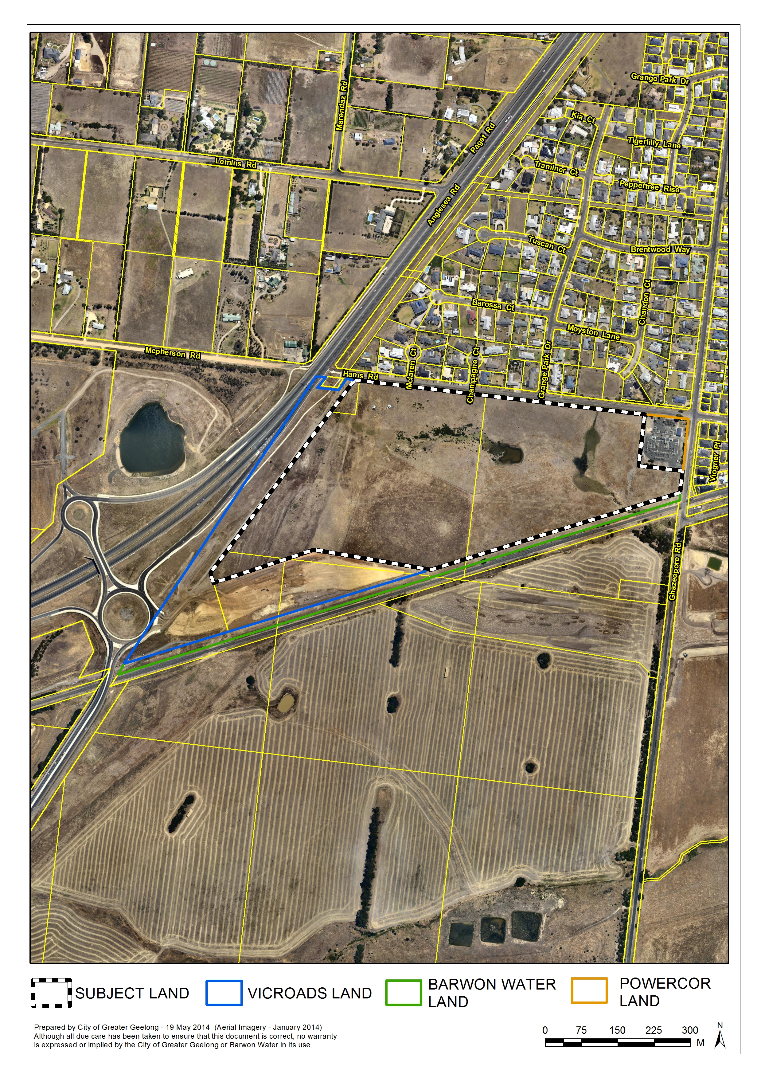
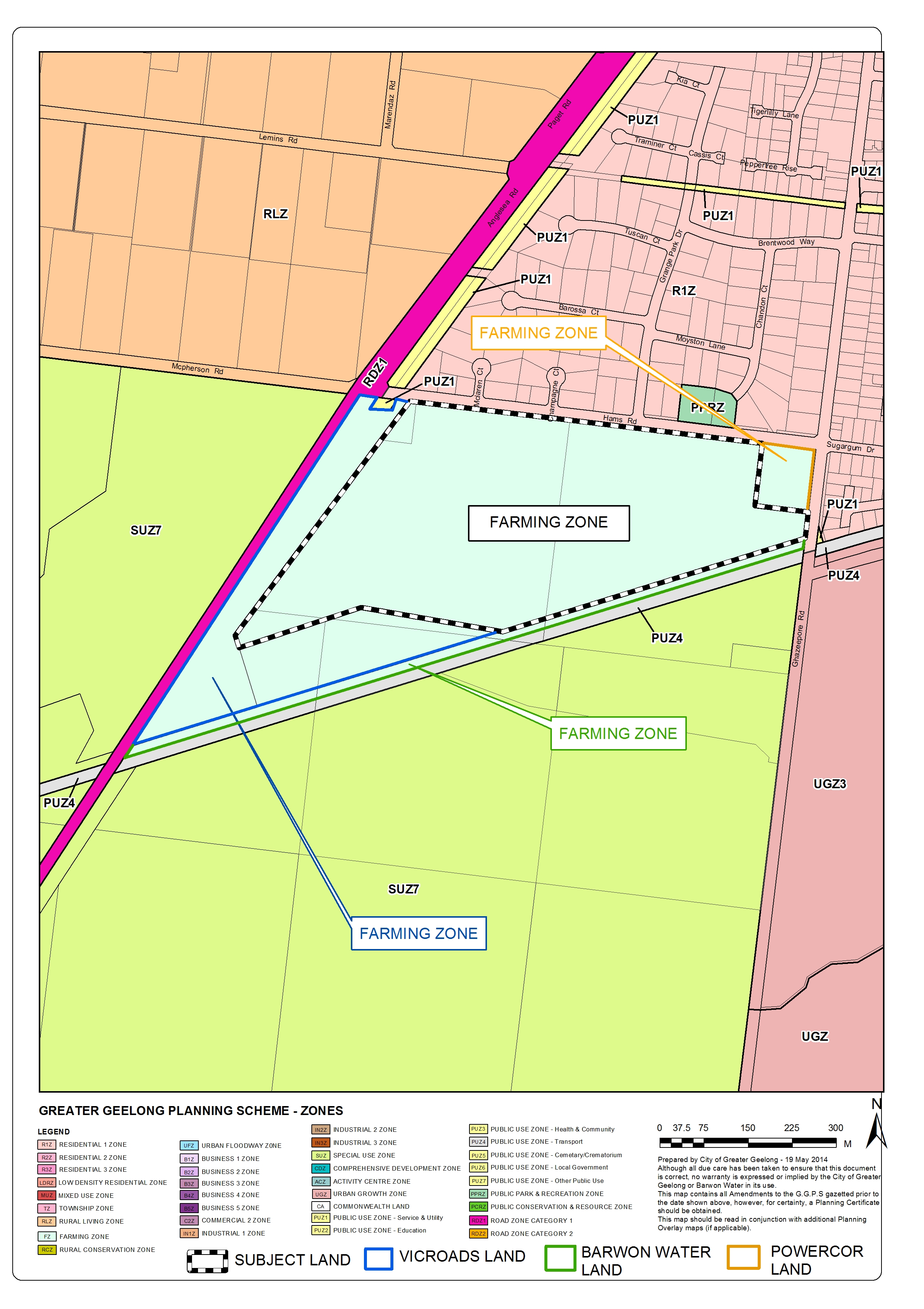
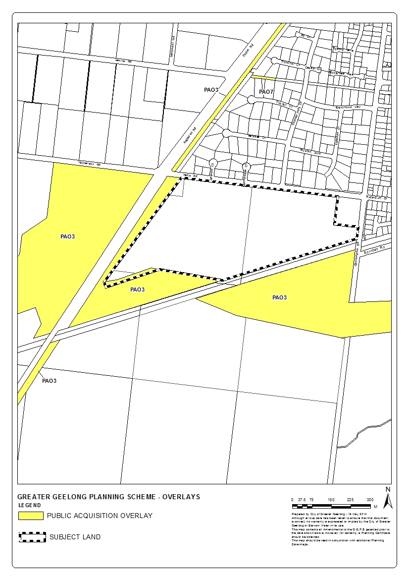
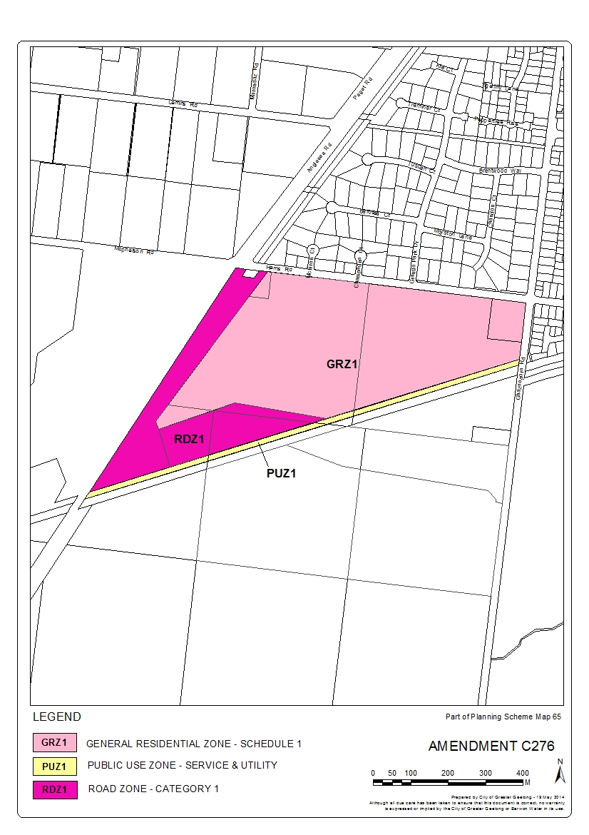
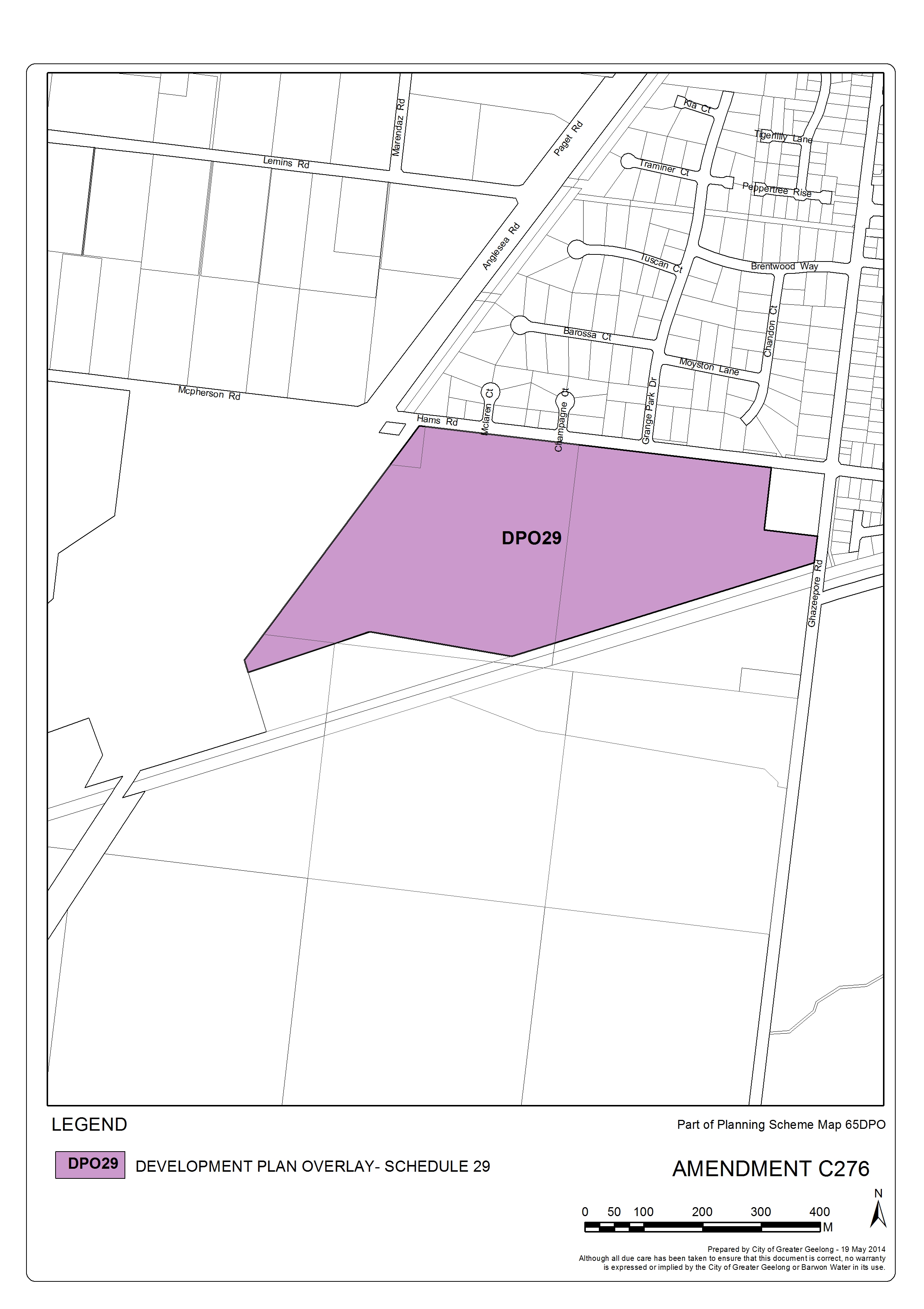
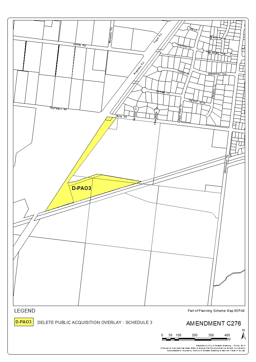
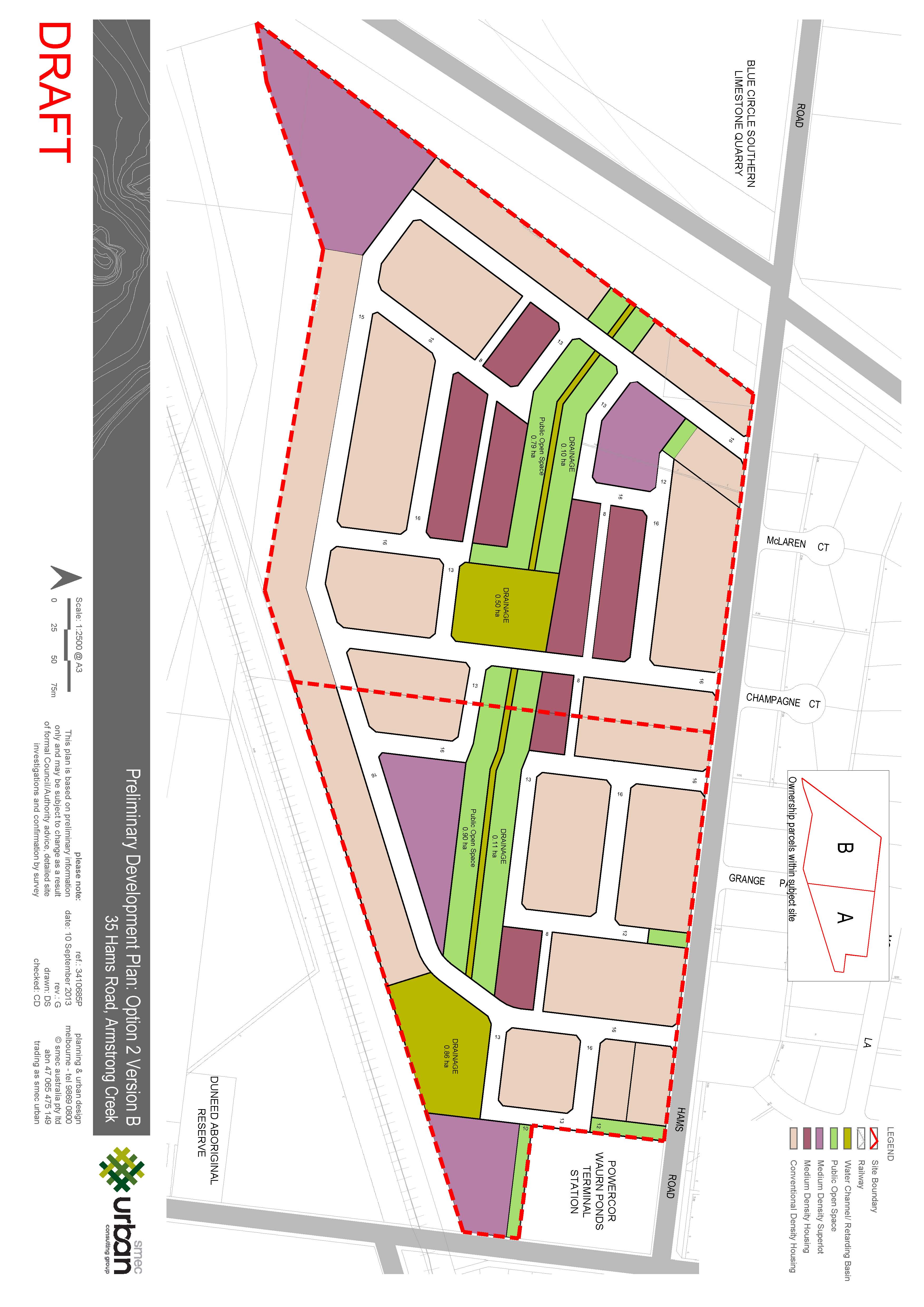
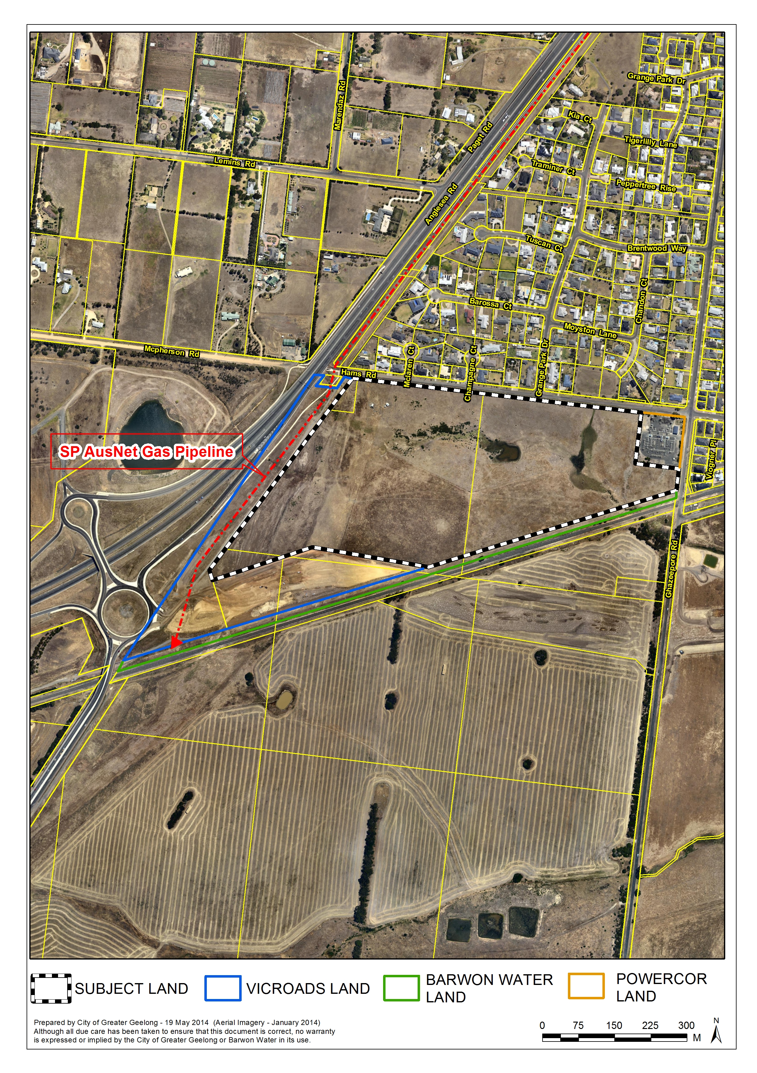
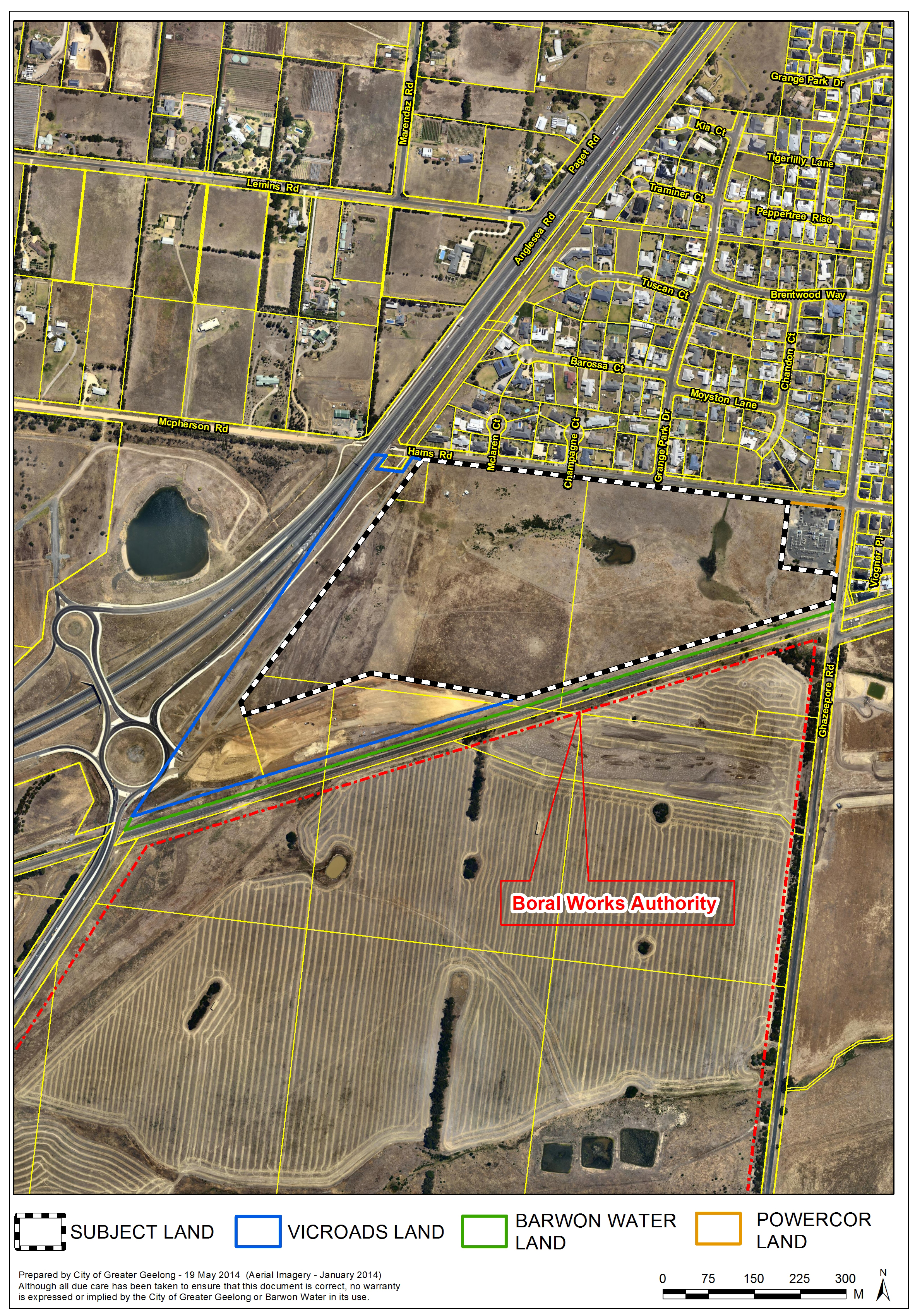
Portfolio: |
Planning - Cr Heagney |
Source: |
Planning and Tourism - City Development |
General Manager: |
Peter Bettess |
Index Reference: |
Application: C280 |
The purpose of this report is to seek Council approval to proceed with the preparation and exhibition of Planning Scheme Amendment C280, subject to authorisation being obtained from the Minister for Planning.
An application has been made by St Quentin Consulting on behalf of Paisley Manor Pty Ltd, owners of the land at 90-108 Ash Road, Leopold, to rezone the land from Farming Zone to Residential 1 Zone.
The purpose of the rezoning is to facilitate residential subdivision.
At the request of officers, the rezoning application has been made to rezone all of the land between 90-172 Ash Road (even numbers) and 21-30 Walkers Road, Leopold (odd and even numbers). This affects ten different landowners covering approximately 25 hectares.
The proposal is supported by the State and Local Planning Policy Framework and the Leopold Structure Plan. The area is designated for urban growth and is within the town’s settlement boundary.
An Outline Development Plan has been prepared for the whole area. Features of this include the provision of a minimum 10% public open space, two drainage reserves, a pocket park protecting a remnant River Red Gum, connections to the Estuary Estate to the west and continuation of a shared pathway reserve to the south.
Subdivision of the area will yield in excess of 280 lots.
A model template Section 173 Agreement, which will form the basis for Agreements to be entered into with all land owners to formalise developer contribution arrangements, is being prepared.
A Shared Infrastructure Funding Plan (SIFP) is also being prepared to guide the delivery of shared infrastructure in the area by apportioning the costs of the required shared infrastructure to each land parcel and describing the mechanisms by which the contributions levies will be collected and infrastructure delivered, including opportunity for works in-kind.
As part of the rezoning, an accompanying new Development Plan Overlay schedule will ensure that the development proceeds in a logical manner in accordance with the agreed Outline Development Plan.
Cr Heagney moved, Cr Macdonald seconded -
That consideration of the report be deferred.
Carried.
Portfolio: |
Planning - Cr Heagney |
|
Source |
Planning and Tourism |
|
General Manager: |
Peter Bettess |
|
Index Reference |
Project: Ocean Grove Urban Design Framework |
The purpose of this report is to seek Council’s adoption of the Ocean Grove Town Centre Urban Design Framework (UDF) and commence preparation of a planning scheme amendment to implement the recommendations into the Greater Geelong Planning Scheme.
The Ocean Grove Structure Plan identified the need to undertake further work to unlock the development potential of the Ocean Grove Town Centre as the town is expected to grow from 12,555 to 15,000 – 21,000 by 2020.
The development of the UDF has been underpinned by the input Council received from residents, businesses, community associations, sporting clubs, schools and government agencies through an Enquiry by Design (EbD) workshop. The two day workshop was held in May 2013 and the preferred future outcomes identified at the workshop have underpinned development of the UDF.
The UDF seeks to guide future growth and development, built form outcomes, streetscapes, traffic and pedestrian movements, car parking and land use as well as providing a framework for Council investment in the centre over the next 10 years. The UDF provides a vision for how the Town Centre should develop, provides design principles and recommends improvements to existing infrastructure and functionality of the town. The UDF will also assist in the assessment of future development proposals.
The UDF was placed on informal consultation for an eight week period from 5 February until 31 March 2014. A community information session was attended by 70 people. A total of 104 submissions were received.
The key concerns raised in the submissions were the need for pedestrian and cycle infrastructure improvements, the impact of building heights on coastal character, the need for a civic hall, development within and around the Ocean Grove Park, the preferred arterial road route and provision of future car parking areas.
The submissions have been considered and the necessary changes have been made to the final UDF. To give statutory effect to the UDF a planning scheme amendment will be prepared to introduce the design and development controls into the Greater Geelong Planning Scheme.
Cr Farrell moved, Cr Heagney seconded -
That Council:
adopt the Ocean Grove Town Centre Urban Design Framework;
develop an implementation plan for the ‘squaring up’ of the Hodgson Street/The Parade intersection including the potential sale of Council land in Precinct 3;
request authorisation from the Minister for Planning to prepare an amendment to the Greater Geelong Planning Scheme; and
resolve, subject to the grant of authorisation, to exhibit an amendment to introduce the recommendations of the UDF into the Planning Scheme as detailed in this report and shown on the map at Appendix 3.
Cr Nelson left the meeting room at 8:47pm.
Cr Nelson re-entered the meeting room at 8:48pm.
Carried.
Ocean Grove is a designated growth location on the Bellarine and it is vital that the Town Centre continues to thrive and remains the primary retail centre for Ocean Grove.
An urban design framework (UDF) is a plan that describes and illustrates how planning and design policies and principles should be implemented in an area where there is a need to manage, guide and promote change.
The development of the UDF has been underpinned by the input Council received from residents, businesses, community associations, sporting clubs, schools and government agencies through an Enquiry by Design (EbD) workshop. The two day workshop was held in May 2013 and attended by 90 delegates to uncover the community aspirations for the Town Centre. Through the EbD a series of preferred community outcomes and a concept master plan was developed that provided the basis for the development of the UDF.
The guiding design principles of the Urban Design Framework are:
Enhance the quality of the experience for locals and visitors in the Town Centre by improving the public realm;
Activate the perimeter block of the Town Centre with shops;
Create vibrant outdoor shopping and eating areas;
Promote economic diversity in the Town Centre;
Reinforce Ocean Grove Town Centre as the primary retail centre for Ocean Grove in the face of new competition at Shell Road and Grubb Road;
Create new meeting places and public spaces;
Prioritise pedestrian and cyclist safety and amenity in new development and streetscape upgrades;
Improve safety for drivers, cyclists and pedestrians;
Create connections from the Town Centre to the beach and Ocean Grove Park; and
New development meets its car parking demand or provides additional spaces within the Town Centre.
The UDF considers the Town Centre as three unique precincts: The Terrace, The Avenue and Hodgson Street. For each of the precincts the UDF seeks to provide guidance on future growth and development, built form outcomes, streetscapes, traffic and pedestrian movements, car parking and land use. The UDF provides a vision for how the centre might develop, provides design principles and recommends improvements to existing infrastructure and functionality of the town. The UDF will also assist in the assessment of future development proposals.
The UDF plan is included as Appendix 1.
The key recommendations and projects identified in the UDF are:
Consolidate commercial land use within the existing zoned land to promote a compact Town Centre;
Create a town square in The Terrace;
Signalise the intersection of Orton Street and Presidents Avenue;
Promote high quality mixed-use development of three and four storeys that respects the coastal setting of Ocean Grove;
Upgrade streetscapes in Presidents Avenue, Hodgson Street and The Avenue;
‘Square up’ the intersection of Hodgson Street and The Parade;
Preserve The Terrace, east of Hodgson Street as the long term arterial road through the Town Centre; and
Improve footpath and cycling connections to the Town Centre.
The draft UDF was placed on informal consultation for an eight week period from 5 February until 31 March 2014. A community information session was attended by 70 people. A total of 104 submissions were received.
The key issues raised during the information session and within the submissions relate to the need for pedestrian and cycle infrastructure improvements, the impact of building heights on coastal character, the need for a civic hall, development within and around the Ocean Grove Park, the preferred arterial road route and provision of future car parking areas.
A response to the submissions is found at Appendix 2. The key issues raised within the submissions are outlined below:
Walking and cycling
Submission: Prioritisation of pedestrian safety and additional footpath installations are supported however many more footpaths are required in Ocean Grove
Officer comment:
Through the EbD and submissions received it is evident that there is strong community support for development of a more coordinated and comprehensive network of footpaths to access key locations such as the Town Centre. As a starting point, the UDF recommends that infill footpaths be provided for the gaps in the footpath network within the Town Centre, such as The Avenue and Presidents Avenue.
However, as many submissions identify, there is a need to have a broader footpath network that allows both walkers and other users, such as motorised scooters to access the Town Centre without a car. It is recommended that a Principle Pedestrian Network (PPN) strategy and implementation plan be developed for the whole of Ocean Grove that includes concept design, costings and an implementation strategy for the delivery of a footpath network for Ocean Grove in an equitable and timely manner.
Built form
Submission: Three and four storey mixed-use development does not respect the existing character of Ocean Grove
Officer comment:
The low rise scale of the Town Centre is a characteristic valued by the community and the design of new buildings rather than the height will be the key to determining how the development fits into this existing character. To limit building heights to two and three storey is a simplistic approach to controlling new developments that may stymie the opportunity to promote economic development and a diversity of businesses and housing types in the Town Centre.
The UDF includes design guidelines for new development in the each of the precincts and specific prominent sites to ensure that new developments compliment the coastal character of Ocean Grove.
In developing the building height guidelines the key considerations have been:
Precedence of three storey development already within the Town Centre;
The need to reinforce The Terrace as prominent shopping strip;
The ‘stepping up’ of development in the Town Centre from the surrounding residential area where three storey development is permitted;
The recessing of third and fourth storey elements to minimise the prominence of upper floors and overshadowing the public realm;
Limiting four storey elements in The Terrace to the south side of the street to protect the footpath on the south side from overshadowing; and
Minimising the visual impact and bulk of new buildings from key viewing locations to the south by recessing buildings from the southern boundary of The Terrace and limiting building heights to three storeys on corner sites.
Civic uses
Submission: An arts centre/civic hall/community facility is required in Ocean Grove
Officer comment:
The community raised the need for a ‘town hall’ or community centre as part of the EbD and again through many of the submissions. Many of the submissions request that such a site be identified as part of UDF.
Council does not have any plans to change the existing community services and facilities that are provided within the Town Centre. The determination of whether a hall is or isn’t needed within Ocean Grove is outside the scope of the UDF to resolve. The UDF does not preclude the opportunity to develop additional community uses in the Town Centre and provides built form guidelines that will be applied to any building proposal.
Ocean Grove Park
Submission: Do not support performance space in Ocean Grove Park
Officer comment:
Whether or not there is a need for a performance space in the Town Centre is not within the scope of this project to resolve.
The Performance Space is shown on the Ocean Grove Park Masterplan 2000 and has a valid planning permit (997/2010). The decision to proceed with construction is a matter for the park owner and committee of management. Council supports the construction of the performance space and has provided financial and in-kind support to the project.
Submission: Does not support angle parking: The Avenue / Presidents Avenue
Officer comment:
The need for additional car parking was identified as an important issue for the community through the consultation. One of the opportunities to provide additional parking was through creating angle parking at the southern and western perimeter of the Ocean Grove Park. There were many submissions both in support and opposing additional parking in The Avenue and Presidents Avenue.
The proposal for angle parking around the park has been removed from the final UDF in response to concerns raised in submissions about the visual impact on the park.
To balance the impact of parking on the park and the desire by the community to achieve additional parking, indented parallel parking is recommended in The Avenue and Presidents Avenue. This is consistent with the existing treatment on The Avenue near the Ocean Grove Plaza. This will allow the parking restrictions on the south side of The Avenue to be lifted and result in approximately 10 additional spaces. Intended parking on Presidents Avenue will allow for improved cyclist safety.
Parking
Submission: Town Centre needs additional parking
Officer comment:
Based on detailed surveys undertaken as part of the UDF, during peak and non-peak periods, there is sufficient car parking in the Town Centre. What is critical is that supply continues to grow with new developments. A key principle of the UDF is that new developments provide adequate parking as there is limited additional capacity within existing supply to absorb new parking demand.
Submission: Do not support the sale of public car parks
Officer comment:
The all day car park at 89-91The Terrace and the north east corner of the Parade main off-street car park (74 – 92 The Parade) are identified as potential sites for development. These sites have been identified due to the urban design benefits these sites offer for creating active frontages and a development outcome with consolidated car parking.
There is no question that any public parking sold would be required to be replaced as part of the sale, either underground on site or within close proximity to the Town Centre, to result in no net loss of car parking. Individual sites for this purpose have not been identified as this would be up to the market to determine if development is feasible.
Submission: Council should purchase additional land to use as parking or a basement or decked parking should be provided within the existing Council car parks
Officer comment:
Through this project Council has investigated the possibility of buying additional land for car parking or building a decked or basement car park on The Parade main car park.
Council has the option under a ‘parking overlay’ to collect money (typically $12,000 per space) from business owners or developers in lieu of the provision of car parking spaces on their sites. Based on the number of spaces waived in recent years (approx. 40 between 2008 - 2013) this would equate to $450,000 collected over 5 years. Based on current valuations, the land required to build a 100 space public car park would cost $4.5 - $6.0 million dollars excluding construction costs. This demonstrates the considerable shortfall in funds between funds raised by a cash-in-lieu scheme and the actual cost of providing the car parking. This shortfall would have to be made up with other funding sources such as a special rates and charges scheme on existing businesses and property owners and as mentioned previously, this will significantly affect local economic development. A levy may also deter investment in the Town Centre should a levy be placed on all future development.
Additionally, a multi-deck or basement car park will not provide sufficient spaces to justify the considerable cost to businesses and Council due to the space taken up for ramps and the high construction costs (i.e. multiple millions of dollars for a basement car park). A previous parking study identified that a decked car park would require the relocation of the existing supermarket which is highly unlikely. A large parking structure would also have a detrimental impact on the character of Ocean Grove and significantly impact on the amenity of the businesses in Park Lane that currently benefit from a northerly aspect and direct access to the car park.
After consideration of the likely demand for additional parking it is recommended that car parking demand be met in the future as part of new developments in line with the design objectives and guidelines for parking in the UDF. This additional provision will include negotiated outcomes with developers and new businesses to undertake works to improve on-street parking facilities identified in the UDF. The waiving of parking spaces will only be considered in exceptional circumstances such as the reuse of an existing shop or upper floor office.
Traffic
Submission: Conversion of The Terrace to the arterial road
Officer comment:
Whilst desirable in the long term to improve the amenity and safety of the Town Centre, the diversion of the arterial road to The Terrace is not achievable due to the high cost of constructing the connection at Tuckfield Street, upgrading The Terrace to arterial road standard and altering the signals at The Terrace. Council supports the use of The Terrace as the arterial road however will not provide limited Council funds to upgrade VicRoad’s asset.
Therefore the UDF proposes a phased approach to upgrading the road network that balances community priorities to improve the amenity of the Town Centre and funding resources available.
Submission: Support redesign of Hodgson Street and The Parade to improve pedestrian safety
Officer comment:
This is the most significant project within the UDF in terms of cost, complexity and potential benefits to the Town Centre.
The draft UDF provided a concept plan for how ‘squaring up’ through a signalisation of this intersection could be achieved. On further advice from VicRoads and in response to community concerns about delays on the arterial road network the intersection treatments proposed has been extended to include the option for a roundabout at this location. Whilst a roundabout does not achieve the same level of pedestrian amenity as signals, with careful design consideration the safety and amenity of pedestrians can be improved on the current situation whilst balancing the priorities of the arterial road network.
Whether signals or a roundabout are developed for this intersection the UDF has been expanded to include the following design principles that the intersection treatment must provide for:
Maximise pedestrian and cyclist safety;
Facilitate pedestrian crossing between The Parade main car park and Precinct 3 east of Hodgson Street;
Minimise impact on the council car park on the north west corner of the intersection;
Minimise acquisition of private property;
Provide for bus stop on Hodgson Street;
Maximising active frontages on Hodgson Street
Accommodate heavy vehicle movements on the arterial road and access to The Parade; and
Fulfil the arterial road function of Hodgson Street and The Parade.
Following adoption of the UDF Council will continue to work with VicRoads to develop an implementation plan for the ‘squaring up’ of the intersection including a process to fund the capital works through the realisation of a development site and sale of surplus Council land in Precinct 3. The implementation plan will include market sounding, detailed road design and consider the process for putting the development site and Council assets to the market.
It is recommended that the rezoning of the surplus road reserve from Road Zone Category 1 to Commercial 1 Zone and application of design controls to Precinct 3 (east of Hodgson Street) be excluded from this amendment until the implementation plan is prepared and the exact land parcels are determined through the detailed design process.
This project does not have direct environmental impacts. The UDF encourages the use of active transport and sustainable built form for new development in the Town Centre.
The implementation of the projects identified in the UDF will require Council funding contributions including acquisition and construction of the rear lane way south of The Terrace, acquisition and construction of the Town Square, car park safety upgrades, Presidents Avenue and The Avenue streetscape works and implementation of ‘squaring up’ of Hodgson Street/The Parade intersection. The UDF projects will be fully costed and will result in future budget bids to Council and to external funding agencies. There are also several aspects to the plan that could be delivered through special rates and charges schemes and works provided by developers through individual site development.
This project has received funding from Council and State Government through the Putting Locals First Program. During 2014/2015 financial years the existing project funding will be used to develop the implementation plan for the ‘squared up’ intersection.
After its subsequent adoption by Council, the policies and outcomes of the UDF will need to be incorporated into the Greater Geelong Planning Scheme. A Planning Scheme Amendment will be prepared to revise Clause 21.14 – The Bellarine Peninsula of the Municipal Strategic Statement to reflect the outcomes of the UDF.
The UDF recommends the application of a Design and Development Overlay (DDO) to the Town Centre to achieve the design and siting objectives. In addition, the application of the DDO will remove the existing DDO16 and DDO27 to apply consistent controls across the centre. It is proposed to remove a small part of Significant Landscape Overlay 7 from the Mixed Use Zone land in the Town Centre as this land will be affected by a revised DDO and does not portray the landscape objectives of the overlay.
The proposed planning scheme overlay changes are shown in Appendix 3.
As the UDF has been subject to an extensive consultation process, it is recommended that development that meets the preferred height and setback requirements of the UDF be exempt from notice and review under the proposed DDO provisions. An exemption already exists for land in a commercial zone that is greater than 30 metres from a residential zone. As the UDF provides setback standards for commercial properties that interface with residential properties, where no controls currently exist it is appropriate that notice and review be removed provided the development that meets these standards to promote economic development and investment in the Town Centre.
The preparation of the UDF aligns with the Sustainable Built and Natural Environment and Growing our Economy strategic directions in City Plan. The recommendations of the UDF seek to achieve thriving Town Centre for residents and visitors to enjoy and promote sustainable development and travel behaviour.
No Council officers have any direct or indirect interest, in accordance with Section 80(C) of the Local Government Act to which this UDF relates.
There are no notable risks in adopting the Ocean Grove Town Centre Urban Design Framework.
The UDF includes proposals that will deliver significant long term social benefits to Ocean Grove community. These include better use of existing commercial land, increased diversity of housing types, improved streetscapes, better pedestrian connections between the town’s key assets – the beach, the Town Centre and the park, slower traffic speeds and better pedestrian safety and amenity throughout the Town Centre. The UDF will create a new a town square to become a focus for social interaction within The Terrace.
The UDF will not impact on any basic rights, freedoms and responsibilities as set out in the Charter. The recommendations of the UDF have been subject to extensive community consultation processes.
Many of the submissions were complimentary to the consultation process undertaken by Council in the development of the UDF.
The UDF has been underpinned by the input Council received from residents, businesses, community associations, sporting clubs, schools and government agencies through an Enquiry by Design (EbD) workshop at the Ocean Grove Surf Lifesaving Club. The two day workshop was held in May 2013 and attended by 90 people.
The concept masterplan and preferred future outcomes were made available to the broader public after the EbD via Council’s website and The Grove Customer Service Centre.
The draft UDF was placed on informal consultation for an eight week period from 5 February until 31 March 2014.
Letters were sent to all attendees of the EbD workshop, owners and occupiers in the study area and notices in the local papers, community bulletin and City News. A community information session was held on 24 February 2014 and attended by 70 people. A total of 104 submissions were received and a summary of the submissions and responses is provided as Appendix 2.
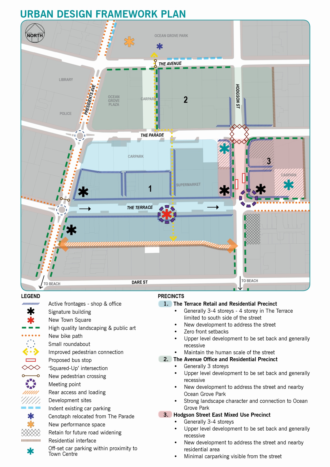
|
Comments |
Submission # |
Response |
Change recommended |
BIKE INFRASTRUCTURE |
|||
|
Supports proposed cycle network / infrastructure upgrades to facilitate more cycling |
11, 18, 19, 21, 26, 28, 29, 37, 56, 60, 63, 65, 66, 74, 75, 82, 90, 94, 97, 101 |
Noted |
- |
|
Supports connection from Tuckfield Street to The Terrace for bikes and pedestrians |
12, 17, 29 |
Noted. Council is developing a design and funding options for how this link can be implemented. |
- |
|
Supports bike lanes on Presidents Avenue but should be continued to Thacker Street |
42, 65, 104, 101 |
Agreed. Council’s cycling strategy identifies Presidents Avenue as a key north south route. There are space constraints because of the existing pedestrian crossing and car parking between The Parade and The Avenue that will need to be considered that the detailed design stage. |
Update plans to show bike lane between The Avenue and The Parade |
|
Support shared path in Presidents Avenue north of The Avenue |
81 |
A shared path or on-road bike path can be provided with the road reserve with the removal of the angle parking on Presidents Avenue from the draft. |
- |
|
Does not support bike path on Presidents Avenue as this will cause a hazard for pedestrians |
5 |
Noted. Bicycle safety is imperative and the planned changes will not negatively impact pedestrian safety |
- |
|
Additional bike parking within the Town Centre is required |
17, 18, 42, 52, 104 |
Agreed. Options to achieve additional bike parking include more small hoops, the temporary removal of car parking spaces for use as bike parking during peak periods – i.e. early Saturday morning or a permanent substantial bike rack in a car parking space in The Terrace. |
Identify need for additional bike parking in the streetscape upgrades to The Terrace. Identify need to include bike parking in all streetscape upgrades. |
| Support for bike racks at either end of The Terrace in fringe car parks | 104 | Include reference to need for additional bike parking in Town Centre | |
|
Hodgson Street should be the preferred North-South route rather than Presidents Avenue |
17 |
Don’t agree. Presidents Avenue is the preferred because it is a through route all the way from Thacker Street, is not an arterial road, it ties in with the planned signalised intersection at Orton Street-Presidents Avenue and the connection to other on-road and off road paths is better. |
- |
|
Bike lanes should be introduced into the design at the intersection of Hodgson Street and The Parade |
42 |
Don’t agree. Bike lanes were considered at the Hodgson Street-The Parade intersection, however due to spatial constraints they are not able to be accommodated. However, when The Terrace becomes the arterial road bike lanes can be retrofitted at the Hodgson Street-The Parade intersection. |
- |
|
A Copenhagen-style bike lane should be investigated for Presidents Avenue |
61 |
Noted. The detailed design of Presidents Avenue will consider the options for all or part separation for cyclists. |
- |
|
Does not support removing or reducing nature strips to improve cycling safety |
85 |
Noted. The use of shared paths on the nature strip is preferable in many instances because it provides the safest options for riders particularly children. The detailed design of any shared path will need to consider the impact on the character of the street through the use of materials and treatments. |
- |
|
Parking should be indented on Presidents Avenue adjoining the park for cyclists safety |
42 |
Agreed. |
Update plans to show indented parking on Presidents Avenue |
BUILT FORM |
|||
PRECINCT 1 - The Terrace |
|||
|
Supports multi-storey development in The Terrace |
43, 47, 51 |
Noted. |
|
PRECINCT 2 - The Avenue |
|||
|
Supports setback of new buildings from The Parade |
73 |
Noted. |
|
|
New development in Precinct 2 should be of a high quality and avoid concrete slab buildings |
79 |
Agreed |
Revise illustration on p. 40 |
|
Support for setback and building design in The Avenue |
97 |
Noted. |
|
|
Support The Avenue Office & Residential Precinct concept |
41, 102, 104 |
Noted. |
|
PRECINCT 3 - Hodgson Street |
|||
|
Supports large scale redevelopment to Precinct 3 to improve entrance to the town |
28 |
Noted. |
- |
|
Upper setbacks of Precinct 3 should be varied to create more flexibility and not include balconies |
27, 29 |
Don’t agree. The setback requirements form the overall building envelope within which the development should occur. The design guidelines require articulation on the facades to create visual interest and break up the bulk of development. |
Amend design guidelines to include additional requirement to vary setback within each floor level |
|
Ground floor setback requirements in Precinct 3 should be reduced |
27 |
Don’t agree. The ground floor setback requirement is to ensure that there is sufficient public space for circulation of pedestrians when road works occur |
- |
|
Design guidelines for Precinct 3 should be revised to remove reference to 85 The Terrace |
27 |
Agreed. |
Reword |
|
Precinct 3 development option should be reviewed and relabelled |
27 |
Agreed. |
Figure relabelled |
|
Concerns about amenity impacts on adjoining residential development from new commercial buildings |
55 |
The UDF already requires that developments that interface with residential properties meet the Rescode setback standards |
- |
HEIGHT |
|||
|
Do not support 3 - 4 storey mixed-use development as it does not respect the existing character of Ocean Grove |
8, 26, 30, 41, 54, 55, 63, 66, 74, 78, 79, 80, 82, 85, 86, 89, 90, 94, 100, 103, 104 |
Don’t agree. There is already a three storey building in The Terrace. Three storey developments are permitted in the surrounding residential areas and it is appropriate that there is a ‘stepping up’ of built form in the Town Centre. Recessing of the third and fourth storey will reduce the visual prominence of the development and a fourth storey on the south side of The Terrace will rarely be visible from the opposite footpath. The design of the building rather than the height will be the key to determining how the development fits in with the existing character. |
- |
|
Limit building heights to three storeys – this was not in EbD |
29, 74, 101, 103, 104 |
Don’t agree. The Enquiry by Design process identified four storey development in The Terrace. |
- |
|
Two storey developments only between The Terrace and The Avenue |
104 |
Don’t agree. The third storey will be recessed to reduce visual bulk. |
- |
|
Support medium rise buildings between The Parade and The Avenue instead of The Terrace |
100 |
Don’t agree. The Terrace is a wide street at over 20 metres and is able to accommodate additional height without causing detrimental impact on the character of the Town. |
- |
|
New development in Precinct 3 should be limited to two and three storeys |
104 |
Don’t agree. Three storey developments are permitted in the surrounding residential areas and it is appropriate that there is a ‘stepping up’ of built form in the Town Centre. Recessing of the third and fourth storey will reduce the visual prominence of the development and a fourth storey on the south side of The Terrace won’t be visible from the opposite footpath. The design of the building rather than the height will be the key to determining how the development fits in to the existing character. |
- |
|
Concerns about wind tunnelling effect as a result of new development |
55, 85 |
Noted. Any new development will have to respond to the urban context, including sunlight and wind impacts. Improved landscaping around the development in the public realm and awning requirements for new development over pedestrian areas will help to create a pedestrian friendly environment and protection from natural elements. |
- |
|
Concerns about overshadowing The Terrace |
103 |
Don’t agree. The Terrace is 20 metres wide that provides for good solar access. The recessing of third and fourth storeys and limiting height on the north side of the street will minimise shadows on the street. Modelling analysis undertaken by Council shows that even at the June solstice the Town Square will not be overshadowed. |
- |
OTHER |
|||
|
Support additional housing in the Town Centre |
10, 29, 33, 41 |
Noted |
- |
|
Further consideration should be given to how larger format uses (e.g. supermarket) are considered in design guidelines |
27 |
Noted. |
Review design guidelines |
Need stricter design code to ensure coastal theme for new developments |
36, 56 |
Noted. Coastal architecture and drawing colours from the landscape is already referenced in the UDF. |
- |
|
Too city centre-focussed and does not respect seaside character |
30 |
- |
|
|
Support active frontages and do not want to see blank façades |
47 |
Agreed. Planning controls will be implemented to ensure active frontages are provided on pedestrian routes. |
- |
|
Stricter signage guidelines and paint controls required |
56 |
Agreed. Signage controls will be implemented as part of the planning controls to implement the UDF. |
- |
|
Privately owned buildings should not be shown for redevelopment |
77 |
Don’t agree. A UDF does not mandate that a specific site is redeveloped. Instead the UDF identifies opportunities for where redevelopment could occur and provides a framework for how change should occur |
- |
|
Do not allow development applications that conflict with UDF |
97 |
Agreed. Planning controls will be developed to ensure that new development is consistent with the objectives of the UDF. |
- |
|
Support linking the shopping precincts together |
98 |
Noted |
- |
|
Support maintenance of the towns character |
101 |
Noted |
- |
|
Supports signature buildings on the corners |
104 |
Noted. |
- |
|
Support retail developments on ground and first floors with elevated walkways between shops – similar to Mings Terrace building |
104 |
Agreed. |
Clarify that second floor retail (similar to Mings Terrace building style) are appropriate also. |
|
Expand Target complex to include medical centre with more underground parking |
104 |
Noted. Target and the Medical Centre are privately owned and investment in private properties is at the discretion of the property owners. |
- |
CIVIC USES |
|||
Town Hall / performance space building required to replace the hall that was lost when the library was built |
24, 29, 44, 60, 67, 68, 74, 79, 85, 96 |
Noted. There is no plan to change the level of service for community facilities in Ocean Grove at this time. |
Include reference in UDF to community support for such a facility. |
|
Potential Town Hall should be identified on redevelopment site in Hodgson Street |
27 |
||
|
Town Hall should be built on Tuckfield Street reserve |
29 |
||
|
Upgrade to existing library complex required |
63 |
Noted. There are no plans to change the existing agreements for the delivery of community services in the Town Centre. |
- |
|
Need to communicate better the availability of public spaces and halls within the town |
25 |
Noted. |
- |
|
Need to establish a Tourist Information Centre |
63 |
Noted. This matter is outside the scope of the UDF and the submission has been referred to Greater Geelong and Bellarine Tourism for consideration |
- |
|
Move Tourist Information Centre to Library or some other central location |
103 |
- |
|
|
Tourist information centre should be located on redevelopment site in Hodgson Street |
104 |
- |
|
|
Do not sell Council park in The Parade and develop with trees, benchs and alfresco dining |
84 |
Don’t agree. This park has already been declared surplus to Council’s requirements. |
- |
INVESTMENT SUPPORT |
|||
|
Support implementation of the UDF to facilitate permit applications |
3 |
Agreed. Planning controls will be prepared to implement the objectives of the UDF into the Planning Scheme. |
- |
|
Need to develop the Ocean Grove brand – shark fins |
36 |
Noted. A branding or signage strategy is outside the scope of the UDF. However the development of such a strategy could build on the work of the community at the EbD. |
Include reference to developing an overall branding and signage strategy for Ocean Grove as further work. |
|
Support for major redevelopment on Hodgson Street East to incorporate missing entertainment and hospitality features |
103, 104 |
Noted. |
|
|
Does not support another Supermarket |
94, 103 |
Noted. A second supermarket would require a planning permit and would need to meet the net community benefit test for large retail developments in the Greater Geelong Planning Scheme. |
|
|
UDF will support and promote investment in Ocean Grove |
29 |
Agreed. |
|
|
A community implementation priority setting workshop is required |
29 |
Noted. This will form part of Council’s budget process |
|
|
Will never be enough investment in Ocean Grove to realise the plan – plan too ambitious |
82 |
Don’t agree. This UDF has been developed around achievable projects for the next ten years. |
|
LANDSCAPING |
|||
|
Supports planting of additional shade trees |
19, 26, 29, 47, 54, 60, 63, 79, 86, 94 |
Noted. |
|
|
Existing landscaping in The Parade (between The Terrace / Hodgson Street) should be removed - dangerous for cars entering/exiting the car park |
5 |
Noted. This matter has been referred to Council’s Engineering Services team for consideration. |
|
|
Supports additional planting in The Terrace |
58 |
Noted. |
|
|
Does not support the planting of Norfolk pines |
6, 9, 85, 94 |
Agreed. Norfolk Pines will not be used for the ‘green links’ due to the potential size of the trees and associated impacts on infrastructure |
|
|
Only native species such as Bellarine Yellow gum should be used |
6, 84 |
Noted. Unfortunately many indigenous species don’t make suitable street trees. Native species will be used wherever possible. |
|
Remove overhead powerlines and increase planting of Bellarine Yellow gums |
84 |
Noted. Final species selection will form part of the detailed design of streetscape works. Noted. |
|
Supports planting of flowering gums |
65 |
||
Does not support planting of flowering gums |
19 |
||
Does not like white cedar as tree choice |
44 |
||
Support use of Lightwood, Black Sheoak or Drooping Sheoak as street trees |
84 |
||
Support planting of Banksia integrifolia and marginate |
79, 84 |
||
|
Support landscaping guidelines to soften impacts of new development and car parks |
29, 79, 103, 104 |
Noted. This is a key principle of the UDF |
|
|
Supports high quality landscaping and public art through The Terrace and south of The Parade |
104 |
Noted. |
|
OCEAN GROVE PARK |
|||
|
Does not support performance space in Ocean Grove Park |
8, 22, 24, 31, 32, 34, 35, 45, 46, 47, 48, 50, 52, 55, 60, 62, 63, 68, 69, 79, 85, 95, 96, 104, 105 |
Noted. The Performance Space is shown on the Ocean Grove Park Masterplan (2000) and has a valid planning permit (997/2010). The decision to proceed with construction is a matter for the park owner and committee of management. |
- |
|
Council should purchase park for parking |
49 |
Don’t agree. Council will not purchase part of the park for parking |
- |
|
Council should not purchase park for parking |
78 |
Agreed. |
- |
|
Does not support transfer of park to Council |
22, 24, 31, 32, 33, 34, 48 |
The City and Trust for Nature have agreed that the park will not be transferred to the City. |
- |
|
Does not support any changes to fencing around the Park |
13, 22, 33, 62, 69, 71, 72, 76, 79, 82, 84, 85, 90, 95, 96, 103 |
Agreed. |
References to the fence around the park to be removed. |
|
Additional fencing suggested on the West boundary of the Park |
81 |
Not agreed. Any changes to the fencing around the park are a matter for the park committee |
- |
|
Supports relocation of the cenotaph to Ocean Grove Park |
30, 65 |
Noted. |
- |
|
Does not support any cycle connections within the Park |
54, 84 |
Agreed. No cycle connections within the park will be provided. |
No cycling infrastructure to be shown in the park |
|
Does not support infrastructure creep (cenotaph or extension of car parking areas), maintain park for natural values and amenity needs |
101 |
Cenotaph has already been relocated to the Park with the agreement of the park owner and committee of management |
- |
|
Support angled parking on Draper Street on north side of park and relocation of bus stop to Presidents Avenue |
103 |
Noted. |
- |
PARKING |
|||
|
Does not support the sale of public car parks |
18, 26, 36, 41, 57, 70, 72, 78, 80, 82, 86, 90, 92, 94, 95, 98, 102, 103, 106 |
Noted. Any public parking sold would be required to be replaced as part of the sale, either underground on site or within close proximity to the Town Centre. Individual sites have not been identified as this would be up to the market to determine if development is feasible. |
Remove development site on public car park fronting Presidents Avenue. |
|
Too much priority is given to parking and cars |
19, 29, 31, 56, 66, 83, 101 |
Noted. |
|
|
Supports upgrades to car parks to improve pedestrian safety even if this results in less spaces |
10, 11, 104 |
Noted. |
|
PARKING - THE AVENUE / PRESIDENTS AVENUE |
|||
|
Support angle parking: The Avenue / Presidents Ave |
3, 4, 9, 10, 12, 16, 21, 26, 28, 36, 37, 38, 52, 55, 56, 57, 64, 74, 77, 78, 86, 93, 94, 98, 100 |
Refer below. |
Refer below. |
|
Does not support angle parking: The Avenue / Presidents Ave |
5, 8, 19, 22, 23, 30, 31, 33, 34, 35, 43, 45, 46, 47, 48, 49, 51, 58, 60, 63, 67, 69, 70, 71, 72, 73, 79, 80, 82, 83, 84, 85, 87, 90, 96, 97, 99, 101, 103, 104 |
Agreed. Angle parking around the park is not supported by the community. To balance the impact of parking on the park and the desire by the community to achieve additional parking indented parallel parking is recommended in The Avenue and Presidents Avenue, consistent with the treatment on the The Avenue near the Ocean Grove Plaza. This will allow the parking restrictions on the south side of The Avenue to be lifted and result in approx10 additional spaces. Indented parking on Presidents Avenue will allow for improved cyclist safety. |
Remove angle parking in The Avenue and Presidents Avenue. |
|
If angle parking is provided adjacent to the Park footpaths should be provided as part of the development by moving the fence |
52 |
Noted. The recommendation for angle parking will be removed from the final version of the UDF. |
|
|
Did the parking study take into account parking demands generated by the performance space? |
105 |
Because the existing and future events in the park are in-frequent in timing and duration it is not useful to account for this use as a permanent generator of parking demand in the Town Centre. Due to the infrequent nature of the use and as many events will occur outside surveyed peak parking times (weekdays between 11am – 3pm) it is not reasonable to provide dedicated parking for the performance space. As is the case now, it is likely that parking from events in the park will spill over into the commercial parking area and surrounding streets however the community benefits of the park must be balanced with the potential for short term inconvenience. |
|
|
Supports angled parking on the south side of The Avenue not the north |
103 |
Don’t agree. The existing power poles limit the amount of space available for additional parking. |
|
|
DEVELOPMENT CONTROL |
|||
|
Supports approach to managing parking |
24, 32 |
Noted. |
- |
|
Developers should be required to provide adequate parking in new developments – such as basement car parking and not have parking requirements waived. |
23, 73, 78, 97, 98, 102, 103 |
Agreed. This is a key principle of the UDF |
- |
|
Introduce a cash in-lieu scheme for waiving of any car parking spaces |
97 |
Don’t agree. Because of the relatively small number of spaces waived by Council each year it is unlikely that enough money will ever be raised to cover the purchase of land and construction of car parking. A cash in-lieu scheme could also stymie economic development in the Town Centre and prevent new small businesses such as small offices and cafes occupying existing premises. |
- |
|
Support for strict enforcement of residential parking requirements |
97 |
Agreed. The planning scheme requires one parking space for a one or two bedroom dwelling and two spaces for three or more bedrooms |
- |
|
PARKING - THE TERRACE |
|||
|
Support additional angle parking in The Terrace |
33, 43, 98, 103 |
Noted. |
- |
|
Does not support additional angle parking in the Terrace |
19 |
Don’t agree. There is a strong community desire for additional parking in the Town Centre. The additional parking will not impact on the slow speed pedestrian environment. |
- |
|
Reduce parking in The Terrace to increase opportunities for alfresco dining |
88 |
Not supported. The existing wide footpaths provide good opportunities for on-street dining. |
- |
|
Provide angle parking in The Terrace between Eggleston Street and Wedge Street |
82 |
Don’t agree. This is too far from the Town Centre to provide useful additional parking. Additional angle parking can be provided west of Eggleston Street, closer to the Town Centre. |
- |
|
Supports 45˚ not 60˚ angled parking and middle white line in The Terrace for through traffic to overtake cars waiting for parks |
103 |
Don’t agree. 60 degree spaces maximises the number of parks available and there is sufficient width in The Terrace to accommodate it. Using the north side of the street is the safest options to provide angle parking as this provides the best sightlines for driver. A white line is unnecessary as this will encourage vehicles to travel through at higher speeds rather than providing an extremely slow and safest possible pedestrian environment. |
- |
|
The Terrace car park could be sold as part of a redevelopment provided replacement parking spaces are provided by the new development |
27 |
Agreed. |
- |
|
Support angle parking: The Terrace (East side of Hodgson Street) |
11, 21, 98, 103 |
Noted. |
- |
|
Provide proposed car parking map like Figure 39 |
103 |
Agreed. |
Add additional plan |
|
The Parade |
|
|
|
|
Support conversion of 90˚parking on The Parade to angle parking |
10, 55, 88, 98 |
Noted. |
|
|
Supports 45˚ not 60˚angled parking in The Parade |
103 |
Don’t agree. 60 degree spaces maximises the number of spaces provided. Cars can exit a 60 degree space without encroaching into the eastbound traffic lane. |
|
|
Support for short-term main carpark to be one-way |
103 |
Don’t agree. There is sufficient space in the car park for two aisles and two way aisles will improve local circulation. |
|
|
Do not support footpaths in long-term central carpark |
103 |
Don’t agree. Pedestrian safety was a key priority identified by the community to date and the existing car park was an area of key concern. |
|
|
Supports removing and upgrading existing crossings in The Parade |
16 |
Noted. |
|
|
ADDITIONAL PARKING SUPPLY |
|||
|
Town Centre needs additional parking |
3, 4, 10, 23, 43, 49, 60, 80, 82, 89, 90, 96, 77, 97, 100, 102, 103, 104, 106 |
Don’t agree. Based on detailed surveys there is sufficient car parking in the Town Centre. It is critical that supply continues to grow with new developments. |
|
|
Purchase land in Precinct 2 for car parking – next to existing parking |
26, 33, 104 |
Don’t agree. Existing parking supply is meeting parking demand. A key principle of the UDF is that new developments provide adequate parking as there is limited additional capacity to within existing supply to absorb new parking demand. In addition, the cost of constructing of purchasing land and constructing a car park would be borne by Council and businesses and this is likely to have a detrimental impact on local economic development. |
|
|
Additional land should be purchased around the Police Station and Library for parking |
36 |
| |
|
Council to purchase properties for use as additional car parking |
60, 98 |
| |
|
Council purchase land on the east side of Hodgson Street between The Parade and The Avenue for parking |
104 |
|
|
|
Council purchase land on the east side of Hodgson Street between The Terrace and Dare Street for parking |
104 |
| |
|
Council purchase land in Dare Street south of The Terrace shopping strip for parking |
104 |
|
|
|
Expand the existing car park on The Terrace to Eggleston Street |
94, 104 |
Don’t agree. This would require acquisition and demolition of the Telstra phone exchange and multiple private properties. |
|
|
Council land east of Hodgson Street should be used as car parking with access from The Parade and egress onto Hodgson Street until the intersection is straightened up and The Terrace becomes the arterial |
103 |
Don’t agree. The location of the park on the existing sweeping bend does not provide a safe location for a public car park. Without a pedestrian crossing providing access to the west over Hodgson Street there would also be risks to pedestrians trying to access the main shopping area on the west side of Hodgson Street. |
|
|
Construct underground car park on main Parade car park |
49, 60, 64, 88, 90 |
a multi-deck or basement car park will not provide sufficient spaces to justify the considerable cost to businesses and Council due to the space taken up for ramps and the high construction costs (i.e. multiple millions of dollars for a basement car park). |
|
|
Roof top parking on Coles and Target should be provided |
19, 104 |
Noted. These properties are privately owned and if these businesses sought to expand they may consider using their roof tops for parking. The principles of the UDF do not preclude this occurring. |
|
|
Recommend multi-deck car park on existing Terrace all day car park |
16, 20, 83 |
Don’t agree. |
|
|
Recommend construction of multi-deck car park on the existing main Parade car park |
4, 20, 22, 83, 86, 87 |
Don’t agree. A multi-deck car park will not provide sufficient spaces to justify the considerable cost to businesses and Council due to the space taken up for ramps and the need to maintain loading access to Coles. A large parking structure would have a detrimental impact on the character of Ocean Grove. |
|
|
OTHER |
|||
|
Did the parking surveys take into account parking overflow into nearby streets? |
105 |
Car parking surveys of the streets immediately adjoining the Town Centre where undertaken. |
|
|
Need to provide parking for RV and motor homes |
63 |
Don’t agree. Parking for these vehicles can be accommodated in the street network. |
|
|
Basement parking not supported, is unviable from a finance point of view |
3 |
Noted. The decision to build a basement car park will be a matter for the developers. Council will not support substantial waivers of car parking so basement may be required to ensure development feasibility. |
|
|
Recommends additional signage to direct visitors to existing car parks |
12 |
Agreed. This recommendation is in the UDF |
|
PEDESTRIAN UPGRADES |
|||
|
Supports prioritisation of pedestrian safety and additional footpath installations |
8, 13, 17, 19, 26, 28, 29 46, 54, 56, 60, 73, 74, 75, 78, 82, 90, 94, 98, 98, 101, 104 |
Noted. This was a key community from the EbD |
|
|
No walkability study has been undertaken |
29 |
Agreed. This is a recommendation of the UDF to develop a principle pedestrian network and implementation strategy to fund the required works. |
|
|
Support development of a comprehensive footpath network |
56, 101 |
|
|
|
Improve amenity of walkways between Park Lane and The Terrace – such as ‘greening’ |
78 |
Noted. Improving the connections between Park Lane and The Terrace is a key recommendation of the UDF |
|
|
ADDITIONAL FOOTPATH INSTALLATIONS |
|||
|
UDF should show more footpath installations and upgrades |
29 |
See above. |
|
|
Additional footpath connections required in Eggleston Street, Kalinga Road, Blackwell Street & Epworth Street |
8 |
Noted. The UDF recommends development of a principle pedestrian network and implementation strategy to fund the required works. |
|
|
Additional footpath connections required in within 1-2km of Town Centre - Wallington/Ocean Grove Rd, Field St, Presidents Ave, Eggleston St, Bramwell/Wedge St, Tuckfield St, Thacker St, Madeley St, Draper St, The Avenue, The Parade, The Terrace and Orton St |
104 |
|
|
|
Footpath required on The Parade (west of Presidents Avenue) |
14, 64, 74 |
|
|
|
Supports improvements to pedestrian network that should be able to be used for gophers |
10 |
|
|
|
Footpath needed on the north side of The Avenue adjoining Ocean Grove Park |
82 |
Agreed. This is a recommendation of the UDF |
|
|
Footpath needed on the southern side of The Avenue opposite Ocean Grove Park |
83, 104 |
|
|
|
Supports new connections from Town Centre to the beach |
8, 21, 29, 36, 47, 56, 74, 79, 82, 90, 96 |
Noted. This is a key principle of the UDF |
|
|
Support linkage between Town Centre and OG Park |
11, 15, 36, 41, 65, 74, 82, 83, 90, 97, 98, 102, 104 |
|
|
|
Support footpath from the Town Centre to Field Street and on to beach |
104 |
Noted. |
|
|
Support linkage between OG Park and Town Centre however car parks should be removed to enlarge pedestrian connection particularly for motorised scooters. |
52 |
Noted. The path width will allow for motorised scooters. |
|
|
Dare Street is a preferred street for walkers and additional pedestrian and cycle infrastructure should be provided |
28 |
Noted. The UDF recommends development of a principle pedestrian network and implementation strategy to fund the required works. |
|
|
Presidents Ave and Dare Street should be narrowed to discourage car use and promote pedestrian priority |
28 |
Noted. |
|
|
CROSSING UPGRADES |
|||
|
Concerns with safety of footpath in front of Coles |
29, 37 |
Noted. This issue has been referred to the Engineering Services department for assessment. |
- |
|
Supports raised pedestrian crossing on The Terrace |
90 |
Noted. |
- |
|
Safe pedestrian crossing required at Tuckfield Street |
104 |
Noted. This outside of the study area of the UDF |
- |
|
Pedestrian crossing at Wedge Street/The Parade and Wedge Street/The Terrace intersections required |
104 |
- |
|
|
Support pedestrian crossing at Presidents Avenue but should be nearer to school or park |
104 |
Don’t agree. The proposed pedestrian crossing provides direct access to the shopping strip from the east and is a known pedestrian concern. |
- |
PROCESS FOR DEVELOPING UDF |
|||
|
Supportive of public consultation and process for developing UDF |
3, 18, 51, 98 |
Noted. |
- |
|
Consultation workshops should have been held over the weekend |
103 |
- |
|
|
Overall concept is fantastic and exciting |
9 |
Noted |
- |
|
A proactive step forwards addressing future issues re: development of Ocean Grove |
12, 101 |
Noted |
- |
|
Comparison between existing and proposed using photos |
20 |
Agreed |
Include in final version |
|
Is 3D visualisation available? |
25 |
Not available. A 3D model has been developed to inform preparation of the UDF and undertake the visual assessments and shadow analysis. This is an analysis tool rather than graphic presentation. |
- |
|
Is there a schedule review period? |
25 |
No. The UDF will be reviewed if for some reason key projects or principles cannot be achieved. |
- |
|
What does short term, medium term and long term mean? |
27 |
The draft UDF identifies the timeframes as: Short term (0-5 years) Medium term (5 -10 years) Long term (10+ years) |
- |
|
|
|
|
|
|
More vision and drastic action is needed |
28 |
Noted. |
- |
|
Plan to be 50 year plus instead of 10 years |
47 |
The plan is intended to provide immediate and achievable actions that can input into Council’s budget processes and meet with community’s expectations about the level of change their centre will experience. |
- |
|
Glossary for jargon? |
47, 51 |
Noted. |
Include glossary |
|
Contact/involve younger families |
74 |
Noted. A cross section of the community has been involved in the process through out the different consultation phases including families. |
- |
|
Supportive of presentation of UDF |
97 |
Noted. |
- |
LAND USE |
|||
|
Supports the Town Centre as the principle retail centre for Ocean Grove |
4, 56, 97 |
Noted. |
- |
|
Town Centre should not grow due to lack of space and development should occur at Grubb Road |
94, 84 |
Don’t agree. The retail hierarchy identifies the Town Centre as the primary retail centre. The UDF does not recommend additional physical expansion of the Town Centre but the better utilisation of the existing commercial zoned land. |
- |
|
Supports expansion of Centre at Grubb Road |
5, 49, 84, 94 |
Noted. |
- |
|
Does not support expansion of Centre at Grubb Road |
56 |
Noted. The Grubb Road centre is identified in the retail hierarchy and Structure Plan as a neighbourhood centre and is indented to provide local shopping needs to the residents of the new estates on Grubb Road. A Development Plan of the new centre is required to be approved showing the layout and size of the new centre. In accordance with Council’s retail assessment policy a economic impact assessment would be required before any permits for retail development were issued. |
- |
|
Believes Town Centre should expand in a horizontal direction rather than vertical |
10 |
Don’t agree. There is sufficient zoned land within the Town Centre to accommodate predicted office and retail floor space demands without creating new land for retail and commercial developments. |
- |
|
Additional development in the Town Centre should be constrained due to parking issues |
51 |
Don’t agree. The UDF recommends that new development should meet its parking demand on site. |
- |
|
Supports compact Town Centre with mixed-use development |
26, 104 |
Agreed. |
- |
|
Office space should be encouraged on Presidents Ave (between The Terrace and Dare Street) |
28 |
Noted. The residential growth zone that is currently being considered by Council for this area will allow for small offices in this area if there is market demand. |
- |
|
Telstra exchange should be rezoned to Commercial zoning |
27, 29 |
Don’t agree. This is a public utility that is currently excluded from the planning scheme. In the event that this infrastructure was no longer required and Telstra sought to dispose of the property then a full assessment of the underlying zoning would be undertaken and a subsequent rezoning prior to sale. |
- |
STREETSCAPES |
|||
|
Supports overall uplift of streetscapes in public realm |
11, 91, 94, 96 |
Noted. This a key objective of the UDF |
- |
|
Additional seating in The Terrace is required |
11, 36 |
Noted. The Town Square will provide new opportunities for public seating and resting places. |
- |
|
Does not support use of concrete paths |
48 |
Noted. Concrete footpaths offer benefits in terms of equitable access for all ages and abilities and ongoing maintenance. The development of the principle pedestrian network and implementation plan will consider the types of materials and finishes that are suitable for Ocean Grove. |
|
|
Supports the addition of public art |
63, 65 |
Noted. |
- |
|
Covered walkway required on the west side of Coles with chess/games for the community |
83 |
Noted. This is a key pedestrian linkage to The Terrace and an upgrade to this area is a key recommendation of the UDF. |
Show active frontages on pedestrian linkage adjoining the supermarket. |
|
Arcades need aesthetic improvements and revitalisation |
101 |
||
|
Support for new bus stops to be a student design competition |
104 |
Noted. This proposal will be considered at detailed design for the Hodgson Street East redevelopment. |
Note in final version |
|
Support for new bus stops to link to a Tourist Information Centre on Hodgson Street and The Terrace ‘meeting point’ |
104 |
Noted. |
|
|
Hodgson Street between The Terrace and The Parade should be a bus and pedestrian zone |
29 |
Until The Terrace becomes the arterial road, Hodgson Street between The Terrace and The Parade will be part of the arterial road, providing safe circulation and access for pedestrians, cyclists and vehicles. When The Terrace becomes the arterial road and if there is consensus from the community a bus and pedestrian zone on Hodgson Street between The Terrace and The Parade will be considered. |
|
|
Support for continuous shop fronts and minimising the frequency of vehicle access |
97 |
Agreed. This is a key principle of the UDF |
|
REAR LANE WAY – THE TERRACE |
|||
|
Supports construction of the rear lane way |
43, 90, 97, 98, 103, 104 |
Noted. |
|
|
Completion of rear laneway should be prioritised |
98 |
Noted. |
|
|
Existing lane way too busy to accommodate additional traffic |
7 |
Don’t agree. The rear laneway provides an important access function for businesses. The laneway will provide an extremely slow traffic environment that can accommodate additional traffic volumes. |
- |
|
Lane way should be 8m wide to function properly and residential land at the rear of Dare Street should be used to construct lane way |
7 |
Don’t agree. The planning scheme requires a carriageway of 5.5m for an Access Lane. The laneway is six metres wide and is sufficient for two vehicles to pass safely. |
- |
|
Rear lane way should be pedestrian and cycle friendly |
28 |
Agree. There will not be dedicated pedestrian or cycle facilities in the laneway but it will be a very slow speed shared environment |
|
TOWN SQUARE |
|||
|
Supports the Town Square concept |
20, 36, 37, 44, 45, 57, 60, 78, 83, 98, 101 |
Noted. This is a key principle of the UDF |
- |
|
A Town Square is unnecessary and problematic for pedestrians and vehicles |
63 |
Don’t agree. The proposed location is adjacent to a key pedestrian node in the heart of the Town Centre, and delivers in more pedestrian (or footpath) space to help distinguish this landmark. The proposed location requires the removal of existing car parks however does not impact on the ability for traffic to move through The Terrace |
- |
|
Town Square needs to be bigger to create more of a destination |
15, 28, 51, 104 |
Don’t agree. Whilst the Town Square will be a relatively small space it is not intended to replicate other larger areas of open space such as the park. More important than the overall size is the landmark location at the heart of The Terrace, providing a reasonable amount of hard space at a key pedestrian nodal point in the heart of the Town Centre that can include public art, seating, on-street dining etc. |
- |
|
Should capture views of the water from the Town Square |
15, 28 |
To capture ocean views from the Town Square would require relocating the Town Square away from the key pedestrian node and heart of the Town Centre. Development is required to allow for reasonable sharing of views throughout Ocean Grove. |
- |
|
Town Square should be located in the main car park |
19, 38 |
Don’t agree. The heart of Ocean Grove Town Centre is The Terrace. A Town Square is usually located in the heart of a town at an intersection of paths. The main car park is an arrival point for many visitors arriving by vehicle, however this does not change the fact that The Terrace is the primary focus. The proposal incorporates more tree planning on The Terrace to reiterate its priority and the proposed Town Square will be a landmark helping to add vitality and vibrancy to the heart of the Ocean Grove Town Centre. |
- |
|
Town Square should be a linear plaza in the main car park by extending Park Lane footpath to the north to provide tree planting and on-street dining |
29 |
- |
|
|
Create a connection through to Dare Street |
28 |
Don’t agree. This option was considered through the development of the UDF, however it was considered unreasonable spend given the connection could not be made all the way to the beach. The proposed pedestrian connections and improvements make the Town Centre more permeable throughout. |
- |
|
Town Square should be located in The Avenue |
59 |
Don’t agree. The Terrace is the heart of Ocean Grove Town Centre and the proposed Town Square will reinforce this. The Ocean Grove Park already provides opportunities for meeting and recreation. |
- |
|
Support for Town Square in a quieter street |
100 |
- |
|
TRAFFIC |
|||
|
Supports overall approach to traffic management |
10, 29, 32, 98 |
Noted. |
- |
|
Through traffic should be diverted away from the Town Centre |
12, 26, 49 |
Noted. The volume of through traffic in the Town Centre is small (5-15%) compared to local traffic accessing in and around the Town Centre. |
- |
|
Existing arterial road traffic is impacting on amenity in Town Centre |
26 |
Noted. Slowing traffic and promoting pedestrian amenity and safety is a key recommendation of the UDF |
- |
|
Need to show contextual analysis for broader traffic network |
19 |
Noted. |
Include additional traffic context plan |
|
A traffic study for the whole of Ocean Grove considering all transport modes to be completed by June 2015 |
29 |
Don’t agree. Structure Plan determined key land use and transport directions for Ocean Grove. A future review of the structure plan will include determine if further broader traffic network considerations are required. |
- |
|
Include artist impression of Tuckfield Street link |
25 |
This is outside the study area and as not been subject to a detailed design. |
- |
|
PRESIDENTS AVENUE |
|||
|
Supports roundabouts on Presidents Avenue |
12, 14, 37, 54, 60, 64, 74, 80, 90, 94, 103, 104 |
Noted. |
- |
|
Do not support roundabouts on Presidents Avenue |
5, 22 |
Noted. The roundabouts are important as the signalisation of Orton and Presidents Avenue will result in more traffic using Presidents Avenue and the two roundabouts will improve local circulation. The roundabouts will also reduce vehicle speeds and create a safer environment for pedestrians |
- |
|
Supports one-way Presidents Avenue heading north (between Orton Street & Dare Street) |
82 |
Don’t agree. Presidents Avenue is a key entry and exit point for users of the Town Centre. If Presidents Avenue was limited to north bound traffic only vehicles heading west from the Town Centre would be forced to use local streets to access the main road or travel east on to Hodgson Street and double back |
- |
|
Redesign of Orton Street and Presidents Avenue intersection to a roundabout |
104 |
Don’t agree. This a key pedestrian route that will be further enhanced by the ‘green links’ and a roundabout is not the safest option for pedestrians. The ultimate intersection treatment will be determined by VicRoads. |
- |
|
THE ARTERIAL ROAD NETWORK |
|||
|
Construct connection between The Terrace and The Parade at Tuckfield Street |
5, 12, 80 |
Noted. There is considerable cost required to construct a vehicle connection between The Terrace and The Parade at Tuckfield Street and is not considered necessary until such time Tuckfield Street is duplicated and The Terrace is the arterial road. It is currently possible for drivers to connect between The Terrace and The Parade at Wedge and Eggleston Street if this movement is desirable. In the interim, the UDF recommends a bike and pedestrian connection and a project is being developed for funding to build this connection. |
- |
|
Convert The Parade and The Terrace (to Tuckfield Street) to one-way system to access the Town Centre |
5, 29, 74, 75, 88 |
Don’t agree. This would create a more confusing access system to the Town Centre, particularly for visitors and result in all drivers travelling extra kilometres to access the Town Centre. There is sufficient width in both the carriage way of The Terrace and The Parade to allow for two way traffic |
- |
|
As part of one-way system traffic system install WSUD and separated bike lanes on The Terrace and The Parade |
29 |
Noted. If desired by the community there is sufficient width in The Terrace to provide an off-road shared path without making the road one-way. This is already identified in the UDF |
Include reference to WSUD for new streetscape upgrades |
|
Widen Hodgson Street, (south of The Terrace) to Orton Street and convert The Terrace to the arterial road |
12 |
Noted. It is not necessary to widen Hodgson Street to facilitate The Terrace as the arterial road. |
- |
|
Supports long-term conversion of The Terrace to arterial road |
21, 29, 36, 42, 55, 74, 78, 79, 82, 93, 97 |
Noted. This is a key recommendation of the UDF |
- |
|
Do not support conversion of The Terrace to arterial road |
49, 62, 86, 91 |
Noted. |
- |
|
Council should advocate to bring forward conversion of The Terrace to the arterial road |
57, 80 |
Noted. Council supports the use of The Terrace as the arterial road however will not provide limited Council funds to VicRoad’s asset. Council will continue to advocate for upgrades to the arterial road network with VicRoads. |
- |
|
South east corner of the Terrace and Hodgson Street should be redesigned to facilitate heavy vehicles turning left from The Terrace to Hodgson Street |
59 |
Noted. These works would be required when The Terrace becomes the arterial road and the intersection concept design provided in the UDF provides for the movement of heavy vehicles from The Terrace to Hodgson Street |
- |
|
Council needs to purchase land at 97 Dare St to facilitate long term use of The Terrace as the arterial road |
29, 74 |
Noted. A concept plan for the upgrade of The Terrace and Hodgson Street as the future arterial road has been prepared as part of the UDF with both the acquisition of additional property and without. The design solution with the property acquisition is more desirable from a traffic engineering point of view nonetheless there is space to construct the required slip lane if acquisition is not possible. It is noted that existing properties should be retained to facilitate additional turning lanes south of Dare Street. |
Include investigation of a public acquisition overlay for the properties at 97 Dare Street and 37 Hodgson Street for implementation of the UDF. |
|
“SQUARING UP” HODGSON AND THE PARADE |
|||
|
Supports signalisation at Orton Street / Presidents Avenue intersection |
8, 55, 60, 80, 90, 93, 104 |
Noted. This is a VicRoads road and Council will advocate strongly for these works |
- |
|
Supports redesign of Hodgson Street and The Parade |
8, 14, 16, 21, 27, 28, 37, 44, 45, 52, 55, 57, 60, 78, 74, 103, 104 |
Noted. This is a key project in the UDF and Council will work with VicRoads to develop an implementation plan over the coming year |
Include design principles for intersection treatment |
|
Do not support redesign of Hodgson Street and The Parade |
59, 82, 92 |
Noted. The draft UDF provided concept plan for how signalisation of this intersection could be achieved. On further advice from VicRoads and in response to community concerns about delays on the arterial road network the intersection treatments proposed has been extended to include the option for a roundabout at this location. Whilst a roundabout does not achieve the same level of pedestrian amenity as signals with careful design consideration the safety and amenity of pedestrians can be improved on the current situation whilst balancing the need to provide for the arterial road network function. |
|
|
A roundabout should be provided at Hodgson Street / The Parade |
12, 94, 103, 104 |
||
|
Traffic signals at The Terrace and The Parade will need to be coordinated |
65 |
Noted. Traffic signals would need to be coordinated to limit queuing from The Parade intersection to The Terrace |
- |
|
THE TERRACE |
|||
|
The Terrace (between Presidents Avenue and Hodgson Street) should be closed to traffic. i.e. construct a mall |
12, 58, 65, 104 |
Don’t agree. The Terrace is a vibrant shopping strip due to the mix of pedestrians, vehicles and bikes. The presence of slow moving vehicles adds movement and increases access to the shopping area. The increasing of the width of the footpath in front of the town square will further increase pedestrian safety and reduce vehicle speeds. |
- |
|
One-way direction of The Terrace traffic be reversed – more investigation of benefits needed |
21, 27, 29, 74, 92 |
Noted. There is no immediate or obvious benefit at this time to change the direction of The Terrace. When arterial road is changed to The Terrace in the longer term this should be revisited. |
Include reference to needing to revisit direction of The Terrace in the future when road network situation changes |
|
Support The Terrace remaining one-way in an eastward direction |
52 |
|
|
|
Supports one-way section in The Avenue |
16, 24, 52, 74, 98 78, 81, 82, 84, 88, 94, 98 |
Noted. If parking is not provided in The Avenue then there is no benefit to converting this strip to one-way |
Remove one-way section in The Avenue |
|
PUBLIC TRANSPORT |
|||
|
Improvements to public transport provision needed |
56 |
Noted. Council will promote the needs of Ocean Grove residents to Public Transport Victoria |
- |
|
Supports creation of bus interchange in Hodgson Street |
12, 104 |
Noted. |
|
|
School bus pick up should be relocated out of the Town Centre |
59 |
Noted. This is a matter for Public Transport Victoria and the school bus operators. There are number of sites of the fringe of the Town Centre that could be suitable for this purpose. |
- |
|
Town shuttle bus should be provided |
19, 104 |
Noted. Council will continue to work with Barwon Coast on the operation of the summer shuttle bus and advocate to Public Transport Victoria about the need for additional public transport services in Ocean Grove. |
|
|
EGGLESTON STREET |
|||
|
Traffic lights are required at The Parade and Eggleston Street |
59 |
Don’t agree. This is a VicRoads road. The Parade is a busy arterial road however it is not possible to include signals or roundabouts at all intersections with minor cross streets. Higher order roads that intersect with the arterial road network are the priority for upgrade. |
- |
|
Roundabout is required at The Parade and Eggleston Street intersection |
104 |
- |
|
|
OTHER |
|||
|
Supports removal of speed humps on The Parade |
90 |
Noted. |
- |
|
The Parade between Hodgson St and Presidents Avenue should be one-way, the opposite direction to The Terrace |
29, 74 |
Don’t agree. Incorporating a one-way system in The Parade would generate confusion for visitors and additional vehicle circulation. A one-way system would force traffic coming from the west and those heading to the east to use local streets and complicate operation of the car park. |
- |
|
The Parade should be signposted to the Town Centre |
97 |
Agreed. Improved signage for the Town Centre is a recommendation of the UDF |
- |
|
Does not support widening of Grubb Road and tree removal |
66 |
Noted. This is a VicRoads road and the duplication has been identified as a result of planned population growth in Ocean Grove. Removal of native vegetation will require a planning permit and off-sets to be provided as part of project. |
- |
|
Upgrade needed to intersection of Hodgson Street and Orton Street – but not a roundabout |
74 |
This site is outside the study area and has not been subject to detailed consideration as part of this project. |
- |
|
Clarify why Phase 2 (squared up intersection) happens before Phase 3 (The Terrace as arterial road) |
103 |
Council supports the use of The Terrace as the arterial road however there is considerable cost to construct the connection at Tuckfield Street and alter the layout of the signals at The Terrace. The likely trigger will be the duplication of Tuckfield Street south of Shell Road. In the interim it is important that the arterial road through the Town Centre be more conducive to pedestrian safety and amenity and the ‘squaring up’ of the intersection will greatly improve this. In the long term when The Terrace becomes the arterial road then Hodgson Street between The Terrace and The Parade could be further enhanced with additional bike lanes and footpath widening. |
- |
|
Clarify why developing Implementation Plan for squared up intersection (p.55 dot point 9) is short not medium term |
103 |
Development of an implementation plan will occur in the next 12 months. |
- |
|
Clarify why Implementation Items 1 & 2 are medium not short term, and Item 8 is short not medium term |
103 |
Agreed. The roundabouts should be short term actions in line with the signalisation of Orton Street and Presidents Avenue. |
Update implementation table |
OTHER ISSUE |
|||
|
Netball courts should not be sold as there is a need for more open space |
66 |
The rezoning of the former netball courts is subject to amendment C299. A panel hearing has been held and the amendment will be considered again by Council later this year. It is noted that the proposal is consistent with and implements the recommendations of Council’s comprehensive open space and recreation planning studies. These reports identify the prospect of the sale of this land because it is no longer required for recreational purposes. |
- |
|
Public toilets required in The Terrace |
104 |
Disagree. There are public toilets in the Parade off street car park |
- |
|
More police patrols required in the Town Centre |
104 |
Noted. This is a matter for Victoria Police and is outside Council’s control |
- |
|
Town Centre should be a dogs on lead zone |
104 |
The Town Centre is already a dogs on lead zone and this is implemented by Council’s local laws department. |
- |
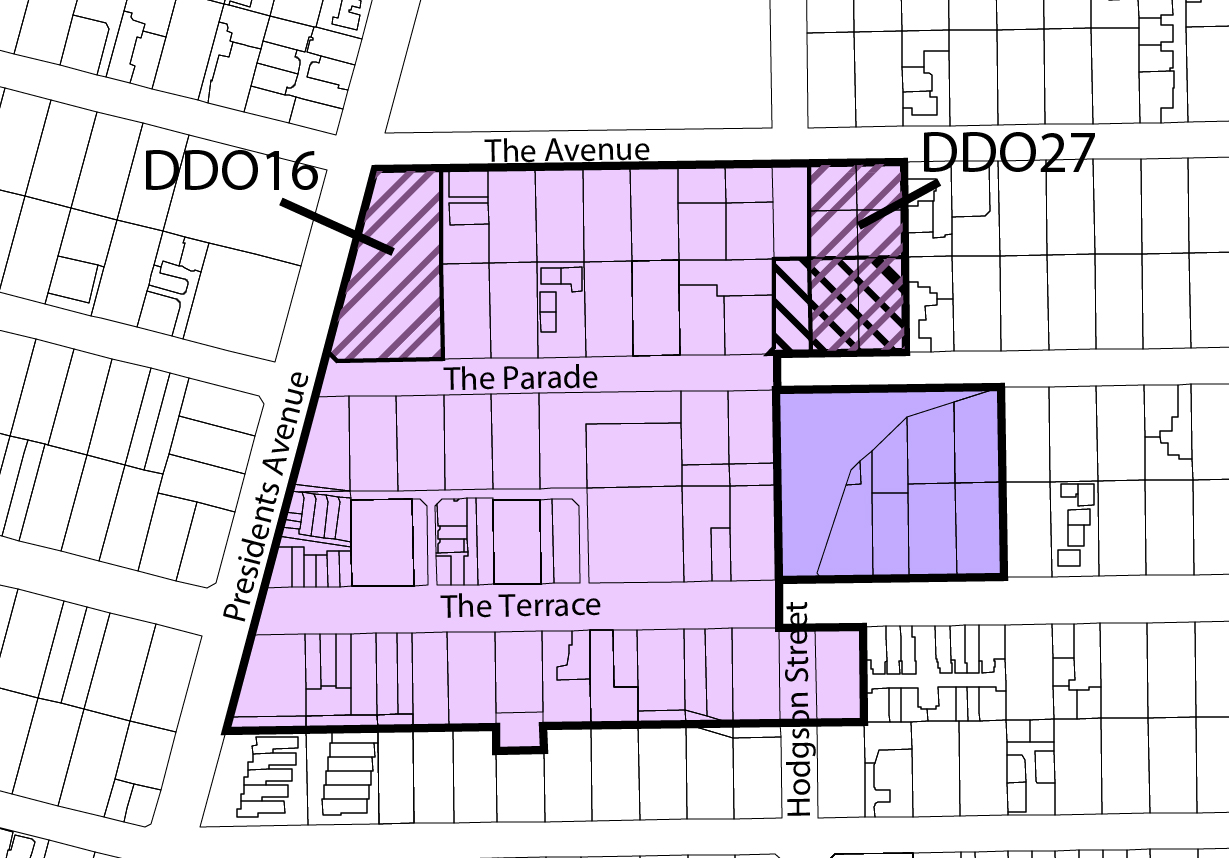
Portfolio: |
Finance - Cr Lyons (Mayor), Cr S Kontelj & Cr E Kontelj |
Source: |
Corporate Services - Financial Services |
A/General Manager: |
Michael Kelly |
Index Reference: |
Financial Management / Reporting |
The purpose of this report is to ensure legislative administrative matters are completed.
Council has contracted Westlink Consulting to undertake the 2014 general valuation.
To comply with the Valuation of Land Act 1960 certain administrative matters require noting by Council namely:
For Council to resolve that a general valuation be undertaken as the valuation authority responsible for the municipal area.
Advise every other rating authority within its area of Council’s resolution to cause a general valuation to be made.
Note the statutory declaration by the appointed Valuer that the valuation and return will be impartial and true.
Cr E Kontelj moved, Cr S Kontelj seconded -
That Council in accordance with the Valuations of Land Act 1960, as the valuation authority, resolves to:
undertake the 2014 General Valuation;
give the necessary notice to other statutory authorities, and;
note receipt of the Contract Valuer’s statutory declaration.
Cr Heagney left the meeting room at 8:54pm.
Carried.
Council is required under the Valuation of Land Act 1960 to conduct bi-annual valuations. The 2014 Revaluation will be the eighth since bi-annual valuations were introduced in 2000 by the Valuer-General Victoria. To date, five of the previous bi-annual valuations (2000, 2002, 2004, 2006, & 2008) for Council have been conducted by Southern Cross Property Services and Westlink Consulting have completed the 2010 & 2012 General Valuations.
Following the 2012 General Valuation, the Fire Services Property Act 2012 has been introduced with the requirement that Council, as the valuation authority for the municipality, also include all non-rateable leviable land (as defined by that Act) in its General Valuations.
The 2014 General Revaluation Contract C1300003 has been awarded to Westlink Consulting.
A tender report recommending Westlink was adopted by Council on 13 November 2012. Appointing Westlink does not fully satisfy all requirement under the Valuation of Land Act for undertaking Municipal Revaluations and this report is require to satisfy compliance requirements.
In accordance with the Valuation of Land Act 1960 certain administrative matters should be noted and recorded in the minutes of Council.
The valuation of land Act 1960, Section 11, 13 DC and 13H outlines Council’s obligations as a valuation and rating authority in regards to the conducting of general valuations of property and explains that a valuation authority, for the purposes of the Local Government Act 1989 and the Fire Services Property Levy Act 2012, must cause a valuation of all rateable land and non-rateable leviable land within its municipal district to be made as at 1 January of every even calendar year and returned to the valuation authority before 30 June in that year.
Section 6(1) of the Valuation of Land Act 1960 requires a rating authority to give to the Valuer-General Victoria, the State Revenue Office and every other rating authority within its area not less than one months’ notice of its resolution to cause such a general valuation to be made.
Section 13DH (2) of the Valuation of Land Act 1960 requires the appointed Valuer “to make a statutory declaration that the valuation and return will be impartial and true and to the best of that person’s judgement and will be made by that person or under that person’s immediate personal supervision”.
A copy of the Valuer’s declaration is provided in Attachment 1.
There are no environmental implications arising from this report..
The 2014 General Valuation including objections is to be conducted in accordance with Contract Number C09091 by Westlink Consulting.
Current approved budget.
Revaluation must comply with the Valuation of Land Act 1960, the Local Government Act 1989 and the Fire Services Property Levy Act 2012.
This report is aligned in Council’s City Plan objective on How We Do Business.
There is no officer direct or indirect interest involved in this report.
Compliance with statute negates any risks.
There are no social implications arising from this report.
There are no known positive or negative effects.
The Valuer-General Victoria, the State Revenue Office and the following neighbouring councils:
Surf Coast Shire Council
Wyndham City Council
Golden Plains Shire Council
Borough of Queenscliffe
Moorabool Shire Council
will be advised of Council’s resolution.
Portfolio: |
Infrastructure – Cr Ellis |
Source: |
City Services – Engineering Services |
General Manager: |
Gary Van Driel |
Index Reference: |
Subject: Drainage - Floods |
The purpose of this report is to present a revision to the flood mapping for existing conditions produced within the early stages of the development of the Armstrong Creek Urban Growth Plan (UGP).
The flood mapping is subject to a revision due to the subdivision and development at 45-67 Carter Road, Armstrong Creek. Prior to subdivision the parent lot was considered to be liable to flooding. This development site, achieves flood immunity for newly created lots for flood events up to and including the 100 year Average Recurrence Interval (ARI) event due to approved internal earthworks including the reshaping of Armstrong Creek.
The earthworks undertaken have resulted in the floodwaters from the 100 year ARI event being contained within the boundaries of the Armstrong Creek reserve.
Council has a statutory obligation under the Building Regulations 2006 to designate land as liable to flooding where it reasonably knows it to be prone to flooding. Conversely, there is an obligation to remove the encumbrance of designation from land that is no longer considered to be flood-prone.
It should be noted that designation is separate to the creation of flood overlays within the Planning Scheme, which generally follows designation. In the case of the Armstrong Creek UGP area, the planning scheme amendment to create post-development flood zones or overlays is proposed after the design of the proposed precincts.
The current designated flood mapping (refer to Appendix 1) was designated by Council at its meeting of 12 December 2006, under the provisions of the Building Regulations 2006. Designation of land as liable to flooding enables the control of floor levels for acceptable building permit applications, or refusal of consent to building applications where there is likely to be a danger to life, health or safety due to flooding. Designation also enables disclosure of flood status within statutory information certificates.
Cr Ellis moved, Cr Richards seconded -
That Council revoke the Council designation of 12 December 2006 of flood affected land as highlighted as 45-67 Carter Road on Armstrong Creek Urban Growth Plan Flood Map dated 29 November 2006 as liable to flooding pursuant to Regulation 802(2) of the Building Regulations 2006.
Carried.
Cr Heagney re-entered the meeting room at 8.56pm
As part of the development of the Armstrong Creek Urban Growth Plan (UGP) a flood study was undertaken by specialist consulting engineers to identify the extents of the 100 year Average Recurrence Interval flood event for existing conditions. Following a public exhibition phase, the resultant flood mapping (refer to Appendix 1) was designated by Council at its meeting of 12 December 2006, under the provisions of the Building Regulations 2006.
Designation of land as liable to flooding under Regulation 802 of the Building Regulations 2006 enables the control of floor levels for acceptable building permit applications, or refusal of consent to building applications where there is likely to be a danger to life, health or safety due to flooding. Designation also enables disclosure of flood status within statutory information certificates such as the Land Information Certificate and Building Information Request Form.
The subject of this report is the residential land at Armstrong Creek fronting Carter Road. Prior to subdivision the lot was used primarily as hobby farmland.
The current designated flood extent affects multiple residential lots within the Estate.
Overland flows that may occur within the subdivision during the 100 year ARI flood event are now contained within road and drainage reserves in accordance with accepted best practice for development within flood-prone areas. Best practice requires that any overland flows within residential areas satisfy public safety criteria with respect to velocity and depth of flow.
Council has a statutory obligation under the Building Regulations 2006 to designate land as liable to flooding where it reasonably knows it to be prone to flooding. Conversely, there is an obligation to remove the encumbrance of designation from land that is no longer considered to be flood-prone.
Appendix 1 shows the existing flood designation. Appendix 2 shows the change in flood mapping at 45-67 Carter, Armstrong Creek after construction of the subdivision.
The revocation of flood-prone areas designation and designation of revised flood data does not result in any known adverse environmental impacts.
The removal of a minimum floor level requirement for new dwellings may result in a minor reduction in energy and material usage during construction. In addition, concrete slab-on-ground construction, which is normally used for a non-elevated floor, achieves the minimum energy rating more readily than a timber floor on stumps.
The costs of proceeding to revoke the existing designation and to designate the revised flood mapping at 45-67 Carter Road, Armstrong Creek, in accordance with the requirements of the Building Regulations 2006, are provided for within the annual recurrent budget.
In revoking the Land Liable to Flooding (LLF) designation ensures that Council provides accurate and reliable information to its community, in line with Council’s City Plan of How We Do Business.
The City has various statutory responsibilities for drainage management and flood management (prevention, response and recovery) as set out in the Local Government Act 1989, Local Government Regulations 1990, Planning and Environment Act 1987, Building Regulations 2006, Water Act 1989, Subdivision Act 1988 and Emergency Management Act 1986.
Regulation 802(2) of the Building Regulations 2006 provides Council with the powers to ‘designate’ land liable to flooding. Regulation 802(3) provides that consent must be obtained from Council for an application to build on land liable to flooding.
Section 27 of the Interpretation of Legislation Act 1984 provides the power for Councils to ‘repeal or amend a subordinate instrument made in the exercise of that power’.
Section 807 of the Building Regulations 2006 requires Council to update the municipality’s designated special area maps at the Building Control Commission in the event of alterations to a designated special area. Designated special areas include areas designated as being liable to flooding.
Section 229 of the Local Government Act and Regulation 326 of the Building Regulations provide for the issue of information certificates containing prescribed information, including the flood status of properties.
The revised flood data for 45-67 Carter Road, Armstrong Creek will assist the City in meeting its statutory obligations with regard to flood data.
The revised flood data will also assist in fulfilling the recommendations of the Municipal Emergency Management Committee adopted by Council in November 1998 (i.e. mapping of 1 in 100 year flood levels).
There are no officer direct or indirect interests with respect to this report.
Council has a risk exposure through its statutory obligations under the Building Regulations 2006 to:
Designate land as liable to flooding where it reasonably knows it to be prone to flooding;
Specify minimum floor levels in consultation with the relevant floodplain management authority (CCMA); and
Refuse consent to building applications where there is likely to be a danger to life, health or safety due to flooding.
Council also has some risk exposure with any failure to disclose the flood-prone status of a property in a Land Information Certificate.
The designation of the flood data produced by the flood study Armstrong Creek UGP project is a key step toward minimising Council’s exposure to these risks.
Conversely, there is an obligation to remove the encumbrance of designation from land that is no longer considered to be flood-prone. Designation of land as being liable to flooding can result in extra construction costs and concerns regarding saleability, in some cases.
Council has a responsibility to the community to provide the best possible information on areas that are flood-prone.
We have taken into consideration all Human Rights as part of the drafting process of this report, none of which apply.
The current designation was undertaken following a public exhibition in October 2006 with notification of affected property owners. These owners were sent letters and fact sheets with an invitation for submissions.
A revocation of designation does not warrant public consultation as it constitutes the removal of an encumbrance on land.
The owners of properties affected by the revocation will be notified so they are aware that disclosure of flood status on a Section 32 Vendors Statement is no longer required.
Relevant Council databases and flood maps will be revised and updates sent to the Corangamite Catchment Management Authority and Building Control Commission.
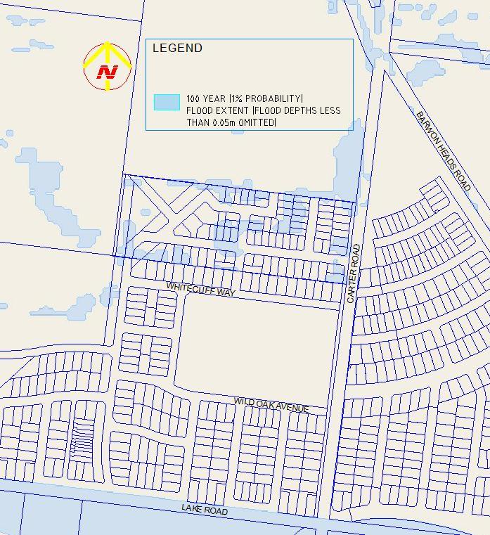
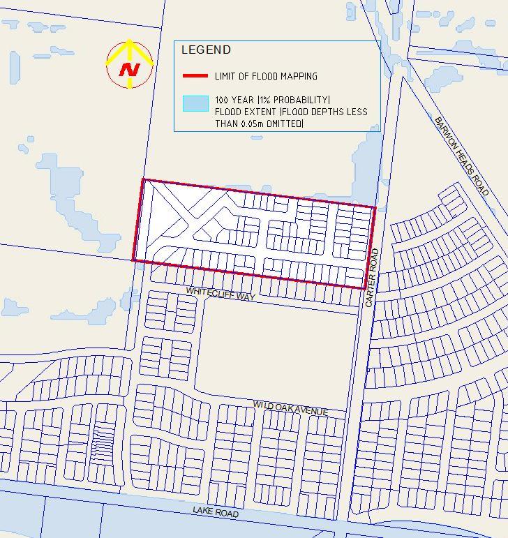
Portfolio: |
Environment and Sustainability - Cr Richards |
Source: |
City Services |
General Manager: |
Gary Van Driel |
Index Reference: |
Waste Management |
To seek Council’s support to nominate a substitute Councillor to the Barwon South West Waste and Resource Recovery Region Local Government Waste Forum.
Throughout 2013 the State Government, through the Minister for Environment and Climate Change, has been preparing for reforms to the governance of waste management with the preparation of the Getting Full Value - Victorian Waste and Resource Recovery Policy (VWRR Policy) and its associated documents, the Ministerial Advisory Committee Report (MAC Report) and the State Waste and Resource Recovery Infrastructure Plan (SWRRI Plan).
The MAC Report recommended the reduction of the number of regional waste management groups from thirteen to seven, including the retention of the Metropolitan Waste Management Group. This Council has been included in the Barwon South West Group.
These groups will be referred to as Waste and Resource Recovery Groups (WRR Groups) and each will be managed by a board of directors.
The MAC Report also recommended the establishment of Waste and Resource Recovery Region Local Government Waste Forums (Waste Forums), comprising of a councillor representative from each Council in a group, to provide for local government input to the boards of the WRR Groups.
At the Council meeting held on March 25th Council appointed Cr Richards as Council’s representative on the Barwon South West Region Local Government Waste Forum.
At the first meeting of the Local Government Waste Forum held on Tuesday 29th April Cr Richards was elected forum chairperson and was nominated as one of the four councillor representatives for consideration as appointments to the Barwon South West Region Waste and Resource Recovery Board.
Following advertisement of positions and selection the Minister will also recommend four independent and appropriately skilled persons for approval of the Governor in Council to also become directors of the region’s board.
At the first Barwon South West Local Government Waste Forum it was agreed that each Council would consider nominating a substitute Councillor to the forum to ensure support for meeting quorums.
Cr Richards moved, Cr Heagney seconded -
That Council endorse the appointment of Cr E Kontelj to the Barwon South West Waste and Resource Recovery Region Local Government Waste Forum for 2014/15 as the substitute representative for the Greater Geelong City Council.
Carried.
Throughout 2013 the State Government, through the Minister for Environment and Climate Change, has been preparing for reforms to the governance of waste management with the preparation of the Getting Full Value - Victorian Waste and Resource Recovery Policy (VWRR Policy) and its associated documents, the Ministerial Advisory Committee Report (MAC Report) and the State Waste and Resource Recovery Infrastructure Plan (SWRRI Plan).
The MAC Report recommended the reduction of the number of regional waste management groups from thirteen to seven, including the retention of the Metropolitan Waste Management Group. This Council is included in the Barwon South West Group.
The MAC Report also recommended the establishment of Regional Waste and Resource Recovery Region Local Government Waste Forums (Waste Forums), comprising of a councillor representative from each Council in a group, to provide for local government input to the boards of the WRR Groups.
Waste Forums would then nominate four council representatives to the Minister for recommendation of the Minister to the Governor in Council to become directors of that region’s board.
Following advertisement of positions and selection the Minister will recommend four independent and appropriately skilled persons for approval of the Governor in Council to also become directors of each region’s board.
Boards are to be established by 1 August 2014.
This structure is the same as that in existence since 2006 under the Melbourne Metropolitan Waste Management Group.
The functions of the WRR Groups within their region will be to:
plan for the future needs of waste and resource recovery infrastructure consistently with the State Waste and Resource Recovery Infrastructure Plan
facilitate the provision of waste and resource recovery infrastructure and services by councils
facilitate the development of contracts for the joint procurement of waste and resource recovery facilities and services
manage contracts
work with Sustainability Victoria, councils, businesses and communities to ensure that state wide waste and resource recovery education programs are adapted to the needs of their region and to deliver those education programs
advise Sustainability Victoria, councils and businesses on best practice and support the region’s Local Government Waste Forum, and to
undertake waste and resource recovery projects as funded by government, councils and other organisations.
The functions of the Waste Forums will be to:
nominate to the Minister the four persons who are to be the representatives of councils for the purpose of appointment as directors of the WRR Group boards
develop procedures for the nomination of these persons
be a conduit for consultation between the WRR Group and local government and for advice to WRR Group boards on matters and issues affecting the role of local governments in waste management and recovery.
The establishment of the Waste Forums is recognition of the ongoing role of local government in providing waste and resource recovery services.
With the release of the drafts of each of the VWRR Policy and its associated documents, the MAC Report and the SWRRI Plan documents, this Council has provided input that generally supported the directions proposed.
Cr Andy Richards, Cr Lindsay Ellis and Cr Eddy Kontelj are the current directors on the Barwon Regional Waste Management Group
At the Council meeting on March 25th Cr Richards was nominated as the City of Greater Geelong’s councillor representative to the forum.
The first meeting of the Barwon South West Region Local Government Forum was held in Camperdown on Tuesday 29th April 2014. At that meeting Cr Andy Richards was elected forum chairman for 2014-15 and was also nominated for consideration as a councillor representative on the Barwon South West Regional Waste and resource Recovery Group board.
The forum endorsed a set of operating guidelines and discussed the need for each Council to consider appointing a substitute Councillor to the forum to ensure smooth operation of the forum and ensure ongoing quorums for the meetings.
Regional waste management groups contribute to a better environment in Victoria by providing co ordination of the planning and development of waste and resource recovery infrastructure and services.
With the changes currently being legislated the continuing role of these groups is dependent upon the nomination of local government representatives to the Waste Forums.
There are no financial implications as a result of the recommendation in this report. Council does support the existing Regional Waste Management Group with project funding support of $96,000 per annum.
The recommendation in this report provides for Council to comply with State Government legislation.
Support our community to live sustainably: Leading the way in waste management practices and continue to reduce the amount of waste to landfill.
Sustainable Built and Natural Environment: Partnering with our community to protect and enhance our natural ecosystems as well as encouraging reduced resource consumption.
No Council officers involved in the preparation of this report has a direct or indirect interest in the matter to which the report relates.
There are no assessed risks resulting from the recommendation in this report.
There are no social considerations resulting from the recommendation in this report.
There are no human rights charter issues resulting from the recommendation in this report.
There are no consultation and communication outcomes resulting from the recommendation in this report.
Portfolio: |
Tourism and Major Events – Cr R Nelson |
Source: |
Projects, Recreation and Central Geelong - Events, Central Geelong & Waterfront |
|
Act/General Manager: |
Paul Jane |
Index Reference: |
Subject: Events / Geelong Major Events |
As per Clause 4.7 of the Geelong Major Events (GME) Terms of Reference, update reports from the GME Committee will be presented to Council each quarter or half-year during the financial year.
Council established the Geelong Major Events (GME) committee in August 1998 pursuant to Section 86 of the Local Government Act.
GME strives to stimulate and encourage major events that offer the best opportunity to provide measurable economic benefits, potential to market Geelong outside the municipality and enhance local community life through participation of resident;
GME support the development and improvement of hallmark, major and developing events whilst focusing its activities on a clearly defined strategic program;
GME has established and maintains strong links with the private sector, government and our communities to achieve high levels of stakeholder investment and activity required to realise the events potential of Geelong;
Major Events have a diverse and varied environmental legacy and the events staged within this period implemented a range of programs to minimise impacts where required and provide positive outcomes where possible. Council works closely with event organisers to ensure best practices in this regard are achieved at major events staged within our region.
This report provides an overview of GME activities for the period January 1 to March 31 2014 which included:
17 major events successfully hosted in the Geelong Region including the Festival of Sails, Melges 24 Sailing World Championships, Victorian Open Golf Championships, Asian Cup Soccer Qualifier, Head of the Schoolgirls Regatta and Motor City Music Festival.
Those events stimulated economic activity and provided social benefits to our community. Approximately $35.5million of event expenditure was generated in our region from local and non local sources which is the equivalent of 284 full time jobs in the region.
Those events provided additional social benefits for the local community through participation and spectator opportunities with a number of our major events offering free public access and entertainment for all ages. More than 290,000 spectators attended the 17 events staged in the three months ending 31 March 2014.
Cr Nelson moved, Cr E Kontelj seconded -
That Council notes the report detailing the activities of Geelong Major Events for the January 1 – 31 March 2014 period.
Cr Macdonald left the meeting room at 8:59pm.
Cr Macdonald re-entered the meeting room at 9:01pm.
Cr Farrell left the meeting room at 9:02pm.
Cr Farrell re-entered the meeting room at 9:04pm.
Carried.
Council, in August 1998, established a Section 86 Committee under the provisions of the Local Government Act known as Geelong Major Events (GME) as a means of stimulating and encouraging events within the municipality.
In line with the Geelong Major Events Terms of Reference, an annual report will be presented to Council at the conclusion of the financial year. This report provides an update on the activities supported by GME for the period 1 January to 31 March 2014
Meetings
GME convened three ordinary meetings in the period between 1 January 2013 and 31 March 2014.
Meetings are currently scheduled for the third Monday of each month commencing at 4.00pm, held at City Hall. GME meetings are open to the public.
Details of major events staged during the period
Event Title |
Date |
Funding amount |
Estimated Economic Benefit |
|
Mitchelton Bay Cycling Classic |
Jan 2-4 |
$35,000 |
$2.3million |
|
Festival of Sails |
Jan 25-27 |
$174,891 |
$14.5million |
|
Melges 24 Sailing World Championships |
Jan 29 - 2 Feb |
$30,000 |
$850k |
|
Great Australian Beer Festival |
Feb 1 |
$10,000 |
$661k |
|
Jayco Herald Sun Tour |
Feb 6 |
$10,000 |
$324k |
|
Super Rugby - Melbourne Rebels @ Simonds Stadium |
Feb 8 |
$15,000 |
$507k |
|
Geelong Multi-Sport Festival (incorp. Ironman 70.3) |
Feb 7-9 |
$150,000 |
$2.37million |
|
**Asian Cup Soccer Qualifier @ Simonds Stadium |
Feb 15 |
$nil |
$859k |
|
*Australian Open Water Junior Swimming Championships |
Feb 14-16 |
$15,000 |
$1million |
|
Victorian Open Golf Championships |
Feb 17-23 |
$70,000 |
$1.95million |
|
*Pako Festa |
Feb 22 |
$60,000 |
$4.9million |
|
Geelong Highland Gathering |
Mar 1-2 |
$15,000 |
$319k |
|
*Wooden Boat Festival |
Mar 8-9 |
$8,000 |
$1.2million |
|
*Motor City Music Festival |
Mar 7-9 |
$45,000 |
$906k |
|
Victorian Lifesaving Championships |
Mar 15 - 16 |
$10,000 |
$446k |
|
*Head of the Schoolgirls Regatta |
Mar 15 - 16 |
$20,000 |
$2million |
|
*Sanitarium Weet-Bix Kids TRYathlon |
Mar 16 |
$5,000 |
$450k |
* The Final post event evaluation has not been completed for this event, therefore the pre-event estimated economic benefits has been used for this report.
** Underwriting of $30,000 was committed for this event. The event was profitable and therefore did not claim the underwriting.
Details of GME funding decisions for the period
Event Title |
Date |
Funding amount |
|
Word 4 Word Writers Festival |
2014 - 2015 |
$50,000 – Year 1 |
|
Geelong Revival (Motorsport) event |
2014 - 2016 |
$130,000 – Year 1 |
|
Extravaganza Food & Wine Festival |
2014 |
$5,000 |
|
Ironman 70.3 |
2015 - 2017 |
$150,000 – Year 1 |
GME has adopted a methodology for assessing event funding applications and event evaluations. This methodology measures the triple bottom line effect; Economic Impact, Social Impact and Environmental Impact.
Each GME funding application is assessed according to the methodology and a value is attributed to the perceived environmental benefit relative to the environmental impacts associated with the event.
Considerations of positive and negative impact include energy usage, and use of renewable sources, water usage, waste and or recycling generated, traffic congestion, use of non-powered transport options, pollution, destruction or damage to natural environments, event legacies of new or reinvigorated nature and resources.
The environmental impact for each event is assessed and where appropriate actions are identified to protect the environment.
Given the nature of events and the variety of events staged within the Geelong region via GME support, some are environmentally friendly while others manage the environmental impacts as well as possible.
The City plays a leading role in working with external agencies and event organisers to ensure that environmental implications are appropriately managed.
Where practicable, event organisers are encouraged or incentivised to implement a variety of environmentally positive programs such as waste-wise and carbon offsets.
The events staged in this period implemented a range of programs to minimise their environmental impacts and to proactively provide positive legacies from their events. They included shuttle bus services to minimise traffic to and from the event, the use of recycled water for filling of traffic barriers and a carbon neutral tree planting program.
The funding commitments of $335,000 for the 2014/2015 year that were approved during the period are within the allocated GME budget.
The Event Expenditure estimated to be generated by the seventeen events staged during the period January 1 2014 to March 31 2014 is estimated to be $35.5million. This event expenditure is estimated to support the equivalent of 284* full-time jobs in Greater Geelong.
*EFT calculation is based on GOT accepted methodology and sourced from the Tourism Research & Impact Assessment for the Geelong Otway Region, Feb 2007.
In supporting major events contractual relationships are entered into generally based on a standard contracted prepared by the City’s solicitors.
In the City Plan 2013-2017, Council has identified Growing Our Economy as one of its four key strategic objectives. City Plan tells us that one of the important priorities in this area is to see Greater Geelong as a leading city for tourism, arts, culture and events. The GME Strategy is identified in City Plan as being a key strategy that will assist Council in delivering Growing Our Economy priorities.
In addition, City Plan identifies its key partnerships in this area as including events related groups such as Victorian Major Events Company, Victorian Events Industry Council, along with event owners and operators. These key relationships are maintained and enhanced through the actions of the GME
Nil.
The management of risks associated with events is an important aspect to protect the community and the City’s assets. Particular attention is undertaken to identify potential risks with each event and ensure that the appropriate risk management treatments are in place.
All high risk major events are required to present event plans to the Events Multi Agency Working Group, coordinated via the City’s Events Services Unit. Feedback and advice is given to event organisers from the represented agencies and stakeholders on the working group.
The expertise within the City’s Risk Management Business Unit is drawn upon to support events as and when required.
GME make a significant contribution to the social, environmental and economic well being of the community. The major events often provide a legacy for future events and community use such as redeveloped or newly constructed infrastructure.
The events staged within this period provided social benefits for the local community through participation and spectator opportunities with 11 of these major events offering free public access and entertainment for all ages.
The Pako Festa and Festival of Sails were, in particular, celebrations of Geelong’s culture and were staged strategically in open public spaces to provide free, family entertainment and activity that is accessible for all.
An estimated 290,000 spectators attended the 17 events staged in the three months ending 31 March 2014.
Some major events include road closures to allow for the safe delivery of an activity on road or restrict community access to public areas for limited periods of time.
An individual’s right to freely and securely participate in an event without the risk of injury to themselves or spectators is given the highest priority. Public events provide significant benefits to the community and major events also provide significant economic benefit.
Strategies are in place to reduce the negative impact while enhancing the positive benefits to our community.
It is considered that any short-term negative impacts encountered by the hosting of these major events are justified and that all reasonable strategies have been put in place to mitigate or minimise the negative impacts wherever.
The achievements of Council and GME in supporting events and the associated benefits provided to Geelong are communicated via a range of mediums.
Portfolio: |
Tourism & Major Events – Cr Nelson |
Source: |
Projects, Recreation and Central Geelong / Events, Central Geelong & Waterfront |
|
Act/General Manager: |
Paul Jane |
Index Reference: |
Subject: Events / Geelong Major Events |
The purpose of this report is to have Council appoint two external representatives to the Geelong Major Events (GME) Committee.
GME Committee was established as a Council Advisory Committee in 1998, and formalised under Section 86 of the Local Government Act 1989 in October 1999.
GME Committee has overseen the procurement and successful hosting in Geelong of a range of national and international major events, in addition to guiding the development and ongoing support of various locally grown major events.
The major events supported by GME each year stimulate substantial economic activity within the municipality (estimated to be over $30 million each year which supports the equivalent of more than 280 full-time jobs) and provide social links within our community.
There are a maximum of ten positions on the GME Committee. External members comprise four of those positions.
Ms Merrigan resigned from the GME Committee in March 2014 and Mr Spangler will complete his four year term in June 2014 resulting in two vacant external member committee positions.
Following public advertisements, twelve (12) applications were received. A selection panel (including the GME Chair, the Acting Chief Executive Officer and an incumbent external committee member) reviewed applications and make a recommendation to Council regarding the appointment of two external committee members.
Cr Nelson moved, Cr Fisher seconded -
That Council:
appoint Ms McClusky and Mr Morris as external representatives to the Geelong Major Events Committee for a four-year term concluding June 2018;
thank Mr Spangler and Ms Merrigan for their participation on the Geelong Major Events Committee.
Carried.
GME Committee was established as a Council Advisory Committee in 1998 and formalised under Section 86 of the Local Government Act 1989 in October 1999. The GME Committee Terms of Reference provide that the committee has been formed to coordinate the attraction, support and funding of major events on behalf of the City.
GME Committee Terms of Reference also provides for the appointment of four external representatives from the business/media/arts or events community for a term of up to four years. In addition to the external representation, the GME Committee membership includes:
The Mayor and up to three other councillors appointed by Council
The Chief Executive Officer
The Executive Director of Geelong Otway Tourism (Tourism Greater Geelong and The Bellarine)
Ms Merrigan resigned from the GME Committee in March 2014 creating the first vacant position. Mr Spangler will complete his four year term in June 2014 resulting in the second vacant external member committee position.
Incumbent applicants are required to reapply should they seek a further term on the Committee. Ian Spangler did not reapply for a further term
The term of the vacant positions will be July 2014 to June 2018.
Following the advertisements communicating the requirement to fill the vacant external representative positions on GME Committee, twelve (12) applications were received in total.
External representation on GME Committee is considered to be essential as it enables the committee to draw upon expertise and networks beyond Council. Specifically, experience relevant to the business, arts, events or media communities are seen as important.
All applications were reviewed by the selection panel consisting of the Chair of GME Committee, Acting Chief Executive Officer and incumbent external member Ms Stefanoff. After careful consideration, the panel determined that Ms McClusky and Mr Morris would best bring the required experience and specialist expertise to GME Committee.
Ms McClusky has significant media, business and board experience. Mr Morris has strong business and sporting sector experience at a national and international level. Both applicants demonstrated their ability to harness broad ranging strategic networks to support the objectives of GME.
There are no environmental implications arising from this report.
There are no financial implications arising from this report as no remuneration is paid to external representative positions on GME Committee.
There is no policy, legal or statutory implications arising from this report. The appointment process is within the framework of the GME Terms of Reference and the Council Instrument of Delegation to GME.
In the City Plan 2013-2017, Council has identified Growing Our Economy as one of its four key strategic objectives. City Plan tells us that one of the important priorities in this area is to see Greater Geelong as a leading city for tourism, arts, culture and events. The GME Strategy is identified in City Plan as being a key strategy that will assist Council in delivering Growing Our Economy priorities.
In addition, City Plan identifies its key partnerships in this area as including events related groups such as Victorian Major Events Company, Victorian Events Industry Council, along with event owners and operators. These key relationships are maintained and enhanced through the actions of the GME committee.
No officer involved in the preparation of this report has any direct or indirect interest.
Staggered appointment durations were established in 2008 to minimise the risk of losing extensive expertise from the Committee at one time. Two incumbent external members have terms expiring in 2016 and the two newest appointed external members will have terms expiring in 2018.
External representatives are fully briefed on their role on GME Committee thereby ensuring that they each understand their roles and responsibilities. Information is also provided to external representatives regarding their obligations regarding declarations of Direct or Indirect Interest.
The inclusion of external representatives on GME Committee supports and enhances the social benefit that events bring to the community.
There are no human rights implications arising from this report.
The appointment of two new external representatives to the GME Committee will be communicated to key stakeholders and the media. The unsuccessful candidates are notified in writing, thanking them for their application and interest in the GME committee.
Portfolio: |
Arts & Culture - Cr Richards |
Source: |
Community Services |
|
General Manager: |
Jenny McMahon |
Index Reference: |
Subject: Arts & Culture |
The purpose of this report to provide Council with the Geelong Gallery’s 2012-2013 Evaluation Report - Appendix 1 and the Gallery’s 2012-2013 Annual Report - Appendix 2 (previously provided with briefing papers).
The Geelong Gallery’s collection of historical and contemporary art is widely acknowledged as one of the finest and most valuable held by a regional gallery in Australia. The Gallery continues to provide the region’s residents and visitors with outstanding exhibition, public and educational programmes as well as curatorial services.
In 2012-2013 Council’s contribution to the Geelong Gallery was $997,000 representing the final year of the fourth Triennial Funding agreement between the Greater Geelong City Council and Geelong Gallery.
The Gallery’s collection of works of art is held in trust for the region and is managed and developed in accordance with international standards of museum practice and includes iconic works of art such as View of Geelong by Eugene Von Guerard and Bush Burial by Frederick McCubbin.
A total of 67,637 visits were made to the Gallery throughout 2012-2013, an increase of 4,035 from the previous 2011-2012 year.
The highlights for 2012-2013 included the outstanding exhibition Impressions of Geelong – a portrait of the city and its region that inspired visitors by way of a visual documentation of the story of colonial and early modern Geelong. Geelong’s presence was featured in the Australian Impressionists in France exhibition at the National Gallery of Victoria (Federation Square) and internationally in the monumental Australia exhibition at the Royal Academy in London where paintings by Fred Williams and Frederick McCubbin from Geelong Gallery were on view.
Cr Richards moved, Cr Heagney seconded -
That Council note the Geelong Gallery 2012-2013 Annual Report and the 2012-2013 Evaluation Report.
Carried.
The Geelong Gallery’s collection of works of art is held in trust for the Region and is managed and developed in accordance with international standards of museum practice. The Gallery’s holdings of historical and contemporary art are widely acknowledged as one of the finest and most valuable collections held by a regional gallery in Australia. The Gallery’s collection includes iconic works of art such as View of Geelong by Eugene Von Guerard, Ocean Blue, Lorne by Arthur Streeton and A Bush Burial by Frederick McCubbin.
The Geelong Gallery is open to the public seven days a week and entry is free. The Gallery presents art exhibitions, educational and public programmes and curatorial services to the residents of and visitors to the Region.
This evaluation report covers 2012-2013 which is the final year of the fourth Triennial Funding Agreement between the Geelong Gallery and the City of Greater Geelong.
As part of the Agreement, KPI’s are set for the Gallery’s annual performance. Most were met or exceeded in 2012-2013 and have been summarised below:
67,637 visited the Gallery – annual target 60,000
2,321 memberships – annual target 2,250
23 exhibitions were mounted in total – agreed target 20
19 exhibitions were self initiated – agreed target 10
7 exhibitions were held in the Community Access Gallery – agreed target 7
8 exhibitions embraced subjects relating to local/regional history and featured work by artists active in the Geelong region – agreed target 8
37 lectures, seminars, and workshops were presented – agreed target 30
20 public programmes were presented – agreed target 16
4 access space exhibitions involving schools and community groups were presented – agreed target 4
25,000 Quarterly Newsletters were distributed – agreed target 27,000
Exhibition highlights for 2012-2013 include:
Impressions of Geelong – a portrait of the city and its region in which famous and less well known paintings, watercolours, prints and photographs inspired visitors by way of a visual documentation of colonial and early modern Geelong.
A curious nature – the landscape as theatre in contemporary photography and new media as well as the major monographic exhibition – the fabric of work by internationally renowned Adelaide based glass artist, Nicholas Mount.
Geelong Gallery works of art were exhibited in the Australian Impressionists in France exhibition at the National Gallery of Victoria - Federation Square, and in the monumental Australia exhibition at the Royal Academy in London from September 2012, where paintings by Fred Williams and Frederick McCubbin were on view.
In June 2013, the Hon. Heidi Victoria MP, Minister for the Arts officially launched the major publication Geelong Gallery – Collections which features some 200 reproductions of Australian and international paintings, works on paper, sculpture and decorative arts along with examples of new media and imagery of Geelong. This publication produced by Adams Print has been awarded the Gold Medal for a major publication by the print industry.
The Gallery was able to secure Theodore Hine’s1878 painting Landscape with figures by a lake through the Australian Governments Cultural gifts program. The Gallery also secured a rare and fine watercolour (dated 1847) of Station Peak and the You Yangs by the famous surveyor and amateur artist Robert Hoddle, which featured in the Impressions of Geelong exhibition,
The Gallery collaborated with various local and Victorian bodies throughout the 2012/2013 year to present exhibitions, education workshops, share knowledge and cross-promote programs including work with Courthouse Youth Arts Centre, Deakin University Waterfront and Burwood Campuses, Geelong Heritage Centre, Geelong regional Library Corporation, Geelong Performing Arts Centre, National Wool Museum, National Gallery of Victoria, State Library of Victoria and University of Melbourne.
During the 2012/2013 year the Gallery was visited by 131 educational establishments with the highest proportion of these being Secondary schools at 66% of total visits. 16 Primary schools and pre-schools visited the Gallery as well as 6 Tertiary and other intuitions. Gallery staff also presented four professional development seminars for teachers covering feature Gallery exhibitions during the year.
The Geelong Gallery is a purpose built gallery designed to make the most of natural light, while keeping within international environment standards for museums. The Triennial funding agreement between Council and the Gallery includes clauses relating to maintenance of the building which enables the Gallery to benefit from contractors already engaged by Council who are encouraged to meet environmentally responsible principles where possible.
The Gallery is investigating a range of more sustainable options for ongoing operation including replacement of current display lighting as funding permits.
The City of Greater Geelong is the Gallery’s largest funding partner. Council makes an annual contribution to the Gallery in accordance with the Triennial Funding Agreement. In 2012/2013 Council’s contribution in the final year of the fourth Triennial Funding Agreement was $997,000.
Maintenance of the Geelong Gallery Building forms part of the Triennial Funding Agreement with request referred to and managed by the Property Department. Additional funding for replacement of major plant and ongoing maintenance are considered separately and form part of Council’s annual budgetary considerations. As a Council asset, the Gallery facility is depreciated through Council’s accounting system.
LBW Chartered Accountants have completed their audit of the Gallery’s financial position for 2012/2013 and have given the Gallery a positive assessment.
The Geelong Art Gallery is located on Crown Land with a lease period of 999 years due to expire on the 16th June 2854. The Building is a Council asset, operated by the Geelong Art Gallery Incorporated, as a body associated for artistic and cultural purposes. The Board is composed of 12 persons, elected each year at the Annual General Meeting.
The Board operates under a Charter. Councillor Barbara Abley was Council’s representative on the Geelong Gallery Board from July to October 2012. Councillor Michelle Heagney, Portfolio Holder for Arts & Culture was Council’s representative on the Geelong Gallery Board from October 2012 for the remainder of the 2012/2013 year.
Although not a document intended to create legal relations between the partners, there is a Memorandum of Understanding under the State Government’s Local Partnerships programme between Arts Victoria, City of Greater Geelong and Geelong Art Gallery Incorporated, to support the annual programmes and operations of the Gallery.
The Geelong Gallery is an important cultural facility, which assists the City of Greater Geelong to deliver the actions outlined in Council’s Culture Strategy Creativity +, as well as the Strategy’s Vision: to develop the City of Greater Geelong as a regional centre of innovation and excellence. The Gallery is one of the key Cultural Precinct facilities identified in the Geelong Future Cities Master plan.
The annual operation of the Geelong Gallery supports City Plan Strategic Directions and Priorities:
Community Wellbeing
Connected, creative and string communities
Growing our Economy
A successful and vibrant City Centre;
A leading city for tourism, arts, culture and events.
There is no direct or indirect interest by Council Officers involved in the preparation of this report.
The 2012/2013 Financial Statements of the Geelong Gallery have been subject to an independent Financial Audit by LBW Chartered Accountants.
The Triennial Agreement and six month reporting and evaluation measures against KPI’s ensure the Gallery’s performance is regularly reviewed and assessed.
On order to safeguard to Collection on behalf of the Geelong community, the Gallery needs to implement proper security measures and acquire an appropriate level of insurance.
The Gallery has an outstanding reputation as a leading regional gallery to maintain. To do so it must be able to continue develop its educational/public programmes and activities.
The Gallery’s collection of works of art is held in trust for the region’s community at large and is managed and developed in accordance with international standards of museum practice.
Galleries play a significant role in the cultural, social, educational and economic development of the community. The Geelong Gallery plays an important role in the collection, conservation and exhibition of the Region’s material heritage as expressed in works of art. The reputation of the Gallery, as one of the finest regional galleries in Australia, is a source of civic pride. The Galleries exhibitions, educational and public programmes as well as curatorial services, are highly valued cultural resources.
The opportunities that the Gallery provides for our emerging and established artists are crucial to the Region’s cultural development. The Gallery contributes to the amenity and attraction of Central Geelong and, as one of the City’s major cultural attractions in the Cultural Precinct, contributes significantly to cultural tourism.
The Geelong Gallery is an important cultural facility, which assists the City of Greater Geelong to deliver the actions outlined in Council’s current Culture Strategy Creativity +, as well as the Strategy’s Vision: to develop the City of Greater Geelong as a regional centre of innovation and excellence.
The Geelong Gallery respects and provides access for all visitors. It presents artists from a diversity of cultural, linguistic, ethnic and religious diversity respecting the right to express all aspects of the human experience.
The Arts & Culture Department in consultation with Communication and Marketing Unit will be responsible for communicating this report.
Portfolio: |
Arts & Culture - Cr Richards |
Source: |
Community Services |
General Manager: |
Jenny McMahon |
Index Reference: |
Subject: Arts & Culture/Bellarine Multi Arts - Potato Shed |
The purpose of this report is to provide Council with information relating to the Potato Shed’s activities over the 2012/2013 period.
The Potato Shed is a multi-arts venue: it presents performing arts, art exhibitions, educational and public programmes to residents and visitors to the Bellarine. Council, Bellarine Secondary College and St Ignatius College Geelong all make annual contributions to the operation of the Potato Shed based on a Joint Use Agreement.
The Potato Shed continued to experience a high level of community demand in 2012/2013. It operated close to capacity and was not able to accommodate all bookings. Over the last twelve years of operation it has experienced a steady increase in visitation rates.
A total of 118,601 visits were made to the Potato Shed in 2012/2013. This represents an overall increase of 5,800 visitors through the doors.
Diverse community engagement activities in 2012/2013 included 78 theatre, dance and music performances, five all-age music events and two youth art festivals. A number of original works were presented, along with multiple forums, seminars and workshops, and weekly classes in dance, drama and music. (Appendix 1, Potato Shed Highlights).
School visitor numbers again increased by over 5,000 in the 2012/2013 year recorded at 57,116, representing an increase in use by both partner schools, with a diverse curriculum of classes and activities in all parts of the venue, as well as special productions, events and exams.
Achievements for 2012/2013 included the culmination of the “Elements” Subscription Season in 2012, and first half of the “Class of 2013” Season. The latter featured a diverse array of performances, dance works and original productions. This included high profile touring product from Hit Productions, Regional Arts Victoria, 6PAC and prominent independent presenters.
Other highlights included a sell-out Morning Showtime series, attendances of 4,000 at the 2012 Family Fun Day, up 500 on previous years, and Children’s Week Prep Workshops, which attracted participation of most primary schools on the Bellarine.
The key challenge facing the venue continued to be managing the needs and expectations of the schools, hirers and community groups increasing demand.
Cr Farrell moved, Cr Richards seconded -
That Council note the report.
Carried.
The Potato Shed was built as a joint venture by the City of Greater Geelong, Bellarine Secondary College and St Ignatius College Geelong (formally Catholic Regional College) with the State Government providing additional funding from the Community Support Fund. Council established a Committee of Management under Section 86 of the Local Government Act, and a Development and Joint Use Agreement was signed. The venue opened on March 15th 2001.
A total of 118,601 visits were made to the Potato Shed in 2012/13. General Public attendance totalled 61,485, and school attendances 57,116.
Throughout the 2012/13 period the Potato Shed once again experienced a high level of community demand. The Potato Shed operated to near capacity, seven days a week, 14 hours a day, and was not able to accommodate all bookings. The key challenge facing the venue was managing the needs and expectations of the schools, hirers and community groups increasing demand.
Programme highlights over 2012/13 included several sell out performances including international sensation Moira Finucane with Caravan Burlesque, the smash hit “Diving for Pearls” and the award wining “Its My Party” (and I’ll Die if I Want To). Audiences were delighted at seeing Australian entertainment legend John Wood in The Club along with a host of established actors live on stage locally. Australian Musical icon Deborah Conway returned with her regional album launch for “Ghosts”. The popular Morning Showtime Season featured regular local performers from Drop of A Hat productions along with Christine Middleton and renowned Shift Theatre with the beautiful work, “Girls in Grey”.
A number of new original works were presented over this period, including a self-devised new work “MUSE” by innovative dance group Collision. Potato Shed also hosted “12x12”, highlighting twelve new short plays presented to sell out crowds. Local company Theatre 3triple2 presented new productions by local emerging writers, as well as a weekend of one-act plays at the Winter Solstice Festival.
Other highlights included the ongoing successes of Crash Course Productions (CCP) with all-age events. CCP is an award-winning youth-operated production group which comprise members aged between 14 and 24 years. They stage fully supervised and strictly smoke, drug and alcohol-free events for youth of Geelong and the Bellarine Peninsula. CCP have become a positive model for other youth groups.
Aside from one-off events, a snapshot of regular weekly bookings reveals an impressive array of community usage which included: multiple ballet classes; martial arts classes; a range of contemporary dance classes; regular rehearsals for amateur theatre companies; significant community engagement workshops; youth focused activities and band practices. These activities were all conducted within the facility outside school hours and were in addition to school use during Monday to Friday class times. (See Appendix 1 – Potato Shed Highlights).
The Shed has also played host to a number of key events and non-theatre related activities, hosting four conferences and events over this period. People of all abilities are welcomed and encouraged to participate in all the activities at the venue and view performances and events.
User satisfaction was still high in spite of capacity usage. However as the venue operates at near capacity there was very little scope for the inclusion of new groups and activities. As the community grows, along with the interest in the venue, some groups may need to find larger spaces to accommodate their needs. The Schools also are growing in numbers and the size of the facility will not be able to cope with any extra classes or workshops.
An accredited Waste Wise process was implemented in 2008 and continues successfully. The Potato Shed encouraged all users and hirers to be waste wise and banned the use of all polystyrene products in the venue. LED lighting has been installed in the Foyer, Hallways and Toilets which reducing the heat generated and is a substantial reduction in electricity use.
There are no financial implications to this report. The Potato Shed has operated with budget allocation.
The Potato Shed is subject to the terms and conditions of a Joint Use Agreement between the City of Greater Geelong, Bellarine Secondary College School Council and The Roman Catholic Trusts Corporation for the Diocese of Melbourne. Under this agreement a formula dictates all parties’ contribution to the daily operation of the facility.
Council’s contribution to the operation of the Potato Shed in 2012/2013 was $168,914 with an additional $28,630 allocated to capital and building maintenance. In addition to Council’s contribution, Bellarine Secondary College and St Ignatius College Geelong contributed $57,443 to the operating costs and an additional $17,577 towards capital and building maintenance.
The above operational costs do not include building maintenance or depreciation.
Through a series of resolutions dating back to 1997, Council agreed to participate as a joint venture partner with Bellarine Secondary College and the Roman Catholic Trusts Corporation for the Diocese of Melbourne (representing St Ignatius College Geelong) in the development of the multi-arts facility at the Bellarine Sub-Regional Centre, Drysdale, known as the Potato Shed. The Potato Shed is an important community cultural facility, particularly to the Bellarine Peninsula community.
The Potato Shed aligns well with many of the ideals of the City Plan, promoting Community Wellbeing with participation in the Arts, Sustainability and Environmental initiatives through waste wise and energy saving measures.
Cr. Jan Farrell (Chair) was the nominated Council representative on the Potato Shed Committee of Management in the 2012/2013 financial year.
There is no direct or indirect interest by Council Officers involved in the preparation of this report.
The Potato Shed has obligations under OH&S legislation to provide appropriate equipment and training for manual handling and to ensure that work stations meet Worksafe requirements.
The Potato Shed consistently operated close to capacity. The steady increase in visitation rates presented some risk challenges managing the needs and expectations of the schools, hirers and community groups high level of usage raising the issue of sustainability of the venue.
In 2012/2013 the Potato Shed again provided a valuable resource for the Bellarine. The multi-purpose nature of the venue means the Potato Shed played a significant role in the cultural, social and educational development of the community. The venue has a reputation as an affordable and accessible community resource.
The Potato Shed embraced diversity and encouraged participation from all sectors of the community and was a vital hub of arts, social and educational activity for people of all ages and abilities on the Bellarine. The venue’s resident groups often collaborate to create positive outcomes within the community.
Collision Dance, Crash Course Productions, Bellarine Jongleurs and Theatre 3triple2 are all excellent examples of how the Potato Shed functioned as a model for social inclusion, providing independent ways for school students (outside of school hours) and other young people to benefit from the venue.
Family Fun Day and Children’s Week Prep Workshops formed an important part of the cultural life on the Bellarine Peninsula.
The partnership model between Council and two Secondary schools is widely admired, with other local governments and schools periodically visiting to learn from this successful experience.
The Potato Shed promotes cultural diversity and cultural acceptance and is a vital hub of arts, social and educational activity for people of all ages and abilities on the Bellarine.
The Potato Shed plays a significant role in the cultural, social and educational development of the community. The venue has a reputation as being a valuable, affordable and accessible community resource. Community members gain a sense of belonging when they engage with the Potato Shed. Most users and participants are involved in planning and development of the venue with meetings and questionnaires. The Venue frequently surveys audiences and the broader community to understand the changing needs. Communication is abundant via CoGG Marketing, Facebook, Web presence and via local media organisations.
|
Portfolio |
Governance – Cr Lyons (Mayor) |
|
Source |
Corporate Services - Customer Service |
|
A/General Manager |
Michael Kelly |
|
Index Reference |
EMT Issues/Council Reports |
Purpose
This report focuses on opportunities for change in the way services are delivered at face-to-face customer service centres in response to the recent Financial Sustainability Review.
The face-to-face customer service function is currently provided from eight customer service centres
The current model of face-to-face customer service provision is the highest compared to the provision adopted by benchmarked councils.
The Financial Sustainability Review and the 2009 ASR Research review of face-to-face customer service that there are opportunities for efficiencies and more effective modes of service delivery
Cr Farrell moved, Cr Ellis seconded –
That consideration of the report be deferred.
Lost.
Cr E Kontelj moved, Cr S Kontelj seconded -
That Council endorse the development of a more effective and efficient model for the delivery of face-to-face customer service by:
promoting Brougham Street as the preferred central customer services location;
approving the commencement of a full service review process including consultation with key stakeholders to establish the most favourable number and locations for customer service centres in the City of Greater Geelong.
Carried.
Council has articulated its vision for customer focused services in the City of Greater Geelong through its 2013-2017 City Plan document.
The 2011-2014 Customer Service Strategy was presented to Council briefing on May 17, 2011 detailing a number of strategic objectives and actions that support a customer focused organisation delivering efficient and cost effective services. In particular the strategy aims to deliver the following action within the context of “Resource Allocation and Access”
Strategic Improvement Action 3.1: Determine objectives and model of service provision for face-to-face customer service centres, including operating times and availability of services.
In November 2011, a number of guiding principles were agreed to underpin the provision of face-to-face customer service. Ensuring value for money and seeking opportunities for efficiency are central to these guiding principles.
The Financial Sustainability Review presented to Council on 3 September 2013 (“FSR”) provides Council with an independent assessment of its current operations, identification of challenges and opportunities and financial sustainability options.
It is generally evident from the FSR and the 2009 ASR Research review of face-to-face customer service that there are opportunities for service level adjustments and alternate modes of service delivery to ensure value for money and operational service efficiency in service delivery.
Existing Customer Service Centres
The face-to-face customer service function is currently provided from the following eight customer service centres:
Belmont; co-located with the Belmont Library at 163 High Street
City Hall; 30 Gheringhap Street Geelong
Corio; Corio Village, corner Bacchus Marsh and Purnell Roads
Drysdale; co-located with the Drysdale Library located at 18-20 Hancock Street
Geelong West; co-located with the newly constructed Geelong West Library at 153A Pakington Street
Brougham Street; 100 Brougham Street, Geelong
Ocean Grove; co-located with the Ocean Grove Library and Grove Health Centre located at the corner of Presidents Avenue and The Avenue.
Waurn Ponds- co-located with the Waurn Ponds Library located at 320 Pioneer Road
The following map shows the location of these centres across the municipality.
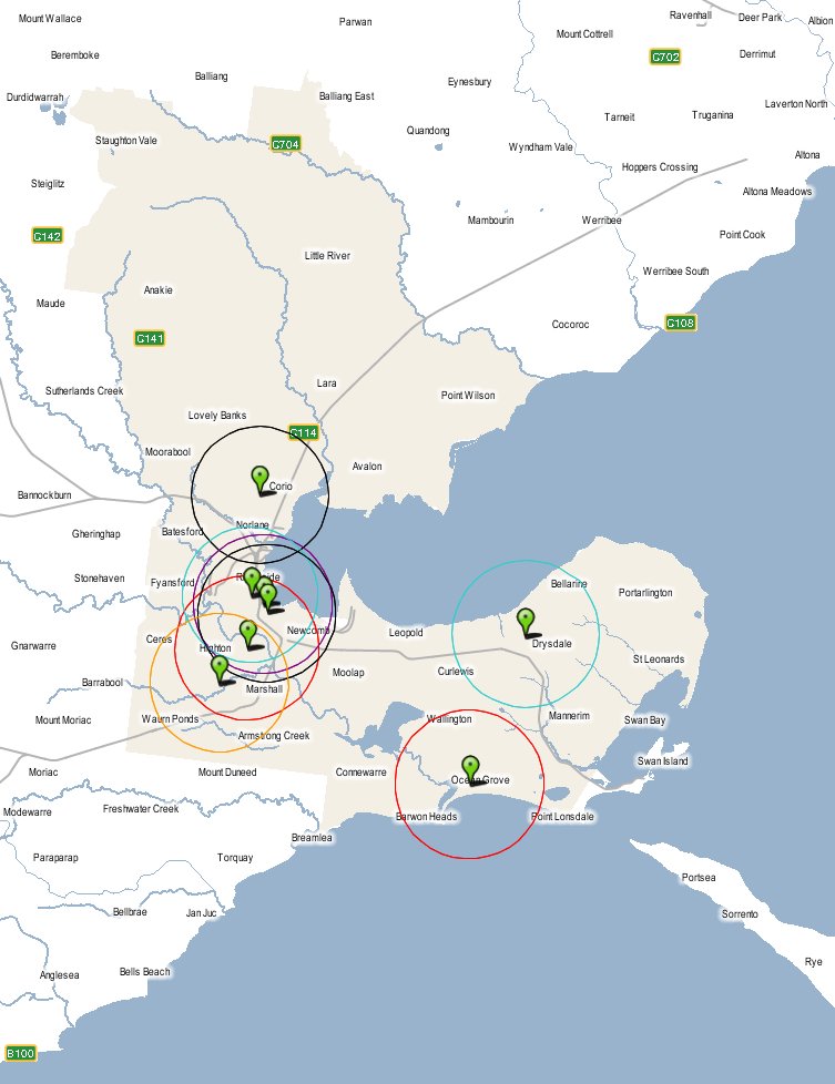
Table: Comparison between councils/number of sites/population
|
Council |
No. of Customer Service Centres |
Population |
Ratio (Rounded to ‘000) |
|
Geelong |
8 |
217,574 |
1 : 27 |
|
Yarra Ranges |
5 |
148,822 |
1 : 30 |
|
Onkaparinga |
5 |
164,977 |
1 : 33 |
|
Dandenong |
4 |
135,605 |
1 : 34 |
|
Redlands |
2 |
145,336 |
1 : 73 |
|
Gold Coast |
7 |
524,583 |
1 : 75 |
|
Knox |
2 |
154,000 |
1 : 77 |
|
Casey |
3 |
266,891 |
1 : 89 |
|
Ballarat |
1 |
96,752 |
1 : 97 |
|
Newcastle |
1 |
156,533 |
1 : 157 |
|
Wollongong |
1 |
202,062 |
1 : 202 |
|
Brisbane |
5 |
1,109,664 |
1 : 222 |
The operating hours and staffing ratio of each of the City of Greater Geelong customer service centres varies based on location, size and scope. The following table provides an overview of each centre.
Table: Overview of operating hours, staffing provision and costs at each centre
|
Centre |
Operating hours Monday to Friday |
Operating costs per annum |
EFT |
Customers per annum |
Cost per Customer Visit |
|
Geelong West |
10am-2pm |
$52,000 |
0.56 |
9,377 |
$5.58 |
|
Ocean Grove |
9am-5pm |
$128,000 |
1.49 |
11,575 |
$11.06 |
|
Belmont |
9am-5pm |
$154,000 |
1.86 |
20,151 |
$7.67 |
|
Drysdale |
9am-5pm |
$193,000 |
1.81 |
17,453 |
$11.08 |
|
Corio Village |
9am-5pm |
$184,000 |
1.82 |
25,628 |
$7.17 |
|
Brougham Street |
8am-5pm |
$258,000 |
3.16 |
27,109 |
$9.51 |
|
City Hall |
8am-5pm |
$179,000 |
2.16 |
22,767 |
$7.87 |
|
Waurn Ponds |
10am-2pm |
$50,000 |
0.53 |
3,559 |
$14.04 |
|
Total |
|
$1,198,000 |
13.39 |
137,619 |
$8.71 |
Table: Customer Transition Activity 2010-2011 to 2012-2013
|
2010-2011 |
2012-2013 |
Variation |
Trend |
Comments |
Web Visits |
1,081,533 |
1,481,841 |
27% |
↑ |
Indicative of customer preference to undertake business via the internet |
Telephone |
192,345 |
184,793 |
3.9% |
↓ |
|
On-line RFS transactions |
3% |
4% |
1% |
↑ |
Customers taking advantage of the increasing number of services coming ‘on-line” |
On-line payment transactions |
3% |
5% |
2% |
↑ |
Represents 18,000 payments. |
Contactus email |
15,820 |
17,952 |
12% |
↑ |
Customers can contact CoGG 24/7 over the internet |
Customer Service Centre Visits (excludes Waurn Ponds) |
167,084 |
133,956 |
-25% |
↓ |
Decreasing number of customers coming to customer service centres to undertake business. |
Receipts (excludes Waurn Ponds) |
81,588 |
71,980 |
-13% |
↓ |
|
Receipts as a % of visits (excludes Waurn Ponds) |
49% |
54% |
5% |
↑ |
Of the reason customers are coming to centres is to conduct a payment. Electronic payment options will see decreased visits. |
% of receipts through Customer Service Centres (excludes Waurn Ponds) |
19% |
16% |
-3% |
↓ |
External agencies such as Australia Post, B-Pay etc receipt 70% of the total CoGG transactions |
The following should be noted in reviewing the above data:
The model of face-to-face customer service provision is the highest compared to the provision adopted by benchmarked councils.
The existing model for face-to-face service delivery is not efficient. The operation of 8 permanent sites results in high fixed costs and significant operating costs to Council in the provision of services. There are currently 4 customer service centres within a 5 kilometre radius of the Central Business District.
The face- to- face channel is the most expensive channel for the City of Greater Geelong to operate, at a cost of $8.71 per visit in 2012-2013.
The online channel continues to be the City of Greater Geelong’s most popular and economical customer contact channel. In 2013 there was a 27 percent increase in website visits at approximately 98 cents per contact.
The City of Greater Geelong’s published telephone continues to be a major contact channel for customers, with the Customer Contact Centre receiving 184,793 calls during 2012-2013 period. The telephone channel provides a relatively cost effective (approximately $3.30 per contact) way of providing assistance for customers who cannot interact with our services online.
In 2012- 2013 there were at least 17,952 customers who perhaps having not found what they required online, accessed a City of Greater Geelong service or requested information via email. This represents an increase of 12 percent from the previous year. The online target customer groups are those who have internet and require no, or minimal assistance in finding information, accessing a service or performing a transaction.
In 2012-2013 there was a 25 percent (16,643 persons) decrease in the number of customers visiting customer service centres.
When compared with an overlay of the existing customer service centres, it is evident that the location of existing centres is not necessarily conducive to the areas of predicted population growth or disadvantage. The nature of some services will continue to require a high proportion of customers needing face-to-face support.
The opening of Brougham Street Customer Service Centre has seen a reduction in customer activity at City Hall. The introduction of the Brougham Street facility offers an opportunity for full relocation of Customer Service Centre activities within the CBD to provide an accessible, fit for purpose, facility in the same location as a significant portion of Council staff and other daily services such as surrounding shops and car parking facilities.
Customer payment preferences continue trending away from Customer Service Centres.
Existing Research
During 2009, the Customer Service Department undertook an initial review of the customer service centres to assist with future planning and resource allocation. Research from the review suggests that face-to-face contact is still important to customers as a means of contacting Council.
The review identified that:
There is recognition that there will always be a need for face-to-face customer service contact for particular citizens and businesses and where particular outcomes are required such as relationship building.
Councillors are generally strong “in principle” supporters of customer service facilities.
The amount of face-to-face services can be expected to decrease as other contact channels become more effective.
The geographic positions of existing customer service centres are essentially historic.
Customer service centres have high infrastructure and operating costs when compared to other contact methods such as by phone or via internet.
The customer base and local economy have changed bringing about different customer needs.
There is strong, consistent opinion that the model of provision should be flexible to adapt to the localised needs of each community / locality.
There can be issues of staffing levels being insufficient at lunch and peak times.
No baseline exists for triggering or altering face-to-face service provision.
Those customer payment preferences are trending away from customer service centres towards other methods such as Australia Post and via Councils website.
Further, in 2013 the City of Greater Geelong commissioned CT Management to conduct a Financial Sustainability Review (FSR) project which provides Council with an independent assessment of its current operations, identification of challenges and opportunities and financial sustainability options.
The FSR final report has now been received and was presented to Council on 3 September 2013. It is evident from this review that there are opportunities for service activity improvements relevant to delivering long-term financial sustainability and efficiency in face to face service delivery.
Approach to the future provision of customer service centres
Based on previous reviews of face-to-face customer service and the councils strong emphasis on financial sustainability, council need to determine the most favourable number of sites and locations for effective customer service centre provision within the municipality.
A number of possible delivery options for the efficient and effective provision of face-to-face customer service can be suggested. These may include redirecting the number of physical face-to-face customer service locations across the municipality by establishing a hierarchy of Customer Service Centres. This may involve an expansive service in Central Geelong (Brougham Street) supported by other centres in Northern Geelong, Waurn Ponds, The Bellarine Peninsula and to the West of Geelong.
It is proposed that the Customer Service Department undertake a customer service centre service review process. This process will be designed in accordance with the City’s preferred service review methodology to determine to future direction and definition of this service.
A key component of the service review will be to undertake a structured community consultation and engagement activity to identify perceptions, expectation and need.
Following the review process a Council report will be produced which recommends changes to face-to-face customer service delivery.
Not applicable.
The face-to-face service delivery model cost is in excess of $1.2m. Any alteration in the number of face-to-face customer service facilities could realise ongoing operational savings while improving the efficiency and effectiveness of service delivery.
Any review and or change in the level of service provision will need to be cognisant of statutory or regulatory requirements.
How We Do Business.
No officer involved in the preparation of this report has a direct or indirect interest.
The principle risks associated with face-to- face service delivery include:
Clarity and consistency around the service offering
Ability to keep pace with changing customer needs and behaviour
Unnecessarily high service delivery costs
Impacts on human resources and Industrial relations.
Council has a responsibility to ensure that services provided to the community are equitable, accessible and that resources are used efficiently to meet the needs of the community.
Any alteration to the existing model of face-to-face service will take into consideration the social implications of any proposed changes to current service delivery.
The City of Greater Geelong provides a mix of customer contact options to allow easy access to the City for all through web, phone, face-to-face, and written channels.
Any proposed changes to the existing model of face-to face service provision will consider the main principles of equity, fairness, dignity and respect.
The development and implementation of a communications plan which incorporates communication with key stakeholders, existing and potential customers would be developed if a new model of service provision is required.
Portfolio: |
Infrastructure - Cr Ellis |
Source: |
City Services - Engineering Services |
General Manager: |
Gary Van Driel |
Index Reference: |
Torquay Road and Marshalltown Road, Grovedale, Special Rates and Charges |
The purpose of this report is to finalise the Torquay Road and Marshalltown Road footpath Special Charge Scheme, Grovedale as shown at Appendix 1.
The Special Charge Scheme was declared by Council at its meeting of 9 October 2012;
The scheme affects 58 properties and the cost estimate for the project was estimated at $275,896 which included a property owner contribution of $135,698, a Council contribution of $135,698 and an ex-gratia contribution by the Aldi Supermarket of $4,500. Owner’s cost estimates varied between $68 and $13,518 and were dependant on their frontage to the new footpath;
The works have now been completed and the scheme can be finalised by Council. The total cost of the project was $229,396.44. The cost savings of $46,500 represents economies of scale during the construction phase and a reduction of as declared charges to property owners;
The scheme has been administered in accordance with the Special Rates and Charges provisions of the Local Government Act 1989, along with Council’s Special Rates and Charges Policy; and
This report seeks a resolution by Council to confirm the Special Charge Scheme for the footpath construction in Torquay Road and Marshalltown Road, Grovedale in accordance with the Special Charge Scheme process as shown in the Process Chart – Attachment 1;
Cr Ellis moved, Cr Richards seconded -
That Council having declared a special charge on 9 October 2012 for the purposes of defraying the expenses in relation to the construction of a footpath, in Torquay Road and Marshalltown Road, Grovedale (Appendix 1 – Plan) in accordance with Section 163 of the Local Government Act 1989 (the Act), resolves that:
the amended special charges be confirmed on the project as required by Section 166 of the Act as shown in Schedule A – Appendix 2;
the reduction in actual cost of $46,500 from the project estimate contribute to a charge reduction to property owners; and
The General Manager of Corporate Services is authorised to levy and recover the special charges by sending notices to the persons who are liable to pay in accordance with Section 166 of the Act and the Regulations in accordance with Section 172.
The rate of interest which is payable on the special charges which have not been paid by the specified date is set at Council’s overdraft rate, reviewed every three months (provided that it shall not exceed the rate fixed by the Governor in Council by Order for the purposes of Section 172 2A in which case the rate of interest shall be the maximum rate fixed by the Governor in Council by Order for the purposes of the Section). The interest is to be calculated from the date the special charge is due, with a six months interest free period, providing those persons who choose to pay by instalments adhere to their repayment plan.
Carried.
This project involves the construction of 1170 lineal metres of 1.5 metre wide concrete footpaths near the intersection of Torquay Road and Marshalltown Road, Grovedale. The footpath has been provided on both sides of Marshalltown Road between Bailey Street and Torquay Road. The recently constructed Aldi Supermarket on the north east corner of Torquay and Marshalltown Road has made an ex-gratia contribution to the footpath as part of compliance with its planning permit conditions for construction.
The footpaths described have been identified as a high priority link after a risk analysis was carried out for a large number of footpath proposals within the municipality. Potential destinations for pedestrians in this area include two relatively new supermarkets, Torquay Road bus stops, a local Primary School and Railway Station.
The footpath works have been completed and provides a missing link in terms of footpath infrastructure. Costs have been accounted for and the scheme can now be finalised by Council.
The actual cost of construction was less than the project estimate due to efficiency of construction and minimal contingencies encountered during construction. The price reduction will be partly passed on to property owners as detailed in the Financial Implications section below. The reduction of charge to property owners represents a 17% reduction from the ‘as declared’ charges.
There are no environmental implications in regards to energy consumption, emissions, water use, storm water quality, waste generation or natural habitats in Councils decision to finalise the scheme.
The financial details of the project are as follows:
|
|
Estimate |
Actual |
|
Scheme cost to property owners |
$135,698 |
$112,448 |
|
Scheme cost to Council |
$135,698 |
$112,448 |
|
Ex-Gratia contribution by Supermarket |
$4,500 |
$4,500 |
|
TOTAL |
$275,896 |
$229,396 |
The scheme cost for the project has been reduced and property owners will be advised of the final amended charges.
The Special Charge Scheme has been administered in accordance with the Special Charge Scheme provisions of the Local Government Act 1989 as well as Council’s Special Rates and Charges policy.
This report aligns with the City Plan as follows:
Community Wellbeing:
Healthy Lifestyles – Facilitating and promoting physical activity
Healthy Environments – Cycling and walking paths
Sustainably Built and Natural Environment
Support our Community to live – Encourage increased use of alternatives to car transport
No Council Officer involved with this process has any direct or indirect interest in the properties.
Provision of footpaths has provided safer walking conditions for pedestrians by minimising the risk of personal injuries through trip hazards and conflict with vehicles. There are no identified risks for Council in finalising the scheme.
The provision of footpaths is aligned to Council’s City Plan as described above and provides improved connectivity and safety for pedestrians.
In developing this report to Council, the subject matter has been considered to determine if it raises any human rights issues. In particular, whether the scope of any human right established by the Victorian Charter of Human Rights and Responsibilities is in any way limited, restricted or interfered with by the recommendations contained in this report. It is considered that the subject matter does not raise any human rights issues.
Communication with property owners has taken place during the course of the project and Special Charge Scheme process. Council will advise the property owners of the reduced final costs.
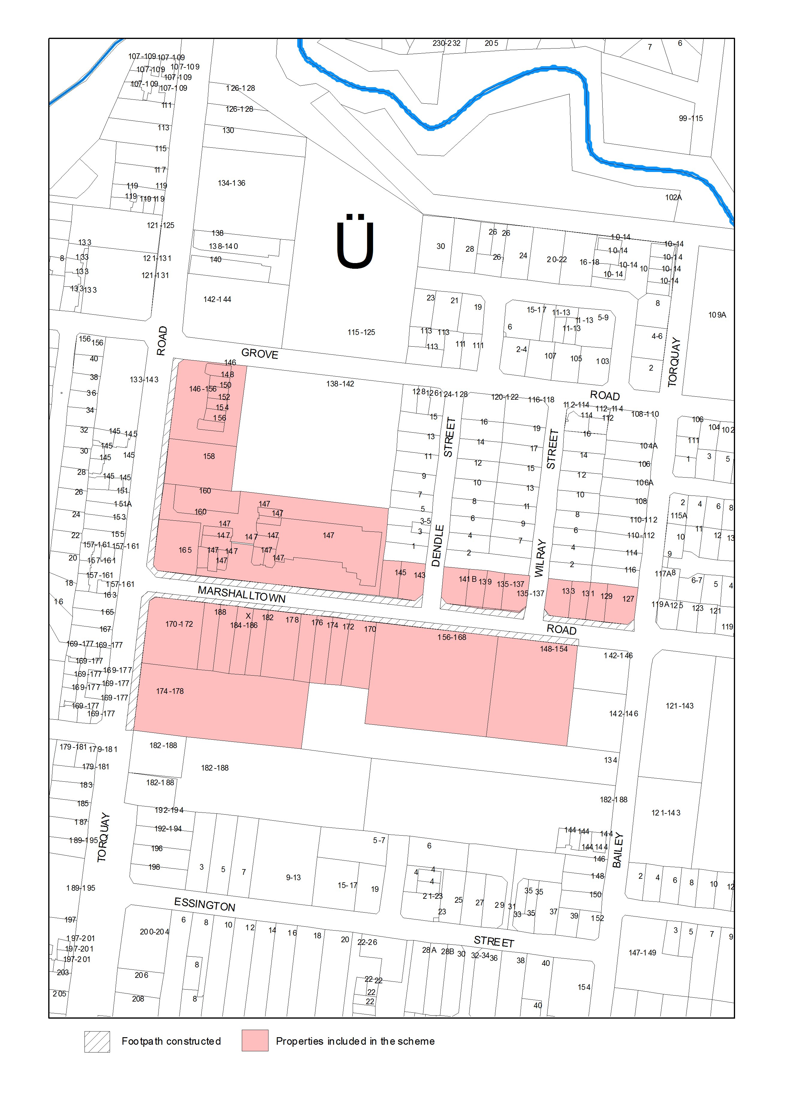
SCHEDULE ‘A’
SPECIAL CHARGE SCHEME FOR FOOTPATH CONSTRUCTION
|
COL 1 |
COL 2 |
COL 3 |
COL 4 |
COL 5 |
|
DESCRIPTION OF PROPERTY |
ESTIMATED COST ($) |
ACTUAL COST ($) |
PROPERTY REFERENCE |
PROPERTY DETAILS |
|
Lot 7 SP 35955 |
$554 |
$450.47 |
240917 |
146 Torquay Road |
|
LOT 6 LP 35955 |
$554 |
$450.47 |
240918 |
148 Torquay Road |
|
Lot 5 SP 35955 |
$554 |
$450.47 |
240919 |
150 Torquay Road |
|
Lot 4 SP 35955 |
$554 |
$450.47 |
331196 |
1/152 Torquay Road |
|
Lot 3 SP 35955 |
$554 |
$450.47 |
240921 |
154 Torquay Road |
|
Lot 2 SP 35955 |
$554 |
$450.47 |
240922 |
156 Torquay Road |
|
Lot 1 SP 35955 |
$9,971 |
$8,103.27 |
240923 |
158 Torquay Road |
|
Lot 1 SP 34174 |
$656 |
$533.30 |
240925 |
1/160 Torquay Road |
|
Lot 2 SP 34174 |
$128 |
$103.69 |
240926 |
2-3/160 Torquay Road |
|
Lot 3 SP 34174 |
$132 |
$107.43 |
240926 |
2-3/160 Torquay Road |
|
Lot 4 SP 34174 |
$82 |
$66.64 |
240928 |
4/160 Torquay Road |
|
Lot 5 SP 34174 |
$87 |
$70.37 |
240929 |
5/160 Torquay Road |
|
Lot 6 SP 34174 |
$82 |
$66.64 |
240930 |
6/160 Torquay Road |
|
Lot 7 SP 34174 |
$78 |
$63.00 |
240931 |
7/160 Torquay Road |
|
Lot 8 SP 34174 |
$78 |
$63.00 |
240932 |
Shop No. 8/147 Marshalltown Road |
|
Lot 10 SP 34174 |
$114 |
$92.59 |
240934 |
10/160 Torquay Road |
|
Lot 11 SP 34174 |
$87 |
$70.37 |
240935 |
11/160 Torquay Road |
|
Lot 12 SP 34174 |
$87 |
$70.37 |
240936 |
12/160 Torquay Road |
|
Lot 22 SP 34174 |
$1,873 |
$1,522.15 |
232661 |
9/147 Marshalltown Road |
|
Lot 1 LP 205775 |
$3,452 |
$2,805.58 |
232596 |
165 Marshalltown Road |
|
Lot 1 SP 34174 |
$3,510 |
$2,918.59 |
240925 |
1/160 Torquay Road, |
|
Lot 2 SP 34174 |
$682 |
$567.35 |
240926 |
2-3/160 Torquay Road |
|
Lot 3 SP 34174 |
$708 |
$588.36 |
240926 |
2-3/160 Torquay Road |
|
Lot 4 SP 34174 |
$439 |
$364.96 |
240928 |
4/160 Torquay Road |
|
Lot 5 SP 34174 |
$463 |
$384.87 |
240929 |
5/160 Torquay Road |
|
Lot 6 SP 34174 |
$439 |
$364.96 |
240930 |
6/160 Torquay Road |
|
Lot 7 SP 34174 |
$415 |
$345.05 |
240931 |
7/160 Torquay Road |
|
Lot 8 SP 34174 |
$415 |
$345.05 |
240932 |
Shop No. 8/147 Marshalltown Road |
|
Lot 10 SP 34174 |
$609 |
$506.52 |
240934 |
10/160 Torquay Road |
|
Lot 11 SP 34174 |
$463 |
$384.87 |
240935 |
11/160 Torquay Road |
|
Lot 12 SP 34174 |
$463 |
$384.87 |
240936 |
12/160 Torquay Road |
|
Lot 22 SP 34174 |
$10,020 |
$8,331.08 |
232661 |
9/147 Marshalltown Road |
|
Lot 1 LP 205775 |
$4,038 |
$3,357.65 |
232596 |
165 Marshalltown Road |
|
PC 356098 |
$13,518 |
$11,239.71 |
302351 |
170-172 Torquay Road |
|
TP886018X |
$8,503 |
$7,070.30 |
299624 |
182-188 Torquay Road |
|
TP885451N |
$4,819 |
$4,006.83 |
299624 |
182-188 Torquay Road |
|
TP885416Q |
$68 |
$56.40 |
299624 |
182-188 Torquay Road |
|
TP885426M |
$3,912 |
$3,252.58 |
330329 |
182-188 Torquay Road |
|
Lot 5 LP 77342 |
$1,163 |
$966.60 |
302558 |
188 Marshalltown Road |
|
Lot 6, Lot 7 LP 77342 |
$4,054 |
$3,370.92 |
232676 |
184-186 Marshalltown Road |
|
Lot 8 LP 77342 |
$2,027 |
$1,685.46 |
232675 |
182 Marshalltown Road |
|
CP 102204 |
$2,259 |
$1,877.89 |
232674 |
178 Marshalltown Road |
|
Lot 11 LP 77342 |
$2,027 |
$1,685.46 |
232673 |
176 Marshalltown Road |
|
Lot 12 LP 77342 |
$1,761 |
$1,464.27 |
232672 |
174 Marshalltown Road |
|
Lot 13 LP 77342 |
$1,163 |
$966.60 |
232671 |
172 Marshalltown Road |
|
Lot 1 PS 417819 |
$3,364 |
$2,796.93 |
232670 |
170 Marshalltown Road |
|
Lot 1 LP 99977 |
$13,151 |
$10,934.47 |
232669 |
156-168 Marshalltown Road |
|
Lot 2 LP 99977 |
$8,542 |
$7,102.37 |
232668 |
148-154 Marshalltown Road |
|
Lot 5 LP 132804 |
$3,053 |
$2,538.80 |
232651 |
127 Marshalltown Road |
|
Lot 6 LP 132804 |
$1,729 |
$1,437.73 |
232652 |
129 Marshalltown Road |
|
Lot 7 LP 132804 |
$1,397 |
$1,161.24 |
232653 |
131-133 Marshalltown Road |
|
Lot 8 LP 143292 |
$3,059 |
$2,543.67 |
232653 |
131-133 Marshalltown Road |
|
Lot 17 LP 132804 |
$3,059 |
$2,543.67 |
232655 |
135-137 Marshalltown Road |
|
Lot 18 LP 132804 |
$1,397 |
$1,161.24 |
232655 |
135-137 Marshalltown Road |
|
Lot 19 LP 132804 |
$2,261 |
$1,880.10 |
232656 |
139 Marshalltown Road |
|
Lot 20 LP 143292 |
$2,261 |
$1,880.10 |
232657 |
141A & 141B Marshalltown Road |
|
Lot 29 LP 143292 |
$2,527 |
$2,101.29 |
232659 |
143 Marshalltown Road |
|
Lot 30 LP 132804 |
$1,729 |
$1,437.73 |
232660 |
145 Marshalltown Road |
|
Stage |
Status |
Description |
|
Approval to prepare scheme |
✓ |
Decision made to prepare scheme following consideration of surveys of property owners and feed back from the community. Council may then place the project in the budget system or proceed immediately to prepare a scheme. Scheme preparation involves survey, design and preparation of an apportionment of costs. |
|
Intention to Declare Scheme |
✓ |
Report to Council providing information on scheme including advice of impending advertising of scheme and declaration of charge. Seeks Council approval by resolution to proceed with process. 31 January 2012 |
|
Advertisement |
✓ |
The scheme is advertised in the local newspaper and all allotted property owners are notified by mail. This advertisement indicates Council’s intention and notification to ‘declare’ a scheme in a month’s time. 14 July 2012 |
|
Submissions |
✓ |
From the time of advertising property owners have 28 days (as set down by the Local Government Act) to lodge submissions, either in support or opposition to the scheme. |
|
Submissions Review Panel Hearing |
N/A |
A Submissions Review Panel is convened (quorum of three Councillors) and meets to consider submissions. Some submissions are written only, and other submitters may wish to be heard before the Panel. The Panel makes a recommendation to Council regarding the scheme. |
|
Declaration Report |
N/A |
Any time 28 days after advertising the scheme and after the Submissions Review Panel has met and considered submissions, Council considers a report and may proceed to “declare” the charges in accordance with its advertised intent. Subsequent to this the Finance Manager issues the levy notices and there is a formal charge placed on the property. This is the final step in the process for Council to make a decision on the scheme. |
|
Appeal |
N/A |
Property owners may lodge an application for review with the Victorian Civil and Administrative Tribunal (VCAT) within one month of issue of the levy notice. An appeal is listed, heard and determined by the Tribunal and this process generally takes three to four months. Decisions made by VCAT are binding on all parties. |
|
Construction |
✓ |
Council may then proceed to construct the works. Invoices are issued seeking payment of the estimated cost within one month of commencement. |
|
Final Cost Report |
✓ |
At the completion of the works the scheme is “finalised” taking into account actual costs incurred and payments are adjusted accordingly. |
Portfolio: |
Governance - Cr Lyons (Mayor) |
Source: |
Corporate Services - Financial Services |
|
A/General Manager: |
Michael Kelly |
Index Reference: |
Subject/Financial Management - Reporting |
To seek approval to rename Warren Court, Thomson to Barling Court, Thomson due to confusion locating properties in this court.
Locating properties in Warren Court, Thomson is causing confusion due to the neighbouring road being called Warren Street, Thomson (refer Attachment A).
It is proposed to rename Warren Court to Barling Court, Thomson.
This name has been selected from a recently compiled ANZAC register of suitable road names. This register was compiled as part of the State Government Office of Geographic Names ANZAC Commemorative Naming Project.
The proposed renaming was advertised in the Independent newspaper on 14 March 2014 and the Geelong Advertiser newspaper on 15 March 2014.
Council received four submissions in response to this advertisement. Three submissions were not related to this renaming and one submission was seeking further information as to why the court was being renamed.
Cr Irvine moved, Cr Richards seconded -
That Council approves the renaming of “Warren Court, Thomson” to “Barling Court, Thomson”.
Carried.
A resident in Warren Street, Thomson wrote to Council advising that confusion was arising regarding locating properties in the area due to the similar road names of Warren Street and Warren Court, Thomson. Warren Court is accessed from Warren Street.
The Guidelines for Geographic Place Names 2010 states that duplication of road names are to be avoided due to confusion with emergency services and visitors to the area. Warren Court and Warren Street are duplicate names and therefore require renaming.
Consequently, Council sent a letter to all affected property owners and residents in Warren Court advising its intention to rename their court.
The letter advising the renaming of Warren Court also sought feedback on two proposed names, viz.:
“Hermann”. This is the Christian name of Mr Warren who served in the Royal Australian Navy on HMAS Canberra. This ship was severely damaged by a surprise attack from the Japanese and sank in 1942 killing 84 members of crew, which included Mr Hermann Warren.
“Barling”. This name was chosen from Council’s recently compiled list of ANZAC names in honour of two brothers who served in WW1. Both brothers were killed in action in France.
Council did not receive any negative responses regarding the proposal. Four responses were in favour of naming the court “Hermann” and eight responses were in favour of naming the court “Barling”. Ten residents / property owners did not reply to the proposal. Therefore, based on the responses received, the preferred name was “Barling”.
The suggested naming complies with the requirement of the Guidelines for Geographic Names 2010.
The proposed renaming was advertised in The Independent newspaper on 14 March 2014 and the Geelong Advertiser newspaper on 15 March 2014. As a result, four submissions were received. However, three of the submissions were not related to this renaming and one submission was seeking further information as to why the court needed to be renamed.
It is therefore recommended to proceed with renaming the court to “Barling Court, Thomson”.
There are no environmental issues arising from this report.
The approximate cost to Council is $1,100. This includes advertising, assistance packages, notification to authorities and street signage.
The Local Government Act 1989, Geographic Place Names Act 1998 and The Guidelines for Geographic Names 2010 have been followed and met.
This proposal aligns to City Plan with the encouragement of Community Wellbeing.
There is no Council Officer direct or indirect interest involved in this report.
If an emergency situation occurred, Council’s proposal to rename this section of roadway could minimise the risk of failure in being able to locate the property in a timely manner.
The renaming of this section of roadway will allow for easy identification to the public and utility services in case of an emergency.
It is the right of every resident and property owner for their property to have a unique address in order to receive services and reduce confusion or delay of emergency services.
Correspondence was sent to all adjoining property owners and residents advising them of the proposed renaming and invited submissions.
This proposal was also advertised in the Independent newspaper on 14 March 2014 and the Geelong Advertiser newspaper on 15 March 2014. The proposal was published on Council’s Geelong Australia website for 30 days as per the Guidelines for Geographic Names 2010.
Four submissions were received. Three submissions did not relate to the proposed renaming and one submission was seeking further information in regards to why this roadway needed to be renamed.
Subject to Council and The Registrar of Geographic Names approval, the relevant authorities and abutting owners and residents will be notified of the official registration of this road renaming.
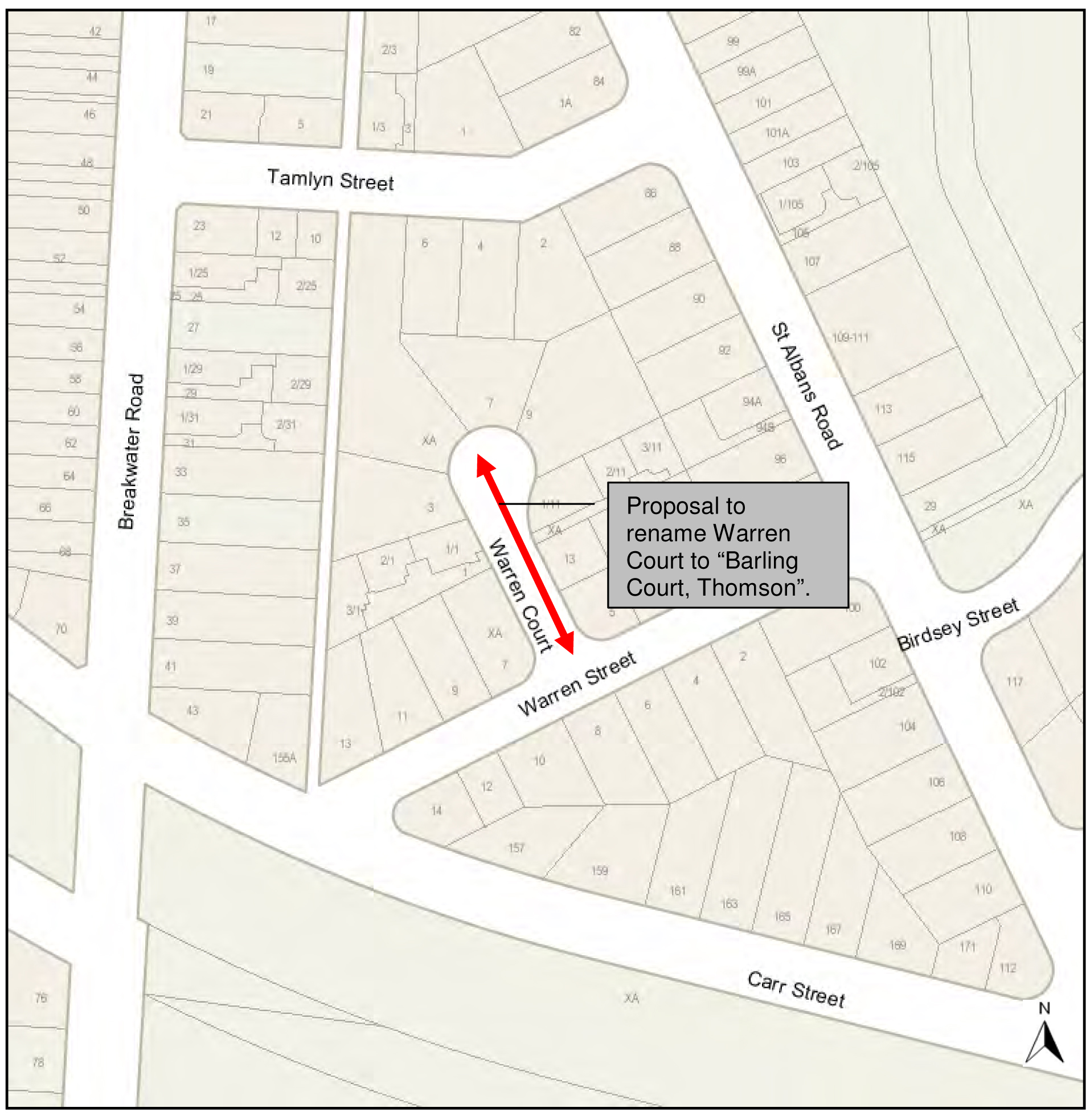
Portfolio: |
Environment and Sustainability – Cr Richards |
Source: |
City Services – Environment & Waste Services |
General Manager: |
Gary Van Driel |
Index Reference: |
Project T1400024 |
To provide Council with the requisite information to facilitate the approval of the tender evaluation panel’s recommendation in relation to the supply of mobile bins and components tender.
Council has sought tenders for supply of mobile bins and components for the provision of bins for new garbage, green waste and recycling collection services and for services that require replacement bins or bin repairs due to damage of existing bins in service.
The term of the Contract for the provision of this service shall be for an initial period of two (2) years with the maximum period for which the contract may be extended beyond the initial contract period being eight (8) years. Extension options available are at the sole discretion of Council.
A total of four companies have provided tender submissions for the supply of mobile bins and components.
Following a detailed evaluation of each of the submissions it is considered that the tender submission of Sulo MGB Australia Pty Ltd is preferred.
Cr Richards moved, Cr E Kontelj seconded -
That Council :
accept the tender submission from Sulo MGB Australia Pty Ltd for Tender No T140024 – Supply of Mobile Bins and Components for the tendered schedule of rates; and
sign and seal the contract documents.
Carried.
Tenders for the Supply of Mobile Bins and Components were invited via public advertisement in The Age and on Tenderlink on Saturday 15 February 2014.
At the close of tenders on Friday 21 March 2014 the following tender submissions were received:
|
Tenderer |
|
Transpacific Superior Pak Pty Ltd |
|
Mastec Australia Pty Ltd |
|
SULO MGB Australia Pty Ltd |
|
Otto Environmental Systems Pty Limited |
All tenders have been submitted exclusive of GST.
The tender submissions associated with this supply service were evaluated by a panel consisting of:
|
Rod Thomas |
Manager Environment & Waste Services |
|
David Tournier |
Project Engineer – Waste Services |
|
Craig Belshaw |
Project Officer – Kerbside Tender |
|
Adrian Rainbow |
Contracts Officer (Non Voting) |
|
Richard Russell |
Team Leader Waste Contract Management (Non Voting) |
Stage One – Mandatory Criteria
OHS mandatory requirements applies to this Tender.
The tender submission from Otto Environmental System Pty Ltd was deemed non conforming due to their inability to supply 140 litre mobile bins.
All other submissions responded to all mandatory requirements set down in the Tender documents and are considered to conform.
Stage Two –Comparative Criteria
Tender submissions were assessed based on the respondent’s performance or tender response in the following areas:
|
Criteria |
Weighting |
|
Financial Assessment |
50% |
|
Technical Capability to meet specification |
36% |
|
Quality |
12% |
|
Economic Contribution to Region |
2% |
|
|
100% |
At the conclusion of the evaluation the tenderers were ranked in the following order in accordance with the above criteria:
|
Tenderer |
Rank |
|
Sulo MGB Australia Pty Ltd |
1 |
|
Transpacific Superior Pak Pty Ltd |
2 |
|
Mastec Australia Pty Ltd |
3 |
At the conclusion of the evaluation process, the evaluation panel determined that SULO MGB Australia Pty Ltd, the highest ranked and lowest priced tender, represented best value to Council.
SULO MGB Australia Pty Ltd are the incumbent provider of this service to Council and have been successfully undertaken this service for over ten years.
SULO MGB Australia Pty Ltd have a quality system certified to AS/NZS ISO 9001-2008 and are also third party certified as having met the Australian Standard AS4123.1 – 2008 for Mobile Waste Containers.
SULO MGB Australia Pty Ltd have current contracts with 6 other Councils including Hume, Brimbank, Stonnington, Boorandara, Maribyrnong and Nillumbik. Reference checks were undertaken which reinforced the panels view that SULO MGB Australia Pty Ltd can continue to successfully provide the supply of mobile bins and components service to Council.
Therefore, SULO MGB Australia Pty Ltd are recommended by the evaluation panel to undertake the supply of mobile bins and components.
Any environmental implications associated with this contract will arise from the execution of this service. It is considered that these are the responsibility of the Contractor and will be managed through the contract documentation.
The funding for this supply service will be drawn from a capital budget allocation of $555,000 (C04308) for purchase of residential collection mobile bins, a recurrent budget allocation of $68,000 (R388110) for purchase of mobile bins for the litter bin collection service and a recurrent budget allocation of $30,000 (R388130) for purchase of mobile bins for the commercial bin collection service.
The requirements of Section 186 of the Local Government Act have been complied with for this tender. There are no other policy, legal or statutory implications associated with this tender process.
Councils waste services requirements are incorporated into the key City Plan objectives.
No officers involved in the preparation of this report have a direct or indirect interest in matters to which this report relates.
There are not considered to be any risks associated with the acceptance of this tender that cannot be managed through the contract conditions.
There are no social implications that will arise from the acceptance of this tender.
There are not anticipated to be any Human Rights impacts associated with the acceptance of this tender.
There is no communication issues associated with the acceptance of this tender.
Portfolio: |
Finance – Cr Lyons (Mayor) Cr S Kontelj & Cr E Kontelj |
Source: |
Corporate Services - Communications and Marketing |
|
A/ General Manager: |
Michael Kelly |
|
|
|
Cr Macdonald moved, Cr E Kontelj seconded -
That in accordance with Section 89 (2) (d) of the Local Government Act 1989, this contractual matter be considered at the conclusion of all other business at which time the meeting be closed to members of the public.
Carried.
Contents | Previous Page: Section A - Procedural Matters | Next Page: Section C - Urgent Business
