
Council Minutes - Section B: Reports (1-8) - 25 September 2012
Contents | Previous Page: Section A - Procedural Matters | Next Page: Section B – Reports (9-15)
Contents | Previous Page: Section A - Procedural Matters | Next Page: Section B – Reports (9-15)
Reports 1-8, tabled at the Ordinary Meeting of Council on Tuesday date held at City Hall, Little Malop Street in Geelong.
Amendment C259: Horseshoe Bend Precinct Structure Plan and Development Contributions Plan
Armstrong Creek Town Centre Precinct Structure Plan C267 Authorisation to Exhibit Amendment
Planning Permit Application 1281/2011 – Common Equity Housing Ltd – 79 Taits Road, Barwon Heads
Portfolio: |
Planning - Cr Macdonald |
Source: |
Economic Development, Planning & Tourism |
General Manager: |
Peter Bettess |
Index Reference: |
Armstrong Creek |
The purpose of this report is to make recommendations to Council regarding the preparation and exhibition of Amendment C259.
The amendment applies to land known as the Horseshoe Bend Precinct in the Armstrong Creek Urban Growth Area and is generally bounded by Reserve Road to the north, the Barwon River floodplain to the east, Burvilles Road to the south and Surf Coast Highway and Barwarre Road to the west.
The amendment proposes to:
include the Horseshoe Bend Precinct Structure Plan (PSP) in the Planning Scheme as an incorporated document,
apply the Development Contributions Plan Overlay (DCPO) to the Precinct, and include the Horseshoe Bend Development Contributions Plan (DCP) as an incorporated document in the planning scheme,
include the Horseshoe Bend Native Vegetation Precinct Plan (NVPP) in the Planning Scheme as an incorporated document,
include land required by Barwon Water for its Pressure Reducing Valves in a Public Acquisition Overlay (PAO).
The Horseshoe Bend Precinct developer and landowner consortium have, in close consultation with Council officers, prepared a draft PSP and draft NVPP. They have also prepared the required information for the preparation of a DCP to the satisfaction of Council officers, and are now in a position to proceed to the formal exhibition of a planning scheme amendment.
The DCP rate per developable hectare for the Precinct is expected to be comparable to the East and West Precinct DCPs.
The Draft PSP master plan went through an informal consultation process during May and June 2012. Submissions received were used to refine the final draft PSP.
Following exhibition of the Amendment a further report will be brought to Council to review and recommend an approach to dealing with submissions. The final amendment will be required to be adopted by Council prior to submission to the Minister for approval.
Cr Macdonald moved, Cr Richards seconded -
That Council prepare and exhibit Amendment C259, subject to Ministerial Authorisation.port..
Carried.
The Horseshoe Bend Precinct developer and landowner consortium (the Consortium) have, in close consultation with Council officers, prepared a Precinct Structure Plan (PSP) and Native Vegetation Precinct Plan (NVPP) for the Horseshoe Bend Precinct.
The Development Contributions Plan (DCP) for the Horseshoe Bend Precinct is being prepared by Urban Enterprise Pty Ltd on behalf of Council, also in close partnership with the Consortium. The DCP is required to ensure that levies are collected so that the infrastructure set out in the PSP is appropriately and equitably funded.
These documents are proposed to be included in the Planning Scheme through this amendment.
This amendment will implement the Armstrong Creek Urban Growth Plan and is consistent with previous adopted PSPs and DCPs in the Armstrong Creek Urban Growth Area. In areas where it varies slightly from the Armstrong Creek framework plan these modifications will enhance the overall planning outcomes for the precinct and are considered to be refinements to the Armstrong Creek Urban Growth Plan.
It should be noted that the PSP and DCP for the Armstrong Creek Town Centre Precinct is the subject of a separate report to Council. The preparation of the PSPs for both of these precincts have taken a coordinated approach to planning along the interface of the Precincts.
While some of the key background studies have been undertaken, the PSP for the Marshall Precinct, adjoining the northern boundary of the Horseshoe Bend Precinct, has not yet begun. However, the planning for the Horseshoe Bend Precinct has considered the future planning for this Precinct where it may influence the future planning and development of the Marshall Precinct.
What the Amendment does
The amendment proposes to:
Include the Horseshoe Bend PSP in the Planning Scheme as an incorporated document.
Include the Horseshoe Bend NVPP in the Planning Scheme as an incorporated document.
Include the land in the Horseshoe Bend Precinct in a Development Contributions Plan Overlay (DCPO) and include the Horseshoe Bend Development Contributions Plan (DCP) as an incorporated document in the Planning Scheme.
Include the land required by Barwon Water for its Pressure Reducing Valves in a Public Acquisition Overlay (PAO).
Amend the Armstrong Creek Framework Plan to reflect the detail in the approved PSP.
What the DCP does
The DCP for the Horseshoe Bend Precinct will fund the following categories of infrastructure:
Land
intersection and traffic infrastructure
Shared paths/trails
Improvement to active open space (including playing fields)
Drainage, wetlands and waterway improvement works
Community complexes (inc. child care, Kindergarten, maternal child health and community meeting space)
Community Pavilions
Planning costs.
The DCP rate per developable hectare for the Precinct is expected to comparable to the East and West Precinct DCPs. While some of the specific projects will be different (owing to the peculiarities of each Precinct), all the projects funded by the PSP are substantially the same as those in other residential Precincts of the Growth Area.
A unique DCP project in this precinct, however, will be the funding of the purchase of the Sparrovale and Robertson farms, to provide for a drainage reserve to service the Precinct.
PSP preparation
The preparation of the draft PSP has included a period of informal consultation where all land owners, affected parties, and relevant external Government agencies and Council departments were invited to review and comment on the draft master plan and background technical reports. The submissions received to this consultation were used to inform the preparation of the final draft PSP and DCP. The NVPP was prepared in consultation with DSE and will be endorsed by DSE prior to exhibition of the amendment.
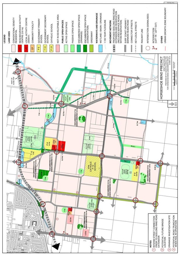
The approach used to develop the Horseshoe Bend PSP is consistent with that used for the East and West residential precincts. The exhibited master plan is included in Appendix 1-1. The Key feature of the Horseshoe Bend PSP and master plan include:
A road network that meshes seamlessly with the adjoining Precincts that provides capacity for all traffic in the Precinct, without depending on the construction of the continuation of the 4C Ring Road extension.
The provision of public open space and three community facilities, equally distributed through the Precinct, with floor/land areas that reflect industry standards and current best practice.
The development (and environmental improvement) of the Sparrovale area, to the east of the precinct, as a drainage wetland.
Exhibition
This Amendment will follow the standard exhibition process as set out in the Planning and Environment Act, 1987, with all submissions reviewed by Council. It is expected that an independent Panel appointed by the Minister will be required to hear submissions, as was the case with the East and West PSPs.
The environmental implications in respect to the PSP, DCP and NVPP relate to the protection of significant vegetation scattered across the precinct. These matters will be appropriately addressed through the preparation of the PSP and NVPP. Note, the NVPP is required to be endorsed by the Department of Sustainability and Environment (DSE). The environmental impacts of development of the Sparrovale area, to the east of the precinct, as a drainage wetland are expected to be minimal and will be addressed during its actual development. It is intended that once the wetlands are complete that the environmental values of the wetland will be significantly greater than its current values.
A limited number of DCP projects will require co-funding by Council, including a multipurpose stadium and a few minor road / traffic projects (Council’s total contribution is estimated at $2M). These costs have been identified in Council’s long term financial plan and will be refined (if required) once the DCP has been approved.
The processing of this planning scheme amendment is provided for in current budgets as is the processing of any development application arising from the ultimate approval of the amendment.
This amendment will follow the normal statutory amendment process as set out in the Planning and Environment Act, 1987.
The PSP will facilitate development generally in accordance with the approved Armstrong Creek Urban Growth Plan and Greater Geelong planning policy (clause 21.11) relating to the Armstrong Creek Urban Growth Area.
No Council Officers involved in this report have any direct or indirect interest, in accordance with Section 80(c) of the Local Government Act.
There are no foreseeable risks associated with adopting the recommendations of this report. The development of this land has strong strategic justification and has been a long-standing Council policy direction.
The PSP includes three community centres in the Precinct. These have been specified and sited in accordance with requirements of the Community Development Department and are funded by the DCP. In addition, the PSP will contain a full complement of pedestrian and bicycle trails and active and passive public open space.
Communication for this amendment will follow the standard statutory exhibition process. It is expected that this will be supplemented with additional public information sessions to ensure appropriate community engagement.
 >
Portfolio: |
Planning - Cr Macdonald |
Source: |
Economic Development, Planning & Tourism |
General Manager: |
Peter Bettess |
Index Reference: |
Armstrong Creek |
The purpose of this report is to make recommendations to Council regarding the preparation and exhibition of Greater Geelong Planning Scheme Amendment C267 Armstrong Creek Town Centre Precinct Structure Plan (PSP) and Development Contributions Plan (DCP).
Amendment C267 applies to land known as the Armstrong Creek Town Centre (formerly the Armstrong Creek Major Activity Centre). The land is bounded by Boundary Road to the north, Barwarre Road to the east, Burvilles Road to the south and Surfcoast Highway to the west.
Amendment C267 proposes to:
Include the Armstrong Creek Town Centre PSP in the Greater Geelong Planning Scheme (the planning scheme) as an incorporated document,
Apply the Development Contributions Plan Overlay (DCPO) to the Precinct, and include the Development Contributions Plan (DCP) as an incorporated document in the planning scheme,
Include the Armstrong Creek Town Centre Native Vegetation Precinct Plan (NVPP) in the planning scheme as an incorporated document.
In late 2010 the Armstrong Creek Town Centre Steering Committee (landowners) was formed to fund, guide and inform the preparation of the PSP and associated planning scheme amendment package. The Steering Committee funded the appointment of Tract Consultants, via a Council project management model.
Tract Consultants have also prepared the required information for the preparation of a DCP to the satisfaction of Council officers, with the DCP being prepared by Council consultant Urban Enterprises P/L.
The Precinct’s DCP rate per developable hectare is expected to be comparable to the Armstrong Creek East and West Precincts, however the small area of the precinct is likely to result in a levy at the higher end of the growth areas’ other precincts.
The Draft PSP master plan has gone through extensive consultation with the Town Centre’s Landowner Steering Committee, with submissions via the consultation process received being used to refine the final draft PSP, where appropriate.
The purpose of this report is to recommend that Council prepare and exhibit Greater Geelong Planning Scheme Amendment C267.
Following exhibition of the amendment a further report will be brought to Council to review and recommend an approach to dealing with submissions.
Cr Macdonald moved, Cr Richards seconded -
That Council prepare and exhibit Amendment C267, subject to Ministerial Authorisation.
Carried.
The implementation of the Armstrong Creek Growth Area has been progressed to a point where the approved Framework Plan has been included in the Planning Scheme, and all the land within the urban growth area rezoned to an Urban Growth zone.
The adoption of the Framework Plan and rezoning of the land to an Urban Growth zone was the subject of an exhibition phase in late 2006 culminating in an independent panel review which ran over 18 days in 2007. The Framework Plan provides very clear direction in relation to the location of activity centres, and land use direction for residential and employment land and the location of key open space. The rezoning of land to the Urban Growth Zone requires the development of Precinct Structure Plans to enable development to commence.
In addition the Armstrong Creek Project Team has undertaken detailed infrastructure planning both for civil infrastructure and community infrastructure for the entire growth area and Council has adopted the Armstrong Creek Integrated Infrastructure Delivery Plan (IIDP) which gives clear direction in relation to the infrastructure requirements to serve future communities across Armstrong Creek.
It should be noted that the Armstrong Creek Town Centre PSP is the third residential and second employment precinct to be prepared for the Armstrong Creek Urban Growth Area. The approach taken to prepare background technical reports to inform the preparation of the PSP and DCP for the Town Centre is consistent with the approach taken for the approved Precinct Structure Plan’s for the Armstrong Creek East Precinct and the North-East Industrial Precinct and the Armstrong Creek West Precinct (currently awaiting Ministerial Approval).
In late 2010 the Armstrong Creek Town Centre Steering Committee was formed to guide and inform the planning process for the development of the C267 amendment package. Membership of the committee comprised two representatives from all titles within the Armstrong Creek Town Centre, The Armstrong Creek Project Team and representatives from the Department of Planning and Community Development.
The Armstrong Creek Project Team has, in close consultation with landowners, prepared a Precinct Structure Plan (PSP) and Native Vegetation Precinct Plan (NVPP) for the Armstrong Creek Town Centre.
The Development Contributions Plan (DCP) for the Armstrong Creek Town Centre is being prepared by Urban Enterprise Pty Ltd on behalf of Council. The DCP is required to ensure that levies are collected so that the infrastructure set out in the PSP is funded.
The above documents are proposed to be included in the Planning Scheme via this amendment.
This amendment will implement the Armstrong Creek Town Centre PSP and is consistent with previous adopted PSPs and DCPs in the Armstrong Creek Urban Growth Area. In areas where it departs from the Armstrong Creek Urban Growth Plan Framework Plan these modifications will enhance the overall planning outcomes for the precinct and are considered to be refinements to the Armstrong Creek Urban Growth Plan.
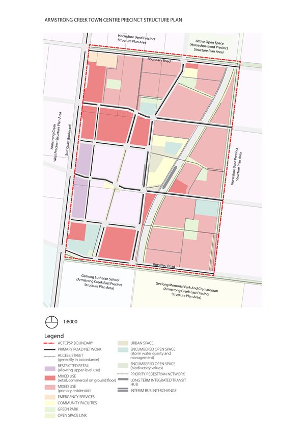
The preparation of the draft PSP has included a period of extensive consultation with all landowners within the Precinct (forming part of the Town Centre Steering Committee). Relevant external Government agencies and Council departments who were invited to review and comment on the draft master plan and background technical reports. The submissions received to this consultation were used to inform the preparation of the final draft PSP. The NVPP was prepared in consultation with DSE and will be endorsed by DSE prior to exhibition of the amendment. A copy of the Draft PSP map is provided in Appendix 2-1.
The ACTCPSP is a high level framework linking State and Local Government planning policies to facilitate future planning permit processes for the use and development of the Armstrong Creek Town Centre.
It provides a long term vision and framework to guide use and development with a description of how the land is expected to be used and developed and also how and where services are planned to support that use and development.
Specifically, the ACTCPSP:
Is a strategic plan setting out the vision and structure for the creation of a new urban area that implements Victorian Government guidelines;
Provides the basis for planning controls that apply in the Schedule to the Urban Growth Zone in the relevant planning scheme;
Provides the framework for the consideration of planning permits that provide for urban development under the provisions of the relevant planning scheme;
Details requirements or conditions that must be met by future development and use;
Outlines projects required to ensure that the future community within the area is provided as early as possible with access to infrastructure and services to support a quality, affordable lifestyle; and
Provides developers, investors and local communities with certainty regarding the nature of future development within the development area.
The ACTCPSP sets out the objectives and implementation of these in relation to twelve key elements
Image and character.
Place making and liveability;
Environmentally sustainable development;
Subdivision and housing;
Built form;
Community facilities;
Movement and access network;
Public open space, natural systems and biodiversity;
Drainage and floodplain management;
Car parking and loading;
Utilities and energy; and,
Development staging.
What the Amendment does
The amendment proposes to:
Include the Armstrong Creek Town Centre PSP in the Planning Scheme as an incorporated document.
Include the Armstrong Creek Town Centre NVPP in the Planning Scheme as an incorporated document.
Include the land in the Armstrong Creek Town Centre Precinct in a Development Contributions Plan Overlay (DCPO) and include the Armstrong Creek Town Centre Development Contributions Plan (DCP) as an incorporated document in the Planning Scheme.
Amend the Armstrong Creek Urban Growth Plan Framework Plan to give effect to the Armstrong Creek Town Centre Precinct Structure Plan detail as adopted, where it is inconsistent with the Urban Growth Plan.
What the DCP does
The DCP for the Armstrong Creek Town Centre Precinct will provide a contribution to the funding of the following categories of infrastructure:
Land
Intersections and traffic infrastructure
Shared paths/trails
Improvement to civic open space
Drainage and wetlands works
Community complexes (inc. child care, Kindergarten, maternal child health and community meeting space)
Contribution to a Armstrong Creek Regional Library
Planning costs.
The Precinct’s DCP rate per developable hectare is expected to be comparable to the Armstrong Creek East and West Precincts, however the small area of the precinct is likely to result in a levy at the higher end of the growth areas’ other precincts
While some of the specific projects will be different (owing to the peculiarities of each Precinct), all the projects funded by the PSP are substantially the same as those in other residential Precincts of the Growth Area.
The Precinct will require the funding of several medium to long term Council community projects to service the Armstrong Creek growth area. These have been identified in the Armstrong Creek Integrated Infrastructure Delivery Plan (ACIIDP) adopted by Council in February 2009 and include facilities such as an aquatic centre, multiple purpose stadium, integrated community and cultural centre and contribution to an Armstrong Creek Regional Library. It is expected, and assumed in the ACIIDP, that most of these projects will receive external funding from the State and / or Federal Government.
Exhibition
This Amendment will follow the standard exhibition process as set out in the Planning and Environment Act, 1987, with all submissions reviewed by Council. It is expected that an independent Panel appointed by the Minister will be required to hear submissions, as was the case with the East and West PSPs.
The environmental impact of development in the Armstrong Creek Urban Growth Area has been subject to thorough analysis and review via the original Framework Plan, independent panel process. The preparation of the Precinct Structure Plan has been supported via the development of detailed technical reports in respect to stormwater management, native vegetation and sustainability analysis. The development and review of these technical reports has been undertaken in consultation with relevant statutory departments of the Government.
The environmental implications in respect to the PSP, DCP and NVPP relate to the protection of significant vegetation scattered across the precinct. These matters will be appropriately addressed through the preparation of the PSP and NVPP. Note, the NVPP is required to be endorsed by the Department of Sustainability and Environment (DSE).
A small number of DCP roads and traffic projects will require co-funding by Council (less than $2M). These costs have been identified in Council’s long term financial plan and will be refined (if required) once the DCP has been approved. The DCP will also facilitate the provision of fully funded land for the siting of key strategic projects for the Armstrong Creek Town Centre Precinct.
The following projects remain unfunded and will be subject to future grants and Council funding opportunities. The DCP does not commit Council to expenditure in respect to these projects and they will be longer term commitments subject to alternate funding availability:
indoor multipurpose stadium $12M
regional library $15M
integrated community, youth and culture centre $15M
aquatic leisure centre $22M
The processing of this planning scheme amendment is provided for in current budgets as is the processing of any development application arising from the ultimate approval of the amendment.
The Precinct will require the funding of several medium to long term Council community projects to service the Armstrong Creek growth area. The Adopted Armstrong Creek Integrated Infrastructure Delivery Plan (ACIIDP) identifies that these projects will require an element of external funding from the State and / or Federal Government.
Policy/Legal/Statutory Implications
This amendment will follow the statutory amendment process set out in the Planning and Environment Act, 1987. The PSP will facilitate development in accordance with the approved Armstrong Creek Urban Growth Plan and the planning policies (clause 21.11) relating to the Armstrong Creek Urban Growth Area.
The Precinct Structure Plan is consistent with all relevant State and Council planning policies which have been described and discussed in detail in the Precinct Structure Plan.
The Armstrong Creek Town Centre PSP will also seek to implement a number key sustainability initiatives detailed with the Armstrong Creek Urban Growth Plan.
There are also some significant opportunities for developer lead sustainability initiatives such as co-generation or solar generation of power, electric vehicle stations, water harvesting and reuse. Further the plan supports best practice Main Street principles and walkability, integrated housing close to amenity areas and the creation of a highly vegetated “green” town centre.
Office Direct or Indirect Interest
In accordance with Sec 80(c) of the Local Government Act Peter Bettess, General Manager, Economic Development, Planning & Tourism declares an indirect financial interest in that he owns Woolworths and Wesfarmers shares.
No other Council Officers involved in this report have any direct or indirect interest, in accordance with Section 80(c) of the Local Government Act.
There are no foreseeable risks associated with adopting the recommendations of this report. The development of this land has strong strategic justification and has been a long-standing Council policy direction.
The Development Contributions Plan (DCP) will provide the land for Council to deliver civic services such as aquatic centre, multi-purpose stadium, library and community meeting spaces to service the entire Armstrong Creek growth area.
All land owners across the precinct to be dealt with under this amendment have been actively engaged throughout the preparation of the amendment package. All relevant state authorities have been engaged during the preparation of the background technical reports to this amendment.
This Amendment will follow the standard exhibition process as set out in the Planning and Environment Act, 1987, with all submissions reviewed by Council. It is expected that an independent Panel appointed by the Minister will be required to hear submissions, as was the case with the East and West PSPs.
Portfolio: |
Planning - Cr Macdonald |
Source: |
Economic Development, Planning and Tourism – Strategic Implementation |
General Manager: |
Peter Bettess |
Index Reference: |
Application: C250 |
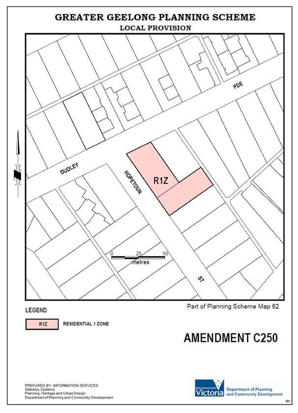
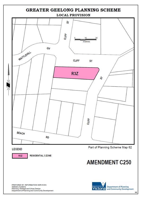
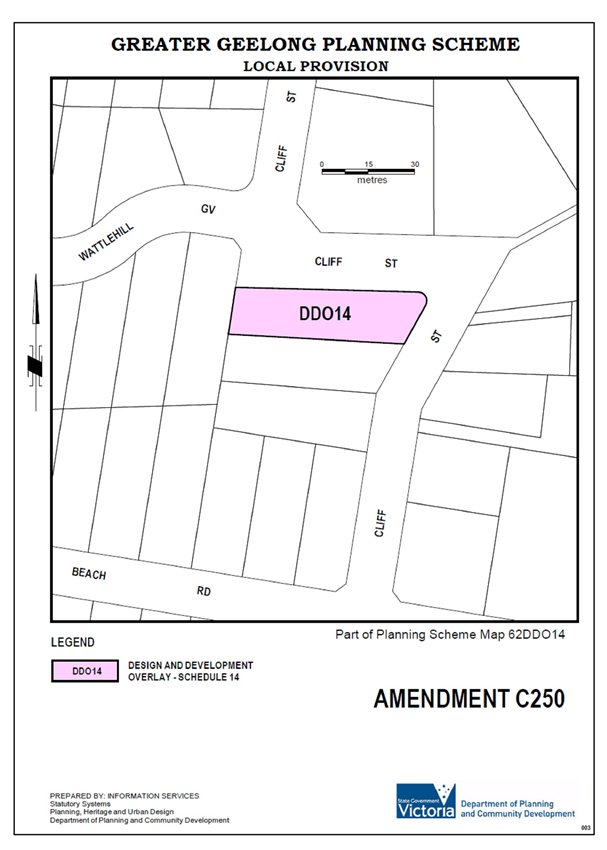
Amendment C250 proposes to rezone land at 31 Dudley Parade and 1 Hopetoun Street, St Leonards from Public Park and Recreation Zone (PPRZ) to Residential 1 Zone (R1Z), and to rezone the land at 18 Cliff Street, St Leonards from PPRZ to Residential 3 Zone (R3Z) with a Design and Development Overlay 14 (DDO14).
The Amendment has been undertaken to facilitate sale of the land which has been declared surplus to Council requirements for public open space purposes. Part of the Cliff Street property is intended for road realignment purposes.
Under the Local Government Best Practice Guideline for the Sale and Exchange of Land, Council is required to ensure that prior to being offered for sale, property should be appropriately zoned.
Authorisation (A02229) for this Amendment was issued on 4 April 2012 under section 35B of the Planning and Environment Act 1987.
Exhibition of the Amendment between 17 May and 18 June 2012 resulted in three submissions – two from service authorities (Barwon Water and the Corangamite Catchment Management Authority) and one from a local resident.
The CCMA did not object to the amendment and considered that the rezoning would be compatible with the projected storm tide risk associated with St Leonards up to the year 2100. Barwon Water is seeking the creation of a two metre wide sewerage easement on the 1 Hopetoun Street property, which can be accommodated.
The objecting submission raised concerns about the impact of the rezoning on an existing storm water drainage pit and the need to use the land to improve the Cliff Street road alignment to improve safety for road users and adjoining residents.
After further discussions between officers and the objecting submittor, they have withdrawn their submission by correspondence.
The Amendment is consistent with planning policy for St Leonards.
Cr Macdonald moved, Cr Richards seconded -
That Council:
adopt Amendment C250 as contained in Appendix 3-1 of this report; and
submit the adopted Amendment together with the prescribed information to the Minister for Planning requesting approval.
Carried.
Amendment C250 is a Council initiated amendment made by the Property Services Department.
The Amendment proposes to rezone the land 31 Dudley Parade and 1 Hopetoun Street, St Leonards from Public Park and Recreation Zone (PPRZ) to Residential 1 Zone (R1Z), and to rezone the land at 18 Cliff Street, St Leonards from PPRZ to Residential 3 Zone (R3Z) with a Design and Development Overlay 14 (DDO14).
The land has been identified as being surplus to Council requirements for public open space purposes. Part of the Cliff Street property is intended for road realignment purposes. Council at its meeting of 28 February 2012 resolved to sell the land subject to approval of the rezoning. Under the Local Government Best Practice Guideline for the Sale and Exchange of Land, Council is required to ensure that prior to being offered for sale, property should be appropriately zoned.
A Coastal Hazard Vulnerability Assessment (CHVA) of the Hopetoun and Dudley properties undertaken as part of the consideration of the amendment application concluded that the properties would be unlikely to be vulnerable to coastal erosion or inundation from projected increased sea levels out to at least 2100. The CHVA also concluded that the subject properties may be vulnerable to localised flooding with variations of water surface levels at St Leonards Lake when combined with overland flooding of the sub catchment. A CHVA was not required for the Cliff Street property as it will be partially used for a road realignment and partially sold (the higher land) to the adjoining landowner to formalise a current lease.
Ministerial Authorisation (No: A02229) for this Amendment was received from the Minister for Planning on 4 April 2012. Exhibition of Amendment C250 took place between 17 May and 18 June 2012 with notices placed in local newspapers and in the Government Gazette. Notice of Amendment was sent to the relevant Ministers under the Planning and Environment Act 1987.
Three submissions have been received from Barwon Water, Corangamite Catchment Management Authority (CCMA) and local residents John and Denise Martin.
The CCMA advises that based on the CMA’s best estimate of the applicable year 2100 storm tide and ground level data; it does not consider inundation associated with sea level rise to be an impediment to the proposed rezoning.
Based on available ground level data for the Hopetoun Street and Dudley Parade properties, the CCMA advises that residential development subsequent to the proposed zone change is likely to be compatible with the projected storm tide risk associated with St Leonards up to the year 2100.
The CCMA advises that there is a small portion of 18 Cliff Street that my be lower than the projected year 2100 storm tide level of 2.22m AHD and on this basis there is a requirement that any development would be recommended to be on land above 2.2m AHD to ensure no risk to infrastructure on this property. Despite this minor portion of land below 2.2m AHD there is relatively high ground to the east and north of the subject property which is expected to provide a physical barrier against storm tide inundation of the property itself, and available egress.
Residential development of the Cliff Street site subsequent to the proposed zone change is also likely to be compatible with the projected storm tide risk associated with St Leonards up to the year 2100 on land above 2.2m AHD.
It is noted that the lower portion of this site is proposed to be utilised for a road realignment of the sharp bend in Cliff Street.
Barwon Water has no objections to the proposed changes from a servicing perspective. Barwon Water requires a two metre Barwon Water sewerage easement to be created as a condition of rezoning. This is accepted and Property Department is working directly with Barwon Water to create the easement on title.
John and Denise Martin objected to the rezoning of 18 Cliff Street on the grounds that:
the land has a storm water soakage pit which handles the run-off from the Cliff Street hill in heavy storms; and
the plan does not adequately show the sharp and dangerous bend in Cliff Street and the land should be used to redirect the road overcome this problem.
Officers met with Mr Martin on 8 August 2012 to respond to concerns about the implications of the rezoning and have satisfactorily addressed their concerns about the rezoning of the 18 Cliff Street property. Officers advised that part of the land is to be used to modify the bend in Cliff Street and the accompanying batter, and that these works would accommodate existing storm water drainage infrastructure. By email dated 8 August 2012, the Martins have withdrawn their submission.
The land consists of mowed grassland and some native species which are either common to the locality and Bellarine Peninsula, or considered environmental weeds. None of the native species present are considered rare or endangered.
There are no foreseeable adverse environmental effects as a result of the amendment for either future residents of the site or any of the nearby or adjoining residents and property owners.
There are no ongoing financial implications for Council arising from this amendment.
The rezoning of the Dudley Parade and Hopetoun Street land will facilitate the sale of surplus Council land for future use consistent with the State Planning Policy Framework and Local Planning Policy Framework.
In accordance with section 80(c) of the local Government Act no Council officers have any direct or indirect interest in the matters to which this amendment relates.
There is no risk associated with this Amendment.
Future use of the land will be consistent with the surrounding land uses and zoning.
The disposal of the surplus land will allow these resources to be redeployed to other services for the benefit of ratepayers.
The amendment was exhibited in accordance with the Planning and Environment Act, 1987. Submissions have been acknowledged and submitters will be notified of Council’s determination and any decision of the Minister for Planning.
The Property Unit is working directly with Barwon Water to create the sewerage easement on the 1 Hopetoun Street property title.
The planning authority for this amendment is Greater Geelong Planning Scheme
The Greater Geelong Planning Scheme is amended as follows:
Planning Scheme Maps
The Planning Scheme Maps are amended by a total of 3 attached maps:
Zoning Maps
Planning Scheme Map No. 62 is amended in the manner shown on the attached 2 maps marked “Greater Geelong Planning Scheme, Amendment C250”.
Overlay Maps
Planning Scheme Map No. 62DDO14 is amended in the manner shown on the attached map marked “Greater Geelong Planning Scheme, Amendment C250”.
End of document
Portfolio: |
Planning - Cr Macdonald |
Source: |
Economic Development, Planning & Tourism |
General Manager: |
Peter Bettess |
Index Reference: |
Index Reference: Application 282/2012 |
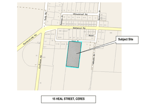
The land 15 Heal Street in Ceres is approximately 1.545 hectares and has an 87.08 metre northern frontage to Heal Street while the site is relatively flat, with a 5 metre fall from the front of the property to the rear. The site falls within two zones – the northern portion of the site falls within the Township Zone (with a Design and Development Overlay Schedule 14) compatible with the urbanised land to the west and north; while the balance of the land to the southern end is held within the Farming Zone.
The proposal involves the subdivision of the land into four (4) allotments with a new dwelling and associated outbuilding proposed on one of the allotments.
Part of the land is subject to the Township Zone and is also subject to the Design and Development Overlay 14 while the remainder of the land is subject to the Farming Zone and is not subject to any overlays.
The application was advertised by way of letters to adjoining and surrounding land owners/occupiers and with a sign on the site for the required 14 day period.
As a result of public notification 14 objections were received which related to neighbourhood character, waste water disposal, health and safety impacts as a result of increased traffic, non-compliance with Council policies, the accuracy of the Land Capability Assessment submitted, setting a precedent for future applications, the potential for two storey dwellings on the proposed lots and the lack of an overlay over Ceres promised by Councillor Katos in 2010.
The application was considered against the relevant State and local planning policy, the Township Zone, the Farming Zone and Clause 56 and 65 and is considered to be generally in accordance with the objectives, strategies and purpose of those provisions.
It is recommended that the application be supported.
Cr Nelson moved, Cr Richards seconded -
That the Responsible Authority having considered all matters which the Planning and Environment Act, 1987, requires it to consider, decides to Issue a Notice of Decision to Grant a Planning Permit for the Use and Development of Land for a Dwelling and Subdivision of Land in to Three (3) Lots at 15 Heal Street, Ceres in accordance with the plans submitted with the application and subject to the following conditions:
Amended Plan of Subdivision Required
Before the plan of subdivision can be certified, amended plans to the satisfaction of the Responsible Authority must be submitted to and approved by the Responsible Authority. When approved the plans will be endorsed and will then form part of the permit. The plans must be drawn to scale with dimensions and three copies must be provided.
The plans must be generally in accordance with the plans submitted with the application, but modified to show:
only two (2) allotments within the Township Zone except for the accessway for the rear allotment in the Farming Zone;
a 5m wide drainage easement along the rear boundary of lots 1 & 2 and across the lot 4 access. The easement is to be made in favour of the City of Greater Geelong;
the section of the land to be dedicated as a road reserve to Council. The road reserve shall be of a width consistent with that on the abutting land at 25 Heal Street, Ceres.
The use and development as well as the layout and site dimensions of the proposed subdivision as shown on the endorsed plan(s) shall not be altered or modified without the written consent of the Responsible Authority. There are no requirements to alter or modify the endorsed plan of subdivision if a plan is certified under the provisions of the Subdivision Act 1988, which is generally in accordance with the endorsed plan(s).
Unless otherwise approved by the Responsible Authority, prior to the statement of compliance for the subdivision, the applicant must enter into an agreement under Section 173 of the Planning and Environment Act 1987 with the Responsible Authority. The agreement must be in a form to the satisfaction of the Responsible Authority, and the applicant must be responsible for the expense of the preparation and registration of the agreement, including the Responsible Authority’s reasonable costs and expense (including legal expenses) incidental to the preparation, registration and enforcement of the agreement. The agreement must contain covenants to be registered on the Title of the property so as to run with the land, and must provide for the following:
The Land Capability Assessment prepared by Melbourne Geological Consultants dated July 2012 is used as a reference document for the design of the septic systems to treat the waste water generated by any future dwellings on these sites;
The strategies for ongoing actions detailed in the Land Management Plan dated March 2012 must be implemented in an ongoing manner on lot 4 once the dwelling has been constructed.
The agreement will be registered on Title in accordance with Section 181 of the Planning and Environment Act 1987.
Unless otherwise approved by the Responsible Authority, prior to the commencement of the development hereby approved, engineer designed drainage plans prepared by a qualified person must be submitted to and approved by the Responsible Authority. These plans must show that the design for the drainage system complies with relevant City of Greater Geelong Standards, Australian Rainfall and Runoff, Australian Standards (in particular AS 3500), WSUD Engineering Procedures:
Stormwater- CSIRO, and any other approved technical publications relevant to the development, demonstrating that the system caters for the development in accordance with the following design criteria:
Runoff from Hard Standing Areas shall be treated to achieve current best practice pollutant removal targets by connection to an appropriate Water Treatment Facility, with capacity to treat at least a 3 month ARI storm event, unless approved otherwise by the Responsible Authority. The Water Treatment Facility must be maintained to the satisfaction of the Responsible Authority.
A swale drain is to be designed along the frontage of the site in Heal Street. The swale drain must discharge to the existing swale drain that runs along the western boundary of 5 Heal Street, Ceres.
A swale drain is to be designed along the rear of lots 1 & 2 and across the access for lot 4. The swale is to discharge to the existing swale drain that runs along the western boundary of 5 Heal Street, Ceres.
A soakage pit is required to be designed and constructed for lots 1 & 2. Lot 4 can discharge/retain stormwater on site.
Unless otherwise approved by the Responsible Authority, prior to the occupation of the development, the developer must:
construct the site stormwater system including connection points for each lot into the soakage pit, or other nominated point/s as approved by the Responsible Authority and no storm water shall drain or discharge from the land to adjoining properties in a concentrated manner.
construct the swale drains along the rear of lots 1 & 2 and in the road reserve fronting the site in accordance with the approved drainage plans.
construct any stormwater treatment works in accordance with the approved drainage plans.
construct vehicular crossings in accordance with the requirements and standards of the City of Greater Geelong. A Vehicle Crossing Permit must be obtained prior to commencement of works. Any redundant vehicular crossing must be removed and the footpath/nature strip area reinstated to match existing construction in the street;
all to the satisfaction of the Responsible Authority.
The site shall be drained to the satisfaction of the Responsible Authority and no stormwater, sullage, sewerage or polluted runoff may drain or discharge from the land to adjoining properties.
Access to the dwelling must be provided via an all-weather road with dimensions adequate to accommodate emergency vehicles to the satisfaction of the Responsible Authority.
The dwelling must be connected to a reticulated sewerage system or if not available, the waste water must be treated and retained on-site in accordance with the State Environment Protection Policy (Waters of Victoria) under the Environment Protection Act 1970.
The dwelling must be connected to a reticulated potable water supply or have an alternative potable water supply with adequate storage for domestic use as well as for fire fighting purposes to the satisfaction of the Responsible Authority.
The dwelling must be connected to a reticulated electricity supply or have an alternative energy source to the satisfaction of the Responsible Authority.
Unless otherwise approved by the Responsible Authority, prior to the statement of compliance for the subdivision, the developer must:
construct the site stormwater system including connection points for each lot into the soakage pit, or other nominated point/s as approved by the Responsible Authority and no storm water shall drain or discharge from the land to adjoining properties in a concentrated manner.
construct the swale drains along the rear of lots 1 & 2 and in the road reserve fronting the site in accordance with the approved drainage plans.
construct any stormwater treatment works in accordance with the approved drainage plans.
construct vehicular crossings in accordance with the requirements and standards of the City of Greater Geelong. A Vehicle Crossing Permit must be obtained prior to commencement of works. Any redundant vehicular crossing must be removed and the footpath/nature strip area reinstated to match existing construction in the street;
all to the satisfaction of the Responsible Authority.
Unless otherwise approved by the Responsible Authority, prior to the statement of compliance for the subdivision, engineer designed drainage plans prepared by a qualified person must be submitted to and approved by the Responsible Authority. These plans must show that the design for the drainage system complies with relevant City of Greater Geelong Standards, Australian Rainfall and Runoff, Australian Standards (in particular AS 3500), WSUD Engineering Procedures: Stormwater- CSIRO, and any other approved technical publications relevant to the development, demonstrating that the system caters for the development in accordance with the following design criteria:
Runoff from Hard Standing Areas shall be treated to achieve current best practice pollutant removal targets by connection to an appropriate Water Treatment Facility, with capacity to treat at least a 3 month ARI storm event, unless approved otherwise by the Responsible Authority. The Water Treatment Facility must be maintained to the satisfaction of the Responsible Authority.
A swale drain is to be designed along the frontage of the site in Heal Street. The swale drain must discharge to the existing swale drain that runs along the western boundary of 5 Heal Street, Ceres.
A swale drain is to be designed along the rear of lots 1 & 2 and across the access for lot 4. The swale is to discharge to the existing swale drain that runs along the western boundary of 5 Heal Street, Ceres.
A soakage pit is required to be designed and constructed for lots 1 & 2. Lot 4 can discharge/retain stormwater on site.
The plan of subdivision must be referred to Barwon Water in accordance with the Subdivision Act 1988 and any subsequent amendments to the plan provided to Barwon Water.
The plan of subdivision submitted for certification under the Subdivision Act 1988 shall be referred to Powercor Australia Ltd in accordance with Section 8 of that Act.
The applicant shall provide an electricity supply to all lots in the subdivision in accordance with Powercor’s requirements and standards, including the extension, augmentation or re-arrangement of any existing electricity supply system, as required by Powercor.
The applicant shall, where buildings or other installations exist on the land to be subdivided and are connected to the electricity supply, they shall be bought into compliance with the Service and Installation Rules issued by the Victorian Electricity Supply Industry. You shall arrange compliance through a Registered Electrical Contractor and provide to Powercor Australia Ltd a completed Electrical Safety Certificate in accordance with Electricity Safe Victoria’s Electrical Safety System.
The applicant shall provide to Powercor Australia Ltd, a copy of the version of the plan of subdivision submitted for certification, which shows any amendments which have been required.
Any buildings must comply with the clearances required by the Electricity Safety (Network Assets) Regulations.
Any construction work must comply with the Officer of the Chief Electrical Inspector “No Go Zone” rules.
That the plan of subdivision submitted for certification be referred to Telstra in accordance with Section 8 of the Subdivision Act 1988.
Telstra will not consent to the issue of a Statement of Compliance until such time as the applicant provides satisfactory evidence of compliance with the above conditions.
Notes: Approval does not cover alterations to existing Telstra Plant or Network. Locations of existing network can be obtained from Dial Before You Dig – Ph: 1100. For co-ordinated Telstra plant reticulation in this development, please refer to www.telstrasmartcommunity.com to Register your Development and Apply for Reticulation.
This permit will expire if one of the following circumstances applies:
The development of the building(s) hereby approved has not commenced within two (2) years of the date of this permit
The plan of subdivision has not been certified within two (2) years of the date of this permit.
The development of the building(s) hereby approved is not completed within four years of the date of this permit.
A statement of compliance is not issued within five (5) years of the date of certification.
The Responsible Authority may extend the periods referred to if a request is made in writing before the permit expires or within three (3) months afterwards.
Construction of the civil works is to be supervised by Council Representative at various stages. An appropriate fee equivalent to 3.25% of total cost of civil works, excluding GST (a minimum fee of $100 applies if the 3.25% amount is less than $100), is to be paid to Council for supervision. Relevant evidential documentation of the cost is to be provided.
All internal property drainage must be designed and constructed to satisfy AS/NZS 3500.
That Officers investigate strategic planning options for Ceres and report back to Council.
Carried.
The Site & Locality
The land 15 Heal Street in Ceres is approximately 1.545 hectares and has an 87.08 metre northern frontage to Heal Street and a maximum depth of 181.90 metres. The site is relatively flat, with a 5 metre fall from the front of the property to the rear. A dam is located in the south-eastern corner of the site.
The site falls within two zones – the northern portion of the site falls within the Township Zone (with a Design and Development Overlay Schedule 14) compatible with the urbanised land to the west and north; while the balance of the land to the southern end is held within the Farming Zone.
Ceres is a small township on the edge of the municipality and is separated from the urban areas by a tract of farming land to the east which forms a buffer from Wandana Heights and Highton. The Geelong Ring Road is also proposed to be located approximately 1.5 kilometres to the east.
The properties to the north-west and the north of the site are rural residential lots within the Township Zone while the land to the south-west is land within the Farming Zone which contains a dwelling. The property to the south and east of the site is a public reserve named Frank Mann Reserve and is located within the Public Park & Recreation Zone.
Proposal
The proposal seeks to subdivide the existing land into four (4) separate allotments consisting of:
Lot 1 – 1430 square metre rectangular shaped allotment with a 27.05 metre frontage and a maximum depth of 53.09 metres.
Lot 2 – 1430 square metre rectangular shaped allotment with a 27.05 metre frontage and a maximum depth of 53.09 metres.
Lot 3 – 1431 square metre rectangular shaped allotment with a 27.05 metre frontage and a maximum depth of 53.09 metres.
Lot 4 – 1.116 hectare battle-axe shaped allotment with a 53.09 metre long driveway which is 5.93 metres wide which leads to the main section of the allotment which is a maximum of 86.84 metres wide and has a maximum depth of 128.82 metres.
The proposal also seeks approval for the use and development of a dwelling and associated outbuilding on lot 4 which is to be contained predominantly on the Farming Zone land.
The dwelling is to be situated around 20 metres south of the proposed rear boundary of Lot 3 and around 13 metres away from the eastern boundary of the site. The dwelling is to contain five (5) bedrooms, an open plan family/lounge/dining/kitchen area with a secondary living/rumpus room and a double garage. The dwelling is to be single storey with a variety of skillion roofs and a mix of contemporary cladding materials.
The shed building is to be situated around 5 metres south of the proposed rear boundary of Lot 1 and around 5 metres away from the western boundary of the site. The shed is to be a gabled roof structure clad with colorbond sheeting. A private access doors are to be provided on the southern and eastern elevations while two (2) 3 metre wide roller doors will be provided on the eastern elevation.
Development
The proposal is considered appropriate within the Farming Zone following reasons:
The site consists of a very small and isolated agricultural entity (1.0373ha) that cannot be viably farmed at a productive level.
The site is constrained to the north with the presence of a Township Zone, and therefore cannot be intensively farmed as it could lead to land use conflicts. The site is further constrained to the south, west and east with adjoining land developed with dwellings and a public reserve.
The site is unlikely to be consolidated with surrounding agricultural land already fragmented. These properties are primarily used for rural living purposes which are suited to smaller lot sizes which require less input and management.
The proposal does not result in the loss of high quality agricultural land nor does it remove it from agricultural production. The proposed rural living component can occur on the land in association with a rural enterprise.
The landscape character of the area consists of predominantly small scale lifestyle properties with dwellings located within both the Farming Zone and abutting Township Zone forming Ceres. The visual amenity of the area will therefore not be impacted by the construction of a dwelling on the land.
The proposal would contribute to sustainable land management practices. The accompanying land management plan includes ecological enhancement through the establishment of native vegetation together with pest animal control and weed eradication.
Clause 35.07-2 Use of Land for a dwelling
A lot used for a dwelling must meet the following requirements:
Access to the dwelling must be provided via an all-weather road with dimensions adequate to accommodate emergency vehicles.
An all weather driveway will be provided from Heal Street to the dwelling.
The dwelling must be connected to a reticulated sewerage system or if not available, the waste water must be treated and retained on-site in accordance with the State Environment Protection Policy (Waters of Victoria) under the Environment Protection Act 1970.
The site is not connected to reticulated sewerage similar to land within the Township Zone to the north. The site is able to treat and retain waste water onsite especially as it is around 1ha in size.
The dwelling must be connected to a reticulated potable water supply or have an alternative potable water supply with adequate storage for domestic use as well as for fire fighting purposes.
The dwelling will have a potable water supply as mains water is not connected to the site. Domestic and fire fighting water supply will be provided in water tanks adjacent to the dwelling and filled from runoff.
The dwelling must be connected to a reticulated electricity supply or have an alternative energy source
The site is connected to a power supply.
Decision Guidelines
Clause 35.07-6 sets out the Decision Guidelines of the Farming Zone, which have been addressed as follows:
General issues
The State Planning Policy Framework and the Local Planning Policy Framework, including the Municipal Strategic Statement and local planning policies.
As discussed later in this report, it is submitted that the proposal adequately complies with the State Planning Policy Framework and the Local Planning Policy Framework, including the Municipal Strategic Statement and local planning policies.
Any Regional Catchment Strategy and associated plan applying to the land.
There are no Regional Catchment Strategies or policies that apply to the land.
The capability of the land to accommodate the proposed use or development, including the disposal of effluent.
The land has the capability to accommodate the proposed dwelling, with respect to site quality attributes such as soils, aspects, contours and drainage patterns. The site has sufficient land area available (~1ha) to cater for waste water management.
How the use or development relates to sustainable land management.
The proposal will contribute to sustainable land management practices. The accompanying land management plan includes ecological enhancement through the establishment of native vegetation together with pest animal control and weed eradication.
In essence, the on-site residence will have a functional association with the ongoing activities of the land which includes revegetation works. Additionally, it is considered that an on-site presence will provide opportunity for better management of natural resources and improved maintenance of the land.
Whether the site is suitable for the use or development and whether the proposal is compatible with adjoining and nearby land uses.
Given the size and location of the subject site, it is considered that the site is suitable for a dwelling. Adjoining land is used for rural living purposes similar to proposed and a public reserve. Surrounding agricultural land is not intensively farmed and given the high concentration of dwellings in the immediate area it is unlikely that agriculture will become the dominant land use in this area.
Overall, it is considered that the placement of the proposed residence away from common boundaries and establishment of screening vegetation will ensure the use and development is compatible with surrounding rural living land.
Agricultural issues
Whether the use or development will support and enhance agricultural production.
The land will not necessarily continue to be farmed however it is not considered that the approval of the dwelling will preclude any future potential for the land to be used for some sort of agricultural use.
Whether the use or development will permanently remove land from agricultural production.
The proposal will remove a small area of land to contain the dwelling footprint along with land to be revegetated but will not permanently remove all of the land from agricultural production.
The potential for the use or development to limit the operation and expansion of adjoining and nearby agricultural uses.
The development of a dwelling on the land will not place any undue impacts on the expansion of nearby agricultural uses. The dwelling has been sited to avoid any land use conflicts.
The capacity of the site to sustain the agricultural use.
Although not highly productive agricultural land the site is considered to have some capabilities to support light agricultural uses such as grazing.
Dwelling issues
Whether the dwelling will result in the loss or fragmentation of productive agricultural land.
The dwelling will not result in fragmentation as the site will exist as a separate entity entirely on Farming Zone land (except for the driveway which is in the Township Zone). The site is not considered highly productive due to its isolation, size and seasonal water logging.
Whether the dwelling is reasonably required for the operation of the agricultural activity conducted on the land.
The site is unlikely to ever be economically viable. Essentially, it is contended that the use and development of a dwelling has a practical association with the use of land for grazing and environmental improvement. In addition residency on the land should facilitate going management and maintenance of the property.
Whether the dwelling will be adversely affected by agricultural activities on adjacent and nearby land due to dust, noise, odour, use of chemicals and farm machinery, traffic and hours of operation.
The surrounding area is not subject to intensive forms of agricultural which might otherwise result in significant off site disturbance.
Whether the dwelling will adversely affect the operation and expansion of adjoining and nearby agricultural uses.
The location of the dwelling has been sited so as not to impact on adjoining uses.
Environmental issues
The impact of the proposal on the natural physical features and resources of the area, in particular on soil and water quality.
It is considered that the proposal will not adversely impact on the environment.
The impact of the use or development on the flora and fauna on the site and its surrounds.
It is considered that the development will not have an injurious impact on the flora, fauna or landscape features of the area. An on-site presence will encourage revegetation and increased attention to protection of the landscape features of the site.
The need to protect and enhance the biodiversity of the area, including the retention of vegetation and faunal habitat and the need to revegetate land including riparian buffers along waterways, gullies, ridgelines, property boundaries and saline discharge and recharge area.
There will be no loss of native vegetation associated with the proposed dwelling and associated works.
Design and siting issues
The need to locate buildings in one area to avoid any adverse impacts on surrounding agricultural uses and to minimise the loss of productive agricultural land.
The dwelling has been specifically sited to minimise loss to productive land, and has been offset from boundaries to limit disturbance from surrounding land uses.
The impact of the siting, design, height, bulk, colours and materials to be used, on the natural environment, major roads, vistas and water features and the measures to be undertaken to minimise any adverse impacts.
The single storey design of the dwelling will be well suited the rural setting and has been designed to ensure best accessibility into the lot with particular regard for placement factors such as aspect, vistas and solar orientation.
The impact on the character and appearance of the area or features of architectural, historic or scientific significance or of natural scenic beauty or importance.
Several of the surrounding land parcels are of similar size and contain dwellings. As described above, the buildings and works proposed are intended to be appropriately sited to maximise assimilation with the physical characteristics of the land. As such it is not considered the proposal will unfavourably impact on the character and appearance of the area.
The location and design of existing and proposed infrastructure including roads, gas, water, drainage, telecommunications and sewerage facilities.
Electricity and telecommunications are available to the site.
Whether the use and development will require traffic management measures.
Heal Street is of suitable standard and construction, and should readily accommodate any additional traffic movements associated with the proposal.
The proposal is consistent with both the SPPF & LPPF in that:
It will not contribute to fragmentation of land within the Farming Zone as it will exist as a small Farming Zone lot subject to the associated subdivision.
Existing agricultural activity on adjoining land will not be compromised with properties generally used for rural living purposes.
It can support a form of agriculture on the land, even though it is not economically viable to farm the site.
The environmental condition of the land will be enhanced through revegetation efforts, including pest plant and animal control
It does not remove a significant portion of site away from farming opportunities.
It will create a permanent on-site presence which will improve land management practices.
It will not result in the removal of native vegetation or adversely impact on biodiversity.
The dwelling has been sited and designed so that it will not unduly compromise the farmed rural landscape.
Subdivision
The Township Zone and the Farming Zone require consideration of the State and local planning policy framework, as well as the objectives and standards of Clause 56 (Rescode), when considering an application to subdivide land. An assessment against Clause 56 is undertaken later in the report.
With regards to the purpose of the Township Zone, the subdivision provides for additional residential development within the existing township boundaries which is considered appropriate. The lot sizes and layout are similar to existing lots within the township, and are considered to enable to siting and design of development that respects the existing character of Ceres.
The southern part of the site which has an area of 10670 square metres is within the Farming Zone. It is proposed to retain all of this land within Lot 4.
Whilst the entire property is used for grazing purposes currently, the northern half of the site has been set aside and zoned for residential purposes for quite some time. This property, along with some others within the Ceres Township, is in the position where they are located within both the Township Zone and Farming Zone.
In this particular situation, the Township Zone portion of the land can be subdivided into smaller residential lots consistent with the zoning of the land, while the remaining portion of land within the Farming Zone will not meet the minimum lot size of 40 hectares needed in order to subdivide, Clause 64.03 allows for the creation of a lot smaller than the minimum lot size of a zone if it results in one property within two zones being subdivided along the zoning boundary.
Given that the northern part of the site is zoned Township Zone, it is not considered reasonable to argue a loss of agricultural land as a result of the smaller lot size proposed. Essentially, the proposal does not remove land from agricultural use within the Farming Zone, as the subdivision retains the whole of the area within the Farming Zone within one lot.
In affect, the proposed subdivision is considered to meet the objectives of both zones, and essentially addresses an anomaly within the Scheme, in that the zoning does not correspond with title boundaries, therefore severely restricting future use of the land in accordance with the zone provisions.
Relevant State and local policies generally encourage urban consolidation which respects the character of the area, retention of native vegetation and protection of agricultural land. The proposal is considered to comply with the objectives of these policies by providing for infill subdivision within the existing township boundaries, whilst retaining the land within the Farming Zone within one lot.
It is considered that there will be no environmental implications for Council in grating of this permit.
It is considered that there will be no financial implications for Council in the granting of the permit.
The proposal has been assessed against the provisions of the Greater Geelong Planning scheme as detailed in Appendix 4-3.
No Council officers have any direct or indirect interest in the matter to which this report relates, in accordance with Section 80 (C) of the Local Government Act.
It is considered that there will be no risk to Council in the granting of this permit.
The application was referred to various internal departments of Council for comment, as can be seen in the report.
Before the plan of subdivision can be certified, amended plans to the satisfaction of the Responsible Authority must be submitted to and approved by the Responsible Authority. When approved the plans will be endorsed and will then form part of the permit. The plans must be drawn to scale with dimensions and three copies must be provided. The plans must be generally in accordance with the plans submitted with the application, but modified to show:
a 5m wide drainage easement along the rear boundary of lots 1-3 and across the lot 4 access. The easement is to be made in favour of the City of Greater Geelong;
the section of the land to be dedicated as a road reserve to Council. The road reserve shall be of a width consistent with that on the abutting land at 25 Heal Street, Ceres.
The use and development as well as the layout and site dimensions of the proposed subdivision as shown on the endorsed plan(s) shall not be altered or modified without the written consent of the Responsible Authority. There are no requirements to alter or modify the endorsed plan of subdivision if a plan is certified under the provisions of the Subdivision Act 1988, which is generally in accordance with the endorsed plan(s).
Unless otherwise approved by the Responsible Authority, prior to the statement of compliance for the subdivision, the applicant must enter into an agreement under Section 173 of the Planning and Environment Act 1987 with the Responsible Authority. The agreement must be in a form to the satisfaction of the Responsible Authority, and the applicant must be responsible for the expense of the preparation and registration of the agreement, including the Responsible Authority’s reasonable costs and expense (including legal expenses) incidental to the preparation, registration and enforcement of the agreement. The agreement must contain covenants to be registered on the Title of the property so as to run with the land, and must provide for the following:
The Land Capability Assessment prepared by Melbourne Geological Consultants dated July 2012 is used as a reference document for the design of the septic systems to treat the waste water generated by any future dwellings on these sites;
The strategies for ongoing actions detailed in the Land Management Plan dated March 2012 must be implemented in an ongoing manner on lot 4 once the dwelling has been constructed.
The agreement will be registered on Title in accordance with Section 181 of the Planning and Environment Act 1987.
Unless otherwise approved by the Responsible Authority, prior to the commencement of the development hereby approved, engineer designed drainage plans prepared by a qualified person must be submitted to and approved by the Responsible Authority. These plans must show that the design for the drainage system complies with relevant City of Greater Geelong Standards, Australian Rainfall and Runoff, Australian Standards (in particular AS 3500), WSUD Engineering Procedures: Stormwater- CSIRO, and any other approved technical publications relevant to the development, demonstrating that the system caters for the development in accordance with the following design criteria:
Runoff from Hard Standing Areas shall be treated to achieve current best practice pollutant removal targets by connection to an appropriate Water Treatment Facility, with capacity to treat at least a 3 month ARI storm event, unless approved otherwise by the Responsible Authority. The Water Treatment Facility must be maintained to the satisfaction of the Responsible Authority.
A swale drain is to be designed along the frontage of the site in Heal Street. The swale drain must discharge to the existing swale drain that runs along the western boundary of 5 Heal Street, Ceres.
A swale drain is to be designed along the rear of lots 1-3 and across the access for lot 4. The swale is to discharge to the existing swale drain that runs along the western boundary of 5 Heal Street, Ceres.
A soakage pit is required to be designed and constructed for lots 1-3. Lot 4 can discharge/retain stormwater on site.
Unless otherwise approved by the Responsible Authority, prior to the occupation of the development, the developer must:
construct the site stormwater system including connection points for each lot into the soakage pit, or other nominated point/s as approved by the Responsible Authority and no storm water shall drain or discharge from the land to adjoining properties in a concentrated manner.
construct the swale drains along the rear of lots 1-3 and in the road reserve fronting the site in accordance with the approved drainage plans.
construct any stormwater treatment works in accordance with the approved drainage plans.
construct vehicular crossings in accordance with the requirements and standards of the City of Greater Geelong. A Vehicle Crossing Permit must be obtained prior to commencement of works. Any redundant vehicular crossing must be removed and the footpath/nature strip area reinstated to match existing construction in the street;
All to the satisfaction of the Responsible Authority.
The site shall be drained to the satisfaction of the Responsible Authority and no stormwater, sullage, sewerage or polluted runoff may drain or discharge from the land to adjoining properties.
Access to the dwelling must be provided via an all-weather road with dimensions adequate to accommodate emergency vehicles to the satisfaction of the Responsible Authority.
The dwelling must be connected to a reticulated sewerage system or if not available, the waste water must be treated and retained on-site in accordance with the State Environment Protection Policy (Waters of Victoria) under the Environment Protection Act 1970.
The dwelling must be connected to a reticulated potable water supply or have an alternative potable water supply with adequate storage for domestic use as well as for fire fighting purposes to the satisfaction of the Responsible Authority.
The dwelling must be connected to a reticulated electricity supply or have an alternative energy source to the satisfaction of the Responsible Authority.
Unless otherwise approved by the Responsible Authority, prior to the statement of compliance for the subdivision, the developer must:
construct the site stormwater system including connection points for each lot into the soakage pit, or other nominated point/s as approved by the Responsible Authority and no storm water shall drain or discharge from the land to adjoining properties in a concentrated manner.
construct the swale drains along the rear of lots 1-3 and in the road reserve fronting the site in accordance with the approved drainage plans.
construct any stormwater treatment works in accordance with the approved drainage plans.
construct vehicular crossings in accordance with the requirements and standards of the City of Greater Geelong. A Vehicle Crossing Permit must be obtained prior to commencement of works. Any redundant vehicular crossing must be removed and the footpath/nature strip area reinstated to match existing construction in the street;
All to the satisfaction of the Responsible Authority.
Unless otherwise approved by the Responsible Authority, prior to the statement of compliance for the subdivision, engineer designed drainage plans prepared by a qualified person must be submitted to and approved by the Responsible Authority. These plans must show that the design for the drainage system complies with relevant City of Greater Geelong Standards, Australian Rainfall and Runoff, Australian Standards (in particular AS 3500), WSUD Engineering Procedures: Stormwater- CSIRO, and any other approved technical publications relevant to the development, demonstrating that the system caters for the development in accordance with the following design criteria:
Runoff from Hard Standing Areas shall be treated to achieve current best practice pollutant removal targets by connection to an appropriate Water Treatment Facility, with capacity to treat at least a 3 month ARI storm event, unless approved otherwise by the Responsible Authority. The Water Treatment Facility must be maintained to the satisfaction of the Responsible Authority.
A swale drain is to be designed along the frontage of the site in Heal Street. The swale drain must discharge to the existing swale drain that runs along the western boundary of 5 Heal Street, Ceres.
A swale drain is to be designed along the rear of lots 1-3 and across the access for lot 4. The swale is to discharge to the existing swale drain that runs along the western boundary of 5 Heal Street, Ceres.
A soakage pit is required to be designed and constructed for lots 1-3. Lot 4 can discharge/retain stormwater on site.
Prior to the issue of a Statement of Compliance, the applicant or owner must pay to the Responsible Authority a sum equivalent to 2 percent of the site value of all land contained within Lots 1-3 inclusive hereby approved. Note: This requirement for payment is made pursuant to Section 18 of the Subdivision Act 1988.
The plan of subdivision must be referred to Barwon Water in accordance with the Subdivision Act 1988 and any subsequent amendments to the plan provided to Barwon Water.
The plan of subdivision submitted for certification under the Subdivision Act 1988 shall be referred to Powercor Australia Ltd in accordance with Section 8 of that Act.
The applicant shall provide an electricity supply to all lots in the subdivision in accordance with Powercor’s requirements and standards, including the extension, augmentation or re-arrangement of any existing electricity supply system, as required by Powercor.
The applicant shall, where buildings or other installations exist on the land to be subdivided and are connected to the electricity supply, they shall be bought into compliance with the Service and Installation Rules issued by the Victorian Electricity Supply Industry. You shall arrange compliance through a Registered Electrical Contractor and provide to Powercor Australia Ltd a completed Electrical Safety Certificate in accordance with Electricity Safe Victoria’s Electrical Safety System.
The applicant shall provide to Powercor Australia Ltd, a copy of the version of the plan of subdivision submitted for certification, which shows any amendments which have been required.
Any buildings must comply with the clearances required by the Electricity Safety (Network Assets) Regulations.
Any construction work must comply with the Officer of the Chief Electrical Inspector “No Go Zone” rules.
That the plan of subdivision submitted for certification be referred to Telstra in accordance with Section 8 of the Subdivision Act 1988.
Telstra will not consent to the issue of a Statement of Compliance until such time as the applicant provides satisfactory evidence of compliance with the above conditions.
Notes: Approval does not cover alterations to existing Telstra Plant or Network. Locations of existing network can be obtained from Dial Before You Dig – Ph: 1100. For co-ordinated Telstra plant reticulation in this development, please refer to www.telstrasmartcommunity.com to Register your Development and Apply for Reticulation.
This permit will expire if one of the following circumstances applies:
The development of the building(s) hereby approved has not commenced within two (2) years of the date of this permit
The plan of subdivision has not been certified within two (2) years of the date of this permit.
The development of the building(s) hereby approved is not completed within four years of the date of this permit.
A statement of compliance is not issued within five (5) years of the date of certification.
The Responsible Authority may extend the periods referred to if a request is made in writing before the permit expires or within three (3) months afterwards.
Construction of the civil works is to be supervised by Council Representative at various stages. An appropriate fee equivalent to 3.25% of total cost of civil works, excluding GST (a minimum fee of $100 applies if the 3.25% amount is less than $100), is to be paid to Council for supervision. Relevant evidential documentation of the cost is to be provided.
All internal property drainage must be designed and constructed to satisfy AS/NZS 3500.
Zone
Clause 32.05 – Township Zone
The purpose of Clause 32.05 of the Township Zone is to:
implement the State Planning Policy Framework and the Local Planning Policy Framework, including the Municipal Strategic Statement and local planning policies.
provide for residential development and a range of commercial, industrial and other uses in small towns.
encourage residential development that respects the neighbourhood character.
Clause 35.07 – Farming Zone
The purpose of Clause 35.07 of the Farming Zone is to:
implement the State Planning Policy Framework and the Local Planning Policy Framework, including the Municipal Strategic Statement and local planning policies.
provide for the use of land for agriculture, to encourage the retention of productive agricultural land, to ensure that non-agricultural uses, particularly dwellings, do not adversely affect the use of land for agriculture.
encourage use and development of land based on comprehensive and sustainable land management practices and infrastructure provision.
protect and enhance natural resources and the biodiversity of the area.
Clause 43.02 – Design and Development Overlay
The purpose of Clause 43.02 of the Design & Development Overlay is to:
implement the State Planning Policy Framework and the Local Planning Policy Framework, including the Municipal Strategic Statement and local planning policies.
identify areas which are affected by specific requirements relating to the design and built form of new development.
A permit is required to subdivide land pursuant to Clause 32.05-4 of the Township Zone.
A permit is required to use land for a Section 2 Use pursuant to Clause 35.07-1 of the Farming Zone.
A permit is required to subdivide land pursuant to Clause 35.07-3 of the Farming Zone. Pursuant to Clause 64.03 a permit may be granted to create one lot smaller than specified in the scheme if all of the following are met:
The lot to be subdivided is in more than one zone and cannot comply with the minimum lot area specified in the scheme.
The proposed subdivision does not create lots where any lot extends into more than one zone. This does not apply to any lots created for the following purposes:
To comply with the requirements of the Urban Floodway Zone.
To provide access to a road.
The remainder of the proposed lots must comply with the minimum lot area specified in the scheme.
A permit is required to construct or carry out building or works associated with a use in Section 2 pursuant to 35.07-4 of the Farming Zone.
Not applicable.
The Aboriginal Heritage Regulations 2007 specify the circumstances in which a cultural heritage management plan is required for an activity or class of activity.
Division 2 of the Aboriginal Heritage Regulations 2007 specifies exempt activities which do not require a cultural heritage management plan. The proposal is not listed as an exempt activity.
Areas of cultural heritage sensitivity are defined within Division 3 of the Aboriginal Heritage Regulations 2007. Division 3 does not identify the site or part of the site as within an area of cultural heritage sensitivity.
In accordance with the above assessment, a cultural heritage management plan is not required.
The transitional provisions contained within Section 75, 76, 77 or 78 do not apply in this instance.
Clause 13.01 of the State Planning Policy Framework requires Councils to plan for and manage the potential coastal impacts of climate change. To meet the objective of Clause 13.01, Council’s must, inter alia:
Plan for sea level rise of not less than 0.8 metres by 2100, and allow for the combined effects of tides, storm surges, coastal processes and local conditions such as topography and geology when assessing risks and coastal impacts associated with climate change.
Apply the precautionary principle to planning and management decision-making when considering the risks associated with climate change.
The criterion that Council has adopted to trigger the requirement for a CHVA to be prepared for a proposal is that the site must have an AHD (Australian Height Datum) level of 5m or less and must be within 1km of the coastline or Barwon River.
Council’s mapping system indicates that the site is located more than one kilometre from the coastline and at 150 metres AHD; as a result a CHVA was not required.
No Council officers have any direct or indirect interest in the matter to which this report relates, in accordance with Section 80 (C) of the Local Government Act.
Not applicable.
Not applicable.
11.02-1 - Supply of Urban Land
The objective of Clause 11.02-1 of the State Planning Policy Framework is to ensure a sufficient supply of land is available for residential, commercial, retail, industrial, recreational, institutional and other community uses.
Strategies
Ensure the ongoing provision of land and supporting infrastructure to support sustainable urban development.
Ensure that sufficient land is available to meet forecast demand.
Plan to accommodate projected population growth over at least a 15 year period and provide clear direction on locations where growth should occur. Residential land supply will be considered on a municipal basis, rather than a town-by-town basis.
Planning for urban growth should consider:
Opportunities for the consolidation, redevelopment and intensification of existing urban areas.
Neighbourhood character and landscape considerations.
The limits of land capability and natural hazards and environmental quality.
Service limitations and the costs of providing infrastructure.
Monitor development trends and land supply and demand for housing and industry.
Maintain access to productive natural resources and an adequate supply of well-located land for energy generation, infrastructure and industry.
Restrict low-density rural residential development that would compromise future development at higher densities.
11.05-3 - Rural Productivity
The objective of Clause 11.05-3 of the State Planning Policy Framework is to manage land use change and development in rural areas to promote agriculture and rural production.
Strategies
Prevent inappropriately dispersed urban activities in rural areas.
Limit new housing development in rural areas, including:
Directing housing growth into existing settlements.
Discouraging development of isolated small lots in the rural zones from use for single dwellings, rural living or other incompatible uses.
Encouraging consolidation of existing isolated small lots in rural zones.
Restructure old and inappropriate subdivisions
11.05-4 - Regional Planning Strategies and Principles
The objective of Clause 11.05-4 of the State Planning Policy Framework is to develop regions and settlements which have a strong identity, are prosperous and are environmental sustainable.
Strategies
Identify and assess the spatial and land use planning implications of a region’s strategic directions in Regional Strategic Plans.
Apply the following principles to settlement planning in Victoria’s regions, including the hinterland areas:
Support a network of integrated and prosperous regional settlements by:
Strengthening networks of settlements by maintaining and improving transport links, spatial patterns of service delivery, and promoting commercial relationships and community activities.
Directing growth to locations where utility, transport, commercial and social infrastructure and services are available or can be provided in the most efficient and sustainable manner.
Ensuring there is a sufficient supply of appropriately located residential, commercial, and industrial land across a region to meet the needs identified at regional level.
Maintain and provide for the enhancement of environmental health and productivity of rural and hinterland landscapes by:
Managing the impacts of settlement growth and development to deliver positive land use and natural resource management outcomes.
Avoiding development impacts on land that contains high biodiversity values, landscape amenity, water conservation values, food production and energy production capacity, extractable resources and minerals, cultural heritage and recreation values, assets and recognised uses.
Maintain and enhance regional Victoria’s competitive advantages by:
Ensuring that the capacity of major infrastructure (including highways, railways, airports, ports, communications networks and energy generation and distribution systems) is not affected adversely by urban development in adjacent areas.
Focusing major government and private sector investments in regional cities and centres on major transport corridors, particularly railway lines, in order to maximise the access and mobility of communities.
Providing adequate and competitive land supply, including urban regeneration, redevelopment and greenfield sites, to meet future housing and urban needs and to ensure effective utilisation of land.
Strengthening settlements by ensuring that retail, office-based employment, community facilities and services are concentrated in central locations.
Respond to the impacts of climate change and natural hazards and promote community safety by:
Siting and designing new dwellings, subdivisions and other development to minimise risk to life, property, the natural environment and community infrastructure from natural hazards, such as bushfire and flooding.
Developing adaptation response strategies for existing settlements in hazardous and high risk areas to accommodate change over time.
Encouraging reduced energy and water consumption through environmentally sustainable subdivision and building design.
Encouraging a form and density of settlements that support sustainable transport to reduce greenhouse gas emissions.
Support the growth and development of distinctive and diverse regional settlements by:
Encouraging high-quality urban and architectural design which respects the heritage, character and identity of each settlement.
Ensuring development respects and enhances the scenic amenity, landscape features and view corridors of each settlement.
Limiting urban sprawl and directing growth into existing settlements, promoting and capitalising on opportunities for urban renewal and redevelopment.
Ensuring that the potential of land that may be required for future urban expansion is not compromised.
Creating opportunities to enhance open space networks within and between settlements.
Promote liveable regional settlements and healthy communities by:
Responding to changing community needs and facilitating timely provision of, and access to, social infrastructure and services.
Encouraging the development of compact urban areas which are based around existing or planned activity centres to maximise accessibility to facilities and services.
Improving the availability of a diverse range of affordable accommodation, including social housing, in locations with good access to transport, commercial facilities and community services.
Supporting innovative ways to maintain equitable service delivery to settlements that have limited or no capacity for further growth, or that experience population decline.
14.01-1 - Protection of Agricultural Land
The objective of Clause 14.01-1 of the State Planning Policy Framework is to protect productive farmland which is of strategic significance in the local or regional context.
Strategies
Ensure that the State’s agricultural base is protected from the unplanned loss of productive agricultural land due to permanent changes of land use.
Consult with the Department of Primary Industries and utilise available information to identify areas of productive agricultural land.
Take into consideration regional, state and local, issues and characteristics in the assessment of agricultural quality and productivity.
Permanent removal of productive agricultural land from the State's agricultural base must not be undertaken without consideration of its economic importance for the agricultural production and processing sectors.
In considering a proposal to subdivide or develop agricultural land, the following factors must be considered:
The desirability and impacts of removing the land from primary production, given its agricultural productivity.
The impacts of the proposed subdivision or development on the continuation of primary production on adjacent land, with particular regard to land values and to the viability of infrastructure for such production.
The compatibility between the proposed or likely development and the existing uses of the surrounding land.
Assessment of the land capability.
Subdivision of productive agricultural land should not detract from the long-term productive capacity of the land.
Where inappropriate subdivisions exist on productive agricultural land, priority should be given by planning authorities to their re-structure.
In assessing rural development proposals, planning and responsible authorities must balance the potential off-site effects of rural land use proposals (such as degradation of soil or water quality and land salinisation) which might affect productive agricultural land against the benefits of the proposals.
Planning for rural land use should consider:
land capability; and
the potential impacts of land use and development on the spread of plant and animal pests from areas of known infestation into agricultural areas.
The objective of Clause 14.01-2 of the State Planning Policy Framework is to encourage sustainable agricultural land use.
Strategies
Ensure agricultural and productive rural land use activities are managed to maintain the long-term sustainable use and management of existing natural resources.
Encourage sustainable agricultural and associated rural land use and support and assist the development of innovative approaches to sustainable practices.
Support effective agricultural production and processing infrastructure, rural industry and farm-related retailing and assist genuine farming enterprises to adjust flexibly to market changes.
Facilitate the establishment and expansion of cattle feedlots, piggeries, poultry farms and other intensive animal industries in a manner consistent with orderly and proper planning and protection of the environment.
15.01-3 - Neighbourhood and Subdivision Design
The objective of Clause 15.01-3 of the State Planning Policy Framework is to ensure the design of subdivisions achieves attractive, liveable, walkable, cyclable, diverse and sustainable neighbourhoods.
Strategy
In the development of new residential areas and in the redevelopment of existing areas, subdivision should be designed to create liveable and sustainable communities by:
Contributing to an urban structure where networks of neighbourhoods are clustered to support larger activity centres on the regional public transport network.
Creating compact neighbourhoods that have walkable distances between activities and where neighbourhood centres provide access to services and facilities to meet day to day needs.
Creating a range of open spaces to meet a variety of needs with links to open space networks and regional parks where possible.
Providing a range of lot sizes to suit a variety of dwelling and household types to meet the needs and aspirations of different groups of people.
Contributing to reducing car dependence by allowing for:
Convenient and safe public transport.
Safe and attractive spaces and networks for walking and cycling.
Subdivision layouts that allow easy movement within and between neighbourhoods.
A convenient and safe road network.
Creating a strong sense of place because neighbourhood development emphasises existing cultural heritage values, well designed and attractive built form, and landscape character.
Protecting and enhancing native habitat.
Environmentally friendly development that includes improved energy efficiency, water conservation, local management of stormwater and waste water treatment, less waste and reduced air pollution.
Being accessible to people with disabilities.
Developing activity centres that integrate housing, employment, shopping, recreation and community services, to provide a mix and level of activity that attracts people, creates a safe environment, stimulates interaction and provides a lively community focus.
15.02-1 - Energy and Resource Efficiency
The objective of Clause 15.02-1 of the State Planning Policy Framework is to encourage land use and development that is consistent with the efficient use of energy and the minimisation of greenhouse gas emissions.
Strategies
Ensure that buildings and subdivision design improves efficiency in energy use.
Promote consolidation of urban development and integration of land use and transport.
Improve efficiency in energy use through greater use of renewable energy.
Support low energy forms of transport such as walking and cycling.
16.01-1 - Integrated Housing
The objective of Clause 16.01-1 of the State Planning Policy Framework is to promote a housing market that meets community needs.
Strategies
Increase the supply of housing in existing urban areas by facilitating increased housing yield in appropriate locations, including under-utilised urban land.
Ensure that the planning system supports the appropriate quantity, quality and type of housing, including the provision of aged care facilities.
Ensure housing developments are integrated with infrastructure and services, whether they are located in existing suburbs, growth areas or regional towns.
Encourage housing that is both water efficient and energy efficient.
Facilitate the delivery of high quality social housing to meet the needs of Victorians.
16.01-5 - Housing Affordability
The objective of Clause 16.01-5 of the State Planning Policy Framework is to deliver more affordable housing closer to jobs, transport and services.
Strategies
Improve housing affordability by:
Ensuring land supply continues to be sufficient to meet demand.
Increasing choice in housing type, tenure and cost to meet the needs of households as they move through life cycle changes and to support diverse communities.
Promoting good housing and urban design to minimise negative environmental impacts and keep down costs for residents and the wider community.
Encouraging a significant proportion of new development, including development at activity centres and strategic redevelopment sites to be affordable for households on low to moderate incomes.
Increase the supply of well-located affordable housing by:
Facilitating a mix of private, affordable and social housing in activity centres, strategic redevelopment sites.
Ensuring the redevelopment and renewal of public housing stock better meets community needs.
16.02-1 - Rural Residential Development
The objective of Clause 16.02-1 of the State Planning Policy Framework is to identify land suitable for rural living and rural residential development.
Strategies
Manage development in rural areas to protect agriculture and avoid inappropriate rural residential development.
Reduce the proportion of new housing development provided in rural areas and encourage the consolidation in existing settlements where investment in physical and community infrastructure and services has already been made.
Demonstrate need and identify locations for rural residential development through a housing and settlement strategy.
Ensure planning for rural living avoids or significantly reduces adverse economic, social and environmental impacts by:
Maintaining the long-term sustainable use and management of existing natural resource attributes in activities including agricultural production, water, mineral and energy resources.
Protecting existing landscape values and environmental qualities such as water quality, native vegetation, biodiversity and habitat.
Minimising or avoiding property servicing costs carried by local and State governments.
Discouraging development of isolated small lots in rural zones from use for rural living or other incompatible uses.
Encouraging consolidation of existing isolated small lots in rural zones.
Maintaining an adequate buffer distance between rural residential development and intensive animal husbandry.
Ensure land is not zoned for rural living or rural residential development if it will encroach on high quality productive agricultural land or adversely impact on waterways or other natural resources.
Ensure land is only be zoned for rural living or rural residential development where it:
Is located close to existing towns and urban centres, but not in areas that will be required for fully serviced urban development.
Can be supplied with electricity and water and good quality road access.
Municipal Strategic Statement
21.06-3 - Urban consolidation
The objective of Clause 21.06-3 of the Municipal Strategic Statement is to:
provide for the consolidation of existing urban areas in a managed way.
encourage an appropriate range of development densities.
improve accessibility to urban services.
Strategies
Manage urban consolidation and housing change across the municipality, by:
Accommodating medium and high density housing in Key Development Areas (as designated in the Incorporated Document ‘Key Development and Increased Housing Diversity Areas July 2009’).
Maximising opportunities for housing within Increased Housing Diversity Areas (as designated in the Incorporated Document ‘Key Development and Increased Housing Diversity Areas July 2009’) by accommodating;
high density housing in the activity centres consistent with their primary commercial and retail role; and medium density housing in residential areas with more intensive development being located closest to the core of activity centres.
appropriate medium density housing in Residential 1 zoned areas.
incremental change in Residential 3 zoned areas.
Encourage medium density housing in mixed use zones.
Require retirement accommodation to be located within urban areas, preferably within close proximity to existing or proposed activity centres and public transport facilities.
21.07-5 - Rural Areas
The objective of Clause 21.07-5 of the Municipal Strategic Statement is to:
support the use of the northern, western and southern rural areas for productive agriculture.
ensure that rural areas provide an attractive setting through the preservation of a farmed rural landscape.
protect and enhance the Bellarine Peninsula as a productive rural area with highly significant landscapes based on farming and environmental features.
Strategies
Maintain rural land in large and productive parcels, in accordance with the schedules to the farming zones.
Minimise non farming land uses in rural areas.
Ensure that any non farming land uses will not compromise farming activity in the area.
Ensure development in rural areas respects the farmed landscape character, particularly significant landscapes identified through the Coastal Spaces Landscape Assessment Study.
Ensure that new dwellings do not compromise the productive potential of land and are associated with the productive agricultural use of the land.
Encourage agricultural development with export potential and specifically encourage aquaculture and horticulture activities in the rural areas around Avalon Airport.
Local Planning Policies
22.05 - Agriculture, Rural Dwellings And Subdivision
The objective of Clause 22.05 of the Local Planning Policy Framework is to:
support the ongoing use of the rural areas for agriculture and to preserve their farmed rural landscape.
ensure that the development of dwellings and excision of existing dwellings in the Farming Zone is consistent with the purpose of the zone and the utilisation of the land for sustainable rural uses.
protect agricultural production and the normal operation of agricultural activities by preventing land use conflicts, particularly conflicts associated with the introduction of non-farm related dwellings into rural areas.
Limit development of new dwellings on prime or high quality agricultural land
Title & Objective |
Complies / Does Not Comply / Variation Required |
|
C6
NEIGHBOURHOOD CHARACTER OBJECTIVE
To design subdivisions that respond to neighbourhood character.
|
ü Complies
The lot sizes in the township of Ceres vary from less than 500sqm to over 5000sqm and in the case of this site 15468 square metres. There are several lots, particularly along Barrabool Road, that are between 480-700sqm in area.
The lot sizes currently proposed within the Township Zone of 1430 square metres are considered to generally respond the character of the area both in size and in dimension. The lots directly opposite the site to the north which have dual frontage to Barrabool Road and Heal Street have a similar width to that proposed for the 3 lots within the Township Zone although it is acknowledged that those properties are larger in size at between 1800-2000 square metres.
It is also acknowledged that the sizes of Lots 1, 2 & 3 will be reduced further subject to the request by Council’s engineering department that a strip across the front of the property, around 3 metres in width, is handed over to Council for the purpose of drainage within Heal Street.
The lots will reduce from 1430 square metres to 1348 square metres however it is considered that due to the great variety of lot sizes within the township that there is not a strong enough argument or a strong enough character to justify a position of setting informal minimum lot sizes of say 1500 square metres or 1800 square metres. |
|
C7
LOT DIVERSITY AND DISTRIBUTION OBJECTIVES
To achieve housing densities that support compact and walkable neighbourhoods and the efficient provision of public transport services.
To provide higher housing densities within walking distance of neighbourhood centres.
To achieve increased housing densities in designated growth areas.
To provide a range of lot sizes to suit a variety of dwelling and household types.
|
ü Complies
The proposal provides a density that is similar to the existing subdivision pattern within Ceres. Ceres is a small township with no commercial facilities that warrant higher density development. The town also does not have reticulated sewerage, which means lots need to be of a sufficient size to dispose of effluent on site. Therefore, the site and surrounding area does not lend itself to higher density development. The lot sizes proposed within the Township Zone portion of the site, are considered appropriate for the site and surrounding area. |
|
C8
LOT AREA AND BUILDING ENVELOPES OBJECTIVE
To provide lots with areas and dimensions that enable the appropriate siting and construction of a dwelling, solar access, private open space, vehicle access and parking, water management, easements and the retention of significant vegetation and site features.
|
ü Complies
All lots possess the appropriate areas and dimensions that enable the appropriate siting and construction of a dwelling, solar access, private open space, vehicle access and parking, water management and easements. |
|
C9
SOLAR ORIENTATION OF LOTS OBJECTIVE
To provide good solar orientation of lots and solar access for future dwellings.
|
ü Complies
All lots will have appropriate solar access. |
|
C10
STREET ORIENTATION OBJECTIVE
To provide a lot layout that contributes to community social interaction, personal safety and property security.
|
ü Complies
The integration of Lot 4 is not as good as the integration that lots 1, 2 & 3 will enjoy however it is still considered to contribute to social interaction, safety and property security. Due to the large area of each of the lots there will be ample opportunity for views to the street and the space around the proposed dwelling on lot 4 will also provide a sense of safety.
|
|
C11
COMMON AREA OBJECTIVES
To identify common areas and the purpose for which the area is commonly held.
To ensure the provision of common area is appropriate and that necessary management arrangements are in place.
To maintain direct public access throughout the neighbourhood street network.
|
N/A
The subdivision does not propose any common areas. |
|
C12
INTEGRATED URBAN LANDSCAPE OBJECTIVES
To provide attractive and continuous landscaping in streets and public open spaces that contribute to the character and identity of new neighbourhoods and urban places or to existing or preferred neighbourhood character in existing urban areas.
To incorporate natural and cultural features in the design of streets and public open space where appropriate.
To protect and enhance native habitat and discourage the planting and spread of noxious weeds.
To provide for integrated water management systems and contribute to drinking water conservation.
|
N/A The proposal relies on the existing street network and does not propose any public open space. The application therefore is not required to be accompanied by a landscape design. |
|
C15
WALKING AND CYCLING NETWORK OBJECTIVES
To contribute to community health and well being by encouraging walking and cycling as part of the daily lives of residents, employees and visitors.
To provide safe and direct movement through and between neighbourhoods by pedestrians and cyclists.
To reduce car use, greenhouse gas emissions and air pollution. |
ü Complies
As the development relies on the existing street network, and does not propose any new streets, the subdivision will have limited impact on existing walking and cycling movements throughout the town. |
|
C17
NEIGHBOURHOOD STREET NETWORK OBJECTIVE
To provide for direct, safe and easy movement through and between neighbourhoods for pedestrians, cyclists, public transport and other motor vehicles using the neighbourhood street network.
|
ü Complies
As the development relies on the existing street network, without creating any new streets, the proposal will have limited impact on movement through and between neighbourhoods for pedestrians, cyclists, public transport and other motor vehicles. |
|
C18
WALKING AND CYCLING NETWORK DETAIL OBJECTIVES
To design and construct footpaths, shared path and cycle path networks that are safe, comfortable, well constructed and accessible for people with disabilities.
To design footpaths to accommodate wheelchairs, prams, scooters and other footpath bound vehicles.
|
N/A
Council’s Engineering Department have not required the construction of additional footpaths abutting the site. |
|
C20
NEIGHBOURHOOD STREET NETWORK DETAIL OBJECTIVE
To design and construct street carriageways and verges so that the street geometry and traffic speeds provide an accessible and safe neighbourhood street system for all users.
|
N/A
No new streets are required to be constructed. |
|
C21
LOT ACCESS OBJECTIVE
To provide for safe vehicle access between roads and lots.
|
ü Complies
Access to the lots will be from Heal Street Road and vehicle crossover permits must be obtained from Council prior to construction.
|
|
C22
DRINKING WATER SUPPLY OBJECTIVES
To reduce the use of drinking water.
To provide an adequate, cost-effective supply of drinking water.
|
ü Complies
There is no reticulated water supply in Ceres. Each lot will need to be provided with water tanks for potable drinking water at the time of development. |
|
C23
REUSED AND RECYCLED WATER OBJECTIVE To provide for the substitution of drinking water for non-drinking purposes with reused and recycled water.
|
N/A
As there is currently no reticulated water supply within Ceres, this objective is not relevant to the consideration of this application. |
|
C24
WASTE WATER MANAGEMENT OBJECTIVE
To provide a waste water system that is adequate for the maintenance of public health and the management of effluent in an environmentally friendly manner.
|
ü Complies
There is no reticulated sewerage within Ceres. Therefore, each lot will be required to dispose of effluent on site. Council’s Environmental Health Department have advised that the sites are capable of retaining waste water within the proposed lot boundaries.
A condition that requires the owner to enter into a Section 173 Agreement has been placed on the permit which will require the Land Capability Assessment submitted with the application to be considered when designing a dwelling and associated septic system. |
|
C25
URBAN RUN-OFF MANAGEMENT OBJECTIVES
To minimise damage to properties and inconvenience to residents from urban run-off.
To ensure that the street operates adequately during major storm events and provides for public safety.
To minimise increases in stormwater run-off and protect the environmental values and physical characteristics of receiving waters from degradation by urban run-off.
|
ü Complies
Drainage plans will be required to be submitted to Council for assessment, which demonstrate that the lots can be drained and that run-off can be adequately contained with lot boundaries. |
|
C26
SITE MANAGEMENT OBJECTIVES
To protect drainage infrastructure and receiving waters from sedimentation and contamination.
To protect the site and surrounding area from environmental degradation or nuisance prior to and during construction of subdivision works.
To encourage the reuse of materials from the site and recycled materials in the construction of subdivisions where practical.
|
ü Complies
Works required by the subdivision will be limited to drainage works and connection of lots to services etc. There will be no major street construction or the like which would result in erosion, dust, waste materials etc. It is therefore not considered necessary to require a construction management plan. |
|
C27
SHARED TRENCHING OBJECTIVES
To maximise the opportunities for shared trenching.
To minimise constraints on landscaping within street reserves.
|
ü Complies
Shared trenching can be used where appropriate. |
|
C28
ELECTRICITY, TELECOMMUNICATIONS AND GAS OBJECTIVES
To provide public utilities to each lot in a timely, efficient and cost effective manner.
To reduce greenhouse gas emissions by supporting generation and use of electricity from renewable sources.
|
ü Complies
Each lot will be required to be connected to reticulated electricity, telephone and gas as relevant. |
|
C29
FIRE HYDRANTS OBJECTIVE
To provide fire hydrants and fire plugs in positions that enable fire fighters to access water safely, effectively and efficiently.
|
N/A
There is no reticulated water supply within Ceres in which to locate fire hydrants. |
|
C30
PUBLIC LIGHTING OBJECTIVE
To provide public lighting to ensure the safety of pedestrians, cyclists and vehicles.
To provide pedestrians with a sense of personal safety at night.
To contribute to reducing greenhouse gas emissions and to saving energy.
|
ü Complies
Street lighting will be provided where appropriate. |
Drainage:
Lots 1 - 3 shall have a soakage pit constructed as a legal point of discharge. A 5m wide easement is also required along the rear boundary of these lots. A swale drain must be constructed along this easement to the satisfaction of Council.
The road reserve along Heal Street is to be widened to match that of the adjoining property (25 Heal Street, Ceres). A swale drain must be designed and formed along the frontage of the property and directed towards the existing swale at the boundary of number 15 and 5 Heal Street.
Vehicle Access & Car Parking:
Access via permit. Parking ok.
Flooding & Coastal Inundation:
N/A
Permit Conditions:
The conditions requested in the referral response should be included on any permit issued.
Heal Street is a local road and is classed as a Category 2 – Local Access – Urban road. The function of this road is to provide access to private dwellings from higher functioning roads. Heal Street is a 4.2m wide gravel road and has grass verges.
The proposed size of the lots is reflective of existing lot sizes on Heal Street. The new lots do not show the location of access to each site, but as 15 Heal Street is not near any intersections and there are no major site obstructions on Heal Street, there should be no issues accessing this site.
The current vehicle volumes on Heal Street are very low. It is accepted that detached residential dwellings in middle and outer suburban areas generate up to 10 vehicle movements per household per day with approximately 10 per cent of these in the morning and afternoon peak hours.
These rates are generally lower in more rural or remote environments. The additional three dwellings on Heal Street would increase the existing volumes by no more than nine vehicle movements in the morning and afternoon peak hours. The existing road network can comfortably absorb the additional volumes that may be generated by this subdivision.
The Traffic Unit does not object to this application.
The comments by the Traffic Unit are acknowledged however it must be noted that if the current proposal receives a planning permit there will be an additional four dwellings on the site instead of the three mentioned in the referral response.
The original response from the Environmental Health unit raised no issues with the Land Capability Assessment (LCA) submitted by the applicant and suggested that based upon the lot sizes that the proposal should be supported subject to the provision of building envelopes on the three (3) lots fronting Heal Street.
However following the receipt of the Engineering unit’s response and acknowledging its request for a drainage easement at the rear of the three (3) lots fronting Heal Street and a requirement for a portion of the front section of the land to be handed over to the Council for the purpose of road side drainage, the applicant submitted a revised plan of subdivision and a revised LCA to recognise the reduction in lot sizes.
Subsequent to this change the following response was received from the Environmental Health unit:
The revised Land Capability Assessment (LCA) that has been submitted has produced suitable designs for the installation of septic systems to service dwellings of up to 4 bedroom size.
The front three sites, Lots 1, 2 and 3 were always the sites that had the smallest land size to manage the volume of waste water. The design figures used by the consultants when preparing the LCA have been conservative for the daily flow rates of waste water, which suggests the designs are capable of managing the waste water.
An inspection of the site today, after a period of wet weather, suggested that septics designed to comply with the LCA recommendations will be able to manage all the waste water generated.
That a Planning Permit be issued to permit the four lot subdivision.
That the Land Capability Assessment dated July 2012 be used as a reference document for the design of the septics to treat the waste water generated by any future dwellings on these sites.
External Referrals
Section 55 referrals were sent to Barwon Water, Powercor, Telstra and Tenix none of which had an objection to the proposal subject to the inclusion of requested conditions, except Tenix who did not request any conditions.
The application is not exempt from the notice requirements of Section 52(1)(a), (b) and (d), the decision requirements of Section 64(1), (2) and (3) and the review rights of Section 82(1) of the Act and pursuant to Section 52 of the Planning and Environment Act 1987 the following forms of advertising were undertaken:
Nine (9) notices were sent to owners and occupiers of adjoining land (includes opposite)
One (1) A3 sign was placed on the land.
As a result of public notification 14 objections were received to the proposal. A consultation meeting was held subsequent to which the applicant submitted a revised subdivision plan showing the loss of the land across the front of the property as well as a revised Land Capability Assessment which acknowledged the loss of the land across the front of the property.
The Council has misunderstood the importance of maintaining the rural character of Ceres and promotes development over protecting Ceres’ unique character.
The proposed subdivision is not in keeping with the unique character of Ceres as the lots sizes of 1430 square metres are smaller than those recently approved and will be reduced further if a section of the front of the property is required for drainage in Heal Street.
Ceres is a unique “cluster township” and the proposed smaller lots fronting Heal Street will be contrary to the lots allocated in the last 30 year period.
Council has a position of lots over 1800 square metres for the Ceres Township and the only recent approval for lots under this size were those at 545 Barrabool Road, Ceres. What has changed that Council now approve lots less than 1500 square metres?
Comment
The lot sizes in the township of Ceres vary from less than 500sqm to over 5000sqm and in the case of this site 15468 square metres. There are several lots, particularly along Barrabool Road, that are between 480-700sqm in area.
The lot sizes currently proposed within the Township Zone of 1430 square metres are considered to generally respond the character of the area both in size and in dimension. The lots directly opposite the site to the north which have dual frontage to Barrabool Road and Heal Street have a similar width to that proposed for the three lots within the Township Zone although it is acknowledged that those properties are larger in size at between 1800-2000 square metres.
It is also acknowledged that the sizes of Lots 1, 2 and 3 will be reduced further subject to the request by Council’s engineering department that a strip across the front of the property, around 3 metres in width, is handed over to Council for the purpose of drainage within Heal Street.
The lots will reduce from 1430 square metres to 1348 square metres however it is considered that due to the great variety of lot sizes within the township that there is not a strong enough argument or a strong enough character to justify a position of setting informal minimum lot sizes of say 1500 square metres or 1800 square metres.
The Township Zone does not specify a minimum lot size and no Structure Plan for Ceres exists therefore the Greater Geelong Planning Scheme states that consideration must be given to the issues of neighbourhood character, effluent disposal etc.
In relation to those two specific matters, the lot sizes in the Township Zone are considered to respect the lot size character of the area by providing lots of similar dimensions and it is also considered that there is adequate area of the lots for the disposal of waste water.
The proposed subdivision of the subject land contravenes the Council’s own policies regarding residences on rural farming zone allotments of small lots.
Comment
Pursuant to Clause 64.03 the creation of a lot smaller than the minium lot size specified in the schedule to the Farming Zone is allowable if it results in one property within 2 zones being subdivided along the zoning boundary which is the case here.
A full response to the state and local planning policies relating to rural or farming land and the subdivision or development of that land is contained later in this report and will address the concern raised above.
The proposed subdivision will have issues with dealing with drainage and effluent disposal, primarily in relation to the smaller lots fronting Heal Street.
The Council has completely misunderstood the issues with effluent disposal in Ceres where much of the townships waste water is already directed in to the storm water system. The lots sizes of 1430 square metres are insufficient to deal with waste water disposal
Comment
It is also acknowledged that the sizes of Lots 1, 2 and 3 will be reduced further from 1430 square metres subject to the request by Council’s engineering department that a strip across the front of the property, around 3 metres in width, is handed over to Council for the purpose of drainage within Heal Street.
The lots will be reduced to 1348 square metres and a 5 metre strip of land across the rear of each of Lots 1, 2 and 3 will be set aside for the purpose of a drainage easement which renders a further 135 square metres unusable for development or the treatment of waste water.
Subject to the advice provided by the Environmental Health unit it is considered that even with the reduction in the lots sizes to 1348 square metres, minus a further 135 square metres, are of an adequate size to treat waste water on the site.
A condition has been placed on the permit requiring that the land owner enter into a Section 173 Agreement which will require the Land Capability Assessment submitted as part of the application be implemented as part of the design of any future dwelling on Lots 1, 2 and 3.
The accuracy of the soil report submitted is questioned as all prior testing of land in the surrounding area had revealed poor results as opposed to this report which claims a level of medium.
Comment
In relation to this objection the following is comments made by the Environmental Health unit which are considered to adequately address this concern:
In relation to the LCA, the reference to Class M or Site Classification M is in relation to the design requirements for footings, and not related to the septic system at all. I can find no other reference to Medium in the document. The Australian Standard AS 2870-2011 by which the site is rated M is the standard that sets out the measurement and design criteria for footings for structures and dwellings. This relates to soil load bearing capability and possible foundation movement. This bears no direct relationship to the septic design. It is assessed against a different Australian Standard (AS 2870-2011) from the septic system (AS/NZS 1547-2000 and the EPA Code of Practice 891.2)
The soil ratings such as Class M may change of relatively small distances such as across a large block, but is also common for most of a suburb to have the same or similar ratings.
In the LCA, the various factors in relation to the septic design area are covered on pages 8, 9 & 10. As stated in the document, any rating of 1 or 2 is considered to be Good or Very Good and therefore it is assumed that these features do not pose a problem. Ratings of 3 to 5, Fair to Very Poor, are addressed individually in the document. The only two to rate in this score were Site Drainage (3-4) and Erosion (3-4), both of which areas are addressed on page 11.
The attraction of Ceres is the larger allotments and slower country lifestyle. If more congestion was the desired lifestyle then they would have chosen a suburb such as Wandana Heights.
The proposed subdivision will have impacts upon health and safety due to increased traffic along Heal Street which is unsealed and is used for both vehicular and pedestrian traffic due to there being no footpaths and the use of the road by children and families to access Frank Mann Reserve may become very dangerous.
The small lot sizes will encourage two storey houses which block views and do not catch sufficient rain water given that there is no reticulated water in this area. This will mean that delivery of water by heavy vehicles down a gravel road will be increased as well as normal traffic flow to the four allotment (Many locals use Heal Street to access Frank Mann reserve by foot).
Comment
Comment was sought from Council’s Traffic unit as to the likely increase in traffic movements subject to a single dwelling being constructed on each of the proposed allotments. The following comments were provided:
The current vehicle volumes on Heal Street are very low. It is accepted that detached residential dwellings in middle and outer suburban areas generate up to 10 vehicle movements per household per day with approximately 10 per cent of these in the morning and afternoon peak hours.
These rates are generally lower in more rural or remote environments. The additional three dwellings on Heal Street would increase the existing volumes by no more than nine vehicle movements in the morning and afternoon peak hours. The existing road network can comfortably absorb the additional volumes that may be generated by this subdivision.
Based upon these comments the concerns regarding safety as a result of traffic are considered to be negligible in terms of the increase in vehicle movements. Obviously consideration cannot be given to driver behaviour or any number of other factors that may contribute to safety issues on roads.
The property was purchased with the full knowledge that the Farming Zone could not be developed with a dwelling and the land can be successfully be used for agriculture as intended.
Comment
It is not the purpose of this report to speculate what the current owner knew about the future development of the land. However the matter raised regarding the use of the Farming Zone land for agricultural purposes is certainly a valid point. Commentary in response to the state and local planning policies relating to agricultural land and the development of such is provided later in this report.
The proposal represents a dangerous precedent for the long term protection of Ceres.
Comment
Each planning application is considered on its merits taking in to consideration the specific site constraints or opportunities that each site may possess.
Our main concern is with the proposal to create three new allotments within the "Township Zone". We request that any planning approval should only allow two new allotments within the “Township Zone”. We also request that any planning permit specifies that any new dwellings constructed in the sub-division must be single storey. This would ensure that the new dwellings are in keeping with their rural surroundings and have enough roof area to be self-sufficient in rain water collection.
By only allowing two new allotments within the “Township Zone”, the sub-division would then:
Replicate the existing subdivision within the "Township Zone" on the south side of Heal Street. (i.e. the dwellings at 27 and 31 Heal Street)
Be consistent with how the potential subdivision was described when the land was advertised for sale last year. (two lots of approx 40m x 50m each).
maximise solar orientation.
respect the existing rural neighbourhood character.
have enough roof area to be self-sufficient in rain water collection.
Comment
With lots 1, 2 and 3 being at least 1348 square metres in area, minus the 135 square metres for the 5 metre drainage easement at the rear of each lot, this provides for a developable area of at least 1200 square metres.
Council’s Environmental Health Unit have indicated that based upon current day septic systems and a 3-4 bedroom dwelling and area of 100-200 square metres for effluent disposal is acceptable which leaves at least 1000 square metres to develop a dwelling.
With a width of 27 metres each of the allotments is considered to have the overall area and dimensions to accommodate a single storey dwelling.
Notwithstanding this, Council is not required or able to consider what future development may occur on Lots 1, 2 and 3.
In August 2010 Cr Katos promised the funding of a Ceres Overlay and Council agreed that until that overlay was complete that all planning applications must be assessed at per the “status quo”. That means:
it is not possible for an officer to approve a building permit in the FZ as that Overlay has not yet been completed, and
that the minimum 1800m2 lot size be adhered to.
Comment
A resolution made by a Councillor is not binding upon a decision being made on a planning application. The Greater Geelong Planning Scheme and the Planning & Environment Act 1987 outline the matters which Council must consider prior to making a decision. Previous Council resolutions are not one of these matters.
Portfolio: |
Planning – Cr Macdonald |
Source: |
Economic Development, Planning & Tourism |
General Manager: |
Peter Bettess |
Index Reference: |
Application 1281/2011 |
The subject site is a rectangular shaped corner allotment measuring 667 square metres in area, located on the south side of Taits Road and the east corner of Plover Court. The subject site is located within the Residential 3 Zone, and is included within the Special Building Overlay.
The site contains an existing single-storey brick dwelling which is set back 5.9 metres from Taits Road and 2.7 metres from Plover Court. The existing street frontage, including vehicle access, is to Taits Road.
The application was advertised pursuant to Section 52 of the Planning and Environment Act 1987. The applicant was required to erect a sign on the site, and letters were sent to adjoining and nearby owners and occupiers. As a result of the advertising procedure, Council received six objections, based on potential traffic impact and neighbourhood character. A consultation meeting was held but the concerns were not resolved.
The application was heard at the Development Hearings Panel meeting of June 7 2012, where the decision was deferred. Amended plans were subsequently submitted and circulated to the objectors. The plans under consideration differ from those discussed at the previous Development Hearings Panel meeting in that the previous design featured a street setback of 2.06 metres, an attached single garage on the north side, private open space on the south side of the dwelling and numerous floor plan changes.
None of the objections were withdrawn, and additional submissions were received from two of the current objectors.
The application has been assessed against, and is considered consistent with, the State Planning Policy Framework, the Municipal Strategic Statement and Local Planning Policies, zoning and overlay requirements as well as the Particular Provisions relevant to residential development. It is recommended that the application be approved, subject to the recommended amendments set out in condition 1 below.
Cr Richards moved, Cr Granger seconded -
That the Responsible Authority having considered all matters which the Planning and Environment Act, 1987, requires it to consider, decides to Refuse to Grant a Planning Permit for the Construction of a Second Dwelling at 79 Taits Road Barwon Heads on the following grounds:
The proposal fails to comply with Clause 55.02-1 (Neighbourhood character) in that the proposal does not respond to the pattern of development in the surrounding area in terms of street and side setbacks and elements of separation and spacing.
* Cr S Kontelj entered the meeting room at 7:38pm
Carried.
The Site & Locality
The subject site is a rectangular shaped corner allotment measuring 667 square metres in area, located on the south side of Taits Road and the east corner of Plover Court. The subject site is located within the Residential 3 Zone, and is included within the Special Building Overlay.
The site currently contains a single-storey brick dwelling, which is set back 5.9 metres from Taits Road and 2.7 metres from Plover Court. The street frontage, including vehicle access, is to Taits Road. A single carport is located under the roofline of the dwelling. The front yard features low scale shrub plantings, with timber paling fencing running along the west site boundary to the Plover Court frontage.
The abutting site to the east contains a double storey brick dwelling set back 8.8 metres from the street, with a double garage located at the rear of the site. A timber picket front fence is located on the north boundary of this allotment.
The abutting site to the south contains a single-storey brick dwelling set back 17 metres from Plover Court, with a single garage located under the roofline of the dwelling, and low scale shrub plantings within the front setback.
Plover Court contains six dwellings with primary frontages to the court, on irregular shaped allotments. Street setbacks in the court range from approximately nine metres to 30 metres. Dwellings in the court are varied in style and form, and include single-storey weatherboard dwellings, and single and double storey rendered dwellings with low-scale plantings and no front fencing. Skillion, hipped and gabled roof forms are evident. The properties at the court head feature high timber paling fencing to the street frontage.
Proposal
The application proposes the construction of a second, single-storey dwelling to the south of the existing dwelling. The new dwelling is proposed to have a frontage to Plover Court, with a street setback of three metres. The two bedroom dwelling is to be provided with a single car space in the car port, with room for an additional space in tandem on the driveway.
An area of 40 square metres of private open space is proposed to be located on the north side of the new dwelling, with access from a living area. The dwelling would have a maximum height of 4.99 metres and would be finished in face brick with colorbond roofing.
The existing dwelling will maintain the single car port and driveway for vehicle parking, and an area of private open space measuring 54 square metres on the east side of the dwelling.
The plans under consideration differ from those discussed at the previous Development Hearings Panel meeting in that the previous design featured a street setback of 2.06 metres, an attached single garage on the north side, private open space on the south side of the dwelling and numerous floor plan changes.
Assessment
State Planning Policy Framework
The proposed development is considered to be consistent with the State and Local Planning Policy Framework as it provides a medium-density housing option which not only respects the character of the neighbourhood but better utilises existing infrastructure through the orderly development of the urban area.
It is considered that the design of the proposed development provides an attractive and liveable housing choice, convenient to community services, facilities and infrastructure.
The design of the proposed development is not at odds with the design of dwellings in the immediate area, with pitched and hipped roof forms reflective of those in the surrounding area, as well as elements of separation and scale.
The development is considered consistent with the policy directions relating to climate change, floodplain management and environmental risk management, with advice from Engineering Services confirming that there are negligible risks to the site from climate change impacts or overland flows.
Local Planning Policy Framework
The Municipal Strategic Statement seeks to encourage medium density housing in Key Development Areas and Increased Housing Diversity Areas, as well as in the Residential 3 Zone where appropriate. The subject site is not located within an Increased Housing Diversity or Key Development Area; however, the response of the development to the Residential 3 Zone is considered to be appropriate in terms of design, layout and built form, and allows for incremental change as encouraged in the Residential 3 Zone.
Lineal urban sprawl is discouraged in coastal areas and in Barwon Heads, and as such the development meets the objectives of local policy through the consolidation of housing in the coastal suburb. The proposal can contribute to the maintenance of a compact urban form and the avoidance of outward sprawl.
Residential 3 Zone
The proposal will add to the range of residential densities and dwelling types available in the area. The response to the site is considered respectful of the existing character of the neighbourhood because of the design elements which reflect those of surrounding properties, the separation between the new and the existing dwellings, and the scale of the new development.
An assessment of the application against the standards and objectives of Clauses 55 of the Greater Geelong Planning Scheme (below) demonstrates the compliance of the proposal with the zoning provisions.
Clause 55 Assessment
Neighbourhood Character and Infrastructure
As previously stated, the proposed development is considered to be responsive to the character of the area. It is considered that the detached development, with hipped and pitched roof forms and single-storey scale, would respond to the existing pattern and scale of development in the surrounding area.
Each dwelling (existing and proposed) would be well integrated to a street frontage, with direct vehicular and pedestrian access.
Site Layout and Building Massing
Standard B6 requires a street setback of three metres. The minimum street setback has been met, and is considered to be appropriate in the context of the site, where the court features irregular shaped lots and dwellings with inconsistent street setbacks ranging from 9 to 30 metres. It is not considered that the proposed street setback would create any dominance or bulk of form to the streetscape, as built form to Plover Court on those lots with frontages to Taits Road is generally set back a maximum of two to three metres from the boundary.
The maximum building height of 4.99 metres is compliant with Standard B7, and is considered to reflect the scale of the existing single-storey buildings in the surrounding area.
Standard B8 (Site Coverage at 57%) and Standard B9 (Permeability at more than 20%) have been met through the design, and this is demonstrated through the predominantly detached form of the development and the area available for landscaping. A landscape plan is required to be submitted as per the recommended permit condition.
Living areas and private open space areas for all dwellings are oriented to maximise solar access within the constraints of the site, with the proposed dwelling featuring direct north-facing windows to the living area and private open space on the north side.
Parking location and parking provision are in accordance with the respective standards and clauses, and the car spaces for each dwelling can be accessed and egressed with efficient vehicle movements.
Amenity Impacts
The side and rear setbacks of the development are in accordance with Standard B17, and no walls are proposed to be built on existing site boundaries.
The adjoining properties surrounding the subject site will all receive adequate daylight to habitable room windows in accordance with the relevant standards. Overshadowing will not occur to the primary private open space areas of any adjoining properties, and the degree of overshadowing to properties meets the requirements of Standard B21.
Overlooking is to be restricted in accordance with the standard. Boundary fencing at a height of 1.8 metres is proposed to prevent overlooking at ground level.
On-site Amenity and Facilities
The development provides adequate light courts to all proposed habitable room windows within the development.
Private open space has been provided to meet the standard requirements of the schedule to the Residential 3 Zone. Each dwelling is to be provided with a minimum of 40 square metres of secluded private open space with a minimum dimension of five metres, accessed from a living area to the side or rear of the dwelling. More than 60 square metres of total private open space is to be provided for each dwelling. It is recommended that the provision of six cubic metres of externally accessible storage for each dwelling be required by condition (a recommended permit condition requires this to be shown on the plans).
Detailed Design
As previously detailed in the report, the design incorporates elements which respond to the existing built form in the surrounding area. The scale, setbacks and design elements are consistent with those of dwellings in both Plover Court and Taits Road.
Special Building Overlay
Subject to the recommended amendments (increase in floor level of the development to 300mm above the applicable flood level), the development will not be susceptible to flooding and flood damage, nor will it increase the risk of flood hazard to the surrounding area by redirection or obstruction of floodwater.
Decision Guidelines of Clause 65
Clause 65 of the Greater Geelong Planning Scheme outlines the decision guidelines to be considered by the Responsible Authority when making decisions on applications. Some of these include:
The matters set out in Section 60 of the Act.
The SPPF, LPPF and the MSS
The purpose of the zone, overlay or other provision.
Any matter required to be considered in the zone, overlay or other provision.
The orderly planning of the area.
The effect on the amenity of the area.
The proposal has been assessed against the above decision guidelines. As discussed earlier in this report it is considered that the proposal accords with State and local planning policies, the purposes of the zone and overlay, and the orderly planning of the area. It is not considered that would adversely affect the amenity of the area.
Legislative Issues
The Planning and Environment Act 1987 and the Greater Geelong Planning Scheme are the relevant documents under which Council must consider this application.
It is considered that there will be no environmental implications for Council in grating of this permit.
It is considered that there will be no financial implications for Council in the granting of the permit.
The proposal has been assessed against the provisions of the Greater Geelong Planning scheme as detailed in Appendix 5-2.
No Council officers have any direct or indirect interest in the matter to which this report relates, in accordance with Section 80 (C) of the Local Government Act.
It is considered that there will be no risk to Council in the granting of this permit.
The application was referred to various internal departments of Council and external referral authorities for comment. A summary of the referral responses is provided in Appendix 5-4. The proposal was also advertised as detailed in Appendix 5-5.
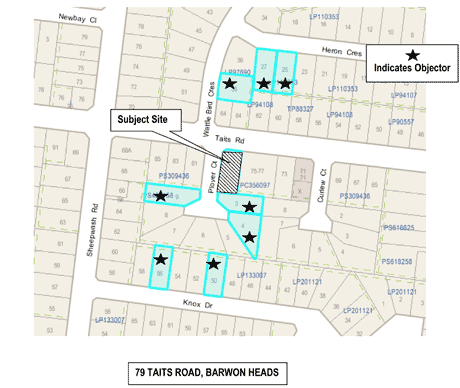
Prior to the commencement of the development, three (3) copies of amended plans to the satisfaction of the Responsible Authority must be submitted to and approved by the Responsible Authority. When approved, the plans will be endorsed and will then form part of the permit. The plans must be drawn to scale with dimensions and must be generally in accordance with the plans submitted with the application on 12 July 2012 but modified to show:
Finished floor levels at a minimum of 300mm freeboard above the applicable flood level (a minimum height of 2.3 metres AHD);
The crossover for the proposed dwelling constructed at a 90 degree angle to the kerb, avoiding the existing side entry pit;
The provision of six cubic metres of externally accessible storage for the existing dwelling to comply with Standard B30 of the Greater Geelong Planning Scheme.
All buildings and works as shown on the endorsed plans must be completed prior to the occupation of the building works, unless otherwise approved in writing by the Responsible Authority.
The development as shown on the endorsed plans must not be altered without the written consent of the Responsible Authority.
The site must be drained to the satisfaction of the Responsible Authority and no concentrated stormwater runoff may drain or discharge from the site to adjoining properties.
Prior to occupation of the dwelling hereby permitted the developer must, unless otherwise approved by the Responsible Authority:
Construct the site drainage system including connection to the easement drain located on the southern boundary of the site, in accordance with relevant Council and Australian standards;
Construct a vehicle crossing for each lot in accordance with Council specifications. Any redundant crossings must be removed with necessary reinstatement works undertaken to match the surrounding construction in the street;
all to the satisfaction of the Responsible Authority.
Prior to the commencement of works, consent to build over the drainage and sewerage easement must be obtained from the City of Greater Geelong Council and Barwon Water. In the case that consent is not granted, application must be made to the Responsible Authority to amend the endorsed plans to delete the proposed car port.
The floor of the new dwelling must be constructed at a minimum height of 2.3 metres AHD.
Prior to the commencement of development, three (3) copies of a landscape plan prepared by a suitably qualified or experienced, person to the satisfaction of the Responsible Authority, must be submitted to and approved by the Responsible Authority. The plan(s) must be drawn to scale and show:
A survey (including botanical names) of all existing vegetation to be retained and/ or removed;
Details of surface finishes of pathways and driveways;
A planting schedule of all proposed trees, shrubs and ground covers including botanical names, common names, pot sizes, sizes at maturity, and quantities of each plant.
When approved, the plan will be endorsed and form part of the permit, all to the satisfaction of the Responsible Authority.
Prior to the occupation of the development, the landscaping works as shown on the endorsed plans must be carried out and completed to the satisfaction of the Responsible Authority.
The landscaping shown on the endorsed plans must be maintained to the satisfaction of the Responsible Authority.
The external fabric including the roofing must be in muted tonings of non-reflective material so as to blend with the environment and preserve the aesthetic amenity of the area to the satisfaction of the Responsible Authority.
This permit will expire if one of the following circumstances applies:
The development of the building(s) hereby approved has not commenced within two (2) years of the date of this permit
The development of the building(s) hereby approved is not completed within four years of the date of this permit.
The Responsible Authority may extend the periods referred to if a request is made in writing before the permit expires or within three (3) months afterwards.
Definition and Nesting
The use as defined as ‘dwelling’ and is nested in the Accommodation Group.
Permit required clause and condition
Pursuant to Clause 32.06-4 of the Residential 3 Zone, a permit is required to construct two or more dwellings on a lot. A development must meet the requirements of Clause 55.
Pursuant to Clause 44.05-1 of the Special Building Overlay, a permit is required to construct a building or to construct or carry out works.
Zone
Clause 32.06 Residential 3 Zone
The purpose of this zone is:
To provide for residential development at a range of densities with a variety of dwellings to meet the housing needs of all households.
To encourage residential development that respects the neighbourhood character.
To limit the maximum height of a dwelling or residential building.
In appropriate locations, to allow educational, recreational, religious, community and a limited range of other non-residential uses to serve local community needs.
Overlay
Clause 44.05 Special Building Overlay
The purpose of this overlay is:
To implement the State Planning Policy Framework and the Local Planning Policy Framework, including the Municipal Strategic Statement and local planning policies.
To identify land in urban areas liable to inundation by overland flows from the urban drainage system as determined by, or in consultation with, the floodplain management authority.
To ensure that development maintains the free passage and temporary storage of floodwaters, minimises flood damage, is compatible with the flood hazard and local drainage conditions and will not cause any significant rise in flood level or flow velocity.
To protect water quality in accordance with the provisions of relevant State Environment Protection Policies, particularly in accordance with Clauses 33 and 35 of the State Environment Protection Policy (Waters of Victoria).
Restrictive Covenant
There is no restrictive covenant listed on the title.
Cultural Heritage Management Plan (CHMP)
The Aboriginal Heritage Regulations 2007 specify the circumstances in which a Cultural Heritage Management Plan is required for an activity or class of activity.
Part 2 - Division 2 of the Aboriginal Heritage Regulations 2007 specifies exempt activities which do not require a Cultural Heritage Management Plan. The proposal is listed as an exempt activity.
Areas of cultural heritage sensitivity are defined within Part 2 - Division 3 of the Aboriginal Heritage Regulations 2007. Part 2 - Division 3 does identify the site or part of the site as being within an area of cultural heritage sensitivity.
High impact activities are defined within Part 2 - Division 5 of the Aboriginal Heritage Regulations 2007. Part 2 - Division 5 does not list the proposal as a high impact activity.
In accordance with the above assessment, a Cultural Heritage Management Plan is not required.
Coastal Hazard Vulnerability Assessment
The subject site is located within 1km of the Barwon River (approximately 400 metres).
The subject site has a contour level of 2m AHD according to Council's Places Weave mapping system.
Following a referral to Council’s Engineering Services Unit, it was determined that it is unlikely that the site would be directly inundated as result of climate change impacts, due to high ground to the north and east of the site preventing direct inundation. There is not considered to be any risk from coastal erosion to the site. A rise in sea level would reduce the effectiveness of the stormwater outfalls and may contribute to flooding upstream due to backflow in the pipes. This has not been modelled against the range of sea level rise scenarios.
Engineering Services does not object to the application on the grounds of coastal hazards.
The application was also referred to the CCMA to determine if the submission of a CHVA was required. The Authority’s ground level data indicate that the property is physically protected from inundation associated with a 1% Annual Exceedance Probability Barwon River flood by high ground between the property and the estuary. The City of Greater Geelong has received several Coastal Hazard Vulnerability Assessments (CHVA’s) for properties in this area that indicate a low risk of coastal erosion of the barrier would occur. Assuming this physical feature remains constant over time, the Authority also expects the property to remain protected from storm tide flooding for the period up to the year 2100.
Therefore, a CHVA was not required to be submitted.
Car Parking
Clause 52.06 requires car parking for a dwelling to be provided as follows:
One space for each one or two bedroom dwelling.
Two spaces for each three or more bedroom dwelling.
Developments of five or more dwellings should provide visitor car parking at a rate of one space for every five dwellings.
Bicycle Spaces
Pursuant to Standard B16 of Clause 55.03-11, bicycle parking is required in relation to the development of land for five or more dwellings. However, the rate of spaces required is applicable only to dwellings of four or more storeys.
Notwithstanding this, it is considered that adequate space would be available for bicycle parking within the boundaries of each proposed lot.
State Planning Policy Framework
The following State Planning Policies are relevant to the consideration of this application:
Clause 11.00 – Settlement
Planning is to anticipate and respond to the needs of existing and future communities through provision of zoned and serviced land for housing, employment, recreation and open space, commercial and community facilities and infrastructure.
Planning is to recognise the need for, and as far as practicable contribute towards:
Health and safety.
Diversity of choice.
Adaptation in response to changing technology.
Economic viability.
A high standard of urban design and amenity.
Energy efficiency.
Prevention of pollution to land, water and air.
Protection of environmentally sensitive areas and natural resources.
Accessibility.
Land use and transport integration.
Planning is to prevent environmental problems created by siting incompatible land uses close together.
Planning is to facilitate sustainable development that takes full advantage of existing settlement patterns, and investment in transport and communication, water and sewerage and social facilities.
11.05-5 - Coastal Settlement
Objective
To plan for sustainable coastal development.
Strategies
Support a network of diverse coastal settlements which provides for a broad range of housing types, economic opportunities and services.
Encourage urban renewal and redevelopment opportunities within existing settlements to reduce the demand for urban sprawl.
Identify a clear settlement boundary around coastal settlements to ensure that growth in coastal areas is planned and coastal values protected. Where no settlement boundary is identified, the extent of a settlement is defined by the extent of existing urban zoned land and any land identified on a plan in the planning scheme for future urban settlement.
Direct residential and other urban development and infrastructure within defined settlement boundaries of existing settlements that are capable of accommodating growth.
Avoid linear urban sprawl along the coastal edge and ribbon development within rural landscapes and protect areas between settlements for non-urban use.
Avoid development on ridgelines, primary coastal dune systems and low lying coastal areas.
Encourage opportunities to restructure old and inappropriate subdivisions to reduce development impacts on the environment.
Ensure a sustainable water supply, stormwater and sewerage treatment for all development.
Minimise the quantity and enhance the quality of storm water discharge from new development into the ocean, bays and estuaries.
12.02-1 - Protection of Coastal Areas
Objective
To recognise and enhance the value of the coastal areas to the community and ensure sustainable use of natural coastal resources.
Strategies
Coordinated land use and planning with the requirements of the Coastal Management Act 1995 to:
Provide clear direction for the future sustainable use of the coast, including the marine environment, for recreation, conservation, tourism, commerce and similar uses in appropriate areas.
Protect and maintain areas of environmental significance.
Identify suitable areas and opportunities for improved facilities.
Apply the hierarchy of principles for coastal planning and management as set out in the Victorian Coastal Strategy 2008, which are:
Principle 1: Provide for the protection of significant environmental and cultural values.
Principle 2: Undertake integrated planning and provide clear direction for the future.
Principle 3: Ensure the sustainable use of natural coastal resources.
When the above principles have been considered and addressed:
Principle 4: Ensure development on the coast is located within existing modified and resilient environments where the demand for development is evident and the impact can be managed.
12.01-2 - Appropriate Development of Coastal Areas
Objective
To ensure development conserves, protects and seeks to enhance coastal biodiversity and ecological values.
Strategies
Ensure development is sensitively sited and designed and respects the character of coastal settlements.
Encourage revegetation of cleared land abutting coastal reserves.
Maintain the natural drainage patterns, water quality and biodiversity within and adjacent to coastal estuaries, wetlands and waterways.
Avoid disturbance of coastal acid sulfate soils.
Protect cultural heritage places, including Aboriginal places, archaeological sites and historic shipwrecks.
13 - Environmental Risks
Planning should adopt a best practice environmental management and risk management approach which aims to avoid or minimise environmental degradation and hazards. Planning should identify and manage the potential for the environment, and environmental changes, to impact upon the economic, environmental or social well-being of society.
13.01-1 - Coastal Inundation and Erosion
Objective
To plan for and manage the potential coastal impacts of climate change.
Strategies
Plan for sea level rise of not less than 0.8 metres by 2100, and allow for the combined effects of tides, storm surges, coastal processes and local conditions such as topography and geology when assessing risks and coastal impacts associated with climate change.
Apply the precautionary principle to planning and management decision-making when considering the risks associated with climate change.
Ensure that new development is located and designed to take account of the impacts of climate change on coastal hazards such as the combined effects of storm tides, river flooding, coastal erosion and sand drift.
Ensure that land subject to coastal hazards are identified and appropriately managed to ensure that future development is not at risk.
Avoid development in identified coastal hazard areas susceptible to inundation (both river and coastal), erosion, landslip/landslide, acid sulfate soils, wildfire and geotechnical risk.
13.02-1 - Floodplain Management
Objective
To assist the protection of:
Life, property and community infrastructure from flood hazard.
The natural flood carrying capacity of rivers, streams and floodways.
The flood storage function of floodplains and waterways.
Floodplain areas of environmental significance or of importance to river health.
Strategies
Identify land affected by flooding, including floodway areas, as verified by the relevant floodplain management authority, in planning scheme maps. Land affected by flooding is land inundate by the 1 in 100 year flood event or as determined by the floodplain management authority.
Avoid intensifying the impacts of flooding through inappropriately located uses and developments.
Locate emergency and community facilities (including hospitals, ambulance stations, police stations, fire stations, residential aged care facilities, communication facilities, transport facilities, community shelters and schools) outside the 1 in 100 year floodplain and, where possible, at levels above the height of the probable maximum flood.
Locate developments and uses which involve the storage or disposal of environmentally hazardous industrial and agricultural chemicals or wastes and other dangerous goods (including intensive animal industries and sewage treatment plants) must not be located on floodplains unless site design and management is such that potential contact between such substances and floodwaters is prevented, without affecting the flood carrying and flood storage functions of the floodplain.
Clause 15 - Built Environment and Heritage
Planning should ensure all new land use and development appropriately responds to its landscape, valued built form and cultural context, and protect places and sites with significant heritage, architectural, aesthetic, scientific and cultural value.
Creating quality built environments supports the social, cultural, economic and environmental wellbeing of our communities, cities and towns.
Land use and development planning must support the development and maintenance of communities with adequate and safe physical and social environments for their residents, through the appropriate location of uses and development and quality of urban design.
Planning should achieve high quality urban design and architecture that:
Contributes positively to local urban character and sense of place.
Reflects the particular characteristics, aspirations and cultural identity of the community.
Enhances liveability, diversity, amenity and safety of the public realm.
Promotes attractiveness of towns and cities within broader strategic contexts.
Minimises detrimental impact on neighbouring properties.
Clause 15.01-5 - Cultural Identity and Neighbourhood Character
Objective
To recognise and protect cultural identity, neighbourhood character and sense of place.
Strategies
Ensure development responds and contributes to existing sense of place and cultural identity.
Ensure development recognises distinctive urban forms and layout and their relationship to landscape and vegetation.
Ensure development responds to its context and reinforces special characteristics of local environment and place by emphasising:
The underlying natural landscape character.
The heritage values and built form that reflect community identity.
The values, needs and aspirations of the community.
15.02-1 - Energy and resource efficiency
Objective
To encourage land use and development that is consistent with the efficient use of energy and the minimisation of greenhouse gas emissions.
Strategies
Ensure that buildings and subdivision design improves efficiency in energy use.
Promote consolidation of urban development and integration of land use and transport.
Improve efficiency in energy use through greater use of renewable energy.
Support low energy forms of transport such as walking and cycling.
Clause 16 – Housing
Planning should provide for housing diversity, and ensure the efficient provision of supporting infrastructure.
New housing should have access to services and be planned for long term sustainability, including walkability to activity centres, public transport, schools and open space.
Planning for housing should include providing land for affordable housing.
Clause 16.01-4 - Housing Diversity
Objective
To provide for a range of housing types to meet increasingly diverse needs
Strategies
Ensure housing stock matches changing demand by widening housing choice, particularly in the middle and outer suburbs.
Encourage the development of well-designed medium-density housing which:
Respects the neighbourhood character.
Improves housing choice.
Makes better use of existing infrastructure.
Improves energy efficiency of housing.
Support opportunities for a wide range of income groups to choose housing in well-serviced locations.
Ensure planning for growth areas provides for a mix of housing types and higher housing densities in and around activity centres.
Clause 16.01-5 - Housing Affordability
Objective
To deliver more affordable housing closer to jobs, transport and services.
Strategies
Improve housing affordability by:
Ensuring land supply continues to be sufficient to meet demand.
Increasing choice in housing type, tenure and cost to meet the needs of households as they move through life cycle changes and to support diverse communities.
Promoting good housing and urban design to minimise negative environmental impacts and keep down costs for residents and the wider community.
Encouraging a significant proportion of new development, including development at activity centres and strategic redevelopment sites to be affordable for households on low to moderate incomes.
Increase the supply of well-located affordable housing by:
Facilitating a mix of private, affordable and social housing in activity centres, strategic redevelopment sites.
Ensuring the redevelopment and renewal of public housing stock better meets community needs.
Local Planning Policy Framework
Municipal Strategic Statement
The following policies of the Municipal Strategic Statement are relevant to the consideration of this application:
21.05-7 – Flooding
The objective of Clause 21.05-7 of the Municipal Strategic Statement is:
To protect floodplains.
To minimise the potential for damage and risks to public safety and property from flooding.
Strategies
Ensure that land use and development is compatible with flood prone land.
Discourage land use and development in floodplains where flood function may be impaired.
Recognise flood hazards associated with waterways and ensure the free passage of water whilst protecting development from flooding impacts.
Clause 21.06-3 - Urban Consolidation
The objective of Clause 21.06-3 of the Municipal Strategic Statement is:
To provide for the consolidation of existing urban areas in a managed way.
To encourage an appropriate range of development densities.
To improve accessibility to urban services.
Strategies
Manage urban consolidation and housing change across the municipality, by:
Accommodating medium and high density housing in Key Development Areas (as designated in the Incorporated Document ‘Key Development and Increased Housing Diversity Areas July 2009’).
Maximising opportunities for housing within Increased Housing Diversity Areas (as designated in the Incorporated Document ‘Key Development and Increased Housing Diversity Areas July 2009’) by accommodating:
High density housing in the activity centres consistent with their primary commercial and retail role; and medium density housing in residential areas with more intensive development being located closest to the core of activity centres.
Appropriate medium density housing in Residential 1 zoned areas.
Incremental change in Residential 3 zoned areas.
Encourage medium density housing in mixed use zones.
Require retirement accommodation to be located within urban areas, preferably within close proximity to existing or proposed activity centres and public transport facilities.
Clause 21.06-4 - Neighbourhood Character
The objective of Clause 21.06-4 of the Municipal Strategic Statement is:
To manage the impact of urban change on existing neighbourhoods.
To ensure that new development responds to the existing neighbourhood character.
To protect areas with a significant garden character.
Strategies
Ensure that development is responsive to the established character of the area.
Support medium density housing in the Residential 3 Zone in accordance with the schedule to the zone.
Acknowledge that neighbourhood character in the Increased Housing Diversity Areas and in Residential 2 Zones will adapt and evolve over time, particularly within and on the edges of activity centres, where land use and development will intensify.
Allow for appropriate transition between residential zones.
Ensure that development on the edges of Residential 1 and Residential 2 Zones is responsive to and respectful of the neighbourhood character in any adjoining Residential 3 Zone.
Support the redevelopment of dwellings owned by the Office of Housing, as part of urban renewal initiatives.
Retain existing vegetation wherever possible, particularly vegetation that contributes to the municipality’s tree canopy.
Avoid gated communities.
Maintain the character of the Rural Living and Low Density Residential Zoned areas.
21.05-4 – Coastal Environments
The objective of Clause 21.05-4 of the Municipal Strategic Statement is:
To protect, maintain and enhance the coast, estuaries and marine environment.
To respect and manage coastal processes.
Strategies
Focus urban coastal development within existing urban settlements.
Prevent lineal urban sprawl along the coast.
Avoid the loss of, and wherever possible increase, public access to the foreshore environment.
Restrict development on primary dunes.
Ensure the potential for existence of acid sulphate soils adjacent to coastal and wetland locations is considered.
Limit the number of stormwater outlets to the coast.
Setback future land use and development from coastal areas, estuaries and coastal wetlands to provide a buffer which is adequate to accommodate coastal recession and the landward migration of coastal wetland vegetation communities such as mangroves and salt marshes.
21.05-5 – Climate Change
The objective of Clause 21.05-5 of the Municipal Strategic Statement is:
To plan for and adapt to the impacts of climate change.
Strategies
Avoid land use and development within areas considered at risk of coastal erosion or inundation from flooding, storm surge or rising sea levels.
21.14 The Bellarine Peninsula
The objective of Clause 21.14 of the Municipal Strategic Statement is:
To protect and enhance the rural and coastal environment on the Bellarine Peninsula and maintain non-urban breaks between settlements.
To facilitate the development of Ocean Grove, Drysdale/Clifton Springs and Leopold as hubs of development and service provision on the Bellarine Peninsula. In all other townships on the Bellarine Peninsula provide retail, commercial and community uses and facilities that serve the daily needs of the community and encourage street based activity.
To provide for sustainable industrial, commercial, retail, agricultural and tourism development in designated locations, to service the wider Bellarine community.
To preserve the individual character, identity and role of each Bellarine township.
Barwon Heads
Maintain a compact urban form and avoid outward sprawl.
Protect the unique character of Barwon Heads as a coastal village located within a sensitive environment and significant landscape setting.
Ensure the Hitchcock Avenue shopping centre remains the focus of retail activity in Barwon Heads.
Restrict new commercial development to the existing business and mixed use zones in Hitchcock Avenue between Bridge Road and Ozone Road and the south side of Bridge Road.
Ensure new housing development complements the character of Barwon Heads and provides for a variety of housing sizes and types.
Support the continued development of 13th Beach Resort as a tourist destination.
Continue upgrading the Barwon Heads Village Park and foreshore reserves in accordance with established master plans.
Support development of appropriate tourist accommodation around the Barwon Heads town centre.
Engineering Services
Council’s Engineering Services Unit has provided standard conditions in relation to drainage and vehicular access for the development.
The Unit has also recommended the following changes be made upon referral of the original plans:
Amended plans showing the crossover perpendicular to the kerb, and the driveway offset a minimum of 600mm from the existing pit.
Amended plans showing finished floor levels allowing a minimum of 300mm freeboard above the applicable flood level.
The Unit has also indicated that the applicant would be expected to enter into a Section 173 agreement with Council as part of the “Build Over Easement” procedure.
Comment:
A recommended permit condition will require amended plans to be submitted which meet these requirements of the Engineering Unit.
In regards to the requirement for a Section 173 agreement to ensure the car port can be removed should access be required to the easement, it is considered that the agreement is not required as these Engineering requirements can be dealt with through the “Build Over Easement” application. A condition on the permit will require consent to build over the easement be obtained prior to the commencement of works.
Barwon Water
The plans originally submitted with the application were referred to Barwon Water for comment due to the presence of a sewer easement along the southern property boundary. Barwon Water required the redesign of the new dwelling to provide for an offset from the southern boundary of 3.5 metres.
Amended plans were subsequently submitted to show this, and were re-referred to Barwon Water. Barwon Water provided a set of subdivision conditions in response to the referral. As the application is not for the subdivision of the land, the conditions provided by Barwon Water cannot be used for this application. However, Barwon Water have confirmed in writing that the proposed dwelling will not impact on their assets, and that a build-over application has been approved in principle.
Barwon Water have offered in principle support for the latest set of plans, now showing a car port to be constructed over the easement, and have advised that the applicant will need to apply directly to Barwon Water for a build-over permission.
Corangamite Catchment Management Authority
The property is subject to inundation associated with the local stormwater catchment. The 1% Annual Exceedance Probability flood level applicable to the property is 2.00 metres Australian Height Datum. The floor of the new dwelling would need to be constructed at a minimum height of 2.3 metres AHD.
The application was advertised pursuant to Section 52 of the Planning and Environment Act 1987. The applicant was required to erect a sign on the site, and letters were sent to adjoining and nearby owners and occupiers. Council received six objections as a result of the advertising procedure. Amended plans were submitted as a result of the previous Development Hearings Panel meeting and these were circulated to objectors. All objectors chose for their objections to stand, with two objectors providing additional submissions. Objections are summarised below:
Objection
The development will cause unreasonable traffic and parking impacts to Plover Court.
Comment
The provision and location of car spaces is in accordance with the relevant standard. The requisite amount of parking, pursuant to Clause 52.06, is to be provided on site. It is not anticipated that the development, which will increase the number of dwellings on the site by one, will create any material traffic impacts to Plover Court or Taits Road.
Objection
The proposal does not meet the ResCode provisions or planning guidelines, particularly in regards to the proposed street setback, and is inconsistent with the character of the neighbourhood and the streetscape of Plover Court.
Comment
The minimum street setback of three metres has been met for the new dwelling in the plans under consideration. The proposed setback is considered to be appropriate in the context of the site. The court features irregular shaped lots and dwellings with inconsistent street setbacks ranging from 9 to 30 metres. The proposed street setback is not considered to create any dominance or bulk of form to the streetscape, as built form to Plover Court on those lots with frontages to Taits Road is generally set back a maximum of two to three metres from the boundary.
The proposal is otherwise compliant with Clause 55, and the State and Local Planning Policy Framework.
Objection
The development of low cost housing in the area will have a detrimental impact on property values.
Comment
Property values are not a material planning consideration pursuant to the Planning Scheme. The State and Local Planning Policy Framework supports consolidation and the better utilisation of existing infrastructure through medium density housing development, where the character of the neighbourhood is not detrimentally impacted. As previously stated, it is considered that the design and siting of the proposal is not at odds with the character of the neighbourhood or streetscape.
Portfolio: |
Planning - Cr Macdonald |
Source: |
Economic Development, Planning and Tourism |
General Manager: |
Peter Bettess |
Index Reference: |
Subject: Regional Skilled Migration Program 2011-2012 |
The City of Greater Geelong has participated in the Victorian Government funded Regional Skilled Migration Program 2011-2012 and met our obligation of 60 employment outcomes. These 60 employment outcomes have contributed over $28 million in total output to our economy (REMPLAN). The program has supported employers across the G21 Region to attract, source and retain skilled overseas professionals to fill positions that could not be filled from the local labour market. In total the program from 2008-2012 has assisted employers to fill 226 skilled vacancies (diploma level or higher).
Geelong is one of 10 Victorian Regions that have access to the Regional Skilled Migration Service (RSMS) visa stream that provides overseas skilled professionals with permanent residency.
Funding for the Regional Skilled Migration Program ceased on 30 June 2012. There is no further ongoing Victorian State Government funding for the Skilled Migration program.
The use of the RSMS visa to support employers with genuine skill shortages requires a procedural check of the employer by the Regional Certification Body (RCB). The State Government (who is the current RCB in our region) is looking to transition this function to the City of Greater Geelong as the operator of the Skilled Migration program.
The Victorian Government Department of Business and Innovation has offered one-off transitional funding of $100,000 to enable the City to put in place systems to operate the RCB program sustainably into the future.
On Tuesday 4 September 2012 the State Government forwarded Grant Guidelines and an Application form for the Regional Certifying Body (RCB) Program 2012-2013. This form requested Council advises the Department of Business and Innovation of its preparedness to undertake the RCB role by 10 September 2012. A holding response has been sent pending Council’s decision. The offer is conditional that Council details how the program will be self sustaining beyond 15 May 2013.
With the State Government funding and RCB revenue, the program could be funded for three years within the Economic Development Department budget. A review of the on-going funding of the program should be conducted in three years having regard to the outcomes of the program.
Cr Macdonald moved, Cr E Kontelj seconded -
That Council notes the achievements of the 2011-2012 Skilled Migration program;
That Council accepts the offer of transitional funding and commits to be a Regional Certification Body (RCB) for three (3) years;
That the Skilled Migration Program and the RCB function be reviewed in three (3) years considering:
the viability of the Program; and
the outcomes achieved for local employers.
Carried.
Between 2008-2011 the City of Greater Geelong participated in the Victorian Government funded Global Skills for Provincial Victoria Program. The program assisted regional employers experiencing skill shortages to source, attract and retain overseas skilled professionals to fill positions that could not be filled locally. The City received $385,000 in funding and assisted employers to fill 166 vacant positions across a range of industry sectors. The GSPV program operated across 11 regional centres.
The program was extended for a further 12 months under a new program title - Regional Skilled Migration Program 2011 - 2012. Ten regional centres participated in this program. The City received $110,000 in funding and assisted regional employers to fill 60 positions that could not be filled locally. Occupations assisted over the past 12 months include Health & Allied Health (GPs, Nurses, Personal Care Attendants) 25 positions, Education and Professional Services 8 positions, Mechanics 7 positions, Manufacturing (various includes engineers) 6 positions, Hospitality (Chefs) 5 positions, Construction 5 positions and Other 4 positions. The 60 employment outcomes generated over $28 million in total output including all direct industrial and consumption effects, with a gain of a further 20 jobs in the flow-on economy.
The Geelong Region is experiencing significant business growth particularly in sectors such as health, education, information communication and technology, food processing, tourism, transport and research. Niche manufacturing sectors are also experiencing growth.
Skills shortages will become an increasing problem for the local economy. Career pathways and higher wages attract many skilled professionals away from regional centres. The workforce is ageing with an anticipated 20%-25% of the workforce expected to retire over the next 20 years. The nature of employment has become more skilled and technology and transport advances have resulted in a much more globally mobile workforce.
Geelong region employers are currently experiencing difficulty in filling skilled vacancies across a range of occupations. The City has worked alongside local education and training providers to identify pathways that will encourage the workforce into occupations in skill shortage sectors. Skilled migration has been a complementary activity that providers employers with an immediate solution to fill critical skill shortages (trade or diploma or higher).
Funding for the Regional Skilled Migration Program ended on 30 June 2012. The current State Government will not be supporting another program into the future.
The program funding has been used to offset the costs of 1.85 EFT in this program and the City of Greater Geelong has provided in-kind support via staff management and furniture and equipment.
The Victorian Government Skilled and Business Migration Program has invited applications for the Regional Certifying Body Program (RCBP) 2012-13.
The RCBP is a transitional funding program offered to Victorian regional bodies previously funded under the Regional Skilled Migration Program (RSMP) to take on the role of a Regional Certifying Body (RCB) under the Commonwealth Government's Regional Sponsored Migration Scheme (RSMS). A certifying body is an organisation which has been approved by the Federal Minister to certify nominations by employers for the RSMS visa before being lodged with the Department of Immigration and Citizenship. The State Government currently provides this service free-of-charge to regional employers. The State Government has detailed that Local Government could charge for this service to offset the cost of undertaking the RCB role and have notionally suggested a figure of $400 per certification.
The funding offer is subject to regions putting in place alternative cost recovery arrangements during the course of the RCBP 2012-13. The agreement payment is subject to the City of Greater Geelong undertaking RCB activities in alignment with the area that we previously provided Skilled Migration services. This requirement means that CoGG need to provide RCB services to Colac Otway, Golden Plains and Surfcoast.
The invitation details conditions that the Council must adhere to be eligible for the one-off transitional funding.
These conditions include:
a valid Gazette notice issued by the relevant Authority certifying that we are a Regional Certifying body under the legislation; and
evidence that the Council has implemented a cost recovery arrangement for the ongoing operations as an RCB on and from 15 May 2013.
Applications opened on Tuesday 4 September 2012 and are noted as remaining open until 5pm Monday 10 September 2012.
On 6 September 2012, the Co-ordinator of Economic Development responded to the Senior Advisor – Industry Engagement, Department of Business and Innovation detailing that the City of Greater Geelong Council would deliberate the matter at a Council meeting and that the Council decision would be advised.
If the Council was to become a RCB, figures from the local RCB detail an average of 42 certifications per month from January 2011 - May 2012. The Victorian Government has touted a figure of approximately $400 as reasonable to undertake the RCB activities per employer application. Charging $400 per certification to employers generates and average monthly income of $16,800. The monthly cost to operate the skilled migration program would equate to approximately $16,000 (Program staff, RCB and ancillaries).
The Regional Skilled Migration Program does not impact on the environment.
The agreement provides for a total funding allocation of $100,000 for the period September 2012 - 15 May 2013 to provide RCB services to CoGG, Surfcoast, Colac Otway and Golden Plains shires.
The financial implications of supporting a program similar to that which we have been operating includes continuation of the 1.85 EFT Skilled Migration Program resource, transitioning an additional EFT to undertake the RCB role from within the Economic Development Unit and management of accounts and current in-kind contributions. In addition the program has been supporting informal networking sessions with recently arrived skilled professionals that are seen as a critical element of supporting people to settle into the Geelong community.
It is anticipated that Geelong employers will need to make approximately 400 RCB paid applications per annum and that the role of RCB would need to be incorporated into the current Economic Development unit staffing resource to enable this program to be self sustaining.
If the City of Greater Geelong takes up the Victorian Government’s offer of one year transitional funding the program could be funded for three years within the Economic Development Department’s budget. There is no guarantee that the monies raised as the RCB would be sufficient to support skilled migration services beyond the three years.
As the numbers of RCB applications is indeterminate, it is suggested that the City of Greater Geelong Council does not commit to the sustainability of the RCB and Skilled Migration Program beyond three years. This would see Council committing to RCB for the period October 2012 – 30 June 2016. The understanding between the City and State Government would need to be such that the Council will review the program after three years having regard to the financial viability of the service and the outcomes achieved.
The RCB income stream must be able to support the skilled professional placement services that are valuable to our employers, primarily being the Skilled Migration Program in order for Council to continue to undertake the role of Regional Certifying Body and subsequently enter into an agreement for the transitional funding. Ongoing commitment however should not be provided given recent (and potential for future) reforms to how the Australian Government manages the Visa requirements and skilled migration program.
The changing nature of obligations regarding visa compliance and certification provides for uncertainty.
Processing timelines for the RSMS visa are managed at the Federal Government level and as such the success of the program is not within the control of Local Government. The positions able to be filled as part of the program are also a determinate of the Federal Government.
There is no direct or indirect interest by any Council officers in this project.
The provision of skilled migration assistance to regional employers has been a highly sought after service. The program has been able to deliver more outcomes than required under its contractual obligations. An annual survey of regional employers has shown that regional employers anticipate over 700 skill shortage positions over the next 12 - 24 months particularly in the health and allied health sector.
The Geelong Region Skilled Migration Project has proved to be a valuable and successful tool in assisting regional employers to fill skilled vacancies that cannot be sourced locally. As Geelong’s economy continues to grow, a lack of access to the range of skills required by employers may be an inhibitor to growth. The attraction of skilled overseas professionals provides an immediate solution for employers that is a complementary activity to the long term skilling of the regional labour force.
Since 2008 the skilled migration service provided by the City has assisted regional employers to fill 226 skilled positions that were unable to be filled from the local market. Together with family members this equates to almost 700 new residents being welcomed to the Geelong Region.
The Geelong Region Skilled Migration Project will work with the State Government to ensure employers are directed to the appropriate agencies within the State and Federal Government’s for assistance with any queries.
Portfolio: |
Arts & Culture – Cr Abley |
Source: |
Projects, Recreation & Central Geelong |
General Manager: |
Dean Frost |
Index Reference: |
Project: Geelong Library & Heritage Centre |
The architects for the Geelong Library and Heritage Centre redevelopment project have provided Council with 3 design concepts. These are summarised as ‘The Dome’, ‘The Oculus’, and ‘The Ripple’.
The Project Control Group (PCG) has reviewed each of the options and is recommending that ‘The Dome’ concept be put forward as the preferred design concept.
Once a concept has been selected, the schematic design and planning phases of the project can commence.
The Geelong Library and Heritage Centre project is jointly funded with Council contributing $20M, the State Government $15M and the Federal Government $10M.
The concept design options have been presented to the Victorian Design Review Panel and they have provided Council with a design review report.
Cr Granger moved, Cr Abley seconded -
That Council endorse the Geelong Library and Heritage Centre ‘Dome Concept’ and authorise officers to commence a public consultation process.
Cr Harwood left the meeting room at 8.04pm
Cr Harwood re-entered the meeting room at 8.05pm
Carried.
In April 2012, Council appointed architecture firm Ashton Raggatt McDougall (ARM) as its design consultant for the $40M Geelong Library and Heritage Centre project.
In addition to the architectural consultancy, Council also engaged Davis Langdon AECOM as the Project Manager and Slattery Australia as the Quantity Surveyor.
Each of the consultant teams were appointed following a two stage tender process that included an expression of interest phase and selective tender phase.
As part of its contractual obligation, ARM was required to present three design concepts for the development of this facility. These concepts were to be supported by a design philosophy that considered Geelong’s heritage.
The architect has been working with various Council departments and end user groups in the development of these concepts, and they are now presented for Council’s consideration and endorsement.
The Geelong Library and Heritage Centre project is one of the largest and most significant projects undertaken by Council in recent history.
A Project Control Group (PCG), which includes 5 Councillors, has been overseeing and reviewing the design development process. This group is ensuring that the concepts developed by the architect meet with Council’s expectations for a contemporary Library and Heritage Centre.
The PCG has also expressed their desire to have the building designed with high environmental standards, be significant in nature and reflective of the buildings importance to the Geelong community.
In responding to this intent, the design team have explored the idea of the importance of the building for the Geelong region and Central Geelong’s Cultural Precinct, concentrating on the themes of ‘The Landscape’, ‘The Garden’ and ‘The Street’.
The attached concept design summary report provides an overview of the architect’s concept study, and the three design options.
These concepts represent a very early stage of in the design development process. Over the next 6 months the consultancy team will continue to develop and refine the selected concept with input from operational staff, users, and the community.
The adoption of a preferred concept will allow the project to proceed to the schematic design phase. The schematic design phase is scheduled to occur during September and October of 2012. This will then lead into the design development and documentation phases.
Site demolition works are scheduled to occur from mid 2012, which will mean that the current occupants of the building will need to be decanted. The Project Working Group (PWG) has been investigating a number of temporary accommodation options. The existing services will need to be re-housed in early to mid 2013 through to the completion of the building works.
One of the key considerations in identifying a temporary premises for a reduced library service, has been to try and maintain a presence in the Cultural Precinct.
After several months of negotiation we have recently been advised that the State Government, as a major sponsor of the project, have made space available in their building located on the corner of Lt Malop Street and Fenwick Street. The modified library service will likely operate out of the foyer area of this building during the construction period.
Council was invited to present the concept design options to the Victorian Design Review Panel. The project team presented its concept options to the panel on 18 July 2012 and have since received a summary report. (Attachment 1).
The panel believed that the ‘Dome’ option is ‘the most exciting option and the challenge will be bringing it into practical reality’. They also encouraged Council to ‘go towards a preferred option as soon as possible, to enable energy and thought to be focussed on the development of a single design proposition’.
The new Library and Heritage Centre is being developed as a ‘5 star’ equivalent building.
The Geelong Library and Heritage Centre project is jointly funded with Council committing $20M, the State Government $15M and the Federal Government $10M.
The Council contribution to the Geelong Library and Heritage Centre is divided into two discrete projects. These are a $15M contribution towards the construction of the facility and a $5M contribution towards the provision of parking and book stock.
All funding commitments have been confirmed and some grant payments have been received.
There are no policy, legal or statutory implications. However, Council is required to obtain planning consent before it can begin the construction phase of this project.
Before the planning process can commence Council needs to determine which concept it wants to pursue as this will form the basis of the planning application.
No Council officers involved in the preparation of this report have declared a direct or indirect interest in this matter.
As with all capital projects there have been numerous risks identified which are being mitigated through various control measures.
The risk profile for this project includes financial risks associated with each of the funding agreements.
The Geelong Library and Heritage Centre project will deliver significant community benefits for all age groupings and facilitate the delivery of quality services.
This project builds upon the Geelong Cultural Precinct Masterplan (GCPM) which aims to develop a cultural hub in Central Geelong.
The public consultation phase of the project will commence once a concept has been selected.
Portfolio: |
Sport & Recreation - Cr Mitchell |
Source: |
Projects, Recreation & Central Geelong |
General Manager: |
Dean Frost |
Index Reference: |
Property: Barwon Heads Village Park |
The purpose of this report is for Council to formally endorse the Barwon Heads Village Park Master Plan (2012).
The Barwon Heads Village Park Master Plan Review was initiated by Council to examine the existing Barwon Heads Village Park Management Plan (2002) and develop an updated plan to guide the development of the reserve in recognition of changing community expectations.
Key development opportunities of the Barwon Heads Village Park Master Plan Review include supporting the existing uses of the reserve, improving use of areas for formal sport, improving traffic & pedestrian circulation and increasing opportunities for informal public use.
During the formation of the Master Plan Review, and in a separate process, a site within Village Park was identified as the preferred location for the Barwon Heads Early Learning Centre (ELC). This facility was included in the draft Master Plan but was the subject of a separate community consultative process including public meetings, public exhibition and concluding with a Submissions Review Panel. Under a separate report, Council has recently resolved to agree to the development of the ELC on the Barwon Heads Village Park site requiring that the project design respond to issues relating to passive surveillance, traffic management and the landscaped parkland interface.
Cr Richards moved, Cr Harwood seconded –
That Council endorse the Barwon Heads Village Park Master Plan (2012).
Carried.
Barwon Heads Village Park (BHVP) is the largest recreation reserve in the township of Barwon Heads. The 24ha Village Park is centrally located and bounded by Barwon Heads-Geelong Road to the South and Sheepwash Road to the West with established residential properties directly adjoining the Northern and Eastern boundaries. The park has a number of sporting and community facilities including equestrian facilities, scout halls, tennis courts, bowling greens, two ovals (used for soccer, cricket and football), athletics facilities and a basketball half court.
The objectives of the Barwon Heads Village Park Master Plan (2012) is to support the existing uses of the reserve, improve use of areas for formal sport, improve traffic and pedestrian circulation and increase opportunities for informal public use.
The purpose of this report is for Council to endorse the Barwon Heads Village Park Master Plan (2012).
The aim of the Barwon Heads Village Park Master Plan Review is to examine and review the existing Management Plan (2002) and develop a guide for the future development of the reserve. The planning process involved a review of background information, including a review of the existing Management Plan (2002).
Formal reference groups were established to provide input into the planning process:
Project Control Group (PCG) consisting of the Ward Councillor and key Council officers to provide high level strategic direction on key issues and opportunities.
Project Working Group (PWG) consisting of Council officers from across CoGG departments to provide technical advice on the project.
Project Reference Group (PRG) consisting of representatives of the sporting and community groups within the Park. The PRG provided input, direction and feedback into the project at key stages.
The consultation and research undertaken during the Barwon Heads Village Park Master Plan Review confirmed a number of issues to be addressed at the reserve. Based on the issues identified during the consultation and investigation process, a number of key recommendations were identified, including but not limited to the following;
Implementation of a fire management plan for the park with the Barwon Heads CFA;
Installation of traffic-slow points and signage at the key entries to the reserve;
Installation of vehicle track cross overs to improve pedestrian safety;
Improve the quality of the turf and allow for the future provision of floodlights for winter sport training;
Upgrading the of the main cricket pavilion to include additional male & female home and away change rooms;
Decommissioning of the toilet block located at the rear of the Bowls Club and Cricket Club pavilions;
Investigation into the potential future relocation of existing Bowls Club pavilion closer to the bowling greens;
Provision of additional bicycle racks to key areas in the park;
Resurfacing of the two northern tennis courts and establish line marking and goals to increase multi use for basketball/tennis and informal soccer; and
Environmental weed removal in the understorey of the Moonah Woodland and in the fenced off area of the Dune Woodland.
Section 4.1 of the Barwon Heads Village Park Master Plan (2012) outlines the recommended implementation schedule and indicative capital costs for the works identified in the Master Plan. The total cost of all works is estimated at $1,018,056 and is represented by the following prioritised breakdown:
|
|
MANDATORY |
CRITICAL |
HIGH |
MEDIUM |
LOW |
|
Conservation Area Works |
$7,500 |
Nil |
$40,500 |
$10,000 |
$41,130 |
|
Recreation Facility Works |
Nil |
Nil |
$303,500 |
$285,000 |
$83,750 |
|
Vehicle Control and Car parking |
Nil |
Nil |
$21,500 |
$45,000 |
$10,500 |
|
Design 10% |
$750 |
|
$36,550 |
$34,000 |
$65,538 |
|
Contingencies 10% |
$750 |
|
$36,550 |
$34,000 |
$13,538 |
|
PROJECT WORKS PRIORITIES |
$9,000 |
$0 |
$438,600 |
$408,000 |
162,456 |
|
TOTAL WORKS |
$1,018,056 |
Implementation of recommendations will improve the overall amenity and functionality of the park, including improved sporting & park ammenity, enhanced traffic management, safety and pedestrian circulation. The current and future needs of the all stakeholders and the wider community have been considered in allowing for improved facilities and amenities.
During the formation of the Master Plan Review, and in a separate process, a site within Village Park was identified as the preferred location for the Barwon Heads Early Learning Centre (ELC). This facility was included in the draft Master Plan but was the subject of a separate community consultative process including public meetings, public exhibition and concluding with a Submissions Review Panel. Under a separate report, Council has recently resolved to agree to the development of the ELC on the Barwon Heads Village Park site requiring that the project design respond to issues relating to passive surveillance, traffic management and the landscaped parkland interface.
The Barwon Heads Village Park Master Plan (2012) seeks to support initiatives that facilitate long-term environmental sustainability within the park including vegetation management and ongoing maintenance. Future development will seek to enhance the landscape quality of the reserve, promote improvement of facilities, infrastructure and functioning for broad community use, whilst retaining the natural ambiance of the precinct.
The Barwon Heads Village Park Master Plan (2012) provides a number of recommendations and indicative costings for recommended projects.
Where implementation of specific recommendations requires a new capital allocation from Council, these will be presented and considered as part of the overall annual budget process. Opportunities for contributions from State Government, Clubs and other funding sources are listed against specific projects in the Master Plan.
The implementation plan provides a broad estimate of cost specific to each of the recommended actions. These actions are assessed as Mandatory, Critical, High, Medium and Low to guide Council decision making in terms of development.
Whilst the adoption of this report does not have any direct financial implications, the listed actions within the plan will cost in the order of $1,018,056. It is expected that the Master Plan will be implemented over an approximate timeframe of 10-15 years and is represented by the following prioritised breakdown:
|
|
MANDATORY |
CRITICAL |
HIGH |
MEDIUM |
LOW |
|
PROJECT WORKS PRIORITIES |
$9,000 |
$0 |
$438,600 |
$408,000 |
162,456 |
|
TOTAL WORKS |
$1,018,056 |
Archaeological assessment of BHVP was undertaken in 2001 and discovered a prominent linear sand dune. Locations on the western side of this dune yielded Aboriginal archaeological materials including middens and stone artefacts. This material has been registered as significant as Aboriginal Affairs Victoria. Any works future works undertaken at BHVP may be subject to a Cultural Heritage Management Plan to ensure that these significant artifacts are protected.
Flora assessment completed at BHVP confirmed the presence of two remnant Coastal Alkaline Scrub sub communities at Barwon Heads Village Park. Council has an obligation to protect this significant vegetation including fencing and weed removal. The mandatory actions listed in this report related to the removal of invasive weeds and protective fencing.
The Equal Opportunity Act (1995) protects Victorians against discrimination based on a wide range of personal characteristics or associations. These include (but are not limited to) age, gender, ethnicity, disability, pregnancy, religion and employment status. The Barwon Heads Village Park Master Plan (2012) recognises that all community members have equal rights to participate in and enjoy the benefits of sport and physical activity. The development of the park will consider design solutions to help facilitate access for all.
No Council staff or persons engaged under contract have a direct or indirect interest in the development of the Barwon Heads Village Park Master Plan (2012).
The Barwon Heads Village Park Master Plan (2012) provides guidance for the development of this important piece of open space over the next 10-15 years.
There are no immediate risks associated with this report. Appropriate risk management measures will be put in place when implementing the recommendations of the report.
The Barwon Heads Village Park Master Plan (2012) will enhance recreational and social experiences within the park. Improvements in the design, layout and functionality of the park, together with improved sporting facilities and road/ path networks will increase safety for visitors to the park.
The Barwon Heads Village Park Master Plan (2012) recognises that participation in sport and physical activity brings about a range of personal, social, health and economic benefits for individuals and communities. Barwon Heads Village Park has an established history of active recreational use, including formal sports such at football, cricket, equestrian, soccer, bowls and tennis. Future development of the reserve will support ongoing use of the area for a range of formal and informal sport and recreation activities.
The Barwon Heads Village Park Master Plan (2012) recognises that supporting formal sporting clubs does not only support participation in physical activity. Sporting clubs are recognised as providing a range of broader benefits to the community, including contributions to social capital, community cohesiveness, community connection and building local leaders.
The Barwon Heads Village Park Master Plan Review has been overseen by a three tiered management structure. These included:
Project Control Group (PCG) consisting of the Ward Councillor and key Council officers to provide high level strategic direction on key issues and opportunities.
Project Working Group (PWG) consisting of Council officers from across CoGG departments to provide technical advice on the project.
Project Reference Group (PRG) consisting of representatives of the sporting and community groups within the Park. The PRG provided input, direction and feedback into the project at key stages. The PRG consisted of the following groups: Barwon Heads CFA, Barwon Grove Golf club, Barwon Heads Cricket Club, Barwon Heads Scouts Association of Australia, Barwon Heads Soccer Club, Barwon Heads Football Club, Barwon Heads Tennis Club, Ocean Grove and Barwon Heads Athletics Club and Barwon Heads Bowling Club.
The planning process involved a review of background material and the establishment of formal reference groups to guide the planning process. The project has involved consultation with stakeholders, Council staff and the community.
The main consultation tasks have included:
On-site meetings to discuss aspect of the reserve in detail;
Follow-up site visits, telephone interviews and meetings;
Establishment of the Project Control Group, Project Working Group and Project Reference Group. These groups have met on a minimum of two occasions each in the lead up to this report; and
Consultation with the sporting and community groups within the Park.
The draft Barwon Heads Village Park Master Plan (2012) was placed on public exhibition for a period of four weeks from the 8th March to 5th April 2012. Community and stakeholder feedback was encouraged. A public information session was held on Wednesday 21 March 2012 at the Barwon Heads Tennis Clubrooms between 5.00 – 7.00pm.
A total of 36 submissions were received. Key comments/suggestions and resultant changes from these submissions are summarised in the appendices of the final Master Plan. Submissions relating to the Barwon Heads Early Learning Centre were referred to the process described below.
During the formation of the Master Plan Review, and in a separate process, a site within Village Park was identified as the preferred location for the Barwon Heads Early Learning Centre (ELC). This facility was included in the draft Master Plan Review but was the subject of a separate community consultative process including public meetings, public exhibition and concluding with a Submissions Review Panel. The Barwon Heads Early Learning Centre Submissions Review Panel was convened on Monday 9 July 2012 to hear submissions regarding the Barwon Heads Early Learning Centre development proposed for Village Park Barwon Heads. The Submissions Review Panel (Advisory Committee) heard presentations from 29 people. Respondents spoke both in favour of, and against the proposed development. The panel was unanimous in its recommendation to support the development of the ELC on the proposed site. Under a separate report, Council has recently resolved to agree to the development of the ELC on the Barwon Heads Village Park site requiring that the project design respond to issues relating to passive surveillance, traffic management and the landscaped parkland interface.
Contents | Previous Page: Section A - Procedural Matters | Next Page: Section B – Reports (9-15)

Copyright CoGG 2012
Last Update: 9 August 2013